US10801855B2 - Method and system for creating map based on 3D laser - Google Patents
Method and system for creating map based on 3D laser Download PDFInfo
- Publication number
- US10801855B2 US10801855B2 US15/745,573 US201815745573A US10801855B2 US 10801855 B2 US10801855 B2 US 10801855B2 US 201815745573 A US201815745573 A US 201815745573A US 10801855 B2 US10801855 B2 US 10801855B2
- Authority
- US
- United States
- Prior art keywords
- data
- laser
- map
- creating
- laser data
- Prior art date
- Legal status (The legal status is an assumption and is not a legal conclusion. Google has not performed a legal analysis and makes no representation as to the accuracy of the status listed.)
- Expired - Fee Related, expires
Links
Images


Classifications
-
- G—PHYSICS
- G01—MEASURING; TESTING
- G01C—MEASURING DISTANCES, LEVELS OR BEARINGS; SURVEYING; NAVIGATION; GYROSCOPIC INSTRUMENTS; PHOTOGRAMMETRY OR VIDEOGRAMMETRY
- G01C21/00—Navigation; Navigational instruments not provided for in groups G01C1/00 - G01C19/00
- G01C21/26—Navigation; Navigational instruments not provided for in groups G01C1/00 - G01C19/00 specially adapted for navigation in a road network
- G01C21/34—Route searching; Route guidance
- G01C21/36—Input/output arrangements for on-board computers
- G01C21/3667—Display of a road map
- G01C21/367—Details, e.g. road map scale, orientation, zooming, illumination, level of detail, scrolling of road map or positioning of current position marker
-
- G—PHYSICS
- G01—MEASURING; TESTING
- G01C—MEASURING DISTANCES, LEVELS OR BEARINGS; SURVEYING; NAVIGATION; GYROSCOPIC INSTRUMENTS; PHOTOGRAMMETRY OR VIDEOGRAMMETRY
- G01C21/00—Navigation; Navigational instruments not provided for in groups G01C1/00 - G01C19/00
- G01C21/38—Electronic maps specially adapted for navigation; Updating thereof
- G01C21/3804—Creation or updating of map data
- G01C21/3833—Creation or updating of map data characterised by the source of data
- G01C21/3848—Data obtained from both position sensors and additional sensors
-
- G—PHYSICS
- G01—MEASURING; TESTING
- G01C—MEASURING DISTANCES, LEVELS OR BEARINGS; SURVEYING; NAVIGATION; GYROSCOPIC INSTRUMENTS; PHOTOGRAMMETRY OR VIDEOGRAMMETRY
- G01C21/00—Navigation; Navigational instruments not provided for in groups G01C1/00 - G01C19/00
- G01C21/38—Electronic maps specially adapted for navigation; Updating thereof
- G01C21/3863—Structures of map data
- G01C21/3867—Geometry of map features, e.g. shape points, polygons or for simplified maps
-
- G—PHYSICS
- G01—MEASURING; TESTING
- G01S—RADIO DIRECTION-FINDING; RADIO NAVIGATION; DETERMINING DISTANCE OR VELOCITY BY USE OF RADIO WAVES; LOCATING OR PRESENCE-DETECTING BY USE OF THE REFLECTION OR RERADIATION OF RADIO WAVES; ANALOGOUS ARRANGEMENTS USING OTHER WAVES
- G01S17/00—Systems using the reflection or reradiation of electromagnetic waves other than radio waves, e.g. lidar systems
- G01S17/88—Lidar systems specially adapted for specific applications
- G01S17/89—Lidar systems specially adapted for specific applications for mapping or imaging
-
- G—PHYSICS
- G01—MEASURING; TESTING
- G01S—RADIO DIRECTION-FINDING; RADIO NAVIGATION; DETERMINING DISTANCE OR VELOCITY BY USE OF RADIO WAVES; LOCATING OR PRESENCE-DETECTING BY USE OF THE REFLECTION OR RERADIATION OF RADIO WAVES; ANALOGOUS ARRANGEMENTS USING OTHER WAVES
- G01S7/00—Details of systems according to groups G01S13/00, G01S15/00, G01S17/00
- G01S7/48—Details of systems according to groups G01S13/00, G01S15/00, G01S17/00 of systems according to group G01S17/00
- G01S7/4808—Evaluating distance, position or velocity data
-
- G—PHYSICS
- G06—COMPUTING OR CALCULATING; COUNTING
- G06T—IMAGE DATA PROCESSING OR GENERATION, IN GENERAL
- G06T17/00—Three-dimensional [3D] modelling for computer graphics
-
- G—PHYSICS
- G06—COMPUTING OR CALCULATING; COUNTING
- G06T—IMAGE DATA PROCESSING OR GENERATION, IN GENERAL
- G06T17/00—Three-dimensional [3D] modelling for computer graphics
- G06T17/05—Geographic models
-
- G—PHYSICS
- G09—EDUCATION; CRYPTOGRAPHY; DISPLAY; ADVERTISING; SEALS
- G09B—EDUCATIONAL OR DEMONSTRATION APPLIANCES; APPLIANCES FOR TEACHING, OR COMMUNICATING WITH, THE BLIND, DEAF OR MUTE; MODELS; PLANETARIA; GLOBES; MAPS; DIAGRAMS
- G09B29/00—Maps; Plans; Charts; Diagrams, e.g. route diagram
- G09B29/003—Maps
- G09B29/004—Map manufacture or repair; Tear or ink or water resistant maps; Long-life maps
Definitions
- the present invention relates to creating a 3D map for an environment, in particular to a method and a system for creating a 3D map for a working scenario of a mobile robot.
- map creation sensing and measuring a profile of an operating environment, and recreating a 2D or 3D structure of the environment, i.e., creating a 2D or 3D map of the environment
- positioning computation computing a position of the robot in the map based on the created map and the current observation data of the robot
- route planning planning a walking route according to the current position and the target position of the robot
- track control controlling the robot to accurately walk along the route according to the route to walk of the mobile robot and the deviation of the robot from the target route.
- 3D map creation mainly includes vision-based 3D map creation and 3D laser-based 3D map creation.
- the vision-based 3D map creation usually has the disadvantages that the long distance accuracy is low, the creation is easily interfered by illumination and movement and the like. Because of advantages of high ranging accuracy, strong anti-interference capability and the like, 3D laser is a comparatively ideal sensor for 3D map creation at present.
- some methods cooperate with differential GPS to solve the problem of error accumulation, but the map creating methods depending on differential GPS cannot solve the problem of map creation of environments with poor GPS signals; some methods utilize surveying and mapping devices such as total stations to solve the problem of distortion and deformation of maps, but they need to cooperate with additional total stations and the mapping process is complex to operate; and some methods utilize an automatic closed-loop detection algorithm to decrease error accumulation, but requirements on structured features of environments are comparatively high, map quality is usually not good in scenarios of bad structured environments and it is comparatively difficult to create large maps.
- the present invention accelerates the speed of laser alignment and can effectively avoid failure of alignment in case of poor laser data.
- the present invention can also perform accurate loop closing to any environment walked through by the mobile robot in an automatic or manual loop closing manner, can adapt to outdoor poorly structured scenarios and can create large-size maps of various indoor and outdoor environments.
- map data acquisition from map creation the present invention can repetitively make fine adjustment to maps off line and can create high-accuracy varied-scale 3D maps.
- the present invention does not depend on GPS and total stations, thus the operation is simple and convenient to perform and the efficiency is high.
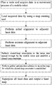
- the present invention provides a method for creating a map based on 3D laser, comprising the following steps: S1: planning a route and acquiring data in a movement process of a mobile robot; S2: loading acquired data by using a map creating tool; S3: performing initial alignment to adjacent laser data; S4: performing accurate alignment to adjacent laser data; S5: performing closed-loop association to the same area passed through by the mobile robot and establishing a closed-loop constraint; S6: performing global optimization solution to an entire map for which the closed-loop constraint is established; and S7: superposing all laser data and outputting a laser map.
- step S1 comprises: planning the route according to one or more of the following rules: (i) firstly walking along a large closed-loop route and then walking along internal small closed-loop routes; (ii) avoiding walking back and forth on the same route as much as possible; and (iii) closing closeable routes as much as possible.
- step S1 comprises: acquiring mileage data, inertial navigation data and laser data in a walking process of the mobile robot.
- step S1 comprises: recurring a walking track of the mobile robot by combining the mileage data and the inertial navigation data, then continuously determining the walking of the mobile robot, and saving a frame of laser data every certain distance of walking or certain angle of rotation.
- step S3 comprises: performing track recursion computation to the walking track of the mobile robot by using the mileage data and the inertial navigation data, and then superposing each frame of laser data saved in the walking process according to positions obtained through track recursion to complete initial alignment of laser data.
- step S4 comprises: using an initial assignment result obtained in step S3 as an initial value of alignment of two adjacent frames of laser data and performing accurate alignment to the two adjacent frames of laser by using normal distribution transform.
- step S4 comprises: updating the walking track of the mobile robot by using a pose obtained through accurate alignment.
- step S5 comprises: traversing the laser data in the walking process of the mobile robot and associating data of the same area passed through by the mobile robot.
- step S5 comprises: S5.1: selecting laser data to which closed-loop association can be performed and moving the laser data to relative poses which are capable of being aligned to obtain an initial matching value; and S5.2: performing accurate alignment based on the obtained initial matching value through normal distribution transform to obtain accurate relative poses of two frames of closed-loop laser data.
- step S5 comprises: performing closed-loop association in an automatic and/or manual manner.
- step S6 comprises: solving an optimal global pose of each frame of laser data acquired by the mobile robot from the angle of probability according to a matching relation between adjacent frames of laser data and a matching relation of laser data established by means of loop closing.
- step S7 comprises: superposing the laser data with the global pose and transforming all laser data into a unified coordinate system to obtain laser data of the unified coordinate system.
- the present invention provides a system for creating a map based on 3D laser, comprising:
- a route planning module configured to manually plan a walking route of a mobile robot aiming at an actual scenario for which a map needs to be created
- a data acquisition module comprising: the mobile robot configured to be capable of moving or walking according to preset instructions or in a real-time control manner; sensors comprising a milemeter, inertial navigation and a 3D laser; and a data acquisition device loaded on the mobile robot and configured to be capable of acquiring various sensor data in a walking process of the mobile robot; a map creating module comprising: a data loading module configured to be capable of loading the acquired various data; an initial alignment module configured to be capable of performing initial alignment to laser data by using the loaded data to obtain an initial value; an accurate alignment module configured to be capable of further performing accurate alignment to the laser data based on the initial value; a closed-loop association module configured to be capable of performing closed-loop association to the same area passed through by the mobile robot and establishing a closed-loop constraint; and a global optimization module configured to be capable of performing global optimization solution to an entire map for which the closed-loop constraint is established; and a map outputting module configured to be capable of outputting a laser map based on a
- the route planning module is configured to manually plan the route according to one or more of the following rules: (i) firstly walking along a large closed-loop route and then walking along internal small closed-loop routes; (ii) avoiding walking back and forth on the same route as much as possible; and (iii) closing closeable routes as much as possible.
- the data acquisition module is configured to be capable of acquiring mileage data, inertial navigation data and laser data in the walking process of the mobile robot.
- the data acquisition module is configured to be capable of recurring a walking track of the mobile robot by combining the mileage data and the inertial navigation data, continuously determining the walking of the mobile robot, and saving a frame of the laser data every certain distance of walking or certain angle of rotation.
- the initial alignment module is configured to be capable of performing track recursion computation to the walking track of the mobile robot by using the mileage data and the inertial navigation data, and then superposing each frame of laser data saved in the walking process according to positions obtained through track recursion.
- the accurate alignment module is configured to be capable of using an initial assignment result as an initial value of alignment of two adjacent frames of laser data and performing accurate alignment to two adjacent frames of laser by using normal distribution transform.
- the accurate alignment module is configured to be capable of updating the walking track of the mobile robot by using a pose obtained through accurate alignment.
- the closed-loop association module is configured to be capable of traversing the laser data in the walking process of the mobile robot and associating data of the same area passed through by the mobile robot.
- the closed-loop association module is configured to be capable of selecting laser data to which closed-loop association can be performed and moving the laser data to relative poses which are capable of being aligned to obtain an initial matching value, and be capable of performing accurate alignment based on the obtained initial matching value through normal distribution transform to obtain accurate relative poses of two frames of closed-loop laser data.
- the closed-loop association module is configured to be capable of performing closed-loop association in an automatic and/or manual manner.
- the global optimization module is configured to be capable of solving an optimal global pose of each frame of laser data acquired by the mobile robot from the angle of probability according to a matching relation between adjacent frames of laser data and a matching relation of laser data established by means of loop closing.
- the map outputting module is configured to be capable of superposing the laser data with the global pose and transforming all laser data into a unified coordinate system to obtain laser data of the unified coordinate system.
- the above-mentioned method and system provided by the present invention do not depend on GPS and are not restricted by GPS signals; no surveying and mapping device such as a total station is used and cumbersome surveying and mapping operations are avoided; a manual loop closing method can be used and large-scale maps of various indoor and outdoor environments can be created; and data acquisition can be separated from map creation, maps can be finely adjusted off line and high-accuracy maps can be created.
- FIG. 1 is a flowchart of steps in a method for creating a map in one embodiment of the present invention
- FIG. 2 is a schematic diagram of a map creating tool in one embodiment of the present invention.
- FIG. 3 is a schematic diagram of a 3D laser map in one embodiment of the present invention.
- FIG. 4 is a schematic diagram of modules of a map creating system in one embodiment of the present invention.
- a high-accuracy 3D map is very important to a mobile robot, and it is a prior condition for autonomous walking of the mobile robot and is also a premise for the mobile robot to accurately go to a point to execute a task. Therefore, researches on reliable, high-efficiency and high-quality methods for creating 3D maps have a very important significance.
- FIG. 1 illustrates a flowchart of steps in a method for creating a map in one embodiment of the present invention, and a process thereof mainly comprises the following steps:
- a reasonable data acquisition route is planned and a data acquisition device is used to acquire various relevant data or information in the movement process of the robot.
- planning and acquisition may be performed according to the following basic rules:
- routes can be simplified as much as possible to decrease the total length of routes walked along by the robot, so as to decrease the volume of data required to be acquired and accelerate the overall acquisition speed of data; and on the other hand, closed routes can be formed as many as possible to facilitate subsequent processing and improve creation efficiency.
- the data acquisition device loaded on the mobile robot can be enabled, and the robot is controlled to run or move along a planned route, and simultaneously, various data or information such as mileage data, inertial navigation data and 3D laser data in the walking process of the robot are acquired.
- various data or information such as mileage data, inertial navigation data and 3D laser data in the walking process of the robot are acquired.
- the laser data are screened and saved according to certain conditions.
- a specific manner is to recur a walking track of the mobile robot by combining the mileage data and the inertial navigation data, then continuously determine the walking of the mobile robot, and save a frame of laser data every certain distance of walking or certain angle of rotation (such as 1 m or 30°).
- FIG. 2 illustrates a schematic diagram of a map creating tool in one embodiment of the present invention.
- various acquired data can be imported to perform various corresponding operations and set or adjust various corresponding parameters.
- one or more of the following parameters may be set or adjusted when data are loaded: a pixel scale, a point size, a loading ID and range, a laser frame pose, whether to track, a height difference, a radius, a minimum point quantity, a leaf size, coordinates and the like; and one or more of the following operations may also be performed: selecting a surveying and mapping file path, selecting a DrNode file, loading, saving a graph, loading a graph, loading a single point cloud file, optimizing, saving a graph and a point cloud, canceling, increasing an edge, deleting an edge, resetting an edge, deleting a laser frame, fixing a laser frame, unfixing a laser frame, adjusting a height difference, loading a point cloud, saving a point cloud, filtering and the like.
- the map creating tool may also intuitively display the map in the processing process and dynamically update and present it according to different operations, so as to facilitate adjustment and processing performed to map data.
- the acquired data are loaded into the map creating tool to process the map data to create a map.
- fine adjustment can be repetitively made to the map off line and high-accuracy varied-scale 3D maps can be created.
- Initial alignment is performed to laser data.
- track recursion computation may be performed to the walking track of the mobile robot by using the mileage data and the inertial navigation data, and then each frame of laser data saved in the walking process is superposed according to positions obtained through track recursion to complete initial alignment of laser data.
- a principle of track recursion is as follows:
- an initial pose may be provided for each frame of laser data through track recursion, and this initial pose is used as an initial value for alignment of two adjacent frames of laser data and then accurate alignment is performed to the two adjacent frames of laser by using NDT (Normal Distribution Transform), such that not only can the alignment speed be improved, but also the situation that the alignment falls into the situation of local optimization can be avoided, and a failure of alignment in case of poor laser data can be effectively avoided.
- NDT Normal Distribution Transform
- Closed-loop association is performed to the same area passed through by the mobile robot and a closed-loop constraint is established. That is, the robot walks through the same place for many times, the laser scans the same structures at each time of walking, the same structures are associated to obtain relative poses of closed-loop laser frame data after association.
- the first uncertainty is that similar areas often exist in the environment, and similar areas may be easily detected as a closed loop since features are relatively few for the laser data
- the second uncertainty is that, for a poorly structured area, laser data do not have stable features which can be extracted to perform closed loop computation
- the third uncertainty is that laser poses always have certain errors, such that laser data of the same place may be relatively far in the computed track, and consequently the failure rate of closed-loop association may be relatively high.
- a manual loop closing operation manner may be selected or a manual loop closing operation manner may be added based on automatic loop closing.
- a specific method for closed-loop association is to traverse laser data in the walking process of the robot, observe data of repetitively walked-through places and associate these data.
- the method comprises the following two steps:
- a manual loop closing manner can perform more accurate loop closing to any environment walked through by the mobile robot, can adapt to outdoor poorly structured scenarios and can create large-size maps of various indoor and outdoor environments.
- All above-mentioned steps belong to matching of laser data, and the matching includes alignment of two adjacent frames of laser data and closed-loop matching of data of the same place.
- global optimization solution may be performed to an entire map for which the closed-loop constraint is established by using graph optimization.
- global optimization solution is performed to the walking track of the robot after matching, and an optimal global pose of each frame of laser data acquired by the mobile robot is solved from the angle of probability by simultaneously considering a matching relation between adjacent frames of laser data and a matching relation of laser data established by means of loop closing.
- global solution may be performed by using g2o (general graph optimization).
- a 3D laser map is output. Since coordinates of each frame of laser data are coordinates of a coordinate system relative to a laser device at that moment, all laser data may be unified into the same coordinate system to obtain an overall 3D laser map.
- the laser data can be superposed with the global pose of the laser, and all laser data are transformed into a certain unified coordinate system (such as a coordinate system of a first frame of laser) to obtain 3D laser data of the unified coordinate system.
- a certain unified coordinate system such as a coordinate system of a first frame of laser
- the present invention further provides a system for creating a map based on 3D laser, which mainly comprises a route planning module, a data acquisition module, a map creating module and a map outputting module.
- the route planning module is capable of planning a walking route of a mobile robot aiming at an actual area for which a map needs to be created.
- route planning may be performed through an automatic route planning algorithm
- a route planning aid tool may also be used to perform route planning in a manual manner or combined automatic and manual manners.
- the data acquisition module mainly comprises: the mobile robot capable of moving or walking according to preset instructions or in a real-time control manner; sensors comprising a mileage sensor, an inertial navigation sensor and a 3D laser sensor; and a data acquisition device loaded on the mobile robot and capable of acquiring various data such as inertial navigation data, mileage data and laser data in a walking process of the mobile robot.
- sensors comprising a mileage sensor, an inertial navigation sensor and a 3D laser sensor
- a data acquisition device loaded on the mobile robot and capable of acquiring various data such as inertial navigation data, mileage data and laser data in a walking process of the mobile robot.
- an integrated data acquisition device may be used for simultaneously acquiring various data
- different data acquisition devices may also be used for respectively acquiring various data.
- the map creating module mainly comprises: a data loading module capable of loading the acquired various data; an initial alignment module capable of performing initial alignment to laser data by using the loaded data to obtain a better initial value; an accurate alignment module capable of further performing accurate alignment to the laser data based on the initial value; a closed-loop association module capable of performing closed-loop association to the same area passed through by the mobile robot and establishing a closed-loop constraint; and a global optimization module capable of performing global optimization solution to an entire map for which the closed-loop constraint is established.
- the map outputting module is capable of superposing the laser data with the global pose of the laser after the optimal global pose of each frame of laser data is solved, and transforming all laser data into a unified coordinate system to obtain 3D laser data of the unified coordinate system.
- FIG. 4 illustrates a schematic diagram of modules of a map creating system in one embodiment of the present invention.
- Each device and module in the map creating system may be implemented by means of hardware, software or a combination of software and hardware.
- the method and system provided by the present invention do not depend on GPS and are not restricted by GPS signals; and no surveying and mapping device such as a total station need to be used, cumbersome surveying and mapping operations are avoided and thus the operation is simple and convenient to perform, and the efficiency is high.
Landscapes
- Engineering & Computer Science (AREA)
- Physics & Mathematics (AREA)
- Remote Sensing (AREA)
- Radar, Positioning & Navigation (AREA)
- General Physics & Mathematics (AREA)
- Theoretical Computer Science (AREA)
- Geometry (AREA)
- Automation & Control Theory (AREA)
- Software Systems (AREA)
- Computer Networks & Wireless Communication (AREA)
- Computer Graphics (AREA)
- Electromagnetism (AREA)
- Mathematical Physics (AREA)
- Business, Economics & Management (AREA)
- Educational Administration (AREA)
- Educational Technology (AREA)
- Control Of Position, Course, Altitude, Or Attitude Of Moving Bodies (AREA)
Abstract
Description
a map creating module comprising: a data loading module configured to be capable of loading the acquired various data; an initial alignment module configured to be capable of performing initial alignment to laser data by using the loaded data to obtain an initial value; an accurate alignment module configured to be capable of further performing accurate alignment to the laser data based on the initial value; a closed-loop association module configured to be capable of performing closed-loop association to the same area passed through by the mobile robot and establishing a closed-loop constraint; and a global optimization module configured to be capable of performing global optimization solution to an entire map for which the closed-loop constraint is established; and
a map outputting module configured to be capable of outputting a laser map based on a processing result of the map creating module.
Claims (12)
Applications Claiming Priority (1)
| Application Number | Priority Date | Filing Date | Title |
|---|---|---|---|
| PCT/CN2018/072482 WO2019136714A1 (en) | 2018-01-12 | 2018-01-12 | 3d laser-based map building method and system |
Publications (2)
| Publication Number | Publication Date |
|---|---|
| US20200080860A1 US20200080860A1 (en) | 2020-03-12 |
| US10801855B2 true US10801855B2 (en) | 2020-10-13 |
Family
ID=67218427
Family Applications (1)
| Application Number | Title | Priority Date | Filing Date |
|---|---|---|---|
| US15/745,573 Expired - Fee Related US10801855B2 (en) | 2018-01-12 | 2018-01-12 | Method and system for creating map based on 3D laser |
Country Status (2)
| Country | Link |
|---|---|
| US (1) | US10801855B2 (en) |
| WO (1) | WO2019136714A1 (en) |
Families Citing this family (18)
| Publication number | Priority date | Publication date | Assignee | Title |
|---|---|---|---|---|
| CN110567468A (en) * | 2018-06-06 | 2019-12-13 | 百度在线网络技术(北京)有限公司 | Road track acquisition method, device and storage medium |
| CN110861082B (en) * | 2019-10-14 | 2021-01-22 | 北京云迹科技有限公司 | Auxiliary mapping method and device, mapping robot and storage medium |
| DE102020205064A1 (en) * | 2020-04-22 | 2021-10-28 | Robert Bosch Gesellschaft mit beschränkter Haftung | Method for reducing ambiguities in the representation and registration of point clouds using laser scanners |
| CN111912417B (en) * | 2020-07-10 | 2022-08-02 | 上海商汤临港智能科技有限公司 | Map construction method, map construction device, map construction equipment and storage medium |
| CN112102400B (en) * | 2020-09-15 | 2022-08-02 | 上海云绅智能科技有限公司 | Distance-based closed loop detection method and device, electronic equipment and storage medium |
| CN112099509B (en) * | 2020-09-24 | 2024-05-28 | 杭州海康机器人股份有限公司 | Map optimization method and device and robot |
| CN112700495B (en) * | 2020-11-25 | 2024-08-16 | 北京旷视机器人技术有限公司 | Pose determination method, pose determination device, robot, electronic equipment and storage medium |
| CN112595322B (en) * | 2020-11-27 | 2024-05-07 | 浙江同善人工智能技术有限公司 | A laser SLAM method integrating ORB closed-loop detection |
| CN114603552B (en) * | 2020-12-08 | 2024-05-10 | 北京配天技术有限公司 | Robot simulation method, electronic equipment and storage medium |
| CN113050116B (en) * | 2021-03-05 | 2024-02-27 | 深圳市优必选科技股份有限公司 | Robot positioning method, device, robot and readable storage medium |
| CN113405544B (en) * | 2021-05-08 | 2024-02-09 | 中电海康集团有限公司 | Mobile robot map building and positioning method and system |
| CN113532421B (en) * | 2021-06-30 | 2024-04-26 | 同济人工智能研究院(苏州)有限公司 | A dynamic laser SLAM method based on sub-image updating and reflector optimization |
| CN113670290B (en) * | 2021-06-30 | 2023-05-12 | 西南科技大学 | Mobile robot indoor map construction method based on multi-robot cooperation |
| CN113625320B (en) * | 2021-08-06 | 2023-10-24 | 恩际艾科技(苏州)有限公司 | Outdoor combined positioning method based on differential GPS and reflector |
| CN113624239B (en) * | 2021-08-11 | 2024-05-31 | 火种源码(中山)科技有限公司 | Laser mapping method and device based on hierarchical switchable sparse pose graph optimization |
| CN114812538B (en) * | 2022-04-20 | 2025-08-26 | 上海擎朗智能科技有限公司 | Map construction method, robot and computer-readable storage medium |
| CN115546348B (en) * | 2022-11-24 | 2023-03-24 | 上海擎朗智能科技有限公司 | Robot mapping method and device, robot and storage medium |
| CN116718177A (en) * | 2023-05-26 | 2023-09-08 | 华东理工大学 | A mobile positioning method and mobile positioning device |
Citations (8)
| Publication number | Priority date | Publication date | Assignee | Title |
|---|---|---|---|---|
| CN104914865A (en) | 2015-05-29 | 2015-09-16 | 国网山东省电力公司电力科学研究院 | Transformer station inspection tour robot positioning navigation system and method |
| CN104964683A (en) | 2015-06-04 | 2015-10-07 | 上海物景智能科技有限公司 | A closed-loop correction method for indoor environment map creation |
| CN105702151A (en) | 2016-03-31 | 2016-06-22 | 百度在线网络技术(北京)有限公司 | Indoor map constructing method and device |
| WO2016162568A1 (en) | 2015-04-10 | 2016-10-13 | The European Atomic Energy Community (Euratom), Represented By The European Commission | Method and device for real-time mapping and localization |
| CN106153048A (en) | 2016-08-11 | 2016-11-23 | 广东技术师范学院 | A kind of robot chamber inner position based on multisensor and Mapping System |
| CN106767827A (en) * | 2016-12-29 | 2017-05-31 | 浙江大学 | A kind of mobile robot point cloud map creating method based on laser data |
| US20180307941A1 (en) * | 2017-04-21 | 2018-10-25 | X Development Llc | Methods and Systems for Simultaneous Localization and Calibration |
| CN109900269A (en) * | 2017-12-07 | 2019-06-18 | 广州映博智能科技有限公司 | A kind of map path planing method |
-
2018
- 2018-01-12 US US15/745,573 patent/US10801855B2/en not_active Expired - Fee Related
- 2018-01-12 WO PCT/CN2018/072482 patent/WO2019136714A1/en not_active Ceased
Patent Citations (8)
| Publication number | Priority date | Publication date | Assignee | Title |
|---|---|---|---|---|
| WO2016162568A1 (en) | 2015-04-10 | 2016-10-13 | The European Atomic Energy Community (Euratom), Represented By The European Commission | Method and device for real-time mapping and localization |
| CN104914865A (en) | 2015-05-29 | 2015-09-16 | 国网山东省电力公司电力科学研究院 | Transformer station inspection tour robot positioning navigation system and method |
| CN104964683A (en) | 2015-06-04 | 2015-10-07 | 上海物景智能科技有限公司 | A closed-loop correction method for indoor environment map creation |
| CN105702151A (en) | 2016-03-31 | 2016-06-22 | 百度在线网络技术(北京)有限公司 | Indoor map constructing method and device |
| CN106153048A (en) | 2016-08-11 | 2016-11-23 | 广东技术师范学院 | A kind of robot chamber inner position based on multisensor and Mapping System |
| CN106767827A (en) * | 2016-12-29 | 2017-05-31 | 浙江大学 | A kind of mobile robot point cloud map creating method based on laser data |
| US20180307941A1 (en) * | 2017-04-21 | 2018-10-25 | X Development Llc | Methods and Systems for Simultaneous Localization and Calibration |
| CN109900269A (en) * | 2017-12-07 | 2019-06-18 | 广州映博智能科技有限公司 | A kind of map path planing method |
Also Published As
| Publication number | Publication date |
|---|---|
| WO2019136714A1 (en) | 2019-07-18 |
| US20200080860A1 (en) | 2020-03-12 |
Similar Documents
| Publication | Publication Date | Title |
|---|---|---|
| US10801855B2 (en) | Method and system for creating map based on 3D laser | |
| US11676307B2 (en) | Online sensor calibration for autonomous vehicles | |
| Li et al. | Multi-sensor fusion for navigation and mapping in autonomous vehicles: Accurate localization in urban environments | |
| He et al. | An integrated GNSS/LiDAR-SLAM pose estimation framework for large-scale map building in partially GNSS-denied environments | |
| US11568559B2 (en) | Localization of a surveying instrument | |
| Georgiev et al. | Localization methods for a mobile robot in urban environments | |
| CN110832279B (en) | Align data captured by autonomous vehicles to generate high-definition maps | |
| CN108921947A (en) | Generate method, apparatus, equipment, storage medium and the acquisition entity of electronic map | |
| CN111958591A (en) | Autonomous inspection method and system for semantic intelligent substation inspection robot | |
| US8510039B1 (en) | Methods and apparatus for three-dimensional localization and mapping | |
| EP3159658A1 (en) | Method and device for real-time target location and map creation | |
| CN111968262A (en) | Semantic intelligent substation inspection operation robot navigation system and method | |
| Herath et al. | Fusion-dhl: Wifi, imu, and floorplan fusion for dense history of locations in indoor environments | |
| CN108332759A (en) | A kind of map constructing method and system based on 3D laser | |
| US9355462B2 (en) | Motion estimation system utilizing point cloud registration | |
| CN109459039A (en) | A kind of the laser positioning navigation system and its method of medicine transfer robot | |
| US20230290055A1 (en) | Surveying assistance system, information display terminal, surveying assistance method, and storage medium storing surveying assistance program | |
| US12462424B2 (en) | Localization of a surveying instrument | |
| He et al. | Camera-odometer calibration and fusion using graph based optimization | |
| US12111151B1 (en) | Method and device for generating trajectory diagram | |
| CN115375861A (en) | Three-dimensional mapping method, device and storage medium for unmanned mining area | |
| CN112729252B (en) | Tunnel laser point cloud collection method based on robot platform and robot system | |
| Li et al. | SLAM of mobile robot based on the joint optimization of LiDAR and camera | |
| CN115685153A (en) | A laser radar calibration method, device, equipment and storage medium | |
| Wilcox et al. | A vision system for a mars rover |
Legal Events
| Date | Code | Title | Description |
|---|---|---|---|
| FEPP | Fee payment procedure |
Free format text: ENTITY STATUS SET TO UNDISCOUNTED (ORIGINAL EVENT CODE: BIG.); ENTITY STATUS OF PATENT OWNER: LARGE ENTITY |
|
| AS | Assignment |
Owner name: ZHEJIANG GUOZI ROBOT TECHNOLOGY CO., LTD., CHINA Free format text: ASSIGNMENT OF ASSIGNORS INTEREST;ASSIGNORS:HUANG, HONG;TAO, YIKUN;LIU, JIE;AND OTHERS;REEL/FRAME:051493/0809 Effective date: 20180305 |
|
| STPP | Information on status: patent application and granting procedure in general |
Free format text: NON FINAL ACTION MAILED |
|
| STPP | Information on status: patent application and granting procedure in general |
Free format text: RESPONSE TO NON-FINAL OFFICE ACTION ENTERED AND FORWARDED TO EXAMINER |
|
| STPP | Information on status: patent application and granting procedure in general |
Free format text: PUBLICATIONS -- ISSUE FEE PAYMENT VERIFIED |
|
| STCF | Information on status: patent grant |
Free format text: PATENTED CASE |
|
| FEPP | Fee payment procedure |
Free format text: MAINTENANCE FEE REMINDER MAILED (ORIGINAL EVENT CODE: REM.); ENTITY STATUS OF PATENT OWNER: LARGE ENTITY |
|
| LAPS | Lapse for failure to pay maintenance fees |
Free format text: PATENT EXPIRED FOR FAILURE TO PAY MAINTENANCE FEES (ORIGINAL EVENT CODE: EXP.); ENTITY STATUS OF PATENT OWNER: LARGE ENTITY |
|
| STCH | Information on status: patent discontinuation |
Free format text: PATENT EXPIRED DUE TO NONPAYMENT OF MAINTENANCE FEES UNDER 37 CFR 1.362 |
|
| FP | Lapsed due to failure to pay maintenance fee |
Effective date: 20241013 |