JP5702476B2 - Display device, control method, program, storage medium - Google Patents
Display device, control method, program, storage medium Download PDFInfo
- Publication number
- JP5702476B2 JP5702476B2 JP2013555061A JP2013555061A JP5702476B2 JP 5702476 B2 JP5702476 B2 JP 5702476B2 JP 2013555061 A JP2013555061 A JP 2013555061A JP 2013555061 A JP2013555061 A JP 2013555061A JP 5702476 B2 JP5702476 B2 JP 5702476B2
- Authority
- JP
- Japan
- Prior art keywords
- mark
- guidance information
- display
- image
- building
- Prior art date
- Legal status (The legal status is an assumption and is not a legal conclusion. Google has not performed a legal analysis and makes no representation as to the accuracy of the status listed.)
- Active
Links
Images


Classifications
-
- G—PHYSICS
- G01—MEASURING; TESTING
- G01C—MEASURING DISTANCES, LEVELS OR BEARINGS; SURVEYING; NAVIGATION; GYROSCOPIC INSTRUMENTS; PHOTOGRAMMETRY OR VIDEOGRAMMETRY
- G01C21/00—Navigation; Navigational instruments not provided for in groups G01C1/00 - G01C19/00
- G01C21/26—Navigation; Navigational instruments not provided for in groups G01C1/00 - G01C19/00 specially adapted for navigation in a road network
- G01C21/34—Route searching; Route guidance
- G01C21/36—Input/output arrangements for on-board computers
- G01C21/3626—Details of the output of route guidance instructions
- G01C21/3635—Guidance using 3D or perspective road maps
- G01C21/3638—Guidance using 3D or perspective road maps including 3D objects and buildings
Description
本発明は、情報を表示する技術に関する。 The present invention relates to a technique for displaying information.
従来から、車両に進行方向を撮影するカメラを設置し、当該カメラから取得された実写画像を用いて案内を行うナビゲーション装置が知られている。例えば、特許文献1には、車両前方の風景画像にナビゲーション情報(案内情報)を重畳表示させる技術が開示されている。
2. Description of the Related Art Conventionally, a navigation apparatus is known in which a camera that captures a traveling direction is installed on a vehicle and guidance is performed using a real image acquired from the camera. For example,
実写画像に案内ルートなどの案内情報を表すCG(Computer Graphics)画像を重畳させる場合、実際には建物により遮蔽されて見えない道路等に対応する表示が実写画像に重畳して表示されてしまう。この場合、実写画像にCG画像を重畳させることで奥行き感が失われ、ユーザは、建物とCG画像に対応する道路等との距離感が掴みにくくなるという問題がある。 When superimposing a CG (Computer Graphics) image representing guidance information such as a guidance route on a live-action image, a display corresponding to a road or the like that is actually shielded by a building and is not visible is displayed superimposed on the live-action image. In this case, there is a problem that the sense of depth is lost by superimposing the CG image on the photographed image, and the user has difficulty grasping the sense of distance between the building and the road corresponding to the CG image.
本発明は、上記のような課題を解決するためになされたものであり、実写画像に案内情報を重畳表示させた場合であっても、適切に奥行き感を保つことが可能な表示装置並びにその制御方法及びプログラムを提供することを主な目的とする。 The present invention has been made to solve the above-described problems, and a display device capable of appropriately maintaining a sense of depth even when guidance information is superimposed and displayed on a live-action image and its display The main purpose is to provide a control method and a program.
請求項1に記載の発明では、実写画像上に案内情報を重畳させて表示する表示装置であって、前記案内情報と前記実写画像中の有体物との重畳部分を特定する特定手段と、前記重畳部分のうち、前記案内情報よりも前記有体物が前面に表示されるべき遮蔽部分を除外した前記案内情報を、前記実写画像に重畳させて表示する表示制御手段と、を有し、前記表示制御手段は、前記実写画像内の施設を示すマークを、前記案内情報として前記実写画像上に重畳させて表示し、前記表示制御手段は、前記マークのうち、経路案内の目印となるマークについて、前記遮蔽部分を除外して表示し、前記経路案内の目印となるマーク以外のマークについては、前記遮蔽部分を除外せずに表示することを特徴とする。
The invention according to
請求項6に記載の発明では、実写画像上に案内情報を重畳させて表示する表示装置が実行する制御方法であって、前記案内情報と前記実写画像中の有体物との重畳部分を特定する特定工程と、前記重畳部分のうち、前記案内情報よりも前記有体物が前面に表示されるべき遮蔽部分を除外した前記案内情報を、前記実写画像に重畳させて表示する表示制御工程と、を有し、前記表示制御工程は、前記実写画像内の施設を示すマークを、前記案内情報として前記実写画像上に重畳させて表示し、前記表示制御工程は、前記マークのうち、経路案内の目印となるマークについて、前記遮蔽部分を除外して表示し、前記経路案内の目印となるマーク以外のマークについては、前記遮蔽部分を除外せずに表示することを特徴とする。
The invention according to claim 6, a control method of the display device performs displaying by superimposing the guidance information to the photographed image, identifying the overlapping portion of the pre-Symbol guidance information and tangible in said photographed image And a display control step of displaying the guidance information excluding the shielding portion where the tangible object is to be displayed in front of the guidance information in the superimposition portion so as to be superimposed on the photographed image. In the display control step, a mark indicating the facility in the live-action image is displayed as the guidance information superimposed on the live-action image, and the display control step includes a route guidance mark of the mark. for made mark, the display by excluding the shielding portion, the mark other than a mark serves as a mark of the route guidance, and displaying without excluding the shielding portion.
請求項7に記載の発明では、実写画像上に案内情報を重畳させて表示する表示装置が実行するプログラムであって、前記案内情報と前記実写画像中の有体物との重畳部分を特定する特定手段と、前記重畳部分のうち、前記案内情報よりも前記有体物が前面に表示されるべき遮蔽部分を除外した前記案内情報を、前記実写画像に重畳させて表示する表示制御手段として前記表示装置を機能させ、前記表示制御手段は、前記実写画像内の施設を示すマークを、前記案内情報として前記実写画像上に重畳させて表示し、前記表示制御手段は、前記マークのうち、経路案内の目印となるマークについて、前記遮蔽部分を除外して表示し、前記経路案内の目印となるマーク以外のマークについては、前記遮蔽部分を除外せずに表示することを特徴とする。 The invention according to claim 7, a program display unit executes the display by superimposing the guidance information to the photographed image, to identify the overlapping portion of the pre-Symbol guidance information and tangible in said photographed image specification And the display device as display control means for displaying the guidance information excluding the shielding portion where the tangible object is to be displayed in front of the guidance information among the superimposed information, and superimposing it on the photographed image. The display control means displays a mark indicating the facility in the live-action image superimposed on the live-action image as the guide information, and the display control means includes a route guidance mark among the marks. for mark serving as the display by excluding the shielding portion, the mark other than a mark serves as a mark of the route guidance, and displaying without excluding the shielding portion
本発明の1つの好適な実施形態では、カメラにより撮影した実写画像上に案内情報を重畳させて表示する表示装置であって、撮影位置と、前記カメラの撮影範囲に存在する建物の位置情報及び家形情報と、案内情報に対応する施設又は道路の位置情報とに基づき、前記案内情報と前記実写画像中の建物との重畳部分を特定する特定手段と、前記重畳部分のうち、前記案内情報よりも前記建物が前面に表示されるべき部分を除外した前記案内情報を、前記実写画像に重畳させて表示する表示制御手段と、を有する。 In one preferred embodiment of the present invention, there is provided a display device that superimposes and displays guidance information on a real image photographed by a camera, the photographing position, position information of a building existing in the photographing range of the camera, and Based on the house shape information and the location information of the facility or road corresponding to the guidance information, the specifying means for identifying a superimposed portion of the guidance information and the building in the live-action image, and the guidance information of the superimposed portion Display control means for displaying the guidance information excluding the part where the building should be displayed on the front side, superimposed on the photographed image.
上記表示装置は、例えばナビゲーション装置であって、カメラにより撮影した実写画像上に案内情報を重畳させて表示する。表示装置は、特定手段と、表示制御手段とを備える。特定手段は、撮影位置と、カメラの撮影範囲に存在する建物の位置情報及び家形情報と、案内情報に対応する施設又は道路の位置情報とに基づき、案内情報と実写画像中の建物との重畳部分を特定する。表示制御手段は、重畳部分のうち、案内情報よりも建物が前面に表示されるべき遮蔽部分を除外した案内情報を、実写画像に重畳させて表示する。 The display device is, for example, a navigation device, and displays guidance information superimposed on a real image taken by a camera. The display device includes a specifying unit and a display control unit. Based on the shooting position, the position information of the building and the house shape information existing in the shooting range of the camera, and the position information of the facility or road corresponding to the guidance information, the specifying means Specify the overlapping part. The display control means superimposes and displays the guidance information excluding the shielding portion where the building should be displayed in front of the guidance information, in the superimposition portion.
一般に、実写画像に案内情報を重畳させた際、実際には建物により遮蔽されて見えない道路又は施設に対応する案内情報が実写画像に重畳して表示されると、奥行き感が失われてしまう。以上を勘案し、上述の表示装置は、案内情報のうち、案内情報よりも建物が前面に表示されるべき遮蔽部分を除外して実写画像に重畳表示させる。このようにすることで、表示装置は、実写画像と案内情報とを重畳させた場合であっても、奥行き感を維持することができる。 In general, when guidance information is superimposed on a live-action image, the sense of depth is lost if guidance information corresponding to a road or facility that is actually shielded by a building is not visible. . In consideration of the above, the above-described display device superimposes and displays on the live-action image, excluding the shielding information where the building should be displayed on the front side of the guidance information. In this way, the display device can maintain a sense of depth even when the photographed image and the guidance information are superimposed.
上記表示装置の一態様では、前記特定手段は、前記建物を当該建物の位置情報及び家形情報に基づき略透明に描画し、かつ、前記案内情報を前記施設又は道路の位置情報に基づき描画することで、前記重畳部分を特定し、前記表示制御手段は、略透明に描画された建物と、前記遮蔽部分を除外した前記案内情報とを合わせた合成画像を生成し、当該合成画像を前記実写画像に重畳表示させる。この態様により、表示装置は、好適に、実写画像と案内情報との重畳部分を特定することができる。また、表示装置は、建物を略透明に描くことで、実写画像に合成画像を重畳表示させた場合であっても、案内情報の遮蔽部分を除外するために描いた建物の表示が残るのを防ぐことができる。 In one aspect of the display device, the specifying unit renders the building substantially transparent based on the location information and house shape information of the building, and draws the guidance information based on the location information of the facility or road. Thus, the superimposed portion is specified, and the display control means generates a composite image combining the building drawn substantially transparently and the guidance information excluding the shielding portion, and the composite image is taken as the actual image. Overlay the image. According to this aspect, the display device can preferably specify the overlapping portion between the photographed image and the guidance information. In addition, the display device draws the building substantially transparent, so that the display of the building drawn to exclude the shielding portion of the guidance information remains even when the composite image is superimposed on the live-action image. Can be prevented.
上記表示装置の他の一態様では、前記表示制御手段は、前記合成画像を生成する場合、前記案内情報より先に略透明な建物を描画し、その後、前記重畳部分のうち、前記遮蔽部分以外の部分を対象に、略透明に描画した建物と前記案内情報との色の混合処理を行う。この態様により、表示装置は、好適に、遮蔽部分を除外した案内情報を表した合成画像を生成することができる。 In another aspect of the display device, when generating the composite image, the display control unit draws a substantially transparent building prior to the guidance information, and then, other than the shielding portion of the overlapping portion. For this part, color mixing processing of the building drawn substantially transparent and the guidance information is performed. According to this aspect, the display device can preferably generate a composite image representing the guidance information excluding the shielding portion.
上記表示装置の他の一態様では、前記表示制御手段は、移動体が走行すべきルートを、前記案内情報として前記実写画像上に重畳させて表示する。この態様により、表示装置は、表示すべき案内ルートのち、建物によって遮蔽される部分を好適に非表示とすることができ、実写画像に案内情報を重ねた場合でも奥行き感を維持することができる。 In another aspect of the display device, the display control unit displays a route on which the moving body should travel as being superimposed on the photographed image as the guidance information. According to this aspect, the display device can preferably hide the portion of the guide route to be displayed that is blocked by the building, and can maintain a sense of depth even when the guide information is superimposed on the photographed image. .
上記表示装置の他の一態様では、前記表示制御手段は、前記ルートの表示を、当該ルートに対応する道路の上空の位置に上下反転させて表示する。この態様によっても、表示装置は、表示すべき案内ルートのち、建物によって遮蔽される部分を好適に非表示とすることができ、実写画像に案内情報を重ねた場合でも奥行き感を維持することができる。 In another aspect of the above display device, the display control means displays the route display upside down at a position above the road corresponding to the route. Also according to this aspect, the display device can suitably hide the portion of the guide route to be displayed that is blocked by the building, and can maintain a sense of depth even when the guide information is superimposed on the photographed image. it can.
上記表示装置の他の一態様では、前記表示制御手段は、前記実写画像内の施設に対応した位置に、当該施設を示すマークを、前記案内情報として前記実写画像上に重畳させて表示する。この態様により、表示装置は、施設を表すマークであっても、当該施設より手前に存在する建物によって遮蔽される部分を好適に非表示とすることができる。 In another aspect of the display device, the display control unit displays a mark indicating the facility on the position corresponding to the facility in the photographed image as the guide information superimposed on the photographed image. According to this aspect, even if the display device is a mark representing a facility, a portion shielded by a building existing in front of the facility can be suitably hidden.
上記表示装置の他の一態様では、前記表示制御手段は、前記マークのうち、経路案内の目印となる前記実写画像内の施設に対して付されるマークのみについて、前記遮蔽部分を除外して表示する。このようにすることで、ユーザは、運転時に目印となる施設の位置を誤認することなく正確に把握することができる。 In another aspect of the display device, the display control unit excludes the shielding portion only for the mark attached to the facility in the live-action image serving as a guide for route guidance. indicate. By doing in this way, the user can grasp | ascertain correctly, without misidentifying the position of the plant | facility used as a mark at the time of a driving | operation.
本発明の他の好適な実施形態では、カメラにより撮影した実写画像上に案内情報を重畳させて表示する表示装置であって、前記実写画像は、第一建物画像と、前記第一建物画像よりも前記カメラから遠方に位置する建物の画像である第二建物画像とを含み、前記実写画像において前記第一建物画像と前記第二建物画像の間にあるルートを示す前記案内情報を表示する際には、前記案内情報を前記実写画像内において前記第二建物画像よりも前記カメラ側に表示させ、且つ、前記第一建物画像を前記案内情報の一部を遮って前記カメラ側に表示させることを特徴とする。表示装置は、この態様によっても、実写画像と案内情報とを重畳させた場合に、奥行き感を好適に維持することができる。 In another preferred embodiment of the present invention, there is provided a display device that displays guidance information superimposed on a live-action image photographed by a camera, wherein the live-action image includes a first building image and the first building image. And a second building image that is an image of a building located far from the camera, and displaying the guidance information indicating a route between the first building image and the second building image in the live-action image The guide information is displayed on the camera side with respect to the second building image in the live-action image, and the first building image is displayed on the camera side while blocking part of the guide information. It is characterized by. Even in this aspect, the display device can suitably maintain the sense of depth when the photographed image and the guidance information are superimposed.
上記表示装置の一態様では、前記表示制御手段は、前記第一建物画像を前記案内情報に重畳させて表示させる。表示装置は、この態様により、案内情報より前面に第一建物画像を表示することができ、奥行き感を好適に維持することができる。 In one aspect of the display device, the display control unit causes the first building image to be displayed superimposed on the guidance information. According to this aspect, the display device can display the first building image in front of the guidance information, and can preferably maintain a feeling of depth.
本発明の他の好適な実施形態では、カメラにより撮影した実写画像上に案内情報を重畳させて表示する表示装置が実行する制御方法であって、撮影位置と、前記カメラの撮影範囲に存在する建物の位置情報及び家形情報と、案内情報に対応する施設又は道路の位置情報とに基づき、前記案内情報と前記実写画像中の建物との重畳部分を特定する特定工程と、前記重畳部分のうち、前記案内情報よりも前記建物が前面に表示されるべき遮蔽部分を除外した前記案内情報を、前記実写画像に重畳させて表示する表示制御工程と、を有する。表示装置は、この制御方法を使用することで、実写画像と案内情報とを重畳させた場合であっても、奥行き感を好適に維持することができる。 In another preferred embodiment of the present invention, there is provided a control method executed by a display device that superimposes and displays guidance information on a real image taken by a camera, and is present in a shooting position and a shooting range of the camera. Based on the location information and house shape information of the building, and the location information of the facility or road corresponding to the guidance information, a specifying step of identifying a superimposed portion of the guidance information and the building in the live-action image, A display control step of displaying the guidance information excluding the shielding portion on which the building is to be displayed on the front of the guidance information in a superimposed manner on the photographed image. By using this control method, the display device can favorably maintain the sense of depth even when the photographed image and the guidance information are superimposed.
本発明の他の好適な実施形態では、カメラにより撮影した実写画像上に案内情報を重畳させて表示する表示方法であって、前記実写画像は、第一建物画像と、前記第一建物画像よりも前記カメラから遠方に位置する建物の画像である第二建物画像とを含み、前記実写画像において前記第一建物画像と前記第二建物画像の間にあるルートを示す前記案内情報を表示する際には、前記案内情報を前記実写画像内において前記第二建物画像よりも前記カメラ側に表示させ、且つ、前記第一建物画像を前記案内情報の一部を遮って前記カメラ側に表示させることを特徴とする表示制御工程を有する。表示装置は、この制御方法を使用した場合であっても、実写画像と案内情報とを重畳させた場合に、奥行き感を好適に維持することができる。 In another preferred embodiment of the present invention, there is provided a display method for displaying guidance information superimposed on a real image taken by a camera, wherein the real image is a first building image and the first building image. And a second building image that is an image of a building located far from the camera, and displaying the guidance information indicating a route between the first building image and the second building image in the live-action image The guide information is displayed on the camera side with respect to the second building image in the live-action image, and the first building image is displayed on the camera side while blocking part of the guide information. A display control step characterized by the above. Even when this display method is used, the display device can suitably maintain the sense of depth when the photographed image and the guidance information are superimposed.
本発明の他の好適な実施形態では、カメラにより撮影した実写画像上に案内情報を重畳させて表示する表示装置が実行するプログラムであって、撮影位置と、前記カメラの撮影範囲に存在する建物の位置情報及び家形情報と、案内情報に対応する施設又は道路の位置情報とに基づき、前記案内情報と前記実写画像中の建物との重畳部分を特定する特定手段と、前記重畳部分のうち、前記案内情報よりも前記建物が前面に表示されるべき遮蔽部分を除外した前記案内情報を、前記実写画像に重畳させて表示する表示制御手段として前記表示装置を機能させる。表示装置は、このプログラムを実行することで、実写画像と案内情報とを重畳させた場合であっても、奥行き感を好適に維持することができる。好適には、上記プログラムは、記憶媒体に記憶される。 In another preferred embodiment of the present invention, there is provided a program executed by a display device that displays guidance information superimposed on a photographed image taken by a camera, wherein the building is located at a shooting position and a shooting range of the camera. Identifying means for identifying a superimposed portion of the guidance information and the building in the live-action image based on the location information and the house shape information of the facility and the location information of the facility or road corresponding to the guidance information, The display device is caused to function as display control means for displaying the guidance information excluding the shielding portion where the building should be displayed in front of the guidance information so as to be superimposed on the photographed image. By executing this program, the display device can preferably maintain a sense of depth even when the photographed image and the guidance information are superimposed. Preferably, the program is stored in a storage medium.
以下、図面を参照して本発明の好適な実施例について説明する。 Hereinafter, preferred embodiments of the present invention will be described with reference to the drawings.
[ナビゲーション装置の構成]
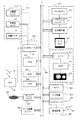
図1は、ナビゲーション装置1の構成を示す。図1に示すように、ナビゲーション装置1は、自立測位装置10、GPS受信機18、システムコントローラ20、ディスクドライブ31、データ記憶ユニット36、通信用インタフェース37、通信装置38、インタフェース39、表示ユニット40、音声出力ユニット50、入力装置60、及びカメラ61を備える。ナビゲーション装置1は、車両の運転者に対し、設定された目的地に従い、カメラ61から取得した実写画像に、目的地に到着するための案内ルートを重畳表示するものとする。[Configuration of navigation device]
FIG. 1 shows the configuration of the
自立測位装置10は、加速度センサ11、角速度センサ12及び距離センサ13を備える。加速度センサ11は、例えば圧電素子からなり、車両の加速度を検出し、加速度データを出力する。角速度センサ12は、例えば振動ジャイロからなり、車両の方向変換時における車両の角速度を検出し、角速度データ及び相対方位データを出力する。距離センサ13は、車両の車輪の回転に伴って発生されているパルス信号からなる車速パルスを計測する。
The
GPS受信機18は、複数のGPS衛星から、測位用データを含む下り回線データを搬送する電波19を受信する。測位用データは、緯度及び経度情報等から車両の絶対的な位置(以後、「現在位置」とも呼ぶ。)を検出するために用いられる。
The
システムコントローラ20は、インタフェース21、CPU(Central Processing Unit)22、ROM(Read Only Memory)23及びRAM(Random Access Memory)24を含んでおり、ナビゲーション装置1全体の制御を行う。
The
インタフェース21は、加速度センサ11、角速度センサ12及び距離センサ13並びにGPS受信機18とのインタフェース動作を行う。そして、これらから、車速パルス、加速度データ、相対方位データ、角速度データ、GPS測位データ、絶対方位データ等をシステムコントローラ20に入力する。CPU22は、システムコントローラ20全体を制御する。ROM23は、システムコントローラ20を制御する制御プログラム等が格納された図示しない不揮発性メモリ等を有する。RAM24は、入力装置60を介して使用者により予め設定された経路データ等の各種データを読み出し可能に格納したり、CPU22に対してワーキングエリアを提供したりする。
The
システムコントローラ20、CD−ROMドライブ又はDVD−ROMドライブなどのディスクドライブ31、データ記憶ユニット36、通信用インタフェース37、表示ユニット40、音声出力ユニット50及び入力装置60は、バスライン30を介して相互に接続されている。
A
ディスクドライブ31は、システムコントローラ20の制御の下、CD又はDVDといったディスク33から、音楽データ、映像データなどのコンテンツデータを読み出し、出力する。なお、ディスクドライブ31は、CD−ROMドライブ又はDVD−ROMドライブのうち、いずれか一方としてもよいし、CD及びDVDコンパチブルのドライブとしてもよい。
The
データ記憶ユニット36は、例えば、HDDなどにより構成され、地図データなどのナビゲーション処理に用いられる各種データを記憶するユニットである。地図データには、道路データや施設情報が含まれる。施設情報には、各施設の名称や各施設の位置情報に加え、施設が建物である場合に当該建物の形状に関する情報(所謂、家形情報)などが含まれる。家形情報は、例えば、建物の立地範囲や高さなどの情報が含まれる。家形情報は、市街地図などをCG画像により表示するために用いられたり、後述する建物に対する案内ルートの奥行判定にも用いられたりする。
The
通信装置38は、例えば、FMチューナやビーコンレシーバ、携帯電話や専用の通信カードなどにより構成され、VICS(Vehicle Information Communication System、登録商標)センタなどから配信される情報(以下、「VICS情報」と呼ぶ。)を電波39より取得する。そしてインタフェース37は、通信装置38のインタフェース動作を行い、VICS情報をシステムコントローラ20等に入力する。
The
表示ユニット40は、システムコントローラ20の制御の下、各種表示データをディスプレイなどの表示装置に表示する。具体的には、システムコントローラ20は、データ記憶ユニット36から地図データを読み出す。表示ユニット40は、システムコントローラ20によってデータ記憶ユニット36から読み出された地図データなどを表示画面上に表示する。表示ユニット40は、バスライン30を介してCPU22から送られる制御データに基づいて表示ユニット40全体の制御を行うグラフィックコントローラ41と、VRAM(Video RAM)等のメモリからなり即時表示可能な画像情報を一時的に記憶するバッファメモリ42と、グラフィックコントローラ41から出力される画像データに基づいて、液晶、CRT(Cathode Ray Tube)等のディスプレイ44を表示制御する表示制御部43と、ディスプレイ44とを備える。ディスプレイ44は、画像表示部として機能し、例えば対角5〜10インチ程度の液晶表示装置等からなり、車内のフロントパネル付近に装着される。
The
音声出力ユニット50は、システムコントローラ20の制御の下、CD−ROMドライブ31又はDVD−ROM32、若しくはRAM24等からバスライン30を介して送られる音声デジタルデータのD/A(Digital to Analog)変換を行うD/Aコンバータ51と、D/Aコンバータ51から出力される音声アナログ信号を増幅する増幅器(AMP)52と、増幅された音声アナログ信号を音声に変換して車内に出力するスピーカ53とを備えて構成されている。
The
入力装置60は、各種コマンドやデータを入力するための、キー、スイッチ、ボタン、リモコン、音声入力装置等から構成されている。入力装置60は、車内に搭載された当該車載用電子システムの本体のフロントパネルやディスプレイ44の周囲に配置される。また、ディスプレイ44がタッチパネル方式の場合、ディスプレイ44の表示画面上に設けられたタッチパネルも入力装置60として機能する。
The
カメラ61は、一定の画角を有し、画角内の被写体を撮影する光学機械である。本実施例では、カメラ61は、車両の前方に向けられ、車両が走行する道路を撮像可能な位置に載置される。そして、カメラ61は、所定の間隔ごとに画像(「実写画像」と呼ぶ。)を生成し、システムコントローラ20へ供給する。
The
[案内ルートの表示方法]
次に、システムコントローラ20が行う案内ルートの表示方法について説明する。概略的には、システムコントローラ20は、案内ルートのうち、前面にある建物により遮蔽されて運転者が視認できない部分(「遮蔽部分」とも呼ぶ。)を除外した画像を実写画像に重畳表示させる。これにより、システムコントローラ20は、案内ルートを実写画像に重畳表示させた場合であっても、奥行き感を維持し、運転者に距離感を的確に掴ませる。[Guidance route display method]
Next, a guide route display method performed by the
この処理について、図2を参照して具体的に説明する。図2は、本実施例に係る処理手順を示すフローチャートの一例である。システムコントローラ20は、図2に示すフローチャートの処理を、例えばカメラ61から実写画像を受信するごとに繰り返し実行する。なお、図2に示す処理手順は、OpenGL(登録商標)やDirectX(登録商標)などの一般的なコンピュータグラフィックスのソフトウェアの処理手順に準じたものであり、これらのソフトウェアにより好適に実行可能である。以下において、「混合(ブレンド)処理」とは、描画されているピクセルの上に、これから描画するもののピクセルの色を混ぜる処理を指す。
This process will be specifically described with reference to FIG. FIG. 2 is an example of a flowchart illustrating a processing procedure according to the present embodiment. The
まず、システムコントローラ20は、家形情報等をデータ記憶ユニット36から読み込む(ステップS101)。具体的には、まず、システムコントローラ20は、GPS受信機18により認識した現在位置を基準としたカメラ61の撮影範囲を特定する。このとき、システムコントローラ20は、例えば、現在位置から車両の進行方向に向かって所定範囲を撮影範囲として特定する。上述の所定範囲は、例えば、カメラ61の設置位置、設置向き、画角等を勘案して予め定められる。次に、システムコントローラ20は、地図データを参照することで撮影範囲内に存在する建物を特定すると共に、特定した建物の家形情報及び位置情報を地図データから読み込む。
First, the
次に、システムコントローラ20は、3次元座標空間に建物を表す透明なポリゴンを描画し、その後案内ルートを描画する(ステップS102)。具体的には、まず、システムコントローラ20は、自車位置を視点とする撮影範囲に対応する3次元座標空間を生成し、当該3次元座標空間中に家形情報から生成したポリゴンを配置する。その後、システムコントローラ20は、案内ルート上の道路と重なる位置に案内ルートを描画する。言い換えると、システムコントローラ20は、案内ルートを、案内ルートに対応する道路と同じ奥行きとなる位置、即ち、任意の建物に対して前面であるか背面であるかの判断が当該道路と同一となる位置に描画する。
Next, the
次に、システムコントローラ20は、3次元座標空間中に描画された建物及び案内ルートをピクセル単位での位置情報及び色情報に変換する処理(即ち、ラスタライズ)を行う(ステップS103)。具体的には、システムコントローラ20は、建物を表したポリゴン及び案内ルートが描画された3次元座標空間をカメラ61の位置から撮影方向に向けて投影させたラスタ画像を生成する。このとき、システムコントローラ20は、建物のポリゴンと案内ルートとが重畳する部分については、まず建物の表示を描画した上で、後述のステップS104の奥行判定処理で案内ルートの表示をさらに描画対象とするか否か判定する。そして、システムコントローラ20は、奥行判定処理により案内ルートを描画対象とすべきと判断した場合にはステップS105で混合処理を行う。
Next, the
次に、システムコントローラ20は、案内ルートの描画対象部分及び非描画対象部分を定める奥行判定処理(所謂デプステスト)を行う(ステップS104)。具体的には、システムコントローラ20は、ラスタライズされたピクセルごとに、建物の表示と案内ルートの表示とが重なるか否か判定する。そして、建物の表示と案内ルートの表示とが重ならない場合、システムコントローラ20は、処理対象のピクセルにおいて、案内ルートを描画対象とする。
Next, the
一方、システムコントローラ20は、処理対象のピクセルにおいて、建物の表示と案内ルートの表示とが重なると判断した場合、さらに、当該建物の表示が当該案内ルートの表示よりも背面にあるか否か判定する。そして、建物の表示が案内ルートの表示よりも背面にある場合には、システムコントローラ20は、処理対象のピクセルにおいて、案内ルートを描画対象とする。一方、システムコントローラ20は、建物の表示が案内ルートの表示よりも前面にある場合には、当該案内ルートの表示を、処理対象のピクセルにおいて描画対象外とする。これにより、案内ルートのうち、建物により遮蔽される部分が描画対象外となる。
On the other hand, when the
このように、システムコントローラ20は、奥行判定処理を後述するステップS105の混合処理より先に行うことで、建物を表すポリゴンを透明に描いた場合であっても、好適に、当該ポリゴンよりも背面にある案内ルートを描画対象から除外することができる。
As described above, the
次に、システムコントローラ20は、混合(ブレンド)処理を行う(ステップS105)。具体的には、システムコントローラ20は、既に透明な建物が描画された画像に対し、奥行判定処理にて描画対象に指定された案内ルートの描画対象部分の混合処理を行う。ここで、建物の表示色は透明に指定されているため、結果として、システムコントローラ20は、案内ルートの描画対象部分のみが表示された画像を生成する。
Next, the
そして、システムコントローラ20は、混合処理により得られたCG画像(合成画像)を実写画像に重畳してディスプレイ44に表示する(ステップS106)。言い換えると、システムコントローラ20は、実写画像を背景画像として、CG画像をディスプレイ44上に表示させる。これにより、システムコントローラ20は、案内ルートのち、建物によって遮蔽される部分を好適に非表示とすることができ、CG画像と実写画像とを重畳させた場合であっても、奥行き感を維持し、運転者に距離感を掴ませることができる。
Then, the
[表示例]
次に、図3(A)、(B)を参照し、本実施例に係る案内ルートの表示態様を具体的に説明する。図3(A)は、車両の走行中にカメラ61が撮影した実写画像を示し、図3(B)は、実写画像に対してCG画像である案内ルート46を重畳させた画像を示す。[Display example]
Next, with reference to FIGS. 3A and 3B, the display mode of the guidance route according to the present embodiment will be specifically described. FIG. 3A shows a real image captured by the
この場合、図3(B)に示すように、システムコントローラ20は、交差点47で左折すべき旨を示す案内ルート46をディスプレイ44上に表示する。具体的には、システムコントローラ20は、走行予定の道路と重なる位置に、道路幅に応じた太さを有する曲線を、案内ルート46として描いている。このとき、システムコントローラ20は、建物45A乃至45Cの家形情報及び位置情報、並びに、道路48の位置情報等に基づき、図2に示す処理に従い、建物45A乃至45Cのポリゴンによる遮蔽部分が除外された案内ルート46を実写画像に重畳表示する。
In this case, as shown in FIG. 3B, the
ここで、交差点47の通過後に車両が走行する案内ルート上の道路48は、カメラ61の視点に対して、建物45A乃至45Cの背面に存在する。その結果、図3(A)に示す実写画像では、道路48の一部は、建物45A乃至45Cにより遮蔽されて非表示となっている。これに対応して、図3(B)に示す案内ルート46は、実写画像の道路48と同様に、建物45A乃至45Cとの重畳部分が非表示となっている。これにより、ユーザは、建物45A等の奥にある道路を左折すべきであると容易に把握することができ、右左折すべき道路と近接する建物との位置関係を的確に把握することができる。
Here, the
図4は、建物と案内ルートとの位置関係を考慮せずに案内ルートのCG画像を生成して実写画像に重畳させた比較例に係る表示を示す。図4に示すように、比較例では、建物45A乃至45Cの一部が案内ルート46xにより重畳されている。その結果、ユーザは、左折道路48Bが建物45A等の前面又は背面のいずれに存在するか直感的に把握することができない。このように、図4に示す比較例では、CG画像と実写画像とを重畳させたことにより、奥行き感が失われる。
FIG. 4 shows a display according to a comparative example in which a CG image of the guidance route is generated and superimposed on the actual image without considering the positional relationship between the building and the guidance route. As shown in FIG. 4, in the comparative example, some of the
以上を勘案し、本実施例では、システムコントローラ20は、各建物を仮想的に描いたポリゴンと案内ルートの表示との奥行判定処理を行い、案内ルートのうち建物のポリゴンによる遮蔽部分を非表示とする。これにより、システムコントローラ20は、CG画像と実写画像とを重畳させた場合でも、奥行き感が失われるのを好適に防ぐ。
In consideration of the above, in the present embodiment, the
[変形例]
以下、上述の実施例に好適な変形例について説明する。以下の変形例は、任意に組み合わせて上述の実施例に適用してもよい。[Modification]
Hereinafter, modified examples suitable for the above-described embodiments will be described. The following modifications may be applied in any combination to the above-described embodiments.
(変形例1)
本発明が適用可能な案内ルートの表示態様は、図3(B)に示すように走行予定の道路に重ねる表示態様に限定されない。これに代えて、システムコントローラ20は、案内ルートの表示を、案内ルートに対応する道路と重畳させることなく異なる位置に表示してもよい。(Modification 1)
The display mode of the guidance route to which the present invention is applicable is not limited to the display mode that is superimposed on the road scheduled to travel as shown in FIG. Instead, the
図5は、変形例に係る案内ルートの表示例を示す。図5に示すように、システムコントローラ20は、案内ルート46yを、走行予定道路の上空の位置に上下反転させて表示している。この場合、システムコントローラ20は、図2のステップS102において、3次元座標空間中に案内ルート46yを描画する場合、当該案内ルート46yを、案内ルート46yに対応する道路より所定距離だけ上空であって、当該道路と同一の奥行きとなる位置に描画する。その結果、図5に示すように、システムコントローラ20は、道路48よりも手前に存在する建物45Aと重なる部分が非表示となるように、案内ルート46yを表示している。
FIG. 5 shows a display example of the guidance route according to the modification. As shown in FIG. 5, the
従って、図5に示す表示態様によっても、ユーザは、建物45Aの背面にある道路を左折すべきであると容易に認識することができ、右左折すべき道路と建物との位置関係を的確に把握することができる。
Therefore, even with the display mode shown in FIG. 5, the user can easily recognize that the road on the back of the
(変形例2)
建物による遮蔽部分を非表示する対象は案内ルートに限定されない。これに代えて、又はこれに加えて、ナビゲーション装置1は、案内ルート以外の案内情報についても、同様に、建物によって遮蔽される部分を非表示にしてもよい。ここで、「案内情報」とは、運転を補助するために運転者に視認させる情報を指し、例えば、施設に対応する位置に付される当該施設を示すマーク(「施設マーク」とも呼ぶ。)、目印となるタワーなどの施設(ランドマーク)、渋滞した道路に沿って表示される渋滞線などが該当する。(Modification 2)
The target for hiding the shielding part by the building is not limited to the guide route. Instead of this, or in addition to this, the
例えば、システムコントローラ20は、カメラ61の撮影範囲内にある施設の施設マークを表示する場合、施設マークを対象に、図2のステップS101乃至ステップS106の処理を実行する。このとき、システムコントローラ20は、ステップS102において、3次元座標空間上で、建物のポリゴンを配置した後、各施設マークを、対応する施設と同一の奥行きとなる表示位置に配置する。このようにすることで、システムコントローラ20は、施設マークが当該施設マークに対応する施設の前面にある建物に重なって表示されるのを防ぎ、ユーザが施設と施設マークとの対応を誤認するのを確実に抑制することができる。
For example, when displaying the facility mark of the facility within the shooting range of the
また、好適には、システムコントローラ20は、案内ルートに従い運転する際の目印として表示する施設マークを表示する場合に限り、本実施例と同様に遮蔽部分の非表示処理を行ってもよい。これにより、システムコントローラ20は、運転上の目印となる施設の位置を適切に認識させることができる。また、システムコントローラ20は、他の施設マークについては、遮蔽部分の有無によらず表示することで、立ち寄る施設を探している場合等に容易に目的の施設をユーザに発見させることができる。
In addition, preferably, the
(変形例3)
図2のフローチャートの処理手順は、一例であり、本発明が適用可能な処理手順は、これに限定されない。例えば、ナビゲーション装置1は、建物の透明なポリゴンを生成することなく、建物の家形情報、位置情報、及び案内ルート上の道路の位置情報等に基づき、案内ルートのうち建物と重なる部分を特定し、当該部分を非表示にした案内ルートの画像を実写画像に重畳させて表示してもよい。その他、使用するソフトウェアの仕様に従い、システムコントローラ20は、適宜処理の一部の順序を入れ替えて実行してもよい。(Modification 3)
The processing procedure of the flowchart of FIG. 2 is an example, and the processing procedure to which the present invention is applicable is not limited to this. For example, the
(変形例4)
図2のステップS102において、システムコントローラ20は、建物を表すポリゴンを描画する際に、完全に透明なポリゴンを描画する代わりに、略透明なポリゴンを描画してもよい。例えば、システムコントローラ20は、実写画像とCG画像を重ねた際に建物を表すポリゴンが目立たない程度に透過率が高いポリゴンを描画してもよい。この場合であっても、実施例と同様に、案内ルートの建物による遮蔽部分を非表示として奥行き感のある表示を出力することができる。(Modification 4)
In step S <b> 102 of FIG. 2, the
(変形例5)
図2のステップS102において、システムコントローラ20は、カメラ61の撮影範囲内に存在する建物のポリゴンを全て描画した。これに代えて、システムコントローラ20は、撮影範囲内の一部の建物のポリゴンを描画してもよい。具体的には、システムコントローラ20は、車両の進行方向において、案内ルートに対応する道路の前面に存在する建物のみを対象にポリゴンを生成してもよい。これによっても、システムコントローラ20は、案内ルートの建物による遮蔽部分を非表示として奥行き感のある表示を出力することができる。(Modification 5)
In step S102 of FIG. 2, the
本発明は、カメラにより撮影された実写画像に基づき案内表示を行う装置に好適に適用することができる。 The present invention can be suitably applied to an apparatus that performs guidance display based on a photographed image taken by a camera.
1 ナビゲーション装置
10 自立測位装置
12 GPS受信機
20 システムコントローラ
22 CPU
36 データ記憶ユニット
38 通信装置
40 表示ユニット
44 ディスプレイDESCRIPTION OF
36
Claims (8)
前記案内情報と前記実写画像中の有体物との重畳部分を特定する特定手段と、
前記重畳部分のうち、前記案内情報よりも前記有体物が前面に表示されるべき遮蔽部分を除外した前記案内情報を、前記実写画像に重畳させて表示する表示制御手段と、
を有し、
前記表示制御手段は、前記実写画像内の施設を示すマークを、前記案内情報として前記実写画像上に重畳させて表示し、
前記表示制御手段は、前記マークのうち、経路案内の目印となるマークについて、前記遮蔽部分を除外して表示し、前記経路案内の目印となるマーク以外のマークについては、前記遮蔽部分を除外せずに表示することを特徴とする表示装置。 A display device that displays guidance information superimposed on a live-action image,
Specifying means for specifying the overlapping portion of the tangible before SL in the guidance information with the photographed image,
Display control means for displaying the guidance information excluding the shielding part on which the tangible object is to be displayed on the front of the guidance information among the superimposed information, and superimposing it on the photographed image,
Have
The display control means displays a mark indicating the facility in the live-action image superimposed on the live-action image as the guidance information,
Wherein the display control unit, of the mark, the mark as a mark for route guidance, the display by excluding the shielding portion, the mark other than the mark as a mark of the route guidance, the shielding portion A display device characterized by displaying without being excluded .
前記特定手段は、前記建物を当該建物の位置情報及び家形情報に基づき略透明に描画し、かつ、前記案内情報を前記施設又は道路の位置情報に基づき描画することで、前記重畳部分を特定し、
前記表示制御手段は、略透明に描画された建物と、前記遮蔽部分を除外した前記案内情報とを合わせた合成画像を生成し、当該合成画像を前記実写画像に重畳表示させることを特徴とする請求項1に記載の表示装置。 The tangible object is a building;
The specifying means specifies the overlapped portion by drawing the building substantially transparent based on the location information and house shape information of the building and drawing the guidance information based on the location information of the facility or road. And
The display control means generates a composite image in which the building drawn substantially transparent and the guide information excluding the shielding portion are combined, and displays the composite image superimposed on the photographed image. The display device according to claim 1.
前記案内情報と前記実写画像中の有体物との重畳部分を特定する特定工程と、
前記重畳部分のうち、前記案内情報よりも前記有体物が前面に表示されるべき遮蔽部分を除外した前記案内情報を、前記実写画像に重畳させて表示する表示制御工程と、
を有し、
前記表示制御工程は、前記実写画像内の施設を示すマークを、前記案内情報として前記実写画像上に重畳させて表示し、
前記表示制御工程は、前記マークのうち、経路案内の目印となるマークについて、前記遮蔽部分を除外して表示し、前記経路案内の目印となるマーク以外のマークについては、前記遮蔽部分を除外せずに表示することを特徴とする制御方法。 A control method executed by a display device that displays guidance information superimposed on a live-action image,
A specifying step of specifying the overlapping portion of the tangible before SL in the guidance information with the photographed image,
A display control step of superimposing the guidance information excluding the shielding part on which the tangible object is to be displayed in front of the guidance information from the superimposition portion, and superimposing it on the live-action image; and
Have
The display control step displays a mark indicating the facility in the live-action image superimposed on the live-action image as the guidance information,
Wherein the display control step, of the mark, the mark as a mark for route guidance, the display by excluding the shielding portion, the mark other than the mark as a mark of the route guidance, the shielding portion A control method characterized by displaying without exclusion .
前記案内情報と前記実写画像中の有体物との重畳部分を特定する特定手段と、
前記重畳部分のうち、前記案内情報よりも前記有体物が前面に表示されるべき遮蔽部分を除外した前記案内情報を、前記実写画像に重畳させて表示する表示制御手段
として前記表示装置を機能させ、
前記表示制御手段は、前記実写画像内の施設を示すマークを、前記案内情報として前記実写画像上に重畳させて表示し、
前記表示制御手段は、前記マークのうち、経路案内の目印となるマークについて、前記遮蔽部分を除外して表示し、前記経路案内の目印となるマーク以外のマークについては、前記遮蔽部分を除外せずに表示することを特徴とするプログラム。 A program executed by a display device that displays guidance information superimposed on a live-action image,
Specifying means for specifying the overlapping portion of the tangible before SL in the guidance information with the photographed image,
The display device is made to function as a display control unit that superimposes and displays the guidance information excluding the shielding part on which the tangible object is to be displayed on the front of the guidance information from the superimposition part,
The display control means displays a mark indicating the facility in the live-action image superimposed on the live-action image as the guidance information,
Wherein the display control unit, of the mark, the mark as a mark for route guidance, the display by excluding the shielding portion, the mark other than the mark as a mark of the route guidance, the shielding portion A program characterized by being displayed without being excluded .
Applications Claiming Priority (1)
| Application Number | Priority Date | Filing Date | Title |
|---|---|---|---|
| PCT/JP2012/051679 WO2013111302A1 (en) | 2012-01-26 | 2012-01-26 | Display device, control method, program, and storage medium |
Publications (2)
| Publication Number | Publication Date |
|---|---|
| JP5702476B2 true JP5702476B2 (en) | 2015-04-15 |
| JPWO2013111302A1 JPWO2013111302A1 (en) | 2015-05-11 |
Family
ID=48873070
Family Applications (1)
| Application Number | Title | Priority Date | Filing Date |
|---|---|---|---|
| JP2013555061A Active JP5702476B2 (en) | 2012-01-26 | 2012-01-26 | Display device, control method, program, storage medium |
Country Status (2)
| Country | Link |
|---|---|
| JP (1) | JP5702476B2 (en) |
| WO (1) | WO2013111302A1 (en) |
Families Citing this family (4)
| Publication number | Priority date | Publication date | Assignee | Title |
|---|---|---|---|---|
| JP2015152467A (en) * | 2014-02-17 | 2015-08-24 | パイオニア株式会社 | display control device, control method, program, and storage medium |
| CN109073403A (en) | 2016-05-17 | 2018-12-21 | 三菱电机株式会社 | Image display device, image display method and image display program |
| EP3482163B1 (en) | 2016-07-07 | 2021-06-23 | Saab Ab | Displaying system and method for displaying a perspective view of the surrounding of an aircraft in an aircraft |
| JP2019095213A (en) * | 2017-11-17 | 2019-06-20 | アイシン・エィ・ダブリュ株式会社 | Superimposed image display device and computer program |
Citations (6)
| Publication number | Priority date | Publication date | Assignee | Title |
|---|---|---|---|---|
| JP2002323328A (en) * | 2001-04-26 | 2002-11-08 | Toyota Motor Corp | Navigation device |
| JP2003269972A (en) * | 1999-05-14 | 2003-09-25 | Denso Corp | Map display device |
| JP2008128827A (en) * | 2006-11-21 | 2008-06-05 | Matsushita Electric Ind Co Ltd | Navigation device, navigation method, and program thereof |
| WO2009084134A1 (en) * | 2007-12-28 | 2009-07-09 | Mitsubishi Electric Corporation | Navigation device |
| JP2011047649A (en) * | 2007-12-28 | 2011-03-10 | Mitsubishi Electric Corp | Navigation device |
| JP2011529569A (en) * | 2008-07-31 | 2011-12-08 | テレ アトラス ベスローテン フエンノートシャップ | Computer apparatus and method for displaying navigation data in three dimensions |
-
2012
- 2012-01-26 WO PCT/JP2012/051679 patent/WO2013111302A1/en active Application Filing
- 2012-01-26 JP JP2013555061A patent/JP5702476B2/en active Active
Patent Citations (6)
| Publication number | Priority date | Publication date | Assignee | Title |
|---|---|---|---|---|
| JP2003269972A (en) * | 1999-05-14 | 2003-09-25 | Denso Corp | Map display device |
| JP2002323328A (en) * | 2001-04-26 | 2002-11-08 | Toyota Motor Corp | Navigation device |
| JP2008128827A (en) * | 2006-11-21 | 2008-06-05 | Matsushita Electric Ind Co Ltd | Navigation device, navigation method, and program thereof |
| WO2009084134A1 (en) * | 2007-12-28 | 2009-07-09 | Mitsubishi Electric Corporation | Navigation device |
| JP2011047649A (en) * | 2007-12-28 | 2011-03-10 | Mitsubishi Electric Corp | Navigation device |
| JP2011529569A (en) * | 2008-07-31 | 2011-12-08 | テレ アトラス ベスローテン フエンノートシャップ | Computer apparatus and method for displaying navigation data in three dimensions |
Also Published As
| Publication number | Publication date |
|---|---|
| WO2013111302A1 (en) | 2013-08-01 |
| JPWO2013111302A1 (en) | 2015-05-11 |
Similar Documents
| Publication | Publication Date | Title |
|---|---|---|
| JP5798392B2 (en) | Parking assistance device | |
| JP2015172548A (en) | Display control device, control method, program, and recording medium | |
| JP5795386B2 (en) | Display device and control method | |
| JP5735658B2 (en) | Display device and display method | |
| JPWO2013114617A1 (en) | Image display device, image display method, and image display program | |
| JP2009236843A (en) | Navigation device, navigation method, and navigation program | |
| JP2008014754A (en) | Navigation apparatus | |
| JP5702476B2 (en) | Display device, control method, program, storage medium | |
| JP2018128466A (en) | Navigation device, head-up display, control method, program, and storage medium | |
| JP2008230560A (en) | Parking assistance device, parking assistance control method, and parking assistance program | |
| JP4833384B1 (en) | Navigation device, navigation method, navigation program, and recording medium | |
| JP3642776B2 (en) | Map display method of navigation device and navigation device | |
| JP2015105903A (en) | Navigation device, head-up display, control method, program, and storage medium | |
| US20150029214A1 (en) | Display device, control method, program and storage medium | |
| JP2015152467A (en) | display control device, control method, program, and storage medium | |
| JP6401925B2 (en) | Virtual image display device, control method, program, and storage medium | |
| WO2011121788A1 (en) | Navigation device, information display device, navigation method, navigation program, and recording medium | |
| JP4917191B1 (en) | Image control apparatus and image control method | |
| JP3790011B2 (en) | Map information display device and map information display method in navigation device, and computer-readable recording medium on which map information display control program in navigation device is recorded | |
| JP5438172B2 (en) | Information display device, information display method, information display program, and recording medium | |
| JP5070350B2 (en) | Parking assistance device, parking assistance control method, and parking assistance program | |
| WO2013046425A1 (en) | Head-up display, control method, and display device | |
| WO2014002167A1 (en) | Information display device, information display method, information display program, and recording medium | |
| WO2013046423A1 (en) | Head-up display, control method, and display device | |
| JP2009248952A (en) | Display device of photographic information, display method thereof, and display program thereof |
Legal Events
| Date | Code | Title | Description |
|---|---|---|---|
| A521 | Written amendment |
Free format text: JAPANESE INTERMEDIATE CODE: A523 Effective date: 20150116 |
|
| TRDD | Decision of grant or rejection written | ||
| A01 | Written decision to grant a patent or to grant a registration (utility model) |
Free format text: JAPANESE INTERMEDIATE CODE: A01 Effective date: 20150210 |
|
| A61 | First payment of annual fees (during grant procedure) |
Free format text: JAPANESE INTERMEDIATE CODE: A61 Effective date: 20150219 |
|
| R150 | Certificate of patent or registration of utility model |
Ref document number: 5702476 Country of ref document: JP Free format text: JAPANESE INTERMEDIATE CODE: R150 |