JP4130441B2 - Map information processing device - Google Patents
Map information processing device Download PDFInfo
- Publication number
- JP4130441B2 JP4130441B2 JP2005014489A JP2005014489A JP4130441B2 JP 4130441 B2 JP4130441 B2 JP 4130441B2 JP 2005014489 A JP2005014489 A JP 2005014489A JP 2005014489 A JP2005014489 A JP 2005014489A JP 4130441 B2 JP4130441 B2 JP 4130441B2
- Authority
- JP
- Japan
- Prior art keywords
- intersection
- road
- map information
- information
- temporary
- Prior art date
- Legal status (The legal status is an assumption and is not a legal conclusion. Google has not performed a legal analysis and makes no representation as to the accuracy of the status listed.)
- Expired - Fee Related
Links
Images


Classifications
-
- G—PHYSICS
- G01—MEASURING; TESTING
- G01C—MEASURING DISTANCES, LEVELS OR BEARINGS; SURVEYING; NAVIGATION; GYROSCOPIC INSTRUMENTS; PHOTOGRAMMETRY OR VIDEOGRAMMETRY
- G01C21/00—Navigation; Navigational instruments not provided for in groups G01C1/00 - G01C19/00
- G01C21/38—Electronic maps specially adapted for navigation; Updating thereof
- G01C21/3804—Creation or updating of map data
- G01C21/3833—Creation or updating of map data characterised by the source of data
- G01C21/3844—Data obtained from position sensors only, e.g. from inertial navigation
-
- G—PHYSICS
- G01—MEASURING; TESTING
- G01C—MEASURING DISTANCES, LEVELS OR BEARINGS; SURVEYING; NAVIGATION; GYROSCOPIC INSTRUMENTS; PHOTOGRAMMETRY OR VIDEOGRAMMETRY
- G01C21/00—Navigation; Navigational instruments not provided for in groups G01C1/00 - G01C19/00
- G01C21/38—Electronic maps specially adapted for navigation; Updating thereof
- G01C21/3804—Creation or updating of map data
- G01C21/3807—Creation or updating of map data characterised by the type of data
- G01C21/3815—Road data
Landscapes
- Engineering & Computer Science (AREA)
- Radar, Positioning & Navigation (AREA)
- Remote Sensing (AREA)
- Automation & Control Theory (AREA)
- Physics & Mathematics (AREA)
- General Physics & Mathematics (AREA)
- Navigation (AREA)
- Traffic Control Systems (AREA)
- Instructional Devices (AREA)
Description
この発明は、地図情報処理装置に関し、特に新規道路を検出して地図情報に組み込む技術に関する。 The present invention relates to a map information processing apparatus, and more particularly to a technique for detecting a new road and incorporating it into map information.
従来、車両に搭載されるナビゲーション装置が知られている。このナビゲーション装置では、地図情報処理装置は、予め記憶された地図情報に基づいて表示装置に地図を表示させる。運転者は、この表示装置に表示された地図を見ることにより自車両の位置を確認しながら運転を行うことができるので、道に迷うことなく、目的地に確実且つ短時間で到着できる。 Conventionally, navigation devices mounted on vehicles are known. In this navigation device, the map information processing device displays a map on a display device based on map information stored in advance. The driver can drive while confirming the position of the host vehicle by looking at the map displayed on the display device, so that the driver can arrive at the destination reliably and in a short time without getting lost.
ところで、このようなナビゲーション装置としては、自己が保有している地図情報に存在しない道路を走行した際に、走行履歴から新規道路を検出し、保有している地図情報に追加するナビゲーション装置が知られている(例えば、特許文献1参照)。このナビゲーション装置は、車両の走行軌跡に基づいて、地図情報に含まれない新たな道路を検出したときに、この道路に対応する走行軌跡を含む更新情報を作成して既存道路情報に追加するとともに、検出された道路の始終点を既存の地図情報に接続する。 By the way, as such a navigation device, when traveling on a road that does not exist in the map information that it owns, a navigation device that detects a new road from the travel history and adds it to the stored map information is known. (For example, refer to Patent Document 1). When this navigation device detects a new road that is not included in the map information based on the travel locus of the vehicle, it creates update information that includes the travel locus corresponding to this road and adds it to the existing road information. The start and end points of the detected road are connected to the existing map information.
ところが、上述した特許文献1に記載された技術では、新しく検出された道路の始終点における既存の道路との接続は可能であるが、始終点以外の地点における他の道路との交差については対応がなされておらず、新しく検出された道路の始終点以外の地点における他道路との交差点の情報を含む地図情報に更新できない。したがって、実際の道路状況に即した経路探索や経路案内をできないという問題がある。 However, with the technique described in Patent Document 1 described above, connection to an existing road at the start and end of a newly detected road is possible, but it is possible to handle intersections with other roads at points other than the start and end points. Is not performed, and it cannot be updated to map information including information on intersections with other roads at points other than the start and end points of newly detected roads. Therefore, there is a problem that route search and route guidance according to actual road conditions cannot be performed.
この発明は、上述した問題を解消するためになされたものであり、実際の道路状況に即した経路探索や経路案内を可能にする地図情報処理装置を提供することを目的とする。 The present invention has been made to solve the above-described problems, and an object of the present invention is to provide a map information processing apparatus that enables route search and route guidance according to actual road conditions.
この発明に係る地図情報処理装置は、自己の位置を検出する位置検出手段と、道路情報を含む地図情報を記憶する地図情報記憶手段と、地図情報記憶手段から地図情報を取得する地図情報取得手段と、位置検出手段によって検出された自己の位置に対応する道路が地図情報取得手段で取得された地図情報に含まれる道路情報中に存在しない新規道路を検出する新規道路検出手段と、新規道路情報を記憶する新規道路情報記憶手段と、新規道路検出手段で検出された新規道路と地図情報取得手段で取得された地図情報に含まれている道路または新規道路検出手段によって過去に検出された道路とが該新規道路の始終点以外で交差する交差地点を判定する交差判定手段と、新規道路検出手段で検出された新規道路を表す新規道路情報を生成するとともに、前記新規道路情報記憶手段に記憶されている新規道路情報および地図情報記憶手段に記憶されている地図情報に含まれる道路情報を更新するための情報を含む道路更新情報を生成する道路更新情報生成手段と、道路更新情報生成手段で生成された道路更新情報に基づき、地図情報記憶手段に記憶されている地図情報に含まれる道路情報および新規道路情報記憶手段に記憶されている新規道路情報に含まれる道路情報を更新し、且つ新規道路情報記憶手段に新規道路情報を書き込む道路情報更新手段とを備えているものである。 A map information processing apparatus according to the present invention includes a position detection unit that detects its own position, a map information storage unit that stores map information including road information, and a map information acquisition unit that acquires map information from the map information storage unit. A new road detecting means for detecting a new road in which the road corresponding to the position detected by the position detecting means does not exist in the road information included in the map information acquired by the map information acquiring means, and new road information New road information storage means for storing, a new road detected by the new road detection means, a road included in the map information acquired by the map information acquisition means, or a road detected in the past by the new road detection means, Generating a new road information representing a new road detected by the new road detecting means and an intersection determining means for determining an intersection other than the start and end points of the new road Road update information for generating road update information including new road information stored in the new road information storage means and information for updating road information included in the map information stored in the map information storage means Based on the road update information generated by the information generation means and the road update information generation means, the road information included in the map information stored in the map information storage means and the new road information stored in the new road information storage means Road information updating means for updating the road information included in the road and storing the new road information in the new road information storage means.
この発明によれば、新規に検出された道路の始終点以外の地点における交差点の情報を利用することができるので、実際の道路状況に即した経路探索や経路案内を可能にする地図情報処理装置を提供できる。 According to the present invention, information on intersections at points other than the start and end points of a newly detected road can be used, so that a map information processing apparatus that enables route search and route guidance according to actual road conditions Can provide.
以下、この発明の実施の形態を、図面を参照しながら詳細に説明する。なお、以下の各実施の形態において、同一または相当する構成部分には同一の符号を付して説明する。
実施の形態1.
図1は、この発明の実施の形態1に係る地図情報処理装置の構成を示すブロック図である。この地図情報処理装置は、カーナビゲーション装置と、これに接続された表示装置40、音声出力装置41、入力装置42、車速センサ43、角速度センサ44およびGPS(Global Positioning System)受信アンテナ45から構成されている。
Hereinafter, embodiments of the present invention will be described in detail with reference to the drawings. In the following embodiments, the same or corresponding components will be described with the same reference numerals.
Embodiment 1 FIG.
1 is a block diagram showing a configuration of a map information processing apparatus according to Embodiment 1 of the present invention. The map information processing apparatus includes a car navigation device, a
カーナビゲーション装置は、表示地図計算手段10、経路計算手段11、表示制御手段12、音声出力制御手段13、入力受信手段14、測位手段15、HDD(Hard Disk Drive)16、HDDアクセス手段17、一時記憶メモリ18、新規道路検出手段19、交差判定手段20、道路更新情報生成手段21、交差点問合せ手段22、交差点決定手段23、道路情報更新手段24および制御手段25から構成されている。
The car navigation device includes a display map calculation means 10, a route calculation means 11, a display control means 12, an audio output control means 13, an input reception means 14, a positioning means 15, an HDD (Hard Disk Drive) 16, an HDD access means 17, a temporary The
表示地図計算手段10は、地図情報および新規道路情報から表示用の地図画像を計算する。経路計算手段11は、任意の2点間の推奨経路を計算する。表示制御手段12は、表示地図計算手段10によって計算された表示用の地図画像や経路計算手段11によって計算した推奨経路を表示装置40が表示可能な形式に変換し表示装置40に送る。音声出力制御手段13は、経路計算手段11によって計算された推奨経路に従って目的地までの案内を行う音声情報や、地図情報に含まれている情報を運転者に知らせるための音声情報を音声出力装置41が出力可能な形式に変換し音声出力装置41に送る。入力受信手段14は、外部の入力装置42からの入力信号を受信する。
The display map calculation means 10 calculates a map image for display from the map information and the new road information. The route calculation means 11 calculates a recommended route between any two points. The display control means 12 converts the display map image calculated by the display map calculation means 10 and the recommended route calculated by the route calculation means 11 into a format that can be displayed by the
測位手段15は、この発明の位置検出手段に対応する。この測位手段15は、車速センサ43、角速度センサ44およびGPS受信アンテナ45からの信号に基づいて、自己(当該地図情報処理装置が搭載された車両をいう。以下においても同じ)の現在位置を決定するとともに、決定した現在位置とHDD16に記憶されている道路情報を照合し、自己の現在位置が道路情報で表されている何れの道路の何れの位置に該当するかを算出する。測位手段15は、表示地図計算手段10において自己の周囲の地図を表示するための計算が行われる際や、経路計算手段11において自己の現在位置から入力地点への推奨経路が計算される際には、測位結果を表示地図計算手段10や経路計算手段11に送る。
The positioning means 15 corresponds to the position detection means of this invention. This positioning means 15 determines the current position of itself (referring to a vehicle on which the map information processing apparatus is mounted, the same applies hereinafter) based on signals from the
HDD16は、この発明の地図情報記憶手段および新規道路情報記憶手段に対応する。このHDD16は、地図情報を記憶する地図情報記憶手段16aと新規道路情報を記憶する新規道路情報記憶手段16bとを備えている。地図情報記憶手段16aには、当該地図情報処理装置の出荷時に、道路情報を含む地図情報が記憶されている。地図情報は、緯度線および経度線に平行な線で網目状に分割された領域ごとに作成されている。この領域を「メッシュ」と呼ぶ。
The
また、新規道路情報記憶手段16bは、出荷時に記憶された地図情報に存在しない道路を走行した際に、その道路を表す新規道路情報が追加される領域である。新規道路情報も、地図情報と同様に網目状に分割されており、メッシュ毎に新規道路情報が作成され、記憶される。HDDアクセス手段17は、HDD16にアクセスするための制御を行う。一時記憶メモリ18は、例えば揮発性メモリから構成されており、種々の情報を一時的に記憶するために使用される。
Further, the new road information storage means 16b is an area where new road information representing the road is added when traveling on a road that does not exist in the map information stored at the time of shipment. The new road information is also divided into a mesh like the map information, and new road information is created and stored for each mesh. The HDD access means 17 performs control for accessing the
新規道路検出手段19は、地図情報に存在しない新規道路を検出する。この新規道路検出手段19の詳細は後述する。交差判定手段20は、既存の道路と新規道路との交差の有無を判定する。この交差判定手段20の詳細は後述する。道路更新情報生成手段21は、地図情報を更新するための道路更新情報を生成する。この道路更新情報生成手段21の詳細は後述する。 The new road detection means 19 detects a new road that does not exist in the map information. Details of the new road detection means 19 will be described later. The intersection determination means 20 determines whether or not there is an intersection between an existing road and a new road. Details of the intersection determination means 20 will be described later. The road update information generation means 21 generates road update information for updating the map information. Details of the road update information generating means 21 will be described later.
交差点問合せ手段22は、道路更新情報生成手段21によって仮交差点(詳細は後述する)として生成された地点が通常の平面交差点であるのか立体交差点であるのかをユーザに問い合わせる。この交差点問合せ手段22の詳細は後述する。交差点決定手段23は、経路計算手段11によって算出された推奨経路が仮交差点における右左折を含む場合に、問い合わせの画面を表示してユーザに提示し、仮交差点の状態をユーザに選択的に入力させる。この交差点決定手段23の詳細は後述する。
The intersection inquiry means 22 inquires of the user whether the point generated by the road update information generation means 21 as a temporary intersection (details will be described later) is a normal plane intersection or a solid intersection. Details of the intersection inquiry means 22 will be described later. When the recommended route calculated by the
道路情報更新手段24は、道路更新情報生成手段21によって生成された道路更新情報に基づき、HDD16の内部の地図情報および新規道路情報を更新する。この道路情報更新手段24の詳細は後述する。制御手段25は、予めプログラムされた手順に従い、表示地図計算手段10、経路計算手段11、表示制御手段12、音声出力制御手段13、入力受信手段14、測位手段15、HDDアクセス手段17を制御する。
The road
表示地図計算手段10、経路計算手段11、音声出力制御手段13および測位手段15は、HDD16に記憶されている地図情報や新規道路情報に含まれている道路(以下、「既存道路」という)の道路情報を使用してそれぞれの処理を実行する際には、その処理の過程において使用するメッシュに該当する地図領域の地図情報や新規道路情報をHDDアクセス手段17によってHDD16から読み出し、読み出した情報を一時記憶メモリ18に保存して使用する。
The display map calculation means 10, the route calculation means 11, the audio output control means 13, and the positioning means 15 are for roads (hereinafter referred to as “existing roads”) included in the map information and new road information stored in the
カーナビゲーション装置に接続される表示装置40は、表示制御手段12から送られてくる表示用の地図画像や推奨経路の情報に基づき表示を行う。音声出力装置41は、推奨経路に従って目的地までの案内を行う音声や、地図情報に含まれている情報を音声で出力する。入力装置42は、表示装置40に表示したい地図領域や、推奨経路の計算を行いたい始点や終点を入力する。この入力装置42は、例えばカーナビゲーション装置の前面に配される本体パネルに設置された入力ボタン、入力ボタンと同等の入力信号を発信するリモートコントローラ(リモコン)、表示装置40の画面上に設定されたタッチパネル、音声操作を行うための音声入力用マイクロホン、または、これらの組合せによって構成できる。
The
車速センサ43は、この発明の速度検出手段に対応し、自己が移動する速度を検出する。この車速センサ43で検出された速度は、測位手段15に送られる。角速度センサ44は、自己の方向変化を検出する。この角速度センサ44で検出された方向変化は、測位手段15に送られる。GPS受信アンテナ45は、GPS衛星から送られてくる電波を受信する。このGPS受信アンテナ45で電波を受信することにより得られたGPS信号は、測位手段15に送られる。
The
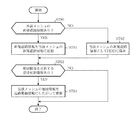
次に、上記のように構成される、この発明の実施の形態1に係る地図情報処理装置の動作を説明する。 Next, the operation of the map information processing apparatus according to Embodiment 1 of the present invention configured as described above will be described.
以下では、新規道路検出手段19、交差判定手段20、道路更新情報生成手段21、道路情報更新手段24によってHDD16に地図情報としても新規道路情報としても未だ保存されていない道路情報を生成し、追加する動作を説明する。
In the following, road information that is not yet stored as map information or new road information is generated in the
図2は、地図情報処理装置の測位に関するメイン処理を示すフローチャートである。このメイン処理では、まず、開始処理が実行される(ステップST10)。この開始処理では、前回終了時の状態に復元する初期化処理などが行われる。この開始処理が終了すると、次いで、測位手段15によって現在位置が検出される(ステップST11)。そして、このステップST11で検出された現在位置が、既存道路上に位置しているかどうかが調べられる(ステップST12)。ここで、現在位置が既存道路上に位置していないことが判断されると、新規道路検出処理が行われる(ステップST15)。この新規道路検出処理については後述する。その後、シーケンスはステップST16に進む。 FIG. 2 is a flowchart showing main processing related to positioning of the map information processing apparatus. In the main process, first, a start process is executed (step ST10). In this start process, an initialization process for restoring the state at the previous end is performed. When this start process is completed, the current position is then detected by the positioning means 15 (step ST11). And it is investigated whether the present position detected by this step ST11 is located on the existing road (step ST12). If it is determined that the current position is not on an existing road, a new road detection process is performed (step ST15). This new road detection process will be described later. Thereafter, the sequence proceeds to step ST16.
上記ステップST12で、現在位置が既存道路上に位置していることが判断されると、前回の測位結果が一時記憶メモリ18から削除される(ステップST13)。そして、最新の測位によって得られた現在位置が一時記憶メモリ18に記憶される(ステップST14)。次いで、メイン処理の終了指示がなされたかどうかが調べられる(ステップST16)。ここで、メイン処理の終了指示がなされていないことが判断されると、シーケンスはステップST11に戻り、上述した処理が繰り返される。一方、ステップST16において、終了指示がなされたことが判断されると、終了処理が実行される(ステップST17)。これにより、地図情報処理装置の測位に関するメイン処理は終了する。 If it is determined in step ST12 that the current position is located on an existing road, the previous positioning result is deleted from the temporary storage memory 18 (step ST13). Then, the current position obtained by the latest positioning is stored in the temporary storage memory 18 (step ST14). Next, it is checked whether or not an instruction to end the main process has been given (step ST16). Here, if it is determined that an instruction to end the main process has not been given, the sequence returns to step ST11 and the above-described process is repeated. On the other hand, if it is determined in step ST16 that an end instruction has been given, an end process is executed (step ST17). Thereby, the main process regarding the positioning of the map information processing apparatus ends.
次に、図2のステップST15において、新規道路検出手段19によって行われる新規道路検出処理の詳細を、図3に示すフローチャートを参照しながら説明する。 Next, details of the new road detection process performed by the new road detection means 19 in step ST15 of FIG. 2 will be described with reference to the flowchart shown in FIG.
新規道路検出処理では、まず、逸脱情報が一時記憶メモリ18に一時記憶される(ステップST20)。逸脱情報は、既存道路から逸脱した時点における既存道路および位置を表す情報から構成されている(詳細は後述する)。次いで、測位手段15によって現在位置が検出される(ステップST21)。次いで、ステップST21で検出された現在位置が既存道路上に位置しているかどうかが調べられる(ステップST22)。 In the new road detection process, first, the departure information is temporarily stored in the temporary storage memory 18 (step ST20). The deviation information includes information indicating the existing road and the position at the time of departure from the existing road (details will be described later). Next, the current position is detected by the positioning means 15 (step ST21). Next, it is checked whether or not the current position detected in step ST21 is located on an existing road (step ST22).
このステップST22で、現在位置が既存道路上に位置していないことが判断されると、新規道路を走行中であることが認識され、次いで、走行履歴時系列データ判定条件を満たしているかどうかが調べられる(ステップST23)。ここで、走行履歴時系列データ判定条件とは、測位手段15から得られる現在位置のうち走行履歴として格納すべき現在位置を規定する条件である(詳細は後述する)。 If it is determined in step ST22 that the current position is not located on the existing road, it is recognized that the vehicle is traveling on a new road, and then whether or not the traveling history time-series data determination condition is satisfied. It is examined (step ST23). Here, the travel history time-series data determination condition is a condition that defines a current position to be stored as a travel history among the current positions obtained from the positioning means 15 (details will be described later).
上記ステップST23で、走行履歴時系列データ判定条件を満たしていることが判断されると、現在位置が走行履歴として一時記憶メモリ18に一時記憶される(ステップST24)。その後、シーケンスはステップST21に戻る。一方、上記ステップST23で、走行履歴時系列データ判定条件を満たしていないことが判断されると、現在位置が走行履歴として一時記憶メモリ18に一時記憶されずに、シーケンスはステップST21に戻る。以下、ステップST22〜ST24の処理が繰り返し実行される。
If it is determined in step ST23 that the travel history time-series data determination condition is satisfied, the current position is temporarily stored in the
上記ステップST22〜ST24の処理の繰り返し実行の途中で、ステップST22において、現在位置が既存道路上に存在していることが判断されると、新規道路を走行中であった車両が既存道路に合流したことが認識され、合流情報が一時記憶メモリ18に一時記憶される(ステップST25)。ここで、合流情報は、新規道路から既存道路に合流した時点における既存道路および位置を表す情報から構成されている。以上の処理により、新規道路検出処理は終了する。 If it is determined in step ST22 that the current position exists on the existing road during the repeated execution of the processes of steps ST22 to ST24, the vehicle traveling on the new road joins the existing road. The merge information is temporarily stored in the temporary storage memory 18 (step ST25). Here, the merge information includes information indicating the existing road and the position at the time when the new road merges with the existing road. With the above process, the new road detection process ends.
上述した新規道路検出処理が終了すると、次いで、図4のフローチャートに示すように、交差判定処理(ステップST30)、道路更新情報生成処理(ステップST31)および道路情報更新処理(ステップST32)が順次実行される。以下、これらの各処理を詳細に説明する。 When the above-described new road detection process is completed, then, as shown in the flowchart of FIG. 4, an intersection determination process (step ST30), a road update information generation process (step ST31), and a road information update process (step ST32) are sequentially executed. Is done. Hereinafter, each of these processes will be described in detail.
まず、図4のステップST30において、交差判定手段20によって行われる交差判定処理を、図5に示すフローチャートを参照しながら説明する。 First, the intersection determination process performed by the intersection determination means 20 in step ST30 of FIG. 4 will be described with reference to the flowchart shown in FIG.
交差判定処理が開始されると、まず、新規道路が複数の線分に分割される(ステップST40)。次いで、分割された全線分についての交差判定が完了したかどうかが調べられる(ステップST41)。ここで、交差判定が完了したことが判断されると、交差判定処理は終了する。上記ステップST41において、分割された全線分についての交差判定が完了していないことが判断されると、次いで、未判定線分の中から1つが選択される(ステップST42)。次いで、選択された線分の近傍の既存道路が、当該新規道路が含まれるメッシュに該当する地図情報および新規道路情報の中から抽出される(ステップST43)。次いで、抽出された線分の近傍の全道路について、当該線分との交差判定が完了したかどうかが調べられる(ステップST44)。ここで、交差判定が完了したことが判断されると、シーケンスはステップST41に戻り、再度、未判定線分の有無の確認が行われる。 When the intersection determination process is started, first, the new road is divided into a plurality of line segments (step ST40). Next, it is checked whether or not the intersection determination for all divided line segments is completed (step ST41). Here, when it is determined that the intersection determination is completed, the intersection determination process ends. If it is determined in step ST41 that the intersection determination for all the divided line segments has not been completed, one of the undecided line segments is then selected (step ST42). Next, existing roads in the vicinity of the selected line segment are extracted from the map information and new road information corresponding to the mesh including the new road (step ST43). Next, for all roads in the vicinity of the extracted line segment, it is checked whether or not the intersection determination with the line segment has been completed (step ST44). Here, when it is determined that the intersection determination is completed, the sequence returns to step ST41, and the presence / absence of the undecided line segment is confirmed again.
上記ステップST44において、交差判定が完了していないことが判断されると、次いで、未判定の近傍道路から1つの道路が選択される(ステップST45)。次いで、選択された線分と選択された近傍道路の位置関係が計算される(ステップST46)。次いで、ステップST46で得られた計算結果に基づいて、選択された線分と選択された近傍道路とが交差しているかどうかが調べられる(ステップST47)。ここで、交差していないことが判断されると、シーケンスはステップST44に戻り、再度、交差判定が完了していない近傍道路の有無の確認が行われる。 If it is determined in step ST44 that the intersection determination is not completed, then one road is selected from the undetermined neighboring roads (step ST45). Next, the positional relationship between the selected line segment and the selected nearby road is calculated (step ST46). Next, based on the calculation result obtained in step ST46, it is checked whether or not the selected line segment intersects the selected neighboring road (step ST47). Here, if it is determined that the vehicle does not intersect, the sequence returns to step ST44, and the presence / absence of a nearby road for which the intersection determination is not completed is confirmed again.
上記ステップST47において、交差していることが判断されると、交差地点座標と近傍道路を特定する情報とが交差情報として一時記憶メモリ18に一時記憶される(ステップST48)。その後、シーケンスはステップST41に戻り、上述した処理が繰り返される。以上により、交差判定処理は終了する。
If it is determined in step ST47 that the vehicle intersects, the intersection point coordinates and information for specifying the neighboring road are temporarily stored in the
次に、図4のステップST31において、道路更新情報生成手段21によって行われる道路更新情報生成処理を、図6に示すフローチャートを参照しながら説明する。 Next, the road update information generation process performed by the road update information generation means 21 in step ST31 of FIG. 4 will be described with reference to the flowchart shown in FIG.
道路更新情報生成処理では、まず、一時記憶メモリ18から逸脱情報が読み込まれる(ステップST50)。次いで、一時記憶メモリ18から合流情報が読み込まれる(ステップST51)。次いで、一時記憶メモリ18から走行履歴が読み込まれる(ステップST52)。次いで、一時記憶メモリ18に交差情報が記憶されているかどうかが調べられる(ステップST53)。ここで、交差情報が記憶されていることが判断されると、その交差情報が一時記憶メモリ18から読み出される(ステップST54)。一方、交差情報が記憶されていないことが判断されると、ステップST54の処理はスキップされる。 In the road update information generation process, first, deviation information is read from the temporary storage memory 18 (step ST50). Next, the merge information is read from the temporary storage memory 18 (step ST51). Next, the travel history is read from the temporary storage memory 18 (step ST52). Next, it is checked whether or not intersection information is stored in the temporary storage memory 18 (step ST53). If it is determined that the intersection information is stored, the intersection information is read from the temporary storage memory 18 (step ST54). On the other hand, if it is determined that the intersection information is not stored, the process of step ST54 is skipped.
次いで、ステップST50〜ST54の処理により読み出された逸脱情報、合流情報、走行履歴および交差情報に基づき新規道路情報が生成される(ステップST55)。次いで、地図情報を更新する必要があるどうかが調べられる(ステップST56)。ここで、必要があることが判断された場合は、地図情報を更新するための道路更新情報が交差情報に基づいて生成される(ステップST57)。ステップST56で、地図情報を更新する必要がないことが判断されると、ステップST57の処理はスキップされる。以上により、道路更新情報生成処理は終了する。 Next, new road information is generated based on the deviation information, the merge information, the travel history, and the intersection information read out by the processes of steps ST50 to ST54 (step ST55). Next, it is checked whether or not the map information needs to be updated (step ST56). If it is determined that it is necessary, road update information for updating the map information is generated based on the intersection information (step ST57). If it is determined in step ST56 that there is no need to update the map information, the process in step ST57 is skipped. Thus, the road update information generation process ends.
次に、図4のステップST32において、道路情報更新手段24によって行われる道路情報更新処理を、図7に示すフローチャートを参照しながら説明する。
Next, the road information update process performed by the road
道路情報更新処理では、まず、当該新規道路の位置するメッシュに該当する新規道路情報がHDD16に存在するかどうかが調べられる(ステップST60)。ここで、存在することが判断された場合は、新たに生成された新規道路情報が、HDD16に存在する当該メッシュの新規道路情報に追加される(ステップST61)。一方、HDD16に当該メッシュの新規道路情報が存在しない場合は、当該メッシュの新規道路情報としてHDDに保存する(ステップST62)。
In the road information update process, first, it is checked whether or not new road information corresponding to the mesh where the new road is located exists in the HDD 16 (step ST60). Here, when it is determined that it exists, the newly generated new road information is added to the new road information of the mesh existing in the HDD 16 (step ST61). On the other hand, when the new road information of the mesh does not exist in the
次に、HDD16に記憶されている当該メッシュに該当する地図情報を修正するための道路更新情報が生成されているかどうかが調べられる(ステップST63)。ここで、生成されていることが判断された場合は、当該道路更新情報に従って、地図情報が更新される(ステップST64)。一方、当該メッシュに該当する地図情報を更新するための道路更新情報が生成されていない場合は、ステップST64の処理はスキップされる。以上により、道路情報更新処理は終了する。
Next, it is checked whether or not road update information for correcting the map information corresponding to the mesh stored in the
次に、具体的な走行例を用いて、新規道路の検出、生成および追加の動作を説明する。図8は、あるメッシュに含まれる既存道路によって構成される道路情報の一部分を示しており、交差点を表すノード(丸印)と、交差点間の道路を表すリンク(丸印の間の線分)で道路が表現されている。これらノードとリンクとで道路のつながりを表現したものを道路ネットワークと呼ぶ。この道路ネットワークにおいて点線で示すように、リンクL1上を走行中、P1の地点においてL1から逸脱し、地点QにおいてリンクL2を横切り、地点P2においてリンクL3に合流し、リンクL3上を走行した場合を想定し、既存道路に含まれていない新規道路を追加する処理を説明する。 Next, a new road detection, generation, and addition operation will be described using a specific driving example. FIG. 8 shows a part of road information configured by existing roads included in a certain mesh, a node (circle) indicating an intersection and a link (line segment between circles) indicating a road between the intersections. The road is represented by. These nodes and links expressing road connections are called road networks. As shown by the dotted line in this road network, when traveling on link L1, deviating from L1 at point P1, crossing link L2 at point Q, joining link L3 at point P2, and traveling on link L3 The process of adding a new road that is not included in the existing road will be described.
リンクL1の走行中に、測位手段15は、車速センサ43、角速度センサ44およびGPS受信アンテナ45からの信号に基づいて、現在位置を計算し、また、HDD16に記憶されている地図情報に含まれる道路情報を参照し、リンクL1上を走行していることを認識している。そして、最新の測位結果を常に一時記憶メモリ18に記憶する。この時、前回の測位結果は削除される。この地図情報処理装置を搭載した車両がP1の地点においてリンクL1から逸脱したとき、測位手段15の測位結果に基づき、その旨が検出され、逸脱前の走行リンクと逸脱地点が逸脱情報として一時記憶メモリ18に記憶される。図8に示す例では、リンクL1と地点P2が一時記憶メモリ18に記憶される。
While traveling on the link L1, the positioning means 15 calculates the current position based on signals from the
次に、新規道路検出手段19における処理(図2における新規道路検出処理)について説明する。 Next, the process in the new road detection means 19 (new road detection process in FIG. 2) will be described.
新規道路検出手段19は、逸脱が検出された後、再び既存道路上の走行に戻るまで、すなわち、既存道路への合流を検出するまでの走行軌跡を一時記憶メモリ18に記憶させる。図8に示す例では、地点P1から地点P2までの走行軌跡が一時記憶メモリ18に記憶される。走行軌跡は、例えば、測位手段15が測位した車両位置の時系列データである。時系列データを取得する最も簡単な方法としては、一定時間毎にデータを取得する方法が考えられる。通常、測位手段15は、定められた時間間隔で現在位置の測位を行う。したがって、一定時間毎に車両位置を取得する方法としては、n回(nは1以上の整数)に1回の割合で測位結果を一時記憶メモリ18に記憶する方法を採用できる。図9は、3回に1の割合で測位結果を記憶する例を示しており、この場合、9地点の測位結果が走行履歴として記憶される。
The new road detection means 19 stores in the
しかし、上述した方法では、取得されるデータ数が増加し、一時記憶メモリ18を浪費するおそれがある。そこで、走行履歴時系列データ判定条件として、一定距離の走行毎の測位結果データを一時記憶メモリ18に記憶するという条件を追加し、取得されるデータ数を削減することが可能である。図10は、一定距離毎に測位結果を記憶する例を示しており、この場合、7地点の測位結果が走行履歴として記憶される。
However, in the above-described method, the number of acquired data increases, and there is a possibility that the
また、走行履歴時系列データ判定条件として、車両の進行方向が閾値を超えて変化したときに測位結果データを一時記憶メモリ18に記憶するという条件を使用することで、取得されるデータ数をより削減し、一時記憶メモリ18の浪費をさらに抑制することが可能になる。図11は、進行方向が変化する毎に測位結果を記憶する例を示しており、この場合、5地点の測位結果が走行履歴として記憶される。進行方向の変化は、角速度センサ44の検出結果を利用することで検出できる。また、前々回の測位結果と前回の測位結果とを結ぶ第1線分と、前回の測位結果と最新の測位結果を結ぶ第2線分とのなす角度を利用して検出することもできる。
Further, by using the condition that the positioning result data is stored in the
次に、新規道路検出手段19は、合流リンクと合流地点の情報を合流情報として一時記憶メモリ18に記憶させる。図8に示す例では、リンクL3と地点P2とが一時記憶メモリ18に記憶される。新規道路検出手段19によって以上の処理が完了すると、次に、交差判定手段20が、新規道路検出手段19によって検出された新規道路の逸脱および合流地点以外の地点におけると既存道路との交差の有無を判定する。交差の有無の判定は、新規道路の走行履歴として一時記憶メモリ18に記憶されている位置情報の時系列データを複数の線分に分割し、各線分と2次元的に交差する既存道路を検索することにより行われる。
Next, the new road detection means 19 stores the information of the merge link and the merge point in the
走行履歴を複数の線分に分割する方法としては、全ての時系列データを用いて分割する方法が最も簡単である。しかし、時系列データ点数が増加すると、それに比例して交差判定に要する計算時間も増加してしまう。そこで、時系列データを間引いて線分を分割することで、この問題を解決するように構成できる。また、交差判定において検索対象とする既存道路は、メッシュ内の既存道路とすることで交差判定を現実的な時間以内に完了することが可能になる。 As a method of dividing the travel history into a plurality of line segments, the method of dividing using all time series data is the simplest. However, when the number of time series data points increases, the calculation time required for the intersection determination also increases in proportion thereto. Therefore, this problem can be solved by thinning out the time series data and dividing the line segment. In addition, it is possible to complete the intersection determination within a realistic time by setting the existing road to be searched in the intersection determination as an existing road in the mesh.
交差判定手段20は、新規道路検出手段19によって検出された新規道路と既存道路との交差地点を検出すると、当該地点が交差地点であることを一時記憶メモリ18に記憶する。図8に示す例では、地点P1から地点P2に至る新規道路上で、リンクL2と地点Qにおいて交差していることが一時記憶メモリ18に記憶される。
When the
次に、道路更新情報生成手段21は、一時記憶メモリ18に記憶されている新規道路の情報を、HDD16の内部に新規道路情報として保存する形式に変換する。
Next, the road update information generation means 21 converts the information on the new road stored in the
また、図12は、図8に示した道路ネットワークに対して、地点P1から地点Qを通り地点P2に至る新規道路を追加した結果の道路ネットワークを示している。この図12からわかるように、新規道路を追加すると、図8に示す例では1本のリンクであったリンクL1、L2およびL3が、それぞれ地点P1、QおよびP2においてL1aとL1b、L2aとL2b、L3aとL3bという2本のリンクに分割されることになる。 FIG. 12 shows a road network as a result of adding a new road from the point P1 through the point Q to the point P2 to the road network shown in FIG. As can be seen from FIG. 12, when a new road is added, the links L1, L2 and L3, which were one link in the example shown in FIG. 8, become L1a and L1b and L2a and L2b at points P1, Q and P2, respectively. , L3a and L3b are divided into two links.
そこで、道路更新情報生成手段21は、既存道路のリンクにおいて、新規道路との交差点となりうる地点にノードを発生させ、リンクを分割するための情報も生成する。この道路更新情報生成手段21が生成する情報を「道路更新情報」と呼ぶ。 Therefore, the road update information generation means 21 generates a node at a point that can be an intersection with the new road in the link of the existing road, and also generates information for dividing the link. Information generated by the road update information generation means 21 is referred to as “road update information”.
この時、道路更新情報生成手段21は、新規道路の始終点以外であって既存道路と交差している地点に該当するノードを仮交差点であるとして道路更新情報を生成する。HDD16の地図情報記憶手段16aに記憶されている地図情報に含まれる道路情報や、新規道路情報記憶手段16bに記憶されている新規道路情報においては、ノードを表現するフィールド中に、仮交差点フラグとして1ビットを割当て、これを利用して当該ノードが仮交差点であるか否かを表現する。
At this time, the road update information generation means 21 generates road update information assuming that a node corresponding to a point that intersects with an existing road other than the start and end points of the new road is a temporary intersection. In the road information included in the map information stored in the map information storage means 16a of the
図8および図12に示す例では、道路更新情報生成手段21は、生成する新規道路情報の中の地点Qに該当するノードの仮交差点フラグをONにするとともに、既存道路のリンクL2を分割したL2a、L2bにおける地点Qに該当するノードの仮交差点フラグをONにした道路更新情報を生成する。 In the examples shown in FIGS. 8 and 12, the road update information generation means 21 turns on the temporary intersection flag of the node corresponding to the point Q in the new road information to be generated and divides the link L2 of the existing road. Road update information is generated by turning on the temporary intersection flag of the node corresponding to the point Q in L2a and L2b.
また、道路更新情報生成手段21は、仮交差点における通行規制を、全ての方向に通行可として生成する。通行規制について、以下に説明する。カーナビゲーション装置が利用する道路情報には、通常、ノードにおける通行規制が記述されている。今、例えば図13(a)に示すように、ノード0にリンク1からリンク4までの4本のリンクが接続されており、リンク1はノード0に向かう方向の一方通行、リンク3からノード0に向かう場合はリンク4へ向かう左折のみ可能、という場合を想定する。このとき、ノード0における進入リンクと脱出リンクの組合せによって、その通行可否は、図13(b)に示すように表現できる。この通行可否を表す情報がノードに関連付けられた情報として、道路情報に記述される。これを通行規制と呼ぶ。
Moreover, the road update information generation means 21 generates the traffic restriction at the temporary intersection as allowing traffic in all directions. The following describes traffic restrictions. The road information used by the car navigation device usually describes a traffic restriction at a node. For example, as shown in FIG. 13A, four links from link 1 to link 4 are connected to node 0. Link 1 is one-way in the direction toward node 0, and
次に、道路情報更新手段24は、道路更新情報生成手段21で生成された道路更新情報に含まれる新規道路情報を、HDDアクセス手段17を介してHDD16の内部の新規道路情報記憶手段16bに保存する。このとき、保存しようとするメッシュに対応する新規道路情報が既に存在している場合は、その新規道路情報に追加し、そのメッシュに対応する新規道路情報が存在しない場合には、そのメッシュに対応する新規道路情報として新たに保存する。また、道路情報更新手段24は、既存の道路ネットワークを更新するための情報が道路更新情報に含まれている場合は、その情報に従って既存の道路ネットワークを更新する。
Next, the road information update means 24 stores the new road information included in the road update information generated by the road update information generation means 21 in the new road information storage means 16b inside the
次に、道路更新情報生成手段21によって仮交差点として生成された地点が通常の平面交差点であるのか立体交差であるのかを、交差点問合せ手段22および交差点決定手段23で特定する動作について説明する。
Next, an operation for specifying whether the point generated as a temporary intersection by the road update
図14は、経路計算手段11によって算出された推奨経路に、仮交差点として登録されているノード(図14中に、新規交差点として二重丸によって表現されている)における右左折が含まれている場合の表示装置40への表示例である。この表示は交差点問合せ手段22によって実施される。この表示例では、画面は、推奨経路を提示する地図、推奨経路に仮交差点で右左折する地点が存在することを示すメッセージ、仮交差点の状態の入力をユーザに促す選択メニューおよび案内開始ボタンから構成されている。なお、画面の中に描かれている第2経路は、仮交差点(図14中の新規交差点)が立体交差等から構成されており、右左折することができないと仮定した場合の推奨経路を示すものである。
In FIG. 14, the recommended route calculated by the route calculation means 11 includes a left / right turn at a node registered as a temporary intersection (represented by a double circle as a new intersection in FIG. 14). It is an example of a display on the
なお、図14に示す表示画面の表示とともに、音声出力装置41から、仮交差点として登録されているノードにおける右左折が含まれる推奨経路が算出されたことを音声によってユーザに案内するように構成できる。この時、右左折する仮交差点がどのような位置にあり(住所や周辺の施設など)、どのような道路同士の交差であるか(道路番号、道路名称など)を伝えるように構成すれば、案内対象の仮交差点が、現実のどの交差地点を指し示しているかをユーザは、より正確に把握することができる。
In addition to the display of the display screen shown in FIG. 14, the
図14に示される表示や、上述した音声案内によって、仮交差点で右左折する経路を提示されたユーザは、案内対象の仮交差点の状態を選択する。図14に示す例では、ユーザは選択メニューに示されている「通常交差点」、「立体交差」、「不明」および「案内開始」のいずれかを選択する。この選択は、本体パネルに設置されたボタンを操作することにより選択メニューの所望の項目にフォーカスをあて、実行ボタンを押下することで実現できる。また、リモコンに設置されたボタンを操作することによっても実現できる。また、表示装置40にタッチパネル入力装置を備えれば、タッチパネル操作によっても実現できる。さらには、音声認識手段を備えれば、音声入力による操作によっても実現できる。
A user who is presented with a route to turn left or right at a temporary intersection by the display shown in FIG. 14 or the voice guidance described above selects the state of the temporary intersection to be guided. In the example illustrated in FIG. 14, the user selects one of “normal intersection”, “stereoscopic intersection”, “unknown”, and “guidance start” shown in the selection menu. This selection can be realized by operating a button provided on the main body panel to focus on a desired item in the selection menu and pressing the execution button. It can also be realized by operating a button installed on the remote control. Further, if the
図15は、経路計算手段11によって算出された推奨経路に、仮交差点として登録されているノードにおける右左折が含まれない場合の表示装置40への表示例である。この場合、通常の推奨経路の算出結果が表示される。図15に例示した推奨経路の算出結果の表示画面は、推奨経路を提示する地図と、推奨経路が求まったことを示すメッセージおよび案内開始ボタンから構成されている。
FIG. 15 is a display example on the
本体パネルに備え付けられた操作ボタン、リモコン、タッチパネル、または、音声入力などによって案内開始ボタンを押下することにより、図15に示す表示画面から通常の地図表示画面に遷移し、目的地までの案内がユーザに提供される。 When the guidance start button is pressed by an operation button, remote control, touch panel, or voice input provided on the main body panel, the display screen shown in FIG. 15 is changed to the normal map display screen, and guidance to the destination is made. Provided to the user.
図16は、図14に示した仮交差点の状態を選択する画面の提示後、交差点決定手段23によって仮交差点の状態が設定されるまでの交差点決定処理を示すフローチャートである。 FIG. 16 is a flowchart showing an intersection determination process until the temporary intersection state is set by the intersection determination means 23 after the screen for selecting the temporary intersection state shown in FIG. 14 is presented.
この交差点決定処理では、交差点問合せ手段22によって図14に示す画面が表示された後、ユーザによる選択待ちに入る(ステップST70)。次いで、選択メニューの何れかの項目が選択されたかどうかが調べられる(ステップST71)。ここで、何れも選択されていないことが判断されると、シーケンスはステップST70に戻り、再び、ユーザによる選択待ちに入る。 In this intersection determination process, after the screen shown in FIG. 14 is displayed by the intersection inquiry means 22, it waits for selection by the user (step ST70). Next, it is checked whether any item in the selection menu has been selected (step ST71). Here, if it is determined that none has been selected, the sequence returns to step ST70 and again waits for selection by the user.
ステップST71で、選択メニューの何れかの項目が選択されたことが判断されると、次いで、「案内開始」が選択されたかどうかが調べられる(ステップST72)。ここで、案内開始が選択されたことが判断されると、交差点決定処理は終了する。一方、案内開始が選択されていないことが判断されると、次いで、「立体交差」が選択されたかどうかが調べられる(ステップST73)。ここで、立体交差が選択されたことが判断されると、HDD16に記憶されている当該仮交差点における通行規制が、右左折の全組合せ(直進を除く)についてOKからNGに変更される(ステップST74)。次いで、HDD16に記憶されている当該仮交差点における仮交差点フラグがOFFに変更される(ステップST75)。
If it is determined in step ST71 that any item in the selection menu has been selected, it is then checked whether or not “start guidance” has been selected (step ST72). Here, when it is determined that the guidance start is selected, the intersection determination process ends. On the other hand, if it is determined that the guidance start is not selected, it is then checked whether or not “stereoscopic intersection” is selected (step ST73). Here, if it is determined that the three-dimensional intersection is selected, the traffic restriction at the temporary intersection stored in the
上記ステップST73で、立体交差が選択されていないことが判断されると、次いで、「通常交差点」が選択されたかどうかが調べられる(ステップST76)。ここで、通常交差点が選択されたことが判断されると、シーケンスはステップST75に移り、上述した処理が実行される。一方、通常交差点が選択されていない、つまり「不明」が選択されたことが判断されると、シーケンスはステップST77に移る。この場合、仮交差点は、そのまま残される。 If it is determined in step ST73 that a three-dimensional intersection has not been selected, it is then checked whether or not a “normal intersection” has been selected (step ST76). Here, if it is determined that the normal intersection is selected, the sequence moves to step ST75, and the above-described processing is executed. On the other hand, if it is determined that the normal intersection is not selected, that is, “unknown” is selected, the sequence proceeds to step ST77. In this case, the temporary intersection is left as it is.
ステップST77では、経路計算手段11によって算出された推奨経路上で、右左折する仮交差点についてユーザによる選択が完了したかどうかが調べられる。ここで、ユーザによる選択が完了していない、つまり推奨経路上で右左折する仮交差点が未だ存在することが判断されると、次の右左折する仮交差点における選択メニューが表示される(ステップST78)。その後、シーケンスはステップST70に戻り、再び、ユーザによる選択待ち状態に入る。
In step ST77, it is checked whether or not the selection by the user is completed for the temporary intersection that turns right and left on the recommended route calculated by the
ステップST77において、ユーザによる選択が完了した、つまり推奨経路上で右左折する仮交差点が存在しないことが判断されると、選択メニューの「案内開始」以外の項目が選択不可にされる(ステップST79)。その後、シーケンスはステップST70に戻り、再び、ユーザによる選択待ち状態に入る。 If it is determined in step ST77 that the selection by the user is completed, that is, there is no temporary intersection that turns right or left on the recommended route, items other than “start guidance” in the selection menu are disabled (step ST79). ). Thereafter, the sequence returns to step ST70, and again enters a state of waiting for selection by the user.
以上説明したように、この発明の実施の形態1に係る地図情報処理装置によれば、HDD16に記憶されていない道路を走行した場合に、その道路をHDD16に追加記憶し、さらには既存道路との交差点を正確に反映したナビゲーションを実現できる。
As described above, according to the map information processing apparatus according to the first embodiment of the present invention, when the vehicle travels on a road that is not stored in
より詳しくは、この地図情報処理装置によれば、新規に検出された新規道路の始終点以外の地点における交差点の情報を利用することができる。また、仮交差点を通常の平面交差点と区別することで、立体交差のところを誤って通常の平面交差点と同様に処理することを防ぐことができる。また、平面交差点と決定された交差地点においては、その後の処理において既存道路における交差点と同様の扱いをすることが可能になる。また、平面交差点か立体交差かをユーザに問い合わせることで、機械的に平面交差点/立体交差を判断する場合と比較し、誤判断の発生を削減することができる。さらに、ユーザに問い合わせるタイミングを経路計算において仮交差点が平面交差点であるのか立体交差であるのかの判断が必要となる時点とすることで、問い合わせが頻発することを防ぐことができる。 More specifically, according to this map information processing apparatus, information on intersections at points other than the start and end points of newly detected new roads can be used. Further, by distinguishing the temporary intersection from the normal plane intersection, it is possible to prevent the three-dimensional intersection from being erroneously processed in the same manner as the normal plane intersection. In addition, at an intersection determined as a plane intersection, it is possible to handle the same as an intersection on an existing road in subsequent processing. Further, by making an inquiry to the user as to whether it is a plane intersection or a three-dimensional intersection, it is possible to reduce the occurrence of misjudgment as compared with a case where a plane intersection / three-dimensional intersection is mechanically determined. Furthermore, it is possible to prevent frequent inquiries by setting the timing of inquiring to the user at a time when it is necessary to determine whether the temporary intersection is a plane intersection or a three-dimensional intersection in the route calculation.
なお、この実施の形態1に係る地図情報処理装置では、新規道路情報と地図情報は別々のものとして存在するように構成したが、新規道路情報を地図情報の中に含める形で保存するように構成できる。この場合、道路更新情報生成手段21は、生成した新規道路情報を地図情報の中のどの位置に追加するか、また、新規道路情報を地図情報の中に追加することで、既存の地図情報の修正が必要になる場合は、どの情報をどのように修正する必要があるかを表現した道路更新情報の生成も行う。 In the map information processing apparatus according to the first embodiment, the new road information and the map information are configured to exist separately, but the new road information is stored so as to be included in the map information. Can be configured. In this case, the road update information generation means 21 adds the generated new road information to which position in the map information, and adds the new road information to the map information, so that the existing map information When correction is required, road update information expressing which information needs to be corrected and how is also generated.
実施の形態2.
上述した実施の形態1に係る地図情報処理装置では、交差点決定手段23は、経路計算手段11によって算出された推奨経路が仮交差点における右左折を含む場合に、図14に示した画面を表示してユーザに提示し、仮交差点の状態をユーザが選択的に入力するように構成したが、この実施の形態2に係る地図情報処理装置では、仮交差点の状態の入力を、地図情報処理装置の電源OFF信号が発生された時に行うようにしたものである。
In the map information processing apparatus according to the first embodiment described above, the
図17は、地図情報処理装置の電源OFF信号が発生された時に、ユーザが仮交差点の状態を選択的に入力するための画面の例を示す。この例では、表示画面は、仮交差点(図17中の新規交差点)を含む地図、仮交差点の状態を入力する画面であることを示すメッセージ、仮交差点の状態の入力をユーザに促す選択メニュー、設定終了ボタンから構成されている。図17に示す表示は、交差点問合せ手段22によって実施される。 FIG. 17 shows an example of a screen for a user to selectively input a temporary intersection state when a power-off signal of the map information processing apparatus is generated. In this example, the display screen is a map including a temporary intersection (a new intersection in FIG. 17), a message indicating that it is a screen for inputting a temporary intersection state, a selection menu for prompting the user to input a temporary intersection state, It consists of a setting end button. The display shown in FIG. 17 is performed by the intersection inquiry means 22.
図18は、図17に示した仮交差点の状態を選択する画面の提示後、交差点決定手段23によって仮交差点の状態が設定されるまでの交差点決定処理を示すフローチャートである。 FIG. 18 is a flowchart showing an intersection determination process from the presentation of the screen for selecting the temporary intersection state shown in FIG. 17 to the setting of the temporary intersection state by the intersection determination means 23.
この交差点決定処理では、交差点問合せ手段22によって図17に示す画面が表示された後、ユーザによる選択待ちに入る(ステップST80)。次いで、選択メニューの何れかの項目が選択されたかどうかが調べられる(ステップST81)。ここで、何れも選択されていないことが判断されると、シーケンスはステップST80に戻り、再び、ユーザによる選択待ちに入る。 In this intersection determination process, after the screen shown in FIG. 17 is displayed by the intersection inquiry means 22, it waits for selection by the user (step ST80). Next, it is checked whether any item in the selection menu has been selected (step ST81). Here, if it is determined that none is selected, the sequence returns to step ST80, and again enters the selection waiting state by the user.
ステップST81で、選択メニューの何れかの項目が選択されたことが判断されると、次いで、「設定終了」が選択されたかどうかが調べられる(ステップST82)。ここで、設定終了が選択されたことが判断されると、交差点決定処理は終了する。一方、案内開始が選択されていないことが判断されると、次いで、「立体交差」が選択されたかどうかが調べられる(ステップST83)。ここで、立体交差が選択されたことが判断されると、HDD16に記憶されている当該仮交差点における通行規制が、右左折の全組合せ(直進を除く)についてOKからNGに変更される(ステップST84)。次いで、HDD16に記憶されている当該仮交差点における仮交差点フラグがOFFに変更される(ステップST85)。
If it is determined in step ST81 that any item in the selection menu has been selected, it is then checked whether or not “end of setting” has been selected (step ST82). Here, if it is determined that the end of setting has been selected, the intersection determination process ends. On the other hand, if it is determined that the guidance start is not selected, it is then checked whether or not “stereoscopic intersection” is selected (step ST83). Here, if it is determined that the three-dimensional intersection is selected, the traffic restriction at the temporary intersection stored in the
上記ステップST83で、立体交差が選択されていないことが判断されると、次いで、「通常交差点」が選択されたかどうかが調べられる(ステップST86)。ここで、通常交差点が選択されたことが判断されると、シーケンスはステップST85に移り、上述した処理が実行される。一方、通常交差点が選択されていない、つまり「不明」が選択されたことが判断されると、シーケンスはステップST87に移る。この場合、仮交差点は、そのまま残される。 If it is determined in step ST83 that a three-dimensional intersection is not selected, it is then checked whether or not a “normal intersection” is selected (step ST86). Here, when it is determined that the normal intersection has been selected, the sequence moves to step ST85, and the above-described processing is executed. On the other hand, if it is determined that the normal intersection is not selected, that is, “unknown” is selected, the sequence proceeds to step ST87. In this case, the temporary intersection is left as it is.
ステップST87では、全ての仮交差点についてユーザによる選択が完了したかどうかが調べられる。ここで、ユーザによる選択が完了していない、つまり仮交差点が未だ残っていることが判断されると、次の仮交差点における選択メニューが表示される(ステップST88)。次の仮交差点の選択は、仮交差点は測位手段15によって測位される自己の現在位置からの距離が近い順に行われる。その後、シーケンスはステップST80に戻り、再び、ユーザによる選択待ち状態に入る。 In step ST87, it is checked whether or not selection by the user has been completed for all temporary intersections. Here, if it is determined that the selection by the user has not been completed, that is, that there is still a temporary intersection, a selection menu at the next temporary intersection is displayed (step ST88). The next temporary intersection is selected in the order of the closest distance from the current position of the temporary intersection measured by the positioning means 15. Thereafter, the sequence returns to step ST80, and again enters a state of waiting for selection by the user.
ステップST87において、ユーザによる選択が完了した、つまり仮交差点が残っていないことが判断されると、選択メニューの「設定終了」以外の項目が選択不可にされる(ステップST89)。その後、シーケンスはステップST80に戻り、再び、ユーザによる選択待ち状態に入る。 If it is determined in step ST87 that the selection by the user is completed, that is, there is no temporary intersection left, items other than “end of setting” in the selection menu are disabled (step ST89). Thereafter, the sequence returns to step ST80, and again enters a state of waiting for selection by the user.
以上説明したように、この発明の実施の形態2に係る地図情報処理装置によれば、地図情報処理装置の電源OFF信号が発生した時点、すなわち、地図情報処理装置の動作が終了する時点において、仮交差点の状態をユーザが設定可能になる。したがって、走行中に問い合わせが発生することを防ぐことができる。また、走行中に発生した仮交差点を、地図情報処理装置の動作の終了時に確認して、正式の交差点として地図情報および新規道路情報に組み込むことができる。 As described above, according to the map information processing apparatus according to the second embodiment of the present invention, at the time when the power-off signal of the map information processing apparatus is generated, that is, when the operation of the map information processing apparatus ends. The user can set the state of the temporary intersection. Therefore, it is possible to prevent an inquiry from occurring during traveling. In addition, a temporary intersection generated during traveling can be confirmed at the end of the operation of the map information processing apparatus, and can be incorporated into the map information and the new road information as an official intersection.
また、この実施の形態2に係る地図情報処理装置では、地図情報処理装置の電源OFF信号が発生した時点で、ユーザが仮交差点の状態を選択的に入力するように構成したが、地図情報処理装置の電源ON信号が発生して地図情報処理装置が起動された時に、仮交差点の状態を選択的に入力するように構成することもできる。 Further, in the map information processing apparatus according to the second embodiment, when the power-off signal of the map information processing apparatus is generated, the user selectively inputs the state of the temporary intersection. It can also be configured to selectively input the state of the temporary intersection when the map information processing apparatus is activated by generating a power ON signal of the apparatus.
この構成によれば、起動時に仮交差点の状態を選択的に入力することにより、走行中に問い合わせが発生することを防ぐことができると同時に、ユーザが持っている最新の知識を地図情報に反映した交差点情報によって地図情報処理装置の動作を開始することができる。また、降車時に地図情報処理装置を操作する必要がないので、ユーザは、余裕をもって仮交差点の設定を行うことができる。 According to this configuration, by selectively inputting the state of the temporary intersection at the time of activation, it is possible to prevent an inquiry from occurring during traveling, and at the same time, reflect the latest knowledge possessed by the user to the map information The operation of the map information processing apparatus can be started by the intersection information. Further, since it is not necessary to operate the map information processing apparatus when getting off, the user can set a temporary intersection with a margin.
また、この実施の形態2に係る地図情報処理装置では、図17に示す画面が表示されたときに、ユーザが設定すべき仮交差点の範囲は特に限定されていないが、設定すべき仮交差点の範囲を限定するように構成することもできる。この場合、ユーザは不要な設定操作から解放されることができる。ユーザが設定すべき仮交差点の範囲は、測位手段15によって測位される自己の現在位置からの距離によって決定するように構成できる。なお、目的地が設定されている場合には、現在位置と目的地とによって算出される適切な範囲によって、ユーザが設定すべき仮交差点の範囲を決定するように構成できる。また、ユーザが予め設定した範囲によって、ユーザが設定すべき仮交差点の範囲を決定するように構成することもできる。 In the map information processing apparatus according to the second embodiment, when the screen shown in FIG. 17 is displayed, the range of the temporary intersection to be set by the user is not particularly limited. It can also be configured to limit the range. In this case, the user can be freed from unnecessary setting operations. The range of the temporary intersection to be set by the user can be determined by the distance from the current position measured by the positioning means 15. In addition, when the destination is set, it can comprise so that the range of the temporary intersection which a user should set may be determined with the appropriate range calculated by the present position and the destination. In addition, the range of the temporary intersection to be set by the user can be determined based on the range set in advance by the user.
実施の形態3.
この発明の実施の形態3に係る地図情報処理装置は、実際の走行時に右左折したという情報に基づいて仮交差点の状態を設定するようにしたものである。
The map information processing apparatus according to the third embodiment of the present invention sets the state of a temporary intersection based on the information that the vehicle turns right and left during actual traveling.
図19は、この発明の実施の形態3に係る地図情報処理装置の構成を示すブロック図である。この地図情報処理装置は、図1に示した実施の形態1に係る地図情報処理装置に方向指示器46が追加されるとともに、カーナビゲーション装置から交差点問合せ手段22が除去され、右左折検出手段26が追加されて構成されている。また、交差点決定手段23の動作が実施の形態1に係る地図情報処理装置のそれと異なる。
FIG. 19 is a block diagram showing the configuration of the map information processing apparatus according to
方向指示器46は、地図情報処理装置が設置されている車両が右左折するときに、第三者にその右左折を伝達するために使用される。この方向指示器46によって示される右左折の方向を表す信号は、右左折検出手段26に送られる。
The
右左折検出手段26は、角速度センサ44から送られてくる自己の方向変化を表す信号または方向指示器46からの信号に基づいて、自己の方向変化を検出する。この右左折検出手段26における検出結果は、制御手段25を介して交差点決定手段23に送られ、仮交差点の状態を設定するために使用される。
The left / right
次に、この発明の実施の形態3に係る地図情報処理装置の交差点決定手段23において行われる仮交差点の状態を設定する処理を、図20に示すフローチャートを参照しながら説明する。
Next, the process of setting the temporary intersection state performed in the intersection determination means 23 of the map information processing apparatus according to
この仮交差点の状態を設定する処理では、まず、地図情報処理装置が仮交差点に到達したかどうかが調べられる(ステップST90)。ここで、仮交差点に到達していないことが判断されると、処理は終了する。一方、仮交差点に到達したことが判断されると、次いで、その仮交差点で右左折がなされたことが右左折検出手段26によって検知されたかどうかが調べられる(ステップST91)。ここで、右左折が検知されたことが判断されると、その仮交差点における仮交差点フラグがOFFに変更され(ステップST92)、その後、処理は終了する。上記ステップST91において右左折が検知されなかったことが判断された場合も、処理は終了する。 In the process of setting the temporary intersection state, first, it is checked whether or not the map information processing apparatus has reached the temporary intersection (step ST90). If it is determined that the temporary intersection has not been reached, the process ends. On the other hand, if it is determined that a temporary intersection has been reached, then it is checked whether the right / left turn detection means 26 has detected that a right / left turn has been made at the temporary intersection (step ST91). Here, if it is determined that a right / left turn has been detected, the temporary intersection flag at the temporary intersection is changed to OFF (step ST92), and then the process ends. The process also ends when it is determined in step ST91 that a right / left turn has not been detected.
以上説明したように、この発明の実施の形態3に係る地図情報処理装置によれば、交差点で右左折することによって自動的に仮交差点が通常の平面交差点であることを認識し、その後は平面交差点として扱うことができる。また、方向指示器46の右左折情報で仮交差点が通常の平面交差点であることを認識できる。
As described above, according to the map information processing apparatus according to the third embodiment of the present invention, the temporary intersection is automatically recognized as a normal plane intersection by turning right and left at the intersection, and then the plane Can be treated as an intersection. Further, it can be recognized from the right / left turn information of the
実施の形態4.
この発明の実施の形態4に係る地図情報処理装置は、高度情報に基づいて仮交差点の状態を設定するようにしたものである。
Embodiment 4 FIG.
The map information processing apparatus according to Embodiment 4 of the present invention sets the state of a temporary intersection based on altitude information.
この実施の形態4に係る地図情報処理装置の構成は、以下の点を除き、図1に示した実施の形態1に係る地図情報処理装置のそれと同じである。即ち、地図情報記憶手段16aに記憶される地図情報に含まれる道路情報は、ノードに関連付けられた情報として、そのノードの高度情報を予め含んでいる。また、新規道路情報記憶手段16bに記憶される新規道路情報には、ノードに関連付けられた情報として、そのノードの高度情報が含まれる。この高度情報は、測位手段15がGPS受信アンテナ45から得られるGPS信号に基づいて生成される。さらに、交差点決定手段23は、高度情報に基づいて仮交差点の状態を設定する。なお、実施の形態4に係る地図情報処理装置では、実施の形態1に係る地図情報処理装置における交差点問合せ手段22は不要である。
The configuration of the map information processing apparatus according to the fourth embodiment is the same as that of the map information processing apparatus according to the first embodiment shown in FIG. 1 except for the following points. That is, the road information included in the map information stored in the map
次に、この発明の実施の形態4に係る地図情報処理装置の交差点決定手段23において行われる仮交差点の状態を設定する処理を、図21に示すフローチャートを参照しながら説明する。 Next, processing for setting the temporary intersection state performed in the intersection determination means 23 of the map information processing apparatus according to Embodiment 4 of the present invention will be described with reference to the flowchart shown in FIG.
この仮交差点の状態を設定する処理では、まず、地図情報処理装置が仮交差点に到達したかどうかが調べられる(ステップST100)。ここで、仮交差点に到達していないことが判断されると、処理は終了する。一方、仮交差点に到達したことが判断されると、次いで、HDDアクセス手段17を介して、HDD16の新規道路情報記憶手段16bに記憶されている新規道路情報から、その仮交差点に対応するノード情報を検索し、検索されたノード情報から高度情報が取得される(ステップST101)。
In the process of setting the temporary intersection state, first, it is checked whether or not the map information processing apparatus has reached the temporary intersection (step ST100). If it is determined that the temporary intersection has not been reached, the process ends. On the other hand, if it is determined that the temporary intersection has been reached, then the node information corresponding to the temporary intersection is obtained from the new road information stored in the new road information storage means 16b of the
次に、交差している相手の道路が地図情報の中に存在するか否かが調べられる(ステップST102)。この処理は、新規道路情報に含まれている交差情報を参照し、交差情報に記述されている交差相手の道路が地図情報の中に存在するか否かを調べることによって行われる。このステップST102で、交差している相手の道路が地図情報の中に存在することが判断されると、次いで、HDDアクセス手段17を介して、HDD16の地図情報記憶手段16aに記憶されている地図情報から該当する仮交差点のノード情報が検索され、そのノードの高度情報が取得される(ステップST103)。その後、シーケンスはステップST105に進む。
Next, it is checked whether or not the intersecting partner's road exists in the map information (step ST102). This process is performed by referring to the intersection information included in the new road information and examining whether or not the intersection road described in the intersection information exists in the map information. If it is determined in this step ST102 that the intersecting partner's road exists in the map information, then the map stored in the map information storage means 16a of the
上記ステップST102で、交差している相手の道路が地図情報の中に存在しないことが判断されると、次いで、HDDアクセス手段17を介して、HDD16の新規道路情報記憶手段16bに記憶されている新規道路情報から該当する仮交差点のノード情報が検索され、そのノードの高度情報が取得される(ステップST104)。その後、シーケンスはステップST105に進む。
If it is determined in the above step ST102 that the intersecting partner's road does not exist in the map information, then it is stored in the new road information storage means 16b of the
ステップST104では、ステップST101で取得された高度情報と、ステップST103またはステップST104で取得された高度情報とから高度差が算出される(ステップST105)。次いで、ステップST105で算出された高度差が予め定められた一定値以上であるかどうかが調べられる(ステップST106)。このステップST106で、一定値以上であることが判断されると、2つの道路は立体交差であることが認識され、その仮交差点における通行規制が、その全組合せについてOKからNGに変更される(ステップST107)。次いで、その仮交差点における仮交差点フラグがOFFに変更され(ステップST108)、処理は終了する。上記ステップST106において、ステップST105で算出された高度差が一定値未満であることが判断されると、2つの道路は平面交差であることが認識され、シーケンスはステップST108に進む。 In step ST104, an altitude difference is calculated from the altitude information acquired in step ST101 and the altitude information acquired in step ST103 or step ST104 (step ST105). Next, it is checked whether or not the altitude difference calculated in step ST105 is greater than or equal to a predetermined value (step ST106). If it is determined in step ST106 that the value is equal to or greater than a certain value, it is recognized that the two roads are three-dimensional intersections, and the traffic restriction at the temporary intersection is changed from OK to NG for all the combinations ( Step ST107). Next, the temporary intersection flag at the temporary intersection is changed to OFF (step ST108), and the process ends. If it is determined in step ST106 that the altitude difference calculated in step ST105 is less than a certain value, it is recognized that the two roads are plane intersections, and the sequence proceeds to step ST108.
以上説明したように、この発明の実施の形態4に係る地図情報処理装置によれば、新規道路と既存の道路の交差地点における高さを比較することで自動的に仮交差点が通常の平面交差点か立体交差かを判断することができる。また、新規道路同士の交差地点においても、高さを比較することで自動的に仮交差点が平面交差しているか立体交差しているかを判断することができる。 As described above, according to the map information processing apparatus according to the fourth embodiment of the present invention, the temporary intersection is automatically set to the normal plane intersection by comparing the heights at the intersection of the new road and the existing road. Or a three-dimensional intersection. In addition, even at intersections between new roads, it is possible to automatically determine whether a temporary intersection is a plane intersection or a three-dimensional intersection by comparing the heights.
実施の形態5.
この発明の実施の形態5に係る地図情報処理装置は、実際の走行時に停止したという情報に基づいて仮交差点の状態を設定するようにしたものである。
The map information processing apparatus according to
図22は、この発明の実施の形態5に係る地図情報処理装置の構成を示すブロック図である。この地図情報処理装置は、図1に示した実施の形態1に係る地図情報処理装置のカーナビゲーション装置から交差点問合せ手段22が除去されて構成されている。また、HDD16の内部に走行履歴情報記憶手段16cが追加されている。
FIG. 22 is a block diagram showing a configuration of the map information processing apparatus according to
また、地図情報処理装置の構成要素のうち、以下の点が実施の形態1に係る地図情報処理装置のそれと異なる。即ち、測位手段15は、車速センサ43からの信号に基づいて速度を検出する。また、測位手段15によって測位された位置とその位置を走行時の速度が走行履歴情報としてHDD16の走行履歴情報記憶手段16cに記憶される。さらに、交差点決定手段23は、走行履歴情報を参照し、仮交差点の状態を設定する。
Further, among the components of the map information processing apparatus, the following points are different from those of the map information processing apparatus according to the first embodiment. That is, the positioning means 15 detects the speed based on the signal from the
次に、この発明の実施の形態5に係る地図情報処理装置の交差点決定手段23において行われる、走行履歴情報を参照して仮交差点の状態を設定する処理を、図23に示すフローチャートを参照しながら説明する。
Next, referring to the flowchart shown in FIG. 23, the process of setting the temporary intersection state with reference to the travel history information, which is performed in the intersection determination means 23 of the map information processing apparatus according to
この仮交差点の状態を設定する処理では、まず、地図情報処理装置が仮交差点に到達したかどうかが調べられる(ステップST110)。ここで、仮交差点に到達していないことが判断されると、処理は終了する。一方、仮交差点に到達したことが判断されると、次いで、HDD16の走行履歴情報記憶手段16cに記憶されている走行履歴情報から当該仮交差点直前の速度推移が取得される(ステップST111)。 In the process of setting the temporary intersection state, first, it is checked whether or not the map information processing apparatus has reached the temporary intersection (step ST110). If it is determined that the temporary intersection has not been reached, the process ends. On the other hand, if it is determined that the temporary intersection has been reached, then the speed transition immediately before the temporary intersection is acquired from the travel history information stored in the travel history information storage means 16c of the HDD 16 (step ST111).
次いで、ステップST111で取得された速度推移に基づいて、仮交差点直前で一時停車したかどうかが調べられる(ステップST112)。ここで、一時停車したことが判断されると、その仮交差点は通常の交差点であることが認識され、その仮交差点における仮交差点フラグがOFFに変更され(ステップST113)、その後、処理は終了する。上記ステップST112において一時停車しなかったことが判断された場合も、処理は終了する。 Next, based on the speed transition acquired in step ST111, it is checked whether or not the vehicle has stopped temporarily just before the temporary intersection (step ST112). Here, if it is determined that the vehicle has temporarily stopped, the temporary intersection is recognized as a normal intersection, the temporary intersection flag at the temporary intersection is changed to OFF (step ST113), and then the process ends. . Even when it is determined in step ST112 that the vehicle has not stopped temporarily, the process ends.
以上説明したように、この発明の実施の形態5に係る地図情報処理装置によれば、新規道路と既存の道路の交差地点に進入する直前に赤信号によって停車した場合に自動的に仮交差点が通常の平面交差点であると判断することができる。 As described above, according to the map information processing apparatus according to the fifth embodiment of the present invention, a temporary intersection is automatically generated when the vehicle stops with a red light just before entering the intersection between a new road and an existing road. It can be determined that this is a normal plane intersection.
実施の形態6.
この発明の実施の形態6に係る地図情報処理装置は、実際の走行時に新規道路から既存の道路に移動したという情報に基づいて仮交差点の状態を設定するようにしたものである。
Embodiment 6 FIG.
The map information processing apparatus according to Embodiment 6 of the present invention sets the state of a temporary intersection based on the information that the vehicle has moved from a new road to an existing road during actual travel.
この実施の形態6に係る地図情報処理装置の構成は、交差点問合せ手段22が不要である点を除き、図1に示した実施の形態1に係る地図情報処理装置のそれと同じである。 The configuration of the map information processing apparatus according to the sixth embodiment is the same as that of the map information processing apparatus according to the first embodiment shown in FIG. 1 except that the intersection inquiry means 22 is unnecessary.
次に、この発明の実施の形態6に係る地図情報処理装置の交差点決定手段23において行われる仮交差点の状態を設定する処理を、図24に示すフローチャートを参照しながら説明する。 Next, processing for setting the temporary intersection state performed in the intersection determination means 23 of the map information processing apparatus according to Embodiment 6 of the present invention will be described with reference to the flowchart shown in FIG.
この仮交差点の状態を設定する処理では、まず、地図情報処理装置が仮交差点に到達したかどうかが調べられる(ステップST120)。ここで、仮交差点に到達していないことが判断されると、処理は終了する。一方、仮交差点に到達したことが判断されると、次いで、一時記憶メモリ18に記憶されている直前の測位結果から、仮交差点に進入した道路が取得される(ステップST121)。 In the process of setting the temporary intersection state, first, it is checked whether or not the map information processing apparatus has reached the temporary intersection (step ST120). If it is determined that the temporary intersection has not been reached, the process ends. On the other hand, if it is determined that the temporary intersection has been reached, then the road that entered the temporary intersection is acquired from the previous positioning result stored in the temporary storage memory 18 (step ST121).
次いで、地図情報処理装置が仮交差点から脱出したかどうかが調べられる(ステップST122)。ここで、仮交差点から脱出していないことが判断されると、測位手段15によって得られる次回の測位結果から現在位置が検出される(ステップST123)。次いで、検出された現在位置が既存道路上に位置するかどうかが調べられる(ステップST124)。ここで、既存道路上に位置していないことが判断されると、新たな新規道路の検出処理に移行するために、交差点決定の処理を終了する。 Next, it is checked whether or not the map information processing apparatus has escaped from the temporary intersection (step ST122). If it is determined that the vehicle has not escaped from the temporary intersection, the current position is detected from the next positioning result obtained by the positioning means 15 (step ST123). Next, it is checked whether or not the detected current position is located on an existing road (step ST124). If it is determined that the vehicle is not located on an existing road, the intersection determination process is terminated in order to shift to a new new road detection process.
一方、ステップST124において、既存道路上に位置していることが判断されると、前回の測位結果が一時記憶メモリ18から削除される(ステップST125)。次いで、ステップST123で検出された最新の測位結果が一時記憶メモリ18に記憶される(ステップST126)。その後、シーケンスはステップST122に戻る。 On the other hand, if it is determined in step ST124 that the vehicle is located on an existing road, the previous positioning result is deleted from the temporary storage memory 18 (step ST125). Next, the latest positioning result detected in step ST123 is stored in the temporary storage memory 18 (step ST126). Thereafter, the sequence returns to step ST122.
上記ステップST122において仮交差点から脱出したことが判断されると、ステップST121で取得された、仮交差点に進入してきた道路が、HDD16の地図情報記憶手段16aに記憶されている地図情報に含まれる道路か、または、HDD16の新規道路情報記憶手段16bに記憶されている新規道路情報に含まれる道路かが調べられる(ステップST127)。
When it is determined in step ST122 that the vehicle has escaped from the temporary intersection, the road that has entered the temporary intersection acquired in step ST121 is included in the map information stored in the map
このステップST127において、地図情報に含まれる道路であることが判断されると、一時記憶メモリ18に記憶されている最新の測位結果を参照し、仮交差点から脱出して現時点で位置している道路(脱出道路)が取得される(ステップST128)。そして、ステップST128で取得した脱出道路が新規道路情報に含まれる道路かどうかが調べられる(ステップST129)。
In this step ST127, when it is determined that the road is included in the map information, the latest positioning result stored in the
このステップST129において、脱出道路が新規道路情報に含まれない道路であることが判断されると、進入道路と脱出道路がともに地図情報に含まれる道路であるため、仮交差点の状態の設定は行われずに、処理は終了する。一方、ステップST129において、脱出道路が新規道路情報に含まれる道路であることが判断された場合は、仮交差点において地図情報に含まれる道路から進入し、新規道路情報に含まれる道路へ脱出したことになるため、この仮交差点は通常の交差点であると認識され、その仮交差点の仮交差点フラグがOFFに変更される(ステップST130)。その後、処理は終了する。 If it is determined in this step ST129 that the escape road is a road that is not included in the new road information, since the approach road and the escape road are both roads that are included in the map information, the state of the temporary intersection is set. Instead, the process ends. On the other hand, if it is determined in step ST129 that the escape road is a road included in the new road information, the vehicle has entered from the road included in the map information at the temporary intersection and has escaped to the road included in the new road information. Therefore, the temporary intersection is recognized as a normal intersection, and the temporary intersection flag of the temporary intersection is changed to OFF (step ST130). Thereafter, the process ends.
上記ステップST127において、地図情報に含まれる道路でないことが判断されると(この場合は、仮交差点に進入した道路が新規道路情報に含まれる道路)、一時記憶メモリ18に記憶されている最新の測位結果を参照し、仮交差点から脱出して現時点で位置している道路が取得される(ステップST131)。そして、その道路が地図情報に含まれる道路であるかどうかが調べられる(ステップST132)。
If it is determined in step ST127 that the road is not included in the map information (in this case, the road that entered the temporary intersection is included in the new road information), the latest memory stored in the
このステップST132において、地図情報に含まれる道路であると判断されると、仮交差点において新規道路情報に含まれる道路から進入し、地図情報に含まれる道路へ脱出したことになるため、この仮交差点は通常の交差点であると認識され、シーケンスはステップST130へ進む。 In this step ST132, if it is determined that the road is included in the map information, the temporary intersection is entered from the road included in the new road information and escapes to the road included in the map information. Is recognized as a normal intersection, and the sequence proceeds to step ST130.
一方、ステップST132において、地図情報に含まれない道路であると判断された場合は、脱出道路も新規道路情報に含まれる道路になり、進入道路と脱出道路がともに新規道路情報に含まれる道路ということになる。そこで、脱出道路である新規道路情報に含まれる道路が、進入道路である新規道路情報に含まれる道路と異なるか否かが調べられる(ステップST133)。ここで、異なることが判断された場合は、この仮交差点は通常の交差点であると認識され、シーケンスはステップST130に移る。一方、一致することが判断された場合は、この仮交差点は通常の交差点であるかどうかを判断できないため、処理は終了する。 On the other hand, if it is determined in step ST132 that the road is not included in the map information, the escape road is also included in the new road information, and both the approach road and the escape road are included in the new road information. It will be. Therefore, it is checked whether or not the road included in the new road information that is an escape road is different from the road included in the new road information that is an approach road (step ST133). Here, when it is determined that they are different, this temporary intersection is recognized as a normal intersection, and the sequence moves to step ST130. On the other hand, if it is determined that they match, it is not possible to determine whether or not this temporary intersection is a normal intersection, so the processing ends.
以上説明したように、この発明の実施の形態6に係る地図情報処理装置によれば、仮交差点において新規道路から入り、既存の道路へ出た場合に自動的に仮交差点が通常の平面交差点であると判断することができる。また、仮交差点において既存道路から入り、新規道路へ出た場合に自動的に仮交差点が通常の平面交差点であると判断することができる。さらに、仮交差点において新規道路から入り、別の新規道路へ出た場合に自動的に仮交差点が通常の平面交差点であると判断することができる。 As described above, according to the map information processing apparatus in accordance with Embodiment 6 of the present invention, when entering from a new road at a temporary intersection and exiting to an existing road, the temporary intersection is automatically a normal plane intersection. It can be judged that there is. Further, when entering from an existing road at a temporary intersection and exiting to a new road, it can be automatically determined that the temporary intersection is a normal plane intersection. Furthermore, when entering from a new road at a temporary intersection and exiting to another new road, it is possible to automatically determine that the temporary intersection is a normal plane intersection.
実施の形態7.
この発明の実施の形態7に係る地図情報処理装置は、撮影装置で撮影することにより得られた画像情報に基づいて仮交差点の状態を設定するようにしたものである。
Embodiment 7 FIG.
A map information processing apparatus according to Embodiment 7 of the present invention sets the state of a temporary intersection based on image information obtained by photographing with a photographing apparatus.
図25は、この発明の実施の形態7に係る地図情報処理装置の構成を示すブロック図である。この地図情報処理装置は、図1に示した実施の形態1に係る地図情報処理装置に、例えばカメラから成る撮影装置47が追加されるとともに、カーナビゲーション装置から交差点問合せ手段22が除去され、映像信号処理手段27が追加されて構成されている。また、交差点決定手段23の動作が実施の形態1に係る地図情報処理装置のそれと異なる。
FIG. 25 is a block diagram showing a configuration of the map information processing apparatus according to Embodiment 7 of the present invention. In this map information processing apparatus, an
撮影装置47は、地図情報処理装置が搭載された車両の周囲を撮影する。この撮影装置47で撮影することにより得られた映像信号は、映像信号処理手段27に送られる。映像信号処理手段27は、撮影装置47から送られてくる映像信号を処理し、道路の状況を表す映像情報として出力する。
The photographing
次に、この発明の実施の形態7に係る地図情報処理装置の交差点決定手段23において行われる仮交差点の状態を設定する処理を、図26に示すフローチャートを参照しながら説明する。 Next, the process of setting the temporary intersection state performed in the intersection determination means 23 of the map information processing apparatus according to Embodiment 7 of the present invention will be described with reference to the flowchart shown in FIG.
この仮交差点の状態を設定する処理では、まず、地図情報処理装置が仮交差点に到達したかどうかが調べられる(ステップST140)。ここで、仮交差点に到達していないことが判断されると、処理は終了する。一方、仮交差点に到達したことが判断されると、次いで、映像情報を解析し、立体交差かどうかの判定が行われる(ステップST141)。次いで、ステップST141における判定結果が立体交差であるかどうかが調べられる(ステップST142)。 In the process of setting the temporary intersection state, first, it is checked whether or not the map information processing apparatus has reached the temporary intersection (step ST140). If it is determined that the temporary intersection has not been reached, the process ends. On the other hand, if it is determined that the temporary intersection has been reached, then the video information is analyzed to determine whether or not it is a three-dimensional intersection (step ST141). Next, it is checked whether or not the determination result in step ST141 is a solid intersection (step ST142).
このステップST142において、立体交差であると判断されると、その仮交差点における通行規制が、その全組合せについてOKからNGに変更される(ステップST143)。次いで、その仮交差点における仮交差点フラグがOFFに変更される(ステップST144)。その後、処理は終了する。ステップST142において、立体交差でないと判断されると、次いで、ステップST141における判定結果が平面交差点であるかどうかが調べられる(ステップST145)。ここで、平面交差点であると判断されると、シーケンスはステップST144に移る。一方、平面交差点でないと判断されると、その仮交差点の状態は不明であると判断され、処理を行わずに終了する。 If it is determined in this step ST142 that it is a three-dimensional intersection, the traffic restriction at the temporary intersection is changed from OK to NG for all the combinations (step ST143). Next, the temporary intersection flag at the temporary intersection is changed to OFF (step ST144). Thereafter, the process ends. If it is determined in step ST142 that the intersection is not a solid intersection, it is then checked whether or not the determination result in step ST141 is a plane intersection (step ST145). Here, if it is determined that it is a plane intersection, the sequence proceeds to step ST144. On the other hand, if it is determined that the intersection is not a plane intersection, it is determined that the state of the temporary intersection is unknown, and the process ends without performing the process.
以上説明したように、この発明の実施の形態7に係る地図情報処理装置によれば、撮影装置47の撮影画像から仮交差点が平面交差点か立体交差かを自動的に判断できる。
As described above, according to the map information processing apparatus according to Embodiment 7 of the present invention, it is possible to automatically determine whether a temporary intersection is a plane intersection or a three-dimensional intersection from a photographed image of the photographing
実施の形態8.
この発明の実施の形態8に係る地図情報処理装置は、有料道路を走行したという情報に基づいて仮交差点の状態を設定するようにしたものである。
Embodiment 8 FIG.
The map information processing apparatus according to Embodiment 8 of the present invention sets the state of a temporary intersection based on information that the vehicle has traveled on a toll road.
図27は、この発明の図1に示した実施の形態1に係る地図情報処理装置の構成を示すブロック図である。この地図情報処理装置は、図25に示した実施の形態7に係る地図情報処理装置に、ETC(Electronic Toll Collection System:自動料金収受システム)装置48、ETCアンテナ49および運転席側窓センサ50が追加されるとともに、カーナビゲーション装置に有料道路走行判定手段28、不揮発性のバックアップRAM29および仮交差点道路種別判定手段30が追加されて構成されている。また、交差点決定手段23の動作が実施の形態7に係る地図情報処理装置のそれと異なる。
FIG. 27 is a block diagram showing a configuration of the map information processing apparatus according to the first embodiment shown in FIG. 1 of the present invention. This map information processing apparatus is different from the map information processing apparatus according to the seventh embodiment shown in FIG. 25 in that an ETC (Electronic Toll Collection System)
有料道路走行判定手段28は、有料道路を走行中であるか否かを判断し、有料道路走行中には一時記憶メモリ18に有料道路走行中情報を記憶させる。有料道路を走行中であるか否かは以下の方法で判断される。即ち、有料道路入口通過検知から有料道路出口通過検知までの間が有料道路を走行中であると判断され、有料道路入口通過検知後、有料道路走行中情報が一時記憶メモリ18に記憶される。また、有料道路出口通過検知後、一時記憶メモリ18から有料道路走行中情報が削除される。
The toll road traveling determination means 28 determines whether or not the vehicle is traveling on a toll road, and stores the toll road traveling information in the
有料道路走行判定手段28は、次のいずれかの方法により有料道路入口通過検知を行う。第1の入口通過検知方法は、次の通りである。即ち、ETCアンテナ49およびETC装置48を装備した移動体(車両)が有料道路に進入する際、ETC装置48はETCアンテナ49を介して有料道路に進入するという交信情報をETC地上装置(図示せず)との間で送受する。有料道路走行判定手段28は、この交信情報を取得することで、有料道路入口通過を検知する。
The toll road
第2の入口通過検知方法は、次の通りである。即ち、測位手段15によって測位された結果から、自己が位置する道路が取得される。有料道路走行判定手段28は、この取得された道路の道路種別が非有料道路(一般国道、都道府県道、主要地方道など)から有料道路に変化したときに、有料道路入口通過を検知する。
The second entrance passage detection method is as follows. That is, the road on which the vehicle is located is acquired from the result of positioning by the positioning means 15. The toll road
また、有料道路走行判定手段28は、次のいずれかの方法により有料道路出口通過検知を行う。第1の出口通過検知方法は、次の通りである。即ち、有料道路走行中情報が一時記憶メモリ18に記憶されているときに、ETC装置48がETCアンテナ49を介してETC地上装置と有料道路出口で交信し料金支払いを行う。有料道路走行判定手段28は、その料金支払いの情報をETC装置48から取得し、有料道路出口通過を検出する。
The toll road traveling determination means 28 performs toll road exit passage detection by any of the following methods. The first exit passage detection method is as follows. That is, when the toll road traveling information is stored in the
第2の出口通過検知方法は、次の通りである。即ち、有料道路走行中情報が一時記憶メモリ18に記憶されているときに、ETC装置48に挿入されていたETCカードが抜かれ、車速センサ43によって自己の移動速度がゼロまたは限りなくゼロに近い状態が一定時間継続しており、運転席側窓センサ50によって窓が開いた状態にあることが検出されたとき、有料道路走行判定手段28は、有料道路出口通過を検出する。
The second exit passage detection method is as follows. That is, when the toll road traveling information is stored in the
第3の出口通過検知方法は、次の通りである。即ち、測位手段15によって測位された結果から、自己の位置する道路が取得される。有料道路走行判定手段28は、この取得された道路の道路種別が有料道路から非有料道路に変化したときに、有料道路出口通過を検出する。 The third exit passage detection method is as follows. That is, the road on which the vehicle is located is acquired from the result of positioning by the positioning means 15. The toll road travel determination means 28 detects toll road exit passage when the road type of the acquired road changes from a toll road to a non-toll road.
次に、有料道路走行中情報が一時記憶メモリ18に記憶されている状態で、サービスエリアなどで地図情報処理装置を搭載した車両がエンジンを停止し、地図情報処理装置の動作が終了する場合の動作を説明する。
Next, when the toll road traveling information is stored in the
図28は、地図情報処理装置の電源OFF時の終了処理を示すフローチャートである。この終了処理が開始されると、まず、一時記憶メモリ18に有料道路走行中情報があるかどうかが調べられる(ステップST150)。ここで、有料道路走行中情報がないことが判断されると、終了処理は終了する。 FIG. 28 is a flowchart showing a termination process when the map information processing apparatus is powered off. When this end processing is started, first, it is checked whether there is toll road traveling information in the temporary storage memory 18 (step ST150). Here, if it is determined that there is no toll road traveling information, the end process ends.
一方、ステップST150において、有料道路走行中情報があることが判断されると、一時記憶メモリ18に記憶されている有料道路走行中情報が読み出される(ステップST151)。次いで、その読み出された有料道路走行中情報がバックアップRAM29に記憶される(ステップST152)。以上により、終了処理は終了する。
On the other hand, if it is determined in step ST150 that there is toll road traveling information, the toll road traveling information stored in
図29は、地図情報処理装置の電源ON時の起動処理を示すフローチャートである。この起動処理が開始されると、まず、バックアップRAM29に有料道路走行中情報が記憶されているかどうかが調べられる(ステップST160)。ここで、有料道路走行中情報が記憶されていないことが判断されると、起動処理は終了する。 FIG. 29 is a flowchart showing a startup process when the map information processing apparatus is powered on. When this activation process is started, it is first checked whether or not toll road traveling information is stored in the backup RAM 29 (step ST160). Here, if it is determined that the toll road traveling information is not stored, the startup process ends.
一方、ステップST160において、有料道路走行中情報が記憶されていることが判断されると、バックアップRAM29から有料道路走行中情報が読み出される(ステップST161)。次いで、その読み出された有料道路走行中情報が一時記憶メモリ18に記憶される(ステップST162)。以上により、起動処理は終了する。 On the other hand, if it is determined in step ST160 that the toll road traveling information is stored, the toll road traveling information is read from the backup RAM 29 (step ST161). Next, the read toll road traveling information is stored in temporary storage memory 18 (step ST162). Thus, the activation process ends.
これら終了処理および起動処理により、有料道路走行中情報が一時記憶メモリ18に記憶されている状態で、サービスエリアなどで地図情報処理装置を搭載した車両がエンジンを停止し、地図情報処理装置の動作が終了する場合にも対応できる。
With these termination processing and start-up processing, the vehicle equipped with the map information processing apparatus in the service area or the like stops the engine while the toll road traveling information is stored in the
次に、この発明の実施の形態8に係る地図情報処理装置の交差点決定手段23において行われる仮交差点の状態を設定する処理を、図30および図31に示すフローチャートを参照しながら説明する。 Next, processing for setting the state of a temporary intersection performed in the intersection determination means 23 of the map information processing apparatus according to Embodiment 8 of the present invention will be described with reference to the flowcharts shown in FIGS.
この仮交差点の状態を設定する処理では、まず、地図情報処理装置が仮交差点に到達したかどうかが調べられる(ステップST170)。ここで、仮交差点に到達していないことが判断されると、処理は終了する。一方、仮交差点に到達したことが判断されると、次いで、一時記憶メモリ18から有料道路走行中情報が取得される(ステップST171)。 In the process of setting the temporary intersection state, first, it is checked whether or not the map information processing apparatus has reached the temporary intersection (step ST170). If it is determined that the temporary intersection has not been reached, the process ends. On the other hand, if it is determined that a temporary intersection has been reached, then toll road traveling information is acquired from temporary storage memory 18 (step ST171).
次いで、有料道路走行中情報を取得できたかどうかが調べられる(ステップST172)。ここで、有料道路走行中情報を取得できたことが判断されると、現在有料道路走行中であるので、その仮交差点は立体交差であると認識され、仮交差点における通行規制が、その全組合せについてOKからNGに変更される(ステップST173)。次いで、その仮交差点における仮交差点フラグがOFFに変更される(ステップST174)、その後、処理は終了する。 Next, it is checked whether or not the toll road traveling information has been acquired (step ST172). Here, if it is determined that the toll road traveling information can be acquired, the temporary intersection is recognized as a three-dimensional intersection because the toll road is currently traveling, and traffic restrictions at the temporary intersection are all combinations. Is changed from OK to NG (step ST173). Next, the temporary intersection flag at the temporary intersection is changed to OFF (step ST174), and then the process ends.
上記ステップST172で、有料道路走行中情報を取得できなかったことが判断されると、交差道路種別判定処理が実行される(ステップST175)。この交差道路種別判定処理は、仮交差点道路種別判定手段30により実行されるものであり、仮交差点において交差している道路の道路種別が算出される。この交差道路種別判定処理の詳細は後述する。 If it is determined in step ST172 that the toll road traveling information cannot be acquired, an intersection road type determination process is executed (step ST175). This intersection road type determination process is executed by the temporary intersection road type determination means 30, and the road type of the road intersecting at the temporary intersection is calculated. Details of this intersection road type determination processing will be described later.
次いで、ステップST175において算出された交差道路のうち、少なくとも1つの道路種別が有料道路であるかどうかが調べられる(ステップST176)。ここで、少なくとも1つの道路種別が有料道路であることが判断されると、当該仮交差点は立体交差であると認識され、シーケンスはステップST173に移る。一方、少なくとも1つの道路種別が有料道路でない、つまり交差道路に道路種別が有料道路である道路が存在しないことが判断されると、処理は終了する。 Next, it is checked whether or not at least one road type among the intersecting roads calculated in step ST175 is a toll road (step ST176). Here, if it is determined that at least one road type is a toll road, the temporary intersection is recognized as a three-dimensional intersection, and the sequence moves to step ST173. On the other hand, if it is determined that at least one road type is not a toll road, that is, there is no road with a road type of a toll road in an intersecting road, the process ends.
図31は、図30のステップST175で実行される交差道路種別判定処理の詳細を示すフローチャートである。この交差道路種別判定処理は、仮交差点道路種別判定手段30により実行される。 FIG. 31 is a flowchart showing details of the intersection road type determination process executed in step ST175 of FIG. This intersection road type determination process is executed by the temporary intersection road type determination means 30.
交差道路種別判定処理では、まず、仮交差点において交差する全ての道路について道路種別の判定が終了したかどうかが調べられる(ステップST180)。ここで、全ての道路について道路種別の判定が終了したことが判断されると、交差道路種別判定処理は終了する。一方、ステップST180で、全ての道路について道路種別の判定が終了していない、つまり未判定の道路が残っていることが判断されると、その未判定の道路の中から1つが選択される(ステップST181)。そして、選択された道路が地図情報に含まれる道路情報であるかどうかが調べられる(ステップST182)。 In the intersection road type determination process, first, it is checked whether or not the road type determination has been completed for all roads that intersect at the temporary intersection (step ST180). Here, when it is determined that the determination of the road type has been completed for all roads, the intersection road type determination process ends. On the other hand, if it is determined in step ST180 that the determination of the road type has not been completed for all roads, that is, there is an undetermined road, one of the undetermined roads is selected ( Step ST181). Then, it is checked whether or not the selected road is road information included in the map information (step ST182).
このステップST182で、選択された道路が地図情報に含まれる道路情報であることが判断されると、地図情報からその道路情報が取得される(ステップST183)。その後、シーケンスはステップST185に進む。一方、ステップST182で、選択された道路が地図情報に含まれる道路情報でない、つまり新規道路情報に含まれる道路であることが判断されると、新規道路情報からその道路情報が取得される(ステップST184)。その後、シーケンスはステップST185に進む。 If it is determined in step ST182 that the selected road is road information included in the map information, the road information is acquired from the map information (step ST183). Thereafter, the sequence proceeds to step ST185. On the other hand, when it is determined in step ST182 that the selected road is not road information included in the map information, that is, a road included in the new road information, the road information is acquired from the new road information (step ST182). ST184). Thereafter, the sequence proceeds to step ST185.
ステップST185では、取得された道路情報から道路種別が取得される。次いで、現在選択されている道路とその道路種別の組が一時記憶メモリ18に記憶される(ステップST186)。その後、シーケンスはステップST180に戻り、上述した処理が繰り返される。 In step ST185, the road type is acquired from the acquired road information. Next, the currently selected road and the set of the road type are stored in the temporary storage memory 18 (step ST186). Thereafter, the sequence returns to step ST180, and the above-described processing is repeated.
以上説明したように、この発明の実施の形態8に係る地図情報処理装置によれば、仮交差点で交差している高速道路を走行したときに、仮交差点を立体交差と判断できる。また、高速道路における仮交差点を自動的に立体交差であると判断できる。 As described above, according to the map information processing apparatus in accordance with Embodiment 8 of the present invention, a temporary intersection can be determined as a three-dimensional intersection when traveling on a highway that intersects at a temporary intersection. In addition, it is possible to automatically determine that a temporary intersection on an expressway is a three-dimensional intersection.
なお、上述した実施の形態8に係る地図情報処理装置では、地図情報処理装置の電源OFF時に一時記憶メモリ18に記憶されている有料道路走行中時をバックアップRAM29に保存し、電源ON時にバックアップRAM29から読み出して一時記憶メモリ18にリストアするように構成したが、バックアップRAM29の替わりにHDD16を用いることもできる。
In the map information processing apparatus according to the eighth embodiment described above, the toll road traveling time stored in the
実施の形態9.
この発明の実施の形態9に係る地図情報処理装置は、高架下を走行したという情報に基づいて仮交差点の状態を設定するようにしたものである。
Embodiment 9 FIG.
The map information processing apparatus according to Embodiment 9 of the present invention sets the state of a temporary intersection based on information that the vehicle has traveled under an overpass.
図32は、この発明の実施の形態9に係る地図情報処理装置の構成を示すブロック図である。この地図情報処理装置は、図1に示した実施の形態1に係る地図情報処理装置に、照度計51が追加されるとともに、カーナビゲーション装置に照度計測手段31および高架下通過検出手段32が追加されて構成されている。また、交差点決定手段23の動作が実施の形態1に係る地図情報処理装置のそれと異なる。
FIG. 32 is a block diagram showing a configuration of the map information processing apparatus according to Embodiment 9 of the present invention. In this map information processing apparatus, the
照度計51は、移動体(車両)に照射される光量を検出する。この照度計51で検出された光量は、照度計測手段31に送られる。照度計測手段31は、接続されている照度計51を用い、移動体に照射される光量を計測する。高架下通過検出手段32は、移動体が高架下を通過したことを検出する。この高架下通過検出手段32の詳細は後述する。
The
次に、この発明の実施の形態9に係る地図情報処理装置の交差点決定手段23において行われる仮交差点の状態を設定する処理を、図33および図34に示すフローチャートを参照しながら説明する。 Next, processing for setting the state of a temporary intersection performed in the intersection determination means 23 of the map information processing apparatus according to Embodiment 9 of the present invention will be described with reference to the flowcharts shown in FIGS.
この仮交差点の状態を設定する処理では、まず、地図情報処理装置が仮交差点に接続された道路を仮交差点方向へ走行中であるかどうかが調べられる(ステップST190)。ここで、仮交差点方向へ走行中でないことが判断されると、処理は終了する。一方、仮交差点方向へ走行中であることが判断されると、測位待ちに入る(ステップST191)。 In the process of setting the temporary intersection state, first, it is checked whether the map information processing apparatus is traveling in the direction of the temporary intersection on the road connected to the temporary intersection (step ST190). If it is determined that the vehicle is not traveling in the direction of the temporary intersection, the process ends. On the other hand, if it is determined that the vehicle is traveling in the direction of the temporary intersection, it waits for positioning (step ST191).
次いで、地図情報処理装置が仮交差点に接近したかどうかが調べられる(ステップST192)。より詳しくは、測位手段15によって測位された自己の現在位置と仮交差点との間の距離が、予め定められた距離以内になったかどうかが調べられる。このステップST192において、仮交差点に接近していないことが判断されると、シーケンスはステップST191に戻り、再び測位待ちに入る。一方、ステップST192において、仮交差点に接近したことが判断されると、次いで、高架下通過判定処理が行われる(ステップST193)。この高架下通過判定処理は、高架下通過検出手段32により実行されるものであり、高架構造物の有無を検出する。この高架下通過判定処理の詳細は後述する。
Next, it is checked whether or not the map information processing apparatus has approached the temporary intersection (step ST192). More specifically, it is checked whether the distance between the current position measured by the
次いで、高架下を通過したかどうか、つまり高架構造物があるかどうかが調べられる(ステップST194)。ここで、高架下を通過していないことが判断されると、処理は終了する。一方、ステップST194において、高架下を通過したことが判断されると、仮交差点における通行規制が、その全組合せについてOKからNGに変更される(ステップST195)。次いで、その仮交差点における仮交差点フラグがOFFに変更される(ステップST196)、以上により、処理は終了する。 Next, it is examined whether or not the vehicle has passed under the overpass, that is, whether or not there is an elevated structure (step ST194). Here, if it is determined that the vehicle does not pass under the overpass, the process ends. On the other hand, if it is determined in step ST194 that the vehicle has passed the underpass, the traffic restriction at the temporary intersection is changed from OK to NG for all the combinations (step ST195). Next, the temporary intersection flag at the temporary intersection is changed to OFF (step ST196), and the process is thus completed.
図34は、図33のステップST193で実行される高架下通過判定処理の詳細を示すフローチャートである。この高架下通過判定処理は、高架下通過検出手段32により実行される。 FIG. 34 is a flowchart showing details of the underpass elevated passage determination process executed in step ST193 of FIG. This underpass passage determination process is executed by the underpass passage detection means 32.
高架下通過判定処理では、まず、照度計測手段31によって照度が計測され、直前照度情報として一時記憶メモリ18に記憶される(ステップST200)。次いで、測位手段15による測位待ちに入る(ステップST201)。次いで、地図情報処理装置が仮交差点に到達したかどうかが調べられる(ステップST202)。ここで、仮交差点に到達していないことが判断されると、シーケンスはステップST201に戻り、再び測位待ちに入る。一方、ステップST202において、仮交差点に到達したことが判断されると、次いで、照度計測手段31によって照度が計測され、交差点照度情報として一時記憶メモリ18に記憶される(ステップST203)。
In the underpass passage determination process, first, the illuminance is measured by the illuminance measuring means 31, and stored in the
次いで、測位手段15による測位待ちに入る(ステップST204)。次いで、地図情報処理装置が仮交差点から脱出したかどうかが調べられる(ステップST205)。ここで、仮交差点から脱出していないことが判断されると、シーケンスはステップST204に戻り、再び測位待ちに入る。一方、ステップST205において、仮交差点から脱出したことが判断されると、次いで、照度計測手段31によって照度が計測され、直後照度情報として一時記憶メモリ18に記憶される(ステップST206)。
Next, the system waits for positioning by the positioning means 15 (step ST204). Next, it is checked whether the map information processing apparatus has escaped from the temporary intersection (step ST205). Here, if it is determined that the vehicle has not escaped from the temporary intersection, the sequence returns to step ST204 and again enters positioning wait. On the other hand, if it is determined in step ST205 that the vehicle has escaped from the temporary intersection, the illuminance is measured by the illuminance measuring means 31 and stored in the
その後、一時記憶メモリ18に記憶されている3種類の照度情報から、高架構造物の検出が行われる。即ち、まず、直前照度情報と交差点照度情報とが比較され、交差点での照度が交差点直前での照度よりも急激に減少しているかどうかが調べられる(ステップST207)。ここで、急激に減少していないことが判断されると、処理は終了する。一方、ステップST207で、急激に減少したことが判断されると、次いで、直前照度情報と直後照度情報とが比較され、交差点直前での照度と交差点直後での照度の差がある一定値以内であるかどうかが調べられる(ステップST208)。
Thereafter, the elevated structure is detected from the three types of illuminance information stored in the
このステップST208で、一定値以内でないことが判断されると、処理は終了する。一方、一定値以内であることが判断されると、その交差地点には高架構造物が存在すると判断され、高架下を通過したことが判定される(ステップST209)。以上により、高架下通過検出手段32による高架下通過判定処理は終了する。 If it is determined in step ST208 that the value is not within the predetermined value, the process ends. On the other hand, if it is determined that it is within a certain value, it is determined that an elevated structure exists at the intersection, and it is determined that the vehicle has passed under the elevated (step ST209). With the above, the underpass passage determination process by the underpass passage detection means 32 ends.
以上説明したように、この発明の実施の形態9に係る地図情報処理装置によれば、仮交差点に高架道路があるときに、仮交差点を自動的に立体交差であると判断できる。また、仮交差点において照度の変化によって高架をくぐったことを判断し、仮交差点を自動的に立体交差であると判断できる。 As described above, according to the map information processing apparatus of the ninth embodiment of the present invention, when there is an elevated road at the temporary intersection, it can be automatically determined that the temporary intersection is a three-dimensional intersection. In addition, it can be determined that the vehicle has passed through the elevated due to a change in illuminance at the temporary intersection, and the temporary intersection can be automatically determined as a three-dimensional intersection.
実施の形態10.
この発明の実施の形態10に係る地図情報処理装置は、GPS衛星および準天頂衛星の捕捉の可否に基づいて仮交差点の状態を設定するようにしたものである。
The map information processing apparatus according to
図35は、この発明の実施の形態10に係る地図情報処理装置の構成を示すブロック図である。この地図情報処理装置は、図1に示した実施の形態1に係る地図情報処理装置に、準天頂衛星受信アンテナ52が追加されるとともに、カーナビゲーション装置に高架下通過検出手段32および捕捉衛星検出手段33が追加されて構成されている。また、交差点決定手段23の動作が実施の形態1に係る地図情報処理装置のそれと異なる。
FIG. 35 is a block diagram showing the structure of the map information processing apparatus in accordance with
交差点決定手段23の構成および動作は、実施の形態9に係る地図情報処理装置のそれと同じである。 The configuration and operation of the intersection determination means 23 are the same as those of the map information processing apparatus according to the ninth embodiment.
捕捉衛星検出手段33は、接続されているGPS受信アンテナ45からのGPS信号および準天頂衛星受信アンテナ52からの準天頂信号に基づいて、捕捉可能なGPS衛星や準天頂衛星を検出し、GPS衛星および準天頂衛星がどの方向に捕捉できているかを算出する。
The capture satellite detection means 33 detects GPS satellites or quasi-zenith satellites that can be captured based on the GPS signal from the connected
次に、この発明の実施の形態10に係る地図情報処理装置の高架下通過検出手段32において行われる処理を、図36および図37に示すフローチャートを参照しながら説明する。
Next, processing performed in the
この仮交差点の状態を設定する処理では、まず、捕捉衛星検出手段33によって捕捉できる衛星が検出され、捕捉できた衛星の中で、天頂付近、例えば仰角が75度以上の衛星の方向および衛星を特定するIDが、直前衛星情報として一時記憶メモリ18に記憶される(ステップST210)。その後、測位手段15による測位待ちに入る(ステップST211)。
In the process of setting the temporary intersection state, first, satellites that can be captured are detected by the captured satellite detection means 33. Among the captured satellites, the direction of the satellite near the zenith, for example, the elevation angle of 75 degrees or more and the satellite The identified ID is stored in the
次いで、地図情報処理装置が仮交差点に到達したかどうかが調べられる(ステップST212)。ここで、仮交差点に到達していないことが判断されると、シーケンスはステップST211に戻り、再び測位待ちに入る。一方、ステップST212において、仮交差点に到達したことが判断されると、次いで、ステップST210における処理と同様に、天頂付近で捕捉できた衛星の情報が交差点衛星情報として一時記憶メモリ18に記憶される(ステップST213)。その後、測位手段15による測位待ちに入る(ステップST214)。
Next, it is checked whether or not the map information processing apparatus has reached a temporary intersection (step ST212). Here, if it is determined that the temporary intersection has not been reached, the sequence returns to step ST211 and waits for positioning again. On the other hand, when it is determined in step ST212 that the temporary intersection has been reached, information on the satellites that can be captured near the zenith is then stored in the
次いで、地図情報処理装置が仮交差点から脱出したかどうかが調べられる(ステップST215)。ここで、仮交差点から脱出していないことが判断されると、シーケンスはステップST214に戻り、再び測位待ちに入る。一方、ステップST215において、仮交差点から脱出したことが判断されると、次いで、ステップST210における処理と同様に、天頂付近で捕捉できた衛星の情報が直後衛星情報として一時記憶メモリ18に記憶される(ステップST216)。
Next, it is checked whether the map information processing apparatus has escaped from the temporary intersection (step ST215). Here, if it is determined that the vehicle has not escaped from the temporary intersection, the sequence returns to step ST214 and again enters positioning wait. On the other hand, when it is determined in step ST215 that the vehicle has escaped from the temporary intersection, the information on the satellite that can be captured near the zenith is stored in the
次いで、一時記憶メモリ18に記憶されている3種類の衛星情報から高架判定処理が行われる(ステップST217)。この高架判定処理は、高架下通過検出手段32により実行される。図37は、このステップST217で実行される高架判定処理の詳細を示すフローチャートである。 Next, an elevated determination process is performed from the three types of satellite information stored in the temporary storage memory 18 (step ST217). This elevated determination process is executed by the underpass elevated passage detection means 32. FIG. 37 is a flowchart showing details of the elevated determination process executed in step ST217.
この高架判定処理では、まず、一時記憶メモリ18に記憶されている直前衛星情報が参照され、その中に準天頂衛星が捕捉されている情報があるかどうかが調べられる(ステップST220)。このステップST220において、準天頂衛星が捕捉されている情報があることが判断されると、次いで、一時記憶メモリ18に記憶されている交差点衛星情報が参照され、その中に準天頂衛星が補足されている情報があるかどうかが調べられる(ステップST221)。
In this elevated determination process, first, the immediately preceding satellite information stored in the
このステップST221において、準天頂衛星が補足されている情報がないことが判断されると、一時記憶メモリ18に記憶されている直後衛星情報が参照され、その中に準天頂衛星が補足されている情報があるかどうかが調べられる(ステップST222)。このステップST222において、準天頂衛星が補足されている情報があることが判断されると、仮交差点において高架下を通過したと判定され(ステップST223)、高架判定処理は終了する。
If it is determined in step ST221 that there is no information supplemented by the quasi-zenith satellite, the immediately following satellite information stored in the
上記ステップST220において準天頂衛星が捕捉されている情報がないことが判断された場合、または上記ステップST221において準天頂衛星が捕捉されている情報があることが判断された場合、または上記ステップST222において準天頂衛星が捕捉されている情報がないことが判断された場合、直前衛星情報が参照され、天頂付近(予め天頂付近の範囲を定めておく。例えば、仰角75度以上など)で捕捉されているGPS衛星が抽出される(ステップST224)。次いで、一時記憶メモリ18に記憶されている交差点衛星情報が参照され、ステップST224において抽出された全てのGPS衛星が交差点衛星情報の中で捕捉されていないかどうかが調べられる(ステップST225)。ここで、ステップST224で抽出された全てのGPS衛星が交差点衛星情報で補足できていないことが判断されると、それらの抽出されたGPS衛星が、一時記憶メモリ18に記憶されている直後衛星情報の中で捕捉されているかどうかが調べられる(ステップST226)。
If it is determined in step ST220 that there is no information that the quasi-zenith satellite is captured, or if it is determined in step ST221 that there is information that the quasi-zenith satellite is captured, or in step ST222, When it is determined that there is no information that the quasi-zenith satellite has been captured, the immediately preceding satellite information is referred to and is captured in the vicinity of the zenith (a range in the vicinity of the zenith is determined in advance. For example, the elevation angle is 75 degrees or more). GPS satellites that are present are extracted (step ST224). Next, the intersection satellite information stored in the
このステップST226において、全ての衛星が捕捉されていることが判断されると、シーケンスはステップST223へ移り、そうでない場合は、高架判定処理は終了する。上記ステップST225において、ステップST224で抽出された全てのGPS衛星が交差点衛星情報で補足できていないと判断されなかった場合は、高架判定処理は終了する。 If it is determined in step ST226 that all the satellites have been captured, the sequence moves to step ST223. If not, the elevated determination process ends. If it is not determined in step ST225 that all the GPS satellites extracted in step ST224 are not supplemented by the intersection satellite information, the elevated determination process ends.
以上説明したように、この発明の実施の形態10に係る地図情報処理装置によれば、仮交差点において捕捉できる衛星の変化によって高架をくぐったことを判断し、仮交差点を自動的に立体交差であると判断できる。 As described above, according to the map information processing apparatus of the tenth embodiment of the present invention, it is determined that the vehicle has passed through the overhead due to a change in the satellite that can be captured at the temporary intersection, and the temporary intersection is automatically determined as a three-dimensional intersection. It can be judged that there is.
実施の形態11.
この発明の実施の形態11に係る地図情報処理装置は、DSRC(Dedicated Short Range Communication :専用狭帯域通信)により得られた信号に基づいて仮交差点の状態を設定するようにしたものである。
The map information processing apparatus according to
図38は、この発明の実施の形態11に係る地図情報処理装置の構成を示すブロック図である。この地図情報処理装置は、図1に示した実施の形態1に係る地図情報処理装置に、DSRCアンテナ53が追加されるとともに、カーナビゲーション装置にDSRC送受信手段34が追加されて構成されている。また、交差点決定手段23の動作が実施の形態1に係る地図情報処理装置のそれと異なる。DSRC送受信手段34および交差点決定手段23は、この発明の受信手段に対応する。
FIG. 38 is a block diagram showing a configuration of the map information processing apparatus according to
DSRC送受信手段34は、DSRCアンテナ53に接続されており、このDSRCアンテナ53によって受信された信号を処理するとともに、DSRCアンテナ53を介して外部に情報を送信する。
The DSRC transmission / reception means 34 is connected to the
なお、以下では、交差点付近に、その交差点の交差点状況(立体交差か平面交差点か)と交差点位置(緯度および経度)が保持されており、これらの情報をDSRC信号として発信するDSRC路側機(図示しない)が設置されているものとする。 In the following, the intersection situation (whether a solid intersection or a plane intersection) and the intersection position (latitude and longitude) are held near the intersection, and a DSRC roadside device (illustrated) that transmits such information as a DSRC signal. No) is installed.
次に、この発明の実施の形態11に係る地図情報処理装置の交差点決定手段23において行われる仮交差点の状態を設定する処理を、図39に示すフローチャートを参照しながら説明する。
Next, processing for setting a temporary intersection state performed in the intersection determination means 23 of the map information processing apparatus according to
この仮交差点の状態を設定する処理では、まず、地図情報処理装置が交差点状況を表すDSRC信号を受信したかどうかが調べられる(ステップST230)。ここで、DSRC信号を受信していないことが判断されると、処理は終了する。一方、DSRC信号を受信したことが判断されると、次いで、当該交差点に該当する仮交差点が新規道路情報および地図情報から検索される(ステップST231)。この検索は、DSRC路側機から受信したDSRC信号に含まれる交差点位置を表す情報に基づいて行われる。 In the process of setting the temporary intersection state, first, it is checked whether or not the map information processing apparatus has received a DSRC signal indicating the intersection state (step ST230). Here, if it is determined that the DSRC signal has not been received, the process ends. On the other hand, if it is determined that a DSRC signal has been received, then a temporary intersection corresponding to the intersection is searched from new road information and map information (step ST231). This search is performed based on information representing the intersection position included in the DSRC signal received from the DSRC roadside machine.
次いで、ステップST231における検索結果に基づき、当該交差点に該当する仮交差点があるかどうかが調べられる(ステップST232)。ここで、仮交差点がないことが判断されると、処理は終了する。一方、仮交差点が有ることが判断されると、次いで、その仮交差点が立体交差であるかどうかが調べられる(ステップST233)。これは、DSRC路側機から受信したDSRC信号に含まれる交差点状況を調べることにより行われる。 Next, based on the search result in step ST231, it is checked whether there is a temporary intersection corresponding to the intersection (step ST232). Here, if it is determined that there is no temporary intersection, the process ends. On the other hand, if it is determined that there is a temporary intersection, it is then checked whether the temporary intersection is a three-dimensional intersection (step ST233). This is done by examining the intersection situation included in the DSRC signal received from the DSRC roadside unit.
このステップST233において、立体交差であることが判断されると、次いで、その仮交差点における通行規制が、その全組合せについてOKからNGに変更される(ステップST234)。次いで、その仮交差点における仮交差点フラグがOFFに変更される(ステップST235)。その後、処理は終了する。ステップST233において、立体交差でないことが判断されると、次いで、その仮交差点が平面交差であるかどうかが調べられる(ステップST236)。これは、DSRC路側機から受信したDSRC信号に含まれる交差点状況を調べることにより行われる。このステップST236において、平面交差であることが判断されるとシーケンスはステップST235に移る。一方、平面交差でないことが判断されると、処理は終了する。 If it is determined in this step ST233 that it is a three-dimensional intersection, then the traffic restriction at the temporary intersection is changed from OK to NG for all the combinations (step ST234). Next, the temporary intersection flag at the temporary intersection is changed to OFF (step ST235). Thereafter, the process ends. If it is determined in step ST233 that the intersection is not a solid intersection, it is then checked whether the temporary intersection is a plane intersection (step ST236). This is done by examining the intersection situation included in the DSRC signal received from the DSRC roadside unit. In this step ST236, if it is determined that a plane intersection has occurred, the sequence proceeds to step ST235. On the other hand, if it is determined that it is not a plane intersection, the process ends.
以上説明したように、この発明の実施の形態11に係る地図情報処理装置によれば、外部のDSRC路側機から取得した情報に基づいて平面交差と立体交差を区別できる。
As described above, according to the map information processing apparatus according to
なお、上述した実施の形態11に係る地図情報処理装置では、交差点付近に設置されたDSRC路側機に交差点状況が保持されている場合について説明したが、複数のDSRC路側機を接続する情報センタで各交差点の交差点状況を保持しておき、DSRC路側機に配信するように構成することもでき、この構成によっても上述した効果と同様の効果が得られる。この場合、情報センタとしては、交差点状況の情報配信を専用に行うセンタや、インターネット上で地図情報を提供しているサービスプロバイダや、他車が検知した情報をプローブ的に配信するセンタなどを利用することができる。また、通信手段としては、DSRC通信以外の通信、例えば、無線LANによる通信を用いることができる。 In addition, in the map information processing apparatus according to the eleventh embodiment described above, the case where the intersection situation is held in the DSRC roadside machine installed in the vicinity of the intersection has been described. However, in the information center that connects a plurality of DSRC roadside machines. It is also possible to maintain the intersection situation of each intersection and distribute it to the DSRC roadside machine, and this configuration also provides the same effect as described above. In this case, as the information center, a center dedicated to distributing information on intersections, a service provider that provides map information on the Internet, a center that distributes information detected by other vehicles in a probe manner, and the like are used. can do. As the communication means, communication other than DSRC communication, for example, communication by wireless LAN can be used.
実施の形態12.
この発明の実施の形態12に係る地図情報処理装置は、DSRC通信により情報センタから取得した情報に基づいて仮交差点の状態を設定するようにしたものである。
The map information processing apparatus according to
この実施の形態12に係る地図情報処理装置の構成は、図39に示した実施の形態11に係る地図情報処理装置の構成と同じである。ただし、交差点決定手段23の動作は実施の形態11に係る地図情報処理装置のそれと異なる。
The configuration of the map information processing apparatus according to the twelfth embodiment is the same as that of the map information processing apparatus according to the eleventh embodiment shown in FIG. However, the operation of the
なお、以下では、交差点が立体交差か平面交差点を示す交差点状況のデータベースを管理し、地図情報処理装置からの要求に応じ交差点状況を配信する情報センタ(図示しない)が設置されているものとする。 In the following, it is assumed that an information center (not shown) is installed that manages a database of intersection situations indicating that the intersection is a three-dimensional intersection or a plane intersection and distributes the intersection situation in response to a request from the map information processing apparatus. .
次に、この発明の実施の形態12に係る地図情報処理装置の交差点決定手段23において行われる仮交差点の状態を設定する処理を、図40に示すフローチャートを参照しながら説明する。
Next, the process of setting the temporary intersection state performed in the intersection determination means 23 of the map information processing apparatus according to
この仮交差点の状態を設定する処理では、まず、地図情報処理装置が仮交差点に到達したかどうかが調べられる(ステップST240)。ここで、仮交差点に到達していないことが判断されると、処理は終了する。一方、仮交差点に到達したことが判断されると、次いで、DSRC通信が可能であるかどうかが調べられる(ステップST241)。ここで、DSRC通信が不可能であることが判断されると、処理は終了する。一方、DSRC通信が可能であることが判断されると、次いで、仮交差点の交差点状況配信が情報センタに要求される(ステップST242)。これは、当該仮交差点の位置情報または当該仮交差点を特定するための位置以外のユニークな識別子を情報センタに送信することにより行われる。 In the process of setting the temporary intersection state, first, it is checked whether or not the map information processing apparatus has reached the temporary intersection (step ST240). If it is determined that the temporary intersection has not been reached, the process ends. On the other hand, if it is determined that a temporary intersection has been reached, it is then checked whether DSRC communication is possible (step ST241). Here, if it is determined that DSRC communication is impossible, the process ends. On the other hand, if it is determined that DSRC communication is possible, then the information center is requested to distribute the intersection status of the temporary intersection (step ST242). This is performed by transmitting, to the information center, the position information of the temporary intersection or a unique identifier other than the position for specifying the temporary intersection.
その後、交差点状況の受信待ちに入る(ステップST243)。次いで、交差点状況が受信されたかどうかが調べられる(ステップST244)。ここで、交差点状況が受信されていないことが判断されると、シーケンスはステップST243に戻り、再び交差点状況の受信待ちに入る。一方、ステップST244において、交差点状況が受信されたことが判断されると、次いで、受信された交差点状況を参照し、当該仮交差点が立体交差であるか否かが調べられる(ステップST245)。 Then, it enters into the reception of the intersection situation (step ST243). Next, it is checked whether or not an intersection situation has been received (step ST244). Here, if it is determined that the intersection situation has not been received, the sequence returns to step ST243, and again enters the waiting state for reception of the intersection situation. On the other hand, if it is determined in step ST244 that an intersection situation has been received, it is then checked whether or not the temporary intersection is a three-dimensional intersection with reference to the received intersection situation (step ST245).
ステップST245において、その仮交差点が立体交差であることが判断されると、その仮交差点における通行規制が、その全組合せについてOKからNGに変更される(ステップST246)。次いで、その仮交差点における仮交差点フラグがOFFに変更される(ステップST247)。その後、処理は終了する。ステップST245において、立体交差でないことが判断されると、次いで、その仮交差点が平面交差であるかどうかが調べられる(ステップST248)。ここで、平面交差であることが判断されるとシーケンスはステップST247に移る。一方、平面交差でないことが判断されると、処理は終了する。 If it is determined in step ST245 that the temporary intersection is a three-dimensional intersection, the traffic restriction at the temporary intersection is changed from OK to NG for all the combinations (step ST246). Next, the temporary intersection flag at the temporary intersection is changed to OFF (step ST247). Thereafter, the process ends. If it is determined in step ST245 that the intersection is not a solid intersection, it is then checked whether the temporary intersection is a plane intersection (step ST248). Here, if it is determined that it is a plane intersection, the sequence moves to step ST247. On the other hand, if it is determined that it is not a plane intersection, the process ends.
以上説明したように、この発明の実施の形態12に係る地図情報処理装置によれば、外部の情報センタからDSRC路側機を介して取得した情報に基づいて平面交差と立体交差を区別できる。 As described above, according to the map information processing apparatus of the twelfth embodiment of the present invention, it is possible to distinguish a plane intersection and a three-dimensional intersection based on information acquired from an external information center via a DSRC roadside unit.
なお、上述した実施の形態12に係る地図情報処理装置では、DSRC通信によって交差点状況配信要求を情報センタに送信し、情報センタから交差点状況を受信するように構成したが、通信は、DSRC通信に限らず、例えば、携帯電話によって情報センタと通信するように構成することもできる。この場合も上述した効果と同様の効果を得ることができる。また、通信としては、1つ以上の衛星を常に天頂付近で捕捉することができる準天頂衛星を介した通信、通信衛星による通信、あるいは、無線LANによる通信を用いることもでき、これらの場合も上述した効果と同様の効果を得ることができる。 The map information processing apparatus according to the twelfth embodiment described above is configured to transmit the intersection situation distribution request to the information center by DSRC communication and receive the intersection situation from the information center. For example, the information center can be configured to communicate with a mobile phone. In this case, the same effect as described above can be obtained. As communication, communication via a quasi-zenith satellite that can always capture one or more satellites near the zenith, communication using a communication satellite, or communication using a wireless LAN can be used. Effects similar to those described above can be obtained.
実施の形態13.
この発明の実施の形態13に係る地図情報処理装置は、放送により得られた信号に基づいて仮交差点の状態を設定するようにしたものである。
The map information processing apparatus according to
図41は、この発明の実施の形態13に係る地図情報処理装置の構成を示すブロック図である。この地図情報処理装置は、図1に示した実施の形態1に係る地図情報処理装置に、放送受信アンテナ54が追加されるとともに、カーナビゲーション装置に放送信号処理手段35が追加されて構成されている。また、交差点決定手段23の動作が実施の形態1に係る地図情報処理装置のそれと異なる。
FIG. 41 is a block diagram showing the structure of the map information processing apparatus in accordance with
放送信号処理手段35は、放送受信アンテナ54によって受信された信号を処理し、カーナビゲーション装置の各部で利用可能なデータに変換する。放送信号処理手段35および放送受信アンテナ54は、この発明の受信手段に対応する。放送局は、交差点の位置情報(または、交差点を特定するユニークな識別子)と交差点状況(立体交差か平面交差点か)とを一組とする情報を保持しており、放送電波を使って放送する。
The broadcast signal processing means 35 processes the signal received by the
次に、この発明の実施の形態13に係る地図情報処理装置の交差点決定手段23において行われる仮交差点の状態を設定する処理を、図42に示すフローチャートを参照しながら説明する。この処理は、道路情報更新手段24によって地図情報の更新および新規道路情報の追加記憶が完了した後に行われる。
Next, processing for setting a temporary intersection state performed in the intersection determination means 23 of the map information processing apparatus according to
この仮交差点の状態を設定する処理では、まず、道路情報更新手段24による地図情報の更新および新規道路情報の追加記憶によって新たな仮交差点が登録されたかどうかが調べられる(ステップST250)。ここで、新たな仮交差点が登録されていないことが判断されると、処理は終了する。一方、新たな仮交差点が登録されたことが判断されると、次いで、放送されている交差点の位置情報(または識別子)と交差点状況が受信される(ステップST251)。 In the process of setting the temporary intersection state, first, it is checked whether or not a new temporary intersection has been registered by updating the map information and adding new road information by the road information updating means 24 (step ST250). Here, if it is determined that a new temporary intersection is not registered, the process ends. On the other hand, if it is determined that a new temporary intersection is registered, then the location information (or identifier) of the broadcasted intersection and the situation of the intersection are received (step ST251).
次いで、受信が完了したかどうかが調べられる(ステップST252)。ここで、受信が完了していないことが判断されると、シーケンスはステップST251に戻り、交差点の位置情報と交差点状況の受信が継続される。一方、受信が完了したことが判断されると、次いで、状態を未確認の仮交差点、つまり立体交差か平面交差点かの判定が行われていない仮交差点が残っているかどうかが調べられる(ステップST253)。ここで、未確認の仮交差点が残っていないことが判断されると、処理は終了する。 Next, it is checked whether or not the reception is completed (step ST252). If it is determined that reception has not been completed, the sequence returns to step ST251, and reception of intersection position information and intersection status is continued. On the other hand, if it is determined that the reception has been completed, it is then checked whether or not there remains a temporary intersection whose state has not been confirmed, that is, a temporary intersection that has not been determined as a three-dimensional intersection or a plane intersection (step ST253). . Here, if it is determined that there are no unconfirmed temporary intersections, the process ends.
上記ステップST253において、未確認の仮交差点が残っていることが判断されると、状態を未確認の仮交差点から1つが選択される(ステップST254)。次いで、選択された仮交差点について、受信された情報の中から交差点状況が検索される(ステップST255)。ここでは、位置情報やユニークな識別子を利用して検索が行われる。次いで、ステップST255における検索の結果、当該仮交差点の交差点状況が存在するかどうかが調べられる(ステップST256)。ここで、該当する交差点状況が存在しないことが判断されると、信号はステップST253に戻る。 If it is determined in step ST253 that an unconfirmed temporary intersection remains, one of the unconfirmed temporary intersections is selected (step ST254). Next, for the selected temporary intersection, the intersection situation is searched from the received information (step ST255). Here, the search is performed using position information and a unique identifier. Next, as a result of the search in step ST255, it is checked whether or not an intersection situation of the temporary intersection exists (step ST256). Here, if it is determined that the corresponding intersection situation does not exist, the signal returns to step ST253.
上記ステップST256において、該当する交差点状況が存在することが判断されると、その交差点状況が参照され、その仮交差点が立体交差であるかどうかが調べられる(ステップST257)。ここで、立体交差であることが判断されると、その仮交差点における通行規制が、その全組合せについてOKからNGに変更される(ステップST258)。次いで、その仮交差点における仮交差点フラグがOFFに変更される(ステップST259)、その後、シーケンスはステップST253に戻る。上記ステップST257において、立体交差でないことが判断されると、その交差点は平面交差点であると判断され、シーケンスはステップST259に移る。 If it is determined in step ST256 that the corresponding intersection situation exists, the intersection situation is referred to and it is checked whether the temporary intersection is a three-dimensional intersection (step ST257). If it is determined that the intersection is a three-dimensional intersection, the traffic restriction at the temporary intersection is changed from OK to NG for all the combinations (step ST258). Next, the temporary intersection flag at the temporary intersection is changed to OFF (step ST259), and then the sequence returns to step ST253. If it is determined in step ST257 that the intersection is not a solid intersection, it is determined that the intersection is a plane intersection, and the sequence proceeds to step ST259.
以上説明したように、この発明の実施の形態13に係る地図情報処理装置によれば、外部からの放送を受信することにより取得した情報に基づいて平面交差と立体交差を区別できる。 As described above, according to the map information processing apparatus of the thirteenth embodiment of the present invention, a plane intersection and a three-dimensional intersection can be distinguished based on information acquired by receiving an external broadcast.
なお、上述した実施の形態13に係る地図情報処理装置では、交差点決定手段23による処理が開始されるたびに、放送される交差点位置情報および交差点状況を受信するように構成したが、一度受信したこれらの情報を一時記憶メモリ18またはHDD16に記憶しておき、次に交差点決定手段23による処理が行われる場合は、一時記憶メモリ18またはHDD16に記憶されている交差点位置情報および交差点状況を利用するように構成できる。この構成によれば、放送の受信処理を省略することができるので、処理を高速化することができる。
The map information processing apparatus according to
実施の形態14.
この発明の実施の形態14に係る地図情報処理装置は、受信計画を作成し、この作成された受信計画に従って行われた放送から取得した信号に基づいて仮交差点の状態を設定するようにしたものである。
In the map information processing apparatus according to
この実施の形態14に係る地図情報処理装置の構成は、図41に示した実施の形態13に係る地図情報処理装置の構成と同じである。ただし、交差点決定手段23の動作は実施の形態13に係る地図情報処理装置のそれと異なる。
The configuration of the map information processing apparatus according to
次に、この発明の実施の形態14に係る地図情報処理装置の交差点決定手段23において行われる仮交差点の状態を設定する処理を、図43および図44に示すフローチャートを参照しながら説明する。この処理は、道路情報更新手段24によって地図情報の更新および新規道路情報の追加記憶が完了した後に行われる。
Next, processing for setting a temporary intersection state performed in the intersection determination means 23 of the map information processing apparatus according to
図43は、放送局から放送されるメッシュ単位の交差点状況配信計画から、必要な交差点状況の受信計画を作成する処理を示すフローチャートである。図44は、受信計画に基づいて交差点状況を受信し、仮交差点の設定を行う処理を示すフローチャートである。交差点決定手段23は、図43に示す処理と図44に示す処理を並列で実行する。
FIG. 43 is a flowchart showing a process of creating a necessary intersection situation reception plan from a mesh unit intersection situation distribution plan broadcast from a broadcasting station. FIG. 44 is a flowchart showing processing for receiving an intersection situation based on a reception plan and setting a temporary intersection. The
まず、受信計画を作成する処理を、図43に示すフローチャートを参照しながら説明する。この処理では、まず、道路情報更新手段24による地図情報の更新および新規道路情報の追加記憶において新たな仮交差点が登録されたか否かが調べられる(ステップST260)。ここで、新たな仮交差点が登録されていないことが判断されると、処理は終了する。 First, the process of creating a reception plan will be described with reference to the flowchart shown in FIG. In this process, first, it is checked whether or not a new temporary intersection has been registered in the update of map information and the addition storage of new road information by the road information update means 24 (step ST260). Here, if it is determined that a new temporary intersection is not registered, the process ends.
ステップST260において、新たな仮交差点が登録されたことが判断されると、次いで、一時記憶メモリ18に交差点状況の受信計画が記憶されているかどうかが調べられる(ステップST261)。ここで、交差点状況の受信計画が記憶されていることが判断されると、次いで、一時記憶メモリ18に記憶されている受信計画の中に、新たに登録された仮交差点を含むメッシュに該当する受信計画が含まれているかどうかが調べられる(ステップST262)。
If it is determined in step ST260 that a new temporary intersection has been registered, it is then checked whether the reception plan for the intersection situation is stored in the temporary storage memory 18 (step ST261). Here, if it is determined that the reception plan of the intersection situation is stored, then the reception plan stored in the
このステップST262で、該当する受信計画が含まれていないことが判断されると、処理は終了する。一方、該当する受信計画が含まれていることが判断されると、放送局が放送するメッシュ単位の交差点状況配信計画が受信される(ステップST263)。次いで、受信された配信計画から、新たに登録された仮交差点を含むメッシュの交差点状況配信時刻が検索され、一時記憶メモリ18に記憶されている受信計画に、当該メッシュの受信計画が追加される(ステップST264)。その後、処理は終了する。上記ステップST261において、交差点状況の受信計画が記憶されていることが判断された場合は、シーケンスはステップST263に進む。この場合は、受信計画自体が一時記憶メモリ18の内部に新規に作成される。
If it is determined in step ST262 that the corresponding reception plan is not included, the process ends. On the other hand, if it is determined that the corresponding reception plan is included, an intersection situation distribution plan for each mesh broadcasted by the broadcast station is received (step ST263). Next, the intersection status distribution time of the mesh including the newly registered temporary intersection is searched from the received distribution plan, and the reception plan of the mesh is added to the reception plan stored in the
次に、受信計画に基づいて交差点状況を受信し、仮交差点の設定を行う処理を、図44に示すフローチャートを参照しながら説明する。この処理では、まず、受信計画が一時記憶メモリ18に記憶されているか否かが調べられる(ステップST270)。ここで、受信計画が記憶されていないことが判断されると、処理は終了する。一方、受信計画が記憶されていることが判断されると、タイマの確認が行われる(ステップST271)。次いで、タイマが受信計画に記録された時刻であるか否かが調べられる(ステップST272)。ここで、受信計画に記録された時刻でないことが判断されると、シーケンスはステップST271に戻り、再度、タイマの確認が行われる。 Next, processing for receiving an intersection situation based on a reception plan and setting a temporary intersection will be described with reference to the flowchart shown in FIG. In this process, first, it is checked whether or not the reception plan is stored in the temporary storage memory 18 (step ST270). Here, if it is determined that the reception plan is not stored, the process ends. On the other hand, if it is determined that the reception plan is stored, the timer is checked (step ST271). Next, it is checked whether or not the timer is the time recorded in the reception plan (step ST272). If it is determined that the time is not recorded in the reception plan, the sequence returns to step ST271 and the timer is checked again.
上記ステップST272において、受信計画に記録された時刻であることが判断されると、次いで、該当するメッシュの交差点状況が受信される(ステップST273)。次いで、当該メッシュ内に交差点状況が未確認である仮交差点が残っているかどうかが調べられる(ステップST274)。ここで、未確認である仮交差点が残っていないことが判断されると、次いで、一時記憶メモリ18に記憶されている受信計画から、当該メッシュに該当する交差点状況の受信計画が削除される(ステップST275)。なお、受信計画の中が空になった場合は、受信計画自体が一時記憶メモリ18から削除される。その後、シーケンスはステップST270に戻る。
If it is determined in step ST272 that the time is recorded in the reception plan, then the corresponding mesh intersection situation is received (step ST273). Next, it is checked whether or not there is a temporary intersection whose intersection status is unconfirmed in the mesh (step ST274). Here, if it is determined that there are no unconfirmed temporary intersections remaining, then the reception plan of the intersection situation corresponding to the mesh is deleted from the reception plan stored in the temporary storage memory 18 (step). ST275). When the reception plan becomes empty, the reception plan itself is deleted from the
上記ステップST274において、未確認である仮交差点が残っていないことが判断されると、以下、ステップST276〜ST281の処理が実行される。これらステップST276〜ST281の処理は、実施の形態13に係る地図情報処理装置において、図42のフローチャートに示したステップST254〜ST259の処理とそれぞれ同じであるので説明を省略する。
If it is determined in step ST274 that there are no unconfirmed temporary intersections, steps ST276 to ST281 are executed. Since the processes of steps ST276 to ST281 are the same as the processes of steps ST254 to ST259 shown in the flowchart of FIG. 42 in the map information processing apparatus according to
以上説明したように、この発明の実施の形態14に係る地図情報処理装置によれば、外部からの放送を受信することにより取得した情報に基づいて平面交差と立体交差を区別できる。この場合、受信計画を作成し、この作成された受信計画に従って、放送から平面交差と立体交差を区別するための情報を取得するように構成したので、放送の有無を常時調べる必要がない。したがって、処理効率を向上させることができる。 As described above, according to the map information processing apparatus in accordance with the fourteenth embodiment of the present invention, plane intersections and three-dimensional intersections can be distinguished based on information acquired by receiving broadcasts from outside. In this case, since a reception plan is created and information for distinguishing a plane intersection and a three-dimensional intersection from a broadcast is obtained according to the created reception plan, it is not necessary to constantly check whether there is a broadcast. Therefore, processing efficiency can be improved.
なお、上述した実施の形態14に係る地図情報処理装置では、道路情報更新手段24によって新たな仮交差点が登録されたときに、受信計画の作成を行うように構成したが、地図情報処理装置の起動時に受信計画の作成を行うように構成することもできる。
In the map information processing apparatus according to the fourteenth embodiment described above, the reception plan is created when a new temporary intersection is registered by the road
実施の形態15.
この発明の実施の形態15に係る地図情報処理装置は、仮交差点を検出する以前に、仮交差点の存在を予見し、未登録高架下情報として保持しておくことにより、仮交差点が生成された時に、立体交差であるかどうかを判断するようにしたものである。
The map information processing apparatus according to the fifteenth embodiment of the present invention predicts the existence of a temporary intersection before detecting the temporary intersection, and stores the information as unregistered underpass information, thereby generating a temporary intersection. Sometimes it is determined whether it is a three-dimensional intersection.
図45は、この発明の実施の形態15に係る地図情報処理装置の構成を示すブロック図である。この地図情報処理装置は、図25に示した実施の形態7に係る地図情報処理装置のカーナビゲーション装置に高架下通過検出手段32と未登録高架下通過判定手段36が追加されて構成されている。また、HDD16の内部に未登録高架下情報記憶手段16dが追加されている。また、交差点決定手段23の動作が実施の形態7に係る地図情報処理装置のそれと異なる。
FIG. 45 is a block diagram showing the structure of the map information processing apparatus in accordance with
映像信号処理手段27は、撮影装置47によって撮影することにより得られた画像信号を、カーナビゲーション装置内の各部で処理できるデータに変換する。高架下通過検出手段32は、映像信号処理手段27によって生成された画像から、現在走行中の道路を横切る高架構造物(高架道路、高架鉄道など)を検出する。また、未登録高架下通過判定手段36は、未登録の高架構造物の下を通過したかどうかを判定する。この未登録高架下通過判定手段36の詳細は後述する。
The video signal processing means 27 converts an image signal obtained by photographing with the photographing
次に、この発明の実施の形態15に係る地図情報処理装置の動作を説明する。図47は、撮影装置47を用いて未登録高架下情報を作成する動作を示すフローチャートである。図48は、図47における未登録高架下通過判定処理の詳細を示すフローチャートである。
Next, the operation of the map information processing apparatus according to
まず、図46に示すフローチャートを参照しながら、地図情報処理装置の動作を説明する。まず、移動体(車両)の上方が撮影装置47によって撮影される(ステップST290)。映像信号処理手段27は、撮影装置47からの信号に基づき画像を生成する。次いで、映像信号処理手段27によって生成された画像に基づき高架構造物が有るかどうかが調べられる(ステップST291)。即ち、高架下通過検出手段32は、映像信号処理手段27によって生成された画像から、現在走行中の道路を横切る高架構造物(高架道路、高架鉄道など)があるかどうかを調べる。このステップST291で、高架構造物がないことが判断されると、シーケンスはステップST290に戻る。
First, the operation of the map information processing apparatus will be described with reference to the flowchart shown in FIG. First, the upper part of the moving body (vehicle) is photographed by the photographing device 47 (step ST290). The video signal processing means 27 generates an image based on the signal from the photographing
上記ステップST291において、高架構造物があることが判断されると、次いで、未登録高架下通過判定手段36によって、未登録高架下通過判定処理が行われる(ステップST292)。この未登録高架下通過判定処理の詳細は後述する。次いで、終了信号を受信したかどうかが調べられる(ステップST293)。ここで、終了シーケンスを受信したことが判断されると、処理は終了する。一方、終了信号を受信していないことが判断されると、シーケンスはステップST290に戻り、再度、上方の撮影が行われる。
If it is determined in step ST291 that there is an elevated structure, then an unregistered underpass
図47は、図46のステップST292で実行される未登録高架下通過判定処理の詳細を示すフローチャートである。この未登録高架下通過判定処理は、高架下通過検出手段32により実行される。 FIG. 47 is a flowchart showing details of the unregistered underpass passage determination process executed in step ST292 of FIG. This unregistered underpass passage determination process is executed by the underpass passage detection means 32.
未登録高架下通過判定処理では、まず、現在位置を含むメッシュに該当する地図情報がHDD16の内部の地図情報記憶手段16aに存在するか否かが調べられる(ステップST300)。ここで、存在しないことが判断されると、シーケンスはステップST303に進む。一方、存在することが判断されると、次いで、該当する地図情報が一時記憶メモリ18に読み出される(ステップST301)。次いで、読み出された地図情報から当該地点を通過する道路情報が取得される(ステップST302)。
In the unregistered underpass passage determination process, first, it is checked whether or not the map information corresponding to the mesh including the current position exists in the map
次いで、現在位置を含むメッシュに該当する新規道路情報がHDD16内の新規道路情報記憶手段16bに存在するかどうかが調べられる(ステップST303)。ここで、存在しないことが判断されると、シーケンスはステップST306に進む。一方、存在することが判断されると、次いで、該当する新規道路情報が一時記憶メモリ18に読み出される(ステップST304)。次いで、読み出された新規道路情報から当該地点を通過する道路情報が取得される(ステップST305)。
Next, it is checked whether or not new road information corresponding to the mesh including the current position exists in the new road
次いで、ステップST302で取得された道路情報とステップST305で取得された道路情報から、当該地点における高架構造物状況が算出される(ステップST306)。次いで、ステップST306における算出結果に基づき、その構造物が高架であるかどうかが調べられる(ステップST307)。ここで、高架であることが判断されると、処理は終了する。一方、高架でないことが判断されると、当該地点についHDD16の地図情報記憶手段16aに記憶されている地図情報および新規道路情報記憶手段16bに記憶されている新規道路情報には含まれていない高架構造物の存在を示す未登録高架下情報が作成され、HDD16の未登録高架下情報記憶手段16dに記憶される(ステップST308)。その後、処理は終了する。
Next, from the road information acquired in step ST302 and the road information acquired in step ST305, the elevated structure status at the point is calculated (step ST306). Next, based on the calculation result in step ST306, it is checked whether or not the structure is elevated (step ST307). Here, if it is determined that the vehicle is elevated, the process ends. On the other hand, if it is determined that the bridge is not elevated, the elevated information that is not included in the map information stored in the map information storage means 16a of the
次に、この発明の実施の形態15に係る地図情報処理装置の交差点決定手段23において行われる、未登録高架下情報を利用して仮交差点の状態を設定する処理を、図48に示すフローチャートを参照しながら説明する。
Next, a process shown in FIG. 48 for setting the state of a temporary intersection using unregistered underpass information, which is performed in the intersection determination means 23 of the map information processing apparatus according to
この仮交差点の状態を設定する処理では、まず、地図情報処理装置が仮交差点に到達したかどうかが調べられる(ステップST310)。ここで、仮交差点に到達していないことが判断されると、処理は終了する。一方、仮交差点に到達したことが判断されると、次いで、HDD16の未登録高架下情報記憶手段16dに記憶されている未登録高架下情報から当該地点の情報が検索される(ステップST311)。次いで、ステップST311における検索結果に基づき、当該地点の情報が存在するかどうかが調べられる(ステップST312)。 In the process of setting the temporary intersection state, first, it is checked whether or not the map information processing apparatus has reached the temporary intersection (step ST310). If it is determined that the temporary intersection has not been reached, the process ends. On the other hand, if it is determined that the temporary intersection has been reached, information on the point is retrieved from unregistered underpass information stored in the unregistered underpass information storage means 16d of the HDD 16 (step ST311). Next, based on the search result in step ST311, whether or not the information of the point exists is checked (step ST312).
このステップST312で、当該地点の情報が存在しないことが判断されると、処理は終了する。一方、当該地点の情報が存在することが判断され、その情報が立体交差を示していれば、仮交差点における通行規制が、その全組合せについてOKからNGに変更される(ステップST313)。次いで、当該仮交差点における仮交差点フラグがOFFに変更される(ステップST314)。その後、処理は終了する。 If it is determined in step ST312 that there is no information about the point, the process ends. On the other hand, if it is determined that the information of the point exists and the information indicates a three-dimensional intersection, the traffic restriction at the temporary intersection is changed from OK to NG for all the combinations (step ST313). Next, the temporary intersection flag at the temporary intersection is changed to OFF (step ST314). Thereafter, the process ends.
以上説明したように、この発明の実施の形態15に係る地図情報処理装置によれば、地図情報記憶手段16aや新規道路情報記憶手段16bに記憶されていない新規道路が既存道路を高架で横切っていることを検出しておくことにより、仮交差点を自動的に立体交差と判断できる。 As described above, according to the map information processing apparatus of the fifteenth embodiment of the present invention, a new road that is not stored in the map information storage means 16a or the new road information storage means 16b crosses an existing road overpass. By detecting that the temporary intersection is present, the temporary intersection can be automatically determined as a three-dimensional intersection.
実施の形態16.
この発明の実施の形態16に係る地図情報処理装置は、高度情報に基づいて仮交差点の登録の要否を判断するようにしたものである。
The map information processing apparatus according to
この実施の形態16に係る地図情報処理装置の構成は、以下の点を除き、図1に示した実施の形態1に係る地図情報処理装置のそれと同じである。即ち、地図情報記憶手段16aに記憶される地図情報に含まれる道路情報は、ノードに関連付けられた情報として、そのノードの高度情報を予め含んでいる。また、新規道路情報記憶手段16bに記憶される新規道路情報には、ノードに関連付けられた情報として、そのノードの高度情報が含まれる。この高度情報は、測位手段15がGPS受信アンテナ45から得られるGPS信号に基づいて生成される。
The configuration of the map information processing apparatus according to the sixteenth embodiment is the same as that of the map information processing apparatus according to the first embodiment shown in FIG. 1 except for the following points. That is, the road information included in the map information stored in the map
また、交差判定手段20は、高度情報を用いて平面交差点か立体交差かの判定を行う。また、道路更新情報生成手段21は、仮交差点を生成しない。交差判定手段20が判定した交差地点は全て平面交差点とする。また、この地図情報処理装置では、仮交差点がないので、ユーザに問い合わせることはない。したがって、実施の形態1に係る地図情報処理装置における交差点問合せ手段22は存在しない。さらに、測位手段15は高さを含めた3次元測位を行う。 Moreover, the intersection determination means 20 determines whether it is a plane intersection or a three-dimensional intersection using altitude information. Moreover, the road update information generation means 21 does not generate a temporary intersection. All the intersections determined by the intersection determination means 20 are plane intersections. Moreover, in this map information processing apparatus, since there is no temporary intersection, the user is not inquired. Therefore, there is no intersection inquiry means 22 in the map information processing apparatus according to the first embodiment. Further, the positioning means 15 performs three-dimensional positioning including the height.
次に、この発明の実施の形態16に係る地図情報処理装置の交差判定手段20において行われる交差判定処理を、図49に示すフローチャートを参照しながら説明する。
Next, the intersection determination process performed in the intersection determination means 20 of the map information processing apparatus according to
図49のフローチャートに示す交差判定処理のステップST320〜ST327の処理は、図5のフローチャートに示す実施の形態1に係る地図情報処理装置における交差判定処理のステップST40〜ST47の処理とそれぞれ同じである。したがって、以下では、相違する部分についてのみ説明する。 The processes of steps ST320 to ST327 of the intersection determination process shown in the flowchart of FIG. 49 are the same as the processes of steps ST40 to ST47 of the intersection determination process in the map information processing apparatus according to Embodiment 1 shown in the flowchart of FIG. . Therefore, only the different parts will be described below.
ステップST327において、選択された線分と選択された近傍道路とが交差していることが判断されると、次いで、交差地点における選択線分の高さが算出される(ステップST328)。交差地点の高さは、選択された線分の両端における高さに基づき、両端からの距離の比で算出される。次いで、交差地点における選択された線分と交差する近傍道路の高さが算出される(ステップST329)。この交差地点の高さは、近傍道路の両端における高さに基づき、両端からの距離の比で算出される。 If it is determined in step ST327 that the selected line segment and the selected nearby road intersect, then the height of the selected line segment at the intersection is calculated (step ST328). The height of the intersection is calculated by the ratio of the distances from both ends based on the heights at both ends of the selected line segment. Next, the height of a neighboring road that intersects the selected line segment at the intersection is calculated (step ST329). The height of this intersection is calculated by the ratio of the distance from both ends based on the height at both ends of the nearby road.
次いで、ステップST328で算出された高さとステップST329で算出された高さの差が予め定められた一定値以上であるかどうかが調べられる(ステップST330)。ここで、一定値以上でないことが判断されると、交差情報が一時記憶メモリ18に一時記憶される(ステップST331)。その後、シーケンスはステップST321に戻る。一方、ステップST330において、一定値以上であることが判断されると、その交差地点は立体交差であると認識され、交差点情報を作成することなく、シーケンスはステップST321に戻る。 Next, it is checked whether or not the difference between the height calculated in step ST328 and the height calculated in step ST329 is greater than or equal to a predetermined value (step ST330). If it is determined that the value is not equal to or greater than a certain value, the intersection information is temporarily stored in the temporary storage memory 18 (step ST331). Thereafter, the sequence returns to step ST321. On the other hand, if it is determined in step ST330 that the value is equal to or greater than a certain value, the intersection is recognized as a three-dimensional intersection, and the sequence returns to step ST321 without creating intersection information.
以上説明したように、この発明の実施の形態16に係る地図情報処理装置によれば、新規道路を検出中に高度情報によって立体交差であることが判断されると交差情報を格納しないので、不要な仮交差点の発生を抑制することができる。 As described above, according to the map information processing apparatus in accordance with the sixteenth embodiment of the present invention, the intersection information is not stored when it is determined that a three-dimensional intersection is detected by altitude information while a new road is being detected. Generation of temporary intersections can be suppressed.
実施の形態17.
この発明の実施の形態17に係る地図情報処理装置は、撮影装置で撮影することにより得られた画像情報に基づいて仮交差点の登録の要否を判断するようにしたものである。
The map information processing apparatus according to
この実施の形態17に係る地図情報処理装置の構成は、以下の点を除き、図25に示した実施の形態7に係る地図情報処理装置のそれと同じである。即ち、道路更新情報生成手段21では、仮交差点は生成されない。交差判定手段20が判定した交差地点は全て平面交差点とする。また、この地図情報処理装置では、仮交差点がないので、ユーザに問い合わせることはない。したがって、実施の形態1に係る地図情報処理装置における交差点問合せ手段22は存在しない。 The configuration of the map information processing apparatus according to the seventeenth embodiment is the same as that of the map information processing apparatus according to the seventh embodiment shown in FIG. 25 except for the following points. That is, the road update information generation means 21 does not generate a temporary intersection. All the intersections determined by the intersection determination means 20 are plane intersections. Moreover, in this map information processing apparatus, since there is no temporary intersection, the user is not inquired. Therefore, there is no intersection inquiry means 22 in the map information processing apparatus according to the first embodiment.
次に、この発明の実施の形態17に係る地図情報処理装置の交差判定手段20において行われる交差判定処理を、図50に示すフローチャートを参照しながら説明する。
Next, the intersection determination process performed in the intersection determination means 20 of the map information processing apparatus according to
図50のフローチャートに示す交差判定処理のステップST340〜ST347の処理は、図5のフローチャートに示す実施の形態1に係る地図情報処理装置における交差判定処理のステップST40〜ST47の処理とそれぞれ同じである。したがって、以下では、相違する部分についてのみ説明する。 The processes of steps ST340 to ST347 of the intersection determination process shown in the flowchart of FIG. 50 are the same as the processes of steps ST40 to ST47 of the intersection determination process in the map information processing apparatus according to Embodiment 1 shown in the flowchart of FIG. . Therefore, only the different parts will be described below.
ステップST347において、選択された線分と選択された近傍道路とが交差していることが判断されると、撮影装置47で撮影することにより得られた画像が処理されることにより、当該地点が立体交差か平面交差点かが算出される(ステップST348)。次いで、ステップST348における画像処理の結果に基づき、当該交差地点は立体交差であるかどうかが調べられる(ステップST349)。ここで、立体交差でない(平面交差である)ことが判断されると、交差情報が作成されて一時記憶メモリ18に一時記憶される(ステップST350)。その後、シーケンスはステップST341に戻る。一方、ステップST349において、立体交差であることが判断されると、交差点情報が作成されることなく、シーケンスはステップST341に戻る。
In step ST347, when it is determined that the selected line segment and the selected nearby road intersect, the image obtained by photographing with the photographing
以上説明したように、この発明の実施の形態17に係る地図情報処理装置によれば、新規道路を検出中にカメラ画像によって立体交差であることが判断されると交差情報を格納しないので、不要な仮交差点の発生を抑制することができる。 As described above, according to the map information processing apparatus in accordance with the seventeenth embodiment of the present invention, it is unnecessary because intersection information is not stored when it is determined that a three-dimensional intersection is detected by a camera image while a new road is detected. Generation of temporary intersections can be suppressed.
実施の形態18.
この発明の実施の形態18に係る地図情報処理装置は、有料道路を走行することにより得られた情報に基づいて仮交差点の登録の要否を判断するようにしたものである。
The map information processing apparatus according to
この実施の形態18に係る地図情報処理装置の構成は、以下の点を除き、図27に示した実施の形態8に係る地図情報処理装置のそれと同じである。即ち、この実施の形態18に係る地図情報処理装置では、交差点問合せ手段22が除去されている。 The configuration of the map information processing apparatus according to the eighteenth embodiment is the same as that of the map information processing apparatus according to the eighth embodiment shown in FIG. 27 except for the following points. That is, in the map information processing apparatus according to the eighteenth embodiment, the intersection inquiry means 22 is removed.
次に、この発明の実施の形態18に係る地図情報処理装置の交差判定手段20において行われる交差判定処理を、図51に示すフローチャートを参照しながら説明する。
Next, the intersection determination process performed in the intersection determination means 20 of the map information processing apparatus according to
図51のフローチャートに示す交差判定処理のステップST360〜ST367の処理は、図5のフローチャートに示す実施の形態1に係る地図情報処理装置における交差判定処理のステップST40〜ST47の処理とそれぞれ同じである。したがって、以下では、相違する部分についてのみ説明する。 The processes of steps ST360 to ST367 of the intersection determination process shown in the flowchart of FIG. 51 are the same as the processes of steps ST40 to ST47 of the intersection determination process in the map information processing apparatus according to the first embodiment shown in the flowchart of FIG. . Therefore, only the different parts will be described below.
ステップST367において、選択された線分と選択された近傍道路とが交差していることが判断されると、次いで、一時記憶メモリ18から有料道路走行中情報を取得できるかどうかが調べられる(ステップST368)。ここで、有料道路走行中情報を取得できることが判断されると、有料道路走行中であり、当該地点は立体交差と認識され、交差情報が生成することなく、シーケンスはステップST361に戻る。 If it is determined in step ST367 that the selected line segment intersects with the selected neighboring road, it is then checked whether toll road driving information can be acquired from the temporary storage memory 18 (step ST367). ST368). If it is determined that the toll road traveling information can be acquired, the toll road is traveling, the point is recognized as a three-dimensional intersection, and the sequence returns to step ST361 without generating intersection information.
ステップST368において、有料道路走行中情報を取得できないことが判断されると、次いで、仮交差点道路種別判定手段30による交差道路種別判定処理が行われる(ステップST369)。この交差道路種別判定処理の詳細は、実施の形態8において、図31のフローチャートを参照して既に説明した。次いで、ステップST369における判定結果に基づいて、当該地点で新規道路と交差する既存道路の道路種別が有料道路であるか否かが調べられる(ステップST370)。 If it is determined in step ST368 that the to-be-paid road traveling information cannot be acquired, then an intersection road type determination process is performed by the temporary intersection road type determination means 30 (step ST369). Details of this intersection road type determination processing have already been described in the eighth embodiment with reference to the flowchart of FIG. Next, based on the determination result in step ST369, it is checked whether or not the road type of the existing road that intersects the new road at the point is a toll road (step ST370).
このステップST370で、有料道路であることが判断されると、当該地点は立体交差と認識され、交差点情報が作成されることなく、シーケンスはステップST361に戻る。一方、ステップST370において、有料道路でないことが判断されると、平面交差点であることが認識され、交差情報が作成されて一時記憶メモリ18に一時記憶される(ステップST371)。その後、シーケンスはステップST361に戻る。 If it is determined in this step ST370 that it is a toll road, the point is recognized as a three-dimensional intersection, and the sequence returns to step ST361 without creating intersection information. On the other hand, if it is determined in step ST370 that the road is not a toll road, it is recognized that the road is a flat intersection, and intersection information is created and temporarily stored in the temporary storage memory 18 (step ST371). Thereafter, the sequence returns to step ST361.
以上説明したように、この発明の実施の形態18に係る地図情報処理装置によれば、新規道路が検出されたときに、不要な仮交差点の発生を抑制することができる。
As explained above, according to the map information processing apparatus in accordance with
実施の形態19.
この発明の実施の形態19に係る地図情報処理装置は、高架下を走行したという情報に基づいて仮交差点の登録の要否を判断するようにしたものである。
The map information processing apparatus according to
この実施の形態19に係る地図情報処理装置の構成は、以下の点を除き、図32に示した実施の形態9に係る地図情報処理装置のそれと同じである。即ち、新規道路検出手段19は、測位手段15によって測位された位置から走行履歴を生成する際に、照度計測手段31によって測定された当該地点での照度を走行履歴に含める。
The configuration of the map information processing apparatus according to the nineteenth embodiment is the same as that of the map information processing apparatus according to the ninth embodiment shown in FIG. 32 except for the following points. That is, when the new
次に、この発明の実施の形態19に係る地図情報処理装置の交差判定手段20において行われる交差判定処理を、図52および図53に示すフローチャートを参照しながら説明する。
Next, the intersection determination process performed in the intersection determination means 20 of the map information processing apparatus according to
図52のフローチャートに示す交差判定処理のステップST380〜ST387の処理は、図5のフローチャートに示す実施の形態1に係る地図情報処理装置における交差判定処理のステップST40〜ST47の処理とそれぞれ同じである。したがって、以下では、相違する部分についてのみ説明する。 The processes of steps ST380 to ST387 of the intersection determination process shown in the flowchart of FIG. 52 are the same as the processes of steps ST40 to ST47 of the intersection determination process in the map information processing apparatus according to Embodiment 1 shown in the flowchart of FIG. . Therefore, only the different parts will be described below.
ステップST387において、選択された線分と選択された近傍道路とが交差していることが判断されると、次いで、高架下通過検出手段32による高架構造物検出処理が行われる(ステップST388)。この高架構造物検出処理の詳細は後述する。次いで、ステップST388における高架構造物検出処理の結果に基づいて、交差地点に高架構造物があるかどうかが調べられる(ステップST389)。ここで、交差地点に高架構造物があることが判断されると、シーケンスはステップST381に戻る。一方、ステップST389において、交差地点に高架構造物がないことが判断されると、平面交差点であることが認識され、交差情報が作成されて一時記憶メモリ18に一時記憶される(ステップST390)。その後、シーケンスはステップST381に戻る。 If it is determined in step ST387 that the selected line segment intersects with the selected nearby road, an elevated structure detection process is performed by the underpass detection unit 32 (step ST388). Details of the elevated structure detection process will be described later. Next, based on the result of the elevated structure detection process in step ST388, it is checked whether there is an elevated structure at the intersection (step ST389). Here, if it is determined that there is an elevated structure at the intersection, the sequence returns to step ST381. On the other hand, if it is determined in step ST389 that there is no elevated structure at the intersection, it is recognized as a plane intersection, and intersection information is created and temporarily stored in the temporary storage memory 18 (step ST390). Thereafter, the sequence returns to step ST381.
次に、上記ステップST388で行われる高架構造物検出処理の詳細を、図53に示すフローチャートを参照しながら説明する。 Next, details of the elevated structure detection process performed in step ST388 will be described with reference to the flowchart shown in FIG.
高架構造物検出処理では、まず、走行履歴の中から当該交差地点直前の照度情報が取得される(ステップST400)。次いで、走行履歴の中から当該交差地点における照度情報が取得される(ステップST401)。次いで、走行履歴の中から当該交差地点直後の照度情報が取得される(ステップST402)。次いで、交差地点の照度が直前照度から急激に減少しているか否かが調べられる(ステップST403)。ここで、急激に減少していないことが判断されると、シーケンスはステップST406に進み、交差地点を横切る高架構造物は存在しないと判断される。 In the elevated structure detection process, first, illuminance information immediately before the intersection is acquired from the travel history (step ST400). Next, illuminance information at the intersection is acquired from the travel history (step ST401). Next, illuminance information immediately after the intersection is acquired from the travel history (step ST402). Next, it is examined whether or not the illuminance at the intersection is drastically decreased from the illuminance immediately before (step ST403). Here, if it is determined that there is no sudden decrease, the sequence proceeds to step ST406, where it is determined that there is no elevated structure crossing the intersection.
一方、ステップST403において、急激に減少していることが判断されると、次いで、直後照度が直前照度とほぼ同程度であるか否かが調べられる(ステップST404)。ここで、同程度でないことが判断されると、シーケンスはステップST406に進み、交差地点を横切る高架構造物はないと判断される。一方、ステップST404において、同程度であることが判断されると、シーケンスはステップST405に進み、交差地点を横切る高架構造物が存在すると判断される。 On the other hand, if it is determined in step ST403 that the illuminance is rapidly decreasing, it is then checked whether or not the illuminance immediately after is substantially the same as the illuminance immediately before (step ST404). If it is determined that the levels are not the same, the sequence proceeds to step ST406, where it is determined that there is no elevated structure crossing the intersection. On the other hand, if it is determined in step ST404 that they are approximately the same, the sequence proceeds to step ST405, where it is determined that there is an elevated structure crossing the intersection.
以上説明したように、この発明の実施の形態19に係る地図情報処理装置によれば、新規道路を検出中に照度の変化によって高架をくぐったことを判断し、不要な仮交差点の発生を抑制することができる。 As described above, according to the map information processing apparatus in accordance with the nineteenth embodiment of the present invention, it is determined that an overpass has been made due to a change in illuminance while a new road is being detected, and the occurrence of unnecessary temporary intersections is suppressed. can do.
実施の形態20.
この発明の実施の形態20に係る地図情報処理装置は、GPS衛星および準天頂衛星の捕捉の可否に基づいて仮交差点の登録の要否を判断するようにしたものである。
The map information processing apparatus according to
この実施の形態20に係る地図情報処理装置の構成は、以下の点を除き、図35に示した実施の形態10に係る地図情報処理装置のそれと同じである。即ち、新規道路検出手段19は、測位手段15によって測位された位置から走行履歴を生成する際に、捕捉衛星検出手段33によって検出された捕捉衛星の情報を走行履歴に含める。具体的には、当該位置において捕捉できた衛星を特定するID情報とその方向を走行履歴に含める。
The configuration of the map information processing apparatus according to the twentieth embodiment is the same as that of the map information processing apparatus according to the tenth embodiment shown in FIG. 35 except for the following points. That is, when the new
次に、この発明の実施の形態20に係る地図情報処理装置の交差判定手段20において行われる交差判定処理を、図54に示すフローチャートを参照しながら説明する。
Next, the intersection determination process performed in the intersection determination means 20 of the map information processing apparatus according to
この実施の形態20に係る地図情報処理装置の交差判定手段20で行われる処理は、高架構造物検出処理(図52のステップST388)の処理内容を除き、図52のフローチャートに示した実施の形態19に係る地図情報処理装置のそれと同じである。したがって、以下では、高架構造物検出処理についてのみ説明する。 The processing performed by the intersection determination means 20 of the map information processing apparatus according to the twentieth embodiment is the embodiment shown in the flowchart of FIG. 52 except for the processing contents of the elevated structure detection processing (step ST388 in FIG. 52). 19 is the same as that of the map information processing apparatus according to FIG. Therefore, only the elevated structure detection process will be described below.
図54のフローチャートに示す高架構造物検出処理では、まず、走行履歴の中から当該交差地点直前の衛星情報が取得される(ステップST410)。次いで、走行履歴の中から当該交差地点における衛星情報が取得される(ステップST411)。次いで、走行履歴の中から当該交差地点直後の衛星情報が取得される(ステップST412)。次いで、一時記憶メモリ18に記憶されている直前衛星情報が参照され、その中に準天頂衛星が捕捉されている情報があるかどうかが調べられる(ステップST413)。このステップST413において、準天頂衛星が捕捉されている情報があることが判断されると、次いで、一時記憶メモリ18に記憶されている交差点衛星情報が参照され、その中に準天頂衛星が補足されている情報があるかどうかが調べられる(ステップST414)。
In the elevated structure detection process shown in the flowchart of FIG. 54, first, satellite information immediately before the intersection is acquired from the travel history (step ST410). Next, satellite information at the intersection is acquired from the travel history (step ST411). Next, satellite information immediately after the intersection is acquired from the travel history (step ST412). Next, the immediately preceding satellite information stored in the
このステップST414において、準天頂衛星が補足されている情報がないことが判断されると、一時記憶メモリ18に記憶されている直後衛星情報が参照され、その中に準天頂衛星が補足されている情報があるかどうかが調べられる(ステップST415)。このステップST415において、準天頂衛星が補足されている情報があることが判断されると、シーケンスはステップST416に進み、交差地点を横切る高架構造物があると判断される。
If it is determined in step ST414 that there is no information supplemented by the quasi-zenith satellite, the immediately following satellite information stored in the
上記ステップST413において準天頂衛星が捕捉されている情報がないことが判断された場合、または上記ステップST414において準天頂衛星が捕捉されている情報があることが判断された場合、または上記ステップST415において準天頂衛星が捕捉されている情報がないことが判断された場合、直前衛星情報が参照され、天頂付近(予め天頂付近の範囲を定めておく。例えば、仰角75度以上など)で捕捉されているGPS衛星が抽出される(ステップST417)。次いで、一時記憶メモリ18に記憶されている交差点衛星情報が参照され、ステップST417において抽出された全てのGPS衛星が交差点衛星情報の中で捕捉されていないかどうかが調べられる(ステップST418)。ここで、ステップST417で抽出された全てのGPS衛星が交差点衛星情報で補足できていないことが判断されると、それらの抽出されたGPS衛星が、一時記憶メモリ18に記憶されている直後衛星情報の中で捕捉されているかどうかが調べられる(ステップST419)。
If it is determined in step ST413 that there is no information that the quasi-zenith satellite is captured, or if it is determined in step ST414 that there is information that the quasi-zenith satellite is captured, or in step ST415, When it is determined that there is no information that the quasi-zenith satellite has been captured, the immediately preceding satellite information is referred to and is captured in the vicinity of the zenith (a range in the vicinity of the zenith is determined in advance. GPS satellites that are present are extracted (step ST417). Next, the intersection satellite information stored in the
このステップST419において、全ての衛星が捕捉されていることが判断されると、シーケンスはステップST416に進み、交差地点を横切る高架構造物があると判断される。一方、ステップST419において、全ての衛星が捕捉されていないことが判断されると、シーケンスはステップST420に進み、交差地点を横切る高架構造物は存在しないと判断される。 If it is determined in step ST419 that all the satellites have been captured, the sequence proceeds to step ST416, and it is determined that there is an elevated structure crossing the intersection. On the other hand, if it is determined in step ST419 that all the satellites have not been acquired, the sequence proceeds to step ST420, and it is determined that there is no elevated structure crossing the intersection.
以上説明したように、この発明の実施の形態20に係る地図情報処理装置によれば、新規道路を検出中に捕捉できる衛星の変化によって高架をくぐったことを判断し、不要な仮交差点の発生を抑制することができる。 As described above, according to the map information processing apparatus in accordance with the twentieth embodiment of the present invention, it is determined that the vehicle has passed through an overpass due to a change in the satellite that can be captured while detecting a new road, and an unnecessary temporary intersection is generated. Can be suppressed.
実施の形態21.
この発明の実施の形態21に係る地図情報処理装置は、予め記憶された高架下を走行したという情報に基づいて仮交差点の登録の要否を判断するようにしたものである。
The map information processing apparatus according to
この実施の形態21に係る地図情報処理装置の構成は、図45に示した実施の形態15に係る地図情報処理装置のそれと同じである。 The configuration of the map information processing apparatus according to the twenty-first embodiment is the same as that of the map information processing apparatus according to the fifteenth embodiment shown in FIG.
次に、この発明の実施の形態21に係る地図情報処理装置の動作を説明する。この地図情報処理装置の交差判定手段20において行われる交差判定処理は、高架構造物検出処理(ステップST388)の処理内容を除き、図52のフローチャートに示した処理と同じである。したがって、以下では、高架構造物検出処理の詳細のみを、図55に示すフローチャートを参照しながら説明する。
Next, the operation of the map information processing apparatus according to
高架構造物検出処理では、まず、HDD16の未登録高架下情報記憶手段16dに記憶されている未登録高架下情報が読み出される(ステップST430)。次いで、ステップST430において読み出された未登録高架下情報から、当該交差地点に該当する情報が検索される(ステップST431)。そして、該当する情報が存在するかどうかが調べられる(ステップST432)。ここで、該当する情報が存在することが判断されるとシーケンスはステップST433に進み、交差地点を横切る高架構造物があると判断される。一方、該当する情報が存在しないことが判断されるとシーケンスはステップST434に進み、交差地点を横切る高架構造物は存在しないと判断される。
In the elevated structure detection process, first, unregistered elevated information stored in the unregistered elevated information storage means 16d of the
以上説明したように、この発明の実施の形態21に係る地図情報処理装置によれば、地図情報記憶手段16aや新規道路情報記憶手段16bに記憶されていない新規道路が既存道路を高架で横切っていることを検出しておくことで、不要な仮交差点の発生を抑制できる。 As described above, according to the map information processing apparatus of the twenty-first embodiment of the present invention, a new road that is not stored in the map information storage means 16a or the new road information storage means 16b crosses an existing road overpass. By detecting this, it is possible to suppress the occurrence of unnecessary temporary intersections.
実施の形態22.
この発明の実施の形態22に係る地図情報処理装置は、複数のメッシュにまたがる新規道路が検出された場合に対応できるようにしたものである。
The map information processing apparatus according to
図56は、この発明の実施の形態22に係る地図情報処理装置の構成を示すブロック図である。この地図情報処理装置は、図1に示した実施の形態1に係る地図情報処理装置のカーナビゲーション装置にメッシュ移動検出手段37が追加されて構成されている。
FIG. 56 is a block diagram showing the structure of the map information processing apparatus according to
メッシュ移動検出手段37は、この発明の地図領域移動検出手段に対応し、現在自己が位置しているメッシュを把握し、測位手段15が測位する位置が、把握しているメッシュから隣接するメッシュへ移動したことを検出する。この時、隣接するメッシュを特定するための情報も生成する。 The mesh movement detecting means 37 corresponds to the map area movement detecting means of the present invention, grasps the mesh where the self is currently located, and the positioning position of the positioning means 15 changes from the grasped mesh to the adjacent mesh. Detect that it has moved. At this time, information for specifying adjacent meshes is also generated.
次に、この発明の実施の形態22に係る地図情報処理装置の動作を、図57に示すように、メッシュM1の既存道路リンクL10上にある地点P20において逸脱し、メッシュM1と隣接するメッシュM2の既存道路リンクL11上にある地点P30に合流するように走行した場合を例に挙げて説明する。
Next, as shown in FIG. 57, the operation of the map information processing apparatus according to
新規道路検出手段19によってP20における逸脱が検出され、走行履歴が蓄積されている状況において、メッシュ移動検出手段37は、測位結果とメッシュM1の領域との比較を行う。この比較の結果、測位結果がメッシュM1から外れると、その外れた方向から移動先のメッシュM2を特定する。このとき、走行履歴としての位置情報の蓄積を一時中止し、メッシュ領域から外れた地点P21を境界端点として走行履歴に記録する。そして、地点P20から地点P21をメッシュM1における新規道路とする。 In the situation where the departure at P20 is detected by the new road detection means 19 and the travel history is accumulated, the mesh movement detection means 37 compares the positioning result with the area of the mesh M1. As a result of this comparison, when the positioning result deviates from the mesh M1, the destination mesh M2 is specified from the deviating direction. At this time, the accumulation of the position information as the travel history is temporarily stopped, and the point P21 out of the mesh area is recorded in the travel history as the boundary end point. Then, the points P20 to P21 are set as new roads in the mesh M1.
次に、処理を隣のメッシュM2に移し、メッシュM1中の地点P21に該当する地点に境界端点P31を発生させる。そして、地点P30における合流を検知するまで再び走行履歴の蓄積を行う。合流が検知されると、地点P31から地点P30までを、メッシュM2における新規道路とする。 Next, the process is transferred to the adjacent mesh M2, and a boundary end point P31 is generated at a point corresponding to the point P21 in the mesh M1. Then, the traveling history is accumulated again until the merge at the point P30 is detected. When the merge is detected, a point from point P31 to point P30 is set as a new road in the mesh M2.
道路更新情報生成手段21は、新規道路検出手段19によって生成されたメッシュ単位の走行履歴に基づいて道路更新情報を生成する。すなわち、地点P20と地点P21との間を1つのリンクとし、地点P31と地点P30との間を別の1つのリンクとする。 The road update information generation means 21 generates road update information based on the travel history in mesh units generated by the new road detection means 19. That is, the point P20 and the point P21 are set as one link, and the point P31 and the point P30 are set as another link.
以上説明したように、この発明の実施の形態22に係る地図情報処理装置によれば、複数メッシュにまたがる新規道路を検出した際に、メッシュ単位で区切られた地図情報に対して新規道路を追加することができる。 As described above, according to the map information processing apparatus of the twenty-second embodiment of the present invention, when a new road extending over a plurality of meshes is detected, a new road is added to the map information divided in units of meshes. can do.
実施の形態23.
この発明の実施の形態23に係る地図情報処理装置は、新規道路および仮交差点を通常の道路および交差点とは異なる形態で出力(表示、音声案内)するようにしたものである。
The map information processing apparatus according to
この実施の形態23に係る地図情報処理装置の構成は、図1に示した実施の形態1に係る地図情報処理装置のそれと同じである。 The configuration of the map information processing apparatus according to the twenty-third embodiment is the same as that of the map information processing apparatus according to the first embodiment shown in FIG.
図58は、この実施の形態23に係る地図情報処理装置における表示装置40への表示例を示す。表示地図計算手段10は、地図情報および新規道路情報から表示用の地図画像を生成する際に、地図情報に含まれる道路と新規道路情報に含まれる道路とを異なる形態、例えば、線の太さや色を変えたり、文字列で新規道路を示すといった形態で表示する。また、生成される地図画像の範囲に仮交差点が存在する場合、その仮交差点の位置に、ユーザが通常の交差点表示とは異なっていることを容易に認識できるように、特別なマーキングを施して仮交差点が存在することを表示する。
FIG. 58 shows a display example on the
また、自己が仮交差点に接続している道路を走行中に、仮交差点までの距離が予め定められた距離になったときに、前方交差点が平面交差点か立体交差かが不明な交差点であることを音声で案内する。 In addition, when driving on a road that is connected to a temporary intersection, when the distance to the temporary intersection reaches a predetermined distance, it is unknown whether the front intersection is a plane intersection or a three-dimensional intersection. Is guided by voice.
以上説明したように、この発明の実施の形態23に係る地図情報処理装置によれば、通常の平面交差点か立体交差かが不明な仮交差点を強調して示すことができる。また、新規道路を強調してユーザに示すことができる。 As described above, according to the map information processing apparatus of the twenty-third embodiment of the present invention, it is possible to emphasize and indicate a temporary intersection where it is unknown whether a normal plane intersection or a three-dimensional intersection. Also, the new road can be highlighted and shown to the user.
実施の形態24.
この発明の実施の形態24に係る地図情報処理装置は、実施の形態3に加えて、仮交差点が平面交差点か立体交差点かを、自車位置の高さ方向の移動変分を利用して決定するようにしたものである。
In addition to
図59は、この実施の形態24に係る地図情報処理装置の構成を示すブロック図である。図59において、実施の形態3で説明に使用した図19中のブロックと同一のブロックは、基本的に実施の形態3と同様の動作を行なう。但し、以下に示すブロックは異なる動作を行なう。
FIG. 59 is a block diagram showing the structure of the map information processing apparatus according to this
加速度センサ55は、高さ方向を含む3次元の加速度を検出する。なお、図19では、同ブロックの代わりに2次元の角速度センサを使用していた。
測位手段15は、加速度センサ55が検出する3次元加速度を利用して、高さ方向の移動変分を含んだ自車位置を計測する。
The
The positioning means 15 uses the three-dimensional acceleration detected by the
道路更新情報生成手段21は、新規道路の各座標点に、それぞれの地点における情報として、2次元座標以外に高さ方向の移動変分を追加する。また、生成する仮交差点では、通行規制の初期値として、直進方向を除くその他の全方向を通行不可とする。
交差点決定手段23は、右左折情報に加えて、高さ方向の移動変分の情報も利用する。
The road update information generation means 21 adds a movement variation in the height direction to each coordinate point of the new road as information at each point in addition to the two-dimensional coordinates. In addition, at the temporary intersection to be generated, as an initial value of the traffic restriction, the vehicle cannot pass in all other directions except the straight direction.
The intersection determination means 23 uses information on the movement variation in the height direction in addition to the right / left turn information.
図60は、この発明の実施の形態24に係る地図情報処理装置において、新規道路の検出を説明するための図である。図60のように、新規道路検出手段19が、既存道路ML1を横切るように新規道路ML2を検出した場合、道路更新情報生成手段21は、それらの2次元交差地点N1が表面交差点か立体交差点か不明なため、図60に示すように、N1に仮交差点を発生させ、直進方向以外の右左折を全て通行不可として新規道路を生成する。またこの時に、新規道路情報には検出方向(ここではP1からQ1に向かって検出したものとする)に従って、新規道路ML2の高さ方向の移動変分も、「高度変化情報」として含むものとする。上記の場合の高さ方向の移動変分をδ1とする。
FIG. 60 is a diagram for explaining detection of a new road in the map information processing apparatus according to
図61は、この発明の実施の形態24に係る地図情報処理装置において、図60の新規道路と既存道路との立体交差を示す図である。前述の新規道路ML2の状況が、実際には図61に示されるような立体交差であった場合を想定する。新規道路ML2は、前述のように新規道路情報記憶手段16bに記憶されているものとする。
61 is a diagram showing a three-dimensional intersection between a new road and an existing road in FIG. 60 in the map information processing apparatus according to
再び交差点N1付近をP1から進入し、T1で新規道路ML2の高架から側道へ逸れ、側道を下って既存道路ML1との丁字路U1で右折しS1方向へ進んだ場合の高さ方向の移動変分をδ2とする。新規道路ML2における右折直前、即ちP1から仮交差点N1へ至る間の高度変化情報(高さ方向の移動変分δ1)と、今回の走行における右折直前、即ちP1からT1を経由して丁字路U1へ至る間の高さ方向の移動変分(高さ方向の移動変分δ2)は一致しない。 Enter the intersection N1 again from P1, and at T1, depart from the elevated side of the new road ML2 to the side road, go down the side road and turn right on the street U1 with the existing road ML1 and proceed in the direction of S1 Let the movement variation be δ2. Altitude change information (moving variation δ1 in the height direction) immediately before the right turn on the new road ML2, that is, from P1 to the temporary intersection N1, and just before the right turn in the current travel, that is, the path U1 via P1 to T1 The movement variation in the height direction (movement variation δ2 in the height direction) does not match.
図62は、この発明の実施の形態24に係る地図情報処理装置において、図60の新規道路と既存道路との仮交差点を判定する動作を説明するための図である。前述の場合には、交差点決定手段23は、新規道路ML2は既存道路ML1と立体交差している、即ち、仮交差点N1は立体交差点であると判定する。そして、図62に示す道路情報を構築し、図59の地図情報記憶手段16aおよび新規道路情報記憶手段16bに記憶する。
FIG. 62 is a diagram for explaining an operation of determining a temporary intersection between the new road and the existing road in FIG. 60 in the map information processing apparatus according to
一方で、図60のように検出した新規道路ML2と既存道路ML1が、仮交差点N1において通常の平面交差点を形成している場合について説明する。仮交差点N1が平面交差点であれば、右左折する場合でも直進する場合でも、仮交差点N1進入直前の高さ方向の移動変分は高度変化情報と一致する。従って、交差点決定手段23は、仮交差点N1を通常の平面交差点として判定し、同交差点における通行規制を全方位、または、当該進入道路および脱出道路の組合せについて通行可に変更する。 On the other hand, the case where the new road ML2 and the existing road ML1 detected as shown in FIG. 60 form a normal plane intersection at the temporary intersection N1 will be described. If the temporary intersection N1 is a plane intersection, the movement variation in the height direction immediately before entering the temporary intersection N1 coincides with the altitude change information, whether turning right or left or going straight. Therefore, the intersection determination means 23 determines the temporary intersection N1 as a normal plane intersection, and changes the traffic restriction at the intersection to all directions or a combination of the approach road and the escape road.
図63は、この発明の実施の形態24に係る地図情報処理装置において、新規道路の検出を説明するための図である。図63のように、新規道路検出手段19が、既存道路ML3を横切るように新規道路ML4を検出した場合、道路更新情報生成手段21は、それらの2次元交差地点N2が表面交差点か立体交差点か不明なため、図63に示すように、N2に仮交差点を発生させ、直進方向以外の右左折を全て通行不可として新規道路を生成する。またこの時に、新規道路情報には検出方向(ここではP2からQ2に向かって検出したものとする)に従って、新規道路ML4の高さ方向の移動変分も、「高度変化情報」として含むものとする。この場合の高さ方向の移動変分をδ3とする。
FIG. 63 is a diagram for explaining detection of a new road in the map information processing apparatus according to
図64は、この発明の実施の形態24に係る地図情報処理装置において、図63の新規道路と既存道路との立体交差を示す図である。前述の新規道路ML4の状況が、実際には図64に示されるような立体交差であった場合を想定する。図63に示す新規道路ML4は、前述のように新規道路情報記憶手段16bに記憶されているものとする。
FIG. 64 is a diagram showing a three-dimensional intersection between the new road and the existing road in FIG. 63 in the map information processing apparatus according to
再びこの仮交差点N2付近を、R2から進入し、丁字路U2で既存道路ML3から左折して側道へ逸れ、側道を上って、T2で新規道路ML4に合流しQ2方向へ進んだ場合の高さ方向の移動変分をδ4とする。新規道路ML4における仮交差点N2からQ2へ至る間の高度変化情報(高さ方向の移動変分δ3)と、今回の走行における左折直後、即ち丁字路U2からT2を経由してQ2へと至る間の高さ方向の移動変分δ4は一致しない。 When you enter the vicinity of this temporary intersection N2 again from R2, turn left from the existing road ML3 on the street U2, turn to the side road, go up the side road, join the new road ML4 at T2, and proceed in the direction of Q2 The movement variation in the height direction is assumed to be δ4. Altitude change information (moving variation δ3 in the height direction) between the temporary intersection N2 and Q2 on the new road ML4, and immediately after the left turn in this travel, that is, from the tangential road U2 to Q2 via T2 The movement variation δ4 in the height direction is not consistent.
図65は、この発明の実施の形態24に係る地図情報処理装置において、図63の新規道路と既存道路との仮交差点を判定する動作を説明するための図である。前述の場合には、交差点決定手段23は、新規道路ML4は既存道路ML3と立体交差している、即ち、仮交差点N2は立体交差点であると判定する。そして、図65に示す道路情報を構築し、図59の地図情報記憶手段16aおよび新規道路情報記憶手段16bに記憶する。
FIG. 65 is a diagram for explaining an operation of determining a temporary intersection between the new road and the existing road in FIG. 63 in the map information processing apparatus according to
なお、仮交差点N2が平面交差点である場合には、右左折する場合でも直進する場合でも、交差点脱出直後の高さ方向の移動変分は高度変化情報と一致する。従って、仮交差点N2を平面交差点として判定し、同交差点における通行規制を全方位、または、当該進入道路および脱出道路の組合せについて通行可に変更する。 When the temporary intersection N2 is a plane intersection, the movement variation in the height direction immediately after exiting the intersection coincides with the altitude change information, whether turning right or left or going straight. Therefore, the temporary intersection N2 is determined as a plane intersection, and the traffic restriction at the intersection is changed to allow all directions or a combination of the approach road and the exit road.
次に、この発明の実施の形態24に係る地図情報処理装置の交差点決定手段23において行われる、仮交差点の状態を設定する処理を、図66に示すフローチャートを参照しながら説明する。なお、図66中で「進入&脱出の組」とは、「進入道路から仮交差点へ侵入し、脱出道路を通って仮交差点から脱出する走行経路の通行規制」のことである。
Next, processing for setting the state of a temporary intersection performed in the intersection determination means 23 of the map information processing apparatus according to
先ず、ステップST440では、仮交差点において、右左折検出手段26が右左折を検出した場合にはステップST441へ進み、右左折を検出しなかった場合には処理は終了する。
ステップST441では、当該仮交差点の立体構造属性を参照し、当該仮交差点が立体交差構造であればステップST442へ進み、そうでなければステップST443へ進む。なお、仮交差点が生成された時点では、その立体構造属性は「平面交差点」と設定される。平面交差点と設定された場合の処理は、図20のステップST92(実施の形態3)と同様である。
ステップST442では、当該交差点の通行規制情報を参照し、当該右左折走行で、当該仮交差点に進入した道路をTL1、当該仮交差点から脱出した道路をTL2とし、当該仮交差点においてTL1から進入し、TL2から脱出する走行経路の通行規制が通行可であれば処理を終了し、そうでなければステップST451へ進む。ステップST451の処理については後述する。
First, in step ST440, if the right / left turn detection means 26 detects a right / left turn at a temporary intersection, the process proceeds to step ST441. If a right / left turn is not detected, the process ends.
In step ST441, the three-dimensional structure attribute of the temporary intersection is referred to. If the temporary intersection is a three-dimensional intersection structure, the process proceeds to step ST442, and if not, the process proceeds to step ST443. At the time when the temporary intersection is generated, the three-dimensional structure attribute is set to “plane intersection”. The processing when a plane intersection is set is the same as step ST92 (Embodiment 3) in FIG.
In step ST442, referring to the traffic regulation information of the intersection, TL1 is the road that has entered the temporary intersection and TL2 is the road that has escaped from the temporary intersection, and the vehicle enters from TL1 at the temporary intersection. If the passage restriction of the travel route that escapes from TL2 is permitted, the process ends. Otherwise, the process proceeds to step ST451. The process of step ST451 will be described later.
ステップST443では、当該仮交差点においてTL1から進入し、TL2から脱出する走行経路の通行規制が通行可であれば処理を終了し、そうでなければステップST444へ進む。
ステップST444では、当該仮交差点においてTL1から進入し、TL2から脱出する走行経路の通行規制以外の、他の走行経路の通行規制中に通行可のものがあればステップST445へ進み、そうでなければステップST448へ進む。ステップST448の処理については後述する。
In step ST443, if the traffic restriction of the travel route that enters from TL1 and exits from TL2 is permitted at the temporary intersection, the process is terminated. Otherwise, the process proceeds to step ST444.
In step ST444, if there is anything that is allowed to pass during traffic restrictions on other travel routes other than the traffic restrictions on the travel route entering from TL1 and exiting from TL2 at the temporary intersection, the process proceeds to step ST445, otherwise. It progresses to step ST448. The process of step ST448 will be described later.
ステップST445では、ステップST444で通行可であった他の走行経路の通行規制を、当該交差点における走行経路の通行規制として、その通行規制情報を「通行可」に変更し、ステップST446へ進む。
ステップST446では、当該仮交差点における残り全ての走行経路の通行規制が通行可であれば、ステップST447へ進み、そうでなければ処理を終了する。
ステップST447では、仮交差点フラグをOFFに設定して終了する。
In step ST445, the traffic regulation of the other travel route that was allowed to pass in step ST444 is changed to the traffic regulation of the travel route at the intersection, the traffic regulation information is changed to “permitted”, and the process proceeds to step ST446.
In step ST446, if the traffic restriction of all remaining travel routes at the temporary intersection is permitted, the process proceeds to step ST447, and if not, the process ends.
In step ST447, the temporary intersection flag is set to OFF and the process ends.
続いて、前述のステップST448へ戻って説明する。ステップST448では、仮交差点進入直前(ステップST440)の高さ方向移動変分の履歴が、交差点進入道路の高さ方向移動変分の状況(高度変化情報)と一致すればステップST449へ進み、一致しなければステップST450へ進む(図60〜62参照)。なお、交差点進入道路の高度変化情報については、図59の地図情報記憶手段16aまたは新規道路情報記憶手段16bを参照する。
Then, it returns to above-mentioned step ST448 and demonstrates. In step ST448, if the history of the change in the height direction movement immediately before entering the temporary intersection (step ST440) matches the situation of the change in the height direction movement of the intersection approach road (altitude change information), the process proceeds to step ST449. If not, the process proceeds to step ST450 (see FIGS. 60 to 62). Note that the map
ステップST449では、仮交差点脱出直後(ステップST440)の高さ方向移動変分の履歴が、交差点脱出道路の高さ方向移動変分の状況(高度変化情報)と一致すればステップST445へ進み、そうでなければステップST450へ進む(図63〜65参照)。ステップST445〜447の処理については前述の通りである。なお、交差点脱出道路の高度変化情報は、図59の地図情報記憶手段16aまたは新規道路情報記憶手段16bを参照する。 In step ST449, if the history of the height direction movement change immediately after exiting the temporary intersection (step ST440) matches the situation of the height direction movement change (altitude change information) of the intersection exit road, the process proceeds to step ST445. Otherwise, the process proceeds to step ST450 (see FIGS. 63 to 65). The processing in steps ST445 to 447 is as described above. For the altitude change information of the intersection escape road, refer to the map information storage means 16a or the new road information storage means 16b in FIG.
ステップST450では、当該仮交差点の構造を立体交差構造に変更すると共に、立体構造属性を「立体交差」に変更してステップST451へ進む。
ステップST451では、当該仮交差点においてTL1から進入しTL2から脱出する走行経路の通行規制(ステップST440)を「通行可」に変更し、道路情報を構築して地図情報記憶手段16aおよび新規道路情報記憶手段16bに記憶する。そして、ステップST452へ進む。
ステップST452では、残り全ての走行経路の通行規制が通行可であればステップST453へ進み、そうでなければ処理を終了する。
ステップST453では、仮交差点フラグをOFFに設定して処理を終了する。
In step ST450, the structure of the temporary intersection is changed to a three-dimensional intersection structure, and the three-dimensional structure attribute is changed to “three-dimensional intersection”, and the process proceeds to step ST451.
In step ST451, the traffic restriction (step ST440) of the travel route entering from TL1 and exiting from TL2 at the temporary intersection is changed to “passable”, road information is constructed, and the map
In step ST452, if the traffic restriction of all remaining travel routes is allowed, the process proceeds to step ST453, and if not, the process ends.
In step ST453, the temporary intersection flag is set to OFF, and the process ends.
なお、実施の形態24では、図61でML1が新規道路、ML2が既存道路となる場合でも等しい効果が得られる。また、図64でML3が新規道路、ML4が既存道路となる場合も同様である。 In the twenty-fourth embodiment, the same effect can be obtained even when ML1 is a new road and ML2 is an existing road in FIG. The same applies to the case where ML3 is a new road and ML4 is an existing road in FIG.
以上説明したように、この発明の実施の形態24に係る地図情報処理装置によれば、平面交差点か立体交差点かの判定をより正確に(現状に合うように)行なうことが出来る。
また、その結果、平面交差点か立体交差点かが不明な仮交差点を案内することが無いため、実際には立体交差点である既存道路と新規道路との交差地点を右左折するような経路をユーザに提示することを回避することができる。
As described above, according to the map information processing apparatus of the twenty-fourth embodiment of the present invention, it is possible to more accurately determine whether a plane intersection or a three-dimensional intersection (according to the current situation).
In addition, as a result, there is no guidance for temporary intersections that are unknown whether they are plane intersections or three-dimensional intersections. Presenting can be avoided.
10 表示地図計算手段、11 経路計算手段、12 表示制御手段、13 音声出力制御手段、14 入力受信手段、15 測位手段、16 HDD、16a 地図情報記憶手段、16b 新規道路情報記憶手段、16c 走行履歴情報記憶手段、16d 未登録高架下情報記憶手段、17 HDDアクセス手段、18 一時記憶メモリ、19 新規道路検出手段、20 交差判定手段、21 道路更新情報生成手段、22 交差点問合せ手段、23 交差点決定手段、24 道路情報更新手段、25 制御手段、26 右左折検出手段、27 映像信号処理手段、28 有料道路走行判定手段、29 バックアップRAM、30 仮交差点道路種別判定手段、31 照度計測手段、32 高架下通過検出手段、33 捕捉衛星検出手段、34 DSRC送受信手段、35 放送信号処理手段、36 未登録高架下通過判定手段、37 メッシュ移動検出手段、40 表示装置、41 音声出力装置、42 入力装置、43 車速センサ、44 角速度センサ、45 GPS受信アンテナ、46 方向指示器、47 撮影装置、48 ETC装置、49 ETCアンテナ、50 運転席側窓センサ、51 照度計、52 準天頂衛星受信アンテナ、53 DSRCアンテナ、54 放送受信アンテナ、55 加速度センサ。
10 display map calculation means, 11 route calculation means, 12 display control means, 13 voice output control means, 14 input reception means, 15 positioning means, 16 HDD, 16a map information storage means, 16b new road information storage means, 16c travel history Information storage means, 16d unregistered underpass information storage means, 17 HDD access means, 18 temporary storage memory, 19 new road detection means, 20 intersection determination means, 21 road update information generation means, 22 intersection inquiry means, 23 intersection determination means 24 Road information update means 25 Control means 26 Left / right turn detection means 27 Video signal processing means 28 Toll road travel determination means 29
Claims (36)
道路情報を含む地図情報を記憶する地図情報記憶手段と、
前記地図情報記憶手段から地図情報を取得する地図情報取得手段と、
前記位置検出手段によって検出された自己の位置に対応する道路が前記地図情報取得手段で取得された地図情報に含まれる道路情報中に存在しない新規道路を検出する新規道路検出手段と、
新規道路情報を記憶する新規道路情報記憶手段と、
前記新規道路検出手段で検出された新規道路と前記地図情報取得手段で取得された地図情報に含まれている道路または前記新規道路検出手段によって過去に検出された道路とが該新規道路の始終点以外で交差する交差地点を判定する交差判定手段と、
前記新規道路検出手段で検出された新規道路を表す新規道路情報を生成するとともに、前記新規道路情報記憶手段に記憶されている前記新規道路情報および前記地図情報記憶手段に記憶されている地図情報に含まれる道路情報を更新するための情報を含む道路更新情報を生成する道路更新情報生成手段と、
前記道路更新情報生成手段で生成された道路更新情報に基づき、前記地図情報記憶手段に記憶されている地図情報に含まれる道路情報および前記新規道路情報記憶手段に記憶されている新規道路情報に含まれる道路情報を更新し、且つ前記新規道路情報記憶手段に新規道路情報を書き込む道路情報更新手段
とを備えた地図情報処理装置。 Position detecting means for detecting its own position;
Map information storage means for storing map information including road information;
Map information acquisition means for acquiring map information from the map information storage means;
New road detection means for detecting a new road that does not exist in the road information included in the map information acquired by the map information acquisition means, the road corresponding to the position detected by the position detection means;
New road information storage means for storing new road information;
The new road detected by the new road detecting means and the road included in the map information acquired by the map information acquiring means or the road detected in the past by the new road detecting means are the start and end points of the new road. Crossing judging means for judging a crossing point other than
The new road information representing the new road detected by the new road detection means is generated, and the new road information stored in the new road information storage means and the map information stored in the map information storage means Road update information generating means for generating road update information including information for updating the included road information;
Based on the road update information generated by the road update information generation means, included in the road information included in the map information stored in the map information storage means and the new road information stored in the new road information storage means Map information processing apparatus comprising: road information updating means for updating road information and writing new road information in the new road information storage means.
ことを特徴とする請求項1記載の地図情報処理装置。 The road update information generation means generates the road update information as a temporary intersection in which the intersection determined by the intersection determination means is not defined as a plane intersection or a three-dimensional intersection. Item 2. The map information processing apparatus according to item 1.
を備えたことを特徴とする請求項2記載の地図情報処理装置。 Determines whether the road information included in the map information stored in the map information storage means and the temporary intersection included in the new road information stored in the new road information storage means is a plane intersection or a three-dimensional intersection The map information processing apparatus according to claim 2, further comprising:
交差点決定手段は、前記交差点問合せ手段からの問い合わせに対する応答に従って、前記仮交差点を平面交差点または立体交差点に決定する
ことを特徴とする請求項3記載の地図情報処理装置。 An intersection inquiry means for inquiring whether the temporary intersection is a plane intersection or a three-dimensional intersection,
The map information processing apparatus according to claim 3, wherein the intersection determining means determines the temporary intersection as a plane intersection or a three-dimensional intersection according to a response to the inquiry from the intersection inquiry means.
交差点問合せ手段は、前記経路計算手段によって計算された推奨経路が仮交差点を含み、且つ該仮交差点で右左折する経路である場合に、該仮交差点が平面交差しているのか立体交差しているのかを問い合わせる
ことを特徴とする請求項4記載の地図情報処理装置。 A route calculation means for calculating a recommended route between two points is provided.
The intersection inquiry means includes a provisional intersection when the recommended route calculated by the route calculation means includes a provisional intersection and turns right or left at the provisional intersection. The map information processing apparatus according to claim 4, wherein the map information processing apparatus inquires about whether or not.
ことを特徴とする請求項4記載の地図情報処理装置。 5. The map information processing apparatus according to claim 4, wherein the intersection inquiry means inquires whether the temporary intersection is a plane intersection or a three-dimensional intersection at the end of the operation of the map information processing apparatus.
ことを特徴とする請求項4記載の地図情報処理装置。 5. The map information processing apparatus according to claim 4, wherein the intersection inquiry means inquires whether the temporary intersection is a plane intersection or a three-dimensional intersection when the map information processing apparatus is activated.
交差点決定手段は、右左折検出手段が仮交差点における右左折を検出した時点で、該仮交差点を平面交差点に決定する
ことを特徴とする請求項3記載の地図情報処理装置。 Equipped with right / left turn detecting means for detecting that the self has made a right / left turn,
The map information processing apparatus according to claim 3, wherein the intersection determination means determines the temporary intersection as a plane intersection when the right / left turn detection means detects a right / left turn at the temporary intersection.
位置検出手段は、高さ方向の移動変分を含む自車位置を検出し、
交差点決定手段は、右左折検出手段が仮交差点における右左折を検出した場合に、位置検出手段が検出する高さ方向の移動変分を含む自車位置の移動履歴と、仮交差点で既存道路と交差する新規道路の高度変化情報から平面交差点か立体交差点かを決定する
ことを特徴とする請求項8記載の地図情報処理装置。 The road update information generating means generates new road information including a movement variation in the height direction of the new road,
The position detection means detects the position of the vehicle including the movement variation in the height direction,
When the right / left turn detection means detects a right / left turn at the temporary intersection, the intersection determination means includes the movement history of the vehicle position including the movement variation in the height direction detected by the position detection means, and the existing road at the temporary intersection. The map information processing apparatus according to claim 8, wherein a plane intersection or a three-dimensional intersection is determined from altitude change information of a new road that intersects.
右左折検出手段は、前記方向指示器の情報に基づいて自己が右左折したことを検出する ことを特徴とする請求項8または請求項9記載の地図情報処理装置。 It has a direction indicator to tell the third person the direction that it is going to turn left and right,
The map information processing apparatus according to claim 8 or 9, wherein the right / left turn detecting means detects that the self has made a right / left turn based on information of the direction indicator.
位置検出手段は、高度情報を含む3次元の位置を検出し、
道路更新情報生成手段は、仮交差点の道路更新情報として前記位置検出手段によって検出された高度情報を含む道路更新情報を生成し、
交差点決定手段は、新規道路検出手段で検出された新規道路と地図情報記憶手段に記憶されている地図情報に含まれる道路情報によって表される道路との仮交差点における高度情報の差が所定範囲内であるときに、該仮交差点を平面交差点に決定し、所定範囲外のときに、該仮交差点を立体交差点に決定する
ことを特徴とする請求項3記載の地図情報処理装置。 The map information storage means stores map information including road information including altitude information,
The position detecting means detects a three-dimensional position including altitude information,
Road update information generation means generates road update information including altitude information detected by the position detection means as road update information of a temporary intersection,
The intersection determination means is configured such that a difference in altitude information at a temporary intersection between a new road detected by the new road detection means and a road represented by road information included in the map information stored in the map information storage means is within a predetermined range. 4. The map information processing apparatus according to claim 3, wherein the temporary intersection is determined to be a plane intersection when it is and the temporary intersection is determined to be a three-dimensional intersection when it is out of a predetermined range.
交差点決定手段は、新規道路検出手段で検出された新規道路と前記新規道路情報記憶手段に記憶されている新規道路情報によって表される道路との仮交差点における高度情報の差が所定範囲内であるときに、該仮交差点を平面交差点に決定し、所定範囲外のときに、該仮交差点を立体交差点に決定する
ことを特徴とする請求項11記載の地図情報処理装置。 The new road information storage means stores new road information including altitude information,
The intersection determination means has a difference in altitude information at a temporary intersection between the new road detected by the new road detection means and the road represented by the new road information stored in the new road information storage means within a predetermined range. 12. The map information processing apparatus according to claim 11, wherein the temporary intersection is determined to be a plane intersection and the temporary intersection is determined to be a three-dimensional intersection when out of a predetermined range.
位置検出手段は、高度情報を含む3次元の位置を検出し、
道路更新情報生成手段は、高度情報を含む道路更新情報を生成し、
交差判定手段は、新規道路検出手段で検出された新規道路と地図情報取得手段で取得された地図情報に含まれている道路情報によって表される道路または新規道路検出手段によって過去に検出された道路との交差地点を検出しても、該新規道路とそれと交差する道路との該交差地点における高度情報の差が所定範囲外であれば、検出された交差地点としない
ことを特徴とする請求項1記載の地図情報処理装置。 The map information storage means stores map information including road information including altitude information,
The position detecting means detects a three-dimensional position including altitude information,
The road update information generating means generates road update information including altitude information,
The intersection determination means is a road represented by road information included in the new road detected by the new road detection means and the map information acquired by the map information acquisition means, or a road detected in the past by the new road detection means. The detected intersection is not detected if the difference in altitude information at the intersection between the new road and the road intersecting with the road is outside a predetermined range even if the intersection with the road is detected. 1. The map information processing apparatus according to 1.
位置検出手段で検出された自己の位置情報と該検出時点において前記速度検出手段で検出された移動速度を含む走行履歴情報を記憶する走行履歴情報記憶手段とを備え、
交差点決定手段は、前記走行履歴情報記憶手段から仮交差点に進入した走行履歴を検出し、該検出された走行履歴によって仮交差点から指定範囲内で一定時間速度ゼロの状態が継続したことが示されている場合に、該仮交差点を平面交差点であると決定する
ことを特徴とする請求項3記載の地図情報処理装置。 Speed detecting means for detecting the moving speed of the self;
Travel history information storage means for storing travel history information including the own position information detected by the position detection means and the moving speed detected by the speed detection means at the time of detection;
The intersection determination means detects the travel history that has entered the temporary intersection from the travel history information storage means, and the detected travel history indicates that the state of zero speed has been maintained within a specified range from the temporary intersection within a specified range. 4. The map information processing apparatus according to claim 3, wherein the temporary intersection is determined to be a plane intersection.
ことを特徴とする請求項3記載の地図情報処理装置。 The intersection determination means is a road whose own position detected by the position detection means is included in the map information stored in the map information storage means from the new road stored in the new road information storage means at the temporary intersection. The map information processing apparatus according to claim 3, wherein when it is detected that the vehicle has moved to a road represented by information, the temporary intersection is determined to be a plane intersection.
ことを特徴とする請求項3または請求項15記載の地図情報処理装置。 The intersection determination means changes the position of the vehicle detected by the position detection means from the road represented by the road information included in the map information stored in the map information storage means to the new road information storage means at the temporary intersection. The map information processing apparatus according to claim 3 or 15, wherein when it is detected that the vehicle has moved to a new road stored, the temporary intersection is determined to be a plane intersection.
ことを特徴とする請求項3、請求項15または請求項16記載の地図情報処理装置。 The intersection determination means changes the position of the vehicle detected by the position detection means from a new road stored in the new road information storage means to another new road stored in the new road information storage means at the temporary intersection. The map information processing apparatus according to claim 3, 15 or 16, wherein the temporary intersection is determined to be a plane intersection when it is detected that it has moved.
前記撮影装置による撮影によって得られた映像信号を処理する映像信号処理手段とを備え、
交差点決定手段は、前記映像信号処理手段で処理することにより得られた仮交差点付近の画像から該仮交差点を平面交差点または立体交差点に決定する
ことを特徴とする請求項3記載の地図情報処理装置。 A photographing device for photographing the surroundings of the self,
Video signal processing means for processing a video signal obtained by photographing by the photographing device;
The map information processing apparatus according to claim 3, wherein the intersection determining means determines the temporary intersection as a plane intersection or a three-dimensional intersection from an image near the temporary intersection obtained by processing by the video signal processing means. .
交差判定手段は、新規道路検出手段で検出された新規道路と地図情報取得手段で取得された地図情報に含まれている道路情報によって表される道路または新規道路検出手段によって過去に検出された道路との交差地点を検出しても、前記撮影装置で撮影することにより得られた画像によって該交差地点が立体交差していると判断されたときは、検出した交差地点と判定しない
ことを特徴とする請求項1記載の地図情報処理装置。 Equipped with a photographic device to photograph the surroundings of the self,
The intersection determination means is a road represented by road information included in the new road detected by the new road detection means and the map information acquired by the map information acquisition means, or a road detected in the past by the new road detection means. Even if a crossing point is detected, if it is determined that the crossing point is a three-dimensional crossing based on an image obtained by photographing with the photographing device, it is not determined as a detected crossing point. The map information processing apparatus according to claim 1.
交差点決定手段は、仮交差点に到達したときに、前記有料道路走行判定手段によって自己が有料道路上を走行していると判断された場合は、該仮交差点を立体交差点であると決定する
ことを特徴とする請求項3記載の地図情報処理装置。 Provided with a toll road driving judging means for judging that the user is driving on the toll road,
The intersection determining means determines that the temporary intersection is a three-dimensional intersection when the toll road traveling determining means determines that the vehicle is traveling on the toll road when the intersection is reached. 4. The map information processing apparatus according to claim 3, wherein
交差判定手段は、新規道路検出手段で検出された新規道路と地図情報取得手段で取得された地図情報に含まれている道路情報によって表される道路または新規道路検出手段によって過去に検出された道路との交差地点を検出しても、前記有料道路走行判定手段によって自己が有料道路上を走行していると判断されたときは、検出した交差地点と判定しない
ことを特徴とする請求項1記載の地図情報処理装置。 Provided with a toll road driving judging means for judging that the user is driving on the toll road,
The intersection determination means is a road represented by road information included in the new road detected by the new road detection means and the map information acquired by the map information acquisition means, or a road detected in the past by the new road detection means. 2. Even if a crossing point is detected, if the toll road traveling determination means determines that the vehicle is traveling on a toll road, it is not determined as a detected crossing point. Map information processing device.
交差点決定手段は、前記仮交差点道路種別判定手段によって、新規道路情報記憶手段に記憶されている新規道路に含まれている仮交差点において交差する道路のうちの少なくとも1つの道路の道路種別が高速道路であると判定された場合に、該仮交差点を立体交差点であると決定する
ことを特徴とする請求項3記載の地図情報処理装置。 A temporary intersection road type determining means for determining a road type of a road intersecting at the temporary intersection,
The intersection determination means determines whether the road type of at least one of the roads intersecting at the temporary intersection included in the new road stored in the new road information storage means by the temporary intersection road type determination means is a highway. 4. The map information processing apparatus according to claim 3, wherein the temporary intersection is determined to be a three-dimensional intersection when it is determined as being.
交差判定手段は、新規道路検出手段で検出された新規道路と地図情報取得手段で取得された地図情報に含まれている道路情報によって表される道路または新規道路検出手段によって過去に検出された道路との交差地点を検出しても、前記仮交差点道路種別判定手段によって、該新規道路と交差している道路が高速道路であると判断されたときは、検出した交差地点と判定しない
ことを特徴とする請求項1記載の地図情報処理装置。 A temporary intersection road type determining means for determining a road type of a road intersecting at the temporary intersection,
The intersection determination means is a road represented by road information included in the new road detected by the new road detection means and the map information acquired by the map information acquisition means, or a road detected in the past by the new road detection means. Even if a crossing point is detected, if the road that intersects the new road is determined to be an expressway by the temporary intersection road type determination means, the detected crossing point is not determined. The map information processing apparatus according to claim 1.
交差点決定手段は、仮交差点の走行時に前記高架下通過検出手段によって高架構造物が検出されたときに、該仮交差点を立体交差点であると決定する
ことを特徴とする請求項3記載の地図情報処理装置。 Equipped with an underpass detection means for detecting an elevated structure that crosses the running road with an overpass,
4. The map information according to claim 3, wherein the intersection determination unit determines that the temporary intersection is a three-dimensional intersection when an elevated structure is detected by the underpass passage detection unit during traveling of the temporary intersection. Processing equipment.
交差判定手段は、新規道路検出手段で検出された新規道路と地図情報取得手段で取得された地図情報に含まれている道路情報によって表される道路または新規道路検出手段によって過去に検出された道路との交差地点を検出しても、前記高架下通過検出手段によって高架構造物が検出されたときは、検出した交差地点と判定しない
ことを特徴とする請求項1記載の地図情報処理装置。 Equipped with an underpass detection means for detecting an elevated structure that crosses the running road with an overpass,
The intersection determination means is a road represented by road information included in the new road detected by the new road detection means and the map information acquired by the map information acquisition means, or a road detected in the past by the new road detection means. 2. The map information processing apparatus according to claim 1, wherein even if a crossing point is detected, when the elevated structure is detected by the underpass detection unit, the map information processing apparatus is not determined as the detected crossing point.
高架下通過検出手段は、前記照度計測手段で計測された光量の変化によって高架構造物を検出する
ことを特徴とする請求項24記載の地図情報処理装置。 It has illuminance measurement means that measures the amount of light irradiated to itself,
The map information processing apparatus according to claim 24, wherein the underpass detection unit detects an elevated structure based on a change in light amount measured by the illuminance measurement unit.
高架下通過検出手段は、前記照度計測手段で計測された光量の変化によって高架構造物を検出する
ことを特徴とする請求項25記載の地図情報処理装置。 It has illuminance measurement means that measures the amount of light irradiated to itself,
26. The map information processing apparatus according to claim 25, wherein the underpass detection unit detects an elevated structure based on a change in light quantity measured by the illuminance measurement unit.
高架下通過検出手段は、前記捕捉衛星検出手段が検出した天頂付近の衛星情報の変化によって高架構造物を検出する
ことを特徴とする請求項24記載の地図情報処理装置。 It has a capture satellite detection means for detecting a satellite that can be captured by itself,
The map information processing apparatus according to claim 24, wherein the underpass detection unit detects an elevated structure based on a change in satellite information in the vicinity of the zenith detected by the captured satellite detection unit.
高架下通過検出手段は、前記捕捉衛星検出手段が検出した天頂付近の衛星情報の変化によって高架構造物を検出する
ことを特徴とする請求項25記載の地図情報処理装置。 It has a capture satellite detection means for detecting a satellite that can be captured by itself,
The map information processing apparatus according to claim 25, wherein the underpass detection unit detects an elevated structure based on a change in satellite information near the zenith detected by the captured satellite detection unit.
交差点決定手段は、前記受信手段によって受信された情報に基づき、新規道路情報記憶手段に記憶されている新規道路情報に含まれる仮交差点が平面交差しているか立体交差しているかを判断し、平面交差していると判断したときには該仮交差点を平面交差点に決定し、立体交差していると判断したときに該仮交差点を立体交差点に決定する
ことを特徴とする請求項3記載の地図情報処理装置。 Receiving means for receiving information indicating whether the temporary intersection is a plane intersection or a three-dimensional intersection from the outside;
The intersection determination means determines whether the temporary intersection included in the new road information stored in the new road information storage means is a plane intersection or a three-dimensional intersection based on the information received by the reception means. 4. The map information processing according to claim 3, wherein the temporary intersection is determined as a plane intersection when it is determined that the vehicle intersects, and the temporary intersection is determined as a solid intersection when it is determined that the vehicle intersects. apparatus.
前記高架下通過検出手段によって検出された高架構造物が、前記地図情報記憶手段に記憶されている地図情報に含まれる構造物に該当しないとき、または、前記新規道路情報記憶手段に記憶されている新規道路情報によって表される道路に該当しないときに、走行中の道路が未登録高架構造物の下を通過したと判定し、当該地点の位置情報を含む未登録高架下情報を作成する未登録高架下通過判定手段と、
前記未登録高架下通過判定手段によって作成された未登録高架下情報を記憶する未登録高架下情報記憶手段とを備え、
交差点決定手段は、仮交差点において、該仮交差点に該当する未登録高架下情報が前記未登録高架下情報記憶手段に記憶されているときに、該仮交差点を立体交差点に決定する
ことを特徴とする請求項3記載の地図情報処理装置。 A road that is running while traveling on a road represented by road information included in the map information stored in the map information storage means or new road information stored in the new road information storage means Underpass detection means for detecting the presence or absence of a structure that crosses over
The elevated structure detected by the underpass passage detection means does not correspond to a structure included in the map information stored in the map information storage means, or is stored in the new road information storage means When it does not correspond to the road represented by the new road information, it is determined that the traveling road has passed under the unregistered elevated structure, and unregistered underpass information including the location information of the point is created An underpass passage determination means;
Comprising unregistered underpass information storage means for storing unregistered underpass information created by the unregistered underpass passage determining means,
The intersection determining means determines the temporary intersection as a three-dimensional intersection when the unregistered underpass information corresponding to the temporary intersection is stored in the unregistered underpass information storage means at the temporary intersection. The map information processing apparatus according to claim 3.
前記高架下通過検出手段によって検出された高架構造物が、前記地図情報記憶手段に記憶されている地図情報に含まれる構造物に該当しないとき、または、前記新規道路情報記憶手段に記憶されている新規道路情報によって表される道路に該当しないときに、走行中の道路が未登録高架構造物の下を通過したと判定し、当該地点の位置情報を含む未登録高架下情報を作成する未登録高架下通過判定手段と、
前記未登録高架下通過判定手段によって作成された未登録高架下情報を記憶する未登録高架下情報記憶手段とを備え、
交差判定手段は、新規道路検出手段で検出された新規道路と地図情報取得手段で取得された地図情報に含まれている道路情報によって表される道路または新規道路検出手段によって過去に検出された道路との交差地点を検出しても、前記未登録高架下情報記憶手段に未登録高架下情報が記憶されていれば、検出した交差地点と判定しない
ことを特徴とする請求項1記載の地図情報処理装置。 A road that is running while traveling on a road represented by road information included in the map information stored in the map information storage means or new road information stored in the new road information storage means Underpass detection means for detecting the presence or absence of a structure that crosses over
The elevated structure detected by the underpass passage detection means does not correspond to a structure included in the map information stored in the map information storage means, or is stored in the new road information storage means When it does not correspond to the road represented by the new road information, it is determined that the traveling road has passed under the unregistered elevated structure, and unregistered underpass information including the location information of the point is created An underpass passage determination means;
Comprising unregistered underpass information storage means for storing unregistered underpass information created by the unregistered underpass passage determining means,
The intersection determination means is a road represented by road information included in the new road detected by the new road detection means and the map information acquired by the map information acquisition means, or a road detected in the past by the new road detection means. 2. The map information according to claim 1, wherein even if a crossing point is detected, if the unregistered underpass information storage means stores unregistered underpass information, the map information is not determined as a detected crossing point. Processing equipment.
地図情報記憶手段は、複数の地図領域に分割された地図情報を記憶し、
新規道路検出手段は、前記地図領域移動検出手段によって地図領域の移動が検出されたときに、当該地点を地図領域境界地点として走行履歴に記録し、
道路更新情報生成手段は、前記新規道路検出手段で検出された新規道路を前記地図領域境界地点において分断し、地図領域ごとに道路更新情報を生成する
ことを特徴とする請求項1記載の地図情報処理装置。 Comprising map area movement detecting means for detecting that the self has moved from one map area to another map area;
The map information storage means stores map information divided into a plurality of map areas,
When the movement of the map area is detected by the map area movement detection means, the new road detection means records the point as a map area boundary point in the travel history,
2. The map information according to claim 1, wherein the road update information generation means divides the new road detected by the new road detection means at the map area boundary point and generates road update information for each map area. Processing equipment.
前記出力手段は、前記地図情報記憶手段に記憶されている地図情報に含まれる道路情報、または、前記新規道路情報記憶手段に記憶されている新規道路情報を出力するときに、前記道路情報または前記新規道路情報に含まれる仮交差点を、平面交差点または立体交差点とは異なる形態で出力する
ことを特徴とする請求項1記載の地図情報処理装置。 Output means for outputting the map information stored in the map information storage means and the new road information stored in the new road information storage means;
The output unit outputs the road information or the road information included in the map information stored in the map information storage unit or the road information or the new road information stored in the new road information storage unit. The map information processing apparatus according to claim 1, wherein the temporary intersection included in the new road information is output in a form different from a plane intersection or a three-dimensional intersection.
前記出力手段は、前記新規道路情報記憶手段に記憶されている新規道路情報を、前記地図情報記憶手段に記憶されている地図情報に含まれる道路情報とは異なる形態で出力する
ことを特徴とする請求項1記載の地図情報処理装置。 Output means for outputting the map information stored in the map information storage means and the new road information stored in the new road information storage means;
The output means outputs the new road information stored in the new road information storage means in a form different from the road information included in the map information stored in the map information storage means. The map information processing apparatus according to claim 1.
ことを特徴とする請求項34記載の地図情報処理装置。 The output means outputs the new road information stored in the new road information storage means in a form different from the road information included in the map information stored in the map information storage means. The map information processing apparatus described.
Priority Applications (5)
| Application Number | Priority Date | Filing Date | Title |
|---|---|---|---|
| JP2005014489A JP4130441B2 (en) | 2004-07-16 | 2005-01-21 | Map information processing device |
| DE112005000048.6T DE112005000048B4 (en) | 2004-07-16 | 2005-04-13 | The map information processing device |
| CN2005800008407A CN1842692B (en) | 2004-07-16 | 2005-04-13 | Map information processing device |
| US10/567,870 US7480565B2 (en) | 2004-07-16 | 2005-04-13 | Map information processing device |
| PCT/JP2005/007173 WO2006008859A1 (en) | 2004-07-16 | 2005-04-13 | Map information processing device |
Applications Claiming Priority (2)
| Application Number | Priority Date | Filing Date | Title |
|---|---|---|---|
| JP2004210201 | 2004-07-16 | ||
| JP2005014489A JP4130441B2 (en) | 2004-07-16 | 2005-01-21 | Map information processing device |
Publications (2)
| Publication Number | Publication Date |
|---|---|
| JP2006053123A JP2006053123A (en) | 2006-02-23 |
| JP4130441B2 true JP4130441B2 (en) | 2008-08-06 |
Family
ID=35784991
Family Applications (1)
| Application Number | Title | Priority Date | Filing Date |
|---|---|---|---|
| JP2005014489A Expired - Fee Related JP4130441B2 (en) | 2004-07-16 | 2005-01-21 | Map information processing device |
Country Status (5)
| Country | Link |
|---|---|
| US (1) | US7480565B2 (en) |
| JP (1) | JP4130441B2 (en) |
| CN (1) | CN1842692B (en) |
| DE (1) | DE112005000048B4 (en) |
| WO (1) | WO2006008859A1 (en) |
Families Citing this family (100)
| Publication number | Priority date | Publication date | Assignee | Title |
|---|---|---|---|---|
| JP4162959B2 (en) * | 2002-09-27 | 2008-10-08 | 株式会社ザナヴィ・インフォマティクス | Map data processor |
| JP4661439B2 (en) * | 2004-11-22 | 2011-03-30 | 株式会社デンソー | Vehicle navigation device and road map distribution system |
| US7698061B2 (en) | 2005-09-23 | 2010-04-13 | Scenera Technologies, Llc | System and method for selecting and presenting a route to a user |
| JP4623517B2 (en) * | 2006-02-27 | 2011-02-02 | アルパイン株式会社 | Car navigation system |
| JP4795206B2 (en) * | 2006-03-10 | 2011-10-19 | 三菱電機株式会社 | Navigation device |
| JP4894336B2 (en) * | 2006-04-12 | 2012-03-14 | 株式会社デンソー | Intersection search device and intersection search method |
| US7702456B2 (en) * | 2006-04-14 | 2010-04-20 | Scenera Technologies, Llc | System and method for presenting a computed route |
| TWI311294B (en) * | 2006-06-15 | 2009-06-21 | Olemap Inc | Method for modifying the electric map |
| GB2440958A (en) * | 2006-08-15 | 2008-02-20 | Tomtom Bv | Method of correcting map data for use in navigation systems |
| US20100179755A1 (en) * | 2006-09-21 | 2010-07-15 | Atsushi Kohno | Map information processing apparatus |
| WO2008044375A1 (en) * | 2006-10-12 | 2008-04-17 | Mitsubishi Electric Corporation | Map information processing device |
| JP4491472B2 (en) * | 2007-03-27 | 2010-06-30 | 日立オートモティブシステムズ株式会社 | Traffic information system |
| JP4954275B2 (en) * | 2007-04-09 | 2012-06-13 | 三菱電機株式会社 | Map information processing device |
| JP4863919B2 (en) * | 2007-04-12 | 2012-01-25 | 三菱電機株式会社 | Map information processing device |
| JPWO2008146507A1 (en) * | 2007-05-25 | 2010-08-19 | 本田技研工業株式会社 | Vehicle driving support device and driving support system |
| US8190401B2 (en) * | 2007-06-04 | 2012-05-29 | Trimble Navigation Limited | Creating road models |
| CN101374274A (en) * | 2007-08-24 | 2009-02-25 | 深圳富泰宏精密工业有限公司 | Positioning system and method for virtual society group |
| TW200921050A (en) * | 2007-11-09 | 2009-05-16 | Altek Corp | Method for updating navigation map data |
| US8803907B2 (en) * | 2007-11-27 | 2014-08-12 | Mitsubishi Electric Corporation | Map information processor and data structure of map information |
| US20090216442A1 (en) * | 2008-02-26 | 2009-08-27 | Nokia Corporation | Method, apparatus and computer program product for map feature detection |
| JP4623145B2 (en) * | 2008-06-16 | 2011-02-02 | トヨタ自動車株式会社 | Driving assistance device |
| WO2010040382A1 (en) * | 2008-10-07 | 2010-04-15 | Tomtom International B.V. | Navigation apparatus and method for use therein |
| JP4743256B2 (en) * | 2008-10-30 | 2011-08-10 | 株式会社デンソー | Data processing device |
| US8290704B2 (en) * | 2008-10-31 | 2012-10-16 | Honda Motor Co., Ltd. | System and method for collecting and conveying point of interest information |
| JP5267076B2 (en) * | 2008-11-27 | 2013-08-21 | 日産自動車株式会社 | Route guidance system, route guidance method, information providing device, and route guidance device |
| JP4666066B2 (en) * | 2008-12-03 | 2011-04-06 | 株式会社デンソー | Map data utilization device |
| DE112009004441B4 (en) * | 2009-03-03 | 2020-10-15 | Toyota Jidosha Kabushiki Kaisha | Vehicle propulsion assist device |
| CN102341836B (en) * | 2009-03-04 | 2014-04-09 | 三菱电机株式会社 | Map distribution server, map information terminal, and map distribution system using these map distribution server and map information terminal |
| JP4748264B2 (en) * | 2009-03-12 | 2011-08-17 | 株式会社デンソー | Navigation device |
| US20120047087A1 (en) | 2009-03-25 | 2012-02-23 | Waldeck Technology Llc | Smart encounters |
| JP2010276553A (en) * | 2009-05-29 | 2010-12-09 | Victor Co Of Japan Ltd | Navigation apparatus and navigation method |
| JP2011053024A (en) * | 2009-08-31 | 2011-03-17 | Pioneer Electronic Corp | Elevated-road identifying device, method of identifying elevated road, and elevated-road identification program |
| US20110068892A1 (en) * | 2009-09-20 | 2011-03-24 | Awarepoint Corporation | Wireless Tracking System And Method Utilizing Near-Field Communication Devices |
| US8340894B2 (en) * | 2009-10-08 | 2012-12-25 | Honda Motor Co., Ltd. | Method of dynamic intersection mapping |
| CN102042837B (en) * | 2009-10-20 | 2015-02-11 | 北京四维图新科技股份有限公司 | Navigation method, electronic map system and navigation device |
| CN102110364B (en) * | 2009-12-28 | 2013-12-11 | 日电(中国)有限公司 | Traffic information processing method and traffic information processing device based on intersections and sections |
| JP2011145159A (en) * | 2010-01-14 | 2011-07-28 | Denso Corp | Road learning device |
| JP5126263B2 (en) * | 2010-03-23 | 2013-01-23 | 株式会社デンソー | Vehicle navigation device |
| EP2556337A1 (en) * | 2010-04-09 | 2013-02-13 | Tomtom North America, Inc. | A method of resolving a location from data representative thereof |
| CN102252685A (en) * | 2010-05-21 | 2011-11-23 | 科菱航睿空间信息技术有限公司 | Navigation electronic map data processing method and storage method based on same |
| US8849867B1 (en) * | 2010-07-23 | 2014-09-30 | Google Inc. | Intersection clustering in a map editor |
| EP2633270B1 (en) * | 2010-10-26 | 2015-05-06 | Tomtom Belgium N.V. | Method for detecting grade separated crossings and underpasses |
| DK2487506T3 (en) | 2011-02-10 | 2014-08-18 | Toll Collect Gmbh | Position Detection Device and Method and Computer Program Product for Detecting the Inoperability of a Position Detection Device |
| US8310361B1 (en) * | 2011-06-13 | 2012-11-13 | Google Inc. | Creating and monitoring alerts for a geographical area |
| US9194711B2 (en) | 2011-12-29 | 2015-11-24 | Wei Lu | Navigation system with grade-separation detection mechanism and method of operation thereof |
| EP2631596B1 (en) * | 2012-02-22 | 2019-04-03 | Harman Becker Automotive Systems GmbH | Navigation method and corresponding navigation system |
| US8818717B2 (en) | 2012-03-28 | 2014-08-26 | Pioneer Advanced Solutions, Inc. | Method for increasing waypoint accuracies for crowd-sourced routes |
| CN102706354B (en) * | 2012-04-25 | 2016-06-08 | 深圳市华盈泰智能技术有限公司 | Based on method and the system of the car full-automatic increment upgrading of networking intelligence map |
| US9997069B2 (en) | 2012-06-05 | 2018-06-12 | Apple Inc. | Context-aware voice guidance |
| US9052197B2 (en) | 2012-06-05 | 2015-06-09 | Apple Inc. | Providing navigation instructions while device is in locked mode |
| US10156455B2 (en) | 2012-06-05 | 2018-12-18 | Apple Inc. | Context-aware voice guidance |
| US20130321400A1 (en) * | 2012-06-05 | 2013-12-05 | Apple Inc. | 3D Map Views for 3D Maps |
| US9886794B2 (en) | 2012-06-05 | 2018-02-06 | Apple Inc. | Problem reporting in maps |
| US9146125B2 (en) | 2012-06-05 | 2015-09-29 | Apple Inc. | Navigation application with adaptive display of graphical directional indicators |
| US9182243B2 (en) | 2012-06-05 | 2015-11-10 | Apple Inc. | Navigation application |
| US9482296B2 (en) | 2012-06-05 | 2016-11-01 | Apple Inc. | Rendering road signs during navigation |
| US9418672B2 (en) | 2012-06-05 | 2016-08-16 | Apple Inc. | Navigation application with adaptive instruction text |
| US10176633B2 (en) | 2012-06-05 | 2019-01-08 | Apple Inc. | Integrated mapping and navigation application |
| US9305380B2 (en) | 2012-06-06 | 2016-04-05 | Apple Inc. | Generating land cover for display by a mapping application |
| US9863780B2 (en) | 2012-06-10 | 2018-01-09 | Apple Inc. | Encoded representation of traffic data |
| US11935190B2 (en) | 2012-06-10 | 2024-03-19 | Apple Inc. | Representing traffic along a route |
| DE102013209729A1 (en) * | 2013-05-24 | 2014-11-27 | Robert Bosch Gmbh | Driver assistance system with additional information about a road map |
| US9404766B2 (en) | 2013-06-08 | 2016-08-02 | Apple Inc. | Navigation peek ahead and behind in a navigation application |
| US9170122B2 (en) | 2013-06-09 | 2015-10-27 | Apple Inc. | Direction list |
| US9500494B2 (en) | 2013-06-09 | 2016-11-22 | Apple Inc. | Providing maneuver indicators on a map |
| US9189976B2 (en) * | 2013-07-10 | 2015-11-17 | Telenav Inc. | Navigation system with multi-layer road capability mechanism and method of operation thereof |
| EP2848892B1 (en) | 2013-09-13 | 2017-12-27 | Elektrobit Automotive GmbH | Technique for correcting digitized map data |
| WO2015098280A1 (en) * | 2013-12-27 | 2015-07-02 | 株式会社シーズ・ラボ | Map data updating device |
| CN105091888A (en) * | 2014-04-30 | 2015-11-25 | 环达电脑(上海)有限公司 | Navigation apparatus and method for updating map data of same |
| US9372089B2 (en) * | 2014-06-02 | 2016-06-21 | International Business Machines Corporation | Monitoring suggested routes for deviations |
| CN105335597B (en) * | 2014-07-30 | 2019-04-16 | 国际商业机器公司 | For obtaining the method and system of the trajectory model of route |
| US10260900B2 (en) * | 2014-10-30 | 2019-04-16 | Here Global B.V. | Method, apparatus and computer program product for route generation |
| JP6382688B2 (en) * | 2014-11-06 | 2018-08-29 | 日立建機株式会社 | Map generator |
| JP6160840B2 (en) | 2014-12-02 | 2017-07-12 | パナソニックIpマネジメント株式会社 | Wireless device |
| EP4202883A1 (en) * | 2015-07-21 | 2023-06-28 | Nissan Motor Co., Ltd. | Scene evaluation device, travel support device, and scene evaluation method |
| US10841379B2 (en) * | 2015-09-22 | 2020-11-17 | Veniam, Inc. | Systems and methods for environmental management in a network of moving things |
| DE102015218811A1 (en) | 2015-09-29 | 2017-03-30 | Continental Teves Ag & Co. Ohg | Device for generating a digital topographic position map in a vehicle |
| JP6277531B2 (en) * | 2016-02-15 | 2018-02-14 | パナソニックIpマネジメント株式会社 | Wireless device |
| CN107543553B (en) * | 2016-06-27 | 2020-12-15 | 阿里巴巴(中国)有限公司 | Interest point updating method and device |
| CN107871400B (en) * | 2016-09-26 | 2020-04-07 | 腾讯科技(深圳)有限公司 | Road network information updating method and device |
| JP6664317B2 (en) * | 2016-12-28 | 2020-03-13 | 本田技研工業株式会社 | Information processing system and information processing method |
| US20180335306A1 (en) * | 2017-05-16 | 2018-11-22 | GM Global Technology Operations LLC | Method and apparatus for detecting road layer position |
| EP3502618B1 (en) * | 2017-12-22 | 2021-09-22 | Ordnance Survey Limited | A geolocation system |
| US11958485B2 (en) * | 2018-03-01 | 2024-04-16 | Jaguar Land Rover Limited | Vehicle control method and apparatus |
| US11520335B2 (en) * | 2018-04-12 | 2022-12-06 | Baidu Usa Llc | Determining driving paths for autonomous driving vehicles based on map data |
| CN110645997B (en) * | 2018-09-30 | 2021-08-20 | 北京奇虎科技有限公司 | Method and device for digging new roads based on track route |
| DE102018126830A1 (en) * | 2018-10-26 | 2020-04-30 | Bayerische Motoren Werke Aktiengesellschaft | Device and control unit for automating a change in state of a window pane of a vehicle |
| CN111127582B (en) * | 2018-10-31 | 2023-06-23 | 驭势(上海)汽车科技有限公司 | Track overlapping section identification method, device, system and storage medium |
| JP7173062B2 (en) * | 2020-01-23 | 2022-11-16 | トヨタ自動車株式会社 | Change point detection device and map information distribution system |
| JP7404115B2 (en) * | 2020-03-12 | 2023-12-25 | 本田技研工業株式会社 | Route guidance device, route guidance device control method and program |
| CN111504334B (en) * | 2020-04-13 | 2022-01-11 | 腾讯科技(深圳)有限公司 | Road updating method and device of electronic map, computer equipment and storage medium |
| CN113672688A (en) * | 2020-05-14 | 2021-11-19 | 阿波罗智联(北京)科技有限公司 | Road network data updating method and device and electronic equipment |
| JP2022012573A (en) * | 2020-07-01 | 2022-01-17 | トヨタ自動車株式会社 | Information processing method, program, vehicle-mounted device, vehicle, information processing device, and information processing system |
| EP3933342A1 (en) * | 2020-07-01 | 2022-01-05 | Zenuity AB | Localization of a vehicle in a multi-level road system |
| DE102020209444A1 (en) * | 2020-07-27 | 2022-01-27 | Zf Friedrichshafen Ag | Mapping of traffic routes in unpaved terrain |
| JP7287373B2 (en) * | 2020-10-06 | 2023-06-06 | トヨタ自動車株式会社 | MAP GENERATION DEVICE, MAP GENERATION METHOD AND MAP GENERATION COMPUTER PROGRAM |
| JP7380532B2 (en) * | 2020-11-16 | 2023-11-15 | トヨタ自動車株式会社 | Map generation device, map generation method, and map generation computer program |
| KR20220078772A (en) * | 2020-12-03 | 2022-06-13 | 현대모비스 주식회사 | Intersection driving system and method for vehicle |
| JP2022107990A (en) * | 2021-01-12 | 2022-07-25 | 本田技研工業株式会社 | map information system |
| CN117889872A (en) * | 2023-12-29 | 2024-04-16 | 飞渡航天科技有限公司 | Updating method, system, medium and equipment of road topology data |
Family Cites Families (37)
| Publication number | Priority date | Publication date | Assignee | Title |
|---|---|---|---|---|
| JPH02137096A (en) * | 1988-11-18 | 1990-05-25 | Nissan Motor Co Ltd | Express-highway travelling recognition device |
| JPH02168111A (en) * | 1988-12-22 | 1990-06-28 | Clarion Co Ltd | Navigation apparatus |
| JPH0510775A (en) | 1991-07-08 | 1993-01-19 | Sumitomo Electric Ind Ltd | Method for displaying information on crossing |
| JPH06180747A (en) * | 1992-12-11 | 1994-06-28 | Toshiba Corp | Map preparing system in document preparing device |
| JPH06273186A (en) * | 1993-03-24 | 1994-09-30 | Nissan Motor Co Ltd | Map information generator |
| JPH0783692A (en) | 1993-09-20 | 1995-03-28 | Sumitomo Electric Ind Ltd | Position detector |
| US5938720A (en) | 1995-02-09 | 1999-08-17 | Visteon Technologies, Llc | Route generation in a vehicle navigation system |
| US5911773A (en) * | 1995-07-24 | 1999-06-15 | Aisin Aw Co., Ltd. | Navigation system for vehicles |
| JP3428275B2 (en) | 1996-02-16 | 2003-07-22 | 日産自動車株式会社 | Vehicle navigation system |
| JP3580457B2 (en) | 1996-04-23 | 2004-10-20 | アイシン・エィ・ダブリュ株式会社 | Vehicle navigation system |
| JPH1019589A (en) * | 1996-07-08 | 1998-01-23 | Hitachi Ltd | Route-searching apparatus |
| US5911775A (en) * | 1996-10-08 | 1999-06-15 | Alpine Electronics, Inc. | Return point route searching for vehicle navigation |
| JP3540106B2 (en) | 1996-11-11 | 2004-07-07 | 三菱電機株式会社 | Navigation apparatus for mobile object, current position determination method thereof, and medium storing current position determination program |
| JPH10253373A (en) | 1997-03-07 | 1998-09-25 | Pioneer Electron Corp | Navigator |
| CN1120349C (en) * | 1997-05-15 | 2003-09-03 | 三菱电机株式会社 | Navigator |
| JP3582560B2 (en) | 1997-07-08 | 2004-10-27 | アイシン・エィ・ダブリュ株式会社 | Vehicle navigation device and recording medium |
| US6680694B1 (en) * | 1997-08-19 | 2004-01-20 | Siemens Vdo Automotive Corporation | Vehicle information system |
| US6707421B1 (en) * | 1997-08-19 | 2004-03-16 | Siemens Vdo Automotive Corporation | Driver information system |
| US6202024B1 (en) | 1998-03-23 | 2001-03-13 | Kabushikikaisha Equos Research | Communicatory navigation system |
| JP4196141B2 (en) * | 1998-03-23 | 2008-12-17 | 株式会社エクォス・リサーチ | Communication navigation system |
| JP2000310544A (en) | 1999-04-27 | 2000-11-07 | Mitsubishi Electric Corp | Navigation apparatus |
| JP3710654B2 (en) | 1999-08-20 | 2005-10-26 | アルパイン株式会社 | Car navigation system |
| JP3148747B1 (en) | 1999-09-10 | 2001-03-26 | 正 山本 | Map information input device, logistics support device using the device, and storage medium recording these control programs |
| JP3521817B2 (en) | 1999-10-26 | 2004-04-26 | 株式会社エクォス・リサーチ | Navigation device |
| JP2001289653A (en) | 2000-04-03 | 2001-10-19 | Matsushita Electric Ind Co Ltd | Present position calculator |
| JP2001304885A (en) * | 2000-04-25 | 2001-10-31 | Mitsubishi Motors Corp | Navigation device for vehicle |
| JP2002098535A (en) * | 2000-09-27 | 2002-04-05 | Kenwood Corp | Navigation system, method for registering road information, and recording medium |
| JP2002174528A (en) | 2000-09-29 | 2002-06-21 | Clarion Co Ltd | Car navigation system and method, software for car navigation and recording medium having recorded car navigation software |
| JP2002148054A (en) * | 2000-11-14 | 2002-05-22 | Auto Network Gijutsu Kenkyusho:Kk | Navigation system |
| JP4566413B2 (en) * | 2001-01-10 | 2010-10-20 | 三菱電機株式会社 | Map information processing device |
| JP2002243469A (en) | 2001-02-19 | 2002-08-28 | Alpine Electronics Inc | Navigation device and map database updating system |
| JP2003077096A (en) * | 2001-09-14 | 2003-03-14 | Equos Research Co Ltd | Information center |
| JP3941499B2 (en) * | 2001-12-26 | 2007-07-04 | 松下電器産業株式会社 | Vehicle position detection device and vehicle position detection method |
| JP4112274B2 (en) | 2002-05-17 | 2008-07-02 | 株式会社ザナヴィ・インフォマティクス | Map data processing method and map data processing program |
| JP4416996B2 (en) * | 2002-11-01 | 2010-02-17 | 三菱電機株式会社 | Map information processing apparatus and map information providing apparatus |
| US7079946B2 (en) * | 2003-08-29 | 2006-07-18 | Denso Corporation | Iterative logical renewal of navigable map database |
| US20050102098A1 (en) * | 2003-11-07 | 2005-05-12 | Montealegre Steve E. | Adaptive navigation system with artificial intelligence |
-
2005
- 2005-01-21 JP JP2005014489A patent/JP4130441B2/en not_active Expired - Fee Related
- 2005-04-13 CN CN2005800008407A patent/CN1842692B/en not_active Expired - Fee Related
- 2005-04-13 WO PCT/JP2005/007173 patent/WO2006008859A1/en active Application Filing
- 2005-04-13 DE DE112005000048.6T patent/DE112005000048B4/en not_active Expired - Fee Related
- 2005-04-13 US US10/567,870 patent/US7480565B2/en active Active - Reinstated
Also Published As
| Publication number | Publication date |
|---|---|
| CN1842692A (en) | 2006-10-04 |
| DE112005000048B4 (en) | 2015-11-05 |
| WO2006008859A1 (en) | 2006-01-26 |
| US7480565B2 (en) | 2009-01-20 |
| US20060217879A1 (en) | 2006-09-28 |
| DE112005000048T5 (en) | 2006-07-20 |
| CN1842692B (en) | 2010-11-10 |
| JP2006053123A (en) | 2006-02-23 |
Similar Documents
| Publication | Publication Date | Title |
|---|---|---|
| JP4130441B2 (en) | Map information processing device | |
| US6904362B2 (en) | Route guidance system, information delivery center, and vehicular route guidance apparatus | |
| JP6848696B2 (en) | Parking management system and parking management method | |
| CN101652633B (en) | Map information processing device | |
| US20050021227A1 (en) | Navigation apparatus | |
| JP4461041B2 (en) | Guide route generation device, vehicle navigation system, and guide route generation method | |
| JP2006220449A (en) | Map information processor | |
| JP2003240588A (en) | Navigation system and information center | |
| JP2003214879A (en) | Navigation system | |
| EP2126515A2 (en) | Route shaping systems and methods | |
| JP4339178B2 (en) | Parking space empty space guidance device and parking space empty space guidance method | |
| JP4757752B2 (en) | Map information processing device | |
| JP2004245610A (en) | System and method for analyzing passing of vehicle coming from opposite direction, and navigation device | |
| JP4531271B2 (en) | Navigation method, route providing device, route guidance device, and system | |
| JP3710654B2 (en) | Car navigation system | |
| JP5335853B2 (en) | Map information processing device | |
| JP2006119690A (en) | Mobile navigation system, mobile navigation device, and server | |
| JP3446555B2 (en) | Route search device and route search method | |
| JP6344769B2 (en) | Electronic device, information providing system, and information providing method | |
| JP2010181265A (en) | Navigation system and program for navigation | |
| JP5098345B2 (en) | In-vehicle device and program | |
| JP4308291B2 (en) | Information terminal equipment | |
| JP2009092464A (en) | Apparatus, method, and system for facility guidance, and program | |
| JP2007178344A (en) | Information providing device and method | |
| JP2002277254A (en) | Navigation program and navigator |
Legal Events
| Date | Code | Title | Description |
|---|---|---|---|
| A621 | Written request for application examination |
Free format text: JAPANESE INTERMEDIATE CODE: A621 Effective date: 20070403 |
|
| RD04 | Notification of resignation of power of attorney |
Free format text: JAPANESE INTERMEDIATE CODE: A7424 Effective date: 20071011 |
|
| TRDD | Decision of grant or rejection written | ||
| A01 | Written decision to grant a patent or to grant a registration (utility model) |
Free format text: JAPANESE INTERMEDIATE CODE: A01 Effective date: 20080422 |
|
| A01 | Written decision to grant a patent or to grant a registration (utility model) |
Free format text: JAPANESE INTERMEDIATE CODE: A01 |
|
| A61 | First payment of annual fees (during grant procedure) |
Free format text: JAPANESE INTERMEDIATE CODE: A61 Effective date: 20080521 |
|
| R150 | Certificate of patent or registration of utility model |
Ref document number: 4130441 Country of ref document: JP Free format text: JAPANESE INTERMEDIATE CODE: R150 Free format text: JAPANESE INTERMEDIATE CODE: R150 |
|
| FPAY | Renewal fee payment (event date is renewal date of database) |
Free format text: PAYMENT UNTIL: 20110530 Year of fee payment: 3 |
|
| FPAY | Renewal fee payment (event date is renewal date of database) |
Free format text: PAYMENT UNTIL: 20110530 Year of fee payment: 3 |
|
| FPAY | Renewal fee payment (event date is renewal date of database) |
Free format text: PAYMENT UNTIL: 20120530 Year of fee payment: 4 |
|
| FPAY | Renewal fee payment (event date is renewal date of database) |
Free format text: PAYMENT UNTIL: 20120530 Year of fee payment: 4 |
|
| FPAY | Renewal fee payment (event date is renewal date of database) |
Free format text: PAYMENT UNTIL: 20130530 Year of fee payment: 5 |
|
| FPAY | Renewal fee payment (event date is renewal date of database) |
Free format text: PAYMENT UNTIL: 20140530 Year of fee payment: 6 |
|
| R250 | Receipt of annual fees |
Free format text: JAPANESE INTERMEDIATE CODE: R250 |
|
| R250 | Receipt of annual fees |
Free format text: JAPANESE INTERMEDIATE CODE: R250 |
|
| R250 | Receipt of annual fees |
Free format text: JAPANESE INTERMEDIATE CODE: R250 |
|
| R250 | Receipt of annual fees |
Free format text: JAPANESE INTERMEDIATE CODE: R250 |
|
| LAPS | Cancellation because of no payment of annual fees |