JP2015007818A - Navigation device, communication device, navigation method, and navigation program - Google Patents

Navigation device, communication device, navigation method, and navigation program Download PDF

Info

Publication number
JP2015007818A
JP2015007818A JP2013131858A JP2013131858A JP2015007818A JP 2015007818 A JP2015007818 A JP 2015007818A JP 2013131858 A JP2013131858 A JP 2013131858A JP 2013131858 A JP2013131858 A JP 2013131858A JP 2015007818 A JP2015007818 A JP 2015007818A
Authority
JP
Japan
Prior art keywords
position information
vehicle
display
information
acquisition
Prior art date
Legal status (The legal status is an assumption and is not a legal conclusion. Google has not performed a legal analysis and makes no representation as to the accuracy of the status listed.)
Ceased
Application number
JP2013131858A
Other languages
Japanese (ja)
Other versions
JP2015007818A5 (en
Inventor
裕昭 柴▲崎▼
Hiroaki Shibazaki
裕昭 柴▲崎▼
Current Assignee (The listed assignees may be inaccurate. Google has not performed a legal analysis and makes no representation or warranty as to the accuracy of the list.)
Pioneer Corp
Original Assignee
Pioneer Electronic Corp
Priority date (The priority date is an assumption and is not a legal conclusion. Google has not performed a legal analysis and makes no representation as to the accuracy of the date listed.)
Filing date
Publication date
Application filed by Pioneer Electronic Corp filed Critical Pioneer Electronic Corp
Priority to JP2013131858A priority Critical patent/JP2015007818A/en
Publication of JP2015007818A publication Critical patent/JP2015007818A/en
Publication of JP2015007818A5 publication Critical patent/JP2015007818A5/ja
Ceased legal-status Critical Current

Links

Images

Abstract

PROBLEM TO BE SOLVED: To provide a navigation device which reduces the risk of an accident and improve the safety.SOLUTION: A navigation device 100 comprises: an acquisition unit 102 which acquires actual position information of another vehicle V2 from information received via radio communication; a RAM 12b which stores the actual position information acquired by the acquisition unit 102; an estimation unit 104 which estimates a current position of the other vehicle V2 by using the actual position information stored in the RAM 12b, when there is interruption in the acquisition of actual position information by the acquisition unit 102 for the other vehicle V2 existing outside of a display range 50 of an electronic map EM on a display 2; and a display control unit 105 which, when the estimated position of the other vehicle V2 based on the estimated position information estimated by the estimation unit 104 reaches the inside of the display range 50, controls the display 2 to start displaying the estimated position of the other vehicle V2 on the basis of the estimated position information estimated by the estimation unit 104.

Description

本発明は、無線通信を介して受信された情報に基づき他の移動体の現在位置を表示させる、ナビゲーション装置、通信装置、ナビゲーション方法、及びナビゲーションプログラムに関する。   The present invention relates to a navigation device, a communication device, a navigation method, and a navigation program that display the current position of another moving body based on information received via wireless communication.

例えば特許文献1には、車車間通信を利用して他の移動体と情報の送受信を行う技術が開示されている。   For example, Patent Literature 1 discloses a technique for transmitting / receiving information to / from another mobile body using inter-vehicle communication.

特開2004−164315号公報JP 2004-164315 A

車車間通信の通信状況は、ビル等の障害物の有無や移動体同士の位置関係に応じて変動する。したがって、表示手段による地図の表示範囲外に存在する他の移動体から車車間通信を介して位置情報が取得された後、当該他の移動体の現在位置が上記表示範囲内になる前に、通信状況の悪化により当該他の移動体からの位置情報の取得が途切れる場合があり得る。この場合、上記表示範囲外に存在する他の移動体が上記表示範囲内(言い換えれば、ユーザの近く)になったにも拘わらず、当該他の移動体の現在位置が表示されない。このため、ユーザが、上記表示範囲内(言い換えれば、自分の近く)に他の移動体が存在するにも拘わらず、当該他の移動体の存在に気付かなかったり当該他の移動体が存在しないと誤認識するおそれがある。   The communication status of vehicle-to-vehicle communication varies depending on the presence or absence of obstacles such as buildings and the positional relationship between moving objects. Therefore, after the position information is acquired via the inter-vehicle communication from another moving body that exists outside the display range of the map by the display means, before the current position of the other moving body falls within the display range, The acquisition of the position information from the other mobile object may be interrupted due to the deterioration of the communication status. In this case, the current position of the other moving object is not displayed even though the other moving object existing outside the display range is within the display range (in other words, near the user). For this reason, the user does not notice the existence of the other moving object or the other moving object does not exist even though the other moving object exists in the display range (in other words, close to the user). There is a risk of misunderstanding.

本発明が解決しようとする課題には、上記した問題が一例として挙げられる。   The problem to be solved by the present invention includes the above-described problem as an example.

上記課題を解決するために、請求項1記載の発明は、無線通信を介して受信された情報から他の移動体の位置情報を取得する第1取得手段と、前記第1取得手段により取得された位置情報を蓄積する第1蓄積手段と、表示手段による地図の表示範囲外に存在する前記他の移動体に関し前記第1取得手段による位置情報の取得が途切れた場合に、前記第1蓄積手段に蓄積された位置情報を用いて前記他の移動体の現在位置を推定する第1推定手段と、前記第1推定手段により推定された位置情報に基づく前記他の移動体の現在位置が前記表示範囲内に到達するときに、前記第1推定手段により推定された位置情報に基づき前記他の移動体の現在位置の表示を開始するように、前記表示手段を制御する表示制御手段と、を有する。   In order to solve the above problem, the invention according to claim 1 is acquired by first acquisition means for acquiring position information of another moving body from information received via wireless communication, and acquired by the first acquisition means. A first accumulator for accumulating the position information, and the first accumulator when the acquisition of the position information by the first acquirer is interrupted with respect to the other moving object that is outside the display range of the map by the display unit. First estimation means for estimating the current position of the other mobile body using the position information stored in the display, and the current position of the other mobile body based on the position information estimated by the first estimation means is displayed on the display Display control means for controlling the display means so as to start displaying the current position of the other moving body based on the position information estimated by the first estimation means when reaching the range. .

また上記課題を解決するために、請求項5記載の発明は、ナビゲーション装置と情報送受信可能に接続された通信装置であって、無線通信を介して情報を受信する受信手段と、前記受信手段により受信された情報から前記他の移動体の位置情報を取得する第2取得手段と、前記第2取得手段により取得された位置情報を蓄積する第2蓄積手段と、表示手段による地図の表示範囲外に存在する前記他の移動体に関し前記第2取得手段による位置情報の取得が途切れた場合に、前記第2蓄積手段に蓄積された位置情報を用いて前記他の移動体の現在位置を推定する第2推定手段と、前記第2推定手段により推定された位置情報に基づく前記他の移動体の現在位置が前記表示範囲内に到達するときに、前記ナビゲーション装置が前記第2推定手段により推定された位置情報に基づき前記表示手段による前記他の移動体の現在位置の表示を開始するように、前記第2推定手段により推定された位置情報を前記ナビゲーション装置へ出力する出力手段と、を有する。   In order to solve the above-mentioned problem, the invention according to claim 5 is a communication device connected to the navigation device so as to be able to transmit and receive information, the receiving device receiving information via wireless communication, and the receiving device. Second acquisition means for acquiring the position information of the other moving body from the received information, second storage means for storing the position information acquired by the second acquisition means, and out of the map display range by the display means When the acquisition of position information by the second acquisition unit is interrupted with respect to the other moving object existing in the area, the current position of the other moving object is estimated using the position information stored in the second storage unit. When the current position of the other moving body based on the position information estimated by the second estimating means and the second estimating means reaches the display range, the navigation device sends the second estimating means to the second estimating means. Output means for outputting the position information estimated by the second estimating means to the navigation device so as to start displaying the current position of the other moving body by the display means based on the estimated position information; Have

また上記課題を解決するために、請求項6記載の発明は、無線通信を介して受信された情報から他の移動体の位置情報を取得する取得手順と、前記取得手順で取得された位置情報を蓄積する蓄積手順と、表示手段による地図の表示範囲外に存在する前記他の移動体に関し前記取得手順での位置情報の取得が途切れた場合に、前記蓄積手順で蓄積された位置情報を用いて前記他の移動体の現在位置を推定する推定手順と、前記推定手順で推定された位置情報に基づく前記他の移動体の現在位置が前記表示範囲内に到達するときに、前記推定手順で推定された位置情報に基づき前記他の移動体の現在位置の表示を開始するように、表示制御する表示制御手順と、を有する。   In order to solve the above problem, the invention described in claim 6 is an acquisition procedure for acquiring position information of another mobile unit from information received via wireless communication, and position information acquired by the acquisition procedure. And the location information accumulated in the accumulation procedure when the acquisition of location information in the acquisition procedure is interrupted with respect to the other moving object existing outside the display range of the map by the display means. An estimation procedure for estimating the current position of the other mobile body, and when the current position of the other mobile body based on the position information estimated in the estimation procedure reaches the display range, A display control procedure for performing display control so as to start displaying the current position of the other moving body based on the estimated position information.

また上記課題を解決するために、請求項7記載の発明は、無線通信を介して受信された情報から他の移動体の位置情報を取得する取得手順と、前記取得手順で取得された位置情報を蓄積する蓄積手順と、表示手段による地図の表示範囲外に存在する前記他の移動体に関し前記取得手順での位置情報の取得が途切れた場合に、前記蓄積手順で蓄積された位置情報を用いて前記他の移動体の現在位置を推定する推定手順と、前記推定手順で推定された位置情報に基づく前記他の移動体の現在位置が前記表示範囲内に到達するときに、前記推定手順で推定された位置情報に基づき前記他の移動体の現在位置の表示を開始するように、表示制御する表示制御手順と、をコンピュータに実行させる。   In order to solve the above problem, the invention according to claim 7 is an acquisition procedure for acquiring position information of another mobile unit from information received via wireless communication, and position information acquired by the acquisition procedure. And the location information accumulated in the accumulation procedure when the acquisition of location information in the acquisition procedure is interrupted with respect to the other moving object existing outside the display range of the map by the display means. An estimation procedure for estimating the current position of the other mobile body, and when the current position of the other mobile body based on the position information estimated in the estimation procedure reaches the display range, Based on the estimated position information, the computer is caused to execute a display control procedure for display control so as to start displaying the current position of the other moving body.

本発明の一実施形態であるナビゲーション装置を搭載した車両を含む複数の車両の一例を示す図である。It is a figure which shows an example of the some vehicle containing the vehicle carrying the navigation apparatus which is one Embodiment of this invention. 自車両の電子系統のハードウェア構成例を示すブロック図である。It is a block diagram which shows the hardware structural example of the electronic system of the own vehicle. 他車両の通信装置の制御部の機能構成例を示す機能ブロック図である。It is a functional block diagram which shows the function structural example of the control part of the communication apparatus of another vehicle. 自車両の通信装置の制御部の機能構成例、及び、ナビゲーション装置の制御部の機能構成例を示す機能ブロック図である。It is a functional block diagram which shows the functional structural example of the control part of the communication apparatus of the own vehicle, and the functional structural example of the control part of a navigation apparatus. 自車両及び他車両の移動に伴う、自車両のディスプレイの表示内容の推移を表す説明図である。It is explanatory drawing showing transition of the display content of the display of the own vehicle accompanying the movement of the own vehicle and another vehicle. 自車両及び他車両の移動に伴う、自車両のディスプレイの表示内容の推移を表す説明図である。It is explanatory drawing showing transition of the display content of the display of the own vehicle accompanying the movement of the own vehicle and another vehicle. 自車両及び他車両の移動に伴う、自車両のディスプレイの表示内容の推移を表す説明図である。It is explanatory drawing showing transition of the display content of the display of the own vehicle accompanying the movement of the own vehicle and another vehicle. 自車両及び他車両の移動に伴う、自車両のディスプレイの表示内容の推移を表す説明図である。It is explanatory drawing showing transition of the display content of the display of the own vehicle accompanying the movement of the own vehicle and another vehicle. 自車両及び他車両の移動に伴う、自車両のディスプレイの表示内容の推移を表す説明図である。It is explanatory drawing showing transition of the display content of the display of the own vehicle accompanying the movement of the own vehicle and another vehicle. 自車両及び他車両の移動に伴う、自車両のディスプレイの表示内容の推移を表す説明図である。It is explanatory drawing showing transition of the display content of the display of the own vehicle accompanying the movement of the own vehicle and another vehicle. 自車両のナビゲーション装置におけるCPUが実行する制御手順例を示すフローチャートである。It is a flowchart which shows the example of a control procedure which CPU in the navigation apparatus of the own vehicle performs. 自車両のナビゲーション装置におけるCPUが実行する制御手順例を示すフローチャートである。It is a flowchart which shows the example of a control procedure which CPU in the navigation apparatus of the own vehicle performs. 自車両のナビゲーション装置におけるCPUが実行する制御手順例を示すフローチャートである。It is a flowchart which shows the example of a control procedure which CPU in the navigation apparatus of the own vehicle performs. 通信装置側で現在位置の推定を行う変形例における、自車両の通信装置の制御部の機能構成例、及び、ナビゲーション装置の制御部の機能構成例を示す機能ブロック図である。It is a functional block diagram which shows the functional structural example of the control part of the communication apparatus of the own vehicle, and the functional structural example of the control part of a navigation apparatus in the modification which estimates a present position by the communication apparatus side.

以下、本発明の一実施の形態を図面を参照しつつ説明する。   Hereinafter, an embodiment of the present invention will be described with reference to the drawings.

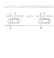
図1は、本発明の一実施形態であるナビゲーション装置を搭載した車両を含む複数の車両の一例を示す図である。   FIG. 1 is a diagram illustrating an example of a plurality of vehicles including a vehicle equipped with a navigation device according to an embodiment of the present invention.

図1に示すように、車両V1は、互いに情報送受信可能に接続された通信装置14及びナビゲーション装置100を搭載し、車両V2は、互いに情報送受信可能に接続された通信装置24及びナビゲーション装置200を搭載している。なお、図1中では車両V2を1台のみ示しているが、車両V2は1台のみ存在する場合に限られず複数台存在してもよい。車両V1の通信装置14と各車両V2の通信装置24とは、無線通信を介して互いに情報を送受信することが可能である。なお、車両V1の通信装置14及びナビゲーション装置100は、別々の筐体で別体となる装置構成であってもよいし、共通の1つの筐体で一体となる機器構成であってもよい。また、各車両V2の通信装置24及びナビゲーション装置200についても同様である。本実施形態では、車両V1のナビゲーション装置100が、1台以上の車両V2(他の移動体に相当)の現在位置を後述の電子地図EM上に描画し、後述のディスプレイ2に表示させる場合について説明する。以下適宜、車両V1を「自車両V1」、車両V2を「他車両V2」という。   As shown in FIG. 1, a vehicle V1 includes a communication device 14 and a navigation device 100 that are connected so as to be able to transmit / receive information to each other, and a vehicle V2 includes a communication device 24 and a navigation device 200 that are connected so as to be able to transmit / receive information to / from each other. It is installed. Although only one vehicle V2 is shown in FIG. 1, the vehicle V2 is not limited to a single vehicle, and a plurality of vehicles V2 may exist. The communication device 14 of the vehicle V1 and the communication device 24 of each vehicle V2 can transmit / receive information to / from each other via wireless communication. Note that the communication device 14 and the navigation device 100 of the vehicle V1 may have a separate device configuration in separate housings, or may have a device configuration integrated in a single common housing. The same applies to the communication device 24 and the navigation device 200 of each vehicle V2. In the present embodiment, the navigation device 100 of the vehicle V1 draws the current position of one or more vehicles V2 (corresponding to other moving objects) on an electronic map EM described later and displays the current position on the display 2 described later. explain. Hereinafter, the vehicle V1 is appropriately referred to as “own vehicle V1” and the vehicle V2 is referred to as “other vehicle V2”.

図2は、自車両V1の電子系統のハードウェア構成例を示すブロック図である。   FIG. 2 is a block diagram illustrating a hardware configuration example of the electronic system of the host vehicle V1.

図2に示すように、自車両V1は、通信装置14、無線通信アンテナ3、ナビゲーション装置100、ディスプレイ2、車速センサ4、ブレーキスイッチ5、ウィンカースイッチ6、車載カメラ7、GPS8、及びジャイロセンサ9を有する。   As shown in FIG. 2, the host vehicle V 1 includes a communication device 14, a wireless communication antenna 3, a navigation device 100, a display 2, a vehicle speed sensor 4, a brake switch 5, a blinker switch 6, an in-vehicle camera 7, a GPS 8, and a gyro sensor 9. Have

通信装置14は、無線通信アンテナ3を介した無線通信により、各他車両V2の通信装置24との情報の送受信を制御する機能を有する。この通信装置14は、制御部15を有する。   The communication device 14 has a function of controlling transmission / reception of information with the communication device 24 of each other vehicle V <b> 2 by wireless communication via the wireless communication antenna 3. The communication device 14 includes a control unit 15.

制御部15は、CPU16及び記憶装置17を備える。   The control unit 15 includes a CPU 16 and a storage device 17.

CPU16は、記憶装置17に記憶された各種のプログラムを実行することで各種の処理を行うと共に、他の各部との間で情報の交換や各種の制御指示を出力することで、通信装置14全体を制御する機能を有する。   The CPU 16 performs various processes by executing various programs stored in the storage device 17, and also exchanges information with other units and outputs various control instructions, whereby the communication device 14 as a whole. It has a function to control.

記憶装置17は、ROM17a、RAM17b、及び記憶媒体17cを備える。ROM17aは、上記各種のプログラムやその他必要な情報が予め書き込まれた情報記憶媒体である。RAM17bは、CPU16が上記各種のプログラムを実行する上で必要な情報の書き込み及び読み出しが行われる情報記憶媒体である。記憶媒体17cは、例えばフラッシュメモリやハードディスク等の不揮発性の情報記憶媒体である。   The storage device 17 includes a ROM 17a, a RAM 17b, and a storage medium 17c. The ROM 17a is an information storage medium in which the various programs and other necessary information are written in advance. The RAM 17b is an information storage medium on which information necessary for the CPU 16 to execute the various programs is written and read. The storage medium 17c is a non-volatile information storage medium such as a flash memory or a hard disk.

無線通信アンテナ3は、自車両V1の室外に取り付けられ、通信装置14から入力された情報信号の送信と、各他車両V2の通信装置24から受信された情報信号の通信装置14への出力とを行う。   The wireless communication antenna 3 is attached outside the vehicle V1 and transmits an information signal input from the communication device 14, and outputs an information signal received from the communication device 24 of each other vehicle V2 to the communication device 14. I do.

ナビゲーション装置100は、制御部10及びグラフィックコントローラ13を有する。   The navigation device 100 includes a control unit 10 and a graphic controller 13.

制御部10は、CPU11及び記憶装置12を備える。   The control unit 10 includes a CPU 11 and a storage device 12.

CPU11(コンピュータに相当)は、記憶装置12に記憶された各種のプログラム(CPU11に対し後述の図11〜図13のフローに示すナビゲーション方法の各手順を実行させるためのナビゲーションプログラムを含む)を実行することで各種の処理を行うと共に、他の各部との間で情報の交換や各種の制御指示を出力することで、ナビゲーション装置100全体を制御する機能を有する。   The CPU 11 (corresponding to a computer) executes various programs (including a navigation program for causing the CPU 11 to execute each procedure of the navigation method shown in the flow of FIGS. 11 to 13 described later) stored in the storage device 12. As a result, various processes are performed, and information is exchanged with other units and various control instructions are output, thereby controlling the entire navigation device 100.

記憶装置12は、ROM12a、RAM12b、及び記憶媒体12cを備える。ROM12aは、上記各種のプログラムやその他必要な情報が予め書き込まれた情報記憶媒体である。RAM12b(第1蓄積手段に相当)は、CPU11が上記各種のプログラムを実行する上で必要な情報の書き込み及び読み出しが行われる情報記憶媒体である。記憶媒体12cは、例えばフラッシュメモリやハードディスク等の不揮発性の情報記憶媒体である。この記憶媒体12cは、地図情報等の各種の情報を記憶する。   The storage device 12 includes a ROM 12a, a RAM 12b, and a storage medium 12c. The ROM 12a is an information storage medium in which the various programs and other necessary information are written in advance. The RAM 12b (corresponding to the first storage means) is an information storage medium on which information necessary for the CPU 11 to execute the various programs is written and read. The storage medium 12c is a non-volatile information storage medium such as a flash memory or a hard disk. The storage medium 12c stores various information such as map information.

グラフィックコントローラ13は、CPU11の制御により、ビデオRAM(図示せず)等から画像データを取得し、画像データに基づく画像を描画して、ディスプレイ2に表示させる機能を有する。例えば、グラフィックコントローラ13は、CPU11の制御により、上記記憶媒体12cに記憶された地図情報に基づき、電子地図EM(地図に相当。後述の図5等参照)を描画し、ディスプレイ2に表示させる。また例えば、グラフィックコントローラ13は、CPU11の制御により、自車両V1の位置情報(後述)に基づき、電子地図EM上に自車両V1の現在位置を描画し、ディスプレイ2に表示させたり、1台以上の他車両V2の位置情報(後述)に基づき、電子地図EM上に1台以上の他車両V2の現在位置を描画し、ディスプレイ2に表示させる。なお、グラフィックコントローラ13は、電子地図EM上に、自車両V1の現在位置を描画せず、1台以上の他車両V2の現在位置のみを描画し、ディスプレイ2に表示させてもよい。   The graphic controller 13 has a function of acquiring image data from a video RAM (not shown) or the like under the control of the CPU 11, drawing an image based on the image data, and displaying the image on the display 2. For example, the graphic controller 13 draws an electronic map EM (corresponding to a map; see FIG. 5 to be described later) based on the map information stored in the storage medium 12 c under the control of the CPU 11 and displays it on the display 2. For example, the graphic controller 13 draws the current position of the host vehicle V1 on the electronic map EM based on the position information (described later) of the host vehicle V1 under the control of the CPU 11, and displays it on the display 2, or one or more units. Based on the position information (described later) of the other vehicle V2, the current position of one or more other vehicles V2 is drawn on the electronic map EM and displayed on the display 2. The graphic controller 13 may draw only the current position of one or more other vehicles V2 on the electronic map EM, and display the current position of one or more other vehicles V2 on the display 2.

ディスプレイ2(表示手段に相当)は、例えばLCDパネル等で構成され、グラフィックコントローラ13から入力された画像信号に基づき、各種の情報画像を表示する。   The display 2 (corresponding to the display means) is constituted by an LCD panel, for example, and displays various information images based on the image signal input from the graphic controller 13.

車速センサ4は、自車両V1の走行速度を検出する機能を有する。CPU11は、この車速センサ4の検出信号に基づき、その時点で自車両V1がどのくらいの速度で走行しているかを認識できる。   The vehicle speed sensor 4 has a function of detecting the traveling speed of the host vehicle V1. Based on the detection signal of the vehicle speed sensor 4, the CPU 11 can recognize how fast the host vehicle V1 is traveling at that time.

ブレーキスイッチ5は、自車両V1のブレーキが所定量以上踏み込まれて作動状態に入っているか否か、つまり自車両V1が制動操作による減速中の状態であるか否かを検出する機能を有する。   The brake switch 5 has a function of detecting whether or not the brake of the host vehicle V1 is depressed and entering an operating state, that is, whether or not the host vehicle V1 is being decelerated by a braking operation.

ウィンカースイッチ6は、自車両V1の右方向又は左方向いずれか一方のウィンカー操作の有無を検出する機能を有する。   The blinker switch 6 has a function of detecting the presence or absence of a blinker operation in either the right direction or the left direction of the host vehicle V1.

車載カメラ7は、例えばCCD撮像素子等を利用して、自車両V1からの撮像方向の風景画像を撮像し、対応する画像信号をCPU11へ出力する機能を有する。なお、車載カメラ7は、赤外線センサやレーダ等でもよい。   The in-vehicle camera 7 has a function of capturing a landscape image in the image capturing direction from the host vehicle V1 using, for example, a CCD image sensor and outputting a corresponding image signal to the CPU 11. The in-vehicle camera 7 may be an infrared sensor or a radar.

GPS8は、自車両V1の現在位置の測位を行い、緯度及び経度で表記した位置情報を取得すると共に、CPU11へ出力する機能を有する。以下適宜、GPS8により検出された位置情報を「現実位置情報」、現実位置情報に基づく現在位置を「現実位置」という。   The GPS 8 has a function of measuring the current position of the host vehicle V <b> 1, acquiring position information expressed in latitude and longitude, and outputting the position information to the CPU 11. Hereinafter, the position information detected by the GPS 8 is referred to as “real position information”, and the current position based on the real position information is referred to as “real position”.

ジャイロセンサ9は、自車両V1の走行方位(走行方向)を検出する機能を有する。CPU11は、このジャイロセンサ9の検出信号に基づき、その時点で自車両V1がどの方位(方向)に走行しているのかを認識できる。   The gyro sensor 9 has a function of detecting the traveling direction (traveling direction) of the host vehicle V1. Based on the detection signal of the gyro sensor 9, the CPU 11 can recognize in which direction (direction) the host vehicle V1 is traveling at that time.

なお、自車両V1は、上記車速センサ4、ブレーキスイッチ5、ウィンカースイッチ6、車載カメラ7、及びジャイロセンサ9のうちの1以上を備えなくてもよいし、上記以外のハードウェアを備えてもよい。   The host vehicle V1 may not include one or more of the vehicle speed sensor 4, the brake switch 5, the blinker switch 6, the in-vehicle camera 7, and the gyro sensor 9, or may include hardware other than the above. Good.

また、各他車両V2の電子系統は、上記と同様のハードウェア構成とすることができるが、必ずしも上記と同様のハードウェア構成とする必要はなく、また各他車両V2同士が同様のハードウェア構成である必要もない。なお、各他車両V2では、通信装置24の制御部を「制御部25」といい、他の各部については上記と同一の呼称とする。   The electronic system of each other vehicle V2 can have the same hardware configuration as described above, but does not necessarily have the same hardware configuration as described above, and each other vehicle V2 has the same hardware configuration. It does not have to be a configuration. In each other vehicle V2, the control unit of the communication device 24 is referred to as a “control unit 25”, and the other units have the same names as described above.

図3は、他車両V2の通信装置24の制御部25の機能構成例を示す機能ブロック図である。   FIG. 3 is a functional block diagram illustrating a functional configuration example of the control unit 25 of the communication device 24 of the other vehicle V2.

図3に示すように、通信装置24の制御部25は、送受信部251を備える。   As illustrated in FIG. 3, the control unit 25 of the communication device 24 includes a transmission / reception unit 251.

送受信部251は、無線通信を介して情報の送受信を間欠的に行う。この送受信部251の最も主要な機能の1つは、他車両V2の識別情報(以下適宜「車両ID」という)、及び、GPS8により検出された他車両V2の現実位置情報を少なくとも含む情報を、無線通信を介して間欠的(例えば100[ms]ごと)に送信することにある。また、送受信部251は、他車両V2の車両ID及び現実位置情報に加え、車速センサ4により検出された他車両V2の速度情報や、ジャイロセンサ9により検出された他車両V2の走行方位情報、他車両V2の加減速情報等の挙動情報を含む情報を送信してもよい。なお、上記では情報の送受信を間欠的に行うと記載したが、通信自体が間欠的に接続と切断を繰り返すものであってもよいし、通信自体は常時又は連続的に情報パケットの送信を間欠的に行い、連続的に送信される情報の内容の更新が上記間隔(例えば100[ms]ごと)で行われるものであってもよい。また、他車両V2の送信する現実位置情報とは、測位上の誤差を含むものであってもよく、ここではその誤差の程度は問わない。   The transmission / reception unit 251 intermittently transmits and receives information via wireless communication. One of the most main functions of the transmission / reception unit 251 includes information including at least identification information of the other vehicle V2 (hereinafter referred to as “vehicle ID” as appropriate) and actual position information of the other vehicle V2 detected by the GPS 8. It is to transmit intermittently (for example, every 100 [ms]) via wireless communication. In addition to the vehicle ID and actual position information of the other vehicle V2, the transmission / reception unit 251 includes the speed information of the other vehicle V2 detected by the vehicle speed sensor 4, the traveling direction information of the other vehicle V2 detected by the gyro sensor 9, Information including behavior information such as acceleration / deceleration information of the other vehicle V2 may be transmitted. In the above description, information is transmitted and received intermittently. However, communication itself may intermittently repeat connection and disconnection, or communication itself may intermittently transmit information packets continuously or continuously. The content of the information transmitted continuously may be updated at the above intervals (for example, every 100 [ms]). In addition, the actual position information transmitted by the other vehicle V2 may include an error in positioning, and here, the degree of the error does not matter.

図4は、自車両V1の通信装置14の制御部15の機能構成例、及び、CPU11が記憶装置12に記憶された所定のプログラムを実行することで発揮されるナビゲーション装置100の制御部10の機能構成例を示す機能ブロック図である。   FIG. 4 shows a functional configuration example of the control unit 15 of the communication device 14 of the host vehicle V1 and the control unit 10 of the navigation device 100 that is exhibited when the CPU 11 executes a predetermined program stored in the storage device 12. It is a functional block diagram which shows an example of a function structure.

図4に示すように、通信装置14の制御部15は、送受信部151を備える。   As illustrated in FIG. 4, the control unit 15 of the communication device 14 includes a transmission / reception unit 151.

送受信部151は、無線通信を介して情報の送受信を間欠的に行う。この送受信部151の最も主要な機能の1つは、1台以上の他車両V2における送受信部251から間欠的に送信された、車両ID及び現実位置情報を少なくとも含む情報を、無線通信を介して間欠的(例えば100[ms]ごと)に受信することにある。なお、他車両V2における送受信部251により、車両ID及び現実位置情報に加え挙動情報を含む情報が送信された場合には、送受信部151は、他車両V2における送受信部251から送信された、車両ID及び現実位置情報に加え挙動情報を含む情報を受信する。この送受信部151により受信された情報は、ナビゲーション装置100の制御部10へ出力される。   The transmission / reception unit 151 intermittently performs transmission / reception of information via wireless communication. One of the most important functions of the transmission / reception unit 151 is to transmit, via wireless communication, information including at least the vehicle ID and the actual position information transmitted intermittently from the transmission / reception unit 251 in one or more other vehicles V2. The reception is intermittent (for example, every 100 [ms]). When information including behavior information in addition to the vehicle ID and the actual position information is transmitted by the transmission / reception unit 251 in the other vehicle V2, the transmission / reception unit 151 transmits the vehicle transmitted from the transmission / reception unit 251 in the other vehicle V2. Information including behavior information in addition to ID and actual position information is received. Information received by the transmission / reception unit 151 is output to the control unit 10 of the navigation device 100.

また、ナビゲーション装置100の制御部10は、取得部102、予測部103、推定部104、及び表示制御部105を備える。   The control unit 10 of the navigation device 100 includes an acquisition unit 102, a prediction unit 103, an estimation unit 104, and a display control unit 105.

取得部102(第1取得手段に相当)は、送受信部151により受信された情報から、当該情報に車両IDが含まれる各他車両V2ごとに、現実位置情報を少なくとも取得する。なお、送受信部151により、車両ID及び現実位置情報に加え挙動情報を含む情報が受信された場合には、取得部102は、送受信部151により受信された情報から、当該情報に車両IDが含まれる各他車両V2ごとに、現実位置情報に加え挙動情報を取得してもよい。この取得部102により取得された情報は、RAM12bに記憶され、蓄積される。   The acquisition unit 102 (corresponding to the first acquisition unit) acquires at least the actual position information for each other vehicle V <b> 2 whose vehicle ID is included in the information from the information received by the transmission / reception unit 151. When information including behavior information in addition to the vehicle ID and the actual position information is received by the transmission / reception unit 151, the acquisition unit 102 includes the vehicle ID in the information from the information received by the transmission / reception unit 151. In addition to the actual position information, behavior information may be acquired for each of the other vehicles V2. Information acquired by the acquisition unit 102 is stored and accumulated in the RAM 12b.

ここで、送受信部151により情報が受信された他車両V2のうちに、取得部102により取得された現実位置情報に基づく現実位置が、グラフィックコントローラ13による電子地図EMの描画範囲に対応する、ディスプレイ2による電子地図EMの表示範囲50(後述の図5等参照)内にある他車両V2が存在する場合があり得る。なお、表示範囲50は、基本的には電子地図EMにおける自車両V1の現在位置を含む範囲が設定される。例えば、所望の縮尺とされた電子地図EMにおける自車両V1の現在位置が常に中心となる範囲が設定される。このとき、ユーザの操作により表示範囲50に含まれる電子地図EMの縮尺を変動できるようにしてもよい。上記の場合には、表示制御部105は、グラフィックコントローラ13を制御し、現実位置が表示範囲50内にある他車両V2に関し、上記取得された現実位置情報に基づき、電子地図EM上に現実位置を描画させ、所定の表示態様(例えば濃い色彩の三角マーク等。以下適宜、「第1表示態様」という)でディスプレイ2に表示させる。   Here, a display in which the actual position based on the actual position information acquired by the acquisition unit 102 of the other vehicle V2 whose information is received by the transmission / reception unit 151 corresponds to the drawing range of the electronic map EM by the graphic controller 13 is displayed. There may be another vehicle V2 within the display range 50 of the electronic map EM 2 (see FIG. 5 and the like described later). The display range 50 is basically set to a range including the current position of the host vehicle V1 on the electronic map EM. For example, a range in which the current position of the host vehicle V1 in the electronic map EM having a desired scale is always the center is set. At this time, the scale of the electronic map EM included in the display range 50 may be changed by a user operation. In the above case, the display control unit 105 controls the graphic controller 13 and relates to the other vehicle V2 whose actual position is within the display range 50 based on the acquired actual position information on the electronic map EM. Is drawn and displayed on the display 2 in a predetermined display mode (for example, a dark triangle mark, etc., hereinafter referred to as “first display mode” as appropriate).

そして、ディスプレイ2に現実位置が表示されている他車両V2に関し、送受信部151により情報が継続して受信されることで、取得部102により現実位置情報が継続して取得され、かつ現実位置が表示範囲50内にある間は、表示制御部105は、グラフィックコントローラ13を制御し、上記継続して取得される現実位置情報に基づき、電子地図EM上への現実位置を更新させつつ継続して描画させ、第1表示態様でディスプレイ2に表示させる。なお、情報が継続して受信される(現実位置情報が継続して取得される)とは、この例では、他車両V2からの最新(直前)の情報の受信時刻から所定期間(例えば200[ms])が経過するまでの間に、再び同一の他車両V2から情報が受信される(現実位置情報が取得される)ことが繰り返される状態をいう。   Then, regarding the other vehicle V <b> 2 whose real position is displayed on the display 2, the information is continuously received by the transmission / reception unit 151, whereby the real position information is continuously acquired by the acquisition unit 102, and the real position is While within the display range 50, the display control unit 105 controls the graphic controller 13 and continuously updates the actual position on the electronic map EM based on the actual position information acquired continuously. Draw and display on the display 2 in the first display mode. In this example, the information is continuously received (actual position information is continuously acquired) in this example from the reception time of the latest (immediately preceding) information from the other vehicle V2 (for example, 200 [ ms]), a state in which information is received again from the same other vehicle V2 (actual position information is acquired) is repeated.

ここで、ディスプレイ2に他車両V2の現実位置が表示されている最中に、自車両V1及び他車両V2の間に無線通信を障害するビル等の障害物が存在する等により無線通信状況が悪化し、送受信部151による情報の受信が途切れることで、取得部102による現実位置情報の取得が途切れる他車両V2が存在する場合があり得る。なお、情報の受信が途切れる(現実位置情報の取得が途切れる)とは、この例では、他車両V2からの最新(直前)の情報の受信時刻から所定期間が経過しても、まだ同一の他車両V2から情報が受信されない(現実位置情報が取得されない)状態をいう。上記の場合には、推定部103は、情報の受信が途切れることで現実位置情報の取得が途切れた他車両V2に関し、RAM12bに蓄積された、これまでの現実位置情報を用いて(挙動情報がある場合は挙動情報も用いて)、現在位置を公知の適宜の手法により推定し、対応する位置情報を生成する。以下適宜、推定された現在位置を「推定位置」、推定位置に対応する位置情報を「推定位置情報」という。なお、推定では、他車両V2から取得して蓄積した情報からの推定位置に対し、さらに自車両V1のナビゲーション装置100の地図情報を用いて公知の適宜のマップマッチング補正をかけて補正した位置を、推定位置としてもよい。   Here, while the actual position of the other vehicle V2 is displayed on the display 2, there is a wireless communication status due to an obstacle such as a building that obstructs wireless communication between the host vehicle V1 and the other vehicle V2. There is a case where there is another vehicle V2 in which the acquisition of the real position information by the acquisition unit 102 is interrupted due to the deterioration of reception of information by the transmission / reception unit 151. In this example, reception of information is interrupted (acquisition of actual position information is interrupted), even if a predetermined period elapses from the reception time of the latest (immediately preceding) information from another vehicle V2. A state in which information is not received from the vehicle V2 (actual position information is not acquired). In the above case, the estimation unit 103 uses the previous actual position information accumulated in the RAM 12b for the other vehicle V2 whose acquisition of the actual position information is interrupted due to the reception of information being interrupted (the behavior information is In some cases (using behavior information as well), the current position is estimated by a known appropriate method, and corresponding position information is generated. Hereinafter, the estimated current position is referred to as “estimated position”, and the position information corresponding to the estimated position is referred to as “estimated position information”. In the estimation, a position corrected by performing appropriate known map matching correction using the map information of the navigation device 100 of the host vehicle V1 with respect to the estimated position from the information acquired and accumulated from the other vehicle V2 is used. The estimated position may be used.

このとき、推定部103により現在位置が推定された他車両V2のうちに、推定された推定位置が表示範囲50内にある他車両V2が存在する場合があり得る。この場合には、表示制御部105は、グラフィックコントローラ13を制御し、推定位置が表示範囲50内にある他車両V2に関し、それまで電子地図EM上に描画させていた現実位置に代え、上記生成した推定位置情報に基づき、電子地図EM上に推定位置を描画させ、上記第1表示態様とは異なる表示態様(例えば薄い色彩の三角マーク等。以下適宜、「第2表示態様」という)でディスプレイ2に表示させる。   At this time, there may be another vehicle V2 in which the estimated position is within the display range 50 among the other vehicles V2 whose current position is estimated by the estimation unit 103. In this case, the display control unit 105 controls the graphic controller 13 to replace the actual position previously drawn on the electronic map EM with respect to the other vehicle V2 whose estimated position is within the display range 50, and generate the above-mentioned Based on the estimated position information, the estimated position is drawn on the electronic map EM and displayed in a display mode different from the first display mode (for example, a thin colored triangle mark, etc., hereinafter referred to as “second display mode” as appropriate). 2 is displayed.

そして、ディスプレイ2に推定位置が表示されている他車両V2に関し、送受信部151による情報の受信が途切れたままで再開されないことで、取得部102による現実位置情報の取得が途切れたままで再開されず、かつ推定位置が表示範囲50内にある間は、表示制御部105は、グラフィックコントローラ13を制御し、上記継続して生成される推定位置情報に基づき、電子地図EM上への推定位置を更新させつつ継続して描画させ、第2表示態様でディスプレイ2に表示させる。   And regarding the other vehicle V2 whose estimated position is displayed on the display 2, the reception of the information by the transmission / reception unit 151 is not interrupted and is not resumed, so that the acquisition of the actual position information by the acquisition unit 102 is interrupted and is not resumed. While the estimated position is within the display range 50, the display control unit 105 controls the graphic controller 13 to update the estimated position on the electronic map EM based on the continuously generated estimated position information. The image is continuously drawn while being displayed on the display 2 in the second display mode.

ここで、ディスプレイ2に他車両V2の推定位置が表示されている最中に、自車両V1及び他車両V2の間に障害物が存在しなくなる等により無線通信状況が好転し、送受信部151による情報の受信が再開されることで、取得部102による現実位置情報の取得が再開され、かつ現在位置が表示範囲50内にある他車両V2が存在する場合があり得る。この場合には、表示制御部105は、グラフィックコントローラ13を制御し、情報の受信が再開されることで現実位置情報の取得が再開されかつ現在位置が表示範囲50内にある他車両V2に関し、それまで電子地図EM上に描画させていた推定位置に代え、上記取得された現実位置情報に基づき、電子地図EM上に現実位置を描画させ、第1表示態様でディスプレイ2に表示させる。   Here, while the estimated position of the other vehicle V <b> 2 is displayed on the display 2, the wireless communication situation is improved due to the absence of an obstacle between the host vehicle V <b> 1 and the other vehicle V <b> 2. When the reception of information is resumed, the acquisition of the actual position information by the obtaining unit 102 may be resumed, and there may be another vehicle V2 whose current position is within the display range 50. In this case, the display control unit 105 controls the graphic controller 13, and the reception of the information is resumed, whereby the acquisition of the actual position information is resumed, and the other vehicle V2 whose current position is within the display range 50, Instead of the estimated position previously drawn on the electronic map EM, the real position is drawn on the electronic map EM based on the acquired actual position information and displayed on the display 2 in the first display mode.

予測部103(予測手段に相当)は、既に1回又は複数回の情報の受信が行なわれ、かつそのうちの最新の情報に含まれる現実位置情報に基づく現実位置が表示範囲50外にある、つまり表示範囲50外に存在する他車両V2について、その現在位置を把握する。そして、表示範囲50外に存在する他車両V2に関し情報の受信が途切れることで現実位置情報の取得が途切れた場合に、予測部103は、RAM12bに蓄積された、これまでの現実位置情報を用いて(挙動情報がある場合は挙動情報も用いて)、自車両V1との今後の位置関係を予測することで、今後表示範囲50内となるか否かを予測する。例えば、予測部103は、自車両V1に近づく方向へ走行している他車両V2については、今後表示範囲50内となると予測し、自車両V1から遠ざかる方向へ走行している他車両V2については、今後表示範囲50内とならないと予測する。なお、予測では、上記の情報から予測した今後の他車両V2の位置に対し、さらに自車両V1のナビゲーション装置100の地図情報を用いて公知の適宜のマップマッチング補正をかけて補正した位置をもって、自車両V1との今後の位置関係を予測してもよい。   The prediction unit 103 (corresponding to the prediction means) has already received information one or more times, and the actual position based on the actual position information included in the latest information is out of the display range 50. For the other vehicle V2 existing outside the display range 50, the current position is grasped. When the acquisition of the actual position information is interrupted due to the interruption of reception of information regarding the other vehicle V2 existing outside the display range 50, the prediction unit 103 uses the actual position information so far accumulated in the RAM 12b. (If there is behavior information, the behavior information is also used), and it is predicted whether or not it will be in the display range 50 in the future by predicting the future positional relationship with the host vehicle V1. For example, the prediction unit 103 predicts that the other vehicle V2 traveling in the direction approaching the host vehicle V1 will be within the display range 50 in the future, and the other vehicle V2 traveling in the direction away from the host vehicle V1. It is predicted that it will not be in the display range 50 in the future. In the prediction, the position of the future vehicle V2 predicted from the above information is further corrected by applying known appropriate map matching correction using the map information of the navigation device 100 of the host vehicle V1, A future positional relationship with the host vehicle V1 may be predicted.

推定部104(第1推定手段に相当)は、表示範囲50外に存在する他車両V2に関し、情報の受信が途切れることで現実位置情報の取得が途切れた場合に、RAM12bに蓄積された、これまでの現実位置情報を用いて(挙動情報がある場合は挙動情報も用いて)、現在位置を公知の適宜の手法により推定し、対応する推定位置情報を生成する。具体的には、推定部104は、処理負荷等を考慮し、予測部103により今後表示範囲50内となると予測された他車両V2及び予測部103により今後表示範囲50内となるともならないとも予測された他車両V2(以下適宜、「予測部103により今後表示範囲50内となると予測された他車両V2等」と略記する)に関してのみ、現在位置の推定を行って、予測部103により今後表示範囲50内とならないと予測された他車両V2に関しては、現在位置の推定を行わない。なお、推定部104は、今後表示範囲50内となると予測された他車両V2等に関してのみ現在位置の推定を行って、今後表示範囲50内とならないと予測された他車両V2に関しては現在位置の推定を行わない場合に限られるものではない。すなわち、推定部104は、今後表示範囲50内となると予測された他車両V2等の現在位置の推定を、今後表示範囲50内とならないと予測された他車両V2よりも優先的に行うようにしてもよい。例えば、所定数の他車両V2まで現在位置の推定を行うと設定しておき、今後表示範囲50内となると予測された他車両V2等が所定数未満であった場合に、推定部104は、今後表示範囲50内となると予測された他車両V2等に加え、今後表示範囲50内とならないと予測された他車両V2の現在位置の推定を行うようにしてもよい。あるいは、推定部104は、予測部103の予測結果によらず、表示範囲50外に存在する他車両V2に関し、情報の受信が途切れることで現実位置情報の取得が途切れた場合に、現在位置の推定を行ってもよく、推定部104がこのような処理を行う場合、予測部103は不要となる。但し、説明の便宜上、以下では、推定部104が、今後表示範囲50内となると予測された他車両V2等に関してのみ、現在位置の推定を行って、今後表示範囲50内とならないと予測された他車両V2に関しては、現在位置の推定を行わない場合について説明する。   The estimation unit 104 (corresponding to the first estimation unit) is stored in the RAM 12b when the acquisition of the actual position information is interrupted due to the interruption of reception of information regarding the other vehicle V2 existing outside the display range 50. The current position is estimated by a known appropriate method using the actual position information up to (if there is behavior information, and the corresponding estimated position information is generated). Specifically, the estimation unit 104 considers the processing load and the like, and predicts that the prediction unit 103 will not be in the display range 50 in the future by the other vehicle V2 predicted to be in the display range 50 in the future and the prediction unit 103. The current position is estimated only for the other vehicle V2 (hereinafter abbreviated as “other vehicle V2, etc. predicted to be within the display range 50 in the future by the prediction unit 103”) and displayed by the prediction unit 103 in the future. For the other vehicle V2 predicted not to fall within the range 50, the current position is not estimated. The estimation unit 104 estimates the current position only for the other vehicle V2 and the like that are predicted to be in the display range 50 in the future, and the current position of the other vehicle V2 that is predicted not to be in the display range 50 in the future. It is not limited to the case where estimation is not performed. That is, the estimation unit 104 preferentially estimates the current position of the other vehicle V2 or the like predicted to be within the display range 50 in the future over the other vehicle V2 predicted not to be within the display range 50 in the future. May be. For example, when the current position is estimated to be estimated up to a predetermined number of other vehicles V2, and the other vehicles V2 and the like predicted to be within the display range 50 in the future are less than the predetermined number, the estimation unit 104 In addition to the other vehicle V2 predicted to be within the display range 50 in the future, the current position of the other vehicle V2 predicted not to be within the display range 50 in the future may be estimated. Alternatively, the estimation unit 104 determines the current position of the other vehicle V2 existing outside the display range 50 when the acquisition of the actual position information is interrupted due to the interruption of information reception, regardless of the prediction result of the prediction unit 103. The estimation may be performed, and when the estimation unit 104 performs such processing, the prediction unit 103 is not necessary. However, for convenience of explanation, in the following, it is predicted that the estimation unit 104 estimates the current position only with respect to the other vehicle V2 or the like predicted to be in the display range 50 in the future and does not fall in the display range 50 in the future. With respect to the other vehicle V2, a case where the current position is not estimated will be described.

表示制御部105(表示制御手段に相当)は、グラフィックコントローラ13を制御し、推定部104により現在位置が推定された他車両V2に関し、推定された推定位置が表示範囲50外にある間は、電子地図EM上への推定位置の描画を開始させず、推定位置が表示範囲50内に到達するときに、生成された推定位置情報に基づき、電子地図EM上への推定位置の描画を開始させ、第2表示態様でディスプレイ2に表示を開始させる。   The display control unit 105 (corresponding to the display control unit) controls the graphic controller 13, and the estimated position of the other vehicle V <b> 2 whose current position is estimated by the estimation unit 104 is outside the display range 50. When the estimated position reaches the display range 50 without starting the drawing of the estimated position on the electronic map EM, the drawing of the estimated position on the electronic map EM is started based on the generated estimated position information. Then, display is started on the display 2 in the second display mode.

図5〜図10は、自車両V1及び他車両V2の移動に伴う、自車両V1のディスプレイ2の表示内容の推移を表す説明図である。なお、これら図5〜図10では、図示の煩雑を避けて理解を容易とするために、情報を送信している他車両V2を1台としている。   5-10 is explanatory drawing showing transition of the display content of the display 2 of the own vehicle V1 accompanying the movement of the own vehicle V1 and the other vehicle V2. In FIGS. 5 to 10, the other vehicle V <b> 2 that transmits information is set to one in order to avoid the complexity of illustration and facilitate understanding.

図5(a)には、自車両V1が、図中上下方向に沿った道路R1を図中上側に向かって走行していると共に、他車両V2が、上記道路R1と交差する図中左右方向に沿った道路R2を図中右側に向かって走行している状況を示している。図5(a)に示す状況では、自車両V1は、送受信部151により他車両V2から情報が受信されることで、取得部102により他車両V2の現在位置情報が取得されており、また他車両V2は表示範囲50外に存在している。この図5(a)に示す状況の時点では、グラフィックコントローラ13による電子地図EM上への、上記取得された現実位置情報に基づく他車両V2の現実位置の描画は行われない。   In FIG. 5A, the host vehicle V1 travels on the road R1 along the vertical direction in the drawing toward the upper side in the drawing, and the other vehicle V2 crosses the road R1 in the horizontal direction in the drawing. The situation which is drive | working toward the right side in the figure on the road R2 along is shown. In the situation shown in FIG. 5 (a), the host vehicle V1 receives information from the other vehicle V2 by the transmission / reception unit 151, and the acquisition unit 102 has acquired the current position information of the other vehicle V2. The vehicle V2 exists outside the display range 50. At the time of the situation shown in FIG. 5A, the graphic controller 13 does not draw the actual position of the other vehicle V2 on the electronic map EM based on the acquired actual position information.

この場合、図5(b)に示す例のように、ディスプレイ2に表示された電子地図EM上には、他車両V2の現実位置を示すマークは表示されず、自車両V1の現実位置を示すマークM1のみが表示される。   In this case, as in the example shown in FIG. 5B, the mark indicating the actual position of the other vehicle V2 is not displayed on the electronic map EM displayed on the display 2, and the actual position of the host vehicle V1 is indicated. Only the mark M1 is displayed.

上記図5(a)に示す状況よりも少し後の状況を示す図6(a)には、自車両V1が、道路R1の上記図5(a)に示す位置よりも少し図中上側を図中上側に向かって走行していると共に、他車両V2が、道路R2の上記図5(a)に示す位置よりも少し図中右側を図中右側に向かって走行している状況を示している。図6(a)に示す状況では、自車両V1は、送受信部151による他車両V2からの情報の受信が途切れることで、取得部102による他車両V2の現在位置情報の取得が途切れており、また他車両V2は表示範囲50外に存在している。この図6(a)に示す状況の時点では、予測部103により他車両V2が今後表示範囲50内となると予測され、推定部104により他車両V2の現在位置の推定が行われるが、推定された他車両V2の推定位置が表示範囲50外となるため、グラフィックコントローラ13による電子地図EM上への、他車両V2の推定位置の描画は行われない。   In FIG. 6 (a) showing a situation slightly after the situation shown in FIG. 5 (a), the host vehicle V1 shows a slightly upper side of the road R1 from the position shown in FIG. 5 (a). While traveling toward the middle upper side, the other vehicle V2 is traveling a little on the right side in the drawing toward the right side in the drawing from the position shown in FIG. 5 (a) of the road R2. . In the situation shown in FIG. 6A, the host vehicle V1 is interrupted from receiving information from the other vehicle V2 by the transmission / reception unit 151, so that the acquisition of the current position information of the other vehicle V2 by the acquisition unit 102 is interrupted. The other vehicle V2 exists outside the display range 50. At the time of the situation shown in FIG. 6A, the prediction unit 103 predicts that the other vehicle V2 will be in the display range 50 in the future, and the estimation unit 104 estimates the current position of the other vehicle V2. Further, since the estimated position of the other vehicle V2 is outside the display range 50, the graphic controller 13 does not draw the estimated position of the other vehicle V2 on the electronic map EM.

この場合、図6(b)に示す例のように、ディスプレイ2に表示された電子地図EM上には、他車両V2の推定位置を示すマークは表示されず、自車両V1の現実位置を示すマークM1のみが更新表示される。   In this case, as in the example shown in FIG. 6B, the mark indicating the estimated position of the other vehicle V2 is not displayed on the electronic map EM displayed on the display 2, and the actual position of the host vehicle V1 is indicated. Only the mark M1 is updated and displayed.

上記図6(a)に示す状況よりも少し後の状況を示す図7(a)には、自車両V1が、道路R1の上記図6(a)に示す位置よりも少し図中上側を図中上側に向かって走行していると共に、他車両V2が、道路R2の上記図6(a)に示す位置よりも少し図中右側を図中右側に向かって走行している状況を示している。図7(a)に示す状況でも、自車両V1は、送受信部151による他車両V2からの情報の受信が途切れたままで再開されないことで、取得部102による他車両V2の現在位置情報の取得が途切れたままで再開されておらず、また他車両V2は表示範囲50外に存在している。この図7(a)に示す状況の時点でも、予測部103により他車両V2が今後表示範囲50内となると予測され、推定部104により他車両V2の現在位置の推定が行われるが、推定された他車両V2の推定位置が表示範囲50外となるため、グラフィックコントローラ13による電子地図EM上への、他車両V2の推定位置の描画は行われない。   In FIG. 7 (a) showing a situation slightly after the situation shown in FIG. 6 (a), the host vehicle V1 is shown on the road R1 slightly above the position shown in FIG. 6 (a). While traveling toward the middle upper side, the other vehicle V2 is traveling a little on the right side in the drawing toward the right side in the drawing from the position shown in FIG. 6 (a) of the road R2. . Even in the situation shown in FIG. 7A, the acquisition of the current position information of the other vehicle V2 by the acquisition unit 102 is not performed in the host vehicle V1 because the reception of information from the other vehicle V2 by the transmission / reception unit 151 is interrupted and is not resumed. The vehicle is not restarted because it is interrupted, and the other vehicle V2 exists outside the display range 50. Even at the time of the situation shown in FIG. 7A, the prediction unit 103 predicts that the other vehicle V2 will be in the display range 50 in the future, and the estimation unit 104 estimates the current position of the other vehicle V2. Further, since the estimated position of the other vehicle V2 is outside the display range 50, the graphic controller 13 does not draw the estimated position of the other vehicle V2 on the electronic map EM.

この場合、図7(b)に示す例のように、ディスプレイ2に表示された電子地図EM上には、他車両V2の推定位置を示すマークは表示されず、自車両V1の現実位置を示すマークM1のみが更新表示される。   In this case, as in the example shown in FIG. 7B, the mark indicating the estimated position of the other vehicle V2 is not displayed on the electronic map EM displayed on the display 2, and the actual position of the host vehicle V1 is indicated. Only the mark M1 is updated and displayed.

上記図7(a)に示す状況よりも少し後の状況を示す図8(a)には、自車両V1が、道路R1の上記図7(a)に示す位置よりも少し図中上側を図中上側に向かって走行していると共に、他車両V2が、道路R2の上記図7(a)に示す位置よりも少し図中右側を図中右側に向かって走行している状況を示している。図8(a)に示す状況でも、自車両V1は、送受信部151による他車両V2からの情報の受信が途切れたままで再開されないことで、取得部102による他車両V2の現在位置情報の取得が途切れたままで再開されておらず、また他車両V2は表示範囲50内に到達している。この図8(a)に示す状況の時点では、推定部104により他車両V2の現在位置の推定が行われ、推定された他車両V2の推定位置が表示範囲50内に到達しているため、グラフィックコントローラ13による電子地図EM上への、他車両V2の推定位置の描画が開始される。   In FIG. 8 (a), which shows a situation slightly after the situation shown in FIG. 7 (a), the host vehicle V1 is slightly above the position shown in FIG. 7 (a) on the road R1. While traveling toward the middle upper side, the other vehicle V2 is traveling a little on the right side in the drawing toward the right side in the drawing from the position shown in FIG. 7A of the road R2. . Even in the situation shown in FIG. 8A, the acquisition of the current position information of the other vehicle V2 by the acquisition unit 102 is not performed in the host vehicle V1, because the transmission / reception unit 151 does not resume receiving information from the other vehicle V2. The vehicle is not restarted because it is interrupted, and the other vehicle V <b> 2 has reached the display range 50. At the time of the situation shown in FIG. 8A, the estimation unit 104 estimates the current position of the other vehicle V2, and the estimated position of the other vehicle V2 has reached the display range 50. Drawing of the estimated position of the other vehicle V2 on the electronic map EM by the graphic controller 13 is started.

この場合、図8(b)に示す例のように、ディスプレイ2に表示された電子地図EM上には、他車両V2の推定位置を示すマークM2′の表示が開始されると共に、自車両V1の現実位置を示すマークM1が更新表示される。   In this case, as in the example shown in FIG. 8B, the display of the mark M2 ′ indicating the estimated position of the other vehicle V2 is started on the electronic map EM displayed on the display 2, and the host vehicle V1. The mark M1 indicating the actual position is updated and displayed.

上記図8(a)に示す状況よりも少し後の状況を示す図9(a)には、自車両V1が、道路R1の上記図8(a)に示す位置よりも少し図中上側を図中上側に向かって走行していると共に、他車両V2が、道路R2の上記図8(a)に示す位置よりも少し図中右側を図中右側に向かって走行している状況を示している。図9(a)に示す状況でも、自車両V1は、送受信部151による他車両V2からの情報の受信が途切れたままで再開されないことで、取得部102による他車両V2の現在位置情報の取得が途切れたままで再開されておらず、また他車両V2は表示範囲50内に存在している。この図9(a)に示す状況の時点では、推定部104により他車両V2の現在位置の推定が行われ、推定された他車両V2の推定位置が表示範囲50内にあるため、グラフィックコントローラ13による電子地図EM上への、他車両V2の推定位置の描画が行われている。   In FIG. 9 (a) showing a situation slightly later than the situation shown in FIG. 8 (a), the host vehicle V1 is shown on the road R1 slightly above the position shown in FIG. 8 (a). While traveling toward the middle upper side, the other vehicle V2 is traveling slightly on the right side in the drawing toward the right side in the drawing from the position shown in FIG. 8A of the road R2. . Even in the situation shown in FIG. 9A, the acquisition of the current position information of the other vehicle V2 by the acquisition unit 102 is not performed in the host vehicle V1, because the transmission / reception unit 151 does not resume reception of information from the other vehicle V2. The vehicle is not restarted because it is interrupted, and the other vehicle V <b> 2 exists in the display range 50. 9A, the current position of the other vehicle V2 is estimated by the estimation unit 104, and the estimated position of the other vehicle V2 is within the display range 50. Therefore, the graphic controller 13 The estimated position of the other vehicle V2 is drawn on the electronic map EM.

この場合、図9(b)に示す例のように、ディスプレイ2に表示された電子地図EM上には、他車両V2の推定位置を示すマークM2′が更新表示されると共に、自車両V1の現実位置を示すマークM1が更新表示される。   In this case, as in the example shown in FIG. 9B, the mark M2 ′ indicating the estimated position of the other vehicle V2 is updated and displayed on the electronic map EM displayed on the display 2, and the vehicle V1 is also displayed. The mark M1 indicating the actual position is updated and displayed.

上記図9(a)に示す状況よりも少し後の状況を示す図10(a)には、自車両V1が、道路R1の上記図9(a)に示す位置よりも少し図中上側を図中上側に向かって走行していると共に、他車両V2が、道路R2の上記図9(a)に示す位置よりも少し図中右側を図中右側に向かって走行している状況を示している。図10(a)に示す状況では、自車両V1は、送受信部151による他車両V2からの情報の受信が再開されることで、取得部102による他車両V2の現在位置情報の取得が再開されており、また他車両V2は表示範囲50内に存在している。この図9(a)に示す状況の時点では、グラフィックコントローラ13による電子地図EM上への、それまで行われていた他車両V2の推定位置の描画に代え、上記取得された現実位置情報に基づく他車両V2の現実位置の描画が行われる。   In FIG. 10 (a) showing a situation slightly later than the situation shown in FIG. 9 (a), the host vehicle V1 is shown on the road R1 slightly above the position shown in FIG. 9 (a). While traveling toward the middle upper side, the other vehicle V2 is traveling a little on the right side in the drawing toward the right side in the drawing from the position shown in FIG. 9A of the road R2. . In the situation illustrated in FIG. 10A, the host vehicle V1 resumes the acquisition of the current position information of the other vehicle V2 by the acquisition unit 102 when the transmission / reception unit 151 resumes the reception of information from the other vehicle V2. The other vehicle V2 exists in the display range 50. At the time of the situation shown in FIG. 9A, instead of drawing the estimated position of the other vehicle V2 that has been performed on the electronic map EM by the graphic controller 13, it is based on the acquired actual position information. The actual position of the other vehicle V2 is drawn.

この場合、図10(b)に示す例のように、ディスプレイ2に表示された電子地図EM上には、それまで表示されていた他車両V2の推定位置を示すマークM2′に代え、他車両V2の現実位置を示すマークM2が表示されると共に、自車両V1の現実位置を示すマークM1が更新表示される。   In this case, as in the example shown in FIG. 10B, on the electronic map EM displayed on the display 2, instead of the mark M2 ′ indicating the estimated position of the other vehicle V2 displayed so far, the other vehicle A mark M2 indicating the actual position of V2 is displayed, and a mark M1 indicating the actual position of the host vehicle V1 is updated and displayed.

図11〜図13は、上記手法を実現するために、自車両V1のナビゲーション装置100におけるCPU11が記憶装置12に記憶されたナビゲーションプログラムにより実行するナビゲーション方法の制御手順例を示すフローチャートである。なお、これら図11〜図13では、図示の煩雑を避けて理解を容易とするために、他車両V2が1台のみ存在する場合について説明する。但し、他車両V2が複数台存在する場合は、以下で説明する処理を各他車両V2ごとに実行する等により適用可能である。   FIGS. 11 to 13 are flowcharts showing an example of a control procedure of the navigation method executed by the CPU 11 in the navigation device 100 of the host vehicle V1 by the navigation program stored in the storage device 12 in order to realize the above method. In addition, in these FIGS. 11-13, in order to avoid the complexity of illustration and to make it easy to understand, the case where only one other vehicle V2 exists is demonstrated. However, when there are a plurality of other vehicles V2, the processing described below can be applied to each other vehicle V2.

図11〜図13において、このフローに示す処理は、例えば自車両V1のナビゲーション装置100の電源が投入された場合(言い換えれば、自車両V1のエンジンがONにされた場合)に開始される。   11 to 13, the processing shown in this flow is started, for example, when the navigation apparatus 100 of the host vehicle V1 is turned on (in other words, when the engine of the host vehicle V1 is turned on).

まず、ステップS10で、CPU11は、表示制御部105の機能により、グラフィックコントローラ13を制御し、記憶媒体12cに記憶された地図情報に基づき、電子地図EMを描画させ、ディスプレイ2に表示させる。そして、CPU11は、表示制御部105の機能により、グラフィックコントローラ13を制御し、GPS8から入力された自車両V1の現実位置情報に基づき、電子地図EM上に自車両V1の現実位置を描画させ、ディスプレイ2に表示させる。なお、このステップS10の処理は、所定の時間間隔ごとに繰り返し行われる。   First, in step S <b> 10, the CPU 11 controls the graphic controller 13 by the function of the display control unit 105, draws an electronic map EM based on the map information stored in the storage medium 12 c, and displays it on the display 2. Then, the CPU 11 controls the graphic controller 13 by the function of the display control unit 105, and draws the actual position of the host vehicle V1 on the electronic map EM based on the actual position information of the host vehicle V1 input from the GPS 8. It is displayed on the display 2. Note that the process of step S10 is repeatedly performed at predetermined time intervals.

その後、ステップS20に移り、CPU11は、他車両V2における送受信部251から無線通信を介して送信された情報(車両ID及び現実位置情報を少なくとも含む。なお、車両ID及び現実位置情報に加え速度情報、走行方位情報、加減速情報等の挙動情報を含む場合もある)が、通信装置14におけるCPU16の送受信部151の機能により無線通信を介して受信され、当該情報を通信装置14から入力したか否かを判定する。他車両V2からの情報を通信装置14から入力した場合には、ステップS20の判定が満たされて(S20:YES)、ステップS40に移る。   Thereafter, the process proceeds to step S20, where the CPU 11 includes at least information (via vehicle ID and actual position information) transmitted from the transmission / reception unit 251 in the other vehicle V2 via wireless communication. Or travel direction information, acceleration / deceleration information, or the like) may be received via wireless communication by the function of the transmission / reception unit 151 of the CPU 16 in the communication device 14 and the information is input from the communication device 14. Determine whether or not. When the information from the other vehicle V2 is input from the communication device 14, the determination in step S20 is satisfied (S20: YES), and the process proceeds to step S40.

ステップS40では、CPU11は、上記ステップS20で入力された情報に含まれる車両IDと同一の車両IDがRAM12bに記憶されているか否かを判定することで、他車両V2から情報が受信されたのが最初であるか否かを判定する。上記ステップS20で入力された情報に含まれる車両IDと同一の車両IDがRAM12bに記憶されていない場合には、他車両V2から情報が受信されたのが最初であるとみなされ、ステップS40の判定が満たされて(S40:YES)、ステップS50に移る。   In step S40, the CPU 11 determines whether or not the same vehicle ID as the vehicle ID included in the information input in step S20 is stored in the RAM 12b, so that the information is received from the other vehicle V2. Is first. When the same vehicle ID as the vehicle ID included in the information input in step S20 is not stored in the RAM 12b, it is considered that the information is received from the other vehicle V2 first, and in step S40. The determination is satisfied (S40: YES), and the routine goes to Step S50.

ステップS50では、CPU11は、取得部102の機能により、上記ステップS20で入力された情報から、他車両V2の車両ID及び現実位置情報を少なくとも取得する(挙動情報がある場合には挙動情報も取得する)。   In step S50, the CPU 11 obtains at least the vehicle ID and actual position information of the other vehicle V2 from the information input in step S20 by the function of the obtaining unit 102 (if there is behavior information, the behavior information is also obtained). To do).

そして、ステップS60で、CPU11は、上記ステップS50で取得された車両ID及び現実位置情報を(挙動情報も取得された場合には挙動情報も)、RAM12bへ新規記録する。   In step S60, the CPU 11 newly records the vehicle ID and actual position information acquired in step S50 (and behavior information when behavior information is also acquired) in the RAM 12b.

その後、ステップS70に移り、CPU11は、RAM12bから、上記ステップS60で新規記録された現実位置情報を取得する。   Thereafter, the process proceeds to step S70, and the CPU 11 acquires the actual position information newly recorded in step S60 from the RAM 12b.

そして、ステップS80で、CPU11は、上記ステップS70で取得された現実位置情報に基づく他車両V2の現実位置が、表示範囲50内にあるか否かを判定する。他車両V2の現実位置が表示範囲50内にある場合には、ステップS0の判定が満たされて(S80:YES)、ステップS90に移る。   In step S80, the CPU 11 determines whether or not the actual position of the other vehicle V2 based on the actual position information acquired in step S70 is within the display range 50. If the actual position of the other vehicle V2 is within the display range 50, the determination at Step S0 is satisfied (S80: YES), and the routine goes to Step S90.

ステップS90では、CPU11は、表示制御部105の機能により、グラフィックコントローラ13を制御し、上記ステップS70で取得された現実位置情報に基づき、電子地図EM上に他車両V2の現実位置を描画させ、第1表示態様でディスプレイ2に表示させる。その後、上記ステップS20に戻り、同様の手順を繰り返す。   In step S90, the CPU 11 controls the graphic controller 13 by the function of the display control unit 105, and draws the actual position of the other vehicle V2 on the electronic map EM based on the actual position information acquired in step S70. It is displayed on the display 2 in the first display mode. Then, it returns to said step S20 and repeats the same procedure.

一方、上記ステップS80において、他車両V2の現実位置が表示範囲50外にある場合には、ステップS80の判定は満たされず(S80;NO)、上記ステップS90をスキップして上記ステップS20に戻り、同様の手順を繰り返す。   On the other hand, if the actual position of the other vehicle V2 is outside the display range 50 in step S80, the determination in step S80 is not satisfied (S80; NO), step S90 is skipped, and the process returns to step S20. Repeat the same procedure.

また一方、上記ステップS20において、他車両V2からの情報を通信装置14から入力していない場合には、ステップS20の判定は満たされず(S20:NO)、ステップS100に移る。   On the other hand, if the information from the other vehicle V2 is not input from the communication device 14 in step S20, the determination in step S20 is not satisfied (S20: NO), and the process proceeds to step S100.

ステップS100では、CPU11は、RAM12bに記録された他車両V2の最新の位置情報に係る時刻(最新の位置情報が現実位置情報である場合には、上記ステップS20での当該現実位置情報を含む情報の受信時刻。最新の位置情報が推定位置情報である場合には、後述のステップS120での当該推定位置情報の生成時刻)と現在時刻とに基づき、当該最新の位置情報が上記ステップS50又はステップS140で取得(当該位置情報が現実位置情報の場合)若しくは後述のステップS120で生成(当該位置情報が推定位置情報の場合)されてから所定期間が経過したか否かを判定する。最新の位置情報が取得若しくは生成されてから所定期間が経過していない場合(最新の位置情報が現実位置情報の場合には、現実位置情報の取得が途切れていない場合に相当)には、ステップS100の判定は満たされず(S100:NO)、上記ステップS20に戻り、同様の手順を繰り返す。なお、RAM12bに他車両V2の位置情報が記録されていない場合、つまり他車両V2からの情報の受信が開始されていない場合にも、ステップS100の判定は満たされず(S100:NO)、上記ステップS20に戻り、同様の手順を繰り返す。一方、最新の位置情報が取得若しくは生成されてから所定期間が経過した場合(最新の位置情報が現実位置情報の場合には、現実位置情報の取得が途切れた場合に相当)には、ステップS100の判定が満たされて(S100:YES)、ステップS110に移る。なお、最新の位置情報に基づく他車両V2の現在位置が表示範囲50内にある場合には、後述のステップS120に移る。   In step S100, the CPU 11 determines the time related to the latest position information of the other vehicle V2 recorded in the RAM 12b (if the latest position information is actual position information, the information including the actual position information in step S20 above). When the latest position information is estimated position information, the latest position information is determined based on the above-described step S50 or step based on the generation time of the estimated position information (described later in step S120) and the current time. It is determined whether or not a predetermined period has elapsed since acquisition in S140 (when the position information is actual position information) or generation in step S120 described later (when the position information is estimated position information). If the predetermined period has not elapsed since the latest position information was acquired or generated (if the latest position information is actual position information, this corresponds to the case where acquisition of actual position information is not interrupted) The determination in S100 is not satisfied (S100: NO), the process returns to step S20 and the same procedure is repeated. Even when the position information of the other vehicle V2 is not recorded in the RAM 12b, that is, when reception of information from the other vehicle V2 is not started, the determination in step S100 is not satisfied (S100: NO), and the above step Returning to S20, the same procedure is repeated. On the other hand, when a predetermined period has elapsed since the latest position information was acquired or generated (when the latest position information is actual position information, this corresponds to a case where acquisition of actual position information is interrupted), step S100. Is satisfied (S100: YES), the process proceeds to step S110. When the current position of the other vehicle V2 based on the latest position information is within the display range 50, the process proceeds to step S120 described later.

ステップS110では、CPU11は、予測部103の機能により、RAM12bに蓄積された他車両V2のこれまでの位置情報を用いて(挙動情報がある場合には挙動情報も用いて)、他車両V2が今後表示範囲50内となるか否かを予測する。他車両V2が今後表示範囲50内とならないと予測された場合(S110:NO)には、上記ステップS20に戻り、同様の手順を繰り返す。一方、他車両V2が今後表示範囲50内となると予測された場合(S110:YES)には、ステップS120に移る。なお、推定部104が、予測部103の予測結果によらず、表示範囲50外に存在する他車両V2に関し、情報の受信が途切れることで現実位置情報の取得が途切れた場合に、現在位置の推定を行うようにする場合には、このステップS110の手順は省略される。   In step S110, the CPU 11 uses the function of the prediction unit 103 to use the previous position information of the other vehicle V2 accumulated in the RAM 12b (if there is behavior information, also use the behavior information), the other vehicle V2 It is predicted whether or not it will be within the display range 50 in the future. When it is predicted that the other vehicle V2 will not be in the display range 50 in the future (S110: NO), the process returns to step S20 and the same procedure is repeated. On the other hand, when it is predicted that the other vehicle V2 will be in the display range 50 in the future (S110: YES), the process proceeds to step S120. It should be noted that the estimation unit 104 determines the current position of the other vehicle V2 existing outside the display range 50 when the acquisition of the actual position information is interrupted due to the interruption of information reception, regardless of the prediction result of the prediction unit 103. When estimation is performed, the procedure of step S110 is omitted.

ステップS120では、CPU11は、推定部104の機能により、RAM12bに蓄積された他車両V2のこれまでの位置情報を用いて(挙動情報がある場合は挙動情報も用いて)、他車両V2の現在位置を推定し、対応する推定位置情報を生成する。   In step S120, the CPU 11 uses the function of the estimation unit 104 to use the current position information of the other vehicle V2 accumulated in the RAM 12b (if there is behavior information, also use the behavior information) to determine the current state of the other vehicle V2. A position is estimated and corresponding estimated position information is generated.

その後、ステップS130に移り、CPU11は、上記ステップS120で生成された推定位置情報を、RAM12bへ追加記録する。その後、後述のステップS160に移る。   Thereafter, the process proceeds to step S130, and the CPU 11 additionally records the estimated position information generated in step S120 in the RAM 12b. Thereafter, the process proceeds to step S160 described later.

一方、上記ステップS40において、上記ステップS20で入力された情報に含まれる車両IDと同一の車両IDがRAM12bに記憶されている場合には、他車両V2から情報が受信されたのが2回目以降であるとみなされ、ステップS40の判定は満たされず(S40:NO)、ステップS140に移る。   On the other hand, in step S40, when the same vehicle ID as the vehicle ID included in the information input in step S20 is stored in the RAM 12b, the information is received from the other vehicle V2 on and after the second time. Therefore, the determination in step S40 is not satisfied (S40: NO), and the process proceeds to step S140.

ステップS140では、CPU11は、取得部102の機能により、上記ステップS20で入力された情報から、他車両V2の車両ID及び現実位置情報を少なくとも取得する(挙動情報がある場合には挙動情報も取得する)。   In step S140, the CPU 11 obtains at least the vehicle ID and actual position information of the other vehicle V2 from the information input in step S20 by the function of the obtaining unit 102 (if there is behavior information, the behavior information is also obtained). To do).

そして、ステップS150で、CPU11は、上記ステップS140で取得された車両ID及び現実位置情報を(挙動情報も取得された場合には挙動情報も)、RAM12bへ追加記録する。   In step S150, the CPU 11 additionally records the vehicle ID and actual position information acquired in step S140 (and behavior information when behavior information is also acquired) in the RAM 12b.

その後、ステップS160に移り、CPU11は、RAM12bから、最新の位置情報を取得する。   Thereafter, the process proceeds to step S160, and the CPU 11 acquires the latest position information from the RAM 12b.

そして、ステップS170で、CPU11は、上記ステップS160で取得された位置情報に基づく他車両V2の現在位置(位置情報が現実位置情報である場合には現実位置。位置情報が推定位置情報である場合には推定位置)が、表示範囲50内にあるか否かを判定する。他車両V2の現在位置が表示範囲50内にある場合(他車両V2の現在位置が表示範囲50内に到達した場合も含む)には、ステップS170の判定が満たされて(S170:YES)、ステップS180に移る。   In step S170, the CPU 11 determines the current position of the other vehicle V2 based on the position information acquired in step S160 (the actual position when the position information is actual position information. When the position information is estimated position information. It is determined whether or not the estimated position is within the display range 50. If the current position of the other vehicle V2 is within the display range 50 (including the case where the current position of the other vehicle V2 has reached the display range 50), the determination in step S170 is satisfied (S170: YES), The process moves to step S180.

ステップS180では、CPU11は、上記ステップS160で取得された位置情報が推定位置情報であったか否かを判定する。上記ステップS160で取得された位置情報が推定位置情報であった場合には、ステップS180の判定が満たされて(S180:YES)、ステップS190に移る。   In step S180, the CPU 11 determines whether or not the position information acquired in step S160 is estimated position information. If the position information acquired in step S160 is estimated position information, the determination in step S180 is satisfied (S180: YES), and the process proceeds to step S190.

ステップS190では、CPU11は、表示制御部105の機能により、グラフィックコントローラ13を制御し、上記ステップS160で取得された推定位置情報に基づき、電子地図EM上に他車両V2の推定位置を描画させ、第2表示態様でディスプレイ2に表示させる(電子地図EM上への他車両V2の推定位置の描画を開始させ、第2表示態様でディスプレイ2に表示を開始させる場合も含む)。その後、上記ステップS20に戻り、同様の手順を繰り返す。   In step S190, the CPU 11 controls the graphic controller 13 by the function of the display control unit 105, and draws the estimated position of the other vehicle V2 on the electronic map EM based on the estimated position information acquired in step S160. It is displayed on the display 2 in the second display mode (including a case where drawing of the estimated position of the other vehicle V2 on the electronic map EM is started and display on the display 2 is started in the second display mode). Then, it returns to said step S20 and repeats the same procedure.

一方、上記ステップS180において、上記ステップS160で取得された位置情報が現実位置情報であった場合には、ステップS180の判定は満たされず(S180:NO)、ステップS200に移る。   On the other hand, if the position information acquired in step S160 is actual position information in step S180, the determination in step S180 is not satisfied (S180: NO), and the process proceeds to step S200.

ステップS200では、CPU11は、表示制御部105の機能により、グラフィックコントローラ13を制御し、上記ステップS160で取得された現実位置情報に基づき、電子地図EM上に他車両V2の現実位置を描画させ、第1表示態様でディスプレイ2に表示させる。その後、上記ステップS20に戻り、同様の手順を繰り返す。   In step S200, the CPU 11 controls the graphic controller 13 by the function of the display control unit 105, and draws the actual position of the other vehicle V2 on the electronic map EM based on the actual position information acquired in step S160. It is displayed on the display 2 in the first display mode. Then, it returns to said step S20 and repeats the same procedure.

一方、上記ステップS170において、他車両V2の現在位置が表示範囲50外にある場合には、ステップS170の判定は満たされず(S170:NO)、上記ステップS180及びステップS190(又はステップS200)をスキップして上記ステップS20に戻り、同様の手順を繰り返す。   On the other hand, if the current position of the other vehicle V2 is outside the display range 50 in step S170, the determination in step S170 is not satisfied (S170: NO), and step S180 and step S190 (or step S200) are skipped. Then, the process returns to step S20 and the same procedure is repeated.

なお、このフローに示す処理は、例えば自車両V1の車載装置100の電源が切断された場合(言い換えれば、自車両V1のエンジンがOFFにされた場合)に終了される。   Note that the processing shown in this flow is terminated when, for example, the power source of the in-vehicle device 100 of the host vehicle V1 is turned off (in other words, when the engine of the host vehicle V1 is turned off).

また、以上説明した図11〜図13において、ステップS50及びステップS140の手順が、取得手順に相当する。また、ステップS60及びステップS160の手順が、蓄積手順に相当する。また、ステップS120の手順が、推定手順に相当する。また、ステップS190の手順が、表示制御手順に相当する。   Further, in FIGS. 11 to 13 described above, the procedure of step S50 and step S140 corresponds to the acquisition procedure. Further, the procedure of step S60 and step S160 corresponds to an accumulation procedure. Further, the procedure of step S120 corresponds to an estimation procedure. Further, the procedure of step S190 corresponds to a display control procedure.

以上説明したように、本実施形態のナビゲーション装置100は、無線通信を介して受信された情報から他車両V2(他の移動体に相当)の現実位置情報(位置情報に相当)を取得する取得部102(第1取得手段に相当)と、取得部102により取得された現実位置情報を蓄積するRAM12b(第1蓄積手段に相当)と、ディスプレイ2(表示手段に相当)による電子地図EM(地図に相当)の表示範囲50外に存在する他車両V2に関し取得部102による現実位置情報の取得が途切れた場合に、RAM12bに蓄積された現実位置情報を用いて他車両V2の現在位置を推定する推定部104(第1推定手段に相当)と、推定部104により推定された推定位置情報(位置情報に相当)に基づく他車両V2の推定位置(現在位置に相当)が表示範囲50内に到達するときに、推定部104により推定された推定位置情報に基づき他車両V2の推定位置の表示を開始するように、ディスプレイ2を制御する表示制御部105(表示制御手段に相当)と、を有する。   As described above, the navigation device 100 according to the present embodiment acquires the actual position information (corresponding to position information) of the other vehicle V2 (corresponding to another moving body) from the information received via wireless communication. An electronic map EM (map) corresponding to a unit 102 (corresponding to first acquisition means), a RAM 12b (corresponding to first storage means) for accumulating actual position information acquired by the acquisition part 102, and a display 2 (corresponding to display means) When the acquisition of the actual position information by the acquisition unit 102 is interrupted for the other vehicle V2 existing outside the display range 50, the current position of the other vehicle V2 is estimated using the actual position information stored in the RAM 12b. An estimated position (corresponding to the current position) of the other vehicle V2 based on the estimation unit 104 (corresponding to the first estimation means) and the estimated position information (corresponding to position information) estimated by the estimation unit 104 Display control unit 105 (display control unit) that controls display 2 to start displaying the estimated position of other vehicle V2 based on the estimated position information estimated by estimating unit 104 when the vehicle reaches within display range 50. Equivalent).

また、本実施形態のナビゲーション方法は、無線通信を介して受信された情報から他車両V2(他の移動体に相当)の現実位置情報(位置情報に相当)を取得する手順と、取得された現実位置情報を蓄積する手順と、ディスプレイ2(表示手段に相当)による電子地図EM(地図に相当)の表示範囲50外に存在する他車両V2に関し現実位置情報の取得が途切れた場合に、蓄積された現実位置情報を用いて他車両V2の現在位置を推定する手順と、推定された推定位置情報(位置情報に相当)に基づく他車両V2の推定位置(現在位置に相当)が表示範囲50内に到達するときに、推定された推定位置情報に基づき他車両V2の推定位置の表示を開始するように、表示制御する手順と、を有する。   In addition, the navigation method of the present embodiment has acquired a procedure for acquiring actual position information (corresponding to position information) of another vehicle V2 (corresponding to another moving body) from information received via wireless communication, and The procedure for accumulating the actual position information and the accumulating information when the acquisition of the actual position information is interrupted for the other vehicle V2 existing outside the display range 50 of the electronic map EM (corresponding to the map) on the display 2 (corresponding to the display means). The estimated range of the other vehicle V2 (corresponding to the current position) based on the estimated position information (corresponding to the position information) based on the estimated position information (corresponding to the position information) is displayed in the display range 50. And a display control procedure so as to start displaying the estimated position of the other vehicle V2 based on the estimated position information.

また、本実施形態のナビゲーションプログラムは、無線通信を介して受信された情報から他車両V2(他の移動体に相当)の現実位置情報(位置情報に相当)を取得する手順と、取得された現実位置情報を蓄積する手順と、ディスプレイ2(表示手段に相当)による電子地図EM(地図に相当)の表示範囲50外に存在する他車両V2に関し現実位置情報の取得が途切れた場合に、蓄積された現実位置情報を用いて他車両V2の現在位置を推定する手順と、推定された推定位置情報(位置情報に相当)に基づく他車両V2の推定位置(現在位置に相当)が表示範囲50内に到達するときに、推定された推定位置情報に基づき他車両V2の推定位置の表示を開始するように、表示制御する手順と、をCPU11(コンピュータに相当)に実行させる。   In addition, the navigation program of the present embodiment has been acquired with a procedure for acquiring actual position information (corresponding to position information) of another vehicle V2 (corresponding to another moving body) from information received via wireless communication. The procedure for accumulating the actual position information and the accumulating information when the acquisition of the actual position information is interrupted for the other vehicle V2 existing outside the display range 50 of the electronic map EM (corresponding to the map) on the display 2 (corresponding to the display means). The estimated range of the other vehicle V2 (corresponding to the current position) based on the estimated position information (corresponding to the position information) based on the estimated position information (corresponding to the position information) is displayed in the display range 50. The CPU 11 (corresponding to a computer) executes a display control procedure so that display of the estimated position of the other vehicle V2 is started based on the estimated position information estimated when the vehicle reaches the inside. That.

本実施形態では、表示範囲50外に存在する他車両V2に関し、取得部102が現実位置情報を少なくとも1回取得した後、通信状況の悪化により現実位置情報の取得が途切れた場合に、推定部104が現在位置を推定する。そして、当該他の移動体に関し、現実位置情報の取得が再開されない間は現在位置の推定が継続され、推定された推定位置情報に基づく推定位置が表示範囲50内に到達するときに、ディスプレイ2が表示制御部105の制御により当該推定位置の表示を開始する。   In this embodiment, regarding the other vehicle V2 existing outside the display range 50, when the acquisition unit 102 acquires the real position information at least once, and the acquisition of the real position information is interrupted due to deterioration of the communication status, the estimation unit 104 estimates the current position. Then, regarding the other moving object, the estimation of the current position is continued while the acquisition of the actual position information is not resumed, and when the estimated position based on the estimated position information reaches the display range 50, the display 2 Starts display of the estimated position under the control of the display control unit 105.

以上のように、本実施形態では、現実位置情報が少なくとも1回取得された後、通信状況の悪化により現実位置情報の取得が途切れた、表示範囲50外に存在する他車両V2に関し、現実位置情報の取得が再開されない場合でも、推定位置が表示範囲50内となるときに、当該推定位置をディスプレイ2に表示させることができる。これにより、表示範囲50外に存在する他車両V2が、表示範囲50内(言い換えれば、ユーザの近く)になったにも拘わらず、当該他車両V2の現在位置が表示されないという不具合を抑えることができる。この結果、ユーザが、表示範囲50内(言い換えれば、自分の近く)に他車両V2が存在するにも拘わらず、当該他車両V2の存在に気付かなかったり、当該他車両V2が存在しないと誤認識するのを抑えることができる。したがって、事故の危険性を低減でき、安全性を高めることができる。   As described above, in the present embodiment, after the actual position information is acquired at least once, the acquisition of the actual position information is interrupted due to the deterioration of the communication status, and the actual position is related to the other vehicle V2 existing outside the display range 50. Even when the acquisition of information is not resumed, the estimated position can be displayed on the display 2 when the estimated position falls within the display range 50. This suppresses the problem that the current position of the other vehicle V2 is not displayed even though the other vehicle V2 existing outside the display range 50 is within the display range 50 (in other words, near the user). Can do. As a result, the user does not notice the presence of the other vehicle V2 even though the other vehicle V2 exists in the display range 50 (in other words, close to him / herself), or erroneously indicates that the other vehicle V2 does not exist. It can suppress recognition. Therefore, the risk of accidents can be reduced and safety can be improved.

また、上記ナビゲーション装置100においては、表示範囲50外に存在する他車両V2に関しRAM12bに蓄積された位置情報に基づき、表示範囲50外に存在する他車両V2が今後表示範囲50内となるか否かを予測する予測部103(予測手段に相当)をさらに有し、推定部104は、予測部103により今後表示範囲50内となると予測された他車両V2の現在位置の推定を行う。   In the navigation device 100, whether or not the other vehicle V2 existing outside the display range 50 will be in the display range 50 in the future based on the positional information stored in the RAM 12b with respect to the other vehicle V2 existing outside the display range 50. Further, the estimation unit 104 estimates the current position of the other vehicle V2 predicted by the prediction unit 103 to be within the display range 50 in the future.

これにより、今後表示範囲50内となると予測された他車両V2の現在位置の推定のみを行ったり(言い換えれば、今後表示範囲50内となると予測されなかった他車両V2の現在位置の推定を行わなかったり)、今後表示範囲50内となると予測された他車両V2の現在位置の推定を、今後表示範囲50内となると予測されなかった他車両V2の現在位置の推定よりも優先的に行うことで、推定部104の処理負担を軽減できる。   Thereby, only the current position of the other vehicle V2 predicted to be in the display range 50 in the future is estimated (in other words, the current position of the other vehicle V2 that is not predicted to be in the display range 50 in the future is estimated). The current position of the other vehicle V2 predicted to be within the display range 50 in the future is preferentially performed over the estimation of the current position of the other vehicle V2 that is not predicted to be within the display range 50 in the future. Thus, the processing load on the estimation unit 104 can be reduced.

また、上記ナビゲーション装置100においては、推定部104は、予測部103により今後表示範囲50内とならないと予測された他車両V2の現在位置の推定を行わない。   In the navigation device 100, the estimation unit 104 does not estimate the current position of the other vehicle V2 predicted by the prediction unit 103 not to be in the display range 50 in the future.

これにより、推定部104の処理負担を軽減できる。   Thereby, the processing burden of the estimation part 104 can be reduced.

また、上記ナビゲーション装置100においては、表示制御部105は、推定部104により推定された推定位置情報に基づく他車両V2の推定位置を、取得部102により取得された現実位置情報に基づく他車両V2の現実位置(現在位置に相当)と異なる表示態様で表示するように、ディスプレイ2を制御する。   In the navigation device 100, the display control unit 105 uses the estimated position of the other vehicle V2 based on the estimated position information estimated by the estimation unit 104 as the other vehicle V2 based on the actual position information acquired by the acquisition unit 102. The display 2 is controlled to display in a display mode different from the actual position (corresponding to the current position).

これにより、ユーザは、ディスプレイ2に表示された他車両V2の現在位置の表示が、推定された推定位置情報に基づく推定位置であるのか、若しくは、取得された現実位置情報に基づく現実位置であるのかを、視覚的に認識できる。   Thereby, the user can display the current position of the other vehicle V2 displayed on the display 2 based on the estimated position information or the actual position based on the acquired actual position information. Can be recognized visually.

なお、本発明は、上記実施形態に限られるものではなく、その趣旨及び技術的思想を逸脱しない範囲内で種々の変形が可能である。以下、そのような変形例を順次説明する。   The present invention is not limited to the above-described embodiment, and various modifications can be made without departing from the spirit and technical idea of the present invention. Hereinafter, such modifications will be sequentially described.

(1)通信装置側で現在位置の推定を行う場合
すなわち、前述の図4に対応する図14に示すように、本変形例の通信装置14の制御部15′は、送受信部151、取得部152、予測部153、推定部154、及び出力部155を備える。
(1) When estimating the current position on the communication device side That is, as shown in FIG. 14 corresponding to FIG. 4 described above, the control unit 15 ′ of the communication device 14 of the present modification includes a transmission / reception unit 151, an acquisition unit 152, a prediction unit 153, an estimation unit 154, and an output unit 155.

送受信部151は、上記実施形態で説明した機能と同様の機能を有する。本変形例では、送受信部151が、受信手段に相当する。   The transmission / reception unit 151 has the same function as that described in the above embodiment. In this modification, the transmission / reception unit 151 corresponds to a reception unit.

取得部152(第2取得手段に相当)は、送受信部151により受信された情報から、当該情報に車両IDが含まれる各他車両V2ごとに、現実位置情報を少なくとも取得する。なお、送受信部151により、車両ID及び現実位置情報に加え挙動情報を含む情報が受信された場合には、取得部152は、送受信部151により受信された情報から、当該情報に車両IDが含まれる各他車両V2ごとに、現実位置情報に加え挙動情報を取得してもよい。この取得部152により取得された情報は、前述のRAM17bに記憶され、蓄積される。本変形例では、RAM17bが、第2蓄積手段に相当する。   The acquisition unit 152 (corresponding to the second acquisition unit) acquires at least the actual position information for each other vehicle V2 whose vehicle ID is included in the information, from the information received by the transmission / reception unit 151. In addition, when the information including behavior information in addition to the vehicle ID and the actual position information is received by the transmission / reception unit 151, the acquisition unit 152 includes the vehicle ID in the information from the information received by the transmission / reception unit 151. In addition to the actual position information, behavior information may be acquired for each of the other vehicles V2. Information acquired by the acquisition unit 152 is stored and accumulated in the RAM 17b described above. In this modification, the RAM 17b corresponds to the second storage unit.

予測部153は、既に1回又は複数回の情報の受信が行なわれ、かつそのうちの最新の情報に含まれる現実位置情報に基づく現実位置が表示範囲50外にある、つまり表示範囲50外に存在する他車両V2について、その現在位置を把握する。そして、表示範囲50外に存在する他車両V2に関し情報の受信が途切れた場合に、予測部153は、RAM17bに蓄積された、これまでの現実位置情報を用いて(挙動情報がある場合は挙動情報も用いて)、自車両V1との今後の位置関係を予測することで、今後表示範囲50内となるか否かを予測する。   The prediction unit 153 has already received information one or more times, and the actual position based on the actual position information included in the latest information is out of the display range 50, that is, exists outside the display range 50. The current position of the other vehicle V2 is determined. And when reception of information regarding the other vehicle V2 existing outside the display range 50 is interrupted, the prediction unit 153 uses the actual position information thus far stored in the RAM 17b (if there is behavior information, the behavior is Whether or not it will be in the display range 50 in the future is predicted by predicting the future positional relationship with the host vehicle V1.

推定部154(第2推定手段に相当)は、表示範囲50外に存在する他車両V2に関し、情報の受信が途切れることで現実位置情報の取得が途切れた場合に、RAM12bに蓄積された、これまでの現実位置情報を用いて(挙動情報がある場合は挙動情報も用いて)、現在位置を公知の適宜の手法により推定し、対応する推定位置情報を生成する。具体的には、推定部154は、処理負荷等を考慮し、予測部153により今後表示範囲50内となると予測された他車両V2等に関してのみ、現在位置の推定を行って、予測部153により今後表示範囲50内とならないと予測された他車両V2に関しては、現在位置の推定を行わない。なお、推定部154は、今後表示範囲50内となると予測された他車両V2等に関してのみ現在位置の推定を行って、今後表示範囲50内とならないと予測された他車両V2に関しては現在位置の推定を行わない場合に限られるものではない。すなわち、推定部154は、今後表示範囲50内となると予測された他車両V2等の現在位置の推定を、今後表示範囲50内とならないと予測された他車両V2よりも優先的に行うようにしてもよい。あるいは、推定部154は、予測部153の予測結果によらず、表示範囲50外に存在する他車両V2に関し、情報の受信が途切れることで現実位置情報の取得が途切れた場合に、現在位置の推定を行ってもよく、推定部154がこのような処理を行う場合、予測部153は不要となる。但し、説明の便宜上、以下では、推定部154が、今後表示範囲50内となると予測された他車両V2等に関してのみ、現在位置の推定を行って、今後表示範囲50内とならないと予測された他車両V2に関しては、現在位置の推定を行わない場合について説明する。   The estimation unit 154 (corresponding to the second estimation means) is stored in the RAM 12b when the acquisition of the actual position information is interrupted due to the interruption of reception of information regarding the other vehicle V2 existing outside the display range 50. The current position is estimated by a known appropriate method using the actual position information up to (if there is behavior information, and the corresponding estimated position information is generated). Specifically, the estimation unit 154 estimates the current position only for the other vehicle V2 and the like predicted to be in the display range 50 in the future by the prediction unit 153 in consideration of the processing load and the like, and the prediction unit 153 For the other vehicle V2 predicted not to be in the display range 50 in the future, the current position is not estimated. The estimation unit 154 estimates the current position only with respect to the other vehicle V2 and the like predicted to be within the display range 50 in the future, and the current position of the other vehicle V2 that is predicted not to be within the display range 50 in the future. It is not limited to the case where estimation is not performed. That is, the estimation unit 154 preferentially estimates the current position of the other vehicle V2 or the like predicted to be in the display range 50 in the future over the other vehicle V2 that is predicted not to be in the display range 50 in the future. May be. Alternatively, the estimation unit 154 determines the current position of the other vehicle V <b> 2 existing outside the display range 50 when the acquisition of the actual position information is interrupted due to the interruption of reception of information, regardless of the prediction result of the prediction unit 153. The estimation may be performed, and when the estimation unit 154 performs such processing, the prediction unit 153 is not necessary. However, for convenience of explanation, in the following, it is predicted that the estimation unit 154 estimates the current position only with respect to the other vehicle V2 and the like predicted to be in the display range 50 in the future and will not be in the display range 50 in the future. With respect to the other vehicle V2, a case where the current position is not estimated will be described.

出力部155(出力手段に相当)は、推定部154により現在位置が推定された他車両V2に関し、推定された推定位置が表示範囲50外にある間は、生成された推定位置情報を本変形例のナビゲーション装置100の制御部10′へ出力せず、推定位置が表示範囲50内に到達するときに、生成された推定位置情報をナビゲーション装置100の制御部10′へ出力する。   The output unit 155 (corresponding to the output means) relates to the other vehicle V2 whose current position has been estimated by the estimation unit 154, while the estimated position information is outside the display range 50, the generated estimated position information is fully transformed. When the estimated position reaches the display range 50 without being output to the control unit 10 ′ of the example navigation device 100, the generated estimated position information is output to the control unit 10 ′ of the navigation device 100.

また、本変形例のナビゲーション装置100の制御部10′表示制御部105′を備える。   Further, the navigation device 100 of the present modification includes a control unit 10 ′ display control unit 105 ′.

表示制御部105′は、グラフィックコントローラ13を制御し、出力部155から入力された推定位置情報に基づき、推定位置が表示範囲50内に到達するときに、電子地図EM上への推定位置の描画を開始させ、前述の第2表示態様でディスプレイ2に表示を開始させる。本変形例では、表示制御部105′が、表示制御手段に相当する。   The display control unit 105 ′ controls the graphic controller 13 and draws the estimated position on the electronic map EM when the estimated position reaches the display range 50 based on the estimated position information input from the output unit 155. And display is started on the display 2 in the second display mode described above. In this modification, the display control unit 105 ′ corresponds to a display control unit.

以上説明したように、本変形例の通信装置14は、ナビゲーション装置100と情報送受信可能に接続された通信装置であって、無線通信を介して情報を受信する送受信部151(受信手段に相当)と、送受信部151により受信された情報から他車両V2(他の移動体に相当)の現実位置情報(位置情報に相当)を取得する取得部152(第2取得手段に相当)と、取得部152により取得された現実位置情報を蓄積するRAM17b(第2蓄積手段に相当)と、ディスプレイ2(表示手段に相当)による電子地図EM(地図に相当)の表示範囲50外に存在する他車両V2に関し取得部152による現実位置情報の取得が途切れた場合に、RAM17bに蓄積された現実位置情報を用いて他車両V2の現在位置を推定する推定部154(第2推定手段に相当)と、推定部154により推定された推定位置情報(位置情報に相当)に基づく他車両V2の推定位置(現在位置に相当)が表示範囲50内に到達するときに、ナビゲーション装置100が推定部154により推定された推定位置情報に基づきディスプレイ2による他車両V2の推定位置の表示を開始するように、推定部154により推定された推定位置情報をナビゲーション装置100へ出力する出力部155(出力手段に相当)と、を有する。   As described above, the communication device 14 according to the present modification is a communication device connected to the navigation device 100 so as to be able to transmit and receive information, and a transmission / reception unit 151 that receives information via wireless communication (corresponding to a receiving unit). An acquisition unit 152 (corresponding to second acquisition means) that acquires actual position information (corresponding to position information) of another vehicle V2 (corresponding to another moving body) from the information received by the transmission / reception unit 151; The other vehicle V2 that exists outside the display range 50 of the electronic map EM (corresponding to the map) by the RAM 17b (corresponding to the second accumulating means) for accumulating the actual position information acquired by 152 and the display 2 (corresponding to the display means). When the acquisition of the actual position information by the acquisition unit 152 is interrupted, the estimation unit 154 (estimating the current position of the other vehicle V2 using the actual position information stored in the RAM 17b) 2) and the estimated position (corresponding to the current position) of the other vehicle V2 based on the estimated position information (corresponding to the position information) estimated by the estimating unit 154 when the estimated position (corresponding to the current position) reaches within the display range 50. Output that outputs the estimated position information estimated by the estimation unit 154 to the navigation device 100 so that the apparatus 100 starts displaying the estimated position of the other vehicle V2 on the display 2 based on the estimated position information estimated by the estimation unit 154. Part 155 (corresponding to output means).

本変形例の通信装置14は、ナビゲーション装置100と情報送受信可能に接続されている。そして、通信装置14では、表示範囲50外に存在する他車両V2に関し、取得部152が現実位置情報を少なくとも1回取得した後、通信状況の悪化により現実位置情報の取得が途切れた場合に、推定部154が現在位置を推定する。そして、当該他車両V2に関し、現実位置情報の取得が再開されない間は現在位置の推定が継続され、推定された推定位置情報に基づく推定位置が表示範囲50内に到達するときに、出力部155が当該推定位置情報をナビゲーション装置10へ出力することで、ナビゲーション装置100がディスプレイ2による当該推定位置の表示を開始する。   The communication device 14 of this modification is connected to the navigation device 100 so that information can be transmitted and received. Then, in the communication device 14, regarding the other vehicle V2 existing outside the display range 50, when the acquisition unit 152 acquires the actual position information at least once, and the acquisition of the actual position information is interrupted due to the deterioration of the communication status, The estimation unit 154 estimates the current position. Then, regarding the other vehicle V2, the estimation of the current position is continued while the acquisition of the actual position information is not resumed, and when the estimated position based on the estimated position information reaches the display range 50, the output unit 155 Outputs the estimated position information to the navigation device 10, whereby the navigation device 100 starts displaying the estimated position on the display 2.

以上のように、本変形例では、現実位置情報が少なくとも1回取得された後、通信状況の悪化により現実位置情報の取得が途切れた、表示範囲50外に存在する他車両V2に関し、現実位置情報の取得が再開されない場合でも、推定位置が表示範囲50内となるときに、推定位置をディスプレイ2に表示させることができる。これにより、表示範囲50外に存在する他車両V2が、表示範囲50内(言い換えれば、ユーザの近く)になったにも拘わらず、当該他車両V2の現在位置が表示されないという不具合を抑えることができる。この結果、ユーザが、表示範囲50内(言い換えれば、自分の近く)に他車両V2が存在するにも拘わらず、当該他車両V2の存在に気付かなかったり、当該他車両V2が存在しないと誤認識するのを抑えることができる。したがって、事故の危険性を低減でき、安全性を高めることができる。   As described above, in this modified example, the actual position information is acquired at least once, and the actual position information is related to the other vehicle V2 outside the display range 50 where the acquisition of the actual position information is interrupted due to the deterioration of the communication status. Even when the acquisition of information is not resumed, the estimated position can be displayed on the display 2 when the estimated position falls within the display range 50. This suppresses the problem that the current position of the other vehicle V2 is not displayed even though the other vehicle V2 existing outside the display range 50 is within the display range 50 (in other words, near the user). Can do. As a result, the user does not notice the presence of the other vehicle V2 even though the other vehicle V2 exists in the display range 50 (in other words, close to him / herself), or erroneously indicates that the other vehicle V2 does not exist. It can suppress recognition. Therefore, the risk of accidents can be reduced and safety can be improved.

(2)その他
以上では、通信装置14及びナビゲーション装置100が車両に搭載されている場合を例にとって説明したが、これに限られず、通信装置及びナビゲーション装置は、車両以外の移動体(例えば航空機や船舶、人間等)や移動しない設備に保持されてもよい。また、以上では、車両の位置情報を取得して現在位置を表示する場合を例にとって説明したが、これに限られず、車両以外の移動体(例えば航空機や船舶、人間、人間以外の動物等)の位置情報を取得して現在位置を表示してもよい。
(2) Others In the above, the case where the communication device 14 and the navigation device 100 are mounted on a vehicle has been described as an example. (Boat, human etc.) or non-moving equipment. In the above description, the case where the position information of the vehicle is acquired and the current position is displayed has been described as an example. However, the present invention is not limited to this, and a moving body other than the vehicle (e.g. Position information may be acquired to display the current position.

なお、図11〜図13に示すフローチャートは、本発明を図示する手順に限定するものではなく、趣旨及び技術的思想を逸脱しない範囲内で手順の追加・削除又は順番の変更等をしてもよい。   Note that the flowcharts shown in FIGS. 11 to 13 are not intended to limit the present invention to the illustrated procedure, and the procedure may be added or deleted or the order may be changed without departing from the spirit and technical idea. Good.

また、以上既に述べた以外にも、上記実施形態や各変形例による手法を適宜組み合わせて利用してもよい。   In addition to those already described above, the methods according to the above-described embodiments and modifications may be used in appropriate combination.

その他、一々例示はしないが、本発明は、その趣旨を逸脱しない範囲内において、種々の変更が加えられて実施されるものである。   In addition, although not illustrated one by one, the present invention is implemented with various modifications within a range not departing from the gist thereof.

2 ディスプレイ(表示手段に相当)
11 CPU(コンピュータに相当)
12b RAM(第1蓄積手段に相当)
14 通信装置
17b RAM(第2蓄積手段に相当)
50 表示範囲
100 ナビゲーション装置
102 取得部(第1取得手段に相当)
103 予測部(予測手段に相当)
104 推定部(第1推定手段に相当)
105 表示制御部(表示制御手段に相当)
105′ 表示制御部(表示制御手段に相当)
151 送受信部(受信手段に相当)
152 取得部(第2取得手段に相当)
154 推定部(第2推定手段に相当)
155 出力部(出力手段に相当)
EM 電子地図(地図に相当)
V2 他車両(他の移動体に相当)
2 Display (equivalent to display means)
11 CPU (equivalent to a computer)
12b RAM (corresponding to first storage means)
14 Communication device 17b RAM (corresponding to second storage means)
50 Display range 100 Navigation device 102 Acquisition unit (corresponding to first acquisition means)
103 Prediction unit (equivalent to prediction means)
104 Estimator (corresponding to first estimating means)
105 Display control unit (equivalent to display control means)
105 'display control unit (equivalent to display control means)
151 Transmission / reception unit (equivalent to reception means)
152 acquisition unit (corresponding to second acquisition means)
154 estimation unit (corresponding to second estimation means)
155 output unit (equivalent to output means)
EM electronic map (equivalent to map)
V2 Other vehicle (equivalent to other moving objects)

Claims (7)

無線通信を介して受信された情報から他の移動体の位置情報を取得する第1取得手段と、
前記第1取得手段により取得された位置情報を蓄積する第1蓄積手段と、
表示手段による地図の表示範囲外に存在する前記他の移動体に関し前記第1取得手段による位置情報の取得が途切れた場合に、前記第1蓄積手段に蓄積された位置情報を用いて前記他の移動体の現在位置を推定する第1推定手段と、
前記第1推定手段により推定された位置情報に基づく前記他の移動体の現在位置が前記表示範囲内に到達するときに、前記第1推定手段により推定された位置情報に基づき前記他の移動体の現在位置の表示を開始するように、前記表示手段を制御する表示制御手段と、
を有することを特徴とするナビゲーション装置。
First acquisition means for acquiring position information of another moving body from information received via wireless communication;
First accumulation means for accumulating position information acquired by the first acquisition means;
When the acquisition of the position information by the first acquisition unit is interrupted with respect to the other moving object existing outside the display range of the map by the display unit, the other information is stored using the position information stored in the first storage unit. First estimating means for estimating the current position of the moving body;
When the current position of the other moving body based on the position information estimated by the first estimating means reaches the display range, the other moving body based on the position information estimated by the first estimating means. Display control means for controlling the display means so as to start displaying the current position of
A navigation device comprising:
前記表示範囲外に存在する他の移動体に関し前記第1蓄積手段に蓄積された位置情報に基づき、前記表示範囲外に存在する他の移動体が今後前記表示範囲内となるか否かを予測する予測手段をさらに有し、
前記第1推定手段は、
前記予測手段により今後前記表示範囲内となると予測された他の移動体の現在位置の推定を行う
ことを特徴とする請求項1に記載のナビゲーション装置。
Based on the position information stored in the first storage unit with respect to other moving objects existing outside the display range, it is predicted whether other moving objects existing outside the display range will be within the display range in the future. Further has a prediction means to
The first estimating means includes
The navigation apparatus according to claim 1, wherein a current position of another mobile body predicted to be within the display range in the future by the prediction unit is estimated.
前記第1推定手段は、
前記予測手段により今後前記表示範囲内とならないと予測された他の移動体の現在位置の推定を行わない
ことを特徴とする請求項2に記載のナビゲーション装置。
The first estimating means includes
3. The navigation apparatus according to claim 2, wherein a current position of another moving body that is predicted not to fall within the display range in the future by the prediction unit is not estimated.
前記表示制御手段は、
前記第1推定手段により推定された位置情報に基づく前記他の移動体の現在位置を、前記第1取得手段により取得された位置情報に基づく前記他の移動体の現在位置と異なる表示態様で表示するように、前記表示手段を制御する
ことを特徴とする請求項1乃至3のいずれか1項に記載のナビゲーション装置。
The display control means includes
The current position of the other mobile body based on the position information estimated by the first estimation means is displayed in a display mode different from the current position of the other mobile body based on the position information acquired by the first acquisition means. The navigation device according to any one of claims 1 to 3, wherein the display unit is controlled.
ナビゲーション装置と情報送受信可能に接続された通信装置であって、
無線通信を介して情報を受信する受信手段と、
前記受信手段により受信された情報から前記他の移動体の位置情報を取得する第2取得手段と、
前記第2取得手段により取得された位置情報を蓄積する第2蓄積手段と、
表示手段による地図の表示範囲外に存在する前記他の移動体に関し前記第2取得手段による位置情報の取得が途切れた場合に、前記第2蓄積手段に蓄積された位置情報を用いて前記他の移動体の現在位置を推定する第2推定手段と、
前記第2推定手段により推定された位置情報に基づく前記他の移動体の現在位置が前記表示範囲内に到達するときに、前記ナビゲーション装置が前記第2推定手段により推定された位置情報に基づき前記表示手段による前記他の移動体の現在位置の表示を開始するように、前記第2推定手段により推定された位置情報を前記ナビゲーション装置へ出力する出力手段と、
を有することを特徴とする通信装置。
A communication device connected to a navigation device so that information can be transmitted and received,
Receiving means for receiving information via wireless communication;
Second acquisition means for acquiring position information of the other moving body from information received by the reception means;
Second storage means for storing position information acquired by the second acquisition means;
When the acquisition of the position information by the second acquisition unit is interrupted with respect to the other moving object existing outside the display range of the map by the display unit, the other information is stored using the position information stored in the second storage unit. A second estimating means for estimating a current position of the moving body;
When the current position of the other moving body based on the position information estimated by the second estimation means reaches the display range, the navigation device is based on the position information estimated by the second estimation means. Output means for outputting the position information estimated by the second estimating means to the navigation device so as to start displaying the current position of the other moving body by the display means;
A communication apparatus comprising:
無線通信を介して受信された情報から他の移動体の位置情報を取得する取得手順と、
前記取得手順で取得された位置情報を蓄積する蓄積手順と、
表示手段による地図の表示範囲外に存在する前記他の移動体に関し前記取得手順での位置情報の取得が途切れた場合に、前記蓄積手順で蓄積された位置情報を用いて前記他の移動体の現在位置を推定する推定手順と、
前記推定手順で推定された位置情報に基づく前記他の移動体の現在位置が前記表示範囲内に到達するときに、前記推定手順で推定された位置情報に基づき前記他の移動体の現在位置の表示を開始するように、表示制御する表示制御手順と、
を有することを特徴とするナビゲーション方法。
An acquisition procedure for acquiring position information of another mobile unit from information received via wireless communication;
An accumulation procedure for accumulating the position information acquired in the acquisition procedure;
When acquisition of position information in the acquisition procedure is interrupted with respect to the other moving object existing outside the display range of the map by the display means, the position information stored in the storing procedure is used to store the other moving object. An estimation procedure for estimating the current position;
When the current position of the other moving object based on the position information estimated in the estimation procedure reaches the display range, the current position of the other moving object is determined based on the position information estimated in the estimation procedure. A display control procedure for controlling display so as to start display;
A navigation method characterized by comprising:
無線通信を介して受信された情報から他の移動体の位置情報を取得する取得手順と、
前記取得手順で取得された位置情報を蓄積する蓄積手順と、
表示手段による地図の表示範囲外に存在する前記他の移動体に関し前記取得手順での位置情報の取得が途切れた場合に、前記蓄積手順で蓄積された位置情報を用いて前記他の移動体の現在位置を推定する推定手順と、
前記推定手順で推定された位置情報に基づく前記他の移動体の現在位置が前記表示範囲内に到達するときに、前記推定手順で推定された位置情報に基づき前記他の移動体の現在位置の表示を開始するように、表示制御する表示制御手順と、
をコンピュータに実行させることを特徴とするナビゲーションプログラム。
An acquisition procedure for acquiring position information of another mobile unit from information received via wireless communication;
An accumulation procedure for accumulating the position information acquired in the acquisition procedure;
When acquisition of position information in the acquisition procedure is interrupted with respect to the other moving object existing outside the display range of the map by the display means, the position information stored in the storing procedure is used to store the other moving object. An estimation procedure for estimating the current position;
When the current position of the other moving object based on the position information estimated in the estimation procedure reaches the display range, the current position of the other moving object is determined based on the position information estimated in the estimation procedure. A display control procedure for controlling display so as to start display;
A navigation program characterized by causing a computer to execute.
JP2013131858A 2013-06-24 2013-06-24 Navigation device, communication device, navigation method, and navigation program Ceased JP2015007818A (en)

Priority Applications (1)

Application Number Priority Date Filing Date Title
JP2013131858A JP2015007818A (en) 2013-06-24 2013-06-24 Navigation device, communication device, navigation method, and navigation program

Applications Claiming Priority (1)

Application Number Priority Date Filing Date Title
JP2013131858A JP2015007818A (en) 2013-06-24 2013-06-24 Navigation device, communication device, navigation method, and navigation program

Related Child Applications (1)

Application Number Title Priority Date Filing Date
JP2017232186A Division JP2018041503A (en) 2017-12-01 2017-12-01 Navigation device, communication device, navigation method, and navigation program

Publications (2)

Publication Number Publication Date
JP2015007818A true JP2015007818A (en) 2015-01-15
JP2015007818A5 JP2015007818A5 (en) 2016-04-14

Family

ID=52338074

Family Applications (1)

Application Number Title Priority Date Filing Date
JP2013131858A Ceased JP2015007818A (en) 2013-06-24 2013-06-24 Navigation device, communication device, navigation method, and navigation program

Country Status (1)

Country Link
JP (1) JP2015007818A (en)

Cited By (4)

* Cited by examiner, † Cited by third party
Publication number Priority date Publication date Assignee Title
WO2016199547A1 (en) * 2015-06-12 2016-12-15 日立建機株式会社 Vehicle-mounted device and vehicle collision prevention method
WO2017110002A1 (en) * 2015-12-25 2017-06-29 パイオニア株式会社 Forecasting device, forecasting system, forecasting method, and forecasting program
JP2019175492A (en) * 2019-06-04 2019-10-10 パイオニア株式会社 Predictor, prediction system, prediction method, and prediction program
CN111737385A (en) * 2020-06-02 2020-10-02 通号城市轨道交通技术有限公司 Electronic map data error detection method and device

Citations (4)

* Cited by examiner, † Cited by third party
Publication number Priority date Publication date Assignee Title
JPH10506995A (en) * 1994-10-07 1998-07-07 マンネスマン・アクチエンゲゼルシャフト Route guidance device for humans
JP2001028098A (en) * 1999-07-14 2001-01-30 Kenwood Corp Navigation system, position information communicating method, and recording medium
JP2004227412A (en) * 2003-01-24 2004-08-12 Toyota Motor Corp Driving assist device for vehicle
JP2006275673A (en) * 2005-03-29 2006-10-12 Alpine Electronics Inc Navigation system

Patent Citations (4)

* Cited by examiner, † Cited by third party
Publication number Priority date Publication date Assignee Title
JPH10506995A (en) * 1994-10-07 1998-07-07 マンネスマン・アクチエンゲゼルシャフト Route guidance device for humans
JP2001028098A (en) * 1999-07-14 2001-01-30 Kenwood Corp Navigation system, position information communicating method, and recording medium
JP2004227412A (en) * 2003-01-24 2004-08-12 Toyota Motor Corp Driving assist device for vehicle
JP2006275673A (en) * 2005-03-29 2006-10-12 Alpine Electronics Inc Navigation system

Cited By (11)

* Cited by examiner, † Cited by third party
Publication number Priority date Publication date Assignee Title
WO2016199547A1 (en) * 2015-06-12 2016-12-15 日立建機株式会社 Vehicle-mounted device and vehicle collision prevention method
JP2017004346A (en) * 2015-06-12 2017-01-05 日立建機株式会社 On-vehicle device and vehicle collision prevention method
CN107615354A (en) * 2015-06-12 2018-01-19 日立建机株式会社 Car-mounted device, vehicle collision prevention method
US20180148050A1 (en) * 2015-06-12 2018-05-31 Hitachi Construction Machinery Co., Ltd. On-board terminal device and vehicle collision prevention method
AU2016277250B2 (en) * 2015-06-12 2019-04-04 Hitachi Construction Machinery Co., Ltd. Vehicle-mounted device and vehicle collision prevention method
US10640108B2 (en) 2015-06-12 2020-05-05 Hitachi Construction Machinery Co., Ltd. On-board terminal device and vehicle collision prevention method
CN107615354B (en) * 2015-06-12 2020-10-27 日立建机株式会社 Vehicle-mounted device and vehicle collision prevention method
WO2017110002A1 (en) * 2015-12-25 2017-06-29 パイオニア株式会社 Forecasting device, forecasting system, forecasting method, and forecasting program
JPWO2017110002A1 (en) * 2015-12-25 2018-11-01 パイオニア株式会社 Prediction device, prediction system, prediction method, and prediction program
JP2019175492A (en) * 2019-06-04 2019-10-10 パイオニア株式会社 Predictor, prediction system, prediction method, and prediction program
CN111737385A (en) * 2020-06-02 2020-10-02 通号城市轨道交通技术有限公司 Electronic map data error detection method and device

Similar Documents

Publication Publication Date Title
CN107077794B (en) Vehicle-mounted control device, vehicle position and posture determining device, and vehicle-mounted display device
JP6368651B2 (en) Driving environment recognition system
US20190360837A1 (en) Navigation system, computer program product, and in-vehicle apparatus
JP6708785B2 (en) Travel route providing system, control method thereof, and program
CN114599566A (en) Remote assistance system, in-vehicle device, remote assistance method, and remote assistance program
WO2016129250A1 (en) Communication system, vehicle-mounted device, and information center
JP2015007818A (en) Navigation device, communication device, navigation method, and navigation program
WO2015079630A1 (en) Driving assistance unit and driving assistance system
WO2019044456A1 (en) Information processing device, vehicle, and roadside unit
WO2014167793A1 (en) Vehicle outside image saving device, and portable terminal with imaging function
JP2019179565A (en) Navigation device
JP2018041503A (en) Navigation device, communication device, navigation method, and navigation program
JP7062743B2 (en) Navigation equipment, communication equipment, navigation methods, and navigation programs
US10776641B2 (en) Information processing device and method of determining an image data displayed on the same
JP2014130550A (en) Information display device and information display method
JP2013205224A (en) In-vehicle device, in-vehicle system, information processing method and program
JP2018077243A (en) Navigation device, navigation method, and navigation program
JP2014215759A (en) Driving assist unit, driving assist apparatus, sensor unit, and portable terminal
JP2016149161A (en) Navigation device
JP2018063267A (en) Navigation device
JP2017175262A (en) Information generation device, information generation method, program, and recording medium
JP2010176507A (en) Bus traveling system, onboard apparatus and bus traveling method
JP2014238340A (en) Navigation device, navigation method, and navigation program
JP2014130116A (en) Navigation device
JP2021015126A (en) Display control device, display control method, and display control program

Legal Events

Date Code Title Description
A521 Written amendment

Free format text: JAPANESE INTERMEDIATE CODE: A523

Effective date: 20160225

A621 Written request for application examination

Free format text: JAPANESE INTERMEDIATE CODE: A621

Effective date: 20160513

A131 Notification of reasons for refusal

Free format text: JAPANESE INTERMEDIATE CODE: A131

Effective date: 20170317

A977 Report on retrieval

Free format text: JAPANESE INTERMEDIATE CODE: A971007

Effective date: 20170322

A521 Written amendment

Free format text: JAPANESE INTERMEDIATE CODE: A523

Effective date: 20170511

A01 Written decision to grant a patent or to grant a registration (utility model)

Free format text: JAPANESE INTERMEDIATE CODE: A01

Effective date: 20171101

A045 Written measure of dismissal of application

Free format text: JAPANESE INTERMEDIATE CODE: A045

Effective date: 20180323