JP2013534656A - Adaptive and innovative mobile device street view - Google Patents
Adaptive and innovative mobile device street view Download PDFInfo
- Publication number
- JP2013534656A JP2013534656A JP2013513211A JP2013513211A JP2013534656A JP 2013534656 A JP2013534656 A JP 2013534656A JP 2013513211 A JP2013513211 A JP 2013513211A JP 2013513211 A JP2013513211 A JP 2013513211A JP 2013534656 A JP2013534656 A JP 2013534656A
- Authority
- JP
- Japan
- Prior art keywords
- view
- location
- image
- input
- street view
- Prior art date
- Legal status (The legal status is an assumption and is not a legal conclusion. Google has not performed a legal analysis and makes no representation as to the accuracy of the status listed.)
- Pending
Links
Images


Classifications
-
- G—PHYSICS
- G06—COMPUTING; CALCULATING OR COUNTING
- G06F—ELECTRIC DIGITAL DATA PROCESSING
- G06F3/00—Input arrangements for transferring data to be processed into a form capable of being handled by the computer; Output arrangements for transferring data from processing unit to output unit, e.g. interface arrangements
- G06F3/01—Input arrangements or combined input and output arrangements for interaction between user and computer
- G06F3/048—Interaction techniques based on graphical user interfaces [GUI]
- G06F3/0487—Interaction techniques based on graphical user interfaces [GUI] using specific features provided by the input device, e.g. functions controlled by the rotation of a mouse with dual sensing arrangements, or of the nature of the input device, e.g. tap gestures based on pressure sensed by a digitiser
- G06F3/0488—Interaction techniques based on graphical user interfaces [GUI] using specific features provided by the input device, e.g. functions controlled by the rotation of a mouse with dual sensing arrangements, or of the nature of the input device, e.g. tap gestures based on pressure sensed by a digitiser using a touch-screen or digitiser, e.g. input of commands through traced gestures
-
- G—PHYSICS
- G06—COMPUTING; CALCULATING OR COUNTING
- G06F—ELECTRIC DIGITAL DATA PROCESSING
- G06F16/00—Information retrieval; Database structures therefor; File system structures therefor
- G06F16/40—Information retrieval; Database structures therefor; File system structures therefor of multimedia data, e.g. slideshows comprising image and additional audio data
- G06F16/44—Browsing; Visualisation therefor
- G06F16/444—Spatial browsing, e.g. 2D maps, 3D or virtual spaces
-
- G—PHYSICS
- G06—COMPUTING; CALCULATING OR COUNTING
- G06F—ELECTRIC DIGITAL DATA PROCESSING
- G06F16/00—Information retrieval; Database structures therefor; File system structures therefor
- G06F16/40—Information retrieval; Database structures therefor; File system structures therefor of multimedia data, e.g. slideshows comprising image and additional audio data
- G06F16/48—Retrieval characterised by using metadata, e.g. metadata not derived from the content or metadata generated manually
- G06F16/487—Retrieval characterised by using metadata, e.g. metadata not derived from the content or metadata generated manually using geographical or spatial information, e.g. location
-
- G—PHYSICS
- G06—COMPUTING; CALCULATING OR COUNTING
- G06F—ELECTRIC DIGITAL DATA PROCESSING
- G06F16/00—Information retrieval; Database structures therefor; File system structures therefor
- G06F16/90—Details of database functions independent of the retrieved data types
- G06F16/95—Retrieval from the web
- G06F16/953—Querying, e.g. by the use of web search engines
- G06F16/9537—Spatial or temporal dependent retrieval, e.g. spatiotemporal queries
-
- G—PHYSICS
- G06—COMPUTING; CALCULATING OR COUNTING
- G06F—ELECTRIC DIGITAL DATA PROCESSING
- G06F16/00—Information retrieval; Database structures therefor; File system structures therefor
- G06F16/90—Details of database functions independent of the retrieved data types
- G06F16/95—Retrieval from the web
- G06F16/957—Browsing optimisation, e.g. caching or content distillation
-
- G—PHYSICS
- G06—COMPUTING; CALCULATING OR COUNTING
- G06F—ELECTRIC DIGITAL DATA PROCESSING
- G06F3/00—Input arrangements for transferring data to be processed into a form capable of being handled by the computer; Output arrangements for transferring data from processing unit to output unit, e.g. interface arrangements
- G06F3/01—Input arrangements or combined input and output arrangements for interaction between user and computer
- G06F3/03—Arrangements for converting the position or the displacement of a member into a coded form
- G06F3/041—Digitisers, e.g. for touch screens or touch pads, characterised by the transducing means
Abstract
利用可能なストリート視点画像の様々な向き及び領域をユーザーが眺めることを可能にする、モバイルデバイス上のストリートビューアプリケーションをナビゲートするための直感的でユーザーフレンドリーなユーザーインターフェース(UI)の手法が提供される。加えて、テキスト表現、ビューの置き換え、画像のリクエストのスケジューリング、及びそれらと類似したもの等の手法を用いて、サーバーから無線接続を通じて所望の画像を取得する際の遅延を低減するように、ストリートビュー画像の取得と表示が処理される。
【選択図】図2Provides an intuitive and user-friendly user interface (UI) method for navigating street view applications on mobile devices that allow users to view different orientations and regions of available street perspective images Is done. In addition, using techniques such as text representation, view replacement, image request scheduling, and the like, streets can be used to reduce the delay in obtaining the desired image over the wireless connection from the server. View image acquisition and display are processed.
[Selection] Figure 2
Description
[0001] オンラインの地図アプリケーションは、多くの人によって頻繁に使われる欠くことのできないツールである。航空写真や正投影地図、又はこれらと類似する方式等の、代替となりうる様々な表示が様々なホストサービスによって提供されている。そうしたバリエーションのうちのいくつかは、重ね合わせられることさえ可能である。オンライン地図サービスにおける最近の進展の1つはストリートビューであり、これによりユーザーは、特定の場所における周囲の様子をストリートの視点で眺めることが可能になる。多くのアプリケーションにおいて、ユーザーから住所を受け取ると、その与えられた住所における既定のストリート視点のビューが表示される。次いでユーザーは、回転コントロールボタンを選択することによって、眺める向きを回転することを可能とされる。多くのストリートビューのアプリケーションは、移動撮影ユニットからキャプチャーされたその場所の限られたビュー(例えば、一度に1つ又は少数の建物)を提供する。 [0001] Online map applications are an indispensable tool used frequently by many people. Various host services provide a variety of alternative displays, such as aerial photographs, orthographic maps, or similar schemes. Some of these variations can even be superimposed. One recent development in online map services is street view, which allows users to see the surroundings at a particular location from a street perspective. In many applications, when an address is received from a user, a default street perspective view at the given address is displayed. The user is then allowed to rotate the viewing direction by selecting the rotation control button. Many street view applications provide a limited view of the location (eg, one or a few buildings at a time) captured from a mobile imaging unit.
[0002] いくつかの地図アプリケーションは、特定の住所に関するビジネス名等の詳細な情報を、バルーンやホバリングディスプレイボックス等を通常の地図又は航空写真上に重ね合わせたユーザーインターフェース要素によって提供する。こうした情報は、有用ではあるが、ストリートビュー表示上には一般に提供されていない。 [0002] Some map applications provide detailed information, such as a business name for a particular address, with user interface elements that overlay balloons, hovering display boxes, etc. on regular maps or aerial photographs. Such information is useful, but is not generally provided on the Street View display.
[0003] 地図アプリケーションは、モバイルデバイス上において提供される場合に特に有用なものとなりうる。例えば、ユーザーは、特定の住所を探していて、モバイルデバイス上で地図やストリートビューをチェックし、探している住所を見つけようとすることがある。しかしながら、多くの場合、モバイルデバイスが有する通信帯域幅は限定されていて、それにより、モバイルデバイスがストリートビュー(又は類似のアプリケーション)の画像を取得するのには遅延が生じることとなる。したがって、ストリートの周囲の様子の高品質なビューをモバイルデバイス上に迅速に提供することは、挑戦的な試みである。 [0003] Map applications can be particularly useful when provided on mobile devices. For example, a user may be looking for a specific address and may check a map or street view on a mobile device to try to find the address they are looking for. However, in many cases, the communication bandwidth of a mobile device is limited, which causes a delay for the mobile device to acquire a street view (or similar application) image. Thus, providing a high quality view of the street surroundings quickly on a mobile device is a challenging attempt.
[0004] この概要は、以下の詳細な説明において更に説明される概念から選び出したものを、単純化した形で紹介すべく提供されるものである。この概要は、特許請求の範囲に記載された対象の主要な特徴、又は本質的な特徴を専ら特定することを意図しておらず、また、特許請求の範囲に記載された対象の範囲を決定付けるための助けとしても意図していない。 [0004] This summary is provided to introduce a selection of concepts in a simplified form that are further described below in the detailed description. This summary is not intended to exclusively identify key features or essential features of the claimed subject matter, but also determines the scope of the claimed subject matter. It is not intended as an aid to attach.
[0005] 本実施態様は、利用可能なストリート視点画像の様々な向き及び領域をユーザーが眺めることを可能にする、モバイルデバイス上のストリートビューアプリケーションをナビゲートするための直感的でユーザーフレンドリーなユーザーインターフェース(UI)の手法を提供することに向けられている。加えて、他の実施態様は、サーバーから無線接続を通じて所望の画像を取得する際の遅延を低減するように、ストリートビュー画像(及びその一部分)の取得と表示を処理することに向けられている。 [0005] This embodiment is an intuitive and user-friendly user for navigating a street view application on a mobile device that allows the user to view various orientations and regions of available street viewpoint images. It is directed to providing an interface (UI) approach. In addition, other embodiments are directed to processing the acquisition and display of street view images (and portions thereof) so as to reduce the delay in acquiring desired images from a server over a wireless connection. .
[0006] これらの及び他の特徴と利点は、以下の詳細な説明を読み、関連する図面を検討することによって明らかとなるだろう。前述した概括的な説明も後述する詳細な説明も共に、説明的なものであって、特許請求の範囲に記載された観点を制限するものではない、ということは理解されなければならない。 [0006] These and other features and advantages will become apparent upon reading the following detailed description and studying the associated drawings. It should be understood that both the foregoing general description and the detailed description below are illustrative and do not limit the scope of the claims.
[0014] 上で簡潔に述べられたように、ストリートビュー画像の取得と表示は、例えば、テキスト表現、ビューの置き換え、画像のリクエストのスケジューリング、及びそれらと類似したもの等の手法によって、サーバーから無線接続を通じて所望の画像を取得する際の遅延を低減するように処理されることができる。加えて、モバイルデバイス上におけるストリートビューアプリケーションのナビゲーションは、利用可能なストリート視点画像の様々な向き及び領域をユーザーが眺めることを可能にする、直感的でユーザーフレンドリーなUIの手法によって実施されることができる。以下の詳細な説明において、その一部分を形成する添付の図面が参照され、その図面において、具体的な実施態様又は例が説明のために示される。これらの側面は組み合わせられることができ、他の側面が利用されることができ、また、本開示の趣旨又は範囲から逸脱することなく構成が変更されることができる。したがって、以下の詳細な説明は、限定的な意味に解釈されてはならず、また、本発明の範囲は、添付された特許請求の範囲及びその均等物によって定義される。 [0014] As briefly mentioned above, street view image acquisition and display can be performed from the server by techniques such as, for example, text representation, view replacement, image request scheduling, and the like. It can be processed to reduce the delay in obtaining a desired image over a wireless connection. In addition, navigation of street view applications on mobile devices is performed by an intuitive and user-friendly UI approach that allows the user to view different orientations and regions of available street viewpoint images. Can do. In the following detailed description, reference is made to the accompanying drawings that form a part hereof, and in which is shown by way of illustration specific embodiments or examples. These aspects can be combined, other aspects can be utilized, and configurations can be changed without departing from the spirit or scope of the present disclosure. The following detailed description is, therefore, not to be taken in a limiting sense, and the scope of the present invention is defined by the appended claims and their equivalents.
[0015] 本実施態様は、パーソナルコンピューターのオペレーティングシステム上で動作するアプリケーションプログラムと連携して実行される、プログラムモジュールの一般的な文脈において説明されるが、当業者は、本側面が他のプログラムモジュールと組み合わせて実現されることもできるということを認識するだろう。 [0015] Although the present embodiment is described in the general context of program modules that are executed in conjunction with an application program running on an operating system of a personal computer, those skilled in the art will appreciate that this aspect is other programs. You will realize that it can also be implemented in combination with modules.
[0016] 一般に、プログラムモジュールは、ルーチン、プログラム、コンポーネント、データ構造、及び、特定のタスクを実行し又は特定の抽象データ型を実現する他のタイプの構造を含む。その上、ハンドヘルド型デバイス、マルチプロセッサーシステム、マイクロプロセッサーベース又はプログラム可能な家電製品、ミニコンピューター、メインフレームコンピューター、及び類似のコンピューティングデバイスを含む、他のコンピューターシステム構成によって実施態様が実施されることができるということを、当業者は認識するだろう。本実施態様はまた、通信ネットワークを通じてリンクされた遠隔処理デバイスによってタスクが実行される、分散コンピューティング環境において実施されることもできる。分散コンピューティング環境において、プログラムモジュールは、ローカル及び遠隔のメモリ記憶装置の両方に配置されることができる。 [0016] Generally, program modules include routines, programs, components, data structures, and other types of structures that perform particular tasks or implement particular abstract data types. In addition, embodiments are implemented by other computer system configurations, including handheld devices, multiprocessor systems, microprocessor-based or programmable consumer electronics, minicomputers, mainframe computers, and similar computing devices. Those skilled in the art will recognize that they can. This embodiment may also be practiced in distributed computing environments where tasks are performed by remote processing devices that are linked through a communications network. In a distributed computing environment, program modules can be located in both local and remote memory storage devices.
[0017] 本実施態様は、コンピューター実装プロセス(方法)やコンピューティングシステムとして、又はコンピュータープログラム製品又はコンピューター読み取り可能媒体等の製品として、実現されることができる。コンピュータープログラム製品は、コンピューターシステムによって読み取り可能であり、コンピューター又はコンピューティングシ
ステムに例示的プロセスを実行させるための命令を備えたコンピュータープログラムをエンコードしている、コンピューター記憶媒体でありうる。このコンピューター読み取り可能記憶媒体は、例えば、揮発性コンピューターメモリ、不揮発性メモリ、ハードドライブ、フラッシュドライブ、フロッピーディスク(登録商標)、又はコンパクトディスク、及び類似の媒体のうちの1つ又は複数によって実現されることが可能である。
[0017] This embodiment can be implemented as a computer-implemented process (method) or computing system, or as a product such as a computer program product or computer-readable medium. A computer program product can be a computer storage medium that is readable by a computer system and that encodes a computer program with instructions for causing the computer or computing system to perform an exemplary process. The computer readable storage medium is implemented, for example, by one or more of volatile computer memory, non-volatile memory, hard drive, flash drive, floppy disk, or compact disk, and similar media. Is possible.
[0018] 本明細書の全体を通して、「プラットフォーム」という用語は、モバイルデバイスと連携して地図の演算を処理するためのソフトウェア及びハードウェアコンポーネントを組み合わせたものでありうる。プラットフォームの例は、限定ではないが、複数のサーバーにわたって実行されるホストサービス、単一のサーバー上で実行されるアプリケーション、及び類似のシステムを含む。「サーバー」という用語は、一般に、1つ又は複数のソフトウェアプログラムを、典型的にはネットワーク環境において実行するコンピューティングデバイスを意味している。しかしながら、サーバーはまた、ネットワーク上のサーバーとみなされる1つ又は複数のコンピューティングデバイス上で実行される、仮想サーバー(ソフトウェアプログラム)として実現されることもできる。 [0018] Throughout this specification, the term "platform" may be a combination of software and hardware components for processing map operations in conjunction with a mobile device. Examples of platforms include, but are not limited to, host services that run across multiple servers, applications that run on a single server, and similar systems. The term “server” generally refers to a computing device that executes one or more software programs, typically in a network environment. However, the server can also be implemented as a virtual server (software program) running on one or more computing devices that are considered servers on the network.
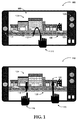
[0019] 図1は、タッチ可能ディスプレイを有したモバイルデバイス上における2つの例示的なストリートビューのナビゲーション方法を示す。本実施態様によるストリートビューは、ユーザーにより指定された場所における周囲の様子を示すパノラマのストリート視点のビューを含むことができる。当該場所は、ユーザー入力に基づいて、又は、全地球測位システム(GPS)情報、携帯電話基地局による三角測量、無線データネットワークにおけるノード検出、及び類似の方法に基づく自動的な位置判定に基づいて、指定されることができる。ストリートビュー、及び当該ストリートビューをナビゲートするためのユーザーインターフェース手法を提供する地図アプリケーションは、任意のコンピューティングデバイス上で実行されることができるが、スマートフォン、ハンドヘルド型コンピューター、無線携帯情報端末(PDA)、地図アプリケーションを利用可能な携帯電話、車載型コンピューティングデバイス、及びこれらに類似したもの等のモバイルデバイスは、このようなアプリケーションにとってより相応しい環境を提供することができる。 [0019] FIG. 1 illustrates two exemplary street view navigation methods on a mobile device having a touch enabled display. The street view according to the present embodiment may include a panoramic street viewpoint view showing a surrounding situation at a location specified by the user. The location can be based on user input or based on global positioning system (GPS) information, triangulation by mobile phone base stations, node detection in wireless data networks, and automatic location determination based on similar methods. Can be specified. A map application that provides a street view and a user interface approach for navigating the street view can be executed on any computing device, but can be a smartphone, a handheld computer, a wireless personal digital assistant (PDA) ), Mobile devices such as mobile phones, in-vehicle computing devices, and the like that can use map applications can provide a more suitable environment for such applications.
[0020] 図1における図形100は、ボタン102及び103、スピーカー101、並びにディスプレイ105といった典型的なコントロール要素を有したスマートフォンを示す。ディスプレイ105は、ユーザーによるタッチベースのジェスチャー(例えば112)に反応するタッチ感応ディスプレイとすることができる。ディスプレイ105上に表示されたストリートビュー104には、ストリート108の片側にある建物と、車両106が含まれている。
A
[0021] いくつかの実施態様によれば、ストリートビューの地図においてナビゲートするためのユーザーインターフェース手法は、ジェスチャーベースの手法及びハードウェア入力の手法を含むことができる。ジェスチャーベースの手法は、モバイルデバイス上のタッチ感応入力デバイスのタッチ可能ディスプレイを通じて1回又は多数回のタッチをするやり方で入力ジェスチャーを与えることによって、特徴付けられることができる。多くのジェスチャーが実施されうるが、少数の例示的なジェスチャーは、Uターンを行うための単一の上下動のジェスチャー、ストリートの両側が見えるようにするための2本の指を離して行う上下動の動作、及び、前方へ進んでストリートを横断するための折れ線状に弧を描くドラッグを含む。 [0021] According to some implementations, user interface techniques for navigating in a street view map can include gesture-based techniques and hardware input techniques. Gesture-based approaches can be characterized by providing input gestures in a single or multiple touch manner through a touch-enabled display of a touch-sensitive input device on a mobile device. Many gestures can be implemented, but a few exemplary gestures are a single up / down gesture to make a U-turn, up / down done with two fingers apart to make both sides of the street visible Includes moving motion and dragging arcs in a polygonal line to go forward and cross the street.
[0022] 図形100において、ユーザーの指114による例示的な上下動ジェスチャー112が示されている。このジェスチャーは、ストリートの表示されている側がその反対側へ切り替わる結果をもたらすことができる。図形110は、2本の指を離して行う上下動の例示的な動作118及び122(指116及び120)を示し、この動作は、ストリ
ート108の表示される側を交互に変更することができる。ここに説明されたジェスチャーは、指を用いて、又は、ペン及びその類似品等の人工的なタッチツールを用いて与えられることができる。
[0022] In figure 100, an exemplary up / down gesture 112 with a user's
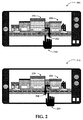
[0023] 図2は、タッチ可能ディスプレイを有したモバイルデバイス上における更なる2つの例示的なストリートビューのナビゲーション方法を示す。図形200は、前方へ進んでストリートを横断するための、折れ線状に弧を描いてドラッグする例示のジェスチャーを示す。この例示的なシナリオにおいて、指230によるジェスチャー232は、ストリートビューが、(建物226の視点位置から)建物224の方向を眺めているストリート228のビューへ変化する結果をもたらす。
[0023] FIG. 2 illustrates two further exemplary street view navigation methods on a mobile device having a touch enabled display. The figure 200 shows an example gesture that drags in a polygonal line to advance forward and cross the street. In this exemplary scenario, the
[0024] 図形210は、折れ線状に反対方向に弧を描いてドラッグする指234によるジェスチャー236の実施を示し、このジェスチャーは、ストリートの視点で建物224の視点位置から建物226の方向を眺めているストリート228を表示する結果をもたらすことができる。ジェスチャー及びタッチはまた、エリアをベースとしたものであってもよい。例えば、画面の上部に沿ってスライドさせることにより、360°のパノラマ内でビューを回転させることができる。カメラの下部に沿ってタッチをスライドさせることにより、ストリートに沿ってビューをスライドさせることができる。
[0024] Figure 210 shows the implementation of
[0025] 他のナビゲーション手法は、加速度計、コンパス、及び/又はトラックボール等のハードウェア入力を利用することができる。そのような手法の例は、電話機を一方に傾けてストリートを上下にスライドさせること、電話機を上下に傾けて広域又は詳細地図を表示すること、及び類似の方法を含むことができる。ユーザーがモバイルデバイスを水平姿勢(即ち、360°ディスプレイにおいて地面の方向を向いた状態)に持っていくと、表示されているストリートビューは、現在表示されている場所の周辺のエリアを表示する広域地図ビューに遷移していくことができる。更に、ハードウェアベースの入力は、モバイルデバイスを鉛直軸の周りに回転させてストリートの反対側を見えるようにすること、モバイルデバイスを回転させて視点をストリートに沿ってスライドさせること、及び(モバイルデバイスの加速度計を使用した)類似の方法を含むことができる。ユーザーを視野に捉えている組み込みカメラから、更なる入力が受け取られることができる。例えば、ストリートの異なる部分が見えるようにするために、ユーザーの頭の動きに基づいて、当該ユーザーの頭の動きに対応した動きを生じさせるように表示を移動させることができる。 [0025] Other navigation techniques may utilize hardware inputs such as accelerometers, compass, and / or trackballs. Examples of such techniques may include tilting the phone to one side and sliding the street up and down, tilting the phone up and down to display a wide area or detailed map, and similar methods. When the user brings the mobile device to a horizontal position (ie, facing the ground on a 360 ° display), the displayed street view is a wide area that displays the area around the currently displayed location. You can transition to the map view. In addition, hardware-based input can rotate the mobile device around the vertical axis to see the other side of the street, rotate the mobile device to slide the viewpoint along the street, and (mobile Similar methods (using device accelerometers) can be included. Further input can be received from an embedded camera that captures the user's view. For example, in order to make a different part of the street visible, the display can be moved based on the movement of the user's head so as to cause a movement corresponding to the movement of the user's head.
[0026] 本実施態様によるモバイルデバイスにおいて、ユーザーは、ストリートを見下ろして、彼の視点位置からは見えないが依然としてこの世界における正しいビュー方向との関連を持ち続けている、詳細を見ることができる。他の実施態様によれば、道路を見下ろしたビューのスナップショットが撮影されることができ、表示されたスナップショット画像上の特定の場所に対するタッチ入力に応答して、そのストリートに対してストリートビューのスライドがもたらされることができる。 [0026] In the mobile device according to this embodiment, the user can look down on the street and see details that are not visible from his viewpoint position but still have an association with the correct view direction in this world. . According to another embodiment, a snapshot of a view looking down at a road can be taken, and in response to touch input for a particular location on the displayed snapshot image, a street view is displayed for that street. Slides can be brought in.

[0027] 更に他の実施態様によれば、(例えば指による)横向きのスライドジェスチャーはパノラマのストリートビューを横方向に移動させることができ、ピンチインジェスチャーはパノラマのストリートビューからのズームアウトを生じさせることができ、ピンチ
アウトジェスチャーはパノラマのストリートビューへのズームインを生じさせることができる。その上更に、表示されているビューは、ストリートの片側を表示したパノラマビューから環状のパノラマビューへ、予め定められたズームレベルで自動的に遷移することができる。
[0027] According to yet another embodiment, a sideways slide gesture (eg, with a finger) can move the panoramic street view laterally, and a pinch-in gesture causes a zoom out from the panoramic street view. A pinch-out gesture can cause a zoom-in to a panoramic street view. Furthermore, the displayed view can automatically transition from a panoramic view displaying one side of the street to an annular panoramic view at a predetermined zoom level.
[0028] 更なる実施態様によれば、トラックボールを回すことで視点をストリートに沿ってスライドさせることができ、ユーザーが、トラックボールを右又は左に回転させることによって、表示されているストリートビューの方向を変化させることが可能とされる。上の表1及び2は、本実施態様によるストリートビューのユーザーインターフェースによって用いられることができるいくつかの例示的なナビゲーション手法を示す。 [0028] According to a further embodiment, the viewpoint can be slid along the street by turning the trackball, and the displayed street view can be displayed by the user rotating the trackball to the right or left. It is possible to change the direction of. Tables 1 and 2 above show some exemplary navigation techniques that can be used by the street view user interface according to this embodiment.
[0029] 図3A及び3Bは、サービスから画像が取得された実施態様による暫定的なストリートビュー表示の様々な例示的方法を示す。モバイルデバイスは、様々な携帯電話ネットワーク、ローカルエリアネットワーク、ワイドエリアネットワーク、及びこれらに類似するもの等の無線ネットワークを介して、地図データ、画像、及び他のデータを提供するサーバーと通信する。そのようなネットワークの帯域幅や処理パワー等の特性は、ネットワーク、モバイルデバイスの位置、ネットワーク使用率、及び類似の要素に依存して異なりうる。したがって、地図データ、特にストリートビュー画像の取得は、ネットワークの状況に基づいて遅延を被る。加えて、モバイルデバイスからのリクエストの受信、サーバーによるキューイングと処理、及び応答の送信に基づくネットワークの待ち時間は、ネットワークの状況にかかわらず、固有の遅延を付加する。ある場合においては、モバイルデバイスの往復待ち時間は、0.25秒にもなりうる。これらの理由により、ユーザーエクスペリエンスを損なうことを避けるために、画像のリクエストを最適化し、視覚的な表示手段を通じた遅延を低減することが望まれる。 [0029] FIGS. 3A and 3B illustrate various exemplary methods of provisional street view display according to an embodiment in which images are obtained from a service. Mobile devices communicate with servers that provide map data, images, and other data over wireless networks such as various cellular networks, local area networks, wide area networks, and the like. Characteristics such as bandwidth and processing power of such networks can vary depending on the network, the location of mobile devices, network utilization, and similar factors. Accordingly, the acquisition of map data, particularly street view images, is subject to delays based on network conditions. In addition, network latency based on receiving requests from mobile devices, queuing and processing by servers, and sending responses adds inherent delays regardless of network conditions. In some cases, the round trip latency of the mobile device can be as much as 0.25 seconds. For these reasons, it is desirable to optimize image requests and reduce delay through visual display means to avoid compromising the user experience.
[0030] いくつかの実施態様によれば、ストリートビュー画像を取得する際のネットワーク遅延は、図3A及び3Bにおいて議論されるような、場所の暫定的な補足的ビューを提供することによって低減されることができる。他の実施態様によれば、画像のリクエストは、補足的な暫定的ビューの代わりに、又はそれに加えて、取得を簡素化するようにスケジューリングされ、又はストリーム化されることができる。 [0030] According to some implementations, network delays in obtaining street view images are reduced by providing a provisional supplemental view of the location, as discussed in FIGS. 3A and 3B. Can. According to other implementations, image requests can be scheduled or streamed to simplify acquisition instead of or in addition to supplemental provisional views.
[0031] ストリートビュー地図のパノラマビューは、画面上で視認できるパートのみがダウンロードされるように、タイル化されたピラミッド構造によって表現されることができる。ピラミッドの階層は、最高解像度画像に対するより低解像度のバージョンを格納することができる。あるいはまた、低解像度のコピーを格納する代わりに、最高表示品質を維持しつつ、意味論的に情報量が豊富なコピーが格納されることができる。例えば、ピラミッドの最低階層において、低解像度の画像を格納する代わりに、近くにある建物のテキスト注釈が格納されることができる。この場合、ユーザーは、(例えば一切の画像又はシンプルなグラフィックスを見ないで)最初に注釈とテキストを目にすることができる。当該テキストは、解像度を全く失わずに高忠実度で描画されることができる。このテキスト自体は、低解像度画像を格納することと比べてもよりコンパクトであり、迅速にダウンロードされることができる。 [0031] The panoramic view of the street view map can be represented by a tiled pyramid structure so that only parts visible on the screen are downloaded. The pyramid hierarchy can store a lower resolution version for the highest resolution image. Alternatively, instead of storing a low resolution copy, a semantically rich copy of information can be stored while maintaining the highest display quality. For example, at the lowest level of the pyramid, instead of storing low resolution images, text annotations of nearby buildings can be stored. In this case, the user can first see the annotations and text (eg, without looking at any images or simple graphics). The text can be drawn with high fidelity without any loss of resolution. This text itself is more compact than storing low resolution images and can be downloaded quickly.
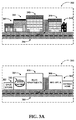
[0032] 図形300は、ストリート352と交差するストリート354に沿って建物342、344、346、348、及び349が並んだ別の例示的なストリートビューを示す。パノラマビュー画像がダウンロードされている間にテキスト注釈を表示する実施態様によれば、これらの建物は、図形310に示されるように、テキスト注釈362、364、366、368、及び369で置換されることができる。これらのテキスト注釈は、如何なるグラフィックスも伴わず即ちシンプルなグラフィックス(例えば、建物のベクトル表現)と共に、既定のフォント(及びスタイル)を用いて表示されることができる。この
ベクトル表現は、典型的には少量のデータを含むが、高解像度の描画をもたらす。
[0032] The graphic 300 shows another exemplary street view with
[0033] 他の実施態様によれば、建物のおおよその色合い、建物の窓/ドアの数、及びそれらに類似した特徴等の付加的な描写指標が、テキスト注釈に追加されることができる。例えば、建物を表す四角が、その建物の正面の実際の色合いに近い代表的な色彩を用いて着色されることができる。更にまた、テキスト注釈は様式化されることができる。例えば、ロゴ(356)を用いてビジネス名が表示されることができる。 [0033] According to other embodiments, additional descriptive indicators such as the approximate color of the building, the number of windows / doors in the building, and similar features can be added to the text annotation. For example, a square representing a building can be colored with a representative color that is close to the actual color of the front of the building. Furthermore, text annotations can be stylized. For example, a business name can be displayed using a logo (356).
[0034] 更なる実施態様によれば、縮図等のデータ削減アプローチを利用して建物(及び他の建造物)を表示することができる。縮図は、実際の画像を縮小したものとみなされることができる。縮図はかなり小さいサイズを有するが、当該画像の本質的な構成要素の大部分を保持している。縮図は、画像の小片の生成モデルとみなされることが可能である。適切な統計的方法の使用により、縮図は、1つの画像、相関性の高い画像の集合、又はビデオシーケンス(サーバー側)から抽出されることができ、リクエストされた実際の画像が送信される前にモバイルデバイスへ供給されることができる。 [0034] According to a further embodiment, buildings (and other structures) can be displayed using a data reduction approach such as reduced scale. The reduced view can be regarded as a reduction of the actual image. The miniature has a fairly small size but retains most of the essential components of the image. A reduced scale can be considered as a generation model of a small piece of an image. With the use of appropriate statistical methods, micrographs can be extracted from a single image, a collection of highly correlated images, or a video sequence (server side) before the requested actual image is transmitted. Can be supplied to mobile devices.
[0035] ストリートビュー地図の描画を最適化するための別の低減アプローチは、画像のリクエストに関する優先順位のスケジューリングを含むことができる。中央に位置し現在のビューにおいて視認できる画像タイルが、最初にリクエストされることができる。次いで、方式に応じて、360°のパノラマ即ちストリートビューからのタイルがリクエストされることができる。更に他の実施態様によれば、複数のリクエストが一続きに1つのリクエストへと配列されて、全体の描画の間に唯一つの待ち時間の影響を受けるようにすることができる。これは、多数のリクエストを受け取り全てのリクエスト画像を格納した1つのストリームを返すサーバー側のサービスを利用することによって、実現されることができる。ストリートビュー地図を描画する際の高品質なユーザーエクスペリエンスを提供するために、上で議論された手法の何れもが組み合わせられることができる、ということは特筆されるべきである。 [0035] Another reduction approach for optimizing the rendering of a street view map may include priority scheduling for image requests. An image tile that is centrally located and visible in the current view can be requested first. Then, depending on the scheme, tiles from a 360 ° panorama or street view can be requested. According to yet another embodiment, multiple requests can be arranged into a single request in a row so that only one latency is affected during the entire drawing. This can be realized by using a server-side service that receives a large number of requests and returns a single stream containing all request images. It should be noted that any of the methods discussed above can be combined to provide a high quality user experience when rendering a street view map.
[0036] 図形320及び330は、上述された手法の組み合わせを示す。図形320において、画像タイルは、それぞれの画像タイルが建物に対応すると仮定してそれぞれの建物に関連付けられた数字1、2、3、4、5によって示されるように、中央から両端に向かって優先順位付けされている。実際には、1つの画像タイルが多数の建物を包含することがある。このように、建物376及び378の実際の画像が最初に描画される。建物372、374、及び379についての画像タイルの取得が行われている間に、これらの建物のベクトル表現が(色合いの情報と共に又はそれを伴わずに)表示されることができる。図形330は、類似のシナリオを示し、建物384及び386に対応する画像タイルがダウンロードされ描画されている。建物382、388、及び389に対応する画像タイルの取得が行われている間、それらの建物についての情報を表示するためにテキスト注釈が用いられる。
[0036] Figures 320 and 330 show a combination of the techniques described above. In graphic 320, image tiles are preferred from center to both ends, as indicated by the
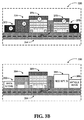
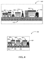
[0037] 図4は、いくつかの実施態様によるストリートビュー画像を表示するためのダウンロードリソースを最小化する別の例示的アプローチを示す。ネットワークに起因した遅延にもかかわらずストリートビュー地図の描画を最適化する更に別のアプローチは、非ホモジェニック(non-homogenic)スケーリングを含むことができ、ここで、関心のあるオブジェクト(例えば、建物又はビジネス標識)は比較的高解像度で表示されることができ、その一方、他のオブジェクト(樹木、繰り返しの窓、フェンス等)はスケールダウンされた解像度で表示される。このように、ストリートビュー全体に対して固定の解像度を用いるのではなく、重要なオブジェクトに対して、貴重な帯域幅が利用されることができる。 [0037] FIG. 4 illustrates another exemplary approach for minimizing download resources for displaying street view images according to some implementations. Yet another approach to optimizing the rendering of street view maps despite network-induced delays can include non-homogenic scaling, where objects of interest (eg, buildings) (Or business signs) can be displayed at a relatively high resolution, while other objects (trees, repeating windows, fences, etc.) are displayed at a scaled down resolution. In this way, valuable bandwidth can be used for important objects, rather than using a fixed resolution for the entire street view.
[0038] 図形400は、ストリート416に沿った建物402、404、408、412、及び414のような特徴物を有する別の例示的な場面を示す。当該場面における他の特徴物は、樹木406、送電塔410、及び交差道路418を含むことができる。これらの特徴物のうち、樹木406と送電塔410は、ユーザーにとって関心がないものと想定されうる。したがって、同一場面を図形420に描画したストリートビュー地図において、関心のあるオブジェクト(建物422、424、428、432、及び434、ストリート436、並びに交差道路438)の高解像度画像が表示されることができる。より関心の少ないオブジェクト(樹木426及び送電塔430)はより低解像度で、又はベクトル表現の形式すら用いて表示されることができ、これによりサーバーからモバイルデバイスへ取得されるべきデータ量が削減される。
[0038] The graphic 400 shows another exemplary scene with features such as
[0039] 帯域幅の節約のための更なるアプローチは、家と家の間の何もない空間や、繰り返し模様等、ストリート画像の「興味のない」部分を縮小させる(例えば、家のいくつかの柱のみを、その幅をそのまま表すのではなく、その本質としての形を表すように表示する)ことを含むことができる。この結果の画像は、より少ないピクセルで当該ビューの情報の大部分を含むことができ、これもまた、限定されたサイズの電話画面上により適して表示される。 [0039] A further approach to saving bandwidth is to reduce “uninteresting” parts of the street image, such as empty space between houses and repetitive patterns (eg, some of the houses Only the column of the column is displayed to represent the shape as the essence of the column. The resulting image can contain the majority of the view's information with fewer pixels, which is also better displayed on a limited size phone screen.
[0040] 画像リクエストをスケジューリングすること、リクエストを1つの画像ストリームに結合すること、及びこれらの手法と他のアプローチとの組み合わせ等の、図4において議論された様々な処理は、別個のハードウェアモジュール、ソフトウェアモジュール、又はハードウェアとソフトウェアの組み合わせにより実行されることができる。更に、そのようなモジュールは、それらの処理の2つ以上を統合的な方法で実行することができる。 [0040] Various processes discussed in FIG. 4, such as scheduling image requests, combining requests into one image stream, and combining these techniques with other approaches, are implemented in separate hardware. It can be executed by a module, a software module, or a combination of hardware and software. Furthermore, such modules can perform two or more of their processes in an integrated manner.
[0041] 図1から4における例示的なユーザーインターフェース、ナビゲーション方法、及び描画最適化手法は、要素、処理、及び動作によって説明されてきた。本実施態様は、これらの例示的な構成によるシステムに限定されるものではない。ストリートビュー地図上のナビゲーション及びストリートビューの描画の最適化を提供するシステムは、より少ない又は追加のコンポーネントを利用し、他のタスクを実行する構成において、実現されることができる。更に、本実施態様は、モバイルデバイスに限定されるものではない。上で議論されたアプローチは、本明細書において説明された原理を用いる如何なるコンピューティングデバイスにおいても実現されることができる。 [0041] The exemplary user interfaces, navigation methods, and drawing optimization techniques in FIGS. 1-4 have been described in terms of elements, processes, and operations. This embodiment is not limited to the system according to these exemplary configurations. A system that provides navigation on street view maps and optimization of street view rendering can be implemented in configurations that utilize fewer or additional components and perform other tasks. Furthermore, this embodiment is not limited to mobile devices. The approach discussed above can be implemented in any computing device that uses the principles described herein.
[0042] 図5は、本実施態様が実現されることが可能である例示的なネットワーク環境である。ストリートビュー地図をナビゲートするUIコントロールと、画像の取得及び通信遅延の低減表示の処理とを提供するためのプラットフォームは、ホストサービスのような1つ又は複数のサーバー514上で実行されるソフトウェアによって実現されることができる。このプラットフォームは、ネットワーク510を通じて、スマートフォン511、携帯電話512、又は類似のデバイスといった個々のモバイルデバイス(「クライアントデバイス」)上のクライアントアプリケーションと通信することができる。
[0042] FIG. 5 is an exemplary network environment in which this embodiment may be implemented. A platform for providing UI control for navigating a street view map and processing of image acquisition and reduced communication delay display is provided by software running on one or
[0043] クライアントデバイス511−512のうちの任意のデバイス上で実行されるクライアント地図アプリケーションは、複数のサーバー514から又は個々のサーバー516上で地図サービスを提供するホストサービスと対話することができる。このホストサービスは、スケジューリングされたリクエスト、又は待ち時間の影響を最小化するようにストリーム化することに基づいて、ストリートビューのためのリクエスト画像を提供することができる。更に、クライアントデバイス511−512上のクライアント地図アプリケーションは、ユーザーが、直感的なナビゲーションコントロールを用いてストリートビューをくまなくナビゲートし、また、リクエスト画像の取得が行われている間に、ストリ
ートビューをテキストベース又は他の表現で補足することを可能にすることができる。ストリートビュー画像及び補足的テキストデータ等の関連データは、データ記憶装置519に格納され、及び/又は、データ記憶装置519から直接に、若しくはデータベースサーバー518を介して取得されることができる。
[0043] A client map application running on any of the client devices 511-512 may interact with a host service that provides map services from
[0044] ネットワーク510は、サーバー、クライアント、インターネットサービスプロバイダー、及び通信媒体の如何なるトポロジーも含むことができる。実施態様によるシステムは、静的又は動的なトポロジーを有することができる。ネットワーク510は、企業ネットワークのような安全なネットワーク、オープンな無線ネットワークのような安全でないネットワーク、又はインターネットを含むことができる。ネットワーク510はまた、(特にサーバーとモバイルデバイスとの間において)携帯電話ネットワークを含むこともできる。更に、ネットワーク510は、ブルートゥース(登録商標)又はそれに類似したもの等の短距離無線ネットワークを含むことができる。ネットワーク510は、本明細書において説明されたノード間の通信を提供する。限定ではなく例として、ネットワーク510は、音波、RF、赤外線、及び他の無線媒体といった、無線媒体を含むことができる。
[0044] The
[0045] ストリートビュー地図のナビゲーション及び遅延待ち時間の低減のためのモバイル入力機構を提供するプラットフォームを実現するために、コンピューティングデバイス、アプリケーション、データソース、及びデータ配信システムの多くの他の構成が利用されることができる。更に、図5において議論されたネットワーク環境は、例証的な目的のためだけのものである。本実施態様は、例示的なアプリケーション、モジュール、又は処理に限定されるものではない。 [0045] To implement a platform that provides a mobile input mechanism for street view map navigation and reduced latency, computing devices, applications, data sources, and many other configurations of data distribution systems have been developed. Can be utilized. Furthermore, the network environment discussed in FIG. 5 is for illustrative purposes only. This embodiment is not limited to exemplary applications, modules, or processes.
[0046] 図6及びそれに関連する議論は、本実施態様が実現されることが可能な相応しいコンピューティング環境の簡潔で概括的な説明を提供することを意図したものである。図6を参照すると、実施態様によるアプリケーションのための、コンピューティングデバイス600のような例示的なコンピューティング動作環境のブロック図が示されている。基本的な構成において、コンピューティングデバイス600は、本実施態様に従ってストリートビュー地図サービスを提供する能力を有したモバイルコンピューティング/通信デバイスであり、少なくとも1つの処理装置602及びシステムメモリ604を含むことができる。コンピューティングデバイス600はまた、プログラムの実行を協力して行う複数の処理装置をも含むことができる。コンピューティングデバイスの厳密な構成及びタイプに依存して、システムメモリ604は、(RAMのような)揮発性、(ROM、フラッシュメモリ等のような)不揮発性、又はこれら2つの何らかの組み合わせでありうる。システムメモリ604は、典型的に、ワシントン州レッドモンドのマイクロソフトコーポレーションからのウィンドウズモバイル(登録商標)オペレーティングシステム又はそれに類似したもの等の、プラットフォームの動作を制御するのに適したオペレーティングシステム605を含む。システムメモリ604はまた、プログラムモジュール606及びモバイルストリートビューアプリケーション622といった1つ又は複数のソフトウェアアプリケーションをも含むことができる。
[0046] FIG. 6 and the discussion associated therewith are intended to provide a concise and general description of a suitable computing environment in which this embodiment may be implemented. With reference to FIG. 6, a block diagram of an exemplary computing operating environment, such as a
[0047] モバイルストリートビューアプリケーション622は、前述されたように、サービスから地図データとストリートビュー画像を受け取ることができる。このアプリケーションは、ジェスチャー、加速度計やコンパスのような統合ハードウェアの使用、音声、及び/又は映像入力等の、様々な入力機構を提供することができ、ユーザーが様々なビューをくまなくナビゲートすることを可能にする。このアプリケーションは更に、画像リクエストのスケジューリング、画像リクエストのストリーム化、データに依存したスケーリング、及び類似のアプローチ等の手法を利用することにより、ストリート画像を取得する際に通信によって引き起こされる遅延の影響を低減することができる。この基本的な構成
は、図6において破線608内のコンポーネントによって示されている。
[0047] The mobile
[0048] コンピューティングデバイス600は、付加的な特徴又は機能を有することができる。例えば、コンピューティングデバイス600は、(リムーバブル及び/又は非リムーバブルの)付加的なデータ記憶装置、例えば磁気ディスク、光ディスク、又はテープを含むこともできる。そのような付加的な記憶装置は、図6においてリムーバブル記憶装置609と非リムーバブル記憶装置610によって示されている。コンピューター読み取り可能記憶媒体は、コンピューター読み取り可能命令、データ構造、プログラムモジュール、又は他のデータ等の情報の記憶のための任意の方法又は技術により実現された、揮発性及び不揮発性、リムーバブル及び非リムーバブルの媒体を含むことができる。システムメモリ604、リムーバブル記憶装置609、及び非リムーバブル記憶装置610は、全てコンピューター読み取り可能記憶媒体の例である。コンピューター読み取り可能記憶媒体は、限定ではないが、RAM、ROM、EEPROM、フラッシュメモリ若しくは他のメモリ技術、CD−ROM、デジタル多用途ディスク(DVD)若しくは他の光記憶装置、磁気テープ、磁気ディスク記憶装置若しくは他の磁気記憶デバイス、又は、所望の情報を格納するために用いられることが可能でありコンピューティングデバイス600によってアクセスされることが可能である任意の他の媒体を含む。如何なるそのようなコンピューター読み取り可能記憶媒体も、コンピューティングデバイス600の一部分でありうる。コンピューティングデバイス600はまた、キーボード、マウス、ペン、音声入力デバイス、タッチ入力デバイス、及び類似の入力デバイス等の入力デバイス612を有することもできる。ディスプレイ、スピーカー、プリンター、及び他のタイプの出力デバイス等の出力デバイス614もまた、含まれることができる。これらのデバイスは当該技術においてよく知られており、本明細書で長々と説明されることを要しない。
[0048] The
[0049] コンピューティングデバイス600はまた、当該デバイスが、分散コンピューティング環境の有線又は無線ネットワーク、衛星リンク、携帯電話リンク、短距離ネットワーク、及び類似の機構を介する等して、他のデバイス618と通信することを可能にする通信接続616を包含することもできる。他のデバイス618は、通信アプリケーションを実行するコンピューターデバイス、他のサーバー、及び類似のデバイスを含むことができる。通信接続616は、通信媒体の一例である。通信媒体は、その中に、コンピューター読み取り可能命令、データ構造、プログラムモジュール、又は他のデータを含むことが可能である。限定ではなく例として、通信媒体は、有線ネットワーク又は直接有線接続等の有線媒体と、音波、RF、赤外線、及び他の無線媒体等の無線媒体とを含む。
[0049]
[0050] 例示的な実施態様には、方法も含まれる。それらの方法は、本文書中で説明された機構を含む多数のやり方で実現されることが可能である。そうした1つのやり方は、本文書中で説明されたタイプのデバイスのマシン動作によるものである。 [0050] Exemplary embodiments also include methods. Those methods can be implemented in a number of ways, including the mechanisms described in this document. One such approach is by machine operation of the type of device described in this document.
[0051] 別の選択可能なやり方は、当該方法の個々の動作のうちの1つ又は複数が、それら動作のいくつかを実施している1人又は複数の人間のオペレーターと連携して実行されることである。そうした人間のオペレーターは、互いに共起される必要はないが、そのそれぞれは、プログラムの一部分を実行するマシンと共に存在することができるのみである。 [0051] Another selectable manner is that one or more of the individual actions of the method are performed in conjunction with one or more human operators performing some of those actions. Is Rukoto. Such human operators need not co-occur with each other, but each can only exist with a machine that executes a portion of the program.
[0052] 図7は、本実施態様による適応的で革新的なモバイルデバイスのストリートビューを提供する処理700のための論理フロー図を示す。処理700は、モバイルデバイス上で実行される地図アプリケーションの一部分として実装されることができる。
[0052] FIG. 7 shows a logic flow diagram for a
[0053] 処理700は、動作710から開始し、この動作710において、ユーザー入力に基づいて、又はGPSシステムに基づく等の自動的な計算に基づいて、表示されるべ
き場所が決定される。動作720において、表示されるべきビューが決定される。このビューもまた、ユーザー入力に基づいて、又は、加速度計及び/又はコンパスといったモバイルデバイスの様々なモジュールに基づいて自動的に、決定されることができる。例えば、ユーザーは、モバイルデバイスをストリートの特定の側へ向けることができ、当該特定の側が、表示されるべきビューとして決定されることができる。
[0053]
[0054] 動作730において、モバイルデバイスは、ストリートビューを表示するための画像及びデータの取得を開始することができる。最適なストリートビューを得るよう画像のリクエストがスケジューリングされ(例えば、最初にビューの中央の画像が取得され、その後に他の画像が取得される)、画像のストリーム化がリクエストされ、又は、通信帯域幅の制限による遅延及び様々な形態の待ち時間を低減する類似の手法が適用されることができる。例えば、パノラマのストリートビューの中央に対応する画像タイルが当該パノラマストリートビューの周辺部に対応する画像タイルと比べてより高い優先順位で受け取られるように、画像の取得がスケジューリングされることができる。
[0054] In
[0055] 動作740において、モバイルデバイスは、上記画像及びデータの取得済みの一部分に基づいて、当該場所のストリートビューの表示を開始することができる。全ての画像はまだ受け取られていないかもしれないので、前述されたように、全ての画像がモバイルデバイスによって入手されるまで、建物(及びストリートの他の特徴)のテキスト表現、データに依存したスケーリング、及びそれらに類似したもの等の表示手法が用いられることができる。
[0055] In
[0056] 動作750において、画像の取得が完了した時点で、取得された画像に基づく完全なビューが表示されることができる。所望の場所の変更又は表示するビューを変えるためのユーザー入力に基づいて、処理は動作710又は720へ戻ることができる。
[0056] In
[0057] 処理700に含まれる動作は、例証的な目的のためのものである。地図アプリケーションの一部分としてのストリートビューにUIのナビゲーション方法と画像の取得及び表示の処理とを提供することは、本明細書において説明された原理を用いて異なる動作順序によるだけでなく、より少ない又は付加的なステップを有する類似の処理によっても、実現されることができる。
[0057] The operations included in
[0058] 上記の明細書、例、及びデータは、実施態様による構成物の製造及び使用に関する完全な説明を提供するものである。主題が構造的機能及び/又は方法論的動作に特有の言葉で説明されてきたが、添付された特許請求の範囲において定義される対象は必ずしも上述された特定の機能又は動作に限定されるものではない、ということは理解されなければならない。それどころか、当該上述された特定の機能及び動作は、特許請求の範囲及び実施態様を実現する例示の形として開示されたのである。 [0058] The above specification, examples and data provide a complete description of the manufacture and use of the composition according to the embodiments. Although the subject matter has been described in language specific to structural functions and / or methodological operations, the subject matter defined in the appended claims is not necessarily limited to the specific functions or operations described above. It must be understood that there is no. On the contrary, the specific functions and operations described above are disclosed as example forms of implementing the claims and embodiments.
Claims (15)
場所を決定するステップと、
前記場所の表示されるべきビューを決定するステップと、
前記表示されるべきビューに関連する画像及びデータの取得を開始するステップと、
前記画像及びデータの取得済みの一部分に基づいて、前記場所の暫定的な補足的ビューを表示するステップと、
前記画像及びデータの取得が完了したことを受けて、前記暫定的な補足的ビューを前記場所の完全なパノラマのストリートビューで置き換えるステップと、
を含む、方法。 A method for displaying a street view of a location on a mobile device, at least partially executed on a computing device, comprising:
Determining the location;
Determining a view of the location to be displayed;
Initiating acquisition of images and data associated with the view to be displayed;
Displaying a provisional supplemental view of the location based on the acquired portion of the image and data;
Replacing the provisional supplemental view with a complete panoramic street view of the location upon completion of the image and data acquisition;
Including a method.
前記ストリートビューを通して前記ユーザーが場所のスナップショットを撮影することを可能にするステップと、
タッチをベースとしたジェスチャー、トラックボールの動き、ソフトキー入力、及び音声入力からなる一群のうちの少なくとも1つを用いて、前記スナップショットにわたって
ナビゲートするステップと、
を更に含む、請求項7に記載の方法。 The step of allowing the user to navigate across the panoramic street view comprises:
Allowing the user to take a snapshot of a location through the street view;
Navigating across the snapshot using at least one of the group consisting of touch-based gestures, trackball movements, soft key inputs, and voice inputs;
The method of claim 7, further comprising:
通信モジュールと、
ディスプレイと、
地図アプリケーションを実行するように構成されたプロセッサーと、を含み、
前記地図アプリケーションは、
場所を決定し、
前記場所の表示されるべきビューを決定し、
前記場所の前記表示されるべきビューに関連する画像及びデータの取得を開始し、
前記画像及びデータの取得済みの一部分に基づいて暫定的な補足的ビューを表示し、
タッチをベースとしたジェスチャー、カメラをベースとした入力、コンパスをベースとした方向の変化、加速度計をベースとした位置の変化、トラックボールの動き、音声入力、及びソフトキー入力からなる一群のうちの少なくとも1つに基づいて、前記表示された暫定的な補足的ビューにわたってユーザーがナビゲートすることを可能にし、
前記画像及びデータの取得が完了したことを受けて、前記暫定的な補足的ビューを前記場所の完全なパノラマストリートビューで置き換える
ように適応されている、モバイルデバイス。 A mobile device for displaying a panoramic street view of a place,
A communication module;
Display,
A processor configured to execute a map application;
The map application
Determine the location,
Determine the view of the place to be displayed,
Initiating acquisition of images and data related to the view to be displayed of the location;
Displaying a provisional supplemental view based on the acquired portion of the image and data;
A group of touch-based gestures, camera-based input, compass-based direction change, accelerometer-based position change, trackball movement, voice input, and softkey input Allowing the user to navigate across the displayed provisional supplemental view based on at least one of
A mobile device adapted to replace the provisional supplemental view with a full panoramic street view of the location upon completion of acquisition of the images and data.
ユーザー入力、全地球測位サービス(GPS)をベースとした入力、携帯電話基地局による三角測量をベースとした入力、及び無線データネットワーク位置からなる一群のうちの少なくとも1つに基づいて、場所を決定するステップと、
ユーザー入力、カメラをベースとした入力、コンパスをベースとした入力、加速度計をベースとした入力、タッチをベースとした入力、トラックボールをベースとした入力、及びマイクロフォンをベースとした入力からなる一群のうちの少なくとも1つに基づいて、前記場所の表示されるべきビューを決定するステップと、
前記場所の前記表示されるべきビューに関連する画像及びデータの取得を開始するステップと、
前記画像及びデータの取得済みの一部分に基づいて、前記場所の暫定的な補足的ビューを表示するステップと、
タッチをベースとしたジェスチャー、カメラをベースとした入力、コンパスをベースとした方向の変化、加速度計をベースとした位置の変化、トラックボールの動き、音声入力、及びソフトキー入力からなる一群のうちの少なくとも1つに基づいて、前記場所の前記暫定的な補足的ビューにわたってユーザーがナビゲートすることを可能にするステップと、
前記画像及びデータの取得が完了したことを受けて、前記場所の前記暫定的な補足的ビューを前記場所の完全なパノラマストリートビューで置き換えるステップと、
を含む、コンピューター読み取り可能記憶媒体。 A computer-readable storage medium having instructions for displaying a panoramic street view of a place on a mobile device, the instructions comprising:
Determine location based on at least one of the group consisting of user input, global positioning service (GPS) based input, triangulation based mobile phone base station, and wireless data network location And steps to
A group of user input, camera-based input, compass-based input, accelerometer-based input, touch-based input, trackball-based input, and microphone-based input Determining a view of the location to be displayed based on at least one of:
Initiating acquisition of images and data associated with the view of the location to be displayed;
Displaying a provisional supplemental view of the location based on the acquired portion of the image and data;
A group of touch-based gestures, camera-based input, compass-based direction change, accelerometer-based position change, trackball movement, voice input, and softkey input Allowing a user to navigate across the provisional supplemental view of the location based on at least one of:
Replacing the provisional supplemental view of the location with a complete panoramic street view of the location upon completion of acquisition of the images and data;
A computer readable storage medium including:
前記最適化は、
前記パノラマストリートビューの中央に対応する画像タイルが当該パノラマストリートビューの周辺部に対応する画像タイルと比べてより高い優先順位で受け取られるように、画像取得リクエストをスケジューリングすること、及び、
前記モバイルデバイスへストリームされるように、画像タイルに関係する個々の画像取得リクエストを1つのリクエストに結合すること、
のうちの1つを含む、請求項13に記載のコンピューター読み取り可能記憶媒体。 The instructions further include utilizing data acquisition optimization for image acquisition,
The optimization is
Scheduling an image acquisition request such that an image tile corresponding to the center of the panoramic street view is received at a higher priority than image tiles corresponding to the periphery of the panoramic street view; and
Combining individual image acquisition requests related to image tiles into one request to be streamed to the mobile device;
The computer readable storage medium of claim 13, comprising one of the following:
Applications Claiming Priority (3)
| Application Number | Priority Date | Filing Date | Title |
|---|---|---|---|
| US12/792,047 | 2010-06-02 | ||
| US12/792,047 US8640020B2 (en) | 2010-06-02 | 2010-06-02 | Adjustable and progressive mobile device street view |
| PCT/US2011/037486 WO2011153014A2 (en) | 2010-06-02 | 2011-05-22 | Adjustable and progressive mobile device street view |
Publications (2)
| Publication Number | Publication Date |
|---|---|
| JP2013534656A true JP2013534656A (en) | 2013-09-05 |
| JP2013534656A5 JP2013534656A5 (en) | 2014-07-03 |
Family
ID=45065464
Family Applications (1)
| Application Number | Title | Priority Date | Filing Date |
|---|---|---|---|
| JP2013513211A Pending JP2013534656A (en) | 2010-06-02 | 2011-05-22 | Adaptive and innovative mobile device street view |
Country Status (10)
| Country | Link |
|---|---|
| US (1) | US8640020B2 (en) |
| EP (1) | EP2577440B1 (en) |
| JP (1) | JP2013534656A (en) |
| KR (1) | KR101865425B1 (en) |
| CN (1) | CN103003789B (en) |
| AU (1) | AU2011261689B2 (en) |
| HK (1) | HK1177791A1 (en) |
| RU (1) | RU2580064C2 (en) |
| TW (1) | TWI459283B (en) |
| WO (1) | WO2011153014A2 (en) |
Cited By (2)
| Publication number | Priority date | Publication date | Assignee | Title |
|---|---|---|---|---|
| WO2016092823A1 (en) * | 2014-12-12 | 2016-06-16 | 株式会社デンソー | Image display terminal, image display system, image display program, and image display method |
| JP2018538588A (en) * | 2015-12-17 | 2018-12-27 | グーグル エルエルシー | Navigation through multidimensional image space |
Families Citing this family (57)
| Publication number | Priority date | Publication date | Assignee | Title |
|---|---|---|---|---|
| US20120050183A1 (en) * | 2010-08-27 | 2012-03-01 | Google Inc. | Switching display modes based on connection state |
| US9317133B2 (en) * | 2010-10-08 | 2016-04-19 | Nokia Technologies Oy | Method and apparatus for generating augmented reality content |
| FR2966679A1 (en) * | 2010-10-25 | 2012-04-27 | France Telecom | METHODS AND DEVICES FOR ENCODING AND DECODING AT LEAST ONE IMAGE FROM A CORRESPONDING EPITOME, SIGNAL AND COMPUTER PROGRAM |
| US9342998B2 (en) * | 2010-11-16 | 2016-05-17 | Microsoft Technology Licensing, Llc | Techniques to annotate street view images with contextual information |
| US9615062B2 (en) * | 2010-12-30 | 2017-04-04 | Pelco, Inc. | Multi-resolution image display |
| KR101049928B1 (en) * | 2011-02-21 | 2011-07-15 | (주)올라웍스 | Method, terminal and computer-readable recording medium for generating panoramic images |
| JP5605504B2 (en) * | 2011-04-12 | 2014-10-15 | トヨタ自動車株式会社 | Control device for vehicle drive device |
| US9047007B2 (en) * | 2011-07-28 | 2015-06-02 | National Instruments Corporation | Semantic zoom within a diagram of a system |
| US20130044220A1 (en) * | 2011-08-19 | 2013-02-21 | Dane Demicell | Method and system for enabling remote inspection communication and documentation |
| US20130106990A1 (en) | 2011-11-01 | 2013-05-02 | Microsoft Corporation | Planar panorama imagery generation |
| US9361283B2 (en) * | 2011-11-30 | 2016-06-07 | Google Inc. | Method and system for projecting text onto surfaces in geographic imagery |
| US9406153B2 (en) * | 2011-12-14 | 2016-08-02 | Microsoft Technology Licensing, Llc | Point of interest (POI) data positioning in image |
| US9324184B2 (en) | 2011-12-14 | 2016-04-26 | Microsoft Technology Licensing, Llc | Image three-dimensional (3D) modeling |
| US10008021B2 (en) | 2011-12-14 | 2018-06-26 | Microsoft Technology Licensing, Llc | Parallax compensation |
| KR20130115953A (en) * | 2012-04-13 | 2013-10-22 | 인포뱅크 주식회사 | Method for displaying image and mobile terminal therfor |
| US9381427B2 (en) | 2012-06-01 | 2016-07-05 | Microsoft Technology Licensing, Llc | Generic companion-messaging between media platforms |
| US9170667B2 (en) | 2012-06-01 | 2015-10-27 | Microsoft Technology Licensing, Llc | Contextual user interface |
| US9541417B2 (en) | 2012-06-05 | 2017-01-10 | Apple Inc. | Panning for three-dimensional maps |
| US9322665B2 (en) * | 2012-06-05 | 2016-04-26 | Apple Inc. | System and method for navigation with inertial characteristics |
| US8983778B2 (en) | 2012-06-05 | 2015-03-17 | Apple Inc. | Generation of intersection information by a mapping service |
| US9367959B2 (en) * | 2012-06-05 | 2016-06-14 | Apple Inc. | Mapping application with 3D presentation |
| US9269178B2 (en) | 2012-06-05 | 2016-02-23 | Apple Inc. | Virtual camera for 3D maps |
| US10176633B2 (en) | 2012-06-05 | 2019-01-08 | Apple Inc. | Integrated mapping and navigation application |
| TWI592913B (en) * | 2012-06-05 | 2017-07-21 | 蘋果公司 | Method, machine-readable medium and electronic device for presenting a map |
| US9997069B2 (en) | 2012-06-05 | 2018-06-12 | Apple Inc. | Context-aware voice guidance |
| US9135751B2 (en) * | 2012-06-05 | 2015-09-15 | Apple Inc. | Displaying location preview |
| US9418672B2 (en) | 2012-06-05 | 2016-08-16 | Apple Inc. | Navigation application with adaptive instruction text |
| US9311750B2 (en) | 2012-06-05 | 2016-04-12 | Apple Inc. | Rotation operations in a mapping application |
| US9482296B2 (en) | 2012-06-05 | 2016-11-01 | Apple Inc. | Rendering road signs during navigation |
| US8965696B2 (en) | 2012-06-05 | 2015-02-24 | Apple Inc. | Providing navigation instructions while operating navigation application in background |
| US9886794B2 (en) | 2012-06-05 | 2018-02-06 | Apple Inc. | Problem reporting in maps |
| US9159153B2 (en) | 2012-06-05 | 2015-10-13 | Apple Inc. | Method, system and apparatus for providing visual feedback of a map view change |
| US10156455B2 (en) | 2012-06-05 | 2018-12-18 | Apple Inc. | Context-aware voice guidance |
| US9445174B2 (en) * | 2012-06-14 | 2016-09-13 | Nokia Technologies Oy | Audio capture apparatus |
| US9395875B2 (en) * | 2012-06-27 | 2016-07-19 | Ebay, Inc. | Systems, methods, and computer program products for navigating through a virtual/augmented reality |
| US9532095B2 (en) * | 2012-11-29 | 2016-12-27 | Fanvision Entertainment Llc | Mobile device with smart gestures |
| CN103257795A (en) * | 2013-04-28 | 2013-08-21 | 百度在线网络技术(北京)有限公司 | Method and device for showing contact person list |
| CN104166464A (en) * | 2013-05-17 | 2014-11-26 | 北京百度网讯科技有限公司 | Method, device and portable terminal for controlling panorama display |
| US9354791B2 (en) * | 2013-06-20 | 2016-05-31 | Here Global B.V. | Apparatus, methods and computer programs for displaying images |
| US10775971B2 (en) | 2013-06-28 | 2020-09-15 | Successfactors, Inc. | Pinch gestures in a tile-based user interface |
| US20150293889A1 (en) * | 2014-04-09 | 2015-10-15 | Google Inc. | Perception of page download time by optimized resource scheduling |
| USD781317S1 (en) | 2014-04-22 | 2017-03-14 | Google Inc. | Display screen with graphical user interface or portion thereof |
| US9934222B2 (en) | 2014-04-22 | 2018-04-03 | Google Llc | Providing a thumbnail image that follows a main image |
| US9972121B2 (en) | 2014-04-22 | 2018-05-15 | Google Llc | Selecting time-distributed panoramic images for display |
| USD780777S1 (en) | 2014-04-22 | 2017-03-07 | Google Inc. | Display screen with graphical user interface or portion thereof |
| DE202015009126U1 (en) * | 2014-08-12 | 2016-11-07 | Google Inc. | Screen transitions in a geographic application |
| US9638538B2 (en) | 2014-10-14 | 2017-05-02 | Uber Technologies, Inc. | Street-level guidance via route path |
| US9727055B2 (en) | 2015-03-31 | 2017-08-08 | Alcatel-Lucent Usa Inc. | System and method for video processing and presentation |
| US9530197B2 (en) * | 2015-04-30 | 2016-12-27 | Microsoft Technology Licensing, Llc | Digital signage for immersive views |
| US10824320B2 (en) * | 2016-03-07 | 2020-11-03 | Facebook, Inc. | Systems and methods for presenting content |
| KR101859050B1 (en) | 2016-06-02 | 2018-05-21 | 네이버 주식회사 | Method and system for searching map image using context of image |
| US10459622B1 (en) * | 2017-11-02 | 2019-10-29 | Gopro, Inc. | Systems and methods for interacting with video content |
| CN110741227B (en) | 2017-12-05 | 2024-03-29 | 谷歌有限责任公司 | Landmark assisted navigation |
| CN110753827A (en) * | 2017-12-05 | 2020-02-04 | 谷歌有限责任公司 | Route on digital map with interactive turn graphics |
| CN108228746A (en) * | 2017-12-20 | 2018-06-29 | 中国电子科技集团公司电子科学研究院 | Call method, device, storage medium and the server of tile map service |
| CN108427935B (en) * | 2018-03-28 | 2022-02-15 | 天津市测绘院有限公司 | Street view comparison image generation method and device |
| CN108499104B (en) * | 2018-04-17 | 2022-04-15 | 腾讯科技(深圳)有限公司 | Orientation display method, device, electronic device and medium in virtual scene |
Citations (11)
| Publication number | Priority date | Publication date | Assignee | Title |
|---|---|---|---|---|
| JPS62284472A (en) * | 1986-06-02 | 1987-12-10 | Hitachi Ltd | Transmission system for image data |
| JPS63189042A (en) * | 1987-01-31 | 1988-08-04 | Ricoh Co Ltd | System for transmitting and displaying picture information |
| JPH05290093A (en) * | 1992-04-07 | 1993-11-05 | Gakushiyuu Joho Tsushin Syst Kenkyusho:Kk | Picture signal processing method/device, picture data base and information retrieval terminal |
| JP2000020540A (en) * | 1998-07-03 | 2000-01-21 | Matsushita Electric Ind Co Ltd | Hypertext display device |
| JP2000089742A (en) * | 1998-09-11 | 2000-03-31 | Canon Inc | Picture processing method, device, and system |
| JP2002213984A (en) * | 2001-01-12 | 2002-07-31 | Oojisu Soken:Kk | Guide system by panoramic image, central device and terminal device, and computer program and recording medium |
| JP2003153263A (en) * | 2001-11-19 | 2003-05-23 | Hitachi Ltd | Video display system and its method |
| JP2005250560A (en) * | 2004-03-01 | 2005-09-15 | Mitsubishi Electric Corp | Landscape display device |
| JP2007279638A (en) * | 2006-04-12 | 2007-10-25 | Xanavi Informatics Corp | Navigation device |
| JP2008164507A (en) * | 2006-12-28 | 2008-07-17 | Xanavi Informatics Corp | Vehicle system, information output method, and information output program |
| WO2009155071A2 (en) * | 2008-05-28 | 2009-12-23 | Google Inc. | Motion-controlled views on mobile computing devices |
Family Cites Families (23)
| Publication number | Priority date | Publication date | Assignee | Title |
|---|---|---|---|---|
| US5572643A (en) * | 1995-10-19 | 1996-11-05 | Judson; David H. | Web browser with dynamic display of information objects during linking |
| CN1216665A (en) * | 1996-02-20 | 1999-05-12 | 艾利森公司 | Sending graphic images to mobile terminals |
| US7284187B1 (en) * | 1997-05-30 | 2007-10-16 | Aol Llc, A Delaware Limited Liability Company | Encapsulated document and format system |
| US6157933A (en) * | 1997-11-26 | 2000-12-05 | International Business Machines Corporation | Method and apparatus for loading multiple animated images on a web-page with limited network throughput |
| US6430501B1 (en) | 2000-01-19 | 2002-08-06 | Magellan Dis, Inc. | Navigation system with route indicators |
| KR20020091486A (en) * | 2001-05-30 | 2002-12-06 | 이기동 | web service method of geographical information system |
| KR100703444B1 (en) * | 2003-06-03 | 2007-04-03 | 삼성전자주식회사 | Device and method for downloading and displaying a images of global position information in navigation system |
| US7720436B2 (en) * | 2006-01-09 | 2010-05-18 | Nokia Corporation | Displaying network objects in mobile devices based on geolocation |
| US20060259585A1 (en) * | 2005-05-10 | 2006-11-16 | International Business Machines Corporation | Enabling user selection of web page position download priority during a download |
| US7315259B2 (en) * | 2005-08-11 | 2008-01-01 | Google Inc. | Techniques for displaying and caching tiled map data on constrained-resource services |
| CN100382082C (en) * | 2005-09-07 | 2008-04-16 | 上海大地软件有限公司 | Geographic information search and display method and search and display system using the method |
| EP1955213A4 (en) * | 2005-11-07 | 2010-01-06 | Google Inc | Mapping in mobile devices |
| US7548814B2 (en) * | 2006-03-27 | 2009-06-16 | Sony Ericsson Mobile Communications Ab | Display based on location information |
| US20080043020A1 (en) | 2006-08-18 | 2008-02-21 | Microsoft Corporation | User interface for viewing street side imagery |
| KR100891099B1 (en) * | 2007-01-25 | 2009-03-31 | 삼성전자주식회사 | Touch screen and method for improvement of usability in touch screen |
| US20090079830A1 (en) | 2007-07-27 | 2009-03-26 | Frank Edughom Ekpar | Robust framework for enhancing navigation, surveillance, tele-presence and interactivity |
| JP4994256B2 (en) * | 2008-01-28 | 2012-08-08 | 株式会社ジオ技術研究所 | Data structure of route guidance database |
| US8200037B2 (en) * | 2008-01-28 | 2012-06-12 | Microsoft Corporation | Importance guided image transformation |
| US8477139B2 (en) * | 2008-06-09 | 2013-07-02 | Apple Inc. | Touch screen device, method, and graphical user interface for manipulating three-dimensional virtual objects |
| US9141640B2 (en) | 2008-07-09 | 2015-09-22 | MLSListings, Inc. | Methods and systems of advanced real estate searching |
| WO2010022386A2 (en) * | 2008-08-22 | 2010-02-25 | Google Inc. | Navigation in a three dimensional environment on a mobile device |
| KR101531192B1 (en) * | 2008-11-14 | 2015-06-25 | 엘지전자 주식회사 | Mobile Terminal And Method Of Displaying Map Using Same |
| CN101539937A (en) * | 2009-04-30 | 2009-09-23 | 北京水晶石数字科技有限公司 | Method for fast display of vast images |
-
2010
- 2010-06-02 US US12/792,047 patent/US8640020B2/en active Active
-
2011
- 2011-04-26 TW TW100114485A patent/TWI459283B/en not_active IP Right Cessation
- 2011-05-22 EP EP11790196.7A patent/EP2577440B1/en active Active
- 2011-05-22 AU AU2011261689A patent/AU2011261689B2/en active Active
- 2011-05-22 JP JP2013513211A patent/JP2013534656A/en active Pending
- 2011-05-22 WO PCT/US2011/037486 patent/WO2011153014A2/en active Application Filing
- 2011-05-22 KR KR1020127031475A patent/KR101865425B1/en not_active Application Discontinuation
- 2011-05-22 RU RU2012151486/08A patent/RU2580064C2/en active
- 2011-05-22 CN CN201180026993.4A patent/CN103003789B/en active Active
-
2013
- 2013-04-18 HK HK13104750.7A patent/HK1177791A1/en unknown
Patent Citations (11)
| Publication number | Priority date | Publication date | Assignee | Title |
|---|---|---|---|---|
| JPS62284472A (en) * | 1986-06-02 | 1987-12-10 | Hitachi Ltd | Transmission system for image data |
| JPS63189042A (en) * | 1987-01-31 | 1988-08-04 | Ricoh Co Ltd | System for transmitting and displaying picture information |
| JPH05290093A (en) * | 1992-04-07 | 1993-11-05 | Gakushiyuu Joho Tsushin Syst Kenkyusho:Kk | Picture signal processing method/device, picture data base and information retrieval terminal |
| JP2000020540A (en) * | 1998-07-03 | 2000-01-21 | Matsushita Electric Ind Co Ltd | Hypertext display device |
| JP2000089742A (en) * | 1998-09-11 | 2000-03-31 | Canon Inc | Picture processing method, device, and system |
| JP2002213984A (en) * | 2001-01-12 | 2002-07-31 | Oojisu Soken:Kk | Guide system by panoramic image, central device and terminal device, and computer program and recording medium |
| JP2003153263A (en) * | 2001-11-19 | 2003-05-23 | Hitachi Ltd | Video display system and its method |
| JP2005250560A (en) * | 2004-03-01 | 2005-09-15 | Mitsubishi Electric Corp | Landscape display device |
| JP2007279638A (en) * | 2006-04-12 | 2007-10-25 | Xanavi Informatics Corp | Navigation device |
| JP2008164507A (en) * | 2006-12-28 | 2008-07-17 | Xanavi Informatics Corp | Vehicle system, information output method, and information output program |
| WO2009155071A2 (en) * | 2008-05-28 | 2009-12-23 | Google Inc. | Motion-controlled views on mobile computing devices |
Cited By (3)
| Publication number | Priority date | Publication date | Assignee | Title |
|---|---|---|---|---|
| WO2016092823A1 (en) * | 2014-12-12 | 2016-06-16 | 株式会社デンソー | Image display terminal, image display system, image display program, and image display method |
| JP2016115067A (en) * | 2014-12-12 | 2016-06-23 | 株式会社デンソー | Image display terminal, image display system, and image display program |
| JP2018538588A (en) * | 2015-12-17 | 2018-12-27 | グーグル エルエルシー | Navigation through multidimensional image space |
Also Published As
| Publication number | Publication date |
|---|---|
| RU2580064C2 (en) | 2016-04-10 |
| HK1177791A1 (en) | 2013-08-30 |
| EP2577440A4 (en) | 2014-03-05 |
| AU2011261689B2 (en) | 2014-06-12 |
| TWI459283B (en) | 2014-11-01 |
| EP2577440B1 (en) | 2015-04-01 |
| EP2577440A2 (en) | 2013-04-10 |
| US8640020B2 (en) | 2014-01-28 |
| AU2011261689A1 (en) | 2012-12-13 |
| US20110302527A1 (en) | 2011-12-08 |
| KR20130088745A (en) | 2013-08-08 |
| RU2012151486A (en) | 2014-06-10 |
| WO2011153014A2 (en) | 2011-12-08 |
| WO2011153014A3 (en) | 2012-02-23 |
| CN103003789A (en) | 2013-03-27 |
| TW201203087A (en) | 2012-01-16 |
| KR101865425B1 (en) | 2018-06-07 |
| CN103003789B (en) | 2015-05-06 |
Similar Documents
| Publication | Publication Date | Title |
|---|---|---|
| JP2013534656A (en) | Adaptive and innovative mobile device street view | |
| AU2021240136B2 (en) | Systems, methods, and graphical user interfaces for interacting with augmented and virtual reality environments | |
| US9218685B2 (en) | System and method for highlighting a feature in a 3D map while preserving depth | |
| DE112013002803B4 (en) | Method, system and device for providing a three-dimensional transition animation for a change in a map view | |
| US10318104B2 (en) | Navigation application with adaptive instruction text | |
| US10366523B2 (en) | Method, system and apparatus for providing visual feedback of a map view change | |
| CA2799443C (en) | Method and apparatus for presenting location-based content | |
| US8811667B2 (en) | Terminal device, object control method, and program | |
| US8863023B2 (en) | System and method for displaying information using a compass | |
| US9224218B2 (en) | System and method for loading and rendering curved features in a map | |
| EP3407019A1 (en) | Navigation application | |
| US20120062602A1 (en) | Method and apparatus for rendering a content display | |
| US10949069B2 (en) | Shake event detection system | |
| EP3504614B1 (en) | Animating an image to indicate that the image is pannable | |
| JP5800386B2 (en) | Map display device, map display method, and program | |
| JP5463455B2 (en) | Map display device and map display method | |
| EP4235634A2 (en) | Navigation application |
Legal Events
| Date | Code | Title | Description |
|---|---|---|---|
| A521 | Written amendment |
Free format text: JAPANESE INTERMEDIATE CODE: A523 Effective date: 20140513 |
|
| A621 | Written request for application examination |
Free format text: JAPANESE INTERMEDIATE CODE: A621 Effective date: 20140513 |
|
| A711 | Notification of change in applicant |
Free format text: JAPANESE INTERMEDIATE CODE: A711 Effective date: 20150525 |
|
| A977 | Report on retrieval |
Free format text: JAPANESE INTERMEDIATE CODE: A971007 Effective date: 20150730 |
|
| A131 | Notification of reasons for refusal |
Free format text: JAPANESE INTERMEDIATE CODE: A131 Effective date: 20150814 |
|
| A601 | Written request for extension of time |
Free format text: JAPANESE INTERMEDIATE CODE: A601 Effective date: 20151113 |
|
| A02 | Decision of refusal |
Free format text: JAPANESE INTERMEDIATE CODE: A02 Effective date: 20160404 |