JP2012514385A - GPS correction using secondary sensors and signal strength - Google Patents
GPS correction using secondary sensors and signal strength Download PDFInfo
- Publication number
- JP2012514385A JP2012514385A JP2011543562A JP2011543562A JP2012514385A JP 2012514385 A JP2012514385 A JP 2012514385A JP 2011543562 A JP2011543562 A JP 2011543562A JP 2011543562 A JP2011543562 A JP 2011543562A JP 2012514385 A JP2012514385 A JP 2012514385A
- Authority
- JP
- Japan
- Prior art keywords
- computer
- mobile unit
- signal strength
- gps
- signal
- Prior art date
- Legal status (The legal status is an assumption and is not a legal conclusion. Google has not performed a legal analysis and makes no representation as to the accuracy of the status listed.)
- Pending
Links
Images


Classifications
-
- G—PHYSICS
- G01—MEASURING; TESTING
- G01S—RADIO DIRECTION-FINDING; RADIO NAVIGATION; DETERMINING DISTANCE OR VELOCITY BY USE OF RADIO WAVES; LOCATING OR PRESENCE-DETECTING BY USE OF THE REFLECTION OR RERADIATION OF RADIO WAVES; ANALOGOUS ARRANGEMENTS USING OTHER WAVES
- G01S19/00—Satellite radio beacon positioning systems; Determining position, velocity or attitude using signals transmitted by such systems
- G01S19/01—Satellite radio beacon positioning systems transmitting time-stamped messages, e.g. GPS [Global Positioning System], GLONASS [Global Orbiting Navigation Satellite System] or GALILEO
- G01S19/13—Receivers
- G01S19/23—Testing, monitoring, correcting or calibrating of receiver elements
-
- G—PHYSICS
- G01—MEASURING; TESTING
- G01S—RADIO DIRECTION-FINDING; RADIO NAVIGATION; DETERMINING DISTANCE OR VELOCITY BY USE OF RADIO WAVES; LOCATING OR PRESENCE-DETECTING BY USE OF THE REFLECTION OR RERADIATION OF RADIO WAVES; ANALOGOUS ARRANGEMENTS USING OTHER WAVES
- G01S19/00—Satellite radio beacon positioning systems; Determining position, velocity or attitude using signals transmitted by such systems
- G01S19/01—Satellite radio beacon positioning systems transmitting time-stamped messages, e.g. GPS [Global Positioning System], GLONASS [Global Orbiting Navigation Satellite System] or GALILEO
- G01S19/13—Receivers
- G01S19/24—Acquisition or tracking or demodulation of signals transmitted by the system
- G01S19/25—Acquisition or tracking or demodulation of signals transmitted by the system involving aiding data received from a cooperating element, e.g. assisted GPS
Abstract
信号源(例えば、モバイルユニットの近くの塔)からの1つまたは複数の信号強度を用いて、ポジショニングシステムの誤差を軽減するシステムおよび方法。この軽減システムは、GPSデータを受信するモバイルユニットが、静止位置にあるか(例えば、動いていない)、または動いているか(例えば、動的位置にある)否かを検証し、GPSの報告の精度を評価する(例えば、静止位置にあるGPSデータを廃棄し、動的位置にあるGPSデータを信頼する)。A system and method that uses one or more signal strengths from a signal source (eg, a tower near a mobile unit) to reduce positioning system errors. This mitigation system verifies whether a mobile unit receiving GPS data is in a stationary position (eg, not moving) or moving (eg, in a dynamic position) Evaluate accuracy (e.g., discard GPS data at rest position and trust GPS data at dynamic position).
Description
コンピューター技術(例えば、マイクロプロセッサの速度、記憶容量、データ転送の帯域幅、ソフトウェア機能など)の進歩は一般的に、様々な産業へのコンピューターの適用を拡大することに寄与してきた。例えば今日、最新のオペレーティングシステムで動作する携帯電話は、従来の技術に比べて、ハードウェアのコンピューティング性能が向上し、ソフトウェアの機能が向上した。 Advances in computer technology (eg, microprocessor speed, storage capacity, data transfer bandwidth, software capabilities, etc.) have generally contributed to expanding the application of computers to various industries. For example, today, mobile phones that run on the latest operating systems have improved hardware computing performance and software functionality compared to conventional technologies.
例えば、携帯電話は、PDA(personal digital assistant)のコンピューティング機能と共に、内蔵のデジタル画像キャプチャ装置(例えば、カメラ)およびマイクを備えていることが多い。これらの装置は、携帯電話の機能とPDAの機能を組み合わせているので、一般に「スマートフォン」と呼ばれる。これらスマートフォンおよび同様に技術的に有能な装置で利用可能なハードウェア機能、ならびに、ソフトウェア機能によって、開発者は、多用途なプラットフォームを通してアプリケーションを構築する可能性と柔軟性を得ている。これらの携帯装置(例えば、PDA)が市場に浸透してきたことによって、プログラマーは、スマートフォン用のアプリケーション、インターネットブラウザなどの構築に意欲が沸く。 For example, mobile phones often include a built-in digital image capture device (eg, a camera) and a microphone along with a PDA (personal digital assistant) computing function. These devices are generally called “smartphones” because they combine the functions of mobile phones and PDAs. The hardware capabilities and software capabilities available on these smartphones and similarly technically capable devices give developers the possibility and flexibility to build applications through a versatile platform. With these portable devices (eg PDAs) penetrating the market, programmers are motivated to build smartphone applications, Internet browsers, and the like.
さらに、インターネットによって、引き続き、増え続ける量の情報が利用可能であり、その情報をデータベースに保存してデータベースからアクセスすることができる。さらに、携帯端末(例えば、ノートブックコンピューター、携帯電話、PDA、スマートフォン、他の類似の通信装置)の普及に伴って、ユーザーはより移動しやすくなり、従って、購買慣習やよく訪れるロケーションに関して、追跡が可能になっている。例えば、安全への配慮および目的地の検索などのために、多くの装置は、GPSといった地理的なロケーションを追跡する技術を備えて設計されている。従って、現在では、ユーザーのロケーションを判定することが可能になっている。 Furthermore, an ever-increasing amount of information is available over the Internet, which can be stored in a database and accessed from the database. In addition, with the proliferation of mobile terminals (eg, notebook computers, mobile phones, PDAs, smart phones, and other similar communication devices), users become more mobile, and therefore track their purchasing practices and frequently visited locations. Is possible. For example, many devices are designed with technology that tracks geographic locations, such as GPS, for safety considerations and destination search. Therefore, it is now possible to determine the user's location.
ロケーション識別システムは、日常、多くの場面で用いられている。例を挙げると、GPSが自動車に組み込まれてナビゲーションを支援することは、ますます普通になっている。一般的にGPSシステムは、3基の衛星からの信号の三角測量によって、地球上の実質的にあらゆる場所での現在のロケーションを、数メートル内に特定することができる。 Location identification systems are used in many situations on a daily basis. For example, it is becoming increasingly common for GPS to be integrated into automobiles to aid navigation. In general, the GPS system can determine the current location within virtually every place on the earth within a few meters by triangulation of signals from three satellites.
ユーザーが訪れた場所を知ることは、ユーザーにとって価値があるだけでなく、ユーザーのロケーションを知ることによってロケーションベースのデータおよびサービスをユーザーに提供して経済的な恩恵を求める企業にとっても、価値がある。従って、ロケーションベースのサービスは、ユーザーのロケーションを知ることによって、そのロケーションで有用と思われるサービスおよびデータのインデックスを作成する。例えば、多くの現代のハンドヘルド装置は、複数のセンサ(例えば、マイク、無線送信機、グローバルポジショニングシステム、すなわちGPSエンジン、カメラ、スタイラスなど)を備えており、ローカルな活動やサービスに関して知らせを受ける。これらは、リマインダアプリケーションを含むことができ、例えば「食料品店の近くにいます。そして、家ではミルクが必要です。」というような、所与のロケーションでのユーザーに関連のある情報を供給することができる。ジオベースのリマインダといった他の便利なアプリケーション、および、「電子落書き」システムは、「ここから1区画北においしいタイレストランがあります。」というような、特定のロケーションに関連する(自分のため、または人のための)電子メモを残したいユーザーを支援することができる。さらに、ロケーションベースのツアーガイドアプリケーションは、ユーザーが現在いる展示会または場所に関する情報を提供する。これらの、および他のほとんどのロケーションベースのサービスは、特定のロケーションのデータの保存および供給専用のカスタムデータベースの必要性を共有している。 Knowing where a user has visited is not only valuable to the user, but also to companies that want to provide users with location-based data and services by knowing the user's location for economic benefits. is there. Thus, location based services know the user's location and create an index of services and data that may be useful at that location. For example, many modern handheld devices include multiple sensors (eg, microphones, wireless transmitters, global positioning systems, ie, GPS engines, cameras, styluses, etc.) and are informed about local activities and services. These can include a reminder application, providing information relevant to the user at a given location, eg "I am near a grocery store and I need milk at home" can do. Other useful applications, such as geo-based reminders, and “electronic graffiti” systems are associated with specific locations, such as “There is a delicious Thai restaurant one block north from here” (for yourself or for people Can help users who want to leave an electronic memo). In addition, the location-based tour guide application provides information about the exhibition or location where the user is currently located. These and most other location-based services share the need for custom databases dedicated to storing and serving data at specific locations.
GPSは、衛星の視界に依存して、地上でのユーザーの位置を判定する。通常はユーザーが、静止、またはその場にとどまっているというシナリオでは、ポータブルGPS追跡装置およびリーダー(reader)は、ポータブルGPS追跡装置とリーダーが、そのような静止位置にあるということを示すことが必要である。さもなければ、距離および経路検索の計算といった様々なポジショニングアプリケーションで、大きな誤差を生む可能性がある。このような誤差に対する従来の訂正は通常、ソースポジション間のマルチラテレーション(multi-lateration)または三角測量技術に基づいており、それによって、その動きはモバイルユニットの動きによるのか、または、その感知された動きはGPS誤差を示すのかを判定する。このような計算は、非常に集約的なものとなることもあり、従って、他のタスクに対してより効率的に使えたであろうシステムリソースを用いることになる。 The GPS determines the position of the user on the ground depending on the field of view of the satellite. In scenarios where the user is usually stationary or staying in place, the portable GPS tracker and reader may indicate that the portable GPS tracker and reader are in such a stationary position. is necessary. Otherwise, various positioning applications, such as distance and route search calculations, can cause significant errors. Conventional corrections for such errors are usually based on multi-lateration or triangulation techniques between source positions, so that the movement is due to the movement of the mobile unit or its perception. It is determined whether the movement indicates a GPS error. Such calculations can be very intensive and therefore use system resources that could have been used more efficiently for other tasks.
下記は、本明細書に説明する態様の基本的な理解を提供するための簡単な概要である。本概要は、特許を請求する主題を広範に述べたものではない。特許請求する主題の主要な要素または必須の要素を特定するものでもなく、特許を請求する主題の範囲を画定することを意図したものでもない。唯一の目的は、後述のより詳細な説明の前置きとして、簡単な形で概念の一部を提示するものである。 The following is a brief summary to provide a basic understanding of the aspects described herein. This summary is not an extensive overview of claimed subject matter. It is not intended to identify key or essential elements of the claimed subject matter nor is it intended to delineate the scope of the claimed subject matter. Its sole purpose is to present some concepts in a simplified form as a prelude to the more detailed description that is presented later.
主題の新技術は、信号源(例えば、モバイルユニットの近くの塔、他のモバイルユニットなど)の1つまたは複数の信号強度を用いて、そのモバイルユニットが静止位置にあるか(例えば、動いていない)否かを検証し、GPSの報告の精度を評価(例えば、GPSデータの表示を廃棄)することによって、ポジショニングシステムの誤差を軽減する。検出コンポーネントは、信号源からモバイルユニットへの入力信号の強度を検出することができ、比較器コンポーネントは、その入力信号の強度を、所定の時刻におけるその信号の強度と比較して、そのモバイルユニットが静止しているか、動いているかを推定することができる。 The subject new technology uses one or more signal strengths of a signal source (eg, tower near the mobile unit, other mobile units, etc.) to determine whether the mobile unit is in a stationary position (eg, moving The positioning system error is reduced by evaluating whether the GPS report is accurate (eg, discarding the display of GPS data). The detection component can detect the strength of the input signal from the signal source to the mobile unit, and the comparator component can compare the strength of the input signal with the strength of the signal at a given time to It can be estimated whether is stationary or moving.
従って、所定期間、信号強度が一定であるということは、静止した(例えば、動いていない)モバイルユニットを示すと推定することができる。同様に、所定期間に信号強度が変化するということは、モバイルユニットが移動したことを示すと推定することができる。このような検出コンポーネントおよび比較器コンポーネントは、モバイルユニットの一部であってもよく、または、三角測量手順をさらに用いてモバイルユニットが静止しているか動いているかを推定する中央制御システムの一部として、配置してもよい。このような検出コンポーネントおよび比較器コンポーネントは、移動した距離を検証するためにGPSデータを採用するアプリケーションにおいて、モバイル装置が停まった地点周辺でGPSが異常な動きを示すとき重要となり、従って、導入されている。他の動き検出装置(例えば、加速度計、速度計、高度計など)をさらに用いて、動きを検出し、GPSデータへの信頼性を確認してもよい。 Thus, a constant signal strength for a predetermined period can be assumed to indicate a stationary (eg, not moving) mobile unit. Similarly, a change in signal strength during a predetermined period can be estimated to indicate that the mobile unit has moved. Such detection and comparator components may be part of the mobile unit, or part of a central control system that uses a triangulation procedure to estimate whether the mobile unit is stationary or moving. May be arranged. Such detection and comparator components are important when the GPS shows abnormal movement around the point where the mobile device stops in applications that employ GPS data to verify the distance traveled, and are therefore introduced Has been. Another motion detection device (for example, an accelerometer, a speedometer, an altimeter, etc.) may be further used to detect the motion and confirm the reliability of the GPS data.
関連する方法では、最初に、モバイルユニットの近くの塔から発する信号が検出される。次に、その信号強度は、そのモバイルユニットが同じ塔から受信した信号と比較することができる。それらの信号強度間の差(例えば、絶対差)が、所定の範囲外にある場合、モバイルユニットは実際に動いていると推定でき、GPSデータは信用することができる。そうでない場合、静止位置が推定されるので、GPSデータを廃棄することができる。言い換えれば、信号強度の差が、所与の時間に対する所定の閾値の範囲内であれば、GPSデータは異常と推定でき、信頼できない。 In a related method, first a signal originating from a tower near the mobile unit is detected. The signal strength can then be compared to the signal received by the mobile unit from the same tower. If the difference between their signal strengths (eg absolute difference) is outside a predetermined range, the mobile unit can be assumed to be actually moving and the GPS data can be trusted. Otherwise, the GPS data can be discarded because the rest position is estimated. In other words, if the difference in signal strength is within a predetermined threshold range for a given time, the GPS data can be estimated as abnormal and unreliable.
前述の目的および関連する目的を達成するために、特許請求する主題のある特定の実例となる態様について、下記の説明および添付の図面に関連して、本明細書において説明する。これらの態様は、主題を具現化する様々な態様を示しており、それら全部が、特許請求する主題の範囲内にあるものとする。他の利点および新規の特徴は、図面と併せて、下記の詳細な説明を読むことにより明らかとなろう。 To the accomplishment of the foregoing and related ends, certain illustrative aspects of the claimed subject matter are described herein in connection with the following description and the annexed drawings. These aspects are indicative of various aspects that embody the subject matter, all of which are intended to be within the scope of the claimed subject matter. Other advantages and novel features will become apparent from the following detailed description when read in conjunction with the drawings.
主題の新技術の様々な態様について添付の図面を参照して説明する。図中、同様の参照番号は、同様のまたは対応する要素を示している。しかしながら、図面および図面に関する詳細な説明は、特許請求する主題を、開示の特定の形に制限することを意図するものではない。特許請求する主題の精神および範囲内にある、全ての変更形態、同等の形態、および代替形態を含むことを意図している。 Various aspects of the subject innovation are now described with reference to the accompanying drawings. In the drawings, like reference numbers indicate like or corresponding elements. However, the drawings and detailed description relating to the drawings are not intended to limit the claimed subject matter to the particular forms disclosed. It is intended to include all modifications, equivalent forms, and alternatives falling within the spirit and scope of the claimed subject matter.
図1は、主題の新技術の一態様による、ポジショニングシステムにおいてGPS誤差を軽減する誤差軽減システム100のブロック図を示している。システム100は、1つまたは複数の通信塔115(例えば、近くの通信塔)の信号強度を用いて、モバイルユニット125が動いていないか(例えば、静止位置にある)否かを検証する。このような検証によって、GPSの報告の精度を評価することができ、GPSデータの表示を廃棄することができる。当然のことながら、主題の新技術は、通信塔から受信した信号強度の評価に制限されず、他のモバイルユニットなどから受信した信号等といった任意の信号源と共に実装することができる。
FIG. 1 shows a block diagram of an
通信塔115は、他の公共ネットワークまたはプライベートネットワークに通信可能に結合することができ、そうすることによって、GPS機能を用いて、モバイルユニットとの情報のやりとりが可能になる。例えば、通信ネットワークは、通常、モバイル通信装置に無線通信リンクを提供する複数の基地局を含むことができる。このような基地局は、固定(例えば、地面に設置)であってもよく、または、モバイル通信装置が異なるサービスエリア間を移動するので、広範なサービスエリアをカバーするように、可動で配置されてもよい。
The
さらに、GPS機能を備えるモバイルユニット125は、指向性アンテナまたは適応アンテナを採用することができる。指向性アンテナおよび/または適応アンテナは通常、所望の方向に信号送信を向けるのに用いられる。例えば、送信中、このようなアンテナを用いることによって、受信機に向けて発せられたエネルギービームを方向集中させて、送信電力単位あたりの、受信電力を大幅に増大させる。これによって、一般的に、送信機と受信機のリンクのスループット率は改善し、情報転送率が向上する。
Further, the
モバイルユニット125は、無線ネットワークのサービスエリア内を移動すると、既存のリンクよりも最適な通信リンクを提供することができる他の基地局の範囲内にくることがある。その基地局を用いて、静的または動的な動きを検証することができる。従って、通信装置125は、現在の基地局よりもよい基地局が存在するか否かを、定期的、継続的または散発的に監視する機構を含むことができる。
As the
信号をモバイルユニット125に供給する基地局または通信塔115の選択に基づいて、誤差軽減システム100は、その信号を用いてモバイルユニット125の動きを検証する。図に示すように、誤差軽減システム100は、検出コンポーネント110および比較器コンポーネント112を含む。検出コンポーネント110は、時刻T1の信号強度S1、および、時刻T2の信号強度S2というように異なった時刻で、モバイルユニット125への入力信号の強度を検出することができる。S1とS2を比較することにより、比較器は、信号強度が変化したか(例えば、所定の閾値を超える)否かを判定することができ、それに基づいて、誤差軽減システム100は、モバイルユニット125に動きが生じたか否かを推定する。信号強度は、受信した信号のレベルもしくは電界の強度が可能であるし、または、基準点における電界の大きさに対応する相対的な/単位のないインデックスの形(例えば、携帯電話画面上の「バー」の数)とすることが可能である。従って、所定期間、信号強度が一定であるということは、静止した(例えば、動いていない)モバイルユニットを示すと推定することができる。同様に、所定期間に信号強度が変化するということは、モバイルユニットが移動したことを示すと推定することができる。このような検出コンポーネントおよび比較器コンポーネントは、モバイルユニットの一部とすることが可能であるし、または、三角測量手順をさらに用いてモバイルユニットが静止しているか動いているかを推定する中央制御システムの一部として配置することが可能である。このような検出コンポーネントおよび比較器コンポーネントは、移動した距離を検証するためにGPSデータを採用するアプリケーションにおいて、モバイル装置が停止した地点周辺でGPSが異常な動きを示すときに重要となり、従って導入されている。他の動き検出装置(例えば、加速度計、速度計など)をさらに用いて動きを検出し、GPSデータの信頼性を確認してもよい。下記に説明するように、信号強度に関するメトリクスを用いる以外に、モバイルユニットはまた、動きセンサ/分析器を用いて、モバイルユニットが動いているか否かを検証することができる。
Based on the selection of the base station or communications tower 115 that supplies the signal to the
図2は、主題の新技術の別の態様による誤差軽減システム200を示している。誤差軽減システム200は、ロケーションベースのデータおよびサービスの識別、ならびに/または、生成に影響を及ぼすことができる。一般的にシステム200は、ロケーション検出コンポーネント206および動き分析器コンポーネント208を含むことができる。ロケーション検出コンポーネント206は、携帯装置のロケーションに対応するコンテンツの識別と提供を容易にする。それに従って、ロケーション検出コンポーネント206は、装置のロケーションの識別を容易にすることができ、従って、そのロケーションに対応するデータおよび/またはサービスを識別することができる。同様に、動き分析器コンポーネント208は、加速度計、速度計などの装置を含むことができ、モバイルユニットの動きを検出する。モバイルユニットの動きを分析するためのこのような検出に基づいて、GPSデータを信頼して216で受理するか、さもなければ、214で廃棄する。例えば、動き分析器コンポーネント208によって、または、図1の検出コンポーネントおよび比較器コンポーネントの結果としてのいずれによっても、動きが検出されない場合は通常、GPSデータを信頼することができず、廃棄する。あるいは、動き分析器コンポーネントによって、および/または、図1の信号強度分析によって、動きが検出されれば、モバイルユニットの動きに関して推定を行うことができ、GPSデータを受理することができる。
FIG. 2 illustrates an
前述のように、地理的ロケーションデータは、GPS(global positioning system)技術の地理的ロケーション信号を受信することによって、ロケーション検出コンポーネント206が判定する。例えば、GPSは24基の衛星群からなり、各衛星は、地球から約11000マイルの軌道上にある。各衛星は、約24時間で地球の周りを一周し、衛星の位置は、地上局によって監視される。衛星は、極めて正確に時間を測る(例えば、互いに3ナノ秒内)原子時計を含むことができ、一部のアプリケーションでは、地上のロケーションコンポーネント102(例えば、ハンドヘルド地上波受信機)の場所を、1メートルの解像度で示すことが可能である。
As described above, the geographic location data is determined by the
GPSロケーションデータは、例えば、GPS対応携帯電話、GPS対応PDAなどの無線支援GPS(WAGPS)装置である、ロケーション検出コンポーネント206を介して、受信することができる。このようなWAGPSは、ロケーション検出コンポーネント206から遠隔地へのGPSロケーションデータの送信を容易にする。一般的に、この送信は、ロケーションコンポーネントが携帯電話である携帯電話ネットワークを通して、IPネットワーク(例えば、インターネット)へ向けて行われ、インターネットもしくはそのサブネット上の遠隔地、ノードまたは装置で終了する。
The GPS location data can be received via a
いくつかのGPS衛星から地理的ロケーション信号を受信すると、ロケーション検出コンポーネント206は、通信中の複数の衛星の当該各衛星との距離を計算し、地表または地上でのロケーション検出コンポーネント206自身の位置を計算することができる。しかしながら、地上の構造物により、信号が中断されまたは低下すると、その中断の時刻および位置の情報は、GPSの影を判定するのに有用となることがある。影は、通信中断または完全に信号が遮断されたエリアである。GPSの状況においては、影は、例えば、建物、橋梁、木、丘、水(水中の場合)およびトンネルを含む多くの種類の構造物のいずれかにより、信号遮断または信号低下が起き、地上波受信機が十分なGPS信号を受信できないエリアである。このような影の情報は、主題の発明に従って利用することができ、下記に説明する。
Upon receiving geographic location signals from several GPS satellites, the
当然のことながら、地理的ロケーション技術、および/または動き検出技術はまた、例えば、WiFi三角測量、携帯電話三角測量、無線周波数信号強度、および、デジタルテレビ信号を含むことが可能である。 Of course, geographic location techniques and / or motion detection techniques can also include, for example, WiFi triangulation, mobile phone triangulation, radio frequency signal strength, and digital television signals.
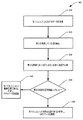
図3は、信号強度の評価によるモバイルユニットが動いているか否かの検証に基づいて、GPSデータの精度を評価する方法300を示している。このような信号強度を隣接する塔から受信して、モバイルユニットは動いておらず、静止位置にあるか否かを検証することができる。このような検証によって、GPSの報告の精度を評価することができ、従って、GPSデータの表示を廃棄することができる。例えば、GPS誤差を軽減することは、モバイルユニットが移動した距離を検証するためにGPSデータを採用するアプリケーションにおいては重要となり、従って、一旦、モバイル装置が実際に停止した地点周辺で異常な動きをGPSが示すと、誤差が導入される。本明細書では、様々なイベントおよび/またはアクトを表す一連とブロックとして、例示的な方法を示して説明するが、主題の新技術は、図示したブロックの順序に制限されない。その新技術によると、例えば、一部の行為(act)もしくはイベントは、本明細書に示した順序とは別に、異なった順序で生じてもよく、および/または、他の行為もしくはイベントと同時に生じてもよい。さらに、主題の新技術による方法を実装するために、図に示したブロック、イベント、または行為の全てを必要とするものではない。さらに当然のことながら、新技術による例示的な方法および他の方法は、本明細書に示して説明した方法に関連して実施してもよく、本明細書に示しても説明してもいない他のシステムおよび機器に関連して実施してもよい。
FIG. 3 illustrates a
最初に、310において、モバイルユニットのGPSデータは、モバイルユニットによって取得され、モバイルユニットによって実行中のアプリケーション(例えば、全移動距離を測定するアプリケーション)への入力として採用することができる。次に、320において、モバイルユニットの近くの塔から発する信号は検出することができる。続いて、330において、その信号の強度はその後、モバイルユニットが同じ塔から受信した信号と比較することができる。340において、時刻T2と比較して、時刻T1における信号強度が同じか否かを判定する。同じであれば、方法300は、モバイルユニットが静止位置であると推定し、350においてGPSデータを拒否する。同じでなければ、方法300は、行為360に進み、そこで、動的位置であると推定して、GPSデータを受理する。
Initially, at 310, the GPS data of the mobile unit is acquired by the mobile unit and can be employed as input to an application running by the mobile unit (eg, an application that measures the total distance traveled). Next, at 320, a signal emanating from a tower near the mobile unit can be detected. Subsequently, at 330, the strength of the signal can then be compared to the signal received by the mobile unit from the same tower. At 340, it is determined whether the signal strength at time T 1 is the same as compared to time T 2 . If so, the
図4は、ロケーションおよび信号強度の認識を採用するシステム400のブロック図を示している。システム400はGPSを用いて、GPSからの緯度/経度データに従って、装置404を操作するユーザー402を位置づけることができる。GPS衛星システム406は継続的に、装置404がユーザーの緯度/経度データを計算できるように、GPS信号408を装置404に通信する。装置404がWAGPS装置の場合、装置404は、無線登録サービスシステム412を備えた携帯電話ネットワーク410に登録することができる。無線登録サービスシステム412は、装置404に加入しているユーザーを登録し、一意に識別するものである。装置/ユーザーのロケーションがGPSを介して知られると、その座標は、検索エンジンが通信ネットワーク416の近くの塔を識別する検索語として、採用することができる。
FIG. 4 shows a block diagram of a
従って、所定の基準および/または規則に従って、返信された検索リンクにアクセスすることができる。領域424において、バーAおよびBにより示された同じ塔からの信号強度は、モバイルユニット404を携帯するユーザー402が動いているという推定を表すことができ、その結果、GPS408を信頼することができる。同じ塔から受信している信号強度AとBが、同一、または、所定の閾値の範囲内である場合、主題の新技術では次に、モバイルユニット404を携帯しているユーザーが静止位置にいると推定でき、従ってGPSデータは信頼するべきではない。
Thus, the returned search link can be accessed according to predetermined criteria and / or rules. In
ユーザーのロケーションが提供されると、他のウェブサイトに自動的にアクセスして、温度、湿度、気圧データを含む気象ウェブサイト420からの気象情報など、信号強度に影響を与え得るパラメーターに関する追加の情報を取得することもできる。当然のことながら、多くの異なる種類の規則(または方針)が実施され、信号強度に影響を与えるパラメーターについて、ウェブサイトのデータソースに自動検索および自動リンクを行うことが可能となる。関連する一態様においては、ユーザー402の方向および速度は、モバイルユニット404に関連付けられた動き分析器を介して確認することもできる。ユーザー402がGPSの影に入ることがあれば、または、ユーザーの進路および速度から、ユーザーがGPSの影に入ろうとしていると判定される場合、他のデータおよび操作を処理することができる。例えば、影のマッピングおよびログのウェブサイト426は、ユーザー402のロケーションに関連付けられた影のマッピングのデータベースを提供する。
Once the user's location is provided, additional access to parameters that can affect signal strength, such as weather information from the
図5は、主題の新技術の一態様による、誤差を軽減する関連方法500を示している。最初に510において、2つのインスタンス間の信号強度の差が、所定の閾値内であることを検証する。閾値内であれば、方法は、行為515に進み、そこでモバイルユニットの静止時の振る舞い、または、静止位置(GPSが、モバイル装置が停止したまたは静止位置にある地点の近くで異常な動きを示す可能性があり、その結果、誤差が導入される)を検出することができるので、GPSデータは廃棄することができる。閾値内でなければ、方法500は、行為520に進み、モバイルユニットの動きを推定することができる。このような推定はその後、530において、モバイル装置に関連付けられた他の種類の動き分析で確認することができる。例えば、他の動き検出装置(例えば、加速度計、速度計など)をさらに用いて、動きを検出し、その結果GPSデータに関する信頼性を確認してもよい。続いて540において、移動した距離を検証するアプリケーションに対する入力として、GPSデータを採用することができる。
FIG. 5 illustrates an associated
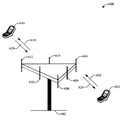
図6は、多重アクセス無線通信システム600からの信号強度を用いて、モバイルユニット616および622のGPSデータの誤差を軽減する例示的なシステムを示している。無線通信システム600は、1つもしくは複数のユーザー装置と通信する1つもしくは複数の塔、または、基地局を含むことができる。各基地局は、複数のセクタをサービスエリアとする。3セクタの基地局602は、複数のアンテナグループを含み、各アンテナグループは、それぞれ、アンテナ604および606、アンテナ608および610、アンテナ612および614を含むことを示している。図によると、アンテナグループごとに、2つのアンテナだけを示している。しかしながら、グループごとに、2つより多くのアンテナまたは2つより少ないアンテナを利用してもよい。モバイル装置616は、アンテナ612および614と通信して、アンテナ612および614は、順方向リンク618を介してモバイル装置616に信号を送信し、逆方向リンク620を介してモバイル装置616から情報を受信する。順方向リンク(またはダウンリンク)は、基地局からモバイル装置への通信リンクを示し、逆方向リンク(またはアップリンク)は、モバイル装置から基地局への通信リンクを示す。モバイル装置622は、アンテナ604および606と通信し、アンテナ604および606は、順方向リンク624を介してモバイル装置622に情報を送信し、逆方向リンク626を介してモバイル装置622から情報を受信する。例えば、FDDシステムにおいては、通信リンクは、通信に異なる周波数を利用することがある。例えば、順方向リンク618は、逆方向リンク620が利用する周波数と異なる周波数を使用することがある。
FIG. 6 illustrates an exemplary system that uses signal strength from multiple access
各アンテナグループおよび/または各アンテナグループが通信するように指定されているエリアは、基地局602のセクタと呼ぶことができる。1つもしくは複数の態様において、各アンテナグループは、基地局602がカバーするセクタまたはエリアにあるモバイル装置と通信するように指定される。基地局は、端末と通信するために用いられる固定局であってよい。順方向リンク618および624を介する通信においては、基地局602の送信アンテナは、異なるモバイル装置616および622に対する順方向リンクの信号対雑音比を改善するために、ビームフォーミングを利用することができる。従って、所定の期間中、モバイルユニット616または622が受信した信号強度が一定であるということは、静止した(例えば、移動していない)モバイルユニットを示すと推定することができる。同様に、所定の時間枠中に信号強度が変化するということは、モバイルユニットが実際に移動したことを示すと推定することができる。
Each antenna group and / or the area in which each antenna group is designated to communicate may be referred to as a
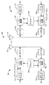
図7は、塔(単数または複数)の信号強度を用いてモバイルユニットの動きを検証することにより、ポジショニングシステムの誤差を軽減する例示的な無線通信システム700を示している。無線通信システム700は、簡潔のために、1つの基地局、および、1つの端末を表す。しかし、当然のことながら、システム700は、複数の基地局もしくはアクセスポイント、および/または、複数の端末もしくはユーザー装置を含むことができ、追加の基地局および/または端末は、下記に説明する例示的な基地局および端末と実質的に同じでもよいし、異なっていてもよい。さらに、当然のことながら、基地局および/または端末は、本明細書に説明するシステムおよび/または方法を用いて、基地局と端末間の無線通信を容易にすることができる。
FIG. 7 illustrates an example
図7に示すように、ダウンリンクでは、アクセスポイント705で、送信(TX)データプロセッサ710が、トラフィックデータを受信し、フォーマット化し、コード化し、インターリーブを行い、および変調(またはシンボルマッピング)して、変調シンボル(「データシンボル」)を提供する。シンボル変調器715が、データシンボルおよびパイロットシンボルを受信して処理し、シンボルストリームを提供する。シンボル変調器715は、データシンボルおよびパイロットシンボルを多重化し、N個の送信シンボルのセットを取得する。各送信シンボルは、データシンボル、パイロットシンボル、またはゼロ信号値であってもよい。パイロットシンボルは、各シンボル期間で継続的に送ることができる。さらに、パイロットシンボルは、周波数分割多重化(FDM)、直交周波数分割多重化(OFDM)、時分割多重化(TDM)、周波数分割多重化(FDM)、または符号分割多重化(CDM)してもよい。
As shown in FIG. 7, in the downlink, at an
送信機ユニット(TMTR)720が、シンボルストリームを受信して1つまたは複数のアナログ信号に変換し、さらにアナログ信号を調整(例えば、増幅、フィルタリング、周波数アップコンバート)して、無線チャネルを介した送信に適するダウンリンク信号を生成する。次いで、ダウンリンク信号は、アンテナ725を介して端末に送信される。端末730においては、アンテナ735が、ダウンリンク信号を受信し、受信した信号を受信機ユニット(RCVR)740に提供する。受信機ユニット740は、受信した信号を調整(例えば、フィルタリング、増幅、周波数ダウンコンバート)して、調節した信号をデジタル化し、サンプルを取得する。シンボル復調器745が、N個(整数)の受信したシンボルを取得し、受信したパイロットシンボルをチャネル推定のためにプロセッサ750に提供する。シンボル復調器745はさらに、ダウンリンクの周波数応答推定値をプロセッサ750から受信し、受信したデータシンボルをデータ復調してデータシンボル推定値(送信したデータシンボルの推定値である)取得し、データシンボル推定値をRXデータプロセッサ755に提供する。RXデータプロセッサ755は、データシンボル推定値を復調し(すなわち、シンボルのデマッピングし)、デインタリーブを行い、およびデコードして、送信されたトラフィックデータを回復する。シンボル復調器745およびRXデータプロセッサ755による処理は、アクセスポイント705でのシンボル変調器715およびTXデータプロセッサ710による処理をそれぞれ補完するものである。
A transmitter unit (TMTR) 720 receives the symbol stream and converts it to one or more analog signals, further conditioning (eg, amplifying, filtering, frequency upconverting) the analog signal and over the radio channel A downlink signal suitable for transmission is generated. The downlink signal is then transmitted to the terminal via
アップリンクにおいては、TXデータプロセッサ760が、トラフィックデータを処理してデータシンボルを提供する。シンボル変調器765が、データシンボルをパイロットシンボルと共に受信して多重化し、変調し、シンボルストリームを提供する。次いで、送信機ユニット770が、シンボルストリームを受信して処理し、アップリンク信号を生成する。アップリング信号は、アンテナ735によってアクセスポイント705に送信される。
On the uplink, a
アクセスポイント705においては、端末730からのアップリンク信号は、アンテナ725で受信され、受信機ユニット775で処理されてサンプルを取得される。シンボル復調器780が、サンプルを処理し、受信したアップリンクのパイロットシンボルおよびデータシンボル推定値を提供する。RXデータプロセッサ785は、データシンボル推定値を処理して、端末730により送信されたトラフィックデータを回復する。プロセッサ790は、アップリンクで送信を行っているアクティブな各端末に対して、チャネル推定を行う。
At
プロセッサ790および750はそれぞれ、アクセスポイント705および端末730における操作を指示する(例えば、制御、調整、管理など)。各プロセッサ790および750は、プログラムコードおよびデータを記憶するメモリユニット(図示せず)に関連付けることができる。プロセッサ790および750はまた、それぞれ、計算を行い、アップリンクおよびダウンリンクの周波数とインパルス応答推定値とを求めることができる。
多重アクセスシステム(例えば、FDMA、OFDMA、CDMA、TDMAなど)では、多数の端末が、アップリンクで同時に送信を行うことができる。このようなシステムでは、パイロットサブバンドは、異なった端末間で共有することができる。各端末のパイロットサブバンドが、動作帯域全体にわたる場合(おそらく、帯域の端を除いて)、チャネル推定技術を採用することができる。このようなパイロットサブバンド構造は、各端末の周波数のダイバーシティを得るために望ましい。当然のことながら、本明細書に説明する技術は、様々な手段によって実現することができる。例えば、このような技術は、ハードウェア、ソフトウェア、または、それらを組み合わせたもので実現することができる。ハードウェアで実現する場合には、チャネル推定に用いられる処理ユニットは、1つまたは複数のASIC(application specific integrated circuit)、DSP(digital signal processor)、デジタル信号処理装置(digital signal processing device)(DSPD))、PLD(programmable logic device)、FPGA(field programmable gate array)、プロセッサ、コントローラ、マイクロコントローラ、マイクロプロセッサ、本明細書に説明する機能を行うように設計された他の電子ユニット、またはそれらの組み合わせ内で実装してよい。ソフトウェアの場合には、本明細書に説明する機能を行うモジュール(例えば、プロシージャ、機能など)を通して実装することができる。ソフトウェアコードは、メモリユニットに記憶し、プロセッサ790および750によって実行してよい。
In a multiple access system (eg, FDMA, OFDMA, CDMA, TDMA, etc.), multiple terminals can transmit simultaneously on the uplink. In such a system, the pilot subband can be shared between different terminals. Channel estimation techniques can be employed when the pilot subbands of each terminal span the entire operating band (possibly except at the edges of the band). Such a pilot subband structure is desirable for obtaining frequency diversity of each terminal. Of course, the techniques described herein can be implemented by various means. For example, such a technique can be realized by hardware, software, or a combination thereof. When implemented in hardware, the processing units used for channel estimation are one or more application specific integrated circuits (ASICs), digital signal processors (DSPs), digital signal processing devices (DSPDs). )), Programmable logic devices (PLDs), field programmable gate arrays (FPGAs), processors, controllers, microcontrollers, microprocessors, other electronic units designed to perform the functions described herein, or May be implemented in combination. In the case of software, it can be implemented through modules (eg, procedures, functions, etc.) that perform the functions described herein. Software code may be stored in a memory unit and executed by
例示的なコードには、下記のコードが含まれる。
//Do this for each stationary signal source in the
vicinity
OnGPSSensorUpdate()
{
//Check received signal strength indicators...
if((CurrentSourceSignalValue == previousSignalValue) &&
(previousMaxValue== GetCurrentSignalSourceMAX())
{
//Do not trust the GPS read. There was either no
movement according to the other signals and we have not
swapped sources
}
Else
{
//Either the source changed or there WAS movement
according to the signal strength.
Pos = Read GPSSensor();// Either way, accept the
current position!
Exemplary codes include the following codes:
// Do this for each stationary signal source in the
vicinity
OnGPSSensorUpdate ()
{
// Check received signal strength indicators ...
if ((CurrentSourceSignalValue == previousSignalValue) &&
(previousMaxValue == GetCurrentSignalSourceMAX ())
{
// Do not trust the GPS read.There was either no
movement according to the other signals and we have not
swapped sources
}
Else
{
// Either the source changed or there WAS movement
according to the signal strength.
Pos = Read GPSSensor (); // Either way, accept the
current position!
信号強度は、受信した信号レベルもしくは電界の強度、または、基準点における電界の強さに対応する相対的な/単位のないインデックスの形式(例えば、携帯電話画面上の「バー」の数)とすることができる。従って、所定期間、信号強度が一定であるということは、静止した(例えば、動いていない)モバイルユニットを示すと推定することができる。同様に、所定の時間枠中に信号強度が変化するということは、モバイルユニットが移動したことを示すと推定することができる。このような検出コンポーネントおよび比較器コンポーネントは、モバイルユニットの一部であってもよく、または、三角測量手順をさらに用いてモバイルユニットが静止しているか動いているかを推定する中央制御システムの一部として、配置してもよい。このような検出コンポーネントおよび比較器コンポーネントは、移動した距離を検証するためにGPSデータを採用するアプリケーションにおいて、モバイル装置が停った地点周辺でGPSが異常な動きを示すとき重要となり、従って導入される。 The signal strength is the received signal level or field strength, or a relative / unitless index format (eg number of “bars” on the mobile phone screen) corresponding to the field strength at the reference point. can do. Thus, a constant signal strength for a predetermined period can be assumed to indicate a stationary (eg, not moving) mobile unit. Similarly, a change in signal strength during a predetermined time frame can be estimated to indicate that the mobile unit has moved. Such detection and comparator components may be part of the mobile unit, or part of a central control system that uses a triangulation procedure to estimate whether the mobile unit is stationary or moving. May be arranged. Such detection and comparator components are important when applications that employ GPS data to verify the distance traveled, when the GPS shows abnormal movement around the point where the mobile device stops. The
図8は、主題の新技術の一態様による、GPSを訂正するための人工知能コンポーネント810を示している。例えば、このような人工知能コンポーネント810は、犠牲選択に関する費用見積もりの経験則を提供することを含むことができる。関連する一態様において、「推定」という語は一般的に、イベントおよび/またはデータを介して得た観察のセットから、システム、環境および/またはユーザーの状態を、推論または推定するプロセスを示す。例えば、推定は、特定の状況または行為を識別するために行われてもよいし、または、状態に関する確率分布を生成するために行われてもよい。推定は、確率的なもの、すなわち、データおよびイベントの考慮に基づいいて、注目している状態に関する確率分布の計算となり得る。推定は、イベントおよび/またはデータのセットから、より上位のイベントを組み立てるのに用いられる技術を示すことができる。このような推定により、観察したイベントおよび/または記憶したイベントデータのセットから、そのイベントが時間的に近接して相互に関連付けられているか否かから、ならびに、そのイベントおよびデータが、1つもしくはいくつかのイベントおよびデータソースからのものであるか否かから、新しいイベントまたは行為を構築する。
FIG. 8 illustrates an
推定コンポーネント810は、本明細書に説明する発明の様々な態様を容易にすることに関連して、上述した様々な適切なAIベースのスキームのうち任意のスキームを採用することができる。例えば、GPSデータを廃棄するべき時を明示的または黙示的に習得するプロセスは、自動分類のシステムおよびプロセスを介して、容易にすることができる。分類は、確率的および/または統計ベースの分析(例えば、ユーティリティおよび費用を分析に入れる)を用いて、ユーザーが自動的に行われることを望む行為を予知または推定することができる。例えば、SVM(support vector machine)分類器を用いることができる。他の分類方法には、ベイジアンネットワーク、決定木を含み、異なったパターンの独立性を提供する確率的分類モデルを用いてもよい。本明細書で使用された分類はまた、優先順位モデルを開発するのに利用される統計的回帰を含む。
The
本明細書から容易に分かるように、主題の新技術は、(例えば、汎用訓練データを介して)明示的に訓練された分類器、および、(例えば、ユーザーの振る舞いを観察、外部情報の受信を介して) 黙示的に訓練された分類器を用いることができ、その結果、分類器を使用して、質問についてどの回答を返すかを、所定の基準に従って自動的に判断する。例えば、よく知られているSVM分類器に関しては、SVM分類器は、分類器コンストラクタおよび機能選択モジュール内の学習または訓練の段階を通して構成される。分類器は、入力属性ベクトルx=(x1,x2,x3,x4,xn)を、この入力がクラスに属する信頼性にマッピングする関数である。すなわち、f(x)=confidence(class)である。 As can be readily seen from this specification, the subject new technologies include explicitly trained classifiers (e.g., via generic training data), and (e.g., observe user behavior, receive external information) Implicitly trained classifiers can be used, so that the classifier is used to automatically determine which answers to return for a question according to predetermined criteria. For example, for the well-known SVM classifier, the SVM classifier is configured through a learning or training stage within a classifier constructor and function selection module. The classifier is a function that maps the input attribute vector x = (x 1 , x 2 , x 3 , x 4 , x n ) to the reliability that this input belongs to the class. That is, f (x) = confidence (class).
本明細書においては、「コンポーネント」、「システム」、「モジュール」などの語は、ハードウェア、ハードウェアとソフトウェアの組み合わせ、ソフトウェア、または、実行中のソフトウェアのいずれかである、コンピューター関連エンティティを指すことを意図している。例えば、コンポーネントは、プロセッサで実行中のプロセス、プロセッサ、オブジェクト、インスタンス、実行ファイル、実行スレッド、プログラム、および/またはコンピューターとしてよいが、これらに限らない。例を挙げると、コンピューターで実行中のアプリケーションおよびコンピューターはともに、コンポーネントとすることができる。1つもしくは複数のコンポーネントが、プロセスおよび/または実行スレッド内に常駐していてもよいし、コンポーネントは、一つのコンピューターに局在してもいてもよし、および/または、2つ以上のコンピューター間で分散していてもよい。 As used herein, the terms “component”, “system”, “module”, etc. refer to computer-related entities that are either hardware, a combination of hardware and software, software, or running software. Intended to point. For example, a component may be, but is not limited to being, a process running on a processor, a processor, an object, an instance, an executable, a thread of execution, a program, and / or a computer. By way of illustration, both an application running on computer and the computer can be a component. One or more components may reside in a process and / or thread of execution, a component may be localized on one computer, and / or between two or more computers May be dispersed.
「例示的な」という語は、本明細書では、例、実例または図として示すという意味である。「例示的な」として本明細書に説明する態様もしくは設計は、必ずしも、他の態様または設計より好ましい、または、有利な、と解釈すべきではない。同様に、例は、単に明瞭に分かりやすくするために、本明細書において提供するものであり、主題の新技術またはその一部は、いかなる方法においても制限するものではない。当然のことながら、追加のまたは代替の例を無数に提示することができるが、簡潔に説明するため省略している。 The word “exemplary” is used herein to mean illustrated as an example, instance, or figure. Any aspect or design described herein as "exemplary" is not necessarily to be construed as preferred or advantageous over other aspects or designs. Similarly, examples are provided herein for clarity and clarity only, and the subject innovation or portions thereof are not limited in any way. It will be appreciated that a myriad of additional or alternative examples may be presented, but have been omitted for the sake of brevity.
さらに、主題の新技術の全てまたは一部は、標準的なプログラミングおよび/またはエンジニアリング技術を用いたシステム、方法、装置もしくは製品として実装して、コンピューターが開示の新技術を実装するように制御するソフトウェア、ファームウェア、ハードウェア、またはそれらの任意の組み合わせを生産することができる。例えば、コンピューター可読媒体は、磁気記憶装置(例えば、ハードディスク、フロッピーディスク、磁気ストリップなど)、光ディスク(例えば、CD(compact disk)、DVD(digital versatile disk)など)、スマートカード、およびフラッシュメモリデバイス(例えば、カード、スティック、キードライブなど)を含むことができるが、これらに限らない。さらに、当然のことながら、搬送波を用いて、電子メールを送受信するのに用いられる、または、インターネットやLAN(local area network)といったネットワークにアクセスするのに用いられるようなコンピューター可読電子データを伝達してもよい。特許を請求する主題の範囲または精神を逸脱することなく、この構成に多くの変更を加えてよいことは、当業者には当然、認識されよう。 Further, all or part of the subject new technology may be implemented as a system, method, apparatus or product using standard programming and / or engineering techniques to control the computer to implement the disclosed new technology. Software, firmware, hardware, or any combination thereof can be produced. For example, computer-readable media include magnetic storage devices (e.g., hard disks, floppy disks, magnetic strips, etc.), optical disks (e.g., CD (compact disk), DVD (digital versatile disk), etc.), smart cards, and flash memory devices ( For example, a card, a stick, a key drive, etc.) can be included. In addition, it should be understood that the carrier wave is used to transmit computer readable electronic data that is used to send and receive e-mail or to access a network such as the Internet or a local area network (LAN). May be. Of course, those skilled in the art will recognize many modifications may be made to this configuration without departing from the scope or spirit of the claimed subject matter.
開示の主題の様々な態様について状況を提供するために、図9、図10および下記の記載は、開示の主題の様々な態様を実施してよい適切な環境を、簡潔かつ一般的に説明することを意図している。1つおよび/または複数のコンピューターで実行するコンピュータープログラムのコンピューター実行可能命令という一般的な状況で主題を述べたが、新技術を他のプログラムモジュールと組み合わせて実装してもよいことは、当業者には認識されよう。プログラムモジュールは一般的に、ルーチン、プログラム、コンポーネント、データ構造などを含み、特定のタスクを行う、および/または、特定の抽象データ型を実装する。さらにこの革新的な方法は、シングルプロセッサもしくはマルチプロセッサコンピューターシステム、ミニコンピューティングデバイス、メインフレームコンピューターを含む他のコンピューターシステム構成、および、パーソナルコンピューター、ハンドヘルドコンピューティングデバイス(例えば、PDA(personal digital assistant)、電話、時計など)、マイクロプロセッサベースまたは、プログラム可能な家庭用電化製品もしくは産業用電子機器などで実施できることは、当業者には理解されよう。図示した態様はまた、通信ネットワークを通してリンクされた遠隔処理装置によってタスクを行う分散コンピューティング環境で実施することができる。しかしながら、この新技術の態様の全てではないにしても、一部は、スタンドアローンコンピューターで実施することができる。分散コンピューティング環境において、プログラムモジュールは、ローカルおよびリモートの記憶装置の両方に配置することができる。 To provide context for various aspects of the disclosed subject matter, FIGS. 9, 10, and the following description provide a brief and general description of a suitable environment in which various aspects of the disclosed subject matter may be implemented. Is intended. Although the subject matter has been described in the general context of computer-executable instructions for a computer program executing on one and / or multiple computers, it will be appreciated by those skilled in the art that the new technology may be implemented in combination with other program modules. Will be recognized. Program modules typically include routines, programs, components, data structures, etc. that perform particular tasks and / or implement particular abstract data types. In addition, the innovative methods include single processor or multiprocessor computer systems, minicomputing devices, other computer system configurations including mainframe computers, and personal computers, handheld computing devices (eg, personal digital assistants (PDAs)). Those skilled in the art will appreciate that it can be implemented on a microprocessor-based or programmable household appliance or industrial electronics, etc.). The illustrated aspects can also be practiced in distributed computing environments where tasks are performed by remote processing devices that are linked through a communications network. However, some, if not all, aspects of this new technology can be implemented on a stand-alone computer. In a distributed computing environment, program modules can be located in both local and remote storage devices.
図9を参照しながら、コンピューター912を含む主題の新技術の様々な態様を実施するための例示的な環境910について説明する。コンピューター912は、処理ユニット914、システムメモリ916、および、システムバス918を含む。システムバス918は、システムコンポーネントを処理ユニット914に結合する。システムコンポーネントには、システムメモリ916が含まれるが、これに限らない。処理ユニット914は、様々な利用可能なプロセッサのうち任意のものでよい。デュアルマイクロプロセッサおよび他のマルチプロセッサアーキテクチャも、処理ユニット914として用いることができる。
With reference to FIG. 9, an
システムバス918は、メモリバス、メモリコントローラ、周辺バスもしくは外部バス、および/または、任意の種類の利用可能なバスアーキテクチャを用いたローカルバスを含む数種類のバス構造の任意のもの(単数または複数)とすることができる。任意の種類のバスアーキテクチャには、11ビットバス、ISA(Industrial Standard Architecture)、MSA(Micro-Channel Architecture)、EISA(Extended ISA)、IDE(Intelligent Drive Electronics)、VLB(VESA Local Bus)、PCI(Peripheral Component Interconnect)、USB(Universal Serial Bus)、AGP(Advanced Graphics Port)、PCMCIA(Personal Computer Memory Card International Association)バス、およびSCSI(Small Computer Systems Interface)が含まれるが、これらに限らない。
The
システムメモリ916は、揮発性メモリ920および不揮発性メモリ922を含む。BIOS(basic input/output system)は、起動中などにコンピューター912内の要素間で情報を転送する基本的なルーチンを含み、不揮発性メモリ922に記憶される。例を挙げると、不揮発性メモリ922は、ROM(read only memory)、PROM(programmable ROM)、EPROM(electrically programmable ROM)、EEPROM(electrically erasable ROM)、または、フラッシュメモリを含むことができるが、これらに限らない。揮発性メモリ920は、RAM(random access memory)を含み、RAMは、外部キャッシュメモリとして作用する。例を挙げると、RAMは、SRAM(synchronous RAM)、DRAM(dynamic RAM)、SDRAM(synchronous DRAM)、DDR SDRAM(double data rate SDRAM)、ESDRAM(enhanced SDRAM)、SLDRAM(Synchlink DRAM)および、DRRAM(direct Rambus RAM)といった多くの形で利用可能であるが、これらに限らない。
The
コンピューター912はまた、取り外し可能/取り外し不能、揮発性/不揮発性コンピューター記憶媒体を含む。図9は、ディスク記憶装置924を示している。このようなディスク記憶装置924は、磁気ディスクドライブ、フロッピーディスクドライブ、テープドライブ、Jazドライブ、Zipドライブ、LS−60ドライブ、フラッシュメモリカード、または、メモリスティックといった装置を含むが、これらに限らない。さらにディスク記憶装置924は、独立して記憶媒体を含んでもよいし、または、他の記憶媒体と組み合わせた記憶媒体を含んでもよい。他の記憶媒体は、CD−ROM(compact disk ROM)デバイス、CD−R(CD-recordable)ドライブ、CD−RW(CD rewritable)ドライブ、または、DVD−ROM(digital versatile disk ROM)ドライブなどの光ディスクドライブを含むが、これらに限らない。ディスク記憶装置924のシステムバス918への接続を容易にするために、インタフェース926などの取り外し可能または取り外し不能インタフェースが通常は使用される。
当然のことながら、図9は、適切なオペレーティング環境910において説明する基本的なコンピューターリソースとユーザーとの間の媒介として働くソフトウェアを示している。このようなソフトウェアは、オペレーティングシステム928を含む。オペレーティングシステム928は、ディスク記憶装置924に記憶することができ、コンピューターシステム912のリソースを制御し、割り当てる働きをする。システムアプリケーション930は、システムメモリ916またはディスク記憶装置924のいずれかに記憶されたプログラムモジュール932およびプログラムデータ934を通して、オペレーティングシステム928によるリソースの管理を利用する。当然のことながら、本明細書に説明する様々なコンポーネントは、様々なオペレーティングシステムまたはオペレーティングシステムの組み合わせと共に実装することができる。
Of course, FIG. 9 illustrates software that acts as an intermediary between the basic computer resources described in a
ユーザーは、1つまたは複数の入力装置936を介してコンピューター912にコマンドまたは情報を入力する。入力装置936は、マウス、トラックボール、スタイラス、タッチパッド、キーボード、ジョイスティック、ゲームパッドなどのポインティングデバイス、マイク、衛星放送受信アンテナ、スキャナ、テレビチューナカード、デジタルカメラ、デジタルビデオカメラ、ウェブカメラなどを含むが、これらに限らない。これらの入力装置および他の入力装置は、インタフェースポート(単数または複数)938を介して、システムバス918を通して、処理ユニット914に接続する。1つまたは複数のインタフェースポート938は、例えば、シリアルポート、パラレルポート、ゲームポート、USB(universal serial bus)を含む。1つまたは複数の出力装置940は、1つまたは複数の入力装置936と同じ種類のポートの一部を用いる。従って、例えば、USBポートを用いて、コンピューター912に入力を行い、コンピューター912から出力装置940に情報を出力してもよい。出力アダプタ942を備えて、専用のアダプタを必要とする他の出力装置940のうち、モニタ、スピーカ、プリンタといった一部の出力装置940があることを示す。例を挙げると、出力アダプタ942は、出力装置940とシステムバス918との間を接続する手段を提供するビデオカードおよびサウンドカードを含むが、これらに限らない。1つもしくは複数のリモートコンピューター944などの他の装置、および/または装置のシステムは、入力能力および出力能力の双方を提供することに留意されたい。
A user enters commands or information into
コンピューター912は、リモートコンピューター(単数または複数)944といった1つまたは複数のリモートコンピューターへの論理接続を用いて、ネットワーク環境で動作することができる。リモートコンピューター(単数または複数)944は、パーソナルコンピューター、サーバー、ルータ、ネットワークPC、ワークステーション、マイクロプロセッサベースの機器、ピアデバイス、または他の共通ネットワークノードなどであってよく、通常、コンピューター912に関して説明する要素の多くまたは全てを含む。簡潔にするために、メモリ記憶装置946のみを、1つまたは複数のリモートコンピューター944と共に図に示す。1つまたは複数のリモートコンピューター944は、ネットワークインタフェース948を介してコンピューター912に論理的に接続され、通信接続950を介して、物理的に接続される。ネットワークインタフェース948は、LAN(local area network)およびWAN(wide area network)といった通信ネットワークを包含する。LAN技術は、FDDI(Fiber Distributed Data Interface)、CDDI(Copper Distributed Data Interface)、イーサネット/IEEE802.3、トークンリング/IEEE802.5などを含む。WAN技術は、ポイントツーポイント接続、ISDN(Integrated Service Digital Network)といった回路交換ネットワークおよびそれらの変更形態、パケット交換ネットワーク、ならびにDSL(Digital Subscriber Line)を含むが、これらに限らない。
1つまたは複数の通信接続950は、ネットワークインタフェース948をバス918に接続するために採用されるハードウェア/ソフトウェアを指す。通信接続950は、図が分かりやすいように、コンピューター912内に示しているが、コンピューター912の外部にあってもよい。ネットワークインタフェース948への接続に必要なハードウェア/ソフトウェアは、例を挙げると、通常の電話レベルのモデム、ケーブルモデルおよびDSLモデムを含むモデム、ISDNアダプタ、およびイーサネットカードといった、内部技術および外部技術を含む。
One or
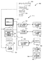
図10は、主題の新技術の一態様による、GPS誤差軽減の一部として採用することができるサンプルコンピューティング環境1000の略ブロック図である。システム1000は、1つまたは複数のクライアント1010を含む。1つもしくは複数のクライアント1010は、ハードウェアおよび/またはソフトウェア(例えば、スレッド、プロセス、コンピューティング装置)であってよい。システム1000は、1つまたは複数のサーバー1030も含む。1つもしくは複数のサーバー1030も、ハードウェアおよび/またはソフトウェア(例えば、スレッド、プロセス、コンピューティング装置)であってよい。サーバー1030は、スレッドを格納し、例えば、本明細書に説明するコンポーネントを採用することによって、変換を行うことができる。クライアント1010とサーバー1030との間で可能な通信の形の1つは、2つ以上のコンピュータープロセス間で送信されるようになされたデータパケットの形であってよい。システム1000は、1つまたは複数のクライアント1010と、1つまたは複数のサーバー1030との間の通信を容易にするために採用することができる通信フレームワーク1050を含む。1つまたは複数のクライアント1010は、1つまたは複数のクライアント1010に局在する情報を記憶するために採用することができる1つまたは複数のクライアントデータストア1060に動作可能に接続される。同様に、1つまたは複数のサーバー1030は、サーバー1030に局在する情報を記憶するために採用することができる1つまたは複数のサーバーデータストア1040に動作可能に接続される。
FIG. 10 is a schematic block diagram of a
上記は、様々な例示的態様を含む。これらの態様を説明するために、コンポーネントまたは方法の考え得る組み合わせをすべて記載することはもちろん可能ではないが、多くのさらなる組み合わせおよび置き換えが可能であることは、当業者には認識されよう。従って、本明細書に説明した態様は、添付の請求項の要旨および範囲に該当する改良、変更および変形の全てを含むものとする。 The above includes various exemplary aspects. One skilled in the art will recognize that it is not possible to describe all possible combinations of components or methods to illustrate these aspects, although many further combinations and substitutions are possible. Accordingly, the aspects described herein are intended to embrace all such alterations, modifications and variations that fall within the spirit and scope of the appended claims.
さらに「含む」という語は、詳細な説明または請求項で用いられる範囲において、「備える」という語が請求項において遷移語として使われる場合に解釈されるのと同様に、包括的であることを意図するものである。 Further, the word “comprising” is to be used in the detailed description or in the claims to be inclusive, as is the case when the word “comprising” is interpreted as a transition word in the claims. Intended.
Claims (20)
前記モバイルユニットに関連付けられたGPSデータの誤差軽減システムであって、1つまたは複数の信号源からの信号強度を評価して、前記モバイルユニットの動きを推定し、前記動きに基づいて前記GPSデータを受理または廃棄する誤差軽減システムと
であるコンピューター実行可能なコンポーネントを備えることを特徴とするコンピューター実行システム。 A mobile unit having a GPS function;
An error mitigation system for GPS data associated with the mobile unit, wherein signal strength from one or more signal sources is evaluated to estimate movement of the mobile unit and the GPS data based on the movement A computer-implemented system comprising: a computer-executable component that is an error mitigation system that accepts or discards
信号源から前記モバイルユニットに送信される信号強度を、誤差軽減システムを介して評価する処理と、
前記誤差軽減システムが評価した前記信号強度に基づいて、前記GPSデータを受理または拒絶する処理と
であるコンピューター実行可能な処理を含むことを特徴とするコンピューター実行方法。 Processing to acquire GPS data by the mobile unit;
A process for evaluating a signal strength transmitted from a signal source to the mobile unit via an error mitigation system;
A computer-implemented method comprising: a computer-executable process that is a process of accepting or rejecting the GPS data based on the signal strength evaluated by the error reduction system.
前記信号強度に基づく前記モバイルユニットの動きに関連したGPS誤差を軽減する手段と
であるコンピューター実行可能なコンポーネントを備えることを特徴とするコンピューター実行システム。 Means for estimating the movement of the mobile unit based on the signal strength from the signal source;
A computer-implemented system comprising a computer-executable component that is means for reducing GPS errors associated with movement of the mobile unit based on the signal strength.
Applications Claiming Priority (3)
| Application Number | Priority Date | Filing Date | Title |
|---|---|---|---|
| US12/344,820 | 2008-12-29 | ||
| US12/344,820 US8059027B2 (en) | 2008-12-29 | 2008-12-29 | Correcting GPS through secondary sensors and signal strength |
| PCT/US2009/067786 WO2010077791A2 (en) | 2008-12-29 | 2009-12-11 | Correcting gps through secondary sensors and signal strength |
Publications (2)
| Publication Number | Publication Date |
|---|---|
| JP2012514385A true JP2012514385A (en) | 2012-06-21 |
| JP2012514385A5 JP2012514385A5 (en) | 2013-01-31 |
Family
ID=42284237
Family Applications (1)
| Application Number | Title | Priority Date | Filing Date |
|---|---|---|---|
| JP2011543562A Pending JP2012514385A (en) | 2008-12-29 | 2009-12-11 | GPS correction using secondary sensors and signal strength |
Country Status (6)
| Country | Link |
|---|---|
| US (1) | US8059027B2 (en) |
| EP (1) | EP2382831B1 (en) |
| JP (1) | JP2012514385A (en) |
| CN (1) | CN102273289B (en) |
| ES (1) | ES2637154T3 (en) |
| WO (1) | WO2010077791A2 (en) |
Cited By (2)
| Publication number | Priority date | Publication date | Assignee | Title |
|---|---|---|---|---|
| JP2016176907A (en) * | 2015-03-23 | 2016-10-06 | 石川県 | Position measurement system, position measurement device, position measurement method, and program |
| JP2017515123A (en) * | 2014-05-08 | 2017-06-08 | クゥアルコム・インコーポレイテッドQualcomm Incorporated | Range ratio based outage detection |
Families Citing this family (27)
| Publication number | Priority date | Publication date | Assignee | Title |
|---|---|---|---|---|
| US7640105B2 (en) | 2007-03-13 | 2009-12-29 | Certus View Technologies, LLC | Marking system and method with location and/or time tracking |
| US9659268B2 (en) * | 2008-02-12 | 2017-05-23 | CertusVies Technologies, LLC | Ticket approval system for and method of performing quality control in field service applications |
| US8612271B2 (en) | 2008-10-02 | 2013-12-17 | Certusview Technologies, Llc | Methods and apparatus for analyzing locate and marking operations with respect to environmental landmarks |
| US9208458B2 (en) | 2008-10-02 | 2015-12-08 | Certusview Technologies, Llc | Methods and apparatus for analyzing locate and marking operations with respect to facilities maps |
| US9208464B2 (en) | 2008-10-02 | 2015-12-08 | Certusview Technologies, Llc | Methods and apparatus for analyzing locate and marking operations with respect to historical information |
| US9473626B2 (en) | 2008-06-27 | 2016-10-18 | Certusview Technologies, Llc | Apparatus and methods for evaluating a quality of a locate operation for underground utility |
| US20090327024A1 (en) | 2008-06-27 | 2009-12-31 | Certusview Technologies, Llc | Methods and apparatus for quality assessment of a field service operation |
| CA2897462A1 (en) * | 2009-02-11 | 2010-05-04 | Certusview Technologies, Llc | Management system, and associated methods and apparatus, for providing automatic assessment of a locate operation |
| US7941379B1 (en) * | 2009-06-25 | 2011-05-10 | Symantec Corporation | Systems and methods for using geo-location information in sensitive internet transactions |
| US8489112B2 (en) * | 2009-07-29 | 2013-07-16 | Shopkick, Inc. | Method and system for location-triggered rewards |
| US8341099B2 (en) * | 2010-03-12 | 2012-12-25 | Microsoft Corporation | Semantics update and adaptive interfaces in connection with information as a service |
| US10250678B2 (en) * | 2010-07-07 | 2019-04-02 | Qualcomm Incorporated | Hybrid modes for peer discovery |
| US20120036140A1 (en) * | 2010-08-05 | 2012-02-09 | Certusview Technologies, Llc | Methods and apparatus for analyzing locate and marking operations by comparing filtered locate and/or marking information |
| DK2487506T3 (en) * | 2011-02-10 | 2014-08-18 | Toll Collect Gmbh | Position Detection Device and Method and Computer Program Product for Detecting the Inoperability of a Position Detection Device |
| US8548739B2 (en) * | 2011-02-10 | 2013-10-01 | Telenav, Inc. | Navigation system with interactive accelerometer mechanism and method of operation thereof |
| KR101105848B1 (en) * | 2011-04-14 | 2012-01-13 | 한국과학기술원 | Mobile terminal including sensor, wireless network system having the same and scanning method of wireless network system |
| FR2978835B1 (en) * | 2011-08-05 | 2013-08-09 | Thales Sa | SATELLITE PAYLOAD FOR INCREASE SYSTEMS |
| JP2013183356A (en) * | 2012-03-02 | 2013-09-12 | Nec Access Technica Ltd | Mobile terminal device |
| EP2653945B1 (en) * | 2012-04-19 | 2016-06-15 | Schneider Electric Buildings LLC | Association of a portable sensor device in a building management system |
| JP2015525348A (en) * | 2012-06-14 | 2015-09-03 | ホアウェイ・デバイス・カンパニー・リミテッド | Barometric pressure calibration method for mobile device, calibration device and mobile device |
| US9405011B2 (en) | 2012-10-05 | 2016-08-02 | Hand Held Products, Inc. | Navigation system configured to integrate motion sensing device inputs |
| US9002641B2 (en) | 2012-10-05 | 2015-04-07 | Hand Held Products, Inc. | Navigation system configured to integrate motion sensing device inputs |
| US9804271B2 (en) * | 2015-01-02 | 2017-10-31 | Samsung Electronics Co., Ltd | Adaptive GNSS power saving control |
| DE102015214834A1 (en) * | 2015-08-04 | 2017-02-09 | Robert Bosch Gmbh | Concept for locating an objective body located within a parking lot |
| CN106813669B (en) * | 2015-12-01 | 2020-01-03 | 骑记(厦门)科技有限公司 | Motion information correction method and device |
| EP3882667A4 (en) * | 2018-11-12 | 2022-08-24 | Furuno Electric Co., Ltd. | Gnss receiving device |
| CN111562605B (en) | 2020-04-24 | 2022-09-02 | 北京智行者科技有限公司 | Self-adaptive GPS error observed value identification method |
Citations (3)
| Publication number | Priority date | Publication date | Assignee | Title |
|---|---|---|---|---|
| JPH1051840A (en) * | 1996-07-29 | 1998-02-20 | Matsushita Electric Ind Co Ltd | Position detection system for radio mobile station |
| JPH1073652A (en) * | 1997-07-23 | 1998-03-17 | Mazda Motor Corp | Navigation apparatus for vehicle |
| US20060119508A1 (en) * | 2004-11-19 | 2006-06-08 | Miller John D | Method and apparatus for conserving power on a mobile device through motion awareness |
Family Cites Families (22)
| Publication number | Priority date | Publication date | Assignee | Title |
|---|---|---|---|---|
| US4912645A (en) * | 1987-03-26 | 1990-03-27 | Mazda Motor Corporation | Automotive navigation system |
| CA2220198A1 (en) * | 1996-11-05 | 1998-05-05 | Savannah River Srt, Inc. | Global positioning system recorder |
| DE19842836A1 (en) * | 1998-09-18 | 2000-04-20 | Nokia Mobile Phones Ltd | Method for determining the position of a communication device and communication device for performing the method |
| MXPA02000661A (en) * | 1999-07-20 | 2002-08-30 | Qualcomm Inc | Method for determining a change in a communication signal and using this information to improve sps signal reception and processing. |
| US20050026589A1 (en) * | 1999-07-29 | 2005-02-03 | Bryan Holland | Remote locator system using A E911-enabled wireless system |
| US6427077B1 (en) * | 2001-01-26 | 2002-07-30 | Motorola, Inc. | GPS enabled mobile stations and location methods therefor |
| US6754584B2 (en) * | 2001-02-28 | 2004-06-22 | Enpoint, Llc | Attitude measurement using a single GPS receiver with two closely-spaced antennas |
| US6853840B2 (en) * | 2001-03-02 | 2005-02-08 | Csi Wireless Llc | System and method for enabling and disabling devices based on RSSI analysis |
| US6861982B2 (en) * | 2001-08-16 | 2005-03-01 | Itt Manufacturing Enterprises, Inc. | System for determining position of an emitter |
| US6584331B2 (en) * | 2001-10-09 | 2003-06-24 | Nokia Corporation | Use of received signal strength indicator (RSSI) and global positioning system (GPS) to reduce power consumption in mobile station |
| KR100498987B1 (en) * | 2002-10-11 | 2005-07-01 | 엘지전자 주식회사 | Method for estimating location of vehicle in Global Positioning System Data's poor region |
| US7250907B2 (en) * | 2003-06-30 | 2007-07-31 | Microsoft Corporation | System and methods for determining the location dynamics of a portable computing device |
| US7409188B2 (en) * | 2003-11-26 | 2008-08-05 | Nokia Corporation | Method and apparatus for lowering power use by a ranging receiver |
| US7251493B2 (en) * | 2004-02-13 | 2007-07-31 | Sony Ericsson Mobile Communications Ab | Mobile terminals and methods for determining a location based on acceleration information |
| US20060038555A1 (en) * | 2004-08-20 | 2006-02-23 | Higgins Robert F | Self-training AC magnetic tracking systems to cover large areas |
| US8032276B2 (en) * | 2004-12-07 | 2011-10-04 | Geotab, Inc. | Apparatus and method for optimally recording geographical position data |
| EP3029484A1 (en) | 2005-04-07 | 2016-06-08 | Intel Mobile Communications GmbH | Mobile device |
| US20060238347A1 (en) * | 2005-04-22 | 2006-10-26 | W.R. Parkinson, Co., Inc. | Object tracking system |
| US20070005363A1 (en) * | 2005-06-29 | 2007-01-04 | Microsoft Corporation | Location aware multi-modal multi-lingual device |
| US7925995B2 (en) * | 2005-06-30 | 2011-04-12 | Microsoft Corporation | Integration of location logs, GPS signals, and spatial resources for identifying user activities, goals, and context |
| US8014788B2 (en) * | 2006-05-08 | 2011-09-06 | Skyhook Wireless, Inc. | Estimation of speed of travel using the dynamic signal strength variation of multiple WLAN access points |
| US20080165737A1 (en) * | 2007-01-09 | 2008-07-10 | Uppala Subramanya R | Motion sensitive system selection for multi-mode devices |
-
2008
- 2008-12-29 US US12/344,820 patent/US8059027B2/en active Active
-
2009
- 2009-12-11 JP JP2011543562A patent/JP2012514385A/en active Pending
- 2009-12-11 ES ES09836794.9T patent/ES2637154T3/en active Active
- 2009-12-11 EP EP09836794.9A patent/EP2382831B1/en active Active
- 2009-12-11 WO PCT/US2009/067786 patent/WO2010077791A2/en active Application Filing
- 2009-12-11 CN CN200980153818.4A patent/CN102273289B/en active Active
Patent Citations (3)
| Publication number | Priority date | Publication date | Assignee | Title |
|---|---|---|---|---|
| JPH1051840A (en) * | 1996-07-29 | 1998-02-20 | Matsushita Electric Ind Co Ltd | Position detection system for radio mobile station |
| JPH1073652A (en) * | 1997-07-23 | 1998-03-17 | Mazda Motor Corp | Navigation apparatus for vehicle |
| US20060119508A1 (en) * | 2004-11-19 | 2006-06-08 | Miller John D | Method and apparatus for conserving power on a mobile device through motion awareness |
Cited By (2)
| Publication number | Priority date | Publication date | Assignee | Title |
|---|---|---|---|---|
| JP2017515123A (en) * | 2014-05-08 | 2017-06-08 | クゥアルコム・インコーポレイテッドQualcomm Incorporated | Range ratio based outage detection |
| JP2016176907A (en) * | 2015-03-23 | 2016-10-06 | 石川県 | Position measurement system, position measurement device, position measurement method, and program |
Also Published As
| Publication number | Publication date |
|---|---|
| EP2382831A4 (en) | 2012-09-19 |
| US20100164787A1 (en) | 2010-07-01 |
| US8059027B2 (en) | 2011-11-15 |
| WO2010077791A2 (en) | 2010-07-08 |
| CN102273289A (en) | 2011-12-07 |
| EP2382831B1 (en) | 2017-05-17 |
| WO2010077791A3 (en) | 2010-08-26 |
| CN102273289B (en) | 2014-05-14 |
| ES2637154T3 (en) | 2017-10-11 |
| EP2382831A2 (en) | 2011-11-02 |
Similar Documents
| Publication | Publication Date | Title |
|---|---|---|
| JP2012514385A (en) | GPS correction using secondary sensors and signal strength | |
| US11910207B2 (en) | Systems and methods for estimating locations of signal shadowing obstructions and signal reflectors in a wireless communications network | |
| EP3342192B1 (en) | Method and arrangement for locating a mobile device | |
| US9843890B2 (en) | Reliability in mobile device positioning in a crowdsourcing system | |
| US9282435B2 (en) | Location spoofing detection | |
| US8918103B2 (en) | Location data regression | |
| CN115398274A (en) | SPS spoofing detection | |
| US9212922B2 (en) | Mobile station position estimation using transmitter almanac information | |
| JP2013529289A (en) | Anti-spoofing detection system | |
| WO2021002746A1 (en) | A device, a system, a method and computer program product for identifying interfering devices in position measurements | |
| US10557915B2 (en) | Providing an indication of a heading of a mobile device | |
| Ayres et al. | Self-mapping radio maps for location fingerprinting | |
| US11668562B1 (en) | GPS-based spatial measurements | |
| WO2023206486A1 (en) | Interaction between ai-based and traditional positioning techniques | |
| Ramakrishnan et al. | Robust Wi-Fi Assisted GNSS Positioning in Urban Canyons | |
| Guo et al. | Multi-channel and Multi-RSS based BLE Range Estimation for Indoor Tracking of Commercial Smartphones | |
| WO2024027939A1 (en) | Training machine learning positioning models in a wireless communications network | |
| Lim | Smart proximity based service agents on mobile handsets | |
| JP2015192444A (en) | Communication log analysis device for estimating position of base station from communication log, program and method |
Legal Events
| Date | Code | Title | Description |
|---|---|---|---|
| A521 | Written amendment |
Free format text: JAPANESE INTERMEDIATE CODE: A523 Effective date: 20121204 |
|
| A621 | Written request for application examination |
Free format text: JAPANESE INTERMEDIATE CODE: A621 Effective date: 20121204 |
|
| A977 | Report on retrieval |
Free format text: JAPANESE INTERMEDIATE CODE: A971007 Effective date: 20130624 |
|
| RD03 | Notification of appointment of power of attorney |
Free format text: JAPANESE INTERMEDIATE CODE: A7423 Effective date: 20130701 |
|
| A131 | Notification of reasons for refusal |
Free format text: JAPANESE INTERMEDIATE CODE: A131 Effective date: 20130702 |
|
| A521 | Written amendment |
Free format text: JAPANESE INTERMEDIATE CODE: A523 Effective date: 20130918 |
|
| RD04 | Notification of resignation of power of attorney |
Free format text: JAPANESE INTERMEDIATE CODE: A7424 Effective date: 20130926 |
|
| A02 | Decision of refusal |
Free format text: JAPANESE INTERMEDIATE CODE: A02 Effective date: 20131220 |