EP4575403A1 - Method for improved data capturing of surroundings - Google Patents
Method for improved data capturing of surroundings Download PDFInfo
- Publication number
- EP4575403A1 EP4575403A1 EP23217784.0A EP23217784A EP4575403A1 EP 4575403 A1 EP4575403 A1 EP 4575403A1 EP 23217784 A EP23217784 A EP 23217784A EP 4575403 A1 EP4575403 A1 EP 4575403A1
- Authority
- EP
- European Patent Office
- Prior art keywords
- data capturing
- path
- data
- user
- capturing unit
- Prior art date
- Legal status (The legal status is an assumption and is not a legal conclusion. Google has not performed a legal analysis and makes no representation as to the accuracy of the status listed.)
- Pending
Links
Images


Classifications
-
- G—PHYSICS
- G01—MEASURING; TESTING
- G01C—MEASURING DISTANCES, LEVELS OR BEARINGS; SURVEYING; NAVIGATION; GYROSCOPIC INSTRUMENTS; PHOTOGRAMMETRY OR VIDEOGRAMMETRY
- G01C21/00—Navigation; Navigational instruments not provided for in groups G01C1/00 - G01C19/00
- G01C21/10—Navigation; Navigational instruments not provided for in groups G01C1/00 - G01C19/00 by using measurements of speed or acceleration
- G01C21/12—Navigation; Navigational instruments not provided for in groups G01C1/00 - G01C19/00 by using measurements of speed or acceleration executed aboard the object being navigated; Dead reckoning
- G01C21/16—Navigation; Navigational instruments not provided for in groups G01C1/00 - G01C19/00 by using measurements of speed or acceleration executed aboard the object being navigated; Dead reckoning by integrating acceleration or speed, i.e. inertial navigation
- G01C21/165—Navigation; Navigational instruments not provided for in groups G01C1/00 - G01C19/00 by using measurements of speed or acceleration executed aboard the object being navigated; Dead reckoning by integrating acceleration or speed, i.e. inertial navigation combined with non-inertial navigation instruments
- G01C21/1656—Navigation; Navigational instruments not provided for in groups G01C1/00 - G01C19/00 by using measurements of speed or acceleration executed aboard the object being navigated; Dead reckoning by integrating acceleration or speed, i.e. inertial navigation combined with non-inertial navigation instruments with passive imaging devices, e.g. cameras
-
- G—PHYSICS
- G01—MEASURING; TESTING
- G01C—MEASURING DISTANCES, LEVELS OR BEARINGS; SURVEYING; NAVIGATION; GYROSCOPIC INSTRUMENTS; PHOTOGRAMMETRY OR VIDEOGRAMMETRY
- G01C21/00—Navigation; Navigational instruments not provided for in groups G01C1/00 - G01C19/00
- G01C21/38—Electronic maps specially adapted for navigation; Updating thereof
- G01C21/3804—Creation or updating of map data
- G01C21/3833—Creation or updating of map data characterised by the source of data
- G01C21/3837—Data obtained from a single source
-
- G—PHYSICS
- G01—MEASURING; TESTING
- G01C—MEASURING DISTANCES, LEVELS OR BEARINGS; SURVEYING; NAVIGATION; GYROSCOPIC INSTRUMENTS; PHOTOGRAMMETRY OR VIDEOGRAMMETRY
- G01C21/00—Navigation; Navigational instruments not provided for in groups G01C1/00 - G01C19/00
- G01C21/26—Navigation; Navigational instruments not provided for in groups G01C1/00 - G01C19/00 specially adapted for navigation in a road network
- G01C21/34—Route searching; Route guidance
- G01C21/3407—Route searching; Route guidance specially adapted for specific applications
-
- G—PHYSICS
- G01—MEASURING; TESTING
- G01C—MEASURING DISTANCES, LEVELS OR BEARINGS; SURVEYING; NAVIGATION; GYROSCOPIC INSTRUMENTS; PHOTOGRAMMETRY OR VIDEOGRAMMETRY
- G01C21/00—Navigation; Navigational instruments not provided for in groups G01C1/00 - G01C19/00
- G01C21/20—Instruments for performing navigational calculations
-
- G—PHYSICS
- G01—MEASURING; TESTING
- G01C—MEASURING DISTANCES, LEVELS OR BEARINGS; SURVEYING; NAVIGATION; GYROSCOPIC INSTRUMENTS; PHOTOGRAMMETRY OR VIDEOGRAMMETRY
- G01C21/00—Navigation; Navigational instruments not provided for in groups G01C1/00 - G01C19/00
- G01C21/20—Instruments for performing navigational calculations
- G01C21/206—Instruments for performing navigational calculations specially adapted for indoor navigation
-
- G—PHYSICS
- G01—MEASURING; TESTING
- G01C—MEASURING DISTANCES, LEVELS OR BEARINGS; SURVEYING; NAVIGATION; GYROSCOPIC INSTRUMENTS; PHOTOGRAMMETRY OR VIDEOGRAMMETRY
- G01C21/00—Navigation; Navigational instruments not provided for in groups G01C1/00 - G01C19/00
- G01C21/26—Navigation; Navigational instruments not provided for in groups G01C1/00 - G01C19/00 specially adapted for navigation in a road network
- G01C21/34—Route searching; Route guidance
Definitions
- the present invention relates to a computer-implemented method for capturing data of surroundings by means of a data capturing unit.
- Mobile mapping is used in surveying projects as well as in other applications, such as engineering, entertainment, automotive or robotics, where a 2D or 3D model of an object or environment is required.
- common mobile mapping systems consist of a sensor unit equipped with LiDAR scanners and/or cameras to create a 2D or 3D model of the environment / surroundings.
- Typical mobile mapping systems are vehicle-based systems (e.g. in cars, trains or boats) in which the sensor unit is mounted on the roof of the vehicle and collects data on the surroundings while the vehicle is moving. There are also mobile mapping systems in which the user walks through the surroundings while holding the sensor unit in his hand or carrying the sensor unit on his body, for example as a kind of backpack.
- the sensor unit is triggered through a software interface with which the user interacts during the data acquisition / capturing. These interactions with the software interface are needed to trigger different behaviors from the sensor unit to build the 2D or 3D model with the desired levels of accuracy and precision. Examples of interactions of the user with the sensor unit or a control unit for the sensor unit are for example turn on and off the LiDAR scanners and/or the cameras, change sensors settings in real time, adjust map view and check for errors and warnings.
- the fact that the user has to interact with the software interface during data capturing in prior art systems means that there is a risk that the user could, for example, make a mistake when switching on the sensor unit and thus not fully capture the data from the surroundings or capture data of specific surroundings, e.g. like military facilities, from which he should not have captured the data. There is also the risk that the user will be distracted by the interaction with the software interface in the case of hand-held systems or vehicle-based systems and thus get lost or even fall or cause a traffic accident. In other words, the user has to both pay attention to the predefined data capturing path (road in case of a car vehicle-based system) but also to the software interface which is a potential accident risk.
- the mobile mapping systems known from the prior art have the further disadvantages that the user must be an expert in handling the mapping system, for example knowing exactly how and when to trigger the sensor unit, and that in the case of a vehicle system at least two users, namely the driver and the operator, must interact with the user interface in order to follow the plan.
- the planning of such a surveying operation is a complex task for a human since many factors have to be coordinated. For example, it must be determined how several predefined data capturing paths are to be arranged or lined up so that the data of the surroundings is captured as completely as possible, but the time required for this and the distance to be covered are as short as possible.
- Such large and complex planning, which is carried out by a human, is very error-prone and also time-consuming and cost-intensive.
- Another object of the invention is to provide a computer-implemented method, a computer system and a computer program product for improved navigation and data capturing of surroundings.
- the present invention relates to a computer-implemented method for capturing data of surroundings by means of a data capturing unit (e.g. a portable / movable data capturing unit), wherein the method comprises:
- a predefined data capturing path can also be described as a "track”, wherein every predefined data capturing path being part of the planned job.
- a job therefore, will always be composed by a specific number of predefined data capturing path (tracks).
- a "transfer path” is every path the user has to follow to reach the start point of the next planned track.
- a planned job is a combination of transfers and tracks through which the user must go through to accomplish the desired result. Every track has a start point and an end point representing the limit of the acquisition the user wants to perform. Moreover, they contain specific sensor unit settings such as camera shooting frequency and LiDAR point cloud density previously defined by the user in the planning phase. Because of this, a planned job results in a list of tracks geolocalized on the map through a defined sets of start and end coordinates.
- the step "if the data capturing unit has reached the start position, providing a start command to the data capturing unit, the start command causing the data capturing unit to capture data of the surroundings" of the computer-implemented method according to the invention it can be said in other words, once the sensor unit reaches a start point of a planned track, and the necessary conditions are met, the sensor unit will start recording setting up automatically each sensor according to the planned settings.
- Exemplary conditions to start recording a planned track are (this list is not exhaustive and is not intended to be restrictive, it is merely examples of starting conditions):
- the sensor unit After the recording is started the sensor unit will maintain its settings along the track until it reaches the end point where the recording will be interrupted automatically.
- the auto-capture solution according to the invention solves the prior art problems throughout the complete workflow, from planning to acquisition, allowing a hands-free experience guiding the user through the optimal path while triggering and configuring sensor unit in an autonomous way.
- the current position of the data capturing unit is continuously monitored by means of at least one of the following (this list is not exhaustive and is not intended to be restrictive):
- the method further comprises generating a particularly colored 2D and/or 3D model of the surroundings by means of the data captured by the data capturing unit.
- motion of the data capturing unit is provided by
- the data capturing unit comprises one or more laser scanners and/or one or more cameras (in other words image capturing units) and is configured to capture 3D point-cloud data and/or image data of the surroundings.
- the data capturing unit can comprise a laser scanner, which is configured to capture 3D point-cloud data of the surroundings, and a camera, which is configured to capture image data of the surroundings.
- the camera can be configured to capture the 3D point-cloud data, for example, if the camera is configured as a time-of-flight (TOF) camera, and the laser scanner can be configured to capture image data, for example, if the laser scanner is configured to capture a colored point cloud.
- TOF time-of-flight
- the navigation commands are continuously provided to the user
- the method further comprises
- the method further comprises
- Such an obstacle can be, for example, an obstacle on the user's path (e.g. a road closure), so that the user has to make a longer detour and therefore has to leave the predefined data capturing path and therefore certain data of the surroundings of the predefined data capturing path cannot be captured, or an obstacle that covers a certain part of the surroundings (e.g. a scaffold), so that the user can stay on the predefined data capturing path but still cannot capture the data of the surroundings of the predefined data capturing path.
- an obstacle on the user's path e.g. a road closure
- an obstacle that covers a certain part of the surroundings e.g. a scaffold
- a completion report is shown (how much percentage of the planned tracks have been captured) and if not all the planned tracks where captured a new data capturing job will be created by default with the non-acquired but planned tracks for a later acquisition
- the method further comprises receiving information regarding the distance which has to be covered to traverse the predefined data capturing path, in particular the distance from the start position to the end position.
- the method further comprises receiving information regarding the expected time required to traverse the predefined data capturing path, in particular the time from the start position to the end position.
- the method further comprises providing information regarding how a plurality of predefined data capturing paths are arrangeable such that the data of the surroundings, from which a particularly colored 2D and/or 3D model has to be generated, is captured efficiently, in particular such that the shortest possible distance has to be covered and/or the shortest possible time is required.
- Such a plan / such information can be imported in the computer system according to the invention (e.g. Pegasus Field) from an external source or can be defined within the built-in planning module.
- the plan is ready the user can proceed with the autonomous acquisition.
- predefined data capturing path (track) recording and transfers
- guiding instructions are provided to help the user to stick to the plan.
- the user is guided to the next one until the complete data capturing job gets acquired. All the above-mentioned procedure does not require any interaction from the user.
- the user can assign different data capturing unit parameters (in other words the sensor unit parameters) to each predefined data capturing path (planned track) and optimize a path/track sequence based on, e.g., his experience and/or on current data, the current data regarding satellite availability and/or the traffic situation to define the most efficient path to acquire the job.
- the possibility to define different settings to data capturing paths/tracks is important as e.g. the user has to drive through "non-camera allowance" areas (like military areas) where cameras need to be switched off only over a certain part of the track (not necessarily the whole job).
- the path information comprises a course of the predefined data capturing path within an environmental map, wherein the environmental map is
- the present invention further relates to a computer system for capturing data of surroundings by means of a data capturing unit, in particular wherein the system is configured to carry out the computer-implemented method according to one of the embodiments described above, for which the system comprises a computing unit configured
- the present invention further relates to a computer program product comprising program code which is stored on a machine-readable medium, or being embodied by an electromagnetic wave comprising a program code segment, and has computer-executable instructions for performing, in particular when run on a computing unit of a computer system described above:
- the program code comprises computer-executable instructions for performing any step in the computer-implemented method according to one of the embodiments described above.
- the computer-implemented method, the computer system and the computer program product according to the invention have the advantage over the prior art that, among other things:
- Figure 1 shows a schematic illustration of the received path information regarding the predefined data capturing path 1.
- the navigation and data capturing procedure is automatically performed comprising the steps of continuously monitoring a current position 2 of the data capturing unit; calculating a transfer path 3 from the current position 2 to a start position 4 of the predefined data capturing path 1; continuously providing navigation commands to the user to guide the user along the transfer path 3; continuously determining, based on the path information and on the continuously monitored position, whether the data capturing unit has reached the start position 4; if the data capturing unit has reached the start position 4, providing a start command to the data capturing unit, the start command causing the data capturing unit to capture data of the surroundings 5; continuously providing navigation commands to the user to guide the user to an end position 6 of the predefined data capturing path 1; and if the data capturing unit has reached the end position 6, providing an end command to the data capturing unit, the end command causing the data capturing unit to end capturing data
- a 2D or 3D model of a larger surroundings has to be created, e.g. of an entire city district with several streets, wherein the data for this cannot be reasonably acquired with a single data acquisition path
- information are provided on how a plurality of predefined data capturing paths can be arranged such that the data of the environment from which a particularly colored 2D and/or 3D model has to be created are efficiently captured, in particular such that the shortest possible distance has to be covered and/or the shortest possible time is required.
- the individual predefined data capturing paths are connected by further transfer paths, which is illustrated in Figure 1 by transfer path 3'.
- Figure 2 shows a schematic illustration of an embodiment of the computer-implemented method respectively the computer system according to the invention.
- the user leaves the predefined data capturing path 2 at position 7 and erroneously moves to path 8 before reaching the end position of the predefined data capturing path, whereby the data of the surroundings along path 8 should not be captured at all.
- the remaining part of the predefined data acquisition path 2, from which the data is now missing, is illustrated as path 9.
- a notification is provided to the user and/or an intermediate end command is provided to the data capturing unit, the intermediate end command causing the data capturing unit to end capturing data of the surroundings, wherein the position 7 of the user on the predefined data capturing path 2 at which the intermediate end command is provided is defined as intermediate end position 7.
- navigation commands e.g. "in 200 meters move right"
- Figure 3 shows a schematic illustration of a software interface 14 of the computer system according to the invention, which shows an environment map 12 together with a configuration window 13, in which the user can define the settings with regard to the navigation and data capturing procedure and/or the parameters to be complied with for sufficiently accurate data capture by means of the data capturing device are displayed to the user.
- the environment map 12 shows several streets, wherein data of the surroundings along these streets are to be captured by means of the data capturing device.
- the user can click on the road map 12 to define a starting point and an end point of the data capture and the computing unit of the computer system according to the invention then calculates how the predefined data capturing paths are to be arranged accordingly (in other words refinement of the track order) and/or how the corresponding setting parameters (e.g. whether a predefined data capturing path is run/traversed several times) are to be selected in order to ensure the optimum and most (time) efficient data capture.
- the setting parameters determined by the computing unit can then be taken from the window 13.
- the user can define the predefined data capturing paths, e.g. by clicking on the respective roads, and/or the setting parameters, e.g. by entering corresponding values, himself and the computing unit of the computer system according to the invention then calculates approximately how long the entire data capturing process will take and what distance will be covered in total, wherein during the capturing phase, these calculations / estimations are continuously updated based on the remaining part of the plan.
- the traffic on the roads, the satellite availability, the kilometers to be covered and/or the battery status of the data capturing unit are also taken into account for the respective calculation.
- Such an embodiment of the computer system according to the invention is particularly intended for experienced users who have a precise idea of how exactly the data capturing should be carried out in the corresponding environment or for users who have to react to special circumstances with regard to the data capturing.
- Figure 4 shows a schematic illustration of the software interface 14 of the computer system according to the invention, wherein the computing unit has defined two data capturing paths 1 (labeled with numbers 1 and 2) in the environment map 12 based on the input of the user (e.g. with respect to the start and end points of the data capturing), wherein the data capturing unit mounted on a car has already traveled almost the entire first predefined data capturing path 1 (marked by the light gray path) and has accordingly captured almost all of the data of the surroundings along the first predefined data capturing path 1.
- the user receives corresponding navigation commands from the computer system according to the invention, which guide the user to and along the second predefined data path 1.
- the navigation commands can be communicated to the user, for example by means of an audio signal, which would have the advantage that the user can concentrate completely on driving the car on which the data capturing unit is mounted, thus ensuring the safety of the user and passers-by.
- Figure 5 shows a schematic illustration of a 3D-model 10 of the surroundings generated based on captured data of the surroundings.
- Figures 6A and 6B show schematic illustrations of workflows for capturing data using the computer-implemented method respectively the computer system according to the invention.
- the user 15 is walking and is carrying the data capturing unit 16, which is exemplarily configured as a laser scanner, in his hand.
- the user 15 is carrying another device in his hand (e.g. a tablet computer), which comprises the computing unit 18.
- the computing unit 18 receives path information 19 regarding the predefined data capturing path 1, in particular information regarding the start position 4 and the end position 6 of the predefined data capturing path 1 and information regarding the current position 2 of the data capturing unit 16. Based on this information, the computing unit 18 calculates the transfer path 3 from the current position 2 to the start position 4.
- the user is guided along the transfer path 3 by means of acoustic navigation commands 17, wherein based on the path information 19 and on the continuously monitored position 2 it is continuously determined whether the data capturing unit 16 has reached the start position 4. Due to the acoustic navigation commands 17, the user 15 can fully concentrate on walking and aligning the data capturing unit 16 and the probability of the user 15 walking the wrong way or falling is significantly reduced. As soon as the data capturing unit 16 has reached the start position 4, a start command 20 is provided to the data capturing unit 16, the start command 20 causing the data capturing unit 16 to capture data of the surroundings 5.
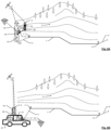
- FIG. 6B shows in principle the same workflow for data capturing by means of the computer-implemented method respectively the computer system according to the invention, wherein the user 15 is now moving with the transportation means 21 configured as a car, wherein the data capturing unit 16 configured as a laser tracker is mounted on the roof of the car 21.
Landscapes
- Engineering & Computer Science (AREA)
- Radar, Positioning & Navigation (AREA)
- Remote Sensing (AREA)
- Automation & Control Theory (AREA)
- Physics & Mathematics (AREA)
- General Physics & Mathematics (AREA)
- Navigation (AREA)
Abstract
The present invention relates to a computer-implemented method for capturing data of surroundings 5 by means of a data capturing unit 16, wherein the method comprises receiving path information 19 regarding a predefined data capturing path 1, the path information 19 comprising at least coordinates, in particular GNSS coordinates, of a plurality of points of the predefined data capturing path 1; and automatically performing a navigation and data capturing procedure, wherein the navigation and data capturing procedure comprises continuously monitoring a current position 2 of the data capturing unit 16; calculating a transfer path 3,3' from the current position 2 to a start position 4 of the predefined data capturing path 1; continuously providing navigation commands 17 to the user 15 to guide the user 15 along the transfer path 3,3'; continuously determining, based on the path information 19 and on the continuously monitored position 2, whether the data capturing unit 16 has reached the start position 4; if the data capturing unit 16 has reached the start position 4, providing a start command 20 to the data capturing unit 16, the start command 20 causing the data capturing unit 16 to capture data of the surroundings 5; continuously providing navigation commands 17 to the user 15 to guide the user 15 to an end position 6 of the predefined data capturing path 1; and if the data capturing unit 16 has reached the end position 6, providing an end command 20 to the data capturing unit 16, the end command 20 causing the data capturing unit 16 to end capturing data of the surroundings 5.
Description
- The present invention relates to a computer-implemented method for capturing data of surroundings by means of a data capturing unit.
- Mobile mapping is used in surveying projects as well as in other applications, such as engineering, entertainment, automotive or robotics, where a 2D or 3D model of an object or environment is required. For these purposes, common mobile mapping systems consist of a sensor unit equipped with LiDAR scanners and/or cameras to create a 2D or 3D model of the environment / surroundings.
- Typical mobile mapping systems are vehicle-based systems (e.g. in cars, trains or boats) in which the sensor unit is mounted on the roof of the vehicle and collects data on the surroundings while the vehicle is moving. There are also mobile mapping systems in which the user walks through the surroundings while holding the sensor unit in his hand or carrying the sensor unit on his body, for example as a kind of backpack.
- The sensor unit is triggered through a software interface with which the user interacts during the data acquisition / capturing. These interactions with the software interface are needed to trigger different behaviors from the sensor unit to build the 2D or 3D model with the desired levels of accuracy and precision. Examples of interactions of the user with the sensor unit or a control unit for the sensor unit are for example turn on and off the LiDAR scanners and/or the cameras, change sensors settings in real time, adjust map view and check for errors and warnings.
- The fact that the user has to interact with the software interface during data capturing in prior art systems means that there is a risk that the user could, for example, make a mistake when switching on the sensor unit and thus not fully capture the data from the surroundings or capture data of specific surroundings, e.g. like military facilities, from which he should not have captured the data. There is also the risk that the user will be distracted by the interaction with the software interface in the case of hand-held systems or vehicle-based systems and thus get lost or even fall or cause a traffic accident. In other words, the user has to both pay attention to the predefined data capturing path (road in case of a car vehicle-based system) but also to the software interface which is a potential accident risk.
- In addition, the mobile mapping systems known from the prior art have the further disadvantages that the user must be an expert in handling the mapping system, for example knowing exactly how and when to trigger the sensor unit, and that in the case of a vehicle system at least two users, namely the driver and the operator, must interact with the user interface in order to follow the plan.
- Furthermore, the planning of such a surveying operation is a complex task for a human since many factors have to be coordinated. For example, it must be determined how several predefined data capturing paths are to be arranged or lined up so that the data of the surroundings is captured as completely as possible, but the time required for this and the distance to be covered are as short as possible. Such large and complex planning, which is carried out by a human, is very error-prone and also time-consuming and cost-intensive.
- All this leads to higher costs per project, potential errors in the final 2D or 3D model due to human interaction and the complexity of the usability due to the introduction of a new technology, as well as a potential source of danger for the user and other people.
- Consequently, there is a need for computer-implemented methods and computer systems, which perform the navigation of the user through the surroundings along predefined data capturing paths as well as the control of the data capturing unit, for example a laser scanner or a camera, for the complete data capturing of the surroundings, so that the user can concentrate only on the movement.
- It is therefore an object of the invention to provide a computer-implemented method, a computer system and a computer program product which overcome the disadvantages of the prior art, particularly in the light of safety, error reduction and cost efficiency.
- Another object of the invention is to provide a computer-implemented method, a computer system and a computer program product for improved navigation and data capturing of surroundings.
- These objects are achieved by realizing at least part of the features of the independent claims. Features which further develop the inventions in an alternative or advantageous manner are described in the dependent patent claims.
- The present invention relates to a computer-implemented method for capturing data of surroundings by means of a data capturing unit (e.g. a portable / movable data capturing unit), wherein the method comprises:
- receiving path information regarding a predefined data capturing path, the path information comprising at least coordinates, in particular GNSS coordinates, of a plurality of points of the predefined data capturing path; and
- automatically performing a navigation and data capturing procedure,
- continuously monitoring a current position of the data capturing unit;
- calculating a transfer path from the current position to a start position of the predefined data capturing path;
- continuously providing navigation commands to an user to guide the user along the transfer path;
- continuously determining, based on the path information and on the continuously monitored position, whether the data capturing unit has reached the start position;
- if the data capturing unit has reached the start position, providing a start command to the data capturing unit, the start command causing the data capturing unit to capture data of the surroundings;
- continuously providing navigation commands to the user to guide the user to an end position of the predefined data capturing path; and
- if the data capturing unit has reached the end position, providing an end command to the data capturing unit, the end command causing the data capturing unit to end capturing data of the surroundings.
- A predefined data capturing path can also be described as a "track", wherein every predefined data capturing path being part of the planned job. A job, therefore, will always be composed by a specific number of predefined data capturing path (tracks). A "transfer path" is every path the user has to follow to reach the start point of the next planned track. Thus, a planned job is a combination of transfers and tracks through which the user must go through to accomplish the desired result. Every track has a start point and an end point representing the limit of the acquisition the user wants to perform. Moreover, they contain specific sensor unit settings such as camera shooting frequency and LiDAR point cloud density previously defined by the user in the planning phase. Because of this, a planned job results in a list of tracks geolocalized on the map through a defined sets of start and end coordinates.
- Regarding the step "if the data capturing unit has reached the start position, providing a start command to the data capturing unit, the start command causing the data capturing unit to capture data of the surroundings" of the computer-implemented method according to the invention, it can be said in other words, once the sensor unit reaches a start point of a planned track, and the necessary conditions are met, the sensor unit will start recording setting up automatically each sensor according to the planned settings. Exemplary conditions to start recording a planned track are (this list is not exhaustive and is not intended to be restrictive, it is merely examples of starting conditions):
- the sensor unit being close enough to the start point within an oriented bounding box;
- normalized projection along the segment to be greater than a specified threshold;
- sensor unit orientation must be within a tolerance cone of 120° with respect to the track orientation;
- the track to be captured must be the right one according to the optimized plan;
- the track to be approached must not be already recorded or disabled (e.g., by the user).
- After the recording is started the sensor unit will maintain its settings along the track until it reaches the end point where the recording will be interrupted automatically.
- The computer-implemented method according to the invention enables precise navigation of the user to and along predefined data capturing paths in the surroundings from which the data should be captured, as well as accurate and autonomous control of the data capturing unit, for example a laser scanner or a camera, to fully capture the data of the surroundings. This allows the user to concentrate fully on moving around correctly and safely, whether on foot or driving a vehicle. Thus, the computer-implemented method according to the invention contributes, among other things, to a complete, error-reduced, fast, cost-efficient and safe data capturing of the surroundings and thus solves the problems of the prior art.
- In other words, the auto-capture solution according to the invention solves the prior art problems throughout the complete workflow, from planning to acquisition, allowing a hands-free experience guiding the user through the optimal path while triggering and configuring sensor unit in an autonomous way.
- In one exemplary embodiment of the computer-implemented method according to the invention, the current position of the data capturing unit is continuously monitored by means of at least one of the following (this list is not exhaustive and is not intended to be restrictive):
- GNSS;
- SLAM;
- IMU; and
- Odometer (mechanical (e.g. wheel sensor) or optical).
- In a further exemplary embodiment of the computer-implemented method, the method further comprises generating a particularly colored 2D and/or 3D model of the surroundings by means of the data captured by the data capturing unit.
- In a further exemplary embodiment, motion of the data capturing unit is provided by
- the user carrying the data capturing unit; or
- the data capturing unit being mounted on a transport means controlled by the user,
in particular wherein the transport means is - a vehicle, in particular a car or motorcycle;
- a boat;
- an airplane; or
- a drone.
- In a further exemplary embodiment, the data capturing unit comprises one or more laser scanners and/or one or more cameras (in other words image capturing units) and is configured to capture 3D point-cloud data and/or image data of the surroundings.
- For example, the data capturing unit can comprise a laser scanner, which is configured to capture 3D point-cloud data of the surroundings, and a camera, which is configured to capture image data of the surroundings. Alternatively or in addition to this embodiment, the camera can be configured to capture the 3D point-cloud data, for example, if the camera is configured as a time-of-flight (TOF) camera, and the laser scanner can be configured to capture image data, for example, if the laser scanner is configured to capture a colored point cloud.
- In a further exemplary embodiment, the navigation commands are continuously provided to the user
- acoustically by means of an audio signal;
- haptically by means of a vibration signal; and/or
- visually by means of visualization on a display.
- In a further exemplary embodiment, the method further comprises
- providing a notification to the user; and/or
- providing an intermediate end command to the data capturing unit, the intermediate end command causing the data capturing unit to end capturing data of the surroundings;
if - the user leaves the predefined data capturing path, in particular before reaching the end position of the predefined data capturing path;
- the data capturing of the surroundings is disturbed or prevented by an obstacle; and/or
- the user moves at a speed at which the data of the surroundings cannot be captured with sufficient accuracy to enable a generation of a particularly colored 2D and/or 3D model of the surroundings,
- In a further exemplary embodiment, the method further comprises
- continuously providing navigation commands to the user to guide the user
- ∘ if the user has left the predefined data capturing path, back on the predefined data capturing path;
- ∘ if the data capturing of the surroundings has been disturbed or prevented by an obstacle, along the predefined data capturing path past the obstacle;
- ∘ if an intermediate end command is provided, to the intermediate end position; and/or
- ∘ to sections of the predefined data capturing path where the surroundings have not yet been captured, and
- providing an intermediate start command to the data capturing unit, the intermediate start command causing the data capturing unit to start capturing data of the surroundings
- ∘ if the user is back on the predefined data capturing path;
- ∘ if the user has been guided past the obstacle;
- ∘ if the user now moves again at a speed at which the data of the surroundings can be captured with sufficient accuracy to enable a generation of a particularly colored 2D and/or 3D model of the surroundings; and/or
- ∘ if the user reaches the intermediate end position.
- Such an obstacle can be, for example, an obstacle on the user's path (e.g. a road closure), so that the user has to make a longer detour and therefore has to leave the predefined data capturing path and therefore certain data of the surroundings of the predefined data capturing path cannot be captured, or an obstacle that covers a certain part of the surroundings (e.g. a scaffold), so that the user can stay on the predefined data capturing path but still cannot capture the data of the surroundings of the predefined data capturing path.
- In other words, if a user drives out of track (due to non-plannable circumstances, for example: construction sites or taking a wrong exit on a roundabout), the system will stop the capture and re-route the user to the start point of the track, which will be the leftover of the previous one. Then a new residual track is created, called "residual track" or "track left". In such a scenario, there is also a possibility to continue capturing in manual mode. Moreover, this embodiment allows to adapt the plan to the real environment changing conditions such as: closed streets, path deviations or voluntary plan change with a specific set of tools.
- In a further embodiment, once the data capturing job is finish, a completion report is shown (how much percentage of the planned tracks have been captured) and if not all the planned tracks where captured a new data capturing job will be created by default with the non-acquired but planned tracks for a later acquisition
- In a further exemplary embodiment, the method further comprises receiving information regarding the distance which has to be covered to traverse the predefined data capturing path, in particular the distance from the start position to the end position.
- In a further exemplary embodiment, the method further comprises receiving information regarding the expected time required to traverse the predefined data capturing path, in particular the time from the start position to the end position.
- In a further exemplary embodiment, the method further comprises providing information regarding how a plurality of predefined data capturing paths are arrangeable such that the data of the surroundings, from which a particularly colored 2D and/or 3D model has to be generated, is captured efficiently, in particular such that the shortest possible distance has to be covered and/or the shortest possible time is required.
- Such a plan / such information can be imported in the computer system according to the invention (e.g. Pegasus Field) from an external source or can be defined within the built-in planning module. When the plan is ready the user can proceed with the autonomous acquisition.
- In a further embodiment, during predefined data capturing path (track) recording and transfers, guiding instructions are provided to help the user to stick to the plan. After a predefined data capturing path (track) is captured, the user is guided to the next one until the complete data capturing job gets acquired. All the above-mentioned procedure does not require any interaction from the user.
- Alternatively or in addition to the embodiment described before, the user can assign different data capturing unit parameters (in other words the sensor unit parameters) to each predefined data capturing path (planned track) and optimize a path/track sequence based on, e.g., his experience and/or on current data, the current data regarding satellite availability and/or the traffic situation to define the most efficient path to acquire the job. The possibility to define different settings to data capturing paths/tracks is important as e.g. the user has to drive through "non-camera allowance" areas (like military areas) where cameras need to be switched off only over a certain part of the track (not necessarily the whole job).
- In a further exemplary embodiment, the path information comprises a course of the predefined data capturing path within an environmental map, wherein the environmental map is
- a land map;
- a sea map;
- a city map;
- a building plan;
- a satellite image; or
- an aerial photograph.
- The present invention further relates to a computer system for capturing data of surroundings by means of a data capturing unit, in particular wherein the system is configured to carry out the computer-implemented method according to one of the embodiments described above, for which the system comprises a computing unit configured
- to receive path information regarding a predefined data capturing path, the path information comprising at least coordinates, in particular GNSS coordinates, of a plurality of points of the predefined data capturing path; and
- to automatically perform a navigation and data capturing procedure,
- to continuously monitor a current position of the data capturing unit;
- to calculate a transfer path from the current position to a start position of the predefined data capturing path;
- to provide continuously navigation commands to the user to guide the user along the transfer path;
- to determine continuously, based on the path information and on the continuously monitored position, whether the data capturing unit has reached the start position;
- if the data capturing unit has reached the start position, to provide a start command to the data capturing unit, the start command causing the data capturing unit to capture data of the surroundings;
- to continuously provide navigation commands to the user to guide the user to an end position of the predefined data capturing path; and
- if the data capturing unit has reached the end position, to provide an end command to the data capturing unit, the end command causing the data capturing unit to end capturing data of the surroundings.
- The present invention further relates to a computer program product comprising program code which is stored on a machine-readable medium, or being embodied by an electromagnetic wave comprising a program code segment, and has computer-executable instructions for performing, in particular when run on a computing unit of a computer system described above:
- receiving path information regarding a predefined data capturing path, the path information comprising at least coordinates, in particular GNSS coordinates, of a plurality of points of the predefined data capturing path; and
- automatically performing a navigation and data capturing procedure,
- continuously monitoring a current position of the data capturing unit;
- calculating a transfer path from the current position to a start position of the predefined data capturing path;
- continuously providing navigation commands to the user to guide the user along the transfer path;
- continuously determining, based on the path information and on the continuously monitored position, whether the data capturing unit has reached the start position;
- if the data capturing unit has reached the start position, providing a start command to the data capturing unit, the start command causing the data capturing unit to capture data of the surroundings;
- continuously providing navigation commands to the user to guide the user to an end position of the predefined data capturing path; and
- if the data capturing unit has reached the end position, providing an end command to the data capturing unit, the end command causing the data capturing unit to end capturing data of the surroundings.
- In one exemplary embodiment of the computer program product according to the invention, the program code comprises computer-executable instructions for performing any step in the computer-implemented method according to one of the embodiments described above.
- The features listed below may complement the computer-implemented method according to the invention, thereby forming alternative embodiments previously described in other words. The features are (this list is not exhaustive and is not intended to be restrictive, it is merely examples of possible features):
- adding audio guidance to avoid the need to look at the interface;
- turn by turn instructions to guide the user through the plan;
- intelligent and autonomous map visualization based on the next action to take;
- camera embedded directions;
- 3D and 2D map polylines;
- planning optimization based on traffic conditions and satellites coverage to achieve optimal data quality;
- support scanning areas instead of single tracks -> planning with a polygon and start/stop the capture if entering/exiting the polygon;
- planning the job in a desktop environment.
- The computer-implemented method, the computer system and the computer program product according to the invention have the advantage over the prior art that, among other things:
- there is no need for expert users to successfully achieve the desired data capturing result,
- there is no need for two operators in case of a vehicle-based system,
- there is an increased safety letting the user concentrate on the path while capturing the data,
- there is less space for manual mistakes while capturing the data,
- there is an increased efficiency by optimal path definition.
- Given these benefits, the result is a considerable reduction in acquisition times and costs together with an improvement of safety and overall project quality by reduction of human mistakes.
- The inventions are illustrated in more detail below, purely by way of example, with reference to working examples shown schematically in the drawing. Identical elements are labelled with the same reference numerals in the figures. The described embodiments are generally not shown true to scale and they are also not to be interpreted as limiting the invention.
- Fig. 1:
- schematic illustration of the received path information regarding the predefined data capturing path;
- Fig. 2:
- schematic illustration of an embodiment of the computer-implemented method respectively the computer system according to the invention;
- Fig. 3-4:
- schematic illustrations of a software interface of the computer system according to the invention;
- Fig. 5:
- schematic illustration of a 3D-model of the surroundings generated based on captured data of the surroundings;
- Fig. 6A-6B:
- schematic illustrations of workflows for capturing data using the computer-implemented method respectively the computer system according to the invention..
-
Figure 1 shows a schematic illustration of the received path information regarding the predefineddata capturing path 1. After that in the course of the computer-implemented method respectively the computer system according to the invention the navigation and data capturing procedure is automatically performed comprising the steps of continuously monitoring acurrent position 2 of the data capturing unit; calculating atransfer path 3 from thecurrent position 2 to astart position 4 of the predefineddata capturing path 1; continuously providing navigation commands to the user to guide the user along thetransfer path 3; continuously determining, based on the path information and on the continuously monitored position, whether the data capturing unit has reached thestart position 4; if the data capturing unit has reached thestart position 4, providing a start command to the data capturing unit, the start command causing the data capturing unit to capture data of thesurroundings 5; continuously providing navigation commands to the user to guide the user to anend position 6 of the predefineddata capturing path 1; and if the data capturing unit has reached theend position 6, providing an end command to the data capturing unit, the end command causing the data capturing unit to end capturing data of thesurroundings 5. - If a 2D or 3D model of a larger surroundings has to be created, e.g. of an entire city district with several streets, wherein the data for this cannot be reasonably acquired with a single data acquisition path, then in a further embodiment of the computer-implemented method according to the invention, information are provided on how a plurality of predefined data capturing paths can be arranged such that the data of the environment from which a particularly colored 2D and/or 3D model has to be created are efficiently captured, in particular such that the shortest possible distance has to be covered and/or the shortest possible time is required. The individual predefined data capturing paths are connected by further transfer paths, which is illustrated in
Figure 1 by transfer path 3'. -
Figure 2 shows a schematic illustration of an embodiment of the computer-implemented method respectively the computer system according to the invention. In this case, the user leaves the predefineddata capturing path 2 at position 7 and erroneously moves topath 8 before reaching the end position of the predefined data capturing path, whereby the data of the surroundings alongpath 8 should not be captured at all. The remaining part of the predefineddata acquisition path 2, from which the data is now missing, is illustrated aspath 9. According to one embodiment of the computer-implemented method according to the invention, in such a case a notification is provided to the user and/or an intermediate end command is provided to the data capturing unit, the intermediate end command causing the data capturing unit to end capturing data of the surroundings, wherein the position 7 of the user on the predefineddata capturing path 2 at which the intermediate end command is provided is defined as intermediate end position 7. - In an exemplary embodiment of the computer-implemented method respectively the computer system according to the invention navigation commands (e.g. "in 200 meters move right") are continuously provided to the user (e.g. by an acoustic announcement or the indication on a display) to guide the user back to the intermediate end position 7 and then when the user reaches the intermediate end position provide an intermediate start command to the data capturing unit, the intermediate start command causing the data capturing unit to start again capturing data of the
surroundings 5. -
Figure 3 shows a schematic illustration of asoftware interface 14 of the computer system according to the invention, which shows anenvironment map 12 together with aconfiguration window 13, in which the user can define the settings with regard to the navigation and data capturing procedure and/or the parameters to be complied with for sufficiently accurate data capture by means of the data capturing device are displayed to the user. - The
environment map 12 shows several streets, wherein data of the surroundings along these streets are to be captured by means of the data capturing device. For example, the user can click on theroad map 12 to define a starting point and an end point of the data capture and the computing unit of the computer system according to the invention then calculates how the predefined data capturing paths are to be arranged accordingly (in other words refinement of the track order) and/or how the corresponding setting parameters (e.g. whether a predefined data capturing path is run/traversed several times) are to be selected in order to ensure the optimum and most (time) efficient data capture. The setting parameters determined by the computing unit can then be taken from thewindow 13. - Alternatively or in addition to the embodiment of the computer system according to the invention described above, the user can define the predefined data capturing paths, e.g. by clicking on the respective roads, and/or the setting parameters, e.g. by entering corresponding values, himself and the computing unit of the computer system according to the invention then calculates approximately how long the entire data capturing process will take and what distance will be covered in total, wherein during the capturing phase, these calculations / estimations are continuously updated based on the remaining part of the plan.
- Among other things, the traffic on the roads, the satellite availability, the kilometers to be covered and/or the battery status of the data capturing unit are also taken into account for the respective calculation.
- Such an embodiment of the computer system according to the invention is particularly intended for experienced users who have a precise idea of how exactly the data capturing should be carried out in the corresponding environment or for users who have to react to special circumstances with regard to the data capturing.
-
Figure 4 shows a schematic illustration of thesoftware interface 14 of the computer system according to the invention, wherein the computing unit has defined two data capturing paths 1 (labeled withnumbers 1 and 2) in theenvironment map 12 based on the input of the user (e.g. with respect to the start and end points of the data capturing), wherein the data capturing unit mounted on a car has already traveled almost the entire first predefined data capturing path 1 (marked by the light gray path) and has accordingly captured almost all of the data of the surroundings along the first predefineddata capturing path 1. After the user has steered the vehicle to the end of the firstpredefined data path 1, the user receives corresponding navigation commands from the computer system according to the invention, which guide the user to and along the secondpredefined data path 1. The navigation commands can be communicated to the user, for example by means of an audio signal, which would have the advantage that the user can concentrate completely on driving the car on which the data capturing unit is mounted, thus ensuring the safety of the user and passers-by. -
Figure 5 shows a schematic illustration of a 3D-model 10 of the surroundings generated based on captured data of the surroundings. -
Figures 6A and 6B show schematic illustrations of workflows for capturing data using the computer-implemented method respectively the computer system according to the invention. - In
Figure 6A , theuser 15 is walking and is carrying thedata capturing unit 16, which is exemplarily configured as a laser scanner, in his hand. Theuser 15 is carrying another device in his hand (e.g. a tablet computer), which comprises thecomputing unit 18. Thecomputing unit 18 receivespath information 19 regarding the predefineddata capturing path 1, in particular information regarding thestart position 4 and theend position 6 of the predefineddata capturing path 1 and information regarding thecurrent position 2 of thedata capturing unit 16. Based on this information, thecomputing unit 18 calculates thetransfer path 3 from thecurrent position 2 to thestart position 4. Subsequently, the user is guided along thetransfer path 3 by means of acoustic navigation commands 17, wherein based on thepath information 19 and on the continuously monitoredposition 2 it is continuously determined whether thedata capturing unit 16 has reached thestart position 4. Due to the acoustic navigation commands 17, theuser 15 can fully concentrate on walking and aligning thedata capturing unit 16 and the probability of theuser 15 walking the wrong way or falling is significantly reduced. As soon as thedata capturing unit 16 has reached thestart position 4, astart command 20 is provided to thedata capturing unit 16, thestart command 20 causing thedata capturing unit 16 to capture data of thesurroundings 5. Subsequently, audible navigation commands 17 are continuously provided to theuser 15 to guide theuser 15 to theend position 6 of the predefineddata capturing path 1 and once thedata capturing unit 16 has reached theend position 6, anend command 20 is provided to thedata capturing unit 16 causing thedata capturing unit 16 to stop capturing data of theenvironment 5.Figure 6B shows in principle the same workflow for data capturing by means of the computer-implemented method respectively the computer system according to the invention, wherein theuser 15 is now moving with the transportation means 21 configured as a car, wherein thedata capturing unit 16 configured as a laser tracker is mounted on the roof of thecar 21. - Although the inventions are illustrated above, partly with reference to some preferred embodiments, it must be understood that numerous modifications and combinations of different features of the embodiments can be made. All of these modifications lie within the scope of the appended claims.
Claims (15)
- Computer-implemented method for capturing data of surroundings (5) by means of a data capturing unit (16), wherein the method comprises:• receiving path information (19) regarding a predefined data capturing path (1), the path information (19) comprising at least coordinates, in particular GNSS coordinates, of a plurality of points of the predefined data capturing path (1); and• automatically performing a navigation and data capturing procedure,wherein the navigation and data capturing procedure comprises:• continuously monitoring a current position (2) of the data capturing unit (16);• calculating a transfer path (3, 3') from the current position (2) to a start position (4) of the predefined data capturing path (1);• continuously providing navigation commands (17) to a user (15) to guide the user (15) along the transfer path (3, 3');• continuously determining, based on the path information (19) and on the continuously monitored position (2), whether the data capturing unit (16) has reached the start position (4);• if the data capturing unit (16) has reached the start position (4), providing a start command (20) to the data capturing unit (16), the start command (20) causing the data capturing unit (16) to capture data of the surroundings (5);• continuously providing navigation commands (17) to the user (15) to guide the user (15) to an end position (6) of the predefined data capturing path (1); and• if the data capturing unit (16) has reached the end position (6), providing an end command (20) to the data capturing unit (16), the end command (20) causing the data capturing unit (16) to end capturing data of the surroundings (5).
- Computer-implemented method according to claim 1, wherein the current position (2) of the data capturing unit (16) is continuously monitored by means of at least one of the following:• GNSS;• SLAM;• an IMU; and• an Odometer.
- Computer-implemented method according to claim 1 or 2, wherein the method further comprises generating a particularly colored 2D and/or 3D model (10) of the surroundings (5) by means of the data captured by the data capturing unit (16).
- Computer-implemented method according to one of the preceding claims, wherein motion of the data capturing unit (16) is provided by• the user (15) carrying the data capturing unit (16); or• the data capturing unit (16) being mounted on a transport means (21) controlled by the user (15),
in particular wherein the transport means (21) is• a vehicle, in particular a car or motorcycle;• a boat;• an airplane; or• a drone. - Computer-implemented method according to one of the preceding claims, wherein the data capturing unit (16) comprises one or more laser scanners and/or one or more cameras and is configured to capture 3D point-cloud data and/or image data of the surroundings (5).
- Computer-implemented method according to one of the preceding claims, wherein the navigation commands (17) are continuously provided to the user (15)• acoustically by means of an audio signal;• haptically by means of a vibration signal; and/or• visually by means of visualization on a display.
- Computer-implemented method according to one of the preceding claims, wherein the method further comprises• providing a notification to the user (15); and/or• providing an intermediate end command (20) to the data capturing unit (16), the intermediate end command (20) causing the data capturing unit (16) to end capturing data of the surroundings (5);
if• the user (15) leaves the predefined data capturing path (1), in particular before reaching the end position (6) of the predefined data capturing path (1);• the data capturing of the surroundings (5) is disturbed or prevented by an obstacle; and/or• the user (15) moves at a speed at which the data of the surroundings (5) cannot be captured with sufficient accuracy to enable a generation of a particularly colored 2D and/or 3D model (10) of the surroundings (5),wherein the position of the user (15) on the predefined data capturing path (1) at which the intermediate end command (20) is provided is defined as intermediate end position (7). - Computer-implemented method according to claim 7, wherein the method further comprises• continuously providing navigation commands (17) to the user (15) to guide the user (15)∘ if the user (15) has left the predefined data capturing path (1), back on the predefined data capturing path (1);∘ if the data capturing of the surroundings (5) has been disturbed or prevented by an obstacle, along the predefined data capturing path (1) past the obstacle;∘ if an intermediate end command (20) is provided, to the intermediate end position (7); and/or∘ to sections (9) of the predefined data capturing path (1) where the surroundings (5) have not yet been captured, and• providing an intermediate start command (20) to the data capturing unit (16), the intermediate start command (20) causing the data capturing unit to start capturing data of the surroundings (5)∘ if the user is back on the predefined data capturing path (1);∘ if the user has been guided past the obstacle;∘ if the user now moves again at a speed at which the data of the surroundings (5) can be captured with sufficient accuracy to enable a generation of a particularly colored 2D and/or 3D model (10) of the surroundings (5); and/or∘ if the user reaches the intermediate end position (7).
- Computer-implemented method according to one of the preceding claims, wherein the method further comprises receiving information regarding the distance which has to be covered to traverse the predefined data capturing path (1), in particular the distance from the start position (4) to the end position (6).
- Computer-implemented method according to one of the preceding claims, wherein the method further comprises receiving information regarding the expected time required to traverse the predefined data capturing path (1), in particular the time from the start position (4) to the end position (6).
- Computer-implemented method according to one of the preceding claims, wherein the method further comprises providing information regarding how a plurality of predefined data capturing paths (1) are arrangeable such that the data of the surroundings (5), from which a particularly colored 2D and/or 3D model (10) has to be generated, is captured efficiently, in particular such that the shortest possible distance has to be covered and/or the shortest possible time is required.
- Computer-implemented method according to one of the preceding claims, wherein the path information (19) comprises a course of the predefined data capturing path (1) within an environmental map (12), wherein the environmental map (12) is• a land map;• a sea map;• a city map;• a building plan;• a satellite image; or• an aerial photograph.
- Computer system for capturing data of surroundings (5) by means of a data capturing unit (16), in particular wherein the system is configured to carry out the computer-implemented method of one of claims 1 to 12, for which the system comprises a computing unit (18) configured• to receive path information (19) regarding a predefined data capturing path (1), the path information (19) comprising at least coordinates, in particular GNSS coordinates, of a plurality of points of the predefined data capturing path (1); and• to automatically perform a navigation and data capturing procedure,wherein the navigation and data capturing procedure comprises:• to continuously monitor a current position (2) of the data capturing unit (16);• to calculate a transfer path (3) from the current position (2) to a start position (4) of the predefined data capturing path (1);• to provide continuously navigation commands (17) to the user (15) to guide the user (15) along the transfer path (3);• to determine continuously, based on the path information (19) and on the continuously monitored position (2), whether the data capturing unit (16) has reached the start position (4);• if the data capturing unit (16) has reached the start position (4), to provide a start command (20) to the data capturing unit (16), the start command (20) causing the data capturing unit (16) to capture data of the surroundings (5);• to continuously provide navigation commands (17) to the user (15) to guide the user (15) to an end position (6) of the predefined data capturing path (1); and• if the data capturing unit (16) has reached the end position (6), to provide an end command (20) to the data capturing unit (16), the end command (20) causing the data capturing unit (16) to end capturing data of the surroundings (5).
- Computer program product comprising program code which is stored on a machine-readable medium, or being embodied by an electromagnetic wave comprising a program code segment, and has computer-executable instructions for performing, in particular when run on a computing unit (18) of a computer system according to claim 13:• receiving path information (19) regarding a predefined data capturing path (1), the path information (19) comprising at least coordinates, in particular GNSS coordinates, of a plurality of points of the predefined data capturing path (1); and• automatically performing a navigation and data capturing procedure,wherein the navigation and data capturing procedure comprises:• continuously monitoring a current position (2) of the data capturing unit (16);• calculating a transfer path (3) from the current position (2) to a start position (4) of the predefined data capturing path (1);• continuously providing navigation commands (17) to the user (15) to guide the user (15) along the transfer path (3);• continuously determining, based on the path information (19) and on the continuously monitored position (2), whether the data capturing unit (16) has reached the start position (4);• if the data capturing unit (16) has reached the start position (4), providing a start command (20) to the data capturing unit (16), the start command (20) causing the data capturing unit (16) to capture data of the surroundings (5);• continuously providing navigation commands (17) to the user (15) to guide the user (15) to an end position (6) of the predefined data capturing path (1); and• if the data capturing unit (16) has reached the end position (6), providing an end command (20) to the data capturing unit (16), the end command (20) causing the data capturing unit (16) to end capturing data of the surroundings (5).
- Computer program product according to claim 14, wherein the program code comprises computer-executable instructions for performing any step in the computer-implemented method according to one of claims 2 to 12.
Priority Applications (3)
| Application Number | Priority Date | Filing Date | Title |
|---|---|---|---|
| EP23217784.0A EP4575403A1 (en) | 2023-12-18 | 2023-12-18 | Method for improved data capturing of surroundings |
| CN202411778914.0A CN120176704A (en) | 2023-12-18 | 2024-12-05 | Method for improved data capture of surrounding environment |
| US18/973,482 US20250198793A1 (en) | 2023-12-18 | 2024-12-09 | Method for improved data capturing of surroundings |
Applications Claiming Priority (1)
| Application Number | Priority Date | Filing Date | Title |
|---|---|---|---|
| EP23217784.0A EP4575403A1 (en) | 2023-12-18 | 2023-12-18 | Method for improved data capturing of surroundings |
Publications (1)
| Publication Number | Publication Date |
|---|---|
| EP4575403A1 true EP4575403A1 (en) | 2025-06-25 |
Family
ID=89223399
Family Applications (1)
| Application Number | Title | Priority Date | Filing Date |
|---|---|---|---|
| EP23217784.0A Pending EP4575403A1 (en) | 2023-12-18 | 2023-12-18 | Method for improved data capturing of surroundings |
Country Status (3)
| Country | Link |
|---|---|
| US (1) | US20250198793A1 (en) |
| EP (1) | EP4575403A1 (en) |
| CN (1) | CN120176704A (en) |
Cited By (1)
| Publication number | Priority date | Publication date | Assignee | Title |
|---|---|---|---|---|
| US20250198793A1 (en) * | 2023-12-18 | 2025-06-19 | Leica Geosystems Ag | Method for improved data capturing of surroundings |
Citations (5)
| Publication number | Priority date | Publication date | Assignee | Title |
|---|---|---|---|---|
| EP3062066A1 (en) * | 2015-02-26 | 2016-08-31 | Hexagon Technology Center GmbH | Determination of object data by template-based UAV control |
| US20200324898A1 (en) * | 2019-04-10 | 2020-10-15 | Thomas Andrew Youmans | Method and algorithm for flight, movement, autonomy, in gps, communication, degraded, denied, obstructed non optimal environment |
| US20210097093A1 (en) * | 2019-09-27 | 2021-04-01 | Beijing Baidu Netcom Science And Technology Co., Ltd. | Methods, apparatuses, electronic device and medium for acquiring map data |
| EP3851797A1 (en) * | 2020-01-14 | 2021-07-21 | Tata Consultancy Services Limited | Systems and methods for performing inclusive indoor navigation |
| US20220099459A1 (en) * | 2019-06-13 | 2022-03-31 | Denso Corporation | Map data generation system, data center, and in-vehicle apparatus |
Family Cites Families (12)
| Publication number | Priority date | Publication date | Assignee | Title |
|---|---|---|---|---|
| US20120231435A1 (en) * | 2011-03-09 | 2012-09-13 | Mcbride Matthew D | System and method for education including community-sourced data and community interactions |
| US8908914B2 (en) * | 2012-01-17 | 2014-12-09 | Maxlinear, Inc. | Method and system for map generation for location and navigation with user sharing/social networking |
| DE102014002150B3 (en) * | 2014-02-15 | 2015-07-23 | Audi Ag | Method for determining the absolute position of a mobile unit and mobile unit |
| JP7077013B2 (en) * | 2017-12-27 | 2022-05-30 | 株式会社トプコン | 3D information processing unit, device equipped with 3D information processing unit, unmanned aerial vehicle, notification device, moving object control method using 3D information processing unit, and program for moving object control processing |
| CN119124135A (en) * | 2018-04-03 | 2024-12-13 | 御眼视觉技术有限公司 | System and method for navigating a host vehicle |
| EP3865822B1 (en) * | 2018-05-15 | 2024-10-02 | Mobileye Vision Technologies Ltd. | Systems and methods for autonomous vehicle navigation |
| WO2020012241A1 (en) * | 2018-07-08 | 2020-01-16 | Nng Software Developing And Commercial Llc. | A method and apparatus for optimal navigation to multiple locations |
| US11567514B2 (en) * | 2019-02-11 | 2023-01-31 | Tesla, Inc. | Autonomous and user controlled vehicle summon to a target |
| US11402220B2 (en) * | 2019-03-13 | 2022-08-02 | Here Global B.V. | Maplets for maintaining and updating a self-healing high definition map |
| CN115867767A (en) * | 2020-01-03 | 2023-03-28 | 御眼视觉技术有限公司 | Systems and methods for vehicle navigation |
| US11532116B2 (en) * | 2020-10-30 | 2022-12-20 | Loveland Innovations, Inc. | Graphical user interface for controlling a solar ray mapping |
| EP4575403A1 (en) * | 2023-12-18 | 2025-06-25 | Leica Geosystems Ag | Method for improved data capturing of surroundings |
-
2023
- 2023-12-18 EP EP23217784.0A patent/EP4575403A1/en active Pending
-
2024
- 2024-12-05 CN CN202411778914.0A patent/CN120176704A/en active Pending
- 2024-12-09 US US18/973,482 patent/US20250198793A1/en active Pending
Patent Citations (5)
| Publication number | Priority date | Publication date | Assignee | Title |
|---|---|---|---|---|
| EP3062066A1 (en) * | 2015-02-26 | 2016-08-31 | Hexagon Technology Center GmbH | Determination of object data by template-based UAV control |
| US20200324898A1 (en) * | 2019-04-10 | 2020-10-15 | Thomas Andrew Youmans | Method and algorithm for flight, movement, autonomy, in gps, communication, degraded, denied, obstructed non optimal environment |
| US20220099459A1 (en) * | 2019-06-13 | 2022-03-31 | Denso Corporation | Map data generation system, data center, and in-vehicle apparatus |
| US20210097093A1 (en) * | 2019-09-27 | 2021-04-01 | Beijing Baidu Netcom Science And Technology Co., Ltd. | Methods, apparatuses, electronic device and medium for acquiring map data |
| EP3851797A1 (en) * | 2020-01-14 | 2021-07-21 | Tata Consultancy Services Limited | Systems and methods for performing inclusive indoor navigation |
Cited By (1)
| Publication number | Priority date | Publication date | Assignee | Title |
|---|---|---|---|---|
| US20250198793A1 (en) * | 2023-12-18 | 2025-06-19 | Leica Geosystems Ag | Method for improved data capturing of surroundings |
Also Published As
| Publication number | Publication date |
|---|---|
| US20250198793A1 (en) | 2025-06-19 |
| CN120176704A (en) | 2025-06-20 |
Similar Documents
| Publication | Publication Date | Title |
|---|---|---|
| US11667283B2 (en) | Autonomous vehicle motion control systems and methods | |
| EP3704684B1 (en) | Object motion prediction and vehicle control for autonomous vehicles | |
| US10796204B2 (en) | Planning system and method for controlling operation of an autonomous vehicle to navigate a planned path | |
| CN112461227B (en) | Wheel type chassis robot inspection intelligent autonomous navigation method | |
| EP3526737B1 (en) | Neural network system for autonomous vehicle control | |
| US10248116B2 (en) | Remote operation of autonomous vehicle in unexpected environment | |
| JP6650386B2 (en) | Remote driving control device, vehicle control system, remote driving control method, and remote driving control program | |
| CN112748743B (en) | Air carrier navigation system | |
| FI130355B (en) | Autonomous operation of a vessel | |
| US20200218253A1 (en) | Advanced control system with multiple control paradigms | |
| US11760356B2 (en) | Lane change planning device and storage medium storing computer program for the same | |
| US11110600B2 (en) | Airport robot and operation method thereof | |
| US10890928B2 (en) | Flying vehicle navigation system and flying vehicle navigation method | |
| WO2018057455A1 (en) | Vehicle control system | |
| US20200283022A1 (en) | Vehicle control system, vehicle control method, and storage medium | |
| US20100023185A1 (en) | Devices and methods for waypoint target generation and mission spooling for mobile ground robots | |
| CN110383005A (en) | A method of for forming Local Navigation path for automatic driving vehicle | |
| US20250198793A1 (en) | Method for improved data capturing of surroundings | |
| CN112461249A (en) | Sensor localization from external source data | |
| JP2023013441A (en) | Automatic driving system | |
| US20260103199A1 (en) | Lane change path generation using piecewise clothoid segments | |
| CN115402300A (en) | Automatic vehicle parking method and device, automatic vehicle warehouse-out method and device, user terminal, mobile tool and related equipment | |
| CN111746789A (en) | Shooting system, server, control method, and storage medium for storing programs | |
| Suprapto et al. | Designing an Autonomous Vehicle Using Sensor Fusion Based on Path Planning and Deep Learning Algorithms | |
| Raivi et al. | Vision-Based Navigation for Urban Air Mobility: A Survey |
Legal Events
| Date | Code | Title | Description |
|---|---|---|---|
| PUAI | Public reference made under article 153(3) epc to a published international application that has entered the european phase |
Free format text: ORIGINAL CODE: 0009012 |
|
| STAA | Information on the status of an ep patent application or granted ep patent |
Free format text: STATUS: THE APPLICATION HAS BEEN PUBLISHED |
|
| AK | Designated contracting states |
Kind code of ref document: A1 Designated state(s): AL AT BE BG CH CY CZ DE DK EE ES FI FR GB GR HR HU IE IS IT LI LT LU LV MC ME MK MT NL NO PL PT RO RS SE SI SK SM TR |
|
| STAA | Information on the status of an ep patent application or granted ep patent |
Free format text: STATUS: REQUEST FOR EXAMINATION WAS MADE |
|
| 17P | Request for examination filed |
Effective date: 20251222 |