EP4535119A1 - Machine learning based control and re-routing - Google Patents
Machine learning based control and re-routing Download PDFInfo
- Publication number
- EP4535119A1 EP4535119A1 EP24187152.4A EP24187152A EP4535119A1 EP 4535119 A1 EP4535119 A1 EP 4535119A1 EP 24187152 A EP24187152 A EP 24187152A EP 4535119 A1 EP4535119 A1 EP 4535119A1
- Authority
- EP
- European Patent Office
- Prior art keywords
- machine
- information
- field
- mobile
- mobile machine
- Prior art date
- Legal status (The legal status is an assumption and is not a legal conclusion. Google has not performed a legal analysis and makes no representation as to the accuracy of the status listed.)
- Pending
Links
Images






Classifications
-
- G—PHYSICS
- G05—CONTROLLING; REGULATING
- G05D—SYSTEMS FOR CONTROLLING OR REGULATING NON-ELECTRIC VARIABLES
- G05D1/00—Control of position, course, altitude or attitude of land, water, air or space vehicles, e.g. using automatic pilots
- G05D1/60—Intended control result
- G05D1/648—Performing a task within a working area or space, e.g. cleaning
-
- A—HUMAN NECESSITIES
- A01—AGRICULTURE; FORESTRY; ANIMAL HUSBANDRY; HUNTING; TRAPPING; FISHING
- A01B—SOIL WORKING IN AGRICULTURE OR FORESTRY; PARTS, DETAILS, OR ACCESSORIES OF AGRICULTURAL MACHINES OR IMPLEMENTS, IN GENERAL
- A01B69/00—Steering of agricultural machines or implements; Guiding agricultural machines or implements on a desired track
- A01B69/007—Steering or guiding of agricultural vehicles, e.g. steering of the tractor to keep the plough in the furrow
- A01B69/008—Steering or guiding of agricultural vehicles, e.g. steering of the tractor to keep the plough in the furrow automatic
-
- G—PHYSICS
- G05—CONTROLLING; REGULATING
- G05D—SYSTEMS FOR CONTROLLING OR REGULATING NON-ELECTRIC VARIABLES
- G05D1/00—Control of position, course, altitude or attitude of land, water, air or space vehicles, e.g. using automatic pilots
- G05D1/20—Control system inputs
- G05D1/22—Command input arrangements
- G05D1/229—Command input data, e.g. waypoints
- G05D1/2297—Command input data, e.g. waypoints positional data taught by the user, e.g. paths
-
- G—PHYSICS
- G05—CONTROLLING; REGULATING
- G05D—SYSTEMS FOR CONTROLLING OR REGULATING NON-ELECTRIC VARIABLES
- G05D1/00—Control of position, course, altitude or attitude of land, water, air or space vehicles, e.g. using automatic pilots
- G05D1/40—Control within particular dimensions
- G05D1/43—Control of position or course in two dimensions [2D]
-
- G—PHYSICS
- G05—CONTROLLING; REGULATING
- G05D—SYSTEMS FOR CONTROLLING OR REGULATING NON-ELECTRIC VARIABLES
- G05D1/00—Control of position, course, altitude or attitude of land, water, air or space vehicles, e.g. using automatic pilots
- G05D1/60—Intended control result
- G05D1/644—Optimisation of travel parameters, e.g. of energy consumption, journey time or distance
-
- G—PHYSICS
- G06—COMPUTING OR CALCULATING; COUNTING
- G06N—COMPUTING ARRANGEMENTS BASED ON SPECIFIC COMPUTATIONAL MODELS
- G06N3/00—Computing arrangements based on biological models
- G06N3/02—Neural networks
- G06N3/08—Learning methods
-
- G—PHYSICS
- G06—COMPUTING OR CALCULATING; COUNTING
- G06Q—INFORMATION AND COMMUNICATION TECHNOLOGY [ICT] SPECIALLY ADAPTED FOR ADMINISTRATIVE, COMMERCIAL, FINANCIAL, MANAGERIAL OR SUPERVISORY PURPOSES; SYSTEMS OR METHODS SPECIALLY ADAPTED FOR ADMINISTRATIVE, COMMERCIAL, FINANCIAL, MANAGERIAL OR SUPERVISORY PURPOSES, NOT OTHERWISE PROVIDED FOR
- G06Q50/00—Information and communication technology [ICT] specially adapted for implementation of business processes of specific business sectors, e.g. utilities or tourism
- G06Q50/02—Agriculture; Fishing; Forestry; Mining
-
- G—PHYSICS
- G05—CONTROLLING; REGULATING
- G05D—SYSTEMS FOR CONTROLLING OR REGULATING NON-ELECTRIC VARIABLES
- G05D2101/00—Details of software or hardware architectures used for the control of position
- G05D2101/10—Details of software or hardware architectures used for the control of position using artificial intelligence [AI] techniques
- G05D2101/15—Details of software or hardware architectures used for the control of position using artificial intelligence [AI] techniques using machine learning, e.g. neural networks
-
- G—PHYSICS
- G05—CONTROLLING; REGULATING
- G05D—SYSTEMS FOR CONTROLLING OR REGULATING NON-ELECTRIC VARIABLES
- G05D2105/00—Specific applications of the controlled vehicles
- G05D2105/15—Specific applications of the controlled vehicles for harvesting, sowing or mowing in agriculture or forestry
-
- G—PHYSICS
- G05—CONTROLLING; REGULATING
- G05D—SYSTEMS FOR CONTROLLING OR REGULATING NON-ELECTRIC VARIABLES
- G05D2107/00—Specific environments of the controlled vehicles
- G05D2107/20—Land use
- G05D2107/21—Farming, e.g. fields, pastures or barns
-
- G—PHYSICS
- G05—CONTROLLING; REGULATING
- G05D—SYSTEMS FOR CONTROLLING OR REGULATING NON-ELECTRIC VARIABLES
- G05D2109/00—Types of controlled vehicles
- G05D2109/10—Land vehicles
Definitions
- the present disclosure relates to methods and systems using machine learning to control and re-route mobile machines.
- route planning has relied on manual planning, expert knowledge, and simple computations (e.g., heuristic algorithms) performed by computing systems.
- route planning does not consider the complex interactions between various factors, such as terrain, ground conditions, soil type, weather conditions, and machinery capabilities. With the complex interactions not being considered, resulting route planning can include subpar paths and increased fuel consumption, ultimately resulting in higher operational costs and reduced productivity.
- the mobile machines can be or include mobile agricultural machines, mobile construction machines, or mobile forestry machines, for example.
- the techniques disclosed herein provide specific technical solutions to at least overcome the technical problems mentioned in the background section or other parts of the application as well as other technical problems not described herein but recognized by those skilled in the art.
- the techniques include technologies that use machine learning to update a route of a mobile machine while the machine is operating in a field.
- Some embodiments include a method that includes using machine learning to update a route plan as well as re-route a mobile machine while it is operating in a field.
- the method can also include controlling the mobile machine at least partially according to the updated route plan or the re-routing.
- disclosed herein are computerized methods for using machine learning to update a route of a mobile machine, re-route the mobile machine, and control the mobile machine according to the updated route as well as a non-transitory computer-readable storage medium for carrying out technical operations of the computerized methods.
- the non-transitory computer-readable storage medium has tangibly stored thereon, or tangibly encoded thereon, computer-readable instructions that when executed by one or more devices (e.g., one or more personal computers or servers) cause at least one processor to perform a method for improved systems and methods for using machine learning to update a route of a mobile machine, re-route the mobile machine, and control the mobile machine according to the updated route.
- one or more devices e.g., one or more personal computers or servers
- some embodiments include a method for using machine learning to update a route of a mobile machine, re-route the mobile machine, and control the mobile machine according to the updated route.
- the method includes using a mobile machine (e.g., see mobile machine 110 shown in FIG. 1 ) to perform work in a field and recording travelled path information (e.g., see step 402 shown in FIG. 4 ).
- the travelled path information (e.g., see recorded path information 118) includes information about one or more paths followed by the mobile machine when performing the work in the field.
- the method can also include The method also includes using one or more computing devices (e.g., see computing system 102 or 200 shown in FIGS.
- the method includes using the one or more computing devices on the mobile machine to control the machine to follow the new machine travel paths generated by the trained deep learning model (e.g., see step 406).
- the method includes receiving, by a computing system (e.g., see computing system 102 or 200), initial routing information (e.g., see routing information 104 and step 304 depicted in FIG. 3 ).
- the initial routing information defines routes followed or to be followed by one or more mobile machines in one or more fields.
- the method can also include, prior to using the deep learning model to generate new routing information (e.g., see information 108 and step 502 shown in FIG. 5 ), training, by the computing system, the deep learning model using the initial routing information (e.g., see step 304).
- the method can also include using, by the computing system, the trained model to generate new routing information specific to the field and the mobile machine (e.g., see step 502).
- the use of the mobile machine to perform the work is based on the new routing information and the new routing information includes the new machine travel paths.
- the method also includes storing the trained model on the mobile machine (such as on a computing device of the machine).
- the method includes receiving, by the computing system, initial mobile machine information (e.g., see mobile machine information 112 shown in FIG. 1 and step 602 shown in FIG. 6 ). Such a method can also include further training, by the computing system, the deep learning model according to the initial mobile machine information (e.g., see step 604).
- the initial mobile machine information includes one or more of machine model information, machine type information, machine size information, machine shape information, machine ground footprint information, machine turn radius information, and energy usage information.
- the method includes receiving, by the computing system, initial field information (e.g., see field information 114 shown in FIG. 1 and step 702 shown in FIG. 7 ).
- Such a method can also include further training, by the computing system, the deep learning model according to the initial field information(e.g., see step 704).
- the initial field information includes one or more of field size information, field shape information, field elevation information, field topology information, soil type information, soil condition information, crop type information, crop lodging information, soil compaction information, weed density information, and weed location information.
- the method includes receiving, by the computing system, weather data (e.g., see weather data 116 shown in FIG. 1 and step 802 shown in FIG. 8 ). And, in such examples the method can include further training, by the computing system, the deep learning model according to the weather data (e.g., see step 804).
- the initial routing information (e.g., see routing information 104) includes initial waylines (e.g., see wayline 1602 shown in FIG. 16 ) and the new machine travel paths (e.g., see new paths 120) include new waylines (e.g., see wayline 1604).
- the new waylines do not include any of the initial waylines since the initial way lines have already been followed by the machine and none of the initial waylines need to be repeated to complete the route.
- the method includes extracting, by the computing system, distances between the initial waylines; and further training, by the computing system, the deep learning model (e.g., see model 106) according to the initial waylines and the extracted distances.
- the trained model is configured to generate the new machine travel paths to minimize fuel consumption of the mobile machine when performing a given field operation. In some embodiments, the trained model is configured to generate the new machine travel paths to minimize operation time of the mobile machine when performing a given field operation. In some embodiments, the trained model is configured to generate the new machine travel paths to minimize soil compaction caused by the mobile machine when performing a given field operation.
- the method includes using one or more computing devices on the mobile machine (e.g., see mobile machine 110) to input the travelled path information and real-time field attributes into the trained model and to receive new machine travel paths from the trained model (e.g., see step 1902 shown in FIG. 19 ).
- the real-time field attributes are sensed by the mobile machine, or by nearby sensors in the field, or by remote sensors capturing field attributes near the machine.
- the method can include using, by the computing system, the trained mode to generate the new machine travel paths according to the travelled path information and the real-time field attributes (e.g., see step 1904).
- the method includes using one or more computing devices on the mobile machine to input the travelled path information and real-time machine attributes into the trained model and to receive new machine travel paths from the trained model (e.g., see step 2002 shown in FIG. 20 ).
- the the real-time machine attributes are measured or sensed by the mobile machine, or by nearby sensors in the field, or by remote sensors capturing attributes of the machine.
- the method can include using, by the computing system, the trained model to generate the new machine travel paths according to the travelled path information and the real-time machine attributes (e.g., see step 2004).
- FIG. 1 illustrates an example technical solution to the example technical problems described herein, in accordance with some embodiments of the present disclosure.
- Described herein are techniques for using machine learning to generate and update routing plans of mobile machines and control the machines accordingly, such as in real-time while machine is moving through a given field.
- the mobile machinery can include mobile agricultural machines, mobile construction machines, and mobile forestry machines, for example.
- the techniques disclosed herein provide specific technical solutions to at least overcome the technical problems mentioned in the background section or other parts of the application as well as other technical problems not described herein but recognized by those skilled in the art.
- the techniques include technologies that use machine learning to plan re-routing and corresponding control of the mobile machine.
- Some embodiments include a method that includes using machine learning to generate or update a route plan as well.
- the technologies described herein leverage advancements in artificial intelligence (Al), machine learning, and deep learning, which makes it possible to develop more sophisticated route planning systems capable of considering a multitude of factors and making enhanced decisions from those made by the prior art.
- the technologies use deep learning models, based on Recurrent Neural Networks (RNNs) or Long Short-Term Memory (LSTM) networks, for example, or Transformer-based models.
- RNNs Recurrent Neural Networks
- LSTM Long Short-Term Memory
- Transformer-based models can generate plans that consider many factors in sequence-based tasks, such as making plans suitable for route planning applications.
- GPS technology and the increasing digitization of mobile machinery large amounts of data has become collectable to facilitate the creation and training of such models.
- the collected data can be used to train deep learning models, allowing them to learn complex patterns and dependencies between a multitude of factors, including waylines, distances, and other relevant features of a work space or field, as well as complex interactions between various factors, such as terrain, ground conditions, soil type, weather conditions, and machinery capabilities.
- the models described herein can predict enhanced routes for mobile machines, that consider various efficiencies and factors such as operational time efficiency, fuel efficiency, soil compaction, and machine capabilities.
- the application of deep learning-based route planning in agricultural, construction, forestry, and other industrial settings has the potential to revolutionize the way corresponding businesses operate. By leveraging AI machine learning, and deep learning to enhance routes, operators of mobile machines can reduce costs, improve efficiency, and minimize the environmental impact of their operations.
- FIG. 1 illustrates an example technical solution to the example technical problems described herein.
- FIG. 1 illustrates an example technical solution to the example technical problems described herein.
- the technical solution shown in FIG. 1 , can include or be a part of the techniques and technologies described herein (such as any one of the methods 300, 400, 500, 600, 700, 800, 900, 1200, 1900, and 2000 shown in FIGS. 3, 4, 5 , 6, 7, 8 , 9 , 12 , 19 and 20 respectively) and can provide specific technical solutions to at
- a network 100 such as a computer network, within which a computing system 102 receives various inputs (e.g., see initial routing information 104, mobile machine information 112, field information 114, and weather information 116). These inputs and others can be received from other computing systems within the network 100.
- the various inputs include or are related to some of the efficiencies and factors (such as operational time efficiency, fuel efficiency, soil compaction, and machine capabilities) that is considered by the computing system in route planning and the determination of routes within a field.
- the computing system includes a deep learning model 106 that is trained through various machine learning and deep learning techniques (e.g., see training 107a), and the result of the training provides a trained model 107b.
- the computing system 102 is a part of a mobile machine 110 as are the inputs and outputs of the computing system (including the inputs of the deep learning model 106 and the output of the trained model 107b).
- the computing system 102 and the inputs and outputs of the computing system are part of a remote system in that the remote system is physically and geographically separated from the mobile machine 110 but communicates with a system or controller of the machine over a telecommunications or computer network (such as network 100).
- the mobile machine 110 can be or include an agricultural machine, a construction machine, a forestry machine, or some other type of mobile industrial machine that can be configured to follow routes.
- FIG. 1 also illustrates a fifth input of the computing system 102 that includes recorded travel path information 118.
- the mobile machine 110 is used to perform work in a field and record travelled path information related to the traveled path of the mobile machine.
- the recorded travelled path information includes information about one or more paths followed by the mobile machine 110 when the machine performs the work in the field.
- one or more computing devices on the mobile machine 110 are used to input the travelled path information 118 into the trained model 107b model and to receive new machine travel paths 120 from the trained model.
- the new machine travel paths 120 are included in the new routing information 108 when new routing information is updated after the recorded travelled path information 118 is inputted into and processed through the trained model 107b. Also, in such embodiments, the one or more computing devices on the mobile machine 110 (including the computing system 102) are used to control the machine to follow the new machine travel paths 120 generated by the trained model 107b.
- the computing system 102 includes electronics such as one or more controllers, sensors, busses, and computers.
- the computing system 102 includes at least a processor, memory, a communication interface and can include one or more sensors, which can make the mobile machine 110 an individual computing device.
- the mobile machine 110 can be considered Internet of Things (IoT) device.
- the computing system 102 is a part of a cloud computing system.
- the computing system 102 and the mobile machine 110 can include both electronic hardware and software that can integrate between the systems of the computing system and the mobile machine 110. And, such hardware and software (such as controllers and sensors and other types of electrical and/or mechanical devices) can be configured to a communicate with a remote computing system via the communications network 100.
- the mobile machine 110 is an agricultural machine, it can include or be a combine harvester, a tractor, a planter, a sprayer, a baler, etc.
- the mobile machine 110 is a construction machine, it can include or be an excavator, a compaction machine (such as one with rollers), a loader, a bulldozer, a skid steer machine, a grader, etc.
- the mobile machine 110 is a forestry machine, it can include or be a delimber, a feller buncher, a stump grinder, a mulcher, a yarder, a forwarder, log loader, a harvester, etc.
- the mobile machine 110 can be or include a vehicle in that it is self-propelling.
- the mobile machine 110 can be a part of a group of similar machines or a group of different types of mobile machines.
- the network 100 can include one or more local area networks (LAN(s)) and/or one or more wide area networks (WAN(s)).
- the network 100 includes the Internet and/or any other type of interconnected communications network.
- the network 100 can also include a single computer network or a telecommunications network. More specifically, in some embodiments, the network 100 includes a local area network (LAN) such as a private computer network that connects computers in small physical areas, a wide area network (WAN) to connect computers located in different geographical locations, and/or a middle area network (MAN) to connect computers in a geographic area larger than that covered by a large LAN but smaller than the area covered by a WAN.
- LAN local area network
- WAN wide area network
- MAN middle area network
- each shown component of the network 100 can be or include a computing system which includes memory that includes media.
- the media includes or is volatile memory components, non-volatile memory components, or a combination of thereof.
- each of the computing systems includes a host system that uses memory. For example, the host system writes data to the memory and read data from the memory.
- the host system is a computing device that includes a memory and a data processing device.
- the host system includes or is coupled to the memory so that the host system reads data from or writes data to the memory.
- the host system is coupled to the memory via a physical host interface.
- the physical host interface provides an interface for passing control, address, data, and other signals between the memory and the host system.
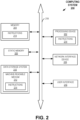
- FIG. 2 illustrates a block diagram of example aspects of a computing system 200 that can implement the technical solution shown in FIG. 1 or each main part of the solution. Also, FIG. 2 illustrates parts of the computing system 200 within which a set of instructions are executed for causing a machine (such as a computer processor or processing device 202) to perform any one or more of the methodologies discussed herein performed by a computing system (e.g., see the method steps of the methods 300, 400, 500, 600, 700, 800, 900, 1200, 1900 and 2000 shown in FIGS. 3, 4, 5 , 6, 7, 8 , 9 , 12 , 19 and 20 respectively).
- the computing system 200 operates with additional computing systems to provide increased computing capacity in which multiple computing systems operate together to perform any one or more of the methodologies discussed herein that are performed by a computing system.
- the computing system 200 corresponds to a host system that includes, is coupled to, or utilizes memory or is used to perform the operations performed by any one of the computing systems described herein.
- the machine is connected (e.g., networked) to other machines in a LAN, an intranet, an extranet, or the Internet.
- the machine operates in the capacity of a server in a client-server network environment, as a peer machine in a peer-to-peer (or distributed) network environment, or as a server in a cloud computing infrastructure or environment.
- the machine is a personal computer (PC), a tablet PC, a cellular telephone, a web appliance, a server, or any machine capable of executing a set of instructions (sequential or otherwise) that specify actions to be taken by that machine.
- PC personal computer
- tablet PC a cellular telephone
- web appliance a web appliance
- server or any machine capable of executing a set of instructions (sequential or otherwise) that specify actions to be taken by that machine.
- the term "machine” shall also be taken to include any collection of machines that individually or jointly execute a set (or multiple sets) of instructions to perform any one or more of the methodologies discussed herein performed by computing systems.
- the computing system 200 includes a processing device 202, a main memory 204 (e.g., read-only memory (ROM), flash memory, dynamic random-access memory (DRAM), etc.), a static memory 206 (e.g., flash memory, static random-access memory (SRAM), etc.), and a data storage system 210, which communicate with each other via a bus 218.
- the processing device 202 represents one or more general-purpose processing devices such as a microprocessor, a central processing unit, or the like. More particularly, the processing device can include a microprocessor or a processor implementing other instruction sets, or processors implementing a combination of instruction sets.
- the processing device 202 is one or more special-purpose processing devices such as an application-specific integrated circuit (ASIC), a field programmable gate array (FPGA), a digital signal processor (DSP), a network processor, or the like.
- the processing device 202 is configured to execute instructions 214 for performing the operations discussed herein performed by a computing system.
- the computing system 200 includes a network interface device 208 to communicate over a communications network.
- a communications network can include one or more local area networks (LAN(s)) and/or one or more wide area networks (WAN(s)).
- the communications network includes the Internet and/or any other type of interconnected communications network.
- the communications network can also include a single computer network or a telecommunications network.
- the data storage system 210 includes a machine-readable storage medium 212 (also known as a computer-readable medium) on which is stored one or more sets of instructions 214 or software embodying any one or more of the methodologies or functions described herein performed by a computing system.
- the instructions 214 also reside, completely or at least partially, within the main memory 204 or within the processing device 202 during execution thereof by the computing system 200, the main memory 204 and the processing device 202 also constituting machine-readable storage media. While the machine-readable storage medium 212 is shown in an example embodiment to be a single medium, the term "machine-readable storage medium" should be taken to include a single medium or multiple media that store the one or more sets of instructions.
- machine-readable storage medium shall also be taken to include any medium that is capable of storing or encoding a set of instructions for execution by the machine and that causes the machine to perform any one or more of the methodologies of the present disclosure performed by a computing system.
- machine-readable storage medium shall accordingly be taken to include solid-state memories, optical media, or magnetic media.
- the computing system 200 includes user interface 216 that includes a display, in some embodiments, and, for example, implements functionality corresponding to any one of the UI devices disclosed herein.
- a Ul such as UI 216, or a UI device described herein includes any space or equipment where interactions between humans and machines occur.
- a UI described herein allows operation and control of the machine from a human user, while the machine simultaneously provides feedback information to the user. Examples of a user interface, or UI device include the interactive aspects of computer operating systems (such as GUIs), machinery operator controls, and process controls.
- FIGS. 3 to 12 and 19 to 20 illustrate methods in accordance with some embodiments of the present disclosure.
- Methods 300, 400, 500, 600, 700, 800, 900, 1200, 1900 and 2000 of the corresponding figures are performed by any one of the computing systems described herein (e.g., see computing system 102 or 200 depicted in FIGS. 1 and 2 respectively).
- any steps of embodiments of the methods described herein are implementable by executing instructions corresponding to the steps, which are stored in memory (such as the instructions 214).
- Deep learning-based route planning as well as re-routing and corresponding control for mobile machines using recorded trajectory and other types of routing information involves the application of neural network architectures to analyze and predict the optimal paths for mobile machinery based on historical movement data.
- a model can capture complex patterns and dependencies within the recorded trajectories and other routing information, allowing for more efficient route planning and execution.
- Such functionality is provided through the combination methods 300 and 400 shown in FIGS. 3 and 4 respectively as well as the other methods described herein that include or can be combined with the steps of methods 300 and 400.
- step 302 includes receiving, by a computing system (e.g., see computing system 102 or 200 shown in FIG. 1 or 2 respectively), initial routing information (e.g., see initial routing information 104 depicted in FIG. 1 ).
- the initial routing information defines routes followed by or to be followed by one or more mobile machines in one or more fields.
- the one or more mobile machines include one or more agricultural machines.
- the one or more mobile machines include one or more construction machines.
- the one or more mobile machines can include one or more forestry machines such as various types of mobile logging equipment.
- Step 302 can also include or rely on data collection by the computing system or other systems communicatively coupled to the computing system.
- the data collection can include gathering a dataset containing recorded trajectories of mobile machines, along with other relevant information, such as machine capabilities, crop type, soil type, elevation data, weather conditions, etc.
- the initial routing information is recorded by the one or more mobile machines while operating in the one or more fields.
- the initial routing information is predetermined routing information derived from designed routes to be followed by the one or more mobile machines in the one or more fields.
- the initial routing information is a combination of data recorded by the one or more mobile machines while operating in the one or more fields and predetermined routing information derived from designed routes to be followed by the one or more mobile machines in the one or more fields.
- the method 300 continues with training, by the computing system, a deep learning model (e.g., see deep learning model 106 depicted in FIG. 1 ) using the initial routing information.
- a deep learning model e.g., see deep learning model 106 depicted in FIG. 1
- the trained model is configured to generate the new routing information to minimize fuel consumption of the mobile machine when performing a given field operation.
- the trained model is configured to generate the new routing information to minimize operation time of the mobile machine when performing a given field operation.
- the trained model is configured to generate the new routing information to minimize soil compaction caused by the mobile machine when performing a given field operation.
- the method 300 can include feature extraction.
- Feature extraction can include extracting relevant features from the recorded trajectories, such as waylines, distances between waylines, and any additional features that might be helpful in route planning.
- the method 300 can include model selection.
- the model selection can include choosing a suitable deep learning model for sequence-based data, such as recurrent neural networks (RNNs), long short-term memory (LSTM) networks, or transformer-based models. Such models are capable of capturing temporal dependencies and learning complex patterns in the data.
- the trained model of step 304 includes at least one of RNNs, LSTM networks, or transformer-based models.
- the training at step 304 according to preprocessed data, using the extracted features from the feature extraction as input sequences.
- the method 300 continues with using, by the computing system, the trained model (e.g., see trained model 107b depicted in FIG. 1 ) to generate new routing information (e.g., see new routing information 108 depicted in FIG. 1 ) for a given field.
- the method 300 can also include model evaluation. Such model evaluation can be a part of the use of the model at step 306. And in some examples, the evaluation can include evaluation of the trained model's performance on a dataset to ensure its generalization is valid to unseen data. The evaluation can use metrics, such as mean absolute error, root mean squared error, or custom metrics relevant to the specific application.
- the method 300 can also include model deployment. The deployment can include integrating the trained model into the mobile machine's control system to provide real-time route planning and optimization. Such deployment can occur at step 306.
- the method 300 can include continuous improvement such as regularly updating the model with new data to ensure its performance remains accurate and up-to-date.
- the improvement can also include monitoring the model's performance and retraining or fine-tuning the model per application of it or as needed.
- method 400 begins with using a mobile machine (e.g., see mobile machine 110 depicted in FIG. 1 ) to perform work in a field and recording travelled path information.
- the recorded path information includes information about path(s) followed by the mobile machine when performing the work in the field (e.g., see recorded path information 118).
- the method 400 at step 404, continues with using computing device(s) on the mobile machine to input the recorded path information into a deep learning model (such as the trained model of method 300) and to receive new machine travel paths (e.g., see new travel paths 120) from the deep learning model.
- a deep learning model such as the trained model of method 300
- step 406 includes communicating, by the computing system, the new routing information, such as the new paths, or a derivative thereof to an electronic control unit (ECU) of the mobile machine as well as at least partially controlling, by the ECU, a movement of the machine according to the new routing information or the derivative thereof.
- ECU electronice control unit
- the mobile machine of method 400 and the other methods disclosed herein includes an agricultural machine.
- the mobile machine includes a construction machine.
- the mobile machine can include a forestry machine such as some sort of mobile logging equipment.
- method 500 begins with the steps from method 300 or method 400, or a combination of the two methods (i.e., steps 302, 304, 306, 402, 404, and 406). Subsequently, method 500 continues with step 502, which includes using, by the computing system, the trained model (such as the trained model of method 300) to generate the new routing information (including the new machine travel paths) for the field and the mobile machine. The, at step 406 (similar to method 400), method 500 continues with using the computing device(s) on the mobile machine to control the machine to follow the new machine travel paths generated by the deep learning model.
- the trained model such as the trained model of method 300
- method 600 begins with step 302 of method 300, which includes the receiving of the initial routing information. And, then continues with step 304, which includes the training of the deep learning model using the initial routing information. Also, the method 600 can begin with step 402 of method 400 (using a mobile machine to perform work in a field and recording travelled path information). Also, as shown, the method 600 starts with step 602, which includes receiving, by the computing system, initial mobile machine information (e.g., see initial mobile machine information 112 depicted in FIG. 1 ). With method 600, at step 604, the method includes further training, by the computing system, the deep learning model according to the initial mobile machine information in addition to the initial routing information.
- initial mobile machine information e.g., see initial mobile machine information 112 depicted in FIG. 1
- the method 600 can end with step 306 of method 300 (using the trained model to generate new routing information for a given field) or steps 404 and 406 of method 400 (using computing device(s) on the mobile machine to input the recorded path information into a deep learning model and to receive new machine travel paths from the model, and using the computing device(s) to control the machine to follow the new paths generated by the model).
- the initial mobile machine information includes one or more of machine model information, machine type information, machine size information, machine shape information, machine ground footprint information, machine turn radius information, and energy usage information.
- the initial mobile machine information is recorded mobile machine information recorded from the one or more mobile machines in the one or more fields, or the initial mobile machine information is predetermined mobile machine information derived from designed machine attributes of the one or more mobile machines, or some combination thereof.
- method 700 begins with step 302 of method 300, which includes the receiving of the initial routing information. And, then continues with step 304, which includes the training of the deep learning model using the initial routing information. Also, the method 600 can begin with step 402 of method 400 (using a mobile machine to perform work in a field and recording travelled path information). Also, as shown, the method 700 starts with step 702, which includes receiving, by the computing system, initial field information (e.g., see initial field information 114 depicted in FIG. 1 ). With method 700, at step 704, the method includes further training, by the computing system, the deep learning model according to the initial field information in addition to the initial routing information.
- initial field information e.g., see initial field information 114 depicted in FIG. 1
- the method 600 can end with step 306 of method 300 (using the trained model to generate new routing information for a given field) or steps 404 and 406 of method 400 (using computing device(s) on the mobile machine to input the recorded path information into a deep learning model and to receive new machine travel paths from the model, and using the computing device(s) to control the machine to follow the new paths generated by the model).
- the initial field information includes one or more of field size information, field shape information, field elevation information, field topology information, soil type information, soil condition information, crop type information, crop lodging information, soil compaction information, weed density information, and weed location information.
- the initial field information is recorded field information recorded from the one or more fields, or the initial field information is predetermined or preselected field information from known field attributes, or some combination thereof.
- method 800 begins with step 302 of method 300, which includes the receiving of the initial routing information. And, then continues with step 304, which includes the training of the deep learning model using the initial routing information. Also, the method 800 can begin with step 402 of method 400 (using a mobile machine to perform work in a field and recording travelled path information). Also, as shown, the method 800 starts with step 802, which includes receiving, by the computing system, weather data (e.g., see weather data 116 depicted in FIG. 1 ). With method 800, at step 804, the method includes further training, by the computing system, the deep learning model according to the weather data in addition to the initial routing information.
- weather data e.g., see weather data 116 depicted in FIG. 1
- the method 800 can end with step 306 of method 300 (using the trained model to generate new routing information for a given field) or steps 404 and 406 of method 400 (using computing device(s) on the mobile machine to input the recorded path information into a deep learning model and to receive new machine travel paths from the model, and using the computing device(s) to control the machine to follow the new paths generated by the model).
- the initial weather data includes one or more of datasets collected from one or more of thermometers, barometers, radar, wind vanes, anemometers, transmissometers, hygrometers, etc.
- the datasets can include measured temperature, air pressure, rain or snow locations, wind direction, wind speed, atmospheric visibility, humidity, etc.
- the initial weather data includes one or more datasets collected from one or more satellites, radiosondes, etc.
- the training includes determining a correlation including a degree to which at least one quantity in the initial mobile machine information is linearly associated with at least one quantity in the initial routing information. In some embodiments, the training includes determining a correlation including a degree to which at least one quantity in the initial field information is linearly associated with at least one quantity in the initial routing information. In some embodiments, the training includes determining a correlation including a degree to which at least one quantity in the initial field information is linearly associated with at least one quantity in the initial mobile machine information. In some embodiments, the training includes determining a correlation including a degree to which at least one quantity in the weather data is linearly associated with at least one quantity in the initial routing information, the field information, the mobile machine information, or a combination thereof.
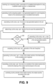
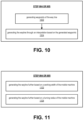
- FIGS. 9 and 12 illustrate methods 900 and 1200 and FIGS. 10 and 11 illustrate sub-methods of method 900, respectively, in accordance with various embodiments of the present disclosure.
- the new routing information includes a set of waylines.
- the using of the trained model e.g., see step 306 of method 300 or step 502 of method 500
- the using of the trained model can include associating, by the computing system, the last generated wayline to the set of waylines. Furthermore, the use of the trained model can include determining, by the computing system, whether the set of waylines covers the given field. Also, the use of the trained model can include generating, by the computing system, a new wayline for the set of waylines based on the generated new routing information and the parameters of the last generated wayline, when the set of waylines does not cover the crop field after the lasted generated wayline is generated and associated with the set of waylines. Also, the use of the trained model can include completing generation of the set of waylines, by the computing system, when the set of waylines does cover the field after the last generated wayline is generated and associated with the set of waylines.
- the set of waylines can include an ordered set of waylines.
- the generation of the last generated wayline includes generating, by the computing system, waypoints of the last generated wayline, and wherein the generation of the last generated wayline further includes generating, by the computing system, the wayline through an interpolation based on the generated waypoints.
- Methods 900 and 1200 are performed by a computing system (which can be the computing system 102 or 200) and a controller of a mobile machine. And, as mentioned, the methods 900 and 1200 can be a part of the use of the trained model at step 306 of method 300 or step 402 of method 400. For the sake of simplicity, the methods 900 and 1200 will be described as being performed by a computing system and a controller; however, it is to be understood that the computing system could be replaced with multiple systems and the controller could be replaced with multiple controllers.
- step 902 includes receiving, by a computing system, parameters of a predetermined wayline for using a selected mobile machine in a selected field (such as a selected crop field, a selected construction zone, or a selected forestry field or area of a forest).
- the mobile machine can be an agricultural mobile machine, a construction mobile machine, a forestry mobile machine, or another type of mobile machine used for another type of industrial application.
- step 904 includes generating, by the computing system, a last generated wayline for a set of waylines based on the received parameters of predetermined wayline.
- step 906 which includes associating, by the computing system, the last (or a newly) generated wayline to the set.
- the method 900 then continues with steps 908 and 909, which includes determining, by the computing system, whether the set covers the field.
- the method 900 essentially returns to step 904, when the set does not cover the field (e.g., see step 905).
- step 906 which includes associating the last (or a newly) generated wayline to the set is repeated, and so on.
- the method 900 then continues with step 910, which includes completing, by the computing system, generation of the set of waylines.
- the method 900 continues with generating, by the computing system, a route of the mobile machine in the field based on the completed set of waylines (at step 912).
- the method 900 continues with transmitting, by the computing system, the route to a controller of the mobile machine that controls the steering of the mobile machine based on the route. And, finally, at step 916, the method 900 continues with controlling, by the controller of the mobile machine, the mobile machine according to the route.
- step 904 or 905 can include step 1002, which includes generating waypoints of the way line.
- step 904 or 905 also can include step 1004, which includes generating the wayline through an interpolation based on the generated waypoints.
- step 904 or 905 can include step 1102, which includes generating the wayline further based on a working width of the mobile machine.
- step 904 or 905 also can include step 1104, which includes generating the wayline further based on a turning radius of the mobile machine.
- method 1200 begins with step 1202, which includes receiving, by a computing system, parameters of a predetermined wayline for using a selected mobile machine in a selected field and receiving a turning radius and a working width of the machine.
- the mobile machine can be any type of mobile machine described herein and the field can be any type of field described herein.
- step 1204 includes generating, by the computing system, a last generated wayline for a set of waylines based on the received parameters of predetermined wayline and the received turning radius and working width.
- the step 1204 also includes generating waypoints of the wayline based on the received parameters, the radius, and the width (at sub-step 1204A) and generating the wayline through an interpolation based on the generated waypoints (at sub-step 1204B).
- the method 1200 also includes step 906 from method 900, which includes associating the last (or the newly) generated wayline to the set.
- the method 1200 also includes steps 908 and 909 from method 900, which includes determining whether the set covers the field.
- the method 1200 like method 900, essentially returns to steps 1204, when the set does not cover the field (e.g., see step 1205, wherein the computing system generates a new wayline for the set based on the parameters of the last generated wayline and the radius and the width). And, then step 906, which includes associating the last (or a newly) generated wayline to the set is repeated, and so on. Otherwise, the method 1200 then continues with step 910 (similar to method 900), which includes completing the generation of the set of waylines. And, after the completion of the set, the method 900 continues with generating a route of the mobile machine in the field based on the completed set of waylines (at step 912). And, finally, at step 914, the method 1200 continues with transmitting the route to a controller of the mobile machine, and at step 916, the method 1200 continues with controlling, by the controller of the mobile machine, the mobile machine according to the route.
- step 910 similar to method 900
- a feature of the method is that it explicitly considers a steering angle constraint (e.g., a curvature constraint) of a mobile machine and generates waylines producing minimum possible overlap with adjacent waylines while reducing that amount and extent of skipped areas of the field (e.g., see skipped areas 1502 between swaths 1504 of a field--shown in FIG. 15 ).
- a planning method for planning waylines in a route of a mobile machine through a selected area of a field can include any one or more of the steps described herein, including any one or more of the steps from methods 900 and 1200. And, in some examples, the planning method includes results that excludes skipped areas completely.
- the generated waylines of the planning method can be used as guidance for a vehicle with an Ackerman mechanism or another type of steering mechanisms.
- the objective function or cost function
- the following equations are used as bases for cost1, cost2, and cost3 of the objective function.
- each constraint is represented by an s.t. constraint function.
- n ⁇ e x i ref e y i ref is the normal unit vector at point x i ref y i ref
- the geometric interpretation of the objective function of the planning method considers weights w1, w2 and w3--which can be user defined weights, e.g., see FIG. 18 . If the operator cares less about one parameter of the set of waylines than another parameter, a lower value can be applied to corresponding one or more weights of the objective function via the slider (e.g., if the operator cares less about skipped area size than wayline length, then a lower value can be given to w3; which coincides with minimization of skipped area being a lower priority than wayline length in the objective functions).
- FIGS. 13A and 13B illustrates a modulus(length) of the vector P i P , which is related to cost1 (e.g., see Eq. 2).
- the modulus(length) of the vector P i P shown in FIGS. 13A and 13B , can be understood as:
- gets smaller, the three points P i- 1 , P i , P i +1 tends to be on a straight line. In other words, the smaller the
- FIG. 14 illustrates that a straight line is easier to follow than a curved line because it is smoother.
- This notion relates to cost2 (e.g., see Eq. 3).
- Cost2 the plan considers minimizing the total length of a wayline, since a shorter wayline length means a straighter wayline and a straighter wayline means a smoother of the wayline.
- the straight line is easier to follow for a mobile machine than the curved line because it is smoother and will have lesser turning angles.
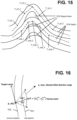
- FIG. 15 illustrates that skipped areas 1502 in a set of waylines occur and increase in size with greater curve in a preceding wayline, with respect to a new wayline, in accordance with some embodiments of the present disclosure.
- FIG. 16 illustrates an example relationship between a previously generated wayline 1602 and a new wayline 1604 generated based on the previously generated wayline, in accordance with some embodiments of the present disclosure.
- cost3 e.g., see Eq. 4
- the plan considers or uses minimizing the overlapping of adjacent waylines while achieving the goal of reducing skipped area between adjacent waylines.
- s.t.1 and s.t.2 relate to distance constraint for points of adjacent waylines where distance between each pair of point at adjacent waylines only allow between certain conditions (e.g., 0.8*w and 1*w, w is the working width of the machine). For example, see FIGS. 15 and 16 , where it is illustrated that at least two waylines each have multiple waypoints. And, as shown in FIG.
- p _new i are wayline points generated based on corresponding point p _ref i at the reference (or previous) wayline by using a traditional offset method, at least to some extent, which leads to skipped areas between swaths.
- the constraint for points of adjacent waylines allows the point p _new i to freely move (e.g., search a solution) between a given distance (e.g., the given distance 0.8*w and 1*w) with a goal to reduce the skipped area and at the same time to keep the produced overlap between adjacent waylines as much as possible.
- the distance is the length between p _new i to its corresponding point p_ref i at reference (or previous) wayline, and, for example, the previously mentioned values of 0.8 and 1 are adjustable values. Such values can be adjusted through a GUI in some embodiments (see FIG. 18 ).
- the geometric interpretation of the objective function also considers or uses equation s.t.4 to ensure a solution by convergence, and with a slack variable greater than 0 is introduced into the curvature constraint.
- the geometric interpretation of the objective function also considers or uses equation s.t.5 as an offset direction constraint.
- the offset direction to generate next waypoint p_ new i based on the p_ ref i is limited to the range [ n - 0.1, n + 0.1] and the value 0.1 is adjustable.
- the geometric interpretation of the objective function also considers that each next new wayline L i with waypoints p_ new i is generated based on the previous wayline L i -1 with waypoints p_ ref i .
- the waypoints p_ ref i . of previous wayline L i -1 is connected by some form of interpolation (e.g., cubic splines, such as cubic B-splines). This is to form a C 2 continuous path, which is to get a smooth vehicle path.
- interpolation e.g., cubic splines, such as cubic B-splines
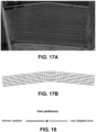
- FIG. 17A illustrates an initial wayline generated for a crop field
- FIG. 17B illustrates additional waylines generated based on the initial wayline according to one or more of the equations provided herein (e.g., equations 1, 2, 3, 4, 5, s.t.1, s.t.2, s.t.3, s.t.4, and s.t.5).
- Waylines generated by such a plan and such equations are shown in FIG. 17B , in which the red line is the one side of the field boundary, see the image shown in FIG. 17A , and is the initial reference wayline and the blue lines are the generated waylines that were generated based on parameters of the initial wayline such as provided by steps 904 and 1204 in methods 900 and 1200 respectively.
- C 1 -continuous and C 2 -continuous paths are used in the interpolation described herein.
- a path is C 1 -continuous if its derivative exists and is continuous.
- Paths that are only C1-continuous have discontinuities in their curvature.
- a path composed of Dubins or Reeds-Shepp path segments has discontinuities in curvature at the points where the segments join.
- These discontinuities in C1-countiuous path result in changes in direction that may not be smooth enough for driving with passengers.
- a C 2 -continuous is added in such embodiments, if its second derivative exists and is continuous.
- C2-continuous paths have continuous curvature and are smooth enough for driving with passengers.
- FIG. 18 illustrates an example graphical output having a slider bar for adjusting the parameters of the waylines according to tradeoffs and the output can be a part of a graphical user interface (GUI)-such as a GUI provided by the computing system 200.
- GUI graphical user interface
- the generation of waylines for a set of waylines can be alternatively based on a preference of an operator and the alternative generation of the waylines is selectable by the operator from a user interface (Ul), such as a GUI.
- the UI includes a slider for adjusting the parameters of the waylines according to one or more tradeoffs.
- a slider is provided in the UI and is movable by a user to control the weights of an objective function (e.g., to adjust w1,w2, and w3 of the objection function described herein). If the operator cares less about one parameter of the set of waylines than another parameter, a lower value can be applied to corresponding one or more weights of the objective function via the slider (e.g., if the operator cares less about skipped area size than wayline length, then a lower value can be given to w3; which coincides with minimization of skipped area being a lower priority than wayline length in the objective functions).
- an objective function e.g., to adjust w1,w2, and w3 of the objection function described herein.
- the UI allows for multiple different selection choices for adjusting the objective function to adjust for different tradeoffs (e.g., adjust for less overlap or skipped area, or straightness of waylines versus skipped area, or less overlap versus straightness of waylines, etc.).
- step 1902 includes using computing device(s) on a mobile machine (e.g., see mobile machine 110 depicted in FIG. 1 ) to input travelled path information (e.g., see recorded path information 118) and real-time field attributes (e.g., the field information 114 can include real-time recorded information) into a trained model (such as the trained model of method 300 or 400) and to receive new machine travel paths from the trained model (e.g., see new travel paths 120).
- the method 1900 continues with using, by the computing system (e.g., see computing system 102 or 200), the trained model to generate the new machine travel paths according to the travelled path information and the real-time field attributes.
- the method 1900 continues with using the computing device(s) on the mobile machine to control the machine to follow the new machine travel paths generated by the trained model.
- the real-time field attributes are sensed by sensors on the mobile machine, or by nearby sensors in the field, or by remote sensors capturing field attributes near the machine.
- step 2002 begins with using computing device(s) on a mobile machine (e.g., see mobile machine 110 depicted in FIG. 1 ) to input travelled path information (e.g., see recorded path information 118) and real-time mobile machine attributes (e.g., the machine information 112 can include real-time recorded information) into a trained model (such as the trained model of method 300 or 400) and to receive new machine travel paths from the trained model (e.g., see new travel paths 120).
- the method 2000 continues with using, by the computing system (e.g., see computing system 102 or 200), the trained model to generate the new machine travel paths according to the travelled path information and the real-time mobile machine attributes.
- the method 2000 continues with using the computing device(s) on the mobile machine to control the machine to follow the new machine travel paths generated by the trained model.
- the real-time field attributes are sensed by sensors on the mobile machine, or by nearby sensors in the field, or by remote sensors capturing mobile machine.
Landscapes
- Engineering & Computer Science (AREA)
- Physics & Mathematics (AREA)
- General Physics & Mathematics (AREA)
- Life Sciences & Earth Sciences (AREA)
- Automation & Control Theory (AREA)
- Remote Sensing (AREA)
- Radar, Positioning & Navigation (AREA)
- Aviation & Aerospace Engineering (AREA)
- Theoretical Computer Science (AREA)
- Business, Economics & Management (AREA)
- General Health & Medical Sciences (AREA)
- Health & Medical Sciences (AREA)
- Economics (AREA)
- Mining & Mineral Resources (AREA)
- Tourism & Hospitality (AREA)
- Human Resources & Organizations (AREA)
- General Business, Economics & Management (AREA)
- Mechanical Engineering (AREA)
- Primary Health Care (AREA)
- Strategic Management (AREA)
- Marine Sciences & Fisheries (AREA)
- Animal Husbandry (AREA)
- Agronomy & Crop Science (AREA)
- Marketing (AREA)
- Environmental Sciences (AREA)
- Soil Sciences (AREA)
- Artificial Intelligence (AREA)
- Data Mining & Analysis (AREA)
- Evolutionary Computation (AREA)
- Molecular Biology (AREA)
- Computing Systems (AREA)
- General Engineering & Computer Science (AREA)
- Mathematical Physics (AREA)
- Software Systems (AREA)
- Computational Linguistics (AREA)
- Biophysics (AREA)
- Biomedical Technology (AREA)
- Management, Administration, Business Operations System, And Electronic Commerce (AREA)
Abstract
Description
- This application claims the benefit of the filing date of
United States Provisional Patent Application Serial No. 63/588,218, filed October 5, 2023 - The present disclosure relates to methods and systems using machine learning to control and re-route mobile machines.
- It is known to perform path planning for various operations, such as agricultural or construction operations. Such planning is often performed manually by the operator of machines working in an environment in an attempt to optimize the operation in terms of efficiency and cost. More recently, computing systems have been developed that suggest operational paths to an operator based on an operational task, field slope, etc.; however, there is much room for improvement on such systems. In some cases, route planning has relied on manual planning, expert knowledge, and simple computations (e.g., heuristic algorithms) performed by computing systems. However, such planning does not consider the complex interactions between various factors, such as terrain, ground conditions, soil type, weather conditions, and machinery capabilities. With the complex interactions not being considered, resulting route planning can include subpar paths and increased fuel consumption, ultimately resulting in higher operational costs and reduced productivity. Thus, it would be advantageous to provide a system (and associated method) which overcomes or at least mitigates one or more problems associated with the prior art systems and considers complex interactions between various factors. It would also be advantageous to provide a system (and associated method) which can update route planning and partially control a mobile machine while the machine is operating in a field.
- Described herein are techniques for using machine learning to update routing plans of mobile machines and control such machines accordingly. The mobile machines can be or include mobile agricultural machines, mobile construction machines, or mobile forestry machines, for example. The techniques disclosed herein provide specific technical solutions to at least overcome the technical problems mentioned in the background section or other parts of the application as well as other technical problems not described herein but recognized by those skilled in the art.
- In some embodiments, the techniques include technologies that use machine learning to update a route of a mobile machine while the machine is operating in a field. Some embodiments include a method that includes using machine learning to update a route plan as well as re-route a mobile machine while it is operating in a field. In some cases, the method can also include controlling the mobile machine at least partially according to the updated route plan or the re-routing. With respect to some embodiments, disclosed herein are computerized methods for using machine learning to update a route of a mobile machine, re-route the mobile machine, and control the mobile machine according to the updated route as well as a non-transitory computer-readable storage medium for carrying out technical operations of the computerized methods. The non-transitory computer-readable storage medium has tangibly stored thereon, or tangibly encoded thereon, computer-readable instructions that when executed by one or more devices (e.g., one or more personal computers or servers) cause at least one processor to perform a method for improved systems and methods for using machine learning to update a route of a mobile machine, re-route the mobile machine, and control the mobile machine according to the updated route.
- For example, some embodiments include a method for using machine learning to update a route of a mobile machine, re-route the mobile machine, and control the mobile machine according to the updated route. In some examples, the method includes using a mobile machine (e.g., see
mobile machine 110 shown inFIG. 1 ) to perform work in a field and recording travelled path information (e.g., seestep 402 shown inFIG. 4 ). The travelled path information (e.g., see recorded path information 118) includes information about one or more paths followed by the mobile machine when performing the work in the field. The method can also include The method also includes using one or more computing devices (e.g., seecomputing system FIGS. 1 and2 respectively) on the mobile machine to input the travelled path information into a trained deep learning model (e.g., see trainedmodel 107b) and to receive new machine travel paths (e.g., see new paths 120) from the deep learning model (e.g., see step 404). The method also includes using the one or more computing devices on the mobile machine to control the machine to follow the new machine travel paths generated by the trained deep learning model (e.g., see step 406). In some embodiments, the method includes receiving, by a computing system (e.g., seecomputing system 102 or 200), initial routing information (e.g., seerouting information 104 andstep 304 depicted inFIG. 3 ). The initial routing information defines routes followed or to be followed by one or more mobile machines in one or more fields. The method can also include, prior to using the deep learning model to generate new routing information (e.g., seeinformation 108 andstep 502 shown inFIG. 5 ), training, by the computing system, the deep learning model using the initial routing information (e.g., see step 304). The method can also include using, by the computing system, the trained model to generate new routing information specific to the field and the mobile machine (e.g., see step 502). In some examples, the use of the mobile machine to perform the work is based on the new routing information and the new routing information includes the new machine travel paths. In some embodiments, the method also includes storing the trained model on the mobile machine (such as on a computing device of the machine). - In some embodiments, the method includes receiving, by the computing system, initial mobile machine information (e.g., see
mobile machine information 112 shown inFIG. 1 andstep 602 shown inFIG. 6 ). Such a method can also include further training, by the computing system, the deep learning model according to the initial mobile machine information (e.g., see step 604). In some embodiments, the initial mobile machine information includes one or more of machine model information, machine type information, machine size information, machine shape information, machine ground footprint information, machine turn radius information, and energy usage information. In some embodiments, the method includes receiving, by the computing system, initial field information (e.g., seefield information 114 shown inFIG. 1 andstep 702 shown inFIG. 7 ). Such a method can also include further training, by the computing system, the deep learning model according to the initial field information(e.g., see step 704). In some embodiments, the initial field information includes one or more of field size information, field shape information, field elevation information, field topology information, soil type information, soil condition information, crop type information, crop lodging information, soil compaction information, weed density information, and weed location information. In some embodiments, the method includes receiving, by the computing system, weather data (e.g., seeweather data 116 shown inFIG. 1 andstep 802 shown inFIG. 8 ). And, in such examples the method can include further training, by the computing system, the deep learning model according to the weather data (e.g., see step 804). In some embodiments, the initial routing information (e.g., see routing information 104) includes initial waylines (e.g., seewayline 1602 shown inFIG. 16 ) and the new machine travel paths (e.g., see new paths 120) include new waylines (e.g., see wayline 1604). The new waylines do not include any of the initial waylines since the initial way lines have already been followed by the machine and none of the initial waylines need to be repeated to complete the route. In some embodiments, the method includes extracting, by the computing system, distances between the initial waylines; and further training, by the computing system, the deep learning model (e.g., see model 106) according to the initial waylines and the extracted distances. In some embodiments, the trained model is configured to generate the new machine travel paths to minimize fuel consumption of the mobile machine when performing a given field operation. In some embodiments, the trained model is configured to generate the new machine travel paths to minimize operation time of the mobile machine when performing a given field operation. In some embodiments, the trained model is configured to generate the new machine travel paths to minimize soil compaction caused by the mobile machine when performing a given field operation. - In some embodiments, the method includes using one or more computing devices on the mobile machine (e.g., see mobile machine 110) to input the travelled path information and real-time field attributes into the trained model and to receive new machine travel paths from the trained model (e.g., see
step 1902 shown inFIG. 19 ). The real-time field attributes are sensed by the mobile machine, or by nearby sensors in the field, or by remote sensors capturing field attributes near the machine. Also the method can include using, by the computing system, the trained mode to generate the new machine travel paths according to the travelled path information and the real-time field attributes (e.g., see step 1904). In some embodiments, the method includes using one or more computing devices on the mobile machine to input the travelled path information and real-time machine attributes into the trained model and to receive new machine travel paths from the trained model (e.g., seestep 2002 shown inFIG. 20 ). The the real-time machine attributes are measured or sensed by the mobile machine, or by nearby sensors in the field, or by remote sensors capturing attributes of the machine. Also, the method can include using, by the computing system, the trained model to generate the new machine travel paths according to the travelled path information and the real-time machine attributes (e.g., see step 2004). - These and other important aspects of the invention are described more fully in the detailed description below. The invention is not limited to the particular methods and systems described herein. Other embodiments can be used and changes to the described embodiments can be made without departing from the scope of the claims that follow the detailed description. Within the scope of this application, it should be understood that the various aspects, embodiments, examples, and alternatives set out herein, and individual features thereof may be taken independently or in any possible and compatible combination. Where features are described with reference to a single aspect or embodiment, it should be understood that such features are applicable to all aspects and embodiments unless otherwise stated or where such features are incompatible.
- The present disclosure will be understood more fully from the detailed description given below and from the accompanying drawings of various example embodiments of the disclosure.
FIG. 1 illustrates an example technical solution to the example technical problems described herein, in accordance with some embodiments of the present disclosure. -
FIG. 2 illustrates a block diagram of example aspects of a computing system, in accordance with some embodiments of the present disclosure. -
FIGS. 3 to 12 and19 to 20 illustrate methods in accordance with some embodiments of the present disclosure. -
FIGS. 13A and 13B illustrate a modulus(length) of the vectorPiP , in accordance with some embodiments of the present disclosure. -
FIG. 14 illustrates that a straight line is easier to follow than a curved line because it is smoother, in accordance with some embodiments of the present disclosure. -
FIG. 15 illustrates that skipped areas in a set of waylines occur and increase in size with greater curve in a preceding wayline, with respect to a new wayline, in accordance with some embodiments of the present disclosure. -
FIG. 16 illustrates an example relationship between a previously generated wayline and a new wayline generated based on the previously generated wayline, in accordance with some embodiments of the present disclosure. -
FIG. 17A illustrates an initial wayline generated for a crop field andFIG. 17B illustrates additional waylines generated based on the initial wayline. -
FIG. 18 illustrates an example graphical output having a slider bar for adjusting the parameters of the waylines according to tradeoffs, in accordance with some embodiments of the present disclosure. - Details of example embodiments of the invention are described in the following detailed description with reference to the drawings. Although the detailed description provides reference to example embodiments, it is to be understood that the invention disclosed herein is not limited to such example embodiments. But to the contrary, the invention disclosed herein includes numerous alternatives, modifications, and equivalents as will become apparent from consideration of the following detailed description and other parts of this disclosure.
- Described herein are techniques for using machine learning to generate and update routing plans of mobile machines and control the machines accordingly, such as in real-time while machine is moving through a given field. The mobile machinery can include mobile agricultural machines, mobile construction machines, and mobile forestry machines, for example. The techniques disclosed herein provide specific technical solutions to at least overcome the technical problems mentioned in the background section or other parts of the application as well as other technical problems not described herein but recognized by those skilled in the art. In some embodiments, the techniques include technologies that use machine learning to plan re-routing and corresponding control of the mobile machine. Some embodiments include a method that includes using machine learning to generate or update a route plan as well.
- As mentioned, it is known to perform path planning for various industrial operations. Such planning is often performed manually by the operator of machines. More recently, computing systems have been developed that suggest operational paths to an operator based on an operational task, field slope, etc.; however, there is much room for improvement on such systems in that such systems are not sophisticated enough to consider complex interaction between various factors. On the other hand, the techniques described herein provide example improvements to such systems and beyond that that they go beyond manual planning, expert knowledge, and simple computations (e.g., heuristic algorithms) and can consider the complex interactions between various factors, such as terrain, ground conditions, soil type, weather conditions, and machinery capabilities. With the complex interactions being considered by the novel techniques described herein, example technical problems can be resolved. For example, the technologies described here can avoid determinations of subpar paths with increased fuel consumption that ultimately result in higher operational costs and reduced productivity. And, this is just one example of the benefits of the disclosed techniques.
- Furthermore, the technologies described herein leverage advancements in artificial intelligence (Al), machine learning, and deep learning, which makes it possible to develop more sophisticated route planning systems capable of considering a multitude of factors and making enhanced decisions from those made by the prior art. The technologies use deep learning models, based on Recurrent Neural Networks (RNNs) or Long Short-Term Memory (LSTM) networks, for example, or Transformer-based models. Such models can generate plans that consider many factors in sequence-based tasks, such as making plans suitable for route planning applications. Combined with GPS technology and the increasing digitization of mobile machinery, large amounts of data has become collectable to facilitate the creation and training of such models. The collected data can be used to train deep learning models, allowing them to learn complex patterns and dependencies between a multitude of factors, including waylines, distances, and other relevant features of a work space or field, as well as complex interactions between various factors, such as terrain, ground conditions, soil type, weather conditions, and machinery capabilities. Also, the models described herein can predict enhanced routes for mobile machines, that consider various efficiencies and factors such as operational time efficiency, fuel efficiency, soil compaction, and machine capabilities. The application of deep learning-based route planning in agricultural, construction, forestry, and other industrial settings has the potential to revolutionize the way corresponding businesses operate. By leveraging AI machine learning, and deep learning to enhance routes, operators of mobile machines can reduce costs, improve efficiency, and minimize the environmental impact of their operations.
-
FIG. 1 illustrates an example technical solution to the example technical problems described herein. The technical solution, shown inFIG. 1 , can include or be a part of the techniques and technologies described herein (such as any one of themethods FIGS. 3, 4, 5 ,6, 7, 8 ,9 ,12 ,19 and 20 respectively) and can provide specific technical solutions to at least overcome the technical problems mentioned in the background section or other parts of the application as well as other technical problems not described herein but recognized by those skilled in the art.FIG. 1 depicts anetwork 100, such as a computer network, within which acomputing system 102 receives various inputs (e.g., seeinitial routing information 104,mobile machine information 112,field information 114, and weather information 116). These inputs and others can be received from other computing systems within thenetwork 100. The various inputs include or are related to some of the efficiencies and factors (such as operational time efficiency, fuel efficiency, soil compaction, and machine capabilities) that is considered by the computing system in route planning and the determination of routes within a field. As shown, the computing system includes adeep learning model 106 that is trained through various machine learning and deep learning techniques (e.g., see training 107a), and the result of the training provides a trainedmodel 107b. Once the model is trained (e.g., see trainedmodel 107b), it can be used to generatenew routing information 108 for route planning within a field. Also, as shown, thecomputing system 102 is a part of amobile machine 110 as are the inputs and outputs of the computing system (including the inputs of thedeep learning model 106 and the output of the trainedmodel 107b). In some embodiments, thecomputing system 102 and the inputs and outputs of the computing system are part of a remote system in that the remote system is physically and geographically separated from themobile machine 110 but communicates with a system or controller of the machine over a telecommunications or computer network (such as network 100). Themobile machine 110 can be or include an agricultural machine, a construction machine, a forestry machine, or some other type of mobile industrial machine that can be configured to follow routes. - In addition to the aforesaid four
inputs including information FIG. 1 also illustrates a fifth input of thecomputing system 102 that includes recorded travel path information 118. In some embodiments, as illustrated byFIG. 1 , themobile machine 110 is used to perform work in a field and record travelled path information related to the traveled path of the mobile machine. The recorded travelled path information includes information about one or more paths followed by themobile machine 110 when the machine performs the work in the field. Also, one or more computing devices on the mobile machine 110 (including the computing system 102) are used to input the travelled path information 118 into the trainedmodel 107b model and to receive new machine travel paths 120 from the trained model. The new machine travel paths 120 are included in thenew routing information 108 when new routing information is updated after the recorded travelled path information 118 is inputted into and processed through the trainedmodel 107b. Also, in such embodiments, the one or more computing devices on the mobile machine 110 (including the computing system 102) are used to control the machine to follow the new machine travel paths 120 generated by the trainedmodel 107b. - The
computing system 102 includes electronics such as one or more controllers, sensors, busses, and computers. Thecomputing system 102 includes at least a processor, memory, a communication interface and can include one or more sensors, which can make themobile machine 110 an individual computing device. In the case of thenetwork 100 including the Internet, themobile machine 110 can be considered Internet of Things (IoT) device. Also, in some embodiments, thecomputing system 102 is a part of a cloud computing system. Thecomputing system 102 and themobile machine 110 can include both electronic hardware and software that can integrate between the systems of the computing system and themobile machine 110. And, such hardware and software (such as controllers and sensors and other types of electrical and/or mechanical devices) can be configured to a communicate with a remote computing system via thecommunications network 100. - In some embodiments, where the
mobile machine 110 is an agricultural machine, it can include or be a combine harvester, a tractor, a planter, a sprayer, a baler, etc. In some embodiments, where themobile machine 110 is a construction machine, it can include or be an excavator, a compaction machine (such as one with rollers), a loader, a bulldozer, a skid steer machine, a grader, etc. In some embodiments, where themobile machine 110 is a forestry machine, it can include or be a delimber, a feller buncher, a stump grinder, a mulcher, a yarder, a forwarder, log loader, a harvester, etc. In some embodiments, themobile machine 110 can be or include a vehicle in that it is self-propelling. Also, in some embodiments, themobile machine 110 can be a part of a group of similar machines or a group of different types of mobile machines. - The
network 100 can include one or more local area networks (LAN(s)) and/or one or more wide area networks (WAN(s)). In some embodiments, thenetwork 100 includes the Internet and/or any other type of interconnected communications network. Thenetwork 100 can also include a single computer network or a telecommunications network. More specifically, in some embodiments, thenetwork 100 includes a local area network (LAN) such as a private computer network that connects computers in small physical areas, a wide area network (WAN) to connect computers located in different geographical locations, and/or a middle area network (MAN) to connect computers in a geographic area larger than that covered by a large LAN but smaller than the area covered by a WAN. - At least each shown component of the network 100 (including computing system 102) can be or include a computing system which includes memory that includes media. The media includes or is volatile memory components, non-volatile memory components, or a combination of thereof. In general, in some embodiments, each of the computing systems includes a host system that uses memory. For example, the host system writes data to the memory and read data from the memory. The host system is a computing device that includes a memory and a data processing device. The host system includes or is coupled to the memory so that the host system reads data from or writes data to the memory. The host system is coupled to the memory via a physical host interface. The physical host interface provides an interface for passing control, address, data, and other signals between the memory and the host system.
-
FIG. 2 illustrates a block diagram of example aspects of acomputing system 200 that can implement the technical solution shown inFIG. 1 or each main part of the solution. Also,FIG. 2 illustrates parts of thecomputing system 200 within which a set of instructions are executed for causing a machine (such as a computer processor or processing device 202) to perform any one or more of the methodologies discussed herein performed by a computing system (e.g., see the method steps of themethods FIGS. 3, 4, 5 ,6, 7, 8 ,9 ,12 ,19 and 20 respectively). In some embodiments, thecomputing system 200 operates with additional computing systems to provide increased computing capacity in which multiple computing systems operate together to perform any one or more of the methodologies discussed herein that are performed by a computing system. - In some embodiments, the
computing system 200 corresponds to a host system that includes, is coupled to, or utilizes memory or is used to perform the operations performed by any one of the computing systems described herein. In some embodiments, the machine is connected (e.g., networked) to other machines in a LAN, an intranet, an extranet, or the Internet. In some embodiments, the machine operates in the capacity of a server in a client-server network environment, as a peer machine in a peer-to-peer (or distributed) network environment, or as a server in a cloud computing infrastructure or environment. In some embodiments, the machine is a personal computer (PC), a tablet PC, a cellular telephone, a web appliance, a server, or any machine capable of executing a set of instructions (sequential or otherwise) that specify actions to be taken by that machine. Further, while a single machine is illustrated, the term "machine" shall also be taken to include any collection of machines that individually or jointly execute a set (or multiple sets) of instructions to perform any one or more of the methodologies discussed herein performed by computing systems. - The
computing system 200 includes aprocessing device 202, a main memory 204 (e.g., read-only memory (ROM), flash memory, dynamic random-access memory (DRAM), etc.), a static memory 206 (e.g., flash memory, static random-access memory (SRAM), etc.), and adata storage system 210, which communicate with each other via abus 218. Theprocessing device 202 represents one or more general-purpose processing devices such as a microprocessor, a central processing unit, or the like. More particularly, the processing device can include a microprocessor or a processor implementing other instruction sets, or processors implementing a combination of instruction sets. Or, theprocessing device 202 is one or more special-purpose processing devices such as an application-specific integrated circuit (ASIC), a field programmable gate array (FPGA), a digital signal processor (DSP), a network processor, or the like. Theprocessing device 202 is configured to executeinstructions 214 for performing the operations discussed herein performed by a computing system. In some embodiments, thecomputing system 200 includes anetwork interface device 208 to communicate over a communications network. Such a communications network can include one or more local area networks (LAN(s)) and/or one or more wide area networks (WAN(s)). In some embodiments, the communications network includes the Internet and/or any other type of interconnected communications network. The communications network can also include a single computer network or a telecommunications network. - The
data storage system 210 includes a machine-readable storage medium 212 (also known as a computer-readable medium) on which is stored one or more sets ofinstructions 214 or software embodying any one or more of the methodologies or functions described herein performed by a computing system. Theinstructions 214 also reside, completely or at least partially, within themain memory 204 or within theprocessing device 202 during execution thereof by thecomputing system 200, themain memory 204 and theprocessing device 202 also constituting machine-readable storage media. While the machine-readable storage medium 212 is shown in an example embodiment to be a single medium, the term "machine-readable storage medium" should be taken to include a single medium or multiple media that store the one or more sets of instructions. The term "machine-readable storage medium" shall also be taken to include any medium that is capable of storing or encoding a set of instructions for execution by the machine and that causes the machine to perform any one or more of the methodologies of the present disclosure performed by a computing system. The term "machine-readable storage medium" shall accordingly be taken to include solid-state memories, optical media, or magnetic media. - Also, as shown, the
computing system 200 includes user interface 216 that includes a display, in some embodiments, and, for example, implements functionality corresponding to any one of the UI devices disclosed herein. A Ul, such as UI 216, or a UI device described herein includes any space or equipment where interactions between humans and machines occur. A UI described herein allows operation and control of the machine from a human user, while the machine simultaneously provides feedback information to the user. Examples of a user interface, or UI device include the interactive aspects of computer operating systems (such as GUIs), machinery operator controls, and process controls. -
FIGS. 3 to 12 and19 to 20 illustrate methods in accordance with some embodiments of the present disclosure.Methods computing system FIGS. 1 and2 respectively). In some systems of the technologies disclosed herein, any steps of embodiments of the methods described herein are implementable by executing instructions corresponding to the steps, which are stored in memory (such as the instructions 214). - Deep learning-based route planning as well as re-routing and corresponding control for mobile machines using recorded trajectory and other types of routing information involves the application of neural network architectures to analyze and predict the optimal paths for mobile machinery based on historical movement data. By leveraging the power of deep learning, a model can capture complex patterns and dependencies within the recorded trajectories and other routing information, allowing for more efficient route planning and execution. Such functionality is provided through the
combination methods FIGS. 3 and 4 respectively as well as the other methods described herein that include or can be combined with the steps ofmethods - As shown in
FIG. 3 ,method 300 begins withstep 302, which includes receiving, by a computing system (e.g., seecomputing system FIG. 1 or2 respectively), initial routing information (e.g., seeinitial routing information 104 depicted inFIG. 1 ). In some examples, the initial routing information defines routes followed by or to be followed by one or more mobile machines in one or more fields. In some embodiments, the one or more mobile machines include one or more agricultural machines. In some other examples, the one or more mobile machines include one or more construction machines. Also, the one or more mobile machines can include one or more forestry machines such as various types of mobile logging equipment. Step 302 can also include or rely on data collection by the computing system or other systems communicatively coupled to the computing system. The data collection can include gathering a dataset containing recorded trajectories of mobile machines, along with other relevant information, such as machine capabilities, crop type, soil type, elevation data, weather conditions, etc. In some embodiments, the initial routing information is recorded by the one or more mobile machines while operating in the one or more fields. In some embodiments, the initial routing information is predetermined routing information derived from designed routes to be followed by the one or more mobile machines in the one or more fields. And, in some examples, the initial routing information is a combination of data recorded by the one or more mobile machines while operating in the one or more fields and predetermined routing information derived from designed routes to be followed by the one or more mobile machines in the one or more fields. - At
step 304, themethod 300 continues with training, by the computing system, a deep learning model (e.g., seedeep learning model 106 depicted inFIG. 1 ) using the initial routing information. In some embodiments, the trained model is configured to generate the new routing information to minimize fuel consumption of the mobile machine when performing a given field operation. Also, in some examples, the trained model is configured to generate the new routing information to minimize operation time of the mobile machine when performing a given field operation. Also, in some examples, the trained model is configured to generate the new routing information to minimize soil compaction caused by the mobile machine when performing a given field operation. Before or after, or withinstep 304, themethod 300 can include feature extraction. Feature extraction can include extracting relevant features from the recorded trajectories, such as waylines, distances between waylines, and any additional features that might be helpful in route planning. Also, Before or after, or withinstep 304, themethod 300 can include model selection. The model selection can include choosing a suitable deep learning model for sequence-based data, such as recurrent neural networks (RNNs), long short-term memory (LSTM) networks, or transformer-based models. Such models are capable of capturing temporal dependencies and learning complex patterns in the data. In some embodiments, the trained model ofstep 304 includes at least one of RNNs, LSTM networks, or transformer-based models. In some embodiments, the training atstep 304 according to preprocessed data, using the extracted features from the feature extraction as input sequences. - At
step 306, themethod 300 continues with using, by the computing system, the trained model (e.g., see trainedmodel 107b depicted inFIG. 1 ) to generate new routing information (e.g., seenew routing information 108 depicted inFIG. 1 ) for a given field. Themethod 300 can also include model evaluation. Such model evaluation can be a part of the use of the model atstep 306. And in some examples, the evaluation can include evaluation of the trained model's performance on a dataset to ensure its generalization is valid to unseen data. The evaluation can use metrics, such as mean absolute error, root mean squared error, or custom metrics relevant to the specific application. Themethod 300 can also include model deployment. The deployment can include integrating the trained model into the mobile machine's control system to provide real-time route planning and optimization. Such deployment can occur atstep 306. - The
method 300, atstep - As shown in
FIG. 4 ,method 400, atstep 402, begins with using a mobile machine (e.g., seemobile machine 110 depicted inFIG. 1 ) to perform work in a field and recording travelled path information. The recorded path information includes information about path(s) followed by the mobile machine when performing the work in the field (e.g., see recorded path information 118). Subsequently, themethod 400, atstep 404, continues with using computing device(s) on the mobile machine to input the recorded path information into a deep learning model (such as the trained model of method 300) and to receive new machine travel paths (e.g., see new travel paths 120) from the deep learning model. Next, atstep 406, themethod 400 continues with using the computing device(s) on the mobile machine to control the machine to follow the new machine travel paths generated by the deep learning model. In some embodiments,step 406 includes communicating, by the computing system, the new routing information, such as the new paths, or a derivative thereof to an electronic control unit (ECU) of the mobile machine as well as at least partially controlling, by the ECU, a movement of the machine according to the new routing information or the derivative thereof. In some embodiments, the mobile machine ofmethod 400 and the other methods disclosed herein includes an agricultural machine. In some other examples, the mobile machine includes a construction machine. Also, the mobile machine can include a forestry machine such as some sort of mobile logging equipment. - As shown in
FIG. 5 ,method 500 begins with the steps frommethod 300 ormethod 400, or a combination of the two methods (i.e., steps 302, 304, 306, 402, 404, and 406). Subsequently,method 500 continues withstep 502, which includes using, by the computing system, the trained model (such as the trained model of method 300) to generate the new routing information (including the new machine travel paths) for the field and the mobile machine. The, at step 406 (similar to method 400),method 500 continues with using the computing device(s) on the mobile machine to control the machine to follow the new machine travel paths generated by the deep learning model. - As shown in
FIG. 6 ,method 600 begins withstep 302 ofmethod 300, which includes the receiving of the initial routing information. And, then continues withstep 304, which includes the training of the deep learning model using the initial routing information. Also, themethod 600 can begin withstep 402 of method 400 (using a mobile machine to perform work in a field and recording travelled path information). Also, as shown, themethod 600 starts withstep 602, which includes receiving, by the computing system, initial mobile machine information (e.g., see initialmobile machine information 112 depicted inFIG. 1 ). Withmethod 600, atstep 604, the method includes further training, by the computing system, the deep learning model according to the initial mobile machine information in addition to the initial routing information. Also, themethod 600 can end withstep 306 of method 300 (using the trained model to generate new routing information for a given field) orsteps - As shown in
FIG. 7 ,method 700 begins withstep 302 ofmethod 300, which includes the receiving of the initial routing information. And, then continues withstep 304, which includes the training of the deep learning model using the initial routing information. Also, themethod 600 can begin withstep 402 of method 400 (using a mobile machine to perform work in a field and recording travelled path information). Also, as shown, themethod 700 starts withstep 702, which includes receiving, by the computing system, initial field information (e.g., seeinitial field information 114 depicted inFIG. 1 ). Withmethod 700, atstep 704, the method includes further training, by the computing system, the deep learning model according to the initial field information in addition to the initial routing information. Also, themethod 600 can end withstep 306 of method 300 (using the trained model to generate new routing information for a given field) orsteps - As shown in
FIG. 8 ,method 800 begins withstep 302 ofmethod 300, which includes the receiving of the initial routing information. And, then continues withstep 304, which includes the training of the deep learning model using the initial routing information. Also, themethod 800 can begin withstep 402 of method 400 (using a mobile machine to perform work in a field and recording travelled path information). Also, as shown, themethod 800 starts withstep 802, which includes receiving, by the computing system, weather data (e.g., seeweather data 116 depicted inFIG. 1 ). Withmethod 800, atstep 804, the method includes further training, by the computing system, the deep learning model according to the weather data in addition to the initial routing information. Also, themethod 800 can end withstep 306 of method 300 (using the trained model to generate new routing information for a given field) orsteps - In some embodiments, the training includes determining a correlation including a degree to which at least one quantity in the initial mobile machine information is linearly associated with at least one quantity in the initial routing information. In some embodiments, the training includes determining a correlation including a degree to which at least one quantity in the initial field information is linearly associated with at least one quantity in the initial routing information. In some embodiments, the training includes determining a correlation including a degree to which at least one quantity in the initial field information is linearly associated with at least one quantity in the initial mobile machine information. In some embodiments, the training includes determining a correlation including a degree to which at least one quantity in the weather data is linearly associated with at least one quantity in the initial routing information, the field information, the mobile machine information, or a combination thereof.
-
FIGS. 9 and12 illustratemethods FIGS. 10 and 11 illustrate sub-methods ofmethod 900, respectively, in accordance with various embodiments of the present disclosure. For example, in some embodiments, the new routing information includes a set of waylines. And, in such instances, the using of the trained model (e.g., seestep 306 ofmethod 300 or step 502 of method 500) can include or be combined with receiving, by the computing system, parameters of a predetermined wayline for using a given machine in a given field and then generating, by the computing system, a last generated wayline for the set of waylines based on (1) parameters of the given crop field, (2) the trained model, and (3) the received parameters of predetermined wayline. Also, the using of the trained model can include associating, by the computing system, the last generated wayline to the set of waylines. Furthermore, the use of the trained model can include determining, by the computing system, whether the set of waylines covers the given field. Also, the use of the trained model can include generating, by the computing system, a new wayline for the set of waylines based on the generated new routing information and the parameters of the last generated wayline, when the set of waylines does not cover the crop field after the lasted generated wayline is generated and associated with the set of waylines. Also, the use of the trained model can include completing generation of the set of waylines, by the computing system, when the set of waylines does cover the field after the last generated wayline is generated and associated with the set of waylines. In such examples and others, the set of waylines can include an ordered set of waylines. And, in some cases, the generation of the last generated wayline includes generating, by the computing system, waypoints of the last generated wayline, and wherein the generation of the last generated wayline further includes generating, by the computing system, the wayline through an interpolation based on the generated waypoints. These processes and others, which can be a part of the use of the trained model, can be found in themethods -
Methods computing system 102 or 200) and a controller of a mobile machine. And, as mentioned, themethods step 306 ofmethod 300 or step 402 ofmethod 400. For the sake of simplicity, themethods - As shown in
FIG. 9 ,method 900 begins withstep 902, which includes receiving, by a computing system, parameters of a predetermined wayline for using a selected mobile machine in a selected field (such as a selected crop field, a selected construction zone, or a selected forestry field or area of a forest). The mobile machine can be an agricultural mobile machine, a construction mobile machine, a forestry mobile machine, or another type of mobile machine used for another type of industrial application. Themethod 900 continues withstep 904, which includes generating, by the computing system, a last generated wayline for a set of waylines based on the received parameters of predetermined wayline. Themethod 900 then continues withstep 906, which includes associating, by the computing system, the last (or a newly) generated wayline to the set. Themethod 900 then continues withsteps method 900 essentially returns to step 904, when the set does not cover the field (e.g., see step 905). And, then step 906, which includes associating the last (or a newly) generated wayline to the set is repeated, and so on. Otherwise, themethod 900 then continues withstep 910, which includes completing, by the computing system, generation of the set of waylines. And, after the completion of the set, themethod 900 continues with generating, by the computing system, a route of the mobile machine in the field based on the completed set of waylines (at step 912). Atstep 914, themethod 900 continues with transmitting, by the computing system, the route to a controller of the mobile machine that controls the steering of the mobile machine based on the route. And, finally, atstep 916, themethod 900 continues with controlling, by the controller of the mobile machine, the mobile machine according to the route. - As shown in
FIG. 10 ,step step 1002, which includes generating waypoints of the way line. Step 904 or 905 also can includestep 1004, which includes generating the wayline through an interpolation based on the generated waypoints. As shown inFIG. 11 ,step step 1102, which includes generating the wayline further based on a working width of the mobile machine. Step 904 or 905 also can includestep 1104, which includes generating the wayline further based on a turning radius of the mobile machine. - As shown in
FIG. 12 ,method 1200 begins withstep 1202, which includes receiving, by a computing system, parameters of a predetermined wayline for using a selected mobile machine in a selected field and receiving a turning radius and a working width of the machine. The mobile machine can be any type of mobile machine described herein and the field can be any type of field described herein. Themethod 1200 continues with step 1204, which includes generating, by the computing system, a last generated wayline for a set of waylines based on the received parameters of predetermined wayline and the received turning radius and working width. The step 1204 also includes generating waypoints of the wayline based on the received parameters, the radius, and the width (at sub-step 1204A) and generating the wayline through an interpolation based on the generated waypoints (at sub-step 1204B). Themethod 1200 also includesstep 906 frommethod 900, which includes associating the last (or the newly) generated wayline to the set. Themethod 1200 also includessteps method 900, which includes determining whether the set covers the field. - The
method 1200, likemethod 900, essentially returns to steps 1204, when the set does not cover the field (e.g., seestep 1205, wherein the computing system generates a new wayline for the set based on the parameters of the last generated wayline and the radius and the width). And, then step 906, which includes associating the last (or a newly) generated wayline to the set is repeated, and so on. Otherwise, themethod 1200 then continues with step 910 (similar to method 900), which includes completing the generation of the set of waylines. And, after the completion of the set, themethod 900 continues with generating a route of the mobile machine in the field based on the completed set of waylines (at step 912). And, finally, atstep 914, themethod 1200 continues with transmitting the route to a controller of the mobile machine, and atstep 916, themethod 1200 continues with controlling, by the controller of the mobile machine, the mobile machine according to the route. - In some embodiments of
method 1200 as well as some other embodiments, a feature of the method is that it explicitly considers a steering angle constraint (e.g., a curvature constraint) of a mobile machine and generates waylines producing minimum possible overlap with adjacent waylines while reducing that amount and extent of skipped areas of the field (e.g., see skippedareas 1502 betweenswaths 1504 of a field--shown inFIG. 15 ). A planning method for planning waylines in a route of a mobile machine through a selected area of a field can include any one or more of the steps described herein, including any one or more of the steps frommethods 


- And, in such embodiments and some other examples, the following constraints are used with the objective function (i.e., each constraint is represented by an s.t. constraint function).


- Also, in such embodiments and some other examples, the following equation is used.

- In some embodiments, the geometric interpretation of the objective function of the planning method considers weights w1, w2 and w3--which can be user defined weights, e.g., see
FIG. 18 . If the operator cares less about one parameter of the set of waylines than another parameter, a lower value can be applied to corresponding one or more weights of the objective function via the slider (e.g., if the operator cares less about skipped area size than wayline length, then a lower value can be given to w3; which coincides with minimization of skipped area being a lower priority than wayline length in the objective functions). -
FIGS. 13A and 13B illustrates a modulus(length) of the vectorPiP , which is related to cost1 (e.g., see Eq. 2). With cost1, the modulus(length) of the vectorPiP , shown inFIGS. 13A and 13B , can be understood as: |PiP | = |PiP i-1 +PiP i+1 |. As |PiP | gets smaller, the three points P i-1, Pi, P i+1 tends to be on a straight line. In other words, the smaller the |PiP | , the more straight the curve; therefore, the smoother the path. The squared modulus ofPiP = (x i-1 - xi , y i+1 - yi ) + (x i+1 - xi , y i+1 - yi ) = (x i-1 + x i+1 - 2xi, y i-1 + y i+1 - 2yi ) is (x i-1 + x i+1 - 2xi )2 + (y i-1 + y i+1 - 2yi )2. -
FIG. 14 illustrates that a straight line is easier to follow than a curved line because it is smoother. This notion relates to cost2 (e.g., see Eq. 3). With respect to Cost2, the plan considers minimizing the total length of a wayline, since a shorter wayline length means a straighter wayline and a straighter wayline means a smoother of the wayline. As showed in the below figure, the straight line is easier to follow for a mobile machine than the curved line because it is smoother and will have lesser turning angles. -
FIG. 15 illustrates that skippedareas 1502 in a set of waylines occur and increase in size with greater curve in a preceding wayline, with respect to a new wayline, in accordance with some embodiments of the present disclosure.FIG. 16 illustrates an example relationship between a previously generated wayline 1602 and anew wayline 1604 generated based on the previously generated wayline, in accordance with some embodiments of the present disclosure. With respect to cost3 (e.g., see Eq. 4), the plan considers or uses minimizing the overlapping of adjacent waylines while achieving the goal of reducing skipped area between adjacent waylines.FIG. 15 illustrates that skipped areas in a set of waylines occur and increase in size with greater curve in a preceding and adjacent wayline, with respect to a new wayline. In some embodiments, the geometric interpretation of the objective function also considers or uses equations s.t.1 and s.t.2. s.t.1 and s.t.2 relate to distance constraint for points of adjacent waylines where distance between each pair of point at adjacent waylines only allow between certain conditions (e.g., 0.8*w and 1*w, w is the working width of the machine). For example, seeFIGS. 15 and 16 , where it is illustrated that at least two waylines each have multiple waypoints. And, as shown inFIG. 15 , p_newi are wayline points generated based on corresponding point p_refi at the reference (or previous) wayline by using a traditional offset method, at least to some extent, which leads to skipped areas between swaths. In objective functions of the methods describe herein, the constraint for points of adjacent waylines allows the point p_newi to freely move (e.g., search a solution) between a given distance (e.g., the given distance 0.8*w and 1*w) with a goal to reduce the skipped area and at the same time to keep the produced overlap between adjacent waylines as much as possible. Note that the distance is the length between p_newi to its corresponding point p_refi at reference (or previous) wayline, and, for example, the previously mentioned values of 0.8 and 1 are adjustable values. Such values can be adjusted through a GUI in some embodiments (seeFIG. 18 ). - In some embodiments, the geometric interpretation of the objective function also considers or uses equation s.t.3, which relates to a curvature κ = 1/Rmin constraint, to make sure the generated wayline satisfies minimum turning radius Rmin constraint. In some embodiments, the geometric interpretation of the objective function also considers or uses equation s.t.4 to ensure a solution by convergence, and with a slack variable greater than 0 is introduced into the curvature constraint. In some embodiments, the geometric interpretation of the objective function also considers or uses equation s.t.5 as an offset direction constraint. As shown in the below figure, the offset direction to generate next waypoint p_newi based on the p_refi is limited to the range [
n - 0.1,n + 0.1] and the value 0.1 is adjustable. In some embodiments, the geometric interpretation of the objective function also considers that each next new wayline Li with waypoints p_newi is generated based on the previous wayline L i-1 with waypoints p_refi . Before generating the next wayline line, the waypoints p_refi . of previous wayline L i-1 is connected by some form of interpolation (e.g., cubic splines, such as cubic B-splines). This is to form a C 2 continuous path, which is to get a smooth vehicle path. Also, it is to be understood that such equations and methods can also generate straight A-B waylines when the reference line is straight A-B line. -
FIG. 17A illustrates an initial wayline generated for a crop field andFIG. 17B illustrates additional waylines generated based on the initial wayline according to one or more of the equations provided herein (e.g.,equations FIG. 17B , in which the red line is the one side of the field boundary, see the image shown inFIG. 17A , and is the initial reference wayline and the blue lines are the generated waylines that were generated based on parameters of the initial wayline such as provided bysteps 904 and 1204 inmethods - In some embodiments, C 1-continuous and C 2-continuous paths, or only C 2-continuous paths, are used in the interpolation described herein. A path is C 1-continuous if its derivative exists and is continuous. Paths that are only C1-continuous have discontinuities in their curvature. For example, a path composed of Dubins or Reeds-Shepp path segments has discontinuities in curvature at the points where the segments join. These discontinuities in C1-countiuous path result in changes in direction that may not be smooth enough for driving with passengers. Thus, a C 2-continuous is added in such embodiments, if its second derivative exists and is continuous. C2-continuous paths have continuous curvature and are smooth enough for driving with passengers.
-
FIG. 18 illustrates an example graphical output having a slider bar for adjusting the parameters of the waylines according to tradeoffs and the output can be a part of a graphical user interface (GUI)-such as a GUI provided by thecomputing system 200. The generation of waylines for a set of waylines can be alternatively based on a preference of an operator and the alternative generation of the waylines is selectable by the operator from a user interface (Ul), such as a GUI. In some embodiments, the UI includes a slider for adjusting the parameters of the waylines according to one or more tradeoffs. For example, a slider is provided in the UI and is movable by a user to control the weights of an objective function (e.g., to adjust w1,w2, and w3 of the objection function described herein). If the operator cares less about one parameter of the set of waylines than another parameter, a lower value can be applied to corresponding one or more weights of the objective function via the slider (e.g., if the operator cares less about skipped area size than wayline length, then a lower value can be given to w3; which coincides with minimization of skipped area being a lower priority than wayline length in the objective functions). In some embodiments, the UI allows for multiple different selection choices for adjusting the objective function to adjust for different tradeoffs (e.g., adjust for less overlap or skipped area, or straightness of waylines versus skipped area, or less overlap versus straightness of waylines, etc.). - As shown in
FIG. 19 ,method 1900 begins withstep 1902, which includes using computing device(s) on a mobile machine (e.g., seemobile machine 110 depicted inFIG. 1 ) to input travelled path information (e.g., see recorded path information 118) and real-time field attributes (e.g., thefield information 114 can include real-time recorded information) into a trained model (such as the trained model ofmethod 300 or 400) and to receive new machine travel paths from the trained model (e.g., see new travel paths 120). Atstep 1904, themethod 1900 continues with using, by the computing system (e.g., seecomputing system 102 or 200), the trained model to generate the new machine travel paths according to the travelled path information and the real-time field attributes. Atstep 1906, themethod 1900 continues with using the computing device(s) on the mobile machine to control the machine to follow the new machine travel paths generated by the trained model. The real-time field attributes are sensed by sensors on the mobile machine, or by nearby sensors in the field, or by remote sensors capturing field attributes near the machine. - As shown in
FIG. 20 ,method 2000 begins withstep 2002, which includes using computing device(s) on a mobile machine (e.g., seemobile machine 110 depicted inFIG. 1 ) to input travelled path information (e.g., see recorded path information 118) and real-time mobile machine attributes (e.g., themachine information 112 can include real-time recorded information) into a trained model (such as the trained model ofmethod 300 or 400) and to receive new machine travel paths from the trained model (e.g., see new travel paths 120). Atstep 2004, themethod 2000 continues with using, by the computing system (e.g., seecomputing system 102 or 200), the trained model to generate the new machine travel paths according to the travelled path information and the real-time mobile machine attributes. Atstep 2006, themethod 2000 continues with using the computing device(s) on the mobile machine to control the machine to follow the new machine travel paths generated by the trained model. The real-time field attributes are sensed by sensors on the mobile machine, or by nearby sensors in the field, or by remote sensors capturing mobile machine. - Some portions of the preceding detailed descriptions have been presented in terms of algorithms and symbolic representations of operations on data bits within a computer memory. These algorithmic descriptions and representations are the ways used by those skilled in the data processing arts to most effectively convey the substance of their work to others skilled in the art. An algorithm is here, and generally, conceived to be a self-consistent sequence of operations leading to a predetermined result. The operations are those requiring physical manipulations of physical quantities. Usually, though not necessarily, these quantities take the form of electrical or magnetic signals capable of being stored, combined, compared, and otherwise manipulated. It has proven convenient at times, principally for reasons of common usage, to refer to these signals as bits, values, elements, symbols, characters, terms, numbers, or the like. It should be borne in mind, however, that these and similar terms are to be associated with the appropriate physical quantities and are merely convenient labels applied to these quantities. The present disclosure can refer to the action and processes of a computing system, or similar electronic computing device, which manipulates and transforms data represented as physical (electronic) quantities within the computing system's registers and memories into other data similarly represented as physical quantities within the computing system memories or registers or other such information storage systems.
- While the invention has been described in conjunction with the specific embodiments described herein, it is evident that many alternatives, combinations, modifications and variations are apparent to those skilled in the art. Accordingly, the example embodiments of the invention, as set forth herein are intended to be illustrative only, and not in a limiting sense. Various changes can be made without departing from the spirit and scope of the invention.
Claims (15)
- A method, comprising:using a mobile machine (110) to perform work in a field and recording travelled path information, the travelled path information (118) comprising information about one or more paths followed by the mobile machine when performing the work in the field (step 402);using one or more computing devices (e.g., see computing system 102 or 200) on the mobile machine (110) to input the travelled path information (118) into a trained deep learning model (107b) and to receive new machine travel paths (120) from the deep learning model (step 404); andusing the one or more computing devices on the mobile machine (110) to control the machine to follow the new machine travel paths (120) generated by the trained deep learning model (107b, step 406).
- The method of claim 1, further comprising:receiving, by a computing system (102, 200), initial routing information (104), the initial routing information defining routes followed or to be followed by one or more mobile machines in one or more fields (step 302); andprior to using the deep learning model (106) to generate new routing information (e.g., see information 108 and step 502), training, by the computing system (102, 200), the deep learning model using the initial routing information (104, step 304).
- The method of claim 1 or 2, further comprising using, by the computing system (102, 200), the trained model (107b) to generate new routing information (108) specific to the field and the mobile machine (110, step 502), and wherein the use of the mobile machine to perform the work is based on the new routing information and the new routing information comprises the new machine travel paths (120).
- The method of claim 1, 2, or 3, further comprising storing the trained model (107b) on the mobile machine (110).
- The method of any of claims 1 through 4, further comprising: receiving, by the computing system (102, 200), initial mobile machine information (112) pertaining to the mobile machine (110, step 602); and further training, by the computing system, the deep learning model (106) according to the initial mobile machine information (step 604); optionally wherein the initial mobile machine information (112) comprises one or more of machine model information, machine type information, machine size information, machine shape information, machine ground footprint information, machine turn radius information, and energy usage information.
- The method of any of claims 1 through 5, further comprising: receiving, by the computing system (102, 200), initial field information (114) pertaining to the field (step 702); and further training, by the computing system, the deep learning model (106) according to the initial field information (step 704); optionally wherein the initial field information (114) comprises one or more of field size information, field shape information, field elevation information, field topology information, soil type information, soil condition information, crop type information, crop lodging information, soil compaction information, weed density information, and weed location information.
- The method of any of claims 1 through 6, further comprising: receiving, by the computing system (102, 200), weather data (weather information 116, step 802); and further training, by the computing system, the deep learning model (106) according to the weather data (step 804).
- The method of any of claims 2 through 7, wherein the initial routing information (104) comprises initial waylines (1602) and the new machine travel paths (120) comprise new waylines (1604), wherein the new waylines do not include any of the initial waylines since the initial way lines have already been followed by the machine and none of the initial waylines need to be repeated to complete the route.
- The method of any of claims 1 to 8, wherein the trained model (107b) is configured to generate the new machine travel paths (120) to:minimize fuel consumption of the mobile machine (110) when performing a given field operation;minimize operation time of the mobile machine (110) when performing a given field operation; and/orminimize soil compaction caused by the mobile machine (110) when performing a given field operation.
- The method of any of claims 1 to 9, further comprising:using one or more computing devices on the mobile machine (110) to input the travelled path information (118) and real-time field attributes into the trained model (107b) and to receive new machine travel paths (120) from the trained model (step 1902), wherein the real-time field attributes are sensed by the mobile machine, or by nearby sensors in the field, or by remote sensors capturing field attributes near the machine; andusing, by the computing system (102, 200), the trained model (107b) to generate the new machine travel paths (120) according to the travelled path information (118) and the real-time field attributes (step 1904).
- The method of any of claims 1 to 10, further comprising:using one or more computing devices on the mobile machine (110) to input the travelled path information (118) and real-time machine attributes into the trained model (107b) and to receive new machine travel paths (120) from the trained model (step 2002), wherein the real-time machine attributes are measure or sensed by the mobile machine, or by nearby sensors in the field, or by remote sensors capturing attributes of the machine; andusing, by the computing system (102, 200), the trained model (107b) to generate the new machine travel paths (120) according to the travelled path information (118) and the real-time machine attributes (step 2004).
- A system (102, 200), comprising: a processing device (202); and memory (204) in communication with the processing device and storing instructions (214) that, when executed by the processing device, cause the processing device to:use a mobile machine (110) to perform work in a field and recording travelled path information, the travelled path information (118) comprising information about one or more paths followed by the mobile machine when performing the work in the field;use one or more computing devices (e.g., see computing system 102 or 200) on the mobile machine (110) to input the travelled path information (118) into a trained deep learning model (107b) and to receive new machine travel paths (120) from the deep learning model; anduse the one or more computing devices on the mobile machine (110) to control the machine to follow the new machine travel paths (120) generated by the trained deep learning model (107b).
- The system of claim 12, wherein when the instructions (214) are executed by the processing device (202), cause the processing device to:receive initial routing information (104), the initial routing information defining routes followed or to be followed by one or more mobile machines in one or more fields;prior to using the deep learning model (106) to generate new routing information (e.g., see information 108 and step 502), train the deep learning model using the initial routing information (104); andstore the trained model (107b) on the mobile machine (110).
- The system of claim 12 or 13, wherein when the instructions (214) are executed by the processing device (202), cause the processing device to:use one or more computing devices on the mobile machine (110) to input the travelled path information (118) and real-time field attributes into the trained model (107b) and to receive new machine travel paths (120) from the trained model, wherein the real-time field attributes are sensed by the mobile machine, or by nearby sensors in the field, or by remote sensors capturing field attributes near the machine; anduse the trained model (107b) to generate the new machine travel paths (120) according to the travelled path information (118) and the real-time field attributes.
- The system of any of claims 12 through 14, wherein when the instructions (214) are executed by the processing device (202), cause the processing device to:use one or more computing devices on the mobile machine (110) to input the travelled path information (118) and real-time machine attributes into the trained model (107b) and to receive new machine travel paths (120) from the trained model, wherein the real-time machine attributes are measure or sensed by the mobile machine, or by nearby sensors in the field, or by remote sensors capturing attributes of the machine; anduse the trained model (107b) to generate the new machine travel paths (120) according to the travelled path information (118) and the real-time machine attributes.
Applications Claiming Priority (1)
| Application Number | Priority Date | Filing Date | Title |
|---|---|---|---|
| US202363588218P | 2023-10-05 | 2023-10-05 |
Publications (1)
| Publication Number | Publication Date |
|---|---|
| EP4535119A1 true EP4535119A1 (en) | 2025-04-09 |
Family
ID=91898457
Family Applications (1)
| Application Number | Title | Priority Date | Filing Date |
|---|---|---|---|
| EP24187152.4A Pending EP4535119A1 (en) | 2023-10-05 | 2024-07-08 | Machine learning based control and re-routing |
Country Status (2)
| Country | Link |
|---|---|
| US (1) | US20250113758A1 (en) |
| EP (1) | EP4535119A1 (en) |
Families Citing this family (3)
| Publication number | Priority date | Publication date | Assignee | Title |
|---|---|---|---|---|
| US20240221140A1 (en) * | 2021-07-06 | 2024-07-04 | Cape Analytics, Inc. | System and method for property condition analysis |
| EP4535232A1 (en) * | 2023-10-05 | 2025-04-09 | AGCO International GmbH | Machine learning based route planning |
| US12607468B2 (en) * | 2024-01-31 | 2026-04-21 | Exergi Predictive Llc | Machine learning based generation and use of synthetic drive cycles |
Citations (1)
| Publication number | Priority date | Publication date | Assignee | Title |
|---|---|---|---|---|
| US20060178823A1 (en) * | 2005-02-04 | 2006-08-10 | Novariant, Inc. | System and method for propagating agricultural vehicle guidance paths that have varying curvature along their length |
Family Cites Families (6)
| Publication number | Priority date | Publication date | Assignee | Title |
|---|---|---|---|---|
| EP2669630A1 (en) * | 2012-06-01 | 2013-12-04 | ABB Technology AG | Method and system for determination of a route for a ship |
| JP6457473B2 (en) * | 2016-12-16 | 2019-01-23 | ファナック株式会社 | Machine learning apparatus, robot system, and machine learning method for learning operation of robot and laser scanner |
| EP4033411A1 (en) * | 2021-01-26 | 2022-07-27 | MOSTLY AI Solutions MP GmbH | Synthesizing mobility traces |
| WO2023178328A2 (en) * | 2022-03-17 | 2023-09-21 | Utopus Insights, Inc. | Systems and methods for ramp predictions for forecasting power using neighboring sites |
| US12455570B2 (en) * | 2023-05-04 | 2025-10-28 | Cnh Industrial America Llc | Systems and methods for hay and forage workflow mapping |
| US20240378872A1 (en) * | 2023-05-09 | 2024-11-14 | Qualcomm Incorporated | Lidar-camera spatio-temporal alignment using neural radiance fields |
-
2024
- 2024-07-08 EP EP24187152.4A patent/EP4535119A1/en active Pending
- 2024-07-17 US US18/775,634 patent/US20250113758A1/en active Pending
Patent Citations (1)
| Publication number | Priority date | Publication date | Assignee | Title |
|---|---|---|---|---|
| US20060178823A1 (en) * | 2005-02-04 | 2006-08-10 | Novariant, Inc. | System and method for propagating agricultural vehicle guidance paths that have varying curvature along their length |
Non-Patent Citations (2)
| Title |
|---|
| DONG LIANG ET AL: "Continuous curvature wayline generation using quadratic optimisation for agricultural machine guidance", BIOSYSTEMS ENGINEERING, ELSEVIER, AMSTERDAM, NL, vol. 238, 5 January 2024 (2024-01-05), pages 22 - 37, XP087466620, ISSN: 1537-5110, [retrieved on 20240105], DOI: 10.1016/J.BIOSYSTEMSENG.2023.12.009 * |
| TORMAGOV TIMOFEY ET AL: "Coverage Path Planning for 3D Terrain with Constraints on Trajectory Curvature Based on Second-Order Cone Programming", ADVANCES IN OPTIMIZATION AND APPLICATIONS. OPTIMA 2021. COMMUNICATIONS IN COMPUTER AND INFORMATION SCIENCE, vol. 1514, 9 December 2021 (2021-12-09), pages 258 - 272, XP093223453, ISBN: 978-3-030-92710-3, DOI: https://doi.org/10.1007/978-3-030-92711-0_18 * |
Also Published As
| Publication number | Publication date |
|---|---|
| US20250113758A1 (en) | 2025-04-10 |
Similar Documents
| Publication | Publication Date | Title |
|---|---|---|
| US20250113758A1 (en) | Machine Learning Based Control and Re-Routing | |
| US20260073401A1 (en) | Autonomous landscaping system | |
| EP3881151B1 (en) | Integrated platform and common software structural architecture for autonomous agricultural vehicle and machinery operation | |
| Bochtis et al. | Route planning for orchard operations | |
| EP4352457B1 (en) | Guidance system to navigate intervening obstacles and method for same | |
| US12298775B2 (en) | Coverage planner | |
| US12032383B2 (en) | Localized obstacle avoidance for optimal V2V path planning | |
| US10394238B2 (en) | Multi-mode mission planning and optimization for autonomous agricultural vehicles | |
| Wooden et al. | Autonomous navigation for BigDog | |
| Bochtis et al. | A mission planner for an autonomous tractor | |
| Celenta et al. | Retrofitting techniques for agricultural machines | |
| CN118092290B (en) | Multi-plant vehicle cooperative control system based on path planning | |
| US20170223888A1 (en) | Curved wayline extensions for contour path planning | |
| Chatzisavvas et al. | Autonomous unmanned ground vehicle in precision agriculture–the velos project | |
| Yang et al. | AgriPath: a robust multi-objective path planning framework for agricultural robots in dynamic field environments | |
| Utamima et al. | Optimizing multi-machine path planning for crop precision seeding with Lovebird Algorithm | |
| EP4535232A1 (en) | Machine learning based route planning | |
| US20250040463A1 (en) | Operational Path Planning | |
| KR102666421B1 (en) | System for optimizing work range and work time of agricultural machinery | |
| Akib et al. | Iot-based autonomous robot for smart farming | |
| US20250390808A1 (en) | Model-Based Route Planning and Graphical User Interfaces for the Planning | |
| US20250370454A1 (en) | Guiding an Agricultural Vehicle Using Reinforcement Learning | |
| EP4666827A1 (en) | Generation of sprayer routes based on corresponding seeder routes | |
| US20250116974A1 (en) | Machine Learning Based Machine Settings Enhancement | |
| Kamble et al. | Smart Farming System with Autonomous Harvesting Using A* Algorithm |
Legal Events
| Date | Code | Title | Description |
|---|---|---|---|
| PUAI | Public reference made under article 153(3) epc to a published international application that has entered the european phase |
Free format text: ORIGINAL CODE: 0009012 |
|
| STAA | Information on the status of an ep patent application or granted ep patent |
Free format text: STATUS: THE APPLICATION HAS BEEN PUBLISHED |
|
| AK | Designated contracting states |
Kind code of ref document: A1 Designated state(s): AL AT BE BG CH CY CZ DE DK EE ES FI FR GB GR HR HU IE IS IT LI LT LU LV MC ME MK MT NL NO PL PT RO RS SE SI SK SM TR |
|
| STAA | Information on the status of an ep patent application or granted ep patent |
Free format text: STATUS: REQUEST FOR EXAMINATION WAS MADE |
|
| 17P | Request for examination filed |
Effective date: 20251009 |
|
| STAA | Information on the status of an ep patent application or granted ep patent |
Free format text: STATUS: EXAMINATION IS IN PROGRESS |
|
| 17Q | First examination report despatched |
Effective date: 20260210 |