EP4510537A1 - Cooperation platform between edge and cloud for providing signage - Google Patents
Cooperation platform between edge and cloud for providing signage Download PDFInfo
- Publication number
- EP4510537A1 EP4510537A1 EP22950351.1A EP22950351A EP4510537A1 EP 4510537 A1 EP4510537 A1 EP 4510537A1 EP 22950351 A EP22950351 A EP 22950351A EP 4510537 A1 EP4510537 A1 EP 4510537A1
- Authority
- EP
- European Patent Office
- Prior art keywords
- signage
- vehicle
- data
- related information
- information
- Prior art date
- Legal status (The legal status is an assumption and is not a legal conclusion. Google has not performed a legal analysis and makes no representation as to the accuracy of the status listed.)
- Pending
Links
Images











Classifications
-
- H—ELECTRICITY
- H04—ELECTRIC COMMUNICATION TECHNIQUE
- H04L—TRANSMISSION OF DIGITAL INFORMATION, e.g. TELEGRAPHIC COMMUNICATION
- H04L67/00—Network arrangements or protocols for supporting network services or applications
- H04L67/01—Protocols
- H04L67/131—Protocols for games, networked simulations or virtual reality
-
- G—PHYSICS
- G06—COMPUTING OR CALCULATING; COUNTING
- G06F—ELECTRIC DIGITAL DATA PROCESSING
- G06F3/00—Input arrangements for transferring data to be processed into a form capable of being handled by the computer; Output arrangements for transferring data from processing unit to output unit, e.g. interface arrangements
- G06F3/14—Digital output to display device ; Cooperation and interconnection of the display device with other functional units
-
- H—ELECTRICITY
- H04—ELECTRIC COMMUNICATION TECHNIQUE
- H04L—TRANSMISSION OF DIGITAL INFORMATION, e.g. TELEGRAPHIC COMMUNICATION
- H04L67/00—Network arrangements or protocols for supporting network services or applications
- H04L67/50—Network services
- H04L67/56—Provisioning of proxy services
- H04L67/59—Providing operational support to end devices by off-loading in the network or by emulation, e.g. when they are unavailable
-
- B—PERFORMING OPERATIONS; TRANSPORTING
- B60—VEHICLES IN GENERAL
- B60K—ARRANGEMENT OR MOUNTING OF PROPULSION UNITS OR OF TRANSMISSIONS IN VEHICLES; ARRANGEMENT OR MOUNTING OF PLURAL DIVERSE PRIME-MOVERS IN VEHICLES; AUXILIARY DRIVES FOR VEHICLES; INSTRUMENTATION OR DASHBOARDS FOR VEHICLES; ARRANGEMENTS IN CONNECTION WITH COOLING, AIR INTAKE, GAS EXHAUST OR FUEL SUPPLY OF PROPULSION UNITS IN VEHICLES
- B60K35/00—Instruments specially adapted for vehicles; Arrangement of instruments in or on vehicles
- B60K35/10—Input arrangements, i.e. from user to vehicle, associated with vehicle functions or specially adapted therefor
-
- B—PERFORMING OPERATIONS; TRANSPORTING
- B60—VEHICLES IN GENERAL
- B60K—ARRANGEMENT OR MOUNTING OF PROPULSION UNITS OR OF TRANSMISSIONS IN VEHICLES; ARRANGEMENT OR MOUNTING OF PLURAL DIVERSE PRIME-MOVERS IN VEHICLES; AUXILIARY DRIVES FOR VEHICLES; INSTRUMENTATION OR DASHBOARDS FOR VEHICLES; ARRANGEMENTS IN CONNECTION WITH COOLING, AIR INTAKE, GAS EXHAUST OR FUEL SUPPLY OF PROPULSION UNITS IN VEHICLES
- B60K35/00—Instruments specially adapted for vehicles; Arrangement of instruments in or on vehicles
- B60K35/20—Output arrangements, i.e. from vehicle to user, associated with vehicle functions or specially adapted therefor
- B60K35/28—Output arrangements, i.e. from vehicle to user, associated with vehicle functions or specially adapted therefor characterised by the type of the output information, e.g. video entertainment or vehicle dynamics information; characterised by the purpose of the output information, e.g. for attracting the attention of the driver
-
- B—PERFORMING OPERATIONS; TRANSPORTING
- B60—VEHICLES IN GENERAL
- B60K—ARRANGEMENT OR MOUNTING OF PROPULSION UNITS OR OF TRANSMISSIONS IN VEHICLES; ARRANGEMENT OR MOUNTING OF PLURAL DIVERSE PRIME-MOVERS IN VEHICLES; AUXILIARY DRIVES FOR VEHICLES; INSTRUMENTATION OR DASHBOARDS FOR VEHICLES; ARRANGEMENTS IN CONNECTION WITH COOLING, AIR INTAKE, GAS EXHAUST OR FUEL SUPPLY OF PROPULSION UNITS IN VEHICLES
- B60K35/00—Instruments specially adapted for vehicles; Arrangement of instruments in or on vehicles
- B60K35/20—Output arrangements, i.e. from vehicle to user, associated with vehicle functions or specially adapted therefor
- B60K35/29—Instruments characterised by the way in which information is handled, e.g. showing information on plural displays or prioritising information according to driving conditions
-
- B—PERFORMING OPERATIONS; TRANSPORTING
- B60—VEHICLES IN GENERAL
- B60K—ARRANGEMENT OR MOUNTING OF PROPULSION UNITS OR OF TRANSMISSIONS IN VEHICLES; ARRANGEMENT OR MOUNTING OF PLURAL DIVERSE PRIME-MOVERS IN VEHICLES; AUXILIARY DRIVES FOR VEHICLES; INSTRUMENTATION OR DASHBOARDS FOR VEHICLES; ARRANGEMENTS IN CONNECTION WITH COOLING, AIR INTAKE, GAS EXHAUST OR FUEL SUPPLY OF PROPULSION UNITS IN VEHICLES
- B60K35/00—Instruments specially adapted for vehicles; Arrangement of instruments in or on vehicles
- B60K35/85—Arrangements for transferring vehicle- or driver-related data
-
- G—PHYSICS
- G06—COMPUTING OR CALCULATING; COUNTING
- G06F—ELECTRIC DIGITAL DATA PROCESSING
- G06F16/00—Information retrieval; Database structures therefor; File system structures therefor
- G06F16/40—Information retrieval; Database structures therefor; File system structures therefor of multimedia data, e.g. slideshows comprising image and additional audio data
- G06F16/43—Querying
- G06F16/435—Filtering based on additional data, e.g. user or group profiles
-
- G—PHYSICS
- G06—COMPUTING OR CALCULATING; COUNTING
- G06F—ELECTRIC DIGITAL DATA PROCESSING
- G06F16/00—Information retrieval; Database structures therefor; File system structures therefor
- G06F16/40—Information retrieval; Database structures therefor; File system structures therefor of multimedia data, e.g. slideshows comprising image and additional audio data
- G06F16/43—Querying
- G06F16/438—Presentation of query results
-
- G—PHYSICS
- G06—COMPUTING OR CALCULATING; COUNTING
- G06Q—INFORMATION AND COMMUNICATION TECHNOLOGY [ICT] SPECIALLY ADAPTED FOR ADMINISTRATIVE, COMMERCIAL, FINANCIAL, MANAGERIAL OR SUPERVISORY PURPOSES; SYSTEMS OR METHODS SPECIALLY ADAPTED FOR ADMINISTRATIVE, COMMERCIAL, FINANCIAL, MANAGERIAL OR SUPERVISORY PURPOSES, NOT OTHERWISE PROVIDED FOR
- G06Q30/00—Commerce
- G06Q30/02—Marketing; Price estimation or determination; Fundraising
- G06Q30/0241—Advertisements
- G06Q30/0251—Targeted advertisements
- G06Q30/0265—Vehicular advertisement
- G06Q30/0266—Vehicular advertisement based on the position of the vehicle
-
- G—PHYSICS
- G06—COMPUTING OR CALCULATING; COUNTING
- G06T—IMAGE DATA PROCESSING OR GENERATION, IN GENERAL
- G06T19/00—Manipulating three-dimensional [3D] models or images for computer graphics
- G06T19/006—Mixed reality
-
- G—PHYSICS
- G08—SIGNALLING
- G08G—TRAFFIC CONTROL SYSTEMS
- G08G1/00—Traffic control systems for road vehicles
- G08G1/09—Arrangements for giving variable traffic instructions
- G08G1/0962—Arrangements for giving variable traffic instructions having an indicator mounted inside the vehicle, e.g. giving voice messages
- G08G1/09623—Systems involving the acquisition of information from passive traffic signs by means mounted on the vehicle
-
- G—PHYSICS
- G08—SIGNALLING
- G08G—TRAFFIC CONTROL SYSTEMS
- G08G1/00—Traffic control systems for road vehicles
- G08G1/09—Arrangements for giving variable traffic instructions
- G08G1/0962—Arrangements for giving variable traffic instructions having an indicator mounted inside the vehicle, e.g. giving voice messages
- G08G1/0967—Systems involving transmission of highway information, e.g. weather, speed limits
- G08G1/096733—Systems involving transmission of highway information, e.g. weather, speed limits where a selection of the information might take place
- G08G1/096741—Systems involving transmission of highway information, e.g. weather, speed limits where a selection of the information might take place where the source of the transmitted information selects which information to transmit to each vehicle
-
- G—PHYSICS
- G08—SIGNALLING
- G08G—TRAFFIC CONTROL SYSTEMS
- G08G1/00—Traffic control systems for road vehicles
- G08G1/09—Arrangements for giving variable traffic instructions
- G08G1/0962—Arrangements for giving variable traffic instructions having an indicator mounted inside the vehicle, e.g. giving voice messages
- G08G1/0967—Systems involving transmission of highway information, e.g. weather, speed limits
- G08G1/096766—Systems involving transmission of highway information, e.g. weather, speed limits where the system is characterised by the origin of the information transmission
- G08G1/096775—Systems involving transmission of highway information, e.g. weather, speed limits where the system is characterised by the origin of the information transmission where the origin of the information is a central station
-
- G—PHYSICS
- G08—SIGNALLING
- G08G—TRAFFIC CONTROL SYSTEMS
- G08G1/00—Traffic control systems for road vehicles
- G08G1/09—Arrangements for giving variable traffic instructions
- G08G1/0962—Arrangements for giving variable traffic instructions having an indicator mounted inside the vehicle, e.g. giving voice messages
- G08G1/0967—Systems involving transmission of highway information, e.g. weather, speed limits
- G08G1/096766—Systems involving transmission of highway information, e.g. weather, speed limits where the system is characterised by the origin of the information transmission
- G08G1/096783—Systems involving transmission of highway information, e.g. weather, speed limits where the system is characterised by the origin of the information transmission where the origin of the information is a roadside individual element
-
- H—ELECTRICITY
- H04—ELECTRIC COMMUNICATION TECHNIQUE
- H04L—TRANSMISSION OF DIGITAL INFORMATION, e.g. TELEGRAPHIC COMMUNICATION
- H04L67/00—Network arrangements or protocols for supporting network services or applications
- H04L67/01—Protocols
- H04L67/12—Protocols specially adapted for proprietary or special-purpose networking environments, e.g. medical networks, sensor networks, networks in vehicles or remote metering networks
-
- H—ELECTRICITY
- H04—ELECTRIC COMMUNICATION TECHNIQUE
- H04L—TRANSMISSION OF DIGITAL INFORMATION, e.g. TELEGRAPHIC COMMUNICATION
- H04L67/00—Network arrangements or protocols for supporting network services or applications
- H04L67/2866—Architectures; Arrangements
- H04L67/289—Intermediate processing functionally located close to the data consumer application, e.g. in same machine, in same home or in same sub-network
-
- H—ELECTRICITY
- H04—ELECTRIC COMMUNICATION TECHNIQUE
- H04L—TRANSMISSION OF DIGITAL INFORMATION, e.g. TELEGRAPHIC COMMUNICATION
- H04L67/00—Network arrangements or protocols for supporting network services or applications
- H04L67/2866—Architectures; Arrangements
- H04L67/30—Profiles
- H04L67/306—User profiles
-
- H—ELECTRICITY
- H04—ELECTRIC COMMUNICATION TECHNIQUE
- H04L—TRANSMISSION OF DIGITAL INFORMATION, e.g. TELEGRAPHIC COMMUNICATION
- H04L67/00—Network arrangements or protocols for supporting network services or applications
- H04L67/50—Network services
- H04L67/52—Network services specially adapted for the location of the user terminal
-
- H—ELECTRICITY
- H04—ELECTRIC COMMUNICATION TECHNIQUE
- H04L—TRANSMISSION OF DIGITAL INFORMATION, e.g. TELEGRAPHIC COMMUNICATION
- H04L67/00—Network arrangements or protocols for supporting network services or applications
- H04L67/50—Network services
- H04L67/535—Tracking the activity of the user
-
- H—ELECTRICITY
- H04—ELECTRIC COMMUNICATION TECHNIQUE
- H04L—TRANSMISSION OF DIGITAL INFORMATION, e.g. TELEGRAPHIC COMMUNICATION
- H04L67/00—Network arrangements or protocols for supporting network services or applications
- H04L67/50—Network services
- H04L67/56—Provisioning of proxy services
- H04L67/565—Conversion or adaptation of application format or content
-
- B—PERFORMING OPERATIONS; TRANSPORTING
- B60—VEHICLES IN GENERAL
- B60K—ARRANGEMENT OR MOUNTING OF PROPULSION UNITS OR OF TRANSMISSIONS IN VEHICLES; ARRANGEMENT OR MOUNTING OF PLURAL DIVERSE PRIME-MOVERS IN VEHICLES; AUXILIARY DRIVES FOR VEHICLES; INSTRUMENTATION OR DASHBOARDS FOR VEHICLES; ARRANGEMENTS IN CONNECTION WITH COOLING, AIR INTAKE, GAS EXHAUST OR FUEL SUPPLY OF PROPULSION UNITS IN VEHICLES
- B60K2360/00—Indexing scheme associated with groups B60K35/00 or B60K37/00 relating to details of instruments or dashboards
- B60K2360/16—Type of output information
- B60K2360/164—Infotainment
-
- B—PERFORMING OPERATIONS; TRANSPORTING
- B60—VEHICLES IN GENERAL
- B60K—ARRANGEMENT OR MOUNTING OF PROPULSION UNITS OR OF TRANSMISSIONS IN VEHICLES; ARRANGEMENT OR MOUNTING OF PLURAL DIVERSE PRIME-MOVERS IN VEHICLES; AUXILIARY DRIVES FOR VEHICLES; INSTRUMENTATION OR DASHBOARDS FOR VEHICLES; ARRANGEMENTS IN CONNECTION WITH COOLING, AIR INTAKE, GAS EXHAUST OR FUEL SUPPLY OF PROPULSION UNITS IN VEHICLES
- B60K2360/00—Indexing scheme associated with groups B60K35/00 or B60K37/00 relating to details of instruments or dashboards
- B60K2360/18—Information management
- B60K2360/186—Displaying information according to relevancy
-
- G—PHYSICS
- G08—SIGNALLING
- G08G—TRAFFIC CONTROL SYSTEMS
- G08G1/00—Traffic control systems for road vehicles
- G08G1/09—Arrangements for giving variable traffic instructions
- G08G1/091—Traffic information broadcasting
- G08G1/093—Data selection, e.g. prioritizing information, managing message queues, selecting the information to be output
Definitions
- the present disclosure relates to an edge-to-cloud cooperation platform for providing signage, and more particularly, to a system and method for providing signage to a user through cooperation between an edge device and a cloud server based on edge data collected from the edge device.
- edge devices such as various Internet of Things (IoT) devices
- cloud services have been widely utilized in which edge data collected from an edge device is transmitted to a cloud server and the cloud server analyze the edge data.
- the edge device transmits all edge data to the cloud server and the cloud server processes all edge data.
- private personal data may also be provided to the cloud server, which may raise privacy concerns.
- edge computing technology may be used to analyze edge data by the edge device collecting the edge data or on a separate edge device, rather than transmitting edge data to the cloud server for data analysis.
- edge devices such as vehicles
- various sensors and devices have been installed in the vehicles and the functions of the vehicles have diversified to ensure the safety and convenience of users who use the vehicles.
- the functions of these vehicles may be divided into convenience functions to ensure the convenience of a driver, and safety functions to ensure the safety of the driver and/or pedestrians.
- the convenience function of a vehicle may be related to driver convenience, such as providing infotainment (information + entertainment) functions to the vehicle, supporting partial autonomous driving functions, or helping secure a field of vision of the driver, such as night vision or blind spots.
- ACC active cruise control
- SPS smart parking assist system
- NV night vision
- HUD head up display
- AVS adaptive headlight system
- AR augmented reality
- HUD head up display
- AR augmented reality
- the present disclosure is proposed to resolve such problems, and is to provide a cooperation system and method between an edge and a cloud, in which the edge and the cloud may appropriately cooperate to efficiently provide signage to a user according to at least one of conditions of an edge device and the characteristics of edge data.
- the object of the present disclosure may be achieved by providing a method of providing data for a vehicle display device, the method including receiving driving context data from a vehicle, collecting signage-related information from an external data source, extracting first signage-related information corresponding to the vehicle from among the collected signage-related information based on the driving context data, determining a display policy for media content to be displayed in the vehicle based on the driving context data, determining a processing location of the first signage-related information based on the driving context data and the first signage-related information, and transmitting the first signage-related information based on the determined processing location.
- the display policy may include a condition for filtering second signage-related information estimated to be preferred by a user from among the first signage-related information based on a profile of the user of the vehicle in the driving context data.
- the method may further include, based on the processing location being determined as a cloud server, filtering second signage-related information from among the first signage-related information in the cloud server based on the display policy, and converting the second signage-related information into the media content by the cloud server.
- the method may further include providing the second signage-related information to the vehicle or providing the media content to the vehicle.
- the media content may be provided to the vehicle, and based on the processing location being determined as the cloud server and the vehicle, the second signage-related information may be provided to the vehicle.
- the method may further include, based on the processing location being determined as the vehicle, providing the first signage-related information to the vehicle.
- the processing location may be determined based on a change possibility of the first signage-related information.
- the processing location may be determined based on a data size of the first signage-related information.
- the processing location may be determined based on an area of a signage displayable area according to the driving context data.
- the processing location may be determined based on a communication situation with the vehicle.
- the processing location may be determined based on driving stability of the vehicle according to the driving context data.
- the method may further include receiving feedback from the vehicle on the media content displayed in the vehicle, wherein media content identical to the feedback-received media content is not provided to the vehicle.
- the object of the present disclosure may be achieved by providing a vehicle display device for communicating with a cloud server, the vehicle display device including a driving context data manager configured to generate driving context data from edge data collected from a vehicle, an edge signage data processor including a signage data filtering module configured to filter second signage-related information from among first signage-related information based on the display policy upon receiving a display policy and first signage-related data from the cloud server, a rendering module configured to match the media content to a corresponding location of the media content upon receiving media content from the cloud server, and a display unit configured to display the media content together with a driving image to match the corresponding location.
- a driving context data manager configured to generate driving context data from edge data collected from a vehicle
- an edge signage data processor including a signage data filtering module configured to filter second signage-related information from among first signage-related information based on the display policy upon receiving a display policy and first signage-related data from the cloud server, a rendering module configured to match the media content to a corresponding location of the media content upon receiving media content from
- the vehicle display device may further include an edge policy manager configured to determine a display policy separate from a display policy to be received from the cloud server based on the driving context data.
- the edge policy manager may be configured to determine a condition for filtering second signage-related information estimated to be preferred by a user from among first signage-related information as the display policy based on a profile of the user of the vehicle in the driving context data.
- the edge signage data processor may further include a media content processing module configured to convert second signage-related information into the media content.
- the edge signage data processor may be configured to provide the converted media content to the rendering module to be displayed together with the driving image.
- the vehicle display device may further include a memory configured to store the displayed media content, wherein the edge policy manager may be configured to feedback the stored media content to the cloud server.
- the edge signage data processor may be configured to provide media content that complies with the display policy from among the stored media content to the rendering module, based on the vehicle repeatedly traveling in the same path.
- the driving context data may include at least one of driving path related data, safe driving related data, computational resource amount information of the vehicle, signage displayable area information, communication environment information, user information, and a user profile.
- the edge and the cloud may efficiently provide signage to the user by appropriately cooperating according to at least one of conditions of the edge device and the characteristics of the edge data.
- Each of these elements may be configured as a separate individual hardware module or implemented as two or more hardware modules. Two or more elements may be implemented as a single hardware module. In some cases, at least one of these elements may be implemented as software.
- the expression "at least one of A or B" may mean “A”, “B”, or “A and B”.
- AI artificial intelligence
- AI Artificial Intelligence
- Machine learning refers to a field that defines various problems handled in the AI field and studies methodology for solving the problems. Machine learning may also be defined as an algorithm for raising performance for any task through steady experience of the task.
- An artificial neural network may refer to a model in general having problem solving capabilities, that is composed of artificial neurons (nodes) constituting a network by a combination of synapses, as a model used in machine learning.
- the ANN may be defined by a connection pattern between neurons of different layers, a learning process of updating model parameters, and/or an activation function for generating an output value.
- the ANN may include an input layer, an output layer, and, optionally, one or more hidden layers. Each layer includes one or more neurons and the ANN may include a synapse connecting neurons. In the ANN, each neuron may output input signals, which are input through the synapse, weights, and function values of an activation function for deflection.
- a model parameter refers to a parameter determined through learning and includes a weight of synaptic connection and a deflection of a neuron.
- a hyperparameter refers to a parameter that should be configured before learning in a machine learning algorithm and includes a learning rate, the number of repetitions, a mini batch size, an initialization function, and the like.
- the purpose of learning of the ANN may be understood as determining the model parameter that minimizes a loss function.
- the loss function may be used as an index to determine an optimal model parameter in a learning process of the ANN.
- Machine learning may be classified into supervised learning, unsupervised learning, and reinforcement learning, according to a learning scheme.
- Supervised learning refers to a method of training the ANN in a state in which a label for training data is given.
- the label may represent a correct answer (or result value) that the ANN should infer when the training data is input to the ANN.
- Unsupervised learning may refer to a method of training the ANN in a state in which the label for the training data is not given.
- Reinforcement learning may refer to a learning method in which an agent defined in a certain environment is trained to select a behavior or a behavior order that maximizes accumulative compensation in each state.
- Deep learning is a part of machine learning.
- machine learning includes deep learning.
- An object detection model using machine learning includes a you only look once (YOLO) model of a single-step scheme, faster regions with convolution neural networks (R-CNN) model of a two-step scheme, and the like.
- YOLO you only look once
- R-CNN convolution neural networks
- the you only look once (YOLO) model is a model in which an object existing in an image and a position of the corresponding object may be predicted as the image is viewed only once.
- the you only look once (YOLO) model divides the original image into grids of the same size. Then, for each grid, the number of bounding boxes specified in a predefined form around a center of the grid is predicted, and reliability is calculated based on the predicted number.
- the faster regions with convolution neural networks (R-CNN) model is a model that may detect the object faster than an RCNN model and a Fast RCNN model.
- R-CNN convolution neural networks
- a feature map is extracted from the image via a convolution neural network (CNN) model. Based on the extracted feature map, a plurality of regions of interest (RoIs) are extracted. RoI pooling is performed for each region of interest.
- CNN convolution neural network
- the RoI pooling is a process of setting grids of a feature map to which the regions of interest are projected to fit a H ⁇ W size that is determined in advance and extracting the greatest value for each cell included in each grid to extract a feature map having the H x W size.
- a feature vector may be extracted from the feature map having the H x W size, and identification information of the object may be obtained from the feature vector.
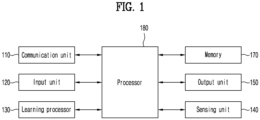
- FIG. 1 illustrates an AI device 100 according to an embodiment of the present disclosure.
- the AI device 100 illustrated in FIG. 1 may be configured as a stationary device or a mobile device, such as a TV, a projector, a portable phone, a smartphone, a desktop computer, a laptop computer, a digital broadcasting terminal, a personal digital assistant (PDA), a portable multimedia player (PMP), a navigation device, a tablet PC, a wearable device, a set-top box (STB), a digital multimedia broadcasting (DMB) receiver, a radio, a washing machine, a refrigerator, a digital signage, a robot, or a vehicle.
- a mobile device such as a TV, a projector, a portable phone, a smartphone, a desktop computer, a laptop computer, a digital broadcasting terminal, a personal digital assistant (PDA), a portable multimedia player (PMP), a navigation device, a tablet PC, a wearable device, a set-top box (STB), a digital multimedia broadcasting (DMB) receiver, a radio, a washing machine, a refrigerator
- the AI device 100 may include a communication unit 110, an input unit 120, a learning processor 130, a sensing unit 140, an output unit 150, a memory 170, and a processor 180.
- the communication unit 110 may transmit and receive data to and from an external device such as other AI devices 100a to 100e or an AI server 200 by wired or wireless communication.
- the communication unit 110 may transmit and receive sensor information, a user input, a learning model, and a control signal to and from the external device.
- Communication schemes used by the communication unit 110 include global system for mobile communication (GSM), CDMA, LTE, 5G, wireless local area network (WLAN), wireless fidelity (Wi-Fi), Bluetooth TM , radio frequency identification (RFID), infrared data association (IrDA), ZigBee, near field communication (NFC), and so on.
- GSM global system for mobile communication
- CDMA Code Division Multiple Access
- LTE Long Term Evolution
- 5G wireless local area network
- Wi-Fi wireless fidelity
- Bluetooth TM Bluetooth TM
- RFID radio frequency identification
- IrDA infrared data association
- ZigBee ZigBee
- NFC near field communication
- the input unit 120 may acquire various types of data.
- the input unit 120 may include a camera for inputting a video signal, a microphone for receiving an audio signal, and a user input unit for receiving information from a user.
- the camera or the microphone may be treated as a sensor, and thus a signal acquired from the camera or the microphone may be referred to as sensing data or sensor information.
- the input unit 120 may acquire training data for model training and input data to be used to acquire an output by using a learning model.
- the input unit 120 may acquire raw input data.
- the processor 180 or the learning processor 130 may extract an input feature by preprocessing the input data.
- the learning processor 130 may train a model composed of an ANN by using training data.
- the trained ANN may be referred to as a learning model.
- the learning model may be used to infer a result value for new input data, not training data, and the inferred value may be used as a basis for determination to perform a certain operation.
- the learning processor 130 may perform AI processing together with a learning processor 240 of an AI server 200.
- the learning processor 130 may include a memory integrated or implemented in the AI device 100. Alternatively, the learning processor 130 may be implemented by using the memory 170, an external memory directly connected to the AI device 100, or a memory maintained in an external device.
- the sensing unit 140 may acquire at least one of internal information about the AI device 100, ambient environment information about the AI device 100, and user information by using various sensors.
- the sensors included in the sensing unit 140 may include a proximity sensor, an illumination sensor, an accelerator sensor, a magnetic sensor, a gyro sensor, an inertial sensor, a red, green, blue (RGB) sensor, an IR sensor, a fingerprint recognition sensor, an ultrasonic sensor, an optical sensor, a microphone, a light detection and ranging (LiDAR), and a radar.
- a proximity sensor an illumination sensor, an accelerator sensor, a magnetic sensor, a gyro sensor, an inertial sensor, a red, green, blue (RGB) sensor, an IR sensor, a fingerprint recognition sensor, an ultrasonic sensor, an optical sensor, a microphone, a light detection and ranging (LiDAR), and a radar.
- the output unit 150 may generate a visual, auditory, or haptic output.
- the output unit 150 may include a display unit for outputting visual information, a speaker for outputting auditory information, and a haptic module for outputting haptic information.
- the memory 170 may store data that supports various functions of the AI device 100.
- the memory 170 may store input data acquired by the input unit 120, training data, a learning model, a learning history, and so on.
- the processor 180 may determine at least one executable operation of the AI device 100 based on information determined or generated by a data analysis algorithm or a machine learning algorithm. The processor 180 may control the components of the AI device 100 to execute the determined operation.
- the processor 180 may request, search, receive, or utilize data of the learning processor 130 or the memory 170.
- the processor 180 may control the components of the AI device 100 to execute a predicted operation or an operation determined to be desirable among the at least one executable operation.
- the processor 180 may generate a control signal for controlling the external device and transmit the generated control signal to the external device.
- the processor 180 may acquire intention information with respect to a user input and determine the user's requirements based on the acquired intention information.
- the processor 180 may acquire the intention information corresponding to the user input by using at least one of a speech to text (STT) engine for converting a speech input into a text string or a natural language processing (NLP) engine for acquiring intention information of a natural language.
- STT speech to text
- NLP natural language processing
- At least one of the STT engine or the NLP engine may be configured as an ANN, at least part of which is trained according to the machine learning algorithm. At least one of the STT engine or the NLP engine may be trained by the learning processor, a learning processor of the AI server, or distributed processing of the learning processors.
- the processor 180 may collect history information including the operation contents of the AI device 100 or the user's feedback on the operation and may store the collected history information in the memory 170 or the learning processor 130 or transmit the collected history information to the external device such as the AI server.
- the collected history information may be used to update the learning model.
- the processor 180 may control at least a part of the components of AI device 100 so as to drive an application program stored in the memory 170. Furthermore, the processor 180 may operate two or more of the components included in the AI device 100 in combination so as to drive the application program.
- FIG. 2 illustrates an AI server 200 according to an embodiment of the present disclosure.
- the AI server 200 may refer to a device that trains an ANN by a machine learning algorithm or uses a trained ANN.
- the AI server 200 may include a plurality of servers to perform distributed processing, or may be defined as a 5G network.
- the AI server 200 may be included as part of the AI device 100, and perform at least part of the AI processing.
- the AI server 200 may include a communication unit 210, a memory 230, a learning processor 240, a processor 260, and so on.
- the communication unit 210 may transmit and receive data to and from an external device such as the AI device 100.
- the memory 230 may include a model storage 231.
- the model storage 231 may store a model (or an ANN 231a) which has been trained or is being trained through the learning processor 240.
- the learning processor 240 may train the ANN 231a by training data.
- the learning model may be used, while being loaded on the AI server 200 of the ANN, or on an external device such as the AI device 100.
- the learning model may be implemented in hardware, software, or a combination of hardware and software. If all or part of the learning model is implemented in software, one or more instructions of the learning model may be stored in the memory 230.
- the processor 260 may infer a result value for new input data by using the learning model and may generate a response or a control command based on the inferred result value.
- FIG. 3 illustrates the AI system 1 according to an embodiment of the present disclosure.
- the AI system 1 may be configured by connecting at least one of the AI server 200, a robot 100a, an autonomous vehicle 100b, an XR device 100c, a smartphone 100d, or a home appliance 100e to a cloud network 10.
- the robot 100a, the autonomous vehicle 100b, the XR device 100c, the smartphone 100d, or the home appliance 100e, to which AI technology is applied may be referred to as AI devices 100a to 100e.
- the cloud network 10 may refer to a network that constitutes a part of a cloud computing infrastructure or exists within a cloud computing infrastructure.
- the cloud network 10 may be configured using a 3G network, a 4G or long term evolution (LTE) network, or a 5G network.
- LTE long term evolution
- the devices 100a to 100e and 200 constituting the AI system 1 may be connected to each other through the cloud network 10.
- the devices 100a to 100e and 200 may communicate with each other through a base station, but may also communicate with each other directly without going through a base station.
- the AI server 200 may include a server that performs AI processing and a server that performs operations on big data.
- the AI server 200 may be connected to at least one of AI devices constituting the AI system 1, such as the robot 100a, the autonomous vehicle 100b, the XR device 100c, the smartphone 100d, or the home appliance 100e, through the cloud network 10 and may assist at least a part of the AI processing of the connected AI devices 100a to 100e.
- AI devices constituting the AI system 1, such as the robot 100a, the autonomous vehicle 100b, the XR device 100c, the smartphone 100d, or the home appliance 100e, through the cloud network 10 and may assist at least a part of the AI processing of the connected AI devices 100a to 100e.
- the AI server 200 may train an ANN according to a machine learning algorithm on behalf of the AI devices 100a to 100e and may directly store the learning model or transmit the learning model to the AI devices 100a to 100e.
- the AI server 200 may receive input data from the AI devices 100a to 100e, infer a result value for the received input data by using the learning model, and generate a response or control command based on the inferred result value and transmit the response or control command to the AI devices 100a to 100e.
- the AI devices 100a to 100e may directly infer a result value for input data by using a learning model and generate a response or control command based on the inferred result value.
- the AI devices 100a to 100e to which the technology described above is applied are described.
- the AI devices 100a to 100e shown in FIG. 3 may be considered as specific examples of the AI device 100 illustrated in FIG. 1 .
- the robot 100a may be implemented as a guide robot, a transport robot, a cleaning robot, a wearable robot, an entertainment robot, a pet robot, an unmanned flying robot, or the like by applying AI technology.
- the robot 100a may include a robot control module for controlling movement, and the robot control module may mean a software module or a chip implementing the same as hardware.
- the robot 100a may obtain status information of the robot 100a, detect (recognize) an ambient environment and objects, generate map data, determine a movement path and driving plan, determine a response to user interaction, or determine an operation by using sensor information obtained from various types of sensors.
- the robot 100a may use sensor information obtained from at least one sensor from among lidar, radar, and camera to determine the movement path and the driving plan.
- the robot 100a may perform the operations described above by using a learning model including at least one ANN.
- the robot 100a may recognize the ambient environment and objects by using the learning model and determine operations by using the recognized ambient environment information or object information.
- the learning model may be learned directly from the robot 100a or from the external device such as the AI server 200.
- the robot 100a may directly generate a result by using the learning model to perform an operation but may perform the operation by transmitting sensor information to the external device such as the AI server 200 and receiving the result generated accordingly.
- the robot 100a may determine a movement path and a driving plan by using at least one of map data, object information detected from sensor information, or object information obtained from an external device, and control a driving unit to drive the robot 100a according to the determined movement path and driving plan.
- the map data may include object identification information for various objects located in a space in which the robot 100a moves.
- map data may include object identification information for fixed objects such as walls and doors, as well as movable objects such as flower pots and desks.
- the object identification information may include a name, a type, a distance, or a location.
- the robot 100a may control the driving unit based on control/interaction of a user.
- the robot 100a may obtain intention information of interaction according to movement or voice utterance of the user and determine a response based on the obtained intention information to perform an operation.
- the autonomous vehicle 100b may be implemented as mobile robots, vehicles, unmanned aerial vehicles, or the like by applying AI technology.
- the autonomous vehicle 100b may include an autonomous driving control module for controlling an autonomous driving function, and the autonomous driving control module may mean a software module or a chip that implements the same as hardware.
- the autonomous driving control module may be included internally as a component of the autonomous vehicle 100b but may also be configured as separate hardware and connected to the outside of the autonomous vehicle 100b.
- the autonomous vehicle 100b may obtain status information of the autonomous vehicle 100b, detect (recognize) an ambient environment and objects, generate map data, determine a movement path and driving plan, or determine an operation by using sensor information obtained from various types of sensors.
- the autonomous vehicle 100b may use sensor information obtained from at least one sensor from among lidar, radar, and camera, similar to the robot 100a, to determine a movement path and a driving plan.
- the autonomous vehicle 100b may recognize the environment or objects in an area in which a field of vision is hidden or an area greater than a certain distance by receiving sensor information from external devices or may receive information recognized directly from external devices.
- the autonomous vehicle 100b may perform the operations described above by using a learning model including at least one ANN.
- the autonomous vehicle 100b may recognize the ambient environment and objects by using the learning model and determine a driving path by using the recognized ambient environment information or object information.
- the learning model may be learned directly from the autonomous vehicle 100b or from the external device such as the AI server 200.
- the autonomous vehicle 100b may directly generate a result by using the learning model to perform an operation but may perform the operation by transmitting sensor information to the external device such as the AI server 200 and receiving the result generated accordingly.
- the autonomous vehicle 100b may determine a movement path and a driving plan by using at least one of map data, object information detected from sensor information, or object information obtained from an external device, and control a driving to drive the autonomous vehicle 100b according to the determined movement path and driving plan.
- the map data may include object identification information for various objects located in a space in which the autonomous vehicle 100b moves.
- map data may include object identification information for fixed objects such as streetlights, rocks, and buildings, as well as movable objects such as vehicles and pedestrians.
- the object identification information may include a name, a type, a distance, or a location.
- the autonomous vehicle 100b may control the driving based on control/interaction of a user.
- the autonomous vehicle 100b may obtain intention information of interaction according to movement or voice utterance of the user and determine a response based on the obtained intention information to perform an operation.
- the XR device 100c may be implemented as a head-mount display (HMD), a head-up display (HUD) installed in a vehicle, a television, a mobile phone, a smart phone, a computer, a wearable device, a home appliance, digital signage, a vehicle, a fixed robot, a mobile robot, or the like by applying AI technology.
- HMD head-mount display
- HUD head-up display
- the XR device 100c may obtain information about a surrounding space or real objects by analyzing 3D point cloud data or image data obtained through various sensors or from an external device to generate location data and attribute data for 3D points and may render and output an XR object to be output. For example, the XR device 100c may output an XR object containing additional information about the recognized object corresponding to the recognized object.
- the XR device 100c may perform the operations described above by using a learning model including at least one ANN.
- the XR device 100c may recognize a real object from 3D point cloud data or image data by using a learning model and provide information corresponding to the recognized real object.
- the learning model may be learned directly from the XR device 100c or from the external device such as the AI server 200.
- the XR device 100c may directly generate a result by using the learning model to perform an operation but may perform the operation by transmitting sensor information to the external device such as the AI server 200 and receiving the result generated accordingly.
- the robot 100a may be implemented as a guide robot, a transport robot, a cleaning robot, a wearable robot, an entertainment robot, a pet robot, an unmanned flying robot, or the like by applying AI technology and autonomous driving technology.
- the robot 100a to which AI technology and autonomous driving technology are applied may refer to a robot itself with an autonomous driving function, or the robot 100a that interacts with the autonomous vehicle 100b.
- the robot 100a with the autonomous driving function may a general term for devices that autonomously move along a given path without user control or move by autonomously determining the path.
- the robot 100a with the autonomous driving function and the autonomous vehicle 100b may use a common sensing method to determine one or more of a movement path or a driving plan.
- the robot 100a with the autonomous driving function and the autonomous vehicle 100b may determine one or more of a movement path or a driving plan by using information sensed through a lidar, radar, and camera.
- the robot 100a interacting with the autonomous vehicle 100b may exist separately from the autonomous vehicle 100b, and may be linked to the autonomous driving function within the autonomous vehicle 100b or perform an operation linked to a user riding in the autonomous vehicle 100b.
- the robot 100a interacting with the autonomous vehicle 100b may control or assist the autonomous driving function of the autonomous vehicle 100b by obtaining sensor information on behalf of the autonomous vehicle 100b and providing the sensor information to the autonomous vehicle 100b or by obtaining the sensor information and generating ambient environment information or object information and providing the generated information to the autonomous vehicle 100b.
- the robot 100a interacting with the autonomous vehicle 100b may monitor a user riding in the autonomous vehicle 100b or control a function of the autonomous vehicle 100b through an interaction with the user. For example, when the robot 100a determines that a driver is drowsy, the robot 100a may activate the autonomous driving function of the autonomous vehicle 100b or assist in controlling the driving unit of the autonomous vehicle 100b.
- the function of the autonomous vehicle 100b controlled by the robot 100a may include not only a simple autonomous driving function, but also a function provided by a navigation system or audio system equipped inside the autonomous vehicle 100b.
- the robot 100a interacting with the autonomous vehicle 100b may provide information to the autonomous vehicle 100b or assist functions from outside the autonomous vehicle 100b.
- the robot 100a may provide traffic information including signal information to the autonomous vehicle 100b, such as a smart traffic light, or may interact with the autonomous vehicle 100b to automatically connect an electric charger to a charging port, such as an automatic electric charger for an electric vehicle.
- the robot 100a may be implemented as a guide robot, a transport robot, a cleaning robot, a wearable robot, an entertainment robot, a pet robot, an unmanned flying robot, a drone, or the like by applying AI technology and XR technology.
- the robot 100a to which XR technology is applied may refer to a robot that is a target of control/interaction within an XR image.
- the robot 100a is separated from the XR device 100c and may be operatively connected thereto.
- the robot 100a that is a target of control/interaction within an XR image obtains sensor information from sensors including a camera
- the robot 100a or the XR device 100c may generate an XR image based on the sensor information, and the XR device 100c may output the generated XR image.
- the robot 100a may operate based on control signals input through the XR device 100c or user interaction.
- a user may check an XR image corresponding to a viewpoint of a remotely connected robot 100a through an external device such as the XR device 100c, and through an interaction, adjust an autonomous driving path of the robot 100a, control the operation or driving, or check information on surrounding objects.
- the autonomous vehicle 100b may be implemented as mobile robots, vehicles, unmanned aerial vehicles, or the like by applying AI technology and XR technology.
- the autonomous vehicle 100b to which XR technology is applied may refer to an autonomous vehicle equipped with a device for providing XR images, an autonomous vehicle that is a target of control/interaction within an XR image, or the like.
- the autonomous vehicle 100b that is a target of control/interaction within the XR image is distinct from the XR device 100c and may be linked therewith.
- the autonomous vehicle 100b including a device for providing XR images may obtain sensor information from sensors including a camera and output an XR image generated based on the obtained sensor information.
- the autonomous vehicle 100b may include an HUD to output an XR image, thereby providing passengers with an XR object corresponding to a real object or an object on a screen.
- an XR object when an XR object is output to the HUD, at least a portion of the XR object may be output to overlap the real object toward which a gaze of the passenger is directed.
- the XR object when the XR object is output to a display inside an autonomous vehicle 100b, at least a part of the XR object may be output to overlap an object on the screen.
- the autonomous vehicle 100b may output XR objects corresponding to objects such as a lane, another vehicle, a traffic light, a traffic sign, a two-wheeled vehicle, a pedestrian, or a building.
- the autonomous vehicle 100b that is a target of control/interaction within an XR image obtains sensor information from sensors including a camera
- the autonomous vehicle 100b or the XR device 100c may generate an XR image based on the sensor information, and the XR device 100c may output the generated XR image.
- the autonomous vehicle 100b may operate based on control signals input through an external device such as the XR device 100c or user interaction.
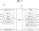
- FIG. 4 illustrates the AI device 100 according to an embodiment of the present disclosure.
- FIG. 1 A repeated description with FIG. 1 is omitted.
- the input unit 120 may include a camera 121 for inputting an image signal, a microphone 122 for receiving an audio signal, and a user input unit 123 for receiving information from a user.
- Voice data or image data collected from the input unit 120 may be analyzed and processed as a control command of the user.
- the input unit 120 is to input image information (or signal), audio information (or signal), data, or information input from the user, and to input the image information, the AI device 100 may include one or more cameras 121.
- the camera 121 processes image frames, such as still images or moving images, obtained by the image sensor in video call mode or shooting mode.
- image frames such as still images or moving images, obtained by the image sensor in video call mode or shooting mode.
- the processed image frame may be displayed in a display unit 151 or stored in the memory 170.
- the microphone 122 processes external acoustic signals into electrical voice data.
- the processed voice data may be utilized in various ways depending on a function being performed (or an application being executed) by the AI device 100.
- Various noise removal algorithms may be applied to the microphone 122 to remove noise generated in a process of receiving the external acoustic signal.
- the user input unit 123 is to receive information from a user.
- the processor 180 may control an operation of the AI device 100 to correspond to the input information.
- the user input unit 123 may include a mechanical input device (or a mechanical key, for example, a button located on a front/rear surface or lateral surface of a terminal 100, a dome switch, a jog wheel, or a jog switch) and a touch input device.
- the touch input device may include a virtual key, a soft key, or a visual key displayed on a touch screen through software processing or may include a touch key located on a portion other than the touch screen.
- the output unit 150 may include at least one of a display unit 151, a sound output unit 152, a haptic module 153, or an optical output unit 154.
- the display unit 151 displays (outputs) information processed in the AI device 100.
- the display unit 151 may display execution screen information of an application program executed in the AI device 100, or user interface (UI) or graphic user interface (GUI) information according to such execution screen information.
- UI user interface
- GUI graphic user interface
- the display unit 151 may implement a touch screen by forming a mutual layer structure with the touch sensor or integrally forming the display unit 151 with the touch screen.
- the touch screen may function as the user input unit 123 that provides an input interface between the AI device 100 and the user while also providing an output interface between the terminal 100 and the user.
- the sound output unit 152 may output audio data received from the communication unit 110 or stored in the memory 170 in a call signal reception mode, a call mode, a recording mode, a voice recognition mode, a broadcast reception mode, or the like.
- the sound output unit 152 may include at least one of a receiver, a speaker, or a buzzer.
- the haptic module 153 generates various tactile effects that the user feels.
- a representative example of the tactile effect generated by the haptic module 153 may include vibration.
- the optical output unit 154 outputs a signal to notify occurrence of an event by using light from a light source of the AI device 100.
- Examples of events occurring in the AI device 100 may include receiving a message, receiving a call signal, receiving a missed call, an alarm, a schedule notification, receiving an email, and receiving information through an application.
- the edge device 100 is a vehicle or a vehicle display device that is to be mounted on the vehicle.
- At least one sensor provided in the sensing unit 140 of the vehicle 100 may collect various data related to the vehicle 100. Data related to the vehicle 100 collected by at least one sensor may be understood as edge data.
- the sensing unit 140 may include at least one of a location search unit (not shown), a vehicle status collection unit (not shown), and a vehicle interior/exterior situation collection unit (not shown).
- the location search unit may search for the current location of the vehicle 100 and provide information about the current location to the processor 180 of the vehicle.
- the location search unit may search the current location of the vehicle through any one of satellite navigation and dead reckoning navigation.
- the satellite navigation measures the location information of the vehicle based on global navigation satellite system (GNSS), and may search for the current location by receiving location information from systems such as global positioning system (GPS), global navigation satellite system (GLONASS), Galileo, and Beidou.
- GNSS global navigation satellite system
- GPS global positioning system
- GLONASS global navigation satellite system
- Galileo Galileo
- Beidou Beidou
- the dead reckoning navigation may measure the location information of the vehicle based on a vehicle speed and dead reckoning (DR) information of the vehicle, which are obtained from a speedometer (not shown), gyroscope sensor (not shown), and geomagnetic sensor (not shown) of the vehicle, and search for the current location.
- DR vehicle speed and dead reckoning
- the vehicle status collection unit may collect a driving status of the vehicle and provide the collected information to the processor 180 of the vehicle.
- the posture, steering status, braking status, acceleration status, and driving status of the vehicle may be collected and provided.
- the vehicle interior/exterior situation collection unit may collect data on the exterior and interior situations of the vehicle and provide the data to the processor 180 of the vehicle.
- the vehicle interior/exterior situation collection unit may include at least one of a camera (e.g., a vehicle exterior camera (i.e., a front camera, a left-side camera, a right-side camera, or a rear-view camera) and a vehicle interior camera (a driver camera or a passenger camera), a radar, and a lidar and detect all surrounding situations necessary for autonomous driving, such as lanes, traffic lights, surrounding vehicles, pedestrians, obstacles, and passengers.
- a camera e.g., a vehicle exterior camera (i.e., a front camera, a left-side camera, a right-side camera, or a rear-view camera) and a vehicle interior camera (a driver camera or a passenger camera), a radar, and a lidar and detect all surrounding situations necessary for autonomous driving, such as lanes, traffic lights, surrounding vehicles, pedestrians, obstacles, and passengers.
- the vehicle 100 may include a navigation system.
- the navigation system may provide navigation information to assist driving of of the vehicle (100).
- the navigation information may include at least one of map information, set destination information, path information according to the set destination, information on various objects on the path, lane information, and current location information of the vehicle.
- the navigation system may include a separate memory for storing navigation information and a dedicated processor for controlling an operation of the navigation system.
- the navigation system may receive information from an external device through the communication unit 130 and update previously stored information.
- the navigation system may be linked with the user input unit 123 to receive commands or information from a user.
- FIG. 5 is a block diagram of a cooperation system between an edge device (e.g., a vehicle) and a cloud server in terms of software, according to an embodiment of the present disclosure.
- an edge device e.g., a vehicle
- a cloud server in terms of software
- Various edge data collected from the vehicle 100 may be transmitted to a driving context data manager 300.
- the edge data may be collected while the vehicle 100 travels or may be collected when the vehicle 100 is stopped.
- the transmission may be performed in real time as the edge data is collected. That is, when the edge data is collected from the vehicle 100, the edge data may be virtually immediately transmitted to the driving context data manager 300.
- the edge data refers to data to be collected from an edge device such as the vehicle 100, examples of which are as follows. However, the present disclosure is not limited thereto.
- the edge data may be data to be collected by the location search unit, the vehicle status collection unit, and the vehicle interior/exterior situation collection unit.
- the edge data may include an external camera image (e.g., a driving image) input in real time through a vision sensor such as an external camera of the vehicle 100.
- Information about surrounding buildings may be obtained through the external camera image.
- the edge data may include information about the topography and/or features of a road on which the vehicle 100 travels, such as the type of road (e.g., highway, national road, or back road), the number and width of lanes, and the presence of building coordinate information, based on map information loaded in the navigation system.
- the type of road e.g., highway, national road, or back road
- the number and width of lanes e.g., the number and width of lanes
- the presence of building coordinate information based on map information loaded in the navigation system.
- the edge data may include data on the exterior and interior situations of the vehicle collected through the vehicle status collection unit while the vehicle 100 travels. For example, there may be sensed driving direction and speed, distance from surrounding vehicles, vehicle posture, and the like.
- the sensing unit 140 may include an ADAS sensor, and the edge data may include driving-related sensing data such as driving direction and speed, distance from lane, and the like, which are obtained through the ADAS sensor 360, as well as data on obstacles or pedestrians around the vehicle.
- driving-related sensing data such as driving direction and speed, distance from lane, and the like, which are obtained through the ADAS sensor 360, as well as data on obstacles or pedestrians around the vehicle.
- the communication unit 110 may include a V2X communication unit, and the edge data may include vehicle traffic related data collected through the V2X communication unit.
- the edge data may include personal profile information of a user (e.g., driver and/or passenger) of the vehicle 100.
- the driving context data manager 300 may extract or generate driving context data from the edge data.
- the driving context data may include at least one of driving path related data, safe driving related data, and computational resource amount of the vehicle 100.
- the driving context data is converted from the edge data by the driving context data manager 300 provided in the vehicle 100, and thus the driving context data may also be understood as a type of edge data.
- Based on the driving context information at least one of a signage displayable area, a maximum number of signage displays, and a signage exposure time may be determined.
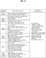
- the edge data and the extraction or conversion of the driving context data therefrom will be described again later with reference to FIG. 6 .
- the driving context data manager 300 may transmit the driving context data to a cloud policy manager 400.
- the cloud policy manager 400 is implemented in a cloud server 200 and its operation will be described later.
- a signage data manager 500 implemented in the cloud server 200 may collate or collect various signage-related information from at least one external data source and store the collated signage-related information in a database 600 provided in the cloud server 200.
- the stored signage-related information may be updated periodically/aperiodically as the signage data manager 500 continuously collects new information from the external data source.
- the external data source may be, for example, an external server.
- the signage-related information may include signage display information such as (but not limited to) transaction service data such as coupons and payments, and advertising-related data.
- the signage-related information may include location information for displaying the signage display information, such as map-related data and building and related topographic feature data, i.e., signage location information.
- the signage-related information may include digital signage information.
- the digital signage information may include augmented reality (AR) information.
- AR augmented reality
- the signage data manager 500 may receive the driving context data from the cloud policy manager 400 and store the received data in the database 600. All of the driving context data may be stored in the database 600, and user profiles from among the driving context data may be selectively stored in the database 600.
- the signage data manager 500 may extract signage-related information appropriate for the vehicle 100 from the collected signage-related information based on the driving context data according to whether a subject location corresponds to the current location and/or expected movement path of the vehicle 100, and the like.
- the signage-related information extracted by the signage data manager 500 may also be referred to as first signage-related information.
- the signage data manager 500 may store the first signage-related information in the database 600.
- various signage-related information and first signage-related information collected from the external data source may be stored and managed in separate areas, each classified for each data characteristic.
- the cloud policy manager 400 may determine whether the extracted signage-related information is appropriately processed in the vehicle 100 and the cloud server 200, i.e., the processing location, based on at least one of the driving context data and the extracted signage-related information (i.e., the first signage-related information).
- the "processing" at the above processing location may mean data processing to convert the first signage-related information into media content to be ultimately displayed on the vehicle 100.
- Determining the processing location may be understood as inferring a proper method of distributing the first signage-related information between the cloud server 200 and the edge device, and to this end, the cloud policy manager 400 may be equipped with an artificial intelligence model for the inference. That is, the extracted signage-related information and the driving context data may be input data for inference for the artificial intelligence model, and the first signage-related information may be output as an inference result through the artificial intelligence model.
- the cloud policy manager 400 may determine that the signage-related information is processed only by the vehicle 100.
- the processing location may correspond to the vehicle 100.
- the cloud policy manager 400 may determine that the signage-related information is processed only by the cloud server 200.
- the processing location may correspond to the cloud server 200.
- the cloud policy manager 400 may also determine that the signage-related information is processed cooperatively by both the vehicle 100 and the cloud server 200.
- the processing location may correspond to the vehicle 100 and the cloud server 200.
- the cloud policy manager 400 may derive a display policy for signage data (i.e., media content described below) to be displayed through the vehicle 100 based on the driving context data (particularly, a profile of the user).
- the display policy of the signage data may be understood as a condition or inference input data for filtering signage-related information (i.e., second signage-related information) that is deemed to be of interest to the user from among the signage-related information (i.e., first signage-related information).
- the cloud policy manager 400 may consider not only the driving context data of the vehicle 100, but also the driving context data of another vehicle moving close to the vehicle 100.
- the processing location and display policy determined by the cloud policy manager 400 will be described in more detail.
- the cloud policy manager 400 may transmit a control signal notifying that the processing location is determined as the cloud server 200 to the signage data manager 500 and a cloud signage data processor 700 provided in the cloud server 200.
- the signage data manager 500 may transmit the extracted first signage-related information to the cloud signage data processor 700.
- the cloud policy manager 400 may transmit the display policy to the cloud signage data processor 700.
- the cloud signage data processor 700 may include a signage data filtering module 710 and a media content processing module 720.
- the signage data filtering module 710 may filter second signage-related information that is inferred to be of interest to the user from among first signage-related information based on the display policy.
- the signage data filtering module 710 may be equipped with an artificial intelligence model for inferring the second signage-related information. That is, the display policy and the first signage-related information may be input data for inference for the artificial intelligence model, and the second signage-related information may be output as an inference result through the artificial intelligence model.
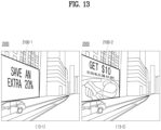
- the media content processing module 720 may convert the filtered second signage-related information into media content such as AR graphic data and tag the converted media content with display location information regarding a location in which the converted media content is to be displayed.
- the signage display information may be converted into the AR graphic data, and in this case, the signage display information may be converted to match the topography or feature, such as a building, on which the AR graphic data is to be displayed, taking into consideration the signage location information.
- the cloud signage data processor 700 may transmit the media content tagged with the display location information to a rendering module 800 provided in the vehicle 1000.
- the rendering module 800 may match the media content to the corresponding location or the corresponding topography or object when the vehicle 100 is determined to approach the corresponding location of the media content within a predetermined distance or when the corresponding topography or feature is recognized through the driving image.
- the media content may be displayed through a display unit 151 together with the driving image to match the corresponding location or the corresponding topography or feature.
- the display unit 151 may include at least one of a center information display (CID), a cluster, a head-up display (HUD), a rear seat entertainment (RSE), and a room mirror display (RMD) in the vehicle 100.
- CID center information display
- HUD head-up display
- RSE rear seat entertainment
- RMD room mirror display
- the cloud policy manager 400 may transmit a control signal notifying that the processing location is determined as the vehicle 100 to the signage data manager 500 and an edge signage data processor 1000 provided in the vehicle 100.
- the signage data manager 500 may transmit the extracted first signage-related information to the edge signage data processor 1000.
- the cloud policy manager 400 may transmit the display policy to the edge signage data processor 1000.
- the edge signage data processor 1000 may, similarly to the cloud signage data processor 700, include a signage data filtering module 1010 and a media content processing module 1020.
- the signage data filtering module 1010 may filter second signage-related information that is inferred to be of interest to the user from among first signage-related information based on the display policy.
- the signage data filtering module 1010 may be equipped with an artificial intelligence model for inferring the second signage-related information. That is, the display policy and the first signage-related information may be input data for inference for the artificial intelligence model, and the second signage-related information may be output as an inference result through the artificial intelligence model.
- the media content processing module 1020 may convert the filtered second signage-related information into media content such as AR graphic data and tag the converted media content with display location information regarding a location in which the converted media content is to be displayed.
- the signage display information may be converted into the AR graphic data, and in this case, the signage display information may be converted to match the topography or feature, such as a building, on which the AR graphic data is to be displayed, taking into consideration the signage location information.
- the edge signage data processor 1000 may transmit the media content tagged with the display location information to the rendering module 800.
- the rendering module 800 may match the media content to the corresponding location or the corresponding topography or object when the vehicle 100 is determined to approach the corresponding location of the media content within a predetermined distance or when the corresponding topography or feature is recognized through the driving image.
- the media content may be displayed through a display unit 151 together with the driving image to match the corresponding location or the corresponding topography or feature.
- the processing location may be determined as the vehicle 100 and the cloud server 200 by the cloud policy manager 400.
- the cloud policy manager 400 may transmit a control signal notifying that the processing location has been determined as the vehicle 100 and the cloud server 200 to the signage data manager 500, the cloud signage data processor 700, and the edge signage data processor 1000.
- the signage data manager 500 may transmit the extracted first signage-related information to the cloud signage data processor 700.
- the cloud policy manager 400 may transmit the display policy to the cloud signage data processor 700.
- the signage data filtering module 710 of the cloud signage data processor 700 may filter second signage-related information that is inferred to be of interest to the user from among the first signage-related information based on the display policy.
- the cloud signage data processor 700 may transmit the filtered second signage-related information to the edge signage data processor 1000.
- the media content processing module 1020 of the edge signage data processor 1000 may convert the filtered second signage-related information into media content such as AR graphic data and tag the converted media content with display location information regarding the location in which the media content is to be displayed.
- the signage display information may be converted into the AR graphic data, and in this case, the signage display information may be converted to match the topography or feature, such as a building, on which the AR graphic data is to be displayed, taking into consideration the signage location information.
- the media content processing module 1020 of the edge signage data processor 1000 may transmit the media content tagged with the display location information to the rendering module 800.
- the rendering module 800 may match the media content to the corresponding location or the corresponding topography or object when the vehicle 100 is determined to approach the corresponding location of the media content within a predetermined distance or when the corresponding topography or feature is recognized through the driving image.
- the media content may be displayed through the display unit 151 together with the driving image to match the corresponding location or the corresponding topography or feature.
- the vehicle 100 may further include an edge policy manager 1100.
- the edge policy manager 1100 may have a similar role to the cloud policy manager 400, and for example, when the vehicle 100 does not communicate smoothly with the cloud server 200 or when the vehicle 100 repeatedly drives the same path, the edge policy manager 1100 may perform the function of the cloud policy manager 400.
- the driving context data manager 300 may transmit a control signal to the edge policy manager 1100 to cause the edge policy manager 1100 to perform the function of the cloud policy manager 400.
- the edge policy manager 1100 may transmit the driving context data received from the driving context data manager 300 and the second signage-related information or the media content stored in the memory 170 (for example, but not limited to, a cache memory) within the vehicle 100 to the edge signage data processor 1000.
- the edge policy manager 1100 may control the edge signage data processor 1000 to directly access the memory 170 and to read out the second signage-related information.
- the edge policy manager 1100 may derive a display policy for signage data to be displayed through the vehicle 100 based on the driving context data (particularly, a profile of the user) and transmit the derived display policy to the signage data processor 1000.
- the signage data processor 1000 may convert the second signage-related information that complies with the display policy into media content and transmit the converted media content to the rendering module 800.
- the signage data processor 1000 may transmit media content that complies with the display policy to the rendering module 800.
- the media content transmitted to the above rendering module 800 is tagged with the display location information.
- the rendering module 800 may match the media content to the corresponding location or the corresponding topography or object when the vehicle 100 is determined to approach the corresponding location of the media content within a predetermined distance or when the corresponding topography or feature is recognized through the driving image.
- the media content may be displayed through the display unit 151 together with the driving image to match the corresponding location or the corresponding topography or feature.
- the edge policy manager 1100, the edge signage data processor 1000, the rendering module 800, and the display unit 151 may be understood to constitute the vehicle display device equipped in the vehicle 100.
- the driving context data manager 300 may or may not be understood as a component belonging to the vehicle display device.
- FIG. 6 illustrates edge data and driving context data extracted therefrom according to an embodiment of the present disclosure.
- the edge data for extracting the driving context data by the driving context data manager 300 may be as follows.
- user information may be utilized as the edge data.
- the user information may include personal information registered for subscription to a service of the present disclosure, such as the gender, age, and place of residence of the user.
- Map or navigation guidance information may be utilized as the edge data.
- the map or navigation guidance information may include i) destination and/or waypoint information, ii) navigation path information to the destination and/or waypoint, iii) turn-by-turn guidance information of the destination and/or waypoint, iv) at least one map information and attributes thereof, and v) road information within the map (e.g., type/attribute, road and lane width, curvature, slope, or speed limit).
- Dynamic (or real-time) information may be utilized as the edge data.
- the dynamic information may include i) traffic information (road-level traffic information and lane-level traffic information), ii) event information such as accidents and hazard warnings, iii) weather information, and iv) coupon information used or available around the current location (including coupon information of other users), iv) communication environment situation information (e.g., communication traffic and/or availability of communication with other vehicles or cloud servers).
- Vehicle sensor information may be utilized as the edge data.
- the vehicle sensor information may include i) current location information (including GPS information and deduced reckoning (DR)-GPS information), ii) camera input information (including ADAS information and object recognition information), iii) V2X information (including real-time surrounding situation information to be collected through V2V and V2I), and iv) remaining fuel or charging amount and information on when to replace consumables.
- a user profile may be utilized as the edge data.
- the user profile may include the i) past/recent driving path, ii) information on preferred brand and interest category registered by the user (e.g. registered hashtag), iii) past/recent destination, waypoint, search location, and registration point, iv) information on major activity hub area, and v) information on downloaded coupon usage history.
- the other driving-related information may include i) driving mode (manual, autonomous driving, semi-autonomous driving, operation of ADAS function, or the like), and ii) electronic horizon information (forward driving path information).
- the driving context data that the driving context data manager 300 is capable of extracting from the edge data may include at least one of i) driving path related data such as an expected driving path and a location and/or information on which signage is to be displayed on the path, ii) safe driving-related data such as a safety rating for a driving section, iii) computational resource amount information such as resource information to be computed and processed in real time in the vehicle 100, iv) signage displayable area information, v) communication environment information, and vi) user information and profile.
- FIG. 7 is a flowchart of a cooperation method between an edge device and a cloud server according to an embodiment of the present disclosure.
- the driving context data manager 300 of the vehicle 100 may collect various edge data related to the vehicle 100 and extract driving context information [S71]. Examples of the collected edge data and the extracted driving context information are as described above with respect to FIG. 6 .
- the driving context information may be transmitted to the signage data manager 500 via the cloud policy manager 400.
- the signage data manager 500 may collect various signage-related information from at least one external data source and extract first signage-related information suitable for the vehicle 100 from the collected signage-related information based on the driving context data [S72].
- the first signage-related information suitable for the vehicle 100 may be, for example, information (but not limited thereto) corresponding to the current location and/or expected movement path of the vehicle 100 from among the collected signage-related information.
- the cloud policy manager 400 may determine whether the first signage-related information is appropriately processed in the vehicle 100 or the cloud server 200, i.e., the processing location, based on the driving context data and the first signage-related information. This may be understood as inferring data processing distribution between the cloud server 200 and the edge device (i.e., the vehicle 100) [S73].
- the first signage-related information may be transmitted to the cloud signage data processor 700 and processed as data [S74]. That is, based on the display policy determined by the cloud policy manager 400, the second signage-related information that is inferred to be of interest to the user from among the first signage-related information may be filtered by the cloud signage data processor 700.
- the second signage-related information may be converted into media content such as AR graphic data, and display location information regarding a location in which the converted media content is to be displayed may be tagged to the converted media content.
- the first signage-related information may be transmitted to the edge signage data processor 1000 and processed as data [S75]. That is, based on the display policy determined by the cloud policy manager 400, the second signage-related information that is inferred to be of interest to the user from among the first signage-related information may be filtered by the edge signage data processor 1000.
- the second signage-related information may be converted into media content such as AR graphic data, and display location information regarding a location in which the converted media content is to be displayed may be tagged to the converted media content.
- the first signage-related information may be transmitted to the cloud signage data processor 700 and processed as data [S74]. That is, based on the display policy determined by the cloud policy manager 400, the second signage-related information that is inferred to be of interest to the user from among the first signage-related information may be filtered by the cloud signage data processor 700.
- the second signage-related information filtered by the cloud signage data processor 700 may be transmitted to the edge signage data processor 1000 and processed as data [S75]. That is, the second signage-related information may be converted into media content such as AR graphic data by the edge signage data processor 1000, and display location information regarding the location in which the media content is to be displayed may be tagged to the converted media content.
- the media content tagged with the display location information may be transmitted to the rendering module 800 of the vehicle 100, and when the vehicle 100 is determined to approach the corresponding location of the media content within a predetermined distance or when the corresponding topography or feature is recognized through the driving image, the media content may be rendered to match the corresponding location or the corresponding topography or feature [S76].
- the media content may be displayed through the display unit 151 together with the driving image to match the corresponding location or the corresponding topography or feature [S77].
- the processing status of signage-related information in the vehicle 100 may be fed back to the cloud policy manager 400 [S78]. This is to prevent signage-related information that has already been processed in the vehicle 100 and stored in the memory 140 (for example, but not limited to, a cache memory) from being processed again, for example, the inference result from the edge signage data processor 1000 and/or the second signage-related information may be fed back to the cloud policy manager 400.
- the rendered media content in operation S76 or the media content displayed in operation S77 may be fed back to the cloud policy manager 400 to prevent redundant processing.
- the cloud policy manager 400 may refer to the fed-back information or data when determining the processing location. For example, when the fed back information or data overlaps the signage-related information that needs to be newly processed to a certain degree or more, the cloud policy manager 400 may determine the processing location to the vehicle 100, and the vehicle 100 may reuse the information or data, thereby preventing data processing from being performed redundantly.
- FIG. 8 is a flowchart illustrating a process for displaying media content processed through a cooperation system between an edge device and a cloud server according to an embodiment of the present disclosure
- FIGS. 9 and 10 illustrate examples for displaying media content processed through a cooperation system between an edge device and a cloud server according to an embodiment of the present disclosure.
- map information disclosed in the present specification mentioned in the present disclosure may be referred to as including an image captured by a vision sensor such as a camera, two-dimensional map information, three-dimensional map information, a digital twin three-dimensional map, and map information in a real/virtual space.
- a vision sensor such as a camera
- two-dimensional map information three-dimensional map information
- a digital twin three-dimensional map a digital twin three-dimensional map
- the "point of interest (POI) information” mentioned in the present disclosure is a point of interest selected based on the map information and may include pre-registered POI information (POI stored on a map of a cloud server), user-defined POI information (e.g., my home, school, and company), driving-related POI information (e.g., destination, waypoint, gas station, rest area, and parking lot), and top search POI information (e.g., POI with a lot of recent clicks/visits and hot places).
- This POI information may be updated in real time based on the current location of the vehicle 100.
- the "driving image” mentioned in the present disclosure may be obtained through a vision sensor of the vehicle 100 or the surroundings of the vehicle 100, and may include, for example, an image obtained or projected through a vision sensor (external camera, laser sensor for image, and the like) while the vehicle travels, an image of the real world projected on a windshield of the vehicle, or an image of a virtual space. That is, the driving image may be referred to as including all images output through a display, images projected through a laser sensor, or the image of reality itself seen through the windshield of the vehicle.
- the rendering module 800 of the vehicle 100 may obtain floor information for each of a plurality of pieces of POI information by calculating spatial coordinates for a building area including at least the plurality of pieces of POI information from the map information [S81]. That is, when a building including a plurality of POIs is detected/recognized from the map information, x, y, and z coordinate information therefor may be calculated as spatial coordinates.
- spatial coordinates may be calculated by receiving information on the location, height, and number of floors of a building area including the plurality of pieces of POI information from the cloud server.
- the map information is a driving image obtained through a vision sensor such as a camera equipped in a vehicle
- the location, height, and number of floors of the building area may be estimated based on the driving image, and spatial coordinates may be estimated therefrom.
- the floor information for each of the plurality of pieces of POI information included in the building area may be calculated/estimated.
- a floor height value i.e. a height offset
- each floor corresponding to the plurality of pieces of POI information may be calculated or estimated.
- the rendering module 800 may calculate a reference point for displaying media content such as AR signage graphic data related to a plurality of pieces of POI information based on the sensing data of the vehicle 100 and the spatial coordinates and floor information of the building area [S82].
- the media content may mean, for example, brand icons, 3D models, still images, and video images for advertising exposure related to POI.
- the reference point of the building area in which the media content information is to be displayed may be calculated by matching information about vehicle sensing data (vehicle driving speed and direction), spatial coordinates of the building area, and floor information of each POI piece of information to correspond to the driving image.
- the reference point may be determined as a coordinate point closest to the current location based on a driving direction of the vehicle from among the spatial coordinates of the building area.
- Each display area for the plurality of pieces of POI information is set to a location moved by the corresponding floor number + height offset from the reference point by applying a height offset to the floor information corresponding to each of the plurality of pieces of POI information based on the reference point.
- the coordinate point close to the current location of the vehicle 100 may be obtained or estimated through edge detection of a building recognized using coordinate data included in map information or sensing information of a camera equipped in the vehicle.
- the reference point for each media content corresponding to the plurality of pieces of POI information (hereinafter, "floor-specific reference point") may be set to a height offset (off) equal to the reference point + the number of floors matching each POI piece of information. That is, different floor-specific reference points may be calculated and applied to each of a plurality of media contents.
- the rendering module 800 may perform rendering to display AR signage graphic data corresponding to the media content in a display area determined based on the calculated reference point [S83].
- the rendering module 800 may determine a display area for mapping a plurality of AR signage graphic data matching the plurality of pieces of POI information to each floor of the building.
- the display areas of the plurality of AR signage graphic data corresponding to the plurality of pieces of POI information may be determined using the height information of the building area calculated based on the spatial coordinates for the building area and the floor information matching each of the plurality of pieces of POI information.
- the rendering module 800 may determine the display area to map the media content information by using the height information and floor information of the building area estimated using the camera sensing information included in the sensing data of the vehicle 100.
- the rendering result may be output to match each floor of the display area of the building in the driving image and displayed on the display unit 151 [S84].
- spatial coordinates 1211, 1212, 1213, and P for the building area 1200 may be calculated (or estimated) based on map information (e.g., 2D/3D map information, or number of floors and height information of the building area) or a driving image obtained through a vision sensor such as an external camera equipped in the vehicle 100.
- map information e.g., 2D/3D map information, or number of floors and height information of the building area
- a vision sensor such as an external camera equipped in the vehicle 100.
- an origin P for mapping AR signage graphic data for each floor to the driving image may be extracted.
- a reference coordinate closest to the location of the vehicle 100 included in the sensing data of the vehicle 100 may be set as the origin P in consideration of a driving direction 1201 of the vehicle 100 from among the spatial coordinates 1211, 1212, 1213, and P of the building area.
- the origin P may be calculated by considering the driving direction of the vehicle 100.
- map information for the building area 1200 does not exist (or is not recognized) or information on the number of floors and height may not be obtained
- the height and number of floors of the building may be estimated from an image of the building by using sensing information of the vision sensor equipped in the vehicle 100, and the origin for the building area may be extracted by detecting the edge of the image.
- the height of each floor may be used as a predefined value.
- the "floor-specific reference point" needs to be calculated for each of the multiple AR signage graphic data.
- the "floor-specific reference point" for the plurality of AR signage graphic data is a location moved in height by the number of floors of the corresponding POI information based on the spatial coordinates 1211, 1212, 1213, and P of the building area and the origin P. That is, the location in which the origin P + the height offset (off) corresponding to the number of floors matching each piece of POI information is applied may be determined as the "floor-specific reference point", and the corresponding AR signage graphic data may be mapped thereto.
- a reference point of first AR signage graphic data 1301 displayed on a first floor of the building area 1200 may be determined as the origin P.
- the floor-specific reference point of second AR signage graphic data 1302 displayed on the second floor of the building area 1200 may be determined as a point P1 obtained by applying a height offset of two floors from the origin P.
- the floor-specific reference points of third and fourth AR signage graphic data 1303 and 1304 displayed on third and fourth floors, respectively, of the building area 1200 may be determined as points P2 and P3 obtained by applying height offsets of three and four floors, respectively, from the origin P.
- the height information of each display area determined based on the floor-specific reference point as above is compared with height data included in the map information (e.g., 2D/3D map information), and at least one of the location and shape of each display area may be corrected based on the comparison result.
- a threshold value normal error range
- the inter-floor height offset described in FIG. 10 may be changed.
- a plurality of AR signage graphic data 1301, 1302, 1303, and 1304 may be mapped for respective floors to a lateral surface, not a front surface, of the building area 1200.
- the plurality of AR signage graphic data 1301, 1302, 1303, and 1304 mapped to the respective floors in the building area 1200 may be mapped to surround at least one surface of each display area of the building in the driving image.
- the plurality of AR signage graphic data 1301, 1302, 1303, and 1304 may be formed to cover the front surface of the building area 1200 for the respective floors. Accordingly, multiple advertising exposure effects may be provided on each floor of a building, and a sense of realism similar to that of an actual signage display board may be provided.
- FIG. 11 illustrates a driving image in which AR signage graphic data is displayed according to an embodiment of the present disclosure.
- the driving image 2000 may be output through the display unit 151, projected through a laser sensor, or the like, or displayed through a windshield of the vehicle 100.
- At least one AR signage graphic data may be overlaid and displayed on the driving image 2000 to match the corresponding location or corresponding topography or feature.
- FIG. 11 illustrates an example of a plurality of AR signage graphic data 2010, 2020, 2025, 2030, 2035, 2040, and 2050 being displayed.
- the at least one AR signage graphic data may include advertising signage 2010, 2020, and 2030, coupon signage 2025 and 2035, driving guidance signage 2040 and 2050.
- the coupon signage 2025 and 2035 may be displayed together with the corresponding advertising signage 2025 and 2035.
- the processing locations of some data 2010, 2020, 2025, 2030, and 2035 may be the cloud server 200, and the processing location of the remaining data 2040 and 2050 may be the vehicle 100.
- only AR signage graphic data, the processing location of which is the cloud server 200, may be displayed, or only AR signage graphic data, the processing location of which is the vehicle 100, may be displayed, or these may be displayed mixed with each other.
- FIG. 12 is a flowchart illustrating the logic for determining a processing location according to an embodiment of the present disclosure
- FIG. 13 illustrates a driving image on which AR signage graphic data is displayed according to an embodiment of the present disclosure.
- the vehicle 100 may collect various edge data while driving or stopped.
- Edge data collected from the vehicle 100 may be converted into driving context data and provided to the cloud server 200.
- the signage data manager 500 of the cloud server 200 may collect various signage-related information from at least one external data source.
- the signage data manager 500 may extract appropriate signage-related information, i.e., first signage-related information, for the vehicle 100 based on the driving context data in consideration of whether it corresponds to a current location and/or a location corresponding to an expected movement path of the vehicle 100 and provide the extracted first signage-related information to the cloud policy manager 400.
- the cloud policy manager 400 may determine whether the extracted first signage-related information is appropriately processed in the vehicle 100 or the cloud server 200, i.e., the processing location, based on at least one of the driving context data and the extracted first signage-related information.
- the cloud policy manager 400 may determine the processing location of the first signage-related information [S71].
- the cloud policy manager 400 may consider a change possibility of the first signage-related information when determining the processing location of the first signage-related information [S121].
- the "information change possibility" of the first signage-related information may mean the possibility that the first signage-related information may change within a predetermined unit of time.
- the information change possibility may be determined based on whether content of the advertisement is likely to change within a predetermined unit of time (e.g., 30 seconds) or whether the advertisement is likely to change to a different advertisement.
- the information change possibility may be determined based on whether the signage location information is likely to change within a predetermined unit of time.
- first AR signage graphic data 2100-1 corresponding to the first signage-related information displayed together with the driving image 2000 as shown in (13-1) of FIG. 13 may be changed to second AR signage graphic data 2100-2 as shown in (13-2) of FIG. 13 within the predetermined time.
- the cloud policy manager 400 may determine the processing location of the first signage-related information to the cloud server 200 [S122].
- the processing location may be determined as the cloud server 200 to more quickly and efficiently respond to the information change possibility of the first signage-related information.
- the cloud policy manager 400 may determine the processing location of the first signage-related information to the vehicle 100 [S123].
- the processing location is determined as the vehicle 100, and thus even if communication between the cloud server 200 and the vehicle 100 becomes temporarily unstable in the future, the AR signage graphic data corresponding to the first signage-related information may be stably displayed.
- FIG. 14 is a flowchart illustrating the logic for determining a processing location according to an embodiment of the present disclosure
- FIG. 15 illustrates a driving image on which AR signage graphic data is displayed according to an embodiment of the present disclosure.
- the vehicle 100 may collect various edge data while driving or stopped.
- Edge data collected from the vehicle 100 may be converted into driving context data and provided to the cloud server 200.
- the signage data manager 500 of the cloud server 200 may collect various signage-related information from at least one external data source.
- the signage data manager 500 may extract appropriate signage-related information, i.e., first signage-related information, for the vehicle 100 based on the driving context data in consideration of whether it corresponds to a current location and/or a location corresponding to an expected movement path of the vehicle 100, and provide the extracted first signage-related information to the cloud policy manager 400.
- the cloud policy manager 400 may determine whether the extracted first signage-related information is appropriately processed in the vehicle 100 or the cloud server 200, i.e., the processing location, based on at least one of the driving context data and the extracted first signage-related information.
- the cloud policy manager 400 may determine the processing location of the first signage-related information [S71].
- the cloud policy manager 400 may consider a data size of the first signage-related information when determining the processing location of the first signage-related information [S141].
- the data size of the first signage-related information may be proportional to the amount of computational resources and processing complexity required to process the first signage-related information.
- the data size of the first signage-related information may vary depending on the type and/or number of data of the first signage-related information.
- the data size may be larger than when the type is 2D.
- the data size may be increased.
- data 2110 to 2160 of the first signage-related information of (15-1) of FIG. 15 may be more than data 2120 and 2160 of the first signage-related information of (15-2) of FIG. 15 .
- the cloud policy manager 400 may determine the processing location of the first signage-related information as the cloud server 200 [S142]. When the data size is greater than or equal to a predetermined value, the processing location may be determined as the cloud server 200, thereby allowing the cloud server 200 to take charge of the computational resources and processing complexity according to the first signage-related information, rather than the vehicle 100.
- the cloud policy manager 400 may determine the processing location of the first signage-related information as the vehicle 100 [S143].
- the processing location is determined as the vehicle 100, and thus even if communication between the cloud server 200 and the vehicle 100 becomes temporarily unstable in the future, the AR signage graphic data corresponding to the first signage-related information may be stably displayed.
- FIG. 16 is a flowchart illustrating the logic for determining a processing location according to an embodiment of the present disclosure
- FIG. 17 illustrates a driving image on which AR signage graphic data is displayed according to an embodiment of the present disclosure.
- Edge data collected from the vehicle 100 may be converted into driving context data and provided to the cloud server 200.
- the signage data manager 500 of the cloud server 200 may collect various signage-related information from at least one external data source.
- the signage data manager 500 may extract appropriate signage-related information, i.e., first signage-related information, for the vehicle 100 based on the driving context data in consideration of whether it corresponds to a current location and/or a location corresponding to an expected movement path of the vehicle 100, and provide the extracted first signage-related information to the cloud policy manager 400.
- the cloud policy manager 400 may determine whether the extracted first signage-related information is appropriately processed in the vehicle 100 or the cloud server 200, i.e., the processing location, based on at least one of the driving context data and the extracted first signage-related information.
- the cloud policy manager 400 may determine the processing location of the first signage-related information [S71 and S161].
- the signage displayable area may be determined as a wall surface 2210 on a specific floor of a specific building.
- the cloud policy manager 400 may determine the processing location of the first signage-related information as the cloud server 200 [S162].
- the signage displayable area is less than a predetermined area, such as a wall surface on a specific floor of a specific building, a lot of computational resources may be required or processing complexity may be high according to the first signage-related information, and thus the computational resources and processing complexity are to be handled by the cloud server 200 rather than the vehicle 100.
- the signage displayable area may be determined as a side wall surface 2220 of the tunnel.
- the cloud policy manager 400 may determine the processing location of the first signage-related information as the vehicle 100 [S163].
- the signage displayable area is equal to or equal to a predetermined area, such as the side wall surface of the tunnel, the computational resources according to the first signage-related information may not be required much or the processing complexity may be low, and thus there may not be a major problem even if the vehicle 100 is capable of handling it.
- FIG. 18 is a flowchart illustrating logic for determining a processing location according to an embodiment of the present disclosure.
- Edge data collected from the vehicle 100 may be converted into driving context data and provided to the cloud server 200.
- the signage data manager 500 of the cloud server 200 may collect various signage-related information from at least one external data source.
- the signage data manager 500 may extract appropriate signage-related information, i.e., first signage-related information, for the vehicle 100 based on the driving context data in consideration of whether it corresponds to a current location and/or a location corresponding to an expected movement path of the vehicle 100, and provide the extracted first signage-related information to the cloud policy manager 400.
- the cloud policy manager 400 may determine whether the extracted first signage-related information is appropriately processed in the vehicle 100 or the cloud server 200, i.e., the processing location, based on at least one of the driving context data and the extracted first signage-related information.
- the cloud policy manager 400 may determine the processing location of the first signage-related information depending on the communication traffic or communication availability between the client 200 and the vehicle 100 according to the driving context data [S71 and S181].
- the cloud policy manager 400 may not necessarily need to refer to the driving context data when determining the processing location of the first signage-related information based on the communication traffic or the communication availability.
- the cloud policy manager 400 or the cloud server 200 may independently determine a communication traffic situation or the communication availability with the vehicle 100, and based thereon, the processing location of the first signage-related information may also be determined.
- the cloud policy manager 400 may determine the processing location of the first signage-related information as the cloud server 200 [S182].
- the cloud policy manager 400 may determine the processing location of the first signage-related information as the vehicle 100 [S183].
- FIG. 19 is a flowchart illustrating the logic for determining a processing location according to an embodiment of the present disclosure
- FIG. 20 illustrates a driving image on which AR signage graphic data is displayed according to an embodiment of the present disclosure.
- Edge data collected from the vehicle 100 may be converted into driving context data and provided to the cloud server 200.
- the signage data manager 500 of the cloud server 200 may collect various signage-related information from at least one external data source.
- the signage data manager 500 may extract appropriate signage-related information, i.e., first signage-related information, for the vehicle 100 based on the driving context data in consideration of whether it corresponds to a current location and/or a location corresponding to an expected movement path of the vehicle 100, and provide the extracted first signage-related information to the cloud policy manager 400.
- the cloud policy manager 400 may determine whether the extracted first signage-related information is appropriately processed in the vehicle 100 or the cloud server 200, i.e., the processing location, based on at least one of the driving context data and the extracted first signage-related information.
- the cloud policy manager 400 may determine the processing location of the first signage-related information [S71 and S191].
- the cloud policy manager 400 may determine the processing location of the first signage-related information as the cloud server 200 [S192]. Accordingly, AR signage graphic data 2210 according to the first signage-related information may be processed by the cloud server 200.
- the cloud policy manager 400 may determine the processing location of the first signage-related information as the vehicle 100 [S193]. Accordingly, AR signage graphic data 2230 and 2240 according to the first signage-related information may be processed by the vehicle 100.
- a displayable area of the AR signage graphic data 2230 and 2240 may be an edge area of a highway or a dedicated automobile road. That is, the displayable area of the AR signage graphic data 2230 and 2240 may not need to be a wall surface of a specific building.
- FIG. 21 is a flowchart illustrating the logic for determining a processing location according to an embodiment of the present disclosure
- FIG. 22 illustrates a driving image on which AR signage graphic data is displayed according to an embodiment of the present disclosure.
- the cloud policy manager 400 may consider a data size of the first signage-related information when determining the processing location of the first signage-related information [S141].
- the cloud policy manager 400 may distribute the first signage-related information and determine the processing location of the first signage-related information as both the vehicle 100 and the cloud server 200 [S211].
- the first signage-related information may be divided according to data type. For example, from among the first signage-related information, data related to AR signage graphic for advertisements may be classified as first data, and from among the first signage-related information, data related to AR signage graphic for point of interest (POI) may be classified as second data.
- POI point of interest
- the cloud policy manager 400 may determine the processing location of the first data as the cloud server 200 and the processing location of the second data as the vehicle 200.
- FIG. 22 illustrates an example in which AR signage graphic data 2110 and 2120 processed by the cloud server 200 as a relationship classified as first data and AR signage graphic data 2170, 2180, and 2190 processed by the vehicle 100 as a relationship classified as second data are displayed together with the driving image 200.
- the first signage-related information is distributed and processed by both the cloud server 200 and the vehicle 100.
- the filtering of the first signage-related information into the second signage-related information is performed in the cloud server 200, and the conversion of the filtered second signage-related information into media content such as AR graphic data is performed in the vehicle 100, and thus the cloud server 200 and the vehicle 100 may cooperate to process the first signage-related information.
- This type of cooperative first signage-related information processing may be performed when the size of the first signage-related information data is large or for a specific data type of the first signage-related information (e.g., a type related to an emergency notification such as recall information or time sale).
- the first signage-related information processing in this type of cooperative method has been described above, and thus a detailed description will be omitted.
- the media content to be displayed during the path needs to be processed, but when the vehicle 100 repeatedly travels in the path thereafter, the media content that is previously displayed may be reused as is without a need to process the media content again. This will be explained with reference to FIG. 5 .
- Media content displayed together with the driving image may be stored in the memory 170 (for example, but not limited to, cache memory).
- the edge policy manager 1100 of the vehicle 100 may feedback the media content and/or an identifier thereof stored in the memory 170 to the cloud policy manager 400 in real time, periodically, or aperiodically when a specific event occurs.
- An example of the "specific event” may include (but is not limited to) detection of repeated driving of the same path by the vehicle 100.
- the cloud policy manager 400 may prevent data related to the fed-back media content from being provided to the vehicle from among the media content to be displayed during the same path or the signage-related data.
- the cloud policy manager 400 may transmit a control signal to the edge policy manager 1100 of the vehicle 1100 such that the media content stored in the memory 170 is displayed together with the driving image when the vehicle 100 travels in the same path.
- data that is not identical to the data related to the fed-back media content may be processed by the cloud server 200 and/or the vehicle 100 in the same manner as described above.
- the edge policy manager 1100 may transmit the driving context data received from the driving context data manager 300 and the second signage-related information or the media content stored in the memory 170 (for example, but not limited to, a cache memory) within the vehicle 100 to the edge signage data processor 1000.
- the edge policy manager 1100 may control the edge signage data processor 1000 to directly access the memory 170 and read out second signage-related information.
- the edge policy manager 1100 may derive a display policy for signage data to be displayed through the vehicle 100 based on the driving context data (particularly, a profile of the user) and transmit the derived display policy to the signage data processor 1000.
- the edge signage data processor 1000 may convert the second signage-related information that complies with the display policy into media content and transmit the converted media content to the rendering module 800.
- the signage data processor 1000 may transmit the media content that complies with the display policy to the rendering module 800.
- the media content transmitted to the rendering module 800 is tagged with the display location information.
- the rendering module 800 may match the media content to the corresponding location or the corresponding topography or object when the vehicle 100 is determined to approach the corresponding location of the media content within a predetermined distance or when the corresponding topography or feature is recognized through the driving image.
- the media content may be displayed through a display unit 151 together with the driving image to match the corresponding location or the corresponding topography or feature.
- Various embodiments may be implemented using a machine-readable medium having instructions stored thereon for execution by a processor to perform various methods presented herein.
- machine-readable mediums include HDD (Hard Disk Drive), SSD (Solid State Disk), SDD (Silicon Disk Drive), ROM, RAM, CD-ROM, a magnetic tape, a floppy disk, an optical data storage device, the other types of storage mediums presented herein, and combinations thereof.
- the machine-readable medium may be realized in the form of a carrier wave (for example, a transmission over the Internet).
- the processor may include the controller of the AI device.
Landscapes
- Engineering & Computer Science (AREA)
- Signal Processing (AREA)
- Computer Networks & Wireless Communication (AREA)
- Physics & Mathematics (AREA)
- General Physics & Mathematics (AREA)
- Theoretical Computer Science (AREA)
- General Engineering & Computer Science (AREA)
- Mechanical Engineering (AREA)
- Chemical & Material Sciences (AREA)
- Combustion & Propulsion (AREA)
- Transportation (AREA)
- Life Sciences & Earth Sciences (AREA)
- Business, Economics & Management (AREA)
- Atmospheric Sciences (AREA)
- Multimedia (AREA)
- Data Mining & Analysis (AREA)
- Databases & Information Systems (AREA)
- Computer Hardware Design (AREA)
- Health & Medical Sciences (AREA)
- General Health & Medical Sciences (AREA)
- Medical Informatics (AREA)
- Computing Systems (AREA)
- Accounting & Taxation (AREA)
- Development Economics (AREA)
- Finance (AREA)
- Strategic Management (AREA)
- Software Systems (AREA)
- Human Computer Interaction (AREA)
- Computer Graphics (AREA)
- Game Theory and Decision Science (AREA)
- Marketing (AREA)
- General Business, Economics & Management (AREA)
- Economics (AREA)
- Entrepreneurship & Innovation (AREA)
- Traffic Control Systems (AREA)
- Management, Administration, Business Operations System, And Electronic Commerce (AREA)
- Vehicle Waterproofing, Decoration, And Sanitation Devices (AREA)
Abstract
Description
- The present disclosure relates to an edge-to-cloud cooperation platform for providing signage, and more particularly, to a system and method for providing signage to a user through cooperation between an edge device and a cloud server based on edge data collected from the edge device.
- Recently, due to the popularization of edge devices such as various Internet of Things (IoT) devices and the development of cloud computing technology, cloud services have been widely utilized in which edge data collected from an edge device is transmitted to a cloud server and the cloud server analyze the edge data.
- In this cloud service, it may be insufficient at least in terms of cloud communication traffic and latency that the edge device transmits all edge data to the cloud server and the cloud server processes all edge data. When all edge data collected by the edge device is transmitted to the cloud server, private personal data may also be provided to the cloud server, which may raise privacy concerns.
- To address these issues, edge computing technology may be used to analyze edge data by the edge device collecting the edge data or on a separate edge device, rather than transmitting edge data to the cloud server for data analysis.
- However, in this case, a high-specification edge device needs to be utilized for smooth edge data processing, which may be inefficient in terms of cost.
- In the case of edge devices such as vehicles, various sensors and devices have been installed in the vehicles and the functions of the vehicles have diversified to ensure the safety and convenience of users who use the vehicles. The functions of these vehicles may be divided into convenience functions to ensure the convenience of a driver, and safety functions to ensure the safety of the driver and/or pedestrians.
- The convenience function of a vehicle may be related to driver convenience, such as providing infotainment (information + entertainment) functions to the vehicle, supporting partial autonomous driving functions, or helping secure a field of vision of the driver, such as night vision or blind spots.
- For example, there are functions such as active cruise control (ACC), smart parking assist system (SPAS), night vision (NV), head up display (HUD), around view monitor (AVM), and adaptive headlight system (AHS).
- Recently, technology development for augmented reality (AR) has been actively underway to output graphic objects through a windshield or head up display (HUD) of a vehicle or to output graphic objects to images captured by a camera, thereby additionally outputting graphic objects into a real world. In particular, the development of technologies that utilize augmented reality (AR) technology to guide drivers through paths or expose the drivers to various additional information or advertisements related to POIs on the path has expanded.
- In the case of various guidance or advertisements using augmented reality (AR) technology, if they are not provided at an appropriate location and/or time, they may not only appear somewhat different from reality, but may even be a distraction to driving.
- The present disclosure is proposed to resolve such problems, and is to provide a cooperation system and method between an edge and a cloud, in which the edge and the cloud may appropriately cooperate to efficiently provide signage to a user according to at least one of conditions of an edge device and the characteristics of edge data.
- The object of the present disclosure may be achieved by providing a method of providing data for a vehicle display device, the method including receiving driving context data from a vehicle, collecting signage-related information from an external data source, extracting first signage-related information corresponding to the vehicle from among the collected signage-related information based on the driving context data, determining a display policy for media content to be displayed in the vehicle based on the driving context data, determining a processing location of the first signage-related information based on the driving context data and the first signage-related information, and transmitting the first signage-related information based on the determined processing location.
- The display policy may include a condition for filtering second signage-related information estimated to be preferred by a user from among the first signage-related information based on a profile of the user of the vehicle in the driving context data.
- The method may further include, based on the processing location being determined as a cloud server, filtering second signage-related information from among the first signage-related information in the cloud server based on the display policy, and converting the second signage-related information into the media content by the cloud server.
- The method may further include providing the second signage-related information to the vehicle or providing the media content to the vehicle.
- Based on the processing location being determined solely as the cloud server, the media content may be provided to the vehicle, and based on the processing location being determined as the cloud server and the vehicle, the second signage-related information may be provided to the vehicle.
- The method may further include, based on the processing location being determined as the vehicle, providing the first signage-related information to the vehicle.
- The processing location may be determined based on a change possibility of the first signage-related information.
- The processing location may be determined based on a data size of the first signage-related information.
- The processing location may be determined based on an area of a signage displayable area according to the driving context data.
- The processing location may be determined based on a communication situation with the vehicle.
- The processing location may be determined based on driving stability of the vehicle according to the driving context data.
- The method may further include receiving feedback from the vehicle on the media content displayed in the vehicle, wherein media content identical to the feedback-received media content is not provided to the vehicle.
- The object of the present disclosure may be achieved by providing a vehicle display device for communicating with a cloud server, the vehicle display device including a driving context data manager configured to generate driving context data from edge data collected from a vehicle, an edge signage data processor including a signage data filtering module configured to filter second signage-related information from among first signage-related information based on the display policy upon receiving a display policy and first signage-related data from the cloud server, a rendering module configured to match the media content to a corresponding location of the media content upon receiving media content from the cloud server, and a display unit configured to display the media content together with a driving image to match the corresponding location.
- The vehicle display device may further include an edge policy manager configured to determine a display policy separate from a display policy to be received from the cloud server based on the driving context data.
- The edge policy manager may be configured to determine a condition for filtering second signage-related information estimated to be preferred by a user from among first signage-related information as the display policy based on a profile of the user of the vehicle in the driving context data.
- The edge signage data processor may further include a media content processing module configured to convert second signage-related information into the media content.
- The edge signage data processor may be configured to provide the converted media content to the rendering module to be displayed together with the driving image.
- The vehicle display device may further include a memory configured to store the displayed media content, wherein the edge policy manager may be configured to feedback the stored media content to the cloud server.
- The edge signage data processor may be configured to provide media content that complies with the display policy from among the stored media content to the rendering module, based on the vehicle repeatedly traveling in the same path.
- The driving context data may include at least one of driving path related data, safe driving related data, computational resource amount information of the vehicle, signage displayable area information, communication environment information, user information, and a user profile.
- An effect of an edge and cloud cooperation platform for providing signage according to the present disclosure is described as follows.
- According to at least one of the embodiments of the present disclosure, there is an advantage in that the edge and the cloud may efficiently provide signage to the user by appropriately cooperating according to at least one of conditions of the edge device and the characteristics of the edge data.
-
-
FIG. 1 illustrates an artificial intelligence (AI) device according to an embodiment of the present disclosure. -
FIG. 2 illustrates an AI server according to an embodiment of the present disclosure. -
FIG. 3 illustrates an AI system according to an embodiment of the present disclosure. -
FIG. 4 illustrates an AI device according to an embodiment of the present disclosure. -
FIG. 5 is a block diagram of a cooperation system between an edge device and a cloud server in terms of software according to an embodiment of the present disclosure. -
FIG. 6 illustrates edge data and driving context data extracted therefrom according to an embodiment of the present disclosure. -
FIG. 7 is a flowchart of a cooperation method between an edge device and a cloud server according to an embodiment of the present disclosure. -
FIG. 8 is a flowchart showing a process for displaying media content processed through a cooperation system between an edge device and a cloud server according to an embodiment of the present disclosure. -
FIGS. 9 and10 are diagrams showing display of media content processed through a cooperation system between an edge device and a cloud server according to an embodiment of the present disclosure. -
FIG. 11 illustrates a driving image in which AR signage graphic data is displayed according to an embodiment of the present disclosure. -
FIG. 12 is a flowchart illustrating logic for determining a processing location according to an embodiment of the present disclosure. -
FIG. 13 illustrates a driving image in which AR signage graphic data is displayed according to an embodiment of the present disclosure. -
FIG. 14 is a flowchart illustrating logic for determining a processing location according to an embodiment of the present disclosure. -
FIG. 15 illustrates a driving image in which AR signage graphic data is displayed according to an embodiment of the present disclosure. -
FIG. 16 is a flowchart illustrating logic for determining a processing location according to an embodiment of the present disclosure. -
FIG. 17 illustrates a driving image in which AR signage graphic data is displayed according to an embodiment of the present disclosure. -
FIG. 18 is a flowchart illustrating logic for determining a processing location according to an embodiment of the present disclosure. -
FIG. 19 is a flowchart illustrating logic for determining a processing location according to an embodiment of the present disclosure. -
FIG. 20 illustrates a driving image in which AR signage graphic data is displayed according to an embodiment of the present disclosure. -
FIG. 21 is a flowchart illustrating logic for determining a processing location according to an embodiment of the present disclosure. -
FIG. 22 illustrates a driving image in which AR signage graphic data is displayed according to an embodiment of the present disclosure. - Description will now be given in detail according to exemplary embodiments disclosed herein, with reference to the accompanying drawings. For the sake of brief description with reference to the drawings, the same or equivalent components may be provided with the same reference numbers, and description thereof will not be repeated. In general, a suffix such as "module" and "unit" may be used to refer to elements or components. Use of such a suffix herein is merely intended to facilitate description of the specification, and the suffix itself is not intended to give any special meaning or function. In the present disclosure, that which is well-known to one of ordinary skill in the relevant art has generally been omitted for the sake of brevity. The accompanying drawings are used to help easily understand various technical features and it should be understood that the embodiments presented herein are not limited by the accompanying drawings. As such, the present disclosure should be construed to extend to any alterations, equivalents and substitutes in addition to those which are particularly set out in the accompanying drawings.
- Each of these elements may be configured as a separate individual hardware module or implemented as two or more hardware modules. Two or more elements may be implemented as a single hardware module. In some cases, at least one of these elements may be implemented as software.
- It will be understood that although the terms first, second, etc. may be used herein to describe various elements, these elements should not be limited by these terms. These terms are generally only used to distinguish one element from another.
- It will be understood that when an element is referred to as being "connected with" another element, the element may be directly connected with the other element or intervening elements may also be present. In contrast, when an element is referred to as being "directly connected with" another element, there are no intervening elements present.
- A singular representation may include a plural representation unless it represents a definitely different meaning from the context. Terms such as "include" or "has" are used herein and should be understood that they are intended to indicate an existence of several components, functions or steps, disclosed in the specification, and it is also understood that greater or fewer components, functions, or steps may likewise be utilized.
- In this disclosure, the expression "at least one of A or B" may mean "A", "B", or "A and B".
- Hereinafter, artificial intelligence (AI) to be utilized in the present disclosure will be described.
- Artificial Intelligence (AI) refers to a field that studies artificial intelligence or methodology capable of achieving artificial intelligence. Machine learning refers to a field that defines various problems handled in the AI field and studies methodology for solving the problems. Machine learning may also be defined as an algorithm for raising performance for any task through steady experience of the task.
- An artificial neural network (ANN) may refer to a model in general having problem solving capabilities, that is composed of artificial neurons (nodes) constituting a network by a combination of synapses, as a model used in machine learning. The ANN may be defined by a connection pattern between neurons of different layers, a learning process of updating model parameters, and/or an activation function for generating an output value.
- The ANN may include an input layer, an output layer, and, optionally, one or more hidden layers. Each layer includes one or more neurons and the ANN may include a synapse connecting neurons. In the ANN, each neuron may output input signals, which are input through the synapse, weights, and function values of an activation function for deflection.
- A model parameter refers to a parameter determined through learning and includes a weight of synaptic connection and a deflection of a neuron. A hyperparameter refers to a parameter that should be configured before learning in a machine learning algorithm and includes a learning rate, the number of repetitions, a mini batch size, an initialization function, and the like.
- The purpose of learning of the ANN may be understood as determining the model parameter that minimizes a loss function. The loss function may be used as an index to determine an optimal model parameter in a learning process of the ANN.
- Machine learning may be classified into supervised learning, unsupervised learning, and reinforcement learning, according to a learning scheme.
- Supervised learning refers to a method of training the ANN in a state in which a label for training data is given. The label may represent a correct answer (or result value) that the ANN should infer when the training data is input to the ANN. Unsupervised learning may refer to a method of training the ANN in a state in which the label for the training data is not given. Reinforcement learning may refer to a learning method in which an agent defined in a certain environment is trained to select a behavior or a behavior order that maximizes accumulative compensation in each state.
- Among ANNs, machine learning implemented as a deep neural network (DNN) including a plurality of hidden layers is also called deep learning. Deep learning is a part of machine learning. Hereinbelow, machine learning includes deep learning.
- An object detection model using machine learning includes a you only look once (YOLO) model of a single-step scheme, faster regions with convolution neural networks (R-CNN) model of a two-step scheme, and the like.
- The you only look once (YOLO) model is a model in which an object existing in an image and a position of the corresponding object may be predicted as the image is viewed only once.
- The you only look once (YOLO) model divides the original image into grids of the same size. Then, for each grid, the number of bounding boxes specified in a predefined form around a center of the grid is predicted, and reliability is calculated based on the predicted number.
- Thereafter, whether the image contains the object or contains only a background may be included, and a location with high object reliability may be selected, so that an object category may be identified.
- The faster regions with convolution neural networks (R-CNN) model is a model that may detect the object faster than an RCNN model and a Fast RCNN model.
- The faster regions with convolution neural networks (R-CNN) model will be described in detail.
- First, a feature map is extracted from the image via a convolution neural network (CNN) model. Based on the extracted feature map, a plurality of regions of interest (RoIs) are extracted. RoI pooling is performed for each region of interest.
- The RoI pooling is a process of setting grids of a feature map to which the regions of interest are projected to fit a H × W size that is determined in advance and extracting the greatest value for each cell included in each grid to extract a feature map having the H x W size.
- A feature vector may be extracted from the feature map having the H x W size, and identification information of the object may be obtained from the feature vector.
- Hereinafter, with reference to
FIG. 1 , an AI device to be used as an edge device in the present disclosure will be described.FIG. 1 illustrates anAI device 100 according to an embodiment of the present disclosure. - The
AI device 100 illustrated inFIG. 1 may be configured as a stationary device or a mobile device, such as a TV, a projector, a portable phone, a smartphone, a desktop computer, a laptop computer, a digital broadcasting terminal, a personal digital assistant (PDA), a portable multimedia player (PMP), a navigation device, a tablet PC, a wearable device, a set-top box (STB), a digital multimedia broadcasting (DMB) receiver, a radio, a washing machine, a refrigerator, a digital signage, a robot, or a vehicle. - Referring to
FIG. 1 , theAI device 100 may include acommunication unit 110, aninput unit 120, a learningprocessor 130, asensing unit 140, anoutput unit 150, amemory 170, and aprocessor 180. - The
communication unit 110 may transmit and receive data to and from an external device such asother AI devices 100a to 100e or anAI server 200 by wired or wireless communication. For example, thecommunication unit 110 may transmit and receive sensor information, a user input, a learning model, and a control signal to and from the external device. - Communication schemes used by the
communication unit 110 include global system for mobile communication (GSM), CDMA, LTE, 5G, wireless local area network (WLAN), wireless fidelity (Wi-Fi), Bluetooth™, radio frequency identification (RFID), infrared data association (IrDA), ZigBee, near field communication (NFC), and so on. - The
input unit 120 may acquire various types of data. - The
input unit 120 may include a camera for inputting a video signal, a microphone for receiving an audio signal, and a user input unit for receiving information from a user. The camera or the microphone may be treated as a sensor, and thus a signal acquired from the camera or the microphone may be referred to as sensing data or sensor information. - The
input unit 120 may acquire training data for model training and input data to be used to acquire an output by using a learning model. Theinput unit 120 may acquire raw input data. In this case, theprocessor 180 or thelearning processor 130 may extract an input feature by preprocessing the input data. - The learning
processor 130 may train a model composed of an ANN by using training data. The trained ANN may be referred to as a learning model. The learning model may be used to infer a result value for new input data, not training data, and the inferred value may be used as a basis for determination to perform a certain operation. - The learning
processor 130 may perform AI processing together with alearning processor 240 of anAI server 200. - The learning
processor 130 may include a memory integrated or implemented in theAI device 100. Alternatively, the learningprocessor 130 may be implemented by using thememory 170, an external memory directly connected to theAI device 100, or a memory maintained in an external device. - The
sensing unit 140 may acquire at least one of internal information about theAI device 100, ambient environment information about theAI device 100, and user information by using various sensors. - The sensors included in the
sensing unit 140 may include a proximity sensor, an illumination sensor, an accelerator sensor, a magnetic sensor, a gyro sensor, an inertial sensor, a red, green, blue (RGB) sensor, an IR sensor, a fingerprint recognition sensor, an ultrasonic sensor, an optical sensor, a microphone, a light detection and ranging (LiDAR), and a radar. - The
output unit 150 may generate a visual, auditory, or haptic output. - Accordingly, the
output unit 150 may include a display unit for outputting visual information, a speaker for outputting auditory information, and a haptic module for outputting haptic information. - The
memory 170 may store data that supports various functions of theAI device 100. For example, thememory 170 may store input data acquired by theinput unit 120, training data, a learning model, a learning history, and so on. - The
processor 180 may determine at least one executable operation of theAI device 100 based on information determined or generated by a data analysis algorithm or a machine learning algorithm. Theprocessor 180 may control the components of theAI device 100 to execute the determined operation. - To this end, the
processor 180 may request, search, receive, or utilize data of the learningprocessor 130 or thememory 170. Theprocessor 180 may control the components of theAI device 100 to execute a predicted operation or an operation determined to be desirable among the at least one executable operation. - When the determined operation needs to be performed in conjunction with an external device, the
processor 180 may generate a control signal for controlling the external device and transmit the generated control signal to the external device. - The
processor 180 may acquire intention information with respect to a user input and determine the user's requirements based on the acquired intention information. - The
processor 180 may acquire the intention information corresponding to the user input by using at least one of a speech to text (STT) engine for converting a speech input into a text string or a natural language processing (NLP) engine for acquiring intention information of a natural language. - At least one of the STT engine or the NLP engine may be configured as an ANN, at least part of which is trained according to the machine learning algorithm. At least one of the STT engine or the NLP engine may be trained by the learning processor, a learning processor of the AI server, or distributed processing of the learning processors.
- The
processor 180 may collect history information including the operation contents of theAI device 100 or the user's feedback on the operation and may store the collected history information in thememory 170 or thelearning processor 130 or transmit the collected history information to the external device such as the AI server. The collected history information may be used to update the learning model. - The
processor 180 may control at least a part of the components ofAI device 100 so as to drive an application program stored in thememory 170. Furthermore, theprocessor 180 may operate two or more of the components included in theAI device 100 in combination so as to drive the application program. - Hereinafter, an AI server to be used as a cloud server in the present disclosure will be described.
FIG. 2 illustrates anAI server 200 according to an embodiment of the present disclosure. - Referring to
FIG. 2 , theAI server 200 may refer to a device that trains an ANN by a machine learning algorithm or uses a trained ANN. TheAI server 200 may include a plurality of servers to perform distributed processing, or may be defined as a 5G network. TheAI server 200 may be included as part of theAI device 100, and perform at least part of the AI processing. - The
AI server 200 may include acommunication unit 210, amemory 230, a learningprocessor 240, aprocessor 260, and so on. - The
communication unit 210 may transmit and receive data to and from an external device such as theAI device 100. - The
memory 230 may include amodel storage 231. Themodel storage 231 may store a model (or anANN 231a) which has been trained or is being trained through the learningprocessor 240. - The learning
processor 240 may train theANN 231a by training data. The learning model may be used, while being loaded on theAI server 200 of the ANN, or on an external device such as theAI device 100. - The learning model may be implemented in hardware, software, or a combination of hardware and software. If all or part of the learning model is implemented in software, one or more instructions of the learning model may be stored in the
memory 230. - The
processor 260 may infer a result value for new input data by using the learning model and may generate a response or a control command based on the inferred result value. - Hereinafter, with reference to
FIG. 3 , anAI system 1 according to an embodiment of the present disclosure will be described.FIG. 3 illustrates theAI system 1 according to an embodiment of the present disclosure. - Referring to
FIG. 3 , theAI system 1 may be configured by connecting at least one of theAI server 200, arobot 100a, anautonomous vehicle 100b, anXR device 100c, a smartphone 100d, or ahome appliance 100e to acloud network 10. Here, therobot 100a, theautonomous vehicle 100b, theXR device 100c, the smartphone 100d, or thehome appliance 100e, to which AI technology is applied, may be referred to asAI devices 100a to 100e. - The
cloud network 10 may refer to a network that constitutes a part of a cloud computing infrastructure or exists within a cloud computing infrastructure. Here, thecloud network 10 may be configured using a 3G network, a 4G or long term evolution (LTE) network, or a 5G network. - That is, the
devices 100a to 100e and 200 constituting theAI system 1 may be connected to each other through thecloud network 10. In particular, thedevices 100a to 100e and 200 may communicate with each other through a base station, but may also communicate with each other directly without going through a base station. - The
AI server 200 may include a server that performs AI processing and a server that performs operations on big data. - The
AI server 200 may be connected to at least one of AI devices constituting theAI system 1, such as therobot 100a, theautonomous vehicle 100b, theXR device 100c, the smartphone 100d, or thehome appliance 100e, through thecloud network 10 and may assist at least a part of the AI processing of theconnected AI devices 100a to 100e. - In this case, the
AI server 200 may train an ANN according to a machine learning algorithm on behalf of theAI devices 100a to 100e and may directly store the learning model or transmit the learning model to theAI devices 100a to 100e. - In this case, the
AI server 200 may receive input data from theAI devices 100a to 100e, infer a result value for the received input data by using the learning model, and generate a response or control command based on the inferred result value and transmit the response or control command to theAI devices 100a to 100e. - Alternatively, the
AI devices 100a to 100e may directly infer a result value for input data by using a learning model and generate a response or control command based on the inferred result value. - Hereinafter, various embodiments of the
AI devices 100a to 100e to which the technology described above is applied are described. Here, theAI devices 100a to 100e shown inFIG. 3 may be considered as specific examples of theAI device 100 illustrated inFIG. 1 . - The
robot 100a may be implemented as a guide robot, a transport robot, a cleaning robot, a wearable robot, an entertainment robot, a pet robot, an unmanned flying robot, or the like by applying AI technology. - The
robot 100a may include a robot control module for controlling movement, and the robot control module may mean a software module or a chip implementing the same as hardware. - The
robot 100a may obtain status information of therobot 100a, detect (recognize) an ambient environment and objects, generate map data, determine a movement path and driving plan, determine a response to user interaction, or determine an operation by using sensor information obtained from various types of sensors. - Here, the
robot 100a may use sensor information obtained from at least one sensor from among lidar, radar, and camera to determine the movement path and the driving plan. - The
robot 100a may perform the operations described above by using a learning model including at least one ANN. For example, therobot 100a may recognize the ambient environment and objects by using the learning model and determine operations by using the recognized ambient environment information or object information. Here, the learning model may be learned directly from therobot 100a or from the external device such as theAI server 200. - In this case, the
robot 100a may directly generate a result by using the learning model to perform an operation but may perform the operation by transmitting sensor information to the external device such as theAI server 200 and receiving the result generated accordingly. - The
robot 100a may determine a movement path and a driving plan by using at least one of map data, object information detected from sensor information, or object information obtained from an external device, and control a driving unit to drive therobot 100a according to the determined movement path and driving plan. - The map data may include object identification information for various objects located in a space in which the
robot 100a moves. For example, map data may include object identification information for fixed objects such as walls and doors, as well as movable objects such as flower pots and desks. The object identification information may include a name, a type, a distance, or a location. - The
robot 100a may control the driving unit based on control/interaction of a user. In this case, therobot 100a may obtain intention information of interaction according to movement or voice utterance of the user and determine a response based on the obtained intention information to perform an operation. - The
autonomous vehicle 100b may be implemented as mobile robots, vehicles, unmanned aerial vehicles, or the like by applying AI technology. - The
autonomous vehicle 100b may include an autonomous driving control module for controlling an autonomous driving function, and the autonomous driving control module may mean a software module or a chip that implements the same as hardware. The autonomous driving control module may be included internally as a component of theautonomous vehicle 100b but may also be configured as separate hardware and connected to the outside of theautonomous vehicle 100b. - The
autonomous vehicle 100b may obtain status information of theautonomous vehicle 100b, detect (recognize) an ambient environment and objects, generate map data, determine a movement path and driving plan, or determine an operation by using sensor information obtained from various types of sensors. - Here, the
autonomous vehicle 100b may use sensor information obtained from at least one sensor from among lidar, radar, and camera, similar to therobot 100a, to determine a movement path and a driving plan. - In particular, the
autonomous vehicle 100b may recognize the environment or objects in an area in which a field of vision is hidden or an area greater than a certain distance by receiving sensor information from external devices or may receive information recognized directly from external devices. - The
autonomous vehicle 100b may perform the operations described above by using a learning model including at least one ANN. For example, theautonomous vehicle 100b may recognize the ambient environment and objects by using the learning model and determine a driving path by using the recognized ambient environment information or object information. Here, the learning model may be learned directly from theautonomous vehicle 100b or from the external device such as theAI server 200. - In this case, the
autonomous vehicle 100b may directly generate a result by using the learning model to perform an operation but may perform the operation by transmitting sensor information to the external device such as theAI server 200 and receiving the result generated accordingly. - The
autonomous vehicle 100b may determine a movement path and a driving plan by using at least one of map data, object information detected from sensor information, or object information obtained from an external device, and control a driving to drive theautonomous vehicle 100b according to the determined movement path and driving plan. - The map data may include object identification information for various objects located in a space in which the
autonomous vehicle 100b moves. For example, map data may include object identification information for fixed objects such as streetlights, rocks, and buildings, as well as movable objects such as vehicles and pedestrians. The object identification information may include a name, a type, a distance, or a location. - The
autonomous vehicle 100b may control the driving based on control/interaction of a user. In this case, theautonomous vehicle 100b may obtain intention information of interaction according to movement or voice utterance of the user and determine a response based on the obtained intention information to perform an operation. - The
XR device 100c may be implemented as a head-mount display (HMD), a head-up display (HUD) installed in a vehicle, a television, a mobile phone, a smart phone, a computer, a wearable device, a home appliance, digital signage, a vehicle, a fixed robot, a mobile robot, or the like by applying AI technology. - The
XR device 100c may obtain information about a surrounding space or real objects by analyzing 3D point cloud data or image data obtained through various sensors or from an external device to generate location data and attribute data for 3D points and may render and output an XR object to be output. For example, theXR device 100c may output an XR object containing additional information about the recognized object corresponding to the recognized object. - The
XR device 100c may perform the operations described above by using a learning model including at least one ANN. For example, theXR device 100c may recognize a real object from 3D point cloud data or image data by using a learning model and provide information corresponding to the recognized real object. Here, the learning model may be learned directly from theXR device 100c or from the external device such as theAI server 200. - In this case, the
XR device 100c may directly generate a result by using the learning model to perform an operation but may perform the operation by transmitting sensor information to the external device such as theAI server 200 and receiving the result generated accordingly. - The
robot 100a may be implemented as a guide robot, a transport robot, a cleaning robot, a wearable robot, an entertainment robot, a pet robot, an unmanned flying robot, or the like by applying AI technology and autonomous driving technology. - The
robot 100a to which AI technology and autonomous driving technology are applied may refer to a robot itself with an autonomous driving function, or therobot 100a that interacts with theautonomous vehicle 100b. - The
robot 100a with the autonomous driving function may a general term for devices that autonomously move along a given path without user control or move by autonomously determining the path. - The
robot 100a with the autonomous driving function and theautonomous vehicle 100b may use a common sensing method to determine one or more of a movement path or a driving plan. For example, therobot 100a with the autonomous driving function and theautonomous vehicle 100b may determine one or more of a movement path or a driving plan by using information sensed through a lidar, radar, and camera. - The
robot 100a interacting with theautonomous vehicle 100b may exist separately from theautonomous vehicle 100b, and may be linked to the autonomous driving function within theautonomous vehicle 100b or perform an operation linked to a user riding in theautonomous vehicle 100b. - In this case, the
robot 100a interacting with theautonomous vehicle 100b may control or assist the autonomous driving function of theautonomous vehicle 100b by obtaining sensor information on behalf of theautonomous vehicle 100b and providing the sensor information to theautonomous vehicle 100b or by obtaining the sensor information and generating ambient environment information or object information and providing the generated information to theautonomous vehicle 100b. - Alternatively, the
robot 100a interacting with theautonomous vehicle 100b may monitor a user riding in theautonomous vehicle 100b or control a function of theautonomous vehicle 100b through an interaction with the user. For example, when therobot 100a determines that a driver is drowsy, therobot 100a may activate the autonomous driving function of theautonomous vehicle 100b or assist in controlling the driving unit of theautonomous vehicle 100b. Here, the function of theautonomous vehicle 100b controlled by therobot 100a may include not only a simple autonomous driving function, but also a function provided by a navigation system or audio system equipped inside theautonomous vehicle 100b. - Alternatively, the
robot 100a interacting with theautonomous vehicle 100b may provide information to theautonomous vehicle 100b or assist functions from outside theautonomous vehicle 100b. For example, therobot 100a may provide traffic information including signal information to theautonomous vehicle 100b, such as a smart traffic light, or may interact with theautonomous vehicle 100b to automatically connect an electric charger to a charging port, such as an automatic electric charger for an electric vehicle. - The
robot 100a may be implemented as a guide robot, a transport robot, a cleaning robot, a wearable robot, an entertainment robot, a pet robot, an unmanned flying robot, a drone, or the like by applying AI technology and XR technology. - The
robot 100a to which XR technology is applied may refer to a robot that is a target of control/interaction within an XR image. In this case, therobot 100a is separated from theXR device 100c and may be operatively connected thereto. - When the
robot 100a that is a target of control/interaction within an XR image obtains sensor information from sensors including a camera, therobot 100a or theXR device 100c may generate an XR image based on the sensor information, and theXR device 100c may output the generated XR image. Therobot 100a may operate based on control signals input through theXR device 100c or user interaction. - For example, a user may check an XR image corresponding to a viewpoint of a remotely connected
robot 100a through an external device such as theXR device 100c, and through an interaction, adjust an autonomous driving path of therobot 100a, control the operation or driving, or check information on surrounding objects. - The
autonomous vehicle 100b may be implemented as mobile robots, vehicles, unmanned aerial vehicles, or the like by applying AI technology and XR technology. - The
autonomous vehicle 100b to which XR technology is applied may refer to an autonomous vehicle equipped with a device for providing XR images, an autonomous vehicle that is a target of control/interaction within an XR image, or the like. In particular, theautonomous vehicle 100b that is a target of control/interaction within the XR image is distinct from theXR device 100c and may be linked therewith. - The
autonomous vehicle 100b including a device for providing XR images may obtain sensor information from sensors including a camera and output an XR image generated based on the obtained sensor information. For example, theautonomous vehicle 100b may include an HUD to output an XR image, thereby providing passengers with an XR object corresponding to a real object or an object on a screen. - In this case, when an XR object is output to the HUD, at least a portion of the XR object may be output to overlap the real object toward which a gaze of the passenger is directed. On the other hand, when the XR object is output to a display inside an
autonomous vehicle 100b, at least a part of the XR object may be output to overlap an object on the screen. For example, theautonomous vehicle 100b may output XR objects corresponding to objects such as a lane, another vehicle, a traffic light, a traffic sign, a two-wheeled vehicle, a pedestrian, or a building. - When the
autonomous vehicle 100b that is a target of control/interaction within an XR image obtains sensor information from sensors including a camera, theautonomous vehicle 100b or theXR device 100c may generate an XR image based on the sensor information, and theXR device 100c may output the generated XR image. Theautonomous vehicle 100b may operate based on control signals input through an external device such as theXR device 100c or user interaction. -
FIG. 4 illustrates theAI device 100 according to an embodiment of the present disclosure. - A repeated description with
FIG. 1 is omitted. - Referring to
FIG. 4 , theinput unit 120 may include acamera 121 for inputting an image signal, amicrophone 122 for receiving an audio signal, and auser input unit 123 for receiving information from a user. - Voice data or image data collected from the
input unit 120 may be analyzed and processed as a control command of the user. - The
input unit 120 is to input image information (or signal), audio information (or signal), data, or information input from the user, and to input the image information, theAI device 100 may include one ormore cameras 121. - The
camera 121 processes image frames, such as still images or moving images, obtained by the image sensor in video call mode or shooting mode. The processed image frame may be displayed in adisplay unit 151 or stored in thememory 170. - The
microphone 122 processes external acoustic signals into electrical voice data. The processed voice data may be utilized in various ways depending on a function being performed (or an application being executed) by theAI device 100. Various noise removal algorithms may be applied to themicrophone 122 to remove noise generated in a process of receiving the external acoustic signal. - The
user input unit 123 is to receive information from a user. When information is input through theuser input unit 123, theprocessor 180 may control an operation of theAI device 100 to correspond to the input information. - The
user input unit 123 may include a mechanical input device (or a mechanical key, for example, a button located on a front/rear surface or lateral surface of a terminal 100, a dome switch, a jog wheel, or a jog switch) and a touch input device. For example, the touch input device may include a virtual key, a soft key, or a visual key displayed on a touch screen through software processing or may include a touch key located on a portion other than the touch screen. - The
output unit 150 may include at least one of adisplay unit 151, asound output unit 152, ahaptic module 153, or anoptical output unit 154. - The
display unit 151 displays (outputs) information processed in theAI device 100. For example, thedisplay unit 151 may display execution screen information of an application program executed in theAI device 100, or user interface (UI) or graphic user interface (GUI) information according to such execution screen information. - The
display unit 151 may implement a touch screen by forming a mutual layer structure with the touch sensor or integrally forming thedisplay unit 151 with the touch screen. The touch screen may function as theuser input unit 123 that provides an input interface between theAI device 100 and the user while also providing an output interface between the terminal 100 and the user. - The
sound output unit 152 may output audio data received from thecommunication unit 110 or stored in thememory 170 in a call signal reception mode, a call mode, a recording mode, a voice recognition mode, a broadcast reception mode, or the like. - The
sound output unit 152 may include at least one of a receiver, a speaker, or a buzzer. - The
haptic module 153 generates various tactile effects that the user feels. A representative example of the tactile effect generated by thehaptic module 153 may include vibration. - The
optical output unit 154 outputs a signal to notify occurrence of an event by using light from a light source of theAI device 100. Examples of events occurring in theAI device 100 may include receiving a message, receiving a call signal, receiving a missed call, an alarm, a schedule notification, receiving an email, and receiving information through an application. In the following description, it may be assumed that theedge device 100 is a vehicle or a vehicle display device that is to be mounted on the vehicle. - At least one sensor provided in the
sensing unit 140 of thevehicle 100 may collect various data related to thevehicle 100. Data related to thevehicle 100 collected by at least one sensor may be understood as edge data. - The
sensing unit 140 may include at least one of a location search unit (not shown), a vehicle status collection unit (not shown), and a vehicle interior/exterior situation collection unit (not shown). - The location search unit may search for the current location of the
vehicle 100 and provide information about the current location to theprocessor 180 of the vehicle. - Here, the location search unit may search the current location of the vehicle through any one of satellite navigation and dead reckoning navigation.
- In this case, the satellite navigation measures the location information of the vehicle based on global navigation satellite system (GNSS), and may search for the current location by receiving location information from systems such as global positioning system (GPS), global navigation satellite system (GLONASS), Galileo, and Beidou.
- The dead reckoning navigation may measure the location information of the vehicle based on a vehicle speed and dead reckoning (DR) information of the vehicle, which are obtained from a speedometer (not shown), gyroscope sensor (not shown), and geomagnetic sensor (not shown) of the vehicle, and search for the current location.
- The vehicle status collection unit may collect a driving status of the vehicle and provide the collected information to the
processor 180 of the vehicle. - For example, the posture, steering status, braking status, acceleration status, and driving status of the vehicle may be collected and provided.
- The vehicle interior/exterior situation collection unit may collect data on the exterior and interior situations of the vehicle and provide the data to the
processor 180 of the vehicle. - Here, the vehicle interior/exterior situation collection unit may include at least one of a camera (e.g., a vehicle exterior camera (i.e., a front camera, a left-side camera, a right-side camera, or a rear-view camera) and a vehicle interior camera (a driver camera or a passenger camera), a radar, and a lidar and detect all surrounding situations necessary for autonomous driving, such as lanes, traffic lights, surrounding vehicles, pedestrians, obstacles, and passengers.
- Although not shown in
FIG. 4 , thevehicle 100 may include a navigation system. - The navigation system may provide navigation information to assist driving of of the vehicle (100). The navigation information may include at least one of map information, set destination information, path information according to the set destination, information on various objects on the path, lane information, and current location information of the vehicle.
- The navigation system may include a separate memory for storing navigation information and a dedicated processor for controlling an operation of the navigation system.
- The navigation system may receive information from an external device through the
communication unit 130 and update previously stored information. - The navigation system may be linked with the
user input unit 123 to receive commands or information from a user. - Hereinafter, with reference to
FIG. 5 , a system for cooperation between an edge device and a cloud server according to an embodiment of the present disclosure will be described in terms of software.FIG. 5 is a block diagram of a cooperation system between an edge device (e.g., a vehicle) and a cloud server in terms of software, according to an embodiment of the present disclosure. - Various edge data collected from the
vehicle 100 may be transmitted to a drivingcontext data manager 300. The edge data may be collected while thevehicle 100 travels or may be collected when thevehicle 100 is stopped. The transmission may be performed in real time as the edge data is collected. That is, when the edge data is collected from thevehicle 100, the edge data may be virtually immediately transmitted to the drivingcontext data manager 300. The edge data refers to data to be collected from an edge device such as thevehicle 100, examples of which are as follows. However, the present disclosure is not limited thereto. - The edge data may be data to be collected by the location search unit, the vehicle status collection unit, and the vehicle interior/exterior situation collection unit.
- For example, the edge data may include an external camera image (e.g., a driving image) input in real time through a vision sensor such as an external camera of the
vehicle 100. Information about surrounding buildings may be obtained through the external camera image. - The edge data may include information about the topography and/or features of a road on which the
vehicle 100 travels, such as the type of road (e.g., highway, national road, or back road), the number and width of lanes, and the presence of building coordinate information, based on map information loaded in the navigation system. - The edge data may include data on the exterior and interior situations of the vehicle collected through the vehicle status collection unit while the
vehicle 100 travels. For example, there may be sensed driving direction and speed, distance from surrounding vehicles, vehicle posture, and the like. - The
sensing unit 140 may include an ADAS sensor, and the edge data may include driving-related sensing data such as driving direction and speed, distance from lane, and the like, which are obtained through the ADAS sensor 360, as well as data on obstacles or pedestrians around the vehicle. - The
communication unit 110 may include a V2X communication unit, and the edge data may include vehicle traffic related data collected through the V2X communication unit. - The edge data may include personal profile information of a user (e.g., driver and/or passenger) of the
vehicle 100. - The driving
context data manager 300 may extract or generate driving context data from the edge data. The driving context data may include at least one of driving path related data, safe driving related data, and computational resource amount of thevehicle 100. The driving context data is converted from the edge data by the drivingcontext data manager 300 provided in thevehicle 100, and thus the driving context data may also be understood as a type of edge data. Based on the driving context information, at least one of a signage displayable area, a maximum number of signage displays, and a signage exposure time may be determined. The edge data and the extraction or conversion of the driving context data therefrom will be described again later with reference toFIG. 6 . - The driving
context data manager 300 may transmit the driving context data to acloud policy manager 400. Thecloud policy manager 400 is implemented in acloud server 200 and its operation will be described later. - A
signage data manager 500 implemented in thecloud server 200 may collate or collect various signage-related information from at least one external data source and store the collated signage-related information in adatabase 600 provided in thecloud server 200. The stored signage-related information may be updated periodically/aperiodically as thesignage data manager 500 continuously collects new information from the external data source. The external data source may be, for example, an external server. - The signage-related information may include signage display information such as (but not limited to) transaction service data such as coupons and payments, and advertising-related data. The signage-related information may include location information for displaying the signage display information, such as map-related data and building and related topographic feature data, i.e., signage location information. The signage-related information may include digital signage information. The digital signage information may include augmented reality (AR) information.
- The
signage data manager 500 may receive the driving context data from thecloud policy manager 400 and store the received data in thedatabase 600. All of the driving context data may be stored in thedatabase 600, and user profiles from among the driving context data may be selectively stored in thedatabase 600. - The
signage data manager 500 may extract signage-related information appropriate for thevehicle 100 from the collected signage-related information based on the driving context data according to whether a subject location corresponds to the current location and/or expected movement path of thevehicle 100, and the like. Hereinafter, the signage-related information extracted by thesignage data manager 500 may also be referred to as first signage-related information. Thesignage data manager 500 may store the first signage-related information in thedatabase 600. - In the
database 600, various signage-related information and first signage-related information collected from the external data source may be stored and managed in separate areas, each classified for each data characteristic. - The
cloud policy manager 400 may determine whether the extracted signage-related information is appropriately processed in thevehicle 100 and thecloud server 200, i.e., the processing location, based on at least one of the driving context data and the extracted signage-related information (i.e., the first signage-related information). The "processing" at the above processing location may mean data processing to convert the first signage-related information into media content to be ultimately displayed on thevehicle 100. - Determining the processing location may be understood as inferring a proper method of distributing the first signage-related information between the
cloud server 200 and the edge device, and to this end, thecloud policy manager 400 may be equipped with an artificial intelligence model for the inference. That is, the extracted signage-related information and the driving context data may be input data for inference for the artificial intelligence model, and the first signage-related information may be output as an inference result through the artificial intelligence model. - For example, the
cloud policy manager 400 may determine that the signage-related information is processed only by thevehicle 100. In this case, the processing location may correspond to thevehicle 100. - The
cloud policy manager 400 may determine that the signage-related information is processed only by thecloud server 200. In this case, the processing location may correspond to thecloud server 200. - The
cloud policy manager 400 may also determine that the signage-related information is processed cooperatively by both thevehicle 100 and thecloud server 200. In this case, the processing location may correspond to thevehicle 100 and thecloud server 200. - The logic by which the processing location is determined will be described again later.
- In addition to determining the processing location, the
cloud policy manager 400 may derive a display policy for signage data (i.e., media content described below) to be displayed through thevehicle 100 based on the driving context data (particularly, a profile of the user). The display policy of the signage data may be understood as a condition or inference input data for filtering signage-related information (i.e., second signage-related information) that is deemed to be of interest to the user from among the signage-related information (i.e., first signage-related information). - When deriving the display policy, the
cloud policy manager 400 may consider not only the driving context data of thevehicle 100, but also the driving context data of another vehicle moving close to thevehicle 100. - The processing location and display policy determined by the
cloud policy manager 400 will be described in more detail. - When the processing location is determined as the
cloud server 200 by thecloud policy manager 400, thecloud policy manager 400 may transmit a control signal notifying that the processing location is determined as thecloud server 200 to thesignage data manager 500 and a cloudsignage data processor 700 provided in thecloud server 200. - In response to the control signal, the
signage data manager 500 may transmit the extracted first signage-related information to the cloudsignage data processor 700. - The
cloud policy manager 400 may transmit the display policy to the cloudsignage data processor 700. - The cloud
signage data processor 700 may include a signagedata filtering module 710 and a mediacontent processing module 720. - The signage
data filtering module 710 may filter second signage-related information that is inferred to be of interest to the user from among first signage-related information based on the display policy. The signagedata filtering module 710 may be equipped with an artificial intelligence model for inferring the second signage-related information. That is, the display policy and the first signage-related information may be input data for inference for the artificial intelligence model, and the second signage-related information may be output as an inference result through the artificial intelligence model. - The media
content processing module 720 may convert the filtered second signage-related information into media content such as AR graphic data and tag the converted media content with display location information regarding a location in which the converted media content is to be displayed. For example, from among the second signage-related information, the signage display information may be converted into the AR graphic data, and in this case, the signage display information may be converted to match the topography or feature, such as a building, on which the AR graphic data is to be displayed, taking into consideration the signage location information. - The cloud
signage data processor 700 may transmit the media content tagged with the display location information to arendering module 800 provided in thevehicle 1000. - The
rendering module 800 may match the media content to the corresponding location or the corresponding topography or object when thevehicle 100 is determined to approach the corresponding location of the media content within a predetermined distance or when the corresponding topography or feature is recognized through the driving image. - The media content may be displayed through a
display unit 151 together with the driving image to match the corresponding location or the corresponding topography or feature. - The
display unit 151 may include at least one of a center information display (CID), a cluster, a head-up display (HUD), a rear seat entertainment (RSE), and a room mirror display (RMD) in thevehicle 100. - When the processing location is determined as the
vehicle 1000 by thecloud policy manager 400, thecloud policy manager 400 may transmit a control signal notifying that the processing location is determined as thevehicle 100 to thesignage data manager 500 and an edgesignage data processor 1000 provided in thevehicle 100. - In response to the control signal, the
signage data manager 500 may transmit the extracted first signage-related information to the edgesignage data processor 1000. - The
cloud policy manager 400 may transmit the display policy to the edgesignage data processor 1000. - The edge
signage data processor 1000 may, similarly to the cloudsignage data processor 700, include a signagedata filtering module 1010 and a mediacontent processing module 1020. - The signage
data filtering module 1010 may filter second signage-related information that is inferred to be of interest to the user from among first signage-related information based on the display policy. The signagedata filtering module 1010 may be equipped with an artificial intelligence model for inferring the second signage-related information. That is, the display policy and the first signage-related information may be input data for inference for the artificial intelligence model, and the second signage-related information may be output as an inference result through the artificial intelligence model. - The media
content processing module 1020 may convert the filtered second signage-related information into media content such as AR graphic data and tag the converted media content with display location information regarding a location in which the converted media content is to be displayed. For example, from among the second signage-related information, the signage display information may be converted into the AR graphic data, and in this case, the signage display information may be converted to match the topography or feature, such as a building, on which the AR graphic data is to be displayed, taking into consideration the signage location information. - The edge
signage data processor 1000 may transmit the media content tagged with the display location information to therendering module 800. - The
rendering module 800 may match the media content to the corresponding location or the corresponding topography or object when thevehicle 100 is determined to approach the corresponding location of the media content within a predetermined distance or when the corresponding topography or feature is recognized through the driving image. - The media content may be displayed through a
display unit 151 together with the driving image to match the corresponding location or the corresponding topography or feature. - The processing location may be determined as the
vehicle 100 and thecloud server 200 by thecloud policy manager 400. In this case, thecloud policy manager 400 may transmit a control signal notifying that the processing location has been determined as thevehicle 100 and thecloud server 200 to thesignage data manager 500, the cloudsignage data processor 700, and the edgesignage data processor 1000. - In response to the control signal, the
signage data manager 500 may transmit the extracted first signage-related information to the cloudsignage data processor 700. - The
cloud policy manager 400 may transmit the display policy to the cloudsignage data processor 700. - The signage
data filtering module 710 of the cloudsignage data processor 700 may filter second signage-related information that is inferred to be of interest to the user from among the first signage-related information based on the display policy. - The cloud
signage data processor 700 may transmit the filtered second signage-related information to the edgesignage data processor 1000. - The media
content processing module 1020 of the edgesignage data processor 1000 may convert the filtered second signage-related information into media content such as AR graphic data and tag the converted media content with display location information regarding the location in which the media content is to be displayed. For example, from among the second signage-related information, the signage display information may be converted into the AR graphic data, and in this case, the signage display information may be converted to match the topography or feature, such as a building, on which the AR graphic data is to be displayed, taking into consideration the signage location information. - The media
content processing module 1020 of the edgesignage data processor 1000 may transmit the media content tagged with the display location information to therendering module 800. - The
rendering module 800 may match the media content to the corresponding location or the corresponding topography or object when thevehicle 100 is determined to approach the corresponding location of the media content within a predetermined distance or when the corresponding topography or feature is recognized through the driving image. - The media content may be displayed through the
display unit 151 together with the driving image to match the corresponding location or the corresponding topography or feature. - The
vehicle 100 may further include anedge policy manager 1100. Theedge policy manager 1100 may have a similar role to thecloud policy manager 400, and for example, when thevehicle 100 does not communicate smoothly with thecloud server 200 or when thevehicle 100 repeatedly drives the same path, theedge policy manager 1100 may perform the function of thecloud policy manager 400. - For example, when the
vehicle 100 does not communicate smoothly with thecloud server 200, or when thevehicle 100 repeatedly drives the same path, the drivingcontext data manager 300 may transmit a control signal to theedge policy manager 1100 to cause theedge policy manager 1100 to perform the function of thecloud policy manager 400. - In response to the control signal, the
edge policy manager 1100 may transmit the driving context data received from the drivingcontext data manager 300 and the second signage-related information or the media content stored in the memory 170 (for example, but not limited to, a cache memory) within thevehicle 100 to the edgesignage data processor 1000. Alternatively, theedge policy manager 1100 may control the edgesignage data processor 1000 to directly access thememory 170 and to read out the second signage-related information. - The
edge policy manager 1100 may derive a display policy for signage data to be displayed through thevehicle 100 based on the driving context data (particularly, a profile of the user) and transmit the derived display policy to thesignage data processor 1000. - When utilizing the second signage-related information stored in the
memory 170, thesignage data processor 1000 may convert the second signage-related information that complies with the display policy into media content and transmit the converted media content to therendering module 800. Alternatively, when utilizing the second signage-related information stored in thememory 170, thesignage data processor 1000 may transmit media content that complies with the display policy to therendering module 800. The media content transmitted to theabove rendering module 800 is tagged with the display location information. - The
rendering module 800 may match the media content to the corresponding location or the corresponding topography or object when thevehicle 100 is determined to approach the corresponding location of the media content within a predetermined distance or when the corresponding topography or feature is recognized through the driving image. - The media content may be displayed through the
display unit 151 together with the driving image to match the corresponding location or the corresponding topography or feature. - The
edge policy manager 1100, the edgesignage data processor 1000, therendering module 800, and thedisplay unit 151 may be understood to constitute the vehicle display device equipped in thevehicle 100. The drivingcontext data manager 300 may or may not be understood as a component belonging to the vehicle display device. - Hereinafter, with further reference to
FIG. 6 , the driving context data will be described in more detail.FIG. 6 illustrates edge data and driving context data extracted therefrom according to an embodiment of the present disclosure. - The edge data for extracting the driving context data by the driving
context data manager 300 may be as follows. - First, user information may be utilized as the edge data. The user information may include personal information registered for subscription to a service of the present disclosure, such as the gender, age, and place of residence of the user.
- Map or navigation guidance information may be utilized as the edge data. The map or navigation guidance information may include i) destination and/or waypoint information, ii) navigation path information to the destination and/or waypoint, iii) turn-by-turn guidance information of the destination and/or waypoint, iv) at least one map information and attributes thereof, and v) road information within the map (e.g., type/attribute, road and lane width, curvature, slope, or speed limit).
- Dynamic (or real-time) information may be utilized as the edge data. The dynamic information may include i) traffic information (road-level traffic information and lane-level traffic information), ii) event information such as accidents and hazard warnings, iii) weather information, and iv) coupon information used or available around the current location (including coupon information of other users), iv) communication environment situation information (e.g., communication traffic and/or availability of communication with other vehicles or cloud servers).
- Vehicle sensor information may be utilized as the edge data. The vehicle sensor information may include i) current location information (including GPS information and deduced reckoning (DR)-GPS information), ii) camera input information (including ADAS information and object recognition information), iii) V2X information (including real-time surrounding situation information to be collected through V2V and V2I), and iv) remaining fuel or charging amount and information on when to replace consumables.
- A user profile may be utilized as the edge data. The user profile may include the i) past/recent driving path, ii) information on preferred brand and interest category registered by the user (e.g. registered hashtag), iii) past/recent destination, waypoint, search location, and registration point, iv) information on major activity hub area, and v) information on downloaded coupon usage history.
- Other driving-related information may be utilized as the edge data. The other driving-related information may include i) driving mode (manual, autonomous driving, semi-autonomous driving, operation of ADAS function, or the like), and ii) electronic horizon information (forward driving path information).
- The driving context data that the driving
context data manager 300 is capable of extracting from the edge data may include at least one of i) driving path related data such as an expected driving path and a location and/or information on which signage is to be displayed on the path, ii) safe driving-related data such as a safety rating for a driving section, iii) computational resource amount information such as resource information to be computed and processed in real time in thevehicle 100, iv) signage displayable area information, v) communication environment information, and vi) user information and profile. - Hereinafter, with reference to
FIG. 7 , a cooperation method between an edge device (i.e., the vehicle 100) and thecloud server 200 according to an embodiment of the present disclosure will be described.FIG. 7 is a flowchart of a cooperation method between an edge device and a cloud server according to an embodiment of the present disclosure. - First, the driving
context data manager 300 of thevehicle 100 may collect various edge data related to thevehicle 100 and extract driving context information [S71]. Examples of the collected edge data and the extracted driving context information are as described above with respect toFIG. 6 . - The driving context information may be transmitted to the
signage data manager 500 via thecloud policy manager 400. - The
signage data manager 500 may collect various signage-related information from at least one external data source and extract first signage-related information suitable for thevehicle 100 from the collected signage-related information based on the driving context data [S72]. The first signage-related information suitable for thevehicle 100 may be, for example, information (but not limited thereto) corresponding to the current location and/or expected movement path of thevehicle 100 from among the collected signage-related information. - Then, the
cloud policy manager 400 may determine whether the first signage-related information is appropriately processed in thevehicle 100 or thecloud server 200, i.e., the processing location, based on the driving context data and the first signage-related information. This may be understood as inferring data processing distribution between thecloud server 200 and the edge device (i.e., the vehicle 100) [S73]. - When the processing location is determined as the
cloud server 200, the first signage-related information may be transmitted to the cloudsignage data processor 700 and processed as data [S74]. That is, based on the display policy determined by thecloud policy manager 400, the second signage-related information that is inferred to be of interest to the user from among the first signage-related information may be filtered by the cloudsignage data processor 700. The second signage-related information may be converted into media content such as AR graphic data, and display location information regarding a location in which the converted media content is to be displayed may be tagged to the converted media content. - When the processing location is determined as the
vehicle 100, the first signage-related information may be transmitted to the edgesignage data processor 1000 and processed as data [S75]. That is, based on the display policy determined by thecloud policy manager 400, the second signage-related information that is inferred to be of interest to the user from among the first signage-related information may be filtered by the edgesignage data processor 1000. The second signage-related information may be converted into media content such as AR graphic data, and display location information regarding a location in which the converted media content is to be displayed may be tagged to the converted media content. - When the processing location is determined as the
vehicle 100 and thecloud server 200, the first signage-related information may be transmitted to the cloudsignage data processor 700 and processed as data [S74]. That is, based on the display policy determined by thecloud policy manager 400, the second signage-related information that is inferred to be of interest to the user from among the first signage-related information may be filtered by the cloudsignage data processor 700. - The second signage-related information filtered by the cloud
signage data processor 700 may be transmitted to the edgesignage data processor 1000 and processed as data [S75]. That is, the second signage-related information may be converted into media content such as AR graphic data by the edgesignage data processor 1000, and display location information regarding the location in which the media content is to be displayed may be tagged to the converted media content. - The media content tagged with the display location information may be transmitted to the
rendering module 800 of thevehicle 100, and when thevehicle 100 is determined to approach the corresponding location of the media content within a predetermined distance or when the corresponding topography or feature is recognized through the driving image, the media content may be rendered to match the corresponding location or the corresponding topography or feature [S76]. - The media content may be displayed through the
display unit 151 together with the driving image to match the corresponding location or the corresponding topography or feature [S77]. - The processing status of signage-related information in the
vehicle 100 may be fed back to the cloud policy manager 400 [S78]. This is to prevent signage-related information that has already been processed in thevehicle 100 and stored in the memory 140 (for example, but not limited to, a cache memory) from being processed again, for example, the inference result from the edgesignage data processor 1000 and/or the second signage-related information may be fed back to thecloud policy manager 400. Although not shown inFIG. 7 , the rendered media content in operation S76 or the media content displayed in operation S77 may be fed back to thecloud policy manager 400 to prevent redundant processing. - The
cloud policy manager 400 may refer to the fed-back information or data when determining the processing location. For example, when the fed back information or data overlaps the signage-related information that needs to be newly processed to a certain degree or more, thecloud policy manager 400 may determine the processing location to thevehicle 100, and thevehicle 100 may reuse the information or data, thereby preventing data processing from being performed redundantly. - Hereinafter, with reference to
FIGS. 8 to 10 , a description will be given of media content such as the AR graphic data being displayed through thedisplay unit 151.FIG. 8 is a flowchart illustrating a process for displaying media content processed through a cooperation system between an edge device and a cloud server according to an embodiment of the present disclosure, andFIGS. 9 and10 illustrate examples for displaying media content processed through a cooperation system between an edge device and a cloud server according to an embodiment of the present disclosure. - The "map information" disclosed in the present specification mentioned in the present disclosure may be referred to as including an image captured by a vision sensor such as a camera, two-dimensional map information, three-dimensional map information, a digital twin three-dimensional map, and map information in a real/virtual space.
- The "point of interest (POI) information" mentioned in the present disclosure is a point of interest selected based on the map information and may include pre-registered POI information (POI stored on a map of a cloud server), user-defined POI information (e.g., my home, school, and company), driving-related POI information (e.g., destination, waypoint, gas station, rest area, and parking lot), and top search POI information (e.g., POI with a lot of recent clicks/visits and hot places). This POI information may be updated in real time based on the current location of the
vehicle 100. - The "driving image" mentioned in the present disclosure may be obtained through a vision sensor of the
vehicle 100 or the surroundings of thevehicle 100, and may include, for example, an image obtained or projected through a vision sensor (external camera, laser sensor for image, and the like) while the vehicle travels, an image of the real world projected on a windshield of the vehicle, or an image of a virtual space. That is, the driving image may be referred to as including all images output through a display, images projected through a laser sensor, or the image of reality itself seen through the windshield of the vehicle. - The
rendering module 800 of thevehicle 100 may obtain floor information for each of a plurality of pieces of POI information by calculating spatial coordinates for a building area including at least the plurality of pieces of POI information from the map information [S81]. That is, when a building including a plurality of POIs is detected/recognized from the map information, x, y, and z coordinate information therefor may be calculated as spatial coordinates. - When the map information is 2D/3D map information received from the
cloud server 200, spatial coordinates may be calculated by receiving information on the location, height, and number of floors of a building area including the plurality of pieces of POI information from the cloud server. - Alternatively, when the map information is a driving image obtained through a vision sensor such as a camera equipped in a vehicle, the location, height, and number of floors of the building area may be estimated based on the driving image, and spatial coordinates may be estimated therefrom.
- As such, when the spatial coordinates for the building area are calculated, the floor information for each of the plurality of pieces of POI information included in the building area may be calculated/estimated. For example, a floor height value, i.e. a height offset, may be calculated based on the height and number of floors of a building included in the spatial coordinates for a building area, and based thereon, each floor corresponding to the plurality of pieces of POI information may be calculated or estimated.
- The
rendering module 800 may calculate a reference point for displaying media content such as AR signage graphic data related to a plurality of pieces of POI information based on the sensing data of thevehicle 100 and the spatial coordinates and floor information of the building area [S82]. The media content may mean, for example, brand icons, 3D models, still images, and video images for advertising exposure related to POI. - The reference point of the building area in which the media content information is to be displayed may be calculated by matching information about vehicle sensing data (vehicle driving speed and direction), spatial coordinates of the building area, and floor information of each POI piece of information to correspond to the driving image.
- The reference point may be determined as a coordinate point closest to the current location based on a driving direction of the vehicle from among the spatial coordinates of the building area.
- Each display area for the plurality of pieces of POI information is set to a location moved by the corresponding floor number + height offset from the reference point by applying a height offset to the floor information corresponding to each of the plurality of pieces of POI information based on the reference point.
- Here, the coordinate point close to the current location of the
vehicle 100 may be obtained or estimated through edge detection of a building recognized using coordinate data included in map information or sensing information of a camera equipped in the vehicle. In this case, the reference point for each media content corresponding to the plurality of pieces of POI information (hereinafter, "floor-specific reference point") may be set to a height offset (off) equal to the reference point + the number of floors matching each POI piece of information. That is, different floor-specific reference points may be calculated and applied to each of a plurality of media contents. - The
rendering module 800 may perform rendering to display AR signage graphic data corresponding to the media content in a display area determined based on the calculated reference point [S83]. - The
rendering module 800 may determine a display area for mapping a plurality of AR signage graphic data matching the plurality of pieces of POI information to each floor of the building. - In detail, the display areas of the plurality of AR signage graphic data corresponding to the plurality of pieces of POI information may be determined using the height information of the building area calculated based on the spatial coordinates for the building area and the floor information matching each of the plurality of pieces of POI information.
- When the spatial coordinates for the building area may not be obtained based on the map information, the
rendering module 800 may determine the display area to map the media content information by using the height information and floor information of the building area estimated using the camera sensing information included in the sensing data of thevehicle 100. - The rendering result may be output to match each floor of the display area of the building in the driving image and displayed on the display unit 151 [S84].
- Hereinafter, a detailed explanation will be provided with reference to
FIGS. 9 and10 . - Referring to
FIG. 9 , when abuilding area 1200 including a plurality of pieces of POI information is detected,spatial coordinates building area 1200 may be calculated (or estimated) based on map information (e.g., 2D/3D map information, or number of floors and height information of the building area) or a driving image obtained through a vision sensor such as an external camera equipped in thevehicle 100. - By using the sensing data (e.g., vehicle driving direction) of the
vehicle 100 and thespatial coordinates - That is, a reference coordinate closest to the location of the
vehicle 100 included in the sensing data of thevehicle 100 may be set as the origin P in consideration of adriving direction 1201 of thevehicle 100 from among thespatial coordinates - For example, when information on the number of floors and height of the
building area 1200 may be obtained from the map information, the origin P may be calculated by considering the driving direction of thevehicle 100. However, when map information for thebuilding area 1200 does not exist (or is not recognized) or information on the number of floors and height may not be obtained, the height and number of floors of the building may be estimated from an image of the building by using sensing information of the vision sensor equipped in thevehicle 100, and the origin for the building area may be extracted by detecting the edge of the image. In this case, the height of each floor may be used as a predefined value. - For multiple AR signage graphic data to be displayed for each floor, the "floor-specific reference point" needs to be calculated for each of the multiple AR signage graphic data.
- In this regard, referring to
FIG. 10 , the "floor-specific reference point" for the plurality of AR signage graphic data is a location moved in height by the number of floors of the corresponding POI information based on thespatial coordinates - In
FIG. 10 , a reference point of first AR signagegraphic data 1301 displayed on a first floor of thebuilding area 1200 may be determined as the origin P. The floor-specific reference point of second AR signagegraphic data 1302 displayed on the second floor of thebuilding area 1200 may be determined as a point P1 obtained by applying a height offset of two floors from the origin P. In addition, the floor-specific reference points of third and fourth AR signagegraphic data building area 1200 may be determined as points P2 and P3 obtained by applying height offsets of three and four floors, respectively, from the origin P. - To more accurately calculate height information of the building area, the height information of each display area determined based on the floor-specific reference point as above (e.g., inter-floor height offset) is compared with height data included in the map information (e.g., 2D/3D map information), and at least one of the location and shape of each display area may be corrected based on the comparison result. When a difference greater than or equal to a threshold value (normal error range) is detected between height information of an initially calculated inter-floor height offset and height information of the building area obtained through the
database 600, the location of each display area may be corrected using the height information of thedatabase 600. - For example, the inter-floor height offset described in
FIG. 10 may be changed. Alternatively, for example, inFIG. 10 , a plurality of AR signagegraphic data building area 1200. - The plurality of AR signage
graphic data building area 1200 may be mapped to surround at least one surface of each display area of the building in the driving image. InFIG. 10 , the plurality of AR signagegraphic data building area 1200 for the respective floors. Accordingly, multiple advertising exposure effects may be provided on each floor of a building, and a sense of realism similar to that of an actual signage display board may be provided. - The display of at least one AR signage graphic data on the driving image in this manner will be further described with reference to
FIG. 11. FIG. 11 illustrates a driving image in which AR signage graphic data is displayed according to an embodiment of the present disclosure. - As illustrated in
FIG. 11 , the drivingimage 2000 may be output through thedisplay unit 151, projected through a laser sensor, or the like, or displayed through a windshield of thevehicle 100. - In this case, at least one AR signage graphic data may be overlaid and displayed on the
driving image 2000 to match the corresponding location or corresponding topography or feature. -
FIG. 11 illustrates an example of a plurality of AR signagegraphic data - The at least one AR signage graphic data may include
advertising signage coupon signage guidance signage coupon signage advertising signage - From among the plurality of AR signage
graphic data data cloud server 200, and the processing location of the remainingdata vehicle 100. - In the
driving image 2000, only AR signage graphic data, the processing location of which is thecloud server 200, may be displayed, or only AR signage graphic data, the processing location of which is thevehicle 100, may be displayed, or these may be displayed mixed with each other. - Hereinafter, the logic for determining the processing location will be explained.
- First, with reference to
FIGS. 12 and13 , the logic by which the processing location is determined will be described.FIG. 12 is a flowchart illustrating the logic for determining a processing location according to an embodiment of the present disclosure, andFIG. 13 illustrates a driving image on which AR signage graphic data is displayed according to an embodiment of the present disclosure. - As described above, the
vehicle 100 may collect various edge data while driving or stopped. - Edge data collected from the
vehicle 100 may be converted into driving context data and provided to thecloud server 200. - The
signage data manager 500 of thecloud server 200 may collect various signage-related information from at least one external data source. Thesignage data manager 500 may extract appropriate signage-related information, i.e., first signage-related information, for thevehicle 100 based on the driving context data in consideration of whether it corresponds to a current location and/or a location corresponding to an expected movement path of thevehicle 100 and provide the extracted first signage-related information to thecloud policy manager 400. - Then, the
cloud policy manager 400 may determine whether the extracted first signage-related information is appropriately processed in thevehicle 100 or thecloud server 200, i.e., the processing location, based on at least one of the driving context data and the extracted first signage-related information. - First, depending on the characteristic of the first signage-related information, the
cloud policy manager 400 may determine the processing location of the first signage-related information [S71]. - For example, the
cloud policy manager 400 may consider a change possibility of the first signage-related information when determining the processing location of the first signage-related information [S121]. - Here, the "information change possibility" of the first signage-related information may mean the possibility that the first signage-related information may change within a predetermined unit of time.
- For example, when the first signage-related information is an advertisement (or coupon) signage for a specific brand, the information change possibility may be determined based on whether content of the advertisement is likely to change within a predetermined unit of time (e.g., 30 seconds) or whether the advertisement is likely to change to a different advertisement.
- Alternatively, when the first signage-related information is related to the signage location information, the information change possibility may be determined based on whether the signage location information is likely to change within a predetermined unit of time.
- When there is a high information change possibility, first AR signage graphic data 2100-1 corresponding to the first signage-related information displayed together with the driving
image 2000 as shown in (13-1) ofFIG. 13 may be changed to second AR signage graphic data 2100-2 as shown in (13-2) ofFIG. 13 within the predetermined time. - In this case, the
cloud policy manager 400 may determine the processing location of the first signage-related information to the cloud server 200 [S122]. When there is a high information change possibility, the processing location may be determined as thecloud server 200 to more quickly and efficiently respond to the information change possibility of the first signage-related information. - When there is a low information change possibility, the
cloud policy manager 400 may determine the processing location of the first signage-related information to the vehicle 100 [S123]. When there is a low information change possibility, the processing location is determined as thevehicle 100, and thus even if communication between thecloud server 200 and thevehicle 100 becomes temporarily unstable in the future, the AR signage graphic data corresponding to the first signage-related information may be stably displayed. - When the processing location is determined as the
cloud server 200 or thevehicle 100 by thecloud policy manager 400, the process of processing the first signage-related information has been described above [S74 and S75], and thus a detailed description will be omitted. - Considering the change possibility as the characteristic of the first signage-related information, the logic for determining the processing location has been described above. However, the processing location may be determined by considering the data size in addition to the change possibility as the characteristic of the first signage-related information. This will be further explained with reference to
FIGS. 14 and15 .FIG. 14 is a flowchart illustrating the logic for determining a processing location according to an embodiment of the present disclosure, andFIG. 15 illustrates a driving image on which AR signage graphic data is displayed according to an embodiment of the present disclosure. - As described above, the
vehicle 100 may collect various edge data while driving or stopped. - Edge data collected from the
vehicle 100 may be converted into driving context data and provided to thecloud server 200. - The
signage data manager 500 of thecloud server 200 may collect various signage-related information from at least one external data source. Thesignage data manager 500 may extract appropriate signage-related information, i.e., first signage-related information, for thevehicle 100 based on the driving context data in consideration of whether it corresponds to a current location and/or a location corresponding to an expected movement path of thevehicle 100, and provide the extracted first signage-related information to thecloud policy manager 400. - Then, the
cloud policy manager 400 may determine whether the extracted first signage-related information is appropriately processed in thevehicle 100 or thecloud server 200, i.e., the processing location, based on at least one of the driving context data and the extracted first signage-related information. - First, depending on the characteristic of the first signage-related information, the
cloud policy manager 400 may determine the processing location of the first signage-related information [S71]. - For example, the
cloud policy manager 400 may consider a data size of the first signage-related information when determining the processing location of the first signage-related information [S141]. - The data size of the first signage-related information may be proportional to the amount of computational resources and processing complexity required to process the first signage-related information.
- The data size of the first signage-related information may vary depending on the type and/or number of data of the first signage-related information.
- For example, when the type of data for the first signage-related information is 3D, the data size may be larger than when the type is 2D.
- As the number of data of the first signage-related information (e.g., the number of signage displays) is increased, the data size may be increased. For example,
data 2110 to 2160 of the first signage-related information of (15-1) ofFIG. 15 may be more thandata FIG. 15 . - When the data size of the first signage-related information is greater than or equal to a predetermined value, the
cloud policy manager 400 may determine the processing location of the first signage-related information as the cloud server 200 [S142]. When the data size is greater than or equal to a predetermined value, the processing location may be determined as thecloud server 200, thereby allowing thecloud server 200 to take charge of the computational resources and processing complexity according to the first signage-related information, rather than thevehicle 100. - When the data size of the first signage-related information is less than the predetermined value, the
cloud policy manager 400 may determine the processing location of the first signage-related information as the vehicle 100 [S143]. When the data size is less than the predetermined value, the processing location is determined as thevehicle 100, and thus even if communication between thecloud server 200 and thevehicle 100 becomes temporarily unstable in the future, the AR signage graphic data corresponding to the first signage-related information may be stably displayed. - When the processing location is determined as the
cloud server 200 or thevehicle 100 by thecloud policy manager 400, the process of processing the first signage-related information has been described above [S74 and S75], and thus a detailed description will be omitted. - Considering the characteristic of the first signage-related information, the logic for determining the processing location has been described above. However, the processing location may be determined by considering the signage displayable area based on the driving context information. This will be further explained with reference to
FIGS. 16 and17 .FIG. 16 is a flowchart illustrating the logic for determining a processing location according to an embodiment of the present disclosure, andFIG. 17 illustrates a driving image on which AR signage graphic data is displayed according to an embodiment of the present disclosure. - Edge data collected from the
vehicle 100 may be converted into driving context data and provided to thecloud server 200. - The
signage data manager 500 of thecloud server 200 may collect various signage-related information from at least one external data source. Thesignage data manager 500 may extract appropriate signage-related information, i.e., first signage-related information, for thevehicle 100 based on the driving context data in consideration of whether it corresponds to a current location and/or a location corresponding to an expected movement path of thevehicle 100, and provide the extracted first signage-related information to thecloud policy manager 400. - Then, the
cloud policy manager 400 may determine whether the extracted first signage-related information is appropriately processed in thevehicle 100 or thecloud server 200, i.e., the processing location, based on at least one of the driving context data and the extracted first signage-related information. - Depending on the signage displayable area depending on the driving context data, the
cloud policy manager 400 may determine the processing location of the first signage-related information [S71 and S161]. - For example, when the
vehicle 100 travels in a city center, as shown in (17-1) ofFIG. 17 , the signage displayable area may be determined as awall surface 2210 on a specific floor of a specific building. - When the signage displayable area is less than a predetermined area, such as a wall surface on a specific floor of a specific building, the
cloud policy manager 400 may determine the processing location of the first signage-related information as the cloud server 200 [S162]. - When the signage displayable area is less than a predetermined area, such as a wall surface on a specific floor of a specific building, a lot of computational resources may be required or processing complexity may be high according to the first signage-related information, and thus the computational resources and processing complexity are to be handled by the
cloud server 200 rather than thevehicle 100. - However, when the
vehicle 100 travels in a tunnel, for example, as shown in (17-2) ofFIG. 17 , the signage displayable area may be determined as aside wall surface 2220 of the tunnel. - When the signage displayable area is greater than or equal to a predetermined area, such as a side wall surface of the tunnel, the
cloud policy manager 400 may determine the processing location of the first signage-related information as the vehicle 100 [S163]. When the signage displayable area is equal to or equal to a predetermined area, such as the side wall surface of the tunnel, the computational resources according to the first signage-related information may not be required much or the processing complexity may be low, and thus there may not be a major problem even if thevehicle 100 is capable of handling it. - When the processing location is determined as the
cloud server 200 or thevehicle 100 by thecloud policy manager 400, the process of processing the first signage-related information has been described above [S74 and S75], and thus a detailed description will be omitted. - The logic for determining the processing location by considering the signage displayable area based on the driving context information has been described above. However, the processing location may be determined by considering communication traffic or communication availability between the
client 200 and thevehicle 100. This will be further explained with reference toFIG. 18. FIG. 18 is a flowchart illustrating logic for determining a processing location according to an embodiment of the present disclosure. - Edge data collected from the
vehicle 100 may be converted into driving context data and provided to thecloud server 200. - The
signage data manager 500 of thecloud server 200 may collect various signage-related information from at least one external data source. Thesignage data manager 500 may extract appropriate signage-related information, i.e., first signage-related information, for thevehicle 100 based on the driving context data in consideration of whether it corresponds to a current location and/or a location corresponding to an expected movement path of thevehicle 100, and provide the extracted first signage-related information to thecloud policy manager 400. - Then, the
cloud policy manager 400 may determine whether the extracted first signage-related information is appropriately processed in thevehicle 100 or thecloud server 200, i.e., the processing location, based on at least one of the driving context data and the extracted first signage-related information. - The
cloud policy manager 400 may determine the processing location of the first signage-related information depending on the communication traffic or communication availability between theclient 200 and thevehicle 100 according to the driving context data [S71 and S181]. - The
cloud policy manager 400 may not necessarily need to refer to the driving context data when determining the processing location of the first signage-related information based on the communication traffic or the communication availability. Thecloud policy manager 400 or thecloud server 200 may independently determine a communication traffic situation or the communication availability with thevehicle 100, and based thereon, the processing location of the first signage-related information may also be determined. - For example, when the
vehicle 100 travels in the city outside a tunnel, as shown in (17-1) ofFIG. 17 , communication between theclient 200 and thevehicle 100 may be smooth. - When communication is smooth between the
client 200 and thevehicle 100, thecloud policy manager 400 may determine the processing location of the first signage-related information as the cloud server 200 [S182]. - However, when the
vehicle 100 travels in a tunnel, for example, as shown in (17-2) ofFIG. 17 , communication between theclient 200 and thevehicle 100 may not be smooth. - When communication is not smooth between the
client 200 and thevehicle 100, thecloud policy manager 400 may determine the processing location of the first signage-related information as the vehicle 100 [S183]. - When the processing location is determined as the
cloud server 200 or thevehicle 100 by thecloud policy manager 400, the process of processing the first signage-related information has been described above [S74 and S75], and thus a detailed description will be omitted. - The logic for determining the processing location in consideration of the signage displayable area based on the driving context information or in consideration of the communication traffic or communication availability between the
client 200 and thevehicle 100 has been described above. However, the processing location may be determined based on the driving stability of thevehicle 100. This will be further explained with reference toFIGS. 19 and20 .FIG. 19 is a flowchart illustrating the logic for determining a processing location according to an embodiment of the present disclosure, andFIG. 20 illustrates a driving image on which AR signage graphic data is displayed according to an embodiment of the present disclosure. - Edge data collected from the
vehicle 100 may be converted into driving context data and provided to thecloud server 200. - The
signage data manager 500 of thecloud server 200 may collect various signage-related information from at least one external data source. Thesignage data manager 500 may extract appropriate signage-related information, i.e., first signage-related information, for thevehicle 100 based on the driving context data in consideration of whether it corresponds to a current location and/or a location corresponding to an expected movement path of thevehicle 100, and provide the extracted first signage-related information to thecloud policy manager 400. - Then, the
cloud policy manager 400 may determine whether the extracted first signage-related information is appropriately processed in thevehicle 100 or thecloud server 200, i.e., the processing location, based on at least one of the driving context data and the extracted first signage-related information. - Depending on the driving stability of the vehicle based on the driving context data, the
cloud policy manager 400 may determine the processing location of the first signage-related information [S71 and S191]. - For example, as shown in (20-1) of
FIG. 20 , when thevehicle 100 travels in the city center, it may not be considered that the driving stability of thevehicle 100 is maintained. This is because, in the city center, a driver may frequently have to make left and right turns, stop, and accelerate repeatedly due to complex road networks, traffic, and various traffic lights. - When it is not possible to maintain the driving stability of the
vehicle 100, thecloud policy manager 400 may determine the processing location of the first signage-related information as the cloud server 200 [S192]. Accordingly, AR signagegraphic data 2210 according to the first signage-related information may be processed by thecloud server 200. - When it is not possible to maintain the driving stability of the
vehicle 100, a lot of computational resources of thevehicle 100 may be required for stable driving of thevehicle 100, and therefore, computational resources for the first signage-related information are to be handled by thecloud server 200 rather than thevehicle 100. - However, as shown in (20-2) of
FIG. 20 , when thevehicle 100 travels at a constant speed in a highway or a dedicated automobile road, it may be seen that the driving stability of thevehicle 100 is maintained. This is because, unlike in the city center, there is no need to frequently repeat left and right turns, stop, and accelerate. - When it is possible to maintain the driving stability of the
vehicle 100, thecloud policy manager 400 may determine the processing location of the first signage-related information as the vehicle 100 [S193]. Accordingly, AR signagegraphic data vehicle 100. A displayable area of the AR signagegraphic data graphic data - When it is possible to maintain the driving stability of the
vehicle 100, a lot of computational resources of thevehicle 100 may not be required for stable driving of thevehicle 100, and therefore, there may be no major problem even if thevehicle 100 is in charge of computational resources for the first signage-related information. - When the processing location is determined as the
cloud server 200 or thevehicle 100 by thecloud policy manager 400, the process of processing the first signage-related information has been described above [S74 and S75], and thus a detailed description will be omitted. - With respect to the
FIG. 14 andFIG. 15 described above, it has been explained that when the size of the data of the first signage-related information is large, the first signage-related information is processed in thecloud server 200. However, in this case, the first signage-related information may be distributed and processed between thevehicle 100 and thecloud server 200. This will be further explained with reference toFIGS. 21 and22 .FIG. 21 is a flowchart illustrating the logic for determining a processing location according to an embodiment of the present disclosure, andFIG. 22 illustrates a driving image on which AR signage graphic data is displayed according to an embodiment of the present disclosure. - As described above, the
cloud policy manager 400 may consider a data size of the first signage-related information when determining the processing location of the first signage-related information [S141]. - When the data size of the first signage-related information is greater than or equal to a predetermined value, the
cloud policy manager 400 may distribute the first signage-related information and determine the processing location of the first signage-related information as both thevehicle 100 and the cloud server 200 [S211]. - The first signage-related information may be divided according to data type. For example, from among the first signage-related information, data related to AR signage graphic for advertisements may be classified as first data, and from among the first signage-related information, data related to AR signage graphic for point of interest (POI) may be classified as second data. This distinction is merely exemplary, and the first signage-related information may be divided according to other references.
- The
cloud policy manager 400 may determine the processing location of the first data as thecloud server 200 and the processing location of the second data as thevehicle 200. -
FIG. 22 illustrates an example in which AR signagegraphic data cloud server 200 as a relationship classified as first data and AR signagegraphic data vehicle 100 as a relationship classified as second data are displayed together with the drivingimage 200. - It has been described above that the first signage-related information is distributed and processed by both the
cloud server 200 and thevehicle 100. However, as described above, the filtering of the first signage-related information into the second signage-related information is performed in thecloud server 200, and the conversion of the filtered second signage-related information into media content such as AR graphic data is performed in thevehicle 100, and thus thecloud server 200 and thevehicle 100 may cooperate to process the first signage-related information. This type of cooperative first signage-related information processing may be performed when the size of the first signage-related information data is large or for a specific data type of the first signage-related information (e.g., a type related to an emergency notification such as recall information or time sale). The first signage-related information processing in this type of cooperative method has been described above, and thus a detailed description will be omitted. - When the
vehicle 100 first travels in a certain path, the media content to be displayed during the path needs to be processed, but when thevehicle 100 repeatedly travels in the path thereafter, the media content that is previously displayed may be reused as is without a need to process the media content again. This will be explained with reference toFIG. 5 . - Media content displayed together with the driving image may be stored in the memory 170 (for example, but not limited to, cache memory).
- The
edge policy manager 1100 of thevehicle 100 may feedback the media content and/or an identifier thereof stored in thememory 170 to thecloud policy manager 400 in real time, periodically, or aperiodically when a specific event occurs. An example of the "specific event" may include (but is not limited to) detection of repeated driving of the same path by thevehicle 100. - Then, when the
cloud policy manager 400 detects that thevehicle 100 travels in the same path through the driving context data received in real time from thevehicle 100, it may prevent data related to the fed-back media content from being provided to the vehicle from among the media content to be displayed during the same path or the signage-related data. - Instead, the
cloud policy manager 400 may transmit a control signal to theedge policy manager 1100 of thevehicle 1100 such that the media content stored in thememory 170 is displayed together with the driving image when thevehicle 100 travels in the same path. - However, from among the media content to be displayed during the same path or the signage-related data related thereto, data that is not identical to the data related to the fed-back media content (e.g., newly updated or added data) may be processed by the
cloud server 200 and/or thevehicle 100 in the same manner as described above. - In response to the control signal, the
edge policy manager 1100 may transmit the driving context data received from the drivingcontext data manager 300 and the second signage-related information or the media content stored in the memory 170 (for example, but not limited to, a cache memory) within thevehicle 100 to the edgesignage data processor 1000. Alternatively, theedge policy manager 1100 may control the edgesignage data processor 1000 to directly access thememory 170 and read out second signage-related information. - The
edge policy manager 1100 may derive a display policy for signage data to be displayed through thevehicle 100 based on the driving context data (particularly, a profile of the user) and transmit the derived display policy to thesignage data processor 1000. - When utilizing the second signage-related information stored in the
memory 170, the edgesignage data processor 1000 may convert the second signage-related information that complies with the display policy into media content and transmit the converted media content to therendering module 800. When utilizing the second signage-related information stored in thememory 170, thesignage data processor 1000 may transmit the media content that complies with the display policy to therendering module 800. The media content transmitted to therendering module 800 is tagged with the display location information. - The
rendering module 800 may match the media content to the corresponding location or the corresponding topography or object when thevehicle 100 is determined to approach the corresponding location of the media content within a predetermined distance or when the corresponding topography or feature is recognized through the driving image. - The media content may be displayed through a
display unit 151 together with the driving image to match the corresponding location or the corresponding topography or feature. - Various embodiments may be implemented using a machine-readable medium having instructions stored thereon for execution by a processor to perform various methods presented herein. Examples of possible machine-readable mediums include HDD (Hard Disk Drive), SSD (Solid State Disk), SDD (Silicon Disk Drive), ROM, RAM, CD-ROM, a magnetic tape, a floppy disk, an optical data storage device, the other types of storage mediums presented herein, and combinations thereof. If desired, the machine-readable medium may be realized in the form of a carrier wave (for example, a transmission over the Internet). The processor may include the controller of the AI device.
Claims (20)
- A method of providing data for a vehicle display device, the method comprising:receiving driving context data from a vehicle;collecting signage-related information from an external data source;extracting first signage-related information corresponding to the vehicle from among the collected signage-related information based on the driving context data;determining a display policy for media content to be displayed in the vehicle based on the driving context data;determining a processing location of the first signage-related information based on the driving context data and the first signage-related information; andtransmitting the first signage-related information based on the determined processing location.
- The method of claim 1, wherein the display policy includes a condition for filtering second signage-related information estimated to be preferred by a user from among the first signage-related information based on a profile of the user of the vehicle in the driving context data.
- The method of claim 1, further comprising:based on the processing location being determined as a cloud server, filtering second signage-related information from among the first signage-related information in the cloud server based on the display policy; andconverting the second signage-related information into the media content by the cloud server.
- The method of claim 3, further comprising providing the second signage-related information to the vehicle or providing the media content to the vehicle.
- The method of claim 4, wherein, based on the processing location being determined solely as the cloud server, the media content is provided to the vehicle, and
based on the processing location being determined as the cloud server and the vehicle, the second signage-related information is provided to the vehicle. - The method of claim 1, further comprising, based on the processing location being determined as the vehicle, providing the first signage-related information to the vehicle.
- The method of claim 1, wherein the processing location is determined based on a change possibility of the first signage-related information.
- The method of claim 1, wherein the processing location is determined based on a data size of the first signage-related information.
- The method of claim 1, wherein the processing location is determined based on an area of a signage displayable area according to the driving context data.
- The method of claim 1, wherein the processing location is determined based on a communication situation with the vehicle.
- The method of claim 1, wherein the processing location is determined based on driving stability of the vehicle according to the driving context data.
- The method of claim 4, further comprising receiving feedback from the vehicle on the media content displayed in the vehicle,
wherein media content identical to the feedback-received media content is not provided to the vehicle. - A vehicle display device for communicating with a cloud server, the vehicle display device comprising:a driving context data manager configured to generate driving context data from edge data collected from a vehicle;an edge signage data processor including a signage data filtering module configured to filter second signage-related information from among first signage-related information based on the display policy upon receiving a display policy and first signage-related data from the cloud server;a rendering module configured to match the media content to a corresponding location of the media content upon receiving media content from the cloud server; anda display configured to display the media content together with a driving image to match the corresponding location.
- The vehicle display device of claim 13, further comprising an edge policy manager configured to determine a display policy separate from a display policy to be received from the cloud server based on the driving context data.
- The vehicle display device of claim 14, wherein the edge policy manager is configured to determine a condition for filtering second signage-related information estimated to be preferred by a user from among first signage-related information as the display policy based on a profile of the user of the vehicle in the driving context data.
- The vehicle display device of claim 13, wherein the edge signage data processor further includes a media content processing module configured to convert second signage-related information into the media content.
- The vehicle display device of claim 16, wherein the edge signage data processor is configured to provide the converted media content to the rendering module to be displayed together with the driving image.
- The vehicle display device of claim 17, further comprising a memory configured to store the displayed media content,
wherein the edge policy manager is configured to feedback the stored media content to the cloud server. - The vehicle display device of claim 18, wherein the edge signage data processor is configured to provide media content that complies with the display policy from among the stored media content to the rendering module, based on the vehicle repeatedly traveling in the same path.
- The vehicle display device of claim 13, wherein the driving context data includes at least one of driving path related data, safe driving related data, computational resource amount information of the vehicle, signage displayable area information, communication environment information, user information, and a user profile.
Applications Claiming Priority (1)
| Application Number | Priority Date | Filing Date | Title |
|---|---|---|---|
| PCT/KR2022/009968 WO2024010125A1 (en) | 2022-07-08 | 2022-07-08 | Cooperation platform between edge and cloud for providing signage |
Publications (2)
| Publication Number | Publication Date |
|---|---|
| EP4510537A1 true EP4510537A1 (en) | 2025-02-19 |
| EP4510537A4 EP4510537A4 (en) | 2025-05-28 |
Family
ID=89453652
Family Applications (1)
| Application Number | Title | Priority Date | Filing Date |
|---|---|---|---|
| EP22950351.1A Pending EP4510537A4 (en) | 2022-07-08 | 2022-07-08 | EDGE-CLOUD COLLABORATION PLATFORM FOR SHIELD DEPLOYMENT |
Country Status (4)
| Country | Link |
|---|---|
| US (1) | US20250328298A1 (en) |
| EP (1) | EP4510537A4 (en) |
| KR (1) | KR20250033228A (en) |
| WO (1) | WO2024010125A1 (en) |
Family Cites Families (5)
| Publication number | Priority date | Publication date | Assignee | Title |
|---|---|---|---|---|
| US11403669B2 (en) * | 2019-07-04 | 2022-08-02 | Lg Electronics Inc. | Vehicular advertisement providing device and vehicular advertisement providing method |
| US20210097762A1 (en) * | 2019-09-26 | 2021-04-01 | Facebook Technologies, Llc | Effective Streaming of Augmented-Reality Data from Third-Party Systems |
| US11127107B2 (en) * | 2019-09-30 | 2021-09-21 | Intel Corporation | Apparatus and method for real time graphics processing using local and cloud-based graphics processing resources |
| US11252226B2 (en) * | 2020-03-05 | 2022-02-15 | Qualcomm Incorporated | Methods and apparatus for distribution of application computations |
| US11363119B1 (en) * | 2020-12-03 | 2022-06-14 | Wormhole Labs, Inc. | Remote processing of augmented reality workloads |
-
2022
- 2022-07-08 KR KR1020257001758A patent/KR20250033228A/en active Pending
- 2022-07-08 US US18/864,092 patent/US20250328298A1/en active Pending
- 2022-07-08 EP EP22950351.1A patent/EP4510537A4/en active Pending
- 2022-07-08 WO PCT/KR2022/009968 patent/WO2024010125A1/en not_active Ceased
Also Published As
| Publication number | Publication date |
|---|---|
| WO2024010125A1 (en) | 2024-01-11 |
| KR20250033228A (en) | 2025-03-07 |
| US20250328298A1 (en) | 2025-10-23 |
| EP4510537A4 (en) | 2025-05-28 |
Similar Documents
| Publication | Publication Date | Title |
|---|---|---|
| US12103554B2 (en) | Systems and methods for autonomous vehicle systems simulation | |
| US11556844B2 (en) | Artificial intelligence robot for determining cleaning route using sensor data and method for the same | |
| US11061406B2 (en) | Object action classification for autonomous vehicles | |
| US11823020B2 (en) | Artificial intelligence apparatus for generating training data for artificial intelligence model and method thereof | |
| US11669781B2 (en) | Artificial intelligence server and method for updating artificial intelligence model by merging plurality of pieces of update information | |
| KR102770864B1 (en) | ARTIFICIAL INTELLIGENCE APPARATUS AND METHOD FOR DETECT THEFT AND TRACE OF IoT DEVICE USING SAME | |
| US20190369622A1 (en) | Method for entering mobile robot into moving walkway and mobile robot thereof | |
| WO2021178513A1 (en) | Systems and methods for integrating radar data for improved object detection in autonomous vehicles | |
| US11511422B2 (en) | Artificial intelligence server for determining route of robot and method for the same | |
| KR20180125885A (en) | Electronic device and method for detecting a driving event of vehicle | |
| US20200001455A1 (en) | Artificial intelligence server for controlling plurality of robots and method for the same | |
| KR102331672B1 (en) | Artificial intelligence device and method for determining user's location | |
| US20250209351A1 (en) | System and method for collaboration between edge and cloud | |
| KR102720843B1 (en) | Robot providing guide service using artificial intelligence and operating method thereof | |
| EP3893162A1 (en) | Artificial intelligence apparatus using a plurality of output layers and method for same | |
| KR102741214B1 (en) | Control system for controlling a plurality of robots using artificial intelligence | |
| WO2021033591A1 (en) | Information processing device, information processing method, and program | |
| US11550328B2 (en) | Artificial intelligence apparatus for sharing information of stuck area and method for the same | |
| KR102802728B1 (en) | Robor for providing guide service using artificial intelligence and operating method thereof | |
| KR102770842B1 (en) | Portable apparatus for providing notification | |
| US20210174422A1 (en) | Smart apparatus | |
| EP4510537A1 (en) | Cooperation platform between edge and cloud for providing signage | |
| WO2022113707A1 (en) | Information processing device, autonomous moving device, information processing method, and program | |
| US20210150668A1 (en) | Mobile terminal | |
| US20250077958A1 (en) | Automatic removal of selected training data from dataset |
Legal Events
| Date | Code | Title | Description |
|---|---|---|---|
| STAA | Information on the status of an ep patent application or granted ep patent |
Free format text: STATUS: THE INTERNATIONAL PUBLICATION HAS BEEN MADE |
|
| PUAI | Public reference made under article 153(3) epc to a published international application that has entered the european phase |
Free format text: ORIGINAL CODE: 0009012 |
|
| STAA | Information on the status of an ep patent application or granted ep patent |
Free format text: STATUS: REQUEST FOR EXAMINATION WAS MADE |
|
| 17P | Request for examination filed |
Effective date: 20241110 |
|
| AK | Designated contracting states |
Kind code of ref document: A1 Designated state(s): AL AT BE BG CH CY CZ DE DK EE ES FI FR GB GR HR HU IE IS IT LI LT LU LV MC MK MT NL NO PL PT RO RS SE SI SK SM TR |
|
| A4 | Supplementary search report drawn up and despatched |
Effective date: 20250429 |
|
| RIC1 | Information provided on ipc code assigned before grant |
Ipc: G08G 1/09 20060101ALN20250423BHEP Ipc: H04L 67/565 20220101ALI20250423BHEP Ipc: H04L 67/52 20220101ALI20250423BHEP Ipc: H04L 67/12 20220101ALI20250423BHEP Ipc: G06Q 30/0251 20230101ALI20250423BHEP Ipc: B60K 35/85 20240101ALI20250423BHEP Ipc: B60K 35/28 20240101ALI20250423BHEP Ipc: B60K 35/10 20240101ALI20250423BHEP Ipc: G08G 1/0967 20060101ALI20250423BHEP Ipc: G08G 1/0962 20060101ALI20250423BHEP Ipc: H04L 67/289 20220101ALI20250423BHEP Ipc: H04L 67/303 20220101ALI20250423BHEP Ipc: H04L 67/306 20220101ALI20250423BHEP Ipc: H04L 67/50 20220101ALI20250423BHEP Ipc: H04L 67/131 20220101AFI20250423BHEP |
|
| DAV | Request for validation of the european patent (deleted) | ||
| DAX | Request for extension of the european patent (deleted) |