EP4509867A1 - Device and method for using spatial voxelization to determine location of object sensed by radar - Google Patents
Device and method for using spatial voxelization to determine location of object sensed by radar Download PDFInfo
- Publication number
- EP4509867A1 EP4509867A1 EP24792969.8A EP24792969A EP4509867A1 EP 4509867 A1 EP4509867 A1 EP 4509867A1 EP 24792969 A EP24792969 A EP 24792969A EP 4509867 A1 EP4509867 A1 EP 4509867A1
- Authority
- EP
- European Patent Office
- Prior art keywords
- voxel
- point
- radar
- reflected signal
- dictionary
- Prior art date
- Legal status (The legal status is an assumption and is not a legal conclusion. Google has not performed a legal analysis and makes no representation as to the accuracy of the status listed.)
- Pending
Links
Images





Classifications
-
- G—PHYSICS
- G06—COMPUTING OR CALCULATING; COUNTING
- G06T—IMAGE DATA PROCESSING OR GENERATION, IN GENERAL
- G06T7/00—Image analysis
- G06T7/80—Analysis of captured images to determine intrinsic or extrinsic camera parameters, i.e. camera calibration
-
- G—PHYSICS
- G01—MEASURING; TESTING
- G01S—RADIO DIRECTION-FINDING; RADIO NAVIGATION; DETERMINING DISTANCE OR VELOCITY BY USE OF RADIO WAVES; LOCATING OR PRESENCE-DETECTING BY USE OF THE REFLECTION OR RERADIATION OF RADIO WAVES; ANALOGOUS ARRANGEMENTS USING OTHER WAVES
- G01S13/00—Systems using the reflection or reradiation of radio waves, e.g. radar systems; Analogous systems using reflection or reradiation of waves whose nature or wavelength is irrelevant or unspecified
- G01S13/88—Radar or analogous systems specially adapted for specific applications
- G01S13/89—Radar or analogous systems specially adapted for specific applications for mapping or imaging
-
- G—PHYSICS
- G01—MEASURING; TESTING
- G01S—RADIO DIRECTION-FINDING; RADIO NAVIGATION; DETERMINING DISTANCE OR VELOCITY BY USE OF RADIO WAVES; LOCATING OR PRESENCE-DETECTING BY USE OF THE REFLECTION OR RERADIATION OF RADIO WAVES; ANALOGOUS ARRANGEMENTS USING OTHER WAVES
- G01S7/00—Details of systems according to groups G01S13/00, G01S15/00, G01S17/00
- G01S7/02—Details of systems according to groups G01S13/00, G01S15/00, G01S17/00 of systems according to group G01S13/00
- G01S7/28—Details of pulse systems
- G01S7/285—Receivers
- G01S7/292—Extracting wanted echo-signals
- G01S7/2923—Extracting wanted echo-signals based on data belonging to a number of consecutive radar periods
- G01S7/2926—Extracting wanted echo-signals based on data belonging to a number of consecutive radar periods by integration
-
- G—PHYSICS
- G01—MEASURING; TESTING
- G01S—RADIO DIRECTION-FINDING; RADIO NAVIGATION; DETERMINING DISTANCE OR VELOCITY BY USE OF RADIO WAVES; LOCATING OR PRESENCE-DETECTING BY USE OF THE REFLECTION OR RERADIATION OF RADIO WAVES; ANALOGOUS ARRANGEMENTS USING OTHER WAVES
- G01S7/00—Details of systems according to groups G01S13/00, G01S15/00, G01S17/00
- G01S7/02—Details of systems according to groups G01S13/00, G01S15/00, G01S17/00 of systems according to group G01S13/00
- G01S7/40—Means for monitoring or calibrating
-
- G—PHYSICS
- G01—MEASURING; TESTING
- G01S—RADIO DIRECTION-FINDING; RADIO NAVIGATION; DETERMINING DISTANCE OR VELOCITY BY USE OF RADIO WAVES; LOCATING OR PRESENCE-DETECTING BY USE OF THE REFLECTION OR RERADIATION OF RADIO WAVES; ANALOGOUS ARRANGEMENTS USING OTHER WAVES
- G01S7/00—Details of systems according to groups G01S13/00, G01S15/00, G01S17/00
- G01S7/02—Details of systems according to groups G01S13/00, G01S15/00, G01S17/00 of systems according to group G01S13/00
- G01S7/40—Means for monitoring or calibrating
- G01S7/4052—Means for monitoring or calibrating by simulation of echoes
- G01S7/4082—Means for monitoring or calibrating by simulation of echoes using externally generated reference signals, e.g. via remote reflector or transponder
-
- G—PHYSICS
- G01—MEASURING; TESTING
- G01S—RADIO DIRECTION-FINDING; RADIO NAVIGATION; DETERMINING DISTANCE OR VELOCITY BY USE OF RADIO WAVES; LOCATING OR PRESENCE-DETECTING BY USE OF THE REFLECTION OR RERADIATION OF RADIO WAVES; ANALOGOUS ARRANGEMENTS USING OTHER WAVES
- G01S7/00—Details of systems according to groups G01S13/00, G01S15/00, G01S17/00
- G01S7/02—Details of systems according to groups G01S13/00, G01S15/00, G01S17/00 of systems according to group G01S13/00
- G01S7/41—Details of systems according to groups G01S13/00, G01S15/00, G01S17/00 of systems according to group G01S13/00 using analysis of echo signal for target characterisation; Target signature; Target cross-section
- G01S7/414—Discriminating targets with respect to background clutter
-
- G—PHYSICS
- G06—COMPUTING OR CALCULATING; COUNTING
- G06T—IMAGE DATA PROCESSING OR GENERATION, IN GENERAL
- G06T2207/00—Indexing scheme for image analysis or image enhancement
- G06T2207/10—Image acquisition modality
- G06T2207/10028—Range image; Depth image; 3D point clouds
Definitions
- the disclosed technology relates to an apparatus and method for determining the position of an object sensed by a radar using spatial voxelization.
- a radar outputs a radio wave signal and receives a signal reflected by an object.
- the radio wave signal is reflected with intensities in various directions.
- reflected signals having various intensities may be received in various directions. Therefore, complex calculation must be performed to analyze the reflected signal received by the radar and to select the position of the object.
- Patent Document 1 KR 10-2023-0013763 A
- the above and other objects can be accomplished by the provision of a method of determining the position of an object sensed by a radar using spatial voxelization, the method including a voxelization step of loading a radar sensing file storing a reflected signal returned as a result of a radio wave signal transmitted by the radar being reflected by the object, searching for a voxel corresponding to the position of a point stored in the radar sensing file, and cumulatively storing the reflected signal intensity of the point in a voxel ID of the searched voxel to create a dictionary, a point extraction step of loading the radar sensing file, searching for a voxel corresponding to the position of the point stored in the radar sensing file, and separately storing the position coordinates of the point when a voxel ID of the searched voxel is the same as a voxel having the largest accumulated value of the reflected signal intensity in the dictionary, and
- the radar sensing file may be created by the radar receiving the reflected signal and storing the position coordinates and reflected signal intensity of a point in the form of point cloud data.
- the voxelization step may include a parameter setting step of setting parameters including a voxel size, lower and upper thresholds of the reflected signal intensity, and a space range in which a voxel grid is to be created, a filtering step of excluding points having reflected signal intensities deviating from the range between the lower and upper thresholds, a voxel grid creation step of creating a voxel grid based on the voxel size and the space range, and a dictionary creation step of searching, in the voxel grid, for a voxel corresponding to the position of the point stored in the radar sensing file and cumulatively storing the reflected signal intensity of the point in a voxel ID of the searched voxel to create a dictionary.
- the dictionary creation step may include a voxel search step of searching for a voxel corresponding to the position of the point stored in the radar sensing file in the voxel grid, a determination step of determining whether a voxel ID of the searched voxel is present in the dictionary, an addition step of, when the voxel ID of the searched voxel is not present in the dictionary, adding the voxel ID of the searched voxel to the dictionary, storing the reflected signal intensity in the voxel ID, storing the count of the point recorded in the voxel ID, dividing the reflected signal intensity by the count, and storing the average reflected signal intensity, and an accumulation step of, when the voxel ID of the searched voxel is present in the dictionary, cumulatively storing the reflected signal intensity of the voxel ID of the searched voxel in the dictionary, cumulatively storing the count of the point recorded in the dictionary
- the point extraction step may include a parameter setting step of setting parameters including a voxel size, lower and upper thresholds of the reflected signal intensity, and a space range in which a voxel grid is to be created, a filtering step of excluding points having reflected signal intensities deviating from the range between the lower and upper thresholds, a voxel grid creation step of creating a voxel grid based on the voxel size and the space range, and a top voxel point extraction step of loading the radar sensing file, searching for a voxel corresponding to the position of the point stored in the radar sensing file, separately storing the position coordinates of the point when a voxel ID of the searched voxel is the same as a voxel ID of the top voxel having the largest accumulated value of the reflected signal intensity in the dictionary, and extracting the point of the top voxel.
- the top voxel point extraction step may include a voxel search step of searching for a voxel corresponding to the position of the point stored in the radar sensing file in the voxel grid, a determination step of determining whether a voxel ID of the searched voxel matches the voxel ID of the top voxel in the dictionary, and a point position storage step of, when the voxel ID of the searched voxel matches the voxel ID of the top voxel, storing the position of the point in the voxel ID of the top voxel.
- the top voxel point extraction step may further include determining whether a current file including the point matches a target file when the voxel ID of the searched voxel matches the voxel ID of the top voxel in the dictionary, when the current file matches the target file, the point position storage step may be performed, and when the current file does not match the target file, the point position storage step may not be performed.
- an apparatus for determining the position of an object sensed by a radar using spatial voxelization including a radar configured to transmit a radio wave signal and to receive a reflected signal reflected by the object and a determination module configured to analyze a radar sensing file storing the reflected signal received by the radar using spatial voxelization and to determine the position of a reflector based on which calibration is performed.
- the determination module may include a processor configured to execute program code, a storage unit connected to the processor so as to transmit and receive data to and from the processor, the storage unit being configured to store the program code, the radar sensing file storing the reflected signal received by the radar, and a dictionary, and an input/output unit connected to the processor so as to transmit and receive data to and from the processor, the input/output unit being configured to receive a parameter required for voxelization, and the program code is written to perform any one of the methods of determining the position of the object sensed by the radar using spatial voxelization.
- expressions such as “has,” “may have,” “includes,” or “may include” refer to the presence of a feature (e.g., a numerical value, function, operation, or a component such as a part) and do not exclude the presence of additional features.
- FIG. 1 is a view showing an environment En in which an apparatus 1 for determining the position of an object sensed by a radar using spatial voxelization according to one embodiment of the disclosed technology is used.
- FIG. 2 is a view showing an apparatus 1 for determining the position of an object sensed by a radar using spatial voxelization according to one embodiment of the disclosed technology.
- the apparatus 1 for determining the position of the object sensed by the radar using spatial voxelization may be used in an environment En in which other objects Ob are present in a space in which a radar 20 and a reflector 10 are present.
- the environment En may be a space in which a desk, a chair, a partition, a clock, a picture frame, and various other objects Ob are disposed.
- the environment En in the embodiment of the disclosed technology may include the state in which the radar 20 and reflector 10 are disposed together in the space in which various objects Ob are disposed.
- the environment En in which calibration is performed using the radar 20, a lidar, and a camera is a space in which only the reflector 10 used as a reference is present.
- a radio signal from the radar 20 is diffusely reflected, making it difficult to accurately distinguish a reference object.
- a method of determining the position of the reflector 10 using two or more radars 20 is used.
- the embodiment of the disclosed technology is capable of accurately distinguishing the position of the reflector 10 even when various objects Ob are present in the environment En.
- the position of the reflector 10 may be accurately determined even when only a single radar 20 is used.
- only a single radar 20 needs to be prepared to perform calibration, thereby minimizing equipment cost, and calibration may be performed in a typical office space, thereby minimizing cost of space required.
- the apparatus 1 for determining the position of the object sensed by the radar using spatial voxelization according to the embodiment of the disclosed technology may include a radar 20 and a determination module 30.
- the apparatus 1 for determining the position of the object sensed by the radar using spatial voxelization according to the embodiment of the disclosed technology may further include a reflector 10.
- a single radar 20 may be used as the radar 20.
- the radar 20 may transmit a radio wave signal and may receive a signal reflected by the object.
- the radar 20 may transmit a radio wave signal having a frequency of 79 GHz.
- the radio wave signal transmitted by the radar 20 may have different frequencies.
- the reflected signal may be received by the radar 20 with various paths and intensities depending on the shape and the material of the object, the distance between the object and the radar 20, and various other factors.
- the radar 20 may output the position coordinates of a point from which the received reflected signal originated and reflected signal intensity.
- the point refers to the part of the object from which the reflected signal originated.
- the position coordinates may include values in the X-axis, Y-axis, and Z-axis.
- the reflected signal intensity refers to the intensity of the reflected signal reflected by the object and received by the radar 20.
- the reflected signal intensity may be the radar cross section (RCS) of the radar 20.
- the reflector 10 is an object made of a material that is highly reflective of radio wave signals.
- the reflector 10 may include a corner reflector.
- the reflector 10 may be formed in a shape that reflects the radio wave signal output by the radar 20 toward the radar 20 with minimal loss.
- the reflector 10 is positioned so as to be used as a reference point for calibration relative to the radar 20.
- the determination module 30 may store the position coordinates and the reflected signal intensity of the point received from the radar 20 to create a radar sensing file F.
- the determination module 30 may receive the radar sensing file F created using the radar 20.
- the determination module 30 may analyze the radar sensing file F storing the reflected signal received by the radar 20 using spatial voxelization to determine the position of the reflector 10 based on which calibration is performed.
- the determination module 30 may include a computer device.
- the determination module 30 may include a desktop computer, a laptop computer, a server, a tablet computer, and other devices capable of performing information processing functions.
- the determination module 30 may be connected to the radar 20 to receive the position coordinates and the reflected signal intensity of the point output by the radar 20.
- the determination module 30 may include a processor 310 configured to execute program code, a storage unit 320 connected to the processor 310 so as to transmit and receive data to and from the processor, the storage unit being configured to store the program code, the radar sensing file F storing the reflected signal received by the radar 20, and a dictionary, and an input/output unit 340 connected to the processor 310 so as to transmit and receive data to and from the processor, the input/output unit being configured to receive a parameter required for voxelization.
- the determination module 30 may further include a communication unit 330 connected to the processor 310 so as to transmit and receive data to and from the processor, the communication unit being configured to transmit and receive data to and from an external device.
- the program code may be written to perform the method of determining the position of the object sensed by the radar using spatial voxelization.
- the processor 310 may include an element capable of performing information processing.
- the processor 310 may be a CPU, a GPU, an AP, or any of various other computing devices.
- the determination module 30 may include a plurality of processors 310.
- the plurality of processors 310 may be connected to each other so as to transmit and receive data to and from each other.
- the processor 310 may perform a method of determining the position of an object sensed by a radar using spatial voxelization according to one embodiment written in program code.
- the storage unit 320 may store data required to perform the method of determining the position of the object sensed by the radar using spatial voxelization.
- the storage unit 320 may include RAM, ROM, memory, a hard disk, or cloud storage.
- the storage unit 320 may store program code written to perform each step of the method of determining the position of the object sensed by the radar using spatial voxelization.
- the program code may be executed by the processor 310.
- the storage unit 320 may store a radar sensing file F, a voxel dictionary, position coordinates of separately stored points, parameters, and other data.
- the input/output unit 340 may include a keyboard, a mouse, a touchpad, a touchscreen, or a pen configured to receive input by a user.
- the input/output unit 340 may include a display or a speaker configured to provide information to the user.
- the input/output unit 340 may provide a screen configured to allow the user to input a parameter, and may visually provide analysis results.
- the communication unit 330 may be connected to a communication network to transmit and receive data.
- the processor 310 may download the radar sensing file F through the communication unit 330, and may transmit the analysis results.
- the communication unit 330 may use any of various communication methods, such as 5G, 6G, satellite communication, Wi-Fi, Bluetooth, LAN, WAN, Ethernet, IP4, or IP6.
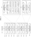
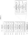
- FIG. 3 is a flowchart showing a method of determining the position of an object sensed by a radar using spatial voxelization according to one embodiment of the disclosed technology.
- the processor 310 performs the method of determining the position of the object sensed by the radar 20 using spatial voxelization according to the embodiment.
- the method of determining the position of the object sensed by the radar 20 using spatial voxelization according to the embodiment includes a voxelization step (S200) of loading a radar sensing file F storing a reflected signal returned as the result of a radio wave signal transmitted by the radar 20 being reflected by the object, searching for a voxel corresponding to the position of a point stored in the radar sensing file F, and cumulatively storing the reflected signal intensity of the point in a voxel ID of the searched voxel to create a dictionary, a point extraction step (S300) of loading the radar sensing file F, searching for a voxel corresponding to the position of the point stored in the radar sensing file F, and separately storing the position coordinates of the point when the voxel ID of the searched voxel is the same
- the voxelization step (S200) is a process of determining which voxel a point stored in the radar sensing file F corresponds to and storing information of the point in a dictionary in a state of being matched with the voxel.
- the dictionary may store the information of the point included in the voxel.
- the dictionary may store a voxel ID, reflected signal intensity, count, and the average reflected signal intensity.
- the dictionary does not store the position of the point. Storing the position of the point in the dictionary may increase the size of the dictionary and slow down data processing.
- the voxel having the largest reflected signal intensity may be called the top voxel. Since the top voxel has the largest accumulated reflected signal intensity, the top voxel includes a large number of points, which may be interpreted as having large reflected signal intensity and thus a space in which the reflector 10 is likely to be located.
- the point extraction step (S300) is a process of reading points stored in the radar sensing file F, determining whether the points are included in the top voxel stored in the dictionary, and extracting only the point included in the top voxel.
- the position coordinates of the point extracted in the point extraction step (S300) may be separately stored.
- the reference point position determination step (S400) is a process of determining the position of the reflector 10 using the position coordinates of the point determined to be included in the top voxel.
- the position of the top voxel generally refers to the coordinates of the center point of the voxel.
- the position coordinates of the point determined to be included in the top voxel and thus extracted are different from the coordinates of the center point of the top voxel. Therefore, the position coordinates of the extracted point are used to accurately determine the position of the reflector 10.
- the position of the reflector 10 may serve as a reference point for calibration to match sensing data from the radar 20, the lidar, and the camera.
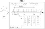
- FIG. 4 is a view illustrating data including a reflected signal received by the radar 20 according to one embodiment of the disclosed technology. Reference is made to FIGs. 3 and 4 together.
- the method of determining the position of the object sensed by the radar using spatial voxelization may further include a sensing step (S100) of the radar 20 transmitting a radio wave signal and receiving a reflected signal reflected by the object.
- the sensing step S100 may further include an operation of the determination module 30 organizing data received from the radar 20 to create a radar sensing file F.
- the radar sensing file F may be created by the radar 20 receiving the reflected signal and storing the position coordinates and the reflected signal intensity of a point in the form of point cloud data.
- Raw data that the radar 20 having receiving the reflected signal provides to the determination module 30 may be in any of various forms.
- the data that the radar 20 provides to the determination module 30 may be X-axis, Y-axis, or Z-axis coordinates or any of various other forms of data depending on the type of radar 20.
- the determination module 30 may organize the data received from the radar 20 into the X-axis, Y-axis, Z-axis, and the reflected signal intensity to create a radar sensing file F.
- the radar sensing file F may be created at a predetermined size or time.
- the radar 20 may have a data acquisition frequency of 10 to 20 Hz.
- the radar 20 may receive a reflected signal at each data acquisition period to create data, and may provide the data to the determination module 30 or may create the radar sensing file F.
- the radar sensing file F may be created by receiving a reflected signal for a radio wave signal every data acquisition period at 10 to 20 Hz and may have a length of 50 to 60 ms.
- the data acquisition period of the radar 20 may vary, and the length or size of the radar sensing file F may vary.
- a plurality of radar sensing files F may be created during the sensing step S100 using the radar 20.
- FIG. 4 shows a first radar sensing file F1 to an N-th radar sensing file FN.
- N is a positive number.
- table A shows data of the fourth radar sensing file F4.
- the fourth radar sensing file F4 may include values corresponding to the X-axis, Y-axis, and Z-axis, and may include values corresponding to the reflected signal intensity (RCS).
- the radar sensing file F may include such type of data.
- the radar sensing file F created by the determination module 30 may be stored in the storage unit 320.
- the determination module 30 may load the radar sensing file F stored in the storage unit 320 to perform the voxelization step (S200).
- the voxelization step (S200) may include a parameter setting step (S210) of setting parameters including a voxel size, lower and upper thresholds of the reflected signal intensity, and a space range in which a voxel grid is to be created, a filtering step (S220) of excluding points having reflected signal intensities deviating from the range between the lower and upper thresholds, a voxel grid creation step (S230) of creating a voxel grid based on the voxel size and the space range, and a dictionary creation step (S240) of searching, in the voxel grid, for a voxel corresponding to the position of the point stored in the radar sensing file F and cumulatively storing the reflected signal intensity of the point in a voxel ID of the searched voxel to create a dictionary.
- a parameter setting step S210
- S220 of excluding points having reflected signal intensities deviating from the range between
- a dictionary creation range DB may be further set.
- the dictionary creation range DB is the range of a file to be voxelized to create the dictionary.
- Setting of the dictionary creation range DB may be performed by defining a target file (File_target) and the number (n) of files to be selected back and forth based on the target file. For example, when the eighth radar sensing file F8 is selected as the target file and the number of files (n) to be selected back and forth is selected as 6, the dictionary creation range DB may be set from the second radar sensing file F2 (File_target-n) to the fourteenth radar sensing file F14 (File_target+n).
- setting of the dictionary creation range DB may be performed by selecting a start file and an end file.
- the second radar sensing file F2 may be selected as the start file and the fourteenth radar sensing file F14 may be selected as the end file, whereby the second to fourteenth radar sensing files F2 to F14 may be set as the dictionary creation range DB.
- FIG. 5 is a view illustrating spatial voxelization according to one embodiment of the disclosed technology. Reference is made to FIGs. 3 and 4 together.
- a voxel size may be set.
- the voxel size may be denoted by R.
- the value of R may be input by the user.
- the voxel may be in the form of a cube.
- the cubic voxel may include eight vertices V1 to V8.
- the space coordinates of the first to eighth vertices V1 to V8 may be represented as [-R,-R,-R] to [R,R,R]. In this case, the distance between neighboring vertices may be 2R.
- the larger the voxel size the more points may be included therein.
- a space range in which the voxel grid is to be created may be set.
- the space range may be determined by the size of a space sensed by the radar 20.
- the space range is set to be larger than the distance from the radar 20 to the reflector 10.
- the space range may be set as X-axis, Y-axis, and Z-axis values.
- a voxel grid may be created.
- the voxel grid is a division of space into a plurality of voxels.
- FIG. 5 shows a part of the voxel grid based on the origin.
- the plurality of voxels included in the voxel grid is each given a voxel ID to distinguish therebetween.
- the voxel ID may be assigned in a predetermined manner.
- lower and upper thresholds of the reflected signal intensity may be set.
- the radio wave signal of the radar 20 is reflected by the object in various directions and is reflected and attenuated repeatedly. Therefore, it is preferable to ignore reflected signals received by the radar 20 when the reflected signals have reflected signal intensities equal to or less than the predetermined lower threshold. Since the radio wave signal of the radar 20 is attenuated as reflected by the object, a reflected signal having intensity equal to or greater than the upper threshold may not be a reflected signal caused by the radio wave signal transmitted by the radar 20 and is preferably ignored.
- the lower and upper thresholds of the reflected signal intensity may be input by the user. Alternatively, the lower and upper thresholds may be determined based on the characteristics of the radar 20.
- the filtering step (S220) may be performed.
- the filtering step (S220) is a process of excluding points stored in the radar sensing file F having reflected signal intensities deviating from the range between the lower threshold and the upper threshold.
- the processor 310 may compare the reflected signal intensities of the points with the lower threshold and the upper threshold, and may exclude points deviating from the range between the lower and upper thresholds.
- the processor 310 may repeat the filtering step (S220) for each loaded radar sensing file F.
- a voxel grid may be created.
- the voxel grid may be created based on the voxel size and the space range.
- the processor 310 may repeatedly perform the voxel grid creation step (S230) for each loaded radar sensing file F.
- S230 the voxel grid creation step
- the dictionary creation step (S240) is a process of determining which voxel corresponds to the point and recording information of the point in the voxel.
- the dictionary creation step (S240) may include a voxel search step (S241) of searching for a voxel corresponding to the position of the point stored in the radar sensing file F in the voxel grid, a determination step (S242) of determining whether the voxel ID of the searched voxel is present in the dictionary, an addition step (S243) of, when the voxel ID of the searched voxel is not present in the dictionary, adding the voxel ID of the searched voxel to the dictionary, storing the reflected signal intensity in the voxel ID, storing count of the point recorded in the voxel ID, dividing the reflected signal intensity by the count, and storing the average reflected signal intensity, and an accumulation step (S244) of, when the voxel ID of the searched voxel is present in the dictionary, cumulatively storing the reflected signal intensity of the voxel ID of the searched voxel in
- the voxel search step (S241) is a process of determining which voxel corresponds to the position of a point stored in the radar sensing file F.
- the positions of a plurality of voxels are set, and the voxel including the point may be searched by comparing the position coordinates of the point with the position of the voxel. For example, in FIG. 5 , when comparing the position coordinates of a first point P1 with the position and size of a voxel, it is possible to search for which voxel the point is included in.
- the first point P1 may be included in a first voxel Vx1
- a second point P2 and a third point P3 may be included in a second voxel Vx2
- a fourth point P4 and a fifth point P5 may be included in a third voxel Vx3. Since the radar sensing file includes a plurality of points, the voxel search step (S241) may be repeatedly performed for each point.
- Performing the voxel search step (S241) may identify voxels corresponding to the points. Each voxel is given a voxel ID.
- the determination step (S242) of determining whether the voxel ID is present is to determine whether the voxel ID of the voxel corresponding to the point is recorded in the dictionary.
- the dictionary may store several voxel IDs and information of points matched with the voxel IDs.
- the processor 310 determines whether the voxel ID of the searched voxel matches the voxel ID stored in the dictionary.
- FIG. 6 is a view illustrating a voxel dictionary according to one embodiment of the disclosed technology. Reference is made to FIGs. 3 , 4 , and 5 together.
- the addition step (S243) may be performed, and when the voxel ID of the searched voxel is present in the dictionary, the accumulation step (S244) may be performed.
- the addition step (S243) is a process of adding a new voxel ID that is not present in the dictionary.
- a new searched voxel ID is added to the dictionary, and the voxel ID may be stored in a state of being matched with the reflected signal intensity of the point, count, and the average reflected signal intensity. For example, in FIG. 6 , when the voxel ID of the searched voxel is 2322, this does not match the voxel ID stored in the existing dictionary D1, and therefore the addition step (S243) may be performed to add the information of the point to the dictionary.
- the dictionary D2 may include the voxel ID of the searched voxel, the value (14.4) of the reflected signal intensity (RCS) may be stored, the count may be stored as 1 since the point is newly added, and the average reflected signal intensity (AVG) may be stored with the same value (14.4) as the reflected signal intensity since the count is 1.
- the accumulation step (S244) is a process of cumulatively storing the information of the point to the voxel ID present in the dictionary.
- the presence of the same voxel ID as the searched voxel ID in the existing dictionary D1 means that another point is determined to correspond to the same voxel, and the information of the point is stored in the dictionary.
- the accumulation step S244 may be performed.
- the reflected signal intensity stored in a state of being matched to the voxel ID of the searched voxel is cumulatively stored from 57.6 to 64.0 in the dictionary D2, the count may be cumulatively stored from 3 to 4, and the average reflected signal intensity may be stored from 19.2 to 16.0.
- the filtering step (S220), the voxel grid creation step (S230), and the dictionary creation step (S240) are repeatedly performed for each of a plurality of radar sensing files F set as the dictionary creation range DB.
- the dictionary creation step (S240) the voxel search step (S241), the determination step (S242) of determining whether the voxel ID of the searched voxel is present in the dictionary, the addition step (S243), and the accumulation step (S244) are repeatedly performed for each of a plurality of points included in one radar sensing file F.
- a dictionary cumulatively storing the reflected signal intensity of the point included in the voxel may be obtained.
- the dictionary stores a plurality of voxel IDs and reflected signal intensities. Voxels are listed in descending order of the reflected signal intensity, and the voxel having the largest reflected signal intensity may be called the top voxel.
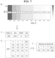
- FIG. 7 is a view illustrating extraction of a point and determination of a reference point according to one embodiment of the disclosed technology. Reference is made to FIGs. 3 and 7 together.
- the point extraction step (S300) may include a parameter setting step (S310) of setting parameters including a voxel size, lower and upper thresholds of the reflected signal intensity, and a space range in which a voxel grid is to be created, a filtering step (S320) of excluding points having reflected signal intensities deviating from the range between the lower and upper thresholds, a voxel grid creation step (S330) of creating a voxel grid based on the voxel size and the space range, and a top voxel point extraction step (S340) of loading the radar sensing file F, searching for a voxel corresponding to the position of the point stored in the radar sensing file F, separately storing the position coordinates of the point when the voxel ID of the searched voxel is the same as the voxel ID of the top voxel having the largest accumulated value of the reflected signal intensity in the dictionary, and extracting the point of
- the parameter setting step (310) of the point extraction step (S300) may be performed in the same manner as the parameter setting step (210) of the voxelization step (S200). Therefore, the parameter setting step (310) of the point extraction step (S300) may be omitted.
- the voxel size, the lower and upper thresholds of the reflected signal intensity, the space range, and the range of the radar sensing file F to extract points may be set.
- the point extraction range EB may be set to the same as the dictionary creation range DB for creating the dictionary in the voxelization step (S200), or may be set differently therefrom.
- the filtering step (320) of the point extraction step (S300) may be performed in the same manner as the filtering step (220) of the voxelization step (S200).
- points stored in the radar sensing file F set as the point extraction range EB points whose reflected signal intensities deviate from the range between the lower threshold and the upper threshold may be excluded.
- the voxel grid creation step (S330) of the point extraction step (S300) may be performed in the same manner as the voxel grid creation step (S230) of the voxelization step (S200).
- a grid may be created with voxels of a set voxel size in a set space range.
- the top voxel point extraction step (S340) is a process of searching for a voxel corresponding to a point stored in the radar sensing file F set as the point extraction range EB and extracting the point when the searched voxel is the same as the top voxel.
- the top voxel point extraction step (S340) may include a voxel search step (S341) of searching for a voxel corresponding to the position of the point stored in the radar sensing file F in the voxel grid, a determination step (S342) of determining whether the voxel ID of the searched voxel matches the voxel ID of the top voxel in the dictionary, and a point position storage step (S343) of, when the voxel ID of the searched voxel matches the voxel ID of the top voxel, storing the position of the point in the voxel ID of the top voxel.
- the voxel search step (S341) of the top voxel point extraction step (S340) is similar to the voxel search step (S241) of the dictionary creation step (S240).
- the voxel search step (S341) of the top voxel point extraction step (S340) is a process of checking a voxel corresponding to the position of the point in the radar sensing file F set as the point extraction range EB. When a voxel corresponding to the point is searched, the voxel ID of the voxel may be checked.
- the determination step (S342) is performed to determine whether the voxel ID of the searched voxel matches the voxel ID of the top voxel in the dictionary.
- the voxel search step (S241) of searching for the voxel with respect to the next point in the radar sensing file F is performed again.
- the point position storage step (S343) is a process of separately storing the position coordinates of the point determined to be included in the top voxel. At this time, the position coordinates of the point may be stored in a state of being matched with the voxel ID of the top voxel.
- the position coordinates of the plurality of points may be stored in one top voxel in separately stored data. For example, it can be seen from the visualization results of FIG.
- the voxel ID of the top voxel is 3027.
- the voxel ID of the top voxel is 3027
- the accumulated reflected signal intensity is 140.2
- the count is 11
- the average reflected signal intensity is 12.7.
- the voxel ID of the voxel corresponding to the point included in the radar sensing file F is 3027, this is the same as the voxel ID of the top voxel, and therefore the position coordinates of the point may be stored separately, and the reflected signal intensity of the point may be stored separately.
- the filtering step (S220), the voxel grid creation step (S230), and the top voxel point extraction step (S340) are repeatedly performed for one radar sensing file F or each of a plurality of radar sensing files F set as the point extraction range EB.
- the voxel search step (S241), the determination step (S342) of determining whether the voxel ID of the searched voxel matches the voxel ID of the top voxel, and a step of storing the position of the point are repeatedly performed for each of the plurality of points included in one radar sensing file F.
- the point extraction step S300 is performed for one radar sensing file F or each of a plurality of radar sensing files F set as the radar sensing file F from which points are to be extracted, the position coordinates of the points determined to be included in the top voxel may be stored separately.
- a step (S400) of determining the position of a reference point may be performed.
- the reference point refers to the position of the reflector 10 that is used as a reference for calibration. In the calibration process, it is necessary to determine the position of the reflector 10 as a reference point based on which the radar 20, the lidar, and the camera are adjusted to measure one reflector 10 at the same position.
- the method of determining the position of the object sensed by the radar using spatial voxelization may be used to determine the position of the reference point measured by the radar 20 during the calibration process.
- the position of the reflector 10 (i.e., the position of the reference point) is calculated using the position coordinates of the points included in the top voxel.
- the X-coordinate of the reflector 10 may be calculated as the average of the X-coordinates of the position coordinates of the points included in the top voxel
- the Y-coordinate of the reflector 10 may be calculated as the average of the Y-coordinates of the position coordinates of the points included in the top voxel
- the Z-coordinate of the reflector 10 may be calculated as the average of the Z-coordinates of the position coordinates of the points included in the top voxel.
- the distance (Dist) refers to the distance from the radar 20 to the reflector 10.
- the distance may be calculated from Equation 1 below using the position coordinates (X,Y,Z) of the reflector 10.
- the method of determining the position of the object sensed by the radar using spatial voxelization may further include a step of visualizing the reflected signal intensities of the voxels stored in the dictionary in order of magnitude.
- the visualization step may be optionally performed after the dictionary creation step (S240).
- the visualization results VR may be provided by displaying the voxels stored in the dictionary in dark colors when the reflected signal intensity is large, and in light colors when the reflected signal intensity is small.
- accumulated reflected signal intensity values and voxel IDs may be displayed. Referring to the visualization results VR, the user may check the accumulated values of the reflected signal intensities of the points included in the voxel in order.
- FIG. 8 is a view illustrating calibration according to one embodiment of the disclosed technology.
- FIG. 9 is a view illustrating a method of extracting a reference point at the point in time of calibration.
- the method of determining the position of the object sensed by the radar using spatial voxelization may be used for calibration.
- calibration may be performed in a manner in which the radar 20, the lidar, and the camera sense a single reference point (reflector 10).
- the reference point in time, at which the position is adjusted during the calibration process may be the same for all sensors (radar 20, lidar, and camera).
- the lidar or the camera has the advantage of acquiring clear data at a specific point in time due to the characteristics of an optical instrument.
- the radar 20 is a radio wave device, and therefore it is necessary to determine a reference point by synthesizing data collected over a predetermined period of time rather than acquiring data at a specific point in time.
- the method of determining the position of the object sensed by the radar using spatial voxelization may use a method of generating a dictionary using a plurality of radar sensing files F and extracting points contained in the target file corresponding to the reference point in time of calibration to determine a reference point.
- the position of a reference point measured by the radar 20 at the reference point in time of calibration may be determined.
- the top voxel point extraction step (S340) may further include a step (S344) of determining whether the current file including the point matches the target file when the voxel ID of the searched voxel matches the voxel ID of the top voxel in the dictionary.
- the point position storage step (S343) is performed, and when the current file does not match the target file Y, the point position storage step (S343) is not performed.
- a first dictionary creation range DB1 may be 43rd to 49th radar sensing files F43 to F49
- the point extraction range EB corresponding to the reference point in time of calibration may be a 53rd radar sensing file F53, which is one target file (File_target).
- a dictionary may be created using the radar sensing files F of the first dictionary creation range DB1, and the points corresponding to the top voxel among the points included in the target file may be extracted to determine the position of the reference point.
- the dictionary creation range DB may include a target file corresponding to the reference point in time of calibration, and in the point extraction step (S300), the point extraction range EB may further include a file different from the target file.
- a second dictionary creation range DB2 includes a target file (File_target), and the point extraction range EB also includes a target file (File_target).
- a dictionary may be created using the radar sensing files F of the second dictionary creation range DB2, and the points corresponding to the top voxel and the target file (File_target) among the points included in the point extraction range EB may be extracted to determine the position of the reference point.
- points included in the radar sensing file F that correspond to the top voxel but are not in the target file (File_target) are not extracted.
- the reference point for the radar 20 for use in calibration may be determined using the described method.
- the method and apparatus according to the embodiment have the advantage that the reference point may be determined in everyday environments in which various objects are present, thereby eliminating the need to separately provide a space for calibration.
Landscapes
- Engineering & Computer Science (AREA)
- Remote Sensing (AREA)
- Radar, Positioning & Navigation (AREA)
- Physics & Mathematics (AREA)
- General Physics & Mathematics (AREA)
- Computer Networks & Wireless Communication (AREA)
- Electromagnetism (AREA)
- Computer Vision & Pattern Recognition (AREA)
- Theoretical Computer Science (AREA)
- Radar Systems Or Details Thereof (AREA)
- Image Analysis (AREA)
Abstract
Description
- The disclosed technology relates to an apparatus and method for determining the position of an object sensed by a radar using spatial voxelization.
- A radar outputs a radio wave signal and receives a signal reflected by an object. Depending on the characteristics of the surface of the object, the radio wave signal is reflected with intensities in various directions. When various types of objects are present in a space, reflected signals having various intensities may be received in various directions. Therefore, complex calculation must be performed to analyze the reflected signal received by the radar and to select the position of the object.
- Meanwhile, with growth of autonomous driving technology, technology is being developed to calibrate sensors such as a radar, a lidar, and a camera. Calibration is adjustment of the radar, the lidar, and the camera to recognize the position of a specific object as the same position. During the calibration process, the radar has difficulty positioning a specific object due to the characteristic that reflected signals having various intensities are received in various directions. This characteristic requires limiting the presence of other objects in a space in which calibration is performed. Therefore, a space and a separate tool are required for calibration.
- (Patent Document 1)
KR 10-2023-0013763 A - It is an object of the disclosed technology to provide an apparatus and method for determining the position of an object sensed by a radar using spatial voxelization.
- In accordance with an aspect of the disclosed technology, the above and other objects can be accomplished by the provision of a method of determining the position of an object sensed by a radar using spatial voxelization, the method including a voxelization step of loading a radar sensing file storing a reflected signal returned as a result of a radio wave signal transmitted by the radar being reflected by the object, searching for a voxel corresponding to the position of a point stored in the radar sensing file, and cumulatively storing the reflected signal intensity of the point in a voxel ID of the searched voxel to create a dictionary, a point extraction step of loading the radar sensing file, searching for a voxel corresponding to the position of the point stored in the radar sensing file, and separately storing the position coordinates of the point when a voxel ID of the searched voxel is the same as a voxel having the largest accumulated value of the reflected signal intensity in the dictionary, and a reference point position determination step of determining the position of a reference point for calibration based on the separately stored position coordinates of the point.
- In an embodiment, the radar sensing file may be created by the radar receiving the reflected signal and storing the position coordinates and reflected signal intensity of a point in the form of point cloud data.
- In an embodiment, the voxelization step may include a parameter setting step of setting parameters including a voxel size, lower and upper thresholds of the reflected signal intensity, and a space range in which a voxel grid is to be created, a filtering step of excluding points having reflected signal intensities deviating from the range between the lower and upper thresholds, a voxel grid creation step of creating a voxel grid based on the voxel size and the space range, and a dictionary creation step of searching, in the voxel grid, for a voxel corresponding to the position of the point stored in the radar sensing file and cumulatively storing the reflected signal intensity of the point in a voxel ID of the searched voxel to create a dictionary.
- In an embodiment, the dictionary creation step may include a voxel search step of searching for a voxel corresponding to the position of the point stored in the radar sensing file in the voxel grid, a determination step of determining whether a voxel ID of the searched voxel is present in the dictionary, an addition step of, when the voxel ID of the searched voxel is not present in the dictionary, adding the voxel ID of the searched voxel to the dictionary, storing the reflected signal intensity in the voxel ID, storing the count of the point recorded in the voxel ID, dividing the reflected signal intensity by the count, and storing the average reflected signal intensity, and an accumulation step of, when the voxel ID of the searched voxel is present in the dictionary, cumulatively storing the reflected signal intensity of the voxel ID of the searched voxel in the dictionary, cumulatively storing the count of the point recorded in the voxel ID, dividing the reflected signal intensity by the count, and storing the average reflected signal intensity.
- In an embodiment, the point extraction step may include a parameter setting step of setting parameters including a voxel size, lower and upper thresholds of the reflected signal intensity, and a space range in which a voxel grid is to be created, a filtering step of excluding points having reflected signal intensities deviating from the range between the lower and upper thresholds, a voxel grid creation step of creating a voxel grid based on the voxel size and the space range, and a top voxel point extraction step of loading the radar sensing file, searching for a voxel corresponding to the position of the point stored in the radar sensing file, separately storing the position coordinates of the point when a voxel ID of the searched voxel is the same as a voxel ID of the top voxel having the largest accumulated value of the reflected signal intensity in the dictionary, and extracting the point of the top voxel.
- In an embodiment, the top voxel point extraction step may include a voxel search step of searching for a voxel corresponding to the position of the point stored in the radar sensing file in the voxel grid, a determination step of determining whether a voxel ID of the searched voxel matches the voxel ID of the top voxel in the dictionary, and a point position storage step of, when the voxel ID of the searched voxel matches the voxel ID of the top voxel, storing the position of the point in the voxel ID of the top voxel.
- In an embodiment, the top voxel point extraction step may further include determining whether a current file including the point matches a target file when the voxel ID of the searched voxel matches the voxel ID of the top voxel in the dictionary, when the current file matches the target file, the point position storage step may be performed, and when the current file does not match the target file, the point position storage step may not be performed.
- In accordance with another aspect of the disclosed technology, there is provided an apparatus for determining the position of an object sensed by a radar using spatial voxelization, the apparatus including a radar configured to transmit a radio wave signal and to receive a reflected signal reflected by the object and a determination module configured to analyze a radar sensing file storing the reflected signal received by the radar using spatial voxelization and to determine the position of a reflector based on which calibration is performed.
- In an embodiment, the determination module may include a processor configured to execute program code, a storage unit connected to the processor so as to transmit and receive data to and from the processor, the storage unit being configured to store the program code, the radar sensing file storing the reflected signal received by the radar, and a dictionary, and an input/output unit connected to the processor so as to transmit and receive data to and from the processor, the input/output unit being configured to receive a parameter required for voxelization, and the program code is written to perform any one of the methods of determining the position of the object sensed by the radar using spatial voxelization.
- The features and advantages of the disclosed technology will be more clearly understood from the following detailed description taken in conjunction with the accompanying drawings.
- It should be understood that the terms used in the specification and appended claims should not be construed as being limited to general and dictionary meanings, but should be construed based on meanings and concepts according to the spirit of the disclosed technology on the basis of the principle that the inventor is permitted to define appropriate terms for the best explanation.
- In accordance with the disclosed technology, it is possible to determine the position of a reference object for calibration in an environment in which various objects are present using a single radar.
-
-
FIG. 1 is a view showing an environment in which an apparatus for determining the position of an object sensed by a radar using spatial voxelization according to one embodiment of the disclosed technology is used; -
FIG. 2 is a view showing an apparatus for determining the position of an object sensed by a radar using spatial voxelization according to one embodiment of the disclosed technology; -
FIG. 3 is a flowchart showing a method of determining the position of an object sensed by a radar using spatial voxelization according to one embodiment of the disclosed technology; -
FIG. 4 is a view illustrating data including a reflected signal received by the radar according to one embodiment of the disclosed technology; -
FIG. 5 is a view illustrating spatial voxelization according to one embodiment of the disclosed technology; -
FIG. 6 is a view illustrating a voxel dictionary according to one embodiment of the disclosed technology; -
FIG. 7 is a view illustrating extraction of a point and determination of a reference point according to one embodiment of the disclosed technology; -
FIG. 8 is a view illustrating calibration according to one embodiment of the disclosed technology; and -
FIG. 9 is a view illustrating a method of extracting a reference point at the point in time of calibration. - Objects, advantages, and features of the disclosed technology will be apparent from exemplary embodiments and the following detailed description in connection with the accompanying drawings, but the disclosed technology is not necessarily limited thereto. Furthermore, in the following description of the disclosed technology, a detailed description of known technology incorporated herein will be omitted when it may obscure the subject matter of the disclosed technology.
- It should be noted that, when reference numerals are assigned to the elements of the drawings, the same or similar reference numerals are assigned to the same or similar elements even when they are illustrated in different drawings.
- The terminology used to describe one embodiment of the disclosed technology is not intended to limit the disclosed technology. It should be understood that singular forms are intended to include plural forms unless mentioned otherwise.
- The drawings may be shown schematically or exaggeratedly to illustrate embodiments.
- As used herein, expressions such as "has," "may have," "includes," or "may include" refer to the presence of a feature (e.g., a numerical value, function, operation, or a component such as a part) and do not exclude the presence of additional features.
- Terms such as "one," "other," "another," "first," and "second" are used to distinguish one component from another, and the components are not limited by such terms.
- It should be understood that terms denoting directions, such as up, down, left, right, X-axis, Y-axis, Z-axis, are for convenience of description only and may be expressed differently depending on the position of an observer or the position of a target.
- Embodiments described herein and the accompanying drawings are not intended to limit the disclosed technology to a specific embodiment. the disclosed technology is to be understood to include various modifications, equivalents, and/or alternatives of the embodiments.
- Hereinafter, one embodiment of the disclosed technology will be described in detail with reference to the accompanying drawings.
-
FIG. 1 is a view showing an environment En in which anapparatus 1 for determining the position of an object sensed by a radar using spatial voxelization according to one embodiment of the disclosed technology is used.FIG. 2 is a view showing anapparatus 1 for determining the position of an object sensed by a radar using spatial voxelization according to one embodiment of the disclosed technology. - The
apparatus 1 for determining the position of the object sensed by the radar using spatial voxelization according to the embodiment of the disclosed technology may be used in an environment En in which other objects Ob are present in a space in which aradar 20 and areflector 10 are present. For example, the environment En may be a space in which a desk, a chair, a partition, a clock, a picture frame, and various other objects Ob are disposed. The environment En in the embodiment of the disclosed technology may include the state in which theradar 20 andreflector 10 are disposed together in the space in which various objects Ob are disposed. - In general, the environment En in which calibration is performed using the
radar 20, a lidar, and a camera is a space in which only thereflector 10 used as a reference is present. When various objects are present in the space, a radio signal from theradar 20 is diffusely reflected, making it difficult to accurately distinguish a reference object. Conventionally, therefore, a method of determining the position of thereflector 10 using two ormore radars 20 is used. - In contrast, the embodiment of the disclosed technology is capable of accurately distinguishing the position of the
reflector 10 even when various objects Ob are present in the environment En. In addition, the position of thereflector 10 may be accurately determined even when only asingle radar 20 is used. Thus, only asingle radar 20 needs to be prepared to perform calibration, thereby minimizing equipment cost, and calibration may be performed in a typical office space, thereby minimizing cost of space required. - The
apparatus 1 for determining the position of the object sensed by the radar using spatial voxelization according to the embodiment of the disclosed technology may include aradar 20 and adetermination module 30. Theapparatus 1 for determining the position of the object sensed by the radar using spatial voxelization according to the embodiment of the disclosed technology may further include areflector 10. - A
single radar 20 may be used as theradar 20. Theradar 20 may transmit a radio wave signal and may receive a signal reflected by the object. Theradar 20 may transmit a radio wave signal having a frequency of 79 GHz. The radio wave signal transmitted by theradar 20 may have different frequencies. The reflected signal may be received by theradar 20 with various paths and intensities depending on the shape and the material of the object, the distance between the object and theradar 20, and various other factors. Theradar 20 may output the position coordinates of a point from which the received reflected signal originated and reflected signal intensity. The point refers to the part of the object from which the reflected signal originated. The position coordinates may include values in the X-axis, Y-axis, and Z-axis. The reflected signal intensity refers to the intensity of the reflected signal reflected by the object and received by theradar 20. The reflected signal intensity may be the radar cross section (RCS) of theradar 20. - The
reflector 10 is an object made of a material that is highly reflective of radio wave signals. Thereflector 10 may include a corner reflector. Thereflector 10 may be formed in a shape that reflects the radio wave signal output by theradar 20 toward theradar 20 with minimal loss. Thereflector 10 is positioned so as to be used as a reference point for calibration relative to theradar 20. - The
determination module 30 may store the position coordinates and the reflected signal intensity of the point received from theradar 20 to create a radar sensing file F. Thedetermination module 30 may receive the radar sensing file F created using theradar 20. Thedetermination module 30 may analyze the radar sensing file F storing the reflected signal received by theradar 20 using spatial voxelization to determine the position of thereflector 10 based on which calibration is performed. - The
determination module 30 may include a computer device. For example, thedetermination module 30 may include a desktop computer, a laptop computer, a server, a tablet computer, and other devices capable of performing information processing functions. Thedetermination module 30 may be connected to theradar 20 to receive the position coordinates and the reflected signal intensity of the point output by theradar 20. - The
determination module 30 may include aprocessor 310 configured to execute program code, astorage unit 320 connected to theprocessor 310 so as to transmit and receive data to and from the processor, the storage unit being configured to store the program code, the radar sensing file F storing the reflected signal received by theradar 20, and a dictionary, and an input/output unit 340 connected to theprocessor 310 so as to transmit and receive data to and from the processor, the input/output unit being configured to receive a parameter required for voxelization. Thedetermination module 30 may further include acommunication unit 330 connected to theprocessor 310 so as to transmit and receive data to and from the processor, the communication unit being configured to transmit and receive data to and from an external device. Here, the program code may be written to perform the method of determining the position of the object sensed by the radar using spatial voxelization. - The
processor 310 may include an element capable of performing information processing. Theprocessor 310 may be a CPU, a GPU, an AP, or any of various other computing devices. Thedetermination module 30 may include a plurality ofprocessors 310. The plurality ofprocessors 310 may be connected to each other so as to transmit and receive data to and from each other. Theprocessor 310 may perform a method of determining the position of an object sensed by a radar using spatial voxelization according to one embodiment written in program code. - The
storage unit 320 may store data required to perform the method of determining the position of the object sensed by the radar using spatial voxelization. Thestorage unit 320 may include RAM, ROM, memory, a hard disk, or cloud storage. Thestorage unit 320 may store program code written to perform each step of the method of determining the position of the object sensed by the radar using spatial voxelization. The program code may be executed by theprocessor 310. Thestorage unit 320 may store a radar sensing file F, a voxel dictionary, position coordinates of separately stored points, parameters, and other data. - The input/
output unit 340 may include a keyboard, a mouse, a touchpad, a touchscreen, or a pen configured to receive input by a user. The input/output unit 340 may include a display or a speaker configured to provide information to the user. The input/output unit 340 may provide a screen configured to allow the user to input a parameter, and may visually provide analysis results. - The
communication unit 330 may be connected to a communication network to transmit and receive data. Theprocessor 310 may download the radar sensing file F through thecommunication unit 330, and may transmit the analysis results. Thecommunication unit 330 may use any of various communication methods, such as 5G, 6G, satellite communication, Wi-Fi, Bluetooth, LAN, WAN, Ethernet, IP4, or IP6. -
FIG. 3 is a flowchart showing a method of determining the position of an object sensed by a radar using spatial voxelization according to one embodiment of the disclosed technology. - The
processor 310 performs the method of determining the position of the object sensed by theradar 20 using spatial voxelization according to the embodiment. The method of determining the position of the object sensed by theradar 20 using spatial voxelization according to the embodiment includes a voxelization step (S200) of loading a radar sensing file F storing a reflected signal returned as the result of a radio wave signal transmitted by theradar 20 being reflected by the object, searching for a voxel corresponding to the position of a point stored in the radar sensing file F, and cumulatively storing the reflected signal intensity of the point in a voxel ID of the searched voxel to create a dictionary, a point extraction step (S300) of loading the radar sensing file F, searching for a voxel corresponding to the position of the point stored in the radar sensing file F, and separately storing the position coordinates of the point when the voxel ID of the searched voxel is the same as a voxel having the largest accumulated value of the reflected signal intensity in the dictionary, and a reference point position determination step (S400) of determining the position of a reference point for calibration based on the separately stored position coordinates of the point. The voxelization step (S200), the point extraction step (S300), and the reference point position determination step (S400) may be performed by theprocessor 310. - The voxelization step (S200) is a process of determining which voxel a point stored in the radar sensing file F corresponds to and storing information of the point in a dictionary in a state of being matched with the voxel. The dictionary may store the information of the point included in the voxel. The dictionary may store a voxel ID, reflected signal intensity, count, and the average reflected signal intensity. The dictionary does not store the position of the point. Storing the position of the point in the dictionary may increase the size of the dictionary and slow down data processing. When voxels are listed in descending order of the reflected signal intensity, the voxel having the largest reflected signal intensity may be called the top voxel. Since the top voxel has the largest accumulated reflected signal intensity, the top voxel includes a large number of points, which may be interpreted as having large reflected signal intensity and thus a space in which the
reflector 10 is likely to be located. - The point extraction step (S300) is a process of reading points stored in the radar sensing file F, determining whether the points are included in the top voxel stored in the dictionary, and extracting only the point included in the top voxel. By separately performing the voxelization step (S200), which creates the dictionary, and the point extraction step (S300), which extracts the point included in the top voxel, it is possible to increase data processing speed and to minimize the size of the dictionary. The position coordinates of the point extracted in the point extraction step (S300) may be separately stored.
- The reference point position determination step (S400) is a process of determining the position of the
reflector 10 using the position coordinates of the point determined to be included in the top voxel. The position of the top voxel generally refers to the coordinates of the center point of the voxel. The position coordinates of the point determined to be included in the top voxel and thus extracted are different from the coordinates of the center point of the top voxel. Therefore, the position coordinates of the extracted point are used to accurately determine the position of thereflector 10. The position of thereflector 10 may serve as a reference point for calibration to match sensing data from theradar 20, the lidar, and the camera. -
FIG. 4 is a view illustrating data including a reflected signal received by theradar 20 according to one embodiment of the disclosed technology. Reference is made toFIGs. 3 and4 together. - The method of determining the position of the object sensed by the radar using spatial voxelization according to the embodiment may further include a sensing step (S100) of the
radar 20 transmitting a radio wave signal and receiving a reflected signal reflected by the object. The sensing step S100 may further include an operation of thedetermination module 30 organizing data received from theradar 20 to create a radar sensing file F. The radar sensing file F may be created by theradar 20 receiving the reflected signal and storing the position coordinates and the reflected signal intensity of a point in the form of point cloud data. - Raw data that the
radar 20 having receiving the reflected signal provides to thedetermination module 30 may be in any of various forms. The data that theradar 20 provides to thedetermination module 30 may be X-axis, Y-axis, or Z-axis coordinates or any of various other forms of data depending on the type ofradar 20. Thedetermination module 30 may organize the data received from theradar 20 into the X-axis, Y-axis, Z-axis, and the reflected signal intensity to create a radar sensing file F. The radar sensing file F may be created at a predetermined size or time. - The
radar 20 may have a data acquisition frequency of 10 to 20 Hz. Theradar 20 may receive a reflected signal at each data acquisition period to create data, and may provide the data to thedetermination module 30 or may create the radar sensing file F. For example, the radar sensing file F may be created by receiving a reflected signal for a radio wave signal every data acquisition period at 10 to 20 Hz and may have a length of 50 to 60 ms. The data acquisition period of theradar 20 may vary, and the length or size of the radar sensing file F may vary. A plurality of radar sensing files F may be created during the sensing step S100 using theradar 20. -
FIG. 4 shows a first radar sensing file F1 to an N-th radar sensing file FN. Here, N is a positive number. InFIG. 4 , table A shows data of the fourth radar sensing file F4. The fourth radar sensing file F4 may include values corresponding to the X-axis, Y-axis, and Z-axis, and may include values corresponding to the reflected signal intensity (RCS). The radar sensing file F may include such type of data. The radar sensing file F created by thedetermination module 30 may be stored in thestorage unit 320. - The
determination module 30 may load the radar sensing file F stored in thestorage unit 320 to perform the voxelization step (S200). - The voxelization step (S200) may include a parameter setting step (S210) of setting parameters including a voxel size, lower and upper thresholds of the reflected signal intensity, and a space range in which a voxel grid is to be created, a filtering step (S220) of excluding points having reflected signal intensities deviating from the range between the lower and upper thresholds, a voxel grid creation step (S230) of creating a voxel grid based on the voxel size and the space range, and a dictionary creation step (S240) of searching, in the voxel grid, for a voxel corresponding to the position of the point stored in the radar sensing file F and cumulatively storing the reflected signal intensity of the point in a voxel ID of the searched voxel to create a dictionary.
- In the parameter setting step (S210), a dictionary creation range DB may be further set.
- The dictionary creation range DB is the range of a file to be voxelized to create the dictionary. Setting of the dictionary creation range DB may be performed by defining a target file (File_target) and the number (n) of files to be selected back and forth based on the target file. For example, when the eighth radar sensing file F8 is selected as the target file and the number of files (n) to be selected back and forth is selected as 6, the dictionary creation range DB may be set from the second radar sensing file F2 (File_target-n) to the fourteenth radar sensing file F14 (File_target+n).
- Alternatively, setting of the dictionary creation range DB may be performed by selecting a start file and an end file. For example, the second radar sensing file F2 may be selected as the start file and the fourteenth radar sensing file F14 may be selected as the end file, whereby the second to fourteenth radar sensing files F2 to F14 may be set as the dictionary creation range DB.
-
FIG. 5 is a view illustrating spatial voxelization according to one embodiment of the disclosed technology. Reference is made toFIGs. 3 and4 together. - In the parameter setting step (S210), a voxel size may be set. The voxel size may be denoted by R. The value of R may be input by the user. The voxel may be in the form of a cube. The cubic voxel may include eight vertices V1 to V8. The space coordinates of the first to eighth vertices V1 to V8 may be represented as [-R,-R,-R] to [R,R,R]. In this case, the distance between neighboring vertices may be 2R. The larger the voxel size, the more points may be included therein.
- In the parameter setting step (S210), a space range in which the voxel grid is to be created may be set. The space range may be determined by the size of a space sensed by the
radar 20. Preferably, the space range is set to be larger than the distance from theradar 20 to thereflector 10. The space range may be set as X-axis, Y-axis, and Z-axis values. - Once the voxel size and the space range are set, a voxel grid may be created. The voxel grid is a division of space into a plurality of voxels.
FIG. 5 shows a part of the voxel grid based on the origin. The plurality of voxels included in the voxel grid is each given a voxel ID to distinguish therebetween. The voxel ID may be assigned in a predetermined manner. - In the parameter setting step (S210), lower and upper thresholds of the reflected signal intensity may be set. The radio wave signal of the
radar 20 is reflected by the object in various directions and is reflected and attenuated repeatedly. Therefore, it is preferable to ignore reflected signals received by theradar 20 when the reflected signals have reflected signal intensities equal to or less than the predetermined lower threshold. Since the radio wave signal of theradar 20 is attenuated as reflected by the object, a reflected signal having intensity equal to or greater than the upper threshold may not be a reflected signal caused by the radio wave signal transmitted by theradar 20 and is preferably ignored. The lower and upper thresholds of the reflected signal intensity may be input by the user. Alternatively, the lower and upper thresholds may be determined based on the characteristics of theradar 20. - After setting the voxel size, the space range, the lower threshold, the upper threshold, and the dictionary creation range DB in the parameter setting step (S210), the filtering step (S220) may be performed.
- The filtering step (S220) is a process of excluding points stored in the radar sensing file F having reflected signal intensities deviating from the range between the lower threshold and the upper threshold. The
processor 310 may compare the reflected signal intensities of the points with the lower threshold and the upper threshold, and may exclude points deviating from the range between the lower and upper thresholds. Theprocessor 310 may repeat the filtering step (S220) for each loaded radar sensing file F. - After performing the filtering step (S220), a voxel grid may be created. The voxel grid may be created based on the voxel size and the space range. The
processor 310 may repeatedly perform the voxel grid creation step (S230) for each loaded radar sensing file F. When the voxel grid is created, a plurality of voxels is created in the space range, and theprocessor 310 may determine which voxel the position coordinates of the point correspond to. - After the voxel grid is created, the dictionary creation step (S240) may be performed. The dictionary creation step (S240) is a process of determining which voxel corresponds to the point and recording information of the point in the voxel.
- The dictionary creation step (S240) may include a voxel search step (S241) of searching for a voxel corresponding to the position of the point stored in the radar sensing file F in the voxel grid, a determination step (S242) of determining whether the voxel ID of the searched voxel is present in the dictionary, an addition step (S243) of, when the voxel ID of the searched voxel is not present in the dictionary, adding the voxel ID of the searched voxel to the dictionary, storing the reflected signal intensity in the voxel ID, storing count of the point recorded in the voxel ID, dividing the reflected signal intensity by the count, and storing the average reflected signal intensity, and an accumulation step (S244) of, when the voxel ID of the searched voxel is present in the dictionary, cumulatively storing the reflected signal intensity of the voxel ID of the searched voxel in the dictionary, cumulatively storing count of the point recorded in the voxel ID, dividing the reflected signal intensity by the count, and storing the average reflected signal intensity.
- The voxel search step (S241) is a process of determining which voxel corresponds to the position of a point stored in the radar sensing file F. In the voxel grid, the positions of a plurality of voxels are set, and the voxel including the point may be searched by comparing the position coordinates of the point with the position of the voxel. For example, in
FIG. 5 , when comparing the position coordinates of a first point P1 with the position and size of a voxel, it is possible to search for which voxel the point is included in. The first point P1 may be included in a first voxel Vx1, a second point P2 and a third point P3 may be included in a second voxel Vx2, and a fourth point P4 and a fifth point P5 may be included in a third voxel Vx3. Since the radar sensing file includes a plurality of points, the voxel search step (S241) may be repeatedly performed for each point. - Performing the voxel search step (S241) may identify voxels corresponding to the points. Each voxel is given a voxel ID. The determination step (S242) of determining whether the voxel ID is present is to determine whether the voxel ID of the voxel corresponding to the point is recorded in the dictionary. The dictionary may store several voxel IDs and information of points matched with the voxel IDs. The
processor 310 determines whether the voxel ID of the searched voxel matches the voxel ID stored in the dictionary. -
FIG. 6 is a view illustrating a voxel dictionary according to one embodiment of the disclosed technology. Reference is made toFIGs. 3 ,4 , and5 together. - When the voxel ID of the searched voxel is not present in the dictionary, the addition step (S243) may be performed, and when the voxel ID of the searched voxel is present in the dictionary, the accumulation step (S244) may be performed.
- The addition step (S243) is a process of adding a new voxel ID that is not present in the dictionary. In the addition step (S243), a new searched voxel ID is added to the dictionary, and the voxel ID may be stored in a state of being matched with the reflected signal intensity of the point, count, and the average reflected signal intensity. For example, in
FIG. 6 , when the voxel ID of the searched voxel is 2322, this does not match the voxel ID stored in the existing dictionary D1, and therefore the addition step (S243) may be performed to add the information of the point to the dictionary. After the addition step (S243), the dictionary D2 may include the voxel ID of the searched voxel, the value (14.4) of the reflected signal intensity (RCS) may be stored, the count may be stored as 1 since the point is newly added, and the average reflected signal intensity (AVG) may be stored with the same value (14.4) as the reflected signal intensity since the count is 1. - The accumulation step (S244) is a process of cumulatively storing the information of the point to the voxel ID present in the dictionary. The presence of the same voxel ID as the searched voxel ID in the existing dictionary D1 means that another point is determined to correspond to the same voxel, and the information of the point is stored in the dictionary. For example, in
FIG. 6 , when the voxel ID of the searched voxel is 1401, a matching voxel ID is present among the voxel IDs stored in the existing dictionary D1. Therefore, the accumulation step S244 may be performed. After the accumulation step S244, the reflected signal intensity stored in a state of being matched to the voxel ID of the searched voxel is cumulatively stored from 57.6 to 64.0 in the dictionary D2, the count may be cumulatively stored from 3 to 4, and the average reflected signal intensity may be stored from 19.2 to 16.0. - When the parameter setting step (S210) of the voxelization step (S200) is performed once, the filtering step (S220), the voxel grid creation step (S230), and the dictionary creation step (S240) are repeatedly performed for each of a plurality of radar sensing files F set as the dictionary creation range DB. In the dictionary creation step (S240), the voxel search step (S241), the determination step (S242) of determining whether the voxel ID of the searched voxel is present in the dictionary, the addition step (S243), and the accumulation step (S244) are repeatedly performed for each of a plurality of points included in one radar sensing file F. When the voxelization step (S200) is performed for each of the plurality of radar sensing files F set as the dictionary creation range DB, a dictionary cumulatively storing the reflected signal intensity of the point included in the voxel may be obtained.
- The dictionary stores a plurality of voxel IDs and reflected signal intensities. Voxels are listed in descending order of the reflected signal intensity, and the voxel having the largest reflected signal intensity may be called the top voxel.
- Reference is made to
FIG. 3 . When the dictionary is created, the point extraction step (S300) may be performed.FIG. 7 is a view illustrating extraction of a point and determination of a reference point according to one embodiment of the disclosed technology. Reference is made toFIGs. 3 and7 together. - The point extraction step (S300) may include a parameter setting step (S310) of setting parameters including a voxel size, lower and upper thresholds of the reflected signal intensity, and a space range in which a voxel grid is to be created, a filtering step (S320) of excluding points having reflected signal intensities deviating from the range between the lower and upper thresholds, a voxel grid creation step (S330) of creating a voxel grid based on the voxel size and the space range, and a top voxel point extraction step (S340) of loading the radar sensing file F, searching for a voxel corresponding to the position of the point stored in the radar sensing file F, separately storing the position coordinates of the point when the voxel ID of the searched voxel is the same as the voxel ID of the top voxel having the largest accumulated value of the reflected signal intensity in the dictionary, and extracting the point of the top voxel.
- The parameter setting step (310) of the point extraction step (S300) may be performed in the same manner as the parameter setting step (210) of the voxelization step (S200). Therefore, the parameter setting step (310) of the point extraction step (S300) may be omitted. In the parameter setting step (310) of the point extraction step (S300), the voxel size, the lower and upper thresholds of the reflected signal intensity, the space range, and the range of the radar sensing file F to extract points (point extraction range EB) may be set. The point extraction range EB may be set to the same as the dictionary creation range DB for creating the dictionary in the voxelization step (S200), or may be set differently therefrom.
- The filtering step (320) of the point extraction step (S300) may be performed in the same manner as the filtering step (220) of the voxelization step (S200). Of the points stored in the radar sensing file F set as the point extraction range EB, points whose reflected signal intensities deviate from the range between the lower threshold and the upper threshold may be excluded.
- The voxel grid creation step (S330) of the point extraction step (S300) may be performed in the same manner as the voxel grid creation step (S230) of the voxelization step (S200). A grid may be created with voxels of a set voxel size in a set space range.
- The top voxel point extraction step (S340) is a process of searching for a voxel corresponding to a point stored in the radar sensing file F set as the point extraction range EB and extracting the point when the searched voxel is the same as the top voxel. The top voxel point extraction step (S340) may include a voxel search step (S341) of searching for a voxel corresponding to the position of the point stored in the radar sensing file F in the voxel grid, a determination step (S342) of determining whether the voxel ID of the searched voxel matches the voxel ID of the top voxel in the dictionary, and a point position storage step (S343) of, when the voxel ID of the searched voxel matches the voxel ID of the top voxel, storing the position of the point in the voxel ID of the top voxel.
- The voxel search step (S341) of the top voxel point extraction step (S340) is similar to the voxel search step (S241) of the dictionary creation step (S240). The voxel search step (S341) of the top voxel point extraction step (S340) is a process of checking a voxel corresponding to the position of the point in the radar sensing file F set as the point extraction range EB. When a voxel corresponding to the point is searched, the voxel ID of the voxel may be checked.
- Subsequently, the determination step (S342) is performed to determine whether the voxel ID of the searched voxel matches the voxel ID of the top voxel in the dictionary. When the voxel ID of the searched voxel is different from the voxel ID of the top voxel, the voxel search step (S241) of searching for the voxel with respect to the next point in the radar sensing file F is performed again.
- When the voxel ID of the searched voxel is the same as the voxel ID of the top voxel, the point position storage step (S343) is performed. The point position storage step (S343) is a process of separately storing the position coordinates of the point determined to be included in the top voxel. At this time, the position coordinates of the point may be stored in a state of being matched with the voxel ID of the top voxel. When a plurality of points is included in the top voxel, the position coordinates of the plurality of points may be stored in one top voxel in separately stored data. For example, it can be seen from the visualization results of
FIG. 7 that the voxel ID of the top voxel is 3027. Referring to the details A of the top voxel recorded in the dictionary, it can be seen that the voxel ID of the top voxel is 3027, the accumulated reflected signal intensity is 140.2, the count is 11, and the average reflected signal intensity is 12.7. When the voxel ID of the voxel corresponding to the point included in the radar sensing file F is 3027, this is the same as the voxel ID of the top voxel, and therefore the position coordinates of the point may be stored separately, and the reflected signal intensity of the point may be stored separately. Referring to the details B in which the position coordinates and the reflected signal intensity of the point are stored separately inFIG. 7 , it can be seen that the position coordinates and reflected signal intensities of a plurality of points are stored in thevoxel ID 3027. - When the parameter setting step (S210) is performed once in the point extraction step (S300), the filtering step (S220), the voxel grid creation step (S230), and the top voxel point extraction step (S340) are repeatedly performed for one radar sensing file F or each of a plurality of radar sensing files F set as the point extraction range EB. In the top voxel point extraction step (S340), the voxel search step (S241), the determination step (S342) of determining whether the voxel ID of the searched voxel matches the voxel ID of the top voxel, and a step of storing the position of the point are repeatedly performed for each of the plurality of points included in one radar sensing file F. When the point extraction step S300 is performed for one radar sensing file F or each of a plurality of radar sensing files F set as the radar sensing file F from which points are to be extracted, the position coordinates of the points determined to be included in the top voxel may be stored separately.
- When the position coordinates of the points corresponding to the top voxel are extracted, a step (S400) of determining the position of a reference point may be performed. The reference point refers to the position of the
reflector 10 that is used as a reference for calibration. In the calibration process, it is necessary to determine the position of thereflector 10 as a reference point based on which theradar 20, the lidar, and the camera are adjusted to measure onereflector 10 at the same position. The method of determining the position of the object sensed by the radar using spatial voxelization according to the embodiment may be used to determine the position of the reference point measured by theradar 20 during the calibration process. - Referring to the details C in which the position of the
reflector 10 is determined inFIG. 7 , the position of the reflector 10 (i.e., the position of the reference point) is calculated using the position coordinates of the points included in the top voxel. The X-coordinate of thereflector 10 may be calculated as the average of the X-coordinates of the position coordinates of the points included in the top voxel, the Y-coordinate of thereflector 10 may be calculated as the average of the Y-coordinates of the position coordinates of the points included in the top voxel, and the Z-coordinate of thereflector 10 may be calculated as the average of the Z-coordinates of the position coordinates of the points included in the top voxel. In the position of thereflector 10, the distance (Dist) refers to the distance from theradar 20 to thereflector 10. The distance may be calculated fromEquation 1 below using the position coordinates (X,Y,Z) of thereflector 10. The position coordinates of thereflector 10 are the coordinates of the reference point.
- Dist: the straight line distance from the
radar 20 to thereflector 10, X: X-coordinate value of thereflector 10, Y: Y-coordinate value of thereflector 10, and Z: Z-coordinate value of thereflector 10 - The method of determining the position of the object sensed by the radar using spatial voxelization according to the embodiment may further include a step of visualizing the reflected signal intensities of the voxels stored in the dictionary in order of magnitude. The visualization step may be optionally performed after the dictionary creation step (S240). The visualization results VR may be provided by displaying the voxels stored in the dictionary in dark colors when the reflected signal intensity is large, and in light colors when the reflected signal intensity is small. In the visualization results VR, accumulated reflected signal intensity values and voxel IDs may be displayed. Referring to the visualization results VR, the user may check the accumulated values of the reflected signal intensities of the points included in the voxel in order.
-
FIG. 8 is a view illustrating calibration according to one embodiment of the disclosed technology.FIG. 9 is a view illustrating a method of extracting a reference point at the point in time of calibration. - The method of determining the position of the object sensed by the radar using spatial voxelization according to the embodiment may be used for calibration. For example, calibration may be performed in a manner in which the
radar 20, the lidar, and the camera sense a single reference point (reflector 10). The reference point in time, at which the position is adjusted during the calibration process, may be the same for all sensors (radar 20, lidar, and camera). The lidar or the camera has the advantage of acquiring clear data at a specific point in time due to the characteristics of an optical instrument. However, theradar 20 is a radio wave device, and therefore it is necessary to determine a reference point by synthesizing data collected over a predetermined period of time rather than acquiring data at a specific point in time. Therefore, only the target file (File_target) corresponding to the reference point in time of calibration may not be sufficient to determine an accurate reference point. For example, the target file may not be long enough. The method of determining the position of the object sensed by the radar using spatial voxelization according to the embodiment may use a method of generating a dictionary using a plurality of radar sensing files F and extracting points contained in the target file corresponding to the reference point in time of calibration to determine a reference point. Thus, the position of a reference point measured by theradar 20 at the reference point in time of calibration may be determined. - In the method of determining the position of the object sensed by the radar using spatial voxelization according to the embodiment, the top voxel point extraction step (S340) may further include a step (S344) of determining whether the current file including the point matches the target file when the voxel ID of the searched voxel matches the voxel ID of the top voxel in the dictionary. When the current file matches the target file Y, the point position storage step (S343) is performed, and when the current file does not match the target file Y, the point position storage step (S343) is not performed.
- Here, the dictionary creation range DB in the dictionary creation step (S240) and the point extraction range EB in the point extraction step (S300) may be different from each other. For example, as shown in
FIG. 8 , a first dictionary creation range DB1 may be 43rd to 49th radar sensing files F43 to F49, and the point extraction range EB corresponding to the reference point in time of calibration may be a 53rd radar sensing file F53, which is one target file (File_target). A dictionary may be created using the radar sensing files F of the first dictionary creation range DB1, and the points corresponding to the top voxel among the points included in the target file may be extracted to determine the position of the reference point. - Alternatively, in the dictionary creation step (S240), the dictionary creation range DB may include a target file corresponding to the reference point in time of calibration, and in the point extraction step (S300), the point extraction range EB may further include a file different from the target file. For example, as shown in
FIG. 8 , a second dictionary creation range DB2 includes a target file (File_target), and the point extraction range EB also includes a target file (File_target). A dictionary may be created using the radar sensing files F of the second dictionary creation range DB2, and the points corresponding to the top voxel and the target file (File_target) among the points included in the point extraction range EB may be extracted to determine the position of the reference point. Here, points included in the radar sensing file F that correspond to the top voxel but are not in the target file (File_target) are not extracted. - The reference point for the
radar 20 for use in calibration may be determined using the described method. The method and apparatus according to the embodiment have the advantage that the reference point may be determined in everyday environments in which various objects are present, thereby eliminating the need to separately provide a space for calibration. - Although the disclosed technology has been described in detail with reference to the embodiments, the embodiments are provided to describe the disclosed technology in detail, the disclosed technology is not limited thereto, and the disclosed technology can be modified or improved by a person having ordinary skill in the art to which the preset invention pertains within the technical idea of the invention.
- Simple modifications and changes of the disclosed technology are to be appreciated as being included within the scope and spirit of the invention, and the protection scope of the disclosed technology will be defined by the accompanying claims.
-
- 1: apparatus and method for determining the position of an object sensed by a radar using spatial voxelization
- En: environment
- Ob: object
- 10: reflector
- 20: rader
- 30: determination module
- 310: processor
- 320: storage unit
- 330: communication unit
- 340: input/output unit
Claims (9)
- A method of determining a position of an object sensed by a radar using spatial voxelization, the method comprising:a voxelization step of loading a radar sensing file storing a reflected signal returned as a result of a radio wave signal transmitted by the radar being reflected by the object, searching for a voxel corresponding to a position of a point stored in the radar sensing file, and cumulatively storing a reflected signal intensity of the point in a voxel ID of the searched voxel to create a dictionary;a point extraction step of loading the radar sensing file, searching for a voxel corresponding to the position of the point stored in the radar sensing file, and separately storing position coordinates of the point when a voxel ID of the searched voxel is the same as a voxel having a largest accumulated value of the reflected signal intensity in the dictionary; anda reference point position determination step of determining a position of a reference point for calibration based on the separately stored position coordinates of the point.
- The method according to claim 1, wherein the radar sensing file is created by the radar receiving the reflected signal and storing position coordinates and reflected signal intensity of a point in a form of point cloud data.
- The method according to claim 2, wherein the voxelization step comprises:a parameter setting step of setting parameters comprising a voxel size, lower and upper thresholds of the reflected signal intensity, and a space range in which a voxel grid is to be created;a filtering step of excluding points having reflected signal intensities deviating from a range between the lower and upper thresholds;a voxel grid creation step of creating a voxel grid based on the voxel size and the space range; anda dictionary creation step of searching, in the voxel grid, for a voxel corresponding to the position of the point stored in the radar sensing file and cumulatively storing the reflected signal intensity of the point in a voxel ID of the searched voxel to create a dictionary.
- The method according to claim 3, wherein the dictionary creation step comprises:a voxel search step of searching for a voxel corresponding to the position of the point stored in the radar sensing file in the voxel grid;a determination step of determining whether a voxel ID of the searched voxel is present in the dictionary;an addition step of, when the voxel ID of the searched voxel is not present in the dictionary, adding the voxel ID of the searched voxel to the dictionary, storing the reflected signal intensity in the voxel ID, storing a count of the point recorded in the voxel ID, dividing the reflected signal intensity by the count, and storing an average reflected signal intensity; andan accumulation step of, when the voxel ID of the searched voxel is present in the dictionary, cumulatively storing the reflected signal intensity of the voxel ID of the searched voxel in the dictionary, cumulatively storing a count of the point recorded in the voxel ID, dividing the reflected signal intensity by the count, and storing an average reflected signal intensity.
- The method according to claim 2, wherein the point extraction step comprises:a parameter setting step of setting parameters comprising a voxel size, lower and upper thresholds of the reflected signal intensity, and a space range in which a voxel grid is to be created;a filtering step of excluding points having reflected signal intensities deviating from a range between the lower and upper thresholds;a voxel grid creation step of creating a voxel grid based on the voxel size and the space range; anda top voxel point extraction step of loading the radar sensing file, searching for a voxel corresponding to the position of the point stored in the radar sensing file, separately storing position coordinates of the point when a voxel ID of the searched voxel is the same as a voxel ID of a top voxel having a largest accumulated value of the reflected signal intensity in the dictionary, and extracting a point of the top voxel.
- The method according to claim 5, wherein the top voxel point extraction step comprises:a voxel search step of searching for a voxel corresponding to the position of the point stored in the radar sensing file in the voxel grid;a determination step of determining whether a voxel ID of the searched voxel matches the voxel ID of the top voxel in the dictionary; anda point position storage step of, when the voxel ID of the searched voxel matches the voxel ID of the top voxel, storing the position of the point in the voxel ID of the top voxel.
- The method according to claim 6, whereinthe top voxel point extraction step further comprises determining whether a current file comprising the point matches a target file when the voxel ID of the searched voxel matches the voxel ID of the top voxel in the dictionary,when the current file matches the target file, the point position storage step is performed, andwhen the current file does not match the target file, the point position storage step is not performed.
- An apparatus for determining a position of an object sensed by a radar using spatial voxelization, the apparatus comprising:a radar configured to transmit a radio wave signal and to receive a reflected signal reflected by the object; anda determination module configured to analyze a radar sensing file storing the reflected signal received by the radar using spatial voxelization and to determine a position of a reflector based on which calibration is performed.
- The apparatus according to claim 8, wherein the determination module comprises:a processor configured to execute program code;a storage unit connected to the processor so as to transmit and receive data to and from the processor, the storage unit being configured to store the program code, the radar sensing file storing the reflected signal received by the radar, and a dictionary; andan input/output unit connected to the processor so as to transmit and receive data to and from the processor, the input/output unit being configured to receive a parameter required for voxelization, andthe program code is written to perform any one of methods described in claims 1 to 7.
Applications Claiming Priority (2)
| Application Number | Priority Date | Filing Date | Title |
|---|---|---|---|
| KR1020230052870A KR102621789B1 (en) | 2023-04-21 | 2023-04-21 | Apparatus and method for determining the position of an object sensed by a radar using spatial voxelization |
| PCT/KR2024/005063 WO2024219783A1 (en) | 2023-04-21 | 2024-04-16 | Device and method for using spatial voxelization to determine location of object sensed by radar |
Publications (2)
| Publication Number | Publication Date |
|---|---|
| EP4509867A1 true EP4509867A1 (en) | 2025-02-19 |
| EP4509867A4 EP4509867A4 (en) | 2026-04-29 |
Family
ID=89538336
Family Applications (1)
| Application Number | Title | Priority Date | Filing Date |
|---|---|---|---|
| EP24792969.8A Pending EP4509867A4 (en) | 2023-04-21 | 2024-04-16 | DEVICE AND METHOD FOR USING SPATIAL VOXELIZATION TO DETERMINE THE POSITION OF AN OBJECT DETECTED BY RADAR |
Country Status (5)
| Country | Link |
|---|---|
| US (1) | US20240354992A1 (en) |
| EP (1) | EP4509867A4 (en) |
| JP (1) | JP2025522342A (en) |
| KR (1) | KR102621789B1 (en) |
| WO (1) | WO2024219783A1 (en) |
Families Citing this family (1)
| Publication number | Priority date | Publication date | Assignee | Title |
|---|---|---|---|---|
| KR102621789B1 (en) * | 2023-04-21 | 2024-01-09 | 한국전자기술연구원 | Apparatus and method for determining the position of an object sensed by a radar using spatial voxelization |
Family Cites Families (9)
| Publication number | Priority date | Publication date | Assignee | Title |
|---|---|---|---|---|
| US10509120B2 (en) * | 2017-02-16 | 2019-12-17 | GM Global Technology Operations LLC | Lidar-radar relative pose calibration |
| WO2019188704A1 (en) * | 2018-03-29 | 2019-10-03 | パイオニア株式会社 | Self-position estimation device, self-position estimation method, program, and recording medium |
| CN113866779B (en) * | 2020-06-30 | 2025-06-06 | 上海商汤智能科技有限公司 | Point cloud data fusion method, device, electronic device and storage medium |
| JP2022090934A (en) * | 2020-12-08 | 2022-06-20 | 株式会社日立エルジーデータストレージ | Object state recognition system and distance information analysis method |
| TW202605407A (en) * | 2021-02-25 | 2026-02-01 | 美商奇瑞許健康公司 | Technologies for tracking objects within defined areas |
| KR102635767B1 (en) | 2021-07-20 | 2024-02-13 | 주식회사 라이드플럭스 | Radar calibration apparatus and method for calibrating radar sensor using the same |
| CN114814750B (en) * | 2022-04-11 | 2025-08-12 | 未来机器人(深圳)有限公司 | Radar calibration and verification method and device, computer equipment and storage medium |
| CN115598606B (en) * | 2022-10-10 | 2025-12-16 | 昆易电子科技(上海)有限公司 | Point cloud fusion method and device for collecting data and electronic equipment |
| KR102621789B1 (en) * | 2023-04-21 | 2024-01-09 | 한국전자기술연구원 | Apparatus and method for determining the position of an object sensed by a radar using spatial voxelization |
-
2023
- 2023-04-21 KR KR1020230052870A patent/KR102621789B1/en active Active
-
2024
- 2024-04-16 WO PCT/KR2024/005063 patent/WO2024219783A1/en not_active Ceased
- 2024-04-16 JP JP2024571236A patent/JP2025522342A/en active Pending
- 2024-04-16 EP EP24792969.8A patent/EP4509867A4/en active Pending
- 2024-04-18 US US18/639,037 patent/US20240354992A1/en active Pending
Also Published As
| Publication number | Publication date |
|---|---|
| WO2024219783A1 (en) | 2024-10-24 |
| US20240354992A1 (en) | 2024-10-24 |
| EP4509867A4 (en) | 2026-04-29 |
| JP2025522342A (en) | 2025-07-15 |
| KR102621789B1 (en) | 2024-01-09 |
Similar Documents
| Publication | Publication Date | Title |
|---|---|---|
| US9170324B2 (en) | Statistical movement analysis | |
| US20130030773A1 (en) | Coordinate measuring system data reduction | |
| CN112199010B (en) | Full storage depth measuring method, digital oscilloscope and storage medium | |
| WO2018138516A1 (en) | Apparatus, method, and system for alignment of 3d datasets | |
| US20240354992A1 (en) | Apparatus and method for determining position of object sensed by radar using spatial voxelization | |
| RU2746152C2 (en) | Detection of a biological object | |
| CN116363192A (en) | Volume measurement method, device, computer equipment and storage medium for warehoused goods | |
| CN117910883B (en) | Logging data quality detection method, device, computing equipment and storage medium | |
| US9189888B1 (en) | Point cloud modeling based on user-provided seed | |
| CN116068523B (en) | Laser ranging methods, devices, electronic equipment and readable storage media | |
| CN108828266A (en) | A kind of median filter method and device for accelerometer calibration | |
| Pyt’ev et al. | Data Analysis and Interpretation: Methods of Computer-Aided Measuring Transducer Theory, Morphological Analysis, Possibility Theory, and Subjective Mathematical Modeling | |
| US20220155356A1 (en) | Electromagnetic environment analysis system, electromagnetic environment analysis method, and non-transitory computer-readable medium | |
| CN117854019A (en) | Detection method of laser point cloud processing program | |
| Mineo et al. | Integrating 3D Point Cloud analysis for potentially unstable rock blocks characterization: a method for assessing size and shape distribution | |
| Peter et al. | Refined homotopic thinning algorithms and quality measures for skeletonisation methods | |
| CN115453545B (en) | Target object detection method, device, removable device and storage medium | |
| CN114612700B (en) | Method, device and computer equipment for establishing sparse image template of object | |
| US12055574B2 (en) | Electromagnetic environment analysis system, electromagnetic environment analysis method, and non-transitory computer-readable medium | |
| US20250272862A1 (en) | Facilitating generation of a point cloud with improved measurement precision | |
| CN119354065A (en) | Data processing method and device for handheld rangefinder and handheld rangefinder | |
| EP3226181A1 (en) | Apparatus, method, and program for supporting development of production line | |
| JP2015028447A (en) | Pulse interval analyzer and pulse interval analysis method | |
| KR20260021219A (en) | Method and apparatus for analyzing frame PRI | |
| JPH0712925A (en) | Radio wave reverse detection device |
Legal Events
| Date | Code | Title | Description |
|---|---|---|---|
| STAA | Information on the status of an ep patent application or granted ep patent |
Free format text: STATUS: THE INTERNATIONAL PUBLICATION HAS BEEN MADE |
|
| PUAI | Public reference made under article 153(3) epc to a published international application that has entered the european phase |
Free format text: ORIGINAL CODE: 0009012 |
|
| STAA | Information on the status of an ep patent application or granted ep patent |
Free format text: STATUS: REQUEST FOR EXAMINATION WAS MADE |
|
| 17P | Request for examination filed |
Effective date: 20241114 |
|
| AK | Designated contracting states |
Kind code of ref document: A1 Designated state(s): AL AT BE BG CH CY CZ DE DK EE ES FI FR GB GR HR HU IE IS IT LI LT LU LV MC ME MK MT NL NO PL PT RO RS SE SI SK SM TR |
|
| A4 | Supplementary search report drawn up and despatched |
Effective date: 20260331 |
|
| RIC1 | Information provided on ipc code assigned before grant |
Ipc: G01S 7/40 20060101AFI20260325BHEP Ipc: G01S 13/89 20060101ALI20260325BHEP Ipc: G01S 7/41 20060101ALI20260325BHEP Ipc: G06T 7/80 20170101ALI20260325BHEP Ipc: G01S 7/292 20060101ALI20260325BHEP |