EP4502938A1 - Data processing device, robot control system, and program - Google Patents
Data processing device, robot control system, and program Download PDFInfo
- Publication number
- EP4502938A1 EP4502938A1 EP23780519.7A EP23780519A EP4502938A1 EP 4502938 A1 EP4502938 A1 EP 4502938A1 EP 23780519 A EP23780519 A EP 23780519A EP 4502938 A1 EP4502938 A1 EP 4502938A1
- Authority
- EP
- European Patent Office
- Prior art keywords
- point cloud
- data
- processing
- segment data
- distance
- Prior art date
- Legal status (The legal status is an assumption and is not a legal conclusion. Google has not performed a legal analysis and makes no representation as to the accuracy of the status listed.)
- Pending
Links
Images








Classifications
-
- G—PHYSICS
- G06—COMPUTING OR CALCULATING; COUNTING
- G06T—IMAGE DATA PROCESSING OR GENERATION, IN GENERAL
- G06T7/00—Image analysis
- G06T7/10—Segmentation; Edge detection
- G06T7/11—Region-based segmentation
-
- B—PERFORMING OPERATIONS; TRANSPORTING
- B25—HAND TOOLS; PORTABLE POWER-DRIVEN TOOLS; MANIPULATORS
- B25J—MANIPULATORS; CHAMBERS PROVIDED WITH MANIPULATION DEVICES
- B25J9/00—Program-controlled manipulators
- B25J9/16—Program controls
- B25J9/1694—Program controls characterised by use of sensors other than normal servo-feedback from position, speed or acceleration sensors, perception control, multi-sensor controlled systems, sensor fusion
- B25J9/1697—Vision controlled systems
-
- G—PHYSICS
- G06—COMPUTING OR CALCULATING; COUNTING
- G06T—IMAGE DATA PROCESSING OR GENERATION, IN GENERAL
- G06T17/00—Three-dimensional [3D] modelling for computer graphics
-
- G—PHYSICS
- G06—COMPUTING OR CALCULATING; COUNTING
- G06T—IMAGE DATA PROCESSING OR GENERATION, IN GENERAL
- G06T7/00—Image analysis
- G06T7/10—Segmentation; Edge detection
-
- G—PHYSICS
- G06—COMPUTING OR CALCULATING; COUNTING
- G06T—IMAGE DATA PROCESSING OR GENERATION, IN GENERAL
- G06T2207/00—Indexing scheme for image analysis or image enhancement
- G06T2207/10—Image acquisition modality
- G06T2207/10028—Range image; Depth image; 3D point clouds
Definitions
- the present disclosure relates to data processing technology.
- Patent Document 1 describes a technology related to processing of point cloud data.
- Patent Document 1 Japanese Patent Application Laid-Open No. 2012-13660
- a data processing apparatus includes a segmentation unit, a converter, and a point cloud processing unit.
- the segmentation unit is configured to divide at least a part of distance image data including distance information to a measurement point in a measurement space into a plurality of first distance image segment data depending on the distance information.
- the converter is configured to individually convert each of the plurality of first distance image segment data to first point cloud segment data being point cloud data including coordinate information of the measurement point in the measurement space.
- the point cloud processing unit is configured to individually perform processing on each of a plurality of the first point cloud segment data respectively obtained from the plurality of first distance image segment data in the converter.
- a data processing apparatus includes a converter, a segmentation unit, and a point cloud processing unit.
- the converter is configured to convert at least a part of distance image data including distance information to a measurement point in a measurement space to first point cloud data including coordinate information of the measurement point in the measurement space.
- the segmentation unit is configured to divide at least a part of the first point cloud data into a plurality of first point cloud segment data depending on a coordinate value of the measurement space in a depth direction.
- the point cloud processing unit is configured to individually perform processing on each of the plurality of first point cloud segment data.
- a robot control system includes the segmentation unit, the converter, and the point cloud processing unit included in the above data processing apparatus, and a robot controller.
- the robot controller is configured to control a robot, based on the plurality of first point cloud segment data processed in the point cloud processing unit or combined point cloud data obtained by combining the plurality of first point cloud segment data.
- a program is configured to cause a computer apparatus to divide at least a part of distance image data including distance information to a measurement point in a measurement space into a plurality of first distance image segment data depending on the distance information.
- the program is configured to cause the computer apparatus to individually convert each of the plurality of first distance image segment data to first point cloud segment data being point cloud data including coordinate information of the measurement point in the measurement space.
- the program is configured to cause the computer apparatus to individually perform processing on each of a plurality of the first point cloud segment data respectively obtained from the plurality of first distance image segment data.
- a program is configured to cause a computer apparatus to convert at least a part of distance image data including distance information to a measurement point in a measurement space to first point cloud data including coordinate information of the measurement point in the measurement space.
- the program is configured to cause the computer apparatus to divide at least a part of the first point cloud data into a plurality of first point cloud segment data depending on a coordinate value of the measurement space in a depth direction.
- the program is configured to cause the computer apparatus to individually perform processing on each of the plurality of first point cloud segment data.
- a data processing apparatus includes an identification unit, a converter, and a point cloud processing unit.
- the identification unit is configured to identify first partial distance image data including distance information related to a first object in a measurement space and second partial distance image data including distance information related to a second object in the measurement space in distance image data including the distance information to a measurement point in the measurement space.
- the converter is configured to convert first distance partial image data to first point cloud data, and convert second partial image data to second point cloud data.
- the point cloud processing unit is configured to perform different processings on the first point cloud data and the second point cloud data.
- a data processing apparatus includes a converter, an identification unit, and a point cloud processing unit.
- the converter is configured to convert at least a part of distance image data including distance information to a measurement point in a measurement space to point cloud data including coordinate information of the measurement point in the measurement space.
- the identification unit is configured to identify first point cloud data including the coordinate information related to a first object in the measurement space and second point cloud data including the coordinate information related to a second object in the measurement space in the point cloud data.
- the point cloud processing unit is configured to perform different processings on the first point cloud data and the second point cloud data.
- a robot control system includes the identification unit, the converter, and the point cloud processing unit included in the above data processing apparatus, and a robot controller.
- the robot controller is configured to control a robot, based on the first point cloud data and the second point cloud data processed in the point cloud processing unit, or based on combined point cloud data obtained by combining the first point cloud data and the second point cloud data.
- a program is configured to cause a computer apparatus to identify first partial distance image data including distance information related to a first object in a measurement space and second partial distance image data including distance information related to a second object in the measurement space in distance image data including the distance information to a measurement point in the measurement space.
- the program is configured to cause the computer apparatus to convert first distance partial image data to first point cloud data, and convert second partial image data to second point cloud data.
- the program is configured to cause the computer apparatus to perform different processings on the first point cloud data and the second point cloud data.
- a program is configured to cause a computer apparatus to convert at least a part of distance image data including distance information to a measurement point in a measurement space to point cloud data including coordinate information of the measurement point in the measurement space.
- the program is configured to cause the computer apparatus to identify first point cloud data including the coordinate information related to a first object in the measurement space and second point cloud data including the coordinate information related to a second object in the measurement space in the point cloud data.
- the program is configured to cause the computer apparatus to perform different processings on the first point cloud data and the second point cloud data.
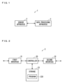
- FIG. 1 is a schematic diagram illustrating one example of a configuration of a measurement system 1 according to Embodiment 1.
- the measurement system 1 is, for example, a system that can measure three-dimensional positions of measurement points in a measurement space being a target space to be measured in a non-contact manner. In the measurement space, at least one object is present.
- the measurement points are, for example, located on a surface of the object in the measurement space.
- the measurement system 1 includes, for example, a sensor apparatus 2 and a data processing apparatus 3.
- the sensor apparatus 2 acquires, for example, distance information to a measurement point in the measurement space and color information of the measurement point in the measurement space.
- the data processing apparatus 3 acquires a three-dimensional position of the measurement point in the measurement space, based on the distance information and the color information acquired in the sensor apparatus 2.
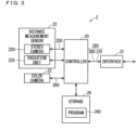
- FIG. 2 is a schematic diagram illustrating one example of a configuration of the data processing apparatus 3.
- the data processing apparatus 3 includes, for example, a controller 30, a first interface 31, a second interface 32, and a storage 33. It can also be said that the data processing apparatus 3 is a data processing circuit, for example.
- the data processing apparatus 3 is a type of computer apparatus, for example.
- the first interface 31 can perform communication with the sensor apparatus 2. It can also be said that the first interface 31 is an interface circuit, for example. It can also be said that the first interface 31 is a communication unit or a communication circuit, for example.
- the first interface 31 may perform wired communication with the sensor apparatus 2, or may perform wireless communication therewith.
- the first interface 31 may communicate with the sensor apparatus 2 in conformity with at least one communication standard.
- the at least one communication standard with which the first interface 31 conforms may include at least one of a Universal Serial Bus (USB), an Inter-Integrated Circuit (I2C), a Clocked Serial Interface (CSI), a Serial Peripheral Interface (SPI), WiFi, and Ethernet, for example.
- the first interface 31 may communicate with the sensor apparatus 2 via the Internet.
- the second interface 32 can communicate with an external apparatus of the measurement system 1 (also simply referred to as an external apparatus).
- the second interface 32 can communicate with at least one external apparatus. It can also be said that the second interface 32 is an interface circuit, for example. It can also be said that the second interface 32 is a communication unit or a communication circuit, for example.
- the second interface 32 may perform wired communication with the external apparatus, or may perform wireless communication therewith.
- the second interface 32 may communicate with the external apparatus in conformity with at least one communication standard.
- the at least one communication standard with which the second interface 32 conforms may include at least one of a USB, an I2C, a CSI, an SPI, WiFi, and Ethernet, for example.
- the second interface 32 may communicate with the external apparatus via the Internet.
- the at least one external apparatus with which the second interface 32 can communicate may include a display apparatus, or may include a server such as a cloud server.
- the display apparatus with which the second interface 32 can communicate may be near-eye displays (NEDs) such as a heads-up display (HUD) and a head-mounted device (HMD).
- NEDs near-eye displays
- HUD heads-up display
- HMD head-mounted device
- the at least one external apparatus may include a mobile device.
- the mobile device may be a mobile phone such as a smartphone, may be a tablet terminal, may be a personal computer, or may be a wearable device.
- the wearable device with which the second interface 32 can communicate may be an arm-worn type such as a wristband type or a wristwatch type, may be a head-worn type such as a headband type or an eyeglass type, or may be a body-worn type such as a garment type.
- the controller 30 can integrally manage operations of the data processing apparatus 3 by controlling other constituent elements of the data processing apparatus 3. It can also be said that the controller 30 is a control circuit, for example. As will be described in further detail below, the controller 30 includes at least one processor in order to provide control and processing capabilities for executing various functions.
- the at least one processor may be executed as a single integrated circuit (IC), or as a plurality of communicably connected integrated circuit ICs and/or discrete circuits.
- the at least one processor can be executed in accordance with various known technologies.
- the processor includes one or more circuits or units configured to perform one or more data computing procedures or processes by executing instructions stored in an associated memory, for example.
- the processor may be implemented as firmware (e.g. discrete logic components) configured to perform one or more data computing procedures or processes.
- the processor may include one or more processors, controllers, microprocessors, microcontrollers, application specific integrated circuits (ASICs), digital signal processors, programmable logic devices, field programmable gate arrays, any combination of these devices or structures, or a combination of other known devices and structures, to perform the functions described herein.
- ASICs application specific integrated circuits
- digital signal processors programmable logic devices, field programmable gate arrays, any combination of these devices or structures, or a combination of other known devices and structures, to perform the functions described herein.
- the controller 30 may include a central processing unit (CPU) as the processor, for example.
- the storage 33 may include a non-transitory recording medium that can be read by the CPU of the controller 30, such as a read only memory (ROM) and a random access memory (RAM).
- the storage 33 stores a program 330 and the like for controlling the data processing apparatus 3, for example.
- Various functions of the controller 30 are implemented by the CPU of the controller 30 executing the program 330 in the storage 33, for example.
- the configuration of the controller 30 is not limited to the example described above.
- the controller 30 may include a plurality of CPUs.
- the controller 30 may include at least one digital signal processor (DSP). All of the functions of the controller 30 or a part of the functions of the controller 30 may be implemented by a hardware circuit that does not require software to implement the functions.
- the storage 33 may include a computer-readable non-transitory recording medium, other than the ROM and the RAM.
- the storage 33 may include a small-sized hard disk drive, a solid state drive (SSD), or the like.
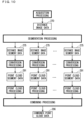
- FIG. 3 is a schematic diagram illustrating one example of a configuration of the sensor apparatus 2.
- the sensor apparatus 2 includes, for example, a controller 20, an interface 21, a distance measurement sensor 22, a color camera 23, and a storage 24. It can also be said that the sensor apparatus 2 is a sensor circuit, for example.
- the interface 21 can communicate with the first interface 31 of the data processing apparatus 3. It can also be said that the interface 21 is an interface circuit, for example. It can also be said that the interface 21 is a communication unit or a communication circuit.
- the interface 21 includes a configuration similar to that of the first interface 31, for example.
- the controller 20 can integrally manage operations of the sensor apparatus 2 by controlling other constituent elements of the sensor apparatus 2. It can also be said that the controller 20 is a control circuit, for example. As will be described in further detail below, the controller 20 includes at least one processor in order to provide control and processing capabilities for executing various functions. The above description relating to the at least one processor included in the controller 30 is also applicable to at least one processor included in the controller 20.
- the controller 20 may include a CPU as the processor, for example.
- the storage 24 may include a non-transitory recording medium that can be read by the CPU of the controller 20, such as a ROM and a RAM.
- the storage 24 stores a program 240 and the like for controlling the sensor apparatus 2, for example.
- Various functions of the controller 20 are implemented by the CPU of the controller 20 executing the program 240 in the storage 24, for example.
- the configuration of the controller 20 is not limited to the example described above.
- the controller 20 may include a plurality of CPUs.
- the controller 20 may include at least one DSP. All of the functions of the controller 20 or a part of the functions of the controller 20 may be implemented by a hardware circuit that does not require software to implement the functions.
- the storage 24 may include a computer-readable non-transitory recording medium, other than the ROM and the RAM.
- the distance measurement sensor 22 is a sensor for acquiring distance information to the measurement point in the measurement space, and includes, for example, a stereo camera 220 and a radiation unit 225.
- the controller 20 acquires the distance information to the measurement point in the measurement space, based on detection results in the distance measurement sensor 22.
- the radiation unit 225 radiates an infrared pattern in the measurement space under control of the controller 20, for example.
- the stereo camera 220 captures an image of the measurement space when the radiation unit 225 radiates the infrared pattern.
- the stereo camera 220 can capture an image of the object in the measurement space and also the infrared pattern (also referred to as a projected pattern) projected on the object.
- the stereo camera 220 includes a left camera and a right camera. Each of the left camera and the right camera includes an image sensor and a lens, for example. In each of the left camera and the right camera, light enters an image sensor through the lens.
- the image sensor includes a plurality of sensor cells (also referred to as pixel parts) arrayed in a matrix pattern, for example.
- Each of the left camera and the right camera generates image data 250 representing an image in which the measurement space appears, and outputs the image data 250.
- the color camera 23 captures a color image of the measurement space when the radiation unit 225 does not radiate the infrared pattern.
- the color camera 23 includes an image sensor and a lens, for example. In the color camera 23, light enters an image sensor through the lens.
- the image sensor includes a plurality of sensor cells arrayed in a matrix pattern, for example.
- the color camera 23 generates color image data 260 representing a color image in which the measurement space appears, and outputs the color image data 260.
- a plurality of pixels constituting the color image represented by the color image data 260 respectively include a plurality of measurement points.
- the color image data 260 is data that two-dimensionally represents the color information of the measurement point in the measurement space.
- the color image data 260 includes pixel values of the plurality of pixels constituting the color image represented thereby.
- a pixel value of a certain pixel is the color information of the measurement point appeared in the certain pixel. It can also be said that the pixel value of the certain pixel is the color information of the measurement point corresponding to the certain pixel.
- the color information of the measurement point is information representing a color of the measurement point.
- the color of the measurement point is represented by the three primary colors of light, for example.
- the pixel value, i.e., the color information includes an R component (red component), a G component (green component), and a B component (blue component), for example.
- Such color image data 260 is also referred to as RGB image data.
- the color camera 23 is also referred to as an RGB camera 23.
- pixel position information representing a position of the pixel and a pixel value of the pixel (i.e., the color information) are associated with each other.
- the color image data 260 generated in the color camera 23 is input to the controller 20.
- the controller 20 performs filter processing on the input color image data 260, for example, and inputs the color image data 260 to the interface 21.
- the controller 20 generates distance image data 270 representing a distance image, based on the image data 250 output from the two cameras included in the stereo camera 220.
- the plurality of pixels constituting the distance image respectively correspond to the plurality of measurement points appeared in the plurality of pixels constituting the image captured by one of the cameras of the stereo camera 220.
- the distance image data 270 includes the pixel values of the plurality of pixels constituting the distance image.
- a pixel value of a certain pixel included in the distance image is the distance information representing the distance to the measurement point corresponding to the certain pixel. It can be said that the distance image data 270 is data that two-dimensionally represents the distance information to the measurement point in the measurement space.
- the pixel position information representing a position of the pixel and the distance information being a pixel value of the pixel are associated with each other.
- the controller 20 inputs the generated distance image data 270 and the color image data 260 subjected to the filter processing to the interface 21 as an image data set 280.
- the interface 21 transmits the input image data set 280 to the data processing apparatus 3.
- the number of the plurality of measurement points respectively corresponding to a plurality of pieces of color information included in the color image data 260 matches the number of the plurality of measurement points respectively corresponding to a plurality of pieces of distance information included in the distance image data 270.
- the color information of a pixel at a certain pixel position included in the color image data 260 and the distance information of the pixel at the same pixel position as the certain pixel position included in the distance image data 270 correspond to the same measurement point.
- the color information of a certain measurement point included in the color image data 260 and the distance information to the certain measurement point included in the distance image data 270 correspond to the pixel at the same pixel position.
- the following expression is used that certain color information included in the color image data 260 and distance information of the pixel at the same pixel position as the pixel position corresponding to the certain color information included in the distance image data 270 correspond to each other.
- the following expression is used that the color information of a certain measurement point and the distance information to the certain measurement point correspond to each other.
- FIG. 4 is a schematic diagram for illustrating one example of the distance information included in the distance image data 270.
- FIG. 4 illustrates a measurement point located on a surface of an object 900 in a measurement space 1000 as one example of a measurement point 1001 in the measurement space 1000.
- the term "distance information" by itself hereinafter refers to the distance information included in the distance image data 270.
- the distance information is information representing the distance from the stereo camera 220 to the measurement point 1001, for example.
- the distance information may be information representing the distance from the stereo camera 220 to the measurement point 1001 along a specific direction, for example.
- the distance information may be information representing a distance d0 (also referred to as a specific direction distance d0) from the stereo camera 220 to the measurement point 1001 along a direction perpendicular to a reference straight line 990 connecting the two cameras included in the stereo camera 220, for example.
- the specific direction distance d0 is a distance from the reference straight line 990 to the measurement point 1001 along the direction perpendicular to the reference straight line 990.
- the reference straight line 990 may be a line connecting the centers of imaging surfaces of the image sensors of the two cameras included in the stereo camera 220, for example.
- the specific direction distance d0 can be calculated using parallax between the two cameras included in the stereo camera 220 (also referred to as inter-camera parallax), a distance between the two cameras (also referred to as an inter-camera distance), and a focal length of the two cameras, based on the principle of triangulation, for example.
- the inter-camera distance and the focal length are known values.
- the controller 20 identifies the inter-camera parallax, based on the image data 250 output from the two cameras included in the stereo camera 220. Then, the controller 20 can calculate the specific direction distance d0, using the identified inter-camera parallax and the known inter-camera distance and focal length.
- the specific direction distance d0 is a depth of the measurement point 1001 in the measurement space 1000 when seen from the stereo camera 220.
- the distance information representing the specific direction distance d0 is also referred to as depth information.
- the distance image data 270 including the distance information representing the specific direction distance d0 is also referred to as depth image data.
- the distance image represented by the distance image data 270 including the distance information representing the specific direction distance d0 is also referred to as a depth image.
- the distance information may be information representing a direct distance d1 (see FIG. 4 ) from the stereo camera 220 to the measurement point 1001.
- the direct distance d1 may be a direct distance from the midpoint between the two cameras included in the stereo camera 220 to the measurement point 1001, or may be a direct distance from one of the two cameras to the measurement point 1001.
- the direct distance d1 can be calculated based on the specific direction distance d0, performance of the stereo camera 220, and the like, for example.
- the controller 30 of the data processing apparatus 3 can convert at least a part of the distance image data 270 output from the sensor apparatus 2 to point cloud data including coordinate information of the measurement point in the measurement space.
- the point cloud data is data representing a point cloud (also referred to as a measurement point cloud) being a set of the plurality of measurement points in the measurement space. It can also be said that the point cloud data is data representing the object in the measurement space, using a plurality of points.
- the point cloud data is also data representing a surface shape of the object in the measurement space.
- the point cloud data includes the coordinate information representing the positions of the points on the surface of the object in the measurement space.
- the distance between two measurement points included in the point cloud is an actual distance in the measurement space, for example.
- the controller 30 can also convert at least a part of the distance image data 270 to point cloud data together with at least a part of the color image data 260.
- the controller 30 can also convert at least a part of the image data set 280 consisting of the distance image data 270 and the color image data 260 to point cloud data.
- the controller 30 converts at least a part of the distance image data 270 together with at least a part of the color image data 260 including a plurality of pieces of color information respectively corresponding to a plurality of pieces of distance information included in at least the part thereof to point cloud data.
- the point cloud data includes the coordinate information and the color information of the measurement point in the measurement space.
- the point cloud data is also data representing the surface shape and the color of the object in the measurement space.
- the point cloud data includes the coordinate information representing the positions of the points on the surface of the object in the measurement space and the color information representing the colors of the points.
- the target data to be converted to the point cloud data may be hereinafter referred to as point cloud conversion target data.
- the point cloud conversion target data may be at least a part of the distance image data 270 or at least a part of the image data set 280.
- the point cloud conversion target data at least includes at least a part of the distance image data.
- the measurement points increase due to complementation processing or the like.
- the number of the plurality of measurement points constituting the point cloud represented by the point cloud data is larger than the number of the plurality of measurement points respectively corresponding to the plurality of pieces of distance information included in the point cloud conversion target data.
- the number of the plurality of measurement points constituting the point cloud represented by the point cloud data is larger than the number of the plurality of measurement points respectively corresponding to the plurality of pieces of distance information included in the distance image data 270.
- the number of the plurality of measurement points constituting the point cloud represented by the point cloud data is larger than the number of the plurality of measurement points respectively corresponding to the plurality of pieces of color information included in the color image data 260.
- FIG. 5 is a schematic diagram illustrating one example of the three-dimensional orthogonal coordinate system 1100 (also simply referred to as a coordinate system 1100).
- FIG. 5 schematically illustrates a visual field range 220a of the stereo camera 220.
- the measurement space 1000 is included in the visual field range 220a.
- An origin 1101 of the coordinate system 1100 is set in the stereo camera 220, for example.
- the origin 1101 may be set to the midpoint between the two cameras included in the stereo camera 220, or may be set to another position.
- the z-axis of the coordinate system 1100 is set to be parallel with an optical axis direction of the stereo camera 220, with the positive side facing a depth side of the visual field range 220a (i.e., a depth side of the measurement space 1000 when seen from the stereo camera 220). It can be said that a z-coordinate value of the coordinate system 1100 is a coordinate value of the measurement space 1000 in a depth direction.
- the x-axis of the coordinate system 1100 is set to be perpendicular to the z-axis of the coordinate system 1100, and the y-axis of the coordinate system 1100 is set to be perpendicular to the x-axis and the z-axis of the coordinate system 1100.
- FIG. 6 is a schematic diagram illustrating one example of the point cloud data when the point cloud conversion target data is at least a part of the image data set 280.
- the point cloud data includes coordinate information 800 in the coordinate system 1100 regarding the measurement points in the measurement space and color information 810.
- the coordinate information 800 of the measurement point and the color information 810 of the measurement point are associated with each other.
- the coordinate information 800 of the point and the color information 810 of the point are associated.
- the coordinate information 800 representing the position of the point and the color information 810 representing the color of the point are included.
- the coordinate information 800 includes an x-coordinate value, a y-coordinate value, and a z-coordinate value of the coordinate system 1100.
- the color information 810 includes an R component, a G component, and a B component.
- the controller 30 generates a plurality of pieces of coordinate information 800 included in the point cloud data, based on at least a part of the distance image data 270 included in the point cloud conversion target data and performance parameters of the stereo camera 220 such as a size of the image sensor, an angle of view, and a focal length.
- the controller 30 generates a plurality of pieces of color information 810 included in the point cloud data, based on at least a part of the color image data 260 included in the point cloud conversion target data and performance parameters of the stereo camera 220 such as a size of the image sensor, an angle of view, and a focal length.
- the point cloud data as in FIG. 6 is also referred to as colored point cloud data.
- the color information 810 is not included in the point cloud data.
- information other than the color information 810 may be associated with the coordinate information 800.
- vector information representing a normal vector of the certain measurement point may be associated, or curvature information representing a curvature of the certain measurement point may be associated.
- the point cloud data is generated based on at least a part of the distance image data 270.
- the distance for example, the specific direction distance d0
- an error tends to be greater. This is because angular resolution of the stereo camera 220 and spatial resolution of the infrared pattern radiated by the radiation unit 225 are further reduced at a distance farther away from the distance measurement sensor 22. Consequently, regarding the coordinate information 800 included in the point cloud data generated based on at least a part of the distance image data 270, a noise component tends to be larger as the z-coordinate values included therein are larger.
- the processing may not be appropriately performed on the point cloud data.
- a case is considered in which noise removal processing is performed on the plurality of pieces of coordinate information included in the point cloud data, using common processing parameters.
- the processing parameters are adjusted to enhance a noise removal effect, the noise component can be appropriately removed regarding the coordinate information having a large noise component; however, regarding the coordinate information having a small noise component, the noise removal effect may be excessively high and thus necessary information may be removed from the coordinate information.
- the noise removal effect when the noise removal effect is reduced, regarding the coordinate information having a small noise component, the noise component can be appropriately removed; however, regarding the coordinate information having a large noise component, the noise removal effect may be inadequate and thus the noise component may not be sufficiently removed from the coordinate information.
- the controller 30 divides the point cloud conversion target data into a plurality of segment data depending on the distance information, and individually converts each segment data to the point cloud data. Then, the controller 30 performs individual processing on each obtained point cloud data. Consequently, the controller 30 can appropriately process each point cloud data depending on the z-coordinate values included therein, and can enhance accuracy of each point cloud data. Operation of the controller 30 will be described below in detail.
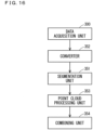
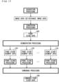
- FIG. 7 is a schematic diagram illustrating one example of a plurality of functional blocks formed in the controller 30 by the controller 30 executing the program 330.
- the controller 30 includes a data acquisition unit 300, a segmentation unit 301, a converter 302, a point cloud processing unit 303, and a combining unit 304.
- all of the functions of the data acquisition unit 300 or a part of the functions of the data acquisition unit 300 may be implemented by a hardware circuit that does not require software to implement the functions.
- the data acquisition unit 300 performs acquisition processing of acquiring at least the distance image data 270 out of the image data set 280 from the sensor apparatus 2 via the first interface 31.
- the data acquisition unit 300 acquires the distance image data 270 and the color image data 260 from the sensor apparatus 2, for example.
- the data acquisition unit 300 acquires the image data set 280 from the sensor apparatus 2.
- the data acquisition unit 300 transmits image capturing start instruction information for giving notification of an instruction to start image capturing to the sensor apparatus 2 via the first interface 31, for example.
- the controller 20 controls the distance measurement sensor 22 and the color camera 23, and causes each of the stereo camera 220 and the color camera 23 to capture an image.
- the controller 20 generates the distance image data 270, based on the image data 250 from the stereo camera 220, and performs processing on the color image data 260 from the color camera 23.
- the controller 20 transmits the image data set 280 consisting of the distance image data 270 and the color image data 260 to the data processing apparatus 3 via the interface 21.
- the image data set 280 received by the first interface 31 from the sensor apparatus 2 is input to the controller 30. Consequently, in the acquisition processing, the data acquisition unit 300 can acquire the image data set 280 in response to transmission of the image capturing start instruction information.
- the segmentation unit 301 performs segmentation processing of dividing at least a part of the distance image data 270 acquired at least in the acquisition processing to a plurality of segment data.
- the segmentation unit 301 divides the image data set 280 acquired in the acquisition processing to a plurality of segment data.
- the segmentation unit 301 divides each of the distance image data 270 and the color image data 260 included in the image data set 280 to a plurality of segment data.
- the distance image data 270 is divided into a plurality of distance image segment data
- the color image data 260 is divided into a plurality of color image segment data.
- one distance image segment data and one color image segment data constitute one segment data set.
- the segmentation unit 301 divides the image data set 280 into a plurality of segment data sets. It can also be said that the segment data set is a type of segment data.
- the converter 302 performs conversion processing of converting the segment data to point cloud data.
- the conversion processing for example, regarding each of the plurality of segment data sets obtained in the segmentation processing, the converter 302 converts the segment data set to point cloud data.
- the segment data set is the point cloud conversion target data.
- the point cloud processing unit 303 performs point cloud processing of performing predetermined processing on the point cloud data.
- the combining unit 304 performs combining processing of combining the plurality of point cloud data subjected to the point cloud processing.
- FIG. 8 is a schematic diagram illustrating one example of the point cloud generation processing in which the point cloud data is generated based on the data acquired in the sensor apparatus 2.
- the point cloud generation processing is performed by the controller 30.
- one point cloud data is generated based on the image data set 280.
- the acquisition processing is performed, and the image data set 280 is acquired from the sensor apparatus 2.
- the segmentation processing is performed on the image data set 280 acquired in the acquisition processing, and a plurality of segment data sets 285 are generated.
- the distance image data 270 included in the acquired image data set 280 is divided into a plurality of distance image segment data 275 depending on the distance information.
- the color image data 260 included in the acquired image data set 280 is divided into a plurality of color image segment data 265 depending on the distance information corresponding to the color information included therein.
- a possible range of the distance indicated by the distance information is divided into N distance sections of from a first distance section to an N-th distance section (N is an integer of 2 or greater). Then, in the segmentation processing, the distance image data 270 is divided into N distance image segment data 275 respectively corresponding to the N distance sections, and the color image data 260 is divided into N color image segment data 265 respectively corresponding to the N distance sections.
- FIG. 9 is a schematic diagram illustrating one example of the first distance section to the N-th distance section.
- An n-th distance section (n is a variable and is an integer satisfying 1 ⁇ n ⁇ N) is a range of a distance An - 1 or more and less than the distance An, for example.
- the N-th distance section is a range of a distance AN - 1 or more and the distance AN or less.
- the distance An is larger than the distance An - 1.
- the distance A0 is a minimum value (for example, 0) of the possible range of the distance indicated by the distance information, for example.
- the distance AN is a maximum value of the possible range of the distance indicated by the distance information, for example.
- the first distance section is a range of the distance A0 or more and less than a distance A1
- the second distance section is a range of the distance A1 or more and less than a distance A2.
- the segmentation unit 301 includes the distance information indicating the distance included in the n-th distance section and the pixel position information associated with the distance information out of the distance image data 270 in the distance image segment data 275 corresponding to the n-th distance section. Consequently, the plurality of pieces of distance information included in one distance image segment data 275 indicate distances close to each other.
- the segmentation unit 301 includes the color information corresponding to the n-th distance section and the pixel position information associated with the color information out of the color image data 260 in the color image segment data 265 corresponding to the n-th distance section.
- the color information corresponding to the n-th distance section included in the color image data 260 of a certain image data set 280 is the color information corresponding to the distance information indicating the distance included in the n-th distance section in the distance image data 270 of the certain image data set 280.
- the color information corresponding to the n-th distance section included in the color image data 260 is the color information corresponding to the same measurement point as the distance information indicating the distance included in the n-th distance section in the distance image data 270.
- the segmentation unit 301 regards one distance image segment data 275 and one color image segment data 265 corresponding to the same distance section as one segment data set 285 corresponding to the distance section.
- the distance image segment data 275 and the color image segment data 265 corresponding to the n-th distance section constitute one segment data set 285 corresponding to the n-th distance section.
- N segment data sets 285 respectively corresponding to the N distance sections are generated.
- the image data set 280 is divided into N segment data sets 285 depending on the distance information.
- a plurality of distance image segment data 276 and a plurality of color image segment data 265 constitute a plurality of segment data sets 285 in which each set includes one distance image segment data and one color image segment data of the same distance section.
- the N distance sections may include a plurality of distance sections having different section lengths, or may include a plurality of distance sections having the same section length.
- the length of the first distance section may be the same as or different from the length of the second distance section.
- the N distance sections need not be contiguous.
- the conversion processing of converting the segment data set 285 to point cloud data is performed.
- the converter 302 performs the conversion processing of converting the segment data set 285 to point cloud data 290 (also referred to as point cloud segment data 290).
- point cloud segment data 290 also referred to as point cloud segment data 290.
- the segment data set 285 is the point cloud conversion target data.
- each point cloud segment data 290 includes a plurality of pieces of coordinate information 800 and a plurality of pieces of color information 810 respectively associated with the plurality of pieces of coordinate information 800.
- the measurement points increase due to complementation processing or the like.
- the number of the plurality of measurement points constituting the point cloud represented by the point cloud segment data 290 is larger than the number of the plurality of measurement points respectively corresponding to the plurality of pieces of distance information included in the distance image segment data 275, and is larger than the number of the plurality of measurement points respectively corresponding to the plurality of pieces of color information included in the color image segment data 265.
- the plurality of pieces of distance information included in one distance image segment data 275 indicate distances close to each other, and accordingly the z-coordinate values of the plurality of pieces of coordinate information 800 included in one point cloud segment data 290 generated based on one distance image segment data 275 are values close to each other.
- the converter 302 may perform the conversion processing regarding at least two segment data sets 285 of the N segment data sets 285 in parallel, for example.
- the converter 302 may perform at least two conversion processings of a plurality of conversion processings of respectively converting the plurality of segment data sets 285 to the plurality of point cloud segment data 290 in parallel. Consequently, a processing time for obtaining the point cloud segment data 290 can be reduced.
- the converter 302 may perform N conversion processings of respectively converting the N segment data sets 285 to N point cloud segment data 290 in parallel.
- the converter 302 may perform a plurality of conversion processings as a part of the N conversion processings in parallel.
- the converter 302 may sequentially perform at least two conversion processings of the N conversion processings in series. Regarding these parallel processing and series processing, the same applies to the conversion processing performed by the converter 302 to be described later. Regarding these parallel processing and series processing, the same applies to the point cloud processing performed by a converter 352 to be described later.
- the point cloud segment data 290 obtained as a result of the conversion processing having been performed on the segment data set 285 corresponding to the n-th distance section is hereinafter referred to as the point cloud segment data 290 corresponding to the n-th distance section.
- the converter 302 generates N point cloud segment data 290 respectively corresponding to the first distance section to the N-th distance section.
- the z-coordinate values of the plurality of pieces of coordinate information 800 included in the point cloud segment data 290 tend to indicate larger values as the distance section corresponding to the point cloud segment data 290 is larger.
- the z-coordinate values of the plurality of pieces of coordinate information 800 included in the point cloud segment data 290 corresponding to an (n+1)-th distance section tend to be larger than the z-coordinate values of the plurality of pieces of coordinate information 800 included in the point cloud segment data 290 corresponding to the n-th distance section.
- the point cloud processing unit 303 individually performs the point cloud processing regarding each of the N generated point cloud segment data 290.
- the noise removal processing is performed on the point cloud segment data 290.
- the noise removal processing is performed on the plurality of pieces of coordinate information 800 included in the point cloud segment data 290.
- a low-pass filter may be employed.
- the low-pass filter may be a low-pass filter using wavelet transform.
- a bilateral filter may be employed, or a filter for removing a statistic noise may be employed. Note that the noise removal processing is not performed on the plurality of pieces of color information 810 included in the point cloud segment data 290.
- the point cloud processing unit 303 may make the processing parameters different between processings for the N point cloud segment data 290, for example.
- the point cloud processing unit 303 may make the processing parameters different between the noise removal processings for the N point cloud segment data 290.
- the point cloud processing unit 303 may make filter coefficients different between the noise removal processings for the N point cloud segment data 290, for example. Consequently, the noise removal effect can be made different between the noise removal processings for the N point cloud segment data 290, for example.
- the noise component tends to be larger as the z-coordinate values included therein are larger.
- the z-coordinate values of the plurality of pieces of coordinate information 800 included in the point cloud segment data 290 tend to indicate larger values as the distance section corresponding to the point cloud segment data 290 is larger. Consequently, regarding the coordinate information 800 included in the point cloud segment data 290, the noise component tends to be larger as the distance section corresponding to the point cloud segment data 290 is larger.
- the noise component tends to be larger than in the coordinate information 800 included in the point cloud segment data 290 corresponding to the n-th distance section.
- the point cloud processing unit 303 may make the filter coefficients different between the noise removal processings for the N point cloud segment data 290, and thereby increase the noise removal effect of the noise removal processings for the point cloud segment data 290 as the distance section corresponding to the point cloud segment data 290 is larger.
- the point cloud processing unit 303 may increase the noise removal effect regarding the coordinate information 800 included in the point cloud segment data 290 corresponding to the (n+1)-th distance section further than the noise removal effect regarding the coordinate information 800 included in the point cloud segment data 290 corresponding to the n-th distance section.
- the noise removal effect can be increased for the coordinate information 800 whose noise component tends to be large which is included in the point cloud segment data 290 with a large corresponding distance section, and the noise removal effect can be reduced for the coordinate information 800 whose noise component tends to be small which is included in the point cloud segment data 290 with a small corresponding distance section. Therefore, the noise removal processing can be appropriately performed on each point cloud segment data 290. As a result, accuracy of each point cloud segment data 290 can be enhanced.
- the point cloud processing unit 303 may make the processing parameters different between processings for at least two point cloud segment data 290 of the N point cloud segment data 290. In this case, appropriate processing can be performed on each of the at least two point cloud segment data 290.
- the point cloud processing unit 303 may perform the point cloud processing regarding at least two point cloud segment data 290 of the N point cloud segment data 290 in parallel. In this case, a processing time regarding at least two point cloud segment data 290 can be reduced. As illustrated in FIG. 8 , the point cloud processing unit 303 may perform the point cloud processing regarding the N point cloud segment data 290 in parallel, or may perform the point cloud processing regarding a plurality of point cloud segment data 290 as a part of the N point cloud segment data 290 in parallel. The point cloud processing unit 303 may sequentially perform the point cloud processing regarding at least two point cloud segment data 290 of the N point cloud segment data 290 in series. Regarding these parallel processing and series processing, the same applies to the point cloud processing performed by the point cloud processing unit 303 to be described later. Regarding these parallel processing and series processing, the same applies to the point cloud processing performed by a point cloud processing unit 353 to be described later.
- the combining processing of combining the N point cloud segment data 290 is performed.
- the combining unit 304 combines the N point cloud segment data 290 subjected to the point cloud processing and generates one point cloud data 295 (also referred to as combined point cloud data 295).
- the combining unit 304 may simply collect and output the N point cloud segment data 290 subjected to the point cloud processing as one combined point cloud data 295, for example.
- the data processing apparatus 3 generates the point cloud data 295, based on the distance image data 270 and the color image data 260 obtained in the sensor apparatus 2. It can also be said that the data processing apparatus 3 converts the distance image data 270 to the point cloud data 295 together with the color image data 260.
- the plurality of pieces of coordinate information 800 and the plurality of pieces of color information 810 are associated on a one-to-one basis.
- the point cloud data 295 is also referred to as colored point cloud data.
- the controller 30 may transmit the point cloud data (in the above example, the combined point cloud data 295) finally obtained in the point cloud generation processing to the external apparatus via the second interface 32.
- the external apparatus may perform processing based on the received point cloud data.
- the display apparatus included in the external apparatus may display the received point cloud data.
- the external apparatus may generate polygon data from the received point cloud data, or may generate computer-aided design (CAD) data from the generated polygon data.
- CAD computer-aided design
- the controller 30 may generate the polygon data from the point cloud data generating the point cloud generation processing, or may generate CAD data from the generated polygon data.
- the controller 30 of the data processing apparatus 3 may generate a plurality of point cloud data 295, based on a plurality of image data sets 280 respectively output by the plurality of sensor apparatuses 2. Then, in the point cloud generation processing, the controller 30 may combine the plurality of generated point cloud data 295 and generate one point cloud data as an atlas, for example.
- the distance image data 270 is converted to point cloud data together with the color image data 260, only the distance image data 270 may be converted to point cloud data.
- the sensor apparatus 2 need not include the color camera 23, and may include the color camera 23.
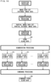
- FIG. 10 is a schematic diagram illustrating one example of the point cloud generation processing in which the point cloud data is generated based only on the distance image data 270.
- the data acquisition unit 300 acquires the distance image data 270 from the sensor apparatus 2.
- the segmentation unit 301 divides the distance image data 270 acquired in the acquisition processing into a plurality of distance image segment data 275 depending on the distance information.
- the distance image data 270 is divided into N distance image segment data 275.
- the data acquisition unit 300 may acquire both of the distance image data 270 and the color image data 260 from the sensor apparatus 2, and the segmentation unit 301 may divide only the distance image data 270 out of the acquired distance image data 270 and color image data 260 into a plurality of segment data.
- the converter 302 After the segmentation processing, regarding each of the N distance image segment data 275 obtained in the segmentation processing, the converter 302 performs the conversion processing of converting the distance image segment data 275 to point cloud data 291 (also referred to as point cloud segment data 291).
- point cloud data 291 also referred to as point cloud segment data 291.
- the distance image segment data 275 is the point cloud conversion target data.
- the point cloud data 291 includes the coordinate information 800 but does not include the color information 810. Similarly to the above point cloud segment data 290, the number of the plurality of measurement points constituting the point cloud represented by the point cloud segment data 291 is larger than the number of the plurality of measurement points respectively corresponding to the plurality of pieces of distance information included in the distance image segment data 275.
- the z-coordinate values of the plurality of pieces of coordinate information 800 included in one point cloud segment data 291 are values close to each other.
- the point cloud segment data 291 obtained as a result of the conversion processing having been performed on the distance image segment data 275 corresponding to the n-th distance section is hereinafter referred to as the point cloud segment data 291 corresponding to the n-th distance section.
- the z-coordinate values of the plurality of pieces of coordinate information 800 included in the point cloud segment data 291 tend to indicate larger values as the distance section corresponding to the point cloud segment data 291 is larger.
- the point cloud processing unit 303 individually performs the point cloud processing similar to the above regarding each of the N generated point cloud segment data 291. Similarly to the point cloud segment data 290, the point cloud processing unit 303 may make the processing parameters different between at least two point cloud segment data 291 of the N point cloud segment data 291, for example. For example, the point cloud processing unit 303 may make the filter coefficients different between the noise removal processings for the N point cloud segment data 291, and thereby increase the noise removal effect of the noise removal processings for the point cloud segment data 291 as the distance section corresponding to the point cloud segment data 291 is larger.
- the noise removal effect can be increased for the coordinate information 800 whose noise component tends to be large which is included in the point cloud segment data 291 with a large corresponding distance section, and the noise removal effect can be reduced for the coordinate information 800 whose noise component tends to be small which is included in the point cloud segment data 291 with a small corresponding distance section. Therefore, the noise removal processing can be appropriately performed on each point cloud segment data 291.
- the combining unit 304 combines the N point cloud segment data 291 subjected to the point cloud processing and generates one point cloud data 296 (also referred to as combined point cloud data 296).
- the combined point cloud data 296 includes the coordinate information 800 but does not include the color information 810.
- the distance image data 270 is divided into a plurality of distance image segment data 275 depending on the distance information. Then, each of the plurality of distance image segment data 275 is individually converted to point cloud data. Consequently, each point cloud data can be appropriately processed depending on the distance section corresponding thereto.
- the distance section corresponding to the point cloud data corresponds to the z-coordinate values included in the point cloud data, and thus each point cloud data can be appropriately processed depending on the z-coordinate values included therein. As a result, accuracy of each point cloud data can be enhanced. Therefore, accuracy of the combined point cloud data can be enhanced.
- the distance image data 270 is divided into a plurality of color image segment data 265 depending on the distance information.
- the distance image segment data 275 is converted to point cloud data together with the color image segment data 265. Consequently, the point cloud data in which the coordinate information 800 and the color information 810 are appropriately associated can be obtained.
- the coordinate information 800 and the color information 810 are associated, and thus even when the point cloud processing is performed regarding the point cloud data, correspondence between the coordinate information 800 and the color information 810 can be appropriately maintained.
- the value of N may be set depending on the accuracy of the combined point cloud data required by a user.
- the value of N may be determined based on a measurement environment, or may be set based on properties of lenses of the stereo camera 220 and the color camera 23.
- FIG. 11 is a schematic diagram illustrating one example of a configuration of the controller 30 of the data processing apparatus 3 included in the measurement system 1 according to Embodiment 2.
- FIG. 12 is a schematic diagram illustrating one example of the point cloud generation processing according to Embodiment 2.
- the measurement system 1 according to Embodiment 2 includes a configuration similar to that of the measurement system 1 according to Embodiment 1 described above. In comparison to the measurement system 1 according to Embodiment 1, the measurement system 1 according to Embodiment 2 is different only in the operation of the controller 30 of the data processing apparatus 3. For example, the controller 30 according to Embodiment 2 generates point cloud data representing a specific object in the measurement space, based on data acquired in the sensor apparatus 2. In Embodiment 2, high-accuracy point cloud data representing the specific object in the measurement space can be obtained.
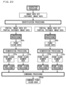
- the controller 30 includes an identification unit 305, in addition to the data acquisition unit 300, the segmentation unit 301, the converter 302, the point cloud processing unit 303, and the combining unit 304 described above. Note that all of the functions of the identification unit 305 or a part of the functions of the identification unit 305 may be implemented by a hardware circuit that does not require software to implement the functions.
- the identification unit 305 performs identification processing of identifying data related to the specific object in the measurement space.
- the identification unit 305 identifies the data related to the specific object in the image data set 280, for example. Specifically, as illustrated in FIG. 12 , in the identification processing, the identification unit 305 identifies partial distance image data 271 including the distance information related to the specific object in the distance image data 270.
- the identification unit 305 identifies partial color image data 261 including the color information related to the specific object in the color image data 260.
- the partial distance image data 271 includes the distance information to each measurement point on the surface of the specific object and the pixel position information associated with the distance information.
- the partial color image data 261 includes the color information of each measurement point on the surface of the specific object and the pixel position information associated with the color information.
- the partial distance image data 271 and the partial color image data 261 identified in the identification processing may be hereinafter collectively referred to as a partial image data set 281.
- the specific object includes at least one object in the measurement space.
- the specific object may be determined depending on a purpose (i.e., a system) in which the measurement system 1 is used. For example, when the measurement system 1 is used for inspection of piping in an industry, the piping in the measurement space may be set to the specific object. When the measurement system 1 is used for control of a robot that holds an object, the object to be held by the robot in the measurement space may be set to the specific object. When the measurement system 1 is used for recognition of a vehicle on a road, the vehicle in the measurement space may be set to the specific object.
- the specific object may include a plurality of objects of the same type, or may include a plurality of objects of different types.
- the storage 33 stores feature information (also referred to as feature values) representing features of the specific object.
- the identification unit 305 can identify the partial distance image data 271 and the partial color image data 261, based on the feature information in the storage 33.
- the feature information may include information representing the color of the specific object, or may include information representing the shape of the specific object.
- the feature information may include information indicating the position appearing the specific object in the color image data 260.
- the segmentation processing is performed.
- the segmentation processing the partial image data set 281 is divided into a plurality of segment data depending on the distance information.
- the segmentation unit 301 divides the partial distance image data 271 into N distance image segment data 276 depending on the distance information.
- the segmentation unit 301 divides the partial color image data 261 into N color image segment data 266 depending on the distance information.
- the segmentation unit 301 regards one distance image segment data 276 and one color image segment data 266 corresponding to the same distance section as one segment data set 286 corresponding to the distance section. In the segmentation processing, N segment data sets 286 respectively corresponding to the N distance sections are generated. The plurality of pieces of distance information included in one distance image segment data 276 indicate distances close to each other.
- the converter 302 After the segmentation processing, similarly to a case in which the segment data set 285 is converted to the point cloud data 290, regarding each of the N segment data sets 286 obtained in the segmentation processing, the converter 302 performs the conversion processing of converting the segment data set 286 into point cloud data 292 (also referred to as point cloud segment data 292).
- the segment data set 286 is the point cloud conversion target data.
- the point cloud segment data 292 obtained as a result of the conversion processing having been performed on the segment data set 286 corresponding to the n-th distance section is hereinafter referred to as the point cloud segment data 292 corresponding to the n-th distance section.
- the converter 302 generates N point cloud segment data 292 respectively corresponding to the N distance sections.
- the z-coordinate values of the plurality of pieces of coordinate information 800 included in one point cloud segment data 292 are values close to each other.
- the z-coordinate values of the plurality of pieces of coordinate information 800 included in the point cloud segment data 292 tend to indicate larger values as the distance section corresponding to the point cloud segment data 292 is larger.
- the point cloud processing unit 303 individually performs the point cloud processing similar to the above regarding each of the N generated point cloud segment data 292. Similarly to the point cloud segment data 290, the point cloud processing unit 303 may make the processing parameters different between at least two point cloud segment data 292 of the N point cloud segment data 292, for example. For example, the point cloud processing unit 303 may make the filter coefficients different between the noise removal processings for the N point cloud segment data 292, and thereby increase the noise removal effect of the noise removal processings for the point cloud segment data 292 as the distance section corresponding to the point cloud segment data 292 is larger. Consequently, the noise removal processing can be appropriately performed on each point cloud segment data 292.
- the point cloud processing unit 303 may perform the point cloud processing regarding at least two point cloud segment data 292 of the N point cloud segment data 292 in parallel.
- the point cloud processing unit 303 may sequentially perform the point cloud processing regarding at least two point cloud segment data 292 of the N point cloud segment data 292 in series.
- the combining unit 304 combines the N point cloud segment data 292 subjected to the point cloud processing and generates one point cloud data 297 (also referred to as combined point cloud data 297).
- the combined point cloud data 297 is data representing the specific object in the measurement space, using a plurality of points.
- the combined point cloud data 297 is also data representing the surface shape and the color of the specific object.
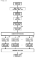
- FIG. 13 is a schematic diagram illustrating one example of the point cloud generation processing in which the point cloud data is generated based only on a part of the distance image data 270.
- the data acquisition unit 300 acquires the distance image data 270 from the sensor apparatus 2.
- the identification unit 305 identifies the partial distance image data 271 including the distance information related to the specific object in the distance image data 270.
- the segmentation unit 301 divides the partial distance image data 271 into N distance image segment data 276 depending on the distance information.
- the converter 302 After the segmentation processing, similarly to the example of FIG. 10 , regarding each of the N distance image segment data 276 obtained in the segmentation processing, the converter 302 performs the conversion processing of converting the distance image segment data 276 to point cloud data 293 (also referred to as point cloud segment data 293).
- the distance image segment data 276 is the point cloud conversion target data.
- the point cloud data 293 includes the coordinate information 800 but does not include the color information 810.
- the z-coordinate values of the plurality of pieces of coordinate information 800 included in one point cloud segment data 293 are values close to each other.
- the point cloud segment data 293 obtained as a result of the conversion processing having been performed on the distance image segment data 276 corresponding to the n-th distance section is hereinafter referred to as the point cloud segment data 293 corresponding to the n-th distance section.
- the z-coordinate values of the plurality of pieces of coordinate information 800 included in the point cloud segment data 293 tend to indicate larger values as the distance section corresponding to the point cloud segment data 293 is larger.
- the point cloud processing unit 303 individually performs the point cloud processing similar to the above regarding each of the N generated point cloud segment data 293.
- the combining unit 304 combines the N point cloud segment data 293 subjected to the point cloud processing and generates one point cloud data 298 (also referred to as combined point cloud data 298).
- the combined point cloud data 298 includes the coordinate information 800 but does not include the color information 810.
- the combined point cloud data 298 is data representing the specific object in the measurement space, using a plurality of points. It can also be said that the combined point cloud data 298 is data representing the surface shape of the specific object.
- Embodiment 2 not all but a part of the distance image data 270 is divided into a plurality of distance image segment data 276 depending on the distance information. Then, each of the plurality of distance image segment data 276 is individually converted to point cloud data. Consequently, similarly to Embodiment 1, each point cloud data can be appropriately processed depending on the distance section corresponding thereto. As a result, for example, high-accuracy point cloud data representing the specific object in the measurement space can be obtained.
- the segmentation processing, the conversion processing, and the point cloud processing may be individually performed.
- the segmentation processing, the conversion processing, and the point cloud processing may be individually performed.
- the partial image data set 281 corresponding to a certain specific object is the partial image data set 281including partial distance image data 271 including the distance information related to the certain specific object and the partial color image data 261 including the color information related to the certain specific object.
- the controller 30 may individually perform the segmentation processing, the conversion processing, and the point cloud processing regarding each of the plurality of partial distance image data 271 respectively corresponding to the plurality of specific objects.
- the partial distance image data 271 corresponding to the certain specific object is the partial distance image data 271 including the distance information related to the certain specific object.
- the following will describe the point cloud processing of a case in which the segmentation processing, the conversion processing, and the point cloud processing are individually performed regarding each of a first specific object and a second specific object as one example of a case in which the segmentation processing, the conversion processing, and the point cloud processing are individually performed regarding each of the plurality of specific objects. Note that the segmentation processing, the conversion processing, and the point cloud processing may be individually performed regarding each of three or more specific objects.
- FIG. 14 is a schematic diagram illustrating one example of the point cloud generation processing of a case in which the segmentation processing, the conversion processing, and the point cloud processing are individually performed regarding each of two partial image data sets 281 respectively corresponding to the first specific object and the second specific object.
- the segmentation processing, the conversion processing, and the point cloud processing are performed regarding the partial image data set 281 corresponding to the first specific object, a plurality of point cloud segment data 292 representing the first specific object are generated.
- a plurality of point cloud segment data 292 representing the second specific object are generated.
- the plurality of point cloud segment data 292 representing the first specific object and the plurality of point cloud segment data 292 representing the second specific object are separately generated, for example, accuracy of the plurality of point cloud segment data 292 representing the first specific object and accuracy of the plurality of point cloud segment data 292 representing the second specific object can be made different from each other.
- the first specific object and the second specific object may be determined depending on a purpose in which the measurement system 1 is used, for example.
- the first specific object may be a target object assumed to be of interest (which may be referred to as a target object of interest) in certain processing with the purpose in which the measurement system 1 is used.
- the second specific object may be an object (which may be referred to as a target object of no interest) other than the target object of interest in the measurement space.
- the piping being the target object of interest may be set to the first specific object, and other objects (that is, target objects of no interest) may be set to the second specific objects.
- the object to be held by the robot being the target object of interest may be set to the first specific object, and other objects may be set to the second specific objects.
- the measurement system 1 is used for recognition of a vehicle on a road, the vehicle being the target object of interest is set to the first specific object, and other roads and the like may be set to the second specific objects.
- Each of the target object of interest and the target object of no interest may be one object, may include a plurality of objects of the same type, or may include a plurality of objects of different types.
- the segmentation processing, the conversion processing, and the point cloud processing regarding the first specific object may be hereinafter respectively referred to as first segmentation processing, first conversion processing, and first point cloud processing.
- the segmentation processing, the conversion processing, and the point cloud processing regarding the second specific object may be respectively referred to as second segmentation processing, second conversion processing, and second point cloud processing.
- the identification processing in the image data set 280 acquired in the acquisition processing, the partial image data set 281 (also referred to as a partial image data set 281a) corresponding to the first specific object and the partial image data set 281 (also referred to as a partial image data set 281b) corresponding to the second specific object are identified.
- the image data set 280 is divided into the partial image data set 281a corresponding to the first specific object and the partial image data set 281b corresponding to the second specific object.
- the identification processing is the segmentation processing in which the image data set 280 is divided into a plurality of segment data, and each of the partial image data set 281a and the partial image data set 281b is segment data.
- the storage 33 of the data processing apparatus 3 stores first feature information representing features of the first specific object and second feature information representing features of the second specific object.
- the identification unit 305 can identify the partial image data set 281a, based on the first feature information in the storage 33.
- the identification unit 305 can identify the partial image data set 281b, based on the second feature information in the storage 33.
- the partial distance image data 271 and the partial color image data 261 included in the partial image data set 281a may be hereinafter respectively referred to as partial distance image data 271a and partial color image data 261a.
- the partial distance image data 271 and the partial color image data 261 included in the partial image data set 281b may be respectively referred to as partial distance image data 271b and partial color image data 261b.
- the segmentation unit 301 individually performs the segmentation processing regarding each of the partial image data sets 281a and 281b. Consequently, in the first segmentation processing, the partial distance image data 271a of the partial image data set 281a is divided into a plurality of distance image segment data 276a depending on the distance information, and the partial color image data 261a of the partial image data set 281a is divided into a plurality of color image segment data 266a depending on the distance information.
- the partial distance image data 271b of the partial image data set 281b is divided into a plurality of distance image segment data 276b depending on the distance information
- the partial color image data 261b of the partial image data set 281a is divided into a plurality of color image segment data 266b depending on the distance information.
- the segmentation unit 301 regards one distance image segment data 276a and one color image segment data 266a corresponding to the same distance section as one segment data set 286a corresponding to the distance section.
- the segmentation unit 301 regards one distance image segment data 276b and one color image segment data 266b corresponding to the same distance section as one segment data set 286b corresponding to the distance section.
- the partial image data set 281a may be divided into N segment data sets 286a as described above.
- the partial image data set 281b may be divided into M (M is an integer of 2 or greater) segment data sets 286.
- N M may hold, or N ⁇ M may hold.
- a possible range of the distance indicated by the distance information is divided into M distance sections of from a first distance section to an M-th distance section.
- the M distance sections is set similarly to the N distance sections described above.
- An m-th distance section (m is a variable and is an integer satisfying 1 ⁇ m ⁇ M) is a range of a distance Bm - 1 or more and less than the distance Bm, for example.
- the M-th distance section is a range of a distance BM - 1 or more and the distance BM or less.
- the distance Bm is larger than the distance Bm - 1.
- the distance B0 is a minimum value (for example, 0) of the possible range of the distance indicated by the distance information, for example.
- the distance BM is a maximum value of the possible range of the distance indicated by the distance information, for example.
- the partial distance image data 271b is divided into M distance image segment data 276b respectively corresponding to the M distance sections
- the partial color image data 261b is divided into M color image segment data 266b respectively corresponding to the M distance sections.
- the plurality of pieces of distance information included in one distance image segment data 276b indicate distances close to each other.
- the first segmentation processing and the second segmentation processing may be performed in parallel, or may be sequentially performed in series.
- the M distance sections may include a plurality of distance sections having different section lengths, or may include a plurality of distance sections having the same section length.
- the M distance sections need not be contiguous.
- the converter 302 converts the segment data set 286a to point cloud data 292a (also referred to as point cloud segment data 292a).
- the segment data set 286a is the point cloud conversion target data.
- the point cloud segment data 292a obtained as a result of the conversion processing having been performed on the segment data set 286a corresponding to the n-th distance section is hereinafter referred to as the point cloud segment data 292a corresponding to the n-th distance section.
- the converter 302 converts the segment data set 286b to point cloud data 292b (also referred to as point cloud segment data 292b).
- the segment data set 286b is the point cloud conversion target data.
- the point cloud segment data 292b obtained as a result of the conversion processing having been performed on the segment data set 286b corresponding to the m-th distance section is hereinafter referred to as the point cloud segment data 292b corresponding to the m-th distance section.
- the first conversion processing and the second conversion processing may be performed in parallel, or may be sequentially performed in series.
- the point cloud processing unit 303 individually performs the first point cloud processing regarding each of the N generated point cloud segment data 292a. After the second conversion processing is performed, the point cloud processing unit 303 individually performs the second point cloud processing regarding each of the M generated point cloud segment data 292a.
- the first point cloud processing and the second point cloud processing may be performed in parallel, or may be sequentially performed in series.
- the combining unit 304 combines the N point cloud segment data 292a subjected to the first point cloud processing and the M point cloud segment data 292a subjected to the second point cloud processing and generates one point cloud data 297ab (also referred to as combined point cloud data 297ab).
- the combined point cloud data 297ab is data representing the first specific object and the second specific object in the measurement space, using a plurality of points.
- the combined point cloud data 297ab is also data representing the surface shape and the color of the first specific object and the second specific object.
- FIG. 15 is a schematic diagram illustrating one example of the point cloud generation processing of a case in which the segmentation processing, the conversion processing, and the point cloud processing are individually performed regarding each of two partial distance image data 271 respectively corresponding to the first specific object and the second specific object.
- the segmentation processing, the conversion processing, and the point cloud processing are performed regarding the partial distance image data 271 corresponding to the first specific object, a plurality of point cloud segment data 293 representing the first specific object are generated.
- a plurality of point cloud segment data 293 representing the second specific object are generated.
- the data acquisition unit 300 acquires the distance image data 270 from the sensor apparatus 2.
- the identification unit 305 identifies the partial distance image data 271a corresponding to the first specific object and the partial distance image data 271b corresponding to the second specific object in the distance image data 270.
- the segmentation unit 301 divides the partial distance image data 271a into N distance image segment data 276a depending on the distance information.
- the segmentation unit 301 divides the partial distance image data 271b into M distance image segment data 276b depending on the distance information.
- the converter 302 converts the distance image segment data 276a to point cloud data 293a (also referred to as point cloud segment data 293a).
- the distance image segment data 276a is the point cloud conversion target data.
- the point cloud segment data 293a obtained as a result of the conversion processing having been performed on the distance image segment data 276a corresponding to the n-th distance section is hereinafter referred to as the point cloud segment data 293a corresponding to the n-th distance section.
- the converter 302 converts the distance image segment data 276b to point cloud data 293b (also referred to as point cloud segment data 293b).
- the distance image segment data 276b is the point cloud conversion target data.
- the point cloud segment data 293b obtained as a result of the conversion processing having been performed on the distance image segment data 276b corresponding to the m-th distance section is hereinafter referred to as the point cloud segment data 293b corresponding to the m-th distance section.
- the point cloud processing unit 303 individually performs the first point cloud processing regarding each of the N generated point cloud segment data 293a. After the second conversion processing, the point cloud processing unit 303 individually performs the second point cloud processing regarding each of the M generated point cloud segment data 293b.
- the combining unit 304 combines the N point cloud segment data 293a subjected to the first point cloud processing and the M point cloud segment data 293b subjected to the second point cloud processing and generates one point cloud data 298ab (also referred to as combined point cloud data 298ab).
- the combined point cloud data 298ab is data representing the first specific object and the second specific object in the measurement space, using a plurality of points. It can also be said that the combined point cloud data 298ab is data representing the surface shape of the first specific object and the second specific object.
- each of the partial distance image data 271a corresponding to the first specific object and the partial distance image data 271b corresponding to the second specific object is individually subjected to the segmentation processing. Consequently, the point cloud segment data having accuracy according to the first specific object and the point cloud segment data having accuracy according to the second specific object can be generated.
- the first specific object is the target object of interest and the second specific object is the target object of no interest.
- the number (that is, the number of divisions) of the plurality of distance image segment data 276a corresponding to the target object of interest is larger than the number (that is, the number of divisions) of the plurality of distance image segment data 276b corresponding to the target object of no interest.
- finer point cloud processing for example, noise removal processing
- accuracy of the plurality of point cloud segment data representing the target object of interest can be enhanced further than accuracy of the plurality of point cloud segment data representing the target object of no interest.
- the number of divisions of the plurality of distance image segment data 276b corresponding to the target object of no interest is reduced, the amount of processing regarding the target object of no interest can be reduced.
- the number of divisions regarding a specific object that is required to generate high-accuracy point cloud data may be set larger than the number of divisions regarding a specific object that is not required to generate high-accuracy point cloud data. Note that M > N may hold.
- the first specific object is a tall object and the second specific object is a short object.
- the tall object is an object having a large dimension in the z-axis direction
- the short object is an object having a small dimension in the z-axis direction.
- N M
- the number of divisions of the plurality of distance image segment data 276a corresponding to the tall object is larger than the number of divisions of the plurality of distance image segment data 276b corresponding to the short object. Consequently, relatively fine point cloud processing can be performed regarding the tall object, and relatively coarse point cloud processing can be performed regarding the short object.
- both accuracy of the plurality of point cloud segment data representing the tall object and accuracy of the plurality of point cloud segment data representing the short object can be appropriately set.
- the point cloud processing is performed regarding each of the N point cloud segment data representing the first specific object and the point cloud processing is performed regarding each of the M point cloud segment data representing the second specific object, and thus accuracy of the N point cloud segment data representing the first specific object can be enhanced, and accuracy of the M point cloud segment data representing the second specific object can be enhanced.
- the point cloud processing need not be performed regarding at least one point cloud segment data of the N point cloud segment data representing the first specific object.
- the point cloud processing need not be performed regarding at least one point cloud segment data of the M point cloud segment data representing the second specific object.
- the point cloud processing need not be performed regarding all of the M point cloud segment data representing the target object of no interest, and the point cloud processing need not be performed regarding a part of the M point cloud segment data. Consequently, the amount of processing regarding the target object of no interest that is not required to generate high-accuracy point cloud data can be reduced.
- the N point cloud segment data representing the first specific object, each of which is subjected to the point cloud processing, and the M point cloud segment data representing the second specific object, which includes at least one point cloud segment data not subjected to the point cloud processing may be combined and the combined point cloud data may be generated.
- the M point cloud segment data representing the second specific object, each of which is subjected to the point cloud processing, and the N point cloud segment data representing the first specific object, which includes at least one point cloud segment data not subjected to the point cloud processing may be combined and the combined point cloud data may be generated.
- the first specific object is the target object of interest and the second specific object is the target object of no interest.
- the N point cloud segment data representing the target object of interest, each of which is subjected to the point cloud processing, and the M point cloud segment data representing the target object of no interest, which includes at least one point cloud segment data not subjected to the point cloud processing may be combined. Consequently, accuracy of data related to the target object of interest in the combined point cloud data can be enhanced, and the amount of processing related to the target object of no interest can be reduced.
- the point cloud processing unit 303 may perform decimation processing of reducing the number of data of the point cloud segment data. In other words, the point cloud processing unit 303 may perform the decimation processing of reducing the number of the plurality of points constituting the point cloud represented by the point cloud segment data.
- the decimation processing may be performed on each of the N point cloud segment data representing the first specific object, or may be performed on a part of the N point cloud segment data.
- the decimation processing may be performed on each of the M point cloud segment data representing the second specific object, or may be performed on a part of the M point cloud segment data.
- the decimation processing may be performed on at least one point cloud segment data of the M point cloud segment data representing the target object of no interest without performing the decimation processing regarding each of the N point cloud segment data representing the target object of interest. Consequently, density of the point cloud representing the target object of interest can be increased, and density of the point cloud representing the target object of no interest can be reduced.
- the first specific object may be set to the first target object of interest, for example, and the second specific object may be set to the second target object of interest, for example.
- the combining unit 304 may combine the N point cloud segment data representing the first specific object and generate one combined point cloud data, and may combine the M point cloud segment data representing the second specific object and generate one combined point cloud data. Consequently, the combined point cloud data representing the first specific object and the combined point cloud data representing the second specific object are separately generated.
- FIG. 16 is a schematic diagram illustrating one example of a configuration of the controller 30 of the data processing apparatus 3 included in the measurement system 1 according to Embodiment 3.
- FIG. 17 is a schematic diagram illustrating one example of the point cloud generation processing according to Embodiment 3.
- the measurement system 1 according to Embodiment 3 includes a configuration similar to that of the measurement system 1 according to Embodiments 1 and 2 described above. In comparison to the measurement system 1 according to Embodiments 1 and 2, the measurement system 1 according to Embodiment 3 is different only in the operation of the controller 30 of the data processing apparatus 3.
- the controller 30 according to Embodiment 3 performs the conversion processing of converting at least a part of the distance image data 270 acquired in the sensor apparatus 2 to point cloud data.
- the controller 30 performs the segmentation processing of dividing the point cloud data into a plurality of point cloud segment data depending on the z-coordinate values.
- the controller 30 individually processes each of the plurality of point cloud segment data. Consequently, a plurality of high-accuracy point cloud segment data can be obtained.
- the segmentation processing according to Embodiment 3 may be hereinafter referred to as point cloud segmentation processing to be distinguished from the segmentation processing according to Embodiments 1 and 2.
- the term "segmentation processing" by itself hereinafter refers to the segmentation processing according to Embodiments 1 and 2.
- the controller 30 includes the data acquisition unit 300 described above, a converter 352, a segmentation unit 351, a point cloud processing unit 353, and a combining unit 354. Note that all of the functions of the converter 352 or a part of the functions of the converter 352 may be implemented by a hardware circuit that does not require software to implement the functions. The same applies to the segmentation unit 351, the point cloud processing unit 353, and the combining unit 354.
- the converter 352 performs the conversion processing of converting the image data set 280 or the distance image data 270 acquired in the data acquisition unit 300 to point cloud data 360 (see FIG. 17 ).
- the plurality of pieces of coordinate information 800 and the plurality of pieces of color information 810 are associated with each other.
- the point cloud data 360 based on the distance image data 270 includes the coordinate information 800 but does not include the color information 810.
- the segmentation unit 351 performs the point cloud segmentation processing of dividing the point cloud data 360 obtained in the conversion processing into a plurality of point cloud segment data 370 (see FIG. 17 ) depending on the z-coordinate values.
- the point cloud processing unit 353 performs the point cloud processing of performing predetermined processing on the point cloud segment data 370.
- the point cloud processing unit 353 performs the point cloud processing regarding each point cloud segment data 370.
- the combining unit 354 performs the combining processing of combining the plurality of point cloud segment data 370 subjected to the point cloud processing and generating combined point cloud data 380 (see FIG. 17 ).
- the acquisition processing, the conversion processing, and the point cloud segmentation processing are sequentially performed. Then, after a plurality of point cloud processings respectively corresponding to the plurality of point cloud segment data 370 are performed, the combining processing is performed. At least two point cloud processings of the plurality of point cloud processings may be performed in parallel. At least two point cloud processings of the plurality of point cloud processings may be sequentially performed in series.
- a possible range of the z-coordinate value included in the coordinate information 800 is divided into P coordinate sections of from a first coordinate section to a P-th coordinate section (P is an integer of 2 or greater). Then, in the point cloud segmentation processing, the point cloud data 360 is divided into P point cloud segment data 370 respectively corresponding to the P coordinate sections.
- a p-th coordinate section (p is a variable and is an integer satisfying 1 ⁇ p ⁇ P) is a range of a coordinate value Cp - 1 or more and less than the coordinate value Cp, for example.
- the P-th coordinate section is a range of a coordinate value CP - 1 or more and the coordinate value CP or less.
- the coordinate value Cp is larger than the coordinate value Cp - 1.
- a coordinate value C0 is a minimum value (for example, 0) of the possible range of the z-coordinate value, for example.
- the coordinate value CP is a maximum value of the possible range of the z-coordinate value, for example.
- the first coordinate section is a range of the coordinate value C0 or more and less than a coordinate value C1
- the second coordinate section is a range of the coordinate value C1 - 1 or more and less than a coordinate value C2.
- the segmentation unit 351 includes the coordinate information 800 including the z-coordinate values included in the p-th coordinate section and the color information 810 associated with the coordinate information 800 out of the point cloud data 360 in the point cloud segment data 370 corresponding to the p-th coordinate section. Consequently, the plurality of z-coordinate values included in the one point cloud segment data 370 indicate values close to each other.
- the segmentation unit 351 includes the coordinate information 800 including the z-coordinate values included in the p-th coordinate section out of the point cloud data 360 in the point cloud segment data 370 corresponding to the p-th coordinate section.
- the z-coordinate values of the plurality of pieces of coordinate information 800 included in the point cloud segment data 370 tend to indicate larger values as the coordinate section corresponding to the point cloud segment data 370 is larger.
- the z-coordinate values of the plurality of pieces of coordinate information 800 included in the point cloud segment data 370 corresponding to a (p+1)-th coordinate section tend to be larger than the z-coordinate values of the plurality of pieces of coordinate information 800 included in the point cloud segment data 370 corresponding to the p-th coordinate section.
- the P coordinate sections may include a plurality of coordinate sections having different section lengths, or may include a plurality of coordinate sections having the same section length.
- the length of the first coordinate section may be the same as or different from the length of the second coordinate section.
- the P coordinate sections need not be contiguous.
- the point cloud processing unit 353 individually performs the point cloud processing regarding each of the P generated point cloud segment data 370. For example, similarly to the above, the point cloud processing unit 353 may make the processing parameters different between processings for at least two point cloud segment data 370 of the P point cloud segment data 370.
- the noise component tends to be larger as the z-coordinate values included therein are larger.
- the z-coordinate values of the plurality of pieces of coordinate information 800 included in the point cloud segment data 370 tend to indicate larger values as the coordinate section corresponding to the point cloud segment data 370 is larger. Consequently, regarding the coordinate information 800 included in the point cloud segment data 370, the noise component tends to be larger as the coordinate section corresponding to the point cloud segment data 370 is larger.
- the noise component tends to be larger than in the coordinate information 800 included in the point cloud segment data 370 corresponding to the p-th coordinate section.
- the point cloud processing unit 353 may make the filter coefficients different between the noise removal processings for the P point cloud segment data 370, and thereby increase the noise removal effect of the noise removal processings for the point cloud segment data 370 as the coordinate section corresponding to the point cloud segment data 370 is larger.
- the point cloud processing unit 353 may increase the noise removal effect regarding the coordinate information 800 included in the point cloud segment data 370 corresponding to the (p+1)-th coordinate section further than the noise removal effect regarding the coordinate information 800 included in the point cloud segment data 370 corresponding to the p-th coordinate section.
- the noise removal effect can be increased for the coordinate information 800 whose noise component tends to be large which is included in the point cloud segment data 370 with a large corresponding coordinate section, and the noise removal effect can be reduced for the coordinate information 800 whose noise component tends to be small which is included in the point cloud segment data 370 with a small corresponding coordinate section.
- the noise removal effect can be increased for the coordinate information 800 whose noise component tends to be large which is included in the point cloud segment data 370 including large z-coordinate values, and the noise removal effect can be reduced for the coordinate information 800 whose noise component tends to be small which is included in the point cloud segment data 370 including small z-coordinate values. Therefore, the noise removal processing can be appropriately performed on each point cloud segment data 370. As a result, accuracy of each point cloud segment data 370 can be enhanced.
- the point cloud data 360 is divided into the plurality of point cloud segment data 370 depending on the z-coordinate values. Consequently, each point cloud segment data 370 can be appropriately processed depending on the coordinate section corresponding thereto. In other words, each point cloud segment data 370 can be appropriately processed depending on the z-coordinate values included therein. As a result, accuracy of each point cloud segment data 370 can be enhanced. Therefore, accuracy of the combined point cloud data 380 can be enhanced. As the number of divisions of the point cloud data 360 is larger, that is, as the value of P is larger, finer point cloud processing (for example, noise removal processing) can be performed. Accordingly, by setting the value of P to be large, accuracy of the combined point cloud data 380 can be enhanced.
- the value of P may be set depending on the accuracy of the combined point cloud data 380 required by a user. The value of P may be determined based on a measurement environment, or may be set based on identification of lenses of the stereo camera 220 and the color camera 23.
- the point cloud data 360 in which the coordinate information 800 and the color information 810 are appropriately associated can be divided into the plurality of point cloud segment data 370.
- the point cloud segment data 370 in which the coordinate information 800 and the color information 810 are appropriately associated can be obtained.
- the coordinate information 800 and the color information 810 are appropriately associated, and thus even when the point cloud processing is performed regarding the point cloud segment data 370, correspondence between the coordinate information 800 and the color information 810 can be appropriately maintained.
- a part of the image data set 280 or the distance image data 270 may be converted to the point cloud data 360.
- FIG. 18 is a schematic diagram illustrating one example of a configuration of the controller 30 of the data processing apparatus 3 included in the measurement system 1 according to Embodiment 4.
- FIG. 19 is a schematic diagram illustrating one example of the point cloud generation processing according to Embodiment 4.
- the measurement system 1 according to Embodiment 4 includes a configuration similar to that of the measurement system 1 according to Embodiment 3 described above. In comparison to the measurement system 1 according to Embodiment 3, the measurement system 1 according to Embodiment 4 is different only in the operation of the controller 30 of the data processing apparatus 3. Similarly to Embodiment 2, for example, the controller 30 according to Embodiment 4 generates point cloud data representing a specific object in the measurement space, based on data acquired in the sensor apparatus 2.
- the controller 30 includes an identification unit 355, in addition to the data acquisition unit 300, the converter 352, the segmentation unit 351, the point cloud processing unit 353, and the combining unit 354 described above. Note that all of the functions of the identification unit 355 or a part of the functions of the identification unit 355 may be implemented by a hardware circuit that does not require software to implement the functions.
- the identification unit 355 performs the identification processing of identifying data related to the specific object in the measurement space in the image data set 280 acquired in the data acquisition unit 300.
- the identification unit 355 identifies the partial distance image data 271 including the distance information related to the specific object in the distance image data 270.
- the identification unit 355 identifies the partial color image data 261 including the color information related to the specific object in the color image data 260.
- the partial distance image data 271 and the partial color image data 261 identified in the identification processing constitute the partial image data set 281.
- the identification unit 355 may identify the partial distance image data 271 including the distance information related to the specific object in the distance image data 270 acquired in the acquisition processing.
- the converter 352 converts the partial image data set 281 or the partial distance image data 271 identified in the identification processing to point cloud data 361 (see FIG. 19 ).
- the segmentation unit 351 divides the point cloud data 361 into P point cloud segment data 371 depending on the z-coordinate values.
- the point cloud processing unit 353 performs the point cloud processing of performing predetermined processing on the point cloud segment data 371.
- the combining unit 354 combines the P point cloud segment data 371 subjected to the point cloud processing and generates combined point cloud data 381.
- the acquisition processing, the identification processing, the conversion processing, and the point cloud segmentation processing are sequentially performed. Then, after a plurality of point cloud processings respectively corresponding to the plurality of point cloud segment data 371 are performed, the combining processing is performed.
- Embodiment 4 not all but a part of the distance image data 270 is converted to the point cloud data 361. Then, the point cloud data 361 is divided into the plurality of point cloud segment data 371 depending on the z-coordinate values. Consequently, similarly to Embodiment 3, each point cloud segment data 371 can be appropriately processed depending on the coordinate section corresponding thereto. In other words, each point cloud segment data 371 can be appropriately processed depending on the z-coordinate values included therein. As a result, for example, high-accuracy point cloud data representing the specific object in the measurement space can be obtained.
- the conversion processing, the point cloud segmentation processing, and the point cloud processing described above may be individually performed.
- the controller 30 may individually perform the conversion processing, the point cloud segmentation processing, and the point cloud processing.
- the controller 30 may individually perform the conversion processing, the point cloud segmentation processing, and the point cloud processing.
- FIG. 20 is a schematic diagram illustrating one example of the point cloud generation processing of a case in which the conversion processing, the point cloud segmentation processing, and the point cloud processing are individually performed regarding each of the first specific object and the second specific object.
- the conversion processing, the point cloud segmentation processing, and the point cloud processing regarding the first specific object may be hereinafter respectively referred to as first conversion processing, first point cloud segmentation processing, and first point cloud processing.
- the conversion processing, the point cloud segmentation processing, and the point cloud processing regarding the second specific object may be respectively referred to as second conversion processing, second point cloud segmentation processing, and second point cloud processing.
- the partial image data set 281a corresponding to the first specific object and the partial image data set 281b corresponding to the second specific object are identified in the image data set 280 acquired in the acquisition processing.
- the partial distance image data 271a corresponding to the first specific object and the partial distance image data 271b corresponding to the second specific object may be identified in the distance image data 270 acquired in the acquisition processing.
- the converter 352 converts the partial image data set 281a or the partial distance image data 271a to point cloud data 361a.
- the point cloud data 361a is point cloud data representing the first specific object, using a plurality of points.
- the converter 352 converts the partial image data set 281b or the partial distance image data 271b to point cloud data 361b.
- the point cloud data 361b is point cloud data representing the second specific object, using a plurality of points.
- the first conversion processing and the second conversion processing may be performed in parallel, or may be sequentially performed in series.
- the point cloud data 361a may be divided into P point cloud segment data 371a as described above.
- the point cloud data 361b may be divided into Q (Q is an integer of 2 or greater) point cloud segment data 371b.
- P Q may hold, or P ⁇ Q may hold.
- a possible range of the z-coordinate value included in the coordinate information 800 is divided into Q coordinate sections of from a first coordinate section to a Q-th coordinate section. Then, in the second point cloud segmentation processing, the point cloud data 361b is divided into Q point cloud segment data 371b respectively corresponding to the Q coordinate sections.
- a q-th coordinate section (q is a variable and is an integer satisfying 1 ⁇ q ⁇ Q) is a range of a coordinate value Dq - 1 or more and less than the coordinate value Dq, for example.
- the Q-th coordinate section is a range of a coordinate value DQ - 1 or more and the coordinate value DQ or less.
- the coordinate value Dq is larger than the coordinate value Dq - 1.
- a coordinate value D0 is a minimum value (for example, 0) of the possible range of the z-coordinate value, for example.
- the coordinate value DQ is a maximum value of the possible range of the z-coordinate value, for example.
- the point cloud data 361b is divided into Q point cloud segment data 371b respectively corresponding to the Q coordinate sections.
- the first point cloud segmentation processing and the second point cloud segmentation processing may be performed in parallel, or may be sequentially performed in series.
- the Q coordinate sections may include a plurality of coordinate sections having different section lengths, or may include a plurality of coordinate sections having the same section length.
- the Q coordinate sections need not be contiguous.
- the point cloud processing unit 353 individually performs the first point cloud processing regarding each of the P generated point cloud segment data 371a.
- the point cloud processing unit 353 individually performs the second point cloud processing regarding each of the Q generated point cloud segment data 371b.
- the first point cloud processing and the second point cloud processing may be performed in parallel, or may be sequentially performed in series.
- the combining unit 354 combines the P point cloud segment data 371a representing the first specific object subjected to the first point cloud processing and the Q point cloud segment data 371b representing the second specific object subjected to the second point cloud processing, and generates one combined point cloud data 381ab.
- the combined point cloud data 381ab is data representing the first specific object and the second specific object in the measurement space, using a plurality of points.
- each of the point cloud data 361a representing the first specific object and the point cloud data 361b representing the second specific object is individually subjected to the segmentation processing. Consequently, the point cloud segment data 371a having accuracy according to the first specific object and the point cloud segment data 371b having accuracy according to the second specific object can be generated.
- the first specific object is the target object of interest and the second specific object is the target object of no interest.
- the number of divisions of the plurality of point cloud segment data 371a representing the target object of interest is larger than the number of divisions of the plurality of point cloud segment data 371b representing the target object of no interest. Consequently, finer point cloud processing (for example, noise removal processing) can be performed on the target object of interest than on the target object of no interest.
- accuracy of the plurality of point cloud segment data 371a representing the target object of interest can be enhanced further than accuracy of the plurality of point cloud segment data 371b representing the target object of no interest.
- the number of divisions of the plurality of point cloud segment data 371b representing the target object of no interest is reduced, the amount of processing regarding the target object of no interest can be reduced.
- the number of divisions regarding a specific object that is required to generate high-accuracy point cloud data may be set larger than the number of divisions regarding a specific object that is not required to generate high-accuracy point cloud data.
- Q > P may hold.
- the point cloud processing is performed regarding each of the P point cloud segment data 371a representing the first specific object and the point cloud processing is performed regarding each of the Q point cloud segment data 371b representing the second specific object, and thus accuracy of the P point cloud segment data 371a representing the first specific object can be enhanced and accuracy of the Q point cloud segment data 371b representing the second specific object can be enhanced.
- the point cloud processing need not be performed regarding at least one point cloud segment data 371a of the P point cloud segment data 371a representing the first specific object.
- the point cloud processing need not be performed regarding at least one point cloud segment data 371b of the Q point cloud segment data 371b representing the second specific object.
- the P point cloud segment data 371a representing the first specific object, each of which is subjected to the point cloud processing, and the Q point cloud segment data 371a representing the second specific object, which includes at least one point cloud segment data 371b not subjected to the point cloud processing may be combined and the combined point cloud data 381ab may be generated.
- the Q point cloud segment data 371b representing the second specific object, each of which is subjected to the point cloud processing, and the P point cloud segment data 371a representing the first specific object, which includes at least one point cloud segment data 371a not subjected to the point cloud processing may be combined and the combined point cloud data 381ab may be generated.
- the point cloud processing unit 353 may perform the decimation processing of reducing the number of data of the point cloud segment data 371a or the point cloud segment data 371b.
- the decimation processing may be performed on at least one of the P point cloud segment data 371a representing the first specific object.
- the decimation processing may be performed on at least one of the Q point cloud segment data 371b representing the second specific object.
- the combining unit 354 may combine the P point cloud segment data 371a and generate one combined point cloud data, and may combine the Q point cloud segment data 371b and generate one combined point cloud data. Consequently, the combined point cloud data representing the first specific object and the combined point cloud data representing the second specific object are separately generated.
- FIG. 21 is a schematic diagram illustrating one example of a configuration of the controller 30 in this case.
- FIG. 22 is a schematic diagram illustrating one example of the point cloud generation processing performed by the controller 30 illustrated in FIG. 21 .
- the controller 30 includes an identification unit 356, in addition to the data acquisition unit 300, the converter 352, the segmentation unit 351, the point cloud processing unit 353, and the combining unit 354 described above. Note that all of the functions of the identification unit 356 or a part of the functions of the identification unit 356 may be implemented by a hardware circuit that does not require software to implement the functions.
- the converter 352 performs the conversion processing of converting the image data set 280 or the distance image data 270 acquired in the acquisition processing of the data acquisition unit 300 to the point cloud data 360.
- the identification unit 356 performs the identification processing of identifying partial point cloud data 365 (see FIG. 22 ) including the coordinate information 800 related to the specific object in the point cloud data 360 obtained in the conversion processing, based on the feature information in the storage 33.
- the partial point cloud data 365 includes the coordinate information 800 of a plurality of points representing the specific object out of the point cloud represented by the point cloud data 360.
- the partial point cloud data 365 included in the point cloud data 360 based on the image data set 280 includes not only the coordinate information 800 of a plurality of points representing the specific object but also a plurality of pieces of color information 810 respectively corresponding to the coordinate information 800 of the plurality of points.
- the segmentation unit 351 divides the partial point cloud data 365 identified in the identification processing into P point cloud segment data 372 (see FIG. 22 ) depending on the z-coordinate values.
- the point cloud processing unit 353 performs the point cloud processing regarding each of the P point cloud segment data 372 generated in the point cloud segmentation processing.
- the combining unit 354 combines the P point cloud segment data 372 subjected to the point cloud processing and generates combined point cloud data 382 (see FIG. 22 ).
- each point cloud segment data 372 can be appropriately processed depending on the coordinate section corresponding thereto. Consequently, for example, high-accuracy point cloud data representing the specific object in the measurement space can be obtained.
- the point cloud segmentation processing and the point cloud processing may be individually performed regarding each of the plurality of specific objects.
- the controller 30 may individually perform the point cloud segmentation processing and the point cloud processing regarding each of the plurality of partial point cloud data 365 respectively representing the plurality of specific objects.
- FIG. 23 is a schematic diagram illustrating one example of the point cloud generation processing of a case in which the point cloud segmentation processing and the point cloud processing are individually performed regarding each of the first specific object and the second specific object.
- the point cloud segmentation processing and the point cloud processing regarding the first specific object may be hereinafter respectively referred to as first point cloud segmentation processing and first point cloud processing.
- the point cloud segmentation processing and the point cloud processing regarding the second specific object may be respectively referred to as second point cloud segmentation processing and second point cloud processing.
- the identification unit 356 identifies partial point cloud data 365a representing the first specific object and partial point cloud data 365b representing the second specific object in the point cloud data 360 acquired in the conversion processing.
- the identification unit 356 identifies the partial point cloud data 365a, based on the first feature information in the storage 33.
- the identification unit 356 identifies the partial point cloud data 365b, based on the second feature information in the storage 33.
- the first point cloud segmentation processing and the second point cloud segmentation processing are performed.
- the partial point cloud data 365a is divided into P point cloud segment data 372a depending on the z-coordinate values.
- the partial point cloud data 365b is divided into Q point cloud segment data 372b depending on the z-coordinate values.
- the first point cloud segmentation processing and the second point cloud segmentation processing may be performed in parallel, or may be sequentially performed in series.
- the point cloud processing unit 353 individually performs the first point cloud processing regarding each of the P generated point cloud segment data 372a.
- the point cloud processing unit 353 individually performs the second point cloud processing regarding each of the Q generated point cloud segment data 372b.
- the first point cloud processing and the second point cloud processing may be performed in parallel, or may be sequentially performed in series.
- the combining unit 354 combines the P point cloud segment data 372a representing the first specific object subjected to the first point cloud processing and the Q point cloud segment data 372b representing the second specific object subjected to the second point cloud processing, and generates one combined point cloud data 382ab.
- the combined point cloud data 382ab is data representing the first specific object and the second specific object in the measurement space, using a plurality of points.
- each of the partial point cloud data 365a representing the first specific object and the partial point cloud data 365b representing the second specific object is individually subjected to the segmentation processing. Consequently, similarly to the example of FIG. 20 , the point cloud segment data 372a having accuracy according to the first specific object and the point cloud segment data 372b having accuracy according to the second specific object can be generated.
- the point cloud processing need not be performed regarding at least one point cloud segment data 372a of the P point cloud segment data 372a representing the first specific object.
- the point cloud processing need not be performed regarding at least one point cloud segment data 372b of the Q point cloud segment data 372b representing the second specific object.
- the P point cloud segment data 372a representing the first specific object, each of which is subjected to the point cloud processing, and the Q point cloud segment data 372a representing the second specific object, which includes at least one point cloud segment data 372b not subjected to the point cloud processing may be combined and the combined point cloud data 382ab may be generated.
- the Q point cloud segment data 372b representing the second specific object, each of which is subjected to the point cloud processing, and the P point cloud segment data 372a representing the first specific object, which includes at least one point cloud segment data 372a not subjected to the point cloud processing may be combined and the combined point cloud data 382ab may be generated.
- the point cloud processing unit 353 may perform the decimation processing of reducing the number of data of the point cloud segment data 372a or the point cloud segment data 372b.
- the decimation processing may be performed on at least one of the P point cloud segment data 372a.
- the decimation processing may be performed on at least one of the Q point cloud segment data 372b representing the second specific object.
- the combining unit 354 may combine the P point cloud segment data 372a and generate one combined point cloud data, and may combine the Q point cloud segment data 372b and generate one combined point cloud data. Consequently, the combined point cloud data representing the first specific object and the combined point cloud data representing the second specific object are separately generated.
- data related to the specific object is identified in the image data set 280 or the distance image data 270.
- data related to the specific object is identified in the point cloud data based on the image data set 280 or the distance image data 270.
- the measurement points increase, and thus the amount of data of the point cloud data is larger than the amount of data of the image data set 280 or the distance image data 270.
- a load of the identification processing can be reduced.
- the segmentation processing is performed on the image data set 280 or the distance image data 270 having a relatively small amount of data.
- the segmentation processing is performed on the point cloud data having a relatively large amount of data.
- a load of the segmentation processing can be reduced.
- the measurement system 1 is not limited to the above examples.
- the sensor apparatus 2 and the data processing apparatus 3 may be accommodated in one case, or may be accommodated in separate cases.
- the sensor apparatus 2 at least one of the distance measurement sensor 22 and the color camera 23 may be accommodated in a case separate from one for other configurations.
- the distance measurement sensor 22 and the color camera 23 may be accommodated in the same case, or may be accommodated in separate cases.
- the controller 20 of the sensor apparatus 2 may also function as the controller 30 of the data processing apparatus 3.
- the controller 20 may include the data acquisition unit, the identification unit, the segmentation unit, the converter, the point cloud processing unit, and the combining unit described above included in the controller 30.
- the first interface 31, the second interface 32, and the storage 33 of the data processing apparatus 3 are unnecessary, and for example, the interface 21 of the sensor apparatus 2 may communicate with the external apparatus, and the sensor apparatus 2 may also function as the data processing apparatus 3.
- the controller 30 may generate the distance image data 270 based on the image data 250, instead of the controller 20 generating the distance image data 270 based on the image data 250.
- the controller 30 of the data processing apparatus 3 may function as the controller 20 of the sensor apparatus 2.
- the sensor apparatus 2 may include the distance measurement sensor 22, the color camera 23, and the interface 21, and the image data 250 output by the distance measurement sensor 22 and the color image data 260 output by the color camera 23 may be input to the data processing apparatus 3 via the interface 21.
- the controller 30 of the data processing apparatus 3 may generate the distance image data 270 based on the image data 250, and may perform the filter processing on the color image data 260.
- each point cloud segment data of at least one target object of no interest in the plurality of specific objects need not be used in the combining processing or combined with other data.
- the point cloud segment data not used in the combining processing may or may not be discarded.
- FIG. 24 is a schematic diagram illustrating one example of the point cloud generation processing of FIG. 20 in which the segmentation processing is not performed.
- FIG. 25 is a schematic diagram illustrating one example of the point cloud generation processing of FIG. 23 in which the segmentation processing is not performed.
- the controller 30 does not include the converter 352.
- the point cloud processing unit 353 performs the first point cloud processing on the point cloud data 361a representing the first specific object, and performs the second point cloud processing on the point cloud data 361b representing the second specific object. Then, the combining unit 354 combines the point cloud data 361a subjected to the first point cloud processing and the point cloud data 361b subjected to the second point cloud processing, and generates combined point cloud data 385.
- the point cloud processing unit 353 performs the first point cloud processing on the partial point cloud data 365a (also referred to as point cloud data 365a) representing the first specific object, and performs the second point cloud processing on the partial point cloud data 365b (also referred to as point cloud data 365b) representing the second specific object. Then, the combining unit 354 combines the partial point cloud data 365a subjected to the first point cloud processing and the partial point cloud data 365b subjected to the second point cloud processing, and generates combined point cloud data 386.
- the first point cloud processing and the second point cloud processing may be different from each other.
- the second point cloud processing may include the decimation processing of reducing the number of data of the point cloud data 361b or the point cloud data 365b, and the first point cloud processing need not include the decimation processing. Consequently, density of the point cloud representing the target object of interest can be increased, and density of the point cloud representing the target object of no interest can be reduced.
- the first point cloud processing may include the filter processing, and the second point cloud processing need not include the filter processing.
- the first point cloud processing may include first filter processing having filter coefficients for increasing the noise removal effect
- the second point cloud processing may include second filter processing having filter coefficients for reducing the noise removal effect.
- the processing parameters of the filter processing are different between the first point cloud processing and the second point cloud processing.
- first point cloud processing and the second point cloud processing may be the same as each other.
- the first point cloud processing need not be performed on at least one of the point cloud data 361a and 365a representing the first specific object.
- the second point cloud processing need not be performed on at least one of the point cloud data 361b and 365b representing the second specific object.
- the point cloud data 361a and 365a representing the first specific object and the point cloud data 361b and 365b representing the second specific object need not be combined.
- the point cloud data representing the specific object not subjected to the segmentation processing as with the point cloud data 361a, 361b, 365a, and 365b of FIGS. 24 and 25 may be hereinafter referred to as non-SG point cloud data.
- the combining unit 354 combines a plurality of non-SG point cloud data and generates combined point cloud data.
- the controller 30 may transmit the plurality of point cloud segment data subjected to the point cloud processing in the point cloud processing unit or the non-SG point cloud data to the external apparatus via the second interface 32. Then, the external apparatus may combine the plurality of point cloud segment data or the non-SG point cloud data and generate combined point cloud data.
- the measurement system 1 can be used for various purposes.
- the measurement system 1 may be used for inspection of piping in an industry.
- the position, the shape, and the like of the piping may be recognized based on the combined point cloud data generated in the data processing apparatus 3, the plurality of point cloud segment data representing the piping, or the non-SG point cloud data representing the piping.
- the measurement system 1 may be used for recognition of a vehicle on a road.
- the position, the shape, and the like of the vehicle may be recognized based on the combined point cloud data generated in the data processing apparatus 3, the plurality of point cloud segment data representing the vehicle, or the non-SG point cloud data representing the vehicle.
- the measurement system 1 may be used for control of a robot.
- a robot control system 500 including the measurement system 1 will be described below.
- FIG. 26 is a schematic diagram illustrating one example of the robot control system 500 that controls a robot 600.
- the robot control system 500 includes, for example, the sensor apparatus 2, the data processing apparatus 3, and a robot controller 510 that controls the robot 600.
- the robot 600 and the robot control system 500 that controls the robot 600 constitute a robot system.
- the robot controller 510 is a type of computer apparatus, and includes a configuration similar to that of the data processing apparatus 3, for example.
- the robot controller 510 can communicate with the second interface 32 of the data processing apparatus 3, for example.
- the robot controller 510 controls the robot 600, based on the combined point cloud data output from the second interface 32, for example. Note that all of the functions of the robot controller 510 or a part of the functions of the robot controller 510 may be implemented by a hardware circuit that does not require software to implement the functions.
- the robot 600 moves a work target object 610 from a work start table 620 to a work destination table 630.
- the robot controller 510 controls the robot 600 so that the work target object 610 is moved from the work start table 620 to the work destination table 630.
- the robot 600 includes, for example, an arm 601 and an end effector 602 to hold the work target object 610.
- the robot 600 moves the arm 601 while holding the work target object 610 with the end effector 602, and thereby moves the work target object 610 from the work start table 620 to the work destination table 630.
- the robot controller 510 can control the arm 601 and the end effector 602.
- the robot 600, the work target object 610, the work start table 620, and the work destination table 630 are located in the measurement space 1000 of the measurement system 1.
- the stereo camera 220 and the color camera 23 of the sensor apparatus 2 capture images of the work target object 610, the work start table 620, and the work destination table 630.
- the data processing apparatus 3 outputs the combined point cloud data representing the work target object 610, the work start table 620, and the work destination table 630 to the robot controller 510.
- the stereo camera 220 and the color camera 23 capture images periodically, for example, and the data processing apparatus 3 sequentially outputs the combined point cloud data to the robot controller 510. Note that, when there is an obstruction that hinders movement of the robot 600 in the measurement space 1000, the combined point cloud data also represents the obstruction.
- the robot controller 510 can recognize the object in the measurement space 1000, based on the combined point cloud data from the data processing apparatus 3. For example, the robot controller 510 performs recognition processing of recognizing the work target object 610, the work start table 620, the work destination table 630, and the obstruction. In the recognition processing, for example, the robot controller 510 can recognize a position and an orientation of each of the work target object 610, the work start table 620, the work destination table 630, and the obstruction. The robot controller 510 controls the arm 601 and the end effector 602, based on results of the recognition processing. Consequently, the robot 600 can appropriately hold the work target object 610, and can appropriately move the held work target object 610 from the work start table 620 to the work destination table 630.
- the robot controller 510 determines an operation path of the arm 601 to avoid the obstruction, based on results of the recognition processing, for example. Then, the robot controller 510 controls the arm 601 so that the arm 601 moves along the determined operation path.
- a case is considered in which the data processing apparatus 3 outputs the combined point cloud data representing the target object of interest and the target object of no interest.
- the work target object 610 and the work start table 620 may be set to the target objects of interest, and the work destination table 630 may be set to the target object of no interest.
- the work destination table 630 may be set to the target object of interest, and the work target object 610 and the work start table 620 may be set to the target objects of no interest.
- the robot 600 can be appropriately controlled.
- the stereo camera 220 and the color camera 23 of the sensor apparatus 2 also capture images of the arm 601 of the robot 600
- the arm 601 may be set to a second target object of no interest.
- the plurality of point cloud segment data or the non-SG point cloud data regarding the second target object of no interest need not be used in the combining processing or combined with other data. Consequently, the robot controller 510 can control the robot 600, based on the combined point cloud data not including data representing the arm 601.
- the robot controller 510 does not recognize the arm 601 as an obstruction.
- the robot controller 510 may control the robot 600, based on the plurality of point cloud segment data or the plurality of non-SG point cloud data.
- the robot controller 510 may combine the plurality of point cloud segment data or the non-SG point cloud data and generate the combined point cloud data, and control the robot 600, based on the generated combined point cloud data.
- the robot controller 510 may be implemented in a cloud server.
- a communication unit connected to the Internet may be provided to the robot 600, and the robot controller 510 may control the robot 600 via the Internet.
- the data processing apparatus 3 may be implemented in a cloud server. In this case, the data processing apparatus 3 may communicate with the robot controller 510 via the Internet.
- the controller 30 of the data processing apparatus 3 may function as the robot controller 510. In this case, the data processing apparatus 3 functions as the robot control system 500.
- the controller 30 functions as the robot controller 510
- the combining unit may be included in the robot controller 510.
- the sensor apparatus 2 need not be included in the robot control system 500.
Landscapes
- Engineering & Computer Science (AREA)
- Physics & Mathematics (AREA)
- General Physics & Mathematics (AREA)
- Theoretical Computer Science (AREA)
- Computer Vision & Pattern Recognition (AREA)
- Computer Graphics (AREA)
- Geometry (AREA)
- Software Systems (AREA)
- Robotics (AREA)
- Mechanical Engineering (AREA)
- Length Measuring Devices By Optical Means (AREA)
- Image Processing (AREA)
Abstract
Description
- The present disclosure relates to data processing technology.
-
Patent Document 1 describes a technology related to processing of point cloud data. - Patent Document 1:
Japanese Patent Application Laid-Open No. 2012-13660 - A data processing apparatus, a robot control system, and a program are disclosed. In one embodiment, a data processing apparatus includes a segmentation unit, a converter, and a point cloud processing unit. The segmentation unit is configured to divide at least a part of distance image data including distance information to a measurement point in a measurement space into a plurality of first distance image segment data depending on the distance information. The converter is configured to individually convert each of the plurality of first distance image segment data to first point cloud segment data being point cloud data including coordinate information of the measurement point in the measurement space. The point cloud processing unit is configured to individually perform processing on each of a plurality of the first point cloud segment data respectively obtained from the plurality of first distance image segment data in the converter.
- In one embodiment, a data processing apparatus includes a converter, a segmentation unit, and a point cloud processing unit. The converter is configured to convert at least a part of distance image data including distance information to a measurement point in a measurement space to first point cloud data including coordinate information of the measurement point in the measurement space. The segmentation unit is configured to divide at least a part of the first point cloud data into a plurality of first point cloud segment data depending on a coordinate value of the measurement space in a depth direction. The point cloud processing unit is configured to individually perform processing on each of the plurality of first point cloud segment data.
- In one embodiment, a robot control system includes the segmentation unit, the converter, and the point cloud processing unit included in the above data processing apparatus, and a robot controller. The robot controller is configured to control a robot, based on the plurality of first point cloud segment data processed in the point cloud processing unit or combined point cloud data obtained by combining the plurality of first point cloud segment data.
- In one embodiment, a program is configured to cause a computer apparatus to divide at least a part of distance image data including distance information to a measurement point in a measurement space into a plurality of first distance image segment data depending on the distance information. The program is configured to cause the computer apparatus to individually convert each of the plurality of first distance image segment data to first point cloud segment data being point cloud data including coordinate information of the measurement point in the measurement space. The program is configured to cause the computer apparatus to individually perform processing on each of a plurality of the first point cloud segment data respectively obtained from the plurality of first distance image segment data.
- In one embodiment, a program is configured to cause a computer apparatus to convert at least a part of distance image data including distance information to a measurement point in a measurement space to first point cloud data including coordinate information of the measurement point in the measurement space. The program is configured to cause the computer apparatus to divide at least a part of the first point cloud data into a plurality of first point cloud segment data depending on a coordinate value of the measurement space in a depth direction. The program is configured to cause the computer apparatus to individually perform processing on each of the plurality of first point cloud segment data.
- In one embodiment, a data processing apparatus includes an identification unit, a converter, and a point cloud processing unit. The identification unit is configured to identify first partial distance image data including distance information related to a first object in a measurement space and second partial distance image data including distance information related to a second object in the measurement space in distance image data including the distance information to a measurement point in the measurement space. The converter is configured to convert first distance partial image data to first point cloud data, and convert second partial image data to second point cloud data. The point cloud processing unit is configured to perform different processings on the first point cloud data and the second point cloud data.
- In one embodiment, a data processing apparatus includes a converter, an identification unit, and a point cloud processing unit. The converter is configured to convert at least a part of distance image data including distance information to a measurement point in a measurement space to point cloud data including coordinate information of the measurement point in the measurement space. The identification unit is configured to identify first point cloud data including the coordinate information related to a first object in the measurement space and second point cloud data including the coordinate information related to a second object in the measurement space in the point cloud data. The point cloud processing unit is configured to perform different processings on the first point cloud data and the second point cloud data.
- In one embodiment, a robot control system includes the identification unit, the converter, and the point cloud processing unit included in the above data processing apparatus, and a robot controller. The robot controller is configured to control a robot, based on the first point cloud data and the second point cloud data processed in the point cloud processing unit, or based on combined point cloud data obtained by combining the first point cloud data and the second point cloud data.
- In one embodiment, a program is configured to cause a computer apparatus to identify first partial distance image data including distance information related to a first object in a measurement space and second partial distance image data including distance information related to a second object in the measurement space in distance image data including the distance information to a measurement point in the measurement space. The program is configured to cause the computer apparatus to convert first distance partial image data to first point cloud data, and convert second partial image data to second point cloud data. The program is configured to cause the computer apparatus to perform different processings on the first point cloud data and the second point cloud data.
- In one embodiment, a program is configured to cause a computer apparatus to convert at least a part of distance image data including distance information to a measurement point in a measurement space to point cloud data including coordinate information of the measurement point in the measurement space. The program is configured to cause the computer apparatus to identify first point cloud data including the coordinate information related to a first object in the measurement space and second point cloud data including the coordinate information related to a second object in the measurement space in the point cloud data. The program is configured to cause the computer apparatus to perform different processings on the first point cloud data and the second point cloud data.
-
-
FIG. 1 is a schematic diagram illustrating one example of a measurement system. -
FIG. 2 is a schematic diagram illustrating one example of a data processing apparatus. -
FIG. 3 is a schematic diagram illustrating one example of a sensor apparatus. -
FIG. 4 is a schematic diagram for illustrating one example of distance information included in distance image data. -
FIG. 5 is a schematic diagram for illustrating one example of an orthogonal coordinate system related to point cloud data. -
FIG. 6 is a schematic diagram illustrating one example of point cloud data. -
FIG. 7 is a schematic diagram illustrating one example of a controller of the data processing apparatus. -
FIG. 8 is a schematic diagram illustrating one example of point cloud generation processing. -
FIG. 9 is a schematic diagram of one example of a plurality of distance sections used in segmentation processing. -
FIG. 10 is a schematic diagram illustrating one example of the point cloud generation processing. -
FIG. 11 is a schematic diagram illustrating one example of the controller of the data processing apparatus. -
FIG. 12 is a schematic diagram illustrating one example of the point cloud generation processing. -
FIG. 13 is a schematic diagram illustrating one example of the point cloud generation processing. -
FIG. 14 is a schematic diagram illustrating one example of the point cloud generation processing. -
FIG. 15 is a schematic diagram illustrating one example of the point cloud generation processing. -
FIG. 16 is a schematic diagram illustrating one example of the controller of the data processing apparatus. -
FIG. 17 is a schematic diagram illustrating one example of the point cloud generation processing. -
FIG. 18 is a schematic diagram illustrating one example of the controller of the data processing apparatus. -
FIG. 19 is a schematic diagram illustrating one example of the point cloud generation processing. -
FIG. 20 is a schematic diagram illustrating one example of the point cloud generation processing. -
FIG. 21 is a schematic diagram illustrating one example of the controller of the data processing apparatus. -
FIG. 22 is a schematic diagram illustrating one example of the point cloud generation processing. -
FIG. 23 is a schematic diagram illustrating one example of the point cloud generation processing. -
FIG. 24 is a schematic diagram illustrating one example of the point cloud generation processing. -
FIG. 25 is a schematic diagram illustrating one example of the point cloud generation processing. -
FIG. 26 is a schematic diagram illustrating one example of a robot control system. -
FIG. 1 is a schematic diagram illustrating one example of a configuration of ameasurement system 1 according toEmbodiment 1. Themeasurement system 1 is, for example, a system that can measure three-dimensional positions of measurement points in a measurement space being a target space to be measured in a non-contact manner. In the measurement space, at least one object is present. The measurement points are, for example, located on a surface of the object in the measurement space. - As illustrated in
FIG. 1 , themeasurement system 1 includes, for example, asensor apparatus 2 and adata processing apparatus 3. Thesensor apparatus 2 acquires, for example, distance information to a measurement point in the measurement space and color information of the measurement point in the measurement space. Thedata processing apparatus 3 acquires a three-dimensional position of the measurement point in the measurement space, based on the distance information and the color information acquired in thesensor apparatus 2. -
FIG. 2 is a schematic diagram illustrating one example of a configuration of thedata processing apparatus 3. As illustrated inFIG. 2 , thedata processing apparatus 3 includes, for example, acontroller 30, afirst interface 31, asecond interface 32, and astorage 33. It can also be said that thedata processing apparatus 3 is a data processing circuit, for example. Thedata processing apparatus 3 is a type of computer apparatus, for example. - The
first interface 31 can perform communication with thesensor apparatus 2. It can also be said that thefirst interface 31 is an interface circuit, for example. It can also be said that thefirst interface 31 is a communication unit or a communication circuit, for example. - The
first interface 31 may perform wired communication with thesensor apparatus 2, or may perform wireless communication therewith. Thefirst interface 31 may communicate with thesensor apparatus 2 in conformity with at least one communication standard. The at least one communication standard with which thefirst interface 31 conforms may include at least one of a Universal Serial Bus (USB), an Inter-Integrated Circuit (I2C), a Clocked Serial Interface (CSI), a Serial Peripheral Interface (SPI), WiFi, and Ethernet, for example. Thefirst interface 31 may communicate with thesensor apparatus 2 via the Internet. - The
second interface 32 can communicate with an external apparatus of the measurement system 1 (also simply referred to as an external apparatus). Thesecond interface 32 can communicate with at least one external apparatus. It can also be said that thesecond interface 32 is an interface circuit, for example. It can also be said that thesecond interface 32 is a communication unit or a communication circuit, for example. - The
second interface 32 may perform wired communication with the external apparatus, or may perform wireless communication therewith. Thesecond interface 32 may communicate with the external apparatus in conformity with at least one communication standard. The at least one communication standard with which thesecond interface 32 conforms may include at least one of a USB, an I2C, a CSI, an SPI, WiFi, and Ethernet, for example. Thesecond interface 32 may communicate with the external apparatus via the Internet. The at least one external apparatus with which thesecond interface 32 can communicate may include a display apparatus, or may include a server such as a cloud server. The display apparatus with which thesecond interface 32 can communicate may be near-eye displays (NEDs) such as a heads-up display (HUD) and a head-mounted device (HMD). The at least one external apparatus may include a mobile device. The mobile device may be a mobile phone such as a smartphone, may be a tablet terminal, may be a personal computer, or may be a wearable device. The wearable device with which thesecond interface 32 can communicate may be an arm-worn type such as a wristband type or a wristwatch type, may be a head-worn type such as a headband type or an eyeglass type, or may be a body-worn type such as a garment type. - The
controller 30 can integrally manage operations of thedata processing apparatus 3 by controlling other constituent elements of thedata processing apparatus 3. It can also be said that thecontroller 30 is a control circuit, for example. As will be described in further detail below, thecontroller 30 includes at least one processor in order to provide control and processing capabilities for executing various functions. - According to various embodiments, the at least one processor may be executed as a single integrated circuit (IC), or as a plurality of communicably connected integrated circuit ICs and/or discrete circuits. The at least one processor can be executed in accordance with various known technologies.
- In one embodiment, the processor includes one or more circuits or units configured to perform one or more data computing procedures or processes by executing instructions stored in an associated memory, for example. In other embodiments, the processor may be implemented as firmware (e.g. discrete logic components) configured to perform one or more data computing procedures or processes.
- According to various embodiments, the processor may include one or more processors, controllers, microprocessors, microcontrollers, application specific integrated circuits (ASICs), digital signal processors, programmable logic devices, field programmable gate arrays, any combination of these devices or structures, or a combination of other known devices and structures, to perform the functions described herein.
- The
controller 30 may include a central processing unit (CPU) as the processor, for example. Thestorage 33 may include a non-transitory recording medium that can be read by the CPU of thecontroller 30, such as a read only memory (ROM) and a random access memory (RAM). Thestorage 33 stores aprogram 330 and the like for controlling thedata processing apparatus 3, for example. Various functions of thecontroller 30 are implemented by the CPU of thecontroller 30 executing theprogram 330 in thestorage 33, for example. - Note that the configuration of the
controller 30 is not limited to the example described above. For example, thecontroller 30 may include a plurality of CPUs. Thecontroller 30 may include at least one digital signal processor (DSP). All of the functions of thecontroller 30 or a part of the functions of thecontroller 30 may be implemented by a hardware circuit that does not require software to implement the functions. Thestorage 33 may include a computer-readable non-transitory recording medium, other than the ROM and the RAM. For example, thestorage 33 may include a small-sized hard disk drive, a solid state drive (SSD), or the like. -
FIG. 3 is a schematic diagram illustrating one example of a configuration of thesensor apparatus 2. As illustrated inFIG. 3 , thesensor apparatus 2 includes, for example, acontroller 20, aninterface 21, adistance measurement sensor 22, acolor camera 23, and astorage 24. It can also be said that thesensor apparatus 2 is a sensor circuit, for example. - The
interface 21 can communicate with thefirst interface 31 of thedata processing apparatus 3. It can also be said that theinterface 21 is an interface circuit, for example. It can also be said that theinterface 21 is a communication unit or a communication circuit. Theinterface 21 includes a configuration similar to that of thefirst interface 31, for example. - The
controller 20 can integrally manage operations of thesensor apparatus 2 by controlling other constituent elements of thesensor apparatus 2. It can also be said that thecontroller 20 is a control circuit, for example. As will be described in further detail below, thecontroller 20 includes at least one processor in order to provide control and processing capabilities for executing various functions. The above description relating to the at least one processor included in thecontroller 30 is also applicable to at least one processor included in thecontroller 20. - The
controller 20 may include a CPU as the processor, for example. Thestorage 24 may include a non-transitory recording medium that can be read by the CPU of thecontroller 20, such as a ROM and a RAM. Thestorage 24 stores aprogram 240 and the like for controlling thesensor apparatus 2, for example. Various functions of thecontroller 20 are implemented by the CPU of thecontroller 20 executing theprogram 240 in thestorage 24, for example. - Note that the configuration of the
controller 20 is not limited to the example described above. For example, thecontroller 20 may include a plurality of CPUs. Thecontroller 20 may include at least one DSP. All of the functions of thecontroller 20 or a part of the functions of thecontroller 20 may be implemented by a hardware circuit that does not require software to implement the functions. Similarly to thestorage 33, thestorage 24 may include a computer-readable non-transitory recording medium, other than the ROM and the RAM. - The
distance measurement sensor 22 is a sensor for acquiring distance information to the measurement point in the measurement space, and includes, for example, astereo camera 220 and aradiation unit 225. Thecontroller 20 acquires the distance information to the measurement point in the measurement space, based on detection results in thedistance measurement sensor 22. - The
radiation unit 225 radiates an infrared pattern in the measurement space under control of thecontroller 20, for example. Under control of thecontroller 20, thestereo camera 220 captures an image of the measurement space when theradiation unit 225 radiates the infrared pattern. Thestereo camera 220 can capture an image of the object in the measurement space and also the infrared pattern (also referred to as a projected pattern) projected on the object. Thestereo camera 220 includes a left camera and a right camera. Each of the left camera and the right camera includes an image sensor and a lens, for example. In each of the left camera and the right camera, light enters an image sensor through the lens. The image sensor includes a plurality of sensor cells (also referred to as pixel parts) arrayed in a matrix pattern, for example. Each of the left camera and the right camera generatesimage data 250 representing an image in which the measurement space appears, and outputs theimage data 250. - Under control of the
controller 20, thecolor camera 23 captures a color image of the measurement space when theradiation unit 225 does not radiate the infrared pattern. Thecolor camera 23 includes an image sensor and a lens, for example. In thecolor camera 23, light enters an image sensor through the lens. The image sensor includes a plurality of sensor cells arrayed in a matrix pattern, for example. Thecolor camera 23 generatescolor image data 260 representing a color image in which the measurement space appears, and outputs thecolor image data 260. A plurality of pixels constituting the color image represented by thecolor image data 260 respectively include a plurality of measurement points. - The
color image data 260 is data that two-dimensionally represents the color information of the measurement point in the measurement space. Thecolor image data 260 includes pixel values of the plurality of pixels constituting the color image represented thereby. A pixel value of a certain pixel is the color information of the measurement point appeared in the certain pixel. It can also be said that the pixel value of the certain pixel is the color information of the measurement point corresponding to the certain pixel. The color information of the measurement point is information representing a color of the measurement point. The color of the measurement point is represented by the three primary colors of light, for example. The pixel value, i.e., the color information, includes an R component (red component), a G component (green component), and a B component (blue component), for example. Suchcolor image data 260 is also referred to as RGB image data. Thecolor camera 23 is also referred to as anRGB camera 23. In thecolor image data 260, regarding each of the plurality of pixels constituting the color image represented thereby, pixel position information representing a position of the pixel and a pixel value of the pixel (i.e., the color information) are associated with each other. - The
color image data 260 generated in thecolor camera 23 is input to thecontroller 20. Thecontroller 20 performs filter processing on the inputcolor image data 260, for example, and inputs thecolor image data 260 to theinterface 21. - The
controller 20 generatesdistance image data 270 representing a distance image, based on theimage data 250 output from the two cameras included in thestereo camera 220. The plurality of pixels constituting the distance image respectively correspond to the plurality of measurement points appeared in the plurality of pixels constituting the image captured by one of the cameras of thestereo camera 220. Thedistance image data 270 includes the pixel values of the plurality of pixels constituting the distance image. A pixel value of a certain pixel included in the distance image is the distance information representing the distance to the measurement point corresponding to the certain pixel. It can be said that thedistance image data 270 is data that two-dimensionally represents the distance information to the measurement point in the measurement space. In thedistance image data 270, regarding each of the plurality of pixels constituting the distance image represented thereby, the pixel position information representing a position of the pixel and the distance information being a pixel value of the pixel are associated with each other. - The
controller 20 inputs the generateddistance image data 270 and thecolor image data 260 subjected to the filter processing to theinterface 21 as animage data set 280. Theinterface 21 transmits the inputimage data set 280 to thedata processing apparatus 3. - The number of the plurality of measurement points respectively corresponding to a plurality of pieces of color information included in the
color image data 260 matches the number of the plurality of measurement points respectively corresponding to a plurality of pieces of distance information included in thedistance image data 270. The color information of a pixel at a certain pixel position included in thecolor image data 260 and the distance information of the pixel at the same pixel position as the certain pixel position included in thedistance image data 270 correspond to the same measurement point. In other words, the color information of a certain measurement point included in thecolor image data 260 and the distance information to the certain measurement point included in thedistance image data 270 correspond to the pixel at the same pixel position. - In the description below, the following expression is used that certain color information included in the
color image data 260 and distance information of the pixel at the same pixel position as the pixel position corresponding to the certain color information included in thedistance image data 270 correspond to each other. In other words, the following expression is used that the color information of a certain measurement point and the distance information to the certain measurement point correspond to each other. -
FIG. 4 is a schematic diagram for illustrating one example of the distance information included in thedistance image data 270.FIG. 4 illustrates a measurement point located on a surface of anobject 900 in ameasurement space 1000 as one example of ameasurement point 1001 in themeasurement space 1000. The term "distance information" by itself hereinafter refers to the distance information included in thedistance image data 270. - The distance information is information representing the distance from the
stereo camera 220 to themeasurement point 1001, for example. The distance information may be information representing the distance from thestereo camera 220 to themeasurement point 1001 along a specific direction, for example. In this case, the distance information may be information representing a distance d0 (also referred to as a specific direction distance d0) from thestereo camera 220 to themeasurement point 1001 along a direction perpendicular to a referencestraight line 990 connecting the two cameras included in thestereo camera 220, for example. It can also be said that the specific direction distance d0 is a distance from the referencestraight line 990 to themeasurement point 1001 along the direction perpendicular to the referencestraight line 990. The referencestraight line 990 may be a line connecting the centers of imaging surfaces of the image sensors of the two cameras included in thestereo camera 220, for example. The specific direction distance d0 can be calculated using parallax between the two cameras included in the stereo camera 220 (also referred to as inter-camera parallax), a distance between the two cameras (also referred to as an inter-camera distance), and a focal length of the two cameras, based on the principle of triangulation, for example. The inter-camera distance and the focal length are known values. Thecontroller 20 identifies the inter-camera parallax, based on theimage data 250 output from the two cameras included in thestereo camera 220. Then, thecontroller 20 can calculate the specific direction distance d0, using the identified inter-camera parallax and the known inter-camera distance and focal length. - It can also be said that the specific direction distance d0 is a depth of the
measurement point 1001 in themeasurement space 1000 when seen from thestereo camera 220. The distance information representing the specific direction distance d0 is also referred to as depth information. Thedistance image data 270 including the distance information representing the specific direction distance d0 is also referred to as depth image data. The distance image represented by thedistance image data 270 including the distance information representing the specific direction distance d0 is also referred to as a depth image. - Note that the distance information may be information representing a direct distance d1 (see
FIG. 4 ) from thestereo camera 220 to themeasurement point 1001. For example, the direct distance d1 may be a direct distance from the midpoint between the two cameras included in thestereo camera 220 to themeasurement point 1001, or may be a direct distance from one of the two cameras to themeasurement point 1001. The direct distance d1 can be calculated based on the specific direction distance d0, performance of thestereo camera 220, and the like, for example. - The
controller 30 of thedata processing apparatus 3 according toEmbodiment 1 can convert at least a part of thedistance image data 270 output from thesensor apparatus 2 to point cloud data including coordinate information of the measurement point in the measurement space. The point cloud data is data representing a point cloud (also referred to as a measurement point cloud) being a set of the plurality of measurement points in the measurement space. It can also be said that the point cloud data is data representing the object in the measurement space, using a plurality of points. The point cloud data is also data representing a surface shape of the object in the measurement space. The point cloud data includes the coordinate information representing the positions of the points on the surface of the object in the measurement space. The distance between two measurement points included in the point cloud is an actual distance in the measurement space, for example. - The
controller 30 can also convert at least a part of thedistance image data 270 to point cloud data together with at least a part of thecolor image data 260. In other words, thecontroller 30 can also convert at least a part of theimage data set 280 consisting of thedistance image data 270 and thecolor image data 260 to point cloud data. Thecontroller 30 converts at least a part of thedistance image data 270 together with at least a part of thecolor image data 260 including a plurality of pieces of color information respectively corresponding to a plurality of pieces of distance information included in at least the part thereof to point cloud data. In such a case, the point cloud data includes the coordinate information and the color information of the measurement point in the measurement space. The point cloud data is also data representing the surface shape and the color of the object in the measurement space. The point cloud data includes the coordinate information representing the positions of the points on the surface of the object in the measurement space and the color information representing the colors of the points. - The target data to be converted to the point cloud data may be hereinafter referred to as point cloud conversion target data. The point cloud conversion target data may be at least a part of the
distance image data 270 or at least a part of theimage data set 280. The point cloud conversion target data at least includes at least a part of the distance image data. - When the point cloud conversion target data is converted to point cloud data, the measurement points increase due to complementation processing or the like. Thus, the number of the plurality of measurement points constituting the point cloud represented by the point cloud data is larger than the number of the plurality of measurement points respectively corresponding to the plurality of pieces of distance information included in the point cloud conversion target data. For example, when all the
distance image data 270 is converted to point cloud data, the number of the plurality of measurement points constituting the point cloud represented by the point cloud data is larger than the number of the plurality of measurement points respectively corresponding to the plurality of pieces of distance information included in thedistance image data 270. When all of thedistance image data 270 is converted to point cloud data together with all the color image data 260 (i.e., when all theimage data set 280 is converted to point cloud data), the number of the plurality of measurement points constituting the point cloud represented by the point cloud data is larger than the number of the plurality of measurement points respectively corresponding to the plurality of pieces of color information included in thecolor image data 260. - The positions of the plurality of measurement points constituting the point cloud are represented by the coordinate information in a three-dimensional orthogonal coordinate
system 1100 set to include the measurement space.FIG. 5 is a schematic diagram illustrating one example of the three-dimensional orthogonal coordinate system 1100 (also simply referred to as a coordinate system 1100).FIG. 5 schematically illustrates avisual field range 220a of thestereo camera 220. Themeasurement space 1000 is included in thevisual field range 220a. - An
origin 1101 of the coordinatesystem 1100 is set in thestereo camera 220, for example. For example, theorigin 1101 may be set to the midpoint between the two cameras included in thestereo camera 220, or may be set to another position. For example, the z-axis of the coordinatesystem 1100 is set to be parallel with an optical axis direction of thestereo camera 220, with the positive side facing a depth side of thevisual field range 220a (i.e., a depth side of themeasurement space 1000 when seen from the stereo camera 220). It can be said that a z-coordinate value of the coordinatesystem 1100 is a coordinate value of themeasurement space 1000 in a depth direction. Regarding the z-coordinate value, as the value is larger on a further depth side of themeasurement space 1000. The x-axis of the coordinatesystem 1100 is set to be perpendicular to the z-axis of the coordinatesystem 1100, and the y-axis of the coordinatesystem 1100 is set to be perpendicular to the x-axis and the z-axis of the coordinatesystem 1100. -
FIG. 6 is a schematic diagram illustrating one example of the point cloud data when the point cloud conversion target data is at least a part of theimage data set 280. As illustrated inFIG. 6 , for example, the point cloud data includes coordinateinformation 800 in the coordinatesystem 1100 regarding the measurement points in the measurement space andcolor information 810. In the point cloud data, regarding each measurement point, the coordinateinformation 800 of the measurement point and thecolor information 810 of the measurement point are associated with each other. In the point cloud data, regarding each point constituting the point cloud, the coordinateinformation 800 of the point and thecolor information 810 of the point are associated. It can be said that, in the point cloud data, regarding each of the plurality of points on the surface of the object in the measurement space, the coordinateinformation 800 representing the position of the point and thecolor information 810 representing the color of the point are included. The coordinateinformation 800 includes an x-coordinate value, a y-coordinate value, and a z-coordinate value of the coordinatesystem 1100. Thecolor information 810 includes an R component, a G component, and a B component. Thecontroller 30 generates a plurality of pieces of coordinateinformation 800 included in the point cloud data, based on at least a part of thedistance image data 270 included in the point cloud conversion target data and performance parameters of thestereo camera 220 such as a size of the image sensor, an angle of view, and a focal length. Thecontroller 30 generates a plurality of pieces ofcolor information 810 included in the point cloud data, based on at least a part of thecolor image data 260 included in the point cloud conversion target data and performance parameters of thestereo camera 220 such as a size of the image sensor, an angle of view, and a focal length. The point cloud data as inFIG. 6 is also referred to as colored point cloud data. - Note that, when the point cloud conversion target data is at least a part of the
distance image data 270, thecolor information 810 is not included in the point cloud data. In the point cloud data, information other than thecolor information 810 may be associated with the coordinateinformation 800. For example, with the coordinateinformation 800 of a certain measurement point, vector information representing a normal vector of the certain measurement point may be associated, or curvature information representing a curvature of the certain measurement point may be associated. - As described above, the point cloud data is generated based on at least a part of the
distance image data 270. Regarding the distance information included in the point cloud conversion target data, as the distance (for example, the specific direction distance d0) represented thereby is larger, an error tends to be greater. This is because angular resolution of thestereo camera 220 and spatial resolution of the infrared pattern radiated by theradiation unit 225 are further reduced at a distance farther away from thedistance measurement sensor 22. Consequently, regarding the coordinateinformation 800 included in the point cloud data generated based on at least a part of thedistance image data 270, a noise component tends to be larger as the z-coordinate values included therein are larger. - When processing is performed on the plurality of pieces of coordinate information included in the point cloud data as above using common processing parameters, the processing may not be appropriately performed on the point cloud data. For example, a case is considered in which noise removal processing is performed on the plurality of pieces of coordinate information included in the point cloud data, using common processing parameters. In this case, when the processing parameters are adjusted to enhance a noise removal effect, the noise component can be appropriately removed regarding the coordinate information having a large noise component; however, regarding the coordinate information having a small noise component, the noise removal effect may be excessively high and thus necessary information may be removed from the coordinate information. In contrast, when the noise removal effect is reduced, regarding the coordinate information having a small noise component, the noise component can be appropriately removed; however, regarding the coordinate information having a large noise component, the noise removal effect may be inadequate and thus the noise component may not be sufficiently removed from the coordinate information.
- In view of this, the
controller 30 divides the point cloud conversion target data into a plurality of segment data depending on the distance information, and individually converts each segment data to the point cloud data. Then, thecontroller 30 performs individual processing on each obtained point cloud data. Consequently, thecontroller 30 can appropriately process each point cloud data depending on the z-coordinate values included therein, and can enhance accuracy of each point cloud data. Operation of thecontroller 30 will be described below in detail. -
FIG. 7 is a schematic diagram illustrating one example of a plurality of functional blocks formed in thecontroller 30 by thecontroller 30 executing theprogram 330. As the functional blocks, for example, thecontroller 30 includes adata acquisition unit 300, asegmentation unit 301, aconverter 302, a pointcloud processing unit 303, and a combiningunit 304. Note that all of the functions of thedata acquisition unit 300 or a part of the functions of thedata acquisition unit 300 may be implemented by a hardware circuit that does not require software to implement the functions. The same applies to theconverter 302, the pointcloud processing unit 303, and the combiningunit 304. - The
data acquisition unit 300 performs acquisition processing of acquiring at least thedistance image data 270 out of theimage data set 280 from thesensor apparatus 2 via thefirst interface 31. Here, in the acquisition processing, thedata acquisition unit 300 acquires thedistance image data 270 and thecolor image data 260 from thesensor apparatus 2, for example. In other words, thedata acquisition unit 300 acquires theimage data set 280 from thesensor apparatus 2. - In the acquisition processing, the
data acquisition unit 300 transmits image capturing start instruction information for giving notification of an instruction to start image capturing to thesensor apparatus 2 via thefirst interface 31, for example. In thesensor apparatus 2, when thecontroller 20 receives the image capturing start instruction information from theinterface 21, thecontroller 20 controls thedistance measurement sensor 22 and thecolor camera 23, and causes each of thestereo camera 220 and thecolor camera 23 to capture an image. Next, thecontroller 20 generates thedistance image data 270, based on theimage data 250 from thestereo camera 220, and performs processing on thecolor image data 260 from thecolor camera 23. Then, thecontroller 20 transmits theimage data set 280 consisting of thedistance image data 270 and thecolor image data 260 to thedata processing apparatus 3 via theinterface 21. In thedata processing apparatus 3, theimage data set 280 received by thefirst interface 31 from thesensor apparatus 2 is input to thecontroller 30. Consequently, in the acquisition processing, thedata acquisition unit 300 can acquire theimage data set 280 in response to transmission of the image capturing start instruction information. - The
segmentation unit 301 performs segmentation processing of dividing at least a part of thedistance image data 270 acquired at least in the acquisition processing to a plurality of segment data. Here, in the segmentation processing, for example, thesegmentation unit 301 divides theimage data set 280 acquired in the acquisition processing to a plurality of segment data. - In the segmentation processing, the
segmentation unit 301 divides each of thedistance image data 270 and thecolor image data 260 included in theimage data set 280 to a plurality of segment data. In the segmentation processing, thedistance image data 270 is divided into a plurality of distance image segment data, and thecolor image data 260 is divided into a plurality of color image segment data. As will be described later, one distance image segment data and one color image segment data constitute one segment data set. In the segmentation processing, thesegmentation unit 301 divides theimage data set 280 into a plurality of segment data sets. It can also be said that the segment data set is a type of segment data. - Regarding each segment data obtained in the segmentation processing, the
converter 302 performs conversion processing of converting the segment data to point cloud data. In the conversion processing, for example, regarding each of the plurality of segment data sets obtained in the segmentation processing, theconverter 302 converts the segment data set to point cloud data. The segment data set is the point cloud conversion target data. - Regarding each of the plurality of point cloud data obtained in the conversion processing, the point
cloud processing unit 303 performs point cloud processing of performing predetermined processing on the point cloud data. The combiningunit 304 performs combining processing of combining the plurality of point cloud data subjected to the point cloud processing. -
FIG. 8 is a schematic diagram illustrating one example of the point cloud generation processing in which the point cloud data is generated based on the data acquired in thesensor apparatus 2. The point cloud generation processing is performed by thecontroller 30. In the point cloud generation processing of the example ofFIG. 8 , one point cloud data is generated based on theimage data set 280. - As illustrated in
FIG. 8 , in the point cloud generation processing, first, the acquisition processing is performed, and theimage data set 280 is acquired from thesensor apparatus 2. - Next, the segmentation processing is performed on the
image data set 280 acquired in the acquisition processing, and a plurality ofsegment data sets 285 are generated. In the segmentation processing, thedistance image data 270 included in the acquiredimage data set 280 is divided into a plurality of distanceimage segment data 275 depending on the distance information. In the segmentation processing, thecolor image data 260 included in the acquiredimage data set 280 is divided into a plurality of colorimage segment data 265 depending on the distance information corresponding to the color information included therein. - In the segmentation processing, for example, a possible range of the distance indicated by the distance information is divided into N distance sections of from a first distance section to an N-th distance section (N is an integer of 2 or greater). Then, in the segmentation processing, the
distance image data 270 is divided into N distanceimage segment data 275 respectively corresponding to the N distance sections, and thecolor image data 260 is divided into N colorimage segment data 265 respectively corresponding to the N distance sections. -
FIG. 9 is a schematic diagram illustrating one example of the first distance section to the N-th distance section. An n-th distance section (n is a variable and is an integer satisfying 1 ≤ n ≤ N) is a range of a distance An - 1 or more and less than the distance An, for example. Note that, exceptionally, the N-th distance section is a range of a distance AN - 1 or more and the distance AN or less. The distance An is larger than the distance An - 1. The distance A0 is a minimum value (for example, 0) of the possible range of the distance indicated by the distance information, for example. The distance AN is a maximum value of the possible range of the distance indicated by the distance information, for example. For example, the first distance section is a range of the distance A0 or more and less than a distance A1, and the second distance section is a range of the distance A1 or more and less than a distance A2. - The
segmentation unit 301 includes the distance information indicating the distance included in the n-th distance section and the pixel position information associated with the distance information out of thedistance image data 270 in the distanceimage segment data 275 corresponding to the n-th distance section. Consequently, the plurality of pieces of distance information included in one distanceimage segment data 275 indicate distances close to each other. Thesegmentation unit 301 includes the color information corresponding to the n-th distance section and the pixel position information associated with the color information out of thecolor image data 260 in the colorimage segment data 265 corresponding to the n-th distance section. Here, the color information corresponding to the n-th distance section included in thecolor image data 260 of a certainimage data set 280 is the color information corresponding to the distance information indicating the distance included in the n-th distance section in thedistance image data 270 of the certainimage data set 280. The color information corresponding to the n-th distance section included in thecolor image data 260 is the color information corresponding to the same measurement point as the distance information indicating the distance included in the n-th distance section in thedistance image data 270. - The
segmentation unit 301 regards one distanceimage segment data 275 and one colorimage segment data 265 corresponding to the same distance section as onesegment data set 285 corresponding to the distance section. In other words, the distanceimage segment data 275 and the colorimage segment data 265 corresponding to the n-th distance section constitute onesegment data set 285 corresponding to the n-th distance section. In the segmentation processing, Nsegment data sets 285 respectively corresponding to the N distance sections are generated. In the segmentation processing, it can also be said that theimage data set 280 is divided into Nsegment data sets 285 depending on the distance information. A plurality of distanceimage segment data 276 and a plurality of colorimage segment data 265 constitute a plurality ofsegment data sets 285 in which each set includes one distance image segment data and one color image segment data of the same distance section. - Note that the N distance sections may include a plurality of distance sections having different section lengths, or may include a plurality of distance sections having the same section length. For example, the length of the first distance section may be the same as or different from the length of the second distance section. Unlike the example of
FIG. 9 , the N distance sections need not be contiguous. - In the point cloud generation processing, after the segmentation processing is performed, the conversion processing of converting the
segment data set 285 to point cloud data is performed. Regarding each of the N segment data sets 285 obtained in the segmentation processing, theconverter 302 performs the conversion processing of converting thesegment data set 285 to point cloud data 290 (also referred to as point cloud segment data 290). In the example ofFIG. 8 , thesegment data set 285 is the point cloud conversion target data. - As illustrated in
FIG. 6 described above, each pointcloud segment data 290 includes a plurality of pieces of coordinateinformation 800 and a plurality of pieces ofcolor information 810 respectively associated with the plurality of pieces of coordinateinformation 800. When thesegment data set 285 is converted to the pointcloud segment data 290, the measurement points increase due to complementation processing or the like. Thus, the number of the plurality of measurement points constituting the point cloud represented by the pointcloud segment data 290 is larger than the number of the plurality of measurement points respectively corresponding to the plurality of pieces of distance information included in the distanceimage segment data 275, and is larger than the number of the plurality of measurement points respectively corresponding to the plurality of pieces of color information included in the colorimage segment data 265. The plurality of pieces of distance information included in one distanceimage segment data 275 indicate distances close to each other, and accordingly the z-coordinate values of the plurality of pieces of coordinateinformation 800 included in one pointcloud segment data 290 generated based on one distanceimage segment data 275 are values close to each other. - The
converter 302 may perform the conversion processing regarding at least twosegment data sets 285 of the Nsegment data sets 285 in parallel, for example. In other words, theconverter 302 may perform at least two conversion processings of a plurality of conversion processings of respectively converting the plurality ofsegment data sets 285 to the plurality of pointcloud segment data 290 in parallel. Consequently, a processing time for obtaining the pointcloud segment data 290 can be reduced. As illustrated inFIG. 8 , theconverter 302 may perform N conversion processings of respectively converting the Nsegment data sets 285 to N pointcloud segment data 290 in parallel. Theconverter 302 may perform a plurality of conversion processings as a part of the N conversion processings in parallel. Theconverter 302 may sequentially perform at least two conversion processings of the N conversion processings in series. Regarding these parallel processing and series processing, the same applies to the conversion processing performed by theconverter 302 to be described later. Regarding these parallel processing and series processing, the same applies to the point cloud processing performed by aconverter 352 to be described later. - The point
cloud segment data 290 obtained as a result of the conversion processing having been performed on thesegment data set 285 corresponding to the n-th distance section is hereinafter referred to as the pointcloud segment data 290 corresponding to the n-th distance section. Theconverter 302 generates N pointcloud segment data 290 respectively corresponding to the first distance section to the N-th distance section. - The z-coordinate values of the plurality of pieces of coordinate
information 800 included in the pointcloud segment data 290 tend to indicate larger values as the distance section corresponding to the pointcloud segment data 290 is larger. In other words, the z-coordinate values of the plurality of pieces of coordinateinformation 800 included in the pointcloud segment data 290 corresponding to an (n+1)-th distance section tend to be larger than the z-coordinate values of the plurality of pieces of coordinateinformation 800 included in the pointcloud segment data 290 corresponding to the n-th distance section. - In the point cloud generation processing, after the conversion processing is performed, the point cloud processing of performing predetermined processing on the point
cloud segment data 290 is performed. The pointcloud processing unit 303 individually performs the point cloud processing regarding each of the N generated pointcloud segment data 290. In the point cloud processing, for example, the noise removal processing is performed on the pointcloud segment data 290. Specifically, the noise removal processing is performed on the plurality of pieces of coordinateinformation 800 included in the pointcloud segment data 290. As the noise removal processing, for example, a low-pass filter may be employed. The low-pass filter may be a low-pass filter using wavelet transform. As the noise removal processing, a bilateral filter may be employed, or a filter for removing a statistic noise may be employed. Note that the noise removal processing is not performed on the plurality of pieces ofcolor information 810 included in the pointcloud segment data 290. - The point
cloud processing unit 303 may make the processing parameters different between processings for the N pointcloud segment data 290, for example. For example, the pointcloud processing unit 303 may make the processing parameters different between the noise removal processings for the N pointcloud segment data 290. In this case, the pointcloud processing unit 303 may make filter coefficients different between the noise removal processings for the N pointcloud segment data 290, for example. Consequently, the noise removal effect can be made different between the noise removal processings for the N pointcloud segment data 290, for example. - Here, as described above, regarding the coordinate
information 800 included in the point cloud data, the noise component tends to be larger as the z-coordinate values included therein are larger. In contrast, the z-coordinate values of the plurality of pieces of coordinateinformation 800 included in the pointcloud segment data 290 tend to indicate larger values as the distance section corresponding to the pointcloud segment data 290 is larger. Consequently, regarding the coordinateinformation 800 included in the pointcloud segment data 290, the noise component tends to be larger as the distance section corresponding to the pointcloud segment data 290 is larger. In other words, in the coordinateinformation 800 included in the pointcloud segment data 290 corresponding to the (n+1)-th distance section, the noise component tends to be larger than in the coordinateinformation 800 included in the pointcloud segment data 290 corresponding to the n-th distance section. - In view of this, the point
cloud processing unit 303 may make the filter coefficients different between the noise removal processings for the N pointcloud segment data 290, and thereby increase the noise removal effect of the noise removal processings for the pointcloud segment data 290 as the distance section corresponding to the pointcloud segment data 290 is larger. For example, the pointcloud processing unit 303 may increase the noise removal effect regarding the coordinateinformation 800 included in the pointcloud segment data 290 corresponding to the (n+1)-th distance section further than the noise removal effect regarding the coordinateinformation 800 included in the pointcloud segment data 290 corresponding to the n-th distance section. Consequently, the noise removal effect can be increased for the coordinateinformation 800 whose noise component tends to be large which is included in the pointcloud segment data 290 with a large corresponding distance section, and the noise removal effect can be reduced for the coordinateinformation 800 whose noise component tends to be small which is included in the pointcloud segment data 290 with a small corresponding distance section. Therefore, the noise removal processing can be appropriately performed on each pointcloud segment data 290. As a result, accuracy of each pointcloud segment data 290 can be enhanced. - Note that the point
cloud processing unit 303 may make the processing parameters different between processings for at least two pointcloud segment data 290 of the N pointcloud segment data 290. In this case, appropriate processing can be performed on each of the at least two pointcloud segment data 290. - For example, the point
cloud processing unit 303 may perform the point cloud processing regarding at least two pointcloud segment data 290 of the N pointcloud segment data 290 in parallel. In this case, a processing time regarding at least two pointcloud segment data 290 can be reduced. As illustrated inFIG. 8 , the pointcloud processing unit 303 may perform the point cloud processing regarding the N pointcloud segment data 290 in parallel, or may perform the point cloud processing regarding a plurality of pointcloud segment data 290 as a part of the N pointcloud segment data 290 in parallel. The pointcloud processing unit 303 may sequentially perform the point cloud processing regarding at least two pointcloud segment data 290 of the N pointcloud segment data 290 in series. Regarding these parallel processing and series processing, the same applies to the point cloud processing performed by the pointcloud processing unit 303 to be described later. Regarding these parallel processing and series processing, the same applies to the point cloud processing performed by a pointcloud processing unit 353 to be described later. - In the point cloud generation processing, after the point cloud processing is performed, the combining processing of combining the N point
cloud segment data 290 is performed. In the combining processing, the combiningunit 304 combines the N pointcloud segment data 290 subjected to the point cloud processing and generates one point cloud data 295 (also referred to as combined point cloud data 295). In the combining processing, the combiningunit 304 may simply collect and output the N pointcloud segment data 290 subjected to the point cloud processing as one combinedpoint cloud data 295, for example. - As in the above description, in the point cloud generation processing, the
data processing apparatus 3 generates thepoint cloud data 295, based on thedistance image data 270 and thecolor image data 260 obtained in thesensor apparatus 2. It can also be said that thedata processing apparatus 3 converts thedistance image data 270 to thepoint cloud data 295 together with thecolor image data 260. In thepoint cloud data 295, the plurality of pieces of coordinateinformation 800 and the plurality of pieces ofcolor information 810 are associated on a one-to-one basis. Thepoint cloud data 295 is also referred to as colored point cloud data. - The
controller 30 may transmit the point cloud data (in the above example, the combined point cloud data 295) finally obtained in the point cloud generation processing to the external apparatus via thesecond interface 32. The external apparatus may perform processing based on the received point cloud data. The display apparatus included in the external apparatus may display the received point cloud data. For example, the external apparatus may generate polygon data from the received point cloud data, or may generate computer-aided design (CAD) data from the generated polygon data. Thecontroller 30 may generate the polygon data from the point cloud data generating the point cloud generation processing, or may generate CAD data from the generated polygon data. - Note that, when the
measurement system 1 includes a plurality ofsensor apparatuses 2 that capture images of the measurement space at angles different from each other, in the point cloud generation processing, thecontroller 30 of thedata processing apparatus 3 may generate a plurality ofpoint cloud data 295, based on a plurality ofimage data sets 280 respectively output by the plurality ofsensor apparatuses 2. Then, in the point cloud generation processing, thecontroller 30 may combine the plurality of generatedpoint cloud data 295 and generate one point cloud data as an atlas, for example. - In the above example, although the
distance image data 270 is converted to point cloud data together with thecolor image data 260, only thedistance image data 270 may be converted to point cloud data. In this case, thesensor apparatus 2 need not include thecolor camera 23, and may include thecolor camera 23. -
FIG. 10 is a schematic diagram illustrating one example of the point cloud generation processing in which the point cloud data is generated based only on thedistance image data 270. In the example ofFIG. 10 , in the acquisition processing, thedata acquisition unit 300 acquires thedistance image data 270 from thesensor apparatus 2. Next, in the segmentation processing, thesegmentation unit 301 divides thedistance image data 270 acquired in the acquisition processing into a plurality of distanceimage segment data 275 depending on the distance information. Here, for example, similarly to the above, thedistance image data 270 is divided into N distanceimage segment data 275. Note that thedata acquisition unit 300 may acquire both of thedistance image data 270 and thecolor image data 260 from thesensor apparatus 2, and thesegmentation unit 301 may divide only thedistance image data 270 out of the acquireddistance image data 270 andcolor image data 260 into a plurality of segment data. - After the segmentation processing, regarding each of the N distance
image segment data 275 obtained in the segmentation processing, theconverter 302 performs the conversion processing of converting the distanceimage segment data 275 to point cloud data 291 (also referred to as point cloud segment data 291). In the example ofFIG. 10 , the distanceimage segment data 275 is the point cloud conversion target data. - The
point cloud data 291 includes the coordinateinformation 800 but does not include thecolor information 810. Similarly to the above pointcloud segment data 290, the number of the plurality of measurement points constituting the point cloud represented by the pointcloud segment data 291 is larger than the number of the plurality of measurement points respectively corresponding to the plurality of pieces of distance information included in the distanceimage segment data 275. The z-coordinate values of the plurality of pieces of coordinateinformation 800 included in one pointcloud segment data 291 are values close to each other. - The point
cloud segment data 291 obtained as a result of the conversion processing having been performed on the distanceimage segment data 275 corresponding to the n-th distance section is hereinafter referred to as the pointcloud segment data 291 corresponding to the n-th distance section. Similarly to the pointcloud segment data 290, the z-coordinate values of the plurality of pieces of coordinateinformation 800 included in the pointcloud segment data 291 tend to indicate larger values as the distance section corresponding to the pointcloud segment data 291 is larger. - After the conversion processing is performed, the point
cloud processing unit 303 individually performs the point cloud processing similar to the above regarding each of the N generated pointcloud segment data 291. Similarly to the pointcloud segment data 290, the pointcloud processing unit 303 may make the processing parameters different between at least two pointcloud segment data 291 of the N pointcloud segment data 291, for example. For example, the pointcloud processing unit 303 may make the filter coefficients different between the noise removal processings for the N pointcloud segment data 291, and thereby increase the noise removal effect of the noise removal processings for the pointcloud segment data 291 as the distance section corresponding to the pointcloud segment data 291 is larger. Consequently, the noise removal effect can be increased for the coordinateinformation 800 whose noise component tends to be large which is included in the pointcloud segment data 291 with a large corresponding distance section, and the noise removal effect can be reduced for the coordinateinformation 800 whose noise component tends to be small which is included in the pointcloud segment data 291 with a small corresponding distance section. Therefore, the noise removal processing can be appropriately performed on each pointcloud segment data 291. - After the point cloud processing is performed, in the combining processing, the combining
unit 304 combines the N pointcloud segment data 291 subjected to the point cloud processing and generates one point cloud data 296 (also referred to as combined point cloud data 296). The combinedpoint cloud data 296 includes the coordinateinformation 800 but does not include thecolor information 810. - As described above, in the
data processing apparatus 3, thedistance image data 270 is divided into a plurality of distanceimage segment data 275 depending on the distance information. Then, each of the plurality of distanceimage segment data 275 is individually converted to point cloud data. Consequently, each point cloud data can be appropriately processed depending on the distance section corresponding thereto. The distance section corresponding to the point cloud data corresponds to the z-coordinate values included in the point cloud data, and thus each point cloud data can be appropriately processed depending on the z-coordinate values included therein. As a result, accuracy of each point cloud data can be enhanced. Therefore, accuracy of the combined point cloud data can be enhanced. - In the example of
FIG. 8 , not only thedistance image data 270 but also thecolor image data 260 is divided into a plurality of colorimage segment data 265 depending on the distance information. The distanceimage segment data 275 is converted to point cloud data together with the colorimage segment data 265. Consequently, the point cloud data in which the coordinateinformation 800 and thecolor information 810 are appropriately associated can be obtained. In the point cloud data, the coordinateinformation 800 and thecolor information 810 are associated, and thus even when the point cloud processing is performed regarding the point cloud data, correspondence between the coordinateinformation 800 and thecolor information 810 can be appropriately maintained. - Note that, as can be understood from the description above, as the number of divisions of the
distance image data 270 and thecolor image data 260 is larger, that is, as the value of N is larger, finer point cloud processing (for example, noise removal processing) can be performed. Accordingly, as the value of N is larger, accuracy of the combined point cloud data can be further enhanced. The value of N may be set depending on the accuracy of the combined point cloud data required by a user. The value of N may be determined based on a measurement environment, or may be set based on properties of lenses of thestereo camera 220 and thecolor camera 23. -
FIG. 11 is a schematic diagram illustrating one example of a configuration of thecontroller 30 of thedata processing apparatus 3 included in themeasurement system 1 according toEmbodiment 2.FIG. 12 is a schematic diagram illustrating one example of the point cloud generation processing according toEmbodiment 2. Themeasurement system 1 according toEmbodiment 2 includes a configuration similar to that of themeasurement system 1 according toEmbodiment 1 described above. In comparison to themeasurement system 1 according toEmbodiment 1, themeasurement system 1 according toEmbodiment 2 is different only in the operation of thecontroller 30 of thedata processing apparatus 3. For example, thecontroller 30 according toEmbodiment 2 generates point cloud data representing a specific object in the measurement space, based on data acquired in thesensor apparatus 2. InEmbodiment 2, high-accuracy point cloud data representing the specific object in the measurement space can be obtained. - As illustrated in
FIG. 11 , as the functional blocks, thecontroller 30 according toEmbodiment 2 includes anidentification unit 305, in addition to thedata acquisition unit 300, thesegmentation unit 301, theconverter 302, the pointcloud processing unit 303, and the combiningunit 304 described above. Note that all of the functions of theidentification unit 305 or a part of the functions of theidentification unit 305 may be implemented by a hardware circuit that does not require software to implement the functions. - In at least the
distance image data 270 acquired in thedata acquisition unit 300, theidentification unit 305 performs identification processing of identifying data related to the specific object in the measurement space. In the identification processing, theidentification unit 305 identifies the data related to the specific object in theimage data set 280, for example. Specifically, as illustrated inFIG. 12 , in the identification processing, theidentification unit 305 identifies partialdistance image data 271 including the distance information related to the specific object in thedistance image data 270. In the identification processing, theidentification unit 305 identifies partialcolor image data 261 including the color information related to the specific object in thecolor image data 260. The partialdistance image data 271 includes the distance information to each measurement point on the surface of the specific object and the pixel position information associated with the distance information. The partialcolor image data 261 includes the color information of each measurement point on the surface of the specific object and the pixel position information associated with the color information. The partialdistance image data 271 and the partialcolor image data 261 identified in the identification processing may be hereinafter collectively referred to as a partialimage data set 281. - The specific object includes at least one object in the measurement space. For example, the specific object may be determined depending on a purpose (i.e., a system) in which the
measurement system 1 is used. For example, when themeasurement system 1 is used for inspection of piping in an industry, the piping in the measurement space may be set to the specific object. When themeasurement system 1 is used for control of a robot that holds an object, the object to be held by the robot in the measurement space may be set to the specific object. When themeasurement system 1 is used for recognition of a vehicle on a road, the vehicle in the measurement space may be set to the specific object. The specific object may include a plurality of objects of the same type, or may include a plurality of objects of different types. - In the
data processing apparatus 3 according toEmbodiment 2, for example, thestorage 33 stores feature information (also referred to as feature values) representing features of the specific object. Theidentification unit 305 can identify the partialdistance image data 271 and the partialcolor image data 261, based on the feature information in thestorage 33. For example, the feature information may include information representing the color of the specific object, or may include information representing the shape of the specific object. When the position of the specific object is fixed, the feature information may include information indicating the position appearing the specific object in thecolor image data 260. - In the point cloud generation processing according to
Embodiment 2, as illustrated inFIG. 12 , after the identification processing, the segmentation processing is performed. In the segmentation processing, the partialimage data set 281 is divided into a plurality of segment data depending on the distance information. Similarly to a case in which thedistance image data 270 is divided, thesegmentation unit 301 divides the partialdistance image data 271 into N distanceimage segment data 276 depending on the distance information. Similarly to a case in which thecolor image data 260 is divided, thesegmentation unit 301 divides the partialcolor image data 261 into N colorimage segment data 266 depending on the distance information. Thesegmentation unit 301 regards one distanceimage segment data 276 and one colorimage segment data 266 corresponding to the same distance section as onesegment data set 286 corresponding to the distance section. In the segmentation processing, Nsegment data sets 286 respectively corresponding to the N distance sections are generated. The plurality of pieces of distance information included in one distanceimage segment data 276 indicate distances close to each other. - After the segmentation processing, similarly to a case in which the
segment data set 285 is converted to thepoint cloud data 290, regarding each of the N segment data sets 286 obtained in the segmentation processing, theconverter 302 performs the conversion processing of converting thesegment data set 286 into point cloud data 292 (also referred to as point cloud segment data 292). In the example ofFIG. 12 , thesegment data set 286 is the point cloud conversion target data. The pointcloud segment data 292 obtained as a result of the conversion processing having been performed on thesegment data set 286 corresponding to the n-th distance section is hereinafter referred to as the pointcloud segment data 292 corresponding to the n-th distance section. - The
converter 302 generates N pointcloud segment data 292 respectively corresponding to the N distance sections. The z-coordinate values of the plurality of pieces of coordinateinformation 800 included in one pointcloud segment data 292 are values close to each other. Similarly to the pointcloud segment data 290, the z-coordinate values of the plurality of pieces of coordinateinformation 800 included in the pointcloud segment data 292 tend to indicate larger values as the distance section corresponding to the pointcloud segment data 292 is larger. - After the conversion processing is performed, the point
cloud processing unit 303 individually performs the point cloud processing similar to the above regarding each of the N generated pointcloud segment data 292. Similarly to the pointcloud segment data 290, the pointcloud processing unit 303 may make the processing parameters different between at least two pointcloud segment data 292 of the N pointcloud segment data 292, for example. For example, the pointcloud processing unit 303 may make the filter coefficients different between the noise removal processings for the N pointcloud segment data 292, and thereby increase the noise removal effect of the noise removal processings for the pointcloud segment data 292 as the distance section corresponding to the pointcloud segment data 292 is larger. Consequently, the noise removal processing can be appropriately performed on each pointcloud segment data 292. - For example, the point
cloud processing unit 303 may perform the point cloud processing regarding at least two pointcloud segment data 292 of the N pointcloud segment data 292 in parallel. The pointcloud processing unit 303 may sequentially perform the point cloud processing regarding at least two pointcloud segment data 292 of the N pointcloud segment data 292 in series. - After the point cloud processing is performed, in the combining processing, the combining
unit 304 combines the N pointcloud segment data 292 subjected to the point cloud processing and generates one point cloud data 297 (also referred to as combined point cloud data 297). The combinedpoint cloud data 297 is data representing the specific object in the measurement space, using a plurality of points. The combinedpoint cloud data 297 is also data representing the surface shape and the color of the specific object. - In the example of
FIG. 12 , although a part of thedistance image data 270 is converted to point cloud data together with a part of thecolor image data 260, only a part of thedistance image data 270 may be converted to point cloud data.FIG. 13 is a schematic diagram illustrating one example of the point cloud generation processing in which the point cloud data is generated based only on a part of thedistance image data 270. - In the example of
FIG. 13 , similarly to the example ofFIG. 10 , in the acquisition processing, thedata acquisition unit 300 acquires thedistance image data 270 from thesensor apparatus 2. Next, in the identification processing, theidentification unit 305 identifies the partialdistance image data 271 including the distance information related to the specific object in thedistance image data 270. Next, in the segmentation processing, similarly to the above, thesegmentation unit 301 divides the partialdistance image data 271 into N distanceimage segment data 276 depending on the distance information. - After the segmentation processing, similarly to the example of
FIG. 10 , regarding each of the N distanceimage segment data 276 obtained in the segmentation processing, theconverter 302 performs the conversion processing of converting the distanceimage segment data 276 to point cloud data 293 (also referred to as point cloud segment data 293). In the example ofFIG. 13 , the distanceimage segment data 276 is the point cloud conversion target data. Thepoint cloud data 293 includes the coordinateinformation 800 but does not include thecolor information 810. The z-coordinate values of the plurality of pieces of coordinateinformation 800 included in one pointcloud segment data 293 are values close to each other. - The point
cloud segment data 293 obtained as a result of the conversion processing having been performed on the distanceimage segment data 276 corresponding to the n-th distance section is hereinafter referred to as the pointcloud segment data 293 corresponding to the n-th distance section. Similarly to the pointcloud segment data 290, the z-coordinate values of the plurality of pieces of coordinateinformation 800 included in the pointcloud segment data 293 tend to indicate larger values as the distance section corresponding to the pointcloud segment data 293 is larger. - After the conversion processing is performed, the point
cloud processing unit 303 individually performs the point cloud processing similar to the above regarding each of the N generated pointcloud segment data 293. After the point cloud processing is performed, in the combining processing, the combiningunit 304 combines the N pointcloud segment data 293 subjected to the point cloud processing and generates one point cloud data 298 (also referred to as combined point cloud data 298). The combinedpoint cloud data 298 includes the coordinateinformation 800 but does not include thecolor information 810. Similarly to the combinedpoint cloud data 297, the combinedpoint cloud data 298 is data representing the specific object in the measurement space, using a plurality of points. It can also be said that the combinedpoint cloud data 298 is data representing the surface shape of the specific object. - As described above, in
Embodiment 2, not all but a part of thedistance image data 270 is divided into a plurality of distanceimage segment data 276 depending on the distance information. Then, each of the plurality of distanceimage segment data 276 is individually converted to point cloud data. Consequently, similarly toEmbodiment 1, each point cloud data can be appropriately processed depending on the distance section corresponding thereto. As a result, for example, high-accuracy point cloud data representing the specific object in the measurement space can be obtained. - Note that, in the point cloud generation processing performed by the
controller 30, regarding each of the plurality of specific objects, the segmentation processing, the conversion processing, and the point cloud processing may be individually performed. For example, regarding each of the plurality of partialimage data sets 281 respectively corresponding to the plurality of specific objects, the segmentation processing, the conversion processing, and the point cloud processing may be individually performed. The partial image data set 281 corresponding to a certain specific object is the partial image data set 281including partialdistance image data 271 including the distance information related to the certain specific object and the partialcolor image data 261 including the color information related to the certain specific object. Thecontroller 30 may individually perform the segmentation processing, the conversion processing, and the point cloud processing regarding each of the plurality of partialdistance image data 271 respectively corresponding to the plurality of specific objects. The partialdistance image data 271 corresponding to the certain specific object is the partialdistance image data 271 including the distance information related to the certain specific object. - The following will describe the point cloud processing of a case in which the segmentation processing, the conversion processing, and the point cloud processing are individually performed regarding each of a first specific object and a second specific object as one example of a case in which the segmentation processing, the conversion processing, and the point cloud processing are individually performed regarding each of the plurality of specific objects. Note that the segmentation processing, the conversion processing, and the point cloud processing may be individually performed regarding each of three or more specific objects.
-
FIG. 14 is a schematic diagram illustrating one example of the point cloud generation processing of a case in which the segmentation processing, the conversion processing, and the point cloud processing are individually performed regarding each of two partialimage data sets 281 respectively corresponding to the first specific object and the second specific object. When the segmentation processing, the conversion processing, and the point cloud processing are performed regarding the partial image data set 281 corresponding to the first specific object, a plurality of pointcloud segment data 292 representing the first specific object are generated. Similarly, when the segmentation processing, the conversion processing, and the point cloud processing are performed regarding the partial image data set 281 corresponding to the second specific object, a plurality of pointcloud segment data 292 representing the second specific object are generated. Because the plurality of pointcloud segment data 292 representing the first specific object and the plurality of pointcloud segment data 292 representing the second specific object are separately generated, for example, accuracy of the plurality of pointcloud segment data 292 representing the first specific object and accuracy of the plurality of pointcloud segment data 292 representing the second specific object can be made different from each other. - Each of the first specific object and the second specific object may be determined depending on a purpose in which the
measurement system 1 is used, for example. For example, the first specific object may be a target object assumed to be of interest (which may be referred to as a target object of interest) in certain processing with the purpose in which themeasurement system 1 is used. For example, the second specific object may be an object (which may be referred to as a target object of no interest) other than the target object of interest in the measurement space. For example, when themeasurement system 1 is used for inspection of piping in an industry, the piping being the target object of interest may be set to the first specific object, and other objects (that is, target objects of no interest) may be set to the second specific objects. When themeasurement system 1 is used for control of a robot that holds an object, the object to be held by the robot being the target object of interest may be set to the first specific object, and other objects may be set to the second specific objects. When themeasurement system 1 is used for recognition of a vehicle on a road, the vehicle being the target object of interest is set to the first specific object, and other roads and the like may be set to the second specific objects. Each of the target object of interest and the target object of no interest may be one object, may include a plurality of objects of the same type, or may include a plurality of objects of different types. - The segmentation processing, the conversion processing, and the point cloud processing regarding the first specific object may be hereinafter respectively referred to as first segmentation processing, first conversion processing, and first point cloud processing. The segmentation processing, the conversion processing, and the point cloud processing regarding the second specific object may be respectively referred to as second segmentation processing, second conversion processing, and second point cloud processing.
- In the example of
FIG. 14 , in the identification processing, in theimage data set 280 acquired in the acquisition processing, the partial image data set 281 (also referred to as a partialimage data set 281a) corresponding to the first specific object and the partial image data set 281 (also referred to as a partialimage data set 281b) corresponding to the second specific object are identified. For example, when the first specific object is the target object of interest and the second specific object is the target object of no interest, it can be said that, in the identification processing, theimage data set 280 is divided into the partial image data set 281a corresponding to the first specific object and the partialimage data set 281b corresponding to the second specific object. Thus, in this case, it can be said that the identification processing is the segmentation processing in which theimage data set 280 is divided into a plurality of segment data, and each of the partialimage data set 281a and the partialimage data set 281b is segment data. - For example, the
storage 33 of thedata processing apparatus 3 stores first feature information representing features of the first specific object and second feature information representing features of the second specific object. Theidentification unit 305 can identify the partialimage data set 281a, based on the first feature information in thestorage 33. Theidentification unit 305 can identify the partialimage data set 281b, based on the second feature information in thestorage 33. - The partial
distance image data 271 and the partialcolor image data 261 included in the partial image data set 281a may be hereinafter respectively referred to as partialdistance image data 271a and partialcolor image data 261a. The partialdistance image data 271 and the partialcolor image data 261 included in the partialimage data set 281b may be respectively referred to as partialdistance image data 271b and partialcolor image data 261b. - After the identification processing, the
segmentation unit 301 individually performs the segmentation processing regarding each of the partialimage data sets distance image data 271a of the partialimage data set 281a is divided into a plurality of distanceimage segment data 276a depending on the distance information, and the partialcolor image data 261a of the partialimage data set 281a is divided into a plurality of colorimage segment data 266a depending on the distance information. In the second segmentation processing, the partialdistance image data 271b of the partialimage data set 281b is divided into a plurality of distanceimage segment data 276b depending on the distance information, and the partialcolor image data 261b of the partialimage data set 281a is divided into a plurality of colorimage segment data 266b depending on the distance information. Thesegmentation unit 301 regards one distanceimage segment data 276a and one colorimage segment data 266a corresponding to the same distance section as onesegment data set 286a corresponding to the distance section. Thesegmentation unit 301 regards one distanceimage segment data 276b and one colorimage segment data 266b corresponding to the same distance section as onesegment data set 286b corresponding to the distance section. - In the segmentation processing regarding the partial
image data set 281a, that is, the first segmentation processing, for example, the partial image data set 281a may be divided into Nsegment data sets 286a as described above. In the segmentation processing regarding the partialimage data set 281b, that is, the second segmentation processing, for example, the partialimage data set 281b may be divided into M (M is an integer of 2 or greater) segment data sets 286. N = M may hold, or N ≠ M may hold. - In the second segmentation processing, a possible range of the distance indicated by the distance information is divided into M distance sections of from a first distance section to an M-th distance section. The M distance sections is set similarly to the N distance sections described above. An m-th distance section (m is a variable and is an integer satisfying 1 ≤ m ≤ M) is a range of a distance Bm - 1 or more and less than the distance Bm, for example. Note that, exceptionally, the M-th distance section is a range of a distance BM - 1 or more and the distance BM or less. The distance Bm is larger than the distance Bm - 1. The distance B0 is a minimum value (for example, 0) of the possible range of the distance indicated by the distance information, for example. The distance BM is a maximum value of the possible range of the distance indicated by the distance information, for example.
- In the second segmentation processing, similarly to the first segmentation processing, the partial
distance image data 271b is divided into M distanceimage segment data 276b respectively corresponding to the M distance sections, and the partialcolor image data 261b is divided into M colorimage segment data 266b respectively corresponding to the M distance sections. The plurality of pieces of distance information included in one distanceimage segment data 276b indicate distances close to each other. The first segmentation processing and the second segmentation processing may be performed in parallel, or may be sequentially performed in series. - Note that the M distance sections may include a plurality of distance sections having different section lengths, or may include a plurality of distance sections having the same section length. The M distance sections need not be contiguous.
- After the first segmentation processing, in the first conversion processing, regarding each of the N
segment data sets 286a obtained in the first segmentation processing, theconverter 302 converts thesegment data set 286a to pointcloud data 292a (also referred to as pointcloud segment data 292a). Here, thesegment data set 286a is the point cloud conversion target data. The pointcloud segment data 292a obtained as a result of the conversion processing having been performed on thesegment data set 286a corresponding to the n-th distance section is hereinafter referred to as the pointcloud segment data 292a corresponding to the n-th distance section. - After the second segmentation processing, in the second conversion processing, regarding each of the M
segment data sets 286b obtained in the second segmentation processing, theconverter 302 converts thesegment data set 286b to pointcloud data 292b (also referred to as pointcloud segment data 292b). Here, thesegment data set 286b is the point cloud conversion target data. The pointcloud segment data 292b obtained as a result of the conversion processing having been performed on thesegment data set 286b corresponding to the m-th distance section is hereinafter referred to as the pointcloud segment data 292b corresponding to the m-th distance section. The first conversion processing and the second conversion processing may be performed in parallel, or may be sequentially performed in series. - After the first conversion processing is performed, the point
cloud processing unit 303 individually performs the first point cloud processing regarding each of the N generated pointcloud segment data 292a. After the second conversion processing is performed, the pointcloud processing unit 303 individually performs the second point cloud processing regarding each of the M generated pointcloud segment data 292a. The first point cloud processing and the second point cloud processing may be performed in parallel, or may be sequentially performed in series. - After the first point cloud processing and the second point cloud processing are performed, the combining
unit 304 combines the N pointcloud segment data 292a subjected to the first point cloud processing and the M pointcloud segment data 292a subjected to the second point cloud processing and generates one point cloud data 297ab (also referred to as combined point cloud data 297ab). The combined point cloud data 297ab is data representing the first specific object and the second specific object in the measurement space, using a plurality of points. The combined point cloud data 297ab is also data representing the surface shape and the color of the first specific object and the second specific object. -
FIG. 15 is a schematic diagram illustrating one example of the point cloud generation processing of a case in which the segmentation processing, the conversion processing, and the point cloud processing are individually performed regarding each of two partialdistance image data 271 respectively corresponding to the first specific object and the second specific object. When the segmentation processing, the conversion processing, and the point cloud processing are performed regarding the partialdistance image data 271 corresponding to the first specific object, a plurality of pointcloud segment data 293 representing the first specific object are generated. Similarly, when the segmentation processing, the conversion processing, and the point cloud processing are performed regarding the partialdistance image data 271 corresponding to the second specific object, a plurality of pointcloud segment data 293 representing the second specific object are generated. When the plurality of pointcloud segment data 293 representing the first specific object and the plurality of pointcloud segment data 293 representing the second specific object are separately generated, for example, accuracy of the plurality of pointcloud segment data 293 representing the first specific object and accuracy of the plurality of pointcloud segment data 293 representing the second specific object can be made different from each other. - In the example of
FIG. 15 , in the acquisition processing, thedata acquisition unit 300 acquires thedistance image data 270 from thesensor apparatus 2. Next, in the identification processing, theidentification unit 305 identifies the partialdistance image data 271a corresponding to the first specific object and the partialdistance image data 271b corresponding to the second specific object in thedistance image data 270. - Next, in the first segmentation processing, similarly to the above, the
segmentation unit 301 divides the partialdistance image data 271a into N distanceimage segment data 276a depending on the distance information. In the second segmentation processing, similarly to the above, thesegmentation unit 301 divides the partialdistance image data 271b into M distanceimage segment data 276b depending on the distance information. - After the first segmentation processing, in the first conversion processing, regarding each of the N distance
image segment data 276a obtained in the first segmentation processing, theconverter 302 converts the distanceimage segment data 276a to pointcloud data 293a (also referred to as pointcloud segment data 293a). Here, the distanceimage segment data 276a is the point cloud conversion target data. The pointcloud segment data 293a obtained as a result of the conversion processing having been performed on the distanceimage segment data 276a corresponding to the n-th distance section is hereinafter referred to as the pointcloud segment data 293a corresponding to the n-th distance section. - After the second segmentation processing, in the second conversion processing, regarding each of the M distance
image segment data 276b obtained in the second segmentation processing, theconverter 302 converts the distanceimage segment data 276b to pointcloud data 293b (also referred to as pointcloud segment data 293b). Here, the distanceimage segment data 276b is the point cloud conversion target data. The pointcloud segment data 293b obtained as a result of the conversion processing having been performed on the distanceimage segment data 276b corresponding to the m-th distance section is hereinafter referred to as the pointcloud segment data 293b corresponding to the m-th distance section. - After the first conversion processing, the point
cloud processing unit 303 individually performs the first point cloud processing regarding each of the N generated pointcloud segment data 293a. After the second conversion processing, the pointcloud processing unit 303 individually performs the second point cloud processing regarding each of the M generated pointcloud segment data 293b. - After the first point cloud processing and the second point cloud processing, in the combining processing, the combining
unit 304 combines the N pointcloud segment data 293a subjected to the first point cloud processing and the M pointcloud segment data 293b subjected to the second point cloud processing and generates one point cloud data 298ab (also referred to as combined point cloud data 298ab). The combined point cloud data 298ab is data representing the first specific object and the second specific object in the measurement space, using a plurality of points. It can also be said that the combined point cloud data 298ab is data representing the surface shape of the first specific object and the second specific object. - As described above, in the examples of
FIGS. 14 and15 , each of the partialdistance image data 271a corresponding to the first specific object and the partialdistance image data 271b corresponding to the second specific object is individually subjected to the segmentation processing. Consequently, the point cloud segment data having accuracy according to the first specific object and the point cloud segment data having accuracy according to the second specific object can be generated. - For example, a case is considered in which the first specific object is the target object of interest and the second specific object is the target object of no interest. In this case, for example, by setting N > M, the number (that is, the number of divisions) of the plurality of distance
image segment data 276a corresponding to the target object of interest is larger than the number (that is, the number of divisions) of the plurality of distanceimage segment data 276b corresponding to the target object of no interest. Consequently, because finer point cloud processing (for example, noise removal processing) can be performed on the target object of interest than on the target object of no interest, accuracy of the plurality of point cloud segment data representing the target object of interest can be enhanced further than accuracy of the plurality of point cloud segment data representing the target object of no interest. In addition, because the number of divisions of the plurality of distanceimage segment data 276b corresponding to the target object of no interest is reduced, the amount of processing regarding the target object of no interest can be reduced. - In this manner, in the first specific object and the second specific object, the number of divisions regarding a specific object that is required to generate high-accuracy point cloud data may be set larger than the number of divisions regarding a specific object that is not required to generate high-accuracy point cloud data. Note that M > N may hold.
- As another example, a case is considered in which the first specific object is a tall object and the second specific object is a short object. Here, the tall object is an object having a large dimension in the z-axis direction, and the short object is an object having a small dimension in the z-axis direction. In this case, for example, by setting N > M, the number of divisions of the plurality of distance
image segment data 276a corresponding to the tall object is larger than the number of divisions of the plurality of distanceimage segment data 276b corresponding to the short object. Consequently, relatively fine point cloud processing can be performed regarding the tall object, and relatively coarse point cloud processing can be performed regarding the short object. Thus, both accuracy of the plurality of point cloud segment data representing the tall object and accuracy of the plurality of point cloud segment data representing the short object can be appropriately set. - In the example of
FIG. 14 , the point cloud processing is performed regarding each of the N point cloud segment data representing the first specific object and the point cloud processing is performed regarding each of the M point cloud segment data representing the second specific object, and thus accuracy of the N point cloud segment data representing the first specific object can be enhanced, and accuracy of the M point cloud segment data representing the second specific object can be enhanced. - Note that the point cloud processing need not be performed regarding at least one point cloud segment data of the N point cloud segment data representing the first specific object. The point cloud processing need not be performed regarding at least one point cloud segment data of the M point cloud segment data representing the second specific object.
- For example, a case is considered in which the first specific object is the target object of interest and the second specific object is the target object of no interest. In this case, the point cloud processing need not be performed regarding all of the M point cloud segment data representing the target object of no interest, and the point cloud processing need not be performed regarding a part of the M point cloud segment data. Consequently, the amount of processing regarding the target object of no interest that is not required to generate high-accuracy point cloud data can be reduced.
- In the combining processing, the N point cloud segment data representing the first specific object, each of which is subjected to the point cloud processing, and the M point cloud segment data representing the second specific object, which includes at least one point cloud segment data not subjected to the point cloud processing, may be combined and the combined point cloud data may be generated. Similarly, in the combining processing, the M point cloud segment data representing the second specific object, each of which is subjected to the point cloud processing, and the N point cloud segment data representing the first specific object, which includes at least one point cloud segment data not subjected to the point cloud processing, may be combined and the combined point cloud data may be generated.
- For example, a case is considered in which the first specific object is the target object of interest and the second specific object is the target object of no interest. In this case, in the combining processing, the N point cloud segment data representing the target object of interest, each of which is subjected to the point cloud processing, and the M point cloud segment data representing the target object of no interest, which includes at least one point cloud segment data not subjected to the point cloud processing, may be combined. Consequently, accuracy of data related to the target object of interest in the combined point cloud data can be enhanced, and the amount of processing related to the target object of no interest can be reduced.
- The point
cloud processing unit 303 may perform decimation processing of reducing the number of data of the point cloud segment data. In other words, the pointcloud processing unit 303 may perform the decimation processing of reducing the number of the plurality of points constituting the point cloud represented by the point cloud segment data. The decimation processing may be performed on each of the N point cloud segment data representing the first specific object, or may be performed on a part of the N point cloud segment data. The decimation processing may be performed on each of the M point cloud segment data representing the second specific object, or may be performed on a part of the M point cloud segment data. - For example, a case is considered in which the first specific object is the target object of interest and the second specific object is the target object of no interest. In this case, the decimation processing may be performed on at least one point cloud segment data of the M point cloud segment data representing the target object of no interest without performing the decimation processing regarding each of the N point cloud segment data representing the target object of interest. Consequently, density of the point cloud representing the target object of interest can be increased, and density of the point cloud representing the target object of no interest can be reduced.
- Note that, for example, when there are a first target object of interest and a second target object of interest with accuracies required for the point cloud data being different from each other, the first specific object may be set to the first target object of interest, for example, and the second specific object may be set to the second target object of interest, for example.
- The combining
unit 304 may combine the N point cloud segment data representing the first specific object and generate one combined point cloud data, and may combine the M point cloud segment data representing the second specific object and generate one combined point cloud data. Consequently, the combined point cloud data representing the first specific object and the combined point cloud data representing the second specific object are separately generated. -
FIG. 16 is a schematic diagram illustrating one example of a configuration of thecontroller 30 of thedata processing apparatus 3 included in themeasurement system 1 according toEmbodiment 3.FIG. 17 is a schematic diagram illustrating one example of the point cloud generation processing according toEmbodiment 3. Themeasurement system 1 according toEmbodiment 3 includes a configuration similar to that of themeasurement system 1 according toEmbodiments measurement system 1 according toEmbodiments measurement system 1 according toEmbodiment 3 is different only in the operation of thecontroller 30 of thedata processing apparatus 3. - For example, the
controller 30 according toEmbodiment 3 performs the conversion processing of converting at least a part of thedistance image data 270 acquired in thesensor apparatus 2 to point cloud data. Next, thecontroller 30 performs the segmentation processing of dividing the point cloud data into a plurality of point cloud segment data depending on the z-coordinate values. Then, thecontroller 30 individually processes each of the plurality of point cloud segment data. Consequently, a plurality of high-accuracy point cloud segment data can be obtained. The segmentation processing according toEmbodiment 3 may be hereinafter referred to as point cloud segmentation processing to be distinguished from the segmentation processing according toEmbodiments Embodiments - As illustrated in
FIG. 16 , as the functional blocks, thecontroller 30 according toEmbodiment 3 includes thedata acquisition unit 300 described above, aconverter 352, asegmentation unit 351, a pointcloud processing unit 353, and a combiningunit 354. Note that all of the functions of theconverter 352 or a part of the functions of theconverter 352 may be implemented by a hardware circuit that does not require software to implement the functions. The same applies to thesegmentation unit 351, the pointcloud processing unit 353, and the combiningunit 354. - Similarly to the
converter 302 described above, theconverter 352 performs the conversion processing of converting theimage data set 280 or thedistance image data 270 acquired in thedata acquisition unit 300 to point cloud data 360 (seeFIG. 17 ). Similarly to the pointcloud segment data 290 described above and the like, in thepoint cloud data 360 based on theimage data set 280, the plurality of pieces of coordinateinformation 800 and the plurality of pieces ofcolor information 810 are associated with each other. In contrast, similarly to the pointcloud segment data 291 described above and the like, thepoint cloud data 360 based on thedistance image data 270 includes the coordinateinformation 800 but does not include thecolor information 810. - The
segmentation unit 351 performs the point cloud segmentation processing of dividing thepoint cloud data 360 obtained in the conversion processing into a plurality of point cloud segment data 370 (seeFIG. 17 ) depending on the z-coordinate values. Regarding each of the plurality of pointcloud segment data 370 generated in the point cloud segmentation processing, the pointcloud processing unit 353 performs the point cloud processing of performing predetermined processing on the pointcloud segment data 370. Similarly to the pointcloud processing unit 303 described above, the pointcloud processing unit 353 performs the point cloud processing regarding each pointcloud segment data 370. Similarly to the combiningunit 304 described above, the combiningunit 354 performs the combining processing of combining the plurality of pointcloud segment data 370 subjected to the point cloud processing and generating combined point cloud data 380 (seeFIG. 17 ). - In the point cloud generation processing according to
Embodiment 3, as illustrated inFIG. 17 , the acquisition processing, the conversion processing, and the point cloud segmentation processing are sequentially performed. Then, after a plurality of point cloud processings respectively corresponding to the plurality of pointcloud segment data 370 are performed, the combining processing is performed. At least two point cloud processings of the plurality of point cloud processings may be performed in parallel. At least two point cloud processings of the plurality of point cloud processings may be sequentially performed in series. - In the point cloud segmentation processing, for example, a possible range of the z-coordinate value included in the coordinate
information 800 is divided into P coordinate sections of from a first coordinate section to a P-th coordinate section (P is an integer of 2 or greater). Then, in the point cloud segmentation processing, thepoint cloud data 360 is divided into P pointcloud segment data 370 respectively corresponding to the P coordinate sections. - For example, the P coordinate sections are set similarly to the N distance sections of the segmentation processing described above. A p-th coordinate section (p is a variable and is an integer satisfying 1 ≤ p ≤ P) is a range of a coordinate value Cp - 1 or more and less than the coordinate value Cp, for example. Note that, exceptionally, the P-th coordinate section is a range of a coordinate value CP - 1 or more and the coordinate value CP or less. The coordinate value Cp is larger than the coordinate value Cp - 1. A coordinate value C0 is a minimum value (for example, 0) of the possible range of the z-coordinate value, for example. The coordinate value CP is a maximum value of the possible range of the z-coordinate value, for example. For example, the first coordinate section is a range of the coordinate value C0 or more and less than a coordinate value C1, and the second coordinate section is a range of the coordinate value C1 - 1 or more and less than a coordinate value C2.
- Regarding the
point cloud data 360 based on theimage data set 280, thesegmentation unit 351 includes the coordinateinformation 800 including the z-coordinate values included in the p-th coordinate section and thecolor information 810 associated with the coordinateinformation 800 out of thepoint cloud data 360 in the pointcloud segment data 370 corresponding to the p-th coordinate section. Consequently, the plurality of z-coordinate values included in the one pointcloud segment data 370 indicate values close to each other. Regarding thepoint cloud data 360 based on thedistance image data 270, thesegmentation unit 351 includes the coordinateinformation 800 including the z-coordinate values included in the p-th coordinate section out of thepoint cloud data 360 in the pointcloud segment data 370 corresponding to the p-th coordinate section. - The z-coordinate values of the plurality of pieces of coordinate
information 800 included in the pointcloud segment data 370 tend to indicate larger values as the coordinate section corresponding to the pointcloud segment data 370 is larger. In other words, the z-coordinate values of the plurality of pieces of coordinateinformation 800 included in the pointcloud segment data 370 corresponding to a (p+1)-th coordinate section tend to be larger than the z-coordinate values of the plurality of pieces of coordinateinformation 800 included in the pointcloud segment data 370 corresponding to the p-th coordinate section. - Note that the P coordinate sections may include a plurality of coordinate sections having different section lengths, or may include a plurality of coordinate sections having the same section length. For example, the length of the first coordinate section may be the same as or different from the length of the second coordinate section. Unlike the above example, the P coordinate sections need not be contiguous.
- The point
cloud processing unit 353 individually performs the point cloud processing regarding each of the P generated pointcloud segment data 370. For example, similarly to the above, the pointcloud processing unit 353 may make the processing parameters different between processings for at least two pointcloud segment data 370 of the P pointcloud segment data 370. - Here, as described above, regarding the coordinate
information 800 included in the point cloud data, the noise component tends to be larger as the z-coordinate values included therein are larger. In contrast, the z-coordinate values of the plurality of pieces of coordinateinformation 800 included in the pointcloud segment data 370 tend to indicate larger values as the coordinate section corresponding to the pointcloud segment data 370 is larger. Consequently, regarding the coordinateinformation 800 included in the pointcloud segment data 370, the noise component tends to be larger as the coordinate section corresponding to the pointcloud segment data 370 is larger. In other words, in the coordinateinformation 800 included in the pointcloud segment data 370 corresponding to the (p+1)-th coordinate section, the noise component tends to be larger than in the coordinateinformation 800 included in the pointcloud segment data 370 corresponding to the p-th coordinate section. - In view of this, the point
cloud processing unit 353 may make the filter coefficients different between the noise removal processings for the P pointcloud segment data 370, and thereby increase the noise removal effect of the noise removal processings for the pointcloud segment data 370 as the coordinate section corresponding to the pointcloud segment data 370 is larger. For example, the pointcloud processing unit 353 may increase the noise removal effect regarding the coordinateinformation 800 included in the pointcloud segment data 370 corresponding to the (p+1)-th coordinate section further than the noise removal effect regarding the coordinateinformation 800 included in the pointcloud segment data 370 corresponding to the p-th coordinate section. Consequently, the noise removal effect can be increased for the coordinateinformation 800 whose noise component tends to be large which is included in the pointcloud segment data 370 with a large corresponding coordinate section, and the noise removal effect can be reduced for the coordinateinformation 800 whose noise component tends to be small which is included in the pointcloud segment data 370 with a small corresponding coordinate section. In other words, the noise removal effect can be increased for the coordinateinformation 800 whose noise component tends to be large which is included in the pointcloud segment data 370 including large z-coordinate values, and the noise removal effect can be reduced for the coordinateinformation 800 whose noise component tends to be small which is included in the pointcloud segment data 370 including small z-coordinate values. Therefore, the noise removal processing can be appropriately performed on each pointcloud segment data 370. As a result, accuracy of each pointcloud segment data 370 can be enhanced. - As described above, in
Embodiment 3, thepoint cloud data 360 is divided into the plurality of pointcloud segment data 370 depending on the z-coordinate values. Consequently, each pointcloud segment data 370 can be appropriately processed depending on the coordinate section corresponding thereto. In other words, each pointcloud segment data 370 can be appropriately processed depending on the z-coordinate values included therein. As a result, accuracy of each pointcloud segment data 370 can be enhanced. Therefore, accuracy of the combinedpoint cloud data 380 can be enhanced. As the number of divisions of thepoint cloud data 360 is larger, that is, as the value of P is larger, finer point cloud processing (for example, noise removal processing) can be performed. Accordingly, by setting the value of P to be large, accuracy of the combinedpoint cloud data 380 can be enhanced. The value of P may be set depending on the accuracy of the combinedpoint cloud data 380 required by a user. The value of P may be determined based on a measurement environment, or may be set based on identification of lenses of thestereo camera 220 and thecolor camera 23. - When the
image data set 280 is converted to thepoint cloud data 360, that is, when thedistance image data 270 is converted to thepoint cloud data 360 together with thecolor image data 260, thepoint cloud data 360 in which the coordinateinformation 800 and thecolor information 810 are appropriately associated can be divided into the plurality of pointcloud segment data 370. Thus, the pointcloud segment data 370 in which the coordinateinformation 800 and thecolor information 810 are appropriately associated can be obtained. In the pointcloud segment data 370, the coordinateinformation 800 and thecolor information 810 are appropriately associated, and thus even when the point cloud processing is performed regarding the pointcloud segment data 370, correspondence between the coordinateinformation 800 and thecolor information 810 can be appropriately maintained. Note that, in the conversion processing, a part of theimage data set 280 or thedistance image data 270 may be converted to thepoint cloud data 360. -
FIG. 18 is a schematic diagram illustrating one example of a configuration of thecontroller 30 of thedata processing apparatus 3 included in themeasurement system 1 according to Embodiment 4.FIG. 19 is a schematic diagram illustrating one example of the point cloud generation processing according to Embodiment 4. Themeasurement system 1 according to Embodiment 4 includes a configuration similar to that of themeasurement system 1 according toEmbodiment 3 described above. In comparison to themeasurement system 1 according toEmbodiment 3, themeasurement system 1 according to Embodiment 4 is different only in the operation of thecontroller 30 of thedata processing apparatus 3. Similarly toEmbodiment 2, for example, thecontroller 30 according to Embodiment 4 generates point cloud data representing a specific object in the measurement space, based on data acquired in thesensor apparatus 2. - As illustrated in
FIG. 18 , as the functional blocks, thecontroller 30 according to Embodiment 4 includes anidentification unit 355, in addition to thedata acquisition unit 300, theconverter 352, thesegmentation unit 351, the pointcloud processing unit 353, and the combiningunit 354 described above. Note that all of the functions of theidentification unit 355 or a part of the functions of theidentification unit 355 may be implemented by a hardware circuit that does not require software to implement the functions. - Similarly to the
identification unit 305 described above, theidentification unit 355 performs the identification processing of identifying data related to the specific object in the measurement space in theimage data set 280 acquired in thedata acquisition unit 300. In the identification processing, similarly to theidentification unit 305, theidentification unit 355 identifies the partialdistance image data 271 including the distance information related to the specific object in thedistance image data 270. In the identification processing, similarly to theidentification unit 305, theidentification unit 355 identifies the partialcolor image data 261 including the color information related to the specific object in thecolor image data 260. The partialdistance image data 271 and the partialcolor image data 261 identified in the identification processing constitute the partialimage data set 281. - In the identification processing, similarly to the example of
FIG. 13 described above, theidentification unit 355 may identify the partialdistance image data 271 including the distance information related to the specific object in thedistance image data 270 acquired in the acquisition processing. - In the conversion processing, similarly to
Embodiment 3, theconverter 352 converts the partialimage data set 281 or the partialdistance image data 271 identified in the identification processing to point cloud data 361 (seeFIG. 19 ). - In the point cloud segmentation processing, similarly to
Embodiment 3, thesegmentation unit 351 divides thepoint cloud data 361 into P pointcloud segment data 371 depending on the z-coordinate values. Similarly toEmbodiment 3, regarding each of the P pointcloud segment data 371 generated in the point cloud segmentation processing, the pointcloud processing unit 353 performs the point cloud processing of performing predetermined processing on the pointcloud segment data 371. In the combining processing, similarly toEmbodiment 3, the combiningunit 354 combines the P pointcloud segment data 371 subjected to the point cloud processing and generates combinedpoint cloud data 381. - In the point cloud generation processing according to Embodiment 4, as illustrated in
FIG. 19 , the acquisition processing, the identification processing, the conversion processing, and the point cloud segmentation processing are sequentially performed. Then, after a plurality of point cloud processings respectively corresponding to the plurality of pointcloud segment data 371 are performed, the combining processing is performed. - As described above, in Embodiment 4, not all but a part of the
distance image data 270 is converted to thepoint cloud data 361. Then, thepoint cloud data 361 is divided into the plurality of pointcloud segment data 371 depending on the z-coordinate values. Consequently, similarly toEmbodiment 3, each pointcloud segment data 371 can be appropriately processed depending on the coordinate section corresponding thereto. In other words, each pointcloud segment data 371 can be appropriately processed depending on the z-coordinate values included therein. As a result, for example, high-accuracy point cloud data representing the specific object in the measurement space can be obtained. - Note that, in the point cloud generation processing, regarding each of the plurality of specific objects, the conversion processing, the point cloud segmentation processing, and the point cloud processing described above may be individually performed. For example, regarding each of the plurality of partial
image data sets 281 respectively corresponding to the plurality of specific objects, thecontroller 30 may individually perform the conversion processing, the point cloud segmentation processing, and the point cloud processing. Regarding each of the plurality of partialdistance image data 271 respectively corresponding to the plurality of specific objects, thecontroller 30 may individually perform the conversion processing, the point cloud segmentation processing, and the point cloud processing. -
FIG. 20 is a schematic diagram illustrating one example of the point cloud generation processing of a case in which the conversion processing, the point cloud segmentation processing, and the point cloud processing are individually performed regarding each of the first specific object and the second specific object. Similarly toEmbodiment 2, the conversion processing, the point cloud segmentation processing, and the point cloud processing regarding the first specific object may be hereinafter respectively referred to as first conversion processing, first point cloud segmentation processing, and first point cloud processing. The conversion processing, the point cloud segmentation processing, and the point cloud processing regarding the second specific object may be respectively referred to as second conversion processing, second point cloud segmentation processing, and second point cloud processing. - In the example of
FIG. 20 , in the identification processing, similarly toEmbodiment 2, the partial image data set 281a corresponding to the first specific object and the partialimage data set 281b corresponding to the second specific object are identified in theimage data set 280 acquired in the acquisition processing. In the identification processing, similarly toEmbodiment 2, the partialdistance image data 271a corresponding to the first specific object and the partialdistance image data 271b corresponding to the second specific object may be identified in thedistance image data 270 acquired in the acquisition processing. - After the identification processing, in the first conversion processing, the
converter 352 converts the partialimage data set 281a or the partialdistance image data 271a to pointcloud data 361a. Thepoint cloud data 361a is point cloud data representing the first specific object, using a plurality of points. In the second conversion processing, theconverter 352 converts the partial image data set 281b or the partialdistance image data 271b to pointcloud data 361b. Thepoint cloud data 361b is point cloud data representing the second specific object, using a plurality of points. The first conversion processing and the second conversion processing may be performed in parallel, or may be sequentially performed in series. - After the first conversion processing, the first point cloud segmentation processing is performed, and after the second conversion processing, the second point cloud segmentation processing is performed. In the first point cloud segmentation processing, for example, the
point cloud data 361a may be divided into P pointcloud segment data 371a as described above. In the second point cloud segmentation processing, for example, thepoint cloud data 361b may be divided into Q (Q is an integer of 2 or greater) pointcloud segment data 371b. P = Q may hold, or P ≠ Q may hold. - In the second point cloud segmentation processing, for example, a possible range of the z-coordinate value included in the coordinate
information 800 is divided into Q coordinate sections of from a first coordinate section to a Q-th coordinate section. Then, in the second point cloud segmentation processing, thepoint cloud data 361b is divided into Q pointcloud segment data 371b respectively corresponding to the Q coordinate sections. - The Q coordinate sections are set similarly to the P coordinate sections. A q-th coordinate section (q is a variable and is an integer satisfying 1 ≤ q ≤ Q) is a range of a coordinate value Dq - 1 or more and less than the coordinate value Dq, for example. Note that, exceptionally, the Q-th coordinate section is a range of a coordinate value DQ - 1 or more and the coordinate value DQ or less. The coordinate value Dq is larger than the coordinate value Dq - 1. A coordinate value D0 is a minimum value (for example, 0) of the possible range of the z-coordinate value, for example. The coordinate value DQ is a maximum value of the possible range of the z-coordinate value, for example.
- In the second point cloud segmentation processing, similarly to the first point cloud segmentation processing, the
point cloud data 361b is divided into Q pointcloud segment data 371b respectively corresponding to the Q coordinate sections. The first point cloud segmentation processing and the second point cloud segmentation processing may be performed in parallel, or may be sequentially performed in series. - Note that the Q coordinate sections may include a plurality of coordinate sections having different section lengths, or may include a plurality of coordinate sections having the same section length. The Q coordinate sections need not be contiguous.
- After the first point cloud segmentation processing, the point
cloud processing unit 353 individually performs the first point cloud processing regarding each of the P generated pointcloud segment data 371a. After the second point cloud segmentation processing, the pointcloud processing unit 353 individually performs the second point cloud processing regarding each of the Q generated pointcloud segment data 371b. The first point cloud processing and the second point cloud processing may be performed in parallel, or may be sequentially performed in series. - After the first point cloud processing and the second point cloud processing are performed, the combining
unit 354 combines the P pointcloud segment data 371a representing the first specific object subjected to the first point cloud processing and the Q pointcloud segment data 371b representing the second specific object subjected to the second point cloud processing, and generates one combined point cloud data 381ab. The combined point cloud data 381ab is data representing the first specific object and the second specific object in the measurement space, using a plurality of points. - As described above, in the example of
FIG. 20 , each of thepoint cloud data 361a representing the first specific object and thepoint cloud data 361b representing the second specific object is individually subjected to the segmentation processing. Consequently, the pointcloud segment data 371a having accuracy according to the first specific object and the pointcloud segment data 371b having accuracy according to the second specific object can be generated. - For example, a case is considered in which the first specific object is the target object of interest and the second specific object is the target object of no interest. In this case, for example, by setting P > Q, the number of divisions of the plurality of point
cloud segment data 371a representing the target object of interest is larger than the number of divisions of the plurality of pointcloud segment data 371b representing the target object of no interest. Consequently, finer point cloud processing (for example, noise removal processing) can be performed on the target object of interest than on the target object of no interest. Thus, accuracy of the plurality of pointcloud segment data 371a representing the target object of interest can be enhanced further than accuracy of the plurality of pointcloud segment data 371b representing the target object of no interest. In addition, because the number of divisions of the plurality of pointcloud segment data 371b representing the target object of no interest is reduced, the amount of processing regarding the target object of no interest can be reduced. - In this manner, in the first specific object and the second specific object, the number of divisions regarding a specific object that is required to generate high-accuracy point cloud data may be set larger than the number of divisions regarding a specific object that is not required to generate high-accuracy point cloud data. Note that Q > P may hold.
- In the example of
FIG. 20 , the point cloud processing is performed regarding each of the P pointcloud segment data 371a representing the first specific object and the point cloud processing is performed regarding each of the Q pointcloud segment data 371b representing the second specific object, and thus accuracy of the P pointcloud segment data 371a representing the first specific object can be enhanced and accuracy of the Q pointcloud segment data 371b representing the second specific object can be enhanced. - Note that the point cloud processing need not be performed regarding at least one point
cloud segment data 371a of the P pointcloud segment data 371a representing the first specific object. The point cloud processing need not be performed regarding at least one pointcloud segment data 371b of the Q pointcloud segment data 371b representing the second specific object. - In the combining processing, the P point
cloud segment data 371a representing the first specific object, each of which is subjected to the point cloud processing, and the Q pointcloud segment data 371a representing the second specific object, which includes at least one pointcloud segment data 371b not subjected to the point cloud processing, may be combined and the combined point cloud data 381ab may be generated. Similarly, in the combining processing, the Q pointcloud segment data 371b representing the second specific object, each of which is subjected to the point cloud processing, and the P pointcloud segment data 371a representing the first specific object, which includes at least one pointcloud segment data 371a not subjected to the point cloud processing, may be combined and the combined point cloud data 381ab may be generated. - The point
cloud processing unit 353 may perform the decimation processing of reducing the number of data of the pointcloud segment data 371a or the pointcloud segment data 371b. The decimation processing may be performed on at least one of the P pointcloud segment data 371a representing the first specific object. The decimation processing may be performed on at least one of the Q pointcloud segment data 371b representing the second specific object. - Note that the combining
unit 354 may combine the P pointcloud segment data 371a and generate one combined point cloud data, and may combine the Q pointcloud segment data 371b and generate one combined point cloud data. Consequently, the combined point cloud data representing the first specific object and the combined point cloud data representing the second specific object are separately generated. - In the examples of examples of
FIGS. 18 to 20 , data related to the specific object is identified in theimage data set 280 or thedistance image data 270, and the identified data is converted to point cloud data. In contrast, the following will describe an example in which theimage data set 280 or thedistance image data 270 is converted to point cloud data, and data related to the specific object is identified in the point cloud data.FIG. 21 is a schematic diagram illustrating one example of a configuration of thecontroller 30 in this case.FIG. 22 is a schematic diagram illustrating one example of the point cloud generation processing performed by thecontroller 30 illustrated inFIG. 21 . - In the example of
FIG. 21 , as the functional blocks, thecontroller 30 includes anidentification unit 356, in addition to thedata acquisition unit 300, theconverter 352, thesegmentation unit 351, the pointcloud processing unit 353, and the combiningunit 354 described above. Note that all of the functions of theidentification unit 356 or a part of the functions of theidentification unit 356 may be implemented by a hardware circuit that does not require software to implement the functions. - In the example of
FIG. 21 , similarly to the example ofFIG. 17 , theconverter 352 performs the conversion processing of converting theimage data set 280 or thedistance image data 270 acquired in the acquisition processing of thedata acquisition unit 300 to thepoint cloud data 360. Theidentification unit 356 performs the identification processing of identifying partial point cloud data 365 (seeFIG. 22 ) including the coordinateinformation 800 related to the specific object in thepoint cloud data 360 obtained in the conversion processing, based on the feature information in thestorage 33. The partialpoint cloud data 365 includes the coordinateinformation 800 of a plurality of points representing the specific object out of the point cloud represented by thepoint cloud data 360. The partialpoint cloud data 365 included in thepoint cloud data 360 based on theimage data set 280 includes not only the coordinateinformation 800 of a plurality of points representing the specific object but also a plurality of pieces ofcolor information 810 respectively corresponding to the coordinateinformation 800 of the plurality of points. - In the point cloud segmentation processing, similarly to the above, the
segmentation unit 351 divides the partialpoint cloud data 365 identified in the identification processing into P point cloud segment data 372 (seeFIG. 22 ) depending on the z-coordinate values. The pointcloud processing unit 353 performs the point cloud processing regarding each of the P pointcloud segment data 372 generated in the point cloud segmentation processing. In the combining processing, the combiningunit 354 combines the P pointcloud segment data 372 subjected to the point cloud processing and generates combined point cloud data 382 (seeFIG. 22 ). - In this manner, even when not all but a part of the
point cloud data 360 is divided into a plurality of pointcloud segment data 372, each pointcloud segment data 372 can be appropriately processed depending on the coordinate section corresponding thereto. Consequently, for example, high-accuracy point cloud data representing the specific object in the measurement space can be obtained. - Note that, in the point cloud generation processing, the point cloud segmentation processing and the point cloud processing may be individually performed regarding each of the plurality of specific objects. For example, the
controller 30 may individually perform the point cloud segmentation processing and the point cloud processing regarding each of the plurality of partialpoint cloud data 365 respectively representing the plurality of specific objects. -
FIG. 23 is a schematic diagram illustrating one example of the point cloud generation processing of a case in which the point cloud segmentation processing and the point cloud processing are individually performed regarding each of the first specific object and the second specific object. Similarly to the above, the point cloud segmentation processing and the point cloud processing regarding the first specific object may be hereinafter respectively referred to as first point cloud segmentation processing and first point cloud processing. The point cloud segmentation processing and the point cloud processing regarding the second specific object may be respectively referred to as second point cloud segmentation processing and second point cloud processing. - In the example of
FIG. 23 , in the identification processing, theidentification unit 356 identifies partialpoint cloud data 365a representing the first specific object and partialpoint cloud data 365b representing the second specific object in thepoint cloud data 360 acquired in the conversion processing. Theidentification unit 356 identifies the partialpoint cloud data 365a, based on the first feature information in thestorage 33. Theidentification unit 356 identifies the partialpoint cloud data 365b, based on the second feature information in thestorage 33. - After the identification processing, the first point cloud segmentation processing and the second point cloud segmentation processing are performed. In the first point cloud segmentation processing, for example, the partial
point cloud data 365a is divided into P pointcloud segment data 372a depending on the z-coordinate values. In the second point cloud segmentation processing, for example, the partialpoint cloud data 365b is divided into Q pointcloud segment data 372b depending on the z-coordinate values. The first point cloud segmentation processing and the second point cloud segmentation processing may be performed in parallel, or may be sequentially performed in series. - After the first point cloud segmentation processing, the point
cloud processing unit 353 individually performs the first point cloud processing regarding each of the P generated pointcloud segment data 372a. After the second point cloud segmentation processing, the pointcloud processing unit 353 individually performs the second point cloud processing regarding each of the Q generated pointcloud segment data 372b. The first point cloud processing and the second point cloud processing may be performed in parallel, or may be sequentially performed in series. - After the first point cloud processing and the second point cloud processing are performed, the combining
unit 354 combines the P pointcloud segment data 372a representing the first specific object subjected to the first point cloud processing and the Q pointcloud segment data 372b representing the second specific object subjected to the second point cloud processing, and generates one combined point cloud data 382ab. The combined point cloud data 382ab is data representing the first specific object and the second specific object in the measurement space, using a plurality of points. - As described above, in the example of
FIG. 23 , each of the partialpoint cloud data 365a representing the first specific object and the partialpoint cloud data 365b representing the second specific object is individually subjected to the segmentation processing. Consequently, similarly to the example ofFIG. 20 , the pointcloud segment data 372a having accuracy according to the first specific object and the pointcloud segment data 372b having accuracy according to the second specific object can be generated. - Note that, similarly to the example of
FIG. 20 , the point cloud processing need not be performed regarding at least one pointcloud segment data 372a of the P pointcloud segment data 372a representing the first specific object. The point cloud processing need not be performed regarding at least one pointcloud segment data 372b of the Q pointcloud segment data 372b representing the second specific object. - Similarly to the example of
FIG. 20 , in the combining processing, the P pointcloud segment data 372a representing the first specific object, each of which is subjected to the point cloud processing, and the Q pointcloud segment data 372a representing the second specific object, which includes at least one pointcloud segment data 372b not subjected to the point cloud processing, may be combined and the combined point cloud data 382ab may be generated. Similarly, in the combining processing, the Q pointcloud segment data 372b representing the second specific object, each of which is subjected to the point cloud processing, and the P pointcloud segment data 372a representing the first specific object, which includes at least one pointcloud segment data 372a not subjected to the point cloud processing, may be combined and the combined point cloud data 382ab may be generated. - Similarly to the example of
FIG. 20 , the pointcloud processing unit 353 may perform the decimation processing of reducing the number of data of the pointcloud segment data 372a or the pointcloud segment data 372b. The decimation processing may be performed on at least one of the P pointcloud segment data 372a. The decimation processing may be performed on at least one of the Q pointcloud segment data 372b representing the second specific object. - Note that the combining
unit 354 may combine the P pointcloud segment data 372a and generate one combined point cloud data, and may combine the Q pointcloud segment data 372b and generate one combined point cloud data. Consequently, the combined point cloud data representing the first specific object and the combined point cloud data representing the second specific object are separately generated. - In the identification processing of the examples of
FIGS. 18 to 20 , data related to the specific object is identified in theimage data set 280 or thedistance image data 270. In contrast, in the identification processing of the examples ofFIGS. 21 to 23 , data related to the specific object is identified in the point cloud data based on theimage data set 280 or thedistance image data 270. As described above, when theimage data set 280 or thedistance image data 270 is converted to point cloud data, the measurement points increase, and thus the amount of data of the point cloud data is larger than the amount of data of theimage data set 280 or thedistance image data 270. As in the identification processing of the examples ofFIGS. 18 to 20 , when data related to the specific object is identified in theimage data set 280 or thedistance image data 270 having a smaller amount of data than the point cloud data, a load of the identification processing can be reduced. - In
Embodiments image data set 280 or thedistance image data 270 having a relatively small amount of data. In contrast, inEmbodiments 3 and 4, the segmentation processing is performed on the point cloud data having a relatively large amount of data. As inEmbodiments image data set 280 or thedistance image data 270 having a relatively small amount of data, a load of the segmentation processing can be reduced. - As described above, while the
measurement system 1 according to a plurality of embodiments has been described, themeasurement system 1 is not limited to the above examples. For example, thesensor apparatus 2 and thedata processing apparatus 3 may be accommodated in one case, or may be accommodated in separate cases. In thesensor apparatus 2, at least one of thedistance measurement sensor 22 and thecolor camera 23 may be accommodated in a case separate from one for other configurations. Thedistance measurement sensor 22 and thecolor camera 23 may be accommodated in the same case, or may be accommodated in separate cases. - The
controller 20 of thesensor apparatus 2 may also function as thecontroller 30 of thedata processing apparatus 3. In other words, thecontroller 20 may include the data acquisition unit, the identification unit, the segmentation unit, the converter, the point cloud processing unit, and the combining unit described above included in thecontroller 30. In this case, thefirst interface 31, thesecond interface 32, and thestorage 33 of thedata processing apparatus 3 are unnecessary, and for example, theinterface 21 of thesensor apparatus 2 may communicate with the external apparatus, and thesensor apparatus 2 may also function as thedata processing apparatus 3. In themeasurement system 1, thecontroller 30 may generate thedistance image data 270 based on theimage data 250, instead of thecontroller 20 generating thedistance image data 270 based on theimage data 250. In this case, for example, thecontroller 30 of thedata processing apparatus 3 may function as thecontroller 20 of thesensor apparatus 2. In this case, thesensor apparatus 2 may include thedistance measurement sensor 22, thecolor camera 23, and theinterface 21, and theimage data 250 output by thedistance measurement sensor 22 and thecolor image data 260 output by thecolor camera 23 may be input to thedata processing apparatus 3 via theinterface 21. Thecontroller 30 of thedata processing apparatus 3 may generate thedistance image data 270 based on theimage data 250, and may perform the filter processing on thecolor image data 260. - As in
FIGS. 14 ,15 ,20 , and23 , when a plurality of point cloud segment data are generated regarding each of a plurality of specific objects, each point cloud segment data of at least one target object of no interest in the plurality of specific objects need not be used in the combining processing or combined with other data. In this case, the point cloud segment data not used in the combining processing may or may not be discarded. - In the point cloud generation processing of
FIGS. 20 and23 , the segmentation processing need not be performed.FIG. 24 is a schematic diagram illustrating one example of the point cloud generation processing ofFIG. 20 in which the segmentation processing is not performed.FIG. 25 is a schematic diagram illustrating one example of the point cloud generation processing ofFIG. 23 in which the segmentation processing is not performed. In the examples ofFIGS. 24 and25 , thecontroller 30 does not include theconverter 352. - In the point cloud generation processing of
FIG. 24 , the pointcloud processing unit 353 performs the first point cloud processing on thepoint cloud data 361a representing the first specific object, and performs the second point cloud processing on thepoint cloud data 361b representing the second specific object. Then, the combiningunit 354 combines thepoint cloud data 361a subjected to the first point cloud processing and thepoint cloud data 361b subjected to the second point cloud processing, and generates combinedpoint cloud data 385. - In the point cloud generation processing of
FIG. 25 , the pointcloud processing unit 353 performs the first point cloud processing on the partialpoint cloud data 365a (also referred to aspoint cloud data 365a) representing the first specific object, and performs the second point cloud processing on the partialpoint cloud data 365b (also referred to aspoint cloud data 365b) representing the second specific object. Then, the combiningunit 354 combines the partialpoint cloud data 365a subjected to the first point cloud processing and the partialpoint cloud data 365b subjected to the second point cloud processing, and generates combinedpoint cloud data 386. - In the examples of
FIGS. 24 and25 , the first point cloud processing and the second point cloud processing may be different from each other. For example, a case is considered in which the first specific object is the target object of interest and the second specific object is the target object of no interest. In this case, the second point cloud processing may include the decimation processing of reducing the number of data of thepoint cloud data 361b or thepoint cloud data 365b, and the first point cloud processing need not include the decimation processing. Consequently, density of the point cloud representing the target object of interest can be increased, and density of the point cloud representing the target object of no interest can be reduced. The first point cloud processing may include the filter processing, and the second point cloud processing need not include the filter processing. Consequently, accuracy of the point cloud data representing the target object of interest can be enhanced, and a processing load of the point cloud data representing the target object of no interest can be reduced. The first point cloud processing may include first filter processing having filter coefficients for increasing the noise removal effect, and the second point cloud processing may include second filter processing having filter coefficients for reducing the noise removal effect. In this case, the processing parameters of the filter processing are different between the first point cloud processing and the second point cloud processing. - Note that the first point cloud processing and the second point cloud processing may be the same as each other. The first point cloud processing need not be performed on at least one of the
point cloud data point cloud data point cloud data point cloud data - The point cloud data representing the specific object not subjected to the segmentation processing as with the
point cloud data FIGS. 24 and25 may be hereinafter referred to as non-SG point cloud data. In the examples ofFIGS. 24 and25 , the combiningunit 354 combines a plurality of non-SG point cloud data and generates combined point cloud data. - In each of the embodiments described above, although the
controller 30 is provided with the combining unit that combines the plurality of point cloud segment data or the plurality of non-SG point cloud data, the combining unit need not be provided in thecontroller 30. In this case, thecontroller 30 may transmit the plurality of point cloud segment data subjected to the point cloud processing in the point cloud processing unit or the non-SG point cloud data to the external apparatus via thesecond interface 32. Then, the external apparatus may combine the plurality of point cloud segment data or the non-SG point cloud data and generate combined point cloud data. - The
measurement system 1 can be used for various purposes. For example, as described above, themeasurement system 1 may be used for inspection of piping in an industry. In this case, for example, the position, the shape, and the like of the piping may be recognized based on the combined point cloud data generated in thedata processing apparatus 3, the plurality of point cloud segment data representing the piping, or the non-SG point cloud data representing the piping. Themeasurement system 1 may be used for recognition of a vehicle on a road. In this case, for example, the position, the shape, and the like of the vehicle may be recognized based on the combined point cloud data generated in thedata processing apparatus 3, the plurality of point cloud segment data representing the vehicle, or the non-SG point cloud data representing the vehicle. Themeasurement system 1 may be used for control of a robot. One example of arobot control system 500 including themeasurement system 1 will be described below. -
FIG. 26 is a schematic diagram illustrating one example of therobot control system 500 that controls arobot 600. As illustrated inFIG. 26 , therobot control system 500 includes, for example, thesensor apparatus 2, thedata processing apparatus 3, and arobot controller 510 that controls therobot 600. Therobot 600 and therobot control system 500 that controls therobot 600 constitute a robot system. - The
robot controller 510 is a type of computer apparatus, and includes a configuration similar to that of thedata processing apparatus 3, for example. Therobot controller 510 can communicate with thesecond interface 32 of thedata processing apparatus 3, for example. Therobot controller 510 controls therobot 600, based on the combined point cloud data output from thesecond interface 32, for example. Note that all of the functions of therobot controller 510 or a part of the functions of therobot controller 510 may be implemented by a hardware circuit that does not require software to implement the functions. - For example, the
robot 600 moves awork target object 610 from a work start table 620 to a work destination table 630. Therobot controller 510 controls therobot 600 so that thework target object 610 is moved from the work start table 620 to the work destination table 630. Therobot 600 includes, for example, anarm 601 and anend effector 602 to hold thework target object 610. Therobot 600 moves thearm 601 while holding thework target object 610 with theend effector 602, and thereby moves thework target object 610 from the work start table 620 to the work destination table 630. Therobot controller 510 can control thearm 601 and theend effector 602. - The
robot 600, thework target object 610, the work start table 620, and the work destination table 630 are located in themeasurement space 1000 of themeasurement system 1. Thestereo camera 220 and thecolor camera 23 of thesensor apparatus 2 capture images of thework target object 610, the work start table 620, and the work destination table 630. For example, thedata processing apparatus 3 outputs the combined point cloud data representing thework target object 610, the work start table 620, and the work destination table 630 to therobot controller 510. Thestereo camera 220 and thecolor camera 23 capture images periodically, for example, and thedata processing apparatus 3 sequentially outputs the combined point cloud data to therobot controller 510. Note that, when there is an obstruction that hinders movement of therobot 600 in themeasurement space 1000, the combined point cloud data also represents the obstruction. - The
robot controller 510 can recognize the object in themeasurement space 1000, based on the combined point cloud data from thedata processing apparatus 3. For example, therobot controller 510 performs recognition processing of recognizing thework target object 610, the work start table 620, the work destination table 630, and the obstruction. In the recognition processing, for example, therobot controller 510 can recognize a position and an orientation of each of thework target object 610, the work start table 620, the work destination table 630, and the obstruction. Therobot controller 510 controls thearm 601 and theend effector 602, based on results of the recognition processing. Consequently, therobot 600 can appropriately hold thework target object 610, and can appropriately move the heldwork target object 610 from the work start table 620 to the work destination table 630. - Note that, when there is an obstruction in the
measurement space 1000, therobot controller 510 determines an operation path of thearm 601 to avoid the obstruction, based on results of the recognition processing, for example. Then, therobot controller 510 controls thearm 601 so that thearm 601 moves along the determined operation path. - For example, as in the examples of
FIGS. 14 ,15 ,20 ,23 ,24 , and25 , a case is considered in which thedata processing apparatus 3 outputs the combined point cloud data representing the target object of interest and the target object of no interest. In this case, when the processing of therobot 600 holding thework target object 610 is performed, thework target object 610 and the work start table 620 may be set to the target objects of interest, and the work destination table 630 may be set to the target object of no interest. When the processing of moving thearm 601 is performed, the work destination table 630 may be set to the target object of interest, and thework target object 610 and the work start table 620 may be set to the target objects of no interest. In this manner, when the target object of interest and the target object of no interest are set depending on the processing, therobot 600 can be appropriately controlled. Note that, when thestereo camera 220 and thecolor camera 23 of thesensor apparatus 2 also capture images of thearm 601 of therobot 600, thearm 601 may be set to a second target object of no interest. In this case, the plurality of point cloud segment data or the non-SG point cloud data regarding the second target object of no interest need not be used in the combining processing or combined with other data. Consequently, therobot controller 510 can control therobot 600, based on the combined point cloud data not including data representing thearm 601. Thus, even when thestereo camera 220 and thecolor camera 23 capture images of thearm 601, for example, therobot controller 510 does not recognize thearm 601 as an obstruction. - When the
data processing apparatus 3 does not include the combining unit and outputs the plurality of point cloud segment data or the plurality of non-SG point cloud data, therobot controller 510 may control therobot 600, based on the plurality of point cloud segment data or the plurality of non-SG point cloud data. In this case, for example, therobot controller 510 may combine the plurality of point cloud segment data or the non-SG point cloud data and generate the combined point cloud data, and control therobot 600, based on the generated combined point cloud data. - The
robot controller 510 may be implemented in a cloud server. In this case, a communication unit connected to the Internet may be provided to therobot 600, and therobot controller 510 may control therobot 600 via the Internet. Thedata processing apparatus 3 may be implemented in a cloud server. In this case, thedata processing apparatus 3 may communicate with therobot controller 510 via the Internet. Thecontroller 30 of thedata processing apparatus 3 may function as therobot controller 510. In this case, thedata processing apparatus 3 functions as therobot control system 500. When thecontroller 30 functions as therobot controller 510, the combining unit may be included in therobot controller 510. Thesensor apparatus 2 need not be included in therobot control system 500. - While the measurement system, the sensor apparatus, the data processing apparatus, and the robot control system have been described in detail as in the above, the above description is in all aspects illustrative, and the present disclosure is not limited to the above description. Various examples described above may be applied in combination, on the condition that the combination is consistent. It is therefore understood that numerous examples not illustrated herein are assumable without departing from the scope of the present disclosure.
-
- 3 Data processing apparatus
- 260 Color image data
- 261, 261a, 261b Partial color image data
- 265, 266, 266a, 266b Color image segment data
- 270 Distance image data
- 271, 271a, 271b Partial distance image data
- 275, 276, 276a, 276b Distance image segment data
- 285, 286, 286a, 286b Segment data set
- 290, 291, 292, 292a, 292b, 293, 293a, 293b, 370, 371, 371a, 371b, 372, 372a, 372b Point cloud segment data
- 295, 296, 297, 297ab, 298, 298ab, 380, 381, 381ab, 382, 382ab Combined point cloud data
- 301, 351 Segmentation unit
- 302, 352 Converter
- 303, 353 Point cloud processing unit
- 304, 354 Combining unit
- 330 Program
- 360, 361, 361a, 361b Point cloud data
- 365, 365a, 365b Partial point cloud data
- 500 Robot control system
- 600 Robot
- 1000 Measurement space
- 1001 Measurement point
Claims (22)
- A data processing apparatus comprising:a segmentation unit configured to divide at least a part of distance image data including distance information to a measurement point in a measurement space into a plurality of first distance image segment data depending on the distance information;a converter configured to individually convert each of the plurality of first distance image segment data to first point cloud segment data being point cloud data including coordinate information of the measurement point in the measurement space; anda point cloud processing unit configured to individually perform processing on each of a plurality of the first point cloud segment data respectively obtained from the plurality of first distance image segment data in the converter.
- The data processing apparatus according to claim 1, wherein the segmentation unit divides first partial distance image data including the distance information related to a first object in the measurement space in the distance image data into the plurality of first distance image segment data.
- The data processing apparatus according to claim 2, whereinthe segmentation unit divides second partial distance image data including the distance information related to a second object in the measurement space in the distance image data into a plurality of second distance image segment data depending on the distance information, andthe converter individually converts each of the plurality of second distance image segment data to second point cloud segment data being the point cloud data including the coordinate information of the measurement point in the measurement space.
- The data processing apparatus according to claim 3, wherein
the segmentation unit makes a number of divisions of the plurality of first distance image segment data and a number of divisions of the plurality of second distance image segment data different from each other. - The data processing apparatus according to any one of claims 1 to 4, wherein
the converter performs at least two conversion processings of a plurality of conversion processings of respectively converting the plurality of first distance image segment data to the plurality of first point cloud segment data in parallel. - The data processing apparatus according to any one of claims 1 to 5, whereinthe segmentation unit divides at least a part of color image data including color information of the measurement point in the measurement space into a plurality of color image segment data depending on the distance information corresponding to the color information,the plurality of first distance image segment data and the plurality of color image segment data constitute a plurality of segment data sets in which each set includes one first distance image segment data and one color image segment data of a same distance section, andthe converter individually converts each of the plurality of segment data sets to the first point cloud segment data including the coordinate information and the color information of the measurement point in the measurement space.
- A data processing apparatus comprising:a converter configured to convert at least a part of distance image data including distance information to a measurement point in a measurement space to first point cloud data including coordinate information of the measurement point in the measurement space;a segmentation unit configured to divide at least a part of the first point cloud data into a plurality of first point cloud segment data depending on a coordinate value of the measurement space in a depth direction; anda point cloud processing unit configured to individually perform processing on each of the plurality of first point cloud segment data.
- The data processing apparatus according to claim 7, whereinthe converter converts first partial distance image data including the distance information related to a first object in the measurement space in the distance image data to the first point cloud data, andthe segmentation unit divides the first point cloud data into the plurality of first point cloud segment data.
- The data processing apparatus according to claim 8, whereinthe converter converts second partial distance image data including the distance information related to a second object in the measurement space in the distance image data to second point cloud data including the coordinate information of the measurement point in the measurement space, andthe segmentation unit divides the second point cloud data into a plurality of second point cloud segment data depending on the coordinate value of the measurement space in the depth direction.
- The data processing apparatus according to claim 7, wherein
the segmentation unit divides first partial point cloud data including the coordinate information related to a first object in the measurement space in the first point cloud data into the plurality of first point cloud segment data. - The data processing apparatus according to claim 10, wherein
the segmentation unit divides second partial point cloud data including the coordinate information related to a second object in the measurement space in the first point cloud data into a plurality of second point cloud segment data depending on the coordinate value of the measurement space in the depth direction. - The data processing apparatus according to claim 9 or 11, wherein
the segmentation unit makes a number of divisions of the plurality of first point cloud segment data and a number of divisions of the plurality of second point cloud segment data different from each other. - The data processing apparatus according to any one of claims 7 to 12, wherein
the converter converts at least a part of a data set including color image data including color information and the distance image data of the measurement point in the measurement space to the first point cloud data including the coordinate information and the color information of the measurement point in the measurement space. - The data processing apparatus according to claim 3, 4, 9 or 11, wherein
the point cloud processing unit individually performs processing on each of a plurality of second point cloud segment data obtained in the converter. - The data processing apparatus according to claim 3, 4, 9, 11 or 14, further comprising
a combining unit configured to combine the plurality of first point cloud segment data and the plurality of second point cloud segment data. - The data processing apparatus according to claim 15, whereinthe point cloud processing unit does not perform processing on at least one second point cloud segment data of the plurality of second point cloud segment data obtained in the converter, andthe combining unit combines the plurality of first point cloud segment data processed in the point cloud processing unit and the plurality of second point cloud segment data including the at least one second point cloud segment data being unprocessed.
- The data processing apparatus according to any one of claims 1 to 16, wherein
the point cloud processing unit performs processings for at least two first point cloud segment data of the plurality of first point cloud segment data in parallel. - The data processing apparatus according to any one of claims 1 to 17, wherein
the point cloud processing unit makes processing parameters different between the processings for the at least two first point cloud segment data of the plurality of first point cloud segment data. - A robot control system comprising:the segmentation unit, the converter, and the point cloud processing unit included in the data processing apparatus according to any one of claims 1 to 18; anda robot controller configured to control a robot, based on the plurality of first point cloud segment data processed in the point cloud processing unit or combined point cloud data obtained by combining the plurality of first point cloud segment data.
- The robot control system according to claim 19, wherein
the robot controller recognizes an object in the measurement space, based on the plurality of first point cloud segment data or the combined point cloud data. - A program configured to cause a computer apparatus to:divide at least a part of distance image data including distance information to a measurement point in a measurement space into a plurality of first distance image segment data depending on the distance information;individually convert each of the plurality of first distance image segment data to first point cloud segment data being point cloud data including coordinate information of the measurement point in the measurement space; andindividually perform processing on each of a plurality of the first point cloud segment data respectively obtained from the plurality of first distance image segment data.
- A program configured to cause a computer apparatus to:convert at least a part of distance image data including distance information to a measurement point in a measurement space to first point cloud data including coordinate information of the measurement point in the measurement space;divide at least a part of the first point cloud data into a plurality of first point cloud segment data depending on a coordinate value of the measurement space in a depth direction; andindividually perform processing on each of the plurality of first point cloud segment data.
Applications Claiming Priority (2)
| Application Number | Priority Date | Filing Date | Title |
|---|---|---|---|
| JP2022057072 | 2022-03-30 | ||
| PCT/JP2023/012502 WO2023190510A1 (en) | 2022-03-30 | 2023-03-28 | Data processing device, robot control system, and program |
Publications (2)
| Publication Number | Publication Date |
|---|---|
| EP4502938A1 true EP4502938A1 (en) | 2025-02-05 |
| EP4502938A4 EP4502938A4 (en) | 2026-03-25 |
Family
ID=88202552
Family Applications (1)
| Application Number | Title | Priority Date | Filing Date |
|---|---|---|---|
| EP23780519.7A Pending EP4502938A4 (en) | 2022-03-30 | 2023-03-28 | DATA PROCESSING DEVICE, ROBOT CONTROL SYSTEM AND PROGRAM |
Country Status (5)
| Country | Link |
|---|---|
| US (1) | US20250222592A1 (en) |
| EP (1) | EP4502938A4 (en) |
| JP (1) | JPWO2023190510A1 (en) |
| CN (1) | CN118974768A (en) |
| WO (1) | WO2023190510A1 (en) |
Family Cites Families (11)
| Publication number | Priority date | Publication date | Assignee | Title |
|---|---|---|---|---|
| US7831087B2 (en) * | 2003-10-31 | 2010-11-09 | Hewlett-Packard Development Company, L.P. | Method for visual-based recognition of an object |
| JP5462093B2 (en) | 2010-07-05 | 2014-04-02 | 株式会社トプコン | Point cloud data processing device, point cloud data processing system, point cloud data processing method, and point cloud data processing program |
| JP5709911B2 (en) * | 2013-02-04 | 2015-04-30 | キヤノン株式会社 | Image processing method, image processing apparatus, image processing program, and imaging apparatus |
| JP6080642B2 (en) * | 2013-03-25 | 2017-02-15 | 株式会社ジオ技術研究所 | 3D point cloud analysis method |
| JP2015022458A (en) * | 2013-07-18 | 2015-02-02 | 株式会社Jvcケンウッド | Image processing device, image processing method, and image processing program |
| JP7031157B2 (en) * | 2017-07-18 | 2022-03-08 | 日産自動車株式会社 | Object detection method and object detection device |
| JP6867938B2 (en) * | 2017-12-07 | 2021-05-12 | 日本電信電話株式会社 | Point cloud registration equipment, methods, and programs |
| US11645756B2 (en) * | 2019-11-14 | 2023-05-09 | Samsung Electronics Co., Ltd. | Image processing apparatus and method |
| US11276166B2 (en) * | 2019-12-30 | 2022-03-15 | GE Precision Healthcare LLC | Systems and methods for patient structure estimation during medical imaging |
| JP7489253B2 (en) * | 2020-07-28 | 2024-05-23 | 日本放送協会 | Depth map generating device and program thereof, and depth map generating system |
| CN112308039B (en) * | 2020-11-25 | 2024-09-06 | 珠海一微半导体股份有限公司 | A method and chip for obstacle segmentation based on TOF camera |
-
2023
- 2023-03-28 US US18/852,909 patent/US20250222592A1/en active Pending
- 2023-03-28 JP JP2024512561A patent/JPWO2023190510A1/ja active Pending
- 2023-03-28 WO PCT/JP2023/012502 patent/WO2023190510A1/en not_active Ceased
- 2023-03-28 EP EP23780519.7A patent/EP4502938A4/en active Pending
- 2023-03-28 CN CN202380031513.6A patent/CN118974768A/en active Pending
Also Published As
| Publication number | Publication date |
|---|---|
| US20250222592A1 (en) | 2025-07-10 |
| CN118974768A (en) | 2024-11-15 |
| JPWO2023190510A1 (en) | 2023-10-05 |
| WO2023190510A1 (en) | 2023-10-05 |
| EP4502938A4 (en) | 2026-03-25 |
Similar Documents
| Publication | Publication Date | Title |
|---|---|---|
| CN111179339B (en) | Coordinate positioning methods, devices, equipment and storage media based on triangulation | |
| EP3392836B1 (en) | Camera calibration method, recording medium, and camera calibration apparatus | |
| JP6330987B2 (en) | Image processing apparatus, image processing method, and storage medium | |
| EP4329296B1 (en) | System and methods for extrinsic calibration of cameras and diffractive optical elements | |
| US10776657B2 (en) | Template creation apparatus, object recognition processing apparatus, template creation method, and program | |
| JP2018025551A (en) | Point cloud data conversion system and method | |
| CN108573471B (en) | Image processing apparatus, image processing method, and recording medium | |
| EP4052213B1 (en) | Methods and apparatus for image frame freeze detection | |
| CN110431835B (en) | Image synthesizing device, image synthesizing method, and recording medium | |
| EP3961556B1 (en) | Object recognition device and object recognition method | |
| JP2020008502A (en) | Depth acquisition device by polarization stereo camera, and method of the same | |
| CN111383262B (en) | Blocking detection method, system, electronic terminal and storage medium | |
| CN114463371B (en) | Object tracking method and processing device and system | |
| EP3678361A1 (en) | Information processing device, information processing method, program, and interchangeable lens | |
| US20250222592A1 (en) | Data processing apparatus, robot control system, and non-transitory computer-readable recording medium | |
| EP3352136B1 (en) | Crossing point detector, camera calibration system, crossing point detection method, camera calibration method, and recording medium | |
| EP4280157A1 (en) | Extended reality (xr) object alignment method and xr projection system | |
| CN116088181A (en) | Structured light system and calibration method | |
| CN108875844A (en) | The matching process and system of lidar image and camera review | |
| CN108564070B (en) | Method and apparatus for extracting gestures | |
| JP2023005022A (en) | Imaging system, imaging method, and program | |
| JP2017162251A (en) | Three-dimensional noncontact input device | |
| US20230054623A1 (en) | Image processing method | |
| US20220405964A1 (en) | Object recognition apparatus and non-transitory recording medium storing computer readable program | |
| WO2023163219A1 (en) | Information processing device, robot control system, and program |
Legal Events
| Date | Code | Title | Description |
|---|---|---|---|
| STAA | Information on the status of an ep patent application or granted ep patent |
Free format text: STATUS: THE INTERNATIONAL PUBLICATION HAS BEEN MADE |
|
| PUAI | Public reference made under article 153(3) epc to a published international application that has entered the european phase |
Free format text: ORIGINAL CODE: 0009012 |
|
| STAA | Information on the status of an ep patent application or granted ep patent |
Free format text: STATUS: REQUEST FOR EXAMINATION WAS MADE |
|
| 17P | Request for examination filed |
Effective date: 20240930 |
|
| AK | Designated contracting states |
Kind code of ref document: A1 Designated state(s): AL AT BE BG CH CY CZ DE DK EE ES FI FR GB GR HR HU IE IS IT LI LT LU LV MC ME MK MT NL NO PL PT RO RS SE SI SK SM TR |
|
| DAV | Request for validation of the european patent (deleted) | ||
| DAX | Request for extension of the european patent (deleted) | ||
| A4 | Supplementary search report drawn up and despatched |
Effective date: 20260219 |
|
| RIC1 | Information provided on ipc code assigned before grant |
Ipc: G06T 7/10 20170101AFI20260213BHEP Ipc: G01B 11/245 20060101ALI20260213BHEP Ipc: G06T 7/11 20170101ALI20260213BHEP |