EP4485427A1 - Guiding an aircraft at an airport - Google Patents
Guiding an aircraft at an airport Download PDFInfo
- Publication number
- EP4485427A1 EP4485427A1 EP23182174.5A EP23182174A EP4485427A1 EP 4485427 A1 EP4485427 A1 EP 4485427A1 EP 23182174 A EP23182174 A EP 23182174A EP 4485427 A1 EP4485427 A1 EP 4485427A1
- Authority
- EP
- European Patent Office
- Prior art keywords
- aircraft
- taxiway
- data representing
- airport
- assigned
- Prior art date
- Legal status (The legal status is an assumption and is not a legal conclusion. Google has not performed a legal analysis and makes no representation as to the accuracy of the status listed.)
- Pending
Links
Images

Classifications
-
- G—PHYSICS
- G08—SIGNALLING
- G08G—TRAFFIC CONTROL SYSTEMS
- G08G5/00—Traffic control systems for aircraft
- G08G5/20—Arrangements for acquiring, generating, sharing or displaying traffic information
- G08G5/26—Transmission of traffic-related information between aircraft and ground stations
-
- G—PHYSICS
- G08—SIGNALLING
- G08G—TRAFFIC CONTROL SYSTEMS
- G08G5/00—Traffic control systems for aircraft
- G08G5/50—Navigation or guidance aids
- G08G5/51—Navigation or guidance aids for control when on the ground, e.g. taxiing or rolling
-
- G—PHYSICS
- G08—SIGNALLING
- G08G—TRAFFIC CONTROL SYSTEMS
- G08G5/00—Traffic control systems for aircraft
- G08G5/20—Arrangements for acquiring, generating, sharing or displaying traffic information
- G08G5/21—Arrangements for acquiring, generating, sharing or displaying traffic information located onboard the aircraft
-
- G—PHYSICS
- G08—SIGNALLING
- G08G—TRAFFIC CONTROL SYSTEMS
- G08G5/00—Traffic control systems for aircraft
- G08G5/80—Anti-collision systems
Definitions
- the present invention relates to aircraft operation.
- the invention relates to aircraft operation at an airport between landing and gate way as well as between push back from the gate way and takeoff.
- Methods and systems are provided which allow for an efficient exchange of information between control tower and aircraft for guiding the aircraft at the airport.
- pilots are guided at an airport by verbal radio communication with the control tower of the airport.
- verbal communication is prone to miscommunication which may result in critical situations, e.g., on taxiways or runways.
- a method and an aircraft which utilizes information from a control tower, position information of the aircraft, and a map of an airport for guiding the aircraft along taxiways of the airport and for preventing accidents.
- the data representing the road map of the airport may be received from a data storage of the aircraft or from the control tower of the airport. It will be understood that the data storage of the aircraft may provide a road map and the airport provides information regarding changes so that the road map stored by the aircraft may be updated.
- the method gains a detailed understanding of the layout and structure of taxiways, runways, gates, and other relevant areas. This information helps in efficient navigation and prevents the aircraft from deviating from the designated paths.
- the position of the aircraft may be determined by means of a global positioning system (GPS). Alternatively or additionally, the position may also be determined by other means which track the position and movement of an aircraft at the ground. By accurately determining the position of the aircraft, the method ensures that the guidance provided is specific to the aircraft's location. This allows for precise instructions and eliminates confusion or potential conflicts with other aircraft.
- GPS global positioning system
- the aircraft or another aircraft may deviate from the assigned taxiway.
- the method enables the detection of potential conflicts. It determines changes in the positions of both the aircraft and other planes and may alert the pilots if the distance between them falls below a minimum threshold.
- the method may further comprise the step of automatically adapting a movement speed and/or movement direction of the aircraft depending on the received data.
- it may be of interest to automatically control maneuvers of the aircraft in case of emergency. Assuming that a pilot loses the ability to control an aircraft which still moves on the ground of an airport, another aircraft may be controlled so as to stay out of way.
- Such automatic control may utilize information both directly from the un-controlled aircraft and from the control tower.
- the method may also provide information about various conditions related to taxi lights, taxiway surfaces, closed sections of taxiways, temporarily blocked taxiways, closed runways, and temporarily blocked runways. This data allows the pilots to make informed decisions, be aware of potential obstacles or maintenance activities, and ensures safe and efficient taxiing.
- the method and aircraft discussed offer several advantages, including precise navigation, collision prevention, conflict detection, real-time updates, operational efficiency, effective communication with the control tower, adaptive movements, and awareness of airport conditions. These features contribute to safer and more efficient ground operations, reducing the risk of accidents and enhancing overall aviation operations.
- the data processing unit can receive position information from other aircraft, enabling it to determine changes in aircraft positions and check if the distance between them falls below a minimum threshold. In such cases, an alert may be provided.
- the data processing unit can also receive data about the assigned taxiway and taxi clearance for other aircraft, allowing it to detect conflicts between the paths and clearances of different aircraft. Alerts may be generated to inform the pilots of these conflicts.
- the data processing unit can automatically adjust the aircraft's movement speed and direction based on the received data, allowing for adaptive movement.
- step S1 data representing a road map of an airport are received, wherein these data may be stored by a storage means of the aircraft or may be provided by the airport to the aircraft as basis information for navigation on the taxiways of the airport.
- step S4 The arrows pointing from step S4 back to either S2, S3 or S4 indicate that the information regarding the position of the aircraft, taxiways and taxi clearance may be updated.
- step S9 data are received representing an assigned taxiway for another aircraft, and according to step S10, data representing a taxi clearance for at least one section of the assigned taxiway of the other aircraft are received.
- the aircraft may automatically process information received from the control tower and/or from another aircraft, and may automatically provide information to the pilot. For example, like that shown in figure 3 , some information may be visually provided on a screen of the aircraft. The information may also be provided acoustically. For example, an alert may be provided both on the screen of the aircraft and by an acoustic signal to the pilot. All this is indicated by the arrows pointing from steps S4, S8, S11, S12 and S13 to step S5. All kind of provision of information to a pilot is meant to be covered by step S5 in figure 1 .
- a respective confirmation is provided to the control tower of the airport.
- the aircraft and/or the pilot may confirm receipt of the data representing (i) the assigned taxiway, (ii) the taxi clearance, (iii) the target gate after landing, (iv) the push back clearance, (v) the runway to use for takeoff, and (vi) the startup clearance.
- the aircraft may communicate autonomously with the control tower as well as with other aircraft. Such an autonomous communication may implement a level of efficient exchange of information allowing a movement speed and/or movement direction of the aircraft to be automatically adapted based on the received data, for example to avoid accidents (step S15).
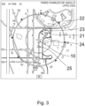
- Figure 3 shows an example of a visualization on a display or screen of an aircraft.
- the aircraft 10 is already on its way between the runway and the assigned gate.
- the aircraft may have received data representing the assigned taxiway. Those data may include points or sections on the map which are referenced by letters and numbers.
- the assigned taxiway may be described by the way K2, points MD1, BM5, and MD2, way M.
- the aircraft 10 is on a section 21 of the taxiway which is illustrated by a dashed line, wherein this section 21 may currently have taxi clearance for the aircraft.
- the following taxiway 22, illustrated by a dotted line does not yet have taxi clearance. In consequence, a holding point 23 is shown on the map.
- the word “comprising” does not exclude other elements or steps, and the indefinite article “a” or “an” does not exclude a plurality.
- a single data processing unit or other unit may fulfil the functions of several items re-cited in the claims.
- the data processing unit may also be divided in several data processing units which are configured to perform parts of the method, like a first data processing unit controlling the visualization on a screen and a second data processing unit processes received data and interprets the data.
- the mere fact that certain measures are re-cited in mutually different dependent claims does not indicate that a combination of these measures cannot be used to advantage. Any reference signs in the claims should not be construed as limiting the scope.
Landscapes
- Engineering & Computer Science (AREA)
- Aviation & Aerospace Engineering (AREA)
- Physics & Mathematics (AREA)
- General Physics & Mathematics (AREA)
- Traffic Control Systems (AREA)
- Radar, Positioning & Navigation (AREA)
- Remote Sensing (AREA)
Abstract
Description
- The present invention relates to aircraft operation. In particular, the invention relates to aircraft operation at an airport between landing and gate way as well as between push back from the gate way and takeoff. Methods and systems are provided which allow for an efficient exchange of information between control tower and aircraft for guiding the aircraft at the airport.
- Typically, pilots are guided at an airport by verbal radio communication with the control tower of the airport. However, the verbal communication is prone to miscommunication which may result in critical situations, e.g., on taxiways or runways.
- By the article "Defining the ATC Controller Interface for Data Link Clearances" of Dr. J. Rankin, 1998, voice recognition is suggested for air traffic controller so that the information and instructions from the control tower to an aircraft may be transmitted as text message data so as to reduce problems with miscommunication and to implement more effective processes for the air traffic controller.
- However, it is still necessary that the pilot of an aircraft understands the information received from the control tower and transfers the information regarding, e.g., an assigned taxiway to a map of the airport so as to find the assigned taxiway to the gate way or back to a runway.
- It may be seen as an object to provide a method and a system for automatically receiving, interpreting, presenting information from a control tower of an airport, guiding an aircraft at that airport. A solution is provided by the subject-matter of each of the independent claims. Further embodiments are defined by the respective dependent claims.
- In general, a method and an aircraft are provided which utilizes information from a control tower, position information of the aircraft, and a map of an airport for guiding the aircraft along taxiways of the airport and for preventing accidents.
- According to an embodiment, a method of guiding an aircraft along a taxiway at an airport comprises the steps of receiving data representing a road map of an airport, determining a position of the aircraft, receiving data representing an assigned taxiway for the aircraft, wherein the assigned taxiway is divided into at least two sections and comprises at least one holding point. Further, data representing a taxi clearance for at least one of the at least two sections is received, wherein the data representing the assigned taxiway for the aircraft and the data representing the taxi clearance for one of the at least two sections of the assigned taxiway are received from a control tower of the airport. Then, the assigned taxiway and the taxi clearance of the at least one section on the road map of the airport may be indicated.
- The data representing the road map of the airport may be received from a data storage of the aircraft or from the control tower of the airport. It will be understood that the data storage of the aircraft may provide a road map and the airport provides information regarding changes so that the road map stored by the aircraft may be updated. By receiving data representing a road map of the airport, the method gains a detailed understanding of the layout and structure of taxiways, runways, gates, and other relevant areas. This information helps in efficient navigation and prevents the aircraft from deviating from the designated paths.
- The position of the aircraft may be determined by means of a global positioning system (GPS). Alternatively or additionally, the position may also be determined by other means which track the position and movement of an aircraft at the ground. By accurately determining the position of the aircraft, the method ensures that the guidance provided is specific to the aircraft's location. This allows for precise instructions and eliminates confusion or potential conflicts with other aircraft.
- The method involves receiving data representing the assigned taxiway for the aircraft and the associated taxi clearance from the control tower. This information ensures that the aircraft follows the correct path and adheres to the specified instructions. Such information is typically provided to avoid congestion, collisions, and other potential hazards.
- Nevertheless, the aircraft or another aircraft may deviate from the assigned taxiway. By receiving position information of other aircraft, the method enables the detection of potential conflicts. It determines changes in the positions of both the aircraft and other planes and may alert the pilots if the distance between them falls below a minimum threshold.
- Alternatively or additionally, the method may extend its capability by receiving data representing the assigned taxiway and taxi clearance for other aircraft. By comparing this data with the aircraft's own assigned path and clearance, it can identify potential conflicts between the two trajectories. Alerts may be provided to the pilots to avoid such conflicts, enhancing overall safety.
- The method may further comprise the step of updating relevant data, like (i) the assigned taxiway of the aircraft, (ii) the taxi clearance of the aircraft, (iii) the position information of the aircraft, (iv) the assigned taxiway of the other aircraft, (v) the taxi clearance of the other aircraft, and (vi) the position information of the other aircraft. This flexibility ensures that the guidance system remains up to date with changing conditions and instructions from the control tower, providing accurate and relevant information to the pilots.
- The method may further include the ability to receive data representing target gates after landing, push back clearance, runway for takeoff, and startup clearance. By incorporating these data points, the method enhances operational efficiency, streamlines aircraft movements, and minimizes delays during taxiing, takeoff, and landing procedures.
- Further, a respective confirmation may be provided to the control tower of the airport regarding the received data. such as the assigned taxiway, taxi clearance, target gate after landing, push back clearance, runway for takeoff, and startup clearance. This feedback loop ensures effective communication between the aircraft and the control tower, reducing the chances of misunderstandings or errors.
- The method may further comprise the step of automatically adapting a movement speed and/or movement direction of the aircraft depending on the received data. In particular, it may be of interest to automatically control maneuvers of the aircraft in case of emergency. Assuming that a pilot loses the ability to control an aircraft which still moves on the ground of an airport, another aircraft may be controlled so as to stay out of way. Such automatic control may utilize information both directly from the un-controlled aircraft and from the control tower.
- The method may also provide information about various conditions related to taxi lights, taxiway surfaces, closed sections of taxiways, temporarily blocked taxiways, closed runways, and temporarily blocked runways. This data allows the pilots to make informed decisions, be aware of potential obstacles or maintenance activities, and ensures safe and efficient taxiing.
- In summary, the method and aircraft discussed offer several advantages, including precise navigation, collision prevention, conflict detection, real-time updates, operational efficiency, effective communication with the control tower, adaptive movements, and awareness of airport conditions. These features contribute to safer and more efficient ground operations, reducing the risk of accidents and enhancing overall aviation operations.
- The aircraft described in the given context includes means for determining its position. It also features a data processing unit that receives data representing a road map of an airport and information from the control tower. This data includes the assigned taxiway for the aircraft, which is divided into sections and may have holding points, as well as the taxi clearance for at least one of these sections.
- The aircraft may be equipped with a display that visualizes its position on the road map, along with the assigned taxiway and the corresponding taxi clearance for one section.
- Furthermore, the data processing unit can receive position information from other aircraft, enabling it to determine changes in aircraft positions and check if the distance between them falls below a minimum threshold. In such cases, an alert may be provided.
- The data processing unit can also receive data about the assigned taxiway and taxi clearance for other aircraft, allowing it to detect conflicts between the paths and clearances of different aircraft. Alerts may be generated to inform the pilots of these conflicts.
- The aircraft's data processing unit is capable of updating the received data, ensuring that the guidance system remains accurate and up to date. It can also provide confirmations to the control tower, indicating that the received data and information have been acknowledged.
- Additionally, the data processing unit can automatically adjust the aircraft's movement speed and direction based on the received data, allowing for adaptive movement.
- The aircraft also includes a data storage system that holds the road map data, facilitating efficient data exchange between the storage and processing units.
- Overall, these features and functionalities enhance the aircraft's navigation capabilities, prevent accidents, and improve the overall safety and efficiency of operations within the airport environment.
- These and other aspects of the present invention will become apparent from and be elucidated with reference to the embodiments described hereinafter.
- Exemplary embodiments of the invention will be described in the following with reference to the following drawings:
-
Fig. 1 is a flowchart illustrating steps of a method according to the disclosure. -
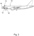
Fig. 2 schematically shows an aircraft comprising means for performing the methods according to the disclosure. -
Fig. 3 is a schematic example of an illustration on a screen of the aircraft including information in accordance with the disclosure. - Certain embodiments will now be described in greater details with reference to the accompanying drawings. In the following description, like drawing reference numerals are used for like elements, even in different drawings. The matters defined in the description, such as detailed construction and elements, are provided to assist in a comprehensive understanding of the exemplary embodiments. Also, well-known functions or constructions are not described in detail since they would obscure the embodiments with unnecessary detail. Moreover, expressions such as "at least one of', when preceding a list of elements, modify the entire list of elements and do not modify the individual elements of the list.
- The flow-chart in
Fig. 1 illustrates the principle of the steps performed in accordance with an embodiment of the disclosure. It will be understood that the steps described are major steps, wherein these major steps might be differentiated or divided into several sub-steps. Furthermore, there might be also sub-steps between these major steps. As becomes apparent from the method claims, only part of the steps according to the flow-chart may contribute to an embodiment. - A method of guiding an aircraft along a taxiway at an airport may mainly comprise steps S1 to S5 as shown in
figure 1 . - According to step S1, data representing a road map of an airport are received, wherein these data may be stored by a storage means of the aircraft or may be provided by the airport to the aircraft as basis information for navigation on the taxiways of the airport.
- According to step S2, a position of the aircraft on the ground of the airport is determined.
- According to step S3, data representing an assigned taxiway for the aircraft are received, wherein the assigned taxiway is divided into at least two sections and comprises at least one holding point.
- According to step S4, data representing a taxi clearance for at least one of the at least two sections are received, wherein the data representing the assigned taxiway for the aircraft and the data representing the taxi clearance for one of the at least two sections of the assigned taxiway are received from a control tower of the airport.
- According to step S5, the assigned taxiway and the taxi clearance of the at least one section on the road map of the airport is indicated, e.g., on a screen of the aircraft.
- The arrows pointing from step S4 back to either S2, S3 or S4 indicate that the information regarding the position of the aircraft, taxiways and taxi clearance may be updated.
- Steps S6 to S8 as well as steps S9 to S11 relate to aspects of collision prevention of two aircraft.
- According to step S6, data representing position information of another aircraft are received, wherein the data representing position information of the other aircraft are received from the other aircraft. It may be noted that such data may be provided by the other aircraft and may be received directly from that other aircraft. Alternatively or additionally, position information of another aircraft may also be provided by the control tower of the airport.
- According to step S7, changes of the position of the aircraft and of the position of the other aircraft are determined, allowing a determination whether a distance between the aircraft and the other aircraft becomes critical, i.e., tends to be less than a minimum distance.
- According to step S8, an alert is provided when the distance is less than the minimum distance, i.e., when the distance falls below a predetermined threshold.
- The arrows pointing from step S8 back to either S6 or S7 indicate that the information regarding the position of the other aircraft and regarding taxiways and taxi clearance of the other aircraft may be updated.
- According to step S9, data are received representing an assigned taxiway for another aircraft, and according to step S10, data representing a taxi clearance for at least one section of the assigned taxiway of the other aircraft are received.
- Based on a comparison of the data related to the other aircraft with the corresponding data of the aircraft, an alert may be provided in step S 11, in case of a conflict between the taxiway and the taxi clearance of the aircraft and the taxiway and the taxi clearance of the other aircraft.
- Again, the arrows pointing from step S11 back to either S9 or
S 10 indicate that the information regarding the taxiway and taxi clearance of the other aircraft may be updated. - As further information, data may be received in step S12, representing (i) a target gate after landing, (ii) a push back clearance, (iii) a runway to use for takeoff, and/or (iv) a startup clearance. Likewise, information may be provided in step S13, with respect to (i) a condition of a taxi light, (ii) a condition of a taxiway surface, (iii) closed sections of taxiways, (iv) temporarily blocked taxiways, (v) closed runways, and/or (vi) temporarily blocked runways.
- It is noted that the aircraft may automatically process information received from the control tower and/or from another aircraft, and may automatically provide information to the pilot. For example, like that shown in
figure 3 , some information may be visually provided on a screen of the aircraft. The information may also be provided acoustically. For example, an alert may be provided both on the screen of the aircraft and by an acoustic signal to the pilot. All this is indicated by the arrows pointing from steps S4, S8, S11, S12 and S13 to step S5. All kind of provision of information to a pilot is meant to be covered by step S5 infigure 1 . - According to step S14, a respective confirmation is provided to the control tower of the airport. The aircraft and/or the pilot may confirm receipt of the data representing (i) the assigned taxiway, (ii) the taxi clearance, (iii) the target gate after landing, (iv) the push back clearance, (v) the runway to use for takeoff, and (vi) the startup clearance. When automatically confirming receipt of data by the aircraft, the aircraft may communicate autonomously with the control tower as well as with other aircraft. Such an autonomous communication may implement a level of efficient exchange of information allowing a movement speed and/or movement direction of the aircraft to be automatically adapted based on the received data, for example to avoid accidents (step S15).
-
Figure 2 shows an aircraft equipped with means for performing the above-described methods. Theaircraft 10 comprises adata processing unit 12, means 14 for determination of a position of the aircraft, a display orscreen 16, and a storage means 18. The above-described methods may be implemented as computer program product which when executed on theprocessing unit 12 of theaircraft 10, causing the aircraft to perform at least some of the above-described method steps. The processing unit is coupled with themeans 14, thedisplay 16 and the storage means 18 so as to exchange data. Theprocessing unit 12 may further be coupled with a communication antenna of the aircraft for the exchange of data with the control tower and with other aircraft. -
Figure 3 shows an example of a visualization on a display or screen of an aircraft. According to this example, theaircraft 10 is already on its way between the runway and the assigned gate. The aircraft may have received data representing the assigned taxiway. Those data may include points or sections on the map which are referenced by letters and numbers. For example, the assigned taxiway may be described by the way K2, points MD1, BM5, and MD2, way M. At the current state, theaircraft 10 is on asection 21 of the taxiway which is illustrated by a dashed line, wherein thissection 21 may currently have taxi clearance for the aircraft. The followingtaxiway 22, illustrated by a dotted line, does not yet have taxi clearance. In consequence, aholding point 23 is shown on the map. Examples of further information are a dotted square 25 which may indicate damages on the taxiway surface, and dottedcircle 24 which may indicate a broken taxi light. As may be expected by a person having ordinary skill in the art, the different information may also be visualized by different colors. For example, thesection 21 which already has taxi clearance may be drawn into the map in green, while thesection 22 which does not yet have taxi clearance may be drawn in red. Information like those atpoints - While the invention has been illustrated and described in detail in the drawings and foregoing description, such illustration and description are to be considered illustrative or exemplary and not restrictive. The invention is not limited to the disclosed embodiments. Other variations to the disclosed embodiments can be understood and effected by those skilled in the art in practicing a claimed invention, from a study of the drawings, the disclosure, and the dependent claims.
- In the claims, the word "comprising" does not exclude other elements or steps, and the indefinite article "a" or "an" does not exclude a plurality. A single data processing unit or other unit may fulfil the functions of several items re-cited in the claims. The data processing unit may also be divided in several data processing units which are configured to perform parts of the method, like a first data processing unit controlling the visualization on a screen and a second data processing unit processes received data and interprets the data. The mere fact that certain measures are re-cited in mutually different dependent claims does not indicate that a combination of these measures cannot be used to advantage. Any reference signs in the claims should not be construed as limiting the scope.
Claims (15)
- A method of guiding an aircraft along a taxiway at an airport, the method comprising the steps of:receiving data representing a road map of an airport,determining a position of the aircraft,receiving data representing an assigned taxiway for the aircraft, wherein the assigned taxiway is divided into at least two sections and comprises at least one holding point,receiving data representing a taxi clearance for at least one of the at least two sections, wherein the data representing the assigned taxiway for the aircraft and the data representing the taxi clearance for one of the at least two sections of the assigned taxiway are received from a control tower of the airport,indicating the assigned taxiway and the taxi clearance of the at least one section on the road map of the airport.
- The method of claim 1, further comprising the steps ofreceiving data representing position information of another aircraft, wherein the data representing position information of the other aircraft are received from the other aircraft,determining changes of the position of the aircraft and of the position of the other aircraft and determining whether a distance between the aircraft and the other aircraft is less than a minimum distance,providing an alert when the distance is less than the minimum distance.
- The method of any one of claim 1 and 2, further comprising the steps ofreceiving data representing an assigned taxiway for another aircraft,receiving data representing a taxi clearance for at least one section of the assigned taxiway of the other aircraft,providing an alert in case of a conflict between the taxiway and the taxi clearance of the aircraft and the taxiway and the taxi clearance of the other aircraft.
- The method of any one of claims 1 to 3, further comprising the step of
updating at least one out of the group consisting of (i) the assigned taxiway of the aircraft, (ii) the taxi clearance of the aircraft, (iii) the position information of the aircraft, (iv) the assigned taxiway of the other aircraft, (v) the taxi clearance of the other aircraft, and (vi) the position information of the other aircraft. - The method of any one of claims 1 to 4, further comprising the steps of receiving data representing (i) a target gate after landing, (ii) a push back clearance, (iii) a runway to use for takeoff, and (iv) a startup clearance.
- The method of any one of claims 1 to 5, further comprising the step of providing a respective confirmation to the control tower of the airport of the received data representing (i) the assigned taxiway, (ii) the taxi clearance, (iii) the target gate after landing, (iv) the push back clearance, (v) the runway to use for takeoff, and (vi) the startup clearance.
- The method of any one of claims 1 to 6, further comprising the step of automatically adapting a movement speed and/or movement direction of the aircraft depending on the received data.
- The method of any one of claims 1 to 7, further comprising the step of
providing information with respect to at least one out of the group consisting of (i) a condition of a taxi light, (ii) a condition of a taxiway surface, (iii) closed sections of taxiways, (iv) temporarily blocked taxiways, (v) closed runways, and (vi) temporarily blocked runways. - An aircraft comprisingmeans for determining a position of the aircraft,a data processing unit, wherein the data processing unit is configured to receive data representing a road map of an airport and to receive data from a control tower of an airport, wherein the data from the control tower represent an assigned taxiway for the aircraft, wherein the assigned taxiway is divided into at least two sections and comprises at least one holding point, and wherein the data from the control tower represent a taxi clearance for at least one of the at least two sections, anda display for visualizing the position of the aircraft on the road map together with the assigned taxiway and the taxi clearance of the one section.
- The aircraft of claim 9, wherein the data processing unit is further configuredto receive data representing position information of another aircraft, wherein the data representing position information of the other aircraft are received from the other aircraft,to determine changes of the position of the aircraft and of the position of the other aircraft,to determine whether a distance between the aircraft and the other aircraft is less than a minimum distance, andto provide an alert when the distance is less than the minimum distance.
- The aircraft of any one of claim 9 and 10, wherein the data processing unit further configuredto receive data representing an assigned taxiway for another aircraft,to receive data representing a taxi clearance for at least one section of the assigned taxiway of the other aircraft, andto provide an alert in case of a conflict between the taxiway and the taxi clearance of the aircraft and the taxiway and the taxi clearance of the other aircraft.
- The aircraft of any one of claims 9 to 11, wherein the data processing unit is further configured to update received data.
- The aircraft of any one of claims 9 to 12, wherein the processing unit is further configured to confirm to the control tower of the airport receipt of data and information.
- The aircraft of any one of claims 9 to 13, wherein the processing unit is further configured to automatically adapt a movement speed and/or movement direction of the aircraft depending on the received data.
- The aircraft of any one of claims 9 to14, further comprising a data storage, wherein the data storage is coupled to the data processing unit for an exchange of data, wherein the data storage is configured to provide the data representing the road map of the airport.
Priority Applications (2)
| Application Number | Priority Date | Filing Date | Title |
|---|---|---|---|
| EP23182174.5A EP4485427A1 (en) | 2023-06-28 | 2023-06-28 | Guiding an aircraft at an airport |
| US18/740,158 US20250006069A1 (en) | 2023-06-28 | 2024-06-11 | Guiding an aircraft at an airport |
Applications Claiming Priority (1)
| Application Number | Priority Date | Filing Date | Title |
|---|---|---|---|
| EP23182174.5A EP4485427A1 (en) | 2023-06-28 | 2023-06-28 | Guiding an aircraft at an airport |
Publications (1)
| Publication Number | Publication Date |
|---|---|
| EP4485427A1 true EP4485427A1 (en) | 2025-01-01 |
Family
ID=87036681
Family Applications (1)
| Application Number | Title | Priority Date | Filing Date |
|---|---|---|---|
| EP23182174.5A Pending EP4485427A1 (en) | 2023-06-28 | 2023-06-28 | Guiding an aircraft at an airport |
Country Status (2)
| Country | Link |
|---|---|
| US (1) | US20250006069A1 (en) |
| EP (1) | EP4485427A1 (en) |
Families Citing this family (1)
| Publication number | Priority date | Publication date | Assignee | Title |
|---|---|---|---|---|
| US20260004660A1 (en) * | 2024-07-01 | 2026-01-01 | The Boeing Company | Determining the compatibility of airside infrastructure for an aircraft |
Citations (4)
| Publication number | Priority date | Publication date | Assignee | Title |
|---|---|---|---|---|
| EP2355070A2 (en) * | 2010-02-10 | 2011-08-10 | Honeywell International Inc. | Methods and systems for inputting taxi instructions |
| US20140278037A1 (en) * | 2013-03-16 | 2014-09-18 | Hardik Choksi | Aircraft taxiing system |
| EP3764342A1 (en) * | 2019-07-01 | 2021-01-13 | Honeywell International Inc. | Collision awareness system for ground operations |
| EP4083965A1 (en) * | 2021-04-26 | 2022-11-02 | The Boeing Company | Taxi route generator |
Family Cites Families (5)
| Publication number | Priority date | Publication date | Assignee | Title |
|---|---|---|---|---|
| WO2002095709A2 (en) * | 2001-05-18 | 2002-11-28 | Technology Planning Incorporated | Surface traffic movement system and method |
| US20030160708A1 (en) * | 2002-02-27 | 2003-08-28 | Knoop Alan Richard | Airport ground control system |
| US9092976B2 (en) * | 2012-09-14 | 2015-07-28 | Honeywell International Inc. | Systems and methods for providing runway-entry awareness and alerting |
| WO2014115139A1 (en) * | 2013-01-23 | 2014-07-31 | Iatas (Automatic Air Traffic Control) Ltd | System and methods for automated airport air traffic control services |
| CN105957404B (en) * | 2016-05-09 | 2018-10-26 | 丁元沅 | Unmanned plane and airborne Autonomous Scheduling system and method under man-carrying aircraft's coexisted environment |
-
2023
- 2023-06-28 EP EP23182174.5A patent/EP4485427A1/en active Pending
-
2024
- 2024-06-11 US US18/740,158 patent/US20250006069A1/en active Pending
Patent Citations (4)
| Publication number | Priority date | Publication date | Assignee | Title |
|---|---|---|---|---|
| EP2355070A2 (en) * | 2010-02-10 | 2011-08-10 | Honeywell International Inc. | Methods and systems for inputting taxi instructions |
| US20140278037A1 (en) * | 2013-03-16 | 2014-09-18 | Hardik Choksi | Aircraft taxiing system |
| EP3764342A1 (en) * | 2019-07-01 | 2021-01-13 | Honeywell International Inc. | Collision awareness system for ground operations |
| EP4083965A1 (en) * | 2021-04-26 | 2022-11-02 | The Boeing Company | Taxi route generator |
Non-Patent Citations (1)
| Title |
|---|
| DR. J. RANKIN, DEFINING THE ATC CONTROLLER INTERFACE FOR DATA LINK CLEARANCES, 1998 |
Also Published As
| Publication number | Publication date |
|---|---|
| US20250006069A1 (en) | 2025-01-02 |
Similar Documents
| Publication | Publication Date | Title |
|---|---|---|
| US20250336300A1 (en) | Unmanned Aircraft Control Using Ground Control Station | |
| US8965671B2 (en) | Aircraft taxiing system | |
| RU2712716C2 (en) | Unmanned aerial vehicle and method of safe landing of unmanned aerial vehicle | |
| US11682308B2 (en) | System and method for enhancing operator situational awareness of traffic diversion patterns and adapting thereto | |
| US8521340B2 (en) | Device and method of automated construction of emergency flight path for aircraft | |
| US20210350716A1 (en) | Detecting and avoiding conflicts between aircraft | |
| EP3703034B1 (en) | Systems and methods for generating a recapture path for an aircraft | |
| US7772992B2 (en) | Method and device for assisting the ground navigation of an aeroplane in an airport | |
| JP5315825B2 (en) | Aircraft approach runway monitoring system and aircraft approach runway monitoring method | |
| EP3667644B1 (en) | Systems and methods for an enhanced stable approach monitor | |
| US20080065312A1 (en) | Guidance method for temporarily deviating a vehicle initially following a predefined path | |
| KR102467524B1 (en) | Estimating method for flight plan using ADS-B data | |
| CN112200352A (en) | Aircraft routing sharing device for guided vehicle based on high-speed data link | |
| US20250006069A1 (en) | Guiding an aircraft at an airport | |
| CN114489123B (en) | A device for switching horizontal routes of fixed-wing aircraft | |
| EP3862999B1 (en) | Runway determination based on a clearance received from traffic control system | |
| EP3573037A1 (en) | Systems and methods for predicting loss of separation events | |
| US8498755B2 (en) | Device and method for the coherent management of data deriving from surveillance systems of an aircraft | |
| JP4651989B2 (en) | Controller decision making support system and method | |
| US12609036B2 (en) | Methods and systems for providing conditional estimated arrival times | |
| EP4531021A1 (en) | Methods and systems for providing conditional estimated arrival times | |
| EP4495914A1 (en) | Systems and methods for displaying a landing runway extension on an aircraft | |
| EP3896674B1 (en) | System and methods enabling aircraft energy dissipation for rapid decision making | |
| US11790795B2 (en) | System and methods enabling aircraft energy dissipation for rapid decision making | |
| US20260004668A1 (en) | Aircraft tail strike detection and prevention system and method |
Legal Events
| Date | Code | Title | Description |
|---|---|---|---|
| PUAI | Public reference made under article 153(3) epc to a published international application that has entered the european phase |
Free format text: ORIGINAL CODE: 0009012 |
|
| STAA | Information on the status of an ep patent application or granted ep patent |
Free format text: STATUS: THE APPLICATION HAS BEEN PUBLISHED |
|
| AK | Designated contracting states |
Kind code of ref document: A1 Designated state(s): AL AT BE BG CH CY CZ DE DK EE ES FI FR GB GR HR HU IE IS IT LI LT LU LV MC ME MK MT NL NO PL PT RO RS SE SI SK SM TR |
|
| STAA | Information on the status of an ep patent application or granted ep patent |
Free format text: STATUS: REQUEST FOR EXAMINATION WAS MADE |
|
| 17P | Request for examination filed |
Effective date: 20250701 |
|
| STAA | Information on the status of an ep patent application or granted ep patent |
Free format text: STATUS: EXAMINATION IS IN PROGRESS |
|
| 17Q | First examination report despatched |
Effective date: 20260114 |