EP4465278A2 - Method for weather information display and ads-b/fis-b weather and ads-b tracks - Google Patents
Method for weather information display and ads-b/fis-b weather and ads-b tracks Download PDFInfo
- Publication number
- EP4465278A2 EP4465278A2 EP24172561.3A EP24172561A EP4465278A2 EP 4465278 A2 EP4465278 A2 EP 4465278A2 EP 24172561 A EP24172561 A EP 24172561A EP 4465278 A2 EP4465278 A2 EP 4465278A2
- Authority
- EP
- European Patent Office
- Prior art keywords
- aircraft
- flight path
- information
- ship
- processing circuitry
- Prior art date
- Legal status (The legal status is an assumption and is not a legal conclusion. Google has not performed a legal analysis and makes no representation as to the accuracy of the status listed.)
- Pending
Links
Images


Classifications
-
- G—PHYSICS
- G08—SIGNALLING
- G08G—TRAFFIC CONTROL SYSTEMS
- G08G5/00—Traffic control systems for aircraft
- G08G5/70—Arrangements for monitoring traffic-related situations or conditions
- G08G5/76—Arrangements for monitoring traffic-related situations or conditions for monitoring atmospheric conditions
-
- G—PHYSICS
- G01—MEASURING; TESTING
- G01S—RADIO DIRECTION-FINDING; RADIO NAVIGATION; DETERMINING DISTANCE OR VELOCITY BY USE OF RADIO WAVES; LOCATING OR PRESENCE-DETECTING BY USE OF THE REFLECTION OR RERADIATION OF RADIO WAVES; ANALOGOUS ARRANGEMENTS USING OTHER WAVES
- G01S13/00—Systems using the reflection or reradiation of radio waves, e.g. radar systems; Analogous systems using reflection or reradiation of waves whose nature or wavelength is irrelevant or unspecified
- G01S13/86—Combinations of radar systems with non-radar systems, e.g. sonar, direction finder
-
- G—PHYSICS
- G01—MEASURING; TESTING
- G01S—RADIO DIRECTION-FINDING; RADIO NAVIGATION; DETERMINING DISTANCE OR VELOCITY BY USE OF RADIO WAVES; LOCATING OR PRESENCE-DETECTING BY USE OF THE REFLECTION OR RERADIATION OF RADIO WAVES; ANALOGOUS ARRANGEMENTS USING OTHER WAVES
- G01S13/00—Systems using the reflection or reradiation of radio waves, e.g. radar systems; Analogous systems using reflection or reradiation of waves whose nature or wavelength is irrelevant or unspecified
- G01S13/88—Radar or analogous systems specially adapted for specific applications
- G01S13/95—Radar or analogous systems specially adapted for specific applications for meteorological use
- G01S13/953—Radar or analogous systems specially adapted for specific applications for meteorological use mounted on aircraft
-
- G—PHYSICS
- G01—MEASURING; TESTING
- G01S—RADIO DIRECTION-FINDING; RADIO NAVIGATION; DETERMINING DISTANCE OR VELOCITY BY USE OF RADIO WAVES; LOCATING OR PRESENCE-DETECTING BY USE OF THE REFLECTION OR RERADIATION OF RADIO WAVES; ANALOGOUS ARRANGEMENTS USING OTHER WAVES
- G01S7/00—Details of systems according to groups G01S13/00, G01S15/00, G01S17/00
- G01S7/003—Transmission of data between radar, sonar or lidar systems and remote stations
-
- G—PHYSICS
- G08—SIGNALLING
- G08G—TRAFFIC CONTROL SYSTEMS
- G08G5/00—Traffic control systems for aircraft
- G08G5/20—Arrangements for acquiring, generating, sharing or displaying traffic information
- G08G5/21—Arrangements for acquiring, generating, sharing or displaying traffic information located onboard the aircraft
-
- G—PHYSICS
- G08—SIGNALLING
- G08G—TRAFFIC CONTROL SYSTEMS
- G08G5/00—Traffic control systems for aircraft
- G08G5/20—Arrangements for acquiring, generating, sharing or displaying traffic information
- G08G5/25—Transmission of traffic-related information between aircraft
-
- G—PHYSICS
- G08—SIGNALLING
- G08G—TRAFFIC CONTROL SYSTEMS
- G08G5/00—Traffic control systems for aircraft
- G08G5/20—Arrangements for acquiring, generating, sharing or displaying traffic information
- G08G5/26—Transmission of traffic-related information between aircraft and ground stations
-
- G—PHYSICS
- G08—SIGNALLING
- G08G—TRAFFIC CONTROL SYSTEMS
- G08G5/00—Traffic control systems for aircraft
- G08G5/30—Flight plan management
- G08G5/34—Flight plan management for flight plan modification
-
- G—PHYSICS
- G08—SIGNALLING
- G08G—TRAFFIC CONTROL SYSTEMS
- G08G5/00—Traffic control systems for aircraft
- G08G5/70—Arrangements for monitoring traffic-related situations or conditions
- G08G5/72—Arrangements for monitoring traffic-related situations or conditions for monitoring traffic
- G08G5/723—Arrangements for monitoring traffic-related situations or conditions for monitoring traffic from the aircraft
-
- G—PHYSICS
- G08—SIGNALLING
- G08G—TRAFFIC CONTROL SYSTEMS
- G08G5/00—Traffic control systems for aircraft
- G08G5/80—Anti-collision systems
Definitions
- the disclosure relates to aircraft avionics and more specifically to aircraft systems that display information to aircraft operators.
- Aircraft both manned and unmanned, may reroute planned flight paths based on changing conditions, such as predicted or actual weather conditions including turbulence, smoke, volcanic ash, and other conditions affecting flight.
- the disclosure describes systems, methods, and devices for receiving information affecting a flight path from several different sources, fusing that information together, and based on analysis of the fused information, automatically determining whether an own ship aircraft should adjust a planned flight path.
- information sources may include an own ship weather radar system, automatic dependent surveillance-broadcast (ADS-B), flight information system broadcast (FIS-B), global position system (GPS), data from an own ship flight management computer (FMC), other onboard or ground based sensors and similar sources.
- Examples of systems or devices that may receive, fuse, and analyze the fused information may include processing circuitry that is part of an aircraft avionics system as well as a standalone device such as a tablet computer running an electronic flight bag (EFB) application.
- the processing circuitry may connect to a user interface, including a display, and in response to determining the own ship aircraft should adjust the planned flight path, may output a depiction of the recommended adjusted flight path for use by the aircraft operator.
- EFB electronic flight bag
- this disclosure describes a system comprising; a weather radar configured to be installed on board an own ship aircraft; processing circuity for the own ship aircraft having access to a storage device, the processing circuitry and storage device configured to: receive, from multiple sources, information related to a planned flight path of the own ship aircraft, wherein the multiple sources include the weather radar, first data received from a flight information system broadcast (FIS-B) service, and second data received from automatic dependent surveillance-broadcast (ADS-B); evaluate the received information; based on the evaluation of the received information, automatically determine whether the own ship aircraft should adjust the planned flight path; output, via a user interface, a depiction of an adjusted flight path to flight crew for the own ship aircraft.
- FIS-B flight information system broadcast
- ADS-B automatic dependent surveillance-broadcast
- this disclosure describes a method comprising receiving, by processing circuitry for an aircraft, information from multiple sources related to a planned flight path of the aircraft, wherein the multiple sources include a weather radar located onboard the aircraft, first data received from a flight information system broadcast (FIS-B) service, and second data received from automatic dependent surveillance-broadcast (ADS-B); evaluating the received information; based on the evaluation of the received information, automatically determining whether the own ship aircraft should adjust the planned flight path; and outputting, via a user interface, a depiction of an adjusted flight path to flight crew for the own ship aircraft.
- FIS-B flight information system broadcast
- ADS-B automatic dependent surveillance-broadcast
- this disclosure describes a non-transitory computer-readable storage medium comprising instructions that, when executed, cause processing circuitry of a computing device to receive information from multiple sources related to a planned flight path of the aircraft, wherein the multiple sources include a weather radar located onboard the aircraft, first data received from a flight information system broadcast (FIS-B) service, and second data received from automatic dependent surveillance-broadcast (ADS-B); evaluate the received information; based on the evaluation of the received information, automatically determine whether the own ship aircraft should adjust the planned flight path; and output, via a user interface, a depiction of an adjusted flight path to flight crew for the own ship aircraft.
- FIS-B flight information system broadcast
- ADS-B automatic dependent surveillance-broadcast
- the disclosure describes systems, methods, and devices for receiving information from several different sources affecting an aircraft flight path.
- Processing circuitry may fuse that information, and based on analysis of the fused information, automatically determining whether to adjust a planned flight path for an own ship aircraft.
- information sources may include an own ship weather radar system, automatic dependent surveillance-broadcast (ADS-B), flight information system broadcast (FIS-B), global position system (GPS), data from an own ship flight management computer (FMC), other onboard or land based sensors and similar sources.
- Examples of systems or devices that may receive, fuse, and analyze the fused information may include processing circuitry that is part of an aircraft avionics system as well as processing circuitry of a standalone device such as a tablet computer running an electronic flight bag (EFB) application.
- the processing circuitry may receive the information via wired or wireless communication.
- the processing circuitry may also connect to a user interface, including a display, and in response to determining the own ship aircraft should adjust the planned flight path, may output a depiction of the recommended adjusted flight path for use by the aircraft operator.
- the aircraft operator may include the flight crew on board a manned aircraft, or flight crew of an unmanned aircraft controlling the unmanned aircraft from a remote location.
- the aircraft operator may determine, based on the recommendation, whether the own ship aircraft should adjust the planned flight path. In some examples, the aircraft operator may request a flight path deviation from air traffic control before changing course or altitude.
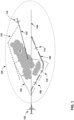
- FIG. 1 is a conceptual diagram illustrating an example operation of an example system of this disclosure.
- FIG. 1 includes own ship aircraft 102, which may be a manned or unmanned aircraft. Own ship aircraft 102 is on a planned flight path 104, which may include one or more legs to reach a final destination (not shown in FIG. 1 ) for own ship aircraft 102.
- FIG. 1 also illustrates other aircraft 108, 110, 112 and 114 that may be in a three dimensional (3D) region of airspace 120 through which the own ship planned flight path 104 passes.
- aircraft 108, 110 and 112 may be traveling on the same or similar flight trajectory as own ship aircraft 102.
- a similar flight trajectory may be a flight path through the same region of air space.
- an aircraft flying from LaGuardia Airport (KLGA) in New York U.S.A to Heathrow (LHR) in London may fly along a similar flight trajectory to an aircraft flying from LaGuardia to Schiphol (AMS) in Amsterdam.
- an aircraft flying from Berlin (BER) in Germany to Beijing Capital International Airport (PEK) may fly a similar flight trajectory to an aircraft flying from Schiphol to Narita International Airport (NRT) in Tokyo Japan.
- FIG. 1 also illustrates aircraft 114 flying a similar flight trajectory 122 as planned flight path 104 for own ship aircraft 102, but in approximately an opposite direction, where "approximately" the opposite direction in this disclosure means within 90 degrees of the reciprocal course or heading.
- the reciprocal course is 090 degrees (east)
- the reciprocal course is 270 degrees (west) and within 90 degrees of 270, e.g., 315 degrees to 235 degrees may be considered “approximately" the opposite direction.
- Any of the aircraft in 3D region of airspace 120 as shown in the example of FIG. 1 may be affected by the same flight conditions, such as storm 126, that may affect own ship aircraft 102.
- Other examples of conditions affecting flight may include a restricted flight area such as a temporary flight restriction (TFR), predicted or actual weather conditions including turbulence, smoke, volcanic ash, and similar conditions.
- TFR temporary flight restriction
- own ship aircraft 102 may operate using a computing system with processing circuitry (not shown in FIG. 1 ) that may receive information from multiple sources related to planned flight path 104.
- sources may include the flight path programmed into the own-ship flight management system (FMS), information from air traffic control (ATC), which in some examples may be received automatically such as via Controller Pilot Data Link Communications (CPDLC) an other sources.
- CPDLC is a means of communication between controller and pilot, using data link for ATC communications.
- own ship aircraft 102 may include onboard weather radar that may have a field of view 128 (FOV) along planned flight path 104 and may detect and warn the flight crew of conditions affecting flight.
- FOV field of view 128
- a weather radar may include a rain echo attenuation compensation technique (REACT) capability. As the transmitted radar signal travels through heavy rain the radar signal may loses power or become attenuated. If this attenuation is severe enough, weather behind a storm cell may not be detectable, or it may be displayed as being less severe than it actually is. So the pilots may not be able get the timely warning of the severe weather.
- REACT rain echo attenuation compensation technique
- the processing circuitry may also receive, for example, information from FIS-B and from ADS-B.
- ADS-B is a system that aircraft and other vehicles automatically transmit and receive data that includes identification, position, heading, speed, and additional data, by broadcast via a data link.
- ADS-B may also provide weather information to aircraft and other vehicles.
- ADS-B data may be received, for example, directly from other aircraft or vehicles and may also be broadcast from ground stations.
- FIS-B is a service available to aircraft who can receive data over 978 MHz (UAT). FIS-B automatically transmits a wide range of weather products with national and regional focus to all equipped aircraft. FIS-B is a data broadcasting service that works along with ADS-B to allow aircraft operators to receive aeronautical information such as weather and airspace restrictions through a data link. In some examples, FIS-B may gather information through the use of ground stations and radar and delivers that data in the form of weather alerts, airport information and other reports. Some examples of weather alerts may include inflight weather advisories for significant meteorological hazards (SIGMET) and airman's meteorological information (AIRMET).
- SIGMET significant meteorological hazards
- AIRMET airman's meteorological information
- SIGMETs and AIRMETs Some examples of information included in SIGMETs and AIRMETs include turbulence predictions, visibility restrictions, icing conditions, thunderstorm predictions, dust, volcanic ash, and other hazards to flight. Other details on weather and other information that the processing circuitry of this disclosure may receive can be found in Minimum Operational Performance Standards (e.g., MOPS DO-260C).
- MOPS DO-260C Minimum Operational Performance Standards
- Aircraft reports are reports of actual weather conditions encountered by an aircraft while in flight. There are two types of reports.
- An AIREP is a routine, often automated report of in-flight weather conditions such as wind, temperature, eddy dissipation rate (EDR), which is related to clear air turbulence (CAT) and other weather information.
- EDR eddy dissipation rate
- CAT clear air turbulence
- a PIREP is reported by a pilot to report encounters of actual weather conditions through which the aircraft is flying, such as icing or turbulence, height of cloud tops, base of clouds, wind speed and direction aloft, and other conditions.
- Both reports may be transmitted in real-time via radio to a ground station and may be made available to other aircraft in flight.
- the processing circuitry may also receive information from other sources such as global positioning system (GPS), the FMC, other onboard sensors such as temperature sensors, gyroscopes, and accelerometers to measure motion, and other sources.
- GPS global positioning system
- Each aircraft report may include the type of aircraft making the report. For example, light turbulence for a commercial multi-engine passenger jet may feel like heavy turbulence to a smaller aircraft.
- the processing circuitry may fuse this information into a cohesive picture. For example, for areas in which the weather radar signal is attenuated and REACT highlights that area as doubtful, the processing circuitry may combine FIS-B weather information in those doubtful areas, to complete, or at least improve, the reference information for that area. This fused information may provide supplementary weather information for flight crew awareness.
- supplementary weather information may come from aircraft on the same or similar trajectory as own ship aircraft 102.
- own ship aircraft 102 may receive information that aircraft 110 had to change its original flight path, e.g., from parallel to flight path 104, to a new flight path 106. Because aircraft 110 is in the same region of airspace 120 as the planned flight path of own ship aircraft 102, receiving data that aircraft 110 made a course and flight path change may be useful supplementary weather information to own ship aircraft 102.
- own ship aircraft 102 may receive the indication that aircraft 110 changed course from ADS-B.
- the onboard weather radar may indicate improved weather, e.g., with REACT, but the ahead aircraft ADS-B are all indicating the ahead aircraft changed flight path. Though an onboard weather radar may have a higher confidence priority in determining whether to change course, an indication that many or most aircraft ahead are changing course, may give a higher confidence to the ADS-B data.
- the processing circuitry may evaluate a large volume of data from the numerous sources, fuse the information together and evaluate the information and based on the evaluation, automatically determine whether own ship aircraft 102 should adjust the planned flight path.
- the processing circuitry may output, via a user interface, a depiction of an adjusted flight path to the own ship aircraft flight crew. The flight crew may then decide whether to follow the recommended adjusted flight path and contact flight operations and/or air traffic control (ATC) to request a change.
- ATC air traffic control
- the system of this disclosure may be an improvement and provide advantages over other systems that evaluate weather and other flight conditions.
- the system of this disclosure may reduce the flight crew workload by receiving the data from the various sources and fusing the information into a cohesive whole picture of the planned flight.
- Processing circuitry of the system of this disclosure may regularly, or continuously, evaluate the received information, as well as received updates to information affecting the flight of own ship aircraft 102.
- the system of this disclosure may determine that each of aircraft 108 and 112, in addition to aircraft 110 all changed planned flight paths because of storm 126.
- the processing circuitry of this disclosure may further determine that aircraft 114, coming approximately the opposite direction, changed the flight path from 122 to a new flight path 124, also because of storm 126.
- This supplementary weather information when fused with the other received information by the processing circuitry may cause the processing circuitry to automatically determine that own ship aircraft 102 should also adjust the flight path to, for example, flight path 106.
- aircraft 112 may have adjusted its flight path from an original flight path to flight path 106.
- aircraft 108 and 110 may have maintained their original flight path, which may indicate that storm 126 has moved or is dissipating and may no longer be a hazard. In this manner the system of this disclosure may satisfy a long felt, but unmet need for flight safety, which includes reducing the workload of the flight crew.
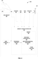
- FIG. 2 is a block diagram illustrating an example system for receiving, fusing, and evaluating information from numerous sources, according to one or more techniques of this disclosure.
- the example of system 200 in FIG. 2 includes own aircraft 202 with antenna 206 configured to receive ADS-B signals and/or interrogation replies directly from other vehicles, e.g., aircraft or UAV 242, or via ground station 240, which is the same or similar to the functions of own ship aircraft 102 described in FIG. 1 .
- the information gathering, fusing, evaluation and recommendation functions described above in relation to FIG. 1 may be executed by an electronic flight bag (EFB 204), which may be a tablet computer, or similar computing device with processing circuitry 220, memory 222 and user interface 208.
- An EFB is one or more applications, comprising programming instructions executed by processing circuitry 220, that may retrieve and display reference material often found in the pilot's carry-on flight bag, including the flight-crew operating manual, navigational charts, and other material.
- the EFB include software applications to automate other functions such as take-off performance calculations.
- Some examples of EFBs may include Jeppesen ® Aviator, ForeFlight ® and other similar EFB applications.
- the computing device executing EFB 204 may receive information from the various sources via a wireless connection or a wired connection.
- own aircraft 202 includes aircraft avionics system 204, which may be implemented as a computing device with processing circuitry 220, memory 222 as well as other sensors, controllers, actuators, and so on not shown FIG. 3 .
- EFB 204 and aircraft avionics 204 are shown as a single system, but in some implementations may be fully or partially separate systems.
- EFB 204 may receive information from aircraft avionics 204, as well as from other sources.
- aircraft avionics system 204 may be located on board the aircraft.
- aircraft avionics 204 may be located at a ground station, a ground vehicle, a waterborne vessel or otherwise off the aircraft.
- the processing circuitry for the aircraft may be onboard, may be off the aircraft or may have components both onboard and off the aircraft.
- Aircraft avionics system 204 may connect to one or more user interfaces 208.
- User interfaces 208 may display information as well as receive input from the flight crew.
- memory 222 may be part of aircraft avionics system 204, and may include programming instructions that when executed by processing circuitry 220, may perform the functions described herein, and as described above in relation to FIG. 1 .
- the instructions for performing the functions of this disclosure may be implemented as a hardware device with embedded software that can be connected securely to the cloud via wired or wireless connection as well as embedded software runs in a device/unit (e.g., firmware).
- Additional examples of information sources from which processing circuitry 220 may receive information to perform the functions of this disclosure may include GPS 232, FIS-B 234, FMC data 236, radar 245 and sensors 230, as described above in relation to FIG. 1 .
- Radar 245 may include a weather radar with a FOV positioned along the heading of own aircraft 202.
- Sensors 230 are an example of the sensors described above in FIG. 1 including temperature, e.g., an outside temperature sensor, a turbulence sensor, a barometric air pressure sensor and other sensors.
- Processing circuitry 220 may also receive weather information from one or more satellite based weather providers, such as SiriusXM or similar system (not shown in FIG. 2 ).
- TIS-B is an aviation information service that may allow aircraft and other vehicle operators to be aware of aircraft that are not emitting ADS-B data but have may a basic transponder.
- FMC data 236 may come from an FMC that is part of a flight management system (FMS).
- FMS comprises four main components: The flight management computer (FMC), described in relation to FIG. 1 ; the automatic flight control or automatic flight guidance system (AFCS or AFGS); the aircraft navigation system; and an electronic flight instrument system (EFIS) or equivalent electromechanical instrumentation.
- the FMC is a computer system that uses a large data base to allow routes to be pre-programmed and fed into the system by means of a data loader.
- antenna 206 may be configured as a directional antenna, and in other examples, antenna 206 may be an integrated antenna system that includes both directional antenna functions as well as omni-directional capability. In some examples own aircraft 202 may include a separate directional antenna and omni-directional antenna where the omni-directional antenna receives and broadcasts ADS-B messages (not shown in FIG.2 ).
- memory 222 may store programming instructions at a memory location within memory 222 that when executed, cause one or more processors of processing circuitry 220 of aircraft avionics system 204, or EFB 204, to perform the functions of this disclosure described above in relation to FIG. 1 .
- Processing circuitry 220 may also execute programming instructions to perform other functions 224, which may include airborne collision avoidance (ACAS), ADS-B IN and OUT functions, communication functions, flight management, navigation, cabin air quality and pressure control, engine and other systems controls and other functions (not shown in FIG. 2 ).
- ADS-B IN and OUT may include airborne collision avoidance (ACAS), ADS-B IN and OUT functions, communication functions, flight management, navigation, cabin air quality and pressure control, engine and other systems controls and other functions (not shown in FIG. 2 ).
- Processing circuitry 220 is an example of the processing circuitry described above in relation to FIG. 1 and may be implemented as any one or more of a microcontroller (MCU), e.g. a computer on a single integrated circuit containing a processor core, memory, and programmable input/output peripherals, a microprocessor ( ⁇ P), e.g. a central processing unit (CPU) on a single integrated circuit (IC), a controller, a digital signal processor (DSP), an application specific integrated circuit (ASIC), a field-programmable gate array (FPGA), a system on chip (SoC) or equivalent discrete or integrated logic circuitry.
- MCU microcontroller
- ⁇ P microprocessor
- CPU central processing unit
- DSP digital signal processor
- ASIC application specific integrated circuit
- FPGA field-programmable gate array
- SoC system on chip
- a processor may be integrated circuitry, i.e., integrated processing circuitry, and that the integrated processing circuitry may be realized as fixed hardware processing circuitry, programmable processing circuitry and/or a combination of both fixed and programmable processing circuitry. Accordingly, the terms "processing circuitry,” “processor” or “controller,” as used herein, may refer to any one or more of the foregoing structures or any other structure operable to perform techniques described herein.
- Examples of memory 222 may include any type of non-transitory computer-readable storage media, such as random access memory (RAM), read only memory (ROM), programmable read only memory (PROM), erasable programmable read only memory (EPROM), one-time programable (OTP) memory, electronically erasable programmable read only memory (EEPROM), flash memory, or another type of volatile or non-volatile memory device.
- RAM random access memory
- ROM read only memory
- PROM programmable read only memory
- EPROM erasable programmable read only memory
- OTP one-time programable
- EEPROM electronically erasable programmable read only memory
- flash memory or another type of volatile or non-volatile memory device.
- the computer readable storage media may store instructions that cause processing circuitry 220 to execute the functions described herein.
- the computer readable storage media may store data, such as configuration information, temporary values and other types of data used to perform the functions of this disclosure at a memory location of memory 222.
- memory 222 may include programming instructions that cause processing circuitry 220 to perform input data concentration, input data concentrator 226, and weather information processing functions 228, as described above and in relation to FIG. 1 .
- weather information processing 228 may determine that a specific aircraft like 108, 110, 112 depicted in FIG. 1 , is on the same or similar flight path via correlating tracked aircraft ADS-B Position data (determined by the transmitted state vector and an ADS-B integrity/accuracy parameter) with the own-ship flight path to determine if the other specific aircraft are on the same flight path of own-ship or not.
- state vector e.g., position, heading and speed
- the ADS-B data package may also include integrity and accuracy parameters.
- the ADS-B data package may include navigation integrity (NIC), and navigation accuracy information, e.g., NAC P , which indicates navigation accuracy category for position and NACv, which indicates navigation accuracy category for velocity.
- Processing circuitry 220 may include the integrity and accuracy of the received ADS-B information in determining whether other aircraft actually deviated from its flight path, or just appears to have deviated because the ADS-B data may be inaccurate.
- FIG. 3 is a block diagram illustrating additional details of the weather information processing of this disclosure.
- Weather information processing 328 is an example of weather information processing function of memory 222 described above in relation to FIG. 2 .
- Weather information processing 328 may store programming instructions that may cause processing circuitry of this disclosure to execute the functions described herein.
- weather information processing 328 includes reference parameter conformity 302, weather information supplementary 304 and weather information fusion 306 and ADS-B track flight path detection 308.
- the blocks of FIG. 3 are just one example implementation of the functions of this disclosure, and used to simplify the description. In other examples, the functions may be divided and/or combined in a different manner.
- Reference parameter conformity 302 may include programming instructions that cause processing circuitry of this disclosure, e.g., processing circuitry 220 of FIG. 2 , to check the received information against parameters for the own ship aircraft, e.g., own ship aircraft 102 of FIG. 1 .
- the processing circuitry may receive numerous information packets from FIS-B, compare the received information with timing, altitude, course, speed, planned flight path and other parameters of the own ship aircraft to determine which of the received FIS-B packets may affect the planned flight path of the own ship aircraft.
- reference parameter conformity 302 may discard information that applies to a region through which the own ship planned flight path may not pass. However, should the system of this disclosure recommend a flight path change, the processing circuitry may consider information formerly discarded by reference parameter conformity 302 to determine the adjusted flight path. For example, received information may not apply to the current planned flight path, but may affect a possible alternative flight path. The received information may be ignored for the current flight path, but used to determine the adjusted flight path, e.g., to ensure the adjusted flight path avoids possible hazardous weather that may not have affected the original planned flight path.
- weather information processing 328 may correlate each received data parameters with priority for the associated weather data source.
- Reference parameter conformity 302 may retrieve the relative weather data from multiple sources with own aircraft interest area on flight path ahead (latitude/longitude/alt), and also timing validation. For example, a FIS-B report may provide the weather info with timing parameter so the system may determine if the weather information is too old to be useful.
- weather information processing 328 may include to prioritize the overlap data from multiple sources that provide information for the area of interest, e.g., region of airspace 120 through which the own ship planned flight path 104 passes as described above in relation to FIG. 1 .
- Weather information processing 328 such as the functions within weather information supplementary 304 may complement and fill in any gaps the data, such as if the weather radar 3D data buffer does not have information in a certain sector of the area of interest, but other sources may have, as described above in relation to FIG. 1 .
- weather information processing 328 may also prioritize a data source for the weather information fusion 306 function.
- the own ship weather radar 3D data parameter may have a higher confidence score that other sources.
- ADS-B parameters may have lower confidence priority that the onboard weather radar but higher confidence than FIS-B data. Said another way, received aircraft 1090Mhz ADS-B weather parameter and/or UAT ADS-B weather parameters may have higher priority than UAT FIS-B data parameters.
- the onboard weather radar may indicate improved weather, e.g., with REACT, but the ahead aircraft ADS-B are all indicating the ahead aircraft changed flight path.
- an onboard weather radar may have a higher confidence priority in determining whether to change course, an indication that many or most aircraft ahead are changing course, may give a higher confidence to the ADS-B data.
- reference parameter conformity 302 may convert the received first data and second data into common interim data format 310.
- the common interim data format 310 may optimize the weather information fusion 306, weather information supplementary 304 and ADS-B track flight detection 308 functions.
- the processing circuitry may receive air traffic service (ATS) information in ASTERIX format.
- ASTERIX which is short for All Purpose Structured Eurocontrol Surveillance Information Exchange, is a standard for the exchange of ATS information.
- ASTERIX is a surveillance data format with a number of different categories, each of which deals with one particular kind of information. These may include target reports from sensors such as air traffic radars as well as processed information such as aircraft tracks and various system status messages.
- the common interim data format 310 of this disclosure may convert ASTERIX, or other data formats, into a data format so that weather information processing 328 may also process information from weather radar 245, and information from sensors 230 such as temperature, pressure, turbulence.
- weather fusion information 306 may more easily and accurately process the numerous packets of information from the variety of sources when the information is converted into common interim data format 310.
- the processing circuitry may fuse this information into a cohesive picture and evaluate the received information based on the common interim data format.
- the fused information may provide supplementary weather information for flight crew awareness as described above in relation to FIG. 1 .
- weather information fusion 306 may also cross-check received information for consistency.
- the processing circuitry executing weather information fusion 306 may receive information from a source that may conflict with other sources.
- Weather information fusion 306 may include comparison, voting, and other functions to resolve such conflicts to determine a cohesive weather picture.
- some sources may have priority over other sources.
- an onboard weather radar that indicates precipitation in the planned flight path may override another source that indicates clear air in the planned flight path.
- Programming instructions located at ADS-B track flight path detection 308, as described above in relation to FIG. 1 may cause the processing circuitry to receive, via for example, ADS-B, a track for an aircraft different from the own ship aircraft.
- the processing circuitry may determine whether the track for the other aircraft is a deviation from an original track for the other aircraft.
- the processing circuitry may similarly evaluate many of the tracks for the hundreds of aircraft enroute along their respective flight paths during the same period that the own ship aircraft is traveling on the planned flight path for the own ship aircraft.
- the processing circuitry may automatically determine whether the own ship aircraft should adjust the planned flight path based on the determined deviation for the other aircraft, as described in FIG. 1 .
- the automatic determination of whether to adjust the own ship planned flight path may consider the determined hazard weather data fused from 306 in the airspace ahead on the planned flight path.
- Weather information processing 328 may also consider a determined deviation for the other aircraft that has been tracked on the same flight path from ADS-B flight path detection 308, which was also described above in relation to FIGS. 1 and 2 .
- the own ship aircraft planned flight path could be received from on-board avionic system like FMC, or ATC procedure via the Aircraft Communication Addressing and Reporting System (ACARS) or CDPLC via the own ship aircraft communication management unit (CMU).
- ADS-B track flight path detection 308 may determine whether other aircraft are on the same planned flight path as the own ship aircraft in a variety of different ways. One possible example may include calculate then detect other aircraft flight path, and deviation from flight path by tracking in-trail ahead aircraft's ADS-B broadcasted data or from another avionic source like processing circuitry executing Traffic Alert and Collision Avoidance System (TCAS).
- TCAS Traffic Alert and Collision Avoidance System
- ADS-B track flight path detection 308 may correlate the on-tracked position data for the in-trail ahead aircraft with own ship planned flight path to determine if the ahead aircraft is on same planned flight path.
- the processing circuitry may cause a display unit of a user interface to output a depiction of an adjusted flight path to flight crew for the own ship aircraft.
- the flight crew may determine whether to adjust the flight path for the aircraft based on the depiction.
- the depiction may be graphical view of the adjusted flight path, and may include the location of the associated causes for the adjustment, e.g., hazardous weather.
- the depiction may be a list of upcoming waypoints, along with course, speed, and altitude between the waypoints.
- the display of the adjusted flight path may be similar to the cockpit display of traffic information (CDTI).
- processing circuitry for the display may determine the "own-aircraft" position a GPS receiver.
- the ADS-B antenna and receiver circuitry may detect extended squitter ADS-B signals from other aircraft and ground stations, as described above in relation to FIG. 2 .
- the processing circuitry may decode the raw messages to determine the identity, position (latitude, longitude), altitude, and velocity of detected aircraft. It then presents symbols on the display depicting other aircraft in relation to the own ship aircraft.
- the user interface for the system of this disclosure e.g., a display connected to aircraft avionics or an EFB, may present symbology indicating detected hazards, in some examples, information regarding aircraft traveling along a similar trajectory that have changed course, as well as an indication of the automatically determined adjusted flight path.
- FIG. 4 is a flowchart illustrating an example operation of the systems of this disclosure.
- Processing circuitry of the systems of this disclosure may execute the steps shown in the blocks of FIG. 4 , including processing circuitry onboard an aircraft, e.g., an installed aviation system, or a separate electronic flight bag, as well as processing circuitry of a computing device on another vehicle or ground station, such as for a UAV.
- an aircraft e.g., an installed aviation system, or a separate electronic flight bag
- processing circuitry of a computing device on another vehicle or ground station such as for a UAV.
- the processing circuitry may receive information from multiple sources related to a planned flight path of an aircraft (90).
- the multiple sources may include a weather radar located onboard the aircraft, data received from a flight information system broadcast (FIS-B) service, data received from automatic dependent surveillance-broadcast (ADS-B), sensors onboard the own ship aircraft comprising: an outside temperature sensor, a turbulence sensor, global positioning system (GPS) and a barometric air pressure sensor and other sources.
- FIS-B flight information system broadcast
- ADS-B automatic dependent surveillance-broadcast
- sensors onboard the own ship aircraft comprising: an outside temperature sensor, a turbulence sensor, global positioning system (GPS) and a barometric air pressure sensor and other sources.
- GPS global positioning system
- the processing circuitry may execute programming instructions, including machine learning, artificial intelligence, and other programming instructions, to evaluate the received information (92).
- Some examples of evaluation may include includes cross-checking information from the various sources for consistency and validity, and fusing the received information into a cohesive picture of the conditions for the planned flight path, and alternative flight paths.
- the processing circuitry may automatically determine whether the own ship aircraft should adjust the planned flight path (94).
- the processing circuitry may receive, e.g., via ADS-B, a track information for dozens or hundreds of other aircraft.
- the other aircraft are located in a 3D region of airspace through which the own ship planned flight path passes.
- the other aircraft are on the same or similar flight trajectory, but may have departed earlier than the own ship aircraft.
- the processing circuitry may also continually receive minute by minute updates on the large number of other aircraft whose flight path information may be useful to the own ship aircraft.
- the processing circuitry may automatically determine whether the track for the second aircraft is a deviation from an original track for the second aircraft and determine whether the own ship aircraft should adjust the planned flight path based on the determined deviation for the second aircraft, as described above in relation to FIG. 1 .
- the processing circuitry may output, e.g., via a user interface, a depiction of the adjusted flight path to flight crew for the own ship aircraft.
- the functions described above may be implemented in hardware, software, firmware, or any combination thereof.
- the various components of FIG. 2 such as processing circuitry 220, may be implemented in hardware, software, firmware, or any combination thereof. If implemented in software, the functions may be stored on or transmitted over, as one or more instructions or code, a computer-readable medium and executed by a hardware-based processing unit.
- Computer-readable media e.g., memory 222 of FIG. 2
- computer-readable media generally may correspond to (1) tangible computer-readable storage media which is non-transitory or (2) a communication medium such as a signal or carrier wave.
- Data storage media may be any available media that can be accessed by one or more computers or one or more processors to retrieve instructions, code and/or data structures for implementation of the techniques described in this disclosure.
- a computer program product may include a computer-readable medium.
- non-transitory may indicate that the storage medium is not embodied in a carrier wave or a propagated signal.
- a non-transitory storage medium may store data that can, over time, change (e.g., in RAM or cache).
- computer-readable storage media may include random access memory (RAM), read only memory (ROM), programmable read only memory (PROM), erasable programmable read only memory (EPROM), electronically erasable programmable read only memory (EEPROM), flash memory, a hard disk, a compact disc ROM (CD-ROM), a floppy disk, a cassette, magnetic media, optical media, or other computer readable media.
- an article of manufacture may include one or more computer-readable storage media.
- any connection is properly termed a computer-readable medium.
- a computer-readable medium For example, if instructions are transmitted from a website, server, or other remote source using a coaxial cable, fiber optic cable, twisted pair, digital subscriber line (DSL), or wireless technologies such as infrared, radio, and microwave, then the coaxial cable, fiber optic cable, twisted pair, DSL, or wireless technologies such as infrared, radio, and microwave are included in the definition of medium.
- DSL digital subscriber line
- computer-readable storage media and data storage media do not include connections, carrier waves, signals, or other transient media, but are instead directed to non-transient, tangible storage media. Combinations of the above should also be included within the scope of computer-readable media.
- processors such as one or more DSPs, general purpose microprocessors, ASICs, FPGAs, or other equivalent integrated or discrete logic circuitry. Accordingly, the term “processor” and “processing circuitry,” as used herein may refer to any of the foregoing structure or any other structure suitable for implementation of the techniques described herein. Also, the techniques could be fully implemented in one or more circuits or logic elements.
- the techniques of this disclosure may be implemented in a wide variety of devices or apparatuses, including, an integrated circuit (IC) or a set of ICs (e.g., a chip set).
- IC integrated circuit
- a set of ICs e.g., a chip set.
- Various components, modules, or units are described in this disclosure to emphasize functional aspects of devices configured to perform the disclosed techniques, but do not necessarily require realization by different hardware units. Rather, as described above, various units may be combined in a hardware unit or provided by a collection of interoperative hardware units, including one or more processors as described above, in conjunction with suitable software and/or firmware.
- Example 1 A system comprising an own ship aircraft; a weather radar configured to be installed on board an own ship aircraft; processing circuity for the own ship aircraft having access to a storage device, the processing circuitry and storage device configured to: receive, from multiple sources, information related to a planned flight path of the own ship aircraft, wherein the multiple sources include the weather radar, first data received from a flight information system broadcast (FIS-B) service, and second data received from automatic dependent surveillance-broadcast (ADS-B); evaluate the received information; based on the evaluation of the received information, automatically determine whether the own ship aircraft should adjust the planned flight path; output, via a user interface, a depiction of an adjusted flight path to flight crew for the own ship aircraft.
- FIS-B flight information system broadcast
- ADS-B automatic dependent surveillance-broadcast
- Example 2 The system of example 1, wherein the processing circuitry is further configured to: convert the received first data and second data into a common interim data format; evaluate the received information based on the common interim data format.
- Example 3 The system of any of examples 1 and 2, wherein the processing circuitry is further configured to output an indication to the flight crew of an information source upon which the adjusted flight path is based, wherein the weather information source comprises: fusion, FIS-B, ADS-B, satellite based weather information, or own ship weather sensors.
- the weather information source comprises: fusion, FIS-B, ADS-B, satellite based weather information, or own ship weather sensors.
- Example 4 The system of any of examples 1 through 3, wherein the multiple sources further include sensors onboard the own ship aircraft comprising an outside temperature sensor, a turbulence sensor, global positioning system (GPS) and a barometric air pressure sensor.
- sensors onboard the own ship aircraft comprising an outside temperature sensor, a turbulence sensor, global positioning system (GPS) and a barometric air pressure sensor.
- GPS global positioning system
- Example 5 The system of any of examples 1 through 4, wherein the processing circuitry is further configured to: receive, via ADS-B, a track for a second aircraft different from the own ship aircraft; determine whether the track for the second aircraft is a deviation from an original track for the second aircraft; determine whether the own ship aircraft should adjust the planned flight path based on the determined deviation for the second aircraft.
- Example 6 The system of example 5, wherein the second aircraft is located in a 3D region of airspace through which the own ship planned flight path passes.
- Example 7 The system of any of examples 5 and 6, wherein the second aircraft is on the same or similar flight trajectory.
- Example 8 The system of example 7, wherein the second aircraft is on a heading approximately opposite to an own ship aircraft heading.
- Example 9 A method comprising receiving, by processing circuitry for an aircraft, information from multiple sources related to a planned flight path of the aircraft, wherein the multiple sources include a weather radar located onboard the aircraft, first data received from a flight information system broadcast (FIS-B) service, and second data received from automatic dependent surveillance-broadcast (ADS-B); evaluating the received information; based on the evaluation of the received information, automatically determining whether the own ship aircraft should adjust the planned flight path; and outputting, via a user interface, a depiction of an adjusted flight path to flight crew for the own ship aircraft.
- FIS-B flight information system broadcast
- ADS-B automatic dependent surveillance-broadcast
- Example 10 The method of example 9, further comprising converting, by the processing circuitry, the received first data and second data into a common interim data format; evaluating, by the processing circuitry, the received information based on the common interim data format.
- Example 11 The method of any of examples 9 and 10, further comprising outputting, by the processing circuitry, an indication to the flight crew of an information source upon which the adjusted flight path is based, wherein the weather information source comprises: fusion, FIS-B, ADS-B, satellite based weather information, or own ship weather sensors.
- the weather information source comprises: fusion, FIS-B, ADS-B, satellite based weather information, or own ship weather sensors.
- Example 12 The method of any of examples 9 through 11, wherein the multiple sources further include sensors onboard the own ship aircraft includes an outside temperature sensor, a turbulence sensor, global positioning system (GPS) and a barometric air pressure sensor.
- sensors onboard the own ship aircraft includes an outside temperature sensor, a turbulence sensor, global positioning system (GPS) and a barometric air pressure sensor.
- GPS global positioning system
- Example 13 The method of any of examples 9 through 12, further comprising receiving, via ADS-B, a track for a second aircraft different from the own ship aircraft; determining whether the track for the second aircraft is a deviation from an original track for the second aircraft; determining whether the own ship aircraft should adjust the planned flight path based on the determined deviation for the second aircraft.
- Example 14 The method of example 13, wherein the second aircraft is located in a 3D region of airspace through which the own ship planned flight path passes.
- Example 15 The method of any of examples 13 and 14, wherein the second aircraft is on the same or similar flight trajectory.
- Example 16 The method of example 15, wherein the second aircraft is on a heading approximately opposite to an own ship aircraft heading.
- Example 17 A non-transitory computer-readable storage medium comprising instructions that, when executed, cause processing circuitry of a computing device to receive information from multiple sources related to a planned flight path of the aircraft, wherein the multiple sources include a weather radar located onboard the aircraft, first data received from a flight information system broadcast (FIS-B) service, and second data received from automatic dependent surveillance-broadcast (ADS-B); evaluate the received information; based on the evaluation of the received information, automatically determine whether the own ship aircraft should adjust the planned flight path; and output, via a user interface, a depiction of an adjusted flight path to flight crew for the own ship aircraft.
- FIS-B flight information system broadcast
- ADS-B automatic dependent surveillance-broadcast
- Example 18 The non-transitory computer-readable storage medium of example 17, further comprising convert the received first data and second data into a common interim data format; evaluate the received information based on the common interim data format.
- Example 19 The non-transitory computer-readable storage medium of any of examples 17 and 18, wherein the instructions further cause the processing circuitry to receive, via ADS-B, a track for a second aircraft different from the own ship aircraft; determine whether the track for the second aircraft is a deviation from an original track for the second aircraft; determine whether the own ship aircraft should adjust the planned flight path based on the determined deviation for the second aircraft.
- Example 20 The non-transitory computer-readable storage medium of example 19, wherein the second aircraft is located in a 3D region of airspace through which the own ship planned flight path passes.
- Example 21 The non-transitory computer-readable storage medium of example 19, wherein the instructions further cause the processing circuitry to receive, via ADS-B, a track for a second aircraft different from the own ship aircraft; determine whether the track for the second aircraft is a deviation from an original track for the second aircraft; determine whether the own ship aircraft should adjust the planned flight path based on fused hazard weather on planned flight path.
Landscapes
- Engineering & Computer Science (AREA)
- Physics & Mathematics (AREA)
- General Physics & Mathematics (AREA)
- Aviation & Aerospace Engineering (AREA)
- Radar, Positioning & Navigation (AREA)
- Remote Sensing (AREA)
- Computer Networks & Wireless Communication (AREA)
- Electromagnetism (AREA)
- Traffic Control Systems (AREA)
- Navigation (AREA)
- Life Sciences & Earth Sciences (AREA)
- Atmospheric Sciences (AREA)
Abstract
Description
- The disclosure relates to aircraft avionics and more specifically to aircraft systems that display information to aircraft operators.
- Aircraft, both manned and unmanned, may reroute planned flight paths based on changing conditions, such as predicted or actual weather conditions including turbulence, smoke, volcanic ash, and other conditions affecting flight.
- In general, the disclosure describes systems, methods, and devices for receiving information affecting a flight path from several different sources, fusing that information together, and based on analysis of the fused information, automatically determining whether an own ship aircraft should adjust a planned flight path. Some examples of information sources may include an own ship weather radar system, automatic dependent surveillance-broadcast (ADS-B), flight information system broadcast (FIS-B), global position system (GPS), data from an own ship flight management computer (FMC), other onboard or ground based sensors and similar sources. Examples of systems or devices that may receive, fuse, and analyze the fused information may include processing circuitry that is part of an aircraft avionics system as well as a standalone device such as a tablet computer running an electronic flight bag (EFB) application. The processing circuitry may connect to a user interface, including a display, and in response to determining the own ship aircraft should adjust the planned flight path, may output a depiction of the recommended adjusted flight path for use by the aircraft operator.
- In one example, this disclosure describes a system comprising; a weather radar configured to be installed on board an own ship aircraft; processing circuity for the own ship aircraft having access to a storage device, the processing circuitry and storage device configured to: receive, from multiple sources, information related to a planned flight path of the own ship aircraft, wherein the multiple sources include the weather radar, first data received from a flight information system broadcast (FIS-B) service, and second data received from automatic dependent surveillance-broadcast (ADS-B); evaluate the received information; based on the evaluation of the received information, automatically determine whether the own ship aircraft should adjust the planned flight path; output, via a user interface, a depiction of an adjusted flight path to flight crew for the own ship aircraft.
- In another example, this disclosure describes a method comprising receiving, by processing circuitry for an aircraft, information from multiple sources related to a planned flight path of the aircraft, wherein the multiple sources include a weather radar located onboard the aircraft, first data received from a flight information system broadcast (FIS-B) service, and second data received from automatic dependent surveillance-broadcast (ADS-B); evaluating the received information; based on the evaluation of the received information, automatically determining whether the own ship aircraft should adjust the planned flight path; and outputting, via a user interface, a depiction of an adjusted flight path to flight crew for the own ship aircraft.
- In another example, this disclosure describes a non-transitory computer-readable storage medium comprising instructions that, when executed, cause processing circuitry of a computing device to receive information from multiple sources related to a planned flight path of the aircraft, wherein the multiple sources include a weather radar located onboard the aircraft, first data received from a flight information system broadcast (FIS-B) service, and second data received from automatic dependent surveillance-broadcast (ADS-B); evaluate the received information; based on the evaluation of the received information, automatically determine whether the own ship aircraft should adjust the planned flight path; and output, via a user interface, a depiction of an adjusted flight path to flight crew for the own ship aircraft.
- The details of one or more examples are set forth in the accompanying drawings and the description below. Other features, objects, and advantages will be apparent from the description, drawings, and claims.
-
-
FIG. 1 is a conceptual diagram illustrating an example operation of the system of this disclosure. -
FIG. 2 is a block diagram illustrating an example system for receiving, fusing, and evaluating information from numerous sources, according to one or more techniques of this disclosure. -
FIG. 3 is a block diagram illustrating additional details of the weather information processing of this disclosure. -
FIG. 4 is a flowchart illustrating an example operation of the systems of this disclosure. - The disclosure describes systems, methods, and devices for receiving information from several different sources affecting an aircraft flight path. Processing circuitry may fuse that information, and based on analysis of the fused information, automatically determining whether to adjust a planned flight path for an own ship aircraft. Some examples of information sources may include an own ship weather radar system, automatic dependent surveillance-broadcast (ADS-B), flight information system broadcast (FIS-B), global position system (GPS), data from an own ship flight management computer (FMC), other onboard or land based sensors and similar sources.
- Examples of systems or devices that may receive, fuse, and analyze the fused information may include processing circuitry that is part of an aircraft avionics system as well as processing circuitry of a standalone device such as a tablet computer running an electronic flight bag (EFB) application. The processing circuitry may receive the information via wired or wireless communication. The processing circuitry may also connect to a user interface, including a display, and in response to determining the own ship aircraft should adjust the planned flight path, may output a depiction of the recommended adjusted flight path for use by the aircraft operator. The aircraft operator may include the flight crew on board a manned aircraft, or flight crew of an unmanned aircraft controlling the unmanned aircraft from a remote location. The aircraft operator may determine, based on the recommendation, whether the own ship aircraft should adjust the planned flight path. In some examples, the aircraft operator may request a flight path deviation from air traffic control before changing course or altitude.
-
FIG. 1 is a conceptual diagram illustrating an example operation of an example system of this disclosure.FIG. 1 includesown ship aircraft 102, which may be a manned or unmanned aircraft.Own ship aircraft 102 is on a plannedflight path 104, which may include one or more legs to reach a final destination (not shown inFIG. 1 ) forown ship aircraft 102. -
FIG. 1 also illustratesother aircraft airspace 120 through which the own ship plannedflight path 104 passes. For example,aircraft own ship aircraft 102. In this disclosure, a similar flight trajectory may be a flight path through the same region of air space. For example, an aircraft flying from LaGuardia Airport (KLGA) in New York U.S.A to Heathrow (LHR) in London may fly along a similar flight trajectory to an aircraft flying from LaGuardia to Schiphol (AMS) in Amsterdam. Similarly, an aircraft flying from Berlin (BER) in Germany to Beijing Capital International Airport (PEK) may fly a similar flight trajectory to an aircraft flying from Schiphol to Narita International Airport (NRT) in Tokyo Japan. -
FIG. 1 also illustratesaircraft 114 flying asimilar flight trajectory 122 as plannedflight path 104 forown ship aircraft 102, but in approximately an opposite direction, where "approximately" the opposite direction in this disclosure means within 90 degrees of the reciprocal course or heading. For example, if own ship aircraft planned flight path course is 090 degrees (east), the reciprocal course is 270 degrees (west) and within 90 degrees of 270, e.g., 315 degrees to 235 degrees may be considered "approximately" the opposite direction. - Any of the aircraft in 3D region of
airspace 120 as shown in the example ofFIG. 1 may be affected by the same flight conditions, such asstorm 126, that may affectown ship aircraft 102. Other examples of conditions affecting flight may include a restricted flight area such as a temporary flight restriction (TFR), predicted or actual weather conditions including turbulence, smoke, volcanic ash, and similar conditions. - In some examples,
own ship aircraft 102 may operate using a computing system with processing circuitry (not shown inFIG. 1 ) that may receive information from multiple sources related to plannedflight path 104. Some examples of sources may include the flight path programmed into the own-ship flight management system (FMS), information from air traffic control (ATC), which in some examples may be received automatically such as via Controller Pilot Data Link Communications (CPDLC) an other sources. CPDLC is a means of communication between controller and pilot, using data link for ATC communications. In some examples,own ship aircraft 102 may include onboard weather radar that may have a field of view 128 (FOV) along plannedflight path 104 and may detect and warn the flight crew of conditions affecting flight. Some examples of conditions affecting flight detectable by radar may include turbulence, predictive hail, predictive lightning, storm cell tracking and trending, predictive windshear (PWS), and weather reflectivity, which may be used by the weather radar system to determine other weather conditions. In some examples, a weather radar may include a rain echo attenuation compensation technique (REACT) capability. As the transmitted radar signal travels through heavy rain the radar signal may loses power or become attenuated. If this attenuation is severe enough, weather behind a storm cell may not be detectable, or it may be displayed as being less severe than it actually is. So the pilots may not be able get the timely warning of the severe weather. In this disclosure, "severe weather" is weather that may be dangerous, or uncomfortable, for an aircraft, or passengers aboard the aircraft. REACT may detect attenuation by measuring the intensity of the signals and highlighting the areas where the interpreted weather is doubtful. - The processing circuitry may also receive, for example, information from FIS-B and from ADS-B. ADS-B is a system that aircraft and other vehicles automatically transmit and receive data that includes identification, position, heading, speed, and additional data, by broadcast via a data link. ADS-B may also provide weather information to aircraft and other vehicles. ADS-B data may be received, for example, directly from other aircraft or vehicles and may also be broadcast from ground stations.
- FIS-B is a service available to aircraft who can receive data over 978 MHz (UAT). FIS-B automatically transmits a wide range of weather products with national and regional focus to all equipped aircraft. FIS-B is a data broadcasting service that works along with ADS-B to allow aircraft operators to receive aeronautical information such as weather and airspace restrictions through a data link. In some examples, FIS-B may gather information through the use of ground stations and radar and delivers that data in the form of weather alerts, airport information and other reports. Some examples of weather alerts may include inflight weather advisories for significant meteorological hazards (SIGMET) and airman's meteorological information (AIRMET). Some examples of information included in SIGMETs and AIRMETs include turbulence predictions, visibility restrictions, icing conditions, thunderstorm predictions, dust, volcanic ash, and other hazards to flight. Other details on weather and other information that the processing circuitry of this disclosure may receive can be found in Minimum Operational Performance Standards (e.g., MOPS DO-260C).
- Other sources of information may include more comprehensive weather information from formatted reports that may be interpreted by the processing circuitry. Some examples of such reports include aircraft reports such as AIREP and pilot reports (PIREPS). Aircraft reports are reports of actual weather conditions encountered by an aircraft while in flight. There are two types of reports. An AIREP is a routine, often automated report of in-flight weather conditions such as wind, temperature, eddy dissipation rate (EDR), which is related to clear air turbulence (CAT) and other weather information. A PIREP is reported by a pilot to report encounters of actual weather conditions through which the aircraft is flying, such as icing or turbulence, height of cloud tops, base of clouds, wind speed and direction aloft, and other conditions. Both reports may be transmitted in real-time via radio to a ground station and may be made available to other aircraft in flight. The processing circuitry may also receive information from other sources such as global positioning system (GPS), the FMC, other onboard sensors such as temperature sensors, gyroscopes, and accelerometers to measure motion, and other sources. Each aircraft report may include the type of aircraft making the report. For example, light turbulence for a commercial multi-engine passenger jet may feel like heavy turbulence to a smaller aircraft.
- The processing circuitry may fuse this information into a cohesive picture. For example, for areas in which the weather radar signal is attenuated and REACT highlights that area as doubtful, the processing circuitry may combine FIS-B weather information in those doubtful areas, to complete, or at least improve, the reference information for that area. This fused information may provide supplementary weather information for flight crew awareness.
- Other supplementary weather information may come from aircraft on the same or similar trajectory as
own ship aircraft 102. For example,own ship aircraft 102 may receive information thataircraft 110 had to change its original flight path, e.g., from parallel toflight path 104, to anew flight path 106. Becauseaircraft 110 is in the same region ofairspace 120 as the planned flight path ofown ship aircraft 102, receiving data thataircraft 110 made a course and flight path change may be useful supplementary weather information to ownship aircraft 102. In some examples,own ship aircraft 102 may receive the indication thataircraft 110 changed course from ADS-B. In some examples, the onboard weather radar may indicate improved weather, e.g., with REACT, but the ahead aircraft ADS-B are all indicating the ahead aircraft changed flight path. Though an onboard weather radar may have a higher confidence priority in determining whether to change course, an indication that many or most aircraft ahead are changing course, may give a higher confidence to the ADS-B data. - The processing circuitry may evaluate a large volume of data from the numerous sources, fuse the information together and evaluate the information and based on the evaluation, automatically determine whether
own ship aircraft 102 should adjust the planned flight path. In some examples, the processing circuitry may output, via a user interface, a depiction of an adjusted flight path to the own ship aircraft flight crew. The flight crew may then decide whether to follow the recommended adjusted flight path and contact flight operations and/or air traffic control (ATC) to request a change. - The system of this disclosure may be an improvement and provide advantages over other systems that evaluate weather and other flight conditions. For example, the system of this disclosure may reduce the flight crew workload by receiving the data from the various sources and fusing the information into a cohesive whole picture of the planned flight. Processing circuitry of the system of this disclosure may regularly, or continuously, evaluate the received information, as well as received updates to information affecting the flight of
own ship aircraft 102. For example, the system of this disclosure may determine that each ofaircraft aircraft 110 all changed planned flight paths because ofstorm 126. The processing circuitry of this disclosure may further determine thataircraft 114, coming approximately the opposite direction, changed the flight path from 122 to anew flight path 124, also because ofstorm 126. This supplementary weather information, when fused with the other received information by the processing circuitry may cause the processing circuitry to automatically determine thatown ship aircraft 102 should also adjust the flight path to, for example,flight path 106. - In other examples, other examples (not shown in
FIG. 1 )only aircraft 112 may have adjusted its flight path from an original flight path toflight path 106. For example,aircraft storm 126 has moved or is dissipating and may no longer be a hazard. In this manner the system of this disclosure may satisfy a long felt, but unmet need for flight safety, which includes reducing the workload of the flight crew. -
FIG. 2 is a block diagram illustrating an example system for receiving, fusing, and evaluating information from numerous sources, according to one or more techniques of this disclosure. The example ofsystem 200 inFIG. 2 includesown aircraft 202 withantenna 206 configured to receive ADS-B signals and/or interrogation replies directly from other vehicles, e.g., aircraft orUAV 242, or viaground station 240, which is the same or similar to the functions ofown ship aircraft 102 described inFIG. 1 . - In some examples, the information gathering, fusing, evaluation and recommendation functions described above in relation to
FIG. 1 may be executed by an electronic flight bag (EFB 204), which may be a tablet computer, or similar computing device withprocessing circuitry 220,memory 222 and user interface 208. An EFB is one or more applications, comprising programming instructions executed by processingcircuitry 220, that may retrieve and display reference material often found in the pilot's carry-on flight bag, including the flight-crew operating manual, navigational charts, and other material. In addition, the EFB include software applications to automate other functions such as take-off performance calculations. Some examples of EFBs may include Jeppesen® Aviator, ForeFlight® and other similar EFB applications. In the example ofFIG. 2 , the computingdevice executing EFB 204 may receive information from the various sources via a wireless connection or a wired connection. - In other examples,
own aircraft 202 includesaircraft avionics system 204, which may be implemented as a computing device withprocessing circuitry 220,memory 222 as well as other sensors, controllers, actuators, and so on not shownFIG. 3 . InFIG. 2 ,EFB 204 andaircraft avionics 204 are shown as a single system, but in some implementations may be fully or partially separate systems. In someexamples EFB 204 may receive information fromaircraft avionics 204, as well as from other sources. In some examplesaircraft avionics system 204 may be located on board the aircraft. In other examples, such as in the example of a UAV,aircraft avionics 204 may be located at a ground station, a ground vehicle, a waterborne vessel or otherwise off the aircraft. In other words, the processing circuitry for the aircraft may be onboard, may be off the aircraft or may have components both onboard and off the aircraft. -
Aircraft avionics system 204 may connect to one or more user interfaces 208. User interfaces 208 may display information as well as receive input from the flight crew. In some examples, in addition to an EFB, or as an alternative,memory 222 may be part ofaircraft avionics system 204, and may include programming instructions that when executed by processingcircuitry 220, may perform the functions described herein, and as described above in relation toFIG. 1 . In other words, the instructions for performing the functions of this disclosure may be implemented as a hardware device with embedded software that can be connected securely to the cloud via wired or wireless connection as well as embedded software runs in a device/unit (e.g., firmware). - Additional examples of information sources from which
processing circuitry 220 may receive information to perform the functions of this disclosure may includeGPS 232, FIS-B 234,FMC data 236,radar 245 andsensors 230, as described above in relation toFIG. 1 .Radar 245 may include a weather radar with a FOV positioned along the heading ofown aircraft 202.Sensors 230 are an example of the sensors described above inFIG. 1 including temperature, e.g., an outside temperature sensor, a turbulence sensor, a barometric air pressure sensor and other sensors.Processing circuitry 220 may also receive weather information from one or more satellite based weather providers, such as SiriusXM or similar system (not shown inFIG. 2 ). - Along with the traffic information system-broadcast (TIS-B), FIS-
B 234 is available to ADS-B equipped vehicles as part of the FAA's next generation air transportation system (NextGen). TIS-B is an aviation information service that may allow aircraft and other vehicle operators to be aware of aircraft that are not emitting ADS-B data but have may a basic transponder. - As noted above in relation to
FIG. 1 ,FMC data 236 may come from an FMC that is part of a flight management system (FMS). In some examples, an FMS comprises four main components: The flight management computer (FMC), described in relation toFIG. 1 ; the automatic flight control or automatic flight guidance system (AFCS or AFGS); the aircraft navigation system; and an electronic flight instrument system (EFIS) or equivalent electromechanical instrumentation. In some examples, the FMC is a computer system that uses a large data base to allow routes to be pre-programmed and fed into the system by means of a data loader. - In some examples,
antenna 206 may be configured as a directional antenna, and in other examples,antenna 206 may be an integrated antenna system that includes both directional antenna functions as well as omni-directional capability. In some examples ownaircraft 202 may include a separate directional antenna and omni-directional antenna where the omni-directional antenna receives and broadcasts ADS-B messages (not shown inFIG.2 ). - In some examples,
memory 222 may store programming instructions at a memory location withinmemory 222 that when executed, cause one or more processors ofprocessing circuitry 220 ofaircraft avionics system 204, orEFB 204, to perform the functions of this disclosure described above in relation toFIG. 1 .Processing circuitry 220 may also execute programming instructions to performother functions 224, which may include airborne collision avoidance (ACAS), ADS-B IN and OUT functions, communication functions, flight management, navigation, cabin air quality and pressure control, engine and other systems controls and other functions (not shown inFIG. 2 ). -
Processing circuitry 220 is an example of the processing circuitry described above in relation toFIG. 1 and may be implemented as any one or more of a microcontroller (MCU), e.g. a computer on a single integrated circuit containing a processor core, memory, and programmable input/output peripherals, a microprocessor (µP), e.g. a central processing unit (CPU) on a single integrated circuit (IC), a controller, a digital signal processor (DSP), an application specific integrated circuit (ASIC), a field-programmable gate array (FPGA), a system on chip (SoC) or equivalent discrete or integrated logic circuitry. A processor may be integrated circuitry, i.e., integrated processing circuitry, and that the integrated processing circuitry may be realized as fixed hardware processing circuitry, programmable processing circuitry and/or a combination of both fixed and programmable processing circuitry. Accordingly, the terms "processing circuitry," "processor" or "controller," as used herein, may refer to any one or more of the foregoing structures or any other structure operable to perform techniques described herein. - Examples of
memory 222 may include any type of non-transitory computer-readable storage media, such as random access memory (RAM), read only memory (ROM), programmable read only memory (PROM), erasable programmable read only memory (EPROM), one-time programable (OTP) memory, electronically erasable programmable read only memory (EEPROM), flash memory, or another type of volatile or non-volatile memory device. In some examples the computer readable storage media may store instructions that causeprocessing circuitry 220 to execute the functions described herein. In some examples, the computer readable storage media may store data, such as configuration information, temporary values and other types of data used to perform the functions of this disclosure at a memory location ofmemory 222. - In the example of
FIG. 2 ,memory 222 may include programming instructions that causeprocessing circuitry 220 to perform input data concentration, input data concentrator 226, and weather information processing functions 228, as described above and in relation toFIG. 1 . For example,weather information processing 228 may determine that a specific aircraft like 108, 110, 112 depicted inFIG. 1 , is on the same or similar flight path via correlating tracked aircraft ADS-B Position data (determined by the transmitted state vector and an ADS-B integrity/accuracy parameter) with the own-ship flight path to determine if the other specific aircraft are on the same flight path of own-ship or not. In addition to state vector, e.g., position, heading and speed, the ADS-B data package may also include integrity and accuracy parameters. In some examples, the ADS-B data package may include navigation integrity (NIC), and navigation accuracy information, e.g., NACP, which indicates navigation accuracy category for position and NACv, which indicates navigation accuracy category for velocity.Processing circuitry 220 may include the integrity and accuracy of the received ADS-B information in determining whether other aircraft actually deviated from its flight path, or just appears to have deviated because the ADS-B data may be inaccurate. -
FIG. 3 is a block diagram illustrating additional details of the weather information processing of this disclosure.Weather information processing 328 is an example of weather information processing function ofmemory 222 described above in relation toFIG. 2 .Weather information processing 328 may store programming instructions that may cause processing circuitry of this disclosure to execute the functions described herein. - In the example of
FIG. 3 ,weather information processing 328 includes reference parameter conformity 302, weather information supplementary 304 andweather information fusion 306 and ADS-B trackflight path detection 308. The blocks ofFIG. 3 are just one example implementation of the functions of this disclosure, and used to simplify the description. In other examples, the functions may be divided and/or combined in a different manner. - Reference parameter conformity 302 may include programming instructions that cause processing circuitry of this disclosure, e.g., processing
circuitry 220 ofFIG. 2 , to check the received information against parameters for the own ship aircraft, e.g.,own ship aircraft 102 ofFIG. 1 . For example, the processing circuitry may receive numerous information packets from FIS-B, compare the received information with timing, altitude, course, speed, planned flight path and other parameters of the own ship aircraft to determine which of the received FIS-B packets may affect the planned flight path of the own ship aircraft. - In some examples, reference parameter conformity 302 may discard information that applies to a region through which the own ship planned flight path may not pass. However, should the system of this disclosure recommend a flight path change, the processing circuitry may consider information formerly discarded by reference parameter conformity 302 to determine the adjusted flight path. For example, received information may not apply to the current planned flight path, but may affect a possible alternative flight path. The received information may be ignored for the current flight path, but used to determine the adjusted flight path, e.g., to ensure the adjusted flight path avoids possible hazardous weather that may not have affected the original planned flight path.
- In some examples,
weather information processing 328 may correlate each received data parameters with priority for the associated weather data source. Reference parameter conformity 302 may retrieve the relative weather data from multiple sources with own aircraft interest area on flight path ahead (latitude/longitude/alt), and also timing validation. For example, a FIS-B report may provide the weather info with timing parameter so the system may determine if the weather information is too old to be useful. - Other functions of
weather information processing 328 may include to prioritize the overlap data from multiple sources that provide information for the area of interest, e.g., region ofairspace 120 through which the own ship plannedflight path 104 passes as described above in relation toFIG. 1 .Weather information processing 328, such as the functions within weather information supplementary 304 may complement and fill in any gaps the data, such as if the weather radar 3D data buffer does not have information in a certain sector of the area of interest, but other sources may have, as described above in relation toFIG. 1 . - If two sources have the same data input,
weather information processing 328 may also prioritize a data source for theweather information fusion 306 function. In some examples, the own ship weather radar 3D data parameter may have a higher confidence score that other sources. In some examples, ADS-B parameters may have lower confidence priority that the onboard weather radar but higher confidence than FIS-B data. Said another way, received aircraft 1090Mhz ADS-B weather parameter and/or UAT ADS-B weather parameters may have higher priority than UAT FIS-B data parameters. - However, as described above in relation to
FIG. 1 , in some examples, the onboard weather radar may indicate improved weather, e.g., with REACT, but the ahead aircraft ADS-B are all indicating the ahead aircraft changed flight path. Though an onboard weather radar may have a higher confidence priority in determining whether to change course, an indication that many or most aircraft ahead are changing course, may give a higher confidence to the ADS-B data. - In some examples, reference parameter conformity 302 may convert the received first data and second data into common
interim data format 310. The commoninterim data format 310 may optimize theweather information fusion 306, weather information supplementary 304 and ADS-Btrack flight detection 308 functions. For example, the processing circuitry may receive air traffic service (ATS) information in ASTERIX format. ASTERIX, which is short for All Purpose Structured Eurocontrol Surveillance Information Exchange, is a standard for the exchange of ATS information. ASTERIX is a surveillance data format with a number of different categories, each of which deals with one particular kind of information. These may include target reports from sensors such as air traffic radars as well as processed information such as aircraft tracks and various system status messages. Some aspects of ASTERIX may be included in MOPS DO-260, described above in relation toFIG. 1 - However, the common
interim data format 310 of this disclosure, may convert ASTERIX, or other data formats, into a data format so thatweather information processing 328 may also process information fromweather radar 245, and information fromsensors 230 such as temperature, pressure, turbulence. For example,weather fusion information 306 may more easily and accurately process the numerous packets of information from the variety of sources when the information is converted into commoninterim data format 310. In other words, the processing circuitry may fuse this information into a cohesive picture and evaluate the received information based on the common interim data format. The fused information may provide supplementary weather information for flight crew awareness as described above in relation toFIG. 1 . - In some examples,
weather information fusion 306 may also cross-check received information for consistency. For example, the processing circuitry executingweather information fusion 306 may receive information from a source that may conflict with other sources.Weather information fusion 306 may include comparison, voting, and other functions to resolve such conflicts to determine a cohesive weather picture. In some examples, some sources may have priority over other sources. For example, an onboard weather radar that indicates precipitation in the planned flight path may override another source that indicates clear air in the planned flight path. - Programming instructions located at ADS-B track
flight path detection 308, as described above in relation toFIG. 1 , may cause the processing circuitry to receive, via for example, ADS-B, a track for an aircraft different from the own ship aircraft. The processing circuitry may determine whether the track for the other aircraft is a deviation from an original track for the other aircraft. The processing circuitry may similarly evaluate many of the tracks for the hundreds of aircraft enroute along their respective flight paths during the same period that the own ship aircraft is traveling on the planned flight path for the own ship aircraft. The processing circuitry may automatically determine whether the own ship aircraft should adjust the planned flight path based on the determined deviation for the other aircraft, as described inFIG. 1 . In some examples, the automatic determination of whether to adjust the own ship planned flight path may consider the determined hazard weather data fused from 306 in the airspace ahead on the planned flight path.Weather information processing 328 may also consider a determined deviation for the other aircraft that has been tracked on the same flight path from ADS-Bflight path detection 308, which was also described above in relation toFIGS. 1 and2 . - In some examples, the own ship aircraft planned flight path could be received from on-board avionic system like FMC, or ATC procedure via the Aircraft Communication Addressing and Reporting System (ACARS) or CDPLC via the own ship aircraft communication management unit (CMU). ADS-B track
flight path detection 308 may determine whether other aircraft are on the same planned flight path as the own ship aircraft in a variety of different ways. One possible example may include calculate then detect other aircraft flight path, and deviation from flight path by tracking in-trail ahead aircraft's ADS-B broadcasted data or from another avionic source like processing circuitry executing Traffic Alert and Collision Avoidance System (TCAS). ADS-B trackflight path detection 308 may correlate the on-tracked position data for the in-trail ahead aircraft with own ship planned flight path to determine if the ahead aircraft is on same planned flight path. - In some examples, the processing circuitry may cause a display unit of a user interface to output a depiction of an adjusted flight path to flight crew for the own ship aircraft. The flight crew may determine whether to adjust the flight path for the aircraft based on the depiction. In some examples, the depiction may be graphical view of the adjusted flight path, and may include the location of the associated causes for the adjustment, e.g., hazardous weather. In other examples, the depiction may be a list of upcoming waypoints, along with course, speed, and altitude between the waypoints.
- In other examples, the display of the adjusted flight path may be similar to the cockpit display of traffic information (CDTI). For the CDTI, processing circuitry for the display may determine the "own-aircraft" position a GPS receiver. The ADS-B antenna and receiver circuitry may detect extended squitter ADS-B signals from other aircraft and ground stations, as described above in relation to
FIG. 2 . The processing circuitry may decode the raw messages to determine the identity, position (latitude, longitude), altitude, and velocity of detected aircraft. It then presents symbols on the display depicting other aircraft in relation to the own ship aircraft. Similarly, the user interface for the system of this disclosure, e.g., a display connected to aircraft avionics or an EFB, may present symbology indicating detected hazards, in some examples, information regarding aircraft traveling along a similar trajectory that have changed course, as well as an indication of the automatically determined adjusted flight path. -
FIG. 4 is a flowchart illustrating an example operation of the systems of this disclosure. Processing circuitry of the systems of this disclosure may execute the steps shown in the blocks ofFIG. 4 , including processing circuitry onboard an aircraft, e.g., an installed aviation system, or a separate electronic flight bag, as well as processing circuitry of a computing device on another vehicle or ground station, such as for a UAV. - As described above in relation to
FIGS. 1 - 3 , the processing circuitry, e.g., processingcircuitry 220 ofFIG. 2 , may receive information from multiple sources related to a planned flight path of an aircraft (90). Some examples of such the multiple sources may include a weather radar located onboard the aircraft, data received from a flight information system broadcast (FIS-B) service, data received from automatic dependent surveillance-broadcast (ADS-B), sensors onboard the own ship aircraft comprising: an outside temperature sensor, a turbulence sensor, global positioning system (GPS) and a barometric air pressure sensor and other sources. - The processing circuitry may execute programming instructions, including machine learning, artificial intelligence, and other programming instructions, to evaluate the received information (92). Some examples of evaluation may include includes cross-checking information from the various sources for consistency and validity, and fusing the received information into a cohesive picture of the conditions for the planned flight path, and alternative flight paths.
- Based on the evaluation of the received information, the processing circuitry may automatically determine whether the own ship aircraft should adjust the planned flight path (94). In some examples, as described above in relation to
FIGS. 1 - 3 , the processing circuitry may receive, e.g., via ADS-B, a track information for dozens or hundreds of other aircraft. In some examples, the other aircraft are located in a 3D region of airspace through which the own ship planned flight path passes. In some examples, the other aircraft are on the same or similar flight trajectory, but may have departed earlier than the own ship aircraft. The processing circuitry may also continually receive minute by minute updates on the large number of other aircraft whose flight path information may be useful to the own ship aircraft. - The processing circuitry may automatically determine whether the track for the second aircraft is a deviation from an original track for the second aircraft and determine whether the own ship aircraft should adjust the planned flight path based on the determined deviation for the second aircraft, as described above in relation to
FIG. 1 . The processing circuitry may output, e.g., via a user interface, a depiction of the adjusted flight path to flight crew for the own ship aircraft. - In one or more examples, the functions described above may be implemented in hardware, software, firmware, or any combination thereof. For example, the various components of
FIG. 2 , such asprocessing circuitry 220, may be implemented in hardware, software, firmware, or any combination thereof. If implemented in software, the functions may be stored on or transmitted over, as one or more instructions or code, a computer-readable medium and executed by a hardware-based processing unit. Computer-readable media, e.g.,memory 222 ofFIG. 2 , may include computer-readable storage media, which corresponds to a tangible medium such as data storage media, or communication media including any medium that facilitates transfer of a computer program from one place to another, e.g., according to a communication protocol. In this manner, computer-readable media generally may correspond to (1) tangible computer-readable storage media which is non-transitory or (2) a communication medium such as a signal or carrier wave. Data storage media may be any available media that can be accessed by one or more computers or one or more processors to retrieve instructions, code and/or data structures for implementation of the techniques described in this disclosure. A computer program product may include a computer-readable medium. - The term "non-transitory" may indicate that the storage medium is not embodied in a carrier wave or a propagated signal. In certain examples, a non-transitory storage medium may store data that can, over time, change (e.g., in RAM or cache). By way of example, and not limitation, such computer-readable storage media, may include random access memory (RAM), read only memory (ROM), programmable read only memory (PROM), erasable programmable read only memory (EPROM), electronically erasable programmable read only memory (EEPROM), flash memory, a hard disk, a compact disc ROM (CD-ROM), a floppy disk, a cassette, magnetic media, optical media, or other computer readable media. In some examples, an article of manufacture may include one or more computer-readable storage media.
- Also, any connection is properly termed a computer-readable medium. For example, if instructions are transmitted from a website, server, or other remote source using a coaxial cable, fiber optic cable, twisted pair, digital subscriber line (DSL), or wireless technologies such as infrared, radio, and microwave, then the coaxial cable, fiber optic cable, twisted pair, DSL, or wireless technologies such as infrared, radio, and microwave are included in the definition of medium. It should be understood, however, that computer-readable storage media and data storage media do not include connections, carrier waves, signals, or other transient media, but are instead directed to non-transient, tangible storage media. Combinations of the above should also be included within the scope of computer-readable media.
- Instructions may be executed by one or more processors, such as one or more DSPs, general purpose microprocessors, ASICs, FPGAs, or other equivalent integrated or discrete logic circuitry. Accordingly, the term "processor" and "processing circuitry," as used herein may refer to any of the foregoing structure or any other structure suitable for implementation of the techniques described herein. Also, the techniques could be fully implemented in one or more circuits or logic elements.
- The techniques of this disclosure may be implemented in a wide variety of devices or apparatuses, including, an integrated circuit (IC) or a set of ICs (e.g., a chip set). Various components, modules, or units are described in this disclosure to emphasize functional aspects of devices configured to perform the disclosed techniques, but do not necessarily require realization by different hardware units. Rather, as described above, various units may be combined in a hardware unit or provided by a collection of interoperative hardware units, including one or more processors as described above, in conjunction with suitable software and/or firmware.
- The techniques of this disclosure may also be described in the following examples.
- Example 1: A system comprising an own ship aircraft; a weather radar configured to be installed on board an own ship aircraft; processing circuity for the own ship aircraft having access to a storage device, the processing circuitry and storage device configured to: receive, from multiple sources, information related to a planned flight path of the own ship aircraft, wherein the multiple sources include the weather radar, first data received from a flight information system broadcast (FIS-B) service, and second data received from automatic dependent surveillance-broadcast (ADS-B); evaluate the received information; based on the evaluation of the received information, automatically determine whether the own ship aircraft should adjust the planned flight path; output, via a user interface, a depiction of an adjusted flight path to flight crew for the own ship aircraft.
- Example 2: The system of example 1, wherein the processing circuitry is further configured to: convert the received first data and second data into a common interim data format; evaluate the received information based on the common interim data format.
- Example 3: The system of any of examples 1 and 2, wherein the processing circuitry is further configured to output an indication to the flight crew of an information source upon which the adjusted flight path is based, wherein the weather information source comprises: fusion, FIS-B, ADS-B, satellite based weather information, or own ship weather sensors.
- Example 4: The system of any of examples 1 through 3, wherein the multiple sources further include sensors onboard the own ship aircraft comprising an outside temperature sensor, a turbulence sensor, global positioning system (GPS) and a barometric air pressure sensor.
- Example 5: The system of any of examples 1 through 4, wherein the processing circuitry is further configured to: receive, via ADS-B, a track for a second aircraft different from the own ship aircraft; determine whether the track for the second aircraft is a deviation from an original track for the second aircraft; determine whether the own ship aircraft should adjust the planned flight path based on the determined deviation for the second aircraft.
- Example 6: The system of example 5, wherein the second aircraft is located in a 3D region of airspace through which the own ship planned flight path passes.
- Example 7: The system of any of examples 5 and 6, wherein the second aircraft is on the same or similar flight trajectory.
- Example 8: The system of example 7, wherein the second aircraft is on a heading approximately opposite to an own ship aircraft heading.
- Example 9: A method comprising receiving, by processing circuitry for an aircraft, information from multiple sources related to a planned flight path of the aircraft, wherein the multiple sources include a weather radar located onboard the aircraft, first data received from a flight information system broadcast (FIS-B) service, and second data received from automatic dependent surveillance-broadcast (ADS-B); evaluating the received information; based on the evaluation of the received information, automatically determining whether the own ship aircraft should adjust the planned flight path; and outputting, via a user interface, a depiction of an adjusted flight path to flight crew for the own ship aircraft.
- Example 10: The method of example 9, further comprising converting, by the processing circuitry, the received first data and second data into a common interim data format; evaluating, by the processing circuitry, the received information based on the common interim data format.
- Example 11: The method of any of examples 9 and 10, further comprising outputting, by the processing circuitry, an indication to the flight crew of an information source upon which the adjusted flight path is based, wherein the weather information source comprises: fusion, FIS-B, ADS-B, satellite based weather information, or own ship weather sensors.
- Example 12: The method of any of examples 9 through 11, wherein the multiple sources further include sensors onboard the own ship aircraft includes an outside temperature sensor, a turbulence sensor, global positioning system (GPS) and a barometric air pressure sensor.
- Example 13: The method of any of examples 9 through 12, further comprising receiving, via ADS-B, a track for a second aircraft different from the own ship aircraft; determining whether the track for the second aircraft is a deviation from an original track for the second aircraft; determining whether the own ship aircraft should adjust the planned flight path based on the determined deviation for the second aircraft.
- Example 14: The method of example 13, wherein the second aircraft is located in a 3D region of airspace through which the own ship planned flight path passes.
- Example 15: The method of any of examples 13 and 14, wherein the second aircraft is on the same or similar flight trajectory.
- Example 16: The method of example 15, wherein the second aircraft is on a heading approximately opposite to an own ship aircraft heading.
- Example 17: A non-transitory computer-readable storage medium comprising instructions that, when executed, cause processing circuitry of a computing device to
receive information from multiple sources related to a planned flight path of the aircraft, wherein the multiple sources include a weather radar located onboard the aircraft, first data received from a flight information system broadcast (FIS-B) service, and second data received from automatic dependent surveillance-broadcast (ADS-B); evaluate the received information; based on the evaluation of the received information, automatically determine whether the own ship aircraft should adjust the planned flight path; and output, via a user interface, a depiction of an adjusted flight path to flight crew for the own ship aircraft. - Example 18: The non-transitory computer-readable storage medium of example 17, further comprising convert the received first data and second data into a common interim data format; evaluate the received information based on the common interim data format.
- Example 19: The non-transitory computer-readable storage medium of any of examples 17 and 18, wherein the instructions further cause the processing circuitry to receive, via ADS-B, a track for a second aircraft different from the own ship aircraft; determine whether the track for the second aircraft is a deviation from an original track for the second aircraft; determine whether the own ship aircraft should adjust the planned flight path based on the determined deviation for the second aircraft.
- Example 20: The non-transitory computer-readable storage medium of example 19, wherein the second aircraft is located in a 3D region of airspace through which the own ship planned flight path passes.
- Example 21: The non-transitory computer-readable storage medium of example 19, wherein the instructions further cause the processing circuitry to receive, via ADS-B, a track for a second aircraft different from the own ship aircraft; determine whether the track for the second aircraft is a deviation from an original track for the second aircraft; determine whether the own ship aircraft should adjust the planned flight path based on fused hazard weather on planned flight path.
- Various examples of the disclosure have been described. These and other examples are within the scope of the following claims.
Claims (15)
- A system comprising:a weather radar configured to be installed on board an own ship aircraft;processing circuitry for the own ship aircraft having access to a storage device, the processing circuitry configured to:receive, from multiple sources, information related to a planned flight path of the own ship aircraft, wherein the multiple sources include the weather radar, first data received from a flight information system broadcast (FIS-B) service, and second data received from automatic dependent surveillance-broadcast (ADS-B);process the received information;based on evaluation of the received information, automatically determine whether to adjust the planned flight path for the own ship aircraft;output, via a user interface, a depiction of an adjusted flight path to flight crew for the own ship aircraft.
- The system of claim 1, wherein the processing circuitry is further configured to:convert the received first data and second data into a common interim data format;evaluate the received information based on the common interim data format.
- The system of claim 1, wherein the processing circuitry is further configured to output an indication to the flight crew of an information source upon which the adjusted flight path is based, wherein weather information sources comprise: fusion, FIS-B, ADS-B, satellite based weather information, or own ship weather sensors.
- The system of claim 1, wherein the processing circuitry is further configured to:receive, via ADS-B, a track for a second aircraft different from the own ship aircraft;determine whether the track for the second aircraft is a deviation from an original track for the second aircraft;determine whether to adjust the planned flight path of the own ship aircraft based on the determined deviation for the second aircraft and fused weather data that is showing severe weather is on the planned flight path.
- The system of claim 4, wherein the second aircraft is located in a 3D region of airspace through which the own ship planned flight path passes.
- The system of claim 4, wherein the second aircraft is on the same or similar flight trajectory.
- A method comprising:receiving, by processing circuitry for an aircraft, information from multiple sources related to a planned flight path of the aircraft, wherein the multiple sources include a weather radar located onboard the aircraft, first data received from a flight information system broadcast (FIS-B) service, and second data received from automatic dependent surveillance-broadcast (ADS-B);processing the received information;based on evaluation of the received information, automatically determining whether to adjust the planned flight path of the own ship aircraft s; andoutputting, via a user interface, a depiction of an adjusted flight path to flight crew for the own ship aircraft.
- The method of claim 7, further comprising:converting, by the processing circuitry, the received first data and second data into a common interim data format;evaluating, by the processing circuitry, the received information based on the common interim data format.
- The method of claim 7, further comprising: outputting, by the processing circuitry, an indication to the flight crew of an information source upon which the adjusted flight path is based, wherein weather information sources comprise: fusion, FIS-B, ADS-B, satellite based weather information, or own ship weather sensors.
- The method of claim 7, further comprising:receiving, via ADS-B, a track for a second aircraft different from the own ship aircraft;determining whether the track for the second aircraft is a deviation from an original track for the second aircraft;determining whether to adjust the planned flight path for the own ship aircraft based on the determined deviation for the second aircraft.
- The method of claim 10,wherein the second aircraft is located in a 3D region of airspace through which the own ship planned flight path passes, andwherein the second aircraft is on the same or similar flight trajectory.
- A non-transitory computer-readable storage medium comprising instructions that, when executed, cause processing circuitry of a computing device to:receive information from multiple sources related to a planned flight path of the aircraft, wherein the multiple sources include a weather radar located onboard the aircraft, first data received from a flight information system broadcast (FIS-B) service, and second data received from automatic dependent surveillance-broadcast (ADS-B);process the received information;based on evaluation of the received information, automatically determine whether to adjust the planned flight path for the own ship aircraft; andoutput, via a user interface, a depiction of an adjusted flight path to flight crew for the own ship aircraft.
- The non-transitory computer-readable storage medium of claim 12, further comprising instructions for causing the processing circuitry to:convert the received first data and second data into a common interim data format;evaluate the received information based on the common interim data format.
- The non-transitory computer-readable storage medium of claim 12, further comprising instructions for causing the processing circuitry to:receive, via ADS-B, a track for a second aircraft different from the own ship aircraft;determine whether the track for the second aircraft is a deviation from an original track for the second aircraft;determine whether to adjust the planned flight path for the own ship aircraft based on the determined deviation for the second aircraft.
- The non-transitory computer-readable storage medium of claim 14, wherein the second aircraft is located in a 3D region of airspace through which the own ship planned flight path passes.
Applications Claiming Priority (1)
| Application Number | Priority Date | Filing Date | Title |
|---|---|---|---|
| US18/319,941 US12499776B2 (en) | 2023-05-18 | 2023-05-18 | Method for weather information display and ADS-B/FIS-B weather and ADS-B tracks |
Publications (2)
| Publication Number | Publication Date |
|---|---|
| EP4465278A2 true EP4465278A2 (en) | 2024-11-20 |
| EP4465278A3 EP4465278A3 (en) | 2025-02-12 |
Family
ID=90904485
Family Applications (1)
| Application Number | Title | Priority Date | Filing Date |
|---|---|---|---|
| EP24172561.3A Pending EP4465278A3 (en) | 2023-05-18 | 2024-04-25 | Method for weather information display and ads-b/fis-b weather and ads-b tracks |
Country Status (2)
| Country | Link |
|---|---|
| US (1) | US12499776B2 (en) |
| EP (1) | EP4465278A3 (en) |
Families Citing this family (4)
| Publication number | Priority date | Publication date | Assignee | Title |
|---|---|---|---|---|
| US12603014B2 (en) * | 2023-03-28 | 2026-04-14 | Rockwell Collins, Inc. | Cloud-based area obstacle detection |
| US12277862B1 (en) * | 2023-09-28 | 2025-04-15 | Aerlogics LLC | Flight compliance system integration of ATC transcription and ADS-B data |
| CN119211386B (en) * | 2024-11-28 | 2025-04-01 | 青岛民航凯亚系统集成有限公司 | A high-concurrency fusion method and system for multi-source apron data based on messages |
| CN119785634B (en) * | 2024-12-24 | 2025-10-10 | 北京航空航天大学 | Multi-aircraft airborne weather cooperative sensing method |
Family Cites Families (22)
| Publication number | Priority date | Publication date | Assignee | Title |
|---|---|---|---|---|
| US6690296B2 (en) | 1998-12-31 | 2004-02-10 | Honeywell Inc. | Airborne alerting system |
| US8004452B2 (en) | 2007-05-31 | 2011-08-23 | Raytheon Company | Methods and apparatus for coordinating ADS-B with mode S SSR and/or having single link communication |
| US7808377B2 (en) | 2007-09-19 | 2010-10-05 | The Boeing Company | Direct aircraft-to-aircraft data link communication |
| KR20090069412A (en) | 2007-12-26 | 2009-07-01 | 한국항공우주연구원 | Cockpit display system for providing automatic navigation information |
| PL2296128T3 (en) | 2009-09-10 | 2013-12-31 | Thales Alenia Space Deutschland Gmbh | ADS-B monitoring and broadcasting services for global air transport using satellites |
| SG184543A1 (en) | 2010-04-12 | 2012-11-29 | Flight Focus Pte Ltd | Moving map display |
| US9324238B2 (en) | 2010-05-17 | 2016-04-26 | Aviation Communication & Surveillance Systems Llc | Dynamic collision avoidance systems and methods |
| US8892349B2 (en) | 2011-09-27 | 2014-11-18 | The Boeing Company | Aviation advisory |
| KR101296462B1 (en) | 2011-11-04 | 2013-08-13 | 인하대학교 산학협력단 | System for processing information of air traffic control |
| US9037319B2 (en) | 2013-09-24 | 2015-05-19 | Honeywell International Inc. | System and method for processing and displaying wake turbulence |
| US9810770B1 (en) | 2014-07-03 | 2017-11-07 | Rockwell Collins, Inc. | Efficient retrieval of aviation data and weather over low bandwidth links |
| US10241203B2 (en) * | 2015-03-13 | 2019-03-26 | Honeywell International Inc. | Weather radar integrating system combining ground-based and aircraft-based weather radar data |
| US10852157B2 (en) | 2015-07-30 | 2020-12-01 | The Boeing Company | Guidance display for controlling aircraft turns for aircraft spacing |
| US9952310B2 (en) | 2015-08-07 | 2018-04-24 | Honeywell International Inc. | Aircraft weather radar coverage supplementing system |
| US10700767B2 (en) | 2016-03-16 | 2020-06-30 | Honeywell International Inc. | Requesting weather data based on pre-selected events |
| US10529239B2 (en) | 2016-08-15 | 2020-01-07 | Honeywell International Inc. | Air traffic and weather data aggregating and de-conflicting |
| US20200258403A1 (en) | 2019-02-07 | 2020-08-13 | Honeywell International Inc. | Systems and methods for identifying and presenting data layers relevant to a vehicle |
| US11270593B2 (en) * | 2019-09-20 | 2022-03-08 | Honeywell International Inc. | Advisory method and system for flight trajectory optimization |
| US11385346B2 (en) | 2020-02-10 | 2022-07-12 | Honeywell International Inc. | Connected weather radar |
| US12394326B2 (en) | 2020-05-06 | 2025-08-19 | Joby Aero, Inc. | Detecting and avoiding conflicts between aircraft |
| US11912431B2 (en) | 2021-09-20 | 2024-02-27 | Rockwell Collins, Inc. | Time based overlay for positional map displays |
| US20230386346A1 (en) * | 2022-05-26 | 2023-11-30 | The Boeing Company | Aircraft flight management systems and methods |
-
2023
- 2023-05-18 US US18/319,941 patent/US12499776B2/en active Active
-
2024
- 2024-04-25 EP EP24172561.3A patent/EP4465278A3/en active Pending
Also Published As
| Publication number | Publication date |
|---|---|
| US12499776B2 (en) | 2025-12-16 |
| US20240386802A1 (en) | 2024-11-21 |
| EP4465278A3 (en) | 2025-02-12 |
Similar Documents
| Publication | Publication Date | Title |
|---|---|---|
| US12499776B2 (en) | Method for weather information display and ADS-B/FIS-B weather and ADS-B tracks | |
| EP3067710B1 (en) | Weather radar integrating system combining aircraft-based weather radar data | |
| US9719785B2 (en) | Methods and systems for route-based display of meteorological forecast information | |
| US8108087B2 (en) | Sequencing, merging and approach-spacing systems and methods | |
| EP3285247B1 (en) | Air traffic and weather data aggregating and de-conflicting | |
| US9934621B2 (en) | Automated transmission of vehicle anomalous incident data via preferred transmission modes | |
| US7116266B1 (en) | Traffic alert and collision avoidance system enhanced surveillance system and method | |
| EP3862786B1 (en) | Connected weather radar | |
| EP3693948A1 (en) | Detect and avoid integration with controller pilot data link communications (cpdlc) | |
| US9159241B1 (en) | Methods, systems, and apparatus for synthetic instrument landing system (SILS) | |
| Lester | Benefits and incentives for ADS-B equipage in the national airspace system | |
| US8566012B1 (en) | On-board aircraft system and method for achieving and maintaining spacing | |
| López-Lago et al. | Present and future of air navigation: PBN operations and supporting technologies | |
| Richards et al. | New air traffic surveillance technology | |
| CN111798703A (en) | System and method for probabilistically determining the expected flight path of an aircraft | |
| EP3608630B1 (en) | Detecting an incorrect altimeter setting | |
| US9666080B2 (en) | Systems and methods for displaying degraded intruder traffic data on an aircraft display | |
| US10713962B1 (en) | Systems and methods for alerting improper inhibition of warning systems | |
| Olaganathan | Safety analysis of automatic dependent surveillance–broadcast (ADS-B) system | |
| US10417916B2 (en) | Method and system to provide contextual auto-correlation of vertical situational display objects to objects displayed on a lateral map display based on a priority scheme | |
| US20160041001A1 (en) | System and method for enhancing altitude situational awareness on a vertical situation display | |
| EP4099301B1 (en) | Methods and systems for alerting dynamic changes in flight rules | |
| McLean | Operational requirements for fully automatic flight | |
| Wichgers | Automatic Dependent Surveillance—Broadcast | |
| Mavrakis et al. | [Poster] Improving light aviation safety through traffic sharing and OpenSky ADS-B feed |
Legal Events
| Date | Code | Title | Description |
|---|---|---|---|
| PUAI | Public reference made under article 153(3) epc to a published international application that has entered the european phase |
Free format text: ORIGINAL CODE: 0009012 |
|
| STAA | Information on the status of an ep patent application or granted ep patent |
Free format text: STATUS: THE APPLICATION HAS BEEN PUBLISHED |
|
| AK | Designated contracting states |
Kind code of ref document: A2 Designated state(s): AL AT BE BG CH CY CZ DE DK EE ES FI FR GB GR HR HU IE IS IT LI LT LU LV MC ME MK MT NL NO PL PT RO RS SE SI SK SM TR |
|
| PUAL | Search report despatched |
Free format text: ORIGINAL CODE: 0009013 |
|
| AK | Designated contracting states |
Kind code of ref document: A3 Designated state(s): AL AT BE BG CH CY CZ DE DK EE ES FI FR GB GR HR HU IE IS IT LI LT LU LV MC ME MK MT NL NO PL PT RO RS SE SI SK SM TR |
|
| RIC1 | Information provided on ipc code assigned before grant |
Ipc: G08G 5/04 20060101ALI20250108BHEP Ipc: G01S 13/95 20060101ALI20250108BHEP Ipc: G01S 7/00 20060101ALI20250108BHEP Ipc: G08G 5/00 20060101AFI20250108BHEP |
|
| STAA | Information on the status of an ep patent application or granted ep patent |
Free format text: STATUS: REQUEST FOR EXAMINATION WAS MADE |
|
| 17P | Request for examination filed |
Effective date: 20250811 |