EP4456040A1 - Method for detecting potentially dannery situation in the area of interaction in road traffic - Google Patents
Method for detecting potentially dannery situation in the area of interaction in road traffic Download PDFInfo
- Publication number
- EP4456040A1 EP4456040A1 EP23169876.2A EP23169876A EP4456040A1 EP 4456040 A1 EP4456040 A1 EP 4456040A1 EP 23169876 A EP23169876 A EP 23169876A EP 4456040 A1 EP4456040 A1 EP 4456040A1
- Authority
- EP
- European Patent Office
- Prior art keywords
- vehicle
- vehicles
- travel path
- future travel
- data
- Prior art date
- Legal status (The legal status is an assumption and is not a legal conclusion. Google has not performed a legal analysis and makes no representation as to the accuracy of the status listed.)
- Pending
Links
Images
Classifications
-
- G—PHYSICS
- G08—SIGNALLING
- G08G—TRAFFIC CONTROL SYSTEMS
- G08G1/00—Traffic control systems for road vehicles
- G08G1/16—Anti-collision systems
- G08G1/166—Anti-collision systems for active traffic, e.g. moving vehicles, pedestrians, bikes
-
- G—PHYSICS
- G08—SIGNALLING
- G08G—TRAFFIC CONTROL SYSTEMS
- G08G1/00—Traffic control systems for road vehicles
- G08G1/16—Anti-collision systems
- G08G1/161—Decentralised systems, e.g. inter-vehicle communication
- G08G1/163—Decentralised systems, e.g. inter-vehicle communication involving continuous checking
Definitions
- the invention relates to a method for detecting potentially dangerous situations in an intersection area in road traffic, wherein a vehicle communicates with other vehicles by means of Car2X communication and/or wherein the vehicle communicates with at least part of a road traffic infrastructure by means of Car2X communication.
- Radar or lidar sensors or cameras can be used.
- an unprotected road user has been obscured by an object, for example a building or greenery, before entering the path of the car
- conventional systems can often no longer react in time and a collision with often serious consequences is unavoidable.
- the systems known from the state of the art are often designed in such a way that a warning is given at the latest possible time in order to keep the number of false activations low.
- the invention is now based on the task of developing a method for detecting potentially dangerous situations in an intersection area in road traffic, in which early detection of a potentially dangerous situation is made possible so that the risk of an accident with an unprotected road user is minimised.
- this task is solved first of all by the features of the identification part of patent claim 1 in that, in the Car2-X communication, information about status data of the vehicle and information about status data of the other vehicles is transmitted and in that the status data is linked with navigation data, in particular with coordinates, in such a way that a prediction of a future route of the vehicle and the other vehicles is made possible.
- Car2X data is a technology in which vehicles communicate with their environment, i.e. "X".
- vehicles can also communicate with each other.
- transmission is possible in both directions. Consequently, the vehicle can communicate with the environment and/or the environment with the vehicle.
- sensor data is transmitted during communication.
- the Car2X communication is realised via a WLAN connection.
- WLANp IEEE 802.11p
- other technologies e.g. C-V2X (LTE-V2X, 5G-V2X) or backend communication are also conceivable.
- Examples are the CAM (Cooperative Awareness Message), or DENM (Decentralised Environmental Notification Message), and/or Plus VAM (Vulnerable Road User Awareness Message) und CPM (Collective Perception Message) of the ETSI standard for Car2X communication.
- Vehicles can communicate with other vehicles via Car2X communication. By communicating with each other, vehicles can communicate their positions with each other. By linking with an environmental sensor system, for example, the position of the vehicle can be determined more clearly.
- the vehicle can communicate with the infrastructure via Car2X communication.
- the infrastructure can be traffic lights or, for example, cameras used to monitor road traffic.
- An intersection is a section of road traffic where at least two roadways cross. This can refer to roadways used by motor vehicles as well as roadways used by other road users, such as cyclists or pedestrians.
- a crossing area can therefore also be a straight road with a pedestrian crossing or a cycle path that crosses the road.
- the status data can be various data of the vehicle or the other vehicles.
- states are physical properties that the vehicle has at a certain moment. These include, for example, the speed, the direction of travel, the acceleration and comparable values, and/or preferably the relative position of the vehicle.
- the navigation data can preferably be provided by means of GNSS, or for example GPS, but also by means of positioning sensors.
- Prediction is a prediction of the future route.
- the future route can be predicted on the basis of various criteria.
- the navigation data which provide information about the condition of the road network, are linked to the status data of the vehicle or the other vehicles, so that the reaching of certain points can be represented by means of time-dependent coordinates.
- the prediction of the route can be calculated probabilistically or discretely.
- Other vehicles are in particular other road users who are in the vicinity of the vehicle. These are vehicles moving in the statutory direction of travel in the lane occupied by the vehicle. However, it is also conceivable that other vehicles are part of oncoming traffic, for example. Furthermore, other vehicles also includes pedestrians and/or cyclists, who can be categorised accordingly.
- the travel distance is the distance travelled by the vehicle or other vehicles, especially on a road.
- the longitudinal movement on the road is taken into account, but also the transverse movement of the vehicle on the road. Consequently, the travel distance is not only the distance travelled on a road, for example, but also the lateral movement, i.e. the position of the vehicle in relation to the entire width of the road or the width of the road.
- the lateral movement i.e. the position of the vehicle in relation to the entire width of the road or the width of the road.
- there are often narrowed lanes so that driving is only possible in a certain area of the entire theoretically available width of the lane.
- the status data contain information about the position and/or the speed.
- the information regarding the position for example represented by coordinates, and the current speed
- conclusions can be drawn about the route of the vehicle or the other vehicles in conjunction with navigation data containing information about the road layout. This information can then be used to predict what the future route will look like.
- condition data contain information about the classification of the vehicle or the other vehicles and that the classification distinguishes at least between motor vehicles with at least four wheels and vehicles with at most two wheels.
- vehicles with two wheels or less are motorbikes or bicycles. These vehicles are often classified as unprotected vehicles because they generally do not contain a driver's cab. Cyclists or motorcyclists therefore have a particularly high risk of injury should an accident occur.
- motorbikes can be subdivided into further subclasses.
- bicycles can be subdivided into motor-assisted bicycles and normal bicycles. In this way, for example, the driver of a vehicle can be shown to which category a nearby vehicle belongs. By knowing the category, it is possible to assess whether special care is required.
- the navigation data are transmitted by means of Car2X communication or that the navigation data are made available by means of stored map data. It is also conceivable that both variants are used in parallel.
- the navigation data is made available by means of Car2X communication and by means of stored map data. In this way, redundancy of the data can provide increased reliability in data retrieval.
- the data can be checked against each other for plausibility. Thus, erroneous data can be adjusted.
- the navigation data contain information about lanes. By knowing the lanes, in particular in the relevant intersection area, the positions of the vehicle or of other vehicles can be further specified.
- the navigation data contain information about pedestrian crossings and/or bicycle crossings.
- the most probable routes of unprotected road users can already be taken into account.
- the prescribed routes can already be associated with the conditions of the unprotected road users.
- the status data contain information about a lane on which the vehicle or the other vehicles are located.
- both the vehicle and the other vehicles can be clearly assigned to a lane.
- This information increases the accuracy of the position determination of the vehicle or the other vehicles.
- the prediction of the further route can be improved if, for example, it is recognised that a vehicle is in a turning lane. This is just as true for the assignment of VRUs to the pedestrian and bicycle crosswalks. Basically, here pedestrian and bicycle crossings are equivalent to the car lanes.
- the vehicle and/or the other vehicles comprise a direction indicator and that the status of the direction indicator is used to enable a prediction of a future travel path of the vehicle and the other vehicles.
- the status of the direction indicator is also communicated via Car2X. Analogous to the assignment of the lane travelled on, the status of the direction indicator can also provide information about the direction in which the vehicle or the other vehicles will move. This can improve the prediction of the future route.
- the vehicle and/or the further vehicles comprise a navigation device and that a navigation route set in the navigation device is used to enable a prediction of a future travel path of the vehicle and the further vehicles. If a navigation route has been calculated, it is likely that the vehicle or the further vehicles will follow the directional indications of the navigation route. Taking the calculated navigation route into account can therefore improve the prediction of the future route of the vehicle or the other vehicles.
- the travel path of the vehicle intersects with a travel path of at least one other vehicle as well as other road users, i.e. when data comes from pedestrians by means of the infrastructure. In this way, it can be recognised in advance whether a potentially dangerous situation could arise.
- a further embodiment of the method according to the invention provides that the vehicle and/or at least one further vehicle is braked if it is detected that the travel path of the vehicle crosses a travel path of at least one further vehicle.
- An intervention for example by driving assistance systems installed in the vehicle and/or the further vehicles, may be necessary if it is recognised that the travel paths will already cross in the near future. If it can be assumed that the driver of the vehicle can no longer react in time, appropriate measures can be initiated by which the vehicle automatically reduces its speed in order to prevent the paths from crossing.
- information can be provided to the driver in any form, for example, visually, acoustically and/or haptically.
- an evasive manoeuvre of the vehicle is initiated if it is detected that the travel path of the vehicle crosses a travel path of at least one other vehicle. If braking is not sufficient, an evasive manoeuvre, i.e. steering the vehicle to the left or right, can be used to increase the probability that the travel paths will no longer cross. It can also be provided that the vehicle automatically swerves to the left, while the other vehicle swerves to the right, so that the vehicles turn in front of each other without crossing each other's paths. Similarly, the vehicle can also swerve to the right, while the other vehicle swerves to the left.
- Electronic or electrical devices and/or other relevant devices or components according to embodiments of the present invention described herein may be implemented using any suitable hardware, firmware (e.g., an application-specific integrated circuit), software, or a combination of software, firmware and hardware.
- the various components of these devices may be located on an integrated circuit (IC) or on separate IC chips.
- the various components of these devices may be implemented on a flexible printed circuit film, a tape carrier package (TCP), a printed circuit board (PCB), or on a single substrate.
- the various components of these devices may be a process or thread running on one or more processors in one or more computing devices, executing computer program instructions and interacting with other system components to perform the various functions described herein.
- the computer program instructions are stored in memory that may be implemented in a computing device using standard memory, such as random access memory (RAM).
- the computer program instructions may also be stored in other non-transferable computer-readable media, such as a CD-ROM, flash drive or the like.
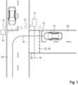
- Fig. 1 shows procedures for detecting potentially dangerous situations in an intersection area in road traffic.
- a vehicle 10 communicates with other vehicles 14 or part of an infrastructure 16 of the road traffic by means of Car2X communication 12.
- the infrastructure 16 is traffic lights and cameras for monitoring road traffic. It is envisaged that information about status data of the vehicle 10 and information about status data of the other vehicles 14 are transmitted during the Car2-X communication 12.
- the status data is linked with navigation data, in particular with coordinates, in such a way that a prediction of a future route 18 of the vehicle 10 and the other vehicles 14 is made possible.
- the status data contain information about the position and speed of the vehicle 10 or the other vehicles 14. By using the information about the position, in the form of coordinates, and the current speed, conclusions can be drawn about the route of the vehicle 10 or the other vehicles 14 in conjunction with navigation data containing information about the road layout, which makes it possible to predict the future route 18. Furthermore, the status data contain information about the classification of the vehicle 10 or the other vehicles 14. In the classification, a distinction is made between motor vehicles with at least four wheels and vehicles with at most two wheels. As a rule, vehicles with two wheels or less are motorbikes or bicycles. These vehicles are often classified as unprotected vehicles because they generally do not contain a driver's cab. Cyclists or motorcyclists are therefore at particularly high risk of injury in the event of an accident. Furthermore, another vehicle 14 also includes a pedestrian, who can be categorised accordingly.
- the navigation data contains information about lanes 20. By knowing the lanes 20, in particular in the relevant intersection area, the positions of the vehicle 10 or of other vehicles 14 can be further specified. Furthermore, the navigation data contains information about pedestrian crossings 22 and bicycle crossings 24. In this way, the most probable routes of unprotected road users can already be taken into account. Thus, the prescribed paths can already be associated with the conditions of unprotected road users.
- the condition data contain information about a lane 20 on which the vehicle 10 or the other vehicles 14 are located. Thus, both the vehicle 10 and the other vehicles 14 can be clearly assigned to a lane 20. This information increases the accuracy of the position determination of the vehicle 10 or the other vehicles 14. In addition, the prediction of the future route 18 can be improved if, for example, it is recognised that a vehicle 10 is in a turning lane.
- the vehicle 10 is braked if it is detected that the future travel path 18 of the vehicle 10 intersects with a future travel path 18 of at least one further vehicle 14.
- An intervention for example by driving assistance systems installed in the vehicle 10 or the further vehicles 14, may be necessary if it is recognised that the future travel paths 18 will already cross in the near future. If it can be assumed that the driver of the vehicle 10 can no longer react in time, appropriate measures can be initiated by which the vehicle 10 automatically reduces its speed in order to prevent a crossing of the future traffic lanes 18. In addition, there is a possibility of passing the information about potentially critical situation to the driver.
- an evasive manoeuvre of the vehicle 10 is initiated if it is detected that the future travel path 18 of the vehicle 10 intersects with a travel path of at least one other vehicle 14. If braking is not sufficient, an evasive manoeuvre, i.e. steering the vehicle to the left or right, can be used to increase the probability that the travel paths will no longer cross. It can also be provided that the vehicle automatically swerves to the left, while the other vehicle swerves to the right, so that the vehicles turn in front of each other without crossing each other's paths.
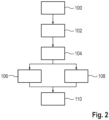
- FIG. 2 shows a schematic block diagram of various steps of a method for detecting potentially dangerous situations in an intersection in road traffic.
- Car2X data is transmitted by sensors with Car2X interface installed at the intersection or directly by other road users.
- the Car2X data contain at least information about the classification, position and speed of the detected or transmitting road user.
- a vehicle equipped with the system 10 has information about the intersection environment in the form of a map (MAPEM) that is also sent out as a Car2X message or a map stored in the vehicle.
- MAPEM map
- the map is lane-specific, so that individual lanes 20 for the vehicle 10 as well as pedestrian crossings 22 or cycle crossings 24 and connections between the lanes as well as intersections are known.
- the received data is stored in databases provided for this purpose.
- the received objects and the own vehicle 10 are now assigned to the respective lanes and crossings in step 102. This can be done discretely or probabilistically.
- information such as the status of the direction indicator or the set navigation route is added.
- the objects along the lanes are predicted on the basis of their current status data, such as speed and acceleration. Predicted paths sent out by Car2X objects themselves are also taken into account.
- step 106 it is calculated whether the paths of own vehicle 10 and other road users calculated along the lanes intersect.
- step 108 the object trajectories are calculated without adding the tracks, which is also used to check whether a collision is imminent in the event of a deviation from the expected movement pattern along the tracks of the intersection.
- a corresponding action can be derived depending on the criticality, for example the probability of reaching the intersection at the same time or the duration until the intersection is estimated to be reached. This can be done in step 110, for example, by early indication of the object, visual and acoustic warnings analogous to known assistance systems or by intervening in the driving dynamics, for example by braking and/or avoiding.
- the determined data can also be made available to other driver assistance systems.
Landscapes
- Physics & Mathematics (AREA)
- General Physics & Mathematics (AREA)
- Traffic Control Systems (AREA)
Abstract
The invention relates to a method for detecting potentially dangerous situations in an intersection area in road traffic, wherein a vehicle (10) communicates with further vehicles (14) by means of Car2X communication (12) and/or wherein the vehicle (10) communicates with at least part of a road traffic infrastructure (16) by means of Car2X communication (12).
In a method in which early detection of a potentially dangerous situation is made possible so that the risk of an accident with an unprotected road user is minimised, it is provided that in the Car2-X communication (12) information about status data of the vehicle (10) and information about status data of the other vehicles (14) is transmitted and that the status data is linked with navigation data, in particular with coordinates, in such a way that a prediction of a future route (18) of the vehicle (10) and the other vehicles (14) is made possible.
Description
- The invention relates to a method for detecting potentially dangerous situations in an intersection area in road traffic, wherein a vehicle communicates with other vehicles by means of Car2X communication and/or wherein the vehicle communicates with at least part of a road traffic infrastructure by means of Car2X communication.
- Despite progress in vehicle safety, the number of accidents between cars and vulnerable road users is stagnating. Especially for cyclists and motorcyclists, intersections and junctions represent an accident black spot. In order to avoid accidents with unprotected road users, state-of-the-art systems are known which warn of collisions between a vehicle and an unprotected road user in critical situations or intervene in the vehicle dynamics, for example by intervening in the brakes. These systems use various sensors installed on the vehicle, such as ultrasonic sensors, radars, lidars or cameras.
- The systems known from the state of the art, which exclusively use sensors installed on the vehicle, suffer from the restriction that a line of sight to the relevant road user must be available, regardless of whether camera, ultrasonic or other sensors are used.
- Radar or lidar sensors or cameras can be used. In situations where an unprotected road user has been obscured by an object, for example a building or greenery, before entering the path of the car, conventional systems can often no longer react in time and a collision with often serious consequences is unavoidable. Also, the systems known from the state of the art are often designed in such a way that a warning is given at the latest possible time in order to keep the number of false activations low.
- The invention is now based on the task of developing a method for detecting potentially dangerous situations in an intersection area in road traffic, in which early detection of a potentially dangerous situation is made possible so that the risk of an accident with an unprotected road user is minimised.
- In the present invention, this task is solved first of all by the features of the identification part of patent claim 1 in that, in the Car2-X communication, information about status data of the vehicle and information about status data of the other vehicles is transmitted and in that the status data is linked with navigation data, in particular with coordinates, in such a way that a prediction of a future route of the vehicle and the other vehicles is made possible.
- Car2X data is a technology in which vehicles communicate with their environment, i.e. "X". In a special Car2Car variant of the Car2X system, vehicles can also communicate with each other. With Car2X, transmission is possible in both directions. Consequently, the vehicle can communicate with the environment and/or the environment with the vehicle. Preferably, sensor data is transmitted during communication. It is conceivable that the Car2X communication is realised via a WLAN connection. In addition to WLANp (IEEE 802.11p), other technologies, e.g. C-V2X (LTE-V2X, 5G-V2X) or backend communication are also conceivable.
- Examples are the CAM (Cooperative Awareness Message), or DENM (Decentralised Environmental Notification Message), and/or Plus VAM (Vulnerable Road User Awareness Message) und CPM (Collective Perception Message) of the ETSI standard for Car2X communication. Vehicles can communicate with other vehicles via Car2X communication. By communicating with each other, vehicles can communicate their positions with each other. By linking with an environmental sensor system, for example, the position of the vehicle can be determined more clearly. In addition, the vehicle can communicate with the infrastructure via Car2X communication.
- The infrastructure can be traffic lights or, for example, cameras used to monitor road traffic.
- An intersection is a section of road traffic where at least two roadways cross. This can refer to roadways used by motor vehicles as well as roadways used by other road users, such as cyclists or pedestrians. A crossing area can therefore also be a straight road with a pedestrian crossing or a cycle path that crosses the road.
- The status data can be various data of the vehicle or the other vehicles. In particular, states are physical properties that the vehicle has at a certain moment. These include, for example, the speed, the direction of travel, the acceleration and comparable values, and/or preferably the relative position of the vehicle.
- The navigation data can preferably be provided by means of GNSS, or for example GPS, but also by means of positioning sensors.
- Prediction is a prediction of the future route. The future route can be predicted on the basis of various criteria. In particular, however, the navigation data, which provide information about the condition of the road network, are linked to the status data of the vehicle or the other vehicles, so that the reaching of certain points can be represented by means of time-dependent coordinates. The prediction of the route can be calculated probabilistically or discretely.
- Other vehicles are in particular other road users who are in the vicinity of the vehicle. These are vehicles moving in the statutory direction of travel in the lane occupied by the vehicle. However, it is also conceivable that other vehicles are part of oncoming traffic, for example. Furthermore, other vehicles also includes pedestrians and/or cyclists, who can be categorised accordingly.
- The travel distance is the distance travelled by the vehicle or other vehicles, especially on a road. The longitudinal movement on the road is taken into account, but also the transverse movement of the vehicle on the road. Consequently, the travel distance is not only the distance travelled on a road, for example, but also the lateral movement, i.e. the position of the vehicle in relation to the entire width of the road or the width of the road. In construction sites, for example, there are often narrowed lanes, so that driving is only possible in a certain area of the entire theoretically available width of the lane.
- In a first embodiment of the method according to the invention, it is provided that the status data contain information about the position and/or the speed. By using the information regarding the position, for example represented by coordinates, and the current speed, conclusions can be drawn about the route of the vehicle or the other vehicles in conjunction with navigation data containing information about the road layout. This information can then be used to predict what the future route will look like.
- In a further embodiment of the method according to the invention, it is provided that the condition data contain information about the classification of the vehicle or the other vehicles and that the classification distinguishes at least between motor vehicles with at least four wheels and vehicles with at most two wheels. As a rule, vehicles with two wheels or less are motorbikes or bicycles. These vehicles are often classified as unprotected vehicles because they generally do not contain a driver's cab. Cyclists or motorcyclists therefore have a particularly high risk of injury should an accident occur.
- It is also conceivable that the classification is realised in a more refined way. For example, motorbikes can be subdivided into further subclasses. Similarly, bicycles can be subdivided into motor-assisted bicycles and normal bicycles. In this way, for example, the driver of a vehicle can be shown to which category a nearby vehicle belongs. By knowing the category, it is possible to assess whether special care is required.
- In a preferred embodiment of the invention, it is provided that the navigation data are transmitted by means of Car2X communication or that the navigation data are made available by means of stored map data. It is also conceivable that both variants are used in parallel. In this case, the navigation data is made available by means of Car2X communication and by means of stored map data. In this way, redundancy of the data can provide increased reliability in data retrieval. On the other hand, the data can be checked against each other for plausibility. Thus, erroneous data can be adjusted.
- In a further embodiment of the method according to the invention, it can be provided that the navigation data contain information about lanes. By knowing the lanes, in particular in the relevant intersection area, the positions of the vehicle or of other vehicles can be further specified.
- In a particularly preferred embodiment of the method according to the invention, it is provided that the navigation data contain information about pedestrian crossings and/or bicycle crossings. In this way, the most probable routes of unprotected road users can already be taken into account. Thus, the prescribed routes can already be associated with the conditions of the unprotected road users.
- Furthermore, in another embodiment of the method according to the invention, it can be provided that the status data contain information about a lane on which the vehicle or the other vehicles are located. Thus, both the vehicle and the other vehicles can be clearly assigned to a lane. This information increases the accuracy of the position determination of the vehicle or the other vehicles. In addition, the prediction of the further route can be improved if, for example, it is recognised that a vehicle is in a turning lane. This is just as true for the assignment of VRUs to the pedestrian and bicycle crosswalks. Basically, here pedestrian and bicycle crossings are equivalent to the car lanes.
- In addition, in a further embodiment of the invention, it can be provided that the vehicle and/or the other vehicles comprise a direction indicator and that the status of the direction indicator is used to enable a prediction of a future travel path of the vehicle and the other vehicles. It may be envisaged that the status of the direction indicator is also communicated via Car2X. Analogous to the assignment of the lane travelled on, the status of the direction indicator can also provide information about the direction in which the vehicle or the other vehicles will move. This can improve the prediction of the future route.
- In addition or alternatively, in a further embodiment of the method according to the invention, it can be provided that the vehicle and/or the further vehicles comprise a navigation device and that a navigation route set in the navigation device is used to enable a prediction of a future travel path of the vehicle and the further vehicles. If a navigation route has been calculated, it is likely that the vehicle or the further vehicles will follow the directional indications of the navigation route. Taking the calculated navigation route into account can therefore improve the prediction of the future route of the vehicle or the other vehicles.
- In a particularly preferred embodiment of the method according to the invention, it is provided that it is determined whether the travel path of the vehicle intersects with a travel path of at least one other vehicle as well as other road users, i.e. when data comes from pedestrians by means of the infrastructure. In this way, it can be recognised in advance whether a potentially dangerous situation could arise.
- In a further embodiment of the method according to the invention, it may be provided that it is determined whether the travel path of the vehicle intersects with a travel path of at least one further vehicle if the travel path of the vehicle and/or a travel path of at least one further vehicle deviates from the prediction of a future travel path of the vehicle and the further vehicles. In this way, it can be determined whether a potentially dangerous situation arises if the vehicle and/or further vehicles deviate from the predicted travel path. The probability of a deviation from the predicted route can be taken into account. Navigation data can also be used for this. For example, if there are structural separations in the road network, it is unlikely that a vehicle will deviate from the predicted route in this area.
- In order to increase safety in road traffic, a further embodiment of the method according to the invention provides that the vehicle and/or at least one further vehicle is braked if it is detected that the travel path of the vehicle crosses a travel path of at least one further vehicle. An intervention, for example by driving assistance systems installed in the vehicle and/or the further vehicles, may be necessary if it is recognised that the travel paths will already cross in the near future. If it can be assumed that the driver of the vehicle can no longer react in time, appropriate measures can be initiated by which the vehicle automatically reduces its speed in order to prevent the paths from crossing. Furthermore, information can be provided to the driver in any form, for example, visually, acoustically and/or haptically.
- In addition or alternatively, in a further embodiment of the invention, it can be provided that an evasive manoeuvre of the vehicle is initiated if it is detected that the travel path of the vehicle crosses a travel path of at least one other vehicle. If braking is not sufficient, an evasive manoeuvre, i.e. steering the vehicle to the left or right, can be used to increase the probability that the travel paths will no longer cross. It can also be provided that the vehicle automatically swerves to the left, while the other vehicle swerves to the right, so that the vehicles turn in front of each other without crossing each other's paths. Similarly, the vehicle can also swerve to the right, while the other vehicle swerves to the left.
- Electronic or electrical devices and/or other relevant devices or components according to embodiments of the present invention described herein may be implemented using any suitable hardware, firmware (e.g., an application-specific integrated circuit), software, or a combination of software, firmware and hardware. For example, the various components of these devices may be located on an integrated circuit (IC) or on separate IC chips. Further, the various components of these devices may be implemented on a flexible printed circuit film, a tape carrier package (TCP), a printed circuit board (PCB), or on a single substrate. In addition, the various components of these devices may be a process or thread running on one or more processors in one or more computing devices, executing computer program instructions and interacting with other system components to perform the various functions described herein. The computer program instructions are stored in memory that may be implemented in a computing device using standard memory, such as random access memory (RAM). The computer program instructions may also be stored in other non-transferable computer-readable media, such as a CD-ROM, flash drive or the like. A person skilled in the art should also recognise that the functionality of different computing devices may be combined or integrated into a single computing device, or that the functionality of a particular computing device may be distributed to one or more other computing devices, without departing from the scope of the exemplary embodiments of the present invention.
- Further preferred embodiments of the invention result from the additional features mentioned in the dependent claims.
- The various embodiments of the invention mentioned herein can be advantageously combined with each other, unless otherwise specified in the individual case.
- Various objects and advantages of the present invention will become apparent to those skilled in the art from the following detailed description of embodiments, when read in light of the accompanying drawings. It shows:
- Fig. 1
- a schematic representation of the implementation of an example of a method for the detection of potentially dangerous situations in an intersection area in road traffic and
- Fig. 2
- a block representation of various steps of a procedure for the detection of potentially dangerous situations in an intersection area in road traffic.
-
Fig. 1 shows procedures for detecting potentially dangerous situations in an intersection area in road traffic. In this case, avehicle 10 communicates withother vehicles 14 or part of aninfrastructure 16 of the road traffic by means ofCar2X communication 12. In this example, theinfrastructure 16 is traffic lights and cameras for monitoring road traffic. It is envisaged that information about status data of thevehicle 10 and information about status data of theother vehicles 14 are transmitted during the Car2-X communication 12. The status data is linked with navigation data, in particular with coordinates, in such a way that a prediction of afuture route 18 of thevehicle 10 and theother vehicles 14 is made possible. - The status data contain information about the position and speed of the
vehicle 10 or theother vehicles 14. By using the information about the position, in the form of coordinates, and the current speed, conclusions can be drawn about the route of thevehicle 10 or theother vehicles 14 in conjunction with navigation data containing information about the road layout, which makes it possible to predict thefuture route 18. Furthermore, the status data contain information about the classification of thevehicle 10 or theother vehicles 14. In the classification, a distinction is made between motor vehicles with at least four wheels and vehicles with at most two wheels. As a rule, vehicles with two wheels or less are motorbikes or bicycles. These vehicles are often classified as unprotected vehicles because they generally do not contain a driver's cab. Cyclists or motorcyclists are therefore at particularly high risk of injury in the event of an accident. Furthermore, anothervehicle 14 also includes a pedestrian, who can be categorised accordingly. - The navigation data contains information about
lanes 20. By knowing thelanes 20, in particular in the relevant intersection area, the positions of thevehicle 10 or ofother vehicles 14 can be further specified. Furthermore, the navigation data contains information about pedestrian crossings 22 and bicycle crossings 24. In this way, the most probable routes of unprotected road users can already be taken into account. Thus, the prescribed paths can already be associated with the conditions of unprotected road users. In addition, the condition data contain information about alane 20 on which thevehicle 10 or theother vehicles 14 are located. Thus, both thevehicle 10 and theother vehicles 14 can be clearly assigned to alane 20. This information increases the accuracy of the position determination of thevehicle 10 or theother vehicles 14. In addition, the prediction of thefuture route 18 can be improved if, for example, it is recognised that avehicle 10 is in a turning lane. - It is determined whether the
future travel path 18 of thevehicle 10 intersects with afuture travel path 18 of anothervehicle 14. In this way, it can be detected in advance whether a potentially dangerous situation could arise. To increase safety, thevehicle 10 is braked if it is detected that thefuture travel path 18 of thevehicle 10 intersects with afuture travel path 18 of at least onefurther vehicle 14. An intervention, for example by driving assistance systems installed in thevehicle 10 or thefurther vehicles 14, may be necessary if it is recognised that thefuture travel paths 18 will already cross in the near future. If it can be assumed that the driver of thevehicle 10 can no longer react in time, appropriate measures can be initiated by which thevehicle 10 automatically reduces its speed in order to prevent a crossing of thefuture traffic lanes 18. In addition, there is a possibility of passing the information about potentially critical situation to the driver. - Furthermore, an evasive manoeuvre of the
vehicle 10 is initiated if it is detected that thefuture travel path 18 of thevehicle 10 intersects with a travel path of at least oneother vehicle 14. If braking is not sufficient, an evasive manoeuvre, i.e. steering the vehicle to the left or right, can be used to increase the probability that the travel paths will no longer cross. It can also be provided that the vehicle automatically swerves to the left, while the other vehicle swerves to the right, so that the vehicles turn in front of each other without crossing each other's paths. -
Figure 2 shows a schematic block diagram of various steps of a method for detecting potentially dangerous situations in an intersection in road traffic. In afirst step 100, Car2X data is transmitted by sensors with Car2X interface installed at the intersection or directly by other road users. The Car2X data contain at least information about the classification, position and speed of the detected or transmitting road user. In addition, a vehicle equipped with thesystem 10 has information about the intersection environment in the form of a map (MAPEM) that is also sent out as a Car2X message or a map stored in the vehicle. The map is lane-specific, so thatindividual lanes 20 for thevehicle 10 as well as pedestrian crossings 22 or cycle crossings 24 and connections between the lanes as well as intersections are known. - The received data is stored in databases provided for this purpose. The received objects and the
own vehicle 10 are now assigned to the respective lanes and crossings instep 102. This can be done discretely or probabilistically. For the own vehicle, information such as the status of the direction indicator or the set navigation route is added. In thenext step 104, the objects along the lanes are predicted on the basis of their current status data, such as speed and acceleration. Predicted paths sent out by Car2X objects themselves are also taken into account. Instep 106, it is calculated whether the paths ofown vehicle 10 and other road users calculated along the lanes intersect. - In parallel, in
step 108, the object trajectories are calculated without adding the tracks, which is also used to check whether a collision is imminent in the event of a deviation from the expected movement pattern along the tracks of the intersection. - If an intersection occurs, a corresponding action can be derived depending on the criticality, for example the probability of reaching the intersection at the same time or the duration until the intersection is estimated to be reached. This can be done in
step 110, for example, by early indication of the object, visual and acoustic warnings analogous to known assistance systems or by intervening in the driving dynamics, for example by braking and/or avoiding. The determined data can also be made available to other driver assistance systems. -
- 10
- vehicle
- 12
- Car2X communication
- 14
- more vehicles
- 16
- infrastructure
- 18
- future route
- 20
- lane
- 22
- pedestrian crossing
- 24
- cycle crossing
- 100-110
- various steps of a method
Claims (13)
- Method for detecting potentially dangerous situations in an intersection area in road traffic,wherein a vehicle (10) communicates with further vehicles (14) by means of Car2X communication (12) and/or wherein the vehicle (10) communicates with at least part of a road traffic infrastructure (16) by means of Car2X communication (12),characterised in thatinformation about status data of the vehicle (10) and information about status data of the further vehicles (14) is transmitted in the Car2-X communication (12), and in that the status data is linked with navigation data, in particular with coordinates, in such a way that a prediction of a future route (18) of the vehicle (10) and of the further vehicles (14) is made possible.
- Method according to claim 1, characterised in that the state data contains information about the position and/or the speed.
- Method according to claim 1 or 2, characterised in that the condition data contain information about the classification of the vehicle (10) or of the further vehicles (14) and in that the classification distinguishes at least between motor vehicles with at least four wheels and vehicles with at most two wheels.
- Method according to one of claims 1 to 3, characterised in that the navigation data is transmitted by means of Car2X communication (12) or that the navigation data is made available by means of stored map data.
- Method according to one of claims 1 to 4, characterised in that the navigation data contains information about lanes (20).
- Method according to one of the claims 1 to 5, characterised in that the navigation data contains information about pedestrian crossings (22) and/or about cycle crossings (24).
- Method according to one of claims 1 to 6, characterised in that the status data contains information about a lane (20) on which the vehicle (10) or the other vehicles (14) are located.
- A method according to any one of claims 1 to 7, characterised in that the vehicle (10) and/or the further vehicles (14) comprise a direction indicator and in that the status of the direction indicator is used to enable prediction of a future travel path (18) of the vehicle (10) and the further vehicles (14).
- A method according to any one of claims 1 to 8, characterized in that the vehicle (10) and/or the further vehicles (14) comprise a navigation device and that a navigation route set in the navigation device is used to enable a prediction of a future travel path (18) of the vehicle (10) and the further vehicles (14).
- A method according to any one of claims 1 to 9, characterised in that it is determined whether the future travel path (18) of the vehicle (10) intersects with a future travel path (18) of at least one further vehicle (14).
- A method according to any one of claims 1 to 10, characterised in that it is determined whether the future travel path (18) of the vehicle (10) intersects with a future travel path (18) of at least one further vehicle (10) when the future travel path (18) of the vehicle (10) and/or a future travel path (18) of at least one further vehicle (14) deviates from the prediction of a future travel path (18) of the vehicle (10) and the further vehicles (14).
- Method according to claim 10 or 11, characterized in that the vehicle (10) and/or at least one further vehicle (14) is braked if it is detected that the future travel path (18) of the vehicle (10) intersects with a future travel path (18) of at least one further vehicle (14).
- A method according to any one of claims 10 to 12, characterized in that an evasive manoeuvre of the vehicle (10) is initiated when it is detected that the future travel path (18) of the vehicle (10) intersects with a future travel path (18) of at least one further vehicle (18).
Priority Applications (2)
| Application Number | Priority Date | Filing Date | Title |
|---|---|---|---|
| EP23169876.2A EP4456040A1 (en) | 2023-04-25 | 2023-04-25 | Method for detecting potentially dannery situation in the area of interaction in road traffic |
| PCT/EP2024/059038 WO2024223243A1 (en) | 2023-04-25 | 2024-04-03 | Method for detecting potentially dangerous situations in an intersection area in road traffic |
Applications Claiming Priority (1)
| Application Number | Priority Date | Filing Date | Title |
|---|---|---|---|
| EP23169876.2A EP4456040A1 (en) | 2023-04-25 | 2023-04-25 | Method for detecting potentially dannery situation in the area of interaction in road traffic |
Publications (1)
| Publication Number | Publication Date |
|---|---|
| EP4456040A1 true EP4456040A1 (en) | 2024-10-30 |
Family
ID=86226829
Family Applications (1)
| Application Number | Title | Priority Date | Filing Date |
|---|---|---|---|
| EP23169876.2A Pending EP4456040A1 (en) | 2023-04-25 | 2023-04-25 | Method for detecting potentially dannery situation in the area of interaction in road traffic |
Country Status (2)
| Country | Link |
|---|---|
| EP (1) | EP4456040A1 (en) |
| WO (1) | WO2024223243A1 (en) |
Citations (5)
| Publication number | Priority date | Publication date | Assignee | Title |
|---|---|---|---|---|
| US20100305804A1 (en) * | 2009-06-01 | 2010-12-02 | Toyota Jidosha Kabushiki Kaisha | Vehicle travel control apparatus |
| US20170113665A1 (en) * | 2015-10-27 | 2017-04-27 | GM Global Technology Operations LLC | Algorithms for avoiding automotive crashes at left and right turn intersections |
| US20170132930A1 (en) * | 2015-11-11 | 2017-05-11 | Denso Corporation | Driving assistance apparatus |
| US20190113927A1 (en) * | 2017-10-18 | 2019-04-18 | Luminar Technologies, Inc. | Controlling an Autonomous Vehicle Using Cost Maps |
| US20220397415A1 (en) * | 2021-06-14 | 2022-12-15 | Ford Global Technologies, Llc | V2x message-based tracker application |
-
2023
- 2023-04-25 EP EP23169876.2A patent/EP4456040A1/en active Pending
-
2024
- 2024-04-03 WO PCT/EP2024/059038 patent/WO2024223243A1/en not_active Ceased
Patent Citations (5)
| Publication number | Priority date | Publication date | Assignee | Title |
|---|---|---|---|---|
| US20100305804A1 (en) * | 2009-06-01 | 2010-12-02 | Toyota Jidosha Kabushiki Kaisha | Vehicle travel control apparatus |
| US20170113665A1 (en) * | 2015-10-27 | 2017-04-27 | GM Global Technology Operations LLC | Algorithms for avoiding automotive crashes at left and right turn intersections |
| US20170132930A1 (en) * | 2015-11-11 | 2017-05-11 | Denso Corporation | Driving assistance apparatus |
| US20190113927A1 (en) * | 2017-10-18 | 2019-04-18 | Luminar Technologies, Inc. | Controlling an Autonomous Vehicle Using Cost Maps |
| US20220397415A1 (en) * | 2021-06-14 | 2022-12-15 | Ford Global Technologies, Llc | V2x message-based tracker application |
Also Published As
| Publication number | Publication date |
|---|---|
| WO2024223243A1 (en) | 2024-10-31 |
Similar Documents
| Publication | Publication Date | Title |
|---|---|---|
| CN102449672B (en) | Vehicular peripheral surveillance device | |
| EP3086990B1 (en) | Method and system for driver assistance for a vehicle | |
| EP3091370B1 (en) | Method and arrangement for determining safe vehicle trajectories | |
| CN110662683B (en) | Driving assistance device and driving assistance method | |
| CN109841088B (en) | Vehicle driving assistance system and method | |
| US10395527B2 (en) | Method and control and detection device for a plausibility check of a wrong-way driving incident of a motor vehicle | |
| US20160140847A1 (en) | Alerting apparatus | |
| KR20190133623A (en) | Method for supporting a guidance of at least one motor vehicle, assistance system and motor vehicle | |
| US20140350837A1 (en) | Method for an automatic intervention into an ego vehicle when traveling erroneously, in particular when traveling the wrong way | |
| US10691125B2 (en) | Blinker judgment device and autonomous driving system | |
| US9638615B2 (en) | Method and control device and detection device for recognizing an entry of a motor vehicle into a traffic lane opposite a driving direction | |
| CN107672584A (en) | The system and method for overtaking lane control | |
| KR20150061752A (en) | Device for driving assist and method for activating the function automatically by the device | |
| CN106608263A (en) | Algorithms for avoiding automotive crashes at left and right turn intersections | |
| US12280791B2 (en) | Driving assistance device, driving assistance method, and storage medium | |
| JP2002178864A (en) | Electric vehicle control device | |
| CN113561977A (en) | Vehicle adaptive cruise control method, device, equipment and storage medium | |
| JP6632581B2 (en) | Travel control device, travel control method, and program | |
| JP6765357B2 (en) | Driving control device, driving control method and program | |
| EP3764337A1 (en) | Vehicle travel assist method and vehicle travel assist device | |
| CN110562222A (en) | Emergency braking control method for curve scene, vehicle-mounted device and storage medium | |
| CN114734995A (en) | Collision avoidance system and collision avoidance method | |
| EP4325462A1 (en) | Method for detecting a wide turn maneuver of a vehicle, method for operating an ego-vehicle, data processing apparatus, computer program, and computer-readable storage medium | |
| WO2024223243A1 (en) | Method for detecting potentially dangerous situations in an intersection area in road traffic | |
| US12115999B2 (en) | Method for predicting behavior of other vehicle, device for predicting behavior of other vehicle, and driving assistance method |
Legal Events
| Date | Code | Title | Description |
|---|---|---|---|
| PUAI | Public reference made under article 153(3) epc to a published international application that has entered the european phase |
Free format text: ORIGINAL CODE: 0009012 |
|
| STAA | Information on the status of an ep patent application or granted ep patent |
Free format text: STATUS: THE APPLICATION HAS BEEN PUBLISHED |
|
| AK | Designated contracting states |
Kind code of ref document: A1 Designated state(s): AL AT BE BG CH CY CZ DE DK EE ES FI FR GB GR HR HU IE IS IT LI LT LU LV MC ME MK MT NL NO PL PT RO RS SE SI SK SM TR |
|
| STAA | Information on the status of an ep patent application or granted ep patent |
Free format text: STATUS: REQUEST FOR EXAMINATION WAS MADE |
|
| 17P | Request for examination filed |
Effective date: 20250430 |
|
| STAA | Information on the status of an ep patent application or granted ep patent |
Free format text: STATUS: EXAMINATION IS IN PROGRESS |