EP4450923A1 - Target monitoring device, target monitoring method, and program - Google Patents
Target monitoring device, target monitoring method, and program Download PDFInfo
- Publication number
- EP4450923A1 EP4450923A1 EP22906884.6A EP22906884A EP4450923A1 EP 4450923 A1 EP4450923 A1 EP 4450923A1 EP 22906884 A EP22906884 A EP 22906884A EP 4450923 A1 EP4450923 A1 EP 4450923A1
- Authority
- EP
- European Patent Office
- Prior art keywords
- target
- image
- camera
- height
- type
- Prior art date
- Legal status (The legal status is an assumption and is not a legal conclusion. Google has not performed a legal analysis and makes no representation as to the accuracy of the status listed.)
- Pending
Links
Images



Classifications
-
- G—PHYSICS
- G01—MEASURING; TESTING
- G01C—MEASURING DISTANCES, LEVELS OR BEARINGS; SURVEYING; NAVIGATION; GYROSCOPIC INSTRUMENTS; PHOTOGRAMMETRY OR VIDEOGRAMMETRY
- G01C3/00—Measuring distances in line of sight; Optical rangefinders
- G01C3/02—Details
- G01C3/06—Use of electric means to obtain final indication
- G01C3/08—Use of electric radiation detectors
-
- G—PHYSICS
- G01—MEASURING; TESTING
- G01C—MEASURING DISTANCES, LEVELS OR BEARINGS; SURVEYING; NAVIGATION; GYROSCOPIC INSTRUMENTS; PHOTOGRAMMETRY OR VIDEOGRAMMETRY
- G01C3/00—Measuring distances in line of sight; Optical rangefinders
- G01C3/10—Measuring distances in line of sight; Optical rangefinders using a parallactic triangle with variable angles and a base of fixed length in the observation station, e.g. in the instrument
- G01C3/12—Measuring distances in line of sight; Optical rangefinders using a parallactic triangle with variable angles and a base of fixed length in the observation station, e.g. in the instrument with monocular observation at a single point, e.g. coincidence type
-
- G—PHYSICS
- G06—COMPUTING OR CALCULATING; COUNTING
- G06T—IMAGE DATA PROCESSING OR GENERATION, IN GENERAL
- G06T7/00—Image analysis
- G06T7/70—Determining position or orientation of objects or cameras
-
- H—ELECTRICITY
- H04—ELECTRIC COMMUNICATION TECHNIQUE
- H04N—PICTORIAL COMMUNICATION, e.g. TELEVISION
- H04N7/00—Television systems
- H04N7/18—Closed-circuit television [CCTV] systems, i.e. systems in which the video signal is not broadcast
- H04N7/183—Closed-circuit television [CCTV] systems, i.e. systems in which the video signal is not broadcast for receiving images from a single remote source
-
- G—PHYSICS
- G06—COMPUTING OR CALCULATING; COUNTING
- G06T—IMAGE DATA PROCESSING OR GENERATION, IN GENERAL
- G06T2207/00—Indexing scheme for image analysis or image enhancement
- G06T2207/30—Subject of image; Context of image processing
- G06T2207/30232—Surveillance
-
- G—PHYSICS
- G06—COMPUTING OR CALCULATING; COUNTING
- G06T—IMAGE DATA PROCESSING OR GENERATION, IN GENERAL
- G06T2207/00—Indexing scheme for image analysis or image enhancement
- G06T2207/30—Subject of image; Context of image processing
- G06T2207/30248—Vehicle exterior or interior
- G06T2207/30252—Vehicle exterior; Vicinity of vehicle
Definitions
- the disclosure relates to a target monitoring device, a target monitoring method, and a program.
- Patent Document 1 WO 2020049634
- the disclosure has been made in view of the above, and a main objective is to provide a target monitoring device, a target monitoring method, and a program capable of increasing the accuracy of estimating a distance from an imaging position of a camera to a target.
- a target monitoring device provides: an image acquiring unit, acquiring an image including a target in the sea and imaged by a camera; an image recognizing unit, detecting a region of the target included in the image; a type acquiring unit, acquiring a type of the target; a height acquiring unit, acquiring a representative height associated in advance with the type of the target; and a distance estimating unit, estimating a distance from an imaging position to the target based on a dimension of the image in a height direction, a dimension of the region of the target in the height direction, and the representative height. Accordingly, it is possible to improve the accuracy of estimating the distance from the imaging position of the camera to the target.
- the distance estimating unit calculates an occupancy angle of the target within a view angle of the camera in the height direction based on the dimension of the image in the height direction, the dimension of the region of the target in the height direction, and the view angle of the camera in the height direction, and estimates the distance from the imaging position to the target based on the occupancy angle of the target, the representative height, and a height of the camera. Accordingly, it is possible to improve the accuracy of estimating the distance from the imaging position of the camera to the target.
- the distance estimating unit calculates the occupancy angle of the target in the view angle based on the dimension of the image in the height direction, the dimension of the region of the target in the height direction, the view angle of the camera in the height direction, a focal point distance of the camera, and an optical center of the camera. Accordingly, it is possible to improve the accuracy of estimating the distance from the imaging position of the camera to the target.
- the image recognizing unit detects a boundary box surrounding the target included in the image as the region of the target. Accordingly, the dimension of the region of the target in the height direction is easily acquired.
- the image recognizing unit the image recognizing unit detects the region and a type of the target included in the image, and the type acquiring unit acquires the type of the target detected by the image recognizing unit. Accordingly, it is possible to estimate the distance to the target by using the type detected by the image recognizing unit.
- the type acquiring unit acquires a type of the target detected through an automatic identification system (AIS). Accordingly, it is possible to estimate the distance to the target by using the type detected by AIS.
- AIS automatic identification system
- the camera is mounted in a ship, and the target in the sea is an other ship. Accordingly, it is possible to improve the accuracy of estimating the distance from the position of a ship to an other ship.
- a target monitoring method includes: acquiring an image including a target in the sea and imaged by a camera; detecting a region of the target included in the image; acquiring a type of the target; acquiring a representative height associated in advance with the type; and estimating a distance from an imaging position to the target based on a dimension of the image in a height direction, a dimension of the region of the target in the height direction, and the representative height. Accordingly, it is possible to improve the accuracy of estimating the distance from the imaging position of the camera to the target.
- a program executed by a computer to: A program, executed by a computer to: acquire an image comprising a target in the sea and imaged by a camera; detect a region of the target comprised in the image; acquire a type of the target; acquire a representative height associated in advance with the type; and estimate a distance from an imaging position to the target based on a dimension of the image in a height direction, a dimension of the region of the target in the height direction, and the representative height. Accordingly, it is possible to improve the accuracy of estimating the distance from the imaging position of the camera to the target.
- FIG. 1 is a block diagram illustrating a configuration example of a target monitoring system 100.
- the target monitoring system 100 is a system mounted in a ship.
- the ship in which the target monitoring system 100 is mounted is referred to as "own ship", and another ship is referred to as "other ship”.
- the target monitoring system 100 includes a target monitoring device 1, a display unit 2, a radar 3, an AIS 4, a camera 5, a GNSS receiver 6, a gyro compass 7, an ECDIS 8, a wireless communicating unit 9, and a ship steering control unit 10.
- a target monitoring device 1 a display unit 2, a radar 3, an AIS 4, a camera 5, a GNSS receiver 6, a gyro compass 7, an ECDIS 8, a wireless communicating unit 9, and a ship steering control unit 10.
- a network N such as LAN, and are able to communicate with each other through network communication.
- the target monitoring device 1 a computer that includes a CPU, a RAM, a ROM, a nonvolatile memory, and an input/output interface, etc.
- the CPU of the target monitoring device 1 executes an information process in accordance with a program loaded from the ROM or the nonvolatile memory to the RAM.
- the program may also be supplied via an information storage medium, such as an optical disc or a memory card, and may also be supplied via a communication network such as the Internet or an LAN.
- an information storage medium such as an optical disc or a memory card
- a communication network such as the Internet or an LAN.
- the display unit 2 displays a display image generated by the target monitoring device 1.
- the display unit 2 also displays a radar image, a camera image, or an electronic chart, etc.
- the display unit 2 for example, is a display device having a touch sensor, i.e., a so-called touch panel.
- the touch sensor detects an indicated position in an image indicated by the user's finger, etc.
- the indicated position may also be input by using a trackball, etc.
- the radar 3 emits radio waves around the own ship, receives the reflected waves thereof, and generates echo data based on the received signals. In addition, the radar 3 recognizes a target from the echo data, and generates target tracking (TT) data indicating the position and the velocity of the target.
- TT target tracking
- the automatic identification system (AIS) 4 receives AIS data from other ships present around the own ship or from land control.
- a VHF data exchange system (VDES) may also be used, instead of being limited to AIS.
- the AIS data include recognition symbols, ship names, positions, courses, velocities, ship types, ship body lengths, and destinations, etc., of other ships.
- the camera 5 is a digital camera that images the outside from the own ship to generate image data.
- the camera 5 is disposed at a bridge of the own ship and toward a bow orientation, for example.
- the camera 5 may be a camera having pan/tilt/zoom functions, i.e., a so-called PTZ camera.
- the camera 5 may also include an image recognizing unit that estimates a position and a type of a target, such as other ships, included in the imaged image by using an object detecting model.
- the image recognizing unit may also be realized in other devices, such as the target monitoring device 1.
- the GNSS receiver 6 detects the position of the own ship based on radio waves received from the global navigation satellite system (GNSS).
- the gyro compass 7 detects a bow orientation of the own ship.
- a GPS compass may also be used, instead of being limited to the gyro compass.
- the electronic chart display and information system (ECDIS) 8 acquires the position of the own ship from the GNSS receiver 6 and displays the position of the own ship on an electronic chart. In addition, the ECDIS 8 also displays a planned route of the own ship on the electronic chart.
- a GNSS plotter may also be used, instead of being limited to ECDIS.
- the wireless communication unit 9 includes various wireless components for ultra short wave band, very short wave band, medium and short wave band, short wave band, etc., for realizing the communication with other ships or land control.
- the ship steering control unit 10 is a control device for realizing automatic ship steering, and controls a steering device of the own ship. In addition, the ship steering control unit 10 may also control the engine of the own ship.
- the target monitoring device 1 is an independent device.
- the disclosure is not limited thereto, and may also be integrated with another device, such as the ECDIS 8. That is, the functional units of the target monitoring device 1 may also be realized by other devices.
- the target monitoring device 1 is mounted in the own ship and used to monitor a target, such as an other ship, present around the own ship.
- a target such as an other ship
- the disclosure is not limited thereto.
- the target monitoring device 1 may also be disposed in the land control and configured to monitor a ship present in a controlled sea area.
- FIG. 2 is a diagram illustrating a configuration example of the target monitoring device 1.
- the control unit 20 of the target monitoring device 1 includes a data acquiring unit 11, a data acquiring unit 12, an image acquiring unit 13, an image processing unit 14, a data integrating unit 15, a display control unit 16, and a ship steering determining unit 17. These functional units are realized by executing information processing according to a program by using the control unit 20.
- the control unit 20 of the target monitoring device 1 further includes a radar management database (DB) 21, an AIS management DB22, a camera management DB 23, and an integral management DB 24.
- the storage units thereof are provided in the memory of the control unit 20.
- the data acquiring unit 11 sequentially acquires, as target data, TT data generated by the radar 3, and registers the target data in the radar management DB 21.
- the target data registered in the radar management DB 21 include the position, the ship velocity, and the course, etc., of the target, such as an other ship, detected by the radar 3.
- the target data registered in the radar management DB 21 may further include the track of the target, the elapsed time since detection, the size of the echo image, and the signal strength of the reflected waves, etc.
- the data acquiring unit 12 acquires, as target data, the AIS data received by the AIS 4 and registers the AIS data in the AIS management DB 22.
- the target data registered in the AIS management DB 22 includes the position, the ship velocity, and the course, etc., of an other ship, detected by the AIS 4.
- the target data registered in the AIS management DB 22 may also include the type, the ship name, the ship body length, the ship body width, and the destination, etc., of the other ship.
- the image acquiring unit 13 acquires an image including the target, such as an other ship, imaged by the camera 5.
- the image acquiring unit 13 sequentially acquires time-series images from the camera 5, and sequentially provides the time-series images to the image processing unit 14.
- the time-series images are, for example, still images (frames) included in motion image data.
- the image processing unit 14 performs a particular image process, such as image recognition, on the image acquired by the image acquiring unit 13, generates target data of the target recognized from the image, and registers the target in the camera management database 23. Details of the image processing unit 14 will be described afterwards.
- the target data registered in the camera management DB 23 includes the position, the ship velocity, and the course, etc., of the target, such as an other ship, calculated by the image processing uni4 14.
- the target data registered in the camera management DB may also include the size of the target, the type of the target, and the elapsed time from detection, etc.
- the position of the target detected by the radar 3 and the position of the target recognized from the image imaged by the camera 5 are relative positions with respect to the own ship. Therefore, the positions can be converted into absolute positions by using the position of the own ship detected by the GNSS receiver 6.
- the target detected by the radar 3 and the target recognized from the image imaged by the camera 5 are mainly ships, but may also include others such as a buoy.
- the data integrating unit 15 registers the target data registered in the radar management DB 21, the AIS management DB 22, and the camera management DB 23 in the integral management DB 24 for cross-management of these databases.
- the target data registered by the data integrating unit 15 include the position, the ship velocity, and the course, etc., of the target, such as an other ship.
- the data integrating unit 15 registers these target data in the integral management DB 24.
- the display control unit 16 generates a display image including an object indicating the target based on the target data registered in the integral management DB 24 and outputs the display image to the display unit 2.
- the display image is, for example, a radar image, an electronic chart, or an image formed by synthesizing a radar image and an electronic chart.
- the object indicating the target is disposed at a position in the image corresponding to the actual position of the target.
- the ship steering determining unit 17 performs ship steering determination based on the target data registered in the integral management DB 24, and, in a case of determining that it is necessary to avoid a target, causes the ship steering control unit 10 to perform an avoidance steering operation. Specifically, the ship steering control unit 10 calculates an avoidance route for avoiding the target by using an avoidance steering algorithm, and controls the steering device and an engine, etc., so that the own ship follows the avoidance route.
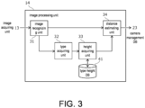
- FIG. 3 is a diagram illustrating a configuration example of the image processing unit 14.
- the image processing unit 14 includes an image recognizing unit 31, a type acquiring unit 32, a height acquiring unit 33, a distance estimating unit 34, and a type-height DB 41.
- the same figure illustrates a configuration relating to a function of estimating a distance to the target among the functions realized by the image estimating unit 14.
- the image recognizing unit 31 detects a target region included in the image acquired by the image acquiring unit 13. In addition, the image recognizing unit 31 detects the type of the target as well as the region of the target included in the image.
- the type of the target may be a ship type, such as a tanker or a fishing boat.
- the image recognizing unit 31 calculates the region of the target included in the image, the type of the target, and the estimation reliability by using a learned model generated in advance through machine learning.
- the disclosure is not limited thereto.
- the image recognizing unit 31 may also recognize the region included in the image and the type of the target by using a rule base.
- the learned model is an object detection model, such as a single shot multibox detector (SSD) or a you only look once (YOLO), and detects a boundary box surrounding the target included in the image as the region of the target.
- SSD single shot multibox detector
- YOLO you only look once
- the learned model may also be a region split model, such as semantic segmentation or instance segmentation.
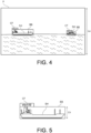
- FIG. 4 is a diagram illustrating a recognition example of an image P.
- FIG. 5 is a diagram in which a boundary box BB is enlarged. As shown in these figures, an other ship SH included in the image P is surrounded by a boundary box BB in a rectangular shape. A label CF in which the type of the target and the estimation reliability are recorded is added to the boundary box BB.
- La in FIG. 4 indicates the dimension of the image P in the height direction.
- Lh in FIG. 5 indicates the dimension of the region of the target in the height direction, that is, the dimension of the boundary box BB in the height direction.
- the height direction of the image is a direction corresponding to the height direction in the actual space, and is the upper-lower direction in the illustrated example.
- the dimension is represented by using the number of pixels, for example.
- the height of the target (particularly a ship) within the image is substantially constant irrelevant of the orientation. Therefore, if the height of the target is known, the distance to the target can be acquired. Although the height of the target is unknown, such height can be acquired once the type of the target is known. Therefore, in the embodiment, the distance to the target is estimated based on the height corresponding to the type of the target, as described below.
- the type acquiring unit 32 acquires the type of the target detected by the image recognizing unit 31. However, the disclosure is not limited thereto.
- the type acquiring unit 32 may also acquire the type of an other ship detected by the AIS 4, acquire the type of the target input by the user, and acquire the ship body length of an other ship detected by the AIS 4 to estimate the ship type of the other ship according to the ship body length of the other ship that is acquired.
- the height acquiring unit 33 acquires a representative height associated in advance with the type of the target acquired by the type acquiring unit 32. Specifically, the height acquiring unit 33 refers to the type-height DB 41 to acquire the representative height corresponding to the type of the target.
- the height acquiring unit 33 may also acquire the ship body length of an other ship detected by the AIS 4, refer to a database in which the ship body length and the representative height are associated with each other, and acquire the representative height associated in advance with the ship body length of the other ship that is acquired.
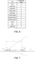
- FIG. 6 is a diagram illustrating an example of the type-height DB 41.
- the type of the target and the representative height are associated with each other.
- the type-height DB 41 is provided in the memory of the control unit 20.
- the types of the target include, for example, ship types, such as a tanker, a vehicle carrier, a fishing vessel, a pleasure vessel, a sailing vessel, a merchant vessel, a passenger vessel, or a warship.
- the type of the target may further include an installation object in the sea, etc., such as a buoy.
- the representative height is a height of a target representing such type, such as a height average of the targets in a type.
- the representative height is a value.
- the representative height may also be a range in which upper and lower limits are defined.
- the distance estimating unit 34 estimates the distance to the target based on the dimension of the image in the height direction as acquired by the image acquiring unit 13, the dimension of the region of the target in the height direction as detected by the image recognizing unit 31, and the representative height acquired by the height acquiring unit 33. Before the distance to the target is estimated, a pre-process, such as distortion calibration on the image, may also be applied.
- the distance estimating unit 34 calculates an occupancy angle ⁇ of the target SH within a view angle ⁇ based on the dimension La of the image in the height direction, the dimension Lh of the region of the target SH in the height direction, and the view angle ⁇ of the camera 5 in the height direction.
- the view angle ⁇ is an angle representing a range included in the image when imaged by using the camera 5, and is an angle determined by the lens of the camera 5.
- the occupancy angle ⁇ of the target SH is an angle representing the range occupied by the target SH, and is an angle between the upper end and the lower end of the target SH with the camera 5 as the center.
- the occupancy angle ⁇ of the target SH can be calculated accordingly.
- the distance estimating unit 34 may also calculate the occupancy angle ⁇ of the target SH in the view angle ⁇ further based on the focal point distance and the optical center of the camera 5, in addition to the dimension La of the image in the height direction, the dimension Lh of the region of the target SH in the height direction, and the view angle ⁇ of the camera 5 in the height direction. That is, considering camera-internal parameters of a perspective projection model, the occupancy angle ⁇ of the target SH may also be calculated by using the focal point distance and the optical center of the camera 5 representing the camera-internal parameters.
- the distance estimating unit 34 estimates a distance d from the own ship SP to the target SH, that is, the distance d from the imaging position of the camera 5 to the target SH based on the occupancy angle ⁇ of the target SH, the representative height, and a height h of the camera 5.
- the distance d to the target SH is calculated as below. Although an example assuming that H-h > 0 is described, the same method may be generally applied to derive results in the case where H-h ⁇ 0.
- Equation 1 H + H 2 + 4 tan 2 ⁇ ⁇ h ⁇ H ⁇ h 2 tan ⁇
- ⁇ represents an angle higher than the height h of the camera 5 in the occupancy angle ⁇ of the target SH, and ⁇ represents an angle lower than the height h of the camera 5 in the occupancy angle ⁇ of the target SH.
- Equation 2 The tangents of ⁇ and ⁇ are represented in Equation 2 below.
- tan ⁇ H ⁇ h d
- tan ⁇ h d
- Equation 4 for d is obtained.
- Equation 1 By solving Equation 4 for d using a solution formula, Equation 1 can be obtained.
- Equation 4 is a quadratic equation, two solutions can be obtained. However, for the solution not appearing in the target equation (the solution with a negative sign of the square root), when H-h>0, d will be negative, and when H-h ⁇ 0, d will be an extremely small value, so the solution is not applicable to the case.
- the distance estimating unit 34 estimates the distance from the own ship to the target according to the above.
- the distance from the own ship to the target as estimated by the distance estimating unit 34 is included in the target data together with the position, the orientation, etc., of the target, and registered in the camera management DB 23.
- the distance estimating unit 34 estimates the distance from the own ship to the target by using the range having an upper limit and a lower limit.
- FIG. 9 is a diagram illustrating a procedural example of a target monitoring method realized in the target monitoring system 100.
- the same figure mainly illustrates a process of estimating the distance to the target.
- the target monitoring device 1 executes the process shown in the same figure according to the program.
- the target monitoring device 1 When acquiring the image imaged by the camera 5, the target monitoring device 1 performs an image recognizing process, and calculates the region of the target included in the image, the type of the target, and the reliability that is estimated (S11, the process as the image recognizing unit 31).
- the target monitoring device 1 acquires the dimension of the region of the target calculated through the image recognizing process in the height direction (S12).
- the dimension of the region of the target in the height direction is the dimension of the boundary box BB in the height direction (see FIG. 5 ).
- the target monitoring device 1 acquires the type of the target calculated through the image recognizing process (S 13, the process as the type acquiring unit 32).
- the target monitoring device 1 estimates the distance from the own ship to the target based on the dimension of the image in the height direction, the dimension of the region of the target in the height direction, and the representative height (S15, the process as the distance estimating unit 34).
- the target monitoring device 1 generates the target data including the distance from the own ship to the target and registers the target data in the camera management DB 23. Accordingly, a series of processes on the image have ended.
- the target data further include the orientation and the position of the target, etc.
- the orientation of the target is calculated based on the position of the target in the image and the orientation in which the camera 5 is disposed.
- the position of the target is calculated based on the distance from the own ship to the target and the orientation of the target.
- the distance to the target estimated from the image according to the processes in the embodiment may be averaged with distances to the target estimated from the image by other processes to further increase the accuracy in estimating the distance to the target.
- 1 Target monitoring device; 2: Display unit; 3: Radar; 4: AIS; 5: Camera; 6: GNSS receiver; 7: Gyro compass; 8: ECDIS; 9: Wireless communicating unit; 10: Ship steering control unit; 20: Control unit; 11, 12: Data acquiring unit; 13: Image acquiring unit; 14: Image processing unit; 15: Data integrating unit; 16: Display control unit; 17: Ship steering determining unit; 21: Radar management DB; 22: AIS management DB; 23: Camera management DB; 24: Integral management DB; 31: Image recognizing unit; 32: Type acquiring unit; 33: Height acquiring unit; 34: Distance estimating unit; 41: Type-height DB; 100: Target monitoring system.
Landscapes
- Engineering & Computer Science (AREA)
- Physics & Mathematics (AREA)
- General Physics & Mathematics (AREA)
- Electromagnetism (AREA)
- Radar, Positioning & Navigation (AREA)
- Remote Sensing (AREA)
- Computer Vision & Pattern Recognition (AREA)
- Theoretical Computer Science (AREA)
- Multimedia (AREA)
- Signal Processing (AREA)
- Traffic Control Systems (AREA)
- Radar Systems Or Details Thereof (AREA)
Abstract
Description
- The disclosure relates to a target monitoring device, a target monitoring method, and a program.
- Conventionally, a technique for detecting a target, such as a ship, in an image imaged by a camera through image recognition is known.
- Patent Document 1:
WO 2020049634 - However, even though a target in an image can be detected through image recognition, it is still difficult to accurately acquire a distance to the detected target.
- The disclosure has been made in view of the above, and a main objective is to provide a target monitoring device, a target monitoring method, and a program capable of increasing the accuracy of estimating a distance from an imaging position of a camera to a target.
- In order to solve the issue, a target monitoring device according to an aspect of the disclosure provides: an image acquiring unit, acquiring an image including a target in the sea and imaged by a camera; an image recognizing unit, detecting a region of the target included in the image; a type acquiring unit, acquiring a type of the target; a height acquiring unit, acquiring a representative height associated in advance with the type of the target; and a distance estimating unit, estimating a distance from an imaging position to the target based on a dimension of the image in a height direction, a dimension of the region of the target in the height direction, and the representative height. Accordingly, it is possible to improve the accuracy of estimating the distance from the imaging position of the camera to the target.
- In the above aspect, it may also be that the distance estimating unit: calculates an occupancy angle of the target within a view angle of the camera in the height direction based on the dimension of the image in the height direction, the dimension of the region of the target in the height direction, and the view angle of the camera in the height direction, and estimates the distance from the imaging position to the target based on the occupancy angle of the target, the representative height, and a height of the camera. Accordingly, it is possible to improve the accuracy of estimating the distance from the imaging position of the camera to the target.
- In the above aspect, it may also be that the distance estimating unit: calculates the occupancy angle of the target in the view angle based on the dimension of the image in the height direction, the dimension of the region of the target in the height direction, the view angle of the camera in the height direction, a focal point distance of the camera, and an optical center of the camera. Accordingly, it is possible to improve the accuracy of estimating the distance from the imaging position of the camera to the target.
- In the above aspect, it may also be that the image recognizing unit detects a boundary box surrounding the target included in the image as the region of the target. Accordingly, the dimension of the region of the target in the height direction is easily acquired.
- In the above aspect, it may also be that the image recognizing unit the image recognizing unit detects the region and a type of the target included in the image, and the type acquiring unit acquires the type of the target detected by the image recognizing unit. Accordingly, it is possible to estimate the distance to the target by using the type detected by the image recognizing unit.
- In the above aspect, it may also be that the type acquiring unit acquires a type of the target detected through an automatic identification system (AIS). Accordingly, it is possible to estimate the distance to the target by using the type detected by AIS.
- In the above aspect, it may also be that the camera is mounted in a ship, and the target in the sea is an other ship. Accordingly, it is possible to improve the accuracy of estimating the distance from the position of a ship to an other ship.
- In addition, a target monitoring method according to another aspect of the disclosure includes: acquiring an image including a target in the sea and imaged by a camera; detecting a region of the target included in the image; acquiring a type of the target; acquiring a representative height associated in advance with the type; and estimating a distance from an imaging position to the target based on a dimension of the image in a height direction, a dimension of the region of the target in the height direction, and the representative height. Accordingly, it is possible to improve the accuracy of estimating the distance from the imaging position of the camera to the target.
- In addition, a program according to another aspect of the disclosure executed by a computer to: A program, executed by a computer to:
acquire an image comprising a target in the sea and imaged by a camera; detect a region of the target comprised in the image; acquire a type of the target; acquire a representative height associated in advance with the type; and estimate a distance from an imaging position to the target based on a dimension of the image in a height direction, a dimension of the region of the target in the height direction, and the representative height. Accordingly, it is possible to improve the accuracy of estimating the distance from the imaging position of the camera to the target. -
- [
FIG. 1] FIG. 1 is a diagram illustrating a configuration example of a target monitoring system. - [
FIG. 2] FIG. 2 is a diagram illustrating a configuration example of a target monitoring device. - [
FIG. 3] FIG. 3 is a diagram illustrating a configuration example of an image processing unit. - [
FIG. 4] FIG. 4 is a diagram illustrating a recognition example of an image. - [
FIG. 5] FIG. 5 is a diagram illustrating an example of a boundary box. - [
FIG. 6] FIG. 6 is a diagram illustrating an example of a type-height database. - [
FIG. 7] FIG. 7 is a diagram illustrating an example of calculating a distance until a target. - [
FIG. 8] FIG. 8 is a diagram illustrating an example of calculating a distance until a target. - [
FIG. 9] FIG. 9 is a diagram illustrating a procedural example of a target monitoring method. - In the following, the embodiments of the disclosure are described with reference to the drawings.
-
FIG. 1 is a block diagram illustrating a configuration example of atarget monitoring system 100. Thetarget monitoring system 100 is a system mounted in a ship. In the following description, the ship in which thetarget monitoring system 100 is mounted is referred to as "own ship", and another ship is referred to as "other ship". - The
target monitoring system 100 includes atarget monitoring device 1, adisplay unit 2, aradar 3, an AIS 4, acamera 5, aGNSS receiver 6, agyro compass 7, an ECDIS 8, a wireless communicating unit 9, and a shipsteering control unit 10. Such components are connected with a network N, such as LAN, and are able to communicate with each other through network communication. - The target monitoring device 1 a computer that includes a CPU, a RAM, a ROM, a nonvolatile memory, and an input/output interface, etc. The CPU of the
target monitoring device 1 executes an information process in accordance with a program loaded from the ROM or the nonvolatile memory to the RAM. - The program may also be supplied via an information storage medium, such as an optical disc or a memory card, and may also be supplied via a communication network such as the Internet or an LAN.
- The
display unit 2 displays a display image generated by thetarget monitoring device 1. Thedisplay unit 2 also displays a radar image, a camera image, or an electronic chart, etc. - The
display unit 2, for example, is a display device having a touch sensor, i.e., a so-called touch panel. The touch sensor detects an indicated position in an image indicated by the user's finger, etc. However, the disclosure is not limited thereto. The indicated position may also be input by using a trackball, etc. - The
radar 3 emits radio waves around the own ship, receives the reflected waves thereof, and generates echo data based on the received signals. In addition, theradar 3 recognizes a target from the echo data, and generates target tracking (TT) data indicating the position and the velocity of the target. - The automatic identification system (AIS) 4 receives AIS data from other ships present around the own ship or from land control. A VHF data exchange system (VDES) may also be used, instead of being limited to AIS. The AIS data include recognition symbols, ship names, positions, courses, velocities, ship types, ship body lengths, and destinations, etc., of other ships.
- The
camera 5 is a digital camera that images the outside from the own ship to generate image data. Thecamera 5 is disposed at a bridge of the own ship and toward a bow orientation, for example. Thecamera 5 may be a camera having pan/tilt/zoom functions, i.e., a so-called PTZ camera. - In addition, the
camera 5 may also include an image recognizing unit that estimates a position and a type of a target, such as other ships, included in the imaged image by using an object detecting model. In addition to thecamera 5, the image recognizing unit may also be realized in other devices, such as thetarget monitoring device 1. - The
GNSS receiver 6 detects the position of the own ship based on radio waves received from the global navigation satellite system (GNSS). Thegyro compass 7 detects a bow orientation of the own ship. A GPS compass may also be used, instead of being limited to the gyro compass. - The electronic chart display and information system (ECDIS) 8 acquires the position of the own ship from the
GNSS receiver 6 and displays the position of the own ship on an electronic chart. In addition, theECDIS 8 also displays a planned route of the own ship on the electronic chart. A GNSS plotter may also be used, instead of being limited to ECDIS. - The wireless communication unit 9 includes various wireless components for ultra short wave band, very short wave band, medium and short wave band, short wave band, etc., for realizing the communication with other ships or land control.
- The ship
steering control unit 10 is a control device for realizing automatic ship steering, and controls a steering device of the own ship. In addition, the shipsteering control unit 10 may also control the engine of the own ship. - In the embodiment, the
target monitoring device 1 is an independent device. However, the disclosure is not limited thereto, and may also be integrated with another device, such as theECDIS 8. That is, the functional units of thetarget monitoring device 1 may also be realized by other devices. - In the embodiment, the
target monitoring device 1 is mounted in the own ship and used to monitor a target, such as an other ship, present around the own ship. However, the disclosure is not limited thereto. For example, thetarget monitoring device 1 may also be disposed in the land control and configured to monitor a ship present in a controlled sea area. -
FIG. 2 is a diagram illustrating a configuration example of thetarget monitoring device 1. Thecontrol unit 20 of thetarget monitoring device 1 includes adata acquiring unit 11, adata acquiring unit 12, animage acquiring unit 13, animage processing unit 14, adata integrating unit 15, adisplay control unit 16, and a shipsteering determining unit 17. These functional units are realized by executing information processing according to a program by using thecontrol unit 20. - The
control unit 20 of thetarget monitoring device 1 further includes a radar management database (DB) 21, an AIS management DB22, acamera management DB 23, and anintegral management DB 24. The storage units thereof are provided in the memory of thecontrol unit 20. - The
data acquiring unit 11 sequentially acquires, as target data, TT data generated by theradar 3, and registers the target data in theradar management DB 21. - The target data registered in the
radar management DB 21 include the position, the ship velocity, and the course, etc., of the target, such as an other ship, detected by theradar 3. The target data registered in theradar management DB 21 may further include the track of the target, the elapsed time since detection, the size of the echo image, and the signal strength of the reflected waves, etc. - The
data acquiring unit 12 acquires, as target data, the AIS data received by theAIS 4 and registers the AIS data in theAIS management DB 22. - The target data registered in the
AIS management DB 22 includes the position, the ship velocity, and the course, etc., of an other ship, detected by theAIS 4. The target data registered in theAIS management DB 22 may also include the type, the ship name, the ship body length, the ship body width, and the destination, etc., of the other ship. - The
image acquiring unit 13 acquires an image including the target, such as an other ship, imaged by thecamera 5. Theimage acquiring unit 13 sequentially acquires time-series images from thecamera 5, and sequentially provides the time-series images to theimage processing unit 14. The time-series images are, for example, still images (frames) included in motion image data. - The
image processing unit 14 performs a particular image process, such as image recognition, on the image acquired by theimage acquiring unit 13, generates target data of the target recognized from the image, and registers the target in thecamera management database 23. Details of theimage processing unit 14 will be described afterwards. - The target data registered in the
camera management DB 23 includes the position, the ship velocity, and the course, etc., of the target, such as an other ship, calculated by theimage processing uni4 14. The target data registered in the camera management DB may also include the size of the target, the type of the target, and the elapsed time from detection, etc. - The position of the target detected by the
radar 3 and the position of the target recognized from the image imaged by thecamera 5 are relative positions with respect to the own ship. Therefore, the positions can be converted into absolute positions by using the position of the own ship detected by theGNSS receiver 6. - The target detected by the
radar 3 and the target recognized from the image imaged by thecamera 5 are mainly ships, but may also include others such as a buoy. - The
data integrating unit 15 registers the target data registered in theradar management DB 21, theAIS management DB 22, and thecamera management DB 23 in theintegral management DB 24 for cross-management of these databases. The target data registered by thedata integrating unit 15 include the position, the ship velocity, and the course, etc., of the target, such as an other ship. - In the case where the position included in the target data registered in one of the
radar management DB 21, theAIS management DB 22, and thecamera management DB 23 and the position included in the target data registered in another one of theradar management DB 21, theAIS management DB 22, and thecamera management DB 23 are the same or similar, thedata integrating unit 15 registers these target data in theintegral management DB 24. - The
display control unit 16 generates a display image including an object indicating the target based on the target data registered in theintegral management DB 24 and outputs the display image to thedisplay unit 2. The display image is, for example, a radar image, an electronic chart, or an image formed by synthesizing a radar image and an electronic chart. The object indicating the target is disposed at a position in the image corresponding to the actual position of the target. - The ship
steering determining unit 17 performs ship steering determination based on the target data registered in theintegral management DB 24, and, in a case of determining that it is necessary to avoid a target, causes the shipsteering control unit 10 to perform an avoidance steering operation. Specifically, the shipsteering control unit 10 calculates an avoidance route for avoiding the target by using an avoidance steering algorithm, and controls the steering device and an engine, etc., so that the own ship follows the avoidance route. -
FIG. 3 is a diagram illustrating a configuration example of theimage processing unit 14. Theimage processing unit 14 includes animage recognizing unit 31, atype acquiring unit 32, aheight acquiring unit 33, adistance estimating unit 34, and a type-height DB 41. The same figure illustrates a configuration relating to a function of estimating a distance to the target among the functions realized by theimage estimating unit 14. - The
image recognizing unit 31 detects a target region included in the image acquired by theimage acquiring unit 13. In addition, theimage recognizing unit 31 detects the type of the target as well as the region of the target included in the image. The type of the target may be a ship type, such as a tanker or a fishing boat. - Specifically, the
image recognizing unit 31 calculates the region of the target included in the image, the type of the target, and the estimation reliability by using a learned model generated in advance through machine learning. However, the disclosure is not limited thereto. Theimage recognizing unit 31 may also recognize the region included in the image and the type of the target by using a rule base. - The learned model is an object detection model, such as a single shot multibox detector (SSD) or a you only look once (YOLO), and detects a boundary box surrounding the target included in the image as the region of the target. However, the disclosure is not limited thereto. The learned model may also be a region split model, such as semantic segmentation or instance segmentation.
-
FIG. 4 is a diagram illustrating a recognition example of an image P.FIG. 5 is a diagram in which a boundary box BB is enlarged. As shown in these figures, an other ship SH included in the image P is surrounded by a boundary box BB in a rectangular shape. A label CF in which the type of the target and the estimation reliability are recorded is added to the boundary box BB. - La in
FIG. 4 indicates the dimension of the image P in the height direction. Lh inFIG. 5 indicates the dimension of the region of the target in the height direction, that is, the dimension of the boundary box BB in the height direction. The height direction of the image is a direction corresponding to the height direction in the actual space, and is the upper-lower direction in the illustrated example. The dimension is represented by using the number of pixels, for example. - The height of the target (particularly a ship) within the image is substantially constant irrelevant of the orientation. Therefore, if the height of the target is known, the distance to the target can be acquired. Although the height of the target is unknown, such height can be acquired once the type of the target is known. Therefore, in the embodiment, the distance to the target is estimated based on the height corresponding to the type of the target, as described below.
- The
type acquiring unit 32 acquires the type of the target detected by theimage recognizing unit 31. However, the disclosure is not limited thereto. Thetype acquiring unit 32 may also acquire the type of an other ship detected by theAIS 4, acquire the type of the target input by the user, and acquire the ship body length of an other ship detected by theAIS 4 to estimate the ship type of the other ship according to the ship body length of the other ship that is acquired. - The
height acquiring unit 33 acquires a representative height associated in advance with the type of the target acquired by thetype acquiring unit 32. Specifically, theheight acquiring unit 33 refers to the type-height DB 41 to acquire the representative height corresponding to the type of the target. - However, the disclosure is not limited thereto. The
height acquiring unit 33 may also acquire the ship body length of an other ship detected by theAIS 4, refer to a database in which the ship body length and the representative height are associated with each other, and acquire the representative height associated in advance with the ship body length of the other ship that is acquired. -
FIG. 6 is a diagram illustrating an example of the type-height DB 41. In the type-height database 41, the type of the target and the representative height are associated with each other. The type-height DB 41 is provided in the memory of thecontrol unit 20. - The types of the target include, for example, ship types, such as a tanker, a vehicle carrier, a fishing vessel, a pleasure vessel, a sailing vessel, a merchant vessel, a passenger vessel, or a warship. In addition, the type of the target may further include an installation object in the sea, etc., such as a buoy.
- The representative height is a height of a target representing such type, such as a height average of the targets in a type. In the example as shown, the representative height is a value. However, the disclosure is not limited thereto. The representative height may also be a range in which upper and lower limits are defined.
- The
distance estimating unit 34 estimates the distance to the target based on the dimension of the image in the height direction as acquired by theimage acquiring unit 13, the dimension of the region of the target in the height direction as detected by theimage recognizing unit 31, and the representative height acquired by theheight acquiring unit 33. Before the distance to the target is estimated, a pre-process, such as distortion calibration on the image, may also be applied. - Specifically, as shown in
FIG. 7 , firstly, thedistance estimating unit 34 calculates an occupancy angle θ of the target SH within a view angle Θ based on the dimension La of the image in the height direction, the dimension Lh of the region of the target SH in the height direction, and the view angle Θ of thecamera 5 in the height direction. - The view angle Θ is an angle representing a range included in the image when imaged by using the
camera 5, and is an angle determined by the lens of thecamera 5. The occupancy angle θ of the target SH is an angle representing the range occupied by the target SH, and is an angle between the upper end and the lower end of the target SH with thecamera 5 as the center. - Since the ratio between the dimension La of the image in the height direction and the dimension Lh of the region of the target SH in the height direction and the ratio between the view angle Θ of the
camera 5 in the height direction and the occupancy angle θ of the target SH can be considered as the same, the occupancy angle θ of the target SH can be calculated accordingly. - More specifically, the
distance estimating unit 34 may also calculate the occupancy angle θ of the target SH in the view angle Θ further based on the focal point distance and the optical center of thecamera 5, in addition to the dimension La of the image in the height direction, the dimension Lh of the region of the target SH in the height direction, and the view angle Θ of thecamera 5 in the height direction. That is, considering camera-internal parameters of a perspective projection model, the occupancy angle θ of the target SH may also be calculated by using the focal point distance and the optical center of thecamera 5 representing the camera-internal parameters. - Then, as shown in
FIG. 8 , thedistance estimating unit 34 estimates a distance d from the own ship SP to the target SH, that is, the distance d from the imaging position of thecamera 5 to the target SH based on the occupancy angle θ of the target SH, the representative height, and a height h of thecamera 5. - The distance d to the target SH is calculated as below. Although an example assuming that H-h > 0 is described, the same method may be generally applied to derive results in the case where H-h ≤ 0.
- The distance d to the target SH is represented by
Equation 1 below.
- α represents an angle higher than the height h of the
camera 5 in the occupancy angle θ of the target SH, and β represents an angle lower than the height h of thecamera 5 in the occupancy angle θ of the target SH. - The tangents of α and β are represented in
Equation 2 below.
- When the tangent addition theorem is used,
Equation 3 below is obtained.
- By expanding and
re-arranging Equation 3,Equation 4 for d as follows is obtained.
- By solving
Equation 4 for d using a solution formula,Equation 1 can be obtained. - Since
Equation 4 is a quadratic equation, two solutions can be obtained. However, for the solution not appearing in the target equation (the solution with a negative sign of the square root), when H-h>0, d will be negative, and when H-h≦0, d will be an extremely small value, so the solution is not applicable to the case. - The
distance estimating unit 34 estimates the distance from the own ship to the target according to the above. The distance from the own ship to the target as estimated by thedistance estimating unit 34 is included in the target data together with the position, the orientation, etc., of the target, and registered in thecamera management DB 23. In the case where the representative height is defined in a range having an upper limit and a lower limit, thedistance estimating unit 34 estimates the distance from the own ship to the target by using the range having an upper limit and a lower limit. -
FIG. 9 is a diagram illustrating a procedural example of a target monitoring method realized in thetarget monitoring system 100. The same figure mainly illustrates a process of estimating the distance to the target. Thetarget monitoring device 1 executes the process shown in the same figure according to the program. - When acquiring the image imaged by the
camera 5, thetarget monitoring device 1 performs an image recognizing process, and calculates the region of the target included in the image, the type of the target, and the reliability that is estimated (S11, the process as the image recognizing unit 31). - Then, the
target monitoring device 1 acquires the dimension of the region of the target calculated through the image recognizing process in the height direction (S12). The dimension of the region of the target in the height direction is the dimension of the boundary box BB in the height direction (seeFIG. 5 ). - Then, the
target monitoring device 1 acquires the type of the target calculated through the image recognizing process (S 13, the process as the type acquiring unit 32). - Then, the
target monitoring device 1 acquires the representative height associated with the type of the target in advance (S14, the process as the height acquiring unit 33). The representative height is acquired by referring to the type-height DB 41 (seeFIG. 6 ). - Then, the
target monitoring device 1 estimates the distance from the own ship to the target based on the dimension of the image in the height direction, the dimension of the region of the target in the height direction, and the representative height (S15, the process as the distance estimating unit 34). - Then, the
target monitoring device 1 generates the target data including the distance from the own ship to the target and registers the target data in thecamera management DB 23. Accordingly, a series of processes on the image have ended. - The target data further include the orientation and the position of the target, etc. The orientation of the target is calculated based on the position of the target in the image and the orientation in which the
camera 5 is disposed. The position of the target is calculated based on the distance from the own ship to the target and the orientation of the target. - According to the above embodiment, it is possible to accurately acquire the distance to the target by using an image imaged by the
camera 5. - Although the embodiments of the disclosure have been described above, the disclosure is not limited thereto. It goes without saying that various modifications can be made by those skilled in the art.
- For example, the distance to the target estimated from the image according to the processes in the embodiment may be averaged with distances to the target estimated from the image by other processes to further increase the accuracy in estimating the distance to the target.
- As other processes, there are processes of acquiring a difference between the waterline position of the target and the horizon position from the image, and estimating the distance to the target based on the difference and the distance to the horizon.
- 1: Target monitoring device; 2: Display unit; 3: Radar; 4: AIS; 5: Camera; 6: GNSS receiver; 7: Gyro compass; 8: ECDIS; 9: Wireless communicating unit; 10: Ship steering control unit; 20: Control unit; 11, 12: Data acquiring unit; 13: Image acquiring unit; 14: Image processing unit; 15: Data integrating unit; 16: Display control unit; 17: Ship steering determining unit; 21: Radar management DB; 22: AIS management DB; 23: Camera management DB; 24: Integral management DB; 31: Image recognizing unit; 32: Type acquiring unit; 33: Height acquiring unit; 34: Distance estimating unit; 41: Type-height DB; 100: Target monitoring system.
Claims (9)
- A target monitoring device, comprising:an image acquiring unit, acquiring an image comprising a target in the sea and imaged by a camera;an image recognizing unit, detecting a region of the target comprised in the image;a type acquiring unit, acquiring a type of the target;a height acquiring unit, acquiring a representative height associated in advance with the type of the target; anda distance estimating unit, estimating a distance from an imaging position to the target based on a dimension of the image in a height direction, a dimension of the region of the target in the height direction, and the representative height.
- The target monitoring device as claimed in claim 1, wherein the distance estimating unit:calculates an occupancy angle of the target within a view angle of the camera in the height direction based on the dimension of the image in the height direction, the dimension of the region of the target in the height direction, and the view angle of the camera in the height direction, andestimates the distance from the imaging position to the target based on the occupancy angle of the target, the representative height, and a height of the camera.
- The target monitoring device as claimed in claim 2, wherein the distance estimating unit:
calculates the occupancy angle of the target in the view angle based on the dimension of the image in the height direction, the dimension of the region of the target in the height direction, the view angle of the camera in the height direction, a focal point distance of the camera, and an optical center of the camera. - The target monitoring device as claimed in any one of claims 1 to 3, wherein the image recognizing unit detects a boundary box surrounding the target comprised in the image as the region of the target.
- The target monitoring device as claimed in any one of claims 1 to 4, wherein the image recognizing unit detects the region and a type of the target comprised in the image, and
the type acquiring unit acquires the type of the target detected by the image recognizing unit. - The target monitoring device as claimed in any one of claims 1 to 5, wherein the type acquiring unit acquires a type of the target detected through an automatic identification system (AIS).
- The target monitoring device as claimed in any one of claims 1 to 6, wherein the camera is mounted in a ship, and
the target in the sea is an other ship. - A target monitoring method, comprising:acquiring an image comprising a target in the sea and imaged by a camera;detecting a region of the target comprised in the image;acquiring a type of the target;acquiring a representative height associated in advance with the type; andestimating a distance from an imaging position to the target based on a dimension of the image in a height direction, a dimension of the region of the target in the height direction, and the representative height.
- A program, executed by a computer to:acquire an image comprising a target in the sea and imaged by a camera;detect a region of the target comprised in the image;acquire a type of the target;acquire a representative height associated in advance with the type; andestimate a distance from an imaging position to the target based on a dimension of the image in a height direction, a dimension of the region of the target in the height direction, and the representative height.
Applications Claiming Priority (2)
| Application Number | Priority Date | Filing Date | Title |
|---|---|---|---|
| JP2021203917 | 2021-12-16 | ||
| PCT/JP2022/013013 WO2023112347A1 (en) | 2021-12-16 | 2022-03-22 | Target monitoring device, target monitoring method, and program |
Publications (2)
| Publication Number | Publication Date |
|---|---|
| EP4450923A1 true EP4450923A1 (en) | 2024-10-23 |
| EP4450923A4 EP4450923A4 (en) | 2025-12-03 |
Family
ID=86774143
Family Applications (1)
| Application Number | Title | Priority Date | Filing Date |
|---|---|---|---|
| EP22906884.6A Pending EP4450923A4 (en) | 2021-12-16 | 2022-03-22 | TARGET MONITORING DEVICE, TARGET MONITORING PROCEDURES AND PROGRAM |
Country Status (4)
| Country | Link |
|---|---|
| EP (1) | EP4450923A4 (en) |
| JP (1) | JPWO2023112347A1 (en) |
| CN (1) | CN118266004A (en) |
| WO (1) | WO2023112347A1 (en) |
Families Citing this family (1)
| Publication number | Priority date | Publication date | Assignee | Title |
|---|---|---|---|---|
| CN116465360A (en) * | 2023-04-19 | 2023-07-21 | 烟台睿创微纳技术股份有限公司 | A probabilistic ranging method, device, equipment and storage medium |
Family Cites Families (9)
| Publication number | Priority date | Publication date | Assignee | Title |
|---|---|---|---|---|
| US7889232B2 (en) * | 2004-06-22 | 2011-02-15 | Stratech Systems Limited | Method and system for surveillance of vessels |
| JP4973393B2 (en) * | 2007-08-30 | 2012-07-11 | セイコーエプソン株式会社 | Image processing apparatus, image processing method, image processing program, and image processing system |
| WO2020049634A1 (en) | 2018-09-04 | 2020-03-12 | 三菱電機株式会社 | Teacher data generation device, teacher data generation method, and teacher data generation system |
| KR102686771B1 (en) * | 2019-02-01 | 2024-07-22 | 한국전자통신연구원 | Method for context awareness of unmanned ship system and apparatus for the same |
| JP7278846B2 (en) * | 2019-04-17 | 2023-05-22 | 日立Astemo株式会社 | OBJECT POSITION DETECTION DEVICE, TRIP CONTROL SYSTEM, AND TRIP CONTROL METHOD |
| JP7003972B2 (en) * | 2019-06-11 | 2022-01-21 | トヨタ自動車株式会社 | Distance estimation device, distance estimation method and computer program for distance estimation |
| JP2021026683A (en) * | 2019-08-08 | 2021-02-22 | トヨタ自動車株式会社 | Distance estimation apparatus |
| KR102156338B1 (en) * | 2019-12-31 | 2020-09-15 | 마린웍스 주식회사 | Method for monitoring ships and apparatus therefor |
| JP2021111902A (en) * | 2020-01-14 | 2021-08-02 | キヤノン株式会社 | Information processing equipment, information processing methods, and programs |
-
2022
- 2022-03-22 EP EP22906884.6A patent/EP4450923A4/en active Pending
- 2022-03-22 JP JP2023567515A patent/JPWO2023112347A1/ja active Pending
- 2022-03-22 WO PCT/JP2022/013013 patent/WO2023112347A1/en not_active Ceased
- 2022-03-22 CN CN202280076879.0A patent/CN118266004A/en active Pending
Also Published As
| Publication number | Publication date |
|---|---|
| WO2023112347A1 (en) | 2023-06-22 |
| CN118266004A (en) | 2024-06-28 |
| JPWO2023112347A1 (en) | 2023-06-22 |
| EP4450923A4 (en) | 2025-12-03 |
Similar Documents
| Publication | Publication Date | Title |
|---|---|---|
| Clunie et al. | Development of a perception system for an autonomous surface vehicle using monocular camera, lidar, and marine radar | |
| US11776411B2 (en) | Ship navigation assisting device | |
| JP5724907B2 (en) | Integrated method of satellite information and ship information for integrated ship monitoring | |
| EP4485424A1 (en) | Target monitoring system, target monitoring method, and program | |
| CN106997043B (en) | Radar device and target object tracking method | |
| US20240286720A1 (en) | Automatic camera registration and calibration using marine sensors | |
| EP4082890A1 (en) | Administrative server in ship navigation assistance system, ship navigation assistance method, and ship navigation assistance program | |
| Wilthil et al. | A target tracking system for ASV collision avoidance based on the PDAF | |
| US11562577B2 (en) | Method of detecting curved lane through path estimation using monocular vision camera | |
| JP4236767B2 (en) | Method for detecting movement information of moving object based on satellite SAR image | |
| US20240320846A1 (en) | Target monitoring device, target monitoring method, and recording medium | |
| JP6732900B2 (en) | Signal processing device and radar device | |
| EP4450923A1 (en) | Target monitoring device, target monitoring method, and program | |
| US8098280B2 (en) | Moving object locating device, moving object locating method, and computer product | |
| US20250200783A1 (en) | Neural networks estimation of a distance to a marine object using camera | |
| CN119437228A (en) | Ship navigation system | |
| US11635511B2 (en) | Method and system for determining a characteristic dimension of a ship | |
| CN119044951B (en) | A target tracking method and device for an escorted ship in autonomous escort operation | |
| KR101006080B1 (en) | Moving Method Speed Measurement Using Synthetic Opening Radar | |
| Karez et al. | Maritime Environmental Perception with FMCW-LiDARs | |
| JP7775316B2 (en) | Learning data collection device, learning data collection method, and program | |
| Maas et al. | Enhancing Maritime Situational Awareness through Monocular Vision | |
| KR20260056080A (en) | Electronic device for identifying maritime target based on coordinate transformation of maritime sensor information, and operation method thereof | |
| CN120703745A (en) | Real-time distance measurement method and system for maritime ship targets based on monocular vision | |
| Marques et al. | Low Cost AI Based Detection of Floating Objects Using Stereo Cameras and Radar |
Legal Events
| Date | Code | Title | Description |
|---|---|---|---|
| STAA | Information on the status of an ep patent application or granted ep patent |
Free format text: STATUS: THE INTERNATIONAL PUBLICATION HAS BEEN MADE |
|
| PUAI | Public reference made under article 153(3) epc to a published international application that has entered the european phase |
Free format text: ORIGINAL CODE: 0009012 |
|
| STAA | Information on the status of an ep patent application or granted ep patent |
Free format text: STATUS: REQUEST FOR EXAMINATION WAS MADE |
|
| 17P | Request for examination filed |
Effective date: 20240619 |
|
| AK | Designated contracting states |
Kind code of ref document: A1 Designated state(s): AL AT BE BG CH CY CZ DE DK EE ES FI FR GB GR HR HU IE IS IT LI LT LU LV MC MK MT NL NO PL PT RO RS SE SI SK SM TR |
|
| DAV | Request for validation of the european patent (deleted) | ||
| DAX | Request for extension of the european patent (deleted) | ||
| A4 | Supplementary search report drawn up and despatched |
Effective date: 20251103 |
|
| RIC1 | Information provided on ipc code assigned before grant |
Ipc: G01C 3/06 20060101AFI20251028BHEP Ipc: G06T 7/60 20170101ALI20251028BHEP Ipc: H04N 7/18 20060101ALI20251028BHEP Ipc: G06T 7/00 20170101ALI20251028BHEP Ipc: G06T 7/70 20170101ALI20251028BHEP |