EP4386319A1 - Method for building a reference map, and a control unit and software for the same - Google Patents
Method for building a reference map, and a control unit and software for the same Download PDFInfo
- Publication number
- EP4386319A1 EP4386319A1 EP22213401.7A EP22213401A EP4386319A1 EP 4386319 A1 EP4386319 A1 EP 4386319A1 EP 22213401 A EP22213401 A EP 22213401A EP 4386319 A1 EP4386319 A1 EP 4386319A1
- Authority
- EP
- European Patent Office
- Prior art keywords
- reference map
- occupancy grid
- cell
- confidence
- cells
- Prior art date
- Legal status (The legal status is an assumption and is not a legal conclusion. Google has not performed a legal analysis and makes no representation as to the accuracy of the status listed.)
- Pending
Links
Images

Classifications
-
- G—PHYSICS
- G01—MEASURING; TESTING
- G01C—MEASURING DISTANCES, LEVELS OR BEARINGS; SURVEYING; NAVIGATION; GYROSCOPIC INSTRUMENTS; PHOTOGRAMMETRY OR VIDEOGRAMMETRY
- G01C21/00—Navigation; Navigational instruments not provided for in groups G01C1/00 - G01C19/00
- G01C21/38—Electronic maps specially adapted for navigation; Updating thereof
- G01C21/3804—Creation or updating of map data
-
- G—PHYSICS
- G01—MEASURING; TESTING
- G01C—MEASURING DISTANCES, LEVELS OR BEARINGS; SURVEYING; NAVIGATION; GYROSCOPIC INSTRUMENTS; PHOTOGRAMMETRY OR VIDEOGRAMMETRY
- G01C21/00—Navigation; Navigational instruments not provided for in groups G01C1/00 - G01C19/00
- G01C21/38—Electronic maps specially adapted for navigation; Updating thereof
- G01C21/3804—Creation or updating of map data
- G01C21/3833—Creation or updating of map data characterised by the source of data
- G01C21/3848—Data obtained from both position sensors and additional sensors
-
- G—PHYSICS
- G01—MEASURING; TESTING
- G01C—MEASURING DISTANCES, LEVELS OR BEARINGS; SURVEYING; NAVIGATION; GYROSCOPIC INSTRUMENTS; PHOTOGRAMMETRY OR VIDEOGRAMMETRY
- G01C21/00—Navigation; Navigational instruments not provided for in groups G01C1/00 - G01C19/00
- G01C21/38—Electronic maps specially adapted for navigation; Updating thereof
- G01C21/3804—Creation or updating of map data
- G01C21/3807—Creation or updating of map data characterised by the type of data
- G01C21/3811—Point data, e.g. Point of Interest [POI]
-
- G—PHYSICS
- G01—MEASURING; TESTING
- G01C—MEASURING DISTANCES, LEVELS OR BEARINGS; SURVEYING; NAVIGATION; GYROSCOPIC INSTRUMENTS; PHOTOGRAMMETRY OR VIDEOGRAMMETRY
- G01C21/00—Navigation; Navigational instruments not provided for in groups G01C1/00 - G01C19/00
- G01C21/38—Electronic maps specially adapted for navigation; Updating thereof
- G01C21/3804—Creation or updating of map data
- G01C21/3833—Creation or updating of map data characterised by the source of data
- G01C21/3837—Data obtained from a single source
-
- G—PHYSICS
- G01—MEASURING; TESTING
- G01C—MEASURING DISTANCES, LEVELS OR BEARINGS; SURVEYING; NAVIGATION; GYROSCOPIC INSTRUMENTS; PHOTOGRAMMETRY OR VIDEOGRAMMETRY
- G01C21/00—Navigation; Navigational instruments not provided for in groups G01C1/00 - G01C19/00
- G01C21/38—Electronic maps specially adapted for navigation; Updating thereof
- G01C21/3863—Structures of map data
- G01C21/387—Organisation of map data, e.g. version management or database structures
- G01C21/3881—Tile-based structures
-
- G—PHYSICS
- G01—MEASURING; TESTING
- G01S—RADIO DIRECTION-FINDING; RADIO NAVIGATION; DETERMINING DISTANCE OR VELOCITY BY USE OF RADIO WAVES; LOCATING OR PRESENCE-DETECTING BY USE OF THE REFLECTION OR RERADIATION OF RADIO WAVES; ANALOGOUS ARRANGEMENTS USING OTHER WAVES
- G01S13/00—Systems using the reflection or reradiation of radio waves, e.g. radar systems; Analogous systems using reflection or reradiation of waves whose nature or wavelength is irrelevant or unspecified
- G01S13/86—Combinations of radar systems with non-radar systems, e.g. sonar, direction finder
-
- G—PHYSICS
- G01—MEASURING; TESTING
- G01S—RADIO DIRECTION-FINDING; RADIO NAVIGATION; DETERMINING DISTANCE OR VELOCITY BY USE OF RADIO WAVES; LOCATING OR PRESENCE-DETECTING BY USE OF THE REFLECTION OR RERADIATION OF RADIO WAVES; ANALOGOUS ARRANGEMENTS USING OTHER WAVES
- G01S13/00—Systems using the reflection or reradiation of radio waves, e.g. radar systems; Analogous systems using reflection or reradiation of waves whose nature or wavelength is irrelevant or unspecified
- G01S13/88—Radar or analogous systems specially adapted for specific applications
- G01S13/89—Radar or analogous systems specially adapted for specific applications for mapping or imaging
-
- G—PHYSICS
- G01—MEASURING; TESTING
- G01S—RADIO DIRECTION-FINDING; RADIO NAVIGATION; DETERMINING DISTANCE OR VELOCITY BY USE OF RADIO WAVES; LOCATING OR PRESENCE-DETECTING BY USE OF THE REFLECTION OR RERADIATION OF RADIO WAVES; ANALOGOUS ARRANGEMENTS USING OTHER WAVES
- G01S13/00—Systems using the reflection or reradiation of radio waves, e.g. radar systems; Analogous systems using reflection or reradiation of waves whose nature or wavelength is irrelevant or unspecified
- G01S13/88—Radar or analogous systems specially adapted for specific applications
- G01S13/93—Radar or analogous systems specially adapted for specific applications for anti-collision purposes
- G01S13/931—Radar or analogous systems specially adapted for specific applications for anti-collision purposes of land vehicles
-
- G—PHYSICS
- G01—MEASURING; TESTING
- G01S—RADIO DIRECTION-FINDING; RADIO NAVIGATION; DETERMINING DISTANCE OR VELOCITY BY USE OF RADIO WAVES; LOCATING OR PRESENCE-DETECTING BY USE OF THE REFLECTION OR RERADIATION OF RADIO WAVES; ANALOGOUS ARRANGEMENTS USING OTHER WAVES
- G01S17/00—Systems using the reflection or reradiation of electromagnetic waves other than radio waves, e.g. lidar systems
- G01S17/88—Lidar systems specially adapted for specific applications
- G01S17/89—Lidar systems specially adapted for specific applications for mapping or imaging
-
- G—PHYSICS
- G06—COMPUTING OR CALCULATING; COUNTING
- G06T—IMAGE DATA PROCESSING OR GENERATION, IN GENERAL
- G06T17/00—Three-dimensional [3D] modelling for computer graphics
- G06T17/05—Geographic models
-
- G—PHYSICS
- G06—COMPUTING OR CALCULATING; COUNTING
- G06T—IMAGE DATA PROCESSING OR GENERATION, IN GENERAL
- G06T17/00—Three-dimensional [3D] modelling for computer graphics
- G06T17/20—Finite element generation, e.g. wire-frame surface description, tesselation
-
- G—PHYSICS
- G01—MEASURING; TESTING
- G01S—RADIO DIRECTION-FINDING; RADIO NAVIGATION; DETERMINING DISTANCE OR VELOCITY BY USE OF RADIO WAVES; LOCATING OR PRESENCE-DETECTING BY USE OF THE REFLECTION OR RERADIATION OF RADIO WAVES; ANALOGOUS ARRANGEMENTS USING OTHER WAVES
- G01S13/00—Systems using the reflection or reradiation of radio waves, e.g. radar systems; Analogous systems using reflection or reradiation of waves whose nature or wavelength is irrelevant or unspecified
- G01S13/88—Radar or analogous systems specially adapted for specific applications
- G01S13/93—Radar or analogous systems specially adapted for specific applications for anti-collision purposes
- G01S13/931—Radar or analogous systems specially adapted for specific applications for anti-collision purposes of land vehicles
- G01S2013/9323—Alternative operation using light waves
-
- G—PHYSICS
- G06—COMPUTING OR CALCULATING; COUNTING
- G06T—IMAGE DATA PROCESSING OR GENERATION, IN GENERAL
- G06T2200/00—Indexing scheme for image data processing or generation, in general
- G06T2200/04—Indexing scheme for image data processing or generation, in general involving 3D image data
Definitions
- the present disclosure relates to a method of building a reference map and, in particular, automotive reference maps for use in advanced driver assistance systems and autonomous driving technologies.
- the disclosure also concerns updating an existing reference map which may, for example, be stored in a central server.
- the disclosure concerns automotive electronic control units and software for implementing the above methods.
- RADAR RADAR
- LIDAR LOIDAR
- sensor data from multiple sensors are fused to provide for more accurate localisation of the vehicle on the road.
- GPS global positioning system
- these systems will often be combined with RADAR and/or LIDAR, and be processed to filter out noise and weight results to provide a higher confidence that localisation determinations are accurate.
- An occupancy grid provides a representation of a map of the environment in the form of an evenly spaced field of random variables each representing the probability of an obstacle existing at that location in the environment.
- each cell state may hold evidences of multiple hypotheses.
- each grid cell keeps track of evidences of the cell having a static, dynamic and free status.
- occupancy grids are limited to only the current local environment of the ego vehicle.
- automotive systems also make use of a reference map, which provides more limited information on constant landmarks in the environment, but for a much larger geographical area (e.g. the whole region or country).
- the reference map may be used for instance to aid the planning of future trajectories or help with vehicle perception outside of the immediate local area (e.g. advanced warning before a tight turn).
- the large area needed to be covered they contain only the most relevant information to limit the data size of the reference map.
- a method for building an reference map comprising the steps of: accumulating perception sensor data for a vehicle moving through an environment; generating a occupancy grid from the accumulated sensor data as the vehicle moves, wherein cells in the occupancy grid have a status and a confidence characteristic associated with the respective cell status determined based on the accumulated data; and building a reference map for the environment by recording reference map cell states based on the confidence characteristics of respective cell statuses in the occupancy grid.
- a reference map may be generated from the occupancy grid as the vehicle moves and its sensors accumulate data.
- the most relevant information may be extracted from the occupancy grid based on the confidence characteristic determined from the accumulated sensor data meeting predetermined criteria. That is, a state may be assigned to each cell in the reference map based on the state having a sufficiently high confidence. This acts to filter the data being recorded into the reference grid, and thereby minimises the memory size needed for storage.
- the step of building the reference map comprises recording reference map cells as having an occupied state based on the respective cell statuses in the occupancy grid having confidence characteristics meeting one or more criteria. For instance, a cell may be identified as occupied with a static object if the sensor data indicates a high belief it is occupied over a plurality of sensor cycles.
- the step of building the reference map comprises recording reference map cells as having an unoccupied state based on the respective cell statuses in the occupancy grid having confidence characteristics meeting one or more criteria. For example, a cell may be identified as unoccupied if the sensor data indicates a high belief that it is free of objects over a plurality of sensor cycles. Equally, if an occupancy grid cell shows a dynamic state over a number of cell cycles, exhibiting evidence of both being occupied and unoccupied, this high entropy characteristic may be used to determine that an unoccupied state should be recorded in the reference grid.
- each reference map cell when recording reference map cell states, is assigned a single state based on the confidence characteristics associated with the respective cell. In this way, duplicate data is not recorded for each cell, thereby minimising the size of the reference map.
- the step of building the reference map further comprises recording a weight associated with each assigned reference map cell state.
- a weight associated with each assigned reference map cell state In this way, although a single state may be assigned to each cell, a confidence or weighting corresponding to the original local perception state from the sensor data may be recorded. This may be used in postprocessing and, for instance, to allow for determination during subsequent updating of the reference map.
- the perception sensor data comprises radar data.
- radar data which is relatively noisy, may be filtered through the reference map building process to assist with the generation of an accurate reference map.
- the occupancy grid comprises a plurality of occupancy grid scans generated by a plurality of sensor scan cycles. In this way, data from one or more sensor systems may be fused and accumulated over time to provide accurate determination.
- the confidence characteristic associated with the respective cell statuses comprises an impact weighting based on the position of the cell relative to the ego vehicle. For example, a lower impact may be assigned to the grid cells in front of the vehicle, and higher impact to the closer cells and objects behind the ego vehicle. This may thereby recognise that cell confidence is lower far in front of the vehicle because there isn't time to accumulate enough evidence to converge into a stable measurement/determination. However, as the ego vehicle moves closer to the obstacle and eventually passes it, sensor measurements are accumulated and the cell state converges into a stable measurement, thereby providing a higher confidence and less noise.
- the method may further comprise the step of uploading the generated reference map to a server.
- the generated reference map may be stored centrally, for example for use by other vehicles.
- the generated reference map is represented as a point cloud.
- an automotive electronic control unit comprising: an input for receiving perception sensor data for a vehicle moving through an environment; an occupancy grid generating block for generating a occupancy grid from the accumulated sensor data as the vehicle moves, wherein cells in the occupancy grid have a status and a confidence characteristic associated with the respective cell status determined based on the accumulated data; and a reference map building block for building a reference map for the environment by recording states for reference map cells based on the confidence characteristics of respective cells statuses in the occupancy grid.
- processing may be implemented on a server. For example, perception sensor data may be transmitted from the vehicle to the cloud, where it is processed, and the resultant reference map is accessible by a large number of vehicles.
- a method of updating an automotive reference map comprising the steps of: accumulating perception sensor data for a vehicle moving through an environment; generating a occupancy grid from the accumulated sensor data as the vehicle moves, wherein cells in the occupancy grid have a status and a confidence characteristic associated with the respective cell status determined based on the accumulated data; and updating a stored reference map for the environment by comparing stored states for reference map cells with respective cells statuses in the occupancy grid and updating the stored states where the confidence characteristics for the respective cell status meet an update criteria.
- an existing reference map may be updated by sensor data accumulated over time.
- the stored reference may be improved over time and adapt as new road features are installed.
- the update criteria are met if the confidence characteristics for the cell statuses indicate a higher confidence level than the weight assigned to the respective stored reference map cell state. In this way, a more confident later determination may be used to override an existing stored state.
- a method of updating an automotive reference map stored at a server comprising the steps of: receiving reference map data from a vehicle moving through an environment, wherein the reference map data has been generated for the environment by recording reference map cell states based on the confidence characteristics of respective cell statuses in a occupancy grid generated from accumulated perception sensor data at the vehicle; and updating the stored reference map for the environment by comparing the recorded reference map cell states in the reference map data with the respective cell statuses in the stored reference map and updating the stored states where the confidence characteristics for the respective cell status meet an update criteria.
- an existing reference map stored at a server may be updated by sensor data accumulated by one or more vehicles over time.
- the stored reference map may be improved over time and adapt as new road features are installed.
- a non-transient computer readable medium comprising instructions which, when executed by a computer, implement the above method.
- a computer software product comprising instructions which, when executed by a computer, implement the above method.
- Figure 1 shows a schematic representation of the method of building a reference map according to a first embodiment.
- Block 1a represents local perception data obtained from multiple perception sensors, such as multiple radar sensors, which are provided in the vehicle.
- the vehicle receives a global positioning reference 1b which provides general positioning tracking as the vehicle moves through the environment.
- the local perception sensor data 1a and GPS reference 1b are then used in block 2 to create a local perception occupancy grid.
- This local perception occupancy grid is dynamic in the sense that the grid moves with the ego vehicle as the vehicle moves through the environment.
- Block 2 may be implemented by an electronic control unit (ECU) within the ego vehicle, with the ECU processing sensor fusion and data filtering to generate the occupancy grid representing the local environment surrounding the vehicle.
- ECU electronice control unit
- the occupancy grid is then used to build a reference map in block 3 which contains only the most relevant information identifying stationary objects within the environment.
- block 3 may be implemented by an electronic control unit (ECU) within the ego vehicle, with the reference map being built by firstly extracting the most relevant information from the occupancy grid and then ensuring that the extracted information is unique to avoid duplication and filter out invalid data.
- ECU electronice control unit
- figure 2 shows an illustrative example of an occupancy grid generated during the method of the first embodiment.
- the local perception sensor systems provide inputs for evidences of cells in the occupancy grid having a stationary, dynamic and free status.
- the confidence associated with each status changes over time as more data is collected.
- sensor detections from cells far away from the ego vehicle 10 are noisy and have a low confidence (see detections in the right side of Figure 2 ).
- the noise is reduced, and confidence increases (see detections in the left side of Figure 2 ).
- the ECU may therefore extract the most relevant information from the occupancy grid based on the perceived state measurement and the associated confidence characteristics.
- the ECU records a cell as having a particular state in the reference map based on the determined confidence characteristics, such as belief and entropy indicators. For example, if sensor detections indicate the presence of a stationary object, the cell may be considered to have associated high stationary evidence (belief). At the same time, if there is a low conflict between the status associated with a particular cell, it is considered to have a low entropy. Accordingly, confidence characteristics for a state in which the belief is above a predetermined threshold and the entropy is below a predetermined threshold may be used to determine that a cell should be recorded as having the associated state.
- confidence characteristics for a state in which the belief is above a predetermined threshold and the entropy is below a predetermined threshold may be used to determine that a cell should be recorded as having the associated state.
- detections relative to the position of the ego vehicle may also have a bearing on the confidence characteristics.
- local perception data is recorded as the vehicle moves and, as more information is accumulated, the cell state is more confident and less noisy. Therefore, in far ranges in front of the vehicle, cell confidence will be lower, because there has not been time to accumulate enough evidence to converge into a stable determination.
- sensor measurements accumulate, and the cell state converges into a stable determination.
- the processing implemented by the ECU may assign a lower impact to occupancy grid cells further in front of the vehicle and a higher impact to the closer cells and objects behind the ego vehicle.
- Determined call states with sufficient confidence characteristics are recorded in the reference map only once. As such, data points from each perception sensor scan aren't duplicated in the output reference map, thereby minimising data redundancy.
- This step also has the effect of filtering out cells which are only relevant for a short period of time, such as false positive measurements. Accordingly, the stability of the relevant information is verified.
- the reference map builder block 3 follows the movement of the occupancy map and stores information about determined cells states. Once cells are marked as recorded, the marked cell areas aren't recorded again, thereby reducing the number of duplicate data points.
- the output reference map may be provided as a point cloud, with points identifying the location of objects in the environment space.
- the reference map builder block 3 may also mark areas which have a high confidence of being free or dynamic. In the case of dynamic detections, such as other moving vehicles, these may be sensed as being located in certain cells but, since they are moving, the area they are located may be determined to be unoccupied in a long-term sense. These rejected areas can be used to filter out single cell noises which may occur in the perception sensor data.
- the reference map is output, for example for transmission to a central server.
- figure 3 shows an illustrative example of a internal classification map synchronized to the occupancy map shown in Figure 2 and used for creating the reference map.
- the output internal classification map provides a less noisy output with the unoccupied road 11 ahead of the ego vehicle, and detections associated with the guardrails 12 either side. As the vehicle moves forward, states for currently unrecorded cells may be recorded as the accumulated data builds sufficient confidence in their determination.
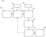
- FIG. 4 shows a flow diagram of the reference map building process according to an illustrative embodiment.
- an empty map is initialised with cell states and weights to establish an internal classification map, like that shown in Figure 3 .
- the cells may be recorded with cell states such as: "Not updated”, “Free”, “Candidate”, or "Reported”.
- a location input is provided for providing the position of the ego vehicle as it moves.
- cells in the internal classification map are shifted with movement of the vehicle.
- the cell states are updated based on confidences, the cell position with respect to the ego vehicle and the presence of conflicting states.
- the shifted internal classification map is updated based on both location input provided by block 101 and the occupancy grid supplied by block 102.
- cells may be marked as "Free” or “Candidate”. The weighting for that assigned cell state may also be recorded at this stage.
- cells that have been marked as a "Candidate” cell for a sufficiently long time/number of iterations (indicating a sufficiently high confidence) are reported to the Reference Map as "Reported”.
- the list of Reported cells and their associated weights may be output. This may be transmitted, for example, to a server for use in building a centralised reference map.
- perception sensor data recorded over time by the vehicle may be used to construct a reference map having a better quality than many existing solutions.
- many prior art reference maps are based on a limited set of features extracted from local perception (e.g. signs, road border, geometrical constraints). As such, they rely on LIDAR and camera sensors and hence are not suited for RADAR sensors.
- additional tracking or particle filtering steps are often required in existing solutions to filter out noise, which is computationally complex, thereby limiting their real time application.
- each cell or datapoint may be labelled with a weight based on the confidence characteristics of the recorded state.
- These weightings may be used in map postprocessing and to provide for determining whether to update a status in an existing reference map over time.
- the method is particularly suited to processing radar sensor perception data, which may be relatively noisy.
- the generated reference map does not rely on geometrical features, but also avoids the reporting of duplicate points in the output point cloud.
Landscapes
- Engineering & Computer Science (AREA)
- Remote Sensing (AREA)
- Radar, Positioning & Navigation (AREA)
- Physics & Mathematics (AREA)
- General Physics & Mathematics (AREA)
- Automation & Control Theory (AREA)
- Computer Networks & Wireless Communication (AREA)
- Electromagnetism (AREA)
- Software Systems (AREA)
- Geometry (AREA)
- Theoretical Computer Science (AREA)
- Computer Graphics (AREA)
- Databases & Information Systems (AREA)
- Traffic Control Systems (AREA)
Abstract
Description
- The present disclosure relates to a method of building a reference map and, in particular, automotive reference maps for use in advanced driver assistance systems and autonomous driving technologies. The disclosure also concerns updating an existing reference map which may, for example, be stored in a central server. Moreover, the disclosure concerns automotive electronic control units and software for implementing the above methods.
- Many modern vehicles are fitted with perception sensor systems, such as RADAR, LIDAR and cameras, to provide localization data. Typically, sensor data from multiple sensors are fused to provide for more accurate localisation of the vehicle on the road. For example, a global positioning system (GPS) sensor will not provide a sufficiently high enough level of accuracy on its own, and whilst camera systems can be very effective, their performance will be lower in some situations and conditions, such as in heavy rain, fog, or snow. As such, these systems will often be combined with RADAR and/or LIDAR, and be processed to filter out noise and weight results to provide a higher confidence that localisation determinations are accurate.
- In this respect, automotive systems often use occupancy grid mapping to generate localisation maps of the ego vehicle's environment from noisy and uncertain sensor measurement data. An occupancy grid provides a representation of a map of the environment in the form of an evenly spaced field of random variables each representing the probability of an obstacle existing at that location in the environment. For example, in an evidential occupancy grid, each cell state may hold evidences of multiple hypotheses. For example, in a three-state evidential occupancy grid, each grid cell keeps track of evidences of the cell having a static, dynamic and free status. However, because of the processing demands and the range limitations of the sensor systems, occupancy grids are limited to only the current local environment of the ego vehicle.
- Accordingly, to further improve localization capabilities in vehicles, automotive systems also make use of a reference map, which provides more limited information on constant landmarks in the environment, but for a much larger geographical area (e.g. the whole region or country). As such, the reference map may be used for instance to aid the planning of future trajectories or help with vehicle perception outside of the immediate local area (e.g. advanced warning before a tight turn). However, because of the large area needed to be covered, they contain only the most relevant information to limit the data size of the reference map.
- In view of the above, the generation and maintenance of accurate reference maps is important for the accurate localization of vehicles. Therefore, there remains a need for improved methods and systems for generating reference maps.
- According to a first aspect, there is provided a method for building an reference map comprising the steps of: accumulating perception sensor data for a vehicle moving through an environment; generating a occupancy grid from the accumulated sensor data as the vehicle moves, wherein cells in the occupancy grid have a status and a confidence characteristic associated with the respective cell status determined based on the accumulated data; and building a reference map for the environment by recording reference map cell states based on the confidence characteristics of respective cell statuses in the occupancy grid.
- In this way, a reference map may be generated from the occupancy grid as the vehicle moves and its sensors accumulate data. As such, as the same objects are detected over number of sensor cycles, confidence of their location increases. The most relevant information may be extracted from the occupancy grid based on the confidence characteristic determined from the accumulated sensor data meeting predetermined criteria. That is, a state may be assigned to each cell in the reference map based on the state having a sufficiently high confidence. This acts to filter the data being recorded into the reference grid, and thereby minimises the memory size needed for storage.
- In embodiments, the step of building the reference map comprises recording reference map cells as having an occupied state based on the respective cell statuses in the occupancy grid having confidence characteristics meeting one or more criteria. For instance, a cell may be identified as occupied with a static object if the sensor data indicates a high belief it is occupied over a plurality of sensor cycles.
- In embodiments, the step of building the reference map comprises recording reference map cells as having an unoccupied state based on the respective cell statuses in the occupancy grid having confidence characteristics meeting one or more criteria. For example, a cell may be identified as unoccupied if the sensor data indicates a high belief that it is free of objects over a plurality of sensor cycles. Equally, if an occupancy grid cell shows a dynamic state over a number of cell cycles, exhibiting evidence of both being occupied and unoccupied, this high entropy characteristic may be used to determine that an unoccupied state should be recorded in the reference grid.
- In embodiments, when recording reference map cell states, each reference map cell is assigned a single state based on the confidence characteristics associated with the respective cell. In this way, duplicate data is not recorded for each cell, thereby minimising the size of the reference map.
- In embodiments, the step of building the reference map further comprises recording a weight associated with each assigned reference map cell state. In this way, although a single state may be assigned to each cell, a confidence or weighting corresponding to the original local perception state from the sensor data may be recorded. This may be used in postprocessing and, for instance, to allow for determination during subsequent updating of the reference map.
- In embodiments, the perception sensor data comprises radar data. In this way, radar data, which is relatively noisy, may be filtered through the reference map building process to assist with the generation of an accurate reference map.
- In embodiments, the occupancy grid comprises a plurality of occupancy grid scans generated by a plurality of sensor scan cycles. In this way, data from one or more sensor systems may be fused and accumulated over time to provide accurate determination.
- In embodiments, the confidence characteristic associated with the respective cell statuses comprises an impact weighting based on the position of the cell relative to the ego vehicle. For example, a lower impact may be assigned to the grid cells in front of the vehicle, and higher impact to the closer cells and objects behind the ego vehicle. This may thereby recognise that cell confidence is lower far in front of the vehicle because there isn't time to accumulate enough evidence to converge into a stable measurement/determination. However, as the ego vehicle moves closer to the obstacle and eventually passes it, sensor measurements are accumulated and the cell state converges into a stable measurement, thereby providing a higher confidence and less noise.
- In embodiments, the method may further comprise the step of uploading the generated reference map to a server. In this way, the generated reference map may be stored centrally, for example for use by other vehicles.
- In embodiments, the generated reference map is represented as a point cloud.
- According to a second aspect there is provided an automotive electronic control unit comprising: an input for receiving perception sensor data for a vehicle moving through an environment; an occupancy grid generating block for generating a occupancy grid from the accumulated sensor data as the vehicle moves, wherein cells in the occupancy grid have a status and a confidence characteristic associated with the respective cell status determined based on the accumulated data; and a reference map building block for building a reference map for the environment by recording states for reference map cells based on the confidence characteristics of respective cells statuses in the occupancy grid. In this way, an automotive electronic control unit, such as a multidomain controller or other body control module, may be provided for implementing the above method. It will be understood that in other embodiments, processing may be implemented on a server. For example, perception sensor data may be transmitted from the vehicle to the cloud, where it is processed, and the resultant reference map is accessible by a large number of vehicles.
- According to a third aspect, there is provided a method of updating an automotive reference map, comprising the steps of: accumulating perception sensor data for a vehicle moving through an environment; generating a occupancy grid from the accumulated sensor data as the vehicle moves, wherein cells in the occupancy grid have a status and a confidence characteristic associated with the respective cell status determined based on the accumulated data; and updating a stored reference map for the environment by comparing stored states for reference map cells with respective cells statuses in the occupancy grid and updating the stored states where the confidence characteristics for the respective cell status meet an update criteria. In this way an existing reference map may be updated by sensor data accumulated over time. As such, the stored reference may be improved over time and adapt as new road features are installed.
- In embodiments, the update criteria are met if the confidence characteristics for the cell statuses indicate a higher confidence level than the weight assigned to the respective stored reference map cell state. In this way, a more confident later determination may be used to override an existing stored state.
- According to a fourth aspect, there is provided a method of updating an automotive reference map stored at a server, comprising the steps of: receiving reference map data from a vehicle moving through an environment, wherein the reference map data has been generated for the environment by recording reference map cell states based on the confidence characteristics of respective cell statuses in a occupancy grid generated from accumulated perception sensor data at the vehicle; and updating the stored reference map for the environment by comparing the recorded reference map cell states in the reference map data with the respective cell statuses in the stored reference map and updating the stored states where the confidence characteristics for the respective cell status meet an update criteria. In this way, an existing reference map stored at a server may be updated by sensor data accumulated by one or more vehicles over time. As such, the stored reference map may be improved over time and adapt as new road features are installed.
- According to a fourth aspect, there is provided a non-transient computer readable medium comprising instructions which, when executed by a computer, implement the above method.
- According to a fifth aspect, there is provided a computer software product comprising instructions which, when executed by a computer, implement the above method.
- Illustrative embodiments will now be described with reference to the drawings in which:
-
Figure 1 shows a schematic representation of the method of building a reference map according to a first embodiment; -
Figure 2 shows an illustrative example of an occupancy grid generated during the method of the first embodiment; -
Figure 3 shows an illustrative example of an internal classification map synchronized to the occupancy map shown inFigure 2 ; and -
Figure 4 shows a flow diagram of the reference map building process according to an illustrative embodiment. -
Figure 1 shows a schematic representation of the method of building a reference map according to a first embodiment.Block 1a represents local perception data obtained from multiple perception sensors, such as multiple radar sensors, which are provided in the vehicle. At the same time, the vehicle receives aglobal positioning reference 1b which provides general positioning tracking as the vehicle moves through the environment. - The local
perception sensor data 1a andGPS reference 1b are then used inblock 2 to create a local perception occupancy grid. This local perception occupancy grid is dynamic in the sense that the grid moves with the ego vehicle as the vehicle moves through the environment.Block 2 may be implemented by an electronic control unit (ECU) within the ego vehicle, with the ECU processing sensor fusion and data filtering to generate the occupancy grid representing the local environment surrounding the vehicle. - The occupancy grid is then used to build a reference map in
block 3 which contains only the most relevant information identifying stationary objects within the environment. Again block 3 may be implemented by an electronic control unit (ECU) within the ego vehicle, with the reference map being built by firstly extracting the most relevant information from the occupancy grid and then ensuring that the extracted information is unique to avoid duplication and filter out invalid data. - To explain the above in further detail,
figure 2 shows an illustrative example of an occupancy grid generated during the method of the first embodiment. As theego vehicle 10 moves in the environment, in this case from left to right along a road, the local perception sensor systems provide inputs for evidences of cells in the occupancy grid having a stationary, dynamic and free status. As data is accumulated, the confidence associated with each status changes over time as more data is collected. For example, as shown inFigure 2 , sensor detections from cells far away from theego vehicle 10 are noisy and have a low confidence (see detections in the right side ofFigure 2 ). However, as more data is accumulated as the vehicle moves closer to an object, the noise is reduced, and confidence increases (see detections in the left side ofFigure 2 ). The ECU may therefore extract the most relevant information from the occupancy grid based on the perceived state measurement and the associated confidence characteristics. - In this connection, the ECU records a cell as having a particular state in the reference map based on the determined confidence characteristics, such as belief and entropy indicators. For example, if sensor detections indicate the presence of a stationary object, the cell may be considered to have associated high stationary evidence (belief). At the same time, if there is a low conflict between the status associated with a particular cell, it is considered to have a low entropy. Accordingly, confidence characteristics for a state in which the belief is above a predetermined threshold and the entropy is below a predetermined threshold may be used to determine that a cell should be recorded as having the associated state.
- Furthermore, as mentioned above, detections relative to the position of the ego vehicle may also have a bearing on the confidence characteristics. In this respect, local perception data is recorded as the vehicle moves and, as more information is accumulated, the cell state is more confident and less noisy. Therefore, in far ranges in front of the vehicle, cell confidence will be lower, because there has not been time to accumulate enough evidence to converge into a stable determination. As the ego vehicle moves closer to the obstacle and eventually passes it, sensor measurements accumulate, and the cell state converges into a stable determination. Accordingly, the processing implemented by the ECU may assign a lower impact to occupancy grid cells further in front of the vehicle and a higher impact to the closer cells and objects behind the ego vehicle.
- Determined call states with sufficient confidence characteristics are recorded in the reference map only once. As such, data points from each perception sensor scan aren't duplicated in the output reference map, thereby minimising data redundancy. This step also has the effect of filtering out cells which are only relevant for a short period of time, such as false positive measurements. Accordingly, the stability of the relevant information is verified.
- The reference
map builder block 3 follows the movement of the occupancy map and stores information about determined cells states. Once cells are marked as recorded, the marked cell areas aren't recorded again, thereby reducing the number of duplicate data points. As such, the output reference map may be provided as a point cloud, with points identifying the location of objects in the environment space. - In addition to recording cells having an occupied state, the reference
map builder block 3 may also mark areas which have a high confidence of being free or dynamic. In the case of dynamic detections, such as other moving vehicles, these may be sensed as being located in certain cells but, since they are moving, the area they are located may be determined to be unoccupied in a long-term sense. These rejected areas can be used to filter out single cell noises which may occur in the perception sensor data. - In
block 4, the reference map is output, for example for transmission to a central server. In this respect,figure 3 shows an illustrative example of a internal classification map synchronized to the occupancy map shown inFigure 2 and used for creating the reference map. As shown the output internal classification map provides a less noisy output with theunoccupied road 11 ahead of the ego vehicle, and detections associated with theguardrails 12 either side. As the vehicle moves forward, states for currently unrecorded cells may be recorded as the accumulated data builds sufficient confidence in their determination. - In this connection, to explain the method in further detail
Figure 4 shows a flow diagram of the reference map building process according to an illustrative embodiment. Inblock 103, an empty map is initialised with cell states and weights to establish an internal classification map, like that shown inFigure 3 . The cells may be recorded with cell states such as: "Not updated", "Free", "Candidate", or "Reported". Atblock 101, a location input is provided for providing the position of the ego vehicle as it moves. Inblock 104, cells in the internal classification map are shifted with movement of the vehicle. Inblock 105, the cell states are updated based on confidences, the cell position with respect to the ego vehicle and the presence of conflicting states. Inblock 105, the shifted internal classification map is updated based on both location input provided byblock 101 and the occupancy grid supplied byblock 102. Inblock 106, cells may be marked as "Free" or "Candidate". The weighting for that assigned cell state may also be recorded at this stage. Inblock 107, cells that have been marked as a "Candidate" cell for a sufficiently long time/number of iterations (indicating a sufficiently high confidence) are reported to the Reference Map as "Reported". Inblock 108, the list of Reported cells and their associated weights may be output. This may be transmitted, for example, to a server for use in building a centralised reference map. - Accordingly, with the above method, perception sensor data recorded over time by the vehicle may be used to construct a reference map having a better quality than many existing solutions. For example, many prior art reference maps are based on a limited set of features extracted from local perception (e.g. signs, road border, geometrical constraints). As such, they rely on LIDAR and camera sensors and hence are not suited for RADAR sensors. Furthermore, additional tracking or particle filtering steps are often required in existing solutions to filter out noise, which is computationally complex, thereby limiting their real time application.
- Furthermore, with the above described method, each cell or datapoint may be labelled with a weight based on the confidence characteristics of the recorded state. These weightings may be used in map postprocessing and to provide for determining whether to update a status in an existing reference map over time. Advantageously, the method is particularly suited to processing radar sensor perception data, which may be relatively noisy. Moreover, the generated reference map does not rely on geometrical features, but also avoids the reporting of duplicate points in the output point cloud.
- It will be understood that the embodiments illustrated above show applications only for the purposes of illustration. In practice, embodiments may be applied to many different configurations, the detailed embodiments being straightforward for those skilled in the art to implement.
- For example, in the above embodiment, a single occupancy grid is described, with different status evidences being recorded against each cell. But it will be understood that in other embodiments, separate occupancy grids may be used to record occupied and unoccupied states, with both being processed to generate the reference map.
- In addition, whilst the above embodiment describes the building of a new reference map, it will be understood that the method is equally applicable to update an existing map, with newly determined cell states being used to update cells in an existing map if the confidence characteristics meet certain criteria, such as having a higher confidence. This may allow, for instance, an optimised central reference map to be used and updated by multiple vehicles.
Claims (15)
- A method for building a reference map comprising the steps of:accumulating perception sensor data for a vehicle moving through an environment;generating an occupancy grid from the accumulated sensor data as the vehicle moves, wherein cells in the occupancy grid have a status and a confidence characteristic associated with the respective cell status determined based on the accumulated data; andbuilding a reference map for the environment by recording reference map cell states based on the confidence characteristics of respective cell statuses in the occupancy grid.
- A method according to claim 1, wherein the step of building the reference map comprises recording reference map cells as having an occupied state based on the respective cell statuses in the occupancy grid having confidence characteristics meeting one or more criteria.
- A method according to claim 1 or 2, wherein the step of building the reference map comprises recording reference map cells as having an unoccupied state based on the respective cell statuses in the occupancy grid having confidence characteristics meeting one or more criteria.
- A method according to any preceding claim, wherein, when recording reference map cell states, each reference map cell is assigned a single state based on the confidence characteristics associated with the respective cell.
- A method according to claim 4, wherein the step of building the reference map further comprises recording a weight associated with each assigned reference map cell state.
- A method according to any preceding claim, wherein the perception sensor data comprises radar data.
- A method according to any preceding claim, wherein the occupancy grid comprises a plurality of occupancy grid scans generated by a plurality of sensor scan cycles.
- A method according to any preceding claim, wherein the confidence characteristic associated with the respective cell statuses comprises an impact weighting based on the position of the cell relative to the ego vehicle.
- A method according to any preceding claim, further comprising the step of uploading the generated reference map to a server.
- A method according to any preceding claim, wherein the generated reference map is represented as a point cloud.
- An automotive electronic control unit comprising:an input for receiving perception sensor data for a vehicle moving through an environment;an occupancy grid generating block for generating a occupancy grid from the accumulated sensor data as the vehicle moves, wherein cells in the occupancy grid have a status and a confidence characteristic associated with the respective cell status determined based on the accumulated data; anda reference map building block for building a reference map for the environment by recording states for reference map cells based on the confidence characteristics of respective cells statuses in the occupancy grid.
- A method of updating an automotive reference map generated based on claims 1 to 10, comprising the steps of:accumulating perception sensor data for a vehicle moving through an environment;generating a occupancy grid from the accumulated sensor data as the vehicle moves, wherein cells in the occupancy grid have a status and a confidence characteristic associated with the respective cell status determined based on the accumulated data; andupdating a stored reference map for the environment by comparing stored states for reference map cells with respective cells statuses in the occupancy grid and updating the stored states where the confidence characteristics for the respective cell status meet an update criteria.
- A method according to claim 12, wherein the update criteria are met if the confidence characteristics for the cell statuses indicate a higher confidence level than the weight assigned to the respective stored reference map cell state.
- A method of updating an automotive reference map stored at a server generated based on claims 1 to 10, comprising the steps of:receiving reference map data from a vehicle moving through an environment, wherein the reference map data has been generated for the environment by recording reference map cell states based on the confidence characteristics of respective cell statuses in a occupancy grid generated from accumulated perception sensor data at the vehicle; andupdating the stored reference map for the environment by comparing the recorded reference map cell states in the reference map data with the respective cell statuses in the stored reference map and updating the stored states where the confidence characteristics for the respective cell status meet an update criteria.
- A non-transient computer readable medium comprising instructions which, when executed by a computer, implement a method according to any one of claims 1 to 10 or 12 to 14.
Priority Applications (3)
| Application Number | Priority Date | Filing Date | Title |
|---|---|---|---|
| EP22213401.7A EP4386319A1 (en) | 2022-12-14 | 2022-12-14 | Method for building a reference map, and a control unit and software for the same |
| CN202311674486.2A CN118189927A (en) | 2022-12-14 | 2023-12-07 | Method for constructing reference map, control unit and software thereof |
| US18/539,176 US12516952B2 (en) | 2022-12-14 | 2023-12-13 | Environmental reference map building based on occupancy grid |
Applications Claiming Priority (1)
| Application Number | Priority Date | Filing Date | Title |
|---|---|---|---|
| EP22213401.7A EP4386319A1 (en) | 2022-12-14 | 2022-12-14 | Method for building a reference map, and a control unit and software for the same |
Publications (1)
| Publication Number | Publication Date |
|---|---|
| EP4386319A1 true EP4386319A1 (en) | 2024-06-19 |
Family
ID=84535770
Family Applications (1)
| Application Number | Title | Priority Date | Filing Date |
|---|---|---|---|
| EP22213401.7A Pending EP4386319A1 (en) | 2022-12-14 | 2022-12-14 | Method for building a reference map, and a control unit and software for the same |
Country Status (3)
| Country | Link |
|---|---|
| US (1) | US12516952B2 (en) |
| EP (1) | EP4386319A1 (en) |
| CN (1) | CN118189927A (en) |
Citations (2)
| Publication number | Priority date | Publication date | Assignee | Title |
|---|---|---|---|---|
| US20210131823A1 (en) * | 2018-06-22 | 2021-05-06 | Marelli Europe S.P.A. | Method for Vehicle Environment Mapping, Corresponding System, Vehicle and Computer Program Product |
| EP4016115A1 (en) * | 2020-12-17 | 2022-06-22 | Aptiv Technologies Limited | Vehicle localization based on radar detections |
Family Cites Families (3)
| Publication number | Priority date | Publication date | Assignee | Title |
|---|---|---|---|---|
| JP4897516B2 (en) * | 2007-02-28 | 2012-03-14 | アイシン・エィ・ダブリュ株式会社 | Navigation device and data update system |
| US11619497B2 (en) * | 2020-10-30 | 2023-04-04 | Pony Ai Inc. | Autonomous vehicle navigation using with coalescing constraints for static map data |
| US12103540B2 (en) * | 2021-07-29 | 2024-10-01 | Qualcomm Incorporated | Occupancy mapping for autonomous control of a vehicle |
-
2022
- 2022-12-14 EP EP22213401.7A patent/EP4386319A1/en active Pending
-
2023
- 2023-12-07 CN CN202311674486.2A patent/CN118189927A/en active Pending
- 2023-12-13 US US18/539,176 patent/US12516952B2/en active Active
Patent Citations (2)
| Publication number | Priority date | Publication date | Assignee | Title |
|---|---|---|---|---|
| US20210131823A1 (en) * | 2018-06-22 | 2021-05-06 | Marelli Europe S.P.A. | Method for Vehicle Environment Mapping, Corresponding System, Vehicle and Computer Program Product |
| EP4016115A1 (en) * | 2020-12-17 | 2022-06-22 | Aptiv Technologies Limited | Vehicle localization based on radar detections |
Also Published As
| Publication number | Publication date |
|---|---|
| US12516952B2 (en) | 2026-01-06 |
| US20240200970A1 (en) | 2024-06-20 |
| CN118189927A (en) | 2024-06-14 |
Similar Documents
| Publication | Publication Date | Title |
|---|---|---|
| CN113379805B (en) | Multi-information resource fusion processing method for traffic nodes | |
| JP7140922B2 (en) | Multi-sensor data fusion method and apparatus | |
| US20210331679A1 (en) | Method for Determining a Drivable Area | |
| Moras et al. | Credibilist occupancy grids for vehicle perception in dynamic environments | |
| US8233663B2 (en) | Method for object formation | |
| KR102405767B1 (en) | Apparatus and method for tracking object based on semantic point cloud | |
| GB2560618A (en) | Object tracking by unsupervised learning | |
| CN116466343B (en) | A tunnel target perception method based on 4D millimeter-wave radar and camera fusion | |
| CN114998860B (en) | A method and device for hierarchical fusion of vehicle-road cooperative perception data | |
| CN114359346B (en) | Point cloud data processing method and device, nonvolatile storage medium and processor | |
| CN114084129A (en) | Fusion-based vehicle automatic driving control method and system | |
| EP4009228A1 (en) | Method for determining a semantic free space | |
| CN114675295A (en) | A method, device, device and storage medium for obstacle determination | |
| CN116902005A (en) | Fusion processing method, device and medium based on unmanned vehicle | |
| Vu et al. | Grid-based localization and online mapping with moving objects detection and tracking: new results | |
| US12602931B2 (en) | Identification of unknown traffic objects | |
| CN115390868A (en) | Development of autodrive system perception | |
| CN110426714B (en) | Obstacle identification method | |
| Elfring et al. | Multisensor simultaneous vehicle tracking and shape estimation | |
| US12516952B2 (en) | Environmental reference map building based on occupancy grid | |
| Nguyen et al. | Optimized grid-based environment perception in advanced driver assistance systems | |
| US12142054B2 (en) | Vehicles, systems and methods for determining an occupancy map of a vicinity of a vehicle | |
| US20220414151A1 (en) | Method for Operating a Surroundings Sensing Device with Grid-Based Evaluation and with Fusion, and Surroundings Sensing Device | |
| CN116363611A (en) | A Vehicle Trajectory Tracking Method Based on Multi-sensor Decision-Level Fusion | |
| Durand et al. | 360 Multisensor object fusion and sensor-based erroneous data management for autonomous vehicles |
Legal Events
| Date | Code | Title | Description |
|---|---|---|---|
| PUAI | Public reference made under article 153(3) epc to a published international application that has entered the european phase |
Free format text: ORIGINAL CODE: 0009012 |
|
| STAA | Information on the status of an ep patent application or granted ep patent |
Free format text: STATUS: THE APPLICATION HAS BEEN PUBLISHED |
|
| AK | Designated contracting states |
Kind code of ref document: A1 Designated state(s): AL AT BE BG CH CY CZ DE DK EE ES FI FR GB GR HR HU IE IS IT LI LT LU LV MC ME MK MT NL NO PL PT RO RS SE SI SK SM TR |
|
| RAP3 | Party data changed (applicant data changed or rights of an application transferred) |
Owner name: APTIV TECHNOLOGIES AG |
|
| STAA | Information on the status of an ep patent application or granted ep patent |
Free format text: STATUS: REQUEST FOR EXAMINATION WAS MADE |
|
| 17P | Request for examination filed |
Effective date: 20241211 |
|
| STAA | Information on the status of an ep patent application or granted ep patent |
Free format text: STATUS: EXAMINATION IS IN PROGRESS |
|
| 17Q | First examination report despatched |
Effective date: 20250714 |