EP4358031A1 - A method for determining the health status of vegetal elements - Google Patents
A method for determining the health status of vegetal elements Download PDFInfo
- Publication number
- EP4358031A1 EP4358031A1 EP22306583.0A EP22306583A EP4358031A1 EP 4358031 A1 EP4358031 A1 EP 4358031A1 EP 22306583 A EP22306583 A EP 22306583A EP 4358031 A1 EP4358031 A1 EP 4358031A1
- Authority
- EP
- European Patent Office
- Prior art keywords
- vegetal
- multispectral
- space
- elements
- zone
- Prior art date
- Legal status (The legal status is an assumption and is not a legal conclusion. Google has not performed a legal analysis and makes no representation as to the accuracy of the status listed.)
- Pending
Links
Images

Classifications
-
- G—PHYSICS
- G06—COMPUTING OR CALCULATING; COUNTING
- G06V—IMAGE OR VIDEO RECOGNITION OR UNDERSTANDING
- G06V20/00—Scenes; Scene-specific elements
- G06V20/10—Terrestrial scenes
- G06V20/188—Vegetation
-
- G—PHYSICS
- G06—COMPUTING OR CALCULATING; COUNTING
- G06F—ELECTRIC DIGITAL DATA PROCESSING
- G06F18/00—Pattern recognition
- G06F18/20—Analysing
- G06F18/21—Design or setup of recognition systems or techniques; Extraction of features in feature space; Blind source separation
- G06F18/214—Generating training patterns; Bootstrap methods, e.g. bagging or boosting
-
- G—PHYSICS
- G06—COMPUTING OR CALCULATING; COUNTING
- G06V—IMAGE OR VIDEO RECOGNITION OR UNDERSTANDING
- G06V10/00—Arrangements for image or video recognition or understanding
- G06V10/10—Image acquisition
- G06V10/12—Details of acquisition arrangements; Constructional details thereof
- G06V10/14—Optical characteristics of the device performing the acquisition or on the illumination arrangements
- G06V10/143—Sensing or illuminating at different wavelengths
-
- G—PHYSICS
- G06—COMPUTING OR CALCULATING; COUNTING
- G06V—IMAGE OR VIDEO RECOGNITION OR UNDERSTANDING
- G06V10/00—Arrangements for image or video recognition or understanding
- G06V10/40—Extraction of image or video features
- G06V10/58—Extraction of image or video features relating to hyperspectral data
-
- G—PHYSICS
- G06—COMPUTING OR CALCULATING; COUNTING
- G06V—IMAGE OR VIDEO RECOGNITION OR UNDERSTANDING
- G06V10/00—Arrangements for image or video recognition or understanding
- G06V10/70—Arrangements for image or video recognition or understanding using pattern recognition or machine learning
- G06V10/77—Processing image or video features in feature spaces; using data integration or data reduction, e.g. principal component analysis [PCA] or independent component analysis [ICA] or self-organising maps [SOM]; Blind source separation
- G06V10/774—Generating sets of training patterns; Bootstrap methods, e.g. bagging or boosting
-
- G—PHYSICS
- G06—COMPUTING OR CALCULATING; COUNTING
- G06V—IMAGE OR VIDEO RECOGNITION OR UNDERSTANDING
- G06V10/00—Arrangements for image or video recognition or understanding
- G06V10/70—Arrangements for image or video recognition or understanding using pattern recognition or machine learning
- G06V10/82—Arrangements for image or video recognition or understanding using pattern recognition or machine learning using neural networks
-
- G—PHYSICS
- G06—COMPUTING OR CALCULATING; COUNTING
- G06V—IMAGE OR VIDEO RECOGNITION OR UNDERSTANDING
- G06V20/00—Scenes; Scene-specific elements
- G06V20/10—Terrestrial scenes
- G06V20/13—Satellite images
-
- G—PHYSICS
- G06—COMPUTING OR CALCULATING; COUNTING
- G06V—IMAGE OR VIDEO RECOGNITION OR UNDERSTANDING
- G06V20/00—Scenes; Scene-specific elements
- G06V20/10—Terrestrial scenes
- G06V20/17—Terrestrial scenes taken from planes or by drones
-
- G—PHYSICS
- G06—COMPUTING OR CALCULATING; COUNTING
- G06V—IMAGE OR VIDEO RECOGNITION OR UNDERSTANDING
- G06V20/00—Scenes; Scene-specific elements
- G06V20/60—Type of objects
Definitions
- the present invention concerns a method for determining the health status of vegetal elements.
- the present invention also concerns an associated computer program product.
- the present invention also relates to an associated readable information carrier.
- Bark beetle is a coleopteran insect that can devastate spruce forests. Due to global warming bark beetles survive the winter and proliferate. As a consequence, some regions, such as the east of France, are highly infested since 2018.
- the invention relates to a method for determining the health status of vegetal elements, such as trees or plants, the method comprising the following phases which are computer-implemented:
- the method according to the invention may comprise one or more of the following features considered alone or in any combination that is technically possible:
- the invention also relates to a computer program product comprising a readable information carrier having stored thereon a computer program comprising program instructions, the computer program being loadable onto a data processing unit and causing a method as previously described to be carried out when the computer program is carried out on the data processing unit.
- the invention also relates to a readable information carrier on which is stored a computer program product as previously described.
- a computer 20 and a computer program product 22 are illustrated in figure 1 .
- the computer 20 is preferably a computer.
- the calculator 20 is a computer or computing system, or similar electronic computing device adapted to manipulate and/or transform data represented as physical, such as electronic, quantities within the computing system's registers and/or memories into other data similarly represented as physical quantities within the computing system's memories, registers or other such information storage, transmission or display devices.
- the calculator 20 interacts with the computer program product 22.
- the calculator 20 comprises a processor 24 comprising a data processing unit 26, memories 28 and a reader 30 for information media.
- the calculator 20 comprises a human machine interface 32, such as a keyboard, and a display 34.
- the computer program product 22 comprises an information medium 36.
- the information medium 36 is a medium readable by the calculator 20, usually by the data processing unit 26.
- the readable information medium 36 is a medium suitable for storing electronic instructions and capable of being coupled to a computer system bus.
- the information medium 36 is a USB key, a floppy disk or flexible disk (of the English name "Floppy disc"), an optical disk, a CD-ROM, a magneto-optical disk, a ROM memory, a memory RAM, EPROM memory, EEPROM memory, magnetic card or optical card.
- the computer program 22 comprising program instructions.
- the computer program 22 is loadable on the data processing unit 26 and is adapted to entail the implementation of a method for determining the health status of vegetal elements, when the computer program 22 is loaded on the processing unit 26 of the calculator 20.
- the determination method comprises a phase 100 of building a training database DB.
- the building phase 100 is, for example, implemented by the calculator 20 interacting with the computer program product 22, that is to say is computer-implemented.
- the building phase 100 comprises a step 110 for collecting input data indicative of the position and health status of target vegetal elements in a plurality of zones of space Z.
- the vegetal elements are for example trees or plants.
- the positions are for example given by geographical coordinates.
- the health status indicates the health condition of the vegetal element.
- the health status indicates whether or not the vegetal element has a disease.
- the disease is for example induced by an insect, such as the bark beetle.
- the input data comprise at least one visual support on which the position of the target vegetal elements are georeferenced for each zone of space Z.
- the target vegetal elements are for example modeled by geometrical forms F, such as polygons, georeferenced on the visual support.
- the visual support is for example an image (seen from the sky of the zones of space) or a cartography.
- the visual support is a cartography C.
- the zones of space Z are defined by rectangle of a grid dividing the cartography C (only four zones Z are referenced on figure 3 in order not to overload the figure).
- the health status indicates whether or not the vegetal elements are ill and all the target vegetal elements are considered ill (the vegetal elements in good health condition are not taken into account).
- the different zones of space Z taken into account in the building phase 100 could be adjacent zones or zones of space coming from different regions or lands (in this case a plurality of visual support can be needed).
- the building phase 100 comprises a step 120 of collecting a set of multispectral images seen from the sky for each zone of space Z. For each zone of space Z, the set of multispectral images are obtained on the basis of the positions of the target vegetal elements in the input data (in order to get images of the target vegetal elements).
- the multispectral images are images within different wavelength ranges across the electromagnetic spectrum.
- the set of multispectral images for each zone of space Z comprises at least images in the visible range (400 nanometers (nm) to 700 nm) and in the near-infrared (700 nm to 3 micrometer ( ⁇ m)).
- the multispectral images have been acquired by a multispectral camera.
- the multispectral camera is mounted on a satellite and the multispectral images are satellite images.
- the multispectral images have been obtained by the satellite Sentinel-2A.
- the multispectral camera is mounted on an aircraft, for example a drone.
- the building phase 100 comprises a step 130 of processing each set of multispectral images so as to compute multispectral indexes characterizing the target vegetal elements of the set of multispectral images.
- the multispectral indexes are obtained by combining the different multispectral images of the set.
- At least one multispectral index is computed using at least one multispectral image of the corresponding set that is in the near infrared.
- At least two computed multispectral indexes are chosen in the following list: the Red Green Blue Index (RGB), the Normalized Difference Vegetation Index (NDVI), the Advanced Vegetation Index (AVI) and the Normalized Difference Moisture Index (NDMI).
- the AVI is calculated with the following formula 2.0[800:1100]-[600:700].
- the NDMI is calculated with the following formula: 820 nm ⁇ 1600 nm 820 nm + 1600 nm .
- At least four multispectral indexes are computed which are the following indexes: RGB, NDVI, AVI and NDMI.
- the building phase 100 comprises a step 140 of building the training database DB by associating, for each zone of space Z, the input data for said zone of space Z and a concatenation of the computed multispectral indexes for said zone of space Z.
- figure 4 illustrates an image IM R corresponding to a raster of the different multispectral images.
- the spectral indexes are then calculated.
- the spectral indexes are concatenated to obtain an image IM(n,m,12) into higher dimension array.
- the reference frame of the multispectral images is different from the reference frame of the visual support (cartography C or equivalent image) of the input data.
- the coordinates of the geometrical forms F modeling the target vegetal elements in the reference frame of the visual support are thus processed so as to be compatible with the coordinate frame of the multispectral images.
- the training database DB is filled with the processed coordinates of the geometrical forms F. This enables the geometrical forms F to be stackable on the multispectral images without error for ground truth evaluation.
- the determination method comprises a phase 200 of training a detection model M on the basis of the training database DB so as to obtain a trained detection model M'.
- the training phase 200 is, for example, implemented by the calculator 20 interacting with the computer program product 22, that is to say is computer-implemented.
- the trained detection model M' is configured for determining the position and health status of target vegetal elements in a zone of space Z as a function of a set of multispectral images of the zone of space Z.
- the detection model M is a deepl learning model.
- the detection model M is convolutional neural network (CNN).
- the detection model M has been pretrained on a database different from the training database DB so as to achieve transfer learning.
- the training technique is typically based on supervised learning, with training and validation substeps (performed by dividing the training database DB, for example 80% of the data for the training substep and 20% of the data for the validation substep).
- the detection model M is a mask Region-based Convolutional Neural Netwotk (mask RCNN) with a Feature Pyramid Network (FPN) as backbone.
- the detection model M is for example obtained from the Facebook AI computer vision tool Detectron 2.
- the trained detection model M' associates a confidence metric relative to the position and/or health status of each target vegetal element determined by said trained detection model M'.
- the determination method comprises a phase 300 of operating the trained detection model M'.
- the operating phase 300 is, for example, implemented by the calculator 20 interacting with the computer program product 22, that is to say is computer-implemented.
- the operating phase 300 comprises the following steps:
- the determination method also comprises a phase 400 of displaying, on a display (for example the display 34 of the calculator 20), the position and health status of the target vegetal elements which have been determined by the trained detection model M'.
- the position and health status are for example displayed on a visual support, such as an image (such as the image IM R of figure 4 ) or a cartography of the corresponding zone of space Z.
- the above method has been implemented and enables to obtain fast and good predictions, which offers the possibility of frequent scoring for health monitoring of vegetal elements.
- the use of concatenate spectral indexes obtained on the basis of multispectral images enables to determine in a more precise way the health status of a vegetal element as compared to the state of the art.
Landscapes
- Engineering & Computer Science (AREA)
- Theoretical Computer Science (AREA)
- Physics & Mathematics (AREA)
- General Physics & Mathematics (AREA)
- Multimedia (AREA)
- Evolutionary Computation (AREA)
- Artificial Intelligence (AREA)
- General Health & Medical Sciences (AREA)
- Health & Medical Sciences (AREA)
- Computer Vision & Pattern Recognition (AREA)
- Computing Systems (AREA)
- Data Mining & Analysis (AREA)
- Remote Sensing (AREA)
- Databases & Information Systems (AREA)
- Medical Informatics (AREA)
- Software Systems (AREA)
- Spectroscopy & Molecular Physics (AREA)
- Astronomy & Astrophysics (AREA)
- Life Sciences & Earth Sciences (AREA)
- Bioinformatics & Cheminformatics (AREA)
- Bioinformatics & Computational Biology (AREA)
- Evolutionary Biology (AREA)
- General Engineering & Computer Science (AREA)
- Image Processing (AREA)
Abstract
- a phase of building a training database by associating, for each zone of space, input data indicative of the position and health status of target vegetal elements for said zone of space and a concatenation of computed multispectral indexes for said zone of space,
- a phase of training a detection model on the basis of the training database so as to obtain a trained detection model configured for determining the position and health status of target vegetal elements in a zone of space as a function of a set of multispectral images of the zone of space, and
- a phase of operating the trained detection model.
Description
- The present invention concerns a method for determining the health status of vegetal elements. The present invention also concerns an associated computer program product. The present invention also relates to an associated readable information carrier.
- Bark beetle is a coleopteran insect that can devastate spruce forests. Due to global warming bark beetles survive the winter and proliferate. As a consequence, some regions, such as the east of France, are highly infested since 2018.
- Once a forest is invested, to prevent the spread of the disease, the solution is to cut down infested trees.
- However, this has an environmental impact. In addition, the affected communities may see their forestry revenues decrease.
- It appears crucial to identify as soon as possible the infected trees to avoid cutting a too huge amount of them. However, such a work is very time consuming. In addition, the signs of the illness are not easy to identify visually.
- Hence, there exists a need for a method enabling to determine the health status of a vegetal element, such a tree, in a more easy and precise way.
- To this end, the invention relates to a method for determining the health status of vegetal elements, such as trees or plants, the method comprising the following phases which are computer-implemented:
- a phase of building a training database comprising the following steps:
- collecting input data indicative of the position and health status of target vegetal elements in a plurality of zones of space,
- for each zone of space, collecting a set of multispectral images seen from the sky of the zone of space as a function of the position of the target vegetal elements in the input data, the set of multispectral images having been acquired by a multispectral camera,
- processing each set of multispectral images so as to compute multispectral indexes characterizing the target vegetal elements of the set of multispectral images,
- building the training database by associating, for each zone of space, the input data for said zone of space and a concatenation of the computed multispectral indexes for said zone of space
- a phase of training a detection model on the basis of the training database so as to obtain a trained detection model configured for determining the position and health status of target vegetal elements in a zone of space as a function of a set of multispectral images of the zone of space, and
- a phase of operating the trained detection model comprising the following steps:
- receiving a set of multispectral images seen from the sky of a zone of space, and
- determining, by the trained detection model, the position and health status of eventual target vegetal elements in the zone of space.
- The method according to the invention may comprise one or more of the following features considered alone or in any combination that is technically possible:
- at least one multispectral index is computed using at least one multispectral image of the corresponding set that is in the near infrared;
- at least two computed multispectral indexes are chosen in the following list: the Red Green Blue Index, the Normalized Difference Vegetation Index, the Advanced Vegetation Index and the Normalized Difference Moisture Index;
- at least four multispectral indexes are computed which are the following indexes: the Red Green Blue Index, the Normalized Difference Vegetation Index, the Advanced Vegetation Index and the Normalized Difference Moisture Index;
- the input data comprise at least one visual support, such as a cartography or an image, on which the position of the target vegetal elements are georeferenced;
- the target vegetal elements are modeled by geometrical forms, such as polygons, georeferenced on the visual support;
- the reference frame of the multispectral images is different from the reference frame of the visual support, the step of building the training database comprising processing the coordinates of the geometrical forms modeling the target vegetal elements in the reference frame of the visual support so as to be compatible with the coordinate frame of the multispectral images, the training database comprising the processed coordinates of the geometrical forms;
- the multispectral images are satellite images;
- the detection model is a convolutional neural network;
- the detection model has been pretrained on a database different from the training database so as to achieve transfer learning;
- the trained detection model associates a confidence metric relative to the position and/or health status of each target vegetal element determined by said trained detection model;
- determining the health status of a vegetal element implies determining whether or not the vegetal element has a disease, preferably the disease being a specific disease induced by an insect, such as the bark beetle;
- the method comprises a phase of displaying, on a display, the position and health status of the target vegetal elements which have been determined by the trained detection model, the position and health status being for example displayed on a visual support, such as an image or a cartography of the corresponding zone of space.
- The invention also relates to a computer program product comprising a readable information carrier having stored thereon a computer program comprising program instructions, the computer program being loadable onto a data processing unit and causing a method as previously described to be carried out when the computer program is carried out on the data processing unit.
- The invention also relates to a readable information carrier on which is stored a computer program product as previously described.
- The invention will be easier to understand in view of the following description, provided solely as an example and with reference to the appended drawings in which:
-
Figure 1 is a schematic view of an example of a computer for implementing a method for determining the health status of vegetal elements, -
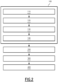
Figure 2 is a schematic representation illustrating the implementation of phases of a method for determining the health status of vegetal elements, -
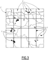
Figure 3 is a schematic representation of an example of input data, and -
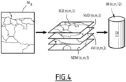
Figure 4 is a schematic representation of an example of a set of multispectral images being processed to obtain spectral indexes, the spectral indexes being concatenated to be integrated in a training database. - A
computer 20 and acomputer program product 22 are illustrated infigure 1 . - The
computer 20 is preferably a computer. - More generally, the
calculator 20 is a computer or computing system, or similar electronic computing device adapted to manipulate and/or transform data represented as physical, such as electronic, quantities within the computing system's registers and/or memories into other data similarly represented as physical quantities within the computing system's memories, registers or other such information storage, transmission or display devices. - The
calculator 20 interacts with thecomputer program product 22. - As illustrated on
figure 1 , thecalculator 20 comprises aprocessor 24 comprising adata processing unit 26,memories 28 and areader 30 for information media. In the example illustrated onfigure 1 , thecalculator 20 comprises ahuman machine interface 32, such as a keyboard, and adisplay 34. - The
computer program product 22 comprises aninformation medium 36. - The
information medium 36 is a medium readable by thecalculator 20, usually by thedata processing unit 26. Thereadable information medium 36 is a medium suitable for storing electronic instructions and capable of being coupled to a computer system bus. - By way of example, the
information medium 36 is a USB key, a floppy disk or flexible disk (of the English name "Floppy disc"), an optical disk, a CD-ROM, a magneto-optical disk, a ROM memory, a memory RAM, EPROM memory, EEPROM memory, magnetic card or optical card. - On the
information medium 36 is stored thecomputer program 22 comprising program instructions. - The
computer program 22 is loadable on thedata processing unit 26 and is adapted to entail the implementation of a method for determining the health status of vegetal elements, when thecomputer program 22 is loaded on theprocessing unit 26 of thecalculator 20. - A method for determining the health status of vegetal elements will now be described with reference to the organigram of
figure 2 , and tofigures 3 and4 , which illustrate examples of some phases of this method. - The determination method comprises a
phase 100 of building a training database DB. Thebuilding phase 100 is, for example, implemented by thecalculator 20 interacting with thecomputer program product 22, that is to say is computer-implemented. - The
building phase 100 comprises astep 110 for collecting input data indicative of the position and health status of target vegetal elements in a plurality of zones of space Z. - The vegetal elements are for example trees or plants.
- The positions are for example given by geographical coordinates.
- The health status indicates the health condition of the vegetal element. In an example, the health status indicates whether or not the vegetal element has a disease. The disease is for example induced by an insect, such as the bark beetle.
- Preferably, the input data comprise at least one visual support on which the position of the target vegetal elements are georeferenced for each zone of space Z. The target vegetal elements are for example modeled by geometrical forms F, such as polygons, georeferenced on the visual support. The visual support is for example an image (seen from the sky of the zones of space) or a cartography.
- In particular, in the example of
figure 3 , the visual support is a cartography C. The zones of space Z are defined by rectangle of a grid dividing the cartography C (only four zones Z are referenced onfigure 3 in order not to overload the figure). In this example, the health status indicates whether or not the vegetal elements are ill and all the target vegetal elements are considered ill (the vegetal elements in good health condition are not taken into account). - It should be noted that the different zones of space Z taken into account in the
building phase 100 could be adjacent zones or zones of space coming from different regions or lands (in this case a plurality of visual support can be needed). - The
building phase 100 comprises astep 120 of collecting a set of multispectral images seen from the sky for each zone of space Z. For each zone of space Z, the set of multispectral images are obtained on the basis of the positions of the target vegetal elements in the input data (in order to get images of the target vegetal elements). - The multispectral images are images within different wavelength ranges across the electromagnetic spectrum. Preferably, the set of multispectral images for each zone of space Z comprises at least images in the visible range (400 nanometers (nm) to 700 nm) and in the near-infrared (700 nm to 3 micrometer (µm)).
- The multispectral images have been acquired by a multispectral camera.
- For example, the multispectral camera is mounted on a satellite and the multispectral images are satellite images. For example, the multispectral images have been obtained by the satellite Sentinel-2A.
- In a variant, the multispectral camera is mounted on an aircraft, for example a drone.
- The
building phase 100 comprises astep 130 of processing each set of multispectral images so as to compute multispectral indexes characterizing the target vegetal elements of the set of multispectral images. The multispectral indexes are obtained by combining the different multispectral images of the set. - Preferably, at least one multispectral index is computed using at least one multispectral image of the corresponding set that is in the near infrared.
- Preferably, at least two computed multispectral indexes are chosen in the following list: the Red Green Blue Index (RGB), the Normalized Difference Vegetation Index (NDVI), the Advanced Vegetation Index (AVI) and the Normalized Difference Moisture Index (NDMI). In particular, the NDVI is calculated as being the ratio


- Preferably, at least four multispectral indexes are computed which are the following indexes: RGB, NDVI, AVI and NDMI.
- The
building phase 100 comprises astep 140 of building the training database DB by associating, for each zone of space Z, the input data for said zone of space Z and a concatenation of the computed multispectral indexes for said zone of space Z. - In particular,
figure 4 illustrates an image IMR corresponding to a raster of the different multispectral images. The spectral indexes are then calculated. Finally, the spectral indexes are concatenated to obtain an image IM(n,m,12) into higher dimension array. - In an example of implementation, the reference frame of the multispectral images is different from the reference frame of the visual support (cartography C or equivalent image) of the input data. The coordinates of the geometrical forms F modeling the target vegetal elements in the reference frame of the visual support are thus processed so as to be compatible with the coordinate frame of the multispectral images. The training database DB is filled with the processed coordinates of the geometrical forms F. This enables the geometrical forms F to be stackable on the multispectral images without error for ground truth evaluation.
- The determination method comprises a
phase 200 of training a detection model M on the basis of the training database DB so as to obtain a trained detection model M'. Thetraining phase 200 is, for example, implemented by thecalculator 20 interacting with thecomputer program product 22, that is to say is computer-implemented. - The trained detection model M' is configured for determining the position and health status of target vegetal elements in a zone of space Z as a function of a set of multispectral images of the zone of space Z.
- The detection model M is a deepl learning model.
- Preferably, the detection model M is convolutional neural network (CNN).
- Preferably, the detection model M has been pretrained on a database different from the training database DB so as to achieve transfer learning.
- The training technique is typically based on supervised learning, with training and validation substeps (performed by dividing the training database DB, for example 80% of the data for the training substep and 20% of the data for the validation substep).
- In an example, the detection model M is a mask Region-based Convolutional Neural Netwotk (mask RCNN) with a Feature Pyramid Network (FPN) as backbone. The detection model M is for example obtained from the Facebook AI computer vision tool Detectron 2.
- Preferably, the trained detection model M' associates a confidence metric relative to the position and/or health status of each target vegetal element determined by said trained detection model M'.
- The determination method comprises a
phase 300 of operating the trained detection model M'. Theoperating phase 300 is, for example, implemented by thecalculator 20 interacting with thecomputer program product 22, that is to say is computer-implemented. - The
operating phase 300 comprises the following steps: - receiving a set of multispectral images seen from the sky of a zone of space Z, and
- determining, by the trained detection model M', the position and health status of eventual target vegetal elements in the zone of space Z.
- Preferably, the determination method also comprises a
phase 400 of displaying, on a display (for example thedisplay 34 of the calculator 20), the position and health status of the target vegetal elements which have been determined by the trained detection model M'. The position and health status are for example displayed on a visual support, such as an image (such as the image IMR offigure 4 ) or a cartography of the corresponding zone of space Z. - The above method has been implemented and enables to obtain fast and good predictions, which offers the possibility of frequent scoring for health monitoring of vegetal elements. In particular, the use of concatenate spectral indexes obtained on the basis of multispectral images enables to determine in a more precise way the health status of a vegetal element as compared to the state of the art.
- The person skilled in the art will understand that the embodiments and variants described above can be combined to form new embodiments provided that they are technically compatible.
Claims (15)
- - A method for determining the health status of vegetal elements, such as trees or plants, the method comprising the following phases which are computer-implemented:- a phase of building a training database (DB) comprising the following steps:• collecting input data indicative of the position and health status of target vegetal elements in a plurality of zones of space (Z),• for each zone of space (Z), collecting a set of multispectral images seen from the sky of the zone of space (Z) as a function of the position of the target vegetal elements in the input data, the set of multispectral images having been acquired by a multispectral camera,• processing each set of multispectral images so as to compute multispectral indexes characterizing the target vegetal elements of the set of multispectral images,• building the training database (DB) by associating, for each zone of space (Z), the input data for said zone of space (Z) and a concatenation of the computed multispectral indexes for said zone of space (Z),- a phase of training a detection model (M) on the basis of the training database (DB) so as to obtain a trained detection model (M') configured for determining the position and health status of target vegetal elements in a zone of space (Z) as a function of a set of multispectral images of the zone of space (Z), and- a phase of operating the trained detection model (M') comprising the following steps:• receiving a set of multispectral images seen from the sky of a zone of space (Z), and• determining, by the trained detection model (M'), the position and health status of eventual target vegetal elements in the zone of space (Z).
- - A method according to claim 1, wherein at least one multispectral index is computed using at least one multispectral image of the corresponding set that is in the near infrared.
- - A method according to claim 1 or 2, wherein at least two computed multispectral indexes are chosen in the following list: the Red Green Blue Index, the Normalized Difference Vegetation Index, the Advanced Vegetation Index and the Normalized Difference Moisture Index.
- - A method according to claim 1 or 2, wherein at least four multispectral indexes are computed which are the following indexes: the Red Green Blue Index, the Normalized Difference Vegetation Index, the Advanced Vegetation Index and the Normalized Difference Moisture Index.
- - A method according to any one of claims 1 to 4, wherein the input data comprise at least one visual support, such as a cartography (C) or an image, on which the position of the target vegetal elements are georeferenced.
- - A method according to claim 5, wherein the target vegetal elements are modeled by geometrical forms (F), such as polygons, georeferenced on the visual support.
- A method according to claim 6, wherein the reference frame of the multispectral images is different from the reference frame of the visual support, the step of building the training database (DB) comprising processing the coordinates of the geometrical forms (F) modeling the target vegetal elements in the reference frame of the visual support so as to be compatible with the coordinate frame of the multispectral images, the training database (DB) comprising the processed coordinates of the geometrical forms (F).
- - A method according to any one of claims 1 to 7, wherein the multispectral images are satellite images.
- - A method according to any one of claims 1 to 8, wherein the detection model (M) is a convolutional neural network.
- - A method according to any one of claims 1 to 9, wherein the detection model (M) has been pretrained on a database different from the training database (DB) so as to achieve transfer learning.
- - A method according to any one of claims 1 to 10, wherein the trained detection model (M') associates a confidence metric relative to the position and/or health status of each target vegetal element determined by said trained detection model (M').
- - A method according to any one of claims 1 to 11, wherein determining the health status of a vegetal element implies determining whether or not the vegetal element has a disease, preferably the disease being a specific disease induced by an insect, such as the bark beetle.
- - A method according to any one of claims 1 to 12, wherein the method comprises a phase of displaying, on a display, the position and health status of the target vegetal elements which have been determined by the trained detection model (M'), the position and health status being for example displayed on a visual support, such as an image or a cartography of the corresponding zone of space (Z).
- - A computer program product comprising a readable information carrier having stored thereon a computer program comprising program instructions, the computer program being loadable onto a data processing unit and causing a method according to any one of claims 1 to 13 to be carried out when the computer program is carried out on the data processing unit.
- - A readable information carrier on which a computer program product according to claim 14 is stored.
Priority Applications (1)
| Application Number | Priority Date | Filing Date | Title |
|---|---|---|---|
| EP22306583.0A EP4358031A1 (en) | 2022-10-19 | 2022-10-19 | A method for determining the health status of vegetal elements |
Applications Claiming Priority (1)
| Application Number | Priority Date | Filing Date | Title |
|---|---|---|---|
| EP22306583.0A EP4358031A1 (en) | 2022-10-19 | 2022-10-19 | A method for determining the health status of vegetal elements |
Publications (1)
| Publication Number | Publication Date |
|---|---|
| EP4358031A1 true EP4358031A1 (en) | 2024-04-24 |
Family
ID=84330695
Family Applications (1)
| Application Number | Title | Priority Date | Filing Date |
|---|---|---|---|
| EP22306583.0A Pending EP4358031A1 (en) | 2022-10-19 | 2022-10-19 | A method for determining the health status of vegetal elements |
Country Status (1)
| Country | Link |
|---|---|
| EP (1) | EP4358031A1 (en) |
Cited By (2)
| Publication number | Priority date | Publication date | Assignee | Title |
|---|---|---|---|---|
| CN120220343A (en) * | 2025-05-15 | 2025-06-27 | 中国林业科学研究院森林生态环境与自然保护研究所(国家林业和草原局世界自然遗产保护研究中心) | Satellite remote sensing-based early warning method, device and medium for pests and diseases in wild apple orchards |
| CN121392579A (en) * | 2025-10-20 | 2026-01-23 | 北京润璟园林绿化有限公司 | Garden plant health intelligent monitoring system based on image recognition |
Citations (1)
| Publication number | Priority date | Publication date | Assignee | Title |
|---|---|---|---|---|
| SE544695C2 (en) * | 2021-04-08 | 2022-10-18 | Earthbanc Ab | System and method for measuring carbon sequestration |
-
2022
- 2022-10-19 EP EP22306583.0A patent/EP4358031A1/en active Pending
Patent Citations (1)
| Publication number | Priority date | Publication date | Assignee | Title |
|---|---|---|---|---|
| SE544695C2 (en) * | 2021-04-08 | 2022-10-18 | Earthbanc Ab | System and method for measuring carbon sequestration |
Non-Patent Citations (2)
| Title |
|---|
| PARK HAE GWANG ET AL: "Multichannel Object Detection for Detecting Suspected Trees With Pine Wilt Disease Using Multispectral Drone Imagery", IEEE JOURNAL OF SELECTED TOPICS IN APPLIED EARTH OBSERVATIONS AND REMOTE SENSING, IEEE, USA, vol. 14, 4 August 2021 (2021-08-04), pages 8350 - 8358, XP011876307, ISSN: 1939-1404, [retrieved on 20210901], DOI: 10.1109/JSTARS.2021.3102218 * |
| ZHANG JINGZONG ET AL: "Detecting Pest-Infested Forest Damage through Multispectral Satellite Imagery and Improved UNet++", SENSORS, vol. 22, no. 19, 30 September 2022 (2022-09-30), pages 7440, XP093034527, DOI: 10.3390/s22197440 * |
Cited By (2)
| Publication number | Priority date | Publication date | Assignee | Title |
|---|---|---|---|---|
| CN120220343A (en) * | 2025-05-15 | 2025-06-27 | 中国林业科学研究院森林生态环境与自然保护研究所(国家林业和草原局世界自然遗产保护研究中心) | Satellite remote sensing-based early warning method, device and medium for pests and diseases in wild apple orchards |
| CN121392579A (en) * | 2025-10-20 | 2026-01-23 | 北京润璟园林绿化有限公司 | Garden plant health intelligent monitoring system based on image recognition |
Similar Documents
| Publication | Publication Date | Title |
|---|---|---|
| Ampatzidis et al. | Agroview: Cloud-based application to process, analyze and visualize UAV-collected data for precision agriculture applications utilizing artificial intelligence | |
| Kierdorf et al. | GrowliFlower: An image time‐series dataset for GROWth analysis of cauLIFLOWER | |
| De Castro et al. | High-throughput system for the early quantification of major architectural traits in olive breeding trials using UAV images and OBIA techniques | |
| JP6932682B2 (en) | Programs, information processing methods, and information processing equipment | |
| Yang et al. | Extraction of soybean planting area based on feature fusion technology of multi-source low altitude unmanned aerial vehicle images | |
| CN120564062B (en) | Farmland monitoring method and system based on remote sensing technology | |
| Zheng et al. | YOLOv4-lite–based urban plantation tree detection and positioning with high-resolution remote sensing imagery | |
| CN114639011B (en) | Chinese torreya planting area calculation method and device based on age characteristics | |
| Liknes et al. | Assessing tree cover in agricultural landscapes using high-resolution aerial imagery | |
| CN110544357B (en) | Agricultural, forest and grass composite district fire prediction and early warning method and device and electronic equipment | |
| Ozguven et al. | The technology uses in the determination of sugar beet diseases | |
| Messina et al. | Defoliation and the war on drugs in Putumayo, Colombia | |
| Green et al. | Plantation Loblolly pine seedling counts with unmanned aerial vehicle imagery: a case study | |
| Chedid et al. | Monitoring the vegetative state of coffee using vegetation indices | |
| Verma et al. | Airborne LiDAR and high resolution multispectral data integration in Eucalyptus tree species mapping in an Australian farmscape | |
| Mishra et al. | Analysis of weed growth in rabi crop agriculture using deep convolutional neural networks | |
| Franklin et al. | Landsat-comparable land cover maps using ASTER and SPOT images: a case study for large-area mapping programmes | |
| CN119515593A (en) | Smart Agriculture UAV Inspection and Data Analysis System | |
| Wang et al. | Mapping Robinia pseudoacacia forest health in the Yellow River delta by using high-resolution IKONOS imagery and object-based image analysis | |
| Neetye | An investigation of change in drone practices in broadacre farming environments | |
| Ferreira et al. | A spatio-temporal analysis of baboon damage using Sentinel-2 imagery and Extreme Gradient Boosting | |
| Irawadi et al. | Smart detection of illicit cannabis plantations using remote sensing technology and machine learning | |
| Vieira et al. | ProtectLeaf: An insect predation analyzer for agricultural crop monitoring | |
| Schefke | Patterns of Tree Defoliation and Mortality From Insect Damage Using Multi-Scale Remote Sensing | |
| Williams et al. | Forest land management by satellite: LANDSAT-derived information as input to a forest inventory system |
Legal Events
| Date | Code | Title | Description |
|---|---|---|---|
| PUAI | Public reference made under article 153(3) epc to a published international application that has entered the european phase |
Free format text: ORIGINAL CODE: 0009012 |
|
| STAA | Information on the status of an ep patent application or granted ep patent |
Free format text: STATUS: THE APPLICATION HAS BEEN PUBLISHED |
|
| AK | Designated contracting states |
Kind code of ref document: A1 Designated state(s): AL AT BE BG CH CY CZ DE DK EE ES FI FR GB GR HR HU IE IS IT LI LT LU LV MC ME MK MT NL NO PL PT RO RS SE SI SK SM TR |
|
| STAA | Information on the status of an ep patent application or granted ep patent |
Free format text: STATUS: REQUEST FOR EXAMINATION WAS MADE |
|
| 17P | Request for examination filed |
Effective date: 20241022 |
|
| RBV | Designated contracting states (corrected) |
Designated state(s): AL AT BE BG CH CY CZ DE DK EE ES FI FR GB GR HR HU IE IS IT LI LT LU LV MC ME MK MT NL NO PL PT RO RS SE SI SK SM TR |