EP4345767A1 - Method and system for ambient intelligence based user interaction - Google Patents
Method and system for ambient intelligence based user interaction Download PDFInfo
- Publication number
- EP4345767A1 EP4345767A1 EP23168830.0A EP23168830A EP4345767A1 EP 4345767 A1 EP4345767 A1 EP 4345767A1 EP 23168830 A EP23168830 A EP 23168830A EP 4345767 A1 EP4345767 A1 EP 4345767A1
- Authority
- EP
- European Patent Office
- Prior art keywords
- point cloud
- point
- user interaction
- tagged sub
- clusters
- Prior art date
- Legal status (The legal status is an assumption and is not a legal conclusion. Google has not performed a legal analysis and makes no representation as to the accuracy of the status listed.)
- Pending
Links
Images




Classifications
-
- G—PHYSICS
- G06—COMPUTING OR CALCULATING; COUNTING
- G06F—ELECTRIC DIGITAL DATA PROCESSING
- G06F3/00—Input arrangements for transferring data to be processed into a form capable of being handled by the computer; Output arrangements for transferring data from processing unit to output unit, e.g. interface arrangements
- G06F3/01—Input arrangements or combined input and output arrangements for interaction between user and computer
- G06F3/011—Arrangements for interaction with the human body, e.g. for user immersion in virtual reality
-
- G—PHYSICS
- G06—COMPUTING OR CALCULATING; COUNTING
- G06V—IMAGE OR VIDEO RECOGNITION OR UNDERSTANDING
- G06V40/00—Recognition of biometric, human-related or animal-related patterns in image or video data
- G06V40/20—Movements or behaviour, e.g. gesture recognition
-
- G—PHYSICS
- G01—MEASURING; TESTING
- G01S—RADIO DIRECTION-FINDING; RADIO NAVIGATION; DETERMINING DISTANCE OR VELOCITY BY USE OF RADIO WAVES; LOCATING OR PRESENCE-DETECTING BY USE OF THE REFLECTION OR RERADIATION OF RADIO WAVES; ANALOGOUS ARRANGEMENTS USING OTHER WAVES
- G01S17/00—Systems using the reflection or reradiation of electromagnetic waves other than radio waves, e.g. lidar systems
- G01S17/88—Lidar systems specially adapted for specific applications
- G01S17/89—Lidar systems specially adapted for specific applications for mapping or imaging
-
- G—PHYSICS
- G06—COMPUTING OR CALCULATING; COUNTING
- G06T—IMAGE DATA PROCESSING OR GENERATION, IN GENERAL
- G06T5/00—Image enhancement or restoration
- G06T5/70—Denoising; Smoothing
-
- G—PHYSICS
- G06—COMPUTING OR CALCULATING; COUNTING
- G06T—IMAGE DATA PROCESSING OR GENERATION, IN GENERAL
- G06T7/00—Image analysis
- G06T7/10—Segmentation; Edge detection
-
- G—PHYSICS
- G06—COMPUTING OR CALCULATING; COUNTING
- G06T—IMAGE DATA PROCESSING OR GENERATION, IN GENERAL
- G06T7/00—Image analysis
- G06T7/70—Determining position or orientation of objects or cameras
-
- G—PHYSICS
- G06—COMPUTING OR CALCULATING; COUNTING
- G06V—IMAGE OR VIDEO RECOGNITION OR UNDERSTANDING
- G06V10/00—Arrangements for image or video recognition or understanding
- G06V10/20—Image preprocessing
- G06V10/26—Segmentation of patterns in the image field; Cutting or merging of image elements to establish the pattern region, e.g. clustering-based techniques; Detection of occlusion
-
- G—PHYSICS
- G06—COMPUTING OR CALCULATING; COUNTING
- G06V—IMAGE OR VIDEO RECOGNITION OR UNDERSTANDING
- G06V40/00—Recognition of biometric, human-related or animal-related patterns in image or video data
- G06V40/10—Human or animal bodies, e.g. vehicle occupants or pedestrians; Body parts, e.g. hands
Definitions
- the disclosure herein generally relates to user interaction, and, more particularly, to method and system for ambient intelligence based user interaction.
- a system based on ambient intelligence is a class of systems that combine multiple modalities like vision, speech and wearables to provide seamless intelligence to users.
- Ambient Intelligence is new multidisciplinary paradigm which changes the relation between humans, technology and the environment they live in.
- Ambient intelligence tends to change some human's activities by automating certain task.
- a smart environment is where a user can operate a set of instruments in the surrounding using gesture and speech. To enable such smart environment, a combination of technologies is needed to work in tandem to enable ubiquitous interactions.
- a set of terminals may be shared between multiple users. The users might be wearing masks and lab protective gowns which will render their faces illegible to a vision based system. Hence face recognition and/or iris scanning cannot be used in these cases with a robust outcome.
- IR based methods In case of several user interaction environments such as operating rooms, demo centers which provide hands-free demos to customers/clients, known methods such as infrared (IR) based methods, radar based methods are not susceptible to be used. IR based methods are sensitive to ambient temperature in a lab environment. Haptic gloves cannot be used in sterile and lab environments as sensors may themselves get contaminated or cause contamination. Radar based techniques are susceptible to noise from metallic surfaces and from ambient radio waves. They are also limited by their measured range. Vision based techniques are dependent on ambient lighting and when hand has no color diversity owing to suite etc., they may not work properly. In privacy protected spaces such as operating rooms, clean-rooms and other private indoor spaces vision based techniques restricts its utility.
- radar based gesture recognition involves training to learn a template of radar signatures from a small, defined set of users carrying out different gestures. This approach is prone to physical similarities between two users and depends on gait differences for person identification.
- a method for ambient intelligence based user interaction includes: receiving (i) a set of raw point cloud from a Light Detection and Ranging (LiDAR) sensor (ii) a set of XY coordinates and (iii) a set of tag IDs corresponding to a set of users captured from a real time locating system sensor in an ambient environment for user interaction; obtaining a set of point cloud by filtering the set of raw point cloud; computing a set of point clusters from the set of point cloud using a segmentation algorithm, wherein each point cluster comprises a cluster center and an XY coordinate; converting the set of point clusters to a set of tagged sub point clouds based on a cost matrix and a data association algorithm; segmenting the set of tagged sub point clouds to obtain a set of tagged sub point cloud segments corresponding to
- LiDAR Light Detection and Ranging
- a system for ambient intelligence based user interaction comprises memory storing instructions; one or more communication interfaces; and one or more hardware processors coupled to the memory via the one or more communication interfaces, wherein the one or more hardware processors are configured by the instructions to receive (i) a set of raw point cloud from a Light Detection and Ranging (LiDAR) sensor (ii) a set of XY coordinates and (iii) a set of tag IDs corresponding to a set of users captured from a real time locating system sensor in an ambient environment for user interaction; obtain a set of point cloud by filtering the set of raw point cloud; compute a set of point clusters from the set of point cloud using a segmentation algorithm, wherein each point cluster comprises a cluster center and an XY coordinate; convert the set of point clusters to a set of tagged sub point clouds based on a cost matrix and a data association algorithm; segment the set of tagged sub point clouds to obtain a set of tagged sub point cloud segments
- the step of converting the set of point clusters to the set of tagged sub point clouds comprises computing a Euclidean distance vector between the set of XY coordinates and the set of cluster centers; obtaining the cost matrix from the Euclidean distance vector and the set of tag IDs; and obtaining the set of tagged sub point clouds by applying the data association algorithm on the cost matrix.
- the set of raw point cloud is filtered by removing noise and background information from the set of raw point cloud.
- the user interaction is a touchless user interaction.
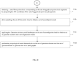
- the step of generating the set of pose graphs comprises, obtaining a set of first point cloud corresponding to the set of tagged sub point cloud segments by projecting the XY coordinate of the set of tagged sub point cloud segments; down sampling the set of first point cloud to obtain a set of second point cloud; applying the Gaussian mixture model technique on the set of second point cloud to obtain a set of gaussian clusters and a set of gaussian means and performing a topological based data analysis on the set of gaussian clusters and the set of gaussian means to generate the set of pose graphs.
- a computer program product comprising a non-transitory computer readable medium having a computer readable program embodied therein, wherein the computer readable program, when executed on a computing device causes the computing device for ambient intelligence based user interaction by receiving (i) a set of raw point cloud from a Light Detection and Ranging (LiDAR) sensor (ii) a set of XY coordinates and (iii) a set of tag IDs corresponding to a set of users captured from a real time locating system sensor in an ambient environment for user interaction; obtaining a set of point cloud by filtering the set of raw point cloud; computing a set of point clusters from the set of point cloud using a segmentation algorithm, wherein each point cluster comprises a cluster center and an XY coordinate; converting the set of point clusters to a set of tagged sub point clouds based on a cost matrix and a data association algorithm; segmenting the set of tagged sub point clouds to obtain a set of tagged sub point
- the embodiments of the present disclosure provides a user interaction system based on hands-free paradigm using principles of ambient intelligence.
- the user interaction system enables smart spaces where content and interfaces can be personalized to a user, or a group of users based on context derived from location, proximity and so on.
- a smart environment where a user can operate a set of instruments using gesture and speech has been considered for the disclosed method.
- a set of terminals may be shared between multiple users and hence, location context is used to understand which user is operating the terminal and based on that personalized content and user interface (UI) is loaded.
- UI user interface
- a wearable Ultra-wideband (UWB) tag is used for location and identity.
- UWB Ultra-wideband
- the embodiments of the present disclosure provide a robust any body part detection method using Light Detection and Ranging (LiDAR) sensor data aided by a real time locating system sensor data positioning.
- LiDAR Light Detection and Ranging
- UWB Ultra-wideband
- the disclosed method provides a body part detection method using LiDAR that avoids interference from neighborhood using location context.
- the current disclosure is explained on hand gesture recognition using LiDAR; however, it may be noted that it is not limited to hand gesture detection only but any body part detection of the user.
- the present disclosure is a multimodal user interaction wherein any number of multimodal sensor data (audio, vision based and so on) can be fused and used for user interaction systems.
- the existing prior methods are intrusive however, the disclosed method is non-intrusive.
- the user interaction system considered in the present disclosure is a touchless user interaction system.
- FIG. 1 through FIG. 9 where similar reference characters denote corresponding features consistently throughout the figures, there are shown preferred embodiments and these embodiments are described in the context of the following exemplary system and/or method.
- FIG. 1 illustrates an exemplary block diagram of a system 100 for ambient intelligence based user interaction according to some embodiments of the present disclosure.
- the system 100 includes one or more processors 102, communication interface device(s) or input/output (I/O) interface(s) 106, and one or more data storage devices or memory 104 operatively coupled to the one or more processors 102.
- the one or more processors 102 that are hardware processors can be implemented as one or more microprocessors, microcomputers, microcontrollers, digital signal processors, central processing units, state machines, graphics controllers, logic circuitries, and/or any devices that manipulate signals based on operational instructions.
- the processor(s) are configured to fetch and execute computer-readable instructions stored in the memory.
- the expressions 'processors' and ⁇ hardware processors' may be used interchangeably.
- the system 100 can be implemented in a variety of computing systems, such as laptop computers, notebooks, hand-held devices, workstations, mainframe computers, servers, a network cloud and the like.
- the I/O interface (s) 106 may include a variety of software and hardware interfaces, for example, a web interface, a graphical user interface, and the like and can facilitate multiple communications within a wide variety of networks and protocol types, including wired networks, for example, LAN, cable, etc., and wireless networks, such as WLAN, cellular, or satellite.
- the I/O interface(s) can include one or more ports for connecting a number of devices to one another or to another server.
- the memory 104 may include any computer-readable medium known in the art including, for example, volatile memory, such as static random access memory (SRAM) and dynamic random access memory (DRAM), and/or non-volatile memory, such as read only memory (ROM), erasable programmable ROM, flash memories, hard disks, optical disks, and magnetic tapes.
- volatile memory such as static random access memory (SRAM) and dynamic random access memory (DRAM)
- DRAM dynamic random access memory
- non-volatile memory such as read only memory (ROM), erasable programmable ROM, flash memories, hard disks, optical disks, and magnetic tapes.
- FIG. 2 is an exemplary block diagram of the system 100 for ambient intelligence based user interaction in accordance with some embodiments of the present disclosure.
- a raw point cloud 202 corresponding to a set of users is obtained from a 3D LiDAR sensor. Further the raw point cloud 202 is denoised by removing the noise to obtain a denoised point cloud 204. Then, segmentation 206 is performed on the denoised point cloud to obtain segmented point cloud. Further a cost matrix 208 is obtained using the UWB data (position coordinates of users) and the segmented point cloud. This cost matrix is used for further mapping the UWB data and the LiDAR data by performing a Lidar UWB data association 210 to obtain mapped segmented point cloud.
- part segmentation 212 is done on the mapped segmented point cloud to obtain point cloud corresponding to human parts and then pose graphs 214 corresponding to these point clouds are generated for utilizing for user interaction.
- FIG. 2 is explained in a detailed manner using the steps illustrated in FIG.3A through FIG.3C .
- FIG. 3A through FIG.3C is an exemplary flow diagram illustrating a method for ambient intelligence based user interaction according to some embodiments of the present disclosure.
- the one or more processors 102 are configured to receive at step 302, (i) a set of raw point cloud from a Light Detection and Ranging (LiDAR) sensor (ii) a set of XY coordinates and (iii) a set of tag IDs corresponding to a set of users captured from a real time locating system sensor in an ambient environment for user interaction. Multiple frames of the sparse LiDAR data are clubbed to generate a near-dense raw point cloud.
- LiDAR Light Detection and Ranging
- the real time locating system sensor such as an Ultra-wideband (UWB) sensor is used for capturing the set of XY coordinates and the set of tag IDs corresponding to the set of users. It is not limited to UWB sensors, however any other real time locating system sensor can be used as well. Prior methods are being used for localization and capturing XY coordinates of the set of users.
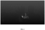
- FIG. 4 depicts an example of a raw point cloud from a LiDAR sensor in accordance with some embodiments of the present disclosure.
- the one or more processors 102 are configured to obtain at step 304, a set of point cloud by filtering the set of raw point cloud.
- the set of raw point cloud is filtered by removing noise and background information from the set of raw point cloud.
- Any state-of-the-art methods for removal of noise and background information can be used for this step.
- filter-based methods, optimization-based methods and deep learning-based methods can be used for this step.
- a statistical noise filter with parameters as neighborhood points, standard deviation and a threshold has been used.
- FIG. 5 depicts an example of point cloud after noise removal from the raw point cloud in accordance with some embodiments of the present disclosure.
- the one or more processors 102 are configured to compute at step 306, a set of point clusters from the set of point cloud using a segmentation algorithm.
- each point cluster from the set of point clusters comprises a cluster center and an XY coordinate.
- an octree segmentation algorithm with parameters like octree grid step, minimum points per component have been used.
- FIG. 6 depicts an example of point cloud associated with a segmented body part in accordance with some embodiments of the present disclosure.
- the one or more processors 102 are configured to convert at step 308, the set of point clusters to a set of tagged sub point clouds based on a cost matrix and a data association algorithm.
- the step of converting the set of point clusters to a set of tagged sub point clouds is performed using a set of steps.
- the main task is to map the set of point clusters to the point clouds and tagging them accordingly.
- the tagging of point clouds is done using the Euclidean distances between the UWB location coordinates and the estimated cluster centers of the set of point clusters.
- a Euclidean distance vector is computed between the set of XY coordinates and the set of cluster centers.
- the cost matrix is obtained from the computed Euclidean distance vector and the set of tag IDs.
- the set of tagged sub point clouds is obtained by applying the data association algorithm on the cost matrix.
- the data association algorithm such as Munkres optimization algorithm is being used here LJWB/LiDAR data association. However, it may not be limited to Munkres optimization algorithm, any data association algorithm can be used.
- Table 1 shows the cost matrix obtained from a set of cluster centers C i and UWB location coordinates L i . The cost values are estimated based on the Euclidean distance between the cluster centers and the UWB location.
- the one or more processors 102 are configured to segment at step 310, the set of tagged sub point clouds to obtain a set of tagged sub point cloud segments corresponding to a plurality of body parts of the set of users. This is done using the XY coordinate associated with each user.
- FIG. 7 depicts an example of a hand point cloud in accordance with some embodiments of the present disclosure.
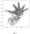
- FIG. 8 depicts an example of projection of hand point cloud on XY plane in accordance with some embodiments of the present disclosure.
- the one or more processors 102 are configured to generate at step 312, a set of pose graphs corresponding to the set of tagged sub point cloud segments using a Gaussian Mixture Model technique, wherein the pose graph is being utilized for user.
- a GMM-TDA (Topological data analysis) based lightweight method has been used to generate hand pose graphs for each tagged cluster.
- the set of steps for generating the set of pose graphs corresponding to the set of tagged sub point cloud segments is being explained below.
- a set of first point cloud corresponding to the set of tagged sub point cloud segments is obtained by projecting the XY coordinate of the set of tagged sub point cloud segments.
- step 312b the set of first point cloud is down sampled to obtain a set of second point cloud.
- the Gaussian mixture model technique is applied at step 312c on the set of second point cloud to obtain a set of gaussian clusters and a set of gaussian means.
- step 312d a topological based data analysis is performed on the set of gaussian clusters and the set of gaussian means to generate the set of pose graphs.
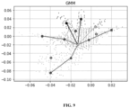
- FIG. 9 depicts an example of a pose graph generated using Gaussian Mixture Model technique in accordance with some embodiments of the present disclosure.
- Algorithm 1 The algorithm for pre-processing the raw point cloud which depicts in the steps 302 to 310 is provided below as Algorithm 1.
- Algorithm 2 The algorithm for generating pose graphs which depicts in the step 312 is provided below as Algorithm 2.
- the embodiments of present disclosure provide an ambient intelligence based user interaction system.
- the embodiments provide a method for mapping a set of point clouds associated with multiple users to a set of UWB location coordinates using a cost matrix and data association algorithm.
- the mapped point clouds are then further segmented to obtain a set of segmented point clouds associated to body parts of users. And further to develop pose graphs which is being utilized for user interaction systems.
- Such computer-readable storage means contain program-code means for implementation of one or more steps of the method, when the program runs on a server or mobile device or any suitable programmable device.
- the hardware device can be any kind of device which can be programmed including e.g., any kind of computer like a server or a personal computer, or the like, or any combination thereof.
- the device may also include means which could be e.g., hardware means like e.g., an application-specific integrated circuit (ASIC), a field-programmable gate array (FPGA), or a combination of hardware and software means, e.g., an ASIC and an FPGA, or at least one microprocessor and at least one memory with software processing components located therein.
- the means can include both hardware means and software means.
- the method embodiments described herein could be implemented in hardware and software.
- the device may also include software means. Alternatively, the embodiments may be implemented on different hardware devices, e.g., using a plurality of CPUs.
- the embodiments herein can comprise hardware and software elements.
- the embodiments that are implemented in software include but are not limited to, firmware, resident software, microcode, etc.
- the functions performed by various components described herein may be implemented in other components or combinations of other components.
- a computer-usable or computer readable medium can be any apparatus that can comprise, store, communicate, propagate, or transport the program for use by or in connection with the instruction execution system, apparatus, or device.
- a computer-readable storage medium refers to any type of physical memory on which information or data readable by a processor may be stored.
- a computer-readable storage medium may store instructions for execution by one or more processors, including instructions for causing the processor(s) to perform steps or stages consistent with the embodiments described herein.
- the term "computer-readable medium” should be understood to include tangible items and exclude carrier waves and transient signals, i.e., be non-transitory. Examples include random access memory (RAM), read-only memory (ROM), volatile memory, nonvolatile memory, hard drives, CD ROMs, DVDs, flash drives, disks, and any other known physical storage media.
Landscapes
- Engineering & Computer Science (AREA)
- Physics & Mathematics (AREA)
- General Physics & Mathematics (AREA)
- Theoretical Computer Science (AREA)
- Computer Vision & Pattern Recognition (AREA)
- Human Computer Interaction (AREA)
- Multimedia (AREA)
- General Engineering & Computer Science (AREA)
- Computer Networks & Wireless Communication (AREA)
- Electromagnetism (AREA)
- Radar, Positioning & Navigation (AREA)
- Remote Sensing (AREA)
- Social Psychology (AREA)
- Psychiatry (AREA)
- General Health & Medical Sciences (AREA)
- Health & Medical Sciences (AREA)
- User Interface Of Digital Computer (AREA)
Abstract
Description
- The present application claims priority to
Indian patent application no. 202221055450, filed on 28 September 2022 - The disclosure herein generally relates to user interaction, and, more particularly, to method and system for ambient intelligence based user interaction.
- A system based on ambient intelligence is a class of systems that combine multiple modalities like vision, speech and wearables to provide seamless intelligence to users. Ambient Intelligence is new multidisciplinary paradigm which changes the relation between humans, technology and the environment they live in. Ambient intelligence tends to change some human's activities by automating certain task. A smart environment is where a user can operate a set of instruments in the surrounding using gesture and speech. To enable such smart environment, a combination of technologies is needed to work in tandem to enable ubiquitous interactions. In the smart environment, a set of terminals may be shared between multiple users. The users might be wearing masks and lab protective gowns which will render their faces illegible to a vision based system. Hence face recognition and/or iris scanning cannot be used in these cases with a robust outcome.
- In case of several user interaction environments such as operating rooms, demo centers which provide hands-free demos to customers/clients, known methods such as infrared (IR) based methods, radar based methods are not susceptible to be used. IR based methods are sensitive to ambient temperature in a lab environment. Haptic gloves cannot be used in sterile and lab environments as sensors may themselves get contaminated or cause contamination. Radar based techniques are susceptible to noise from metallic surfaces and from ambient radio waves. They are also limited by their measured range. Vision based techniques are dependent on ambient lighting and when hand has no color diversity owing to suite etc., they may not work properly. In privacy protected spaces such as operating rooms, clean-rooms and other private indoor spaces vision based techniques restricts its utility. For few user interaction systems proximity of users is important for detecting their presence, and hence proximity sensors need to be utilized. In some prior works for user interaction, radar based gesture recognition involves training to learn a template of radar signatures from a small, defined set of users carrying out different gestures. This approach is prone to physical similarities between two users and depends on gait differences for person identification.
- Embodiments of the present disclosure present technological improvements as solutions to one or more of the above-mentioned technical problems recognized by the inventors in conventional systems. For example, in one embodiment, a method for ambient intelligence based user interaction is provided. The method includes: receiving (i) a set of raw point cloud from a Light Detection and Ranging (LiDAR) sensor (ii) a set of XY coordinates and (iii) a set of tag IDs corresponding to a set of users captured from a real time locating system sensor in an ambient environment for user interaction; obtaining a set of point cloud by filtering the set of raw point cloud; computing a set of point clusters from the set of point cloud using a segmentation algorithm, wherein each point cluster comprises a cluster center and an XY coordinate; converting the set of point clusters to a set of tagged sub point clouds based on a cost matrix and a data association algorithm; segmenting the set of tagged sub point clouds to obtain a set of tagged sub point cloud segments corresponding to a plurality of body parts of the set of users; and generating a set of pose graphs corresponding to the set of tagged sub point cloud segments using a Gaussian Mixture Model technique, wherein the pose graph is being utilized for user interaction.
- In another aspect, a system for ambient intelligence based user interaction is provided. The system comprises memory storing instructions; one or more communication interfaces; and one or more hardware processors coupled to the memory via the one or more communication interfaces, wherein the one or more hardware processors are configured by the instructions to receive (i) a set of raw point cloud from a Light Detection and Ranging (LiDAR) sensor (ii) a set of XY coordinates and (iii) a set of tag IDs corresponding to a set of users captured from a real time locating system sensor in an ambient environment for user interaction; obtain a set of point cloud by filtering the set of raw point cloud; compute a set of point clusters from the set of point cloud using a segmentation algorithm, wherein each point cluster comprises a cluster center and an XY coordinate; convert the set of point clusters to a set of tagged sub point clouds based on a cost matrix and a data association algorithm; segment the set of tagged sub point clouds to obtain a set of tagged sub point cloud segments corresponding to a plurality of body parts of the set of users; and generate a set of pose graphs corresponding to the set of tagged sub point cloud segments using a Gaussian Mixture Model technique, wherein the pose graph is being utilized for user interaction.
- In an embodiment, wherein the step of converting the set of point clusters to the set of tagged sub point clouds comprises computing a Euclidean distance vector between the set of XY coordinates and the set of cluster centers; obtaining the cost matrix from the Euclidean distance vector and the set of tag IDs; and obtaining the set of tagged sub point clouds by applying the data association algorithm on the cost matrix.
- In an embodiment, wherein the set of raw point cloud is filtered by removing noise and background information from the set of raw point cloud.
- In an embodiment, wherein the user interaction is a touchless user interaction.
- In an embodiment, wherein the step of generating the set of pose graphs comprises, obtaining a set of first point cloud corresponding to the set of tagged sub point cloud segments by projecting the XY coordinate of the set of tagged sub point cloud segments; down sampling the set of first point cloud to obtain a set of second point cloud; applying the Gaussian mixture model technique on the set of second point cloud to obtain a set of gaussian clusters and a set of gaussian means and performing a topological based data analysis on the set of gaussian clusters and the set of gaussian means to generate the set of pose graphs.
- In yet another aspect, there is provided a computer program product comprising a non-transitory computer readable medium having a computer readable program embodied therein, wherein the computer readable program, when executed on a computing device causes the computing device for ambient intelligence based user interaction by receiving (i) a set of raw point cloud from a Light Detection and Ranging (LiDAR) sensor (ii) a set of XY coordinates and (iii) a set of tag IDs corresponding to a set of users captured from a real time locating system sensor in an ambient environment for user interaction; obtaining a set of point cloud by filtering the set of raw point cloud; computing a set of point clusters from the set of point cloud using a segmentation algorithm, wherein each point cluster comprises a cluster center and an XY coordinate; converting the set of point clusters to a set of tagged sub point clouds based on a cost matrix and a data association algorithm; segmenting the set of tagged sub point clouds to obtain a set of tagged sub point cloud segments corresponding to a plurality of body parts of the set of users; and generating a set of pose graphs corresponding to the set of tagged sub point cloud segments using a Gaussian Mixture Model technique, wherein the pose graph is being utilized for user interaction.
- It is to be understood that both the foregoing general description and the following detailed description are exemplary and explanatory only and are not restrictive of the invention, as claimed.
- The accompanying drawings, which are incorporated in and constitute a part of this disclosure, illustrate exemplary embodiments and, together with the description, serve to explain the disclosed principles:
-
FIG. 1 illustrates an exemplary block diagram of a system for ambient intelligence based user interaction according to some embodiments of the present disclosure. -
FIG. 2 is an exemplary block diagram of the system for ambient intelligence based user interaction in accordance with some embodiments of the present disclosure. -
FIG. 3A through FIG.3C is an exemplary flow diagram illustrating a method for ambient intelligence based user interaction according to some embodiments of the present disclosure. -
FIG. 4 depicts an example of a raw point cloud from a Light Detection and Ranging (LiDAR) sensor in accordance with some embodiments of the present disclosure. -
FIG. 5 depicts an example of point cloud after noise removal from the raw point cloud in accordance with some embodiments of the present disclosure. -
FIG. 6 depicts an example of point cloud associated with a segmented body part in accordance with some embodiments of the present disclosure. -
FIG. 7 depicts an example of a hand point cloud in accordance with some embodiments of the present disclosure. -
FIG. 8 depicts an example of projection of hand point cloud on XY plane in accordance with some embodiments of the present disclosure. -
FIG. 9 depicts an example of a pose graph generated using Gaussian Mixture Model technique in accordance with some embodiments of the present disclosure. - Exemplary embodiments are described with reference to the accompanying drawings. In the figures, the left-most digit(s) of a reference number identifies the figure in which the reference number first appears. Wherever convenient, the same reference numbers are used throughout the drawings to refer to the same or like parts. While examples and features of disclosed principles are described herein, modifications, adaptations, and other implementations are possible without departing from the scope of the disclosed embodiments.
- The embodiments of the present disclosure, provides a user interaction system based on hands-free paradigm using principles of ambient intelligence. The user interaction system enables smart spaces where content and interfaces can be personalized to a user, or a group of users based on context derived from location, proximity and so on. A smart environment where a user can operate a set of instruments using gesture and speech has been considered for the disclosed method. A set of terminals may be shared between multiple users and hence, location context is used to understand which user is operating the terminal and based on that personalized content and user interface (UI) is loaded. A wearable Ultra-wideband (UWB) tag is used for location and identity. Also, it has been considered that the users might be wearing masks and lab protective gowns which will render their faces illegible to a vision based system and hence face recognition and/or iris scanning cannot be used in these cases with a robust outcome.
- The embodiments of the present disclosure provide a robust any body part detection method using Light Detection and Ranging (LiDAR) sensor data aided by a real time locating system sensor data positioning. In the current disclosure, Ultra-wideband (UWB) sensors are used for location positioning of the users. The disclosed method provides a body part detection method using LiDAR that avoids interference from neighborhood using location context. The current disclosure is explained on hand gesture recognition using LiDAR; however, it may be noted that it is not limited to hand gesture detection only but any body part detection of the user. The present disclosure is a multimodal user interaction wherein any number of multimodal sensor data (audio, vision based and so on) can be fused and used for user interaction systems. The existing prior methods are intrusive however, the disclosed method is non-intrusive. The user interaction system considered in the present disclosure is a touchless user interaction system.
- Referring now to the drawings, and more particularly to
FIG. 1 through FIG. 9 , where similar reference characters denote corresponding features consistently throughout the figures, there are shown preferred embodiments and these embodiments are described in the context of the following exemplary system and/or method. -
FIG. 1 illustrates an exemplary block diagram of asystem 100 for ambient intelligence based user interaction according to some embodiments of the present disclosure. In an embodiment, thesystem 100 includes one ormore processors 102, communication interface device(s) or input/output (I/O) interface(s) 106, and one or more data storage devices ormemory 104 operatively coupled to the one ormore processors 102. The one ormore processors 102 that are hardware processors can be implemented as one or more microprocessors, microcomputers, microcontrollers, digital signal processors, central processing units, state machines, graphics controllers, logic circuitries, and/or any devices that manipulate signals based on operational instructions. Among other capabilities, the processor(s) are configured to fetch and execute computer-readable instructions stored in the memory. In the context of the present disclosure, the expressions 'processors' and `hardware processors' may be used interchangeably. In an embodiment, thesystem 100 can be implemented in a variety of computing systems, such as laptop computers, notebooks, hand-held devices, workstations, mainframe computers, servers, a network cloud and the like. - The I/O interface (s) 106 may include a variety of software and hardware interfaces, for example, a web interface, a graphical user interface, and the like and can facilitate multiple communications within a wide variety of networks and protocol types, including wired networks, for example, LAN, cable, etc., and wireless networks, such as WLAN, cellular, or satellite. In an embodiment, the I/O interface(s) can include one or more ports for connecting a number of devices to one another or to another server.
- The
memory 104 may include any computer-readable medium known in the art including, for example, volatile memory, such as static random access memory (SRAM) and dynamic random access memory (DRAM), and/or non-volatile memory, such as read only memory (ROM), erasable programmable ROM, flash memories, hard disks, optical disks, and magnetic tapes. -
FIG. 2 is an exemplary block diagram of thesystem 100 for ambient intelligence based user interaction in accordance with some embodiments of the present disclosure. Araw point cloud 202 corresponding to a set of users is obtained from a 3D LiDAR sensor. Further theraw point cloud 202 is denoised by removing the noise to obtain adenoised point cloud 204. Then,segmentation 206 is performed on the denoised point cloud to obtain segmented point cloud. Further acost matrix 208 is obtained using the UWB data (position coordinates of users) and the segmented point cloud. This cost matrix is used for further mapping the UWB data and the LiDAR data by performing a LidarUWB data association 210 to obtain mapped segmented point cloud. Further,part segmentation 212 is done on the mapped segmented point cloud to obtain point cloud corresponding to human parts and then posegraphs 214 corresponding to these point clouds are generated for utilizing for user interaction.FIG. 2 is explained in a detailed manner using the steps illustrated inFIG.3A through FIG.3C . -
FIG. 3A through FIG.3C is an exemplary flow diagram illustrating a method for ambient intelligence based user interaction according to some embodiments of the present disclosure. In an embodiment of the present disclosure, the one ormore processors 102 are configured to receive atstep 302, (i) a set of raw point cloud from a Light Detection and Ranging (LiDAR) sensor (ii) a set of XY coordinates and (iii) a set of tag IDs corresponding to a set of users captured from a real time locating system sensor in an ambient environment for user interaction. Multiple frames of the sparse LiDAR data are clubbed to generate a near-dense raw point cloud. The real time locating system sensor such as an Ultra-wideband (UWB) sensor is used for capturing the set of XY coordinates and the set of tag IDs corresponding to the set of users. It is not limited to UWB sensors, however any other real time locating system sensor can be used as well. Prior methods are being used for localization and capturing XY coordinates of the set of users.FIG. 4 depicts an example of a raw point cloud from a LiDAR sensor in accordance with some embodiments of the present disclosure. - In an embodiment of the present disclosure, the one or
more processors 102 are configured to obtain atstep 304, a set of point cloud by filtering the set of raw point cloud. The set of raw point cloud is filtered by removing noise and background information from the set of raw point cloud. Any state-of-the-art methods for removal of noise and background information can be used for this step. For example, filter-based methods, optimization-based methods and deep learning-based methods. In the present disclosure, a statistical noise filter with parameters as neighborhood points, standard deviation and a threshold has been used.FIG. 5 depicts an example of point cloud after noise removal from the raw point cloud in accordance with some embodiments of the present disclosure. - In an embodiment of the present disclosure, the one or
more processors 102 are configured to compute atstep 306, a set of point clusters from the set of point cloud using a segmentation algorithm. Here, each point cluster from the set of point clusters comprises a cluster center and an XY coordinate. In the present disclosure, an octree segmentation algorithm with parameters like octree grid step, minimum points per component have been used.FIG. 6 depicts an example of point cloud associated with a segmented body part in accordance with some embodiments of the present disclosure. - In an embodiment of the present disclosure, the one or
more processors 102 are configured to convert atstep 308, the set of point clusters to a set of tagged sub point clouds based on a cost matrix and a data association algorithm. The step of converting the set of point clusters to a set of tagged sub point clouds is performed using a set of steps. The main task is to map the set of point clusters to the point clouds and tagging them accordingly. The tagging of point clouds is done using the Euclidean distances between the UWB location coordinates and the estimated cluster centers of the set of point clusters. Atstep 308a, a Euclidean distance vector is computed between the set of XY coordinates and the set of cluster centers. Further atstep 308b, the cost matrix is obtained from the computed Euclidean distance vector and the set of tag IDs. Finally, atstep 308c, the set of tagged sub point clouds is obtained by applying the data association algorithm on the cost matrix. The data association algorithm such as Munkres optimization algorithm is being used here LJWB/LiDAR data association. However, it may not be limited to Munkres optimization algorithm, any data association algorithm can be used. For example, Table 1 shows the cost matrix obtained from a set of cluster centers Ci and UWB location coordinates Li. The cost values are estimated based on the Euclidean distance between the cluster centers and the UWB location.Table 1 C1 C2 C3 C4 C5 L1 12 15 13 14 15 L2 16 18 15 14 16 L3 18 16 15 18 20 L4 15 20 18 17 19 L5 16 15 18 14 15 - C1 -> L4
- C2 -> L3
- C3 -> L1
- C4 -> L2
- C5 -> L5
- In an embodiment of the present disclosure, the one or
more processors 102 are configured to segment atstep 310, the set of tagged sub point clouds to obtain a set of tagged sub point cloud segments corresponding to a plurality of body parts of the set of users. This is done using the XY coordinate associated with each user.FIG. 7 depicts an example of a hand point cloud in accordance with some embodiments of the present disclosure.FIG. 8 depicts an example of projection of hand point cloud on XY plane in accordance with some embodiments of the present disclosure. - In an embodiment of the present disclosure, the one or
more processors 102 are configured to generate atstep 312, a set of pose graphs corresponding to the set of tagged sub point cloud segments using a Gaussian Mixture Model technique, wherein the pose graph is being utilized for user. In the present disclosure, a GMM-TDA (Topological data analysis) based lightweight method has been used to generate hand pose graphs for each tagged cluster. The set of steps for generating the set of pose graphs corresponding to the set of tagged sub point cloud segments is being explained below. Atstep 312a, a set of first point cloud corresponding to the set of tagged sub point cloud segments is obtained by projecting the XY coordinate of the set of tagged sub point cloud segments. Further atstep 312b, the set of first point cloud is down sampled to obtain a set of second point cloud. The Gaussian mixture model technique is applied atstep 312c on the set of second point cloud to obtain a set of gaussian clusters and a set of gaussian means. Finally atstep 312d, a topological based data analysis is performed on the set of gaussian clusters and the set of gaussian means to generate the set of pose graphs.FIG. 9 depicts an example of a pose graph generated using Gaussian Mixture Model technique in accordance with some embodiments of the present disclosure. - The algorithm for pre-processing the raw point cloud which depicts in the
steps 302 to 310 is provided below as Algorithm 1. The algorithm for generating pose graphs which depicts in thestep 312 is provided below as Algorithm 2.


- EXPERIMENTATION RESULTS: During experimentation, even with use of low cost and sparse LiDAR, the fingers of the users were clustered and pose graph was generated from the relevant cluster centers. Now, the co-ordinates of these nodes in the pose graph can be used for tracking hand key points. The same, when mapped to a set of gestures in a look-up table/database enables lightweight and swifter gesture recognition. Furthermore, the inclusion of location prior and LiDAR/UWB data association channelizes the data processing for individual sub point clouds, reducing the complexity in multi-user scenario. Hence the disclosed method provides a contextual, ubiquitous, personalized, and hands-free interface to operate instruments in a smart space, using principles of ambient intelligence.
- The written description describes the subject matter herein to enable any person skilled in the art to make and use the embodiments. The scope of the subject matter embodiments is defined by the claims and may include other modifications that occur to those skilled in the art. Such other modifications are intended to be within the scope of the claims if they have similar elements that do not differ from the literal language of the claims or if they include equivalent elements with insubstantial differences from the literal language of the claims.
- The embodiments of present disclosure provide an ambient intelligence based user interaction system. The embodiments provide a method for mapping a set of point clouds associated with multiple users to a set of UWB location coordinates using a cost matrix and data association algorithm. The mapped point clouds are then further segmented to obtain a set of segmented point clouds associated to body parts of users. And further to develop pose graphs which is being utilized for user interaction systems.
- It is to be understood that the scope of the protection is extended to such a program and in addition to a computer-readable means having a message therein; such computer-readable storage means contain program-code means for implementation of one or more steps of the method, when the program runs on a server or mobile device or any suitable programmable device. The hardware device can be any kind of device which can be programmed including e.g., any kind of computer like a server or a personal computer, or the like, or any combination thereof. The device may also include means which could be e.g., hardware means like e.g., an application-specific integrated circuit (ASIC), a field-programmable gate array (FPGA), or a combination of hardware and software means, e.g., an ASIC and an FPGA, or at least one microprocessor and at least one memory with software processing components located therein. Thus, the means can include both hardware means and software means. The method embodiments described herein could be implemented in hardware and software. The device may also include software means. Alternatively, the embodiments may be implemented on different hardware devices, e.g., using a plurality of CPUs.
- The embodiments herein can comprise hardware and software elements. The embodiments that are implemented in software include but are not limited to, firmware, resident software, microcode, etc. The functions performed by various components described herein may be implemented in other components or combinations of other components. For the purposes of this description, a computer-usable or computer readable medium can be any apparatus that can comprise, store, communicate, propagate, or transport the program for use by or in connection with the instruction execution system, apparatus, or device.
- The illustrated steps are set out to explain the exemplary embodiments shown, and it should be anticipated that ongoing technological development will change the manner in which particular functions are performed. These examples are presented herein for purposes of illustration, and not limitation. Further, the boundaries of the functional building blocks have been arbitrarily defined herein for the convenience of the description. Alternative boundaries can be defined so long as the specified functions and relationships thereof are appropriately performed. Alternatives (including equivalents, extensions, variations, deviations, etc., of those described herein) will be apparent to persons skilled in the relevant art(s) based on the teachings contained herein. Such alternatives fall within the scope of the disclosed embodiments. Also, the words "comprising," "having," "containing," and "including," and other similar forms are intended to be equivalent in meaning and be open ended in that an item or items following any one of these words is not meant to be an exhaustive listing of such item or items, or meant to be limited to only the listed item or items. It must also be noted that as used herein and in the appended claims, the singular forms "a," "an," and "the" include plural references unless the context clearly dictates otherwise.
- Furthermore, one or more computer-readable storage media may be utilized in implementing embodiments consistent with the present disclosure. A computer-readable storage medium refers to any type of physical memory on which information or data readable by a processor may be stored. Thus, a computer-readable storage medium may store instructions for execution by one or more processors, including instructions for causing the processor(s) to perform steps or stages consistent with the embodiments described herein. The term "computer-readable medium" should be understood to include tangible items and exclude carrier waves and transient signals, i.e., be non-transitory. Examples include random access memory (RAM), read-only memory (ROM), volatile memory, nonvolatile memory, hard drives, CD ROMs, DVDs, flash drives, disks, and any other known physical storage media.
- It is intended that the disclosure and examples be considered as exemplary only, with a true scope of disclosed embodiments being indicated by the following claims.
Claims (15)
- A processor implemented method (300) comprising the steps of:receiving (302), via one or more hardware processors, (i) a set of raw point cloud from a Light Detection and Ranging (LiDAR) sensor (ii) a set of XY coordinates and (iii) a set of tag IDs corresponding to a set of users captured from a real time locating system sensor in an ambient environment for user interaction;obtaining (304), via the one or more hardware processors, a set of point cloud by filtering the set of raw point cloud;computing (306), via the one or more hardware processors, a set of point clusters from the set of point cloud using a segmentation algorithm, wherein each point cluster comprises a cluster center and an XY coordinate;converting (308), via the one or more hardware processors, the set of point clusters to a set of tagged sub point clouds based on a cost matrix and a data association algorithm;segmenting (310), via the one or more hardware processors, the set of tagged sub point clouds to obtain a set of tagged sub point cloud segments corresponding to a plurality of body parts of the set of users; andgenerating (312), via the one or more hardware processors, a set of pose graphs corresponding to the set of tagged sub point cloud segments using a Gaussian Mixture Model technique, wherein the pose graph is being utilized for user interaction.
- The method of claim 1, wherein the step of converting the set of point clusters to the set of tagged sub point clouds comprise:computing a Euclidean distance vector between the set of XY coordinates and the set of cluster centers (308a);obtaining the cost matrix from the Euclidean distance vector and the set of tag IDs (308b); andobtaining the set of tagged sub point clouds by applying the data association algorithm on the cost matrix (308c).
- The method of claim 1, wherein the set of raw point cloud is filtered by removing noise and background information from the set of raw point cloud.
- The method of claim 1, wherein the user interaction is a touchless user interaction.
- The method of claim 1, wherein the step of generating the set of pose graphs comprises:obtaining a set of first point cloud corresponding to the set of tagged sub point cloud segments by projecting the XY coordinate of the set of tagged sub point cloud segments (312a);down sampling the set of first point cloud to obtain a set of second point cloud (312b);applying the Gaussian mixture model technique on the set of second point cloud to obtain a set of gaussian clusters and a set of gaussian means (312c); andperforming a topological based data analysis on the set of gaussian clusters and the set of gaussian means to generate the set of pose graphs (312d).
- A system (100), comprising:a memory (104) storing instructions;one or more communication interfaces (106); andone or more hardware processors (102) coupled to the memory (104) via the one or more communication interfaces (106), wherein the one or more hardware processors (102) are configured by the instructions to:receive (i) a set of raw point cloud from a Light Detection and Ranging (LiDAR) sensor (ii) a set of XY coordinates and (iii) a set of tag IDs corresponding to a set of users captured from a real time locating system sensor in an ambient environment for user interaction;obtain a set of point cloud by filtering the set of raw point cloud;compute a set of point clusters from the set of point cloud using a segmentation algorithm, wherein each point cluster comprises a cluster center and an XY coordinate;convert the set of point clusters to a set of tagged sub point clouds based on a cost matrix and a data association algorithm;segment the set of tagged sub point clouds to obtain a set of tagged sub point cloud segments corresponding to a plurality of body parts of the set of users; andgenerate a set of pose graphs corresponding to the set of tagged sub point cloud segments using a Gaussian Mixture Model technique, wherein the pose graph is being utilized for user interaction.
- The system of claim 6, wherein the one or more hardware processors are configured to convert the set of point clusters to the set of tagged sub point clouds by:computing a Euclidean distance vector between the set of XY coordinates and the set of cluster centers;obtaining the cost matrix from the Euclidean distance vector and the set of tag IDs; andobtaining the set of tagged sub point clouds by applying the data association algorithm on the cost matrix.
- The system of claim 6, wherein the set of raw point cloud is filtered by removing noise and background information from the set of raw point cloud.
- The system of claim 6, wherein the user interaction is a touchless user interaction.
- The system of claim 6, wherein the one or more hardware processors are configured to generate the set of pose graphs by,obtaining a set of first point cloud corresponding to the set of tagged sub point cloud segments by projecting the XY coordinate of the set of tagged sub point cloud segments;down sampling the set of first point cloud to obtain a set of second point cloud;applying the Gaussian mixture model technique on the set of second point cloud to obtain a set of gaussian clusters and a set of gaussian means; andperforming a topological based data analysis on the set of gaussian clusters and the set of gaussian means to generate the set of pose graphs.
- One or more non-transitory machine-readable information storage mediums comprising one or more instructions which when executed by one or more hardware processors cause:receiving, (i) a set of raw point cloud from a Light Detection and Ranging (LiDAR) sensor (ii) a set of XY coordinates and (iii) a set of tag IDs corresponding to a set of users captured from a real time locating system sensor in an ambient environment for user interaction;obtaining a set of point cloud by filtering the set of raw point cloud;computing a set of point clusters from the set of point cloud using a segmentation algorithm, wherein each point cluster comprises a cluster center and an XY coordinate;converting the set of point clusters to a set of tagged sub point clouds based on a cost matrix and a data association algorithm;segmenting the set of tagged sub point clouds to obtain a set of tagged sub point cloud segments corresponding to a plurality of body parts of the set of users; andgenerating a set of pose graphs corresponding to the set of tagged sub point cloud segments using a Gaussian Mixture Model technique, wherein the pose graph is being utilized for user interaction.
- The one or more non-transitory machine-readable information storage mediums of claim 11, wherein the step of converting the set of point clusters to the set of tagged sub point clouds comprises:computing a Euclidean distance vector between the set of XY coordinates and the set of cluster centers;obtaining the cost matrix from the Euclidean distance vector and the set of tag IDs; andobtaining the set of tagged sub point clouds by applying the data association algorithm on the cost matrix.
- The one or more non-transitory machine-readable information storage mediums of claim 11, wherein the set of raw point cloud is filtered by removing noise and background information from the set of raw point cloud.
- The one or more non-transitory machine-readable information storage mediums of claim 11, wherein the user interaction is a touchless user interaction.
- The one or more non-transitory machine-readable information storage mediums of claim 11, wherein the step of generating the set of pose graphs comprises,obtaining a set of first point cloud corresponding to the set of tagged sub point cloud segments by projecting the XY coordinate of the set of tagged sub point cloud segments;down sampling the set of first point cloud to obtain a set of second point cloud;applying the Gaussian mixture model technique on the set of second point cloud to obtain a set of gaussian clusters and a set of gaussian means; andperforming a topological based data analysis on the set of gaussian clusters and the set of gaussian means to generate the set of pose graphs.
Applications Claiming Priority (1)
| Application Number | Priority Date | Filing Date | Title |
|---|---|---|---|
| IN202221055450 | 2022-09-28 |
Publications (1)
| Publication Number | Publication Date |
|---|---|
| EP4345767A1 true EP4345767A1 (en) | 2024-04-03 |
Family
ID=86095870
Family Applications (1)
| Application Number | Title | Priority Date | Filing Date |
|---|---|---|---|
| EP23168830.0A Pending EP4345767A1 (en) | 2022-09-28 | 2023-04-19 | Method and system for ambient intelligence based user interaction |
Country Status (2)
| Country | Link |
|---|---|
| US (1) | US12373021B2 (en) |
| EP (1) | EP4345767A1 (en) |
Families Citing this family (1)
| Publication number | Priority date | Publication date | Assignee | Title |
|---|---|---|---|---|
| CN117409161A (en) * | 2022-07-06 | 2024-01-16 | 戴尔产品有限公司 | Point cloud processing method and electronic equipment |
Citations (1)
| Publication number | Priority date | Publication date | Assignee | Title |
|---|---|---|---|---|
| CN113689504B (en) * | 2021-10-25 | 2022-01-25 | 上海仙工智能科技有限公司 | Method, device and storage medium for precise location of point cloud based on descriptive shape |
Family Cites Families (5)
| Publication number | Priority date | Publication date | Assignee | Title |
|---|---|---|---|---|
| US10481696B2 (en) | 2015-03-03 | 2019-11-19 | Nvidia Corporation | Radar based user interface |
| EP3631755B1 (en) * | 2017-05-25 | 2023-11-01 | Bayerische Motoren Werke Aktiengesellschaft | Method and apparatus for representing environmental elements, system, and vehicle/robot |
| US11429192B2 (en) | 2018-06-05 | 2022-08-30 | Google Llc | Confidence-based application-specific user interactions |
| US11688082B2 (en) * | 2019-11-22 | 2023-06-27 | Baidu Usa Llc | Coordinate gradient method for point cloud registration for autonomous vehicles |
| US12504522B2 (en) * | 2021-05-03 | 2025-12-23 | The Boeing Company | Automatic detection of a calibration standard in unstructured lidar point clouds |
-
2023
- 2023-04-19 EP EP23168830.0A patent/EP4345767A1/en active Pending
- 2023-04-21 US US18/304,569 patent/US12373021B2/en active Active
Patent Citations (1)
| Publication number | Priority date | Publication date | Assignee | Title |
|---|---|---|---|---|
| CN113689504B (en) * | 2021-10-25 | 2022-01-25 | 上海仙工智能科技有限公司 | Method, device and storage medium for precise location of point cloud based on descriptive shape |
Non-Patent Citations (2)
| Title |
|---|
| CHAN KAI-CHI ET AL: "A 3-D-Point-Cloud System for Human-Pose Estimation", IEEE TRANSACTIONS ON SYSTEMS, MAN, AND CYBERNETICS: SYSTEMS, IEEE, PISCATAWAY, NJ, USA, vol. 44, no. 11, 1 November 2014 (2014-11-01), pages 1486 - 1497, XP011561431, ISSN: 2168-2216, [retrieved on 20141013], DOI: 10.1109/TSMC.2014.2329266 * |
| FURST MICHAEL ET AL: "HPERL: 3D Human Pose Estimation from RGB and LiDAR", 2020 25TH INTERNATIONAL CONFERENCE ON PATTERN RECOGNITION (ICPR), IEEE, 10 January 2021 (2021-01-10), pages 7321 - 7327, XP033909158, DOI: 10.1109/ICPR48806.2021.9412785 * |
Also Published As
| Publication number | Publication date |
|---|---|
| US20240103607A1 (en) | 2024-03-28 |
| US12373021B2 (en) | 2025-07-29 |
Similar Documents
| Publication | Publication Date | Title |
|---|---|---|
| US11321593B2 (en) | Method and apparatus for detecting object, method and apparatus for training neural network, and electronic device | |
| CN109584276B (en) | Key point detection method, device, equipment and readable medium | |
| US20190022863A1 (en) | Systems and methods for detecting grasp poses for handling target objects | |
| CN108256479B (en) | Face tracking method and device | |
| WO2022105125A1 (en) | Image segmentation method and apparatus, computer device, and storage medium | |
| CN110163096B (en) | Person identification method, person identification device, electronic equipment and computer readable medium | |
| WO2021051547A1 (en) | Violent behavior detection method and system | |
| CN111767858A (en) | Image recognition method, apparatus, device and computer storage medium | |
| US10769795B2 (en) | Image processing method and device | |
| KR102924172B1 (en) | Image creation method, device, and storage medium | |
| EP4009277A1 (en) | Methods and systems for generating end-to-end model to estimate 3-dimensional(3-d) pose of object | |
| CN113362314B (en) | Medical image recognition method, recognition model training method and device | |
| CN113378696A (en) | Image processing method, device, equipment and storage medium | |
| EP3711027B1 (en) | System and method for drawing beautification | |
| Alsaffar et al. | [Retracted] Human‐Computer Interaction Using Manual Hand Gestures in Real Time | |
| WO2019198634A1 (en) | Learning data generation device, variable region detection method, and computer program | |
| US12373021B2 (en) | Method and system for ambient intelligence based user interaction | |
| CN111783777A (en) | Image processing method, image processing device, electronic equipment and computer readable medium | |
| CN106462736B (en) | Processing device and method for face detection | |
| US12536838B2 (en) | Patch-based adversarial attack detection and mitigation | |
| Pradhan et al. | A hand gesture recognition using feature extraction | |
| CN111783889B (en) | Image recognition method and device, electronic equipment and computer readable medium | |
| CN114648814A (en) | Face living body detection method, training method, device, equipment and medium of model | |
| US11461916B2 (en) | Methods and systems for recognizing geometric units in a computer image | |
| CN113591568A (en) | Target detection method, training method of target detection model and device thereof |
Legal Events
| Date | Code | Title | Description |
|---|---|---|---|
| PUAI | Public reference made under article 153(3) epc to a published international application that has entered the european phase |
Free format text: ORIGINAL CODE: 0009012 |
|
| STAA | Information on the status of an ep patent application or granted ep patent |
Free format text: STATUS: THE APPLICATION HAS BEEN PUBLISHED |
|
| AK | Designated contracting states |
Kind code of ref document: A1 Designated state(s): AL AT BE BG CH CY CZ DE DK EE ES FI FR GB GR HR HU IE IS IT LI LT LU LV MC ME MK MT NL NO PL PT RO RS SE SI SK SM TR |
|
| STAA | Information on the status of an ep patent application or granted ep patent |
Free format text: STATUS: REQUEST FOR EXAMINATION WAS MADE |
|
| 17P | Request for examination filed |
Effective date: 20240709 |
|
| RBV | Designated contracting states (corrected) |
Designated state(s): AL AT BE BG CH CY CZ DE DK EE ES FI FR GB GR HR HU IE IS IT LI LT LU LV MC ME MK MT NL NO PL PT RO RS SE SI SK SM TR |
|
| GRAP | Despatch of communication of intention to grant a patent |
Free format text: ORIGINAL CODE: EPIDOSNIGR1 |
|
| STAA | Information on the status of an ep patent application or granted ep patent |
Free format text: STATUS: GRANT OF PATENT IS INTENDED |
|
| INTG | Intention to grant announced |
Effective date: 20260206 |