EP4336147A1 - Method for providing route data for a vehicle - Google Patents
Method for providing route data for a vehicle Download PDFInfo
- Publication number
- EP4336147A1 EP4336147A1 EP22194467.1A EP22194467A EP4336147A1 EP 4336147 A1 EP4336147 A1 EP 4336147A1 EP 22194467 A EP22194467 A EP 22194467A EP 4336147 A1 EP4336147 A1 EP 4336147A1
- Authority
- EP
- European Patent Office
- Prior art keywords
- data
- vehicle
- signal quality
- route
- providing
- Prior art date
- Legal status (The legal status is an assumption and is not a legal conclusion. Google has not performed a legal analysis and makes no representation as to the accuracy of the status listed.)
- Pending
Links
Images





Classifications
-
- G—PHYSICS
- G01—MEASURING; TESTING
- G01C—MEASURING DISTANCES, LEVELS OR BEARINGS; SURVEYING; NAVIGATION; GYROSCOPIC INSTRUMENTS; PHOTOGRAMMETRY OR VIDEOGRAMMETRY
- G01C21/00—Navigation; Navigational instruments not provided for in groups G01C1/00 - G01C19/00
- G01C21/26—Navigation; Navigational instruments not provided for in groups G01C1/00 - G01C19/00 specially adapted for navigation in a road network
- G01C21/34—Route searching; Route guidance
- G01C21/3453—Special cost functions, i.e. other than distance or default speed limit of road segments
- G01C21/3461—Preferred or disfavoured areas, e.g. dangerous zones, toll or emission zones, intersections, manoeuvre types or segments such as motorways, toll roads or ferries
-
- G—PHYSICS
- G01—MEASURING; TESTING
- G01C—MEASURING DISTANCES, LEVELS OR BEARINGS; SURVEYING; NAVIGATION; GYROSCOPIC INSTRUMENTS; PHOTOGRAMMETRY OR VIDEOGRAMMETRY
- G01C21/00—Navigation; Navigational instruments not provided for in groups G01C1/00 - G01C19/00
- G01C21/26—Navigation; Navigational instruments not provided for in groups G01C1/00 - G01C19/00 specially adapted for navigation in a road network
- G01C21/34—Route searching; Route guidance
- G01C21/36—Input/output arrangements for on-board computers
- G01C21/3691—Retrieval, searching and output of information related to real-time traffic, weather, or environmental conditions
-
- G—PHYSICS
- G06—COMPUTING OR CALCULATING; COUNTING
- G06Q—INFORMATION AND COMMUNICATION TECHNOLOGY [ICT] SPECIALLY ADAPTED FOR ADMINISTRATIVE, COMMERCIAL, FINANCIAL, MANAGERIAL OR SUPERVISORY PURPOSES; SYSTEMS OR METHODS SPECIALLY ADAPTED FOR ADMINISTRATIVE, COMMERCIAL, FINANCIAL, MANAGERIAL OR SUPERVISORY PURPOSES, NOT OTHERWISE PROVIDED FOR
- G06Q10/00—Administration; Management
- G06Q10/04—Forecasting or optimisation specially adapted for administrative or management purposes, e.g. linear programming or "cutting stock problem"
- G06Q10/047—Optimisation of routes or paths, e.g. travelling salesman problem
-
- G—PHYSICS
- G06—COMPUTING OR CALCULATING; COUNTING
- G06Q—INFORMATION AND COMMUNICATION TECHNOLOGY [ICT] SPECIALLY ADAPTED FOR ADMINISTRATIVE, COMMERCIAL, FINANCIAL, MANAGERIAL OR SUPERVISORY PURPOSES; SYSTEMS OR METHODS SPECIALLY ADAPTED FOR ADMINISTRATIVE, COMMERCIAL, FINANCIAL, MANAGERIAL OR SUPERVISORY PURPOSES, NOT OTHERWISE PROVIDED FOR
- G06Q50/00—Information and communication technology [ICT] specially adapted for implementation of business processes of specific business sectors, e.g. utilities or tourism
- G06Q50/40—Business processes related to the transportation industry
-
- H—ELECTRICITY
- H04—ELECTRIC COMMUNICATION TECHNIQUE
- H04W—WIRELESS COMMUNICATION NETWORKS
- H04W4/00—Services specially adapted for wireless communication networks; Facilities therefor
- H04W4/02—Services making use of location information
- H04W4/024—Guidance services
-
- H—ELECTRICITY
- H04—ELECTRIC COMMUNICATION TECHNIQUE
- H04W—WIRELESS COMMUNICATION NETWORKS
- H04W4/00—Services specially adapted for wireless communication networks; Facilities therefor
- H04W4/30—Services specially adapted for particular environments, situations or purposes
- H04W4/40—Services specially adapted for particular environments, situations or purposes for vehicles, e.g. vehicle-to-pedestrians [V2P]
- H04W4/44—Services specially adapted for particular environments, situations or purposes for vehicles, e.g. vehicle-to-pedestrians [V2P] for communication between vehicles and infrastructures, e.g. vehicle-to-cloud [V2C] or vehicle-to-home [V2H]
-
- H—ELECTRICITY
- H04—ELECTRIC COMMUNICATION TECHNIQUE
- H04L—TRANSMISSION OF DIGITAL INFORMATION, e.g. TELEGRAPHIC COMMUNICATION
- H04L43/00—Arrangements for monitoring or testing data switching networks
- H04L43/08—Monitoring or testing based on specific metrics, e.g. QoS, energy consumption or environmental parameters
Definitions
- the present disclosure relates to a method for providing route data for a vehicle, a system for providing route data for a vehicle, a vehicle for route planning, a vehicle of a plurality of vehicles further comprising a logging means for logging vehicle data and/or means for transmitting the vehicle data to a cloud and/or a second vehicle and/or a separate computing unit and a computer program element.
- route planning methods use, for example, the route length and/or travel time to a desired destination to generate a route for a vehicle that will guide to the desired destination. Also known are route planning methods that, for example, incorporate a traffic situation on a calculated route to recalculate and/or adjust a route. In addition, it is also known that data from connected vehicles are used to process and provide route data. However, the data from connected vehicles are not used for route planning. Moreover, connectivity data of vehicles are not used for route planning.
- a computer-implemented method for providing route data for a vehicle comprising:
- the provided vehicle data, vehicle position data, signal strength data and/or signal frequency data may be logged by the plurality of vehicles.
- other parameters that may be recorded by modems and/or vehicles and which may be useful for customers and internal applications may also be logged by the plurality of vehicles.
- Further recorded parameters may be comprised by the vehicle data.
- vehicle data In other words, in modern vehicles, large amounts of data may be exchanged constantly via the internal communication buses. These data may include diagnostic data for control units and other electronics in the vehicle, as well as status displays for various functions. Some of this data may also be made available, e.g. in a cloud. Therefore, there may be a great potential to use this data, partly for new customer features and partly to improve the performance of a vehicle.
- the provided vehicle data may also be used to derive performance status of the communication means of the vehicle, e.g. for modems and/or antennas used in the respective vehicle.
- the signal strength data may be based on the received power level of the signal originating from a base station (e.g. a 5G base station) and reported by the modem of the vehicle as the received signal strength indicator (RSSI) at the vehicle position in a geographic region at a given time.
- This received signal power level may modify over time if the vehicle is traveling in the geographic region.
- the signal strength and thus the RSSI value
- the RSSI value may also be based on how well the receive link is constructed in the vehicle. For example, a better reception connection may be based on the antenna, receiver, cables, etc. whereby more power may be delivered to the modem and therefore the RSSI value may be higher if optimized reception components are used.
- the frequency data may, for example, comprise data for all frequencies detected by the vehicle/modem or may only comprise data for predefined frequencies.
- the plurality of vehicles may comprise at least one or more vehicles, whereby the plurality of vehicles may be, for example, a fleet of vehicles of a vehicle manufacturer and/or vehicle provider. Moreover, the plurality of vehicles may comprise modems and/or antennas similar to the modem and/or antenna provided in the vehicle for which route data may be provided.
- the route data is generated by the vehicle and/or a separate computing unit and may be provided to the vehicle and/or accessible via the separate computing unit. Thereby, the vehicle may use the route data to provide navigation from a current location to a desired destination and/or support driving from the current location to a desired destination.
- the generation of the route data may be based on real and up-to-date vehicular-measured data and statistics from a fleet of cars of the same car model/model year (and thereby the same connectivity hardware and software components) as the vehicle for which the route planning is performed, of the respective locations, in order that a more exact route planning may be performed.
- the accuracy in route planning with respect to connectivity requirements may be improved.
- the generating of the route data may further be based on a predetermined signal quality value, whereby the predetermined signal quality value may preferably correspond to a needed signal strength level required for a voice communication of a driver of the vehicle and/or for file transfers of the driver.
- the signal strength level may, for example, be based on the RSSI value, which may be reported by the modem of the vehicle and based on a received signal strength value in decibel of a signal.
- the predetermined signal quality value for the voice communication may, for example, require that the signal strength level is always sufficient to make a call and/or that disconnections between the vehicle and a base station are to be avoided.
- the predetermined signal quality value for the file transfer may, for example, require that the signal strength level is mostly high, in order that high data rates may be achieved in the connection between the vehicle and a base station.
- the generating of the route data may further be based on a predetermined deviation value from a route planning without considering the signal quality data.
- the deviation value may comprise, for example, a kilometer value and/or a time value by which the generated route may have a further distance compared to a distance-optimal route and/or by which the generated route may have a longer duration compared to a time-optimal route.
- the method may further comprise connecting, one or more vehicles of the plurality of vehicles by means of a wireless connection with a wireless connection base station, preferably a cellular base station.
- the cellular base station may also be understood as a cell site and/or cell tower, which may be a location for a cellular mobile means and where antennas and electronic communication devices may be placed (typically on a cell tower, tower, or other elevated structure) to create a cell or adjacent cells in a cellular network.
- the vehicle data may further comprise time stamp data and/or vehicle identification number (VIN) data and/or the signal frequency data may further comprise quality-of-service data.
- VIN vehicle identification number
- the quality of service data may be a measurement of the overall performance of a service, e.g., a telephony or computer network or a cloud computing service, in particular the performance perceived by the users of the network.
- a service e.g., a telephony or computer network or a cloud computing service
- several related aspects of the network service may be considered, e.g., packet loss, bit rate, throughput, transmission delay, availability, jitter, etc.
- the signal quality data may be provided to the vehicle and/or the separate computing unit.
- the signal quality data may be accessed, for example, by the vehicle and/or the separate computing unit configured to further process and/or use of the signal quality data.
- the separate computing unit may be configured as a cloud based computing unit.
- the cloud-based computing unit may be distributed in one network-accessible location or in multiple network-accessible locations.
- the database of the separate computing unit may also be distributed at a network-accessible location or at multiple locations accessible via one or more networks, whereby the location or locations may be different from the location or locations of the separate computing unit.
- the method may further comprise processing, by the separate computing unit, the vehicle data.
- the statistics may provide information for optimizing the performance of existing vehicles and/or for future vehicles.
- connectivity data may answer typical questions about vehicle receiving performance and indicate whether its performance is good enough or may require improvements to vehicle receiving performance.
- the method may further comprise providing, by the separate computing unit, the vehicle data and/or the processed vehicle data.
- the vehicle data and/or the processed vehicle data may be provided to a computing device of a vehicle, a computing system and/or a mobile computing system.
- vehicle data for example of all vehicles of a manufacturer, or for example, for the vehicle models of a manufacturer
- This information may, for example, be provided to a vehicle manufacturer and/or a user of the vehicle.
- Another benefit of having access to connectivity data of current vehicles may be that by creating the geographical region based on the signal quality data, areas with poor network coverage may be shown in a simplified way. This information may, for example, be provided to mobile network operators and thus lead to better area-wide network coverage.
- the route data may further be generated by the computing device and/or the mobile computing device.
- a customer private driver or fleet manager
- autonomous vehicles that rely on internet connectivity for advanced use cases in the future may use these statistics to optimize the driving route for the longest duration of automatic driving functionality.
- a further aspect of the present disclosure relates to a system for providing route data for a vehicle, comprising:
- system may further comprise:
- a further aspect of the present disclosure relates to a vehicle for route planning, a second vehicle of a plurality of vehicles further comprising a logging means for logging the vehicle data and/or means for transmitting the vehicle data to a cloud and/or a second vehicle and/or a separate computing unit comprising a disclosed system.
- the second vehicle may be, for example, a vehicle of a plurality of vehicles.
- the plurality of vehicles may be more than two vehicles, preferably substantially more than two vehicles.
- a further aspect of the present disclosure relates to a computer program element with instructions, which, when executed on a computing device of a computing environment, is configured to carry out the steps of the disclosed method in the disclosed system.
- Fig. 1 shows an example of a diagram of the disclosed method for providing route data 100 for a vehicle, comprising: providing signal quality data for a geographical region 110 comprising vehicle data of a plurality of vehicles, whereby the vehicle data comprising vehicle position data associated with signal strength data and signal frequency data; providing destination data for the vehicle 120; and generating, by the vehicle and/or a separate computing unit, the route data 130 for the vehicle based on the signal quality data and the destination data for the vehicle.
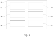
- Fig. 2 shows a schematic illustration showing an overview of an implementation of the disclosed system 10 for providing route data for a vehicle, comprising: a first providing unit 12 configured to provide signal quality data for a geographical region comprising vehicle data of a plurality of vehicles, whereby the vehicle data comprising vehicle position data associated with signal strength data and signal frequency data; a second providing unit 14 configured to provide the destination data for the vehicle; and a generating unit 16 configured to generate, by the vehicle and/or the separate computing unit, the route data for the vehicle based on the signal quality data and the destination data for the vehicle.
- system 10 may comprise: a connecting unit 18 configured to connect, at least one of the vehicles of the plurality of vehicles by means of a wireless connection with a wireless connection base station, preferably a cellular base station; a processing unit 20 configured to process, by the separate computing unit, the vehicle data of the database; and a third providing unit 22 configured to provide, by the separate computing unit, the vehicle data and/or the processed vehicle data of the database.
- a connecting unit 18 configured to connect, at least one of the vehicles of the plurality of vehicles by means of a wireless connection with a wireless connection base station, preferably a cellular base station
- processing unit 20 configured to process, by the separate computing unit, the vehicle data of the database
- a third providing unit 22 configured to provide, by the separate computing unit, the vehicle data and/or the processed vehicle data of the database.
- Fig. 3 shows a schematic illustration of an example of predicted signal quality data for a geographical region, whereby a vehicle 50 travels along a vehicle's path 70 through a geographic region 60.
- a base station 62 which transmits a wireless signal, is located in the center of the geographic region 60.
- the wireless signal may have a different signal strength.
- the signal strength is represented for the vehicle's path 70 through the geographical region 60 by means of four bars of different sizes standing next to each other, whereby the present signal strength is represented by a black coloring of the bars.
- Fig. 4 shows a schematic illustration of an example of a RSSI usage in a vehicle, whereby the vehicle 50 comprises an RSSI indicator 52 that provides a hint to the received signal strength or provides a simplified graphical representation of the received signal strength.
- Fig. 5 shows a schematic illustration of an example of actual signal quality data for a geographical region, whereby the vehicle 50 travels along a vehicle's path 70 through the geographic region 60.
- the base station 62 which transmits a wireless signal, is located in the center of the geographic region 60.
- the wireless signal may have a different signal strength.
- the signal strength is represented for the vehicle's path 70 through the geographical region 60 by means of four bars of different sizes standing next to each other, whereby the present signal strength is represented by a black coloring of the bars.
- the vehicle 50 provides the vehicle data for its vehicle's path 70 through the geographical region 60 to a database 80, e.g. of the separate computing unit, which processes and includes the vehicle data of the vehicle 50 to first signal quality data 81 of the geographical region 60.
- vehicle data of a plurality of vehicles may be provided in the same manner and may be used to improve the accuracy of the first signal quality data 81 for the geographical region 60.
- the database 80 of the separate computing unit may be configured as a cloud based database of the separate computing unit.
- the separate computing unit may be configured as a cloud based separate computing unit.
- vehicle data comprised by the signal quality data may comprise time stamp data and/or vehicle identification number (VIN) data and/or the signal frequency data may comprise quality of service data.
- VIN vehicle identification number
- Fig. 6 shows a schematic illustration of a database of a separate computing unit comprising signal quality data for different geographical regions, whereby the database 80 of the separate computing unit may comprise signal quality data for different geographical regions, e.g. first signal quality data 81 for the geographical region 60 and signal quality data 82, 83 for further geographical regions.
- the database 80 of the separate computing unit may comprise signal quality data for different geographical regions, e.g. first signal quality data 81 for the geographical region 60 and signal quality data 82, 83 for further geographical regions.
- the separate computing unit may process the different vehicle data and/or different signal quality data for different geographical regions.
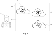
- Fig. 7 shows a schematic illustration for providing signal quality data by the database of Fig. 6 , whereby the separate computing unit may allow a user 91 to access the database 80 comprising the vehicle data and/or signal quality data and to analyze these data.
- the user 91 may access the database 80 by means of a computing system and/or a mobile computing system.
- the signal quality data and/or the vehicle data may be provided to further computing units.
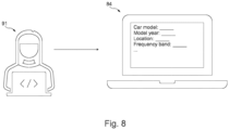
- Fig. 8 shows a schematic illustration for sorting vehicle data, whereby the database 80 may be sorted/analyzed by means of parameters, e.g. technical specifications of the vehicles which have been used to provide/process the signal quality data. Such sorting/analyzing may be performed by the user 91 using a UI of the separate computing unit 84.
- Fig. 9 shows a schematic illustration for sorting signal quality data for geographical regions, whereby the database 80 is sorted/analyzed by means of parameters, e.g. technical specifications of the vehicles which have been used to provide/process the signal quality data. Thereby, the database 80 may provide first sorted signal quality data 85 and second sorted signal quality data 86. Further, the sorted signal quality 85, 86 data of the database 80 may be provided to the vehicle, the separate computing unit, a computing device and/or a mobile computing device for generating route data. Therefore, the sorted vehicle data may be provided to the first user 91.
- the database 80 may provide first sorted signal quality data 85 and second sorted signal quality data 86.
- the sorted signal quality 85, 86 data of the database 80 may be provided to the vehicle, the separate computing unit, a computing device and/or a mobile computing device for generating route data. Therefore, the sorted vehicle data may be provided to the first user 91.
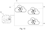
- Fig. 10 shows a further schematic illustration for providing signal quality data by the database 80 of Fig. 6 , whereby the separate computing unit may allow a second user 92 to access the database 80 comprising the vehicle data and/or the signal quality data and to analyze these data.
- the first user 91 may access the database 80 by means of a computing system and/or a mobile computing system.
- the signal quality data and/or the vehicle data may be provided to further computing units.
- the second user 92 may use a mobile computing system to access the database 80.
- Fig. 11 shows a schematic illustration of an example for generating and providing route data based on a predetermined signal quality value, whereby route data for an improved, i.e. with respect to the signal quality, vehicle's path 71 of the geographical region 60 are provided by the second user 92 to the vehicle 50.
- the improved vehicle's path 71 differs from the non-improved vehicle's path 70, in such a way that it guides the vehicle 50 around the base station 62 in such a way that the vehicle 50 may mostly travel in areas of the geographical region 60 that provide an improved received signal strength compared to the non-improved vehicle's path 70.
- the route data for the improved vehicle's path 71 may be provided to the vehicle 50 by a mobile computing system of the second user 92.
- the route data may, additionally or alternatively, be provided by the vehicle 50 itself, the separate computing unit and/or devices with access to the database 80.
- the generation of the route data may be based on a predetermined signal quality value, whereby the predetermined signal quality value may preferably correspond to a required signal strength level that may be required for a voice communication of a driver of the vehicle and/or for file transfers of a driver.
- the generation of the route data may be further based on a predetermined deviation value from a route planning without considering the signal quality data.
- a deviation from a distance and/or time-optimal route may be configured by means of the predetermined deviation value and included in the generation of the route data. Therefore, the generation of the route data may be based on the vehicle data of the geographical region 60, the predetermined signal quality value and/or the predetermined deviation value.
- a vehicle for route planning a vehicle of a plurality of vehicles may further comprise logging means for logging the vehicle data and/or means for transmitting the vehicle data to a cloud and/or a second vehicle and/or a separate computing unit.
- a computer program element with instructions which, when executed on a computing device of a computing environment, may be configured to carry out the steps of the method for providing route data as described in the present disclosure.
Landscapes
- Engineering & Computer Science (AREA)
- Business, Economics & Management (AREA)
- Remote Sensing (AREA)
- Radar, Positioning & Navigation (AREA)
- Human Resources & Organizations (AREA)
- General Physics & Mathematics (AREA)
- Physics & Mathematics (AREA)
- Strategic Management (AREA)
- Economics (AREA)
- Automation & Control Theory (AREA)
- Signal Processing (AREA)
- General Business, Economics & Management (AREA)
- Marketing (AREA)
- Computer Networks & Wireless Communication (AREA)
- Theoretical Computer Science (AREA)
- Tourism & Hospitality (AREA)
- Atmospheric Sciences (AREA)
- Development Economics (AREA)
- Health & Medical Sciences (AREA)
- Biodiversity & Conservation Biology (AREA)
- Ecology (AREA)
- Environmental & Geological Engineering (AREA)
- Environmental Sciences (AREA)
- Life Sciences & Earth Sciences (AREA)
- Game Theory and Decision Science (AREA)
- Entrepreneurship & Innovation (AREA)
- Operations Research (AREA)
- Quality & Reliability (AREA)
- General Health & Medical Sciences (AREA)
- Primary Health Care (AREA)
- Traffic Control Systems (AREA)
Abstract
A computer-implemented method (100) for providing route data for a vehicle (50), comprising the step of providing (110) signal quality data related to a wireless network for a geographical region (60) comprising vehicle data of a plurality of vehicles, whereby the vehicle data comprise vehicle position data associated with signal strength data and signal frequency data, another step of providing (120) destination data for the vehicle (50) and a step of generating (130), by the vehicle (50) and/or a separate computing unit, the route data for the vehicle (50) based on the signal quality data and the destination data for the vehicle (50).

Description
- The present disclosure relates to a method for providing route data for a vehicle, a system for providing route data for a vehicle, a vehicle for route planning, a vehicle of a plurality of vehicles further comprising a logging means for logging vehicle data and/or means for transmitting the vehicle data to a cloud and/or a second vehicle and/or a separate computing unit and a computer program element.
- Known route planning methods use, for example, the route length and/or travel time to a desired destination to generate a route for a vehicle that will guide to the desired destination. Also known are route planning methods that, for example, incorporate a traffic situation on a calculated route to recalculate and/or adjust a route. In addition, it is also known that data from connected vehicles are used to process and provide route data. However, the data from connected vehicles are not used for route planning. Moreover, connectivity data of vehicles are not used for route planning.
- In view of this, it is found that a further need exists to provide an improved method for providing route data for a vehicle.
- In the view of the above, it is an object of the present disclosure to provide a method for providing route data for a vehicle.
- The problem is at least partially solved or alleviated by the subject matter of the independent claims of the present disclosure, whereby further examples are incorporated in the dependent claims.
- According to a first aspect, a computer-implemented method for providing route data for a vehicle is disclosed, comprising:
- providing signal quality data for a geographical region comprising vehicle data of a plurality of vehicles, whereby the vehicle data comprising vehicle position data associated with signal strength data and signal frequency data;
- providing destination data for the vehicle; and
- generating, by the vehicle and/or a separate computing unit, the route data for the vehicle based on the signal quality data and the destination data for the vehicle.
- The provided vehicle data, vehicle position data, signal strength data and/or signal frequency data may be logged by the plurality of vehicles. In addition, other parameters that may be recorded by modems and/or vehicles and which may be useful for customers and internal applications may also be logged by the plurality of vehicles. Further recorded parameters may be comprised by the vehicle data. In other words, in modern vehicles, large amounts of data may be exchanged constantly via the internal communication buses. These data may include diagnostic data for control units and other electronics in the vehicle, as well as status displays for various functions. Some of this data may also be made available, e.g. in a cloud. Therefore, there may be a great potential to use this data, partly for new customer features and partly to improve the performance of a vehicle. The provided vehicle data may also be used to derive performance status of the communication means of the vehicle, e.g. for modems and/or antennas used in the respective vehicle.
- The signal strength data may be based on the received power level of the signal originating from a base station (e.g. a 5G base station) and reported by the modem of the vehicle as the received signal strength indicator (RSSI) at the vehicle position in a geographic region at a given time. This received signal power level may modify over time if the vehicle is traveling in the geographic region. For example, the signal strength (and thus the RSSI value) may be better if the vehicle is closer to a base station and thus providing a better internet connection. In addition, the RSSI value may also be based on how well the receive link is constructed in the vehicle. For example, a better reception connection may be based on the antenna, receiver, cables, etc. whereby more power may be delivered to the modem and therefore the RSSI value may be higher if optimized reception components are used.
- The frequency data may, for example, comprise data for all frequencies detected by the vehicle/modem or may only comprise data for predefined frequencies.
- The plurality of vehicles may comprise at least one or more vehicles, whereby the plurality of vehicles may be, for example, a fleet of vehicles of a vehicle manufacturer and/or vehicle provider. Moreover, the plurality of vehicles may comprise modems and/or antennas similar to the modem and/or antenna provided in the vehicle for which route data may be provided.
- The route data is generated by the vehicle and/or a separate computing unit and may be provided to the vehicle and/or accessible via the separate computing unit. Thereby, the vehicle may use the route data to provide navigation from a current location to a desired destination and/or support driving from the current location to a desired destination.
- In other words, it may generally be a matter of collecting a combination of vehicle data parameters to provide these to applications of a vehicle. For the specific case of vehicle connectivity data, for example, the following steps may be taken,
- a vehicle may be driven under real field conditions and may have a connection to a network (e.g. an internet connection). A combination of data parameters that may be of interest to a predefined application may be recorded at a predefined frequency, including but not limited to received signal strength, position data (global navigation satellite system), timestamp, and chassis number respectively vehicle identification number (VIN) of the vehicle;
- the data points consisting of a combination of these data parameters may be uploaded to a cloud;
- the data parameters may be collected from a large number of vehicles to create unique statistics over time through the collection of the data parameter. These statistics may be provided to developers or third parties.
- Thereby, the generation of the route data may be based on real and up-to-date vehicular-measured data and statistics from a fleet of cars of the same car model/model year (and thereby the same connectivity hardware and software components) as the vehicle for which the route planning is performed, of the respective locations, in order that a more exact route planning may be performed. Thus, the accuracy in route planning with respect to connectivity requirements may be improved.
- In an implementation, the generating of the route data may further be based on a predetermined signal quality value, whereby the predetermined signal quality value may preferably correspond to a needed signal strength level required for a voice communication of a driver of the vehicle and/or for file transfers of the driver.
- The signal strength level may, for example, be based on the RSSI value, which may be reported by the modem of the vehicle and based on a received signal strength value in decibel of a signal.
- The predetermined signal quality value for the voice communication may, for example, require that the signal strength level is always sufficient to make a call and/or that disconnections between the vehicle and a base station are to be avoided.
- The predetermined signal quality value for the file transfer may, for example, require that the signal strength level is mostly high, in order that high data rates may be achieved in the connection between the vehicle and a base station.
- In an implementation, the generating of the route data may further be based on a predetermined deviation value from a route planning without considering the signal quality data.
- The deviation value may comprise, for example, a kilometer value and/or a time value by which the generated route may have a further distance compared to a distance-optimal route and/or by which the generated route may have a longer duration compared to a time-optimal route.
- In an implementation, the method may further comprise connecting, one or more vehicles of the plurality of vehicles by means of a wireless connection with a wireless connection base station, preferably a cellular base station.
- The cellular base station may also be understood as a cell site and/or cell tower, which may be a location for a cellular mobile means and where antennas and electronic communication devices may be placed (typically on a cell tower, tower, or other elevated structure) to create a cell or adjacent cells in a cellular network.
- In an implementation, the vehicle data may further comprise time stamp data and/or vehicle identification number (VIN) data and/or the signal frequency data may further comprise quality-of-service data.
- The quality of service data may be a measurement of the overall performance of a service, e.g., a telephony or computer network or a cloud computing service, in particular the performance perceived by the users of the network. To quantitatively measure quality of service, several related aspects of the network service may be considered, e.g., packet loss, bit rate, throughput, transmission delay, availability, jitter, etc.
- In an implementation, the signal quality data may be provided to the vehicle and/or the separate computing unit.
- The signal quality data may be accessed, for example, by the vehicle and/or the separate computing unit configured to further process and/or use of the signal quality data.
- In an implementation, the separate computing unit may be configured as a cloud based computing unit.
- For example, the cloud-based computing unit may be distributed in one network-accessible location or in multiple network-accessible locations. In addition, the database of the separate computing unit may also be distributed at a network-accessible location or at multiple locations accessible via one or more networks, whereby the location or locations may be different from the location or locations of the separate computing unit.
- In an implementation, the method may further comprise processing, by the separate computing unit, the vehicle data.
- In other words, by collecting and processing an amount of vehicle data from a variety of vehicles, it may be possible to provide a dataset in the database for different vehicle-related statistics. Thereby, it may be useful to structure and/or sort the dataset to make it more usable, e.g. for specific vehicle settings and/or vehicle specifications. Thus, a comprehensive set of statistics on the performance of the vehicles sending the data may be compiled. For example, the statistics may provide information for optimizing the performance of existing vehicles and/or for future vehicles. For example, connectivity data may answer typical questions about vehicle receiving performance and indicate whether its performance is good enough or may require improvements to vehicle receiving performance.
- In an implementation, the method may further comprise providing, by the separate computing unit, the vehicle data and/or the processed vehicle data.
- In an implementation, the vehicle data and/or the processed vehicle data may be provided to a computing device of a vehicle, a computing system and/or a mobile computing system.
- In particular, by providing a collection of vehicle data, for example of all vehicles of a manufacturer, or for example, for the vehicle models of a manufacturer, it may be possible to make predictions of the robustness of the vehicle model with respect to the connectivity for each model of a manufacturer. This information may, for example, be provided to a vehicle manufacturer and/or a user of the vehicle.
- Another benefit of having access to connectivity data of current vehicles may be that by creating the geographical region based on the signal quality data, areas with poor network coverage may be shown in a simplified way. This information may, for example, be provided to mobile network operators and thus lead to better area-wide network coverage.
- In an implementation, the route data may further be generated by the computing device and/or the mobile computing device.
- In other words, more applications may conceivably be added on top of that. For example, a customer (private driver or fleet manager) may have access to the statistics via an app and may be able to plan a driving route based on the highest probability of robust connectivity. Similarly, autonomous vehicles that rely on internet connectivity for advanced use cases in the future may use these statistics to optimize the driving route for the longest duration of automatic driving functionality.
- A further aspect of the present disclosure relates to a system for providing route data for a vehicle, comprising:
- a first providing unit configured to provide signal quality data for a geographical region comprising vehicle data of a plurality of vehicles, whereby the vehicle data comprising vehicle position data associated with signal strength data and signal frequency data;
- a second providing unit configured to provide the destination data for the vehicle; and
- a generating unit configured to generate, by the vehicle and/or the separate computing unit, the route data for the vehicle based on the signal quality data and the destination data for the vehicle.
- In an implementation, the system may further comprise:
- a connecting unit configured to connect a vehicle of a plurality of vehicles by means of a wireless connection with a wireless connection base station, preferably a cellular base station;
- a processing unit configured to process, by the separate computing unit, the vehicle data of the database; and/or
- a third providing unit configured to provide, by the separate computing unit, the vehicle data and/or the processed vehicle data of the database.
- A further aspect of the present disclosure relates to a vehicle for route planning, a second vehicle of a plurality of vehicles further comprising a logging means for logging the vehicle data and/or means for transmitting the vehicle data to a cloud and/or a second vehicle and/or a separate computing unit comprising a disclosed system.
- The second vehicle may be, for example, a vehicle of a plurality of vehicles. The plurality of vehicles may be more than two vehicles, preferably substantially more than two vehicles.
- A further aspect of the present disclosure relates to a computer program element with instructions, which, when executed on a computing device of a computing environment, is configured to carry out the steps of the disclosed method in the disclosed system.
- In the following, the disclosure is described exemplarily with reference to the enclosed figures, in which:
- Fig. 1
- is an example of a diagram of the disclosed method;
- Fig. 2
- is a schematic illustration showing an overview of an implementation of the disclosed system;
- Fig. 3
- is a schematic illustration of an example of predicted signal quality data for a geographical region;
- Fig. 4
- is a schematic illustration of an example of a RSSI usage in a vehicle;
- Fig. 5
- is a schematic illustration of an example of actual signal quality data for a geographical region;
- Fig. 6
- is a schematic illustration of a database of a separate computing unit comprising signal quality data for different geographical regions;
- Fig. 7
- is a schematic illustration for providing signal quality data by the database of
Fig. 6 ; - Fig. 8
- is a schematic illustration for sorting vehicle data;
- Fig. 9
- is a schematic illustration for sorting signal quality data for geographical regions;
- Fig. 10
- is a further schematic illustration for providing signal quality data by the database of
Fig. 6 ; and - Fig. 11
- is a schematic illustration of an example for generating and providing route data based on a predetermined signal quality value.
- Notably, the figures are merely schematic representations and serve only to illustrate examples of the present disclosure. Identical or equivalent elements are in principle provided with the same reference signs.
-
Fig. 1 shows an example of a diagram of the disclosed method for providingroute data 100 for a vehicle, comprising: providing signal quality data for ageographical region 110 comprising vehicle data of a plurality of vehicles, whereby the vehicle data comprising vehicle position data associated with signal strength data and signal frequency data; providing destination data for thevehicle 120; and generating, by the vehicle and/or a separate computing unit, theroute data 130 for the vehicle based on the signal quality data and the destination data for the vehicle. -
Fig. 2 shows a schematic illustration showing an overview of an implementation of the disclosedsystem 10 for providing route data for a vehicle, comprising: a first providingunit 12 configured to provide signal quality data for a geographical region comprising vehicle data of a plurality of vehicles, whereby the vehicle data comprising vehicle position data associated with signal strength data and signal frequency data; a second providingunit 14 configured to provide the destination data for the vehicle; and a generatingunit 16 configured to generate, by the vehicle and/or the separate computing unit, the route data for the vehicle based on the signal quality data and the destination data for the vehicle. - Further the
system 10 may comprise: a connectingunit 18 configured to connect, at least one of the vehicles of the plurality of vehicles by means of a wireless connection with a wireless connection base station, preferably a cellular base station; aprocessing unit 20 configured to process, by the separate computing unit, the vehicle data of the database; and a third providingunit 22 configured to provide, by the separate computing unit, the vehicle data and/or the processed vehicle data of the database. -
Fig. 3 shows a schematic illustration of an example of predicted signal quality data for a geographical region, whereby avehicle 50 travels along a vehicle'spath 70 through ageographic region 60. Here, abase station 62, which transmits a wireless signal, is located in the center of thegeographic region 60. Depending on different circumstances, e.g. a distance of thevehicle 50 to thebase station 62, the wireless signal may have a different signal strength. As thevehicle 50 connects to thebase station 62, the signal strength is represented for the vehicle'spath 70 through thegeographical region 60 by means of four bars of different sizes standing next to each other, whereby the present signal strength is represented by a black coloring of the bars. -
Fig. 4 shows a schematic illustration of an example of a RSSI usage in a vehicle, whereby thevehicle 50 comprises an RSSI indicator 52 that provides a hint to the received signal strength or provides a simplified graphical representation of the received signal strength. -
Fig. 5 shows a schematic illustration of an example of actual signal quality data for a geographical region, whereby thevehicle 50 travels along a vehicle'spath 70 through thegeographic region 60. Here, thebase station 62, which transmits a wireless signal, is located in the center of thegeographic region 60. Depending on different circumstances, e.g. a distance of thevehicle 50 to thebase station 62, the wireless signal may have a different signal strength. As thevehicle 50 connects to thebase station 62, the signal strength is represented for the vehicle'spath 70 through thegeographical region 60 by means of four bars of different sizes standing next to each other, whereby the present signal strength is represented by a black coloring of the bars. - The
vehicle 50 provides the vehicle data for its vehicle'spath 70 through thegeographical region 60 to adatabase 80, e.g. of the separate computing unit, which processes and includes the vehicle data of thevehicle 50 to firstsignal quality data 81 of thegeographical region 60. Furthermore, vehicle data of a plurality of vehicles may be provided in the same manner and may be used to improve the accuracy of the firstsignal quality data 81 for thegeographical region 60. - Further, whereby the
database 80 of the separate computing unit may be configured as a cloud based database of the separate computing unit. However, the separate computing unit may be configured as a cloud based separate computing unit. - Further, vehicle data comprised by the signal quality data may comprise time stamp data and/or vehicle identification number (VIN) data and/or the signal frequency data may comprise quality of service data.
-
Fig. 6 shows a schematic illustration of a database of a separate computing unit comprising signal quality data for different geographical regions, whereby thedatabase 80 of the separate computing unit may comprise signal quality data for different geographical regions, e.g. firstsignal quality data 81 for thegeographical region 60 andsignal quality data - Further, the separate computing unit may process the different vehicle data and/or different signal quality data for different geographical regions.
-
Fig. 7 shows a schematic illustration for providing signal quality data by the database ofFig. 6 , whereby the separate computing unit may allow auser 91 to access thedatabase 80 comprising the vehicle data and/or signal quality data and to analyze these data. Theuser 91 may access thedatabase 80 by means of a computing system and/or a mobile computing system. Moreover, the signal quality data and/or the vehicle data may be provided to further computing units.Fig. 8 shows a schematic illustration for sorting vehicle data, whereby thedatabase 80 may be sorted/analyzed by means of parameters, e.g. technical specifications of the vehicles which have been used to provide/process the signal quality data. Such sorting/analyzing may be performed by theuser 91 using a UI of theseparate computing unit 84. -
Fig. 9 shows a schematic illustration for sorting signal quality data for geographical regions, whereby thedatabase 80 is sorted/analyzed by means of parameters, e.g. technical specifications of the vehicles which have been used to provide/process the signal quality data. Thereby, thedatabase 80 may provide first sortedsignal quality data 85 and second sortedsignal quality data 86. Further, thesorted signal quality database 80 may be provided to the vehicle, the separate computing unit, a computing device and/or a mobile computing device for generating route data. Therefore, the sorted vehicle data may be provided to thefirst user 91. -
Fig. 10 shows a further schematic illustration for providing signal quality data by thedatabase 80 ofFig. 6 , whereby the separate computing unit may allow asecond user 92 to access thedatabase 80 comprising the vehicle data and/or the signal quality data and to analyze these data. Thefirst user 91 may access thedatabase 80 by means of a computing system and/or a mobile computing system. Moreover, the signal quality data and/or the vehicle data may be provided to further computing units. In addition, thesecond user 92 may use a mobile computing system to access thedatabase 80. -
Fig. 11 shows a schematic illustration of an example for generating and providing route data based on a predetermined signal quality value, whereby route data for an improved, i.e. with respect to the signal quality, vehicle'spath 71 of thegeographical region 60 are provided by thesecond user 92 to thevehicle 50. Thereby, the improved vehicle'spath 71 differs from the non-improved vehicle'spath 70, in such a way that it guides thevehicle 50 around thebase station 62 in such a way that thevehicle 50 may mostly travel in areas of thegeographical region 60 that provide an improved received signal strength compared to the non-improved vehicle'spath 70. Moreover, the route data for the improved vehicle'spath 71 may be provided to thevehicle 50 by a mobile computing system of thesecond user 92. However, the provision is not limited to such a mobile computing system, the route data may, additionally or alternatively, be provided by thevehicle 50 itself, the separate computing unit and/or devices with access to thedatabase 80. - In addition, the generation of the route data may be based on a predetermined signal quality value, whereby the predetermined signal quality value may preferably correspond to a required signal strength level that may be required for a voice communication of a driver of the vehicle and/or for file transfers of a driver. The generation of the route data may be further based on a predetermined deviation value from a route planning without considering the signal quality data. A deviation from a distance and/or time-optimal route may be configured by means of the predetermined deviation value and included in the generation of the route data. Therefore, the generation of the route data may be based on the vehicle data of the
geographical region 60, the predetermined signal quality value and/or the predetermined deviation value. - Moreover, a vehicle for route planning, a vehicle of a plurality of vehicles may further comprise logging means for logging the vehicle data and/or means for transmitting the vehicle data to a cloud and/or a second vehicle and/or a separate computing unit.
- In addition, a computer program element with instructions, which, when executed on a computing device of a computing environment, may be configured to carry out the steps of the method for providing route data as described in the present disclosure.
- Other variations to the disclosed examples may be understood and effected by those skilled in the art in practicing the claimed subject matter, from the study of the figures, the disclosure, and the appended claims. In particular, respective parts/functions of the respective example described above may also be combined with each other. In particular, the present disclosure is not limited to specific modules, vehicle functions, user interfaces, user interface areas/fields and/or communication methods. In the claims, the word "comprising" does not exclude other elements or steps and the indefinite article "a" or "an" does not exclude a plurality. The mere fact that certain measures are recited in mutually different dependent claims does not indicate that a combination of these measures may not be used to advantage. Any reference signs in the claims should not be construed as limiting the scope of the claims.
-
- 10
- System for providing route data
- 12
- First providing unit
- 14
- Second providing unit
- 16
- Generating unit
- 18
- Connecting unit
- 20
- Processing unit
- 22
- Third providing unit
- 50
- Vehicle
- 52
- RSSI indicator
- 60
- Geographical region
- 62
- Base station
- 70
- Vehicle's path
- 71
- Improved vehicle's path
- 80
- Database
- 81
- First signal quality data
- 82
- Second signal quality data
- 83
- Third signal quality data
- 84
- Sorting UI of the separate computing unit
- 85
- first sorted signal quality data
- 86
- second sorted signal quality data
- 91
- First user
- 92
- Second user
- 100
- Method for providing route data
- 110
- Providing signal quality data for a geographical region
- 120
- Providing destination data for the vehicle
- 130
- Generating, by the vehicle and/or a separate computing unit route data
Claims (15)
- A computer-implemented method for providing route data for a vehicle, comprising:providing (110) signal quality data for a geographical region comprising vehicle data of a plurality of vehicles, whereby the vehicle data comprising vehicle position data associated with signal strength data and signal frequency data;providing (120) destination data for the vehicle; andgenerating (130), by the vehicle and/or a separate computing unit, the route data for the vehicle based on the signal quality data and the destination data for the vehicle.
- Method according to claim 1, whereby generating the route data is further based on a predetermined signal quality value, whereby the predetermined signal quality value preferably corresponds to a needed signal strength level required for a voice communication of a driver of the vehicle and/or for file transfers of the driver.
- Method according to claim 1 or 2, whereby generating the route data is further based on a predetermined deviation value from a route planning without considering the signal quality data.
- Method according to any one of the preceding claims, the method further comprising: connecting, one or more vehicles of the plurality of vehicles by means of a wireless connection with a wireless connection base station, preferably a cellular base station.
- Method according any one of the preceding claims, whereby the vehicle data is further comprising time stamp data and/or vehicle identification number (VIN) data and/or the signal frequency data is further comprising quality-of-service data.
- Method according to any one of the preceding claims, whereby the signal quality data is provided to the vehicle and/or the separate computing unit.
- Method according to any one of the preceding claims, whereby the separate computing unit is configured as a cloud based computing unit.
- Method according to claim 7, the method further comprising: processing, by the separate computing unit, the vehicle data.
- Method according to any one of the claims 7 or 8, the method further comprising: providing, by the separate computing unit, the vehicle data and/or the processed vehicle data.
- Method according to claim 9, whereby the vehicle data and/or the processed vehicle data is provided to a computing device of a vehicle, a computing system and/or a mobile computing system.
- Method according to claim 10, whereby the route data is further generated by the computing device and/or the mobile computing device.
- System for providing route data for a vehicle, comprising:a first providing unit (12) configured to provide signal quality data for a geographical region comprising vehicle data of a plurality of vehicles, whereby the vehicle data comprising vehicle position data associated with signal strength data and signal frequency data;a second providing unit (14) configured to provide the destination data for the vehicle; anda generating unit (16) configured to generate, by the vehicle and/or the separate computing unit, the route data for the vehicle based on the signal quality data and the destination data for the vehicle.
- System according to claim 12, further comprising:a connecting unit (18) configured to connect, a plurality of vehicles, the vehicle by means of a wireless connection with a wireless connection base station, preferably a cellular base station;a processing unit (20) configured to process, by the separate computing unit, the vehicle data of the database; and/ora third providing unit (22) configured to provide, by the separate computing unit, the vehicle data and/or the processed vehicle data of the database.
- A vehicle for route planning, a vehicle of a plurality of vehicles further comprising a logging means for logging the vehicle data and/or means for transmitting the vehicle data to a cloud and/or a second vehicle and/or a separate computing unit comprising a system according to any of the claims 12 to 13.
- A computer program element with instructions, which, when executed on a computing device of a computing environment, is configured to carry out the steps of the method according to any one of the claims 1 to 12 in a system according to claim 12 or claim 13.
Priority Applications (1)
| Application Number | Priority Date | Filing Date | Title |
|---|---|---|---|
| EP22194467.1A EP4336147A1 (en) | 2022-09-07 | 2022-09-07 | Method for providing route data for a vehicle |
Applications Claiming Priority (1)
| Application Number | Priority Date | Filing Date | Title |
|---|---|---|---|
| EP22194467.1A EP4336147A1 (en) | 2022-09-07 | 2022-09-07 | Method for providing route data for a vehicle |
Publications (1)
| Publication Number | Publication Date |
|---|---|
| EP4336147A1 true EP4336147A1 (en) | 2024-03-13 |
Family
ID=83232828
Family Applications (1)
| Application Number | Title | Priority Date | Filing Date |
|---|---|---|---|
| EP22194467.1A Pending EP4336147A1 (en) | 2022-09-07 | 2022-09-07 | Method for providing route data for a vehicle |
Country Status (1)
| Country | Link |
|---|---|
| EP (1) | EP4336147A1 (en) |
Cited By (1)
| Publication number | Priority date | Publication date | Assignee | Title |
|---|---|---|---|---|
| CN119485445A (en) * | 2024-10-24 | 2025-02-18 | 中通服网盈科技有限公司 | Data center computing power network resource scheduling method |
Citations (3)
| Publication number | Priority date | Publication date | Assignee | Title |
|---|---|---|---|---|
| US20140379252A1 (en) * | 2013-06-25 | 2014-12-25 | Bayersiche Motoren Werke Aktiengesellschaft | Method for Operating a Navigation System of a Motor Vehicle, Navigation System and Motor Vehicle |
| US9565625B1 (en) * | 2015-09-09 | 2017-02-07 | Ford Global Technologies, Llc | Multiprotocol vehicle communications |
| US20220196425A1 (en) * | 2020-12-18 | 2022-06-23 | Here Global B.V. | Network support for vehicle routing |
-
2022
- 2022-09-07 EP EP22194467.1A patent/EP4336147A1/en active Pending
Patent Citations (3)
| Publication number | Priority date | Publication date | Assignee | Title |
|---|---|---|---|---|
| US20140379252A1 (en) * | 2013-06-25 | 2014-12-25 | Bayersiche Motoren Werke Aktiengesellschaft | Method for Operating a Navigation System of a Motor Vehicle, Navigation System and Motor Vehicle |
| US9565625B1 (en) * | 2015-09-09 | 2017-02-07 | Ford Global Technologies, Llc | Multiprotocol vehicle communications |
| US20220196425A1 (en) * | 2020-12-18 | 2022-06-23 | Here Global B.V. | Network support for vehicle routing |
Cited By (1)
| Publication number | Priority date | Publication date | Assignee | Title |
|---|---|---|---|---|
| CN119485445A (en) * | 2024-10-24 | 2025-02-18 | 中通服网盈科技有限公司 | Data center computing power network resource scheduling method |
Similar Documents
| Publication | Publication Date | Title |
|---|---|---|
| US7319847B2 (en) | Bitwise monitoring of network performance | |
| CN101420714B (en) | Method for scheduling indicator for collecting key performance from communication network | |
| US8112261B2 (en) | Methods and simulation tools for predicting GPS performance in the broad operating environment | |
| US9743287B2 (en) | Methods and apparatus for determining and planning wireless network deployment sufficiency when utilizing vehicle-based relay nodes | |
| EP2508021A1 (en) | Coverage hole detector | |
| US20070129086A1 (en) | Method and apparatus for identifying a geographic area having undesirable wireless service | |
| CN108307427B (en) | LTE network coverage analysis and prediction method and system | |
| CN113133058B (en) | Load balancing method, device and system | |
| Xiao et al. | Driving in the fog: Latency measurement, modeling, and optimization of lte-based fog computing for smart vehicles | |
| Yastrebova et al. | Hybrid connectivity for autonomous vehicles: Conceptual view & initial results | |
| CN101621808B (en) | Method and device for confirming cell coverage area | |
| US20020155816A1 (en) | Systems and methods for measuring data quality in wireless communication networks | |
| US20220217557A1 (en) | Method for predicting a signal and/or service quality and associated device | |
| Song et al. | First mile: An open innovation lab for infrastructure-assisted cooperative intelligent transportation systems | |
| US7643936B1 (en) | Method and system for automatic analysis and management of drive test routes | |
| US20220103442A1 (en) | Internet of things operations monitoring system | |
| Megnafi et al. | Creation of an application under mapbasic for the drive test reports automation in cellular networks | |
| CN102781023B (en) | Network optimization method based on time window | |
| EP2595436B1 (en) | A method and a network node for localization of a user equipment | |
| CN111639703B (en) | Method for calculating position of base station based on minimum bounding circle of discrete point set | |
| CN109005504A (en) | Localization method, device, terminal device and the storage medium of wireless messages | |
| US20070004399A1 (en) | Quality assessment for telecommunications network | |
| CN119071741A (en) | Method, device, equipment and storage medium for expanding coverage of broadcast signals | |
| Pinzel et al. | V2V-and V2X-Communication data within a distributed computing platform for adaptive radio channel modelling. | |
| US11528211B2 (en) | Data inspection system for inspecting operating situations of multiple IoT devices in a plurality of target IoT systems |
Legal Events
| Date | Code | Title | Description |
|---|---|---|---|
| PUAI | Public reference made under article 153(3) epc to a published international application that has entered the european phase |
Free format text: ORIGINAL CODE: 0009012 |
|
| STAA | Information on the status of an ep patent application or granted ep patent |
Free format text: STATUS: REQUEST FOR EXAMINATION WAS MADE |
|
| 17P | Request for examination filed |
Effective date: 20230719 |
|
| AK | Designated contracting states |
Kind code of ref document: A1 Designated state(s): AL AT BE BG CH CY CZ DE DK EE ES FI FR GB GR HR HU IE IS IT LI LT LU LV MC MK MT NL NO PL PT RO RS SE SI SK SM TR |
|
| STAA | Information on the status of an ep patent application or granted ep patent |
Free format text: STATUS: EXAMINATION IS IN PROGRESS |
|
| 17Q | First examination report despatched |
Effective date: 20241024 |