EP4318439A1 - Information processing device and information processing method - Google Patents
Information processing device and information processing method Download PDFInfo
- Publication number
- EP4318439A1 EP4318439A1 EP22779798.2A EP22779798A EP4318439A1 EP 4318439 A1 EP4318439 A1 EP 4318439A1 EP 22779798 A EP22779798 A EP 22779798A EP 4318439 A1 EP4318439 A1 EP 4318439A1
- Authority
- EP
- European Patent Office
- Prior art keywords
- information
- road
- difference
- map information
- unit
- Prior art date
- Legal status (The legal status is an assumption and is not a legal conclusion. Google has not performed a legal analysis and makes no representation as to the accuracy of the status listed.)
- Granted
Links
Images




Classifications
-
- G—PHYSICS
- G01—MEASURING; TESTING
- G01C—MEASURING DISTANCES, LEVELS OR BEARINGS; SURVEYING; NAVIGATION; GYROSCOPIC INSTRUMENTS; PHOTOGRAMMETRY OR VIDEOGRAMMETRY
- G01C21/00—Navigation; Navigational instruments not provided for in groups G01C1/00 - G01C19/00
- G01C21/38—Electronic maps specially adapted for navigation; Updating thereof
- G01C21/3804—Creation or updating of map data
- G01C21/3807—Creation or updating of map data characterised by the type of data
- G01C21/3815—Road data
-
- G—PHYSICS
- G01—MEASURING; TESTING
- G01C—MEASURING DISTANCES, LEVELS OR BEARINGS; SURVEYING; NAVIGATION; GYROSCOPIC INSTRUMENTS; PHOTOGRAMMETRY OR VIDEOGRAMMETRY
- G01C11/00—Photogrammetry or videogrammetry, e.g. stereogrammetry; Photographic surveying
-
- G—PHYSICS
- G01—MEASURING; TESTING
- G01C—MEASURING DISTANCES, LEVELS OR BEARINGS; SURVEYING; NAVIGATION; GYROSCOPIC INSTRUMENTS; PHOTOGRAMMETRY OR VIDEOGRAMMETRY
- G01C21/00—Navigation; Navigational instruments not provided for in groups G01C1/00 - G01C19/00
- G01C21/26—Navigation; Navigational instruments not provided for in groups G01C1/00 - G01C19/00 specially adapted for navigation in a road network
- G01C21/34—Route searching; Route guidance
- G01C21/36—Input/output arrangements for on-board computers
- G01C21/3602—Input other than that of destination using image analysis, e.g. detection of road signs, lanes, buildings, real preceding vehicles using a camera
-
- G—PHYSICS
- G01—MEASURING; TESTING
- G01C—MEASURING DISTANCES, LEVELS OR BEARINGS; SURVEYING; NAVIGATION; GYROSCOPIC INSTRUMENTS; PHOTOGRAMMETRY OR VIDEOGRAMMETRY
- G01C21/00—Navigation; Navigational instruments not provided for in groups G01C1/00 - G01C19/00
- G01C21/38—Electronic maps specially adapted for navigation; Updating thereof
- G01C21/3804—Creation or updating of map data
- G01C21/3833—Creation or updating of map data characterised by the source of data
- G01C21/3841—Data obtained from two or more sources, e.g. probe vehicles
-
- G—PHYSICS
- G01—MEASURING; TESTING
- G01C—MEASURING DISTANCES, LEVELS OR BEARINGS; SURVEYING; NAVIGATION; GYROSCOPIC INSTRUMENTS; PHOTOGRAMMETRY OR VIDEOGRAMMETRY
- G01C21/00—Navigation; Navigational instruments not provided for in groups G01C1/00 - G01C19/00
- G01C21/38—Electronic maps specially adapted for navigation; Updating thereof
- G01C21/3804—Creation or updating of map data
- G01C21/3833—Creation or updating of map data characterised by the source of data
- G01C21/3852—Data derived from aerial or satellite images
-
- G—PHYSICS
- G06—COMPUTING OR CALCULATING; COUNTING
- G06V—IMAGE OR VIDEO RECOGNITION OR UNDERSTANDING
- G06V10/00—Arrangements for image or video recognition or understanding
- G06V10/70—Arrangements for image or video recognition or understanding using pattern recognition or machine learning
- G06V10/74—Image or video pattern matching; Proximity measures in feature spaces
- G06V10/761—Proximity, similarity or dissimilarity measures
-
- G—PHYSICS
- G06—COMPUTING OR CALCULATING; COUNTING
- G06V—IMAGE OR VIDEO RECOGNITION OR UNDERSTANDING
- G06V20/00—Scenes; Scene-specific elements
- G06V20/10—Terrestrial scenes
- G06V20/182—Network patterns, e.g. roads or rivers
-
- G—PHYSICS
- G06—COMPUTING OR CALCULATING; COUNTING
- G06V—IMAGE OR VIDEO RECOGNITION OR UNDERSTANDING
- G06V20/00—Scenes; Scene-specific elements
- G06V20/50—Context or environment of the image
- G06V20/56—Context or environment of the image exterior to a vehicle by using sensors mounted on the vehicle
- G06V20/588—Recognition of the road, e.g. of lane markings; Recognition of the vehicle driving pattern in relation to the road
-
- G—PHYSICS
- G09—EDUCATION; CRYPTOGRAPHY; DISPLAY; ADVERTISING; SEALS
- G09B—EDUCATIONAL OR DEMONSTRATION APPLIANCES; APPLIANCES FOR TEACHING, OR COMMUNICATING WITH, THE BLIND, DEAF OR MUTE; MODELS; PLANETARIA; GLOBES; MAPS; DIAGRAMS
- G09B29/00—Maps; Plans; Charts; Diagrams, e.g. route diagram
Definitions
- the present invention relates to an information processing device and an information processing method.
- the present disclosure relates to the information processing device and the information processing method that handle map data for automatic driving and an advanced safety driving system.
- a method for collecting road information by a map generation vehicle or manpower and constructing a highly accurate map for a map that holds road or lane information in a network shape is known for the automatic driving and driving assistance.
- this method because a considerable amount of human labor is generated, only information about a part of the road such as an expressway can be constructed, and there are problems that completeness of the constructed map information is reduced and that a range in which the map can be provided for automatic driving and driving assistance is narrowed.
- PTL 1 discloses a method for updating the map using data collected from an imaging device mounted on a general vehicle.
- PTL 2 discloses a technique for enhancing the accuracy of the map using an aerial photograph and navigation map data.
- PTL 3 discloses a map correction method using aerial photograph data and substrate road map data.
- the conventional technique has a problem that a shielding region that does not appear in the image because the road is shielded cannot be appropriately handled.
- the shielded region where the road is shielded by a tunnel, an overhead crossing, high-rise buildings, and the like exists in the aerial photograph, a satellite image, and the image captured by the imaging device mounted on the general vehicle. For this reason, when road information extracted based on the captured image is reflected on the map, there is a problem that wrong information is reflected.
- the present invention has been made to solve such a problem, and an object of the present invention is to provide an information processing device and an information processing method capable of appropriately handling the shielding region of the road.
- An example of an information processing device includes:
- the present specification includes the disclosure of Japanese Patent Application No. 2021-063499 on which priority of the present application is based.
- the information processing device and the information processing method according to the present invention can appropriately handle the shielding region of the road.
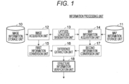
- FIG. 1 illustrates a configuration of an information processing device according to a first embodiment.
- the information processing device executes an information processing method described in the present specification.
- An image acquisition unit 12 acquires a satellite image or an aerial image belonging to a range designated by a latitude-longitude designation unit 13 from an image information storage unit 10 that stores the satellite image or an aerial photograph.
- the satellite image is obtained by capturing an image of a ground from a camera mounted on a satellite, acquiring the image, and restoring data of the ground as if overlooking the data.
- the aerial image is the image of the ground captured by the camera mounted on an aircraft, acquired, and restored as if the data of the ground is overlooked.
- the latitude-longitude designation unit 13 may designate the latitude and longitude such that an image to be acquired is extracted, or substitute the latitude and longitude with an identifier or the like that substitutes the latitude and longitude.
- a first information conversion unit 15 estimates a road region (first road region) from the image obtained by imaging the road. For example, processing is performed on the satellite image or the aerial image acquired by the image acquisition unit 12 to estimate the road region.
- the first road region may be represented as the image.
- the road region is estimated as an attribute given to each pixel of the image, and includes information indicating whether each pixel is the road.
- This information can be represented as the image.
- the road region may be extracted in a network shape represented by nodes and links, and in this case, the extracted information may be represented by a set of pixels.
- a map information acquisition unit 14 acquires map information (for example, information in a network format) of a region designated by the latitude-longitude designation unit 13 from a map information storage unit 11.
- a second information conversion unit 17 estimates a road region (second road region) from the map information stored in the map information storage unit 11. For example, data having the same format as that output by the first information conversion unit 15 is output. That is, when the first information conversion unit 15 outputs the image, the second information conversion unit 17 also generates the image indicating the road region. When the first information conversion unit 15 outputs the data in the network format, the second information conversion unit 17 also outputs the data in the network format.
- a difference extraction unit 16 extracts difference information representing a difference between the two road regions (the first road region and the second road region).
- a structure information verification unit 18 verifies a structure regarding the road based on the extracted difference information, and outputs a result.
- the forms output from the first information conversion unit 15 and the second information conversion unit 17 are images, but the outputs of the first information conversion unit 15 and the second information conversion unit 17 may be in the network shape.
- the difference extraction unit 16 may compare images with each other or compare networks with each other.
- the information processing device in FIG. 1 can be configured using a known computer.
- the information processing device includes arithmetic means and storage means.
- the arithmetic means includes a processor
- the storage means includes a storage medium such as a semiconductor memory device and a magnetic disk device.
- the computer may include input/output means.
- the input/output means includes an input device such as a keyboard and a mouse, an output device such as a display and a printer, and a communication device such as a network interface.
- the storage means may store a program.
- the computer may perform functions described in the embodiment by a processor executing the program,. That is, the computer functions as each component in FIG. 1 , thereby operating as the information processing device, namely, executing the information processing method.
- FIG. 2 illustrates configurations of the first information conversion unit 15 and the second information conversion unit 17.
- the first information conversion unit 15 uses the image acquired by the image acquisition unit 12 as the input to estimate whether the image is, for example, the road region for each pixel of the image.
- the estimation can be performed by a semantic segmentation technique or the like using a prior learning model 150 such as a neural network previously learned by machine learning.
- road is a generic term for a road including a single lane and a road including a plurality of lanes.
- the entire road including the plurality of lanes may be processed as one road, or be processed as a plurality of parallel roads.
- the estimation of the road region is performed by a first road region estimation unit 151.
- the first information conversion unit 15 may include a first road boundary estimation unit 152 that estimates a boundary between a road and a road or between a road and a non-road, or include a first road indication region estimation unit 153 that estimates a white line, a yellow line, a zebra zone, or the like.
- the first information conversion unit 15 may include a first lane boundary estimation unit 154 and/or a first lane region estimation unit 155 that divides the road region for each lane to estimate the road region together with the boundary of the lane in order to estimate more detailed information.
- the map information storage unit 11 stores road data included in map data for navigation.
- a shape of the road is stored in the network shape, and for example, an element of the shape of the road is stored in a state representing a node, a link, the shape of the link, and the attribute of the road.
- an edge of the road is represented as the node, and the road is represented as the link connecting two nodes.
- the link may be associated with information indicating the attribute of the road (for example, a width of the road or the lane).
- the second information conversion unit 17 may include a second road boundary estimation unit 172 that estimates the boundary between the road and the non-road or the boundary between the road and another road, and include a second lane boundary estimation unit 174 and/or a second lane region estimation unit 175 that divides the road region for each lane to estimate the road region together with the boundary of the lane in order to estimate more detailed information.
- the second information conversion unit 17 may include a second road indication region estimation unit 173.
- the second road region estimation unit 171 can first convert the network information into information in an image format, and further widen pixels on both sides of the center line to estimate the road region. For example, the widening is performed by configuring a disk having a radius of half of the pixel corresponding to the lane width while considering the number of lanes for each pixel configuring the center line and superimposing the disks. For example, the number of pixels to be actually widened can be determined according to a distance per pixel of the image obtained by the first information conversion unit 15. When two parallel roads overlap each other at the time of widening, the center line of the overlapping region may be treated as the road boundary. A person skilled in the art can appropriately design processing in the case where there is a vertical relationship in altitude on the road (for example, a three-dimensional intersection), but for example, the road having a higher altitude may be preferentially widened.
- FIG. 4 illustrates the function of the difference extraction unit 16.
- the results of the first road region estimation unit 151 and the second road region estimation unit 171 are used in the estimation units in FIG. 2 .
- processing results of the first road boundary estimation unit 152 and the second road boundary estimation unit 172, the first road indication region estimation unit 153 and the second road indication region estimation unit 173, and the first lane boundary estimation unit 154 and the second lane boundary estimation unit 174 may also be used as information improving accuracy of difference extraction.
- the difference extraction unit 16 extracts a difference between the images acquired from the first information conversion unit 15 and the second information conversion unit 17.
- the positions of the roads are shifted from each other due to distortion of the satellite image or the aerial photograph that is a source of the images or the shift of the position of the network of the map registered in the map information storage unit 11.
- first an initial position correction unit 161 performs rough alignment between roads. Specific processing of the alignment between two images can be appropriately designed based on a known technique.
- the second information conversion unit 17 may refer to the original network information to perform adjustment and regenerate the image. Subsequently, according to a comparison format (162), a road presence-absence determination unit 163 and a road width comparison unit 165 perform the comparison of the presence or absence of the road on the image, the road widths, the presence or absence of the lane, or the lane widths in the case where the comparison is made based on the road, and a lane presence-absence determination unit 164 and a lane width comparison unit 166 perform the comparison of the presence or absence of the road on the image, the road widths, the presence or absence of the lane, or the lane widths in the case where the comparison is made based on the lane.
- a comparison format (162) a road presence-absence determination unit 163 and a road width comparison unit 165 perform the comparison of the presence or absence of the road on the image, the road widths, the presence or absence of the lane, or the lane widths in the case where the comparison is made based on the lane.
- processing for recognizing the road may be performed based on the first road region and the second road region.
- processing for recognizing an end point and a width of the road may be performed after the road is recognized.
- processing for determining a correspondence relationship of roads between the road regions may be performed.
- the road presence-absence determination unit 163 determines the difference regarding the presence or absence of the road in the first road region and the second road region (both images in the following example). For example, in the case where the information about a certain road exists in one image while no information about the road corresponding to the other image, it is determined that the difference regarding the presence or absence of the road exists.
- the road width comparison unit 165 compares the widths of the roads on the images, and obtains and outputs the difference in the widths.
- the output of the difference may be processed in consideration of a conversion error or the like in both data inputs, and the output unit may be the number of pixels or the number of lanes corresponding to the number of pixels.
- the lane presence-absence determination unit 164 determines the difference regarding the presence or absence of the lane in the first road region and the second road region.
- the lane width comparison unit 166 compares the widths of the lanes on the images, and obtains and outputs the difference in the widths.
- the difference extraction unit 16 collectively sets these pieces of information as difference information, and transmits the difference information to the structure information verification unit 18.
- the difference information includes the difference presence-absence information indicating the presence or absence of the difference and the difference amount information indicating the difference amount.
- the "presence or absence of difference” means whether the difference regarding the presence or absence of the road exists and whether the difference regarding the width of the road exists
- the "difference amount” means the magnitude of the difference regarding the difference of the width of the road.
- the unit outputting the difference may be a part of the road or the lane, a set of pixels on the image, the node or the link on the network, or the like.
- the unit outputting the difference is referred to as a section.
- the section is a section obtained by dividing the image on a predetermined reference (for example, into equal-sized squares).
- a predetermined reference for example, into equal-sized squares.
- FIG. 5 illustrates a configuration of the structure information verification unit 18.
- the structure information verification unit 18 includes a map information verification unit 20.
- the map information verification unit 20 classifies and outputs the type of the difference based on the comparison result of the difference extraction unit 16 and the structure information about the road or the lane.
- the map information verification unit 20 checks whether the shielding is generated in the target section.
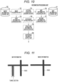
- the map information verification unit 20 refers to the information about the corresponding map information storage unit 11 in the section in which the difference is obtained, and determines whether the shielded region exists (that is, whether the road is shielded by another structure). For example, as illustrated in FIG. 11 , when the road is in a tunnel, the part is determined to be the shielding region. In addition, for example, when the road is a lower road relative to a junction or an expressway, the part is determined to be the shielding region. In a part where the roads three-dimensionally intersect, the shielding region may be determined in consideration of the widths of both roads.
- 1 is output as a variable "#" in FIG. 5 when the shielding exists, and 0 is output as the variable "#" in FIG. 5 when the shielding does not exist.
- the value of the variable # may be set to a level in a stepwise manner according to a shielding degree or the like.
- a signal B is output.
- the map information verification unit 20 outputs a signal BO when the road regarding the difference is not shielded, and outputs a signal B1 when the road regarding the difference is shielded.
- a signal C or D is output. That is, the case is the case where it is estimated that the number of lanes, the road width, and the like registered on the road are different although the road exists in both.
- the map information verification unit 20 when the width (or the number of lanes) of the road observed on the image given from the first information conversion unit 15 is greater than that given from the second information conversion unit 17 (Yes in S5), the map information verification unit 20 outputs the signal D, and otherwise outputs the signal C (No in S5).
- the map information verification unit 20 outputs a signal CO when the road regarding the difference is not shielded, and outputs a signal C1 when the road regarding the difference is shielded.
- the map information verification unit 20 outputs a signal DO when the shielding does not exist for the road regarding the difference, and outputs a signal D1 when the shielding exists.
- the difference extraction unit 16 determines that the difference does not exist (No in S1), and outputs a signal E when the roads exist on both sides (S6).
- a signal E0 is output when the shielding does not exist
- a signal E1 is output when the shielding exists.
- the structure information verification unit 18 distinguishes and outputs the type of difference by checking the shielding status in the map of the section in which the difference exists.
- the information processing device may include a difference reliability output unit 30 as illustrated in FIG. 10 , and the difference reliability output unit 30 may determine the reliability of the difference according to the result of the processing in FIG. 5 .
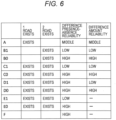
- FIG. 6 illustrates a relationship between the difference information and the reliability.
- the difference reliability output unit 30 outputs the reliability to each of the difference presence-absence information and the difference amount information.
- the difference reliability output unit 30 determines the reliability based on the first road region, the second road region, and the presence or absence of the shielding. With such the configuration, the reliability is determined by appropriately considering the presence or absence of the shielding.
- the data "-" indicates that the data to be updated does not exist because the difference does not exist.
- the reliability in the case where the shielding exists (B1, C1, D1, E1) is lower than the reliability in the case where the shielding does not exist (B0, C0, D0, E0). This is because road recognition from the image may be inaccurate due to the shielding.
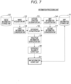
- the information processing device may include a map information update unit 31 as illustrated in FIG. 7 .
- the map information update unit 31 updates the map information about the map information storage unit 11 based on the difference information (for example, according to the results of the structure information verification unit 18 and the difference reliability output unit 30). More specifically, whether to update the map information is determined based on the reliability of the difference presence-absence information and the reliability of the difference amount information. Then, when it is determined to perform the update, the map information is updated. According to such the configuration, the map information can be appropriately updated.
- the map information is updated according to the classified results in FIGS. 5 and 6 .
- the map information update unit 31 does not update the map information.
- the update may be performed even when the data of the image information storage unit 10 is older.
- the map information may be updated when freshness of the data is similar (for example, a time difference is within a predetermined range) or when the reliability of the map information is low.
- the "reliability of map information" may be determined by processing described later, or be determined using other appropriate reference.
- the map information update unit 31 may determine to update the map information in the case of A (that is, when the road exists in the first road,-region and the road corresponding to the second road region does not exist).
- information regarding the road may be added to the map information. In this way, when the new road is found by the image, the information can be reflected in the map information.
- the map information update unit 31 may determine not to update the map information when it is determined that the difference information is caused by the shielding of the road (B1) in the case where the road exists in the second road region and in the case where the road corresponding to the first road region (B) does not exist. On the other hand, when it is not determined that the difference information is caused by the shielding of the road (B0), it may be determined to update the map information. In this way, the map information can be appropriately updated in consideration of the presence or absence of the shielding.
- the map information update unit 31 determines whether to update the map information (C1 or D1) based on the width of the road in the first road region and the width of the road in the second road region. In this way, the map information can be appropriately updated in consideration of the width of the road.
- the update of the reliability is not required.
- information indicating that the reliability of the map information is high is added as the result of the verification of the image information storage unit 10.
- the information indicating that the reliability is low is given at a place where the road on which the difference appears and another road intersect. At this time, it is also conceivable to newly add the node or the link to an intersection of the network information to update the network information.
- the pieces of information A to F may be registered as the information representing the reliability of the map information as they are.
- the shielding region of the road can be appropriately handled.
- the map information can be updated while the shielding information that is a problem peculiar to the satellite image and the aerial photograph is considered.
- FIG. 3 illustrates a configuration in which a functional unit that estimates the shielding region is added to the first information conversion unit 15 and the second information conversion unit 17 in FIG. 2 .
- the first information conversion unit 15 includes a first shielding region estimation unit 156
- the second information conversion unit 17 includes a second shielding region estimation unit 176.
- the first information conversion unit 15 estimates first structure information based on the image using the first shielding region estimation unit 156.
- the first structure information is information specifying a part (shielding region) in which the road is shielded in the image.
- Specific estimation processing can be appropriately designed based on a known technique or the like.
- the prior learning model 150 may estimate the road region shielded from a group of surrounding buildings or pattern information.
- the structure other than the road such as a building or a tree
- another road such as a road having a three-dimensional intersection or an expressway.
- a plurality of attributes may be output for one pixel.
- the attribute of the structure other than the road and the attribute of the shielded road may be output, or the attribute of the road and the attribute of the shielded road may be output.
- the output that estimates a shielding cause such as the shielding by a building, the shielding by a tree, and the shielding by another road may be provided.
- the second information conversion unit 17 causes the second shielding region estimating unit 176 to estimate second structure information based on the map information.
- the second structure information is information specifying a part where the road shielding exists in the map information.
- the estimation may be performed by processing similar to that of-the map information verification unit 20.
- the difference extraction unit 16 obtains the difference of the road region instead of the difference of the shielding region.
- the shielded region that can be estimated by the shielded region estimation unit of the first information conversion unit 15 tends to be a shorter distance or a narrower region than that estimated by the second information conversion unit 17.
- the first information conversion unit 15 can estimate the shielding for the road in which a small part of the road is shielded, but cannot appropriately estimate shielding for the region in which most of the road is shielded, such as a long tunnel.
- the configuration of the structure information verification unit 18 includes a mutual shielding information verification unit 21 in FIG. 8 .
- the mutual shielding information verification unit 21 collates the first structure information with the second structure information to estimate a shielding situation.
- the mutual shielding information verification unit 21 outputs 3 when both the first structure information (image) and the second structure information (map information) are shielded, outputs 2 when only the map information is shielded, outputs 1 when only the image is shielded, and outputs 0 when both the image and the map information are not shielded.
- the meaning of the variable $ is similar to that of the variable # in FIG. 5 , but the variable $ can take four values of 0 to 3. According to such the configuration, the shielding of each of the image and the map information can be considered.
- the structure information verification unit 18 verifies the reliability of the extracted difference region.
- a shielding possibility is determined, and the map information is not updated when the entire one of the roads is shielded.
- the reliability of the difference is lowered.
- the reliability of the difference is increased.
- the reliability can be determined for the configuration in FIG. 8 as illustrated in FIG. 9 .
- A because the shielding information corresponding to the map side does not exist, A3 and A2 do not exist. Likewise, neither F3 nor F2 exists.
- the classified result may be used as the output of the difference reliability output unit 30 in FIG. 10 .
- the map information may be updated based on the reliability in FIG. 9 .
- the specific processing at this time can be designed similarly to the example described in reference to FIG. 6 .
- the map information update unit 31 sets the reliability of the map information to 3.
- the following processing is performed.
- the map information update unit 31 sets the reliability of the map information to 2.
- the following processing is performed.
- the map information update unit 31 refers to the previous reliability (that is, the reliability of the map information determined when the map information was updated last time).
- the previous reliability that is, the reliability of the map information determined when the map information was updated last time.
- the previous reliability is not designated (No in S13)
- the reliability of the map information is set to 1.
- the previous reliability is 0 or 1 (Yes in S14)
- the reliability of the map information is set to 0.
- the previous reliability is 2 or 3 (No in S14)
- the reliability of the map information is set to 1.
- the map information update unit 31 determines the reliability of the map information when the map information is updated. Then, the new reliability of the map information is determined based on the reliability of the map information determined when the map information was updated last time. For this reason, the reliability of the map information can be more appropriately determined based on the reliability of the difference, the reliability of the map information, and a history of the reliability of the map information. For example, the reliability of the map information is used as a criterion determining whether to update the map information, so that the map information can be updated more appropriately.
- the map information may be updated only for the. node and the link in which the difference is generated from previous map information. In that case, it is conceivable to discard the previous difference information regarding the updated node and link and consider only the result of newly performing the collation.
Landscapes
- Engineering & Computer Science (AREA)
- Remote Sensing (AREA)
- Radar, Positioning & Navigation (AREA)
- General Physics & Mathematics (AREA)
- Physics & Mathematics (AREA)
- Theoretical Computer Science (AREA)
- Automation & Control Theory (AREA)
- Multimedia (AREA)
- Computer Vision & Pattern Recognition (AREA)
- Computing Systems (AREA)
- Software Systems (AREA)
- Medical Informatics (AREA)
- General Health & Medical Sciences (AREA)
- Evolutionary Computation (AREA)
- Databases & Information Systems (AREA)
- Artificial Intelligence (AREA)
- Health & Medical Sciences (AREA)
- Instructional Devices (AREA)
- Processing Or Creating Images (AREA)
Abstract
Description
- The present invention relates to an information processing device and an information processing method. For example, the present disclosure relates to the information processing device and the information processing method that handle map data for automatic driving and an advanced safety driving system.
- A method for collecting road information by a map generation vehicle or manpower and constructing a highly accurate map for a map that holds road or lane information in a network shape is known for the automatic driving and driving assistance. In this method, because a considerable amount of human labor is generated, only information about a part of the road such as an expressway can be constructed, and there are problems that completeness of the constructed map information is reduced and that a range in which the map can be provided for automatic driving and driving assistance is narrowed.
- For this problem, for example,
PTL 1 discloses a method for updating the map using data collected from an imaging device mounted on a general vehicle.PTL 2 discloses a technique for enhancing the accuracy of the map using an aerial photograph and navigation map data. Furthermore,PTL 3 discloses a map correction method using aerial photograph data and substrate road map data. -
- PTL 1:
Japanese Patent No. 6197393 - PTL 2:
Japanese Patent No. 4799709 - PTL 3:
JP 2019-101256 A - However, the conventional technique has a problem that a shielding region that does not appear in the image because the road is shielded cannot be appropriately handled.
- The shielded region where the road is shielded by a tunnel, an overhead crossing, high-rise buildings, and the like exists in the aerial photograph, a satellite image, and the image captured by the imaging device mounted on the general vehicle. For this reason, when road information extracted based on the captured image is reflected on the map, there is a problem that wrong information is reflected.
- The present invention has been made to solve such a problem, and an object of the present invention is to provide an information processing device and an information processing method capable of appropriately handling the shielding region of the road.
- An example of an information processing device includes:
- a first information conversion unit that estimates a first road region from an image obtained by imaging a road;
- a second information conversion unit that estimates a second road region from map information stored in a map information storage unit; and
- a difference extraction unit that extracts difference information indicating a difference between the first road region and the second road region.
- An example of an information processing method in which a computer:
- estimates a first road region from an image obtained by imaging a road;
- estimates a second road region from map information; and
- extracts difference information indicating a difference between the first road region and the second road region.
- The present specification includes the disclosure of
Japanese Patent Application No. 2021-063499 - The information processing device and the information processing method according to the present invention can appropriately handle the shielding region of the road.
-
- [
FIG. 1] FIG. 1 is a view illustrating a basic configuration of an information processing device. - [
FIG. 2] FIG. 2 is a view illustrating an information conversion unit. - [
FIG. 3] FIG. 3 is a view illustrating the information conversion unit including a shielding region estimation unit. - [
FIG. 4] FIG. 4 is a view illustrating a difference extraction unit. - [
FIG. 5] FIG. 5 is a view illustrating a map information verification unit. - [
FIG. 6] FIG. 6 is a view illustrating a relationship between difference information and reliability according to a configuration inFIG. 5 . - [
FIG. 7] FIG. 7 is a view illustrating an information processing device including a map information update unit. - [
FIG. 8] FIG. 8 is a view illustrating a mutual shielding information verification unit. - [
FIG. 9] FIG. 9 is a view illustrating a relationship between difference information and reliability according to a configuration inFIG. 8 . - [
FIG. 10] FIG. 10 is a view illustrating a configuration including a difference reliability output unit. - [
FIG. 11] FIG. 11 is a view illustrating an example in which an output is different between map information and image information. - [
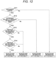
FIG. 12] FIG. 12 is a view illustrating an example of a method for determining the reliability of the map information. - Hereinafter, an embodiment of the present invention will be described with reference to the accompanying drawings.
-
FIG. 1 illustrates a configuration of an information processing device according to a first embodiment. The information processing device executes an information processing method described in the present specification. - An
image acquisition unit 12 acquires a satellite image or an aerial image belonging to a range designated by a latitude-longitude designation unit 13 from an imageinformation storage unit 10 that stores the satellite image or an aerial photograph. At this point, for example, the satellite image is obtained by capturing an image of a ground from a camera mounted on a satellite, acquiring the image, and restoring data of the ground as if overlooking the data. In addition, for example, the aerial image is the image of the ground captured by the camera mounted on an aircraft, acquired, and restored as if the data of the ground is overlooked. - The latitude-
longitude designation unit 13 may designate the latitude and longitude such that an image to be acquired is extracted, or substitute the latitude and longitude with an identifier or the like that substitutes the latitude and longitude. - A first
information conversion unit 15 estimates a road region (first road region) from the image obtained by imaging the road. For example, processing is performed on the satellite image or the aerial image acquired by theimage acquisition unit 12 to estimate the road region. The first road region may be represented as the image. - For example, the road region is estimated as an attribute given to each pixel of the image, and includes information indicating whether each pixel is the road. This information can be represented as the image. Alternatively, the road region may be extracted in a network shape represented by nodes and links, and in this case, the extracted information may be represented by a set of pixels.
- A map
information acquisition unit 14 acquires map information (for example, information in a network format) of a region designated by the latitude-longitude designation unit 13 from a mapinformation storage unit 11. - A second
information conversion unit 17 estimates a road region (second road region) from the map information stored in the mapinformation storage unit 11. For example, data having the same format as that output by the firstinformation conversion unit 15 is output. That is, when the firstinformation conversion unit 15 outputs the image, the secondinformation conversion unit 17 also generates the image indicating the road region. When the firstinformation conversion unit 15 outputs the data in the network format, the secondinformation conversion unit 17 also outputs the data in the network format. - A
difference extraction unit 16 extracts difference information representing a difference between the two road regions (the first road region and the second road region). - A structure
information verification unit 18 verifies a structure regarding the road based on the extracted difference information, and outputs a result. In the following description, unless otherwise specified, it is assumed that the forms output from the firstinformation conversion unit 15 and the secondinformation conversion unit 17 are images, but the outputs of the firstinformation conversion unit 15 and the secondinformation conversion unit 17 may be in the network shape. Thedifference extraction unit 16 may compare images with each other or compare networks with each other. - For example, the information processing device in
FIG. 1 can be configured using a known computer. For example, the information processing device includes arithmetic means and storage means. For example, the arithmetic means includes a processor, and the storage means includes a storage medium such as a semiconductor memory device and a magnetic disk device. - In addition, the computer may include input/output means. For example, the input/output means includes an input device such as a keyboard and a mouse, an output device such as a display and a printer, and a communication device such as a network interface.
- The storage means may store a program. The computer may perform functions described in the embodiment by a processor executing the program,. That is, the computer functions as each component in
FIG. 1 , thereby operating as the information processing device, namely, executing the information processing method. -
FIG. 2 illustrates configurations of the firstinformation conversion unit 15 and the secondinformation conversion unit 17. The firstinformation conversion unit 15 uses the image acquired by theimage acquisition unit 12 as the input to estimate whether the image is, for example, the road region for each pixel of the image. At this point, for example, the estimation can be performed by a semantic segmentation technique or the like using aprior learning model 150 such as a neural network previously learned by machine learning. - In the following, description, the term "road" is a generic term for a road including a single lane and a road including a plurality of lanes. For example, the entire road including the plurality of lanes may be processed as one road, or be processed as a plurality of parallel roads.
- The estimation of the road region is performed by a first road
region estimation unit 151. In addition, the firstinformation conversion unit 15 may include a first roadboundary estimation unit 152 that estimates a boundary between a road and a road or between a road and a non-road, or include a first road indicationregion estimation unit 153 that estimates a white line, a yellow line, a zebra zone, or the like. The firstinformation conversion unit 15 may include a first laneboundary estimation unit 154 and/or a first laneregion estimation unit 155 that divides the road region for each lane to estimate the road region together with the boundary of the lane in order to estimate more detailed information. - For example, the map
information storage unit 11 stores road data included in map data for navigation. In this data, a shape of the road is stored in the network shape, and for example, an element of the shape of the road is stored in a state representing a node, a link, the shape of the link, and the attribute of the road. For example, an edge of the road is represented as the node, and the road is represented as the link connecting two nodes. The link may be associated with information indicating the attribute of the road (for example, a width of the road or the lane). - Similarly to the first
information conversion unit 15, in addition to a second roadregion estimation unit 171, the secondinformation conversion unit 17 may include a second roadboundary estimation unit 172 that estimates the boundary between the road and the non-road or the boundary between the road and another road, and include a second laneboundary estimation unit 174 and/or a second laneregion estimation unit 175 that divides the road region for each lane to estimate the road region together with the boundary of the lane in order to estimate more detailed information. In more detail, when the map holds the yellow line, the white line information, and the like, the secondinformation conversion unit 17 may include a second road indicationregion estimation unit 173. - For example, when given network information indicates a center line position of the road, the second road
region estimation unit 171 can first convert the network information into information in an image format, and further widen pixels on both sides of the center line to estimate the road region. For example, the widening is performed by configuring a disk having a radius of half of the pixel corresponding to the lane width while considering the number of lanes for each pixel configuring the center line and superimposing the disks. For example, the number of pixels to be actually widened can be determined according to a distance per pixel of the image obtained by the firstinformation conversion unit 15. When two parallel roads overlap each other at the time of widening, the center line of the overlapping region may be treated as the road boundary. A person skilled in the art can appropriately design processing in the case where there is a vertical relationship in altitude on the road (for example, a three-dimensional intersection), but for example, the road having a higher altitude may be preferentially widened. -
FIG. 4 illustrates the function of thedifference extraction unit 16. In the embodiment, the results of the first roadregion estimation unit 151 and the second roadregion estimation unit 171 are used in the estimation units inFIG. 2 . However, processing results of the first roadboundary estimation unit 152 and the second roadboundary estimation unit 172, the first road indicationregion estimation unit 153 and the second road indicationregion estimation unit 173, and the first laneboundary estimation unit 154 and the second laneboundary estimation unit 174 may also be used as information improving accuracy of difference extraction. - The
difference extraction unit 16 extracts a difference between the images acquired from the firstinformation conversion unit 15 and the secondinformation conversion unit 17. In the images acquired from the two information conversion units, there is a possibility that the positions of the roads are shifted from each other due to distortion of the satellite image or the aerial photograph that is a source of the images or the shift of the position of the network of the map registered in the mapinformation storage unit 11. For this reason, first an initialposition correction unit 161 performs rough alignment between roads. Specific processing of the alignment between two images can be appropriately designed based on a known technique. - In order to perform this alignment, the second
information conversion unit 17 may refer to the original network information to perform adjustment and regenerate the image. Subsequently, according to a comparison format (162), a road presence-absence determination unit 163 and a roadwidth comparison unit 165 perform the comparison of the presence or absence of the road on the image, the road widths, the presence or absence of the lane, or the lane widths in the case where the comparison is made based on the road, and a lane presence-absence determination unit 164 and a lanewidth comparison unit 166 perform the comparison of the presence or absence of the road on the image, the road widths, the presence or absence of the lane, or the lane widths in the case where the comparison is made based on the lane. - In the comparison of the presence or absence of the lane and the comparison of the lane width, processing for recognizing the road may be performed based on the first road region and the second road region. In addition, processing for recognizing an end point and a width of the road may be performed after the road is recognized. Furthermore, processing for determining a correspondence relationship of roads between the road regions may be performed. These pieces of specific processing can be appropriately designed based on a known technique. This makes it possible to compare the presence or absence of the road or the width of the road.
- The road presence-
absence determination unit 163 determines the difference regarding the presence or absence of the road in the first road region and the second road region (both images in the following example). For example, in the case where the information about a certain road exists in one image while no information about the road corresponding to the other image, it is determined that the difference regarding the presence or absence of the road exists. - When the road information associated with both images exists, the road
width comparison unit 165 compares the widths of the roads on the images, and obtains and outputs the difference in the widths. The output of the difference may be processed in consideration of a conversion error or the like in both data inputs, and the output unit may be the number of pixels or the number of lanes corresponding to the number of pixels. - The lane presence-
absence determination unit 164 determines the difference regarding the presence or absence of the lane in the first road region and the second road region. When the lane information associated with both images exists, the lanewidth comparison unit 166 compares the widths of the lanes on the images, and obtains and outputs the difference in the widths. - The
difference extraction unit 16 collectively sets these pieces of information as difference information, and transmits the difference information to the structureinformation verification unit 18. As described above, the difference information includes the difference presence-absence information indicating the presence or absence of the difference and the difference amount information indicating the difference amount. At this point, for example, the "presence or absence of difference" means whether the difference regarding the presence or absence of the road exists and whether the difference regarding the width of the road exists, and the "difference amount" means the magnitude of the difference regarding the difference of the width of the road. - For example, the unit outputting the difference may be a part of the road or the lane, a set of pixels on the image, the node or the link on the network, or the like. Hereinafter, the unit outputting the difference is referred to as a section. For example, the section is a section obtained by dividing the image on a predetermined reference (for example, into equal-sized squares). Furthermore, it is assumed that which part of the information in the original image
information storage unit 10 or the mapinformation storage unit 11 corresponds to the output section can be determined by following the conversion process so far. -
FIG. 5 illustrates a configuration of the structureinformation verification unit 18. In this example, the structureinformation verification unit 18 includes a mapinformation verification unit 20. - The map
information verification unit 20 classifies and outputs the type of the difference based on the comparison result of thedifference extraction unit 16 and the structure information about the road or the lane. Hereinafter, although the function will be described focusing on the road, the road may be replaced with the lane. In the structureinformation verification unit 18, the mapinformation verification unit 20 checks whether the shielding is generated in the target section. - The map
information verification unit 20 refers to the information about the corresponding mapinformation storage unit 11 in the section in which the difference is obtained, and determines whether the shielded region exists (that is, whether the road is shielded by another structure). For example, as illustrated inFIG. 11 , when the road is in a tunnel, the part is determined to be the shielding region. In addition, for example, when the road is a lower road relative to a junction or an expressway, the part is determined to be the shielding region. In a part where the roads three-dimensionally intersect, the shielding region may be determined in consideration of the widths of both roads. - In this case, 1 is output as a variable "#" in
FIG. 5 when the shielding exists, and 0 is output as the variable "#" inFIG. 5 when the shielding does not exist. However, the value of the variable # may be set to a level in a stepwise manner according to a shielding degree or the like. - First, when the
difference extraction unit 16 determines that the difference exists (Yes in S1), and when the road exists on the image given from the firstinformation conversion unit 15 and when the road does not exist on the image given from the second information conversion unit 17 (S2), a signal A is output as a classification result. - When it is determined that the difference exists (Yes in S1), and when the road does not exist on the image given from the first
information conversion unit 15 and when the road exists on the image given from the second information conversion unit 17 (S3), a signal B is output. In particular, the mapinformation verification unit 20 outputs a signal BO when the road regarding the difference is not shielded, and outputs a signal B1 when the road regarding the difference is shielded. - When it is determined that the difference exists (Yes in S1), and when the road exists on the image given from the first
information conversion unit 15 and when the road exists also on the image given from the second information conversion unit 17 (S4), a signal C or D is output. That is, the case is the case where it is estimated that the number of lanes, the road width, and the like registered on the road are different although the road exists in both. - In this case, when the width (or the number of lanes) of the road observed on the image given from the first
information conversion unit 15 is greater than that given from the second information conversion unit 17 (Yes in S5), the mapinformation verification unit 20 outputs the signal D, and otherwise outputs the signal C (No in S5). - In particular, regarding the signal C, the map
information verification unit 20 outputs a signal CO when the road regarding the difference is not shielded, and outputs a signal C1 when the road regarding the difference is shielded. Similarly, for the signal D, the mapinformation verification unit 20 outputs a signal DO when the shielding does not exist for the road regarding the difference, and outputs a signal D1 when the shielding exists. - When the
difference extraction unit 16 determines that the difference does not exist (No in S1), and outputs a signal E when the roads exist on both sides (S6). In particular, a signal E0 is output when the shielding does not exist, and a signal E1 is output when the shielding exists. - When the
difference extraction unit 16 determines that the difference does not exist (No in S1), and outputs a signal F when the road does not exist on both sides (S7). - In this manner, the structure
information verification unit 18 distinguishes and outputs the type of difference by checking the shielding status in the map of the section in which the difference exists. - The information processing device may include a difference
reliability output unit 30 as illustrated inFIG. 10 , and the differencereliability output unit 30 may determine the reliability of the difference according to the result of the processing inFIG. 5 . -
FIG. 6 illustrates a relationship between the difference information and the reliability. The differencereliability output unit 30 outputs the reliability to each of the difference presence-absence information and the difference amount information. In the embodiment, the differencereliability output unit 30 determines the reliability based on the first road region, the second road region, and the presence or absence of the shielding. With such the configuration, the reliability is determined by appropriately considering the presence or absence of the shielding. - The reason why only A has the reliability of "medium" is that the data to be referred to does not exist on the side of the map
information storage unit 11. - The data "-" indicates that the data to be updated does not exist because the difference does not exist. The reliability in the case where the shielding exists (B1, C1, D1, E1) is lower than the reliability in the case where the shielding does not exist (B0, C0, D0, E0). This is because road recognition from the image may be inaccurate due to the shielding.
- Regarding the road recognition (processing based on the first road region) from the image, because a part of the road does not appear in the image when the shielding exists, there is a high possibility that the recognized road is narrower than the actual road, and there is a low possibility that the recognized road is wider than the actual road. For this reason, the reliability in the case of C1 is low, and the reliability in the case of D1 is high (higher than C1).
- The information processing device may include a map
information update unit 31 as illustrated inFIG. 7 . The mapinformation update unit 31 updates the map information about the mapinformation storage unit 11 based on the difference information (for example, according to the results of the structureinformation verification unit 18 and the difference reliability output unit 30). More specifically, whether to update the map information is determined based on the reliability of the difference presence-absence information and the reliability of the difference amount information. Then, when it is determined to perform the update, the map information is updated. According to such the configuration, the map information can be appropriately updated. - In the embodiment, the map information is updated according to the classified results in
FIGS. 5 and6 . - Although a reference example of the update will be described below, it is assumed that the data of the image
information storage unit 10 is newer than the data of the mapinformation storage unit 11. When the data in the imageinformation storage unit 10 is older, the mapinformation update unit 31 does not update the map information. However, as a modification, the update may be performed even when the data of the imageinformation storage unit 10 is older. Furthermore, as another modification, the map information may be updated when freshness of the data is similar (for example, a time difference is within a predetermined range) or when the reliability of the map information is low. The "reliability of map information" may be determined by processing described later, or be determined using other appropriate reference. - First, an example of additionally registering whether the reliability is high for the presence or absence of information registered on the map will be described. In
FIGS. 5 and6 , the mapinformation update unit 31 may determine to update the map information in the case of A (that is, when the road exists in the first road,-region and the road corresponding to the second road region does not exist). As a specific example, information regarding the road may be added to the map information. In this way, when the new road is found by the image, the information can be reflected in the map information. As a modification, in the case of A, it may be determined that the map information is not updated. - For the cases of B0, C0, D0, D1 in which there is the high possibility that the presence or absence of the extracted difference is correct, information indicating that the reliability of the map information is low is added to the map. On the other hand, for Bl, C1, E1 in which there is the high possibility that the extracted difference is incorrect, the reliability of the map information is not updated, or the information indicating that the reliability of the map information is high is added as the result of verification with the image
information storage unit 10. - That is, the map
information update unit 31 may determine not to update the map information when it is determined that the difference information is caused by the shielding of the road (B1) in the case where the road exists in the second road region and in the case where the road corresponding to the first road region (B) does not exist. On the other hand, when it is not determined that the difference information is caused by the shielding of the road (B0), it may be determined to update the map information. In this way, the map information can be appropriately updated in consideration of the presence or absence of the shielding. - When the road corresponding to both the first road region and the second road region exists (C1 and D1), the map
information update unit 31 determines whether to update the map information (C1 or D1) based on the width of the road in the first road region and the width of the road in the second road region. In this way, the map information can be appropriately updated in consideration of the width of the road. - In the case of E0 and F, the update of the reliability is not required. In the case of E0, information indicating that the reliability of the map information is high is added as the result of the verification of the image
information storage unit 10. Regarding A, it may be determined to update the map information, or the information indicating that the map information is not updated may be added because the road information to be updated does not exist on the map. Alternatively, with regarding A, for example, the information indicating that the reliability is low is given at a place where the road on which the difference appears and another road intersect. At this time, it is also conceivable to newly add the node or the link to an intersection of the network information to update the network information. - The case in which whether the reliability of the number of lanes or the lane width is high is additionally registered in the map information will be considered below. In this case, when the result of the reliability of the difference amount is high in
FIG. 6 , it is conceivable to consider that the reliability of the information registered on the map is low to give the result. InFIG. 6 , when the reliability of the difference amount is low, it is considered that the information registered on the map is reliable, and the information indicating that the map information is not updated or the information indicating that the reliability is high is added. - In the above description, a mechanism determining the reliability of the map information from the reliability of the difference has been described. However, as a matter of course, the pieces of information A to F may be registered as the information representing the reliability of the map information as they are.
- As described above, according to the information processing device of the embodiment, the shielding region of the road can be appropriately handled. For example, when the mechanism based on the presence or absence of the difference and the reliability of the output difference is taken, the map information can be updated while the shielding information that is a problem peculiar to the satellite image and the aerial photograph is considered.
-
FIG. 3 illustrates a configuration in which a functional unit that estimates the shielding region is added to the firstinformation conversion unit 15 and the secondinformation conversion unit 17 inFIG. 2 . The firstinformation conversion unit 15 includes a first shieldingregion estimation unit 156, and the secondinformation conversion unit 17 includes a second shieldingregion estimation unit 176. - The first
information conversion unit 15 estimates first structure information based on the image using the first shieldingregion estimation unit 156. For example, the first structure information is information specifying a part (shielding region) in which the road is shielded in the image. Specific estimation processing can be appropriately designed based on a known technique or the like. In the estimation, theprior learning model 150 may estimate the road region shielded from a group of surrounding buildings or pattern information. - In the shielded region, there are the case where the structure other than the road, such as a building or a tree, is shielded and the case where the structure other than the road is shielded by another road, such as a road having a three-dimensional intersection or an expressway. For this reason, a plurality of attributes may be output for one pixel. For example, the attribute of the structure other than the road and the attribute of the shielded road may be output, or the attribute of the road and the attribute of the shielded road may be output.
- In addition, the output that estimates a shielding cause such as the shielding by a building, the shielding by a tree, and the shielding by another road may be provided.
- The second
information conversion unit 17 causes the second shieldingregion estimating unit 176 to estimate second structure information based on the map information. For example, the second structure information is information specifying a part where the road shielding exists in the map information. The estimation may be performed by processing similar to that of-the mapinformation verification unit 20. In the embodiment, thedifference extraction unit 16 obtains the difference of the road region instead of the difference of the shielding region. - Several differences exist in the shielding region estimated by the first shielding
region estimating unit 156 and the second shieldingregion estimating unit 176. One is that the shielded region that can be estimated by the shielded region estimation unit of the firstinformation conversion unit 15 tends to be a shorter distance or a narrower region than that estimated by the secondinformation conversion unit 17. For example, the firstinformation conversion unit 15 can estimate the shielding for the road in which a small part of the road is shielded, but cannot appropriately estimate shielding for the region in which most of the road is shielded, such as a long tunnel. - In the configuration including the first shielding
region estimating unit 156 and the second shieldingregion estimating unit 176 as described above, for example, the configuration of the structureinformation verification unit 18 includes a mutual shieldinginformation verification unit 21 inFIG. 8 . The mutual shieldinginformation verification unit 21 collates the first structure information with the second structure information to estimate a shielding situation. - As the variable "$" in
FIG. 8 , the mutual shieldinginformation verification unit 21outputs 3 when both the first structure information (image) and the second structure information (map information) are shielded,outputs 2 when only the map information is shielded,outputs 1 when only the image is shielded, andoutputs 0 when both the image and the map information are not shielded. The meaning of the variable $ is similar to that of the variable # inFIG. 5 , but the variable $ can take four values of 0 to 3. According to such the configuration, the shielding of each of the image and the map information can be considered. - In view of such characteristics, the structure
information verification unit 18 verifies the reliability of the extracted difference region. As a specific example, when the difference is extracted by thedifference extraction unit 16, a shielding possibility is determined, and the map information is not updated when the entire one of the roads is shielded. In addition, when only a part is shielded, the reliability of the difference is lowered. On the other hand, when it is determined that the shielding does not exist, the reliability of the difference is increased. - In the classification of A to F described above, in addition to whether the extracted difference is the presence or absence of the road, whether the reliability of the extracted difference is high or whether the difference amount is reliable is classified on the assumption that the shielding exists in the image
information storage unit 10. - Similarly to
FIG. 6 , the reliability can be determined for the configuration inFIG. 8 as illustrated inFIG. 9 . Regarding A, because the shielding information corresponding to the map side does not exist, A3 and A2 do not exist. Likewise, neither F3 nor F2 exists. The classified result may be used as the output of the differencereliability output unit 30 inFIG. 10 . - The map information may be updated based on the reliability in
FIG. 9 . The specific processing at this time can be designed similarly to the example described in reference toFIG. 6 . - An example in which only the information about the image
information storage unit 10 is updated and collated after being updated with the configuration inFIG. 7 will be described with reference toFIG. 12 . Here, it is assumed that the reliability of the map information is 0 to 3, and that the reliability of the map information is high when the value is large. The "reliability of map information" is different from the "reliability of difference" described above. - At this point, although the case where the data (image) of the image
information storage unit 10 is newer than the data (map information) of the mapinformation storage unit 11 is considered, the following processing is similarly applicable to other cases. - When it is determined that the difference does not exist (No in S11), the map
information update unit 31 sets the reliability of the map information to 3. When it is determined that the difference exists (Yes in S11), the following processing is performed. - When it is determined that the reliability of the presence or absence of the difference is low (No in S12), the map
information update unit 31 sets the reliability of the map information to 2. When it is determined that the reliability of the presence or absence of the difference is high (Yes in S12), the following processing is performed. - The map
information update unit 31 refers to the previous reliability (that is, the reliability of the map information determined when the map information was updated last time). When the previous reliability is not designated (No in S13), the reliability of the map information is set to 1. When the previous reliability is 0 or 1 (Yes in S14), the reliability of the map information is set to 0. When the previous reliability is 2 or 3 (No in S14), the reliability of the map information is set to 1. - According to this example, the map
information update unit 31 determines the reliability of the map information when the map information is updated. Then, the new reliability of the map information is determined based on the reliability of the map information determined when the map information was updated last time. For this reason, the reliability of the map information can be more appropriately determined based on the reliability of the difference, the reliability of the map information, and a history of the reliability of the map information. For example, the reliability of the map information is used as a criterion determining whether to update the map information, so that the map information can be updated more appropriately. - Subsequently, an example in which the data (map information) of the map
information storage unit 11 is newer than the data (image) of the imageinformation storage unit 10 will be described. The map information may be updated only for the. node and the link in which the difference is generated from previous map information. In that case, it is conceivable to discard the previous difference information regarding the updated node and link and consider only the result of newly performing the collation. - Finally, when the freshness of both pieces of data is the same (for example, when the pieces of data are updated at the same time), it is conceivable that the previous difference information is discarded to register a new comparison result for the node and the link part in which the map information is updated, and that an update rule in
FIG. 12 is applied to other parts. -
- 15 first information conversion unit
- 16 difference extraction unit
- 17 second information conversion unit
- 18 structure information verification unit
- 30 difference reliability output unit
- 31 map information update unit
- All publications, patents, and patent applications cited herein are hereby incorporated by reference in their entirety.
Claims (10)
- An information processing device, comprising:a first information conversion unit that estimates a first road region from an image obtained by imaging a road;a second information conversion unit that estimates a second road region from map information stored in a map information storage unit; anda difference extraction unit that extracts difference information indicating a difference between the first road region and the second road region.
- The information processing device according to claim 1, comprising:a difference reliability output unit that determines reliability of the difference information; anda map information update unit that determines whether to update the map information based on the difference information.
- The information processing device according to claim 2, whereinthe difference information includes difference presence-absence information indicating presence or absence of the difference and difference amount information indicating an difference amount,the difference reliability output unit outputs reliability for each of the difference presence-absence information and the difference amount information, andthe map information update unit determines whether to update the map information based on the reliability of the difference presence-absence information and the reliability of the difference amount information.
- The information processing device according to claim 2, wherein the map information update unit determines reliability of the map information when the map information is updated..
- The information processing device according to claim 4, wherein the map information update unit determines the reliability of the map information based on the reliability of the map information determined when the map information is updated last time.
- The information processing device according to claim 1, comprising a structure information verification unit that collates first structure information and second structure information,
whereinthe first information conversion unit estimates the first structure information based on the image, andthe second information conversion unit estimates the second structure information based on the map information. - The information processing device according to claim 2, wherein the map information update unit determines to update the map information when a road exists in the first road region and when a road corresponding to the second road region does not exist.
- The information processing device according to claim 2, wherein when a road exists in the second road region and when a road corresponding to the first road region does not exist, the map information update unit determines not to update the map information when it is determined that the difference information is generated by shielding of the road, and determines to update the map information when it is not determined that the difference information is generated by the shielding of the road.
- The information processing device according to claim 2, wherein the map information update unit determines whether to update the map information further based on a width of a road in the first road region and a width of a road in the second road region when a road corresponding to both the first road region and the second road region exists.
- An information processing method in which a computer:estimates a first road region from an image obtained by imaging a road;estimates a second road region from map information; andextracts difference information indicating a difference between the first road region and the second road region.
Applications Claiming Priority (2)
| Application Number | Priority Date | Filing Date | Title |
|---|---|---|---|
| JP2021063499A JP7715524B2 (en) | 2021-04-02 | 2021-04-02 | Information processing device and information processing method |
| PCT/JP2022/009319 WO2022209573A1 (en) | 2021-04-02 | 2022-03-04 | Information processing device and information processing method |
Publications (3)
| Publication Number | Publication Date |
|---|---|
| EP4318439A1 true EP4318439A1 (en) | 2024-02-07 |
| EP4318439A4 EP4318439A4 (en) | 2025-02-19 |
| EP4318439B1 EP4318439B1 (en) | 2026-05-06 |
Family
ID=83458577
Family Applications (1)
| Application Number | Title | Priority Date | Filing Date |
|---|---|---|---|
| EP22779798.2A Active EP4318439B1 (en) | 2021-04-02 | 2022-03-04 | Information processing device and information processing method |
Country Status (5)
| Country | Link |
|---|---|
| US (1) | US12633118B2 (en) |
| EP (1) | EP4318439B1 (en) |
| JP (1) | JP7715524B2 (en) |
| CN (1) | CN116997948B (en) |
| WO (1) | WO2022209573A1 (en) |
Families Citing this family (1)
| Publication number | Priority date | Publication date | Assignee | Title |
|---|---|---|---|---|
| JP7856076B2 (en) * | 2023-09-26 | 2026-05-11 | トヨタ自動車株式会社 | Information processing device |
Family Cites Families (29)
| Publication number | Priority date | Publication date | Assignee | Title |
|---|---|---|---|---|
| JP3378490B2 (en) * | 1998-01-29 | 2003-02-17 | 富士重工業株式会社 | Road information recognition device |
| JP2000352516A (en) * | 1999-06-10 | 2000-12-19 | Alpine Electronics Inc | Car navigation system |
| JP2003329469A (en) * | 2002-05-15 | 2003-11-19 | Sony Corp | Map display system, map display device, method of displaying traffic jam information, and program |
| JP2007128141A (en) * | 2005-11-01 | 2007-05-24 | Hitachi Software Eng Co Ltd | System and method for determining road lane number in road image |
| JP2009176163A (en) * | 2008-01-25 | 2009-08-06 | Hitachi Software Eng Co Ltd | Section data creation system |
| JP2009184648A (en) * | 2008-02-11 | 2009-08-20 | Aisin Aw Co Ltd | Driving support device, driving support method and program |
| US8214145B2 (en) * | 2009-03-04 | 2012-07-03 | Mitsubishi Electric Corporation | Map distribution server, map information terminal, and map distribution system using these map distribution server and map information terminal |
| JP2013186464A (en) | 2012-03-12 | 2013-09-19 | Aisin Aw Co Ltd | Picture data provision system |
| JP6197393B2 (en) | 2013-06-20 | 2017-09-20 | 株式会社豊田中央研究所 | Lane map generation device and program |
| JP6656886B2 (en) * | 2015-11-10 | 2020-03-04 | パイオニア株式会社 | Information processing apparatus, control method, program, and storage medium |
| JP6312754B2 (en) * | 2016-08-04 | 2018-04-18 | 三菱電機株式会社 | Vehicle travel control device and vehicle travel control method |
| WO2018094475A1 (en) * | 2016-11-28 | 2018-05-31 | Hillman Media Pty Ltd | Road event planning tool |
| JP6885781B2 (en) * | 2017-05-11 | 2021-06-16 | 日立Astemo株式会社 | Vehicle control device, vehicle control method and vehicle control system |
| JP6710190B2 (en) * | 2017-09-29 | 2020-06-17 | クラリオン株式会社 | Marking line recognition device |
| WO2019103049A1 (en) * | 2017-11-22 | 2019-05-31 | 株式会社ミックウェア | Map information processing device, map information processing method, and map information processing program |
| JP6828668B2 (en) * | 2017-12-04 | 2021-02-10 | 株式会社デンソー | Lane network data generator, lane network data generator and storage medium |
| US10446027B1 (en) * | 2017-12-11 | 2019-10-15 | Waymo Llc | Differentiating roadways by elevation |
| CN108318043B (en) * | 2017-12-29 | 2020-07-31 | 百度在线网络技术(北京)有限公司 | Method, apparatus, and computer-readable storage medium for updating electronic map |
| JP2019168514A (en) * | 2018-03-22 | 2019-10-03 | 株式会社豊田中央研究所 | Map data creation device |
| US11512965B2 (en) * | 2018-03-30 | 2022-11-29 | Hitachi Astemo, Ltd. | Vehicle control device with road identification |
| CN109710795B (en) * | 2018-12-29 | 2021-08-06 | 咪咕文化科技有限公司 | A data processing method, apparatus and computer readable storage medium |
| US11227168B2 (en) * | 2019-01-08 | 2022-01-18 | Qualcomm Incorporated | Robust lane association by projecting 2-D image into 3-D world using map information |
| JP7243370B2 (en) * | 2019-03-27 | 2023-03-22 | 株式会社アイシン | Road information update system, route search system, road information update program |
| WO2020241766A1 (en) | 2019-05-29 | 2020-12-03 | 株式会社デンソー | Map system, map generating program, storage medium, on-vehicle apparatus, and server |
| JP7215460B2 (en) * | 2019-05-29 | 2023-01-31 | 株式会社デンソー | Map system, map generation program, storage medium, vehicle device and server |
| US10752253B1 (en) * | 2019-08-28 | 2020-08-25 | Ford Global Technologies, Llc | Driver awareness detection system |
| JP6993588B2 (en) | 2019-10-17 | 2022-01-13 | ダイキン工業株式会社 | Hydropower system |
| CN113847930A (en) * | 2020-06-28 | 2021-12-28 | 图森有限公司 | Multi-sensor calibration system |
| EP4275192A4 (en) * | 2021-01-08 | 2025-05-21 | Mobileye Vision Technologies Ltd. | Systems and methods for common speed mapping and navigation |
-
2021
- 2021-04-02 JP JP2021063499A patent/JP7715524B2/en active Active
-
2022
- 2022-03-04 WO PCT/JP2022/009319 patent/WO2022209573A1/en not_active Ceased
- 2022-03-04 CN CN202280016954.4A patent/CN116997948B/en active Active
- 2022-03-04 EP EP22779798.2A patent/EP4318439B1/en active Active
- 2022-03-04 US US18/548,998 patent/US12633118B2/en active Active
Also Published As
| Publication number | Publication date |
|---|---|
| EP4318439A4 (en) | 2025-02-19 |
| JP7715524B2 (en) | 2025-07-30 |
| EP4318439B1 (en) | 2026-05-06 |
| US12633118B2 (en) | 2026-05-19 |
| US20240153266A1 (en) | 2024-05-09 |
| JP2022158530A (en) | 2022-10-17 |
| WO2022209573A1 (en) | 2022-10-06 |
| CN116997948A (en) | 2023-11-03 |
| CN116997948B (en) | 2026-04-10 |
Similar Documents
| Publication | Publication Date | Title |
|---|---|---|
| JP6832504B2 (en) | Object tracking methods, object tracking devices and programs | |
| US10803357B2 (en) | Computer-readable recording medium, training method, and object detection device | |
| CN113495940B (en) | Road area correction device, road area correction method, and computer-readable recording medium | |
| US20170004345A1 (en) | Survey data processing device, survey data processing method, and survey data processing program | |
| CN112084835A (en) | Generating map features based on aerial data and telemetry data | |
| JP2016138788A (en) | Surveying data processing apparatus, surveying data processing method and program | |
| EP3690814B1 (en) | Lane recognition device | |
| KR102223484B1 (en) | System and method for 3D model generation of cut slopes without vegetation | |
| CN111213154A (en) | A lane line detection method, equipment, mobile platform and storage medium | |
| WO2019073024A1 (en) | Lane sensing method | |
| EP4318439B1 (en) | Information processing device and information processing method | |
| CN115683142A (en) | A method and device for determining a region of interest | |
| CN115482478A (en) | Road identification method and device, unmanned aerial vehicle, equipment and storage medium | |
| CN116721396B (en) | Lane detection methods, equipment and storage media | |
| CN116503824B (en) | A lane line detection method, module, and medium | |
| Duarte et al. | Damage detection on building façades using multi-temporal aerial oblique imagery | |
| CN118439031A (en) | A perception and map edge association system that accommodates inconsistent perception and map data | |
| JP2019515376A (en) | Serial convolutional neural network | |
| CN113435427B (en) | Method and device for aggregating lane lines | |
| CN118644515B (en) | Line merging method and system based on airport regulations AIP diagram | |
| CN114373169A (en) | Method and system for automatically driving and visually recognizing lane line and vehicle | |
| CN120088675A (en) | A vehicle trajectory extraction method, device and storage medium based on rotating detection frame | |
| CN115035497B (en) | Traffic light shielding tracking method and device and unmanned automobile | |
| CN118661206A (en) | Map information processing device | |
| CN114037854B (en) | Method and device for clustering and fusing ground elements in crowdsourcing high-precision map |
Legal Events
| Date | Code | Title | Description |
|---|---|---|---|
| STAA | Information on the status of an ep patent application or granted ep patent |
Free format text: STATUS: THE INTERNATIONAL PUBLICATION HAS BEEN MADE |
|
| PUAI | Public reference made under article 153(3) epc to a published international application that has entered the european phase |
Free format text: ORIGINAL CODE: 0009012 |
|
| STAA | Information on the status of an ep patent application or granted ep patent |
Free format text: STATUS: REQUEST FOR EXAMINATION WAS MADE |
|
| 17P | Request for examination filed |
Effective date: 20231102 |
|
| AK | Designated contracting states |
Kind code of ref document: A1 Designated state(s): AL AT BE BG CH CY CZ DE DK EE ES FI FR GB GR HR HU IE IS IT LI LT LU LV MC MK MT NL NO PL PT RO RS SE SI SK SM TR |
|
| DAV | Request for validation of the european patent (deleted) | ||
| DAX | Request for extension of the european patent (deleted) | ||
| REG | Reference to a national code |
Ref country code: DE Ref legal event code: R079 Free format text: PREVIOUS MAIN CLASS: G09B0029000000 Ipc: G01C0021000000 Ref country code: DE Ref legal event code: R079 Ref document number: 602022036392 Country of ref document: DE Free format text: PREVIOUS MAIN CLASS: G09B0029000000 Ipc: G01C0021000000 |
|
| A4 | Supplementary search report drawn up and despatched |
Effective date: 20250122 |
|
| RIC1 | Information provided on ipc code assigned before grant |
Ipc: G06V 20/56 20220101ALI20250116BHEP Ipc: G01C 11/00 20060101ALI20250116BHEP Ipc: G01C 21/36 20060101ALI20250116BHEP Ipc: G01C 21/00 20060101AFI20250116BHEP |
|
| RAP3 | Party data changed (applicant data changed or rights of an application transferred) |
Owner name: ASTEMO, LTD. |
|
| GRAP | Despatch of communication of intention to grant a patent |
Free format text: ORIGINAL CODE: EPIDOSNIGR1 |
|
| STAA | Information on the status of an ep patent application or granted ep patent |
Free format text: STATUS: GRANT OF PATENT IS INTENDED |
|
| INTG | Intention to grant announced |
Effective date: 20260115 |
|
| GRAS | Grant fee paid |
Free format text: ORIGINAL CODE: EPIDOSNIGR3 |
|
| GRAA | (expected) grant |
Free format text: ORIGINAL CODE: 0009210 |
|
| STAA | Information on the status of an ep patent application or granted ep patent |
Free format text: STATUS: THE PATENT HAS BEEN GRANTED |
|
| AK | Designated contracting states |
Kind code of ref document: B1 Designated state(s): AL AT BE BG CH CY CZ DE DK EE ES FI FR GB GR HR HU IE IS IT LI LT LU LV MC MK MT NL NO PL PT RO RS SE SI SK SM TR |
|
| REG | Reference to a national code |
Ref country code: CH Ref legal event code: F10 Free format text: ST27 STATUS EVENT CODE: U-0-0-F10-F00 (AS PROVIDED BY THE NATIONAL OFFICE) Effective date: 20260506 Ref country code: GB Ref legal event code: FG4D |
|
| REG | Reference to a national code |
Ref country code: DE Ref legal event code: R096 Ref document number: 602022036392 Country of ref document: DE |
|
| REG | Reference to a national code |
Ref country code: IE Ref legal event code: FG4D |