EP4247710B1 - System to manage constellation of satellites - Google Patents
System to manage constellation of satellites Download PDFInfo
- Publication number
- EP4247710B1 EP4247710B1 EP21810253.1A EP21810253A EP4247710B1 EP 4247710 B1 EP4247710 B1 EP 4247710B1 EP 21810253 A EP21810253 A EP 21810253A EP 4247710 B1 EP4247710 B1 EP 4247710B1
- Authority
- EP
- European Patent Office
- Prior art keywords
- data
- satellite
- proposed
- indicative
- event
- Prior art date
- Legal status (The legal status is an assumption and is not a legal conclusion. Google has not performed a legal analysis and makes no representation as to the accuracy of the status listed.)
- Active
Links
Images





Classifications
-
- B—PERFORMING OPERATIONS; TRANSPORTING
- B64—AIRCRAFT; AVIATION; COSMONAUTICS
- B64G—COSMONAUTICS; VEHICLES OR EQUIPMENT THEREFOR
- B64G1/00—Cosmonautic vehicles
- B64G1/22—Parts of, or equipment specially adapted for fitting in or to, cosmonautic vehicles
- B64G1/24—Guiding or controlling apparatus, e.g. for attitude control
-
- B—PERFORMING OPERATIONS; TRANSPORTING
- B64—AIRCRAFT; AVIATION; COSMONAUTICS
- B64G—COSMONAUTICS; VEHICLES OR EQUIPMENT THEREFOR
- B64G1/00—Cosmonautic vehicles
- B64G1/10—Artificial satellites; Systems of such satellites; Interplanetary vehicles
- B64G1/1085—Swarms and constellations
-
- B—PERFORMING OPERATIONS; TRANSPORTING
- B64—AIRCRAFT; AVIATION; COSMONAUTICS
- B64G—COSMONAUTICS; VEHICLES OR EQUIPMENT THEREFOR
- B64G1/00—Cosmonautic vehicles
- B64G1/22—Parts of, or equipment specially adapted for fitting in or to, cosmonautic vehicles
- B64G1/24—Guiding or controlling apparatus, e.g. for attitude control
- B64G1/242—Orbits and trajectories
-
- B—PERFORMING OPERATIONS; TRANSPORTING
- B64—AIRCRAFT; AVIATION; COSMONAUTICS
- B64G—COSMONAUTICS; VEHICLES OR EQUIPMENT THEREFOR
- B64G3/00—Observing or tracking cosmonautic vehicles
-
- G—PHYSICS
- G05—CONTROLLING; REGULATING
- G05D—SYSTEMS FOR CONTROLLING OR REGULATING NON-ELECTRIC VARIABLES
- G05D1/00—Control of position, course, altitude or attitude of land, water, air or space vehicles, e.g. using automatic pilots
- G05D1/0094—Control of position, course, altitude or attitude of land, water, air or space vehicles, e.g. using automatic pilots involving pointing a payload, e.g. camera, weapon, sensor, towards a fixed or moving target
-
- G—PHYSICS
- G05—CONTROLLING; REGULATING
- G05D—SYSTEMS FOR CONTROLLING OR REGULATING NON-ELECTRIC VARIABLES
- G05D1/00—Control of position, course, altitude or attitude of land, water, air or space vehicles, e.g. using automatic pilots
- G05D1/60—Intended control result
- G05D1/656—Interaction with payloads or external entities
- G05D1/689—Pointing payloads towards fixed or moving targets
-
- H—ELECTRICITY
- H04—ELECTRIC COMMUNICATION TECHNIQUE
- H04B—TRANSMISSION
- H04B7/00—Radio transmission systems, i.e. using radiation field
- H04B7/14—Relay systems
- H04B7/15—Active relay systems
- H04B7/185—Space-based or airborne stations; Stations for satellite systems
- H04B7/1851—Systems using a satellite or space-based relay
-
- H—ELECTRICITY
- H04—ELECTRIC COMMUNICATION TECHNIQUE
- H04B—TRANSMISSION
- H04B7/00—Radio transmission systems, i.e. using radiation field
- H04B7/14—Relay systems
- H04B7/15—Active relay systems
- H04B7/185—Space-based or airborne stations; Stations for satellite systems
- H04B7/1851—Systems using a satellite or space-based relay
- H04B7/18513—Transmission in a satellite or space-based system
-
- H—ELECTRICITY
- H04—ELECTRIC COMMUNICATION TECHNIQUE
- H04B—TRANSMISSION
- H04B7/00—Radio transmission systems, i.e. using radiation field
- H04B7/14—Relay systems
- H04B7/15—Active relay systems
- H04B7/185—Space-based or airborne stations; Stations for satellite systems
- H04B7/1851—Systems using a satellite or space-based relay
- H04B7/18519—Operations control, administration or maintenance
-
- H—ELECTRICITY
- H04—ELECTRIC COMMUNICATION TECHNIQUE
- H04B—TRANSMISSION
- H04B7/00—Radio transmission systems, i.e. using radiation field
- H04B7/14—Relay systems
- H04B7/15—Active relay systems
- H04B7/185—Space-based or airborne stations; Stations for satellite systems
- H04B7/195—Non-synchronous stations
-
- B—PERFORMING OPERATIONS; TRANSPORTING
- B64—AIRCRAFT; AVIATION; COSMONAUTICS
- B64G—COSMONAUTICS; VEHICLES OR EQUIPMENT THEREFOR
- B64G1/00—Cosmonautic vehicles
- B64G1/22—Parts of, or equipment specially adapted for fitting in or to, cosmonautic vehicles
- B64G1/24—Guiding or controlling apparatus, e.g. for attitude control
- B64G1/244—Spacecraft control systems
- B64G1/247—Advanced control concepts for autonomous, robotic spacecraft, e.g. by using artificial intelligence, neural networks or autonomous agents
Definitions
- a constellation of a large number of satellites, and the payloads carried by those satellites, may be used to provide various services, see US9651946 B1 .
- the constellation is managed to maintain safety and efficacy.
- a constellation of many satellites may be used to provide a wide variety of useful services.
- a communication system may utilize satellites in the constellation to wirelessly transfer data between user terminals and ground stations that in turn connect to other networks, such as the Internet.
- a remote sensing system may utilize satellites in a constellation to acquire remote sensing data for weather forecasting or terrestrial resource management.
- the CMS acquires and uses data from a variety of sources to maintain situational awareness of the orbital environment and the constellation.
- the CMS may accept as input space situation awareness data that comprises information about objects in orbit, such as obtained from other operators of other satellites, radar tracking, and so forth.
- the CMS may accept as input space weather data that is indicative of space weather.
- the space weather data may be indicative of solar storms, geomagnetic storms, and so forth.
- the CMS accepts as input telemetry data from satellites in the constellation.
- the telemetry data may include information about the satellite as well as position data obtained from global satellite navigation system (GNSS) receivers onboard individual satellites.
- GNSS global satellite navigation system
- the CMS may also accept as input navigation status data about the GNSS being used to provide position data.
- the navigation status data may be indicative as to changes in reliability of the signals emitted by the GNSS.
- Various events may occur that involve one or more satellites in the constellation. These may include, but are not limited, a predicted or actual deviation in position of a satellite of a satellite from an assigned orbit that exceeds a threshold value, a telemetry value associated with a component onboard a satellite that is outside of a specified range, a potential radio interference event such as another satellite passing through the radio frequency "volume" of a payload on a satellite in the constellation, expiration of time since last evaluation of the satellite, and so forth. These events may require that some action be taken.
- the CMS uses the information ingested to determine a proposed plan.
- An event may be associated with several alternative activities. For example, an event of "payload orientation out of limit" may have several alternative activities such as doing nothing, using another satellite to provide service, or various options to reorient the satellite using different systems. Costs may be associated with these alternative activities. These costs may be representative of various factors such as current battery state, estimated battery discharge, estimated propellant consumption, time to complete, and so forth. Based on the cost, a particular alternative activity may be selected and used to generate a proposed plan.
- pending activities that are associated with the satellite may also be retrieved. For example, routine maintenance operations that are not time sensitive may be retrieved. Pending activities that do not conflict, may be combined to generate a proposed plan that includes more than one activity.
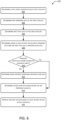
- the proposed plan may then be assessed to determine if any of the proposed activities exceed automated oversight limits.
- governors or limits may be set to limit automated maneuvers that have a maximum delta v (change in velocity) that exceeds 1.5 meters per second (m/s), or would consume more than some specified quantity of propellant.
- proposed plans may be provided to external systems.
- information about a proposed orbit resulting from a proposed maneuver may be provided to an external space situation awareness (SSA) provider.
- the SSA may accept the information about the proposed orbit and determine if a conjunction with tracked objects is likely to occur within a specified interval of time.
- the SSA may provide response data to the system, such as an indication that no conjunction is deemed likely.
- the system may take the response data into consideration, and subsequently determines commands to operate the satellite to perform the activities specified. The commands are sent to the satellite that executes those commands to perform the activities.
- the CMS operates without human intervention.
- a human may be consulted to confirm a proposed plan that exceeds the automated oversight limits, is designated for operator confirmation, and so forth.
- the CMS maintains awareness of the constellation as a whole and may request human oversight for activities that may involve many satellites. For example, while an individual proposed plan to maneuver a particular satellite may be within the automated oversight limits, if the count of satellites in the constellation that have proposed concurrent maneuvers exceeds a threshold count, a human may be notified and asked to confirm those maneuvers.
- the CMS may provide various levels of involvement. For example, a first event indicative of a predicted conjunction event in 10 days may be handled automatically. Continuing the example, a second event indicative of a predicted conjunction event in six hours may result in the immediate generation of a proposed plan that is promptly presented to a human operator for confirmation.
- the CMS may include one or more machine learning systems. These machine learning systems may be trained based at least in part on human input.
- the training data may comprise event data, state data of the satellite, ephemeris data, a set of alternative activities, and the activity ultimately selected by a human operator.
- the machine learning systems may provide various functions such as predicting failures, providing improved recommendations for activities to address various situations, and automatically initiating activities.
- the CMS also reduces the capital costs associated with the constellation by managing usage of resources onboard the satellite, such as battery systems and maneuvering systems. For example, the CMS may moderate activities that use various resources onboard individual satellites to avoid depleting the battery and propellant of a single satellite. As a result, operational life of the individual satellite may be extended, reducing the need for replacement or refurbishment.
- the automation provided by the CMS handles routine events, and over time learns to deal with less common events.
- the CMS is able to manage complex inputs and quickly determine and implement plans to perform activities that maintain the constellation and perform the mission(s) associated with the payload of the satellites in the constellation.
- a constellation of satellites may be used to provide a wide variety of useful services.
- a constellation of satellites may include sensors to acquire remote sensing data to facilitate terrestrial resource management.
- a constellation of satellites may provide communication services. The ability to communicate between two or more locations that are physically separated provides substantial benefits. Communications over areas ranging from counties, states, continents, oceans, and the entire planet are used to enable a variety of activities including health and safety, logistics, remote sensing, interpersonal communication, and so forth.
- Electromagnetic signals may travel, or propagate, best when there is an unobstructed path between the antenna of the transmitter and the antenna of the receiver. This path may be referred to as a "line of sight”. While electromagnetic signals may bend or bounce, the ideal situation for communication is often a line of sight that is unobstructed. Electromagnetic signals will also experience some spreading or dispersion. Just as ripples in a pond will spread out, a radio signal or a spot of light from a laser will spread out at progressively larger distances.
- a relay station having a radio receiver and transmitter with their antennas placed high above the ground is able to "see” more ground and provide communication service to a larger area.
- a satellite may be maintained in space for months or years by placing it into orbit around the Earth.
- the movement of the satellite in orbit is directly related to the height above ground. For example, the greater the altitude the longer the period of time it takes for a satellite to complete a single orbit.
- a satellite in a geosynchronous orbit at an altitude of 35,800 km may appear to be fixed with respect to the ground because the period of the geosynchronous orbit matches the rotation of the Earth.
- a satellite in a non-geosynchronous orbit (NGO) will appear to move with respect to the Earth.
- NGO non-geosynchronous orbit
- a satellite in a circular orbit at 600 km will circle the Earth about every 96 minutes. To an observer on the ground, the satellite in the 600 km orbit will speed by, moving from horizon to horizon in a matter of minutes.
- geosynchronous satellites have been used for broadcast and communication services because they appear stationary to users on or near the Earth and they can cover very large areas. This simplifies the equipment needed by a station on or near the ground to track the satellite.
- geosynchronous satellites there are limits as to how many geosynchronous satellites may be provided. For example, the number of "slots" or orbital positions that can be occupied by geosynchronous satellites are limited due to technical requirements, regulations, treaties, and so forth. It is also costly in terms of fuel to place a satellite in such a high orbit, increasing the cost of launching the satellite.
- the high altitude of the geosynchronous satellite can introduce another problem when it comes to sharing electromagnetic spectrum.
- the geosynchronous satellite can "see" so much of the Earth that special antennas may be needed to focus radio signals to particular areas, such as a particular portion of a continent or ocean, to avoid interfering with radio services on the ground in other areas that are using the same radio frequencies.
- Using a geosynchronous satellite to provide communication services also introduces a significant latency or delay because of the time it takes for a signal to travel up to the satellite in geosynchronous orbit and back down to a device on or near the ground.
- the latency due to signal propagation time of a single hop can be at least 240 milliseconds (ms).
- satellites in NGOs may be used.
- the altitude of an NGO is high enough to provide coverage to a large portion of the ground, while remaining low enough to minimize latency due to signal propagation time. For example, the satellite at 600 km only introduces 4 ms of latency for a single hop.
- the lower altitude also reduces the distance the electromagnetic signal has to travel.
- the reduced distance of the NGO reduces the dispersion of electromagnetic signals. This allows the satellite in NGO as well as the device communicating with the satellite to use a less powerful transmitter, use smaller antennas, and so forth.
- the system 100 shown here comprises a plurality (or “constellation” 114) of artificial satellites 102(1), 102(2), ..., 102(S), each satellite 102 being in orbit 104 around a body such as the Earth, moon, sun, and so forth. Also shown is a ground station 106, user terminal (UTs) 108, a user device 110, and so forth.
- UTs user terminal
- the constellation 114 may comprise hundreds or thousands of satellites 102, in various orbits 104.
- these satellites 102 may be in non-geosynchronous orbits (NGOs) in which they are in constant motion with respect to the Earth, such as a low earth orbit (LEO).
- LEO low earth orbit
- orbit 104 is depicted with an arc pointed to the right.
- a first satellite (SAT1) 102(1) is leading (ahead of) a second satellite (SAT2) 102(2) in the orbit 104.
- SAT1 first satellite
- SAT2 second satellite
- the satellite 102 is discussed in more detail with regard to FIG. 2 .
- One or more ground stations 106 comprise facilities that are in communication with one or more satellites 102.
- the ground stations 106 may pass data between the satellites 102, a network management system 150, networks such as the Internet, and so forth.
- the ground stations 106 may be emplaced on land, on vehicles, at sea, and so forth.
- Each ground station 106 may comprise a communication system 140.
- Each ground station 106 may use the communication system 140 to establish communication with one or more satellites 102, other ground stations 106, and so forth.
- the ground station 106 may also be connected to one or more communication networks.
- the ground station 106 may connect to a terrestrial fiber optic communication network.
- the ground station 106 may act as a network gateway, passing user data or other data between the one or more communication networks and the satellites 102.
- the communication system 140 of a ground station 106 may include components similar to those of the communication system of a satellite 102 and may perform similar communication functionalities.
- the communication system 140 may include one or more modems, digital signal processors, power amplifiers, antennas (including at least one antenna that implements multiple antenna elements, such as a phased array antenna), processors, memories, storage devices, communications peripherals, interface buses, and so forth.
- the satellites 102 are in communication with a constellation management system (CMS) 160 that facilitates management of the satellites 102 in the constellation 114.
- CMS 160 may coordinate and direct operation of the satellites 102 in the constellation 114.
- the CMS 160 may monitor and maintain satellites 102 in their assigned orbits, initiate maintenance activities onboard the satellites 102, provide instructions to prevent a payload on a satellite 102 from interfering with another satellite, and so forth.
- the CMS 160 may comprise one or more servers or other computing devices. Operation of the CMS 160 is discussed in more detail with regard to FIGS. 3-9 .
- the ground stations 106 are in communication with a network management system 150 that may include a scheduling system 156.
- the network management system 150 is also in communication, via the ground stations 106, with the satellites 102 and the UTs 108.
- the network management system 150 coordinates operation of the ground stations 106, UTs 108, and other resources of the system 100.
- the network management system 150 may interact with the CMS 160 during operation.
- the network management system 150 may comprise one or more servers or other computing devices.
- the scheduling system 156 schedules resources to provide communication to the UTs 108. For example, the scheduling system 156 may determine handover data that indicates when communication is to be transferred from the first satellite 102(1) to the second satellite 102(2). Continuing the example, the scheduling system 156 may also specify communication parameters such as frequency, timeslot, and so forth. During operation, the scheduling system 156 may use information such as ephemeris data from the CMS 160, communication system status data 158, user terminal data 160, and so forth.
- the system status data 158 may comprise information such as which UTs 108 are currently transferring data, satellite availability, current satellites 102 in use by respective UTs 108, capacity available at particular ground stations 106, diagnostic information, and so forth.
- the satellite availability may comprise information indicative of satellites 102 that are available to provide communication service or those satellites 102 that are unavailable for communication service.
- the CMS 160 may indicate that a satellite 102 is unavailable due to malfunction, previous tasking, maneuvering, and so forth.
- the communication system status data 158 may be indicative of past status, predictions of future status, and so forth.
- the communication system status data 158 may include information such as projected data traffic for a specified interval of time based on previous transfers of user data.
- the communication system status data 158 may be indicative of future status, such as a satellite 102 being unavailable to provide communication service due to scheduled maneuvering, scheduled maintenance, scheduled decommissioning, and so forth.
- the user terminal data 160 may comprise information such as a location of a particular UT 108.
- the user terminal data 160 may also include other information such as a priority assigned to user data associated with that UT 108, information about the communication capabilities of that particular UT 108, and so forth. For example, a particular UT 108 in use by a business may be assigned a higher priority relative to a UT 108 operated in a residential setting. Over time, different versions of UTs 108 may be deployed, having different communication capabilities such as being able to operate at particular frequencies, supporting different signal encoding schemes, having different antenna configurations, and so forth.
- the UT 108 includes a communication system 180 to establish communication with one or more satellites 102.
- the communication system 180 of the UT 108 may include components similar to those of the communication system 212 of a satellite 102 and may perform similar communication functionalities.
- the communication system 180 may include one or more modems, digital signal processors, power amplifiers, antennas (including at least one antenna that implements multiple antenna elements, such as a phased array antenna), processors, memories, storage devices, communications peripherals, interface buses, and so forth.
- the UT 108 passes communication system status data 158 between the constellation of satellites 102 and the user device 110.
- the 112 data may include data originated by the user device 110 (upstream data) or data addressed to the user device 110 (downstream data).
- the UT 108 may be fixed or in motion.
- the UT 108 may be used at a residence or on a vehicle such as a car, boat, aerostat, drone, airplane, and so forth.
- the UT 108 includes a tracking system 182.
- the tracking system 182 uses almanac data 184 to determine tracking data 186.
- the almanac data 184 provides information indicative of orbital elements of the orbit 104 of one or more satellites 102.
- the CMS 160 may generate almanac data 184 that comprises orbital elements such as "two-line element" data for the satellites 102 in the constellation 114.
- the almanac data 184 may be broadcast or otherwise sent to the UTs 108 using the communication system 180.
- the tracking system 182 may use the current location of the UT 108 and the almanac data 184 to determine the tracking data 186 for the satellite 102. For example, based on the current location of the UT 108 and the predicted position and movement of the satellites 102, the tracking system 182 is able to calculate the tracking data 186.
- the tracking data 186 may include information indicative of azimuth, elevation, distance to the second satellite, time of flight correction, or other information associated with a specified time.
- the determination of the tracking data 186 may be ongoing. For example, the first UT 108 may determine tracking data 186 every 100 ms, every second, every five seconds, or at other intervals.
- a first PoP system 146 at a facility accepts the data 112 addressed to the UT 108 and proceeds to attempt delivery of the data 112 to the UT 108.
- the PoP system 146 is in communication with one or more ground stations 106(1), 106(2), ..., 106(G) and the network management system 150.
- one or more functions may be combined.
- the PoP system 146 may perform one or more functions of the network management system 150.
- the PoP system 146 may include an integrated ground station 106.
- the PoP system 146 determines the UT 108 that the downstream data 112 is addressed to and determines first communication resource data.
- the first communication resource data specifies the communication resources, such as ground station 106, uplink modem at the ground station 106, satellite, downlink modem on the satellite, and so forth that would result in delivery of the downstream data 112 to the UT 108.
- the downstream data 112 may comprise a single packet or other unit of data transfer, or a plurality of packets or other units of data transfer that are associated with delivery to the particular UT 108.
- the satellite 102, the ground station 106, the user terminal 108, the user device 110, the PoP system 146, the network management system 150, the CMS 160, or other systems described herein may include one or more computer devices or computer systems comprising one or more hardware processors, computer-readable storage media, and so forth.
- the hardware processors may include application specific integrated circuits (ASICs), field-programmable gate arrays (FPGAs), digital signal processors (DSPs), and so forth.
- ASICs application specific integrated circuits
- FPGAs field-programmable gate arrays
- DSPs digital signal processors
- Embodiments may be provided as a software program or computer program including a non-transitory computer-readable storage medium having stored thereon instructions (in compressed or uncompressed form) that may be used to program a computer (or other electronic device) to perform the processes or methods described herein.
- the computer-readable storage medium may be one or more of an electronic storage medium, a magnetic storage medium, an optical storage medium, a quantum storage medium, and so forth.
- the computer-readable storage medium may include, but is not limited to, hard drives, optical disks, read-only memories (ROMs), random access memories (RAMs), erasable programmable ROMs (EPROMs), electrically erasable programmable ROMs (EEPROMs), flash memory, magnetic or optical cards, solid-state memory devices, or other types of physical media suitable for storing electronic instructions.
- Further embodiments may also be provided as a computer program product including a transitory machine-readable signal (in compressed or uncompressed form).
- Transitory machine-readable signals whether modulated using a carrier or unmodulated, include, but are not limited to, signals that a computer system or machine hosting or running a computer program can be configured to access, including signals transferred by one or more networks.
- the transitory machine-readable signal may comprise transmission of software by the Internet.
- FIG. 2 is a block diagram 200 of some systems associated with the satellite 102, according to some implementations.
- the satellite 102 may comprise a structural system 202, a control system 204, a power system 206, a maneuvering system 208, one or more sensors 210, and a communication system 212.
- a pulse per second (PPS) system 214 may be used to provide timing reference to the systems onboard the satellite 102.
- PPS pulse per second
- One or more busses 216 may be used to transfer data between the systems onboard the satellite 102. In some implementations, redundant busses 216 may be provided.
- the busses 216 may include, but are not limited to, data busses such as Controller Area Network Flexible Data Rate (CAN FD), Ethernet, Serial Peripheral Interface (SPI), and so forth.
- CAN FD Controller Area Network Flexible Data Rate
- SPI Serial Peripheral Interface
- the busses 216 may carry other signals.
- a radio frequency bus may comprise coaxial cable, waveguides, and so forth to transfer radio signals from one part of the satellite 102 to another.
- some systems may be omitted or other systems added. One or more of these systems may be communicatively coupled with one another in various combinations.
- the structural system 202 comprises one or more structural elements to support operation of the satellite 102.
- the structural system 202 may include trusses, struts, panels, and so forth.
- the components of other systems may be affixed to, or housed by, the structural system 202.
- the structural system 202 may provide mechanical mounting and support for solar panels in the power system 206.
- the structural system 202 may also provide for thermal control to maintain components of the satellite 102 within operational temperature ranges.
- the structural system 202 may include louvers, heat sinks, radiators, and so forth.
- the maneuvering system 208 maintains the satellite 102 in one or more of a specified orientation or orbit 104.
- the maneuvering system 208 may stabilize the satellite 102 with respect to one or more axes.
- the maneuvering system 208 may move the satellite 102 to a specified orbit 104.
- the maneuvering system 208 may include one or more of reaction wheel(s) 240, thrusters 242, magnetic torque rods 244, solar sails, drag devices, and so forth.
- the thrusters 242 may include, but are not limited to, cold gas thrusters, hypergolic thrusters, solid-fuel thrusters, ion thrusters, arcjet thrusters, electrothermal thrusters, and so forth.
- the thrusters 242 may expend propellent.
- an electrothermal thruster may use water as propellent, using electrical power obtained from the power system 206 to expel the water and produce thrust.
- the maneuvering system 208 may use data obtained from one or more of the sensors 210.
- the satellite 102 includes one or more sensors 210.
- the sensors 210 may include one or more engineering cameras 250.
- an engineering camera 250 may be mounted on the satellite 102 to provide images of at least a portion of the photovoltaic array 230.
- Accelerometers 252 provide information about acceleration of the satellite 102 along one or more axes.
- Gyroscopes 254 provide information about rotation of the satellite 102 with respect to one or more axes.
- the sensors 210 may include a global navigation satellite system (GNSS) 256 receiver, such as a Global Positioning System (GPS) receiver, to provide information about the position of the satellite 102 relative to Earth.
- GPS Global Positioning System
- the GNSS 256 may also provide information indicative of velocity, orientation, and so forth.
- One or more star trackers 258 may be used to determine an orientation of the satellite 102.
- a coarse sun sensor 260 may be used to detect the sun, provide information on the relative position of the sun with respect to the satellite 102, and so forth.
- a radar 262 may be used to provide information such as distance and bearing to objects.
- the radar 262 may be used to determine the presence of objects in nearby orbits.
- other sensors may be used, such as LIDAR, optical time of flight devices, cameras, and so forth.
- a camera may be used to determine occlusion by an object of one or more stellar light sources, such as distance stars. Image data provided by the camera may be processed to determine an approximate distance and bearing of the object.
- a debris sensor 264 may be used to detect impacts, such as micrometeoroid impacts, small debris impacts, and so forth.
- the debris sensor 264 may comprise a microphone, microelectromechanical system, or other device that detects acoustic energy in a chassis of the satellite 102 as a result of an impact.
- the accelerometer(s) 252 may be used to detect impacts.
- the satellite 102 may include other sensors 210 as well.
- the satellite 102 may include a horizon detector, lidar, and so forth.
- the communication system 212 provides communication with one or more other devices, such as other satellites 102, ground stations 106, user terminals 108, and so forth.
- the communication system 212 may include one or more modems 276, digital signal processors, power amplifiers, antennas (including at least one antenna that implements multiple antenna elements, such as a phased array antenna) 282, processors, memories, storage devices, communications peripherals, interface buses, and so forth.
- Such components support communications with other satellites 102, ground stations 106, user terminals 108, and so forth using radio frequencies within a desired frequency spectrum.
- the communications may involve multiplexing, encoding, and compressing data to be transmitted, modulating the data to a desired radio frequency, and amplifying it for transmission.
- Each satellite 102 may use one or more antennas 282 or antenna elements to provide a beam for transmission and reception of radio signals.
- the satellite 102 may have a phased array antenna that allows for gain in a particular direction. Compared to a non-directional radiator, this gain directs the energy of transmitted radio frequency signals in that particular direction. This increases the strength of the signal at a receiver in the UT 108, ground station 106, and so forth. Likewise, the gain results in improved received signal strength at the satellite 102.
- the beam provided by the satellite 102 may comprise a plurality of subbeams.
- Subbeams on a satellite 102 may use different frequencies, timeslots, and so forth, to communicate with the UT 108.
- Each subbeam provides coverage of a particular geographic area or "footprint".
- subbeams provide several advantages. For example, by using subbeams, radio frequencies may be reused by the same satellite 102 and other satellites 102 to service different areas. This allows increased density of UTs 108 and bandwidth.
- each subbeam may be targeted to a geographic location on the Earth. While that target geographic location is in range of the satellite 102, the subbeam tracks the target location. As the satellite 102 moves in orbit 104, the boundary of the footprint may change due to the relative angle between the satellite 102 and the Earth. For example, the footprint boundary may change from approximately an oval shape while the satellite 102 is low on the horizon relative to the target location, a circular shape while directly overhead, then an oval shape as the satellite 102 nears the opposite horizon. As the satellite 102 moves, a subbeam may be retargeted to another target location. In this configuration, instead of the subbeam sweeping along the ground track of the satellite 102, the subbeam loiters on a first area relative to the Earth, then is redirected to a second area.
- a particular modem 276 or set of modems 276 may be allocated to a particular subbeam. For example, a first modem 276(1) provides communication to UTs 108 in a first geographic area using a first subbeam while a second modem 276(2) provides communication to UTs 108 in a second geographic area using a second subbeam.
- the communication system 212 may include hardware to support the intersatellite link 190.
- an intersatellite link FPGA 270 may be used to modulate data that is sent and received by an ISL transceiver 272 to send data between satellites 102.
- the ISL transceiver 272 may operate using radio frequencies, optical frequencies, and so forth.
- a communication FPGA 274 may be used to facilitate communication between the satellite 102 and the ground stations 106, UTs 108, and so forth.
- the communication FPGA 274 may direct operation of a modem 276 to modulate signals sent using a downlink transmitter 278 and demodulate signals received using an uplink receiver 280.
- the satellite 102 may include one or more antennas 282.
- one or more parabolic antennas may be used to provide communication between the satellite 102 and one or more ground stations 106.
- a phased array antenna 282 may be used to provide communication between the satellite 102 and the UTs 108.
- FIG. 3 illustrates at 300 the CMS 160 and associated systems, according to some implementations.
- the CMS 160 may provide various services that include receiving information from external systems, providing information to those external systems, coordinating with those external systems, planning and initiating activities that include satellites 102 in the constellation 114, coordinating with the network management system 150 to facilitate operation of the payloads on the satellites 102, and so forth.
- the space environment is dynamic and complex, involving many factors that are outside of our daily experience here on Earth. One factor is the number of objects that are in orbit 104 around the Earth. There are over 25,000 objects in Earth orbit that are being tracked. These objects include active satellites, decommissioned satellites, expended rocket boosters, lost tools, and so forth. Some of these objects are under active control, such as satellites that have functional control and maneuvering systems, while other objects are no longer under active control.
- Objects that are in orbit around a body such as the Earth experience a variety of effects that change or "perturb" their orbits. These effects are internal and external. Internal effects can include intentional maneuvers using devices such as thrusters, solar sails, interaction with Earth's magnetic field, and so forth. Internal effects can include outgassing, thermal radiation of satellite components, pressure vessel failures, battery failures, and so forth. External effects include interactions between the object and the various gravitational fields experienced in Earth orbit, Earth's atmosphere, Earth's magnetosphere, solar activity, collisions with other objects, and so forth.
- the CMS 160 may include various systems, such as a flight dynamics system 302, an input quality assessment system 304, a state management system 306, a plan generation system 308, a satellite mission control (SMC) system 314, an operator interface system 312, and so forth.
- the CMS 160 may also interact with the network management system 150.
- the flight dynamics system (FDS) 302 acquires and processes information that affects the location of satellites 102 in the constellation 114.
- Ephemeris data comprises information about orbital elements that are descriptive of the orbit 104 of a particular object, such as a satellite 102. These orbital elements may include an epoch or reference time, distance of a semi-major axis, eccentricity, right ascension at reference time, and so forth.
- the FDS 302 may maintain one or more of assigned ephemeris data 370, actual ephemeris data 372, or predicted ephemeris data 374.
- the assigned ephemeris data 370 is indicative of the orbital elements that a particular satellite 102 is assigned to maintain to within some threshold.
- the assigned ephemeris data 370 may be determined manually or automatically. For example, a human operator may specify a particular set of orbital elements that are assigned to the satellite 102. In another example, the FDS 302 may automatically determine the assigned ephemeris data 370 for a particular satellite.
- the actual ephemeris data 372 is based on an actual location of the satellite 102.
- the actual ephemeris data 372 is indicative of a current or previous actual location of the satellite.
- the actual ephemeris data 372 may be determined based on telemetry data 354 from the satellite 102 that comprises position data.
- An example of telemetry data 354 is shown in FIG. 5A .
- the predicted ephemeris data 374 is a prediction of what the orbital elements of the satellite 102 will be.
- the predicted ephemeris data 374 may be based on the effects of the various internal effects such as planned maneuvers, external effects such space weather and orbital perturbation models, and so forth.
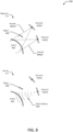
- the FDS 302 may determine interference mitigation data 376 that is indicative of potential interactions between a communication payload on a satellite 102 and other objects including other satellites 102 in the constellation 114.
- the interference mitigation data 376 may be indicative of, for a specified time, a volume in space within which a radio frequency (RF) transmitted by a payload on a satellite 102 would exceed a specified threshold value.
- the FDS 302 may generate interference mitigation data 376 that indicates an RF payload, or at least a portion thereof, of a particular satellite 102 should be deactivated during a specified time interval to avoid interfering with another satellite 102. This is discussed in more detail with regard to FIGS. 8-9 .
- One or more space situation awareness (SSA) systems 320 may provide SSA data 322 to the CMS 160.
- the SSA data 322 may comprise object ephemeris data 324, maneuvering data 326, and so forth.
- the object ephemeris data 324 may comprise orbital two-line elements (TLE) data that may be used to determine a predicted location of an object in space.
- the maneuvering data 326 may be indictive of planned or in-progress maneuvers that may change the motion of the object.
- An SSA system 320 may be operated by governments, private companies, or other entities. For example, the United States Air Force (USAF) obtains tracking data using various radar and optical tracking resources. A portion of this data is available to others to facilitate orbital operations. For example, orbital elements for various objects in orbit 104 tracked by the USAF may be accessed online at space-track.org. In another example, private companies may generate SSA data 322. For example, commercial services providers may use data from ground based radar sites to generate object ephemeris data 324 for objects in orbit. In another example, operators of other constellations 114 may provide object ephemeris data 324 for satellites 102 under their control.
- USAF United States Air Force
- Space weather systems 330 provide space weather data 332 to the CMS 160.
- the space weather systems 330 may be operated by governments, private companies, or other entities. For example, the United States National Oceanic and Atmospheric Administration (NOAA) acquires data from various ground-based and satellite-based resources about the sun, Earth's upper atmosphere, Earth's magnetosphere, radiation belts, and so forth.
- NOAA National Oceanic and Atmospheric Administration
- the space weather data 332 may provide information such as movement of the upper atmosphere, energetic particle flux, solar activity, location of the South Atlantic Anomaly, and so forth.
- Space weather can substantially affect operation of satellites 102.
- a coronal mass ejection (CME) from the sun may result in a substantial increase in charged particles that interfere with operation of electronic devices onboard satellites 102.
- changes in solar activity cause the atmosphere to change height, changing aerodynamic drag on satellites.
- Navigation systems 340 comprising global navigation satellite systems (GNSS) may provide navigation status data 342 to the CMS 160.
- the navigation systems 340 may be operated by governments, private companies, or other entities. For example, the USAF operates the global positioning system (GPS), Russia operates the Global Navigation Satellite System (GLONASS), and so forth.
- the satellite portion of the navigation systems 340 is susceptible to the effects of space weather, may experience equipment failures, and so forth.
- Navigation status data 342 may provide information indicative of operation of the GNSS, accuracy data, correction factors, and so forth.
- the navigation status data 342 may comprise information that indicates the accuracy of navigational signals provided for a particular volume of space at a particular time.
- the GNSS 256 receiver onboard the satellites 102 may use signals from the navigation system 340 to determine position data for the satellites 102 in the constellation 114.
- Other systems 394 may provide other data 396 to the CMS 160.
- the other systems 394 may include terrestrial weather data indicative of observed or forecasted terrestrial weather conditions.
- Terrestrial weather conditions may affect operations involving the satellites 102. For example, heavy precipitation in the atmosphere between the satellite 102 and a UT 108 may attenuate radio signals along a signal path, producing "rain fade". This attenuation may affect communication by resulting in reduced throughput, requiring additional transmit power, and so forth.
- the data described herein as provided to the CMS 160 may be provided to the network management system 150.
- the network management system 150 may use the terrestrial weather data to select which satellites 102 will be used to provide communication service to UTs 108 to minimize attenuation of radio signals along the signal path between a given satellite 102 and UT 108.
- the network management system 150 may also provide information for the CMS 160.
- the network management system 150 may provide information to the CMS 160 about system status data 158, geographic location of UTs 108, diagnostic data, and so forth.
- the CMS 160 may take this information into consideration while determining proposed plan data 384.
- a satellite data system 350 provides satellite data 352 about the satellites 102 in the constellation 114.
- the satellite data system 350 may receive satellite data 352 from satellites 102 via the ground stations 106.
- the satellite data 352 may comprise telemetry data 354, sensor data 356, and so forth.
- the telemetry data 354 may comprise information indicative of the operation of one or more devices onboard the satellite 102.
- the telemetry data 354 may be indicative of battery charge, propellant quantity, and so forth.
- the sensor data 356 may comprise data obtained by one or more sensors 210.
- the sensor data 356 may include position data obtained by the GNSS 256 receiver.
- the sensor data 356 may comprise data indicative of objects detected by the radar 262.
- the FDS 302 may accept as input one or more of the SSA data 322, space weather data 332, navigation status data 342, satellite data 352, and so forth.
- the FDS 302 may use the navigation status data 342 and the sensor data 356 to determine the actual ephemeris data 372 for a particular satellite 102.
- the FDS 302 may use the space weather data 332, and the actual ephemeris data 372 to determine the predicted ephemeris data 374.
- the FDS 302 may use the SSA data 322 and the predicted ephemeris data 374 to determine if a conjunction event may occur.
- a conjunction event may be determined when the locations of a satellite 102 and another object are less than a threshold distance apart at a specified time. In some situations, a conjunction event may involve a collision between the satellite 102 and the object.
- the FDS 302 may also send data to the SSA system(s) 320 or other operators of constellations 114.
- the FDS 302 may send predicted ephemeris data 374 about the constellation 114 to the SSA system 320. This may reduce operational risks by providing an additional opportunity to determine possible conjunction events in advance.
- the SSA system 320 may use the predicted ephemeris data 374 to produce an independent determination as to whether a conjunction event may occur. That determination may then be provided back to the CMS 160 or to other systems.
- the state management system 306 may maintain state data 378 about satellites 102 in the constellation 114.
- the state data 378 may include information about the satellite 102, payload, and so forth.
- An example of state data 378 is shown in FIG. 5A .
- the state data 378 may include predicted data.
- the state data 378 may include a prediction of remaining operational lifespan of a particular system onboard the satellite 102.
- the state management system 306 may determine predicted data using one or more of decision trees, heuristics, machine learning systems, and so forth.
- the machine learning systems may comprise one or more neural networks.
- the one or more neural networks may be trained using satellite data 352 to determine a correspondence between particular inputs such as specific values of telemetry data 354 and later values.
- telemetry data 354 from many satellites 102 may be acquired over time and used to predict performance of a particular system.
- the plan generation system 308 interacts with the other systems and uses a prioritization system 390 to determine actual plan data 392 based on proposed plan data 384.
- the actual plan data 392 may comprise a satellite identifier, priority value indicative of priority of the plan, timing information, information about the systems on the satellite 102 used by the plan, and details about operating those systems.
- An example of actual plan data 392 is shown in FIG. 5E .
- Data from other systems, such as from the FDS 302, the state management system 306, operator interface system 312, and so forth may result in determination of an event.
- the plan generation system 308 determines one or more activities, and from those activities, the proposed plan data 384.
- the prioritization system 390 may assess activity alternatives to determine the proposed plan data 384.
- the proposed plan data 384 may comprise the satellite identifier, priority value indicative of priority of the proposed plan, timing information, and so forth.
- the activities described in the proposed plan data 384 may be constrained by one or more values and may be specified by automated limit data 382.
- the delta v indicated in the proposed plan data 384 for a maneuver generated automatically by the plan generation system 308 may be limited by values specified in the automated limit data 382.
- the proposed plan data 384 may be evaluated, and if approved, is used to determine actual plan data 392.
- the proposed plan data 384 may be approved to use as actual plan data 392.
- operator input may be received to confirm the use of the proposed plan data 384 as the actual plan data 392.
- the proposed plan data 384 may be provided to the operator interface system 312 to receive user input via a user interface.
- the plan generation system 308 may take into consideration data from the network management system 150. For example, during maneuvers the satellite 102 may be unable to operate the payload to provide communication services to a UT 108.
- the proposed plan data 384 may specify maneuvers for a particular satellite 102 to take place while the satellite 102 is over a portion of the Earth that contains a low number of UTs 108 per area, to reduce the number of UTs 108 that would be affected by the reduction in available communication resources.
- the actual plan data 392 may be passed to a satellite mission control system 314.
- the satellite mission control system 314 may perform one or more functions.
- the satellite mission control system 314 may confirm that the actual plan data 392 would not result in an adverse event associated with the satellite 102.
- the satellite mission control system 314 may confirm that an operation involving an update to the onboard computer will not be executed while the satellite 102 is passing through the South Atlantic Anomaly that could result in an upset event to the onboard computer.
- the satellite mission control system 314 may determine control data 398 comprising one or more commands for the satellite 102 to execute to implement the actual plan data 392.
- the satellite mission control system 314 may send the control data 398 to the appropriate satellite 102.
- the satellite 102 then executes the one or more commands in the control data 398.
- a TTC ground station may be used to send the control data 398 to the satellite 102.
- the TTC system 222 onboard the satellite 102 may receive and process the control data 398.
- one or more of the functions described with respect to the plan generation system 308 may be performed at least in part by the SMC system 314.
- the proposed plan data 384 may be passed to the SMC system 314 that then generates the actual plan data 392.
- the plan generation system 308 may also send data to the SSA system(s) 320 or other operators of constellations 114.
- the plan generation system 308 may send information about a proposed maneuver that is in proposed plan data 384 to the SSA system 320. This may reduce operational risks by providing an additional opportunity to determine possible conjunction events in advance.
- the SSA system 320 may use the information about the proposed maneuver and other available information to produce an independent determination as to whether the maneuver is likely to result in a conjunction event. That determination may then be provided back to the plan generation system 308 in the CMS 160 or to other systems. For example, if the SSA 320 confirms the proposed maneuver is not likely to result in a conjunction event, the plan generation system 308 may generate actual plan data 392 that includes the proposed maneuver.
- the operator interface system 312 provides functionality allowing other operators, such as human operators or autonomous operators, to interact with the CMS 160.
- the operator interface system 312 may provide a user interface for a human operator to use.
- the operator may provide input via the user interface that indicates approval of a proposed plan data 384, changes to the proposed plan data 384, and so forth.
- a general oversight system 360 may provide various functions such as a "dashboard" or overall status of the constellation 114.
- the general oversight system 360 may monitor larger scale operations, such as maneuvering a group of satellites 102.
- the operator interface system 312 may include a control confirmation system 362.
- the control confirmation system 362 allows an operator to be introduced into the operational workflow. Operation of the operator interface system 312 may be constrained by operator limit data 364.
- the operator limit data 364 may specify thresholds as to what activities may be approved by a single operator, which activities require multiple operators, and so forth. For example, the control confirmation system 362 may require approval from two human operators to perform certain activities such as deorbiting a satellite 102. An example of operator limit data 364 is shown in FIG. 5B .
- the CMS 160 may interact with the network management system 150 that operates and manages the communication service and associated payload.
- the FDS 302 may determine interference mitigation data 376 that, relative to a particular location to provide service on Earth, indicates satellite 102(1734) will be within the radio frequency (RF) volume produced by a transmitter on satellite 102(941).
- the radio transmitter payload on satellite 102(941) may be turned off for the period that satellite 102(1734) will be within the volume.
- some activities may result in a satellite 102 being unavailable to provide communication services. For example, while maneuvering the satellite 102 may be unable to provide communication services to UTs 108.
- the CMS 160 may provide information to the network management system 150 that is indicative of which satellites 102 are unavailable, and time intervals as to when those satellites 102 will be unavailable.
- FIGS. 5A-5E Additional description of some of the data mentioned above are discussed with regard to FIGS. 5A-5E .
- various protocols to maintain security of the system 100 are not shown.
- one or more cryptographic techniques may be used to secure the transfer of data between systems, to confirm the origin of data ingested into the CMS 160, and so forth.
- the CMS 160 may utilize one or more of decision trees, heuristics, machine learning systems, or other techniques during operation.
- the machine learning systems may comprise one or more neural networks.
- the one or more neural networks may be trained using data associated with operation of the system 100.
- the plan generation system 308 may comprise a neural network that is trained at least in part using actual plan data 392 and associated input data to the CMS 160 that is associated with the determination of the actual plan data 392.
- FIG. 4 illustrates the plan generation system 308 of the CMS 160 that is used to determine actual plan data 392 used to operate satellites 102 in the constellation 114, according to some implementations.
- Event data 402 is indicative of an event or occurrence that is associated with one or more satellites 102 in the constellation 114.
- An example of event data 402 is shown in FIG. 5C .
- the FDS 302 may generate event data 402 that is based on the location or orientation of the satellite 102. For example, if the predicted ephemeris data 374 indicates that the predicted orbit of the satellite 102 will deviate from the assigned orbit indicated by the assigned ephemeris data 370 by more than a threshold value, event data 402 may be generated. Continuing the example, the predicted deviation in position of the satellite 102 exceeding a threshold value may generate event data 402.
- the state management system 306 may generate event data 402 that is based on the state data 378 of the satellite 102.
- the event may be determined by comparing one or more values of the state data 378 with historical values, a specified threshold, specified range, and so forth. For example, if a battery charge value drops below a minimum threshold value or rises above a maximum threshold value, event data 402 may be generated.
- the operator interface system 312 may generate event data 402.
- an operator may generate event data 402 that is indicative of a potential failure in a specified component used in a subset of the satellites 102.
- the satellite mission control system 314 may generate event data 402.
- the satellite mission control system 314 may generate event data 402 indicative of a failure to execute one or more commands in the control data 398.
- a scheduler system may generate event data 402 upon expiration of a timer, at a specified time, and so forth.
- event data 402 may be generated at a specified interval such as every four hours that is indicative of the event to evaluate or check a particular satellite 102.
- the FDS 302 may update predicted ephemeris data 374, interference mitigation data 376, and so forth.
- the state management system 306 may assess satellite health.
- the event data 402 is provided to an event processing system 410 of the plan generation system 308.
- the event processing system 410 may associate particular events with corresponding activity data 412.
- the activity data 412 may be indicative of an activity category and may include constraints on a resulting activity, such as an "execute by time” or a "complete by time”.
- the FDS 302 may issue event data 402 for a "payload orientation out of limit" event, indicating that at a predicted time the antennas 282 associated with the satellite's 102 downlink will not be pointing in the direction needed to maintain communication service to a specified location on Earth.
- An example of activity data 412 is shown in FIG. 5C .
- the event processing system 410 may determine, responsive to the event data 402, activity data 412 that is indicative of one or more categories of activity. Continuing the earlier example, responsive to the event data 402 of "payload orientation out of limit” the resulting activity data 412 may be indicative of an activity category “reorient satellite for payload” and data indicative of a "complete by time” indicating when the action needs to be completed by.
- An activity category may be associated with one or more possible activities.
- the activity alternative data 418 may provide alternative actions that are associated with a particular activity category.
- the activity alternative data 418 may also include other information associated with the alternative actions.
- the activity alternative data 418 may indicate a satellite cost value 506 that is indicative of a cost associated with an activity performed by the satellite 102.
- An example of activity alternative data 418 is shown in FIG. 5D .
- the satellite cost value 506 may be generalized to a cost associated with a particular type of satellite, or may be specific to a particular individual satellite 102. For example, the satellite cost value 506 for a maneuver that involves consumption of propellent may be proportionate to the propellent quantity remaining on a particular satellite 102. As the particular satellite 102 depletes its propellant, the corresponding cost for activities that use the remaining propellant may increase.
- the activity alternative data 418 may also associate payload cost values 508 with activities.
- the payload cost value 508 may be indicative of how the activity will affect operation of the payload. For example, if the payload provides communication services, a low payload cost value 508 may indicate negligible impairment of providing communication service to UTs 108 while a high payload cost value 508 indicates failure to provide communication service to UTs 108.
- the automated limit data 382 may specify value(s) that are indicative of constraints placed on activities that are initiated without operator intervention.
- the automated limit data 382 may specify a maximum delta v per maneuver, maximum number of concurrent maneuvers that are permitted across the constellation 114 or a subgroup thereof, maximum number of adjacent maneuvers, maximum power consumption, and so forth.
- the automated limit data 382 may govern the automated actions of the system 100.
- the values of the automated limit data 382 may be determine by an operator, analysis of data, operational limits of the system, and so forth.
- a threshold count of the maximum number of concurrent maneuvers may be specified by a human operator.
- the threshold count of the maximum number of concurrent maneuvers may be determined based on a number of simultaneous maneuvers the satellite mission control system 314 is able to support.
- An example of automated limit data 382 is shown in FIG. 5B .
- the CMS 160 or associated systems may generate event data 402 responsive to other event data 402. For example, an unexpected acceleration of the satellite 102 that is indicated by the satellite data 352 that exceeds a threshold value may result in the state management system 306 generating a first event data 402. Responsive to the first event data 402, the FDS 302 may determine actual ephemeris data 372 and generate a second event data 402 indicative of a deviation from the assigned ephemeris data 370.
- the prioritization system 390 of the plan generation system 308 may assess the activity alternative data 418 for pending activities and determine activity set data 420. For example, the prioritization system 390 may select a particular activity from the activity alternative data 418 based on one or more of the satellite cost value 506, payload cost value 508, or other cost values. The prioritization system 390 may select, from the activity alternative data 418, the activity that has the lowest sum of satellite cost value 506 and payload cost value 508. An example of activity alternative data 418 is shown in FIG. 5D .
- the activity set data 420 determined by the prioritization system 390 may also specify a sequence or order in which the activities should be performed. Activities may be sequenced based on priority value, complete by times, system dependences, and so forth. For example, activities may be sorted so that activities with earlier complete by times are performed before activities with later complete by times. In another example, the activity “charge batteries” may supersede “operate magnetorquer” if there is insufficient available power to operate the magnetorquer.
- the activity set data 420 may be used to determine the proposed plan data 384.
- the proposed plan data 384 may specify the satellite 102, a priority of the overall plan, information about the activities to be performed, and other information.
- the proposed plan data 384 may indicate whether the proposed activities are expected to cause the satellite 102 to leave an assigned volume in the orbit 104 that is associated with the assigned ephemeris data 370, , information about the satellite systems to be used, and so forth.
- An example of proposed plan data 384 is shown in FIG. 5E .
- the proposed plan data 384 may be used to determine the actual plan data 392. For example, if the activities specified within the proposed plan data 384 are within the limits specified by the automated limit data 382, the proposed plan data 384 may be used as the actual plan data 392. In another example, the proposed plan data 384 may be provided to the operator interface system 312. A human operator or autonomous operator may be presented with the proposed plan data 384 and may approve the proposed plan, modify the proposed plan, deny the proposed plan, or take other steps. The actual plan data 392 may be indicative of one or more activities.
- the actual plan data 392 may include one or more activities that have been combined together.
- the actual plan data 392 may include one or more activities indicated in first proposed plan data 384 associated with the satellite 102, second proposed data 384 associated with the satellite 102, and so forth.
- additional confirmation or checking may be performed before the actual plan data 492 is determined.
- proposed plan data 384 that involves a maneuver may result in consulting with an external system such as one or more SSA systems 320 to determine if the proposed maneuver would result in a possible conjunction event.
- Response data may be received from the external system and may be used to evaluate the proposed plan data 384.
- the proposed plan data 384 may be rejected and new proposed plan data 384 may be generated.
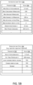
- FIGS. 5A - 5E illustrate data associated with operation of the system 100, according to some implementations.
- the data may include parameters 502 and associated values 504.
- the telemetry data 354 may comprise information indicative of the operation of one or more devices onboard the satellite 102.
- the telemetry data 354 may include one or more of a satellite identifier, position data, propellant quantity, time thruster(s) used, propellant temperature, photovoltaic effectiveness, state of charge, total charge cycles of the battery 234, payload status, reaction wheel saturation(s), single event upset count, and so forth.
- the satellite identifier is indicative of a particular satellite 102 in the constellation 114.
- the position data comprises information that is indicative of one or more of position with respect to a reference point and one or more axes, orientation with respect to the one or more axes, and so forth.
- the position data may be generated by the GNSS 256 and be indicative of a latitude, longitude, altitude, orientation, and so forth.
- the propellant quantity may indicate a mass of propellant remaining for use by one or more thrusters 242.
- the time maneuvering system used may be indicative of total elapsed time of operation of the thruster(s) 242.
- the propellant temperature may be indicative of a temperature of the propellant used by the one or more thrusters 242.
- the photovoltaic effectiveness may be indicative of performance of the PV array(s) 230.
- the photovoltaic effectiveness may be assessed relative to a specified baseline, such as relative to a tested engineering baseline.
- the state of charge may indicate the state of charge of one or more batterie(s) 234, representing how much power is available within the battery 234.
- the total charge cycles of the battery 234 may be indicative of an accumulated count of charge and discharge cycles the battery 234 has been subjected to.
- the payload status may be indicative of overall operation of the payload, such as whether the payload is offline by command, offline due to malfunction, operating nominally, operating off-nominally, and so forth.
- the reaction wheel saturation(s) may be indicative of momentum saturation levels of one or more reaction wheels 240.
- the single event upset count may be indicative of a number of single event upsets occurring within specified electronic circuitry, such as due to high energy particle impingement on a semiconductor device.
- the telemetry data 354 may include other data as well.
- the state data 378 may include information about the satellite 102, payload, and so forth.
- the state data 378 may be based at least in part on the telemetry data 354.
- the state data 378 may include the satellite identifier as described above.
- the state data 378 may include information indicative of a model, block, version, or build of the satellite 102.
- the state data 378 may include a satellite overall metric.
- the satellite overall metric may be indicative of overall usefulness of the satellite 102.
- the satellite overall metric may comprise a weighted average of propellant quantity, time maneuvering system used, photovoltaic effectiveness, total charge cycles, payload status, and so forth. Over time, as systems onboard the satellite 102 degrade, the value 504 of the satellite overall metric may decrease.
- the state data 378 may include a payload metric that is indicative of overall usefulness of the payload.
- the payload metric may be based on the payload status, state of charge of the batteries 234 providing power to the payload, available transmitter power output, number of devices in the payload that have failed, and forth.
- the state data 378 may include a maneuvering system metric that is indicative of capability of the maneuvering system 208.
- the maneuvering system metric may comprise a weighted average of propellant quantity, time thruster(s) used, propellant temperature, state of charge, reaction wheel saturation(s), and so forth. Over time, as systems onboard the satellite 102 degrade, the value 504 of the maneuvering system metric may decrease.
- Automated operation of the CMS 160 may be constrained by the values 504 specified in the automated limit data 382.
- the automated limit data 382 may include a maximum (max) delta v per maneuver, specifying a maximum permitted change in velocity for a given maneuver or sequence of maneuvers for a particular satellite 102.
- the automated limit data 382 may specify a max concurrent maneuvers, specifying a maximum number of concurrent maneuvers that are permitted within the constellation 114 at any given time.
- Max adjacent maneuvers specifies a maximum number of maneuvers that are permitted to occur in adjacent satellites 102.
- the max adjacent maneuver value 504 may constrain maneuvers that would result in maneuvers of more than three adjacent satellites 102 at one time.
- a minimum (min) variance to maneuver may specify a minimum variance between an actual and assigned position that will result in event data 402 to maneuver the satellite 102. For example, if the variance between the actual and assigned position exceeds the min variance to maneuver value 504, event data 402 would be generated indicative of the deviation and result in a maneuver to reposition the satellite 102.
- the automated limit data 382 may specify a maximum number of activities to satellites per unit time. For example, a maximum number of 75 activities per hour that involve satellites 102 may be permitted by the CMS 160.
- a minimum number of alternative inputs to act may be specified. For example, to avoid incorrect activities resulting from poor data from a single source, the CMS 160 may specify that input data from two different systems may be required before generating proposed plan data 384.
- the automated limit data 382 may also specify maximum limits on autonomous maneuvers.
- an "orientation change ⁇ " may specify a maximum number of degrees that can be specified by proposed plan data 384 for automatic operation. Orientation change angles that are greater than this value 504 may be submitted to the operator interface system 312 for confirmation by a human operator.
- the automated limit data 382 may specify a max power consumed during an activity. For example, activities in proposed plan data 384 that exceed this threshold may be submitted to the operator interface system 312 for confirmation by a human operator.
- the automated limit data 382 may include other parameters 502 and associated values 504.
- the operator limit data 364 is also shown in FIG. 5B .
- the operator limit data 364 specifies thresholds as to what activities have been designated as requiring operator approval.
- the parameters 502 may include a delta v per maneuver that requires operator approval. For example, this may specify a maximum change in velocity due to maneuvering of 1.5 m/s that requires authorization by an operator.
- An estimated final propellant value may specify a minimum value of propellant remaining after maneuvering that may be performed automatically.
- the threshold of estimated final propellant may include reserves to deorbit a satellite 102. This parameter 502 may be used to determine when to have an operator confirm proposed plan data 384 that includes a maneuver that is expected to deplete the propellant below the specified threshold.
- the operator limit data 364 may specify whether activities that would result in the satellite 102 leaving its assigned orbital volume require operator approval. For example, if a maneuver is predicted to result in the satellite 102 moving to a different assigned orbital volume, the operator approval may be obtained to confirm the proposed plan data 384. Other activities that the operator limit data 364 may specify requiring operator approval may include changing orbital plane, deorbiting, and so forth.
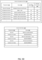
- FIG. 5C illustrates parameters 502 and values 504 that the event data 402 may comprise.
- An event identifier may be indicative of a particular event, distinguishing one event from another.
- the event data 402 may include a satellite identifier indicative of the satellite(s) 102 associated with the event data 402.
- An event type may specify a category of the event, such as "payload orientation out of limit", "payload malfunction", "PV array failure", and so forth.
- Timing type specifies whether the timing associated with the event is actual or predicted. For example, an actual event may result from an occurrence indicated by the telemetry data 354 while a predicted event may result from a predicted conjunction event with another object.
- the event data 402 may include a time associated with the event. For example, this may include the actual time the event is determined to have occurred, or a time that is associated with the predicted event.
- the event data 402 may include other information as well.
- the prioritization data 416 associates a priority value with the activity category indicated by the activity data 412.
- the activity category "reorient satellite for payload” may be executed with an execute by (time) less than threshold value of "YES" and have a priority of "115".
- the execute by (time) less than threshold may indicate that the interval between the current time and the execute by (time) specified in the activity data 412 is less than a threshold value.
- This parameter 502 may be used to prioritize activities that are designated as having a start or execute by time that is rapidly approaching.
- the priority value associated with the activity category may be manually specified or based on one or more factors. For example, the priority value may be determined based on whether the activity category involves a maneuver, time remaining until the execute by (time), time remaining until the complete by (time), and so forth.
- FIG. 5D illustrates activity alternative data 418.
- the activity category may be associated with one or more possible activities.
- the activity alternative data 418 may provide alternative actions that are associated with a particular activity category.
- the activity alternative data 418 may also include other information associated with the alternative actions.
- the activity alternative data 418 may indicate a satellite cost value 506, payload cost value 508, and so forth.
- the satellite cost value 506 is indicative of a cost to the overall satellite 102 that is associated with the activity.
- the satellite cost value 506 may be calculated based on estimated propellant to be consumed, power to be consumed, total duration of the activity, and so forth.
- the payload cost value 508 is indicative of a cost to the operation of the payload.
- the payload cost value 508 may be determined based on a number of customers of the payload that are affected, whether the payload would be usable during the activities, and so forth. For example, the payload cost value may have a maximum value of 255 if the payload is unable to provide service to any UTs 108.
- the activity category "reorient satellite for payload” is associated with at least five possible alternative activities: none (drift), have the satellite 102 service a different geographic area on Earth that would not require reorientation, reorienting using propulsion, reorienting using a magnetorquer, reorienting using a reaction wheel, and so forth.
- Each of these different activities results in different satellite cost values 506 and payload cost values 508. For example, servicing a different geographic area has a relatively low satellite cost value 506 because no power or propellant is consumed, but does have a relatively high payload cost value as service to the originally scheduled geographic area is not possible.
- reorientation using propulsion such as the thrusters 242 exhibits a high satellite cost value 506 due to the consumption of propellant while also producing a high payload cost value 508 as the payload may be unable to provide service to the UTs 108 while the thrusters 242 are operating.
- the activity set data 420 determined by the prioritization system 390 may also specify a sequence or order in which the activities should be performed. Activities may be sequenced based on priority value, complete by times, system dependences, and so forth. In this example, the activity to operate the magnetorquer to reorient the satellite 102 has been prioritized first with a specified complete by (time), followed by the activities to perform a battery maintenance cycle and PV actuator exercise to move the PV array actuators 232.
- the proposed plan data 384 includes information such as the satellite identifier, priority of the proposed plan, execute by (time), complete by (time) and other information.
- the proposed plan data 384 may indicate whether a maneuver is involved, the activity category for one or more of the activities specified, information about the satellite systems used, whether the activity is expected to result in the satellite leaving the assigned orbital volume, and action details such as values 504 for the various parameters 502.
- actual plan data 392 Also shown at 5E is an example of actual plan data 392.
- the proposed plan data 384 has been approved, and the actual plan data 392 includes information about the priority, timing, and activities to be performed.
- the actual plan data 392 may specify a window of time within which the plan is to be completed, action details that specify particular commands to be used to operate the satellite 102 to perform the activities, and so forth.
- FIG. 6 is a flow diagram 600 of a process of determining actual plan data 392 and operating a satellite 102 based on that actual plan data 392, according to some implementations.
- the process may be implemented at least in part by the CMS 160.
- a first event associated with at least a first satellite 102 is determined.
- the FDS 302 may generate event data 402 indicative of a payload orientation of the first satellite 102 being out of limit at a particular time.
- first ephemeris data of the first satellite 102 is determined.
- the FDS 302 may generate predicted ephemeris data 374.
- first state data of the first satellite 102 is determined.
- the state management system 306 may determine state data 378 indicative of available propellant, battery charge, and so forth.
- proposed plan data 384 is determined.
- the event processing system 410 of the plan generation system 308 may determine activity data 412.
- the activity assessment system 414 may then determine prioritization data 416 and activity alternative data 418.
- the prioritization system 390 may use the prioritization data 416, the activity alternative data 418, and the automated limit data 382 to determine the activity set data 420 and the proposed plan data 384.
- the process proceeds to 612. If the proposed plan data 384 includes activities that are within the automated oversight limits specified by the automated limit data 382, the process proceeds to 614.
- the automated limit data 382 may place constraints on individual activities, groups of activities, or activities across two or more satellites 102 in the constellation 114.
- the plan generation system 308 may determine a first set of proposed plan data that includes the first proposed plan data 384.
- the first set of proposed plan data is also indicative of proposed activities involving a first count of satellites 102 in the constellation 114 within a first time interval.
- the proposed plan data 384 may be approved for further action if the first count is less than a threshold value. If the first count is greater than or equal to the threshold value, the proposed plan data 384 may be presented for operator confirmation, such as via the operator interface system 312, may be delayed, or other actions may be taken.
- the automated limit data 382 may limit the number of concurrent maneuvers by satellites 102 within the constellation 114 to 195. Continuing the example, this limit may be used to prevent large-scale simultaneous maneuvers that could complicate operation of the FDS 302.
- operator input approving the proposed plan data 384 is obtained.
- the operator interface system 312 may present the proposed plan data 384 to an operator for approval, modification, denial, or other action. Once approved or modified, the process continues to 614.
- actual plan data 392 is determined based in part on the proposed plan data 384.
- the proposed plan data 384 may be approved and used as the actual plan data 392.
- a human operator may add or modify one or more additional activities of the proposed plan data 384 to determine the actual plan data 392.
- the first satellite 102 is operated based at least in part on the actual plan data 392.
- the actual plan data 392 may be provided to the satellite mission control system 314.
- the satellite mission control system 314 may determine control data 398 comprising one or more commands to operate one or more devices onboard the first satellite 102.
- FIG. 7 is a flow diagram 700 of another process of determining actual plan data 392 and operating a satellite 102 based on that actual plan data 392, according to some implementations.
- the process may be implemented at least in part by the CMS 160.
- proposed plan data 384 is determined.
- the plan generation system 308 may determine the proposed plan data 384 in response to event data 402.
- the FDS 302 may determine event data 402 indicative of a potential conjunction event with another object.
- the first actual plan data 392 is determined. For example, if no changes were made to the proposed plan data 384, the proposed plan data 384 may be used as the first actual plan data 392.
- control data 398 is determined based on the first actual plan data 392.
- the satellite mission control system 314 may use the actual plan data 392 to determine the control data 398 that comprises one or more commands to operate the satellite 102.
- the satellite 102 is operated based on the control data 398.
- the satellite mission control system 314 may send the control data 398 to the satellite 102 for execution.
- second proposed plan data 384 is determined based at least in part on the response data. For example, if the response data indicates a possible conjunction event, the second proposed plan data 384 may be determined that indicates a different maneuver to avoid the adverse outcome.
- FIG. 8 illustrates at 800 an object entering a volume associated with operation of a payload of a first satellite 102 and a mitigating action, according to some implementations.
- the service provided by the payload of the satellite 102 may involve transmitting a radio signal, receiving a radio signal, operating one or more sensors to acquire remote sensing data, and so forth.
- the Earth 802 is shown, with a first satellite 102(1) and a second satellite 102(2) shown in orbit 104.
- Each satellite 102 has an associated volume 804 of space that is associated with the respective payload.
- a first volume 804(1) of space may represent a solid angle that includes a first radio signal generated by a radio transmitter and emitted by an antenna 282 in a first payload of the first satellite 102(1) while a second volume 804(2) of space is representative of a second radio signal from a second payload of the second satellite 102(2).
- the object 806 may include another satellite 102 in the constellation 114, other satellite 102, debris, and so forth.
- the FDS 302 may determine the predicted locations of the satellites 102, objects 806, orientation of the volumes 804 associated with the payloads of the satellites 102, and so forth.
- Operation of a payload may be modified based on the presence of an object 806 within the volume 804(1).
- the payload is a synthetic aperture radar
- the presence of the object 806 may occlude and otherwise interfere with acquiring data about features on the Earth 802.
- the payload is a radio transmitter and the object 806 includes a radio receiver at or near the same frequency
- output from the radio transmitter could overload the radio receiver of the object 806.
- the FDS 302 may generate interference mitigation data 376.
- the interference mitigation data 376 may indicate the volume 804 includes an object 806 that could affect the payload of the satellite 102, or that the volume 804 includes an object 806 that could be affected by the payload of the satellite 102.
- the system 100 may mitigate potential interference involving the object 806.
- the network management system 150 may use the interference mitigation data 376 provided by the FDS 302 to determine which satellite 102 will provide service to a particular location on the Earth 802.
- Interference mitigation may include other activities as well.
- the payload may be operated to use a third volume 804 that is predicted to not include the object 806.
- the first satellite 102(1) may be reoriented so the first volume 804(1) no longer includes the object 806.
- FIG. 9 is a flow diagram 900 of a process of operating a satellite 102 based on a determination that an object 806 is within a volume 804 associated with operation of a payload, according to some implementations.
- a location and orientation of a first satellite 102(1) in a constellation 114 at the first time is determined.
- a first volume 804(1) of space that is associated with operation of a payload of the first satellite 102(1) at the first time is determined. For example, a solid angle may be determined that is associated with an antenna radiation pattern from the antennas 282 onboard the first satellite 102(1).
- a first object 806 is predicted to be within the first volume 804(1) at the first time.
- the location of the first object 806 may be determined by the FDS 302 based on the SSA data 322 received from the SSA system(s) 320.
- first data to control the payload of the first satellite 102(1) is determined.
- the plan generation system 308 may generate actual plan data 392.
- the satellite mission control system 314 may use the actual plan data 392 to determine control data 398.
- the first data is sent to the first satellite 102(1).
- the control data 398 may be transmitted to the first satellite 102(1) by a ground station 106.
- the first satellite 102(1) is operated based on the first data.
- the first satellite 102(1) may execute the control data 398.
- Times, intervals, durations, and the like as used in this disclosure may be specified with respect to actual clock time, system time, system timing references, discrete timeslots, interval indicators, and so forth. For example, time ticks may be specified relative to an epoch that resets at 10-minute intervals. In another example, actual clock time obtained from the Global Position System or other precision timing system may be used.
- Embodiments may be provided as a software program or computer program product including a non-transitory computer-readable storage medium having stored thereon instructions (in compressed or uncompressed form) that may be used to program a computer (or other electronic device) to perform processes or methods described herein.
- the computer-readable storage medium may be one or more of an electronic storage medium, a magnetic storage medium, an optical storage medium, a quantum storage medium, and so forth.
- the computer-readable storage medium may include, but is not limited to, hard drives, optical disks, read-only memories (ROMs), random access memories (RAMs), erasable programmable ROMs (EPROMs), electrically erasable programmable ROMs (EEPROMs), flash memory, magnetic or optical cards, solid-state memory devices, or other types of physical media suitable for storing electronic instructions.
- Further embodiments may also be provided as a computer program product including a transitory machine-readable signal (in compressed or uncompressed form). Examples of transitory machine-readable signals, whether modulated using a carrier or unmodulated, include, but are not limited to, signals that a computer system or machine hosting or running a computer program can be configured to access, including signals transferred by one or more networks.
- the transitory machine-readable signal may comprise transmission of software by the Internet.
Landscapes
- Engineering & Computer Science (AREA)
- Remote Sensing (AREA)
- Aviation & Aerospace Engineering (AREA)
- Physics & Mathematics (AREA)
- General Physics & Mathematics (AREA)
- Astronomy & Astrophysics (AREA)
- Radar, Positioning & Navigation (AREA)
- Signal Processing (AREA)
- Computer Networks & Wireless Communication (AREA)
- Chemical & Material Sciences (AREA)
- Combustion & Propulsion (AREA)
- Automation & Control Theory (AREA)
- Position Fixing By Use Of Radio Waves (AREA)
- Radio Relay Systems (AREA)
Description
- This application claims priority to,
U.S. Patent Application No. 17/100,276, filed on 20 November 2020 - A constellation of a large number of satellites, and the payloads carried by those satellites, may be used to provide various services, see
US9651946 B1 - The detailed description is set forth with reference to the accompanying figures. In the figures, the left-most digit(s) of a reference number identifies the figure in which the reference number first appears. The use of the same reference numbers in different figures indicates similar or identical items or features. The figures are not necessarily drawn to scale, and in some figures, the proportions or other aspects may be exaggerated to facilitate comprehension of particular aspects.
-
FIG. 1 illustrates a system that utilizes a constellation management system (CMS) for a constellation of satellites, according to some implementations. -
FIG. 2 is a block diagram of some systems associated with the satellite, according to some implementations. -
FIG. 3 illustrates the CMS and associated systems, according to some implementations. -
FIG. 4 illustrates a plan generation system of the CMS that is used to determine actual plan data used to operate satellites in the constellation, according to some implementations. -
FIGS. 5A-5E illustrate data associated with operation of the system, according to some implementations. -
FIG. 6 is a flow diagram of a process of determining actual plan data and operating a satellite based on that actual plan data, according to some implementations. -
FIG. 7 is a flow diagram of another process of determining actual plan data and operating a satellite based on that actual plan data, according to some implementations. -
FIG. 8 illustrates an object entering a volume associated with operation of a payload of a first satellite and a mitigating action, according to some implementations. -
FIG. 9 is a flow diagram of a process of operating a satellite based on a determination that an object is within a volume associated with operation of a payload, according to some implementations. - While implementations are described herein by way of example, those skilled in the art will recognize that the implementations are not limited to the examples or figures described. It should be understood that the figures and detailed description thereto are not intended to limit implementations to the particular form disclosed but, on the contrary, the intention is to cover all modifications falling within the scope as defined by the appended claims. The headings used herein are for organizational purposes only and are not meant to be used to limit the scope of the description or the claims. As used throughout this application, the word "may" is used in a permissive sense (i.e., meaning having the potential to), rather than the mandatory sense (i.e., meaning must). Similarly, the words "include", "including", and "includes" mean "including, but not limited to".
- A constellation of many satellites may be used to provide a wide variety of useful services. For example, a communication system may utilize satellites in the constellation to wirelessly transfer data between user terminals and ground stations that in turn connect to other networks, such as the Internet. In another example, a remote sensing system may utilize satellites in a constellation to acquire remote sensing data for weather forecasting or terrestrial resource management.
- Traditionally, operators of individual satellites have manually managed their satellites. Manual management is time and labor intensive, costly, and may be slow to respond to dynamic events. Manual management does not scale well, and rapidly becomes infeasible as the number of satellites managed increases. For example, while traditional organizations may be able to manually manage a relatively small constellation of 70 satellites, managing 700 satellites in such fashion is infeasible and may adversely impact safety and efficiency of the constellation as well as other resources that are in orbit.
- Described in this disclosure is a constellation management system (CMS) that facilitates operation of satellite constellations. The CMS acquires and uses data from a variety of sources to maintain situational awareness of the orbital environment and the constellation. The CMS may accept as input space situation awareness data that comprises information about objects in orbit, such as obtained from other operators of other satellites, radar tracking, and so forth. The CMS may accept as input space weather data that is indicative of space weather. For example, the space weather data may be indicative of solar storms, geomagnetic storms, and so forth. The CMS accepts as input telemetry data from satellites in the constellation. For example, the telemetry data may include information about the satellite as well as position data obtained from global satellite navigation system (GNSS) receivers onboard individual satellites. The CMS may also accept as input navigation status data about the GNSS being used to provide position data. For example, the navigation status data may be indicative as to changes in reliability of the signals emitted by the GNSS.
- Various events may occur that involve one or more satellites in the constellation. These may include, but are not limited, a predicted or actual deviation in position of a satellite of a satellite from an assigned orbit that exceeds a threshold value, a telemetry value associated with a component onboard a satellite that is outside of a specified range, a potential radio interference event such as another satellite passing through the radio frequency "volume" of a payload on a satellite in the constellation, expiration of time since last evaluation of the satellite, and so forth. These events may require that some action be taken.
- The CMS uses the information ingested to determine a proposed plan. An event may be associated with several alternative activities. For example, an event of "payload orientation out of limit" may have several alternative activities such as doing nothing, using another satellite to provide service, or various options to reorient the satellite using different systems. Costs may be associated with these alternative activities. These costs may be representative of various factors such as current battery state, estimated battery discharge, estimated propellant consumption, time to complete, and so forth. Based on the cost, a particular alternative activity may be selected and used to generate a proposed plan.
- Other pending activities that are associated with the satellite may also be retrieved. For example, routine maintenance operations that are not time sensitive may be retrieved. Pending activities that do not conflict, may be combined to generate a proposed plan that includes more than one activity.
- The proposed plan may then be assessed to determine if any of the proposed activities exceed automated oversight limits. For example, governors or limits may be set to limit automated maneuvers that have a maximum delta v (change in velocity) that exceeds 1.5 meters per second (m/s), or would consume more than some specified quantity of propellant.
- In some situations, proposed plans may be provided to external systems. For example, information about a proposed orbit resulting from a proposed maneuver may be provided to an external space situation awareness (SSA) provider. The SSA may accept the information about the proposed orbit and determine if a conjunction with tracked objects is likely to occur within a specified interval of time. The SSA may provide response data to the system, such as an indication that no conjunction is deemed likely. The system may take the response data into consideration, and subsequently determines commands to operate the satellite to perform the activities specified. The commands are sent to the satellite that executes those commands to perform the activities.
- During typical operation the CMS operates without human intervention. A human may be consulted to confirm a proposed plan that exceeds the automated oversight limits, is designated for operator confirmation, and so forth. In addition to managing individual satellites, the CMS maintains awareness of the constellation as a whole and may request human oversight for activities that may involve many satellites. For example, while an individual proposed plan to maneuver a particular satellite may be within the automated oversight limits, if the count of satellites in the constellation that have proposed concurrent maneuvers exceeds a threshold count, a human may be notified and asked to confirm those maneuvers.
- The CMS may provide various levels of involvement. For example, a first event indicative of a predicted conjunction event in 10 days may be handled automatically. Continuing the example, a second event indicative of a predicted conjunction event in six hours may result in the immediate generation of a proposed plan that is promptly presented to a human operator for confirmation.
- The CMS may include one or more machine learning systems. These machine learning systems may be trained based at least in part on human input. For example, the training data may comprise event data, state data of the satellite, ephemeris data, a set of alternative activities, and the activity ultimately selected by a human operator. Once trained, the machine learning systems may provide various functions such as predicting failures, providing improved recommendations for activities to address various situations, and automatically initiating activities.
- The CMS also reduces the capital costs associated with the constellation by managing usage of resources onboard the satellite, such as battery systems and maneuvering systems. For example, the CMS may moderate activities that use various resources onboard individual satellites to avoid depleting the battery and propellant of a single satellite. As a result, operational life of the individual satellite may be extended, reducing the need for replacement or refurbishment.
- By using the techniques described in this disclosure, the safe and effective management of a constellation becomes possible. The automation provided by the CMS handles routine events, and over time learns to deal with less common events. The CMS is able to manage complex inputs and quickly determine and implement plans to perform activities that maintain the constellation and perform the mission(s) associated with the payload of the satellites in the constellation.
- A constellation of satellites may be used to provide a wide variety of useful services. For example, a constellation of satellites may include sensors to acquire remote sensing data to facilitate terrestrial resource management. In another example, a constellation of satellites may provide communication services. The ability to communicate between two or more locations that are physically separated provides substantial benefits. Communications over areas ranging from counties, states, continents, oceans, and the entire planet are used to enable a variety of activities including health and safety, logistics, remote sensing, interpersonal communication, and so forth.
- Communications facilitated by electronics use electromagnetic signals, such as radio waves or light to send information over a distance. These electromagnetic signals have a maximum speed in a vacuum of 299,792,458 meters per second, known as the "speed of light" and abbreviated "c". Electromagnetic signals may travel, or propagate, best when there is an unobstructed path between the antenna of the transmitter and the antenna of the receiver. This path may be referred to as a "line of sight". While electromagnetic signals may bend or bounce, the ideal situation for communication is often a line of sight that is unobstructed. Electromagnetic signals will also experience some spreading or dispersion. Just as ripples in a pond will spread out, a radio signal or a spot of light from a laser will spread out at progressively larger distances.
- As height above ground increases, the area on the ground that is visible from that elevated point increases. For example, the higher you go in a building or on a mountain, the farther you can see. The same is true for the electromagnetic signals used to provide communication services. A relay station having a radio receiver and transmitter with their antennas placed high above the ground is able to "see" more ground and provide communication service to a larger area.
- There are limits to how tall a structure can be built and where. For example, it is not cost effective to build a 2000 meter tall tower in a remote area to provide communication service to a small number of users. However, if that relay station is placed on a satellite high in space, that satellite is able to "see" a large area, potentially providing communication services to many users across a large geographic area. In this situation, the cost of building and operating the satellite is distributed across many different users and becomes cost effective.
- A satellite may be maintained in space for months or years by placing it into orbit around the Earth. The movement of the satellite in orbit is directly related to the height above ground. For example, the greater the altitude the longer the period of time it takes for a satellite to complete a single orbit. A satellite in a geosynchronous orbit at an altitude of 35,800 km may appear to be fixed with respect to the ground because the period of the geosynchronous orbit matches the rotation of the Earth. In comparison, a satellite in a non-geosynchronous orbit (NGO) will appear to move with respect to the Earth. For example, a satellite in a circular orbit at 600 km will circle the Earth about every 96 minutes. To an observer on the ground, the satellite in the 600 km orbit will speed by, moving from horizon to horizon in a matter of minutes.
- Building, launching, and operating a satellite is costly. Traditionally, geosynchronous satellites have been used for broadcast and communication services because they appear stationary to users on or near the Earth and they can cover very large areas. This simplifies the equipment needed by a station on or near the ground to track the satellite.
- However, there are limits as to how many geosynchronous satellites may be provided. For example, the number of "slots" or orbital positions that can be occupied by geosynchronous satellites are limited due to technical requirements, regulations, treaties, and so forth. It is also costly in terms of fuel to place a satellite in such a high orbit, increasing the cost of launching the satellite.
- The high altitude of the geosynchronous satellite can introduce another problem when it comes to sharing electromagnetic spectrum. The geosynchronous satellite can "see" so much of the Earth that special antennas may be needed to focus radio signals to particular areas, such as a particular portion of a continent or ocean, to avoid interfering with radio services on the ground in other areas that are using the same radio frequencies.
- Using a geosynchronous satellite to provide communication services also introduces a significant latency or delay because of the time it takes for a signal to travel up to the satellite in geosynchronous orbit and back down to a device on or near the ground. The latency due to signal propagation time of a single hop can be at least 240 milliseconds (ms).
- To alleviate these and other issues, satellites in NGOs may be used. The altitude of an NGO is high enough to provide coverage to a large portion of the ground, while remaining low enough to minimize latency due to signal propagation time. For example, the satellite at 600 km only introduces 4 ms of latency for a single hop. The lower altitude also reduces the distance the electromagnetic signal has to travel. Compared to the geosynchronous orbit, the reduced distance of the NGO reduces the dispersion of electromagnetic signals. This allows the satellite in NGO as well as the device communicating with the satellite to use a less powerful transmitter, use smaller antennas, and so forth.
- The
system 100 shown here comprises a plurality (or "constellation" 114) of artificial satellites 102(1), 102(2), ..., 102(S), eachsatellite 102 being inorbit 104 around a body such as the Earth, moon, sun, and so forth. Also shown is aground station 106, user terminal (UTs) 108, auser device 110, and so forth. - The
constellation 114 may comprise hundreds or thousands ofsatellites 102, invarious orbits 104. For example, one or more of thesesatellites 102 may be in non-geosynchronous orbits (NGOs) in which they are in constant motion with respect to the Earth, such as a low earth orbit (LEO). In this illustration,orbit 104 is depicted with an arc pointed to the right. A first satellite (SAT1) 102(1) is leading (ahead of) a second satellite (SAT2) 102(2) in theorbit 104. Thesatellite 102 is discussed in more detail with regard toFIG. 2 . - One or
more ground stations 106 comprise facilities that are in communication with one ormore satellites 102. Theground stations 106 may pass data between thesatellites 102, anetwork management system 150, networks such as the Internet, and so forth. Theground stations 106 may be emplaced on land, on vehicles, at sea, and so forth. Eachground station 106 may comprise acommunication system 140. Eachground station 106 may use thecommunication system 140 to establish communication with one ormore satellites 102,other ground stations 106, and so forth. Theground station 106 may also be connected to one or more communication networks. For example, theground station 106 may connect to a terrestrial fiber optic communication network. Theground station 106 may act as a network gateway, passing user data or other data between the one or more communication networks and thesatellites 102. Such data may be processed by theground station 106 and communicated via thecommunication system 140. Thecommunication system 140 of aground station 106 may include components similar to those of the communication system of asatellite 102 and may perform similar communication functionalities. For example, thecommunication system 140 may include one or more modems, digital signal processors, power amplifiers, antennas (including at least one antenna that implements multiple antenna elements, such as a phased array antenna), processors, memories, storage devices, communications peripherals, interface buses, and so forth. - The
satellites 102 are in communication with a constellation management system (CMS) 160 that facilitates management of thesatellites 102 in theconstellation 114. TheCMS 160 may coordinate and direct operation of thesatellites 102 in theconstellation 114. For example, theCMS 160 may monitor and maintainsatellites 102 in their assigned orbits, initiate maintenance activities onboard thesatellites 102, provide instructions to prevent a payload on asatellite 102 from interfering with another satellite, and so forth. TheCMS 160 may comprise one or more servers or other computing devices. Operation of theCMS 160 is discussed in more detail with regard toFIGS. 3-9 . - The
ground stations 106 are in communication with anetwork management system 150 that may include ascheduling system 156. Thenetwork management system 150 is also in communication, via theground stations 106, with thesatellites 102 and theUTs 108. Thenetwork management system 150 coordinates operation of theground stations 106,UTs 108, and other resources of thesystem 100. Thenetwork management system 150 may interact with theCMS 160 during operation. Thenetwork management system 150 may comprise one or more servers or other computing devices. - The
scheduling system 156 schedules resources to provide communication to theUTs 108. For example, thescheduling system 156 may determine handover data that indicates when communication is to be transferred from the first satellite 102(1) to the second satellite 102(2). Continuing the example, thescheduling system 156 may also specify communication parameters such as frequency, timeslot, and so forth. During operation, thescheduling system 156 may use information such as ephemeris data from theCMS 160, communication system status data 158,user terminal data 160, and so forth. - The system status data 158 may comprise information such as which
UTs 108 are currently transferring data, satellite availability,current satellites 102 in use byrespective UTs 108, capacity available atparticular ground stations 106, diagnostic information, and so forth. For example, the satellite availability may comprise information indicative ofsatellites 102 that are available to provide communication service or thosesatellites 102 that are unavailable for communication service. Continuing the example, theCMS 160 may indicate that asatellite 102 is unavailable due to malfunction, previous tasking, maneuvering, and so forth. The communication system status data 158 may be indicative of past status, predictions of future status, and so forth. For example, the communication system status data 158 may include information such as projected data traffic for a specified interval of time based on previous transfers of user data. In another example, the communication system status data 158 may be indicative of future status, such as asatellite 102 being unavailable to provide communication service due to scheduled maneuvering, scheduled maintenance, scheduled decommissioning, and so forth. - The
user terminal data 160 may comprise information such as a location of aparticular UT 108. Theuser terminal data 160 may also include other information such as a priority assigned to user data associated with thatUT 108, information about the communication capabilities of thatparticular UT 108, and so forth. For example, aparticular UT 108 in use by a business may be assigned a higher priority relative to aUT 108 operated in a residential setting. Over time, different versions ofUTs 108 may be deployed, having different communication capabilities such as being able to operate at particular frequencies, supporting different signal encoding schemes, having different antenna configurations, and so forth. - The
UT 108 includes acommunication system 180 to establish communication with one ormore satellites 102. Thecommunication system 180 of theUT 108 may include components similar to those of thecommunication system 212 of asatellite 102 and may perform similar communication functionalities. For example, thecommunication system 180 may include one or more modems, digital signal processors, power amplifiers, antennas (including at least one antenna that implements multiple antenna elements, such as a phased array antenna), processors, memories, storage devices, communications peripherals, interface buses, and so forth. TheUT 108 passes communication system status data 158 between the constellation ofsatellites 102 and theuser device 110. The 112 data may include data originated by the user device 110 (upstream data) or data addressed to the user device 110 (downstream data). - The
UT 108 may be fixed or in motion. For example, theUT 108 may be used at a residence or on a vehicle such as a car, boat, aerostat, drone, airplane, and so forth. TheUT 108 includes atracking system 182. Thetracking system 182 usesalmanac data 184 to determine trackingdata 186. Thealmanac data 184 provides information indicative of orbital elements of theorbit 104 of one ormore satellites 102. For example, theCMS 160 may generatealmanac data 184 that comprises orbital elements such as "two-line element" data for thesatellites 102 in theconstellation 114. Thealmanac data 184 may be broadcast or otherwise sent to theUTs 108 using thecommunication system 180. - The
tracking system 182 may use the current location of theUT 108 and thealmanac data 184 to determine the trackingdata 186 for thesatellite 102. For example, based on the current location of theUT 108 and the predicted position and movement of thesatellites 102, thetracking system 182 is able to calculate the trackingdata 186. The trackingdata 186 may include information indicative of azimuth, elevation, distance to the second satellite, time of flight correction, or other information associated with a specified time. The determination of the trackingdata 186 may be ongoing. For example, thefirst UT 108 may determine trackingdata 186 every 100 ms, every second, every five seconds, or at other intervals. - With regard to
FIG. 1 , an uplink is a communication link which allows data to be sent to asatellite 102 from aground station 106,UT 108, or device other than anothersatellite 102. Uplinks are designated as UL1, UL2, UL3 and so forth. For example, UL1 is a first uplink from theground station 106 to the second satellite 102(2). In comparison, a downlink is a communication link which allows data to be sent from thesatellite 102 to aground station 106,UT 108, or device other than anothersatellite 102. For example, DL1 is a first downlink from the second satellite 102(2) to theground station 106. Thesatellites 102 may also be in communication with one another. For example, an intersatellite link (ISL) 190 provides for communication betweensatellites 102 in theconstellation 114. - A device, such as a server, uses one or
more networks 144 to senddownstream data 112 that is addressed to aUT 108 or auser device 110 that is connected to theUT 108. Thesystem 100 may include one or more point of presence (PoP)systems 146. EachPoP system 146 may comprise one or more servers or other computing devices at a facility, such as on Earth.Separate PoP systems 146 may be located at different locations in different facilities. In one implementation, aPoP system 146 may be associated with providing service to a plurality ofUTs 108 that are located in a particular geographic region. - In this illustration, a
first PoP system 146 at a facility accepts thedata 112 addressed to theUT 108 and proceeds to attempt delivery of thedata 112 to theUT 108. ThePoP system 146 is in communication with one or more ground stations 106(1), 106(2), ..., 106(G) and thenetwork management system 150. In some implementations one or more functions may be combined. For example, thePoP system 146 may perform one or more functions of thenetwork management system 150. In another example, thePoP system 146 may include anintegrated ground station 106. - The
PoP system 146 may provide several functions including determining timeslot and communication resources, generating preshaped data, and so forth. One function is to assign a targeted timeslot to thedownstream data 112. For example, scheduling handoffs ofUTs 108 from onesatellite 102 to another may be scheduled on 5-second intervals. The targeted timeslot may indicate a particular 5-second interval within which thedownstream data 112 is expected to be delivered. The targeted timeslot may already be in progress. For example, the targeted timeslot assigned to thedownstream data 112 may have begun 3 seconds before thedownstream data 112 was received. - The
PoP system 146 determines theUT 108 that thedownstream data 112 is addressed to and determines first communication resource data. The first communication resource data specifies the communication resources, such asground station 106, uplink modem at theground station 106, satellite, downlink modem on the satellite, and so forth that would result in delivery of thedownstream data 112 to theUT 108. Thedownstream data 112 may comprise a single packet or other unit of data transfer, or a plurality of packets or other units of data transfer that are associated with delivery to theparticular UT 108. - The
satellite 102, theground station 106, theuser terminal 108, theuser device 110, thenetwork management system 150, theCMS 160, or other systems described herein may include clocks. These clocks may be synchronized to a common source. In some implementations the clock may be a global positioning system (GPS) disciplined clock or an atomic clock that provides a high accuracy and high precision time source. Output from the clock may be used to coordinate operation of thesystem 100. - Various configurations of the systems described in this disclosure may be used. For example, the
CMS 160 may be distributed across a plurality of data centers to improve reliability and system availability. - The
satellite 102, theground station 106, theuser terminal 108, theuser device 110, thePoP system 146, thenetwork management system 150, theCMS 160, or other systems described herein may include one or more computer devices or computer systems comprising one or more hardware processors, computer-readable storage media, and so forth. For example, the hardware processors may include application specific integrated circuits (ASICs), field-programmable gate arrays (FPGAs), digital signal processors (DSPs), and so forth. Embodiments may be provided as a software program or computer program including a non-transitory computer-readable storage medium having stored thereon instructions (in compressed or uncompressed form) that may be used to program a computer (or other electronic device) to perform the processes or methods described herein. The computer-readable storage medium may be one or more of an electronic storage medium, a magnetic storage medium, an optical storage medium, a quantum storage medium, and so forth. For example, the computer-readable storage medium may include, but is not limited to, hard drives, optical disks, read-only memories (ROMs), random access memories (RAMs), erasable programmable ROMs (EPROMs), electrically erasable programmable ROMs (EEPROMs), flash memory, magnetic or optical cards, solid-state memory devices, or other types of physical media suitable for storing electronic instructions. Further embodiments may also be provided as a computer program product including a transitory machine-readable signal (in compressed or uncompressed form). Examples of transitory machine-readable signals, whether modulated using a carrier or unmodulated, include, but are not limited to, signals that a computer system or machine hosting or running a computer program can be configured to access, including signals transferred by one or more networks. For example, the transitory machine-readable signal may comprise transmission of software by the Internet. -
FIG. 2 is a block diagram 200 of some systems associated with thesatellite 102, according to some implementations. Thesatellite 102 may comprise astructural system 202, acontrol system 204, apower system 206, amaneuvering system 208, one ormore sensors 210, and acommunication system 212. A pulse per second (PPS)system 214 may be used to provide timing reference to the systems onboard thesatellite 102. One or more busses 216 may be used to transfer data between the systems onboard thesatellite 102. In some implementations, redundant busses 216 may be provided. The busses 216 may include, but are not limited to, data busses such as Controller Area Network Flexible Data Rate (CAN FD), Ethernet, Serial Peripheral Interface (SPI), and so forth. In some implementations the busses 216 may carry other signals. For example, a radio frequency bus may comprise coaxial cable, waveguides, and so forth to transfer radio signals from one part of thesatellite 102 to another. In other implementations, some systems may be omitted or other systems added. One or more of these systems may be communicatively coupled with one another in various combinations. - The
structural system 202 comprises one or more structural elements to support operation of thesatellite 102. For example, thestructural system 202 may include trusses, struts, panels, and so forth. The components of other systems may be affixed to, or housed by, thestructural system 202. For example, thestructural system 202 may provide mechanical mounting and support for solar panels in thepower system 206. Thestructural system 202 may also provide for thermal control to maintain components of thesatellite 102 within operational temperature ranges. For example, thestructural system 202 may include louvers, heat sinks, radiators, and so forth. - The
control system 204 provides various services, such as operating the onboard systems, resource management, providing telemetry, processing commands, and so forth. For example, thecontrol system 204 may direct operation of thecommunication system 212. Thecontrol system 204 may include one or moreflight control processors 220. Theflight control processors 220 may comprise one or more processors, FPGAs, and so forth. A tracking, telemetry, and control (TTC)system 222 may include one or more processors, radios, and so forth. For example, theTTC system 222 may comprise a dedicated radio transmitter and receiver to receive commands from aground station 106, send telemetry to theground station 106, and so forth. A power management and distribution (PMAD)system 224 may direct operation of thepower system 206, control distribution of power to the systems of thesatellite 102,control battery 234 charging, and so forth. - The
power system 206 provides electrical power for operation of the components onboard thesatellite 102. Thepower system 206 may include components to generate electrical energy. For example, thepower system 206 may comprise one or morephotovoltaic arrays 230 comprising a plurality of photovoltaic cells, thermoelectric devices, fuel cells, and so forth. One or morePV array actuators 232 may be used to change the orientation of the photovoltaic array(s) 230 relative to thesatellite 102. For example, thePV array actuator 232 may comprise a motor. Thepower system 206 may include components to store electrical energy. For example, thepower system 206 may comprise one ormore batteries 234, fuel cells, and so forth. - The
maneuvering system 208 maintains thesatellite 102 in one or more of a specified orientation ororbit 104. For example, themaneuvering system 208 may stabilize thesatellite 102 with respect to one or more axes. In another example, themaneuvering system 208 may move thesatellite 102 to a specifiedorbit 104. Themaneuvering system 208 may include one or more of reaction wheel(s) 240, thrusters 242,magnetic torque rods 244, solar sails, drag devices, and so forth. The thrusters 242 may include, but are not limited to, cold gas thrusters, hypergolic thrusters, solid-fuel thrusters, ion thrusters, arcjet thrusters, electrothermal thrusters, and so forth. During operation, the thrusters 242 may expend propellent. For example, an electrothermal thruster may use water as propellent, using electrical power obtained from thepower system 206 to expel the water and produce thrust. During operation, themaneuvering system 208 may use data obtained from one or more of thesensors 210. - The
satellite 102 includes one ormore sensors 210. Thesensors 210 may include one ormore engineering cameras 250. For example, anengineering camera 250 may be mounted on thesatellite 102 to provide images of at least a portion of thephotovoltaic array 230.Accelerometers 252 provide information about acceleration of thesatellite 102 along one or more axes. Gyroscopes 254 provide information about rotation of thesatellite 102 with respect to one or more axes. Thesensors 210 may include a global navigation satellite system (GNSS) 256 receiver, such as a Global Positioning System (GPS) receiver, to provide information about the position of thesatellite 102 relative to Earth. In some implementations theGNSS 256 may also provide information indicative of velocity, orientation, and so forth. One ormore star trackers 258 may be used to determine an orientation of thesatellite 102. Acoarse sun sensor 260 may be used to detect the sun, provide information on the relative position of the sun with respect to thesatellite 102, and so forth. Aradar 262 may be used to provide information such as distance and bearing to objects. For example, theradar 262 may be used to determine the presence of objects in nearby orbits. In other implementations other sensors may be used, such as LIDAR, optical time of flight devices, cameras, and so forth. For example, a camera may be used to determine occlusion by an object of one or more stellar light sources, such as distance stars. Image data provided by the camera may be processed to determine an approximate distance and bearing of the object. Adebris sensor 264 may be used to detect impacts, such as micrometeoroid impacts, small debris impacts, and so forth. For example, thedebris sensor 264 may comprise a microphone, microelectromechanical system, or other device that detects acoustic energy in a chassis of thesatellite 102 as a result of an impact. In some implementations the accelerometer(s) 252 may be used to detect impacts. Thesatellite 102 may includeother sensors 210 as well. For example, thesatellite 102 may include a horizon detector, lidar, and so forth. - The
communication system 212 provides communication with one or more other devices, such asother satellites 102,ground stations 106,user terminals 108, and so forth. Thecommunication system 212 may include one ormore modems 276, digital signal processors, power amplifiers, antennas (including at least one antenna that implements multiple antenna elements, such as a phased array antenna) 282, processors, memories, storage devices, communications peripherals, interface buses, and so forth. Such components support communications withother satellites 102,ground stations 106,user terminals 108, and so forth using radio frequencies within a desired frequency spectrum. The communications may involve multiplexing, encoding, and compressing data to be transmitted, modulating the data to a desired radio frequency, and amplifying it for transmission. The communications may also involve demodulating received signals and performing any necessary de-multiplexing, decoding, decompressing, error correction, and formatting of the signals. Data decoded by thecommunication system 212 may be output to other systems, such as to thecontrol system 204, for further processing. Output from a system, such as thecontrol system 204, may be provided to thecommunication system 212 for transmission. - Each
satellite 102 may use one ormore antennas 282 or antenna elements to provide a beam for transmission and reception of radio signals. For example, thesatellite 102 may have a phased array antenna that allows for gain in a particular direction. Compared to a non-directional radiator, this gain directs the energy of transmitted radio frequency signals in that particular direction. This increases the strength of the signal at a receiver in theUT 108,ground station 106, and so forth. Likewise, the gain results in improved received signal strength at thesatellite 102. - The beam provided by the
satellite 102 may comprise a plurality of subbeams. Subbeams on asatellite 102 may use different frequencies, timeslots, and so forth, to communicate with theUT 108. Each subbeam provides coverage of a particular geographic area or "footprint". Compared to a single beam, subbeams provide several advantages. For example, by using subbeams, radio frequencies may be reused by thesame satellite 102 andother satellites 102 to service different areas. This allows increased density ofUTs 108 and bandwidth. - During a pass over of a particular location on the Earth, each subbeam may be targeted to a geographic location on the Earth. While that target geographic location is in range of the
satellite 102, the subbeam tracks the target location. As thesatellite 102 moves inorbit 104, the boundary of the footprint may change due to the relative angle between thesatellite 102 and the Earth. For example, the footprint boundary may change from approximately an oval shape while thesatellite 102 is low on the horizon relative to the target location, a circular shape while directly overhead, then an oval shape as thesatellite 102 nears the opposite horizon. As thesatellite 102 moves, a subbeam may be retargeted to another target location. In this configuration, instead of the subbeam sweeping along the ground track of thesatellite 102, the subbeam loiters on a first area relative to the Earth, then is redirected to a second area. - In some implementations, a
particular modem 276 or set ofmodems 276 may be allocated to a particular subbeam. For example, a first modem 276(1) provides communication toUTs 108 in a first geographic area using a first subbeam while a second modem 276(2) provides communication toUTs 108 in a second geographic area using a second subbeam. - The
communication system 212 may include hardware to support theintersatellite link 190. For example, anintersatellite link FPGA 270 may be used to modulate data that is sent and received by anISL transceiver 272 to send data betweensatellites 102. TheISL transceiver 272 may operate using radio frequencies, optical frequencies, and so forth. - A
communication FPGA 274 may be used to facilitate communication between thesatellite 102 and theground stations 106,UTs 108, and so forth. For example, thecommunication FPGA 274 may direct operation of amodem 276 to modulate signals sent using adownlink transmitter 278 and demodulate signals received using anuplink receiver 280. Thesatellite 102 may include one ormore antennas 282. For example, one or more parabolic antennas may be used to provide communication between thesatellite 102 and one ormore ground stations 106. In another example, a phasedarray antenna 282 may be used to provide communication between thesatellite 102 and theUTs 108. -
FIG. 3 illustrates at 300 theCMS 160 and associated systems, according to some implementations. TheCMS 160 may provide various services that include receiving information from external systems, providing information to those external systems, coordinating with those external systems, planning and initiating activities that includesatellites 102 in theconstellation 114, coordinating with thenetwork management system 150 to facilitate operation of the payloads on thesatellites 102, and so forth. The space environment is dynamic and complex, involving many factors that are outside of our daily experience here on Earth. One factor is the number of objects that are inorbit 104 around the Earth. There are over 25,000 objects in Earth orbit that are being tracked. These objects include active satellites, decommissioned satellites, expended rocket boosters, lost tools, and so forth. Some of these objects are under active control, such as satellites that have functional control and maneuvering systems, while other objects are no longer under active control. - Objects that are in orbit around a body such as the Earth experience a variety of effects that change or "perturb" their orbits. These effects are internal and external. Internal effects can include intentional maneuvers using devices such as thrusters, solar sails, interaction with Earth's magnetic field, and so forth. Internal effects can include outgassing, thermal radiation of satellite components, pressure vessel failures, battery failures, and so forth. External effects include interactions between the object and the various gravitational fields experienced in Earth orbit, Earth's atmosphere, Earth's magnetosphere, solar activity, collisions with other objects, and so forth.
- The
CMS 160 may include various systems, such as aflight dynamics system 302, an inputquality assessment system 304, astate management system 306, aplan generation system 308, a satellite mission control (SMC)system 314, anoperator interface system 312, and so forth. TheCMS 160 may also interact with thenetwork management system 150. - The flight dynamics system (FDS) 302 acquires and processes information that affects the location of
satellites 102 in theconstellation 114. Ephemeris data comprises information about orbital elements that are descriptive of theorbit 104 of a particular object, such as asatellite 102. These orbital elements may include an epoch or reference time, distance of a semi-major axis, eccentricity, right ascension at reference time, and so forth. TheFDS 302 may maintain one or more of assignedephemeris data 370,actual ephemeris data 372, or predictedephemeris data 374. - The assigned
ephemeris data 370 is indicative of the orbital elements that aparticular satellite 102 is assigned to maintain to within some threshold. The assignedephemeris data 370 may be determined manually or automatically. For example, a human operator may specify a particular set of orbital elements that are assigned to thesatellite 102. In another example, theFDS 302 may automatically determine the assignedephemeris data 370 for a particular satellite. - The
actual ephemeris data 372 is based on an actual location of thesatellite 102. Theactual ephemeris data 372 is indicative of a current or previous actual location of the satellite. For example, theactual ephemeris data 372 may be determined based ontelemetry data 354 from thesatellite 102 that comprises position data. An example oftelemetry data 354 is shown inFIG. 5A . - The predicted
ephemeris data 374 is a prediction of what the orbital elements of thesatellite 102 will be. The predictedephemeris data 374 may be based on the effects of the various internal effects such as planned maneuvers, external effects such space weather and orbital perturbation models, and so forth. - The
FDS 302 may determineinterference mitigation data 376 that is indicative of potential interactions between a communication payload on asatellite 102 and other objects includingother satellites 102 in theconstellation 114. For example, theinterference mitigation data 376 may be indicative of, for a specified time, a volume in space within which a radio frequency (RF) transmitted by a payload on asatellite 102 would exceed a specified threshold value. Continuing the example, theFDS 302 may generateinterference mitigation data 376 that indicates an RF payload, or at least a portion thereof, of aparticular satellite 102 should be deactivated during a specified time interval to avoid interfering with anothersatellite 102. This is discussed in more detail with regard toFIGS. 8-9 . - Various systems may interact with the
CMS 160. One or more space situation awareness (SSA)systems 320 may provideSSA data 322 to theCMS 160. TheSSA data 322 may compriseobject ephemeris data 324, maneuveringdata 326, and so forth. For example, theobject ephemeris data 324 may comprise orbital two-line elements (TLE) data that may be used to determine a predicted location of an object in space. Continuing the example, themaneuvering data 326 may be indictive of planned or in-progress maneuvers that may change the motion of the object. - An
SSA system 320 may be operated by governments, private companies, or other entities. For example, the United States Air Force (USAF) obtains tracking data using various radar and optical tracking resources. A portion of this data is available to others to facilitate orbital operations. For example, orbital elements for various objects inorbit 104 tracked by the USAF may be accessed online at space-track.org. In another example, private companies may generateSSA data 322. For example, commercial services providers may use data from ground based radar sites to generateobject ephemeris data 324 for objects in orbit. In another example, operators ofother constellations 114 may provideobject ephemeris data 324 forsatellites 102 under their control. -
Space weather systems 330 providespace weather data 332 to theCMS 160. Thespace weather systems 330 may be operated by governments, private companies, or other entities. For example, the United States National Oceanic and Atmospheric Administration (NOAA) acquires data from various ground-based and satellite-based resources about the sun, Earth's upper atmosphere, Earth's magnetosphere, radiation belts, and so forth. For example, thespace weather data 332 may provide information such as movement of the upper atmosphere, energetic particle flux, solar activity, location of the South Atlantic Anomaly, and so forth. - Space weather can substantially affect operation of
satellites 102. For example, a coronal mass ejection (CME) from the sun may result in a substantial increase in charged particles that interfere with operation of electronic devicesonboard satellites 102. In another example, changes in solar activity cause the atmosphere to change height, changing aerodynamic drag on satellites. -
Navigation systems 340 comprising global navigation satellite systems (GNSS) may provide navigation status data 342 to theCMS 160. Thenavigation systems 340 may be operated by governments, private companies, or other entities. For example, the USAF operates the global positioning system (GPS), Russia operates the Global Navigation Satellite System (GLONASS), and so forth. The satellite portion of thenavigation systems 340 is susceptible to the effects of space weather, may experience equipment failures, and so forth. Navigation status data 342 may provide information indicative of operation of the GNSS, accuracy data, correction factors, and so forth. For example, the navigation status data 342 may comprise information that indicates the accuracy of navigational signals provided for a particular volume of space at a particular time. TheGNSS 256 receiver onboard thesatellites 102 may use signals from thenavigation system 340 to determine position data for thesatellites 102 in theconstellation 114. -
Other systems 394 may provideother data 396 to theCMS 160. In one implementation, theother systems 394 may include terrestrial weather data indicative of observed or forecasted terrestrial weather conditions. Terrestrial weather conditions may affect operations involving thesatellites 102. For example, heavy precipitation in the atmosphere between thesatellite 102 and aUT 108 may attenuate radio signals along a signal path, producing "rain fade". This attenuation may affect communication by resulting in reduced throughput, requiring additional transmit power, and so forth. - In some implementations, the data described herein as provided to the
CMS 160 may be provided to thenetwork management system 150. For example, thenetwork management system 150 may use the terrestrial weather data to select whichsatellites 102 will be used to provide communication service to UTs 108 to minimize attenuation of radio signals along the signal path between a givensatellite 102 andUT 108. - The
network management system 150 may also provide information for theCMS 160. For example, thenetwork management system 150 may provide information to theCMS 160 about system status data 158, geographic location ofUTs 108, diagnostic data, and so forth. TheCMS 160 may take this information into consideration while determining proposedplan data 384. - A
satellite data system 350 providessatellite data 352 about thesatellites 102 in theconstellation 114. For example, thesatellite data system 350 may receivesatellite data 352 fromsatellites 102 via theground stations 106. Thesatellite data 352 may comprisetelemetry data 354,sensor data 356, and so forth. Thetelemetry data 354 may comprise information indicative of the operation of one or more devices onboard thesatellite 102. For example, thetelemetry data 354 may be indicative of battery charge, propellant quantity, and so forth. Thesensor data 356 may comprise data obtained by one ormore sensors 210. For example, thesensor data 356 may include position data obtained by theGNSS 256 receiver. In another example, thesensor data 356 may comprise data indicative of objects detected by theradar 262. - The input
quality assessment system 304 processes data ingested by theCMS 160 to assess the quality of the data. The inputquality assessment system 304 determines quality based on comparisons between different sources of data, based on analysis relative to historical data, by comparing to predefined ranges, or using other techniques. For example, theCMS 160 may compare at least a portion of firstobject ephemeris data 324 received from afirst SSA system 320 to secondobject ephemeris data 324 received from asecond SSA system 320. If the comparison indicates a variation that exceeds a threshold amount, one or both of the first or secondobject ephemeris data 324 may be disregarded. Data that is determined to have quality less than a threshold may be discarded or flagged during subsequent processing by theCMS 160. - During operation, the
FDS 302 may accept as input one or more of theSSA data 322,space weather data 332, navigation status data 342,satellite data 352, and so forth. For example, theFDS 302 may use the navigation status data 342 and thesensor data 356 to determine theactual ephemeris data 372 for aparticular satellite 102. In another example, theFDS 302 may use thespace weather data 332, and theactual ephemeris data 372 to determine the predictedephemeris data 374. - The
FDS 302 may use theSSA data 322 and the predictedephemeris data 374 to determine if a conjunction event may occur. A conjunction event may be determined when the locations of asatellite 102 and another object are less than a threshold distance apart at a specified time. In some situations, a conjunction event may involve a collision between thesatellite 102 and the object. - During operation, the
FDS 302 may also send data to the SSA system(s) 320 or other operators ofconstellations 114. For example, theFDS 302 may send predictedephemeris data 374 about theconstellation 114 to theSSA system 320. This may reduce operational risks by providing an additional opportunity to determine possible conjunction events in advance. For example, theSSA system 320 may use the predictedephemeris data 374 to produce an independent determination as to whether a conjunction event may occur. That determination may then be provided back to theCMS 160 or to other systems. - The
state management system 306 may maintainstate data 378 aboutsatellites 102 in theconstellation 114. Thestate data 378 may include information about thesatellite 102, payload, and so forth. An example ofstate data 378 is shown inFIG. 5A . - In some implementations the
state data 378 may include predicted data. For example, thestate data 378 may include a prediction of remaining operational lifespan of a particular system onboard thesatellite 102. Thestate management system 306 may determine predicted data using one or more of decision trees, heuristics, machine learning systems, and so forth. For example, the machine learning systems may comprise one or more neural networks. The one or more neural networks may be trained usingsatellite data 352 to determine a correspondence between particular inputs such as specific values oftelemetry data 354 and later values. For example,telemetry data 354 frommany satellites 102 may be acquired over time and used to predict performance of a particular system. - The
plan generation system 308 interacts with the other systems and uses aprioritization system 390 to determineactual plan data 392 based on proposedplan data 384. Theactual plan data 392 may comprise a satellite identifier, priority value indicative of priority of the plan, timing information, information about the systems on thesatellite 102 used by the plan, and details about operating those systems. An example ofactual plan data 392 is shown inFIG. 5E . Data from other systems, such as from theFDS 302, thestate management system 306,operator interface system 312, and so forth may result in determination of an event. - Responsive to the event, the
plan generation system 308 determines one or more activities, and from those activities, the proposedplan data 384. For example, as described below with regard toFIG. 4 , theprioritization system 390 may assess activity alternatives to determine the proposedplan data 384. The proposedplan data 384 may comprise the satellite identifier, priority value indicative of priority of the proposed plan, timing information, and so forth. The activities described in the proposedplan data 384 may be constrained by one or more values and may be specified byautomated limit data 382. For example, the delta v indicated in the proposedplan data 384 for a maneuver generated automatically by theplan generation system 308 may be limited by values specified in theautomated limit data 382. The proposedplan data 384 may be evaluated, and if approved, is used to determineactual plan data 392. For example, if values within the proposedplan data 384 are within the limits specified by theautomated limit data 382, the proposedplan data 384 may be approved to use asactual plan data 392. In some situations, operator input may be received to confirm the use of the proposedplan data 384 as theactual plan data 392. For example, the proposedplan data 384 may be provided to theoperator interface system 312 to receive user input via a user interface. - As mentioned above, the
plan generation system 308 may take into consideration data from thenetwork management system 150. For example, during maneuvers thesatellite 102 may be unable to operate the payload to provide communication services to aUT 108. The proposedplan data 384 may specify maneuvers for aparticular satellite 102 to take place while thesatellite 102 is over a portion of the Earth that contains a low number of UTs 108 per area, to reduce the number ofUTs 108 that would be affected by the reduction in available communication resources. - The
actual plan data 392 may be passed to a satellitemission control system 314. The satellitemission control system 314 may perform one or more functions. In one implementation, the satellitemission control system 314 may confirm that theactual plan data 392 would not result in an adverse event associated with thesatellite 102. For example, the satellitemission control system 314 may confirm that an operation involving an update to the onboard computer will not be executed while thesatellite 102 is passing through the South Atlantic Anomaly that could result in an upset event to the onboard computer. The satellitemission control system 314 may determinecontrol data 398 comprising one or more commands for thesatellite 102 to execute to implement theactual plan data 392. The satellitemission control system 314 may send thecontrol data 398 to theappropriate satellite 102. Thesatellite 102 then executes the one or more commands in thecontrol data 398. For example, a TTC ground station may be used to send thecontrol data 398 to thesatellite 102. TheTTC system 222 onboard thesatellite 102 may receive and process thecontrol data 398. - In some implementations one or more of the functions described with respect to the
plan generation system 308 may be performed at least in part by theSMC system 314. For example, the proposedplan data 384 may be passed to theSMC system 314 that then generates theactual plan data 392. - During operation, the
plan generation system 308 may also send data to the SSA system(s) 320 or other operators ofconstellations 114. For example, theplan generation system 308 may send information about a proposed maneuver that is in proposedplan data 384 to theSSA system 320. This may reduce operational risks by providing an additional opportunity to determine possible conjunction events in advance. For example, theSSA system 320 may use the information about the proposed maneuver and other available information to produce an independent determination as to whether the maneuver is likely to result in a conjunction event. That determination may then be provided back to theplan generation system 308 in theCMS 160 or to other systems. For example, if theSSA 320 confirms the proposed maneuver is not likely to result in a conjunction event, theplan generation system 308 may generateactual plan data 392 that includes the proposed maneuver. - The
operator interface system 312 provides functionality allowing other operators, such as human operators or autonomous operators, to interact with theCMS 160. For example, theoperator interface system 312 may provide a user interface for a human operator to use. The operator may provide input via the user interface that indicates approval of a proposedplan data 384, changes to the proposedplan data 384, and so forth. Ageneral oversight system 360 may provide various functions such as a "dashboard" or overall status of theconstellation 114. Thegeneral oversight system 360 may monitor larger scale operations, such as maneuvering a group ofsatellites 102. - The
operator interface system 312 may include acontrol confirmation system 362. Thecontrol confirmation system 362 allows an operator to be introduced into the operational workflow. Operation of theoperator interface system 312 may be constrained byoperator limit data 364. Theoperator limit data 364 may specify thresholds as to what activities may be approved by a single operator, which activities require multiple operators, and so forth. For example, thecontrol confirmation system 362 may require approval from two human operators to perform certain activities such as deorbiting asatellite 102. An example ofoperator limit data 364 is shown inFIG. 5B . - In implementations where the
constellation 114 provides communication services, theCMS 160 may interact with thenetwork management system 150 that operates and manages the communication service and associated payload. For example, theFDS 302 may determineinterference mitigation data 376 that, relative to a particular location to provide service on Earth, indicates satellite 102(1734) will be within the radio frequency (RF) volume produced by a transmitter on satellite 102(941). To avoid radio frequency interference, responsive to theinterference mitigation data 376, the radio transmitter payload on satellite 102(941) may be turned off for the period that satellite 102(1734) will be within the volume. - In another example, some activities may result in a
satellite 102 being unavailable to provide communication services. For example, while maneuvering thesatellite 102 may be unable to provide communication services toUTs 108. TheCMS 160 may provide information to thenetwork management system 150 that is indicative of whichsatellites 102 are unavailable, and time intervals as to when thosesatellites 102 will be unavailable. - Additional description of some of the data mentioned above are discussed with regard to
FIGS. 5A-5E . For ease of illustration, and not by way of limitation, various protocols to maintain security of thesystem 100 are not shown. For example, one or more cryptographic techniques may be used to secure the transfer of data between systems, to confirm the origin of data ingested into theCMS 160, and so forth. - The
CMS 160 may utilize one or more of decision trees, heuristics, machine learning systems, or other techniques during operation. For example, the machine learning systems may comprise one or more neural networks. The one or more neural networks may be trained using data associated with operation of thesystem 100. For example, theplan generation system 308 may comprise a neural network that is trained at least in part usingactual plan data 392 and associated input data to theCMS 160 that is associated with the determination of theactual plan data 392. -
FIG. 4 illustrates theplan generation system 308 of theCMS 160 that is used to determineactual plan data 392 used to operatesatellites 102 in theconstellation 114, according to some implementations. - Systems within or associated with the
CMS 160 may generateevent data 402.Event data 402 is indicative of an event or occurrence that is associated with one ormore satellites 102 in theconstellation 114. An example ofevent data 402 is shown inFIG. 5C . - The
FDS 302 may generateevent data 402 that is based on the location or orientation of thesatellite 102. For example, if the predictedephemeris data 374 indicates that the predicted orbit of thesatellite 102 will deviate from the assigned orbit indicated by the assignedephemeris data 370 by more than a threshold value,event data 402 may be generated. Continuing the example, the predicted deviation in position of thesatellite 102 exceeding a threshold value may generateevent data 402. - The
state management system 306 may generateevent data 402 that is based on thestate data 378 of thesatellite 102. The event may be determined by comparing one or more values of thestate data 378 with historical values, a specified threshold, specified range, and so forth. For example, if a battery charge value drops below a minimum threshold value or rises above a maximum threshold value,event data 402 may be generated. - The
operator interface system 312 may generateevent data 402. For example, an operator may generateevent data 402 that is indicative of a potential failure in a specified component used in a subset of thesatellites 102. - The satellite
mission control system 314 may generateevent data 402. For example, the satellitemission control system 314 may generateevent data 402 indicative of a failure to execute one or more commands in thecontrol data 398. - Other systems may also generate
event data 402. In one implementation a scheduler system (not shown) may generateevent data 402 upon expiration of a timer, at a specified time, and so forth. For the example,event data 402 may be generated at a specified interval such as every four hours that is indicative of the event to evaluate or check aparticular satellite 102. Responsive to theevent data 402, theFDS 302 may update predictedephemeris data 374,interference mitigation data 376, and so forth. Responsive to theevent data 402, thestate management system 306 may assess satellite health. - The
event data 402 is provided to anevent processing system 410 of theplan generation system 308. Theevent processing system 410 may associate particular events withcorresponding activity data 412. Theactivity data 412 may be indicative of an activity category and may include constraints on a resulting activity, such as an "execute by time" or a "complete by time". For example, theFDS 302 may issueevent data 402 for a "payload orientation out of limit" event, indicating that at a predicted time theantennas 282 associated with the satellite's 102 downlink will not be pointing in the direction needed to maintain communication service to a specified location on Earth. An example ofactivity data 412 is shown inFIG. 5C . - The
event processing system 410 may determine, responsive to theevent data 402,activity data 412 that is indicative of one or more categories of activity. Continuing the earlier example, responsive to theevent data 402 of "payload orientation out of limit" the resultingactivity data 412 may be indicative of an activity category "reorient satellite for payload" and data indicative of a "complete by time" indicating when the action needs to be completed by. - An
activity assessment system 414 may accept theactivity data 412 as input and determineprioritization data 416 and activityalternative data 418. Theprioritization data 416 associates a priority value with the activity category indicated by theactivity data 412. In some implementations, a priority value may be assigned to a particular activity category. In another implementation, the priority value may vary based on one or more factors. For example, as an interval time between current time and the "complete by time" decreases, the priority value may increase. Theprioritization data 416 may also indicate whether the activity category is to be executed by a specified time. An example ofprioritization data 416 is shown inFIG. 5C . - An activity category may be associated with one or more possible activities. The activity
alternative data 418 may provide alternative actions that are associated with a particular activity category. The activityalternative data 418 may also include other information associated with the alternative actions. For example, the activityalternative data 418 may indicate asatellite cost value 506 that is indicative of a cost associated with an activity performed by thesatellite 102. An example of activityalternative data 418 is shown inFIG. 5D . - The
satellite cost value 506 may be generalized to a cost associated with a particular type of satellite, or may be specific to a particularindividual satellite 102. For example, thesatellite cost value 506 for a maneuver that involves consumption of propellent may be proportionate to the propellent quantity remaining on aparticular satellite 102. As theparticular satellite 102 depletes its propellant, the corresponding cost for activities that use the remaining propellant may increase. - The activity
alternative data 418 may also associate payload cost values 508 with activities. Thepayload cost value 508 may be indicative of how the activity will affect operation of the payload. For example, if the payload provides communication services, a lowpayload cost value 508 may indicate negligible impairment of providing communication service to UTs 108 while a highpayload cost value 508 indicates failure to provide communication service toUTs 108. - The
automated limit data 382 may specify value(s) that are indicative of constraints placed on activities that are initiated without operator intervention. For example, theautomated limit data 382 may specify a maximum delta v per maneuver, maximum number of concurrent maneuvers that are permitted across theconstellation 114 or a subgroup thereof, maximum number of adjacent maneuvers, maximum power consumption, and so forth. Theautomated limit data 382 may govern the automated actions of thesystem 100. The values of theautomated limit data 382 may be determine by an operator, analysis of data, operational limits of the system, and so forth. For example, a threshold count of the maximum number of concurrent maneuvers may be specified by a human operator. In another example, the threshold count of the maximum number of concurrent maneuvers may be determined based on a number of simultaneous maneuvers the satellitemission control system 314 is able to support. An example ofautomated limit data 382 is shown inFIG. 5B . - Some events indicated by
event data 402 may be associated with some activities that are more time sensitive and other activities that are less time sensitive. For example, maneuvers may be highly time sensitive, requiring precise timing. In comparison, maintenance activities such as exercising an actuator may be done anytime within a span of several days. The time sensitivity of these activities may be specified by theprioritization data 416, the activityalternative data 418, and so forth. - The
CMS 160 or associated systems may generateevent data 402 responsive toother event data 402. For example, an unexpected acceleration of thesatellite 102 that is indicated by thesatellite data 352 that exceeds a threshold value may result in thestate management system 306 generating afirst event data 402. Responsive to thefirst event data 402, theFDS 302 may determineactual ephemeris data 372 and generate asecond event data 402 indicative of a deviation from the assignedephemeris data 370. - The
prioritization system 390 of theplan generation system 308 may assess the activityalternative data 418 for pending activities and determine activity setdata 420. For example, theprioritization system 390 may select a particular activity from the activityalternative data 418 based on one or more of thesatellite cost value 506,payload cost value 508, or other cost values. Theprioritization system 390 may select, from the activityalternative data 418, the activity that has the lowest sum ofsatellite cost value 506 andpayload cost value 508. An example of activityalternative data 418 is shown inFIG. 5D . - The activity set
data 420 determined by theprioritization system 390 may also specify a sequence or order in which the activities should be performed. Activities may be sequenced based on priority value, complete by times, system dependences, and so forth. For example, activities may be sorted so that activities with earlier complete by times are performed before activities with later complete by times. In another example, the activity "charge batteries" may supersede "operate magnetorquer" if there is insufficient available power to operate the magnetorquer. - The activity set
data 420 may be used to determine the proposedplan data 384. The proposedplan data 384 may specify thesatellite 102, a priority of the overall plan, information about the activities to be performed, and other information. For example, the proposedplan data 384 may indicate whether the proposed activities are expected to cause thesatellite 102 to leave an assigned volume in theorbit 104 that is associated with the assignedephemeris data 370, , information about the satellite systems to be used, and so forth. An example of proposedplan data 384 is shown inFIG. 5E . - The proposed
plan data 384 may be used to determine theactual plan data 392. For example, if the activities specified within the proposedplan data 384 are within the limits specified by theautomated limit data 382, the proposedplan data 384 may be used as theactual plan data 392. In another example, the proposedplan data 384 may be provided to theoperator interface system 312. A human operator or autonomous operator may be presented with the proposedplan data 384 and may approve the proposed plan, modify the proposed plan, deny the proposed plan, or take other steps. Theactual plan data 392 may be indicative of one or more activities. - The
actual plan data 392 may include one or more activities that have been combined together. For example, theactual plan data 392 may include one or more activities indicated in first proposedplan data 384 associated with thesatellite 102, second proposeddata 384 associated with thesatellite 102, and so forth. - In some implementations, additional confirmation or checking may be performed before the actual plan data 492 is determined. For example, proposed
plan data 384 that involves a maneuver may result in consulting with an external system such as one ormore SSA systems 320 to determine if the proposed maneuver would result in a possible conjunction event. Response data may be received from the external system and may be used to evaluate the proposedplan data 384. Continuing the example, if the response data indicates a possible conjunction event, the proposedplan data 384 may be rejected and new proposedplan data 384 may be generated. -
FIGS. 5A - 5E illustrate data associated with operation of thesystem 100, according to some implementations. The data may includeparameters 502 and associatedvalues 504. - As shown in
FIG. 5A , thetelemetry data 354 may comprise information indicative of the operation of one or more devices onboard thesatellite 102. For example, thetelemetry data 354 may include one or more of a satellite identifier, position data, propellant quantity, time thruster(s) used, propellant temperature, photovoltaic effectiveness, state of charge, total charge cycles of thebattery 234, payload status, reaction wheel saturation(s), single event upset count, and so forth. The satellite identifier is indicative of aparticular satellite 102 in theconstellation 114. The position data comprises information that is indicative of one or more of position with respect to a reference point and one or more axes, orientation with respect to the one or more axes, and so forth. For example, the position data may be generated by theGNSS 256 and be indicative of a latitude, longitude, altitude, orientation, and so forth. The propellant quantity may indicate a mass of propellant remaining for use by one or more thrusters 242. The time maneuvering system used may be indicative of total elapsed time of operation of the thruster(s) 242. The propellant temperature may be indicative of a temperature of the propellant used by the one or more thrusters 242. The photovoltaic effectiveness may be indicative of performance of the PV array(s) 230. The photovoltaic effectiveness may be assessed relative to a specified baseline, such as relative to a tested engineering baseline. The state of charge may indicate the state of charge of one or more batterie(s) 234, representing how much power is available within thebattery 234. The total charge cycles of thebattery 234 may be indicative of an accumulated count of charge and discharge cycles thebattery 234 has been subjected to. The payload status may be indicative of overall operation of the payload, such as whether the payload is offline by command, offline due to malfunction, operating nominally, operating off-nominally, and so forth. The reaction wheel saturation(s) may be indicative of momentum saturation levels of one ormore reaction wheels 240. The single event upset count may be indicative of a number of single event upsets occurring within specified electronic circuitry, such as due to high energy particle impingement on a semiconductor device. Thetelemetry data 354 may include other data as well. - As shown in
FIG. 5A , thestate data 378 may include information about thesatellite 102, payload, and so forth. Thestate data 378 may be based at least in part on thetelemetry data 354. Thestate data 378 may include the satellite identifier as described above. Thestate data 378 may include information indicative of a model, block, version, or build of thesatellite 102. Thestate data 378 may include a satellite overall metric. The satellite overall metric may be indicative of overall usefulness of thesatellite 102. For example, the satellite overall metric may comprise a weighted average of propellant quantity, time maneuvering system used, photovoltaic effectiveness, total charge cycles, payload status, and so forth. Over time, as systems onboard thesatellite 102 degrade, thevalue 504 of the satellite overall metric may decrease. - The
state data 378 may include a payload metric that is indicative of overall usefulness of the payload. For example, the payload metric may be based on the payload status, state of charge of thebatteries 234 providing power to the payload, available transmitter power output, number of devices in the payload that have failed, and forth. - The
state data 378 may include a maneuvering system metric that is indicative of capability of themaneuvering system 208. For example, the maneuvering system metric may comprise a weighted average of propellant quantity, time thruster(s) used, propellant temperature, state of charge, reaction wheel saturation(s), and so forth. Over time, as systems onboard thesatellite 102 degrade, thevalue 504 of the maneuvering system metric may decrease. - Automated operation of the
CMS 160 may be constrained by thevalues 504 specified in theautomated limit data 382. As shown inFIG. 5B , theautomated limit data 382 may include a maximum (max) delta v per maneuver, specifying a maximum permitted change in velocity for a given maneuver or sequence of maneuvers for aparticular satellite 102. Theautomated limit data 382 may specify a max concurrent maneuvers, specifying a maximum number of concurrent maneuvers that are permitted within theconstellation 114 at any given time. Max adjacent maneuvers specifies a maximum number of maneuvers that are permitted to occur inadjacent satellites 102. For example, the maxadjacent maneuver value 504 may constrain maneuvers that would result in maneuvers of more than threeadjacent satellites 102 at one time. A minimum (min) variance to maneuver may specify a minimum variance between an actual and assigned position that will result inevent data 402 to maneuver thesatellite 102. For example, if the variance between the actual and assigned position exceeds the min variance to maneuvervalue 504,event data 402 would be generated indicative of the deviation and result in a maneuver to reposition thesatellite 102. - The
automated limit data 382 may specify a maximum number of activities to satellites per unit time. For example, a maximum number of 75 activities per hour that involvesatellites 102 may be permitted by theCMS 160. - A minimum number of alternative inputs to act may be specified. For example, to avoid incorrect activities resulting from poor data from a single source, the
CMS 160 may specify that input data from two different systems may be required before generating proposedplan data 384. - The
automated limit data 382 may also specify maximum limits on autonomous maneuvers. For example, an "orientation change <" may specify a maximum number of degrees that can be specified by proposedplan data 384 for automatic operation. Orientation change angles that are greater than thisvalue 504 may be submitted to theoperator interface system 312 for confirmation by a human operator. - The
automated limit data 382 may specify a max power consumed during an activity. For example, activities in proposedplan data 384 that exceed this threshold may be submitted to theoperator interface system 312 for confirmation by a human operator. - In other implementations, the
automated limit data 382 may includeother parameters 502 and associatedvalues 504. - The
operator limit data 364 is also shown inFIG. 5B . Theoperator limit data 364 specifies thresholds as to what activities have been designated as requiring operator approval. In the illustration shown here, theparameters 502 may include a delta v per maneuver that requires operator approval. For example, this may specify a maximum change in velocity due to maneuvering of 1.5 m/s that requires authorization by an operator. - An estimated final propellant value may specify a minimum value of propellant remaining after maneuvering that may be performed automatically. For example, the threshold of estimated final propellant may include reserves to deorbit a
satellite 102. Thisparameter 502 may be used to determine when to have an operator confirm proposedplan data 384 that includes a maneuver that is expected to deplete the propellant below the specified threshold. - The
operator limit data 364 may specify whether activities that would result in thesatellite 102 leaving its assigned orbital volume require operator approval. For example, if a maneuver is predicted to result in thesatellite 102 moving to a different assigned orbital volume, the operator approval may be obtained to confirm the proposedplan data 384. Other activities that theoperator limit data 364 may specify requiring operator approval may include changing orbital plane, deorbiting, and so forth. -
FIG. 5C illustratesparameters 502 andvalues 504 that theevent data 402 may comprise. An event identifier may be indicative of a particular event, distinguishing one event from another. Theevent data 402 may include a satellite identifier indicative of the satellite(s) 102 associated with theevent data 402. An event type may specify a category of the event, such as "payload orientation out of limit", "payload malfunction", "PV array failure", and so forth. Timing type specifies whether the timing associated with the event is actual or predicted. For example, an actual event may result from an occurrence indicated by thetelemetry data 354 while a predicted event may result from a predicted conjunction event with another object. Theevent data 402 may include a time associated with the event. For example, this may include the actual time the event is determined to have occurred, or a time that is associated with the predicted event. Theevent data 402 may include other information as well. - The
activity data 412 may include the satellite identifier, an activity category, an execute by (time), a complete by (time), and so forth. The activity category is indicative of an overall grouping that is associated with an activity. For example, activities that involve reorienting thesatellite 102 may be associated with the activity category of "reorient satellite for payload". The execute by (time) may specify a time when an activity associated with the activity category is expected to begin. In comparison, the complete by (time) may specify the time when the activity associated with the activity category must be completed. For example, the complete by (time) may specify the time at which the reorientation needs to be complete to provide a suitable response to the "payload orientation out of limit" that is predicted to occur. Theactivity data 412 may include other information as well. - The
prioritization data 416 associates a priority value with the activity category indicated by theactivity data 412. For example, the activity category "reorient satellite for payload" may be executed with an execute by (time) less than threshold value of "YES" and have a priority of "115". The execute by (time) less than threshold may indicate that the interval between the current time and the execute by (time) specified in theactivity data 412 is less than a threshold value. Thisparameter 502 may be used to prioritize activities that are designated as having a start or execute by time that is rapidly approaching. The priority value associated with the activity category may be manually specified or based on one or more factors. For example, the priority value may be determined based on whether the activity category involves a maneuver, time remaining until the execute by (time), time remaining until the complete by (time), and so forth. -
FIG. 5D illustrates activityalternative data 418. As described above, the activity category may be associated with one or more possible activities. The activityalternative data 418 may provide alternative actions that are associated with a particular activity category. The activityalternative data 418 may also include other information associated with the alternative actions. For example, the activityalternative data 418 may indicate asatellite cost value 506,payload cost value 508, and so forth. Thesatellite cost value 506 is indicative of a cost to theoverall satellite 102 that is associated with the activity. For example, thesatellite cost value 506 may be calculated based on estimated propellant to be consumed, power to be consumed, total duration of the activity, and so forth. Thepayload cost value 508 is indicative of a cost to the operation of the payload. Thepayload cost value 508 may be determined based on a number of customers of the payload that are affected, whether the payload would be usable during the activities, and so forth. For example, the payload cost value may have a maximum value of 255 if the payload is unable to provide service to anyUTs 108. - In this illustration, the activity category "reorient satellite for payload" is associated with at least five possible alternative activities: none (drift), have the
satellite 102 service a different geographic area on Earth that would not require reorientation, reorienting using propulsion, reorienting using a magnetorquer, reorienting using a reaction wheel, and so forth. Each of these different activities results in different satellite cost values 506 and payload cost values 508. For example, servicing a different geographic area has a relatively lowsatellite cost value 506 because no power or propellant is consumed, but does have a relatively high payload cost value as service to the originally scheduled geographic area is not possible. In another example, reorientation using propulsion such as the thrusters 242 exhibits a highsatellite cost value 506 due to the consumption of propellant while also producing a highpayload cost value 508 as the payload may be unable to provide service to theUTs 108 while the thrusters 242 are operating. - The activity set
data 420 determined by theprioritization system 390 may also specify a sequence or order in which the activities should be performed. Activities may be sequenced based on priority value, complete by times, system dependences, and so forth. In this example, the activity to operate the magnetorquer to reorient thesatellite 102 has been prioritized first with a specified complete by (time), followed by the activities to perform a battery maintenance cycle and PV actuator exercise to move thePV array actuators 232. - As shown at 5E, the proposed
plan data 384 includes information such as the satellite identifier, priority of the proposed plan, execute by (time), complete by (time) and other information. For example, the proposedplan data 384 may indicate whether a maneuver is involved, the activity category for one or more of the activities specified, information about the satellite systems used, whether the activity is expected to result in the satellite leaving the assigned orbital volume, and action details such asvalues 504 for thevarious parameters 502. - Also shown at 5E is an example of
actual plan data 392. In this illustration, the proposedplan data 384 has been approved, and theactual plan data 392 includes information about the priority, timing, and activities to be performed. For example, theactual plan data 392 may specify a window of time within which the plan is to be completed, action details that specify particular commands to be used to operate thesatellite 102 to perform the activities, and so forth. -
FIG. 6 is a flow diagram 600 of a process of determiningactual plan data 392 and operating asatellite 102 based on thatactual plan data 392, according to some implementations. The process may be implemented at least in part by theCMS 160. - At 602 a first event associated with at least a
first satellite 102 is determined. For example, theFDS 302 may generateevent data 402 indicative of a payload orientation of thefirst satellite 102 being out of limit at a particular time. - At 604 first ephemeris data of the
first satellite 102 is determined. For example, theFDS 302 may generate predictedephemeris data 374. - At 606 first state data of the
first satellite 102 is determined. For example, thestate management system 306 may determinestate data 378 indicative of available propellant, battery charge, and so forth. - At 608, based at least in part on the first ephemeris data and the
first state data 378, proposedplan data 384 is determined. For example, theevent processing system 410 of theplan generation system 308 may determineactivity data 412. Theactivity assessment system 414 may then determineprioritization data 416 and activityalternative data 418. Theprioritization system 390 may use theprioritization data 416, the activityalternative data 418, and theautomated limit data 382 to determine the activity setdata 420 and the proposedplan data 384. - At 610 if the proposed
plan data 384 includes activities that are outside of the automated oversight limits specified by theautomated limit data 382, the process proceeds to 612. If the proposedplan data 384 includes activities that are within the automated oversight limits specified by theautomated limit data 382, the process proceeds to 614. - The
automated limit data 382 may place constraints on individual activities, groups of activities, or activities across two ormore satellites 102 in theconstellation 114. In one implementation, theplan generation system 308 may determine a first set of proposed plan data that includes the first proposedplan data 384. The first set of proposed plan data is also indicative of proposed activities involving a first count ofsatellites 102 in theconstellation 114 within a first time interval. The proposedplan data 384 may be approved for further action if the first count is less than a threshold value. If the first count is greater than or equal to the threshold value, the proposedplan data 384 may be presented for operator confirmation, such as via theoperator interface system 312, may be delayed, or other actions may be taken. For example, theautomated limit data 382 may limit the number of concurrent maneuvers bysatellites 102 within theconstellation 114 to 195. Continuing the example, this limit may be used to prevent large-scale simultaneous maneuvers that could complicate operation of theFDS 302. - At 612, operator input approving the proposed
plan data 384 is obtained. For example, theoperator interface system 312 may present the proposedplan data 384 to an operator for approval, modification, denial, or other action. Once approved or modified, the process continues to 614. - At 614
actual plan data 392 is determined based in part on the proposedplan data 384. For example, the proposedplan data 384 may be approved and used as theactual plan data 392. In another example, a human operator may add or modify one or more additional activities of the proposedplan data 384 to determine theactual plan data 392. - At 616, the
first satellite 102 is operated based at least in part on theactual plan data 392. For example, theactual plan data 392 may be provided to the satellitemission control system 314. The satellitemission control system 314 may determinecontrol data 398 comprising one or more commands to operate one or more devices onboard thefirst satellite 102. -
FIG. 7 is a flow diagram 700 of another process of determiningactual plan data 392 and operating asatellite 102 based on thatactual plan data 392, according to some implementations. The process may be implemented at least in part by theCMS 160. - At 702, proposed
plan data 384 is determined. For example, theplan generation system 308 may determine the proposedplan data 384 in response toevent data 402. Continuing the example, theFDS 302 may determineevent data 402 indicative of a potential conjunction event with another object. - At 704 a determination is made as to whether the proposed
plan data 384 is indicative of a maneuver. If no, the process may proceed to 706. If yes, the process may proceed to 712. - At 706 the first
actual plan data 392 is determined. For example, if no changes were made to the proposedplan data 384, the proposedplan data 384 may be used as the firstactual plan data 392. - At 708
control data 398 is determined based on the firstactual plan data 392. For example, the satellitemission control system 314 may use theactual plan data 392 to determine thecontrol data 398 that comprises one or more commands to operate thesatellite 102. - At 710 the
satellite 102 is operated based on thecontrol data 398. For example, the satellitemission control system 314 may send thecontrol data 398 to thesatellite 102 for execution. - Returning to 704, if the proposed
plan data 384 is indicative of a maneuver, at 712 the proposedplan data 384 or a portion thereof is sent to theexternal SSA system 320. For example, information about the proposed maneuver and predictedephemeris data 374 associated with the completion of the proposed maneuver may be sent to theSSA system 320. TheSSA system 320 may process the information and determine if the proposed maneuver would result in an adverse outcome such as a possible conjunction event, possible interference event, and so forth. TheSSA system 320 may provide response data indicative of this determination to theCMS 160. - At 716 if the response data indicates no conflict, the process proceeds to 706. If the response data from the
SSA system 320 indicates a possible adverse outcome, the process proceeds to 718. - At 718 second proposed
plan data 384 is determined based at least in part on the response data. For example, if the response data indicates a possible conjunction event, the second proposedplan data 384 may be determined that indicates a different maneuver to avoid the adverse outcome. - In some implementations a determination to proceed with using the proposed
plan data 384 without waiting for the response data may be made. For example, a maneuver may require some amount of time to perform and may need to be performed at a particular time. If no response is received from theSSA system 320 before the command to execute the maneuver is due to be initiated, the system may proceed from 716 to 706. -
FIG. 8 illustrates at 800 an object entering a volume associated with operation of a payload of afirst satellite 102 and a mitigating action, according to some implementations. The service provided by the payload of thesatellite 102 may involve transmitting a radio signal, receiving a radio signal, operating one or more sensors to acquire remote sensing data, and so forth. - In this illustration, the
Earth 802 is shown, with a first satellite 102(1) and a second satellite 102(2) shown inorbit 104. Eachsatellite 102 has an associatedvolume 804 of space that is associated with the respective payload. For example, a first volume 804(1) of space may represent a solid angle that includes a first radio signal generated by a radio transmitter and emitted by anantenna 282 in a first payload of the first satellite 102(1) while a second volume 804(2) of space is representative of a second radio signal from a second payload of the second satellite 102(2). - As shown here, an
object 806 is predicted to be within the first volume 804(1) at time T=1. Due to the different relative position of the second satellite 102(2) in this illustration, the second volume 804(2) does not include theobject 806. Theobject 806 may include anothersatellite 102 in theconstellation 114,other satellite 102, debris, and so forth. - In some implementations, the
FDS 302 may determine the predicted locations of thesatellites 102, objects 806, orientation of thevolumes 804 associated with the payloads of thesatellites 102, and so forth. - Operation of a payload may be modified based on the presence of an
object 806 within the volume 804(1). For example, if the payload is a synthetic aperture radar, the presence of theobject 806 may occlude and otherwise interfere with acquiring data about features on theEarth 802. In another example, if the payload is a radio transmitter and theobject 806 includes a radio receiver at or near the same frequency, output from the radio transmitter could overload the radio receiver of theobject 806. - The
FDS 302 may generateinterference mitigation data 376. For example, theinterference mitigation data 376 may indicate thevolume 804 includes anobject 806 that could affect the payload of thesatellite 102, or that thevolume 804 includes anobject 806 that could be affected by the payload of thesatellite 102. Continuing the example, theinterference mitigation data 376 may indicate that at time T=1, the first satellite 102(1) will have theobject 806 within the first volume 804(1) while the second satellite 102(2) has noobject 806 within the second volume 804(2). - Based at least in part on the
interference mitigation data 376, thesystem 100 may mitigate potential interference involving theobject 806. For example, the first payload, or a portion thereof, of the first satellite 102(1) may be deactivated at time T=1 and instead, the second payload of the second satellite 102(2) at time T=1 may be used to provide service to the particular location on theEarth 802, as shown at actual T=1 in the illustration. Continuing the example, thenetwork management system 150 may use theinterference mitigation data 376 provided by theFDS 302 to determine whichsatellite 102 will provide service to a particular location on theEarth 802. - Interference mitigation may include other activities as well. For example, the payload may be operated to use a
third volume 804 that is predicted to not include theobject 806. In another example, the first satellite 102(1) may be reoriented so the first volume 804(1) no longer includes theobject 806. -
FIG. 9 is a flow diagram 900 of a process of operating asatellite 102 based on a determination that anobject 806 is within avolume 804 associated with operation of a payload, according to some implementations. - At 902, based on first predicted
ephemeris data 374 that is associated with a first time, a location and orientation of a first satellite 102(1) in aconstellation 114 at the first time is determined. For example, theFDS 302 may determine a location and orientation of the first satellite 102(1) at time t=1 in the future. - At 904 a first volume 804(1) of space that is associated with operation of a payload of the first satellite 102(1) at the first time is determined. For example, a solid angle may be determined that is associated with an antenna radiation pattern from the
antennas 282 onboard the first satellite 102(1). - At 906, a
first object 806 is predicted to be within the first volume 804(1) at the first time. For example, the location of thefirst object 806 may be determined by theFDS 302 based on theSSA data 322 received from the SSA system(s) 320. - At 908 first data to control the payload of the first satellite 102(1) is determined. For example, the
plan generation system 308 may generateactual plan data 392. The satellitemission control system 314 may use theactual plan data 392 to determinecontrol data 398. - At 910 the first data is sent to the first satellite 102(1). For example, the
control data 398 may be transmitted to the first satellite 102(1) by aground station 106. - At 912 the first satellite 102(1) is operated based on the first data. For example, the first satellite 102(1) may execute the
control data 398. - Times, intervals, durations, and the like as used in this disclosure may be specified with respect to actual clock time, system time, system timing references, discrete timeslots, interval indicators, and so forth. For example, time ticks may be specified relative to an epoch that resets at 10-minute intervals. In another example, actual clock time obtained from the Global Position System or other precision timing system may be used.
- The processes and methods discussed in this disclosure may be implemented in hardware, software, or a combination thereof. In the context of software, the described operations represent computer-executable instructions stored on one or more computer-readable storage media that, when executed by one or more hardware processors, perform the recited operations. Generally, computer-executable instructions include routines, programs, objects, components, data structures, and the like that perform particular functions or implement particular abstract data types. Those having ordinary skill in the art will readily recognize that certain steps or operations illustrated in the figures above may be eliminated, combined, or performed in an alternate order as long as this falls within the scope of the claims. Any steps or operations may be performed serially or in parallel. Furthermore, the order in which the operations are described is not intended to be construed as a limitation.
- Embodiments may be provided as a software program or computer program product including a non-transitory computer-readable storage medium having stored thereon instructions (in compressed or uncompressed form) that may be used to program a computer (or other electronic device) to perform processes or methods described herein. The computer-readable storage medium may be one or more of an electronic storage medium, a magnetic storage medium, an optical storage medium, a quantum storage medium, and so forth. For example, the computer-readable storage medium may include, but is not limited to, hard drives, optical disks, read-only memories (ROMs), random access memories (RAMs), erasable programmable ROMs (EPROMs), electrically erasable programmable ROMs (EEPROMs), flash memory, magnetic or optical cards, solid-state memory devices, or other types of physical media suitable for storing electronic instructions. Further embodiments may also be provided as a computer program product including a transitory machine-readable signal (in compressed or uncompressed form). Examples of transitory machine-readable signals, whether modulated using a carrier or unmodulated, include, but are not limited to, signals that a computer system or machine hosting or running a computer program can be configured to access, including signals transferred by one or more networks. For example, the transitory machine-readable signal may comprise transmission of software by the Internet.
- Separate instances of these programs can be executed on or distributed across any number of separate computer systems. Thus, although certain steps have been described as being performed by certain devices, software programs, processes, or entities, this need not be the case, and a variety of alternative implementations will be understood by those having ordinary skill in the art.
- Additionally, those having ordinary skill in the art will readily recognize that the techniques described above can be utilized in a variety of devices, physical spaces, and situations. Although the subject matter has been described in language specific to structural features or methodological acts, it is to be understood that the subject matter defined in the appended claims is not necessarily limited to the specific features or acts described. Rather, the specific features and acts are disclosed as illustrative forms of implementing the claims.
Claims (15)
- A system (100) comprising:
a constellation of artificial satellites (102) orbiting a first body (802), the constellation of artificial satellites comprising a first satellite (102(1)); and a computer system configured to:receive first data indicative of ephemeris of objects orbiting the first body (802); receive second data indicative of space weather;receive third data indicative of status of one or more global navigation satellite systems;receive fourth data indicative of telemetry from at least the first satellite;determine, based on one or more of the first data, the second data, the third data, and the fourth data, fifth data indicative of ephemeris of the first satellite;determine, based at least in part on the fifth data, a first volume of space (804(1)) associated with operation of a payload of the first satellite at a first time;determine a first event, based at least in part on the first data, that a first object (806) is predicted to be within the first volume at the first time, wherein the first event is associated with the first object being predicted to be within the first volume at the first time;determine, responsive to the first event and based at least in part on the fifth data, first plan data;determine sixth data indicative of one or more commands associated with the first plan data; andsend the sixth data to the first satellite, wherein the first satellite executes the one or more commands;wherein the sixth data is indicative of one or more commands to one or more of:operate the payload to use a second volume of space (804(2)); wherein the first object (806) is not predicted to be in the second volume,reorient the first satellite, ordeactivate at least a portion of the payload of the first satellite while the first object is predicted to be within the first volume. - The system of claim 1, wherein determining first plan data comprises determining, responsive to the first event and based at least in part on the fifth data, first proposed plan data; and determining, based on the first proposed plan data, first actual plan data; and wherein the sixth data is indicative of one or more commands associated with the first actual plan data.
- The system of claim 2, the computer system further to:determine at least a portion of the first proposed plan data exceeds a value of automated limit data;present the first proposed plan data via a user interface;receive, via the user interface, an input indicative of approval of the first proposed plan data; andwherein the first actual plan data comprises the first proposed plan data.
- The system of any of claims 2 or 3, the computer system further to:determine a first set of proposed plan data that includes the first proposed plan data, wherein the first set of proposed plan data is indicative of proposed activities involving a first count of satellites in the constellation of artificial satellites within a first time interval; anddetermine the first count is less than a threshold value.
- The system of any of claims 1-4, the computer system further to:determine, based at least in part on the fifth data, a first volume of space associated with operation of a first payload of the first satellite at least at a first time;determine, based at least in part on the first data, that a first object is predicted to be within the first volume at the first time, wherein the first event is indicative of the first object being within the first volume at the first time;determine, based at least in part on the first data, a second satellite of the constellation of artificial satellites;determine seventh data associated with operation of the second satellite;operate the second satellite using the seventh data to provide communication services to a first location on the first body at the first time; andwherein the sixth data causes deactivation of at least a portion of the first payload of the first satellite while the first object is predicted to be within the first volume.
- The system of claim 2 or any of claims 3-5 when dependent on claim 2, the computer system further to:determine that the first proposed plan data is indicative of a maneuver associated with the first satellite;send the first proposed plan data to a space situation awareness system, wherein the space situation awareness system maintains information about one or more tracked objects associated with the first body;receive, from the space situation awareness system, response data; andwherein the first actual plan data is based on the response data.
- The system of any of claims claim 2 or any of claims 3-6 when dependent on claim 2, the computer system further to:determine, responsive to the first event:a first proposed activity having a first cost value, anda second proposed activity having a second cost value, wherein the second cost value is less than the first cost value; andwherein the first proposed plan data comprises the second proposed activity.
- The system of any of claims 1-7, the computer system further to:determine a first proposed activity that is associated with the first event;responsive to the first event, determine a second event associated with the first satellite;determine a second proposed activity that is associated with the second event; andwherein the first proposed plan data is further based on the first proposed activity and the second proposed activity.
- A computer-implemented method comprising:receiving first data indicative of ephemeris of an object (806) orbiting a first body (802);receiving second data indicative of space weather;receiving third data indicative of status of a navigation system that provides position data to one or more satellites (102) in a constellation;receiving fourth data indicative of telemetry from the one or more satellites in the constellation;determining, based on one or more of the first data, the second data, the third data, or the fourth data, fifth data indicative of ephemeris data of a first of the one or more satellites in the constellation;determining , based at least in part on the fifth data, a first volume of space (804(1)) associated with operation of a payload of the first satellite at a first time;determining a first event, based at least in part on the first data, that the object (806) is predicted to be within the first volume at the first time, wherein the first event is associated with the object being predicted to be within the first volume at the first time;determining, responsive to the first event and based at least in part on the fifth data, first plan data;determining sixth data indicative of one or more commands associated with the first plan data; andsending the sixth data to the first satellite, wherein the first satellite executes the one or more commands;wherein the sixth data is indicative of one or more commands to one or more of:operate the payload to use a second volume of space (804(2)), wherein the object (806) is not predicted to be in the second volume,reorient the first satellite, ordeactivate at least a portion of the payload of the first satellite while the first object is predicted to be within the first volume.
- The computer-implemented method of claim 9, wherein:determining the first plan data comprises determining first proposed plan data indicative of a first proposed activity and a second proposed activity; andthe sixth data is indicative of one or more commands associated with the second proposed activity.
- The computer-implemented method of claim 10, further comprising:determining a first set of proposed plan data that includes the first proposed plan data, wherein the first set of proposed plan data is indicative of proposed activities involving a first count of satellites in the constellation within a first time interval; andwherein the determining the sixth data is associated with determining the first count is less than a threshold value.
- The computer-implemented method of claim 10 or 11, further comprising:determining that the first proposed plan data is indicative of a maneuver associated with the first satellite;sending the first proposed plan data to an external system;receiving, from the external system, response data; andwherein the determining the sixth data is based on the response data.
- The computer-implemented method of any of claims 10-12, further comprising:determining, based on the first event:the first proposed activity having a first cost value, andthe second proposed activity having a second cost value, wherein the second cost value is less than the first cost value; andwherein the determining the first proposed plan data is based on the first cost value and the second cost value.
- The computer-implemented method of any of claims 10-13, further comprising:determining a first proposed activity that is associated with the first event;responsive to the first event, determining a second event associated with the first satellite;determining a third proposed activity that is associated with the second event; andwherein the first proposed plan data is further based on the third proposed activity.
- The computer-implemented method of any of claims 10-14, wherein the second proposed activity comprises one or more maneuvers of the first satellite; and further comprising:determining that the one or more maneuvers result in a predicted orbit that is free from conjunction with the object orbiting the first body as indicated by the first data;determining that resource consumption associated with the one or more maneuvers is below a first threshold value; anddetermining that the predicted orbit is within a second threshold value of a first orbit assigned to the first satellite.
Applications Claiming Priority (2)
| Application Number | Priority Date | Filing Date | Title |
|---|---|---|---|
| US17/100,276 US11919662B2 (en) | 2020-11-20 | 2020-11-20 | System to manage constellation of satellites |
| PCT/US2021/072000 WO2022109515A1 (en) | 2020-11-20 | 2021-10-22 | System to manage constellation of satellites |
Publications (2)
| Publication Number | Publication Date |
|---|---|
| EP4247710A1 EP4247710A1 (en) | 2023-09-27 |
| EP4247710B1 true EP4247710B1 (en) | 2025-04-30 |
Family
ID=78650129
Family Applications (1)
| Application Number | Title | Priority Date | Filing Date |
|---|---|---|---|
| EP21810253.1A Active EP4247710B1 (en) | 2020-11-20 | 2021-10-22 | System to manage constellation of satellites |
Country Status (4)
| Country | Link |
|---|---|
| US (1) | US11919662B2 (en) |
| EP (1) | EP4247710B1 (en) |
| CN (1) | CN116685922B (en) |
| WO (1) | WO2022109515A1 (en) |
Families Citing this family (14)
| Publication number | Priority date | Publication date | Assignee | Title |
|---|---|---|---|---|
| US10467783B2 (en) | 2018-02-23 | 2019-11-05 | ExoAnalytic Solutions, Inc. | Visualization interfaces for real-time identification, tracking, and prediction of space objects |
| AU2020319085C1 (en) | 2019-07-25 | 2024-12-05 | ExoAnalytic Solutions, Inc. | Systems and visualization interfaces for orbital paths and path parameters of space objects |
| WO2022137623A1 (en) * | 2020-12-22 | 2022-06-30 | 三菱電機株式会社 | Satellite constellation, flying body handling system, information collection system, satellite information transmission system, satellite, hybrid constellation, hybrid constellation formation method, ground system, mission satellite, and ground facility |
| JP7507953B2 (en) * | 2021-02-19 | 2024-06-28 | 三菱電機株式会社 | Anti-missile systems, defense information integration center and communication route finder |
| US12374725B2 (en) * | 2021-03-12 | 2025-07-29 | Zebra Technologies Corporation | Battery management system for monitoring a battery status |
| JP7527492B2 (en) * | 2021-07-27 | 2024-08-02 | 三菱電機株式会社 | Satellite constellation maintenance method, orbit lowering method, and artificial satellite |
| US20250214719A1 (en) * | 2021-08-27 | 2025-07-03 | R2 Space, LLC | Flight and mission planning as a service |
| AU2023333559A1 (en) * | 2022-07-29 | 2025-02-06 | ExoAnalytic Solutions, Inc. | Space object alert management and user interfaces |
| WO2024150071A1 (en) * | 2023-01-10 | 2024-07-18 | Network Access Associates Limited | Systems and methods for scalable and automated satellite fleet tasking and control |
| US12494999B2 (en) * | 2023-01-24 | 2025-12-09 | Cisco Technology, Inc. | Scheduled FIB to account for intermittent connectivity due to orbital dynamics |
| CN116101514B (en) * | 2023-04-13 | 2023-06-30 | 中国科学院空天信息创新研究院 | Multi-satellite on-orbit autonomous coordination system and its autonomous mission planning method |
| CN119946838A (en) * | 2023-11-03 | 2025-05-06 | 华为技术有限公司 | Sensing method and device |
| CN118502987B (en) * | 2024-05-14 | 2025-08-01 | 中科星图测控技术股份有限公司 | Method for realizing satellite simulation event manager based on multiple space events |
| CN121098392A (en) * | 2025-11-10 | 2025-12-09 | 椭圆时空(北京)科技有限公司 | Dynamic control method and system for satellite-based multi-ring layer coupling wide area system |
Family Cites Families (21)
| Publication number | Priority date | Publication date | Assignee | Title |
|---|---|---|---|---|
| US5810297A (en) * | 1996-04-29 | 1998-09-22 | Basuthakur; Sibnath | Satellite cluster attitude/orbit determination and control system and method |
| US6133870A (en) | 1999-06-29 | 2000-10-17 | Trw Inc. | Ephemeris determination using intersatellite ranging and ephemeris knowledge of other satellites |
| US6522636B1 (en) | 1999-10-01 | 2003-02-18 | Motorola, Inc. | Satellite communications system and method with real-time power-based flow control |
| US20060294585A1 (en) * | 2005-06-24 | 2006-12-28 | Microsoft Corporation | System and method for creating and managing a trusted constellation of personal digital devices |
| US8193968B1 (en) | 2010-01-15 | 2012-06-05 | Exelis, Inc. | Systems and methods for space situational awareness and space weather |
| EP2603769A4 (en) * | 2010-08-12 | 2015-05-13 | Us Gov Sec Navy | SYSTEM AND METHOD FOR ENHANCED ORBITAL COVARIANCE ESTIMATION AND ANALYSIS (OCEAN) |
| KR101640208B1 (en) | 2010-12-03 | 2016-07-18 | 한국전자통신연구원 | Apparatus and method for automatically generating parameters of a satellite operation procedure |
| KR101140554B1 (en) * | 2010-12-17 | 2012-05-02 | 한국항공우주연구원 | Ground operating device of geostationary satellite having integrated monitoring function |
| US8483888B2 (en) * | 2011-04-06 | 2013-07-09 | Orbital Sciences Corporation | Emergency communications channel systems and methods for satellite command |
| EP2946231A1 (en) * | 2013-01-14 | 2015-11-25 | Nokia Technologies OY | Ephemeris extension |
| CN104467945B (en) * | 2013-09-16 | 2019-02-12 | 中国人民解放军总参谋部第六十一研究所 | Distributed group of stars method for managing network resource based on virtual bus |
| US20170033455A1 (en) * | 2015-07-27 | 2017-02-02 | Google Inc. | Active Interference Avoidance in Unlicensed Bands |
| US10361771B2 (en) * | 2016-01-22 | 2019-07-23 | Viasat, Inc. | Determining an attenuation environment of a satellite communication terminal |
| JP6856656B2 (en) * | 2016-02-15 | 2021-04-07 | クアルコム,インコーポレイテッド | Management of ephemeris information for satellite communications |
| US9651946B1 (en) * | 2016-06-29 | 2017-05-16 | Planet Labs Inc. | Automated schedule calculation for controlling a constellation of satellites |
| CN107592152A (en) * | 2016-07-06 | 2018-01-16 | 北京信威通信技术股份有限公司 | A kind of constellation satellite system, communication means and system based on constellation satellite system |
| US20180346153A1 (en) | 2017-05-30 | 2018-12-06 | Launchspace Technologies Corporation | Apparatus and Methods for Orbital Sensing and Debris Removal |
| US10545243B2 (en) * | 2017-11-10 | 2020-01-28 | Spire Global, Inc. | Systems and methods for improved atmospheric monitoring and GPS positioning utilizing GNSS tomographic refractivity |
| RU2018141566A (en) | 2017-11-30 | 2020-05-28 | Телеспацио С.П.А. | AUTOMATIC SATELLITE TELEMETRY, TRACKING AND CONTROL SYSTEM |
| WO2019191294A1 (en) * | 2018-03-27 | 2019-10-03 | Massachusetts Institute Of Technology | Methods and apparatus for in-situ measurements of atmospheric density |
| WO2020028098A1 (en) * | 2018-07-31 | 2020-02-06 | Loft Orbital Solutions Inc. | System and method for providing spacecraft-based services |
-
2020
- 2020-11-20 US US17/100,276 patent/US11919662B2/en active Active
-
2021
- 2021-10-22 CN CN202180082216.5A patent/CN116685922B/en active Active
- 2021-10-22 EP EP21810253.1A patent/EP4247710B1/en active Active
- 2021-10-22 WO PCT/US2021/072000 patent/WO2022109515A1/en not_active Ceased
Non-Patent Citations (1)
| Title |
|---|
| BEZWADA H ET AL: "AN INTEGRATED MANAGEMENT SYSTEM FOR DOD COMMUNICATIONS NETWORKS USING MILITARY AND COMMERCIAL SATELLITES", MILCOM 97 PROCEEDINGS. NOV. 3 - 5, 1997; [ANNUAL MILITARY COMMUNICATIONS CONFERENCE], NEW YORK, NY : IEEE, US, 3 November 1997 (1997-11-03), pages 160 - 166, XP000799669, ISBN: 978-0-7803-4250-7, DOI: 10.1109/MILCOM.1997.648693 * |
Also Published As
| Publication number | Publication date |
|---|---|
| EP4247710A1 (en) | 2023-09-27 |
| CN116685922A (en) | 2023-09-01 |
| WO2022109515A1 (en) | 2022-05-27 |
| US20220161944A1 (en) | 2022-05-26 |
| CN116685922B (en) | 2026-04-24 |
| US11919662B2 (en) | 2024-03-05 |
Similar Documents
| Publication | Publication Date | Title |
|---|---|---|
| US11919662B2 (en) | System to manage constellation of satellites | |
| Sarda et al. | Making the invisible visible: Precision RF-emitter geolocation from space by the hawkeye 360 pathfinder mission | |
| EA025745B1 (en) | Satellite system and method for circumpolar latitudes | |
| US11414218B1 (en) | System for maintaining satellites in orbital configuration | |
| US11515936B2 (en) | System for distributed transfer of uplink state data | |
| US11595113B1 (en) | System to preshape data sent via satellite | |
| US11848746B1 (en) | System for user terminal entry to satellite network entry | |
| WO2019140156A1 (en) | System for producing remote sensing data from near earth orbit | |
| US11894899B1 (en) | System for operating hybrid beamforming device | |
| US12256350B1 (en) | System to determine pulse per second timing | |
| US12395917B1 (en) | System for mobile user terminal triggered handover | |
| Edwards et al. | Telecommunications relay support of the Mars Phoenix Lander mission | |
| Shibuya et al. | Development and Demonstration of the Mission Control System for Artificial Meteor Generating Micro-satellites | |
| Pelton et al. | Overview of small satellite technology and systems design | |
| Hui-Min et al. | Technology analysis and scheme design of aerospace vehicles TT&C and communication based on relay satellites | |
| Song et al. | Feasibility study of communication access via iridium constellation for small-scale magnetospheric ionospheric plasma experiment mission | |
| US12556266B1 (en) | System for maintaining satellites in orbital configuration to mitigate interference with geosynchronous satellites | |
| US11658735B1 (en) | System for collaborative constellation management interface | |
| US11546049B1 (en) | System to manage satellite communications | |
| US12494841B1 (en) | System for providing communication to a mobile user terminal | |
| US12470294B1 (en) | System for inter-satellite communication | |
| US12585028B1 (en) | Mobile customer terminals (CTs) operation in an global navigation satellite system (GNSS) outage | |
| US12461250B1 (en) | System to determine antenna pointing direction | |
| US12316433B1 (en) | System for grant-free transmissions | |
| Antonini et al. | I‐5: Mission Examples |
Legal Events
| Date | Code | Title | Description |
|---|---|---|---|
| STAA | Information on the status of an ep patent application or granted ep patent |
Free format text: STATUS: UNKNOWN |
|
| STAA | Information on the status of an ep patent application or granted ep patent |
Free format text: STATUS: THE INTERNATIONAL PUBLICATION HAS BEEN MADE |
|
| PUAI | Public reference made under article 153(3) epc to a published international application that has entered the european phase |
Free format text: ORIGINAL CODE: 0009012 |
|
| STAA | Information on the status of an ep patent application or granted ep patent |
Free format text: STATUS: REQUEST FOR EXAMINATION WAS MADE |
|
| 17P | Request for examination filed |
Effective date: 20230620 |
|
| AK | Designated contracting states |
Kind code of ref document: A1 Designated state(s): AL AT BE BG CH CY CZ DE DK EE ES FI FR GB GR HR HU IE IS IT LI LT LU LV MC MK MT NL NO PL PT RO RS SE SI SK SM TR |
|
| DAV | Request for validation of the european patent (deleted) | ||
| DAX | Request for extension of the european patent (deleted) | ||
| RIC1 | Information provided on ipc code assigned before grant |
Ipc: H04B 7/195 20060101ALI20241121BHEP Ipc: B64G 3/00 20060101ALI20241121BHEP Ipc: H04B 7/185 20060101ALI20241121BHEP Ipc: G05D 1/00 20060101ALI20241121BHEP Ipc: B64G 1/10 20060101AFI20241121BHEP |
|
| GRAP | Despatch of communication of intention to grant a patent |
Free format text: ORIGINAL CODE: EPIDOSNIGR1 |
|
| STAA | Information on the status of an ep patent application or granted ep patent |
Free format text: STATUS: GRANT OF PATENT IS INTENDED |
|
| INTG | Intention to grant announced |
Effective date: 20250102 |
|
| GRAS | Grant fee paid |
Free format text: ORIGINAL CODE: EPIDOSNIGR3 |
|
| GRAA | (expected) grant |
Free format text: ORIGINAL CODE: 0009210 |
|
| STAA | Information on the status of an ep patent application or granted ep patent |
Free format text: STATUS: THE PATENT HAS BEEN GRANTED |
|
| AK | Designated contracting states |
Kind code of ref document: B1 Designated state(s): AL AT BE BG CH CY CZ DE DK EE ES FI FR GB GR HR HU IE IS IT LI LT LU LV MC MK MT NL NO PL PT RO RS SE SI SK SM TR |
|
| P01 | Opt-out of the competence of the unified patent court (upc) registered |
Free format text: CASE NUMBER: APP_14480/2025 Effective date: 20250325 |
|
| REG | Reference to a national code |
Ref country code: CH Ref legal event code: EP Ref country code: GB Ref legal event code: FG4D |
|
| REG | Reference to a national code |
Ref country code: IE Ref legal event code: FG4D |
|
| REG | Reference to a national code |
Ref country code: DE Ref legal event code: R096 Ref document number: 602021030127 Country of ref document: DE |
|
| REG | Reference to a national code |
Ref country code: NL Ref legal event code: MP Effective date: 20250430 |
|
| REG | Reference to a national code |
Ref country code: AT Ref legal event code: MK05 Ref document number: 1789863 Country of ref document: AT Kind code of ref document: T Effective date: 20250430 |
|
| PG25 | Lapsed in a contracting state [announced via postgrant information from national office to epo] |
Ref country code: PT Free format text: LAPSE BECAUSE OF FAILURE TO SUBMIT A TRANSLATION OF THE DESCRIPTION OR TO PAY THE FEE WITHIN THE PRESCRIBED TIME-LIMIT Effective date: 20250901 Ref country code: FI Free format text: LAPSE BECAUSE OF FAILURE TO SUBMIT A TRANSLATION OF THE DESCRIPTION OR TO PAY THE FEE WITHIN THE PRESCRIBED TIME-LIMIT Effective date: 20250430 Ref country code: ES Free format text: LAPSE BECAUSE OF FAILURE TO SUBMIT A TRANSLATION OF THE DESCRIPTION OR TO PAY THE FEE WITHIN THE PRESCRIBED TIME-LIMIT Effective date: 20250430 |
|
| REG | Reference to a national code |
Ref country code: LT Ref legal event code: MG9D |
|
| PG25 | Lapsed in a contracting state [announced via postgrant information from national office to epo] |
Ref country code: NO Free format text: LAPSE BECAUSE OF FAILURE TO SUBMIT A TRANSLATION OF THE DESCRIPTION OR TO PAY THE FEE WITHIN THE PRESCRIBED TIME-LIMIT Effective date: 20250730 Ref country code: GR Free format text: LAPSE BECAUSE OF FAILURE TO SUBMIT A TRANSLATION OF THE DESCRIPTION OR TO PAY THE FEE WITHIN THE PRESCRIBED TIME-LIMIT Effective date: 20250731 |
|
| PG25 | Lapsed in a contracting state [announced via postgrant information from national office to epo] |
Ref country code: NL Free format text: LAPSE BECAUSE OF FAILURE TO SUBMIT A TRANSLATION OF THE DESCRIPTION OR TO PAY THE FEE WITHIN THE PRESCRIBED TIME-LIMIT Effective date: 20250430 Ref country code: PL Free format text: LAPSE BECAUSE OF FAILURE TO SUBMIT A TRANSLATION OF THE DESCRIPTION OR TO PAY THE FEE WITHIN THE PRESCRIBED TIME-LIMIT Effective date: 20250430 |
|
| PG25 | Lapsed in a contracting state [announced via postgrant information from national office to epo] |
Ref country code: BG Free format text: LAPSE BECAUSE OF FAILURE TO SUBMIT A TRANSLATION OF THE DESCRIPTION OR TO PAY THE FEE WITHIN THE PRESCRIBED TIME-LIMIT Effective date: 20250430 |
|
| PG25 | Lapsed in a contracting state [announced via postgrant information from national office to epo] |
Ref country code: HR Free format text: LAPSE BECAUSE OF FAILURE TO SUBMIT A TRANSLATION OF THE DESCRIPTION OR TO PAY THE FEE WITHIN THE PRESCRIBED TIME-LIMIT Effective date: 20250430 |
|
| PG25 | Lapsed in a contracting state [announced via postgrant information from national office to epo] |
Ref country code: AT Free format text: LAPSE BECAUSE OF FAILURE TO SUBMIT A TRANSLATION OF THE DESCRIPTION OR TO PAY THE FEE WITHIN THE PRESCRIBED TIME-LIMIT Effective date: 20250430 |
|
| PG25 | Lapsed in a contracting state [announced via postgrant information from national office to epo] |
Ref country code: RS Free format text: LAPSE BECAUSE OF FAILURE TO SUBMIT A TRANSLATION OF THE DESCRIPTION OR TO PAY THE FEE WITHIN THE PRESCRIBED TIME-LIMIT Effective date: 20250731 |
|
| PG25 | Lapsed in a contracting state [announced via postgrant information from national office to epo] |
Ref country code: IS Free format text: LAPSE BECAUSE OF FAILURE TO SUBMIT A TRANSLATION OF THE DESCRIPTION OR TO PAY THE FEE WITHIN THE PRESCRIBED TIME-LIMIT Effective date: 20250830 |
|
| PG25 | Lapsed in a contracting state [announced via postgrant information from national office to epo] |
Ref country code: LV Free format text: LAPSE BECAUSE OF FAILURE TO SUBMIT A TRANSLATION OF THE DESCRIPTION OR TO PAY THE FEE WITHIN THE PRESCRIBED TIME-LIMIT Effective date: 20250430 |
|
| PGFP | Annual fee paid to national office [announced via postgrant information from national office to epo] |
Ref country code: DE Payment date: 20251029 Year of fee payment: 5 |
|
| PGFP | Annual fee paid to national office [announced via postgrant information from national office to epo] |
Ref country code: GB Payment date: 20251027 Year of fee payment: 5 |
|
| PG25 | Lapsed in a contracting state [announced via postgrant information from national office to epo] |
Ref country code: DK Free format text: LAPSE BECAUSE OF FAILURE TO SUBMIT A TRANSLATION OF THE DESCRIPTION OR TO PAY THE FEE WITHIN THE PRESCRIBED TIME-LIMIT Effective date: 20250430 Ref country code: SM Free format text: LAPSE BECAUSE OF FAILURE TO SUBMIT A TRANSLATION OF THE DESCRIPTION OR TO PAY THE FEE WITHIN THE PRESCRIBED TIME-LIMIT Effective date: 20250430 |
|
| PGFP | Annual fee paid to national office [announced via postgrant information from national office to epo] |
Ref country code: FR Payment date: 20251027 Year of fee payment: 5 |
|
| PG25 | Lapsed in a contracting state [announced via postgrant information from national office to epo] |
Ref country code: CZ Free format text: LAPSE BECAUSE OF FAILURE TO SUBMIT A TRANSLATION OF THE DESCRIPTION OR TO PAY THE FEE WITHIN THE PRESCRIBED TIME-LIMIT Effective date: 20250430 |
|
| PG25 | Lapsed in a contracting state [announced via postgrant information from national office to epo] |
Ref country code: EE Free format text: LAPSE BECAUSE OF FAILURE TO SUBMIT A TRANSLATION OF THE DESCRIPTION OR TO PAY THE FEE WITHIN THE PRESCRIBED TIME-LIMIT Effective date: 20250430 |
|
| PG25 | Lapsed in a contracting state [announced via postgrant information from national office to epo] |
Ref country code: SK Free format text: LAPSE BECAUSE OF FAILURE TO SUBMIT A TRANSLATION OF THE DESCRIPTION OR TO PAY THE FEE WITHIN THE PRESCRIBED TIME-LIMIT Effective date: 20250430 |
|
| PG25 | Lapsed in a contracting state [announced via postgrant information from national office to epo] |
Ref country code: IT Free format text: LAPSE BECAUSE OF FAILURE TO SUBMIT A TRANSLATION OF THE DESCRIPTION OR TO PAY THE FEE WITHIN THE PRESCRIBED TIME-LIMIT Effective date: 20250430 |
|
| REG | Reference to a national code |
Ref country code: DE Ref legal event code: R097 Ref document number: 602021030127 Country of ref document: DE |
|
| PG25 | Lapsed in a contracting state [announced via postgrant information from national office to epo] |
Ref country code: RO Free format text: LAPSE BECAUSE OF FAILURE TO SUBMIT A TRANSLATION OF THE DESCRIPTION OR TO PAY THE FEE WITHIN THE PRESCRIBED TIME-LIMIT Effective date: 20250430 |
|
| PLBE | No opposition filed within time limit |
Free format text: ORIGINAL CODE: 0009261 |
|
| STAA | Information on the status of an ep patent application or granted ep patent |
Free format text: STATUS: NO OPPOSITION FILED WITHIN TIME LIMIT |
|
| REG | Reference to a national code |
Ref country code: CH Ref legal event code: L10 Free format text: ST27 STATUS EVENT CODE: U-0-0-L10-L00 (AS PROVIDED BY THE NATIONAL OFFICE) Effective date: 20260311 |
|
| 26N | No opposition filed |
Effective date: 20260202 |