EP4209951A1 - A method, a computer program product and a device for dynamic spatial anonymization of vehicle data in a cloud environment - Google Patents
A method, a computer program product and a device for dynamic spatial anonymization of vehicle data in a cloud environment Download PDFInfo
- Publication number
- EP4209951A1 EP4209951A1 EP22150434.3A EP22150434A EP4209951A1 EP 4209951 A1 EP4209951 A1 EP 4209951A1 EP 22150434 A EP22150434 A EP 22150434A EP 4209951 A1 EP4209951 A1 EP 4209951A1
- Authority
- EP
- European Patent Office
- Prior art keywords
- data
- spatial
- vehicle
- aggregation
- mean
- Prior art date
- Legal status (The legal status is an assumption and is not a legal conclusion. Google has not performed a legal analysis and makes no representation as to the accuracy of the status listed.)
- Granted
Links
Images


Classifications
-
- G—PHYSICS
- G06—COMPUTING OR CALCULATING; COUNTING
- G06F—ELECTRIC DIGITAL DATA PROCESSING
- G06F21/00—Security arrangements for protecting computers, components thereof, programs or data against unauthorised activity
- G06F21/60—Protecting data
- G06F21/62—Protecting access to data via a platform, e.g. using keys or access control rules
- G06F21/6218—Protecting access to data via a platform, e.g. using keys or access control rules to a system of files or objects, e.g. local or distributed file system or database
- G06F21/6245—Protecting personal data, e.g. for financial or medical purposes
- G06F21/6254—Protecting personal data, e.g. for financial or medical purposes by anonymising data, e.g. decorrelating personal data from the owner's identification
Definitions
- the invention is related to a method for dynamic spatial anonymization of vehicle data in a cloud environment according to the independent method claim. Further, the invention is related to a corresponding computer program product according to the independent product claim. Furthermore, the invention is related to a corresponding device, especially backend device, according to the independent device claim.
- Real-time vehicular data plays a key role in current data driven projects.
- Typical use cases concerned with the analysis of vehicular information extracted from installed sensors include e.g. the creation of maps providing parking or weather information.
- the displayed information thereby may be a result of advanced analytics including, in particular, forecasts that can be in return consumed by the vehicle.
- the static grid spatial anonymization approach also neglects sparsely populated areas which typically imply small traffic densities. This is due to the predefined grid sizes that do not exceed a certain limit. As a result, data extracted in such areas usually is bound to deletion as anonymization fails.
- the aim of the present invention is to provide an improved method for dynamic spatial anonymization of vehicle data in a cloud environment.
- the aim of the present invention is to provide a flexible and/or adaptive method for dynamic spatial anonymization of vehicle data in a cloud environment, which allows for arbitrary sizes and locations of the anonymization areas and does not rely on underlying static grid structures and which serve for enhanced privacy protection, even for sparsely covered areas.
- it is the aim of the present invention is to provide an improved method for dynamic spatial anonymization of vehicle data in a cloud environment, which enhances aggregation techniques and which increases the quality and the reliability of the anonymized data.
- the aim of the present invention is to provide an improved method for dynamic spatial anonymization of vehicle data in a cloud environment, which reduces computational runtime, in particular, in case of big data loads. Also, the aim of the invention is to provide a corresponding computer program product. Besides, the aim of the invention is to provide a device, especially backend device, for dynamic spatial anonymization of vehicle data in a cloud environment.
- embodiments of the invention provide a method for dynamic spatial anonymization of vehicle data in a cloud environment with the features of the independent method claim.
- embodiments of the invention provide a corresponding computer program product for a respective method with the features of the independent product claim.
- embodiments of the invention provide a corresponding device, especially backend device, for dynamic spatial anonymization of vehicle data in a cloud environment with the features of the independent device claim. Details and features disclosed on individual aspects of the invention also apply to the other aspects of the invention and vice versa.
- embodiments of the invention provide a method for dynamic spatial anonymization of vehicle data in a cloud environment, the method comprising:
- the method may be executed by an external device, such as a backend device in the cloud, in order to save computational power of the vehicle side and to provide enhanced computational resources for dynamic spatial anonymization of vehicle data.
- an external device such as a backend device in the cloud
- the actions of the method may be carried out in the given order or in a modified order. Individual actions of the method may be carried out simultaneously and/or repeatedly to allow a flowing process.
- a plurality of participating vehicles may send vehicle data, for example in the form of records and/or measurements, preferably comprising sensor data, such as environmental data, temperature values, humidity values, rain intensity, slipping coefficient, etc., and spatial data, such geographical coordinates, to the external device.
- vehicle data may also comprise time stamp.
- the collecting of vehicle data may be done periodically, for example over a time interval.
- the time interval may be determined by a performing device, preferably individually for different vehicle services, such as navigation services, map services and/or forecast services etc.
- vehicle services such as navigation services, map services and/or forecast services etc.
- Each time, after collecting vehicle data within one time interval, the vehicle data will be anonymized before further use, for example for storing, processing and/or providing vehicle services.
- the spatial partitioning within the meaning of the present disclosure may also be explained as splitting over geographical areas.
- the spatial partitioning of the vehicle data may be preferably used for reducing the amount of records intended to be anonymized in one execution.
- Vehicle data aggregation within the meaning of the present disclosure may also be explained as compiling of vehicle data with intent to prepare aggregated (or combined) data sets for further data processing.
- the spatial aggregation may be preferably used for anonymization of the vehicle data, especially within a current time interval, within a corresponding data subset and/or within an associated geographical area.
- the presented method solves the above-mentioned problems of static grid sizes and handling of great amounts of data by spatial anonymization approaches.
- the presented method is based on a dynamic approach that allows for both dynamic adjustment of grids and dynamic partitioning of big data loads.
- the vehicle data may be splitted spatially by applying geospatial indexing.
- Geospatial indexing will be described in the following.
- Geospatial indexing is the process of partitioning areas of the Earth into identifiable grid cells. Geospatial indexing is a preferably faster than indexing to areas with static grid sizes.
- the world and/or a geographical region of interest may be divided into geographical areas with different resolutions, for example starting from 0 until 15.
- Resolution may be defined as a number of records over a geographic extent of the area.
- Each area for each resolution gets its own unique ID.
- each data subset within an associated geographical area gets the same ID.
- the dynamic spatial anonymization follows preferably a two level aggregation approach.
- Vehicle data aggregation may further preferably use the information advantage that is available for non-anonymized data prior to anonymization.
- Vehicle data aggregation provides a combination of multiple vehicle data, records and/or measurements aggregated to a lower number of values, and thus providing anonymization
- the amount of vehicle data to be anonymized in one execution may be considerably reduced with the help of spatial aggregation.
- the relevant information may be reliably maintained.
- the temperature sampling frequency on the vehicle may be 1Hz. It may be possible to aggregate together the temperature information provided from a single vehicle in the same time interval, e.g. 10 s, without losing relevant information. The temperature usually does not change significantly within in 10 s. Also, the vehicle displacement in such a time interval may be neglected for the specific use-case, but the amount of data to process is 10 times smaller.
- the vehicle may happen that the vehicle passes under some roof, bridge or tree.
- these unusual measurements may be considered as an outlier in the 10 s time window.
- the data aggregation may preferably filter out the effects of such outliers.
- the data aggregation may also highlight some uncommon measurement. For example, by collecting the slipping coefficient of the road in a certain area, in a certain time, due to ice slabs on the street, it is possible to take into account each single ice slab on the road, even if small. Aggregated data in this case will contain the information about the "ice", even if for most of the 10 s time interval there was no ice on the road.
- the data quality may be improved with the help of filtering and/or highlighting the vehicle data.
- aggregation methodologies comprehend statistical indicators (mean, max, n-th percentile, etc%), a combination of them, or functions implemented ad hoc for the specific use-case.
- a second level of aggregation may be then performed between measurements coming from a set of several vehicles in the same time interval and in the same area. This second step of aggregation allows to reach the anonymization goal, because from the aggregated data it would be extremely unlikely to go back to the single vehicle that contributed to the aggregated data.
- the vehicle data may be collected periodically with a time interval. More preferably the time interval may be chosen depending on vehicle service, sensor type, signal source and/or data type.
- the properties and requirements of vehicle services and/or evaluable vehicle data may be advantageously taken into account by adapting the dynamic of the spatial anonymization.
- the spatial partitioning may be used for reducing the amount of records intended to be anonymized in one execution.
- the spatial aggregation may be used for anonymization of the vehicle data, especially within a current time interval, within a corresponding data subset and/or within an associated geographical area.
- the spatial aggregation may be provided using the k-anonymity methodology. More preferably, a spatial aggregated data set aggregates data points coming from different vehicles arranged into groups using the k-nearest neighbor method. In this way, effective data protection may be provided with simple techniques and without much computational effort.
- a spatial aggregated data set multiply aggregates data points coming from different vehicles, wherein especially some vehicles will be arranged to more than one group.
- overlapping groups of vehicles may be provided within an associated geographical area of the corresponding data subset. This allows using data from one vehicle multiple times, thus enlarging the value of data significantly.
- the vehicle data may comprise sensor data and spatial data.
- the sensor data may comprise environmental data, temperature values, humidity values, rain intensity, slipping coefficient, etc. Therefore, a data point coming from a single vehicle comprises aggregated sensor data and aggregated spatial data for the single vehicle.
- a spatial aggregated data set coming from a group of vehicles comprises aggregated sensor data and aggregated spatial data for the group of vehicles.
- vehicle data within a data point may be filtered in order to exclude unusual measurements.
- the quality and reliability of the data may be achieved.
- vehicle data within a data point may be highlighted in order to detect environmental effects, such as ice slabs on the street, in highly restricted areas within a particular geographical area.
- environmental effects such as ice slabs on the street
- restricted effects that may not be registered by all participants can still be detected by the method. Therefore, the value of the data may be significantly increased.
- the spatial aggregation may be performed using different aggregation methodologies for different vehicle services, sensor types, signal sources and/or data types.
- a particular aggregation methodology may be chosen depending on vehicle service, sensor type, signal source and/or data type.
- the spatial partitioning may be provided using a method of geospatial indexing.
- dynamic adjustment of grids and dynamic partitioning of big data loads may be provided.
- the spatial partitioning may be provided using an iterative splitting of an incoming set of records into geographical areas having different resolution levels.
- a reduction of big data loads may be provided in an iteratively way.
- the spatial partitioning may be provided until a data subset comprises an amount of records lower than the maximal amount of records.
- the computational constrains of a performing device may be addressed.
- the maximal amount of records may be chosen according to computational capacity of a performing device.
- a computer program product comprising instructions which, when the program is executed by a computer, cause the computer to carry out a method as described above.
- the same advantages may be achieved as described above in the context of the inventive method. Full reference is made to these advantages in the present case.
- a device comprising a memory device in which program code is stored, and a computing device configured to execute the program code, wherein when executing the program code, a method may be performed as described above.
- a method may be performed as described above.
- the memory device may comprise a database for spatial aggregated data sets.
- the anonymized vehicle data may be stored und easily used, especially combined with a goal that the individual vehicles cannot be re-identified, while the data remains useful for vehicle services.
- the computing device may be configured to provide vehicle services, comprising navigation services, map services and/or forecast services etc., to participating vehicles using the aggregated data sets. More preferably, the computing device may be configured to provide different vehicle services depending on service type, signal source and/or data type. Thus, the different vehicle services may be provided with more quality and increased functionality.
- Fig. 1 to 5 serve for explaining an inventive method for dynamic spatial anonymization of vehicle data in a cloud environment, the method comprising:
- the method may be executed by an external device 20, such as a backend device in the cloud, in order to save computational power of the vehicle's side and to provide enhanced computational resources for providing improved vehicle services.
- an external device 20 such as a backend device in the cloud
- the present method provides variable grid sizes and handles great amounts of data in a preferable effective manner.
- the presented method is based on a dynamic approach that allows for both dynamic adjustment of grids and dynamic partitioning of big data loads.
- vehicle data D(t) may be splitted spatially, for example by applying geospatial indexing, as explained in the following and represented in fig. 1 .
- the world and/or a geographical region (s. the first representation a in fig.1 ) of interest may be divided into geographical areas with different resolutions.
- the resolution may be iterated from 0 till 15.
- Resolution may be represented by a number of records in a geographic area. The records are shown in fig. 1 as single points.
- each area Z for each resolution gets its own unique ID (for example from 1 to 13).
- each data subset DZ(t) within an associated geographical area gets the same ID.
- fig. 1 represents, following actions may be executed for spatial partitioning/geospatial indexing:
- Representation of data partitioning using geospatial indexing shown in fig. 1 illustrates how the method iteratively splits the incoming vehicle data D(t).
- the dynamic spatial anonymization follows preferably a two level i, j aggregation approach.
- Vehicle data aggregation may use the information advantage that is available for non-anonymized vehicle data D(t) prior to anonymization in action II.
- Vehicle data aggregation II provides a combination of multiple vehicle data D(t), that is records and/or measurements and/or pints in the view of fig. 1 , aggregated to a lower number of values, and thus providing anonymization,
- the amount of vehicle data D(t) to be anonymized (Dj_mean) in one execution may be considerably reduced with the help of spatial aggregation II.
- a first level i of aggregation is illustrated in fig. 2 .
- the relevant information may be reliably maintained within a corresponding data point Di_mean.
- the temperature sampling frequency on the vehicle may be 1Hz. It may be possible to aggregate together the temperature information provided from a single vehicle 10 in the same time interval, e.g. 10 s, without losing relevant information. The temperature usually does not change significantly within in 10 s. Also, the vehicle displacement in such a time interval dt may be neglected for the specific vehicle service, but the amount of data to process by anonymization is 10 times smaller.
- the vehicle data D(t) aggregation may preferably filter out the effects of such outliers.
- the data aggregation may also highlight some uncommon measurement. For example by collecting the slipping coefficient of the road in a certain area, in a certain time, due to ice slabs on the street, it is possible to take into account each single ice slab on the road, even if small. Aggregated data in this case will contain the information about the "ice", even if for most of the 10 s time-interval there was no ice on the road.
- the data quality may be improved with the help of filtering and/or highlighting the vehicle data D(t).
- aggregation methodologies comprehend statistical indicators (mean, max, n-th percentile, etc%), a combination of them, or functions implemented ad hoc for the specific use-case.
- time series data D(t) from single vehicles 10 will be recorded over a time interval dt, comprising positional information (spatial data P) along the trajectory of a vehicle 10 together with recorded information (sensor data V) of the vehicle sensors.
- a single vehicle trajectory over a time interval dt for example from 1 to 10 s, is depicted using arrows, where every dot stands for a single recorded spatial data P and a corresponding sensor data V.
- This vehicle trajectory is then aggregated into one data point Di_mean illustrated using the cross.
- the vehicle data Di(t) from vehicles 10 will be aggregated into corresponding data points Di_mean containing only an aggregate. Thus, no exact position (spatial data P) but only an aggregation of the perceived sensor data V will be maintained within the data points Di_mean.
- a second level j of aggregation is illustrated in fig. 3 .
- a second level j of aggregation is thus performed within a set of vehicles 10 in the same time interval dt and in the same geographical area Z.
- This second step j of aggregation allows to reach the anonymization goal, because from the aggregated data it would be extremely unlikely to go back to the single vehicle 10 that contributed to the aggregated data set Dj_mean.
- multiply aggregated data points Di_mean coming from different vehicles 10 will be arranged in groups G of k vehicles 10, preferably using the k nearest neighbor method.
- the number of groups G may be smaller than the number of vehicles 10 in the corresponding geographical area Z.
- Fig. 4 illustrates the result over a time interval dt from 0 to 10 s for groups G1, G2, G3, G4, ... Fig. 4 shows varying sizes and overlapping portions of the resulting spatial aggregated data sets Dj_mean.
- overlapping groups G of vehicles 10 may be provided within an associated geographical area Z of the corresponding data subset DZ(t). This allows using data from some vehicles 10 multiple times. Thus, the value of data may be enlarged significantly.
- Fig. 5 illustrates the result over a time interval dt from 10 to 20 s, following the time interval dt of fig. 4 , for groups G1, G2, G3, G4, .... Comparing fig. 4 and 5 , it may be seen, that for every time interval dt new spatial bounding boxes, that is new groups G, comprising different vehicles 10 will be formed grouping the spatially closest vehicles 10 together.
- vehicle data D(t) may be fully anonymized within flexible determined geographical areas Z following the methodology of k-anonymity and preferably the k-nearest neighbor grouping/classification.
- the dynamic feature of spatial partitioning I allows for arbitrary sizes and locations of the anonymization areas Z.
- the reliability of the anonymized data output may be increased.
- the presented method combining both techniques: spatial partitioning I and spatial aggregation II, reduces computational runtime, in particular, in case of big data loads and results in an enhanced privacy protection, even for sparsely covered areas that may now be incorporated within the dynamic grid approach.
- a computer program product comprising a program code for carrying out a method as described above provides an aspect of the invention.
- a device 20, especially backend device provides an aspect of the invention.
- the device 20 is only shown schematically in fig. 4 and 5 .
- the device 20 comprises a memory device 21 in which program code is stored, and a computing device 22 configured to execute the program code, wherein when executing the program code, a method may be performed as described above.
- the memory device 21 may further comprise a database for spatial aggregated data sets Dj_mean.
- the computing device 22 may be configured to provide vehicle services, comprising navigation services, map services and/or forecast services etc., to participating vehicles 10 using the aggregated data sets Dj_mean.
- the computing device 22 may be configured to provide different vehicle services depending on service type, signal source and/or data type.
Landscapes
- Engineering & Computer Science (AREA)
- Health & Medical Sciences (AREA)
- Bioethics (AREA)
- General Health & Medical Sciences (AREA)
- Theoretical Computer Science (AREA)
- Computer Hardware Design (AREA)
- Databases & Information Systems (AREA)
- Computer Security & Cryptography (AREA)
- Software Systems (AREA)
- Physics & Mathematics (AREA)
- General Engineering & Computer Science (AREA)
- General Physics & Mathematics (AREA)
- Medical Informatics (AREA)
- Traffic Control Systems (AREA)
Abstract
- collecting vehicle data (D(t)),
- spatial partitioning the vehicle data (D(t)) into data subsets (DZ(t)) associated with different geographical areas (Z) of various sizes and comprising a maximal amount (N) of records within each data subset (DZ(t)),
- spatial aggregation of the vehicle data (D(t)) within the data subsets (DZ(t)), providing two level aggregation:
- aggregation of vehicle data (Di(t)), coming from a single vehicle (10), to a corresponding data point (Di_mean) and
- aggregation data points (Di_mean), coming from a group (G) of vehicles (10) comprising a particular number (k) of vehicles (10), to a spatial aggregated data set (Dj_mean).
Description
- The invention is related to a method for dynamic spatial anonymization of vehicle data in a cloud environment according to the independent method claim. Further, the invention is related to a corresponding computer program product according to the independent product claim. Furthermore, the invention is related to a corresponding device, especially backend device, according to the independent device claim.
- Real-time vehicular data plays a key role in current data driven projects. Typical use cases concerned with the analysis of vehicular information extracted from installed sensors include e.g. the creation of maps providing parking or weather information. The displayed information thereby may be a result of advanced analytics including, in particular, forecasts that can be in return consumed by the vehicle.
- Due to in-car computational constraints, advanced analytics usually take place in a cloud environment. Thus, the sensor data is extracted and shared with a cloud platform. This approach requires, however, the anonymization of the extracted data due to data protection requirements. The sensitive data content for the considered use cases is represented by the tuple of temporal and spatial data which un-anonymized allows for the exact location of the data creator at an exact point in time. Present state of the art technologies, therefore, shift the extracted data by an additive constant with respect to time or space. The goal, thereby, is to decouple the time and space tuple and further hide the identity of the data creator in an anonymization group that aggregates data from several sources/creators. The amount of the applied temporal or spatial shift can depend on the traffic density. The shift may be increased with decreasing traffic density and vice versa decreased with increasing traffic density.
- Although the anonymization approach of pure temporal shifts has undergone several iterations improving e.g. the quality of the resulting anonymized data, current state of the art spatial anonymization techniques lack optimization.
- Presently, spatial anonymization is based on static grid structures with predefined grid sizes which do not allow for arbitrary dynamic adjustments based on the underlying traffic density. This circumstance usually results in less accurate applications as the required level of data granularity is mostly not met in such a framework, finally ruling out certain use cases.
- On the other hand, the static grid spatial anonymization approach also neglects sparsely populated areas which typically imply small traffic densities. This is due to the predefined grid sizes that do not exceed a certain limit. As a result, data extracted in such areas usually is bound to deletion as anonymization fails.
- Furthermore, current spatial anonymization techniques lack runtime optimization. Besides, current spatial anonymization techniques have to process big data loads. Since most use cases in consideration rely on big vehicle fleets, the state of the art spatial anonymization struggles to meet this requirement.
- The aim of the present invention is to provide an improved method for dynamic spatial anonymization of vehicle data in a cloud environment. Especially, the aim of the present invention is to provide a flexible and/or adaptive method for dynamic spatial anonymization of vehicle data in a cloud environment, which allows for arbitrary sizes and locations of the anonymization areas and does not rely on underlying static grid structures and which serve for enhanced privacy protection, even for sparsely covered areas. Furthermore, it is the aim of the present invention is to provide an improved method for dynamic spatial anonymization of vehicle data in a cloud environment, which enhances aggregation techniques and which increases the quality and the reliability of the anonymized data. Moreover, the aim of the present invention is to provide an improved method for dynamic spatial anonymization of vehicle data in a cloud environment, which reduces computational runtime, in particular, in case of big data loads. Also, the aim of the invention is to provide a corresponding computer program product. Besides, the aim of the invention is to provide a device, especially backend device, for dynamic spatial anonymization of vehicle data in a cloud environment.
- According to the first aspect, embodiments of the invention provide a method for dynamic spatial anonymization of vehicle data in a cloud environment with the features of the independent method claim. According to the second aspect, embodiments of the invention provide a corresponding computer program product for a respective method with the features of the independent product claim. According to the third aspect, embodiments of the invention provide a corresponding device, especially backend device, for dynamic spatial anonymization of vehicle data in a cloud environment with the features of the independent device claim. Details and features disclosed on individual aspects of the invention also apply to the other aspects of the invention and vice versa.
- According to the first aspect, embodiments of the invention provide a method for dynamic spatial anonymization of vehicle data in a cloud environment, the method comprising:
- (dynamic) collecting vehicle data,
- (dynamic) spatial partitioning (may also be called geospatial indexing and/or splitting) the vehicle data into data subsets, especially dynamically, associated with different geographical areas of various sizes and comprising a maximal amount of records within each data subset,
- (dynamic) spatial aggregation of (may also be called compiling and/or combining) the vehicle data within the data subsets, providing two level aggregation:
- first level aggregation of vehicle data (within a data subset), coming from a single vehicle (within an associated geographical area), to a corresponding data point and
- second level aggregation of data points, coming from a group of vehicles comprising a particular number of vehicles (within an associated geographical area), to a spatial aggregated data set.
- The method may be executed by an external device, such as a backend device in the cloud, in order to save computational power of the vehicle side and to provide enhanced computational resources for dynamic spatial anonymization of vehicle data.
- The actions of the method may be carried out in the given order or in a modified order. Individual actions of the method may be carried out simultaneously and/or repeatedly to allow a flowing process.
- For collecting vehicle data, a plurality of participating vehicles may send vehicle data, for example in the form of records and/or measurements, preferably comprising sensor data, such as environmental data, temperature values, humidity values, rain intensity, slipping coefficient, etc., and spatial data, such geographical coordinates, to the external device. The vehicle data may also comprise time stamp.
- The collecting of vehicle data may be done periodically, for example over a time interval. The time interval may be determined by a performing device, preferably individually for different vehicle services, such as navigation services, map services and/or forecast services etc. Each time, after collecting vehicle data within one time interval, the vehicle data will be anonymized before further use, for example for storing, processing and/or providing vehicle services.
- The spatial partitioning within the meaning of the present disclosure may also be explained as splitting over geographical areas. The spatial partitioning of the vehicle data may be preferably used for reducing the amount of records intended to be anonymized in one execution.
- Vehicle data aggregation within the meaning of the present disclosure may also be explained as compiling of vehicle data with intent to prepare aggregated (or combined) data sets for further data processing. The spatial aggregation may be preferably used for anonymization of the vehicle data, especially within a current time interval, within a corresponding data subset and/or within an associated geographical area.
- The presented method solves the above-mentioned problems of static grid sizes and handling of great amounts of data by spatial anonymization approaches. The presented method is based on a dynamic approach that allows for both dynamic adjustment of grids and dynamic partitioning of big data loads.
- In the case of vehicle application, there are massive amounts of geo-related data, which cannot be efficiently anonymized all in one execution. To overcome this challenge, the vehicle data may be splitted spatially by applying geospatial indexing. Geospatial indexing will be described in the following.
- Geospatial indexing is the process of partitioning areas of the Earth into identifiable grid cells. Geospatial indexing is a preferably faster than indexing to areas with static grid sizes.
- For spatial partitioning within the present disclosure, especially using geospatial indexing, the world and/or a geographical region of interest may be divided into geographical areas with different resolutions, for example starting from 0 until 15. Resolution may be defined as a number of records over a geographic extent of the area. Each area for each resolution gets its own unique ID. Thus, each data subset within an associated geographical area gets the same ID.
- For spatial partitioning within the present disclosure, especially using geospatial indexing, following conditions may be provided for splitting the records into subsets:
- 1. Each data subset comprises a maximal amount (N) of records. The maximal amount of records may be chosen based upon computational capacity constraints of the performing device, such as a backend device in the cloud.
- 2. Each data subset is denoted by a unique ID. Each unique ID of data subsets correspond to the unique ID of associated geographical areas. The IDs of data subsets within the present disclosure may be represented by the counter.
- For spatial partitioning within the present disclosure, especially using geospatial indexing, following actions may be executed:
- 1.1. For each time interval in which spatial anonymization should be performed iteratively over geo-coordinates starting from the resolution 0 (highest resolution level).
- 1.2. If found any geographical area comprising a corresponding data subset which has less than N records, then assign unique ID to this data subset.
- 1.3. Identify geographical areas comprising corresponding data subsets which have more than N records.
- 1.4. Split the geographical areas comprising corresponding data subsets which have more than N records with an incremental resolution which is now 1.
- 1.5. Repeat steps 1.2, 1.3 and 1.4 until all records are assigned to geographical areas comprising corresponding data subsets which have less than N records or until the resolution reaches a maximal available value, for example 15.
- The dynamic spatial anonymization follows preferably a two level aggregation approach.
- Vehicle data aggregation may further preferably use the information advantage that is available for non-anonymized data prior to anonymization.
- Vehicle data aggregation provides a combination of multiple vehicle data, records and/or measurements aggregated to a lower number of values, and thus providing anonymization,
- first level i aggregation within vehicle data from every single vehicle, preferably reducing the effect of sensor noise, for example removing data outliers, and/or highlighting some unusual measurement of interest.
- second level j aggregation within vehicle data coming from several vehicles in the same area combined to groups of k-members.
- Thus, the amount of vehicle data to be anonymized in one execution may be considerably reduced with the help of spatial aggregation.
- By assuming that the information measured from a single vehicle does not vary significantly in a certain time interval, and the sensor sampling frequency is higher than needed, it is possible to aggregate the data coming from a single vehicle without losing significant information. Thus, the relevant information may be reliably maintained.
- For example, by collecting temperature measurements in a certain area, the temperature sampling frequency on the vehicle may be 1Hz. It may be possible to aggregate together the temperature information provided from a single vehicle in the same time interval, e.g. 10 s, without losing relevant information. The temperature usually does not change significantly within in 10 s. Also, the vehicle displacement in such a time interval may be neglected for the specific use-case, but the amount of data to process is 10 times smaller.
- For example, by collecting the rain intensity measurements, it may happen that the vehicle passes under some roof, bridge or tree. In this case these unusual measurements may be considered as an outlier in the 10 s time window. The data aggregation may preferably filter out the effects of such outliers.
- The data aggregation may also highlight some uncommon measurement. For example, by collecting the slipping coefficient of the road in a certain area, in a certain time, due to ice slabs on the street, it is possible to take into account each single ice slab on the road, even if small. Aggregated data in this case will contain the information about the "ice", even if for most of the 10 s time interval there was no ice on the road.
- Thus, the data quality may be improved with the help of filtering and/or highlighting the vehicle data.
- In general for each sensor type, signal source and/or data type, a different aggregation methodology may be applied that has proven to be valuable for the specific cases. Aggregation methodologies comprehend statistical indicators (mean, max, n-th percentile, etc...), a combination of them, or functions implemented ad hoc for the specific use-case.
- Thus, improving quality and reliability of data prior to anonymization.
- A second level of aggregation may be then performed between measurements coming from a set of several vehicles in the same time interval and in the same area. This second step of aggregation allows to reach the anonymization goal, because from the aggregated data it would be extremely unlikely to go back to the single vehicle that contributed to the aggregated data.
- Preferably the vehicle data may be collected periodically with a time interval. More preferably the time interval may be chosen depending on vehicle service, sensor type, signal source and/or data type. Thus, the properties and requirements of vehicle services and/or evaluable vehicle data may be advantageously taken into account by adapting the dynamic of the spatial anonymization.
- According to one advantage of the method, the spatial partitioning may be used for reducing the amount of records intended to be anonymized in one execution. According to another advantage of the method, the spatial aggregation may be used for anonymization of the vehicle data, especially within a current time interval, within a corresponding data subset and/or within an associated geographical area.
- Further, the spatial aggregation may be provided using the k-anonymity methodology. More preferably, a spatial aggregated data set aggregates data points coming from different vehicles arranged into groups using the k-nearest neighbor method. In this way, effective data protection may be provided with simple techniques and without much computational effort.
- Furthermore, it may be preferable, if a spatial aggregated data set multiply aggregates data points coming from different vehicles, wherein especially some vehicles will be arranged to more than one group. Thus, overlapping groups of vehicles may be provided within an associated geographical area of the corresponding data subset. This allows using data from one vehicle multiple times, thus enlarging the value of data significantly.
- Preferably, the vehicle data may comprise sensor data and spatial data. Hereby the sensor data may comprise environmental data, temperature values, humidity values, rain intensity, slipping coefficient, etc. Therefore, a data point coming from a single vehicle comprises aggregated sensor data and aggregated spatial data for the single vehicle. Thus, a spatial aggregated data set coming from a group of vehicles comprises aggregated sensor data and aggregated spatial data for the group of vehicles.
- According to one further advantage of the method, vehicle data within a data point may be filtered in order to exclude unusual measurements. Thus, the quality and reliability of the data may be achieved.
- According to one still further advantage of the method, vehicle data within a data point may be highlighted in order to detect environmental effects, such as ice slabs on the street, in highly restricted areas within a particular geographical area. Thus, restricted effects that may not be registered by all participants can still be detected by the method. Therefore, the value of the data may be significantly increased.
- For increased functionality and suitability of the method, the spatial aggregation may be performed using different aggregation methodologies for different vehicle services, sensor types, signal sources and/or data types. Hereby, a particular aggregation methodology may be chosen depending on vehicle service, sensor type, signal source and/or data type.
- Advantageously, the spatial partitioning may be provided using a method of geospatial indexing. Thus, dynamic adjustment of grids and dynamic partitioning of big data loads may be provided.
- Further, it may be possible, that the spatial partitioning may be provided using an iterative splitting of an incoming set of records into geographical areas having different resolution levels. Thus, a reduction of big data loads may be provided in an iteratively way.
- Furthermore, it may be possible, that the spatial partitioning may be provided until a data subset comprises an amount of records lower than the maximal amount of records. Thus, the computational constrains of a performing device may be addressed.
- More preferably, the maximal amount of records may be chosen according to computational capacity of a performing device.
- According to a further aspect of the invention a computer program product is provided, comprising instructions which, when the program is executed by a computer, cause the computer to carry out a method as described above. With the help of the computer program product, the same advantages may be achieved as described above in the context of the inventive method. Full reference is made to these advantages in the present case.
- According to a further aspect of the invention a device, especially backend device, is provided, comprising a memory device in which program code is stored, and a computing device configured to execute the program code, wherein when executing the program code, a method may be performed as described above. With the help of the device, the same advantages may be achieved as described above in the context of the inventive method. Full reference is made to these advantages in the present case.
- Preferably, the memory device may comprise a database for spatial aggregated data sets. With the help of the database, the anonymized vehicle data may be stored und easily used, especially combined with a goal that the individual vehicles cannot be re-identified, while the data remains useful for vehicle services.
- Advantageously, the computing device may be configured to provide vehicle services, comprising navigation services, map services and/or forecast services etc., to participating vehicles using the aggregated data sets. More preferably, the computing device may be configured to provide different vehicle services depending on service type, signal source and/or data type. Thus, the different vehicle services may be provided with more quality and increased functionality.
- Embodiments of the invention and its further developments as well as its advantages will be explained in more detail below using figures. The figures show schematically:
- Fig. 1
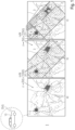
- generic representation of data partitioning using geospatial indexing,
- Fig. 2
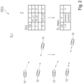
- single vehicle data aggregation,
- Fig. 3
- multi vehicle data aggregation,
- Fig. 4
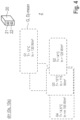
- results of dynamic spatial anonymization for one time interval, and
- Fig. 5
- results of dynamic spatial anonymization for two time intervals.
-
Fig. 1 to 5 serve for explaining an inventive method for dynamic spatial anonymization of vehicle data in a cloud environment,
the method comprising: - 0 (dynamic) collecting vehicle data D(t),
- I (dynamic) spatial partitioning (or geospatial indexing and/or splitting) the vehicle data D(t) into data subsets DZ(t), especially dynamically, associated with different geographical areas Z of various sizes and comprising a maximal amount N of records within each data subset DZ(t),
- II (dynamic) spatial aggregation of (or compiling and/or combining) the vehicle data D(t) within the data subsets DZ(t), providing two level aggregation:
- first level i aggregation of vehicle data Di(t) (within a data subset DZ(t)), coming from a single vehicle (10) (within an associated geographical area Z), to a corresponding data point Di_mean and
- second level j aggregation of data points Di_mean, coming from a group of
vehicles 10 comprising a particular number k of vehicles 10 (within an associated geographical area Z), to a spatial aggregated data set Dj_mean.
- The method may be executed by an
external device 20, such as a backend device in the cloud, in order to save computational power of the vehicle's side and to provide enhanced computational resources for providing improved vehicle services. - The present method provides variable grid sizes and handles great amounts of data in a preferable effective manner. The presented method is based on a dynamic approach that allows for both dynamic adjustment of grids and dynamic partitioning of big data loads.
- In the case of vehicle application, there are massive amounts of geo-related data, which cannot be efficiently anonymized all at the same time and/or in one execution. To overcome this challenge, the vehicle data D(t) may be splitted spatially, for example by applying geospatial indexing, as explained in the following and represented in
fig. 1 . - For spatial partitioning within the present disclosure, especially using geospatial indexing, the world and/or a geographical region (s. the first representation a in
fig.1 ) of interest may be divided into geographical areas with different resolutions. In an example, the resolution may be iterated from 0 till 15. Resolution may be represented by a number of records in a geographic area. The records are shown infig. 1 as single points. As the second and the third representations b and c infig.1 show, each area Z for each resolution gets its own unique ID (for example from 1 to 13). Thus, each data subset DZ(t) within an associated geographical area gets the same ID. - For spatial partitioning/geospatial indexing following conditions may be provided for splitting the vehicle data D(t) into subsets DZ(t):
- 1. Each data subset DZ(t) comprises a maximal amount N of records. The maximal amount N of records may be chosen based upon computational capacity constraints of the performing
device 20, such as backend device in the cloud. - 2. Each data subset DZ(t) is denoted by unique ID (s. number Z from 1 to 13 in
fig. 1 ). Each unique ID of data subsets DZ(t) corresponds to the unique ID of associated geographical areas Z. Thus, the IDs of data subsets DZ(t) are represented by the counter Z. - As
fig. 1 represents, following actions may be executed for spatial partitioning/geospatial indexing: - 1.1 For each time interval in which spatial anonymization should be performed iteratively over geo-coordinates starting from the resolution 0 (highest resolution level, the first representation a in
fig. 1 ). - 1.2 If found any geographical area Z comprising a corresponding data subset DZ(t) which has less than N records, then assign unique ID to this data subset DZ(t).
- 1.3 Identify (see
areas 4 and 5 in the second representation b infig. 1 ) geographical areas Z comprising corresponding data subsets DZ(t) which have more than N records. - 1.4 Split the geographical areas Z comprising corresponding data subsets DZ(t) which have more than N records with an incremental resolution which is now 1.
- 1.5 Repeat steps 1.2, 1.3 and 1.4 until all records are assigned to geographical areas Z comprising corresponding data subsets DZ(t) which have less than N records (the third representation c in
fig. 1 ) or until the resolution reaches maximal available value, for example 15. - Representation of data partitioning using geospatial indexing shown in
fig. 1 illustrates how the method iteratively splits the incoming vehicle data D(t). - a) Initial vehicle data D(t) collected from participating
vehicles 10. This vehicle data D(t) contains more than N records and it is computationally intensive to perform anonymization on it. - b) First step of (dynamic) spatial partitioning (geospatial indexing and/or splitting). Geographical areas Z = 1, Z = 2 and Z = 3 contain less than N records and may be used as input for an efficient execution of the anonymization. Geographical areas Z = 4 and Z = 5 contain more than N records and need to be further divided in sub-areas.
- c) Outcome of (dynamic) spatial partitioning (geospatial indexing and/or splitting). All the areas Z = 1, 2, 3, 6, 7, 8, 9, 10, 11, 12, 13 contain less than N records and may be used to perform anonymization in an efficient way providing representative results.
- This approach results in dynamic grid sizes that may span in reality from less than 0.01 km2 to 100 km2, as shown in
fig. 1 . In contrast to state of the art methods that only anonymize on fixed grid levels not leveraging the smaller grid sizes that could be possible because of high vehicle coverage in dense, urban areas. - The dynamic spatial anonymization follows preferably a two level i, j aggregation approach.
- Vehicle data aggregation may use the information advantage that is available for non-anonymized vehicle data D(t) prior to anonymization in action II.
- Vehicle data aggregation II provides a combination of multiple vehicle data D(t), that is records and/or measurements and/or pints in the view of
fig. 1 , aggregated to a lower number of values, and thus providing anonymization, - first level i aggregation within vehicle data Di(t) from every
single vehicle 10, preferably reducing the effect of sensor noise, for example removing data outliers, and/or highlighting some unusual measurement of interest. - second level j aggregation within vehicle data D(t) coming from
several vehicles 10 in the same area combined to groups G of k-members. - Thus, the amount of vehicle data D(t) to be anonymized (Dj_mean) in one execution may be considerably reduced with the help of spatial aggregation II.
- A first level i of aggregation is illustrated in
fig. 2 . - By assuming that the vehicle data D(t) from a
single vehicle 10 does not vary significantly in a certain time interval dt, and the sensor sampling frequency is higher than needed, it is possible to aggregate the vehicle data D(t) coming from asingle vehicle 10 without losing significant information. Thus, the relevant information may be reliably maintained within a corresponding data point Di_mean. - For example, by collecting temperature measurements in a certain area Z, the temperature sampling frequency on the vehicle may be 1Hz. It may be possible to aggregate together the temperature information provided from a
single vehicle 10 in the same time interval, e.g. 10 s, without losing relevant information. The temperature usually does not change significantly within in 10 s. Also, the vehicle displacement in such a time interval dt may be neglected for the specific vehicle service, but the amount of data to process by anonymization is 10 times smaller. - For example, by collecting the rain intensity measurements, it may happen that the
vehicle 10 passes under some roof, bridge or tree. In this case these unusual measurements may be considered as an outlier in the 10s time window. The vehicle data D(t) aggregation may preferably filter out the effects of such outliers. - The data aggregation may also highlight some uncommon measurement. For example by collecting the slipping coefficient of the road in a certain area, in a certain time, due to ice slabs on the street, it is possible to take into account each single ice slab on the road, even if small. Aggregated data in this case will contain the information about the "ice", even if for most of the 10 s time-interval there was no ice on the road.
- Thus, the data quality may be improved with the help of filtering and/or highlighting the vehicle data D(t).
- In general for each sensor type, signal source and/or data type, a different aggregation methodology may be applied that has proven to be valuable for the specific cases. Aggregation methodologies comprehend statistical indicators (mean, max, n-th percentile, etc...), a combination of them, or functions implemented ad hoc for the specific use-case.
- Thus, improving quality and reliability of data prior to anonymization.
- In the first step i, time series data D(t) from
single vehicles 10 will be recorded over a time interval dt, comprising positional information (spatial data P) along the trajectory of avehicle 10 together with recorded information (sensor data V) of the vehicle sensors. As illustrated infig. 2 a single vehicle trajectory over a time interval dt, for example from 1 to 10 s, is depicted using arrows, where every dot stands for a single recorded spatial data P and a corresponding sensor data V. This vehicle trajectory is then aggregated into one data point Di_mean illustrated using the cross. The vehicle data Di(t) fromvehicles 10 will be aggregated into corresponding data points Di_mean containing only an aggregate. Thus, no exact position (spatial data P) but only an aggregation of the perceived sensor data V will be maintained within the data points Di_mean. - A second level j of aggregation is illustrated in
fig. 3 . - A second level j of aggregation is thus performed within a set of
vehicles 10 in the same time interval dt and in the same geographical area Z. This second step j of aggregation allows to reach the anonymization goal, because from the aggregated data it would be extremely unlikely to go back to thesingle vehicle 10 that contributed to the aggregated data set Dj_mean. - In the second step j of the spatial anonymization following the k-anonymity methodology, multiply aggregated data points Di_mean coming from
different vehicles 10 will be arranged in groups G ofk vehicles 10, preferably using the k nearest neighbor method. Data of these groups G of k vehicles 10 (for example k=3) are then aggregated again leaving only information about the portion of the geographical area Z where the group G of vehicles were located in and aggregate values. The number of groups G may be smaller than the number ofvehicles 10 in the corresponding geographical area Z. -
Fig. 4 illustrates the result over a time interval dt from 0 to 10 s for groups G1, G2, G3, G4, ...Fig. 4 shows varying sizes and overlapping portions of the resulting spatial aggregated data sets Dj_mean. As can be seen fromfig. 4 , overlapping groups G ofvehicles 10 may be provided within an associated geographical area Z of the corresponding data subset DZ(t). This allows using data from somevehicles 10 multiple times. Thus, the value of data may be enlarged significantly. -
Fig. 5 illustrates the result over a time interval dt from 10 to 20 s, following the time interval dt offig. 4 , for groups G1, G2, G3, G4, .... Comparingfig. 4 and5 , it may be seen, that for every time interval dt new spatial bounding boxes, that is new groups G, comprisingdifferent vehicles 10 will be formed grouping the spatiallyclosest vehicles 10 together. - By following the dynamic spatial anonymization, vehicle data D(t) may be fully anonymized within flexible determined geographical areas Z following the methodology of k-anonymity and preferably the k-nearest neighbor grouping/classification.
- The dynamic feature of spatial partitioning I allows for arbitrary sizes and locations of the anonymization areas Z.
- With the help of the integrating spatial aggregation II, the data quality enhancing aggregation techniques, the reliability of the anonymized data output may be increased.
- Furthermore, the presented method, combining both techniques: spatial partitioning I and spatial aggregation II, reduces computational runtime, in particular, in case of big data loads and results in an enhanced privacy protection, even for sparsely covered areas that may now be incorporated within the dynamic grid approach.
- A computer program product comprising a program code for carrying out a method as described above provides an aspect of the invention.
- Also, a
device 20, especially backend device, provides an aspect of the invention. Thedevice 20 is only shown schematically infig. 4 and5 . Thedevice 20 comprises amemory device 21 in which program code is stored, and a computing device 22 configured to execute the program code, wherein when executing the program code, a method may be performed as described above. Thememory device 21 may further comprise a database for spatial aggregated data sets Dj_mean. The computing device 22 may be configured to provide vehicle services, comprising navigation services, map services and/or forecast services etc., to participatingvehicles 10 using the aggregated data sets Dj_mean. Furthermore, the computing device 22 may be configured to provide different vehicle services depending on service type, signal source and/or data type. - The above description of the figures describes the present invention only in the context of examples. Of course, individual features of the embodiments may be combined with each other, provided it is technically reasonable, without leaving the scope of the invention.
-
- 10
- vehicle
- 20
- device
- 21
- memory device
- 22
- computing device
- t
- time
- dt
- time interval
- D(t)
- vehicle data
- DZ(t)
- data subsets
- N
- a maximal amount of records within a data subset
- Di(t)
- vehicle data, coming from a single vehicle
- Di_mean
- data point
- G
- group of vehicles
- k
- particular number of vehicles within a group
- Dj_mean
- aggregated data set
- G1
- group
- G2
- group
- G3
- group
- G4
- group
- T
- temperature
- ln
- light intensity
- P
- spatial data
- V
- sensor data
- Z
- geographical areas
Claims (15)
- A method for dynamic spatial anonymization of vehicle data in a cloud environment, the method comprising:- collecting vehicle data (D(t)),- spatial partitioning the vehicle data (D(t)) into data subsets (DZ(t)), especially dynamically, associated with different geographical areas (Z) of various sizes and comprising a maximal amount (N) of records within each data subset (DZ(t)),- spatial aggregation of the vehicle data (D(t)) within the data subsets (DZ(t)), providing two level aggregation:- aggregation of vehicle data (Di(t)), coming from a single vehicle (10), to a corresponding data point (Di_mean) and- aggregation of data points (Di_mean), coming from a group (G) of vehicles (10) comprising a particular number (k) of vehicles (10), to a spatial aggregated data set (Dj_mean).
- The method according to claim 1,whereinthe vehicle data (D(t)) will be collected periodically with a time interval (dt),wherein especially the time interval (dt) is chosen depending on vehicle service, sensor type, signal source and/or data type,and/or whereinspatial partitioning is used for reducing the amount of records intended to be anonymized in one execution,and/or whereinthe spatial aggregation is used for anonymization of the vehicle data (D(t)), especially within a current time interval (dt), within a corresponding data subset (DZ(t)) and/or within an associated geographical area (Z).
- The method according to claim 1 or 2,whereinthe spatial aggregation is provided using the k-anonymity methodology,and/or whereina spatial aggregated data set (Dj_mean) aggregates data points (Di_mean) coming from different vehicles (10) arranged into groups (G) using the k-nearest neighbor method.
- The method according to any one of the preceding claims,whereina spatial aggregated data set (Dj_mean) multiply aggregates data points (Di_mean) coming from different vehicles (10),wherein especially some vehicles (10) will be arranged to more than one group (G).
- The method according to any one of the preceding claims,whereinthe vehicle data (D(t)) comprise sensor data (V) and spatial data (P),and/or whereinsensor data comprise environmental data, temperature values, humidity values, rain intensity, slipping coefficient, etc.whereina data point (Di_mean) coming from a single vehicle (10) comprises aggregated sensor data (V) and aggregated spatial data (P) for the single vehicle (10),and/or whereina spatial aggregated data set (Dj_mean) coming from a group of vehicles (10) comprises aggregated sensor data (V) and aggregated spatial data (P) for the group (G) of vehicles (10).
- The method according to any one of the preceding claims,whereinvehicle data (D(t)) within a data point (Di_mean) will be filtered in order to exclude unusual measurements.
- The method according to any one of the preceding claims,whereinvehicle data (D(t)) within a data point (Di_mean) will be highlighted in order to detect environmental effects, such as ice slabs on the street, in highly restricted areas within a particular geographical area (Z).
- The method according to any one of the preceding claims,whereinthe spatial aggregation is performed using different aggregation methodologies for different vehicle services, sensor types, signal sources and/or data types,and/or whereina particular aggregation methodology is chosen depending on vehicle service, sensor type, signal source and/or data type.
- The method according to any one of the preceding claims,whereinthe spatial partitioning is provided using a method of geospatial indexing.
- The method according to any one of the preceding claims,whereinthe spatial partitioning is provided using an iterative splitting of incoming sets of records into geographical areas (Z) having different resolution levels,and/or whereinthe spatial partitioning is provided until a data subset (DZ(t)) comprise an amount of records lower than the maximal amount (N) of records.
- The method according to any one of the preceding claims,whereinthe maximal amount (N) of records will be chosen according to computational capacity of a performing device.
- A computer program product comprising instructions which, when the program is executed by a computer, cause the computer to carry out a method according to any one of preceding claims.
- A device (20), especially backend device, comprising:a memory device (21) in which program code is stored, anda computing device (22) configured to execute the program code, wherein when executing the program code, a method according to any one of the preceding claims will be performed.
- The device (20) according to the preceding claim,whereinthe memory device (21) comprises a database for spatial aggregated data sets (Dj_mean).
- The device (20) according to any one of the preceding claims,whereinthe computing device (22) is configured to provide vehicle services, comprising navigation services, map services and/or forecast services etc., to participating vehicles (10) using the aggregated data sets (Dj_mean),and/or whereinthe computing device (22) is configured to provide different vehicle services depending on service type, signal source and/or data type.
Priority Applications (3)
| Application Number | Priority Date | Filing Date | Title |
|---|---|---|---|
| EP22150434.3A EP4209951B1 (en) | 2022-01-06 | 2022-01-06 | A method, a computer program product and a device for dynamic spatial anonymization of vehicle data in a cloud environment |
| US18/697,690 US20240403469A1 (en) | 2022-01-06 | 2023-01-06 | A Method, a Computer Program Product and a Device for Dynamic Spatial Anonymization of Vehicle Data in a Cloud Environment |
| PCT/EP2023/050245 WO2023131684A1 (en) | 2022-01-06 | 2023-01-06 | A method, a computer program product and a device for dynamic spatial anonymization of vehicle data in a cloud environment |
Applications Claiming Priority (1)
| Application Number | Priority Date | Filing Date | Title |
|---|---|---|---|
| EP22150434.3A EP4209951B1 (en) | 2022-01-06 | 2022-01-06 | A method, a computer program product and a device for dynamic spatial anonymization of vehicle data in a cloud environment |
Publications (2)
| Publication Number | Publication Date |
|---|---|
| EP4209951A1 true EP4209951A1 (en) | 2023-07-12 |
| EP4209951B1 EP4209951B1 (en) | 2025-06-25 |
Family
ID=80112442
Family Applications (1)
| Application Number | Title | Priority Date | Filing Date |
|---|---|---|---|
| EP22150434.3A Active EP4209951B1 (en) | 2022-01-06 | 2022-01-06 | A method, a computer program product and a device for dynamic spatial anonymization of vehicle data in a cloud environment |
Country Status (1)
| Country | Link |
|---|---|
| EP (1) | EP4209951B1 (en) |
Citations (2)
| Publication number | Priority date | Publication date | Assignee | Title |
|---|---|---|---|---|
| US9842017B1 (en) * | 2015-03-30 | 2017-12-12 | Amazon Technologies, Inc. | Collection and aggregation of device health metrics |
| GB2583363A (en) * | 2019-04-25 | 2020-10-28 | Telensa Holdings Ltd | Data anonymization |
-
2022
- 2022-01-06 EP EP22150434.3A patent/EP4209951B1/en active Active
Patent Citations (2)
| Publication number | Priority date | Publication date | Assignee | Title |
|---|---|---|---|---|
| US9842017B1 (en) * | 2015-03-30 | 2017-12-12 | Amazon Technologies, Inc. | Collection and aggregation of device health metrics |
| GB2583363A (en) * | 2019-04-25 | 2020-10-28 | Telensa Holdings Ltd | Data anonymization |
Also Published As
| Publication number | Publication date |
|---|---|
| EP4209951B1 (en) | 2025-06-25 |
Similar Documents
| Publication | Publication Date | Title |
|---|---|---|
| CN106408147B (en) | Dispatching method and system for vehicle insurance survey task | |
| Mulrooney et al. | A comparison of raster-based travel time surfaces against vector-based network calculations as applied in the study of rural food deserts | |
| US10489431B2 (en) | Digital location-based data methods and product | |
| CN112669190A (en) | Detection method and device for abnormal emission behavior of pollution source and computer equipment | |
| Jensen et al. | The INFATI data | |
| Zhai et al. | Characteristics of operating mode distributions of light duty vehicles by road type, average speed, and driver type for estimating on-road emissions: Case study of Beijing | |
| Kim et al. | Distributed computing for region‐wide line source dispersion modeling | |
| CN113593243B (en) | Method and device for predicting toll vehicle type traffic volume in toll road operation period | |
| CN112731565B (en) | Weather forecast data processing method and device based on multi-level grid map | |
| Sun et al. | Evaluation of bus accessibility based on hotspot detection and matter-element analysis | |
| Vitanova et al. | Understanding Sofia’s travel dynamics: Study of private traffic patterns and urban mobility | |
| Alpalhão et al. | Assessing the risk of traffic accidents in lisbon using a gradient boosting algorithm with a hybrid classification/regression approach | |
| Kleshko et al. | Analysis of Temporal and Geographical Data to Improve Travel Time Forecasting | |
| Cook et al. | Toward a dynamic national transportation noise map: Modeling temporal variability of traffic volume | |
| CN119723895B (en) | Traffic flow prediction method, device, equipment and medium based on space-time data | |
| EP4209951B1 (en) | A method, a computer program product and a device for dynamic spatial anonymization of vehicle data in a cloud environment | |
| EP4209952B1 (en) | A method, a computer program product and a device for dynamic spatial anonymization of vehicle data in a cloud environment | |
| US20240403469A1 (en) | A Method, a Computer Program Product and a Device for Dynamic Spatial Anonymization of Vehicle Data in a Cloud Environment | |
| CN116153088B (en) | Traffic demand prediction method and device and electronic equipment | |
| Hariani et al. | The Application Of Intelligent Transportation System (Its) In Urban Areas Based On Public Preferences | |
| Reijsbergen | Probabilistic modelling of station locations in bicycle-sharing systems | |
| Pritee et al. | Cloud based spatial visualization with statistical approach for road accidents | |
| Gorgul et al. | A visualization based analysis to assist rebalancing issues related to last mile problem for bike sharing programs in China: a big-data case study on mobike | |
| Shaw | Geographic information systems for transportation–An introduction | |
| Devipriya et al. | Estimation of Public Transport Accessibility in Rural Areas Using GIS |
Legal Events
| Date | Code | Title | Description |
|---|---|---|---|
| PUAI | Public reference made under article 153(3) epc to a published international application that has entered the european phase |
Free format text: ORIGINAL CODE: 0009012 |
|
| STAA | Information on the status of an ep patent application or granted ep patent |
Free format text: STATUS: THE APPLICATION HAS BEEN PUBLISHED |
|
| AK | Designated contracting states |
Kind code of ref document: A1 Designated state(s): AL AT BE BG CH CY CZ DE DK EE ES FI FR GB GR HR HU IE IS IT LI LT LU LV MC MK MT NL NO PL PT RO RS SE SI SK SM TR |
|
| STAA | Information on the status of an ep patent application or granted ep patent |
Free format text: STATUS: REQUEST FOR EXAMINATION WAS MADE |
|
| 17P | Request for examination filed |
Effective date: 20240112 |
|
| RBV | Designated contracting states (corrected) |
Designated state(s): AL AT BE BG CH CY CZ DE DK EE ES FI FR GB GR HR HU IE IS IT LI LT LU LV MC MK MT NL NO PL PT RO RS SE SI SK SM TR |
|
| STAA | Information on the status of an ep patent application or granted ep patent |
Free format text: STATUS: EXAMINATION IS IN PROGRESS |
|
| 17Q | First examination report despatched |
Effective date: 20240603 |
|
| GRAP | Despatch of communication of intention to grant a patent |
Free format text: ORIGINAL CODE: EPIDOSNIGR1 |
|
| STAA | Information on the status of an ep patent application or granted ep patent |
Free format text: STATUS: GRANT OF PATENT IS INTENDED |
|
| INTG | Intention to grant announced |
Effective date: 20241111 |
|
| GRAJ | Information related to disapproval of communication of intention to grant by the applicant or resumption of examination proceedings by the epo deleted |
Free format text: ORIGINAL CODE: EPIDOSDIGR1 |
|
| STAA | Information on the status of an ep patent application or granted ep patent |
Free format text: STATUS: EXAMINATION IS IN PROGRESS |
|
| GRAP | Despatch of communication of intention to grant a patent |
Free format text: ORIGINAL CODE: EPIDOSNIGR1 |
|
| STAA | Information on the status of an ep patent application or granted ep patent |
Free format text: STATUS: GRANT OF PATENT IS INTENDED |
|
| INTC | Intention to grant announced (deleted) | ||
| INTG | Intention to grant announced |
Effective date: 20250401 |
|
| GRAS | Grant fee paid |
Free format text: ORIGINAL CODE: EPIDOSNIGR3 |
|
| GRAA | (expected) grant |
Free format text: ORIGINAL CODE: 0009210 |
|
| STAA | Information on the status of an ep patent application or granted ep patent |
Free format text: STATUS: THE PATENT HAS BEEN GRANTED |
|
| AK | Designated contracting states |
Kind code of ref document: B1 Designated state(s): AL AT BE BG CH CY CZ DE DK EE ES FI FR GB GR HR HU IE IS IT LI LT LU LV MC MK MT NL NO PL PT RO RS SE SI SK SM TR |
|
| REG | Reference to a national code |
Ref country code: GB Ref legal event code: FG4D |
|
| REG | Reference to a national code |
Ref country code: CH Ref legal event code: EP |
|
| REG | Reference to a national code |
Ref country code: CH Ref legal event code: EP |
|
| REG | Reference to a national code |
Ref country code: IE Ref legal event code: FG4D |
|
| REG | Reference to a national code |
Ref country code: DE Ref legal event code: R096 Ref document number: 602022016259 Country of ref document: DE |
|
| P01 | Opt-out of the competence of the unified patent court (upc) registered |
Free format text: CASE NUMBER: UPC_APP_0860_4209951/2025 Effective date: 20250723 |
|
| PG25 | Lapsed in a contracting state [announced via postgrant information from national office to epo] |
Ref country code: FI Free format text: LAPSE BECAUSE OF FAILURE TO SUBMIT A TRANSLATION OF THE DESCRIPTION OR TO PAY THE FEE WITHIN THE PRESCRIBED TIME-LIMIT Effective date: 20250625 |
|
| REG | Reference to a national code |
Ref country code: LT Ref legal event code: MG9D |
|
| PG25 | Lapsed in a contracting state [announced via postgrant information from national office to epo] |
Ref country code: NO Free format text: LAPSE BECAUSE OF FAILURE TO SUBMIT A TRANSLATION OF THE DESCRIPTION OR TO PAY THE FEE WITHIN THE PRESCRIBED TIME-LIMIT Effective date: 20250925 Ref country code: GR Free format text: LAPSE BECAUSE OF FAILURE TO SUBMIT A TRANSLATION OF THE DESCRIPTION OR TO PAY THE FEE WITHIN THE PRESCRIBED TIME-LIMIT Effective date: 20250926 |
|
| PG25 | Lapsed in a contracting state [announced via postgrant information from national office to epo] |
Ref country code: BG Free format text: LAPSE BECAUSE OF FAILURE TO SUBMIT A TRANSLATION OF THE DESCRIPTION OR TO PAY THE FEE WITHIN THE PRESCRIBED TIME-LIMIT Effective date: 20250625 |
|
| PG25 | Lapsed in a contracting state [announced via postgrant information from national office to epo] |
Ref country code: HR Free format text: LAPSE BECAUSE OF FAILURE TO SUBMIT A TRANSLATION OF THE DESCRIPTION OR TO PAY THE FEE WITHIN THE PRESCRIBED TIME-LIMIT Effective date: 20250625 |
|
| PG25 | Lapsed in a contracting state [announced via postgrant information from national office to epo] |
Ref country code: RS Free format text: LAPSE BECAUSE OF FAILURE TO SUBMIT A TRANSLATION OF THE DESCRIPTION OR TO PAY THE FEE WITHIN THE PRESCRIBED TIME-LIMIT Effective date: 20250925 |
|
| PG25 | Lapsed in a contracting state [announced via postgrant information from national office to epo] |
Ref country code: LV Free format text: LAPSE BECAUSE OF FAILURE TO SUBMIT A TRANSLATION OF THE DESCRIPTION OR TO PAY THE FEE WITHIN THE PRESCRIBED TIME-LIMIT Effective date: 20250625 |
|
| REG | Reference to a national code |
Ref country code: NL Ref legal event code: MP Effective date: 20250625 |
|
| PG25 | Lapsed in a contracting state [announced via postgrant information from national office to epo] |
Ref country code: NL Free format text: LAPSE BECAUSE OF FAILURE TO SUBMIT A TRANSLATION OF THE DESCRIPTION OR TO PAY THE FEE WITHIN THE PRESCRIBED TIME-LIMIT Effective date: 20250625 |
|
| PG25 | Lapsed in a contracting state [announced via postgrant information from national office to epo] |
Ref country code: PT Free format text: LAPSE BECAUSE OF FAILURE TO SUBMIT A TRANSLATION OF THE DESCRIPTION OR TO PAY THE FEE WITHIN THE PRESCRIBED TIME-LIMIT Effective date: 20251027 |
|
| REG | Reference to a national code |
Ref country code: AT Ref legal event code: MK05 Ref document number: 1807235 Country of ref document: AT Kind code of ref document: T Effective date: 20250625 |
|
| PG25 | Lapsed in a contracting state [announced via postgrant information from national office to epo] |
Ref country code: IS Free format text: LAPSE BECAUSE OF FAILURE TO SUBMIT A TRANSLATION OF THE DESCRIPTION OR TO PAY THE FEE WITHIN THE PRESCRIBED TIME-LIMIT Effective date: 20251025 |
|
| PG25 | Lapsed in a contracting state [announced via postgrant information from national office to epo] |
Ref country code: AT Free format text: LAPSE BECAUSE OF FAILURE TO SUBMIT A TRANSLATION OF THE DESCRIPTION OR TO PAY THE FEE WITHIN THE PRESCRIBED TIME-LIMIT Effective date: 20250625 Ref country code: SM Free format text: LAPSE BECAUSE OF FAILURE TO SUBMIT A TRANSLATION OF THE DESCRIPTION OR TO PAY THE FEE WITHIN THE PRESCRIBED TIME-LIMIT Effective date: 20250625 |
|
| PG25 | Lapsed in a contracting state [announced via postgrant information from national office to epo] |
Ref country code: CZ Free format text: LAPSE BECAUSE OF FAILURE TO SUBMIT A TRANSLATION OF THE DESCRIPTION OR TO PAY THE FEE WITHIN THE PRESCRIBED TIME-LIMIT Effective date: 20250625 |
|
| PG25 | Lapsed in a contracting state [announced via postgrant information from national office to epo] |
Ref country code: PL Free format text: LAPSE BECAUSE OF FAILURE TO SUBMIT A TRANSLATION OF THE DESCRIPTION OR TO PAY THE FEE WITHIN THE PRESCRIBED TIME-LIMIT Effective date: 20250625 |
|
| PG25 | Lapsed in a contracting state [announced via postgrant information from national office to epo] |
Ref country code: EE Free format text: LAPSE BECAUSE OF FAILURE TO SUBMIT A TRANSLATION OF THE DESCRIPTION OR TO PAY THE FEE WITHIN THE PRESCRIBED TIME-LIMIT Effective date: 20250625 |
|
| PG25 | Lapsed in a contracting state [announced via postgrant information from national office to epo] |
Ref country code: SK Free format text: LAPSE BECAUSE OF FAILURE TO SUBMIT A TRANSLATION OF THE DESCRIPTION OR TO PAY THE FEE WITHIN THE PRESCRIBED TIME-LIMIT Effective date: 20250625 |
|
| PG25 | Lapsed in a contracting state [announced via postgrant information from national office to epo] |
Ref country code: ES Free format text: LAPSE BECAUSE OF FAILURE TO SUBMIT A TRANSLATION OF THE DESCRIPTION OR TO PAY THE FEE WITHIN THE PRESCRIBED TIME-LIMIT Effective date: 20250625 |
|
| PGFP | Annual fee paid to national office [announced via postgrant information from national office to epo] |
Ref country code: GB Payment date: 20260126 Year of fee payment: 5 |
|
| PG25 | Lapsed in a contracting state [announced via postgrant information from national office to epo] |
Ref country code: DK Free format text: LAPSE BECAUSE OF FAILURE TO SUBMIT A TRANSLATION OF THE DESCRIPTION OR TO PAY THE FEE WITHIN THE PRESCRIBED TIME-LIMIT Effective date: 20250625 |
|
| PGFP | Annual fee paid to national office [announced via postgrant information from national office to epo] |
Ref country code: DE Payment date: 20260131 Year of fee payment: 5 |
|
| PG25 | Lapsed in a contracting state [announced via postgrant information from national office to epo] |
Ref country code: IT Free format text: LAPSE BECAUSE OF FAILURE TO SUBMIT A TRANSLATION OF THE DESCRIPTION OR TO PAY THE FEE WITHIN THE PRESCRIBED TIME-LIMIT Effective date: 20250625 |
|
| PGFP | Annual fee paid to national office [announced via postgrant information from national office to epo] |
Ref country code: FR Payment date: 20260126 Year of fee payment: 5 |
|
| PLBE | No opposition filed within time limit |
Free format text: ORIGINAL CODE: 0009261 |
|
| STAA | Information on the status of an ep patent application or granted ep patent |
Free format text: STATUS: NO OPPOSITION FILED WITHIN TIME LIMIT |
|
| REG | Reference to a national code |
Ref country code: CH Ref legal event code: L10 Free format text: ST27 STATUS EVENT CODE: U-0-0-L10-L00 (AS PROVIDED BY THE NATIONAL OFFICE) Effective date: 20260507 |