EP4206743A1 - Method for vehicle positioning, related apparatus, device, and storage medium - Google Patents
Method for vehicle positioning, related apparatus, device, and storage medium Download PDFInfo
- Publication number
- EP4206743A1 EP4206743A1 EP22755529.9A EP22755529A EP4206743A1 EP 4206743 A1 EP4206743 A1 EP 4206743A1 EP 22755529 A EP22755529 A EP 22755529A EP 4206743 A1 EP4206743 A1 EP 4206743A1
- Authority
- EP
- European Patent Office
- Prior art keywords
- moment
- target vehicle
- satellite
- vehicle
- obtaining
- Prior art date
- Legal status (The legal status is an assumption and is not a legal conclusion. Google has not performed a legal analysis and makes no representation as to the accuracy of the status listed.)
- Pending
Links
Images






Classifications
-
- G—PHYSICS
- G01—MEASURING; TESTING
- G01S—RADIO DIRECTION-FINDING; RADIO NAVIGATION; DETERMINING DISTANCE OR VELOCITY BY USE OF RADIO WAVES; LOCATING OR PRESENCE-DETECTING BY USE OF THE REFLECTION OR RERADIATION OF RADIO WAVES; ANALOGOUS ARRANGEMENTS USING OTHER WAVES
- G01S5/00—Position-fixing by co-ordinating two or more direction or position line determinations; Position-fixing by co-ordinating two or more distance determinations
- G01S5/01—Determining conditions which influence positioning, e.g. radio environment, state of motion or energy consumption
- G01S5/017—Detecting state or type of motion
-
- G—PHYSICS
- G01—MEASURING; TESTING
- G01S—RADIO DIRECTION-FINDING; RADIO NAVIGATION; DETERMINING DISTANCE OR VELOCITY BY USE OF RADIO WAVES; LOCATING OR PRESENCE-DETECTING BY USE OF THE REFLECTION OR RERADIATION OF RADIO WAVES; ANALOGOUS ARRANGEMENTS USING OTHER WAVES
- G01S19/00—Satellite radio beacon positioning systems; Determining position, velocity or attitude using signals transmitted by such systems
- G01S19/38—Determining a navigation solution using signals transmitted by a satellite radio beacon positioning system
- G01S19/39—Determining a navigation solution using signals transmitted by a satellite radio beacon positioning system the satellite radio beacon positioning system transmitting time-stamped messages, e.g. GPS [Global Positioning System], GLONASS [Global Orbiting Navigation Satellite System] or GALILEO
- G01S19/396—Determining accuracy or reliability of position or pseudorange measurements
-
- G—PHYSICS
- G01—MEASURING; TESTING
- G01S—RADIO DIRECTION-FINDING; RADIO NAVIGATION; DETERMINING DISTANCE OR VELOCITY BY USE OF RADIO WAVES; LOCATING OR PRESENCE-DETECTING BY USE OF THE REFLECTION OR RERADIATION OF RADIO WAVES; ANALOGOUS ARRANGEMENTS USING OTHER WAVES
- G01S19/00—Satellite radio beacon positioning systems; Determining position, velocity or attitude using signals transmitted by such systems
- G01S19/01—Satellite radio beacon positioning systems transmitting time-stamped messages, e.g. GPS [Global Positioning System], GLONASS [Global Orbiting Navigation Satellite System] or GALILEO
- G01S19/03—Cooperating elements; Interaction or communication between different cooperating elements or between cooperating elements and receivers
- G01S19/05—Cooperating elements; Interaction or communication between different cooperating elements or between cooperating elements and receivers providing aiding data
-
- G—PHYSICS
- G01—MEASURING; TESTING
- G01S—RADIO DIRECTION-FINDING; RADIO NAVIGATION; DETERMINING DISTANCE OR VELOCITY BY USE OF RADIO WAVES; LOCATING OR PRESENCE-DETECTING BY USE OF THE REFLECTION OR RERADIATION OF RADIO WAVES; ANALOGOUS ARRANGEMENTS USING OTHER WAVES
- G01S19/00—Satellite radio beacon positioning systems; Determining position, velocity or attitude using signals transmitted by such systems
- G01S19/01—Satellite radio beacon positioning systems transmitting time-stamped messages, e.g. GPS [Global Positioning System], GLONASS [Global Orbiting Navigation Satellite System] or GALILEO
- G01S19/13—Receivers
- G01S19/24—Acquisition or tracking or demodulation of signals transmitted by the system
- G01S19/25—Acquisition or tracking or demodulation of signals transmitted by the system involving aiding data received from a cooperating element, e.g. assisted GPS
- G01S19/254—Acquisition or tracking or demodulation of signals transmitted by the system involving aiding data received from a cooperating element, e.g. assisted GPS relating to Doppler shift of satellite signals
-
- G—PHYSICS
- G01—MEASURING; TESTING
- G01S—RADIO DIRECTION-FINDING; RADIO NAVIGATION; DETERMINING DISTANCE OR VELOCITY BY USE OF RADIO WAVES; LOCATING OR PRESENCE-DETECTING BY USE OF THE REFLECTION OR RERADIATION OF RADIO WAVES; ANALOGOUS ARRANGEMENTS USING OTHER WAVES
- G01S19/00—Satellite radio beacon positioning systems; Determining position, velocity or attitude using signals transmitted by such systems
- G01S19/01—Satellite radio beacon positioning systems transmitting time-stamped messages, e.g. GPS [Global Positioning System], GLONASS [Global Orbiting Navigation Satellite System] or GALILEO
- G01S19/13—Receivers
- G01S19/24—Acquisition or tracking or demodulation of signals transmitted by the system
- G01S19/25—Acquisition or tracking or demodulation of signals transmitted by the system involving aiding data received from a cooperating element, e.g. assisted GPS
- G01S19/258—Acquisition or tracking or demodulation of signals transmitted by the system involving aiding data received from a cooperating element, e.g. assisted GPS relating to the satellite constellation, e.g. almanac, ephemeris data, lists of satellites in view
-
- G—PHYSICS
- G01—MEASURING; TESTING
- G01S—RADIO DIRECTION-FINDING; RADIO NAVIGATION; DETERMINING DISTANCE OR VELOCITY BY USE OF RADIO WAVES; LOCATING OR PRESENCE-DETECTING BY USE OF THE REFLECTION OR RERADIATION OF RADIO WAVES; ANALOGOUS ARRANGEMENTS USING OTHER WAVES
- G01S19/00—Satellite radio beacon positioning systems; Determining position, velocity or attitude using signals transmitted by such systems
- G01S19/38—Determining a navigation solution using signals transmitted by a satellite radio beacon positioning system
- G01S19/39—Determining a navigation solution using signals transmitted by a satellite radio beacon positioning system the satellite radio beacon positioning system transmitting time-stamped messages, e.g. GPS [Global Positioning System], GLONASS [Global Orbiting Navigation Satellite System] or GALILEO
- G01S19/393—Trajectory determination or predictive tracking, e.g. Kalman filtering
-
- G—PHYSICS
- G01—MEASURING; TESTING
- G01S—RADIO DIRECTION-FINDING; RADIO NAVIGATION; DETERMINING DISTANCE OR VELOCITY BY USE OF RADIO WAVES; LOCATING OR PRESENCE-DETECTING BY USE OF THE REFLECTION OR RERADIATION OF RADIO WAVES; ANALOGOUS ARRANGEMENTS USING OTHER WAVES
- G01S19/00—Satellite radio beacon positioning systems; Determining position, velocity or attitude using signals transmitted by such systems
- G01S19/38—Determining a navigation solution using signals transmitted by a satellite radio beacon positioning system
- G01S19/39—Determining a navigation solution using signals transmitted by a satellite radio beacon positioning system the satellite radio beacon positioning system transmitting time-stamped messages, e.g. GPS [Global Positioning System], GLONASS [Global Orbiting Navigation Satellite System] or GALILEO
- G01S19/40—Correcting position, velocity or attitude
-
- G—PHYSICS
- G01—MEASURING; TESTING
- G01S—RADIO DIRECTION-FINDING; RADIO NAVIGATION; DETERMINING DISTANCE OR VELOCITY BY USE OF RADIO WAVES; LOCATING OR PRESENCE-DETECTING BY USE OF THE REFLECTION OR RERADIATION OF RADIO WAVES; ANALOGOUS ARRANGEMENTS USING OTHER WAVES
- G01S19/00—Satellite radio beacon positioning systems; Determining position, velocity or attitude using signals transmitted by such systems
- G01S19/38—Determining a navigation solution using signals transmitted by a satellite radio beacon positioning system
- G01S19/39—Determining a navigation solution using signals transmitted by a satellite radio beacon positioning system the satellite radio beacon positioning system transmitting time-stamped messages, e.g. GPS [Global Positioning System], GLONASS [Global Orbiting Navigation Satellite System] or GALILEO
- G01S19/40—Correcting position, velocity or attitude
- G01S19/41—Differential correction, e.g. DGPS [differential GPS]
-
- G—PHYSICS
- G01—MEASURING; TESTING
- G01S—RADIO DIRECTION-FINDING; RADIO NAVIGATION; DETERMINING DISTANCE OR VELOCITY BY USE OF RADIO WAVES; LOCATING OR PRESENCE-DETECTING BY USE OF THE REFLECTION OR RERADIATION OF RADIO WAVES; ANALOGOUS ARRANGEMENTS USING OTHER WAVES
- G01S19/00—Satellite radio beacon positioning systems; Determining position, velocity or attitude using signals transmitted by such systems
- G01S19/38—Determining a navigation solution using signals transmitted by a satellite radio beacon positioning system
- G01S19/39—Determining a navigation solution using signals transmitted by a satellite radio beacon positioning system the satellite radio beacon positioning system transmitting time-stamped messages, e.g. GPS [Global Positioning System], GLONASS [Global Orbiting Navigation Satellite System] or GALILEO
- G01S19/42—Determining position
-
- G—PHYSICS
- G01—MEASURING; TESTING
- G01S—RADIO DIRECTION-FINDING; RADIO NAVIGATION; DETERMINING DISTANCE OR VELOCITY BY USE OF RADIO WAVES; LOCATING OR PRESENCE-DETECTING BY USE OF THE REFLECTION OR RERADIATION OF RADIO WAVES; ANALOGOUS ARRANGEMENTS USING OTHER WAVES
- G01S19/00—Satellite radio beacon positioning systems; Determining position, velocity or attitude using signals transmitted by such systems
- G01S19/38—Determining a navigation solution using signals transmitted by a satellite radio beacon positioning system
- G01S19/39—Determining a navigation solution using signals transmitted by a satellite radio beacon positioning system the satellite radio beacon positioning system transmitting time-stamped messages, e.g. GPS [Global Positioning System], GLONASS [Global Orbiting Navigation Satellite System] or GALILEO
- G01S19/42—Determining position
- G01S19/45—Determining position by combining measurements of signals from the satellite radio beacon positioning system with a supplementary measurement
Definitions
- the present disclosure relates to the technical field of positioning and navigation, and in particular, to vehicle positioning.
- positioning is particularly important as a technology for self-vehicle pose assessment.
- high-precision positioning determines the location of the vehicle's geographic information, which is a key part of ensuring the safety of advanced driver assistance and even autonomous driving.
- the related art provides a method for suppressing data drift of an in-vehicle positioning apparatus, which determines whether to discard positioning data obtained by the in-vehicle positioning apparatus according to whether the in-vehicle positioning apparatus is turned on or the cold start time reaches a set value, and in a case that the vehicle is driving, whether to discard the positioning data obtained by the in-vehicle positioning apparatus is determined according to the speed of the vehicle.
- the method above utilizes global positioning system (GPS) positioning to determine a stationary or motion state of the vehicle.
- GPS global positioning system
- state constraint is carried out according to historical positioning data, otherwise the normal positioning process is carried out.
- Embodiments of the present disclosure provide a vehicle positioning method, a related apparatus, a device, and a storage medium.
- Pseudo range observation values and Doppler observation values determined based on satellite ephemeris have higher reliability. Therefore, using the pseudo range observation values and the Doppler observation values to assist in satellite positioning may enhance the accuracy of satellite positioning in weak satellite signal scenarios, thereby improving the accuracy of vehicle positioning information.
- an aspect of the present disclosure provides a vehicle positioning method, including:
- a vehicle positioning apparatus including:
- a terminal device including: a memory, a processor, and a bus system,
- Another aspect of the present disclosure provides a computer-readable storage medium, storing instructions, the instructions, when running on a computer, causing the computer to perform the method according to the foregoing aspects.
- Another aspect of the present disclosure provides a computer program product or a computer program, including computer instructions, and the computer instructions being stored in a computer-readable storage medium.
- a processor of a computer device reads the computer instructions from the computer-readable storage medium, and executes the computer instructions, causing the computer device to perform the method according to the foregoing aspects.
- a vehicle positioning method First, a satellite filtering parameter and to-be-processed data are obtained, the satellite filtering parameter include a clock skew and a clock skew change rate, and at least one of location information and speed information of a target vehicle at a first moment, and the to-be-processed data includes at least one of a pseudo range observation value and a Doppler observation value corresponding to the target vehicle at the first moment; and then a first parameter correction amount corresponding to the target vehicle at the first moment is determined by using the satellite filtering parameter and the to-be-processed data.
- the satellite filtering parameter may be updated by using the first parameter correction amount, to obtain positioning information of the target vehicle at the first moment.
- a motion state of the target vehicle at a second moment is obtained, where the second moment is a moment after the first moment. If the motion state of the target vehicle at the second moment satisfies a positioning correction condition, a constraint matrix corresponding to the motion state is obtained, then a second parameter correction amount corresponding to the target vehicle at the second moment is determined by using the constraint matrix corresponding to the motion state, and finally, the positioning information at the first moment is updated by using the second parameter correction amount, to obtain positioning information of the target vehicle at the second moment.
- the positioning information of the vehicle may be corrected by using at least one of the pseudo range observation value and the Doppler observation value.
- the pseudo range observation value and the Doppler observation value determined based on satellite ephemeris have higher reliability. Therefore, using the pseudo range observation value and the Doppler observation value to assist in satellite positioning may enhance the reliability of satellite positioning in weak satellite signal scenarios, thereby improving the accuracy of vehicle positioning information. Furthermore, constraints are then constructed based on the vehicle motion state, which may better improve the positioning accuracy.
- the embodiments of the present disclosure provide a vehicle positioning method, a related apparatus, a device, and a storage medium, where pseudo range observation values and Doppler observation values determined based on satellite ephemeris and having higher reliability are used to assist in satellite positioning, so as to enhance the accuracy of satellite positioning in weak satellite signal scenarios, thereby improving the accuracy of vehicle positioning information.
- a process, method, system, product, or device that includes a list of steps or units is not necessarily limited to those steps or units that are clearly listed, but may include other steps or units not expressly listed or inherent to such a process, method, system, product, or device.
- positioning technology achieves a qualitative leap in technical means, positioning accuracy, usability and other aspects, and has gradually penetrated into all aspects of social life from the fields of navigation, aerospace, aviation, surveying and mapping, military and natural disaster prevention, and has become an indispensable and important application in people's daily life, such as personnel search, location search, traffic management, vehicle navigation and route planning, among which the Global Navigation Satellite System (GNSS) plays an important role in the above scenarios.
- GNSS Global Navigation Satellite System
- the positioning coordinates of the terminal device are prone to change, sometimes to large changes, and may even include errors. This phenomenon is the so-called "positioning drift". In places with dense tall buildings or bad weather conditions, signal errors and positioning drift may occur due to multiple reflections, which limits the promotion and use of positioning applications.
- the vehicle positioning system includes a Continuously Operating Reference Stations (CORS) server, a service server and a terminal device, where a client deployed on the terminal device.
- CORS Continuously Operating Reference Stations
- the service server may be a navigation service server
- the client may be a navigation application.
- the service server involved in the present disclosure may be an independent physical server, or may be a server cluster or a distributed system formed by multiple physical servers, or may be a cloud server that provides basic cloud computing services such as a cloud service, a cloud database, cloud computing, a cloud function, cloud storage, a network service, cloud communication, a middleware service, a domain name service, a security service, a content delivery network (CDN), big data, and an AI platform.
- the terminal device may be an in-vehicle terminal, a smartphone, a tablet computer, a notebook computer, a palmtop computer, a personal computer, a smart TV, a smartwatch and the like, but is not limited thereto.
- the terminal device and the server may be directly or indirectly connected in a wired or wireless communication manner. This is not limited in the present disclosure.
- the number of servers and terminal devices is also not limited.
- the CORS server includes four parts, including a reference station part, a data center part, a data communication part and a user application part.
- the parts form a private network that is distributed throughout the city.
- the reference station part includes evenly distributed base stations within a control area.
- the base station includes a GNSS, a computer, a meteorological device, a communication device, a power device, and an observation site, etc., and has the ability to continuously track and record satellite signals for a long time.
- the reference station is a data source of the CORS, and has main functions including the acquisition, tracking, recording and transmission of satellite signals, and device integrity monitoring, etc.
- the GNSS is a space-based radio navigation and positioning system that provides users with all-weather three-dimensional coordinates, speed and time information at any place on the Earth's surface or in the near-Earth space.
- the data center part includes a computer, a network and a software system.
- the data center part includes a system control center and a user data center.
- the system control center is a nerve center of the CORS, which continuously performs overall modeling and calculation in an area according to real-time observation data acquired by each base station 24 hours a day, and provides code phase and carrier phase difference correction information in an international common format to users who need measurement and navigation through the existing data communication network and wireless data broadcasting network, so as to calculate the precise point position of a moving station in real time.
- the user data center provides a downlink of a CORS service, and transmits a data result of the control center to the user.
- the data communication part includes a public or private communication network, including a data transmission hardware device and software control modules.
- the main function of the data communication part is to transmit the GNSS observation data of the base station to the system control center, and to transmit system differential information to the user, etc.
- the user application part includes a receiver, a demodulator of wireless communication and a related device.
- the main function of the user application part is to perform different precision positioning according to user needs.
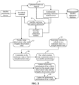
- FIG. 2 is a schematic interaction flowchart of a vehicle positioning method according to an embodiment of the present disclosure. As shown in the FIG.2 , the method includes the following steps S1 to S8.
- step S1 an in-vehicle terminal transmits an ephemeris delivery request to a CORS server.
- step S2 the CORS server transmits broadcast ephemeris information to the in-vehicle terminal, where the in-vehicle terminal receives a satellite real-time navigation ephemeris broadcast by the CORS base station server.
- step S3 the in-vehicle terminal obtains a pseudo range observation value and a Doppler observation value through a satellite positioning device.
- step S4 the in-vehicle terminal updates positioning information of a vehicle by using at least one of the pseudo range observation value and the Doppler observation value, the positioning information including a location and a speed of the vehicle.
- step S5 the in-vehicle terminal determines whether the vehicle is in a stationary state or a straight driving state based on steering wheel information, odometer information, camera information, or road network matching information of the vehicle.
- step S6 in a case that the vehicle is in the stationary or straight driving state, the in-vehicle terminal constructs vehicle motion state constraints.
- step S7 the in-vehicle terminal assists in satellite positioning by using the vehicle motion state constraints.
- step S8 the in-vehicle terminal updates the positioning information of the vehicle.
- the vehicle positioning method of the present disclosure may implement autonomous driving or auxiliary driving in combination with autonomous driving technology.
- the autonomous driving technology usually includes high-precision maps, environment perception, behavior decision-making, path planning, motion control, and other technologies.
- the autonomous driving technology has a wide range of application prospects.
- the autonomous driving technology is a branch of an artificial intelligence (Al) technology.
- AI is a theory, method, technology, and application system that use a digital computer or a machine controlled by the digital computer to simulate, extend, and expand human intelligence, perceive an environment, obtain knowledge, and use knowledge to obtain an optimal result.
- Al is a comprehensive technology of computer science. Al attempts to understand the essence of intelligence and produce a new kind of intelligent machine that can react in a similar way to human intelligence. AI is to study the design principles and implementation methods of various intelligent machines, so that the machines have the functions of perception, reasoning and decision-making.
- Basic Al technologies generally include technologies such as a sensor, a dedicated AI chip, cloud computing, distributed storage, a big data processing technology, an operating/interaction system, and electromechanical integration.
- AI software technologies mainly include several major directions such as a computer vision (CV) technology, a speech processing technology, a natural language processing technology, and ML/DL.
- a vehicle positioning method according to an embodiment of the present disclosure includes the following steps 101 to 107.
- a terminal device obtains a satellite filtering parameter and to-be-processed data, the satellite filtering parameter including a clock skew and a clock skew change rate, and at least one of location information and speed information of a target vehicle at a first moment, and the to-be-processed data including at least one of a pseudo range observation value and a Doppler observation value corresponding to the target vehicle at the first moment.
- the terminal device obtains the satellite filtering parameter at the first moment, the satellite filtering parameter including the clock skew and the clock skew change rate corresponding to the first moment, and may further include at least one of the location information and speed information of the target vehicle at the first moment.
- the first moment is a current moment
- the target vehicle is a to-be-positioned vehicle.
- the clock skew represents a difference between the time indicated by a clock under a certain time system and the standard time of the system, e.g., a difference between a GPS receiver's clock reading and the GPS standard time at a moment.
- the clock skew change rate represents a change in the clock skew, for example, of the satellite positioning device.
- the terminal device obtains to-be-processed data at the first moment, and the to-be-processed data includes at least one of a pseudo range observation value and a Doppler observation value corresponding to the target vehicle at the first moment.
- the pseudo range observation value represents a difference between a local receiving moment of a signal and a characterization time value carried by the signal.
- the Doppler observation value represents an average speed in an interval between two adjacent observation moment.
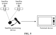
- FIG. 5 is a schematic architectural diagram of an in-vehicle positioning system according to an embodiment of the present disclosure.
- the in-vehicle positioning system includes a satellite system, connecting lines, a satellite positioning device and a terminal device.
- the satellite system includes but is not limited to four major satellite navigation systems, namely, U.S.'s GPS, China's BeiDou Navigation Satellite System (BDS), Russia's GLONASS and Europe's GALILEO.
- Satellite navigation systems have been widely used in aviation, navigation, communications, personnel tracking, consumer entertainment, surveying and mapping, timing, vehicle monitoring and management, and automobile navigation and information services, and the general development trend is to provide high-precision services for real-time applications.
- the satellite positioning device used in the present disclosure may be a consumer-grade satellite positioning device, and the consumer-grade satellite positioning device is configured to provide to-be-processed data for a terminal device.
- the terminal device may be an in-vehicle terminal or a computer.
- the connecting line may be a Universal Serial Bus (USB) or a High Definition Multimedia Interface (HDMI) connecting line, and the connecting line is mainly configured to connect the satellite positioning device and the terminal device.
- USB Universal Serial Bus
- HDMI High Definition Multimedia Interface
- the terminal device involved in the present disclosure may be an in-vehicle terminal, a smart phone, or other types of computers, which are not limited here.
- the terminal device determines a first parameter correction amount corresponding to the target vehicle at the first moment by using the satellite filtering parameter and the to-be-processed data.
- the terminal device calculates the first parameter correction amount corresponding to the target vehicle at the first moment by using the satellite filtering parameter corresponding to the first moment and the to-be-processed data.
- the terminal device updates the satellite filtering parameter by using the first parameter correction amount, to obtain positioning information of the target vehicle at the first moment.
- the terminal device updates the satellite filtering parameter by using the first parameter correction amount, that is, the terminal device may obtain positioning information of the target vehicle at the first moment by adding the first parameter correction amount to the satellite filtering parameter.
- the positioning information includes updated location information.
- the satellite filtering parameter includes the speed information
- the positioning information includes updated speed information.
- the satellite filtering parameter include the speed information and the location information
- the positioning information includes updated speed information and updated location information.
- the terminal device obtains a motion state of the target vehicle at a second moment, the second moment being after the first moment.
- the terminal device may further update the positioning information of the target vehicle based on the motion state of the target vehicle, where the positioning information includes the location information and the speed information.
- the terminal device obtains a constraint matrix corresponding to the motion state in a case that the motion state of the target vehicle at the second moment satisfies a positioning correction condition, the constraint matrix representing a positioning information variation satisfied in the motion state.
- the terminal device needs to determine whether the motion state of the target vehicle at the second moment satisfies the positioning correction condition. If the motion state of the target vehicle at the second moment satisfies the positioning correction condition, the terminal device obtains the constraint matrix corresponding to the motion state. If the motion state of the target vehicle at the second moment does not satisfy the positioning correction condition, the positioning information at the first moment may be determined as the positioning information at the second moment, or the positioning information at the second moment may be calculated based on the Doppler observation value and the pseudo range observation value at the second moment.
- a constraint matrix in a stationary state is constructed in a case that the target vehicle is in a stationary state
- a constraint matrix in a straight driving state is constructed in a case that the target vehicle is in the straight driving state.
- the terminal device determines a second parameter correction amount corresponding to the target vehicle at the second moment by using the constraint matrix corresponding to the motion state.
- the terminal device calculates the second parameter correction amount based on the constraint matrix in the stationary state, or calculates the second parameter correction amount based on the constraint matrix in the straight driving state.
- the terminal device updates the positioning information at the first moment by using the second parameter correction amount, to obtain positioning information of the target vehicle at the second moment.
- the terminal device updates the positioning information at the first moment by using the second parameter correction amount, to obtain positioning information of the target vehicle at the second moment.
- FIG. 4 is a schematic flowchart of a vehicle positioning method according to an embodiment of the present disclosure. As shown in FIG. 4 , the vehicle positioning method includes the following steps 201 to 207.
- the terminal device e.g., the in-vehicle terminal
- the terminal device sets a satellite filtering parameter and initializes the satellite filtering parameter.
- step 202 the terminal device (e.g., the in-vehicle terminal) determines whether to-be-processed data outputted by a satellite positioning device is received. In a case that the to-be-processed data outputted by the satellite positioning device is received, step 204 is executed, otherwise, in a case that the to-be-processed data outputted by the satellite positioning device is not received, step 203 is executed.
- the terminal device e.g., the in-vehicle terminal
- the terminal device e.g., the in-vehicle terminal
- advances and updates filter time For example, the terminal device advances a moment t to a moment t+1.
- step 204 in a case that the terminal device (e.g., the in-vehicle terminal) receives the to-be-processed data outputted by the satellite positioning device, the terminal device updates the positioning information of the target vehicle based on the pseudo range observation value and the Doppler observation value, the positioning information including at least one of the location information and the speed information.
- the terminal device e.g., the in-vehicle terminal
- the terminal device updates the positioning information of the target vehicle based on the pseudo range observation value and the Doppler observation value, the positioning information including at least one of the location information and the speed information.
- the terminal device determines the motion state of the target vehicle based on a steering wheel, an odometer, a camera, or road network matching result of the target vehicle.
- step 206 in a case that the target vehicle is in the stationary state, the terminal device (e.g., the in-vehicle terminal) constructs a constraint matrix in the stationary state, and updates the location information and the speed information of the vehicle based on the constraint matrix in the stationary state.
- the terminal device e.g., the in-vehicle terminal
- step 207 in a case that the target vehicle is in the straight driving state, the terminal device (e.g., the in-vehicle terminal) constructs a constraint matrix in the straight driving state, and updates the location information and the speed information of the vehicle based on the constraint matrix in the straight driving state.
- the terminal device e.g., the in-vehicle terminal
- a vehicle positioning method is provided.
- the positioning information of the vehicle may be corrected by using at least one of the pseudo range observation value and the Doppler observation value.
- the pseudo range observation value and the Doppler observation value determined based on satellite ephemeris have higher reliability. Therefore, using the pseudo range observation value and the Doppler observation value to assist in satellite positioning may enhance the reliability of satellite positioning in weak satellite signal scenarios, thereby improving the accuracy of vehicle positioning information.
- constraints are then constructed based on the vehicle motion state, which may better improve the positioning accuracy.
- the terminal device obtains the satellite filtering parameter and the to-be-processed data, which may include the following steps:
- the terminal device may obtain satellite location and a satellite filtering parameter before updating the vehicle positioning information by using the pseudo range observation value and the Doppler observation value.
- the terminal device transmits an ephemeris delivery request to a CORS server, and receives broadcast ephemeris information transmitted by the CORS server.
- the broadcast ephemeris information refers to the broadcast ephemeris information corresponding to the first moment.
- the broadcast ephemeris information includes a header file and satellite related parameters.
- the header file includes basic information of the file, such as ionospheric parameters, data type, a time increment caused by jump seconds, and almanac parameters used for calculating the Universal Time Coordinated (UTC) time.
- the satellite related parameters include a pseudo random noise code (PRN), clock time, a satellite clock error, orbit eccentricity, ephemeris reference time and so on.
- PRN pseudo random noise code
- the terminal device may further calculate the satellite location of each satellite at the first moment by using the broadcast ephemeris information corresponding to the first moment.
- FIG. 6 is a schematic diagram of obtaining a satellite filtering parameter according to an embodiment of the present disclosure. As shown in FIG. 6 , the obtaining a satellite filtering parameter includes following steps A1 to A3.
- step A1 the terminal device transmits the ephemeris delivery request to the CORS server through the 4 th generation mobile communication technology (4G) network or WIFI network, the ephemeris delivery request carrying a time identity corresponding to the first moment.
- 4G 4 th generation mobile communication technology
- WIFI WIFI
- the CORS server may transmit real-time broadcast ephemeris information to the terminal device through the 4G network or the WIFI network in response to the ephemeris delivery request.
- the approach of transmitting the broadcast ephemeris information includes but not limited to sending in the form of a binary stream, or sending in the form of a data packet.
- the broadcast ephemeris information includes ephemeris parameter tables of different satellites, and each ephemeris parameter table may be represented as a set of ephemeris parameters for calculating satellite locations, that is, the broadcast ephemeris information includes ephemeris parameters corresponding to N satellites.
- the terminal device calculates N satellite locations and the satellite filtering parameter at the first moment (i.e., a current moment) through a satellite information processing unit by using the broadcast ephemeris information, the first moment being obtained from the system time of the terminal device (e.g., the in-vehicle terminal) or a pseudo range observation value time scale.
- the satellite information processing unit may be built in the terminal device, or may be externally placed in the terminal device, which is not limited here.
- the terminal device Before updating the vehicle positioning information by using the pseudo range observation value and the Doppler observation value, the terminal device may obtain the to-be-processed data, that is, obtain at least one of the pseudo range observation value and the Doppler observation value.
- FIG. 7 is a schematic diagram of obtaining to-be-processed data according to an embodiment of the present disclosure.
- the terminal device e.g., the in-vehicle terminal
- receives, through a connecting line for example, a USB or HDMI connecting line
- the pseudo range observation value and the Doppler observation value obtained by the satellite positioning device are connected to the satellite positioning device.
- the satellite positioning device is configured to track and process a satellite signal and measure a geometrical distance between the terminal device and the satellite (i.e., the pseudo range observation value) and the Doppler effect of the satellite signal (i.e., the Doppler observation value), which is a change in a frequency of the satellite signal when the satellite positioning device moves relative to the satellite.
- the satellite positioning device includes modules such as an antenna, a satellite signal tracking loop, and a baseband signal processing module.
- the terminal device integrated with the satellite positioning device calculates current location coordinates of the terminal device based on the pseudo range observation value and the Doppler observation value.
- the satellite positioning device is widely used in map navigation, surveying and mapping, aerospace, location services and other fields, such as smart phone map navigation, high-precision geodetic surveying, and civil aviation.
- the in-vehicle terminal includes an in-vehicle GPS and/or BeiDou monitoring terminal, a communication network and a dispatch monitoring center.
- the in-vehicle GPS and/or BeiDou monitoring terminal is also known as a car machine, a GPS and/or BeiDou terminal or a GPS and/or BeiDou monitoring terminal, and is responsible for calculating the positioning coordinates based on the received GPS and/or BeiDou satellite signal, and transmits positioning information, state information, and transmitting and receiving control information through a communication network.
- the communication network is a carrier that realizes information exchange between the vehicle and the dispatch monitoring center, generally referring to a Global System for Mobile Communications (GSM), a General Packet Radio Service (GPRS), a Code Division Multiple Access (CDMA) base station and Internet.
- the dispatch monitoring center is a communication core of the entire information system, and is responsible for information exchange with the in-vehicle GPS monitoring terminal, classification, recording and forwarding of various content and control information.
- the CORS server may deliver real-time broadcast ephemeris information to the terminal device, so that the terminal device may determine the location of each satellite at a current moment by using the broadcast ephemeris information. Since the broadcast ephemeris information has higher real-time performance, the calculated satellite locations are more accurate. Accurate pseudo range observation value and Doppler observation value may be captured by using the satellite positioning device, thereby improving the feasibility and operability of the solution.
- the satellite filtering parameter includes the location information of the target vehicle at the first moment
- the to-be-processed data includes the pseudo range observation value corresponding to the target vehicle at the first moment
- the terminal device determines a first parameter correction amount corresponding to the target vehicle at the first moment by using the satellite filtering parameter and the to-be-processed data, which may include the following steps:
- an approach of determining the first parameter correction amount based on the pseudo range observation value is introduced.
- the satellite filtering parameter is initialized.
- the initial location information may be obtained from a network positioning result or an output result of the satellite positioning device, and the initial speed information may be obtained from a speed outputted by the satellite positioning device or set to zero.
- the clock skew dt GPS , the clock skew dt GLO , the clock skew dt GAL and the clock skew dt BDS of the satellite positioning device are set to 0, and the clock skew change rate dtr of the satellite positioning device is set to zero.
- a satellite filtering parameter at a moment t k is X ( t k )
- a satellite filtering parameter at the next moment that is, the current moment or the first moment
- t k +1 is:
- X t k + 1 F ⁇ X t k ;
- X( t k +1 ) represents a satellite filtering parameter corresponding to the first moment
- X ( t k ) represents a satellite filtering parameter corresponding to a moment before the first moment
- F represents a state transition matrix of the system.
- a covariance matrix for the satellite filtering parameter at the moment t k is P( t k )
- P( t k +1 ) represents a covariance matrix corresponding to the first moment
- P( t k ) represents a covariance matrix corresponding to the previous moment
- F represents the state transition matrix of the system
- Q ( t k +1 ) represents a system noise matrix corresponding to the first moment.
- the pseudo range observation value is to be obtained.
- the terminal device receives the pseudo range observation values of N satellite signals fed back by the satellite positioning device, including m BeiDou satellites, n GPS satellites, p GLONASS satellites and q GALILEO satellites
- the pseudo range observation values are: ⁇ BDS , 1 ⁇ ⁇ BDS , m ⁇ GPS , 1 ⁇ ⁇ GPS , n ⁇ GLO , 1 ⁇ ⁇ GLO , p ⁇ GAL , 1 ⁇ ⁇ GAL , q ;
- the terminal device determines the first parameter correction amount corresponding to the target vehicle at the first moment by using to the covariance matrix, the first Jacobian matrix, the pseudo range measurement error matrix, the first gain matrix and the first prediction residual vector corresponding to the first moment.
- ⁇ X ( t k +1 ) represents a first parameter correction amount corresponding to the target vehicle at the first moment
- P( t k +1 ) represents a covariance matrix corresponding to the first moment
- H represents a first Jacobian matrix
- R ⁇ ( t k +1 ) represents a pseudo range measurement error matrix corresponding to the first moment (directly obtained by the satellite positioning device)
- ⁇ z represents a first prediction residual vector
- K ( t k +1 ) represents a first gain matrix corresponding to the first moment.
- the first Jacobian matrix is determined based on the N unit observation vectors, each unit observation vector represents a direction vector of a connecting line between the satellite and the target vehicle.
- the speed information in the satellite filtering parameter is set to 0.
- the parameter correction amount (e.g., the first parameter correction amount) is used for correcting the location information and the speed information of the target vehicle, and the covariance matrix represents the accuracy of the location information and the speed information of the target vehicle.
- a method for determining a first parameter correction amount based on a pseudo range observation value is provided.
- the satellite filtering parameter is corrected by using the pseudo range observation value that is determined based on the satellite ephemeris and having higher reliability. Therefore, satellite positioning assistance may enhance the accuracy of satellite positioning in weak satellite signal scenarios, thereby improving the accuracy of vehicle positioning information.
- the satellite filtering parameter includes the speed information of the target vehicle at the first moment
- the to-be-processed data includes the Doppler observation value corresponding to the target vehicle at the first moment.
- the terminal device determines a first parameter correction amount corresponding to the target vehicle at the first moment by using the satellite filtering parameter and the to-be-processed data, which may include the following steps:
- an approach of determining the first parameter correction amount based on the Doppler observation value is introduced. Similar to the foregoing embodiment, in response to constructing a location and speed filter of the terminal device (e.g., the in-vehicle terminal), the location information, the speed information, the clock skew and the clock skew change rate are set as the satellite filtering parameter, and the satellite filtering parameter is initialized.
- the initial location information may be obtained from a network positioning result or an output result of the satellite positioning device, and the initial speed information may be obtained from a speed outputted by the satellite positioning device or set to zero.
- a satellite filtering parameter at a moment t k is X ( t k )
- a satellite filtering parameter at the next moment that is, the current moment or the first moment
- t k +1 is:
- X t k + 1 F ⁇ X t k ;
- X( t k +1 ) represents a satellite filtering parameter corresponding to the first moment
- X ( t k ) represents a satellite filtering parameter corresponding to a moment before the first moment
- F represents a state transition matrix of the system.
- a covariance matrix for the satellite filtering parameter at the moment t k is P( t k )
- P( t k +1 ) represents a covariance matrix corresponding to the first moment
- P( t k ) represents a covariance matrix corresponding to the previous moment
- F represents the state transition matrix of the system
- Q ( t k +1 ) represents a system noise matrix corresponding to the first moment.
- the terminal device in response to calculating the first parameter correction amount of the target vehicle at the first moment, it is necessary to obtain the Doppler observation value.
- ⁇ represents the second prediction residual vector
- t k +1 represents the first moment
- ⁇ i ,i 1,2,3, ......
- N represents the pseudo range observation value
- the terminal device determines the first parameter correction amount corresponding to the target vehicle at the first moment by using the covariance matrix corresponding to the first moment, the second Jacobian matrix, the Doppler measurement error matrix, the second gain matrix and the second prediction residual vector.
- ⁇ X ⁇ t k + 1 represents a first parameter correction amount corresponding to the target vehicle at the first moment
- P( t k +1 ) represents a covariance matrix corresponding to the first moment
- M represents a second Jacobian matrix
- R ⁇ (t 4 ) represents a Doppler measurement error matrix corresponding to the first moment (directly obtained by the satellite positioning device)
- ⁇ represents a second prediction residual vector
- ⁇ (t 4 ) represents a second gain matrix corresponding to the first moment.
- the second Jacobian matrix is determined by using the N unit observation vectors, each unit observation vector represents a direction vector of a connecting line between the satellite and the target vehicle.
- the location information in the satellite filtering parameter is set to 0. It is to be understood that m, n, p, and q may be integers greater than or equal to 0, and the sum of m+n+p+q is equal to N, N being an integer greater than or equal to 1.
- the covariance matrix for the satellite filtering parameter may also be updated by: where P (t k+1 ) represents an updated covariance matrix at the first moment, I 11 ⁇ 11 represents a matrix of 11 ⁇ 11, M represents a second Jacobian matrix, P( t k +1 ) represents the covariance matrix at the first moment, and ⁇ (t 4 ) represents the second gain matrix corresponding to the first moment.
- the parameter correction amount (e.g., the first parameter correction amount) is used for correcting the location information and the speed information of the target vehicle, and the covariance matrix represents the accuracy of the location information and the speed information of the target vehicle.
- a method for determining a first parameter correction amount based on a Doppler observation value is provided.
- the satellite filtering parameter is corrected by using the Doppler observation value that is determined based on the satellite ephemeris and has higher reliability. Therefore, satellite positioning assistance may enhance the accuracy of satellite positioning in weak satellite signal scenarios, thereby improving the accuracy of vehicle positioning information.
- the satellite filtering parameter includes the speed information and the location information of the target vehicle at the first moment
- the to-be-processed data includes the pseudo range observation value and the Doppler observation value corresponding to the target vehicle at the first moment.
- the terminal device determines a first parameter correction amount corresponding to the target vehicle at the first moment by using the satellite filtering parameter and the to-be-processed data, which may include the following steps:
- an approach of determining the first parameter correction amount based on the pseudo range observation value and the Doppler observation value is introduced.
- the location information, the speed information, the clock skew and the clock skew change rate are set as the satellite filtering parameter, and the satellite filtering parameter is initialized.
- the initial location information may be obtained from a network positioning result or an output result of the satellite positioning device, and the initial speed information may be obtained from a speed outputted by the satellite positioning device or set to zero.
- a satellite filtering parameter at a moment t k is X ( t k )
- a satellite filtering parameter at the next moment that is, the current moment or the first moment
- t k +1 is:
- X t k + 1 F ⁇ X t k ;
- X( t k +1 ) represents a satellite filtering parameter corresponding to the first moment
- X ( t k ) represents a satellite filtering parameter corresponding to a moment before the first moment
- F represents a state transition matrix of the system.
- a covariance matrix for the satellite filtering parameter at the moment t k is P( t k )
- P( t k +1 ) represents a covariance matrix corresponding to the first moment
- P( t k ) represents a covariance matrix corresponding to the previous moment
- F represents the state transition matrix of the system
- Q ( t k +1 ) represents a system noise matrix corresponding to the first moment.
- the terminal device receives the pseudo range observation values of N satellite signals fed back by the satellite positioning device, including m BeiDou satellites, n GPS satellites, p GLONASS satellites and q GALILEO satellites
- the pseudo range observation values are: ⁇ BDS , 1 ⁇ ⁇ BDS , m ⁇ GPS , 1 ⁇ ⁇ GPS , n ⁇ GLO , 1 ⁇ ⁇ GLO , p ⁇ GAL , 1 ⁇ ⁇ GAL , q ;
- the first Jacobian matrix is determined by using the N unit observation vectors, each unit observation vector represents a direction vector of a connecting line between the satellite and the target vehicle.
- the terminal device determines the updated satellite filtering parameter by using the target parameter correction amount and the satellite filtering parameter, and then determines the first parameter correction amount corresponding to the target vehicle at the first moment by using the target covariance matrix, the second Jacobian matrix, the Doppler measurement error matrix, the second gain matrix and the second prediction residual vector. Finally, the updated satellite filtering parameter is updated by using the first parameter correction amount, to obtain positioning information of the target vehicle at the first moment.
- the satellite filtering parameter is corrected by using the pseudo range observation value and the Doppler observation value.
- the pseudo range observation value and the Doppler observation value determined based on satellite ephemeris have higher reliability. Therefore, satellite positioning assistance may enhance the accuracy of satellite positioning in weak satellite signal scenarios, thereby improving the accuracy of vehicle positioning information.
- the terminal device determines a first parameter correction amount corresponding to the target vehicle at the first moment by using the target covariance matrix, which may include the following steps:
- an approach of determining the first parameter correction amount based on the pseudo range observation value and the Doppler observation value is introduced.
- the terminal device determines the first parameter correction amount corresponding to the target vehicle at the first moment by using the covariance matrix corresponding to the first moment, the second Jacobian matrix, the Doppler measurement error matrix, the second gain matrix and the second prediction residual vector.
- the first parameter correction amount is calculated by: where ⁇ X ⁇ t k + 1 represents a first parameter correction amount corresponding to the target vehicle at the first moment, P (t k+1 ) represents a covariance matrix corresponding to the first moment, M represents a second Jacobian matrix, R ⁇ (t 4 ) represents a Doppler measurement error matrix corresponding to the first moment (directly obtained by the satellite positioning device), ⁇ represents a second prediction residual vector, and ⁇ (t 4 ) represents a second gain matrix corresponding to the first moment.
- the second Jacobian matrix is determined based on the N unit observation vectors, each unit observation vector represents a direction vector of a connecting line between the satellite and the target vehicle.
- the location information in the satellite filtering parameter is set to 0. It is to be understood that m, n, p, and q may be integers greater than or equal to 0, and the sum of m+n+p+q is equal to N, N being an integer greater than or equal to 1.
- the covariance matrix for the satellite filtering parameter may also be updated by: where P (t k+1 ) represents an updated covariance matrix at the first moment, I 11 ⁇ 11 represents a matrix of 11 ⁇ 11, M represents a second Jacobian matrix, P (t k+1 ) represents the covariance matrix corresponding to the first moment, and ⁇ (t 4 ) represents the second gain matrix corresponding to the first moment.
- the parameter correction amount (e.g., the first parameter correction amount) is used for correcting the location information and the speed information of the target vehicle, and the covariance matrix represents the accuracy of the location information and the speed information of the target vehicle.
- the satellite filtering parameter is corrected by using the pseudo range observation value and the Doppler observation value.
- the pseudo range observation value and the Doppler observation value determined based on satellite ephemeris have higher reliability. Therefore, satellite positioning assistance may enhance the accuracy of satellite positioning in weak satellite signal scenarios, thereby improving the accuracy of vehicle positioning information.
- the terminal device updates the positioning information at the first moment by using the second parameter correction amount, to obtain positioning information of the target vehicle at the second moment, which may include the following steps:
- the terminal device may update the positioning information at the first moment by using the second parameter correction amount, for example, the second parameter correction amount and the positioning information at the first moment are added, to obtain to-be-processed positioning information of the target vehicle at the second moment.
- the terminal device may further calculate the positioning information at the first moment by using the first weight value. Assuming that the first weight value is 0.1, the positioning information at the first moment (including the speed information and the location information) is multiplied by the first weight value, to obtain the corresponding first positioning information. Similarly, the terminal device may also calculate the to-be-processed positioning information at the second moment by using the second weight value. Assuming that the second weight value is 0.9, the to-be-processed positioning information at the second moment (including the speed information and the location information) is multiplied by the second weight value, to obtain the corresponding second positioning information. The first positioning information and the second positioning information are added, to obtain the positioning information of the target vehicle at the second moment.
- the first weight value and the second weight value may be adjusted according to the actual situations, which is only an illustration here, and may not be construed as a limitation of the present disclosure.
- an approach of updating the positioning information is provided.
- the positioning information calculated based on the Doppler observation value and the pseudo range observation value and the positioning information calculated based on the constraint matrix are assigned corresponding weight values according to a certain proportion, so as to adjust the confidence of the positioning information, thereby improving the reliability of the solution.
- the satellite filtering parameter includes the location information and the speed information of the target vehicle at the first moment.
- the method may further include the following steps:
- the terminal device may obtain the location information and speed information of the target vehicle at a certain moment, and further obtain the location confidence factor of the location information and the speed confidence factor of the speed information. In addition, the terminal device may detect the number of visible satellites.
- the location confidence factor and the speed confidence factor may be determined according to the scenarios. Assuming that the value range of the location confidence factor and the speed confidence factor is 0 to 1. The larger the value is, the higher the confidence is.
- the location confidence factor and the speed confidence factor are related to the scenario where the target vehicle is located. For example, in lane-level navigation, the location confidence factor and the speed confidence factor are both 0.3, and in map navigation, the location confidence factor and the speed confidence factor are both 0.5. It is to be understood that the above scenario is only an illustration. In practical applications, the location confidence factor and the speed confidence factor may also be flexibly defined based on other scenarios.
- the vehicle constraint is satisfied. Conversely, in a case that the location confidence factor is smaller than the first threshold, or the speed confidence factor is smallerthan the second threshold, or the number of visible satellites is smaller than the third threshold, the vehicle constraint is not satisfied.
- the first threshold may be set to 0.5
- the second threshold may be set to 0.6
- the third threshold may be set to 6.
- the first threshold, the second threshold and the third threshold may be flexibly set according to the actual situations. It is only an illustration and may not be construed as a limitation to the present disclosure.
- an approach of determining whether to execute the positioning constraints based on the location confidence factor, the speed confidence factor and the number of visible satellites is provided.
- the above approach provides certain restrictions for the positioning constraints.
- the accuracy of the positioning constraints may be improved, and on the other hand, in the case where the vehicle constraint is not satisfied, subsequent calculations are not required, thereby saving computing resources.
- the terminal device obtains a motion state of the target vehicle at the second moment, which may include the following steps:
- an approach of determining a vehicle driving state based on an in-vehicle image is introduced.
- the terminal device captures continuous in-vehicle images through the image acquisition apparatus, then performs feature point matching on two adjacent in-vehicle image frames in the in-vehicle images, and determines whether the vehicle is stationary or in a straight driving state according to the change of the location coordinates of the matched image feature points in the image coordinate system.
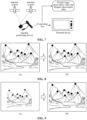
- FIG. 8 is a schematic diagram of determining a vehicle motion state based on an in-vehicle image according to an embodiment of the present disclosure.
- a first in-vehicle image has eight feature points.
- a second in-vehicle image has eight feature points.
- the eight feature points in the first in-vehicle image and the eight feature points in the second in-vehicle image are not offset, or the offset is less than a preset value (for example, 10 pixels), the target vehicle is considered to be in a stationary state.
- the situation as shown in FIG. 8 may be understood as that the target vehicle is in a stationary state.
- FIG. 9 is another schematic diagram of determining a vehicle motion state based on an in-vehicle image according to an embodiment of the present disclosure.
- a first in-vehicle image has eight feature points.
- a second in-vehicle image has eight feature points.
- the eight feature points in the first in-vehicle image and the eight feature points in the second in-vehicle image are offset, and an offset direction is convergence or divergence, the target vehicle is considered to be in a straight driving state.
- the situation as shown in FIG. 9 may be understood as that the target vehicle is in a straight driving state.
- an approach of determining the vehicle driving state based on the in-vehicle image is provided.
- the current driving state of the target vehicle may be determined, which is convenient for subsequent processing, thereby improving the feasibility and operability of the solution.
- the terminal device obtains a motion state of the target vehicle at the second moment, which may include the following steps:
- FIG. 11 is another schematic diagram of determining a vehicle motion state based on steering wheel position information according to an embodiment of the present disclosure.
- the steering wheel position information is 0 degree.
- the steering wheel position information is -5 degrees.
- the target vehicle is in a non-stationary state and is also in a non-straight driving state.
- Road network matching may be understood as map matching.
- a driving trajectory of the target vehicle is obtained, and then the location of the target vehicle is determined based on Location Based Services (LBS), and then the road network matching result is obtained by matching according to the map data.
- LBS Location Based Services
- the LBS is a location-related service provided by wireless operators for users. Based on the LBS, various types of positioning technologies are used for obtaining the current location of the positioning device, and information resources and basic services are provided to the positioning device through the mobile Internet.
- the LBS service integrates various information technologies such as mobile communication, Internet, spatial positioning, location information and big data, and performs data update and interaction by using a mobile Internet service platform, so that the users may obtain corresponding services through spatial positioning.
- an approach of determining the vehicle driving state based on the steering wheel position information and the road network matching result is provided.
- the current driving state of the target vehicle may be determined, which is convenient for subsequent processing, thereby improving the feasibility and operability of the solution.
- the method may also include the following step: The terminal device determines that the motion state of the target vehicle at the second moment satisfies the positioning correction condition in a case that the motion state of the target vehicle at the second moment is a stationary state.
- the terminal device obtains a constraint matrix corresponding to the motion state, which may include the following step:
- an approach of constructing a vehicle stationary state constraint to assist in satellite positioning is introduced. Assuming that the current moment is the second moment, the second moment is expressed as t p+1 , and the moment before the second moment is t p . In a case that the target vehicle is in a stationary state within a time interval between a moment t p and a moment t p+1 , the positioning information X(t p+1 ) at the first moment corresponding to the second moment and the covariance matrix P(t p+1 ) corresponding to the second moment may be obtained at this time.
- ⁇ X 0 (t p+1 ) represents a second parameter correction amount corresponding to the target vehicle at the second moment
- P(t p+1 ) represents a covariance matrix corresponding to the second moment
- V represents a constraint matrix corresponding to the stationary state
- R 0 (t p+i ) represents a first measurement error variance matrix corresponding to the second moment
- K 0 (t p+1 ) represents a third gain matrix corresponding to the second moment
- ⁇ z 0 represents a speed matrix corresponding to the second moment.
- ⁇ z 0 represents a speed matrix corresponding to the second moment
- v x (t p+1 ) represents speed information of the target vehicle at the second moment in the x-axis direction
- v y (t p+1 ) represents speed information of the target vehicle at the second moment in the y-axis direction
- v z (t p+1 ) represents speed information of the target vehicle at the second moment in the z-axis direction.
- V 0 0 0 1 0 0 0 0 0 0 0 0 0 0 0 1 0 0 0 0 0 0 0 0 0 0 0 0 1 0 0 0 0 0 0 0 0 0 0 0 0 1 0 0 0 0 0 0 0 0 0 ; where V represents the constraint matrix corresponding to the stationary state.
- constructing a vehicle stationary state constraint may improve the positioning accuracy in a case that the vehicle is stationary.
- the method may also include the following step: The terminal device determines that the motion state of the target vehicle at the second moment satisfies the positioning correction condition in a case that the motion state of the target vehicle at the second moment is a straight driving state.
- the terminal device obtains a constraint matrix corresponding to the motion state, which may include the following step:
- ⁇ t p represents the motion direction of the target vehicle at the moment t p
- ⁇ represents the longitude of the terminal device
- ⁇ represents the latitude of the terminal device.
- v t p + 1 v x t p + 1 v y t p + 1 v z t p + 1 ;
- v(t p+1 ) represents a speed of the target vehicle at the moment (t p+1 ) (i.e., the second moment)
- v x (t p+1 ) represents speed information of the target vehicle at the moment (t p+1 ) (i.e., the second moment) in the x-axis direction
- v y (t p+1 ) represents speed information of the target vehicle at the moment (t p+1 ) (i.e., the second moment) in the y-axis direction
- v z (t p+1 ) represents speed information of the target vehicle at the moment (t p+1 ) (i.e., the second moment) in the z-axis direction.
- ⁇ z L tan ⁇ t p + 1 ⁇ tan ⁇ t p ;
- the terminal device updates the positioning information at the first moment by using the second parameter correction amount, to obtain positioning information of the target vehicle at the second moment. That is, the positioning information of the target vehicle at the second moment is calculated by: where X ⁇ (t p+1 ) represents the positioning information of the target vehicle at the second moment, X(t p+1 ) represents the positioning information of the target vehicle at the first moment, and ⁇ X L (t p+1 ) represents the second parameter correction amount.
- the covariance matrix for the satellite filtering parameter may also be updated by: where P ⁇ (t p+1 ) represents an updated covariance matrix at the second moment, I 11 ⁇ 11 represents a matrix of 11 ⁇ 11, G represents the constraint matrix corresponding to the straight driving state, P(t p+1 ) represents the covariance matrix corresponding to the second moment, and K L (t p+1 ) represents the fourth gain matrix corresponding to the second moment.
- the embodiments of the present disclosure provided is an approach of constructing a vehicle straight driving state constraint to assist in satellite positioning.
- constructing a reasonable constraint may improve the positioning accuracy in the case of the vehicle straight motion.
- FIG. 12 is a schematic diagram of an embodiment of a vehicle positioning apparatus according to an embodiment of the present disclosure.
- the vehicle positioning apparatus 30 includes:
- the satellite filtering parameter includes the location information of the target vehicle at the first moment
- the to-be-processed data includes the pseudo range observation value corresponding to the target vehicle at the first moment
- the determining module 302 is configured to: obtain a covariance matrix corresponding to the first moment;
- the satellite filtering parameter includes the speed information of the target vehicle at the first moment
- the to-be-processed data includes the Doppler observation value corresponding to the target vehicle at the first moment.
- the determining module 302 is configured to: obtain a covariance matrix corresponding to the first moment;
- the satellite filtering parameter includes the speed information and the location information of the target vehicle at the first moment
- the to-be-processed data includes the pseudo range observation value and the Doppler observation value corresponding to the target vehicle at the first moment.
- the determining module 302 is configured to: obtain a covariance matrix corresponding to the first moment;
- the updating the satellite filtering parameter by using the first parameter correction amount, to obtain positioning information of the target vehicle at the first moment includes:
- the satellite filtering parameter includes the location information and the speed information of the target vehicle at the first moment.
- the obtaining module 301 is further configured to obtain a location confidence factor and a speed confidence factor corresponding to the satellite filtering parameter before the obtaining of a motion state of the target vehicle at a second moment, the location confidence factor representing location accuracy of the target vehicle, and the speed confidence factor representing speed accuracy of the target vehicle.
- the obtaining module 301 is further configured to obtain a number of visible satellites.
- the determining module 302 is further configured to determine to execute the step of obtaining a motion state of the target vehicle at a second moment in a case that the location confidence factor, the speed confidence factor and the number of visible satellites satisfy a vehicle constraint.
- the determining module 302 is further configured to determine that the motion state of the target vehicle at the second moment satisfies the positioning correction condition in a case that the motion state of the target vehicle at the second moment is a stationary state during the obtaining module 301 obtains the motion state of the target vehicle at a second moment.
- the obtaining module 301 is configured to construct a constraint matrix corresponding to the stationary state.
- the determining module 302 is configured to: obtain a covariance matrix corresponding to the second moment;
- the determining module 302 is further configured to determine that the motion state of the target vehicle at the second moment satisfies the positioning correction condition in a case that the motion state of the target vehicle at the second moment is a straight driving state during the obtaining module 301 obtains the motion state of the target vehicle at a second moment.
- the obtaining module 301 is configured to construct a constraint matrix corresponding to the straight driving state.
- the determining module 302 is configured to: obtain a covariance matrix corresponding to the second moment;
- FIG. 13 is a block diagram of a part of a structure of an in-vehicle terminal related to a terminal device according to an embodiment of the present disclosure.
- the in-vehicle terminal includes: components such as a radio frequency (RF) circuit 410, a memory 420, an input unit 430, a display unit 440, a sensor 450, an audio circuit 460, a wireless fidelity (WiFi) module 370, a processor 480, and a power supply 490.
- RF radio frequency
- the RF circuit 410 may be configured to receive and send a signal in an information receiving and sending process or a call process, and in particular, after downlink information of a base station is received, send the downlink information to the processor 480 for processing. In addition, the RF circuit sends uplink data to the base station.
- the RF circuit 410 includes, but is not limited to, an antenna, at least one amplifier, a transceiver, a coupler, a low noise amplifier (LNA), and a duplexer.
- the RF circuit 410 may also communicate with a network and another device by wireless communication.
- the wireless communication may use any communication standard or protocol, including but not limited to GSM, GPRS, CDMA, wideband code division multiple access (WCDMA), long term evolution (LTE), email, short messaging service (SMS), and the like.
- the memory 420 may be configured to store a software program and module.
- the processor 480 runs the software program and module stored in the memory 420, to implement various functional applications and data processing of the in-vehicle terminal.
- the memory 420 may mainly include a program storage area and a data storage area.
- the program storage area may store an operating system, an application program required by at least one function (such as a sound playback function and an image display function), and the like.
- the data storage area may store data (for example, audio data and a phone book) created according to use of the in-vehicle terminal.
- the memory 420 may include a high-speed random access memory, and may further include a nonvolatile memory, such as at least one magnetic disk storage device, a flash memory, or another volatile solid-state storage device.
- the input unit 430 may be configured to receive input digit or character information, and generate key signal input related to the user setting and function control of the in-vehicle terminal.
- the input unit 430 may include a touch panel 431 and another input device 432.
- the touch panel 431 which may also be referred to as a touch screen, may collect a touch operation of a user on or near the touch panel (such as an operation of a user on or near the touch panel 431 by using any suitable object or accessory such as a finger or a stylus), and drive a corresponding connection apparatus according to a preset program.
- the display unit 440 may be configured to display information input by the user or information provided for the user, and various menus of the in-vehicle terminal.
- the display unit 440 may include a display panel 441.
- the in-vehicle terminal may further include at least one sensor 450, such as an optical sensor, a motion sensor, and other sensors.
- the optical sensor may include an ambient light sensor and a proximity sensor.
- the audio circuit 460, a loudspeaker 461, and a microphone 462 may provide audio interfaces between the user and the in-vehicle terminal.
- WiFi is a short-range wireless transmission technology.
- the in-vehicle terminal may help users send and receive an email, browse a webpage, and access streaming media through the WiFi module 370, which provides users with access to the wireless broadband Internet.
- the processor 480 is a control center of the in-vehicle terminal, uses various interfaces and lines to connect various parts of the entire in-vehicle terminal, and executes various functions of the in-vehicle terminal and processes data by running or executing software programs and/or modules stored in the memory 420 and invoking data stored in the memory 420.
- Steps performed by the terminal device in the foregoing embodiments may be based on the structure of the terminal device shown in FIG. 13 .
- An embodiment of the present disclosure further provides a computer-readable storage medium, storing computer instructions, the computer instructions, when running on a computer, causing the computer to perform the methods according to the foregoing embodiments.
- An embodiment of the present disclosure further provides a computer program product including instructions, the instructions, when running on a computer, causing the computer to perform the methods according to the foregoing embodiments.
- the disclosed system, apparatus, and method may be implemented in other manners.
- the apparatus embodiments described above are merely exemplary.
- the division of the units is merely the division of logic functions, and may use other division manners during actual implementation.
- multiple units or components may be combined, or may be integrated into another system, or some features may be omitted or not performed.
- the displayed or discussed mutual couplings or direct couplings or communication connections may be implemented through some interfaces.
- the indirect couplings or communication connections between the apparatuses or units may be implemented in electrical, mechanical or other forms.
- the units described as separate components may or may not be physically separate, and components displayed as units may or may not be physical units, may be located in one position, or may be distributed on multiple network units. Some of or all of the units may be selected according to actual needs to achieve the objectives of the solutions of the embodiments of the present disclosure.
- functional units in the embodiments of the present disclosure may be integrated into one processing unit, or each of the units may be physically separated, or two or more units may be integrated into one unit.
- the integrated unit may be implemented in the form of hardware, or may be implemented in the form of a software function unit.
- the integrated unit When the integrated unit is implemented in the form of a software functional unit and sold or used as an independent product, the integrated unit may be stored in a computer-readable storage medium.
- the computer software product is stored in a storage medium and includes several instructions for instructing a computer device (which may be a personal computer, a server, a network device, or the like) to perform all or some of the steps of the methods described in the embodiments of the present disclosure.
- the foregoing storage medium includes: any medium that can store program code, such as a USB flash drive, a removable hard disk, a read-only memory (ROM), a random access memory (RAM), a magnetic disk, or an optical disc.
Landscapes
- Engineering & Computer Science (AREA)
- Radar, Positioning & Navigation (AREA)
- Remote Sensing (AREA)
- Physics & Mathematics (AREA)
- General Physics & Mathematics (AREA)
- Computer Networks & Wireless Communication (AREA)
- Position Fixing By Use Of Radio Waves (AREA)
- Navigation (AREA)
Abstract
Description
- This application claims priority to
Chinese Patent Application No. 202110196837.8, entitled "METHOD FOR VEHICLE POSITIONING, RELATED APPARATUS, DEVICE, AND STORAGE MEDIUM", filed with the China National Intellectual Property Administration on February 22, 2021 - The present disclosure relates to the technical field of positioning and navigation, and in particular, to vehicle positioning.
- With the rapid development of autonomous driving and driver-assistance technologies, positioning is particularly important as a technology for self-vehicle pose assessment. In advanced driver assistance and autonomous driving systems, high-precision positioning determines the location of the vehicle's geographic information, which is a key part of ensuring the safety of advanced driver assistance and even autonomous driving.
- At present, the related art provides a method for suppressing data drift of an in-vehicle positioning apparatus, which determines whether to discard positioning data obtained by the in-vehicle positioning apparatus according to whether the in-vehicle positioning apparatus is turned on or the cold start time reaches a set value, and in a case that the vehicle is driving, whether to discard the positioning data obtained by the in-vehicle positioning apparatus is determined according to the speed of the vehicle.
- The method above utilizes global positioning system (GPS) positioning to determine a stationary or motion state of the vehicle. In a case that the vehicle is in the stationary state, state constraint is carried out according to historical positioning data, otherwise the normal positioning process is carried out.
- Embodiments of the present disclosure provide a vehicle positioning method, a related apparatus, a device, and a storage medium. Pseudo range observation values and Doppler observation values determined based on satellite ephemeris have higher reliability. Therefore, using the pseudo range observation values and the Doppler observation values to assist in satellite positioning may enhance the accuracy of satellite positioning in weak satellite signal scenarios, thereby improving the accuracy of vehicle positioning information.
- In view of the above, an aspect of the present disclosure provides a vehicle positioning method, including:
- obtaining a satellite filtering parameter and to-be-processed data, the satellite filtering parameter including a clock skew and a clock skew change rate, and at least one of location information and speed information of a target vehicle at a first moment; and the to-be-processed data including at least one of a pseudo range observation value and a Doppler observation value corresponding to the target vehicle at the first moment;
- determining a first parameter correction amount corresponding to the target vehicle at the first moment by using the satellite filtering parameter and the to-be-processed data;
- updating the satellite filtering parameter by using the first parameter correction amount, to obtain positioning information of the target vehicle at the first moment;
- obtaining a motion state of the target vehicle at a second moment, the second moment being after the first moment;
- obtaining a constraint matrix corresponding to the motion state in a case that the motion state of the target vehicle at the second moment satisfies a positioning correction condition, the constraint matrix representing a positioning information variation satisfied in the motion state;
- determining a second parameter correction amount corresponding to the target vehicle at the second moment by using the constraint matrix corresponding to the motion state; and
- updating the positioning information at the first moment by using the second parameter correction amount, to obtain positioning information of the target vehicle at the second moment.
- Another aspect of the present disclosure provides a vehicle positioning apparatus, including:
- an obtaining module, configured to obtain a satellite filtering parameter and to-be-processed data, the satellite filtering parameter including a clock skew and a clock skew change rate, and at least one of location information and speed information of a target vehicle at a first moment; and the to-be-processed data including at least one of a pseudo range observation value and a Doppler observation value corresponding to the target vehicle at the first moment;
- a determining module, configured to determine a first parameter correction amount corresponding to the target vehicle at the first moment by using the satellite filtering parameter and the to-be-processed data;
- an updating module, configured to update the satellite filtering parameter by using the first parameter correction amount, to obtain positioning information of the target vehicle at the first moment;
- the obtaining module, further configured to obtain a motion state of the target vehicle at a second moment, the second moment being after the first moment;
- the obtaining module, further configured to obtain a constraint matrix corresponding to the motion state in a case that the motion state of the target vehicle at the second moment satisfies a positioning correction condition, the constraint matrix representing a positioning information variation satisfied in the motion state;
- the determining module, configured to determine a second parameter correction amount corresponding to the target vehicle at the second moment by using the constraint matrix corresponding to the motion state; and
- the updating module, configured to update the positioning information at the first moment by using the second parameter correction amount, to obtain positioning information of the target vehicle at the second moment.
- Another aspect of the present disclosure provides a terminal device, including: a memory, a processor, and a bus system,
- the memory being configured to store a program;
- the processor being configured to execute the program in the memory, and perform, according to instructions in a program code, the method according to the foregoing aspects; and
- the bus system being configured to connect the memory and the processor, to enable the memory to communicate with the processor.
- Another aspect of the present disclosure provides a computer-readable storage medium, storing instructions, the instructions, when running on a computer, causing the computer to perform the method according to the foregoing aspects.
- Another aspect of the present disclosure provides a computer program product or a computer program, including computer instructions, and the computer instructions being stored in a computer-readable storage medium. A processor of a computer device reads the computer instructions from the computer-readable storage medium, and executes the computer instructions, causing the computer device to perform the method according to the foregoing aspects.
- As can be seen from the foregoing technical solutions, the embodiments of the present disclosure have the following advantages:
In the embodiments of the present disclosure, provided is a vehicle positioning method. First, a satellite filtering parameter and to-be-processed data are obtained, the satellite filtering parameter include a clock skew and a clock skew change rate, and at least one of location information and speed information of a target vehicle at a first moment, and the to-be-processed data includes at least one of a pseudo range observation value and a Doppler observation value corresponding to the target vehicle at the first moment; and then a first parameter correction amount corresponding to the target vehicle at the first moment is determined by using the satellite filtering parameter and the to-be-processed data. On this basis, the satellite filtering parameter may be updated by using the first parameter correction amount, to obtain positioning information of the target vehicle at the first moment. A motion state of the target vehicle at a second moment is obtained, where the second moment is a moment after the first moment. If the motion state of the target vehicle at the second moment satisfies a positioning correction condition, a constraint matrix corresponding to the motion state is obtained, then a second parameter correction amount corresponding to the target vehicle at the second moment is determined by using the constraint matrix corresponding to the motion state, and finally, the positioning information at the first moment is updated by using the second parameter correction amount, to obtain positioning information of the target vehicle at the second moment. Through the manner above, in a case that the vehicle is in a weak satellite signal scenario, the positioning information of the vehicle may be corrected by using at least one of the pseudo range observation value and the Doppler observation value. The pseudo range observation value and the Doppler observation value determined based on satellite ephemeris have higher reliability. Therefore, using the pseudo range observation value and the Doppler observation value to assist in satellite positioning may enhance the reliability of satellite positioning in weak satellite signal scenarios, thereby improving the accuracy of vehicle positioning information. Furthermore, constraints are then constructed based on the vehicle motion state, which may better improve the positioning accuracy. -
-
FIG. 1 is a schematic architectural diagram of a vehicle positioning system according to an embodiment of the present disclosure. -
FIG. 2 is a schematic interaction flowchart of a vehicle positioning method according to an embodiment of the present disclosure. -
FIG. 3 is a schematic diagram of a vehicle positioning method according to an embodiment of the present disclosure. -
FIG. 4 is a schematic flowchart of a vehicle positioning method according to an embodiment of the present disclosure. -
FIG. 5 is a schematic architectural diagram of an in-vehicle positioning system according to an embodiment of the present disclosure. -
FIG. 6 is a schematic diagram of obtaining a satellite filtering parameter according to an embodiment of the present disclosure. -
FIG. 7 is a schematic diagram of obtaining to-be-processed data according to an embodiment of the present disclosure. -
FIG. 8 is a schematic diagram of determining a vehicle motion state based on an in-vehicle image according to an embodiment of the present disclosure. -
FIG. 9 is another schematic diagram of determining a vehicle motion state based on an in-vehicle image according to an embodiment of the present disclosure. -
FIG. 10 is a schematic diagram of determining a vehicle motion state based on steering wheel position information according to an embodiment of the present disclosure. -
FIG. 11 is a schematic diagram of determining a vehicle motion state based on steering wheel position information according to another embodiment of the present disclosure. -
FIG. 12 is a schematic diagram of a vehicle positioning apparatus according to an embodiment of the present disclosure. -
FIG. 13 is a schematic structural diagram of a terminal device according to an embodiment of the present disclosure. - The embodiments of the present disclosure provide a vehicle positioning method, a related apparatus, a device, and a storage medium, where pseudo range observation values and Doppler observation values determined based on satellite ephemeris and having higher reliability are used to assist in satellite positioning, so as to enhance the accuracy of satellite positioning in weak satellite signal scenarios, thereby improving the accuracy of vehicle positioning information.
- The terms such as "first", "second", "third", and "fourth" (if any) in the specification and claims of the present disclosure and in the accompanying drawings are used for distinguishing similar objects and not necessarily used for describing any particular order or sequence. It is to be understood that data used in this way is exchangeable in a proper case, so that the embodiments of the present disclosure described herein can be implemented in an order different from the order shown or described herein. Moreover, the terms "include", "corresponding to", and any other variants thereof mean to cover the nonexclusive inclusion. For example, a process, method, system, product, or device that includes a list of steps or units is not necessarily limited to those steps or units that are clearly listed, but may include other steps or units not expressly listed or inherent to such a process, method, system, product, or device.
- With the progress of society and the development of science and technology, positioning technology achieves a qualitative leap in technical means, positioning accuracy, usability and other aspects, and has gradually penetrated into all aspects of social life from the fields of navigation, aerospace, aviation, surveying and mapping, military and natural disaster prevention, and has become an indispensable and important application in people's daily life, such as personnel search, location search, traffic management, vehicle navigation and route planning, among which the Global Navigation Satellite System (GNSS) plays an important role in the above scenarios. However, the positioning coordinates of the terminal device are prone to change, sometimes to large changes, and may even include errors. This phenomenon is the so-called "positioning drift". In places with dense tall buildings or bad weather conditions, signal errors and positioning drift may occur due to multiple reflections, which limits the promotion and use of positioning applications.
- To reduce the impact of positioning drift on vehicle positioning, embodiments of the present disclosure provide a vehicle positioning method. The method is applied to the vehicle positioning system as shown in
FIG. 1 . As shown in theFIG. 1 , the vehicle positioning system includes a Continuously Operating Reference Stations (CORS) server, a service server and a terminal device, where a client deployed on the terminal device. In an embodiment, the service server may be a navigation service server, and correspondingly, the client may be a navigation application. The service server involved in the present disclosure may be an independent physical server, or may be a server cluster or a distributed system formed by multiple physical servers, or may be a cloud server that provides basic cloud computing services such as a cloud service, a cloud database, cloud computing, a cloud function, cloud storage, a network service, cloud communication, a middleware service, a domain name service, a security service, a content delivery network (CDN), big data, and an AI platform. The terminal device may be an in-vehicle terminal, a smartphone, a tablet computer, a notebook computer, a palmtop computer, a personal computer, a smart TV, a smartwatch and the like, but is not limited thereto. The terminal device and the server may be directly or indirectly connected in a wired or wireless communication manner. This is not limited in the present disclosure. The number of servers and terminal devices is also not limited. - The CORS server includes four parts, including a reference station part, a data center part, a data communication part and a user application part. The parts form a private network that is distributed throughout the city.
- The reference station part includes evenly distributed base stations within a control area. The base station includes a GNSS, a computer, a meteorological device, a communication device, a power device, and an observation site, etc., and has the ability to continuously track and record satellite signals for a long time. The reference station is a data source of the CORS, and has main functions including the acquisition, tracking, recording and transmission of satellite signals, and device integrity monitoring, etc. The GNSS is a space-based radio navigation and positioning system that provides users with all-weather three-dimensional coordinates, speed and time information at any place on the Earth's surface or in the near-Earth space.
- The data center part includes a computer, a network and a software system. The data center part includes a system control center and a user data center. The system control center is a nerve center of the CORS, which continuously performs overall modeling and calculation in an area according to real-time observation data acquired by each base station 24 hours a day, and provides code phase and carrier phase difference correction information in an international common format to users who need measurement and navigation through the existing data communication network and wireless data broadcasting network, so as to calculate the precise point position of a moving station in real time. The user data center provides a downlink of a CORS service, and transmits a data result of the control center to the user.
- The data communication part includes a public or private communication network, including a data transmission hardware device and software control modules. The main function of the data communication part is to transmit the GNSS observation data of the base station to the system control center, and to transmit system differential information to the user, etc.
- The user application part includes a receiver, a demodulator of wireless communication and a related device. The main function of the user application part is to perform different precision positioning according to user needs.
- For the convenience of description, a method for vehicle positioning according to the present disclosure is introduced below with reference to
FIG. 2. FIG. 2 is a schematic interaction flowchart of a vehicle positioning method according to an embodiment of the present disclosure. As shown in theFIG.2 , the method includes the following steps S1 to S8. - In step S1, an in-vehicle terminal transmits an ephemeris delivery request to a CORS server.
- In step S2, the CORS server transmits broadcast ephemeris information to the in-vehicle terminal, where the in-vehicle terminal receives a satellite real-time navigation ephemeris broadcast by the CORS base station server.
- In step S3, the in-vehicle terminal obtains a pseudo range observation value and a Doppler observation value through a satellite positioning device.
- In step S4, the in-vehicle terminal updates positioning information of a vehicle by using at least one of the pseudo range observation value and the Doppler observation value, the positioning information including a location and a speed of the vehicle.
- In step S5, the in-vehicle terminal determines whether the vehicle is in a stationary state or a straight driving state based on steering wheel information, odometer information, camera information, or road network matching information of the vehicle.
- In step S6, in a case that the vehicle is in the stationary or straight driving state, the in-vehicle terminal constructs vehicle motion state constraints.
- In step S7, the in-vehicle terminal assists in satellite positioning by using the vehicle motion state constraints.
- In step S8, the in-vehicle terminal updates the positioning information of the vehicle.
- Based on the foregoing introduction, the vehicle positioning method of the present disclosure may implement autonomous driving or auxiliary driving in combination with autonomous driving technology. The autonomous driving technology usually includes high-precision maps, environment perception, behavior decision-making, path planning, motion control, and other technologies. The autonomous driving technology has a wide range of application prospects.
- The autonomous driving technology is a branch of an artificial intelligence (Al) technology. AI is a theory, method, technology, and application system that use a digital computer or a machine controlled by the digital computer to simulate, extend, and expand human intelligence, perceive an environment, obtain knowledge, and use knowledge to obtain an optimal result. In other words, Al is a comprehensive technology of computer science. Al attempts to understand the essence of intelligence and produce a new kind of intelligent machine that can react in a similar way to human intelligence. AI is to study the design principles and implementation methods of various intelligent machines, so that the machines have the functions of perception, reasoning and decision-making.
- Al technology is a comprehensive discipline, covering a wide range of fields, including both hardware-level technology and software-level technology. Basic Al technologies generally include technologies such as a sensor, a dedicated AI chip, cloud computing, distributed storage, a big data processing technology, an operating/interaction system, and electromechanical integration. AI software technologies mainly include several major directions such as a computer vision (CV) technology, a speech processing technology, a natural language processing technology, and ML/DL.
- The vehicle positioning method in the present disclosure is introduced below with reference to the foregoing introduction. Referring to
FIG. 3 , a vehicle positioning method according to an embodiment of the present disclosure includes the followingsteps 101 to 107. - 101: A terminal device obtains a satellite filtering parameter and to-be-processed data, the satellite filtering parameter including a clock skew and a clock skew change rate, and at least one of location information and speed information of a target vehicle at a first moment, and the to-be-processed data including at least one of a pseudo range observation value and a Doppler observation value corresponding to the target vehicle at the first moment.
- In this embodiment, the terminal device (e.g., the in-vehicle terminal of the target vehicle) obtains the satellite filtering parameter at the first moment, the satellite filtering parameter including the clock skew and the clock skew change rate corresponding to the first moment, and may further include at least one of the location information and speed information of the target vehicle at the first moment. The first moment is a current moment, and the target vehicle is a to-be-positioned vehicle. The clock skew represents a difference between the time indicated by a clock under a certain time system and the standard time of the system, e.g., a difference between a GPS receiver's clock reading and the GPS standard time at a moment. The clock skew change rate represents a change in the clock skew, for example, of the satellite positioning device.
- The terminal device obtains to-be-processed data at the first moment, and the to-be-processed data includes at least one of a pseudo range observation value and a Doppler observation value corresponding to the target vehicle at the first moment. The pseudo range observation value represents a difference between a local receiving moment of a signal and a characterization time value carried by the signal. The Doppler observation value represents an average speed in an interval between two adjacent observation moment.
- The terminal device according to the present disclosure may be applied to an in-vehicle positioning system as shown in
FIG. 5 . For convenience of understanding, reference is made toFIG. 5. FIG. 5 is a schematic architectural diagram of an in-vehicle positioning system according to an embodiment of the present disclosure. As shown in theFIG. 5 , the in-vehicle positioning system includes a satellite system, connecting lines, a satellite positioning device and a terminal device. The satellite system includes but is not limited to four major satellite navigation systems, namely, U.S.'s GPS, China's BeiDou Navigation Satellite System (BDS), Russia's GLONASS and Europe's GALILEO. With the opening of comprehensive services of BDS and GLONASS in the Asia-Pacific region in recent years, the development of BDS in the civilian field is getting faster and faster. Satellite navigation systems have been widely used in aviation, navigation, communications, personnel tracking, consumer entertainment, surveying and mapping, timing, vehicle monitoring and management, and automobile navigation and information services, and the general development trend is to provide high-precision services for real-time applications. - The satellite positioning device used in the present disclosure may be a consumer-grade satellite positioning device, and the consumer-grade satellite positioning device is configured to provide to-be-processed data for a terminal device. The terminal device may be an in-vehicle terminal or a computer. The connecting line may be a Universal Serial Bus (USB) or a High Definition Multimedia Interface (HDMI) connecting line, and the connecting line is mainly configured to connect the satellite positioning device and the terminal device.
- It is to be understood that the terminal device involved in the present disclosure may be an in-vehicle terminal, a smart phone, or other types of computers, which are not limited here.
- 102: The terminal device determines a first parameter correction amount corresponding to the target vehicle at the first moment by using the satellite filtering parameter and the to-be-processed data.
- In this embodiment, the terminal device calculates the first parameter correction amount corresponding to the target vehicle at the first moment by using the satellite filtering parameter corresponding to the first moment and the to-be-processed data.
- 103: The terminal device updates the satellite filtering parameter by using the first parameter correction amount, to obtain positioning information of the target vehicle at the first moment.
- In this embodiment, the terminal device updates the satellite filtering parameter by using the first parameter correction amount, that is, the terminal device may obtain positioning information of the target vehicle at the first moment by adding the first parameter correction amount to the satellite filtering parameter. In a case that the satellite filtering parameter includes the location information, the positioning information includes updated location information. In a case that the satellite filtering parameter includes the speed information, the positioning information includes updated speed information. In a case that the satellite filtering parameter include the speed information and the location information, the positioning information includes updated speed information and updated location information.
- 104: The terminal device obtains a motion state of the target vehicle at a second moment, the second moment being after the first moment.
- In this embodiment, the terminal device may further update the positioning information of the target vehicle based on the motion state of the target vehicle, where the positioning information includes the location information and the speed information.
- 105: The terminal device obtains a constraint matrix corresponding to the motion state in a case that the motion state of the target vehicle at the second moment satisfies a positioning correction condition, the constraint matrix representing a positioning information variation satisfied in the motion state.
- In this embodiment, the terminal device needs to determine whether the motion state of the target vehicle at the second moment satisfies the positioning correction condition. If the motion state of the target vehicle at the second moment satisfies the positioning correction condition, the terminal device obtains the constraint matrix corresponding to the motion state. If the motion state of the target vehicle at the second moment does not satisfy the positioning correction condition, the positioning information at the first moment may be determined as the positioning information at the second moment, or the positioning information at the second moment may be calculated based on the Doppler observation value and the pseudo range observation value at the second moment.
- In an embodiment, in the case that the positioning correction condition is satisfied, a constraint matrix in a stationary state is constructed in a case that the target vehicle is in a stationary state, and a constraint matrix in a straight driving state is constructed in a case that the target vehicle is in the straight driving state.
- 106: The terminal device determines a second parameter correction amount corresponding to the target vehicle at the second moment by using the constraint matrix corresponding to the motion state.
- In this embodiment, the terminal device calculates the second parameter correction amount based on the constraint matrix in the stationary state, or calculates the second parameter correction amount based on the constraint matrix in the straight driving state.
- 107. The terminal device updates the positioning information at the first moment by using the second parameter correction amount, to obtain positioning information of the target vehicle at the second moment.
- In this embodiment, the terminal device updates the positioning information at the first moment by using the second parameter correction amount, to obtain positioning information of the target vehicle at the second moment.
- For convenience of understanding, reference is made to
FIG. 4 , which is a schematic flowchart of a vehicle positioning method according to an embodiment of the present disclosure. As shown inFIG. 4 , the vehicle positioning method includes the followingsteps 201 to 207. - In
step 201, the terminal device (e.g., the in-vehicle terminal) sets a satellite filtering parameter and initializes the satellite filtering parameter. - In
step 202, the terminal device (e.g., the in-vehicle terminal) determines whether to-be-processed data outputted by a satellite positioning device is received. In a case that the to-be-processed data outputted by the satellite positioning device is received,step 204 is executed, otherwise, in a case that the to-be-processed data outputted by the satellite positioning device is not received,step 203 is executed. - In
step 203, the terminal device (e.g., the in-vehicle terminal) advances and updates filter time. For example, the terminal device advances a moment t to a moment t+1. - In
step 204, in a case that the terminal device (e.g., the in-vehicle terminal) receives the to-be-processed data outputted by the satellite positioning device, the terminal device updates the positioning information of the target vehicle based on the pseudo range observation value and the Doppler observation value, the positioning information including at least one of the location information and the speed information. - In
step 205, the terminal device (e.g., the in-vehicle terminal) determines the motion state of the target vehicle based on a steering wheel, an odometer, a camera, or road network matching result of the target vehicle. - In
step 206, in a case that the target vehicle is in the stationary state, the terminal device (e.g., the in-vehicle terminal) constructs a constraint matrix in the stationary state, and updates the location information and the speed information of the vehicle based on the constraint matrix in the stationary state. - In
step 207, in a case that the target vehicle is in the straight driving state, the terminal device (e.g., the in-vehicle terminal) constructs a constraint matrix in the straight driving state, and updates the location information and the speed information of the vehicle based on the constraint matrix in the straight driving state. - In the embodiments of the present disclosure, a vehicle positioning method is provided. Through the manner above, in a case that the vehicle is in a weak satellite signal scenario, the positioning information of the vehicle may be corrected by using at least one of the pseudo range observation value and the Doppler observation value. The pseudo range observation value and the Doppler observation value determined based on satellite ephemeris have higher reliability. Therefore, using the pseudo range observation value and the Doppler observation value to assist in satellite positioning may enhance the reliability of satellite positioning in weak satellite signal scenarios, thereby improving the accuracy of vehicle positioning information. Furthermore, constraints are then constructed based on the vehicle motion state, which may better improve the positioning accuracy.
- In an embodiment, based on the embodiment corresponding to
FIG. 3 , in another embodiment of the present disclosure, the terminal device obtains the satellite filtering parameter and the to-be-processed data, which may include the following steps: - the terminal device transmits an ephemeris delivery request to a server, so that the server obtains broadcast ephemeris information corresponding to the first moment in response to the ephemeris delivery request, the broadcast ephemeris information including ephemeris parameters corresponding to N satellites, N being an integer greater than or equal to 1;
- the terminal device receives the broadcast ephemeris information corresponding to the first moment transmitted by the server;
- the terminal device determines, by using the broadcast ephemeris information corresponding to the first moment, the satellite filtering parameter corresponding to the first moment; and
- the terminal device obtains the to-be-processed data corresponding to the first moment through a satellite positioning device.
- In this embodiment, an approach of obtaining the satellite filtering parameter is introduced. The terminal device may obtain satellite location and a satellite filtering parameter before updating the vehicle positioning information by using the pseudo range observation value and the Doppler observation value. In an embodiment, the terminal device transmits an ephemeris delivery request to a CORS server, and receives broadcast ephemeris information transmitted by the CORS server. The broadcast ephemeris information refers to the broadcast ephemeris information corresponding to the first moment. The broadcast ephemeris information includes a header file and satellite related parameters. The header file includes basic information of the file, such as ionospheric parameters, data type, a time increment caused by jump seconds, and almanac parameters used for calculating the Universal Time Coordinated (UTC) time. The satellite related parameters include a pseudo random noise code (PRN), clock time, a satellite clock error, orbit eccentricity, ephemeris reference time and so on. On this basis, the terminal device may further calculate the satellite location of each satellite at the first moment by using the broadcast ephemeris information corresponding to the first moment.
- For ease of description, reference is made to
FIG. 6. FIG. 6 is a schematic diagram of obtaining a satellite filtering parameter according to an embodiment of the present disclosure. As shown inFIG. 6 , the obtaining a satellite filtering parameter includes following steps A1 to A3. - In step A1, the terminal device transmits the ephemeris delivery request to the CORS server through the 4th generation mobile communication technology (4G) network or WIFI network, the ephemeris delivery request carrying a time identity corresponding to the first moment.
- In step A2, the CORS server may transmit real-time broadcast ephemeris information to the terminal device through the 4G network or the WIFI network in response to the ephemeris delivery request. The approach of transmitting the broadcast ephemeris information includes but not limited to sending in the form of a binary stream, or sending in the form of a data packet. The broadcast ephemeris information includes ephemeris parameter tables of different satellites, and each ephemeris parameter table may be represented as a set of ephemeris parameters for calculating satellite locations, that is, the broadcast ephemeris information includes ephemeris parameters corresponding to N satellites.
- In step A3, the terminal device calculates N satellite locations and the satellite filtering parameter at the first moment (i.e., a current moment) through a satellite information processing unit by using the broadcast ephemeris information, the first moment being obtained from the system time of the terminal device (e.g., the in-vehicle terminal) or a pseudo range observation value time scale. It is to be understood that the satellite information processing unit may be built in the terminal device, or may be externally placed in the terminal device, which is not limited here.
- Before updating the vehicle positioning information by using the pseudo range observation value and the Doppler observation value, the terminal device may obtain the to-be-processed data, that is, obtain at least one of the pseudo range observation value and the Doppler observation value.
- For convenience of understanding, reference is made to
FIG. 7. FIG. 7 is a schematic diagram of obtaining to-be-processed data according to an embodiment of the present disclosure. As shown in theFIG. 7 , the terminal device (e.g., the in-vehicle terminal) receives, through a connecting line (for example, a USB or HDMI connecting line), the pseudo range observation value and the Doppler observation value obtained by the satellite positioning device. - It is to be understood that, the satellite positioning device is configured to track and process a satellite signal and measure a geometrical distance between the terminal device and the satellite (i.e., the pseudo range observation value) and the Doppler effect of the satellite signal (i.e., the Doppler observation value), which is a change in a frequency of the satellite signal when the satellite positioning device moves relative to the satellite. The satellite positioning device includes modules such as an antenna, a satellite signal tracking loop, and a baseband signal processing module. The terminal device integrated with the satellite positioning device calculates current location coordinates of the terminal device based on the pseudo range observation value and the Doppler observation value. The satellite positioning device is widely used in map navigation, surveying and mapping, aerospace, location services and other fields, such as smart phone map navigation, high-precision geodetic surveying, and civil aviation.
- The in-vehicle terminal includes an in-vehicle GPS and/or BeiDou monitoring terminal, a communication network and a dispatch monitoring center. The in-vehicle GPS and/or BeiDou monitoring terminal is also known as a car machine, a GPS and/or BeiDou terminal or a GPS and/or BeiDou monitoring terminal, and is responsible for calculating the positioning coordinates based on the received GPS and/or BeiDou satellite signal, and transmits positioning information, state information, and transmitting and receiving control information through a communication network. The communication network is a carrier that realizes information exchange between the vehicle and the dispatch monitoring center, generally referring to a Global System for Mobile Communications (GSM), a General Packet Radio Service (GPRS), a Code Division Multiple Access (CDMA) base station and Internet. The dispatch monitoring center is a communication core of the entire information system, and is responsible for information exchange with the in-vehicle GPS monitoring terminal, classification, recording and forwarding of various content and control information.
- In the embodiments of the present disclosure, an approach for obtaining a satellite filtering parameter is provided. Through the approach above, the CORS server may deliver real-time broadcast ephemeris information to the terminal device, so that the terminal device may determine the location of each satellite at a current moment by using the broadcast ephemeris information. Since the broadcast ephemeris information has higher real-time performance, the calculated satellite locations are more accurate. Accurate pseudo range observation value and Doppler observation value may be captured by using the satellite positioning device, thereby improving the feasibility and operability of the solution.
- In an embodiment, based on the embodiment corresponding to
FIG. 3 , in another embodiment of the present disclosure, the satellite filtering parameter includes the location information of the target vehicle at the first moment, and the to-be-processed data includes the pseudo range observation value corresponding to the target vehicle at the first moment. - The terminal device determines a first parameter correction amount corresponding to the target vehicle at the first moment by using the satellite filtering parameter and the to-be-processed data, which may include the following steps:
- the terminal device obtains a covariance matrix corresponding to the first moment;
- the terminal device obtains a first Jacobian matrix corresponding to N unit observation vectors, each of the N unit observation vectors representing a direction vector of a connecting line between a satellite and the target vehicle;
- the terminal device obtains a pseudo range measurement error matrix corresponding to the first moment;
- the terminal device obtains a first gain matrix corresponding to the first moment;
- the terminal device determines a first prediction residual vector by using the satellite filtering parameter and the pseudo range observation value corresponding to the first moment; and
- the terminal device determines the first parameter correction amount corresponding to the target vehicle at the first moment by using the covariance matrix, the first Jacobian matrix, the pseudo range measurement error matrix, the first gain matrix and the first prediction residual vector corresponding to the first moment.
- In this embodiment, an approach of determining the first parameter correction amount based on the pseudo range observation value is introduced. First, in response to constructing a location and speed filter for the terminal device (e.g., the in-vehicle terminal), the location information, the speed information, the clock skew, and the clock skew change rate are set as the satellite filtering parameter, which is expressed as:

where X represents the satellite filtering parameter, x represents an x-axis coordinate of the vehicle, y represents a y-axis coordinate of the vehicle, z represents a z-axis coordinate of the vehicle, vx represents a speed of the vehicle in the x-axis direction, vy represents a speed of the vehicle in the y-axis direction, vz represents a speed of the vehicle in the z-axis direction, dt GPS represents a clock skew of a satellite positioning device clock relative to the GPS clock, dt GLO represents a clock skew of the satellite positioning device clock relative to the GLONASS clock, dt BDS represents a clock skew of the satellite positioning device clock relative to the GALILEO clock, dt BDS represents a clock skew of the satellite positioning device clock relative to the BeiDou system clock, and dtr represents a clock skew change rate of the satellite positioning device. - On this basis, the satellite filtering parameter is initialized. The initial location information may be obtained from a network positioning result or an output result of the satellite positioning device, and the initial speed information may be obtained from a speed outputted by the satellite positioning device or set to zero. The clock skew dtGPS, the clock skew dt GLO, the clock skew dt GAL and the clock skew dt BDS of the satellite positioning device are set to 0, and the clock skew change rate dtr of the satellite positioning device is set to zero. The initialized satellite filtering parameter is expressed as:

where X(t 0) represents the initialized satellite filtering parameter, x 0 represents an initial x-coordinate of the vehicle, y 0 represents an initial y-coordinate of the vehicle, z 0 represents an initial z-coordinate of the vehicle, v x0 represents an initial speed of the vehicle in the x-axis direction, v y0 represents an initial speed of the vehicle in the y-axis direction, and v z0 represents an initial speed of the vehicle in the z-axis direction. - In addition, a covariance matrix for filtering may further be set, and the covariance matrix is initialized to obtain the following form:

where P(t 0) represents the initialized covariance matrix, diag(106, 11) represents an 11-dimensional diagonal matrix whose diagonal elements are all 106. - Combined with the above introduction, assuming that a satellite filtering parameter at a moment tk is X(tk ), then a satellite filtering parameter at the next moment (that is, the current moment or the first moment) t k+1 is:

where X(t k+1) represents a satellite filtering parameter corresponding to the first moment, X(tk ) represents a satellite filtering parameter corresponding to a moment before the first moment, and F represents a state transition matrix of the system. - In addition, assuming that a covariance matrix for the satellite filtering parameter at the moment tk is P(tk ), then a covariance matrix for the satellite filtering parameter at the next moment (that is, the current moment or the first moment) t k+1 is:

where P(t k+1) represents a covariance matrix corresponding to the first moment, P(tk ) represents a covariance matrix corresponding to the previous moment, F represents the state transition matrix of the system, and Q(t k+1) represents a system noise matrix corresponding to the first moment. The system noise matrix corresponding to the first moment is represented as:


where Sx represents a density spectrum of acceleration in the x-axis direction, Sy represents a density spectrum of acceleration in the y-axis direction, Sz represents a density spectrum of acceleration in the z-axis direction, Sf represents a clock frequency drift spectral density of the satellite positioning device, and Sg represents a clock phase drift spectral density of the satellite positioning device relative to the previous moment. - Combined with the introduction above, in response to calculating the first parameter correction amount of the target vehicle at the first moment, the pseudo range observation value is to be obtained. Assuming that at the first moment t k+1, the terminal device receives the pseudo range observation values of N satellite signals fed back by the satellite positioning device, including m BeiDou satellites, n GPS satellites, p GLONASS satellites and q GALILEO satellites, the pseudo range observation values are:

- where ρ BDS,1 represents a pseudo range observation value of the first BeiDou satellite, pBDS,m represents a pseudo range observation value of the mth BeiDou satellite, ρ GPS,1 represents a pseudo range observation value of the first GPS satellite, ρ GPS,n represents a pseudo range observation value of the nth GPS satellite, ρ GLO,1 represents a pseudo range observation value of the first GLONASS satellite, ρGLO,p represents a pseudo range observation value of the pth GLONASS satellite, ρ GAL,1 represents a pseudo range observation value of the first GALILEO satellite, and ρGAL,q represents a pseudo range observation value of the qth GALILEO satellite.
- m, n, p, and q may be integers greater than or equal to 0, and the sum of m+n+p+q is equal to N, N being an integer greater than or equal to 1.
- In this case, the terminal device determines a first prediction residual vector by using the satellite filtering parameter and the pseudo range observation value corresponding to the first moment, that is, the first prediction residual vector is calculated in the following manner:


where δz represents the first prediction residual vector, t k+1 represents the first moment, r(t k+1) represents location information of the target vehicle at the first moment (the location information is derived from the satellite filtering parameter), ri represents a satellite location of an ith satellite (for example, r GPS,1 represents the satellite location of the first GPS satellite, and r GPS,n represents the satellite location of the nth GPS satellite), c represents a value of the speed of light in vacuum, and dti represents a clock skew of the ith satellite, and the above parameters may be calculated from the satellite real-time navigation ephemeris, that is, calculated from the broadcast ephemeris information at the first moment. ηi ,i = 1,2, ......, N represents the number of error corrections (including ionosphere, troposphere and S-earth rotation corrections), and the above parameters may be calculated by using an empirical model. - On this basis, the terminal device determines the first parameter correction amount corresponding to the target vehicle at the first moment by using to the covariance matrix, the first Jacobian matrix, the pseudo range measurement error matrix, the first gain matrix and the first prediction residual vector corresponding to the first moment. That is, the first parameter correction amount is calculated by:

where δX(t k+1) represents a first parameter correction amount corresponding to the target vehicle at the first moment, P(t k+1) represents a covariance matrix corresponding to the first moment, H represents a first Jacobian matrix, Rρ (t k+1) represents a pseudo range measurement error matrix corresponding to the first moment (directly obtained by the satellite positioning device), δz represents a first prediction residual vector, and K(t k+1) represents a first gain matrix corresponding to the first moment. - The first Jacobian matrix is determined based on the N unit observation vectors, each unit observation vector represents a direction vector of a connecting line between the satellite and the target vehicle. The first Jacobian matrix is calculated by:




- where H represents the first Jacobian matrix, ei represents a unit observation vector from an ith satellite to the target vehicle, which is a direction vector of a connecting line between the two space points, namely, the satellite and the terminal device, σρi represents a variance value of the measurement noise, CN0 represents a carrier-to-noise ratio of the ith satellite, r(t k+1) represents location information of the target vehicle at the first moment, x(t k+1) represents the x-axis coordinate of the target vehicle at the first moment, y(t k+1) represents the y-axis coordinate of the target vehicle at the first moment, and z(t k+1) represents the z-axis coordinate of the target vehicle at the first moment. Furthermore, ei is calculated by:

- where ri represents a satellite location of the ith satellite, and r(t k+1) represents the location information of the target vehicle at the first moment.
- In a case that the satellite filtering parameter includes the location information of the target vehicle at the first moment, but do not include the speed information, the speed information in the satellite filtering parameter is set to 0.
- After the first parameter correction amount δX(t k+1) is obtained, the satellite filtering parameter X(tk+1) is updated to obtain positioning information of the target vehicle at the first moment, that is, the positioning information is updated by:

whereX (tk+1) represents the positioning information of the target vehicle at the first moment, X(tk+1) represents the satellite filtering parameter, and δX(tk+1) represents the first parameter correction amount corresponding to the target vehicle at the first moment. - In addition, the covariance matrix for the filtering parameter may also be updated by:

whereP (tk+1) represents an updated covariance matrix at the first moment, I11×11 represents a matrix of 11×11, H represents a first Jacobian matrix, P(t k+1) represents the covariance matrix at the first moment, and K(t k+1) represents the first gain matrix corresponding to the first moment. - The parameter correction amount (e.g., the first parameter correction amount) is used for correcting the location information and the speed information of the target vehicle, and the covariance matrix represents the accuracy of the location information and the speed information of the target vehicle.
- In the embodiments of the present disclosure, a method for determining a first parameter correction amount based on a pseudo range observation value is provided. Through the above method, the satellite filtering parameter is corrected by using the pseudo range observation value that is determined based on the satellite ephemeris and having higher reliability. Therefore, satellite positioning assistance may enhance the accuracy of satellite positioning in weak satellite signal scenarios, thereby improving the accuracy of vehicle positioning information.
- Based on the embodiment corresponding to
FIG. 3 , in another embodiment according to the present disclosure, the satellite filtering parameter includes the speed information of the target vehicle at the first moment, and the to-be-processed data includes the Doppler observation value corresponding to the target vehicle at the first moment. - The terminal device determines a first parameter correction amount corresponding to the target vehicle at the first moment by using the satellite filtering parameter and the to-be-processed data, which may include the following steps:
- the terminal device obtains a covariance matrix corresponding to the first moment;
- the terminal device obtains a second Jacobian matrix corresponding to N unit observation vectors, each of the N unit observation vectors representing a direction vector of a connecting line between the satellite and the target vehicle;
- the terminal device obtains a Doppler measurement error matrix corresponding to the first moment;
- the terminal device obtains a second gain matrix corresponding to the first moment;
- the terminal device determines a second prediction residual vector by using the satellite filtering parameter and the Doppler observation value corresponding to the first moment; and
- the terminal device determines the first parameter correction amount corresponding to the target vehicle at the first moment by using the covariance matrix corresponding to the first moment, the second Jacobian matrix, the Doppler measurement error matrix, the second gain matrix and the second prediction residual vector.
- In this embodiment, an approach of determining the first parameter correction amount based on the Doppler observation value is introduced. Similar to the foregoing embodiment, in response to constructing a location and speed filter of the terminal device (e.g., the in-vehicle terminal), the location information, the speed information, the clock skew and the clock skew change rate are set as the satellite filtering parameter, and the satellite filtering parameter is initialized. The initial location information may be obtained from a network positioning result or an output result of the satellite positioning device, and the initial speed information may be obtained from a speed outputted by the satellite positioning device or set to zero.
- Combined with the above introduction, assuming that a satellite filtering parameter at a moment tk is X(tk ), then a satellite filtering parameter at the next moment (that is, the current moment or the first moment) t k+1 is:

where X(t k+1) represents a satellite filtering parameter corresponding to the first moment, X(tk ) represents a satellite filtering parameter corresponding to a moment before the first moment, and F represents a state transition matrix of the system. - In addition, assuming that a covariance matrix for the satellite filtering parameter at the moment tk is P(tk ), then a covariance matrix for the satellite at the next moment (that is, the current moment or the first moment) t k+1 is:

where P(t k+1) represents a covariance matrix corresponding to the first moment, P(tk ) represents a covariance matrix corresponding to the previous moment, F represents the state transition matrix of the system, and Q(t k+1) represents a system noise matrix corresponding to the first moment. It is to be understood that an approach of calculating the system noise matrix at the first moment is similar to the foregoing embodiment, and details are not described here. - Combined with the introduction above, in response to calculating the first parameter correction amount of the target vehicle at the first moment, it is necessary to obtain the Doppler observation value. Assuming that at the first moment t k+1, the terminal device receives the Doppler observation values of N satellite signals fed back by the satellite positioning device, the pseudo range observation values are represented as: ρ̇i,i = 1,2,3, ...... , N.
- In this case, the terminal device determines a second prediction residual vector by using the satellite filtering parameter and the Doppler observation value corresponding to the first moment, that is, the second prediction residual vector is calculated by:

where δž represents the second prediction residual vector, t k+1 represents the first moment, ρ̇i,i = 1,2,3, ......, N represents the pseudo range observation value, vi represents a speed of an ith satellite, v(tk+1) represents speed information of the target vehicle at the first moment (the speed information is derived from the satellite filtering parameter), ri represents a satellite location of the ith satellite (for example, r GPS,1 represents the satellite location of the first GPS satellite, and r GPS,n represents the satellite location of the nth GPS satellite), c represents a value of the speed of light in vacuum, dtr represents a clock skew change rate of the satellite positioning device, and ḋti(tk+1) represents a clock skew change rate of the ith satellite. The above parameters may be calculated from satellite real-time navigation ephemeris, that is, calculated from the broadcast ephemeris information at the first moment. - On this basis, the terminal device determines the first parameter correction amount corresponding to the target vehicle at the first moment by using the covariance matrix corresponding to the first moment, the second Jacobian matrix, the Doppler measurement error matrix, the second gain matrix and the second prediction residual vector. The first parameter correction amount is calculated by:

where
- The second Jacobian matrix is determined by using the N unit observation vectors, each unit observation vector represents a direction vector of a connecting line between the satellite and the target vehicle. The second Jacobian matrix is calculated by:


- where M represents the second Jacobian matrix, ei represents a unit observation vector from an ith satellite to the target vehicle, which is a direction vector of a connecting line between the two space points, namely, the satellite and the terminal device, σρ̇i represents a variance value of the measurement noise, CN0 represents a carrier-to-noise ratio of the ith satellite, v(tk+1) represents speed information of the target vehicle at the first moment, vx(tk+1) represents the speed information of the target vehicle at the first moment in the x-axis direction, vy(tk+1) represents the speed information of the target vehicle at the first moment in the y-axis direction, and vz(tk+1) represents the speed information of the target vehicle at the first moment in the z-axis direction. Furthermore, ei is calculated by:

- where ri represents a satellite location of the ith satellite, and r(t k+1) represents the location information of the target vehicle at the first moment.
- In a case that the satellite filtering parameter includes the speed information of the target vehicle at the first moment, but do not include the location information, the location information in the satellite filtering parameter is set to 0. It is to be understood that m, n, p, and q may be integers greater than or equal to 0, and the sum of m+n+p+q is equal to N, N being an integer greater than or equal to 1.
- After obtaining the first parameter correction amount


whereX (tk+1) represents the positioning information of the target vehicle at the first moment, X(tk+1) represents the satellite filtering parameter, and
- In addition, the covariance matrix for the satellite filtering parameter may also be updated by:

P (tk+1) represents an updated covariance matrix at the first moment, I11×11 represents a matrix of 11×11, M represents a second Jacobian matrix, P(t k+1) represents the covariance matrix at the first moment, and Ǩ(t4) represents the second gain matrix corresponding to the first moment. - The parameter correction amount (e.g., the first parameter correction amount) is used for correcting the location information and the speed information of the target vehicle, and the covariance matrix represents the accuracy of the location information and the speed information of the target vehicle.
- In the embodiments of the present disclosure, a method for determining a first parameter correction amount based on a Doppler observation value is provided. Through the above method, the satellite filtering parameter is corrected by using the Doppler observation value that is determined based on the satellite ephemeris and has higher reliability. Therefore, satellite positioning assistance may enhance the accuracy of satellite positioning in weak satellite signal scenarios, thereby improving the accuracy of vehicle positioning information.
- In an embodiment, based on the embodiment corresponding to
FIG. 3 , in another embodiment according to the present disclosure, the satellite filtering parameter includes the speed information and the location information of the target vehicle at the first moment, and the to-be-processed data includes the pseudo range observation value and the Doppler observation value corresponding to the target vehicle at the first moment. - The terminal device determines a first parameter correction amount corresponding to the target vehicle at the first moment by using the satellite filtering parameter and the to-be-processed data, which may include the following steps:
- the terminal device obtains a covariance matrix corresponding to the first moment;
- the terminal device obtains a first Jacobian matrix corresponding to N unit observation vectors, each of the N unit observation vectors representing a direction vector of a connecting line between a satellite and the target vehicle;
- the terminal device obtains a pseudo range measurement error matrix corresponding to the first moment;
- the terminal device obtains a first gain matrix corresponding to the first moment;
- the terminal device determines a first prediction residual vector by using the satellite filtering parameter and the pseudo range observation value corresponding to the first moment;
- the terminal device determines a target parameter correction amount corresponding to the target vehicle at the first moment by using the covariance matrix corresponding to the first moment, the first Jacobian matrix, the pseudo range measurement error matrix, the first gain matrix and the first prediction residual vector, the target parameter correction amount being used for updating the satellite filtering parameter;
- the terminal device determines a target covariance matrix by using the covariance matrix corresponding to the first moment, the first gain matrix and the first Jacobian matrix; and
- the terminal device determines a first parameter correction amount corresponding to the target vehicle at the first moment by using the target covariance matrix.
- In this embodiment, an approach of determining the first parameter correction amount based on the pseudo range observation value and the Doppler observation value is introduced. Similar to the foregoing embodiment, in response to constructing a location and speed filter of the terminal device (e.g., the in-vehicle terminal), the location information, the speed information, the clock skew and the clock skew change rate are set as the satellite filtering parameter, and the satellite filtering parameter is initialized. The initial location information may be obtained from a network positioning result or an output result of the satellite positioning device, and the initial speed information may be obtained from a speed outputted by the satellite positioning device or set to zero.
- Combined with the above introduction, assuming that a satellite filtering parameter at a moment tk is X(tk ), and a satellite filtering parameter at the next moment (that is, the current moment or the first moment) t k+1 is:

where X(t k+1) represents a satellite filtering parameter corresponding to the first moment, X(tk ) represents a satellite filtering parameter corresponding to a moment before the first moment, and F represents a state transition matrix of the system. - In addition, assuming that a covariance matrix for the satellite filtering parameter at the moment tk is P(tk ), then a covariance matrix for the satellite filtering parameter at the next moment (that is, the current moment or the first moment) t k+1 is:

where P(t k+1) represents a covariance matrix corresponding to the first moment, P(tk ) represents a covariance matrix corresponding to the previous moment, F represents the state transition matrix of the system, and Q(t k+1) represents a system noise matrix corresponding to the first moment. It is to be understood that an approach of calculating the system noise matrix at the first moment is similar to the foregoing embodiment, and details are not described here. - Combined with the introduction above, in response to calculating the first parameter correction amount of the target vehicle at the first moment, it is necessary to obtain the pseudo range observation value. Assuming that at the first moment t k+1, the terminal device receives the pseudo range observation values of N satellite signals fed back by the satellite positioning device, including m BeiDou satellites, n GPS satellites, p GLONASS satellites and q GALILEO satellites, the pseudo range observation values are:

- where ρ BDS,1 represents a pseudo range observation value of the first BeiDou satellite, ρ BDS,m represents a pseudo range observation value of the mth BeiDou satellite, ρ GPS,1 represents a pseudo range observation value of the first GPS satellite, ρ GPS,n represents a pseudo range observation value of the nth GPS satellite, ρ GLO,1 represents a pseudo range observation value of the first GLONASS satellite, ρ GLO,p represents a pseudo range observation value of the pth GLONASS satellite, ρ GAL,1 represents a pseudo range observation value of the first GALILEO satellite, and ρ GAL,q represents a pseudo range observation value of the qth GALILEO satellite.
- m, n, p, and q may be integers greater than or equal to 0, and the sum of m+n+p+q is equal to N, N being an integer greater than or equal to 1.
- In this case, the terminal device determines a first prediction residual vector by using the satellite filtering parameter and the pseudo range observation value corresponding to the first moment, that is, the first prediction residual vector is calculated by using the following equation:


where δz represents the first prediction residual vector, t k+1 represents the first moment, r(t k+1) represents location information of the target vehicle at the first moment (the location information is derived from the satellite filtering parameter), ri represents a satellite location of an ith satellite (for example, r GPS,1 represents the satellite location of the first GPS satellite, and r GPS,n represents the satellite location of the nth GPS satellite), c represents a value of the speed of light in vacuum, and dti represents a clock skew of the ith satellite, and the above parameters may be calculated from the satellite real-time navigation ephemeris, that is, calculated from the broadcast ephemeris information at the first moment.ηi ,i = 1,2, ... ... , N represents the number of error corrections (including ionosphere, troposphere and S-earth rotation corrections), and the above parameters may be calculated by empirical models. - On this basis, the terminal device determines the target parameter correction amount corresponding to the target vehicle at the first moment by using the covariance matrix corresponding to the first moment, the first Jacobian matrix, the pseudo range measurement error matrix, the first gain matrix and the first prediction residual vector. That is, the target parameter correction amount is calculated by:

where δX(t k+1 ) represents a target parameter correction amount corresponding to the target vehicle at the first moment, P(t k+1) represents a covariance matrix corresponding to the first moment, H represents a first Jacobian matrix, Rρ (t k+1) represents a pseudo range measurement error matrix corresponding to the first moment (directly obtained by the satellite positioning device), δz represents a first prediction residual vector, and K(t k+1) represents a first gain matrix corresponding to the first moment. - The first Jacobian matrix is determined by using the N unit observation vectors, each unit observation vector represents a direction vector of a connecting line between the satellite and the target vehicle. The first Jacobian matrix is calculated by:


- where H represents the first Jacobian matrix, ei represents a unit observation vector from an ith satellite to the target vehicle, which is a direction vector of a connecting line between the two space points, namely, the satellite and the terminal device, σρi represents a variance value of the measurement noise, CN0 represents a carrier-to-noise ratio of the ith satellite, r(t k+1) represents location information of the target vehicle at the first moment, x(t k+1) represents the x-axis coordinate of the target vehicle at the first moment, y(t k+1) represents the y-axis coordinate of the target vehicle at the first moment, and z(t k+1) represents the z-axis coordinate of the target vehicle at the first moment. Furthermore, eí is calculated by:

- where ri represents a satellite location of the ith satellite, and r(t k+1) represents the location information of the target vehicle at the first moment.
- After obtaining of the target parameter correction amount δX(t k+1), the satellite filtering parameter X(tk+1) is updated to obtain an updated satellite filtering parameter of the target vehicle at the first moment, that is, the updated satellite filtering parameter are obtained by:

whereX (tk+1) represents the updated satellite filtering parameter of the target vehicle at the first moment, X(tk+1) represents the satellite filtering parameter, and δX(tk+1) represents the target parameter correction amount corresponding to the target vehicle at the first moment. - In addition, the covariance matrix for the satellite filtering parameter may also be updated by:

whereP (tk+1) represents a target covariance matrix corresponding to the first moment, I11×11 represents a matrix of 11×11, H represents a first Jacobian matrix, P(t k+1) represents the covariance matrix corresponding to the first moment, and K(t k+1) represents the first gain matrix corresponding to the first moment. - In view of the above, the terminal device determines the updated satellite filtering parameter by using the target parameter correction amount and the satellite filtering parameter, and then determines the first parameter correction amount corresponding to the target vehicle at the first moment by using the target covariance matrix, the second Jacobian matrix, the Doppler measurement error matrix, the second gain matrix and the second prediction residual vector. Finally, the updated satellite filtering parameter is updated by using the first parameter correction amount, to obtain positioning information of the target vehicle at the first moment.
- In the embodiments of the present disclosure, provided is an approach of determining the first parameter correction amount based on the pseudo range observation value and the Doppler observation value. Through the approach above, the satellite filtering parameter is corrected by using the pseudo range observation value and the Doppler observation value. The pseudo range observation value and the Doppler observation value determined based on satellite ephemeris have higher reliability. Therefore, satellite positioning assistance may enhance the accuracy of satellite positioning in weak satellite signal scenarios, thereby improving the accuracy of vehicle positioning information.
- In an embodiment, based on the embodiment corresponding to
FIG. 3 , in another optional embodiment provided by the embodiments of the present disclosure, the terminal device determines a first parameter correction amount corresponding to the target vehicle at the first moment by using the target covariance matrix, which may include the following steps: - the terminal device obtains a second Jacobian matrix corresponding to N unit observation vectors, each of the N unit observation vectors representing a direction vector of a connecting line between the satellite and the target vehicle;
- the terminal device obtains a Doppler measurement error matrix corresponding to the first moment;
- the terminal device obtains a second gain matrix corresponding to the first moment;
- the terminal device determines a second prediction residual vector by using the satellite filtering parameter and the Doppler observation value corresponding to the first moment;
- the terminal device determines the first parameter correction amount corresponding to the target vehicle at the first moment by using the target covariance matrix, the second Jacobian matrix, the Doppler measurement error matrix, the second gain matrix and the second prediction residual vector; and
- the terminal device updates the satellite filtering parameter by using the first parameter correction amount, to obtain positioning information of the target vehicle at the first moment, which may include the following steps:
- the terminal device determines updated satellite filtering parameter by using the target parameter correction amount and the satellite filtering parameter, the updated satellite filtering parameter including updated speed information and updated location information of the target vehicle at the first moment; and
- the terminal device updates the updated satellite filtering parameter by using the first parameter correction amount, to obtain positioning information of the target vehicle at the first moment.
- In this embodiment, an approach of determining the first parameter correction amount based on the pseudo range observation value and the Doppler observation value is introduced. Combined with the introduction above, in response to calculating the first parameter correction amount of the target vehicle at the first moment, it is necessary to obtain the Doppler observation value. Assuming that at the first moment t k+1, the terminal device receives the Doppler observation values of N satellite signals fed back by the satellite positioning device, the pseudo range observation values are represented as: ρ̇i,i = 1,2,3, ...... , N.
- In this case, the terminal device determines a second prediction residual vector by using the satellite filtering parameter and the Doppler observation value corresponding to the first moment, that is, the second prediction residual vector is calculated by:

- On this basis, the terminal device determines the first parameter correction amount corresponding to the target vehicle at the first moment by using the covariance matrix corresponding to the first moment, the second Jacobian matrix, the Doppler measurement error matrix, the second gain matrix and the second prediction residual vector. That is, the first parameter correction amount is calculated by:


P (tk+1) represents a covariance matrix corresponding to the first moment, M represents a second Jacobian matrix, Rρ̇(t4) represents a Doppler measurement error matrix corresponding to the first moment (directly obtained by the satellite positioning device), δž represents a second prediction residual vector, and Ǩ(t4) represents a second gain matrix corresponding to the first moment. - The second Jacobian matrix is determined based on the N unit observation vectors, each unit observation vector represents a direction vector of a connecting line between the satellite and the target vehicle. The second Jacobian matrix is calculated by:


- where M represents the second Jacobian matrix, ei represents a unit observation vector from an ith satellite to the target vehicle, which is a direction vector of a connecting line between the two space points, namely, the satellite and the terminal device, σρ̇i represents a variance value of the measurement noise, CN0 represents a carrier-to-noise ratio of the ith satellite, v(tk+1) represents speed information of the target vehicle at the first moment, vx(tk+1) represents the speed information of the target vehicle at the first moment in the x-axis direction, vy(tk+1) represents the speed information of the target vehicle at the first moment in the y-axis direction, and vz(tk+1) represents the speed information of the target vehicle at the first moment in the z-axis direction. Furthermore, ei is calculated by:

- where ri represents a satellite location of the ith satellite, and r(t k+1) represents the location information of the target vehicle at the first moment.
- In a case that the satellite filtering parameter includes the speed information of the target vehicle at the first moment, but do not include the location information, the location information in the satellite filtering parameter is set to 0. It is to be understood that m, n, p, and q may be integers greater than or equal to 0, and the sum of m+n+p+q is equal to N, N being an integer greater than or equal to 1.
- After obtaining of the first parameter correction amount

X (tk+1) is updated to obtain positioning information of the target vehicle at the first moment, that is, the positioning information is updated by:
where
X (tk+1) represents the updated satellite filtering parameterX , and
- In addition, the covariance matrix for the satellite filtering parameter may also be updated by:

P (tk+1) represents an updated covariance matrix at the first moment, I11×11 represents a matrix of 11×11, M represents a second Jacobian matrix,P (tk+1) represents the covariance matrix corresponding to the first moment, and Ǩ(t4) represents the second gain matrix corresponding to the first moment. - The parameter correction amount (e.g., the first parameter correction amount) is used for correcting the location information and the speed information of the target vehicle, and the covariance matrix represents the accuracy of the location information and the speed information of the target vehicle.
- In the embodiments of the present disclosure, provided is an approach of determining the first parameter correction amount based on the pseudo range observation value and the Doppler observation value. Through the approach above, the satellite filtering parameter is corrected by using the pseudo range observation value and the Doppler observation value. The pseudo range observation value and the Doppler observation value determined based on satellite ephemeris have higher reliability. Therefore, satellite positioning assistance may enhance the accuracy of satellite positioning in weak satellite signal scenarios, thereby improving the accuracy of vehicle positioning information.
- In an embodiment, based on the embodiment corresponding to
FIG. 3 , in another optional embodiment provided by the present disclosure, the terminal device updates the positioning information at the first moment by using the second parameter correction amount, to obtain positioning information of the target vehicle at the second moment, which may include the following steps: - the terminal device updates the positioning information at the first moment by using the second parameter correction amount, to obtain to-be-processed positioning information;
- the terminal device determines first positioning information by using the positioning information at the first moment and a first weight value;
- the terminal device determines second positioning information by using the to-be-processed positioning information and a second weight value; and
- the terminal device determines the positioning information of the target vehicle at the second moment by using the first positioning information and the second positioning information.
- In this embodiment, an approach of updating positioning information is introduced. The terminal device may update the positioning information at the first moment by using the second parameter correction amount, for example, the second parameter correction amount and the positioning information at the first moment are added, to obtain to-be-processed positioning information of the target vehicle at the second moment.
- The terminal device may further calculate the positioning information at the first moment by using the first weight value. Assuming that the first weight value is 0.1, the positioning information at the first moment (including the speed information and the location information) is multiplied by the first weight value, to obtain the corresponding first positioning information. Similarly, the terminal device may also calculate the to-be-processed positioning information at the second moment by using the second weight value. Assuming that the second weight value is 0.9, the to-be-processed positioning information at the second moment (including the speed information and the location information) is multiplied by the second weight value, to obtain the corresponding second positioning information. The first positioning information and the second positioning information are added, to obtain the positioning information of the target vehicle at the second moment.
- The first weight value and the second weight value may be adjusted according to the actual situations, which is only an illustration here, and may not be construed as a limitation of the present disclosure.
- In the embodiments of the present disclosure, an approach of updating the positioning information is provided. Through the above approach, the positioning information calculated based on the Doppler observation value and the pseudo range observation value and the positioning information calculated based on the constraint matrix are assigned corresponding weight values according to a certain proportion, so as to adjust the confidence of the positioning information, thereby improving the reliability of the solution.
- In an embodiment, based on the embodiment corresponding to
FIG. 3 , in another optional embodiment provided by the embodiments of the present disclosure, the satellite filtering parameter includes the location information and the speed information of the target vehicle at the first moment. - Before the terminal device obtaining a motion state of the target vehicle at a second moment, the method may further include the following steps:
- the terminal device obtains a location confidence factor and a speed confidence factor corresponding to the satellite filtering parameter, the location confidence factor representing location accuracy of the target vehicle, and the speed confidence factor representing speed accuracy of the target vehicle;
- the terminal device obtains a number of visible satellites; and
- the terminal device determines to execute the step of obtaining a motion state of the target vehicle at a second moment in a case that the location confidence factor, the speed confidence factor and the number of visible satellites satisfy a vehicle constraint.
- In this embodiment, an approach of determining whether to execute positioning constraints based on the location confidence factor, the speed confidence factor and the number of visible satellites is introduced. The terminal device may obtain the location information and speed information of the target vehicle at a certain moment, and further obtain the location confidence factor of the location information and the speed confidence factor of the speed information. In addition, the terminal device may detect the number of visible satellites.
- The location confidence factor and the speed confidence factor may be determined according to the scenarios. Assuming that the value range of the location confidence factor and the speed confidence factor is 0 to 1. The larger the value is, the higher the confidence is. The location confidence factor and the speed confidence factor are related to the scenario where the target vehicle is located. For example, in lane-level navigation, the location confidence factor and the speed confidence factor are both 0.3, and in map navigation, the location confidence factor and the speed confidence factor are both 0.5. It is to be understood that the above scenario is only an illustration. In practical applications, the location confidence factor and the speed confidence factor may also be flexibly defined based on other scenarios.
- In a case that the location confidence factor is greater than or equal to a first threshold, the speed confidence factor is greater than or equal to a second threshold, and the number of visible satellites is greater than or equal to a third threshold, the vehicle constraint is satisfied. Conversely, in a case that the location confidence factor is smaller than the first threshold, or the speed confidence factor is smallerthan the second threshold, or the number of visible satellites is smaller than the third threshold, the vehicle constraint is not satisfied.
- It is to be understood that the first threshold may be set to 0.5, the second threshold may be set to 0.6, and the third threshold may be set to 6. The first threshold, the second threshold and the third threshold may be flexibly set according to the actual situations. It is only an illustration and may not be construed as a limitation to the present disclosure.
- Secondly, in the embodiments of the present disclosure, an approach of determining whether to execute the positioning constraints based on the location confidence factor, the speed confidence factor and the number of visible satellites is provided. The above approach provides certain restrictions for the positioning constraints. On the one hand, the accuracy of the positioning constraints may be improved, and on the other hand, in the case where the vehicle constraint is not satisfied, subsequent calculations are not required, thereby saving computing resources.
- In an embodiment, based on the embodiment corresponding to
FIG. 3 , in another optional embodiment provided by the embodiments of the present disclosure, the terminal device obtains a motion state of the target vehicle at the second moment, which may include the following steps: - the terminal device obtains a first in-vehicle image through an image acquisition apparatus;
- the terminal device obtains a second in-vehicle image through the image acquisition apparatus, the second in-vehicle image and the first in-vehicle image being two adjacent image frames;
- the terminal device performs feature point matching on the first in-vehicle image and the second in-vehicle image; and
- the terminal device determines the motion state of the target vehicle at the second moment by using a result of the feature point matching.
- In this embodiment, an approach of determining a vehicle driving state based on an in-vehicle image is introduced. The terminal device captures continuous in-vehicle images through the image acquisition apparatus, then performs feature point matching on two adjacent in-vehicle image frames in the in-vehicle images, and determines whether the vehicle is stationary or in a straight driving state according to the change of the location coordinates of the matched image feature points in the image coordinate system.
- For the convenience of introduction, reference is made to
FIG. 8. FIG. 8 is a schematic diagram of determining a vehicle motion state based on an in-vehicle image according to an embodiment of the present disclosure. As shown in (A) ofFIG. 8 , a first in-vehicle image has eight feature points. As shown in (B) ofFIG. 8 , a second in-vehicle image has eight feature points. In a case that the eight feature points in the first in-vehicle image and the eight feature points in the second in-vehicle image are not offset, or the offset is less than a preset value (for example, 10 pixels), the target vehicle is considered to be in a stationary state. The situation as shown inFIG. 8 may be understood as that the target vehicle is in a stationary state. - Reference is made to
FIG. 9. FIG. 9 is another schematic diagram of determining a vehicle motion state based on an in-vehicle image according to an embodiment of the present disclosure. As shown in (A) ofFIG. 9 , a first in-vehicle image has eight feature points. As shown in (B) ofFIG. 9 , a second in-vehicle image has eight feature points. In a case that the eight feature points in the first in-vehicle image and the eight feature points in the second in-vehicle image are offset, and an offset direction is convergence or divergence, the target vehicle is considered to be in a straight driving state. The situation as shown inFIG. 9 may be understood as that the target vehicle is in a straight driving state. - Secondly, in the embodiments of the present disclosure, an approach of determining the vehicle driving state based on the in-vehicle image is provided. Through the above approach, the current driving state of the target vehicle may be determined, which is convenient for subsequent processing, thereby improving the feasibility and operability of the solution.
- In an embodiment, based on the embodiment corresponding to
FIG. 3 , in another optional embodiment provided by the embodiments of the present disclosure, the terminal device obtains a motion state of the target vehicle at the second moment, which may include the following steps: - the terminal device determines the motion state of the target vehicle at the second moment according to steering wheel position information of the target vehicle;
or, - the terminal device determines the motion state of the target vehicle at the second moment based on a road network matching result.
- In this embodiment, an approach of determining a vehicle driving state based on the steering wheel position information and the road network matching result is introduced. These are respectively described in the following.
- 1. Determining the vehicle driving state based on the steering wheel position information;
For the convenience of introduction, reference is made toFIG. 10. FIG. 10 is a schematic diagram of determining a vehicle motion state based on steering wheel position information according to an embodiment of the present disclosure. As shown in (A) ofFIG. 10 , in a case that the steering wheel of the target vehicle is aligned, the steering wheel position information is 0 degree. In a case that there is a deflection, the steering wheel position information is changed according to an angle change. For example, in a case that it is turned 5 degrees to the left, the steering wheel position information is -5 degrees. For another example, in a case that it is turned 5 degrees to the right, then the steering wheel position information is 5 degrees. As shown in (B) ofFIG. 10 , in this case, the steering wheel position information is 0 degree, thereby determining that the target vehicle is in a stationary state or a straight driving state. - Reference is made to
FIG. 11. FIG. 11 is another schematic diagram of determining a vehicle motion state based on steering wheel position information according to an embodiment of the present disclosure. As shown in (A) ofFIG. 11 , in a case that the steering wheel of the target vehicle is aligned, the steering wheel position information is 0 degree. Assuming that the steering wheel is turned 5 degrees to the left, i.e., the situation as shown in (B) ofFIG. 11 , the steering wheel position information is -5 degrees. Hence, it is determined that the target vehicle is in a non-stationary state and is also in a non-straight driving state. - It is to be understood that, in combination with the throttle condition or the odometer, etc., whether it is a straight driving state or a stationary state may be further determined.
- 2. Determining the vehicle driving state based on the road network matching result;
Road network matching may be understood as map matching. First, a driving trajectory of the target vehicle is obtained, and then the location of the target vehicle is determined based on Location Based Services (LBS), and then the road network matching result is obtained by matching according to the map data. - It is to be understood that the LBS is a location-related service provided by wireless operators for users. Based on the LBS, various types of positioning technologies are used for obtaining the current location of the positioning device, and information resources and basic services are provided to the positioning device through the mobile Internet. The LBS service integrates various information technologies such as mobile communication, Internet, spatial positioning, location information and big data, and performs data update and interaction by using a mobile Internet service platform, so that the users may obtain corresponding services through spatial positioning.
- Secondly, in the embodiments of the present disclosure, an approach of determining the vehicle driving state based on the steering wheel position information and the road network matching result is provided. Through the above approach, the current driving state of the target vehicle may be determined, which is convenient for subsequent processing, thereby improving the feasibility and operability of the solution.
- In an embodiment, based on the embodiment corresponding to
FIG. 3 , in another optional embodiment provided by the embodiments of the present disclosure, after the obtaining a motion state of the target vehicle at the second moment, the method may also include the following step:
The terminal device determines that the motion state of the target vehicle at the second moment satisfies the positioning correction condition in a case that the motion state of the target vehicle at the second moment is a stationary state. - The terminal device obtains a constraint matrix corresponding to the motion state, which may include the following step:
- the terminal device constructs a constraint matrix corresponding to the stationary state; and
- the terminal device determines a second parameter correction amount corresponding to the target vehicle at the second moment by using the constraint matrix corresponding to the motion state, which may include the following steps:
- the terminal device obtains a covariance matrix corresponding to the second moment;
- the terminal device obtains a first measurement error variance matrix;
- the terminal device obtains a speed matrix corresponding to the second moment;
- the terminal device obtains a third gain matrix corresponding to the second moment; and
- the terminal device determines the second parameter correction amount corresponding to the target vehicle at the second moment by using the covariance matrix corresponding to the second moment, the constraint matrix corresponding to the stationary state, the first measurement error variance matrix, the speed matrix corresponding to the second moment, and the third gain matrix.
- In this embodiment, an approach of constructing a vehicle stationary state constraint to assist in satellite positioning is introduced. Assuming that the current moment is the second moment, the second moment is expressed as tp+1, and the moment before the second moment is tp. In a case that the target vehicle is in a stationary state within a time interval between a moment tp and a moment tp+1, the positioning information X(tp+1) at the first moment corresponding to the second moment and the covariance matrix P(tp+1) corresponding to the second moment may be obtained at this time.
- The second parameter correction amount is calculated by:

where δX0(tp+1) represents a second parameter correction amount corresponding to the target vehicle at the second moment, P(tp+1) represents a covariance matrix corresponding to the second moment, V represents a constraint matrix corresponding to the stationary state, R0(tp+i) represents a first measurement error variance matrix corresponding to the second moment, K0(tp+1) represents a third gain matrix corresponding to the second moment, and δz0 represents a speed matrix corresponding to the second moment. - On this basis, the speed matrix corresponding to the second moment is expressed as:

where δz0 represents a speed matrix corresponding to the second moment, vx(tp+1) represents speed information of the target vehicle at the second moment in the x-axis direction, vy(tp+1) represents speed information of the target vehicle at the second moment in the y-axis direction, vz(tp+1) represents speed information of the target vehicle at the second moment in the z-axis direction. - On this basis, the constraint matrix corresponding to the stationary state is expressed as:

where V represents the constraint matrix corresponding to the stationary state. - On this basis, the first measurement error variance matrix corresponding to the second moment is expressed as:
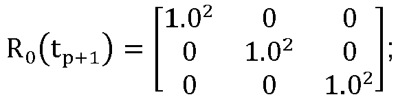
where R0(tp+1) represents the first measurement error variance matrix corresponding to the second moment. - Combined with the introduction above, the terminal device updates the positioning information at the first moment by using the second parameter correction amount, to obtain positioning information of the target vehicle at the second moment. That is, the positioning information of the target vehicle at the second moment is calculated by:

where X̂(tp+1) represents the positioning information of the target vehicle at the second moment, X(tp+1) represents the positioning information of the target vehicle at the first moment, and δX0(tp+1) represents the second parameter correction amount. - The covariance matrix for the satellite filtering parameter may also be updated by:

where P̂(tp+1) represents an updated covariance matrix at the second moment, I11×11 represents a matrix of 11 ×11, V represents the constraint matrix corresponding to the stationary state, P(tp+1) represents the covariance matrix corresponding to the second moment, and K0(tp+1) represents the third gain matrix corresponding to the second moment. - So far, the update of the vehicle stationary state constraints is completed, and the updated positioning information X̂(tp+1) and the updated P̂(tp+1) are obtained.
- In the embodiments of the present disclosure, provided is an approach of constructing a vehicle stationary state constraint to assist in satellite positioning. Through the approach above, constructing a reasonable constraint may improve the positioning accuracy in a case that the vehicle is stationary.
- In an embodiment, based on the embodiment corresponding to
FIG. 3 , in another optional embodiment provided by the embodiments of the present disclosure, after the terminal device obtains a motion state of the target vehicle at the second moment, the method may also include the following step:
The terminal device determines that the motion state of the target vehicle at the second moment satisfies the positioning correction condition in a case that the motion state of the target vehicle at the second moment is a straight driving state. - The terminal device obtains a constraint matrix corresponding to the motion state, which may include the following step:
- the terminal device constructs a constraint matrix corresponding to the straight driving state; and
- the terminal device determines a second parameter correction amount corresponding to the target vehicle at the second moment by using the constraint matrix corresponding to the motion state, which may include the following steps:
- the terminal device obtains a covariance matrix corresponding to the second moment;
- the terminal device obtains a second measurement error variance matrix;
- the terminal device obtains a motion direction difference, the motion direction difference being a difference between a motion direction of the target vehicle at the second moment and a motion direction of the target vehicle at a third moment, and the third moment being before the second moment;
- the terminal device obtains a fourth gain matrix corresponding to the second moment; and
- the terminal device determines the second parameter correction amount corresponding to the target vehicle at the second moment by using the covariance matrix corresponding to the second moment, the constraint matrix corresponding to the straight driving state, the second measurement error variance matrix, the motion direction difference, and the fourth gain matrix.
- In this embodiment, an approach of constructing a vehicle straight driving state constraint to assist in satellite positioning is introduced. Assuming that the current moment is the second moment, the second moment is expressed as tp+1, and the moment before the second moment is tp. In a case that the target vehicle is in a stationary state within a time interval between a moment tp and a moment tp+1, the positioning information X(tp+1) at the first moment corresponding to the second moment and the covariance matrix P(tp+1) corresponding to the second moment may be obtained at this time, and at the moment tp, the speed of the target vehicle is:

where v(tp) represents a speed of the target vehicle at the moment tp, vx(tp) represents speed information of the target vehicle at the moment tp in the x-axis direction, vy(tp) represents speed information of the target vehicle at the moment tp in the y-axis direction, vz(tp) represents speed information of the target vehicle at the moment tp in the z-axis direction. - Therefore, it may be obtained that the motion direction θt
p of the target vehicle at the moment tp satisfies the following relational expression:
where θtp represents the motion direction of the target vehicle at the moment tp, λ represents the longitude of the terminal device, and φ represents the latitude of the terminal device. - At the moment tp+1, the motion speed of the vehicle is expressed as:

where v(tp+1) represents a speed of the target vehicle at the moment (tp+1) (i.e., the second moment), vx(tp+1) represents speed information of the target vehicle at the moment (tp+1) (i.e., the second moment) in the x-axis direction, vy(tp+1) represents speed information of the target vehicle at the moment (tp+1) (i.e., the second moment) in the y-axis direction, vz(tp+1) represents speed information of the target vehicle at the moment (tp+1) (i.e., the second moment) in the z-axis direction. - At the moment (tp+1) (i.e., the second moment), the motion direction θt
p+1 of the target vehicle also satisfies the following relational expression, namely:
where θtp+1 represents the motion direction of the target vehicle at the moment (tp+1) (i.e., the second moment), λ represents the longitude of the terminal device, and φ represents the latitude of the terminal device. - Since the vehicle moves in a straight line, theoretically, the following constraint equation of the vehicle's straight motion is satisfied:

- the second parameter correction amount is calculated by:

- where δXL(tp+1) represents a second parameter correction amount corresponding to the target vehicle at the second moment, P(tp+1) represents a covariance matrix corresponding to the second moment, G represents a constraint matrix corresponding to the straight driving state, RL(tp+1) represents a second measurement error variance matrix corresponding to the second moment, KL(tp+1) represents a fourth gain matrix corresponding to the second moment, and δzL represents a motion direction difference.
- On this basis, the motion direction difference is expressed as:

- On this basis, the constraint matrix corresponding to the straight driving state is expressed as:


where Jvx represents a speed constraint in the x direction, Jvy represents a speed constraint in the y direction, and Jvz represents a speed constraint in the z direction. - On this basis, the second measurement error variance matrix corresponding to the second moment is expressed as:

where RL(tp+1) represents the second measurement error variance matrix corresponding to the second moment. - Combined with the introduction above, the terminal device updates the positioning information at the first moment by using the second parameter correction amount, to obtain positioning information of the target vehicle at the second moment. That is, the positioning information of the target vehicle at the second moment is calculated by:

- The covariance matrix for the satellite filtering parameter may also be updated by:

- So far, the update of the vehicle straight driving state constraints is completed, and the updated positioning information X̌(tp+1) and the updated P̌(tp+1) are obtained.
- The embodiments of the present disclosure, provided is an approach of constructing a vehicle straight driving state constraint to assist in satellite positioning. Through the approach above, constructing a reasonable constraint may improve the positioning accuracy in the case of the vehicle straight motion.
- The vehicle positioning apparatus in the present disclosure is described in detail below, and reference is made to
FIG. 12. FIG. 12 is a schematic diagram of an embodiment of a vehicle positioning apparatus according to an embodiment of the present disclosure. Thevehicle positioning apparatus 30 includes: - an obtaining
module 301, configured to obtain a satellite filtering parameter and to-be-processed data, the satellite filtering parameters including a clock skew and a clock skew change rate, and at least one of location information and speed information of a target vehicle at a first moment; and the to-be-processed data including at least one of a pseudo range observation value and a Doppler observation value corresponding to the target vehicle at the first moment; - a determining
module 302, configured to determine a first parameter correction amount corresponding to the target vehicle at the first moment by using the satellite filtering parameter and the to-be-processed data; - an
updating module 303, configured to update the satellite filtering parameter by using the first parameter correction amount, to obtain positioning information of the target vehicle at the first moment; - the obtaining
module 301, further configured to obtain a motion state of the target vehicle at a second moment, the second moment being after the first moment; - the obtaining
module 301, further configured to obtain a constraint matrix corresponding to the motion state in a case that the motion state of the target vehicle at the second moment satisfies a positioning correction condition, the constraint matrix representing a positioning information variation satisfied in the motion state; - the determining
module 302, configured to determine a second parameter correction amount corresponding to the target vehicle at the second moment by using the constraint matrix corresponding to the motion state; and - the updating
module 303, configured to update the positioning information at the first moment by using the second parameter correction amount, to obtain positioning information of the target vehicle at the second moment. - In an embodiment, based on the embodiment corresponding to
FIG. 12 , in another embodiment of thevehicle positioning apparatus 30 provided in the embodiments of the present disclosure, - the obtaining
module 301 is configured to: transmit an ephemeris delivery request to a server, wherein the server obtains broadcast ephemeris information corresponding to the first moment in response to the ephemeris delivery request, the broadcast ephemeris information including ephemeris parameters corresponding to N satellites, N being an integer greater than or equal to 1; - receive the broadcast ephemeris information corresponding to the first moment transmitted by the server;
- determine, by using the broadcast ephemeris information corresponding to the first moment, the satellite filtering parameter corresponding to the first moment; and
- obtain the to-be-processed data corresponding to the first moment through a satellite positioning device.
- In an embodiment, based on the embodiment corresponding to
FIG. 12 , in another embodiment of thevehicle positioning apparatus 30 provided by the embodiments of the present disclosure, the satellite filtering parameter includes the location information of the target vehicle at the first moment, and the to-be-processed data includes the pseudo range observation value corresponding to the target vehicle at the first moment. - The determining
module 302 is configured to: obtain a covariance matrix corresponding to the first moment; - obtain a first Jacobian matrix corresponding to N unit observation vectors, each of the N unit observation vectors representing a direction vector of a connecting line between a satellite and the target vehicle;
- obtain a pseudo range measurement error matrix corresponding to the first moment;
- obtain a first gain matrix corresponding to the first moment;
- determine a first prediction residual vector by using the satellite filtering parameter and the pseudo range observation value corresponding to the first moment; and
- determine the first parameter correction amount corresponding to the target vehicle at the first moment by using the covariance matrix corresponding to the first moment, the first Jacobian matrix, the pseudo range measurement error matrix, the first gain matrix and the first prediction residual vector.
- In an embodiment, based on the embodiment corresponding to
FIG. 12 , in another embodiment of thevehicle positioning apparatus 30 provided by the embodiments of the present disclosure, the satellite filtering parameter includes the speed information of the target vehicle at the first moment, and the to-be-processed data includes the Doppler observation value corresponding to the target vehicle at the first moment. - The determining
module 302 is configured to: obtain a covariance matrix corresponding to the first moment; - obtain a second Jacobian matrix corresponding to N unit observation vectors, each of the N unit observation vectors representing a direction vector of a connecting line between a satellite and the target vehicle;
- obtain a Doppler measurement error matrix corresponding to the first moment;
- obtain a second gain matrix corresponding to the first moment;
- determine a second prediction residual vector by using the satellite filtering parameter and the Doppler observation value corresponding to the first moment; and
- determine the first parameter correction amount corresponding to the target vehicle at the first moment by using the covariance matrix corresponding to the first moment, the second Jacobian matrix, the Doppler measurement error matrix, the second gain matrix and the second prediction residual vector.
- In an embodiment, based on the embodiment corresponding to
FIG. 12 , in another embodiment of thevehicle positioning apparatus 30 provided by the embodiments of the present disclosure, the satellite filtering parameter includes the speed information and the location information of the target vehicle at the first moment, and the to-be-processed data includes the pseudo range observation value and the Doppler observation value corresponding to the target vehicle at the first moment. - The determining
module 302 is configured to: obtain a covariance matrix corresponding to the first moment; - obtain a first Jacobian matrix corresponding to N unit observation vectors, each of the N unit observation vectors representing a direction vector of a connecting line between a satellite and the target vehicle;
- obtain a pseudo range measurement error matrix corresponding to the first moment;
- obtain a first gain matrix corresponding to the first moment;
- determine a first prediction residual vector by using the satellite filtering parameter and the pseudo range observation value corresponding to the first moment;
- determine a target parameter correction amount corresponding to the target vehicle at the first moment by using the covariance matrix corresponding to the first moment, the first Jacobian matrix, the pseudo range measurement error matrix, the first gain matrix and the first prediction residual vector, the target parameter correction amount being used for updating the satellite filtering parameter;
- determine a target covariance matrix by using the covariance matrix corresponding to the first moment, the first gain matrix and the first Jacobian matrix; and
- determine a first parameter correction amount corresponding to the target vehicle at the first moment by using the target covariance matrix.
- In an embodiment, based on the foregoing embodiment corresponding to
FIG. 12 , in another embodiment of thevehicle positioning apparatus 30 provided in the embodiments of the present disclosure, - the determining
module 302 is configured to: obtain a second Jacobian matrix corresponding to N unit observation vectors, each of the N unit observation vectors representing a direction vector of a connecting line between a satellite and the target vehicle; - obtain a Doppler measurement error matrix corresponding to the first moment;
- obtain a second gain matrix corresponding to the first moment;
- determine a second prediction residual vector by using the satellite filtering parameter and the Doppler observation value corresponding to the first moment; and
- determine the first parameter correction amount corresponding to the target vehicle at the first moment by using the target covariance matrix, the second Jacobian matrix, the Doppler measurement error matrix, the second gain matrix and the second prediction residual vector.
- The updating the satellite filtering parameter by using the first parameter correction amount, to obtain positioning information of the target vehicle at the first moment includes:
- determining updated satellite filtering parameter by using the target parameter correction amount and the satellite filtering parameter, the updated satellite filtering parameter including updated speed information and updated location information of the target vehicle at the first moment; and
- updating the updated satellite filtering parameter by using the first parameter correction amount, to obtain positioning information of the target vehicle at the first moment.
- In an embodiment, based on the foregoing embodiment corresponding to
FIG. 12 , in another embodiment of thevehicle positioning apparatus 30 provided in the embodiments of the present disclosure, - the updating
module 303 is configured to: update the positioning information at the first moment by using the second parameter correction amount, to obtain to-be-processed positioning information; - determine first positioning information by using the positioning information at the first moment and a first weight value;
- determine second positioning information by using the to-be-processed positioning information and a second weight value; and
- determine the positioning information of the target vehicle at the second moment by using the first positioning information and the second positioning information.
- In an embodiment, based on the embodiment corresponding to
FIG. 12 , in another embodiment of thevehicle positioning apparatus 30 provided by the embodiments of the present disclosure, the satellite filtering parameter includes the location information and the speed information of the target vehicle at the first moment. - The obtaining
module 301 is further configured to obtain a location confidence factor and a speed confidence factor corresponding to the satellite filtering parameter before the obtaining of a motion state of the target vehicle at a second moment, the location confidence factor representing location accuracy of the target vehicle, and the speed confidence factor representing speed accuracy of the target vehicle. - The obtaining
module 301 is further configured to obtain a number of visible satellites. - The determining
module 302 is further configured to determine to execute the step of obtaining a motion state of the target vehicle at a second moment in a case that the location confidence factor, the speed confidence factor and the number of visible satellites satisfy a vehicle constraint. - In an embodiment, based on the foregoing embodiment corresponding to
FIG. 12 , in another embodiment of thevehicle positioning apparatus 30 provided in the embodiments of the present disclosure, - the obtaining
module 301 is configured to obtain a first in-vehicle image through an image acquisition apparatus; - obtain a second in-vehicle image through the image acquisition apparatus, the second in-vehicle image and the first in-vehicle image being two adjacent image frames;
- perform feature point matching on the first in-vehicle image and the second in-vehicle image; and
- determine the motion state of the target vehicle at the second moment by using a result of the feature point matching.
- In an embodiment, based on the foregoing embodiment corresponding to
FIG. 12 , in another embodiment of thevehicle positioning apparatus 30 provided in the embodiments of the present disclosure, - the obtaining
module 301 is configured to determine the motion state of the target vehicle at the second moment by using steering wheel position information of the target vehicle;
or, - determine the motion state of the target vehicle at the second moment based on a road network matching result.
- In an embodiment, based on the foregoing embodiment corresponding to
FIG. 12 , in another embodiment of thevehicle positioning apparatus 30 provided in the embodiments of the present disclosure,
the determiningmodule 302 is further configured to determine that the motion state of the target vehicle at the second moment satisfies the positioning correction condition in a case that the motion state of the target vehicle at the second moment is a stationary state during the obtainingmodule 301 obtains the motion state of the target vehicle at a second moment. - The obtaining
module 301 is configured to construct a constraint matrix corresponding to the stationary state. - The determining
module 302 is configured to: obtain a covariance matrix corresponding to the second moment; - obtain a first measurement error variance matrix;
- obtain a speed matrix corresponding to the second moment;
- obtain a third gain matrix corresponding to the second moment; and
- determine the second parameter correction amount corresponding to the target vehicle at the second moment by using the covariance matrix corresponding to the second moment, the constraint matrix corresponding to the stationary state, the first measurement error variance matrix, the speed matrix corresponding to the second moment, and the third gain matrix.
- In an embodiment, based on the foregoing embodiment corresponding to
FIG. 12 , in another embodiment of thevehicle positioning apparatus 30 provided in the embodiments of the present disclosure,
the determiningmodule 302 is further configured to determine that the motion state of the target vehicle at the second moment satisfies the positioning correction condition in a case that the motion state of the target vehicle at the second moment is a straight driving state during the obtainingmodule 301 obtains the motion state of the target vehicle at a second moment. - The obtaining
module 301 is configured to construct a constraint matrix corresponding to the straight driving state. - The determining
module 302 is configured to: obtain a covariance matrix corresponding to the second moment; - obtain a second measurement error variance matrix;
- obtain a motion direction difference, the motion direction difference being a difference between a motion direction of the target vehicle at the second moment and a motion direction of the target vehicle at a third moment, and the third moment being before the second moment;
- obtain a fourth gain matrix corresponding to the second moment; and
- determine the second parameter correction amount corresponding to the target vehicle at the second moment by using the covariance matrix corresponding to the second moment, the constraint matrix corresponding to the straight driving state, the second measurement error variance matrix, the motion direction difference, and the fourth gain matrix.
- An embodiment of the present disclosure further provides another vehicle positioning apparatus. As shown in
FIG. 13 , for ease of description, only parts related to the embodiments of the present disclosure are shown. For specific technical details that are not disclosed, refer to the method part in the embodiments of the present disclosure. In the embodiments of the present disclosure, an example in which the terminal device is served as an in-vehicle terminal is used for description:
FIG. 13 is a block diagram of a part of a structure of an in-vehicle terminal related to a terminal device according to an embodiment of the present disclosure. Referring toFIG. 13 , the in-vehicle terminal includes: components such as a radio frequency (RF)circuit 410, amemory 420, aninput unit 430, adisplay unit 440, asensor 450, anaudio circuit 460, a wireless fidelity (WiFi) module 370, aprocessor 480, and apower supply 490. A person skilled in the art may understand that the structure of the in-vehicle terminal shown inFIG. 13 does not constitute a limitation on the in-vehicle terminal, and may include more or fewer components than shown, or combine some components, or have different component arrangements. - Each component part of the in-vehicle terminal is described below in detail with reference to
FIG. 13 . - The
RF circuit 410 may be configured to receive and send a signal in an information receiving and sending process or a call process, and in particular, after downlink information of a base station is received, send the downlink information to theprocessor 480 for processing. In addition, the RF circuit sends uplink data to the base station. Usually, theRF circuit 410 includes, but is not limited to, an antenna, at least one amplifier, a transceiver, a coupler, a low noise amplifier (LNA), and a duplexer. In addition, theRF circuit 410 may also communicate with a network and another device by wireless communication. The wireless communication may use any communication standard or protocol, including but not limited to GSM, GPRS, CDMA, wideband code division multiple access (WCDMA), long term evolution (LTE), email, short messaging service (SMS), and the like. - The
memory 420 may be configured to store a software program and module. Theprocessor 480 runs the software program and module stored in thememory 420, to implement various functional applications and data processing of the in-vehicle terminal. Thememory 420 may mainly include a program storage area and a data storage area. The program storage area may store an operating system, an application program required by at least one function (such as a sound playback function and an image display function), and the like. The data storage area may store data (for example, audio data and a phone book) created according to use of the in-vehicle terminal. In addition, thememory 420 may include a high-speed random access memory, and may further include a nonvolatile memory, such as at least one magnetic disk storage device, a flash memory, or another volatile solid-state storage device. - The
input unit 430 may be configured to receive input digit or character information, and generate key signal input related to the user setting and function control of the in-vehicle terminal. Theinput unit 430 may include atouch panel 431 and anotherinput device 432. Thetouch panel 431, which may also be referred to as a touch screen, may collect a touch operation of a user on or near the touch panel (such as an operation of a user on or near thetouch panel 431 by using any suitable object or accessory such as a finger or a stylus), and drive a corresponding connection apparatus according to a preset program. - The
display unit 440 may be configured to display information input by the user or information provided for the user, and various menus of the in-vehicle terminal. Thedisplay unit 440 may include adisplay panel 441. - The in-vehicle terminal may further include at least one
sensor 450, such as an optical sensor, a motion sensor, and other sensors. The optical sensor may include an ambient light sensor and a proximity sensor. - The
audio circuit 460, aloudspeaker 461, and amicrophone 462 may provide audio interfaces between the user and the in-vehicle terminal. - WiFi is a short-range wireless transmission technology. The in-vehicle terminal may help users send and receive an email, browse a webpage, and access streaming media through the WiFi module 370, which provides users with access to the wireless broadband Internet.
- The
processor 480 is a control center of the in-vehicle terminal, uses various interfaces and lines to connect various parts of the entire in-vehicle terminal, and executes various functions of the in-vehicle terminal and processes data by running or executing software programs and/or modules stored in thememory 420 and invoking data stored in thememory 420. - Steps performed by the terminal device in the foregoing embodiments may be based on the structure of the terminal device shown in
FIG. 13 . - An embodiment of the present disclosure further provides a computer-readable storage medium, storing computer instructions, the computer instructions, when running on a computer, causing the computer to perform the methods according to the foregoing embodiments.
- An embodiment of the present disclosure further provides a computer program product including instructions, the instructions, when running on a computer, causing the computer to perform the methods according to the foregoing embodiments.
- A person skilled in the art may clearly understand that, for simple and clear description, for specific work processes of the foregoing described system, apparatus, and unit, reference may be made to corresponding process in the foregoing method embodiments, and details are not described herein again.
- In the several embodiments provided in the present disclosure, it should be understood that the disclosed system, apparatus, and method may be implemented in other manners. For example, the apparatus embodiments described above are merely exemplary. For example, the division of the units, is merely the division of logic functions, and may use other division manners during actual implementation. For example, multiple units or components may be combined, or may be integrated into another system, or some features may be omitted or not performed. In addition, the displayed or discussed mutual couplings or direct couplings or communication connections may be implemented through some interfaces. The indirect couplings or communication connections between the apparatuses or units may be implemented in electrical, mechanical or other forms.
- The units described as separate components may or may not be physically separate, and components displayed as units may or may not be physical units, may be located in one position, or may be distributed on multiple network units. Some of or all of the units may be selected according to actual needs to achieve the objectives of the solutions of the embodiments of the present disclosure.
- In addition, functional units in the embodiments of the present disclosure may be integrated into one processing unit, or each of the units may be physically separated, or two or more units may be integrated into one unit. The integrated unit may be implemented in the form of hardware, or may be implemented in the form of a software function unit.
- When the integrated unit is implemented in the form of a software functional unit and sold or used as an independent product, the integrated unit may be stored in a computer-readable storage medium. Based on such an understanding, the technical solutions of the present disclosure essentially, or the part contributing to the related technology, or all or some of the technical solutions may be implemented in the form of a software product. The computer software product is stored in a storage medium and includes several instructions for instructing a computer device (which may be a personal computer, a server, a network device, or the like) to perform all or some of the steps of the methods described in the embodiments of the present disclosure. The foregoing storage medium includes: any medium that can store program code, such as a USB flash drive, a removable hard disk, a read-only memory (ROM), a random access memory (RAM), a magnetic disk, or an optical disc.
- The foregoing embodiments are merely intended for describing the technical solutions of the present disclosure, but not for limiting the present disclosure. Although the present disclosure is described in detail with reference to the foregoing embodiments, it should be appreciated by a person skilled in the art that, modifications may still be made to the technical solutions described in the foregoing embodiments, or equivalent replacements may be made to the part of the technical features. Such modifications or replacements do not cause the essence of corresponding technical solutions to depart from the spirit and scope of the technical solutions of the embodiments of the present disclosure.
Claims (16)
- A vehicle positioning method, executed by a terminal device, the method comprising:obtaining a satellite filtering parameter and to-be-processed data, the satellite filtering parameter comprising a clock skew and a clock skew change rate, and at least one of location information and speed information of a target vehicle at a first moment; and the to-be-processed data comprising at least one of a pseudo range observation value and a Doppler observation value corresponding to the target vehicle at the first moment;determining a first parameter correction amount corresponding to the target vehicle at the first moment by using the satellite filtering parameter and the to-be-processed data;updating the satellite filtering parameter by using the first parameter correction amount, to obtain positioning information of the target vehicle at the first moment;obtaining a motion state of the target vehicle at a second moment, the second moment being after the first moment;obtaining a constraint matrix corresponding to the motion state in a case that the motion state of the target vehicle at the second moment satisfies a positioning correction condition, the constraint matrix representing a positioning information variation satisfied in the motion state;determining a second parameter correction amount corresponding to the target vehicle at the second moment by using the constraint matrix corresponding to the motion state; andupdating the positioning information at the first moment by using the second parameter correction amount, to obtain positioning information of the target vehicle at the second moment.
- The method according to claim 1, wherein the obtaining a satellite filtering parameter and to-be-processed data comprises:transmitting an ephemeris delivery request to a server, wherein the server obtains broadcast ephemeris information corresponding to the first moment in response to the ephemeris delivery request, the broadcast ephemeris information comprising ephemeris parameters corresponding to N satellites, N being an integer greater than or equal to 1;receiving the broadcast ephemeris information corresponding to the first moment transmitted by the server;determining, by using the broadcast ephemeris information corresponding to the first moment, the satellite filtering parameter corresponding to the first moment; andobtaining, through a satellite positioning device, the to-be-processed data corresponding to the first moment.
- The method according to claim 1, wherein the satellite filtering parameter comprises the location information of the target vehicle at the first moment, and the to-be-processed data comprises the pseudo range observation value corresponding to the target vehicle at the first moment; and
the determining a first parameter correction amount corresponding to the target vehicle at the first moment by using the satellite filtering parameter and the to-be-processed data comprises:obtaining a covariance matrix corresponding to the first moment;obtaining a first Jacobian matrix corresponding to N unit observation vectors, each of the N unit observation vectors representing a direction vector of a connecting line between a satellite and the target vehicle;obtaining a pseudo range measurement error matrix corresponding to the first moment;obtaining a first gain matrix corresponding to the first moment;determining a first prediction residual vector by using the satellite filtering parameter and the pseudo range observation value corresponding to the first moment; anddetermining the first parameter correction amount corresponding to the target vehicle at the first moment by using the covariance matrix corresponding to the first moment, the first Jacobian matrix, the pseudo range measurement error matrix, the first gain matrix and the first prediction residual vector. - The method according to claim 1, wherein the satellite filtering parameter comprises the speed information of the target vehicle at the first moment, and the to-be-processed data comprises the Doppler observation value corresponding to the target vehicle at the first moment; and
the determining a first parameter correction amount corresponding to the target vehicle at the first moment by using the satellite filtering parameter and the to-be-processed data comprises:obtaining a covariance matrix corresponding to the first moment;obtaining a second Jacobian matrix corresponding to N unit observation vectors, each of the N unit observation vectors representing a direction vector of a connecting line between a satellite and the target vehicle;obtaining a Doppler measurement error matrix corresponding to the first moment;obtaining a second gain matrix corresponding to the first moment;determining a second prediction residual vector by using the satellite filtering parameter and the Doppler observation value corresponding to the first moment; anddetermining the first parameter correction amount corresponding to the target vehicle at the first moment by using the covariance matrix corresponding to the first moment, the second Jacobian matrix, the Doppler measurement error matrix, the second gain matrix and the second prediction residual vector. - The method according to claim 1, wherein the satellite filtering parameter comprises the speed information and the location information of the target vehicle at the first moment, and the to-be-processed data comprises the pseudo range observation value and the Doppler observation value corresponding to the target vehicle at the first moment; and
the determining a first parameter correction amount corresponding to the target vehicle at the first moment by using the satellite filtering parameter and the to-be-processed data comprises:obtaining a covariance matrix corresponding to the first moment;obtaining a first Jacobian matrix corresponding to N unit observation vectors, each of the N unit observation vectors representing a direction vector of a connecting line between a satellite and the target vehicle;obtaining a pseudo range measurement error matrix corresponding to the first moment;obtaining a first gain matrix corresponding to the first moment;determining a first prediction residual vector by using the satellite filtering parameter and the pseudo range observation value corresponding to the first moment;determining a target parameter correction amount corresponding to the target vehicle at the first moment by using the covariance matrix corresponding to the first moment, the first Jacobian matrix, the pseudo range measurement error matrix, the first gain matrix and the first prediction residual vector, the target parameter correction amount being used for updating the satellite filtering parameter;determining a target covariance matrix by using the covariance matrix corresponding to the first moment, the first gain matrix and the first Jacobian matrix; anddetermining a first parameter correction amount corresponding to the target vehicle at the first moment by using the target covariance matrix. - The method according to claim 5, wherein the determining a first parameter correction amount corresponding to the target vehicle at the first moment by using the target covariance matrix comprises:obtaining a second Jacobian matrix corresponding to N unit observation vectors, each unit observation vector comprised in the N unit observation vectors representing a direction vector of a connecting line between a satellite and the target vehicle;obtaining a Doppler measurement error matrix corresponding to the first moment;obtaining a second gain matrix corresponding to the first moment;determining a second prediction residual vector by using the satellite filtering parameter and the Doppler observation value corresponding to the first moment; anddetermining the first parameter correction amount corresponding to the target vehicle at the first moment by using the target covariance matrix, the second Jacobian matrix, the Doppler measurement error matrix, the second gain matrix and the second prediction residual vector; andthe updating the satellite filtering parameter by using the first parameter correction amount, to obtain positioning information of the target vehicle at the first moment comprises:determining updated satellite filtering parameter by using the target parameter correction amount and the satellite filtering parameter, the updated satellite filtering parameter comprising updated speed information and updated location information of the target vehicle at the first moment; andupdating the updated satellite filtering parameter by using the first parameter correction amount, to obtain positioning information of the target vehicle at the first moment.
- The method according to claim 1, wherein the updating the positioning information at the first moment by using the second parameter correction amount, to obtain positioning information of the target vehicle at the second moment comprises:updating the positioning information at the first moment by using the second parameter correction amount, to obtain to-be-processed positioning information;determining first positioning information by using the positioning information at the first moment and a first weight value;determining second positioning information by using the to-be-processed positioning information and a second weight value; anddetermining the positioning information of the target vehicle at the second moment by using the first positioning information and the second positioning information.
- The method according to claim 1, wherein the satellite filtering parameter comprises the location information and the speed information of the target vehicle at the first moment; and
before the obtaining a motion state of the target vehicle at a second moment, the method further comprises:obtaining a location confidence factor and a speed confidence factor corresponding to the satellite filtering parameter, the location confidence factor representing location accuracy of the target vehicle, and the speed confidence factor representing speed accuracy of the target vehicle;obtaining a number of visible satellites; anddetermining to execute the operation of obtaining a motion state of the target vehicle at a second moment in a case that the location confidence factor, the speed confidence factor and the number of visible satellites satisfy a vehicle constraint. - The method according to claim 1, wherein the obtaining a motion state of the target vehicle at a second moment comprises:obtaining, by an image acquisition apparatus, a first in-vehicle image;obtaining, by the image acquisition apparatus, a second in-vehicle image, the second in-vehicle image and the first in-vehicle image being two adjacent image frames;performing feature point matching on the first in-vehicle image and the second in-vehicle image; anddetermining the motion state of the target vehicle at the second moment by using a result of the feature point matching.
- The method according to claim 1, wherein the obtaining a motion state of the target vehicle at a second moment comprises:determining the motion state of the target vehicle at the second moment by using steering wheel position information of the target vehicle;
or,determining the motion state of the target vehicle at the second moment based on a road network matching result. - The method according to any one of claims 1 to 10, wherein after the obtaining a motion state of the target vehicle at a second moment, the method further comprises:determining that the motion state of the target vehicle at the second moment satisfies the positioning correction condition in a case that the motion state of the target vehicle at the second moment is a stationary state;the obtaining a constraint matrix corresponding to the motion state comprises:constructing a constraint matrix corresponding to the stationary state; andthe determining a second parameter correction amount corresponding to the target vehicle at the second moment by using the constraint matrix corresponding to the motion state comprises:obtaining a covariance matrix corresponding to the second moment;obtaining a first measurement error variance matrix;obtaining a speed matrix corresponding to the second moment;obtaining a third gain matrix corresponding to the second moment; anddetermining the second parameter correction amount corresponding to the target vehicle at the second moment by using the covariance matrix corresponding to the second moment, the constraint matrix corresponding to the stationary state, the first measurement error variance matrix, the speed matrix corresponding to the second moment, and the third gain matrix.
- The method according to any one of claims 1 to 10, wherein after the obtaining a motion state of the target vehicle at a second moment, the method further comprises:determining that the motion state of the target vehicle at the second moment satisfies the positioning correction condition in a case that the motion state of the target vehicle at the second moment is a straight driving state;the obtaining a constraint matrix corresponding to the motion state comprises:constructing a constraint matrix corresponding to the straight driving state; andthe determining a second parameter correction amount corresponding to the target vehicle at the second moment by using the constraint matrix corresponding to the motion state comprises:obtaining a covariance matrix corresponding to the second moment;obtaining a second measurement error variance matrix;obtaining a motion direction difference, the motion direction difference being a difference between a motion direction of the target vehicle at the second moment and a motion direction of the target vehicle at a third moment, and the third moment being before the second moment;obtaining a fourth gain matrix corresponding to the second moment; anddetermining the second parameter correction amount corresponding to the target vehicle at the second moment by using the covariance matrix corresponding to the second moment, the constraint matrix corresponding to the straight driving state, the second measurement error variance matrix, the motion direction difference, and the fourth gain matrix.
- A vehicle positioning apparatus, comprising:an obtaining module, configured to obtain a satellite filtering parameter and to-be-processed data, the satellite filtering parameter comprising a clock skew and a clock skew change rate, and at least one of location information and speed information of a target vehicle at a first moment; and the to-be-processed data comprising at least one of a pseudo range observation value and a Doppler observation value corresponding to the target vehicle at the first moment;a determining module, configured to determine a first parameter correction amount corresponding to the target vehicle at the first moment by using the satellite filtering parameter and the to-be-processed data;an updating module, configured to update the satellite filtering parameter by using the first parameter correction amount, to obtain positioning information of the target vehicle at the first moment;the obtaining module, further configured to obtain a motion state of the target vehicle at a second moment, the second moment being after the first moment;the obtaining module, further configured to obtain a constraint matrix corresponding to the motion state in a case that the motion state of the target vehicle at the second moment satisfies a positioning correction condition, the constraint matrix representing a positioning information variation satisfied in the motion state;the determining module, configured to determine a second parameter correction amount corresponding to the target vehicle at the second moment by using the constraint matrix corresponding to the motion state; andthe updating module, configured to update the positioning information at the first moment by using the second parameter correction amount, to obtain positioning information of the target vehicle at the second moment.
- A terminal device, comprising: a memory, a processor, and a bus system,the memory being configured to store a program;the processor being configured to execute the program in the memory, and perform, according to instructions in a program code, the method according to any one of claims 1 to 12; andthe bus system being configured to connect the memory and the processor, to enable the memory to communicate with the processor.
- A computer-readable storage medium, configured to store a computer program, the computer program being configured to perform the method according to any one of claims 1 to 12.
- A computer program product comprising instructions, the instructions, when running on a computer, causing the computer to perform the method according to any one of claims 1 to 12.
Applications Claiming Priority (2)
| Application Number | Priority Date | Filing Date | Title |
|---|---|---|---|
| CN202110196837.8A CN112558125B (en) | 2021-02-22 | 2021-02-22 | Vehicle positioning method, related device, equipment and storage medium |
| PCT/CN2022/076131 WO2022174756A1 (en) | 2021-02-22 | 2022-02-14 | Method for vehicle positioning, related apparatus, device, and storage medium |
Publications (2)
| Publication Number | Publication Date |
|---|---|
| EP4206743A1 true EP4206743A1 (en) | 2023-07-05 |
| EP4206743A4 EP4206743A4 (en) | 2024-05-29 |
Family
ID=75034462
Family Applications (1)
| Application Number | Title | Priority Date | Filing Date |
|---|---|---|---|
| EP22755529.9A Pending EP4206743A4 (en) | 2021-02-22 | 2022-02-14 | VEHICLE POSITIONING METHOD, ASSOCIATED DEVICE, DEVICE AND STORAGE MEDIUM |
Country Status (4)
| Country | Link |
|---|---|
| US (1) | US12422565B2 (en) |
| EP (1) | EP4206743A4 (en) |
| CN (1) | CN112558125B (en) |
| WO (1) | WO2022174756A1 (en) |
Families Citing this family (16)
| Publication number | Priority date | Publication date | Assignee | Title |
|---|---|---|---|---|
| CN112558125B (en) * | 2021-02-22 | 2021-05-25 | 腾讯科技(深圳)有限公司 | Vehicle positioning method, related device, equipment and storage medium |
| CN112902989B (en) * | 2021-05-07 | 2021-07-16 | 腾讯科技(深圳)有限公司 | Data error calibration method and device, electronic equipment and storage medium |
| CN113406682B (en) * | 2021-06-22 | 2024-03-12 | 腾讯科技(深圳)有限公司 | Positioning method, positioning device, electronic equipment and storage medium |
| CN113608248B (en) * | 2021-06-25 | 2023-06-13 | 北京建筑大学 | Beidou 5G fusion high-precision patrol personnel positioning method and related equipment |
| CN113899375B (en) * | 2021-12-10 | 2022-03-11 | 腾讯科技(深圳)有限公司 | Vehicle positioning method and device, storage medium and electronic equipment |
| CN114510679B (en) * | 2021-12-15 | 2024-04-12 | 成都飞机工业(集团)有限责任公司 | Device position information obtaining method and device, terminal device and storage medium |
| CN114252897B (en) * | 2021-12-30 | 2025-08-22 | 阿里巴巴创新公司 | Positioning method, device, electronic device and computer storage medium |
| CN114384569B (en) * | 2022-01-12 | 2025-04-18 | 腾讯科技(深圳)有限公司 | Terminal positioning method, device, equipment and medium |
| CN115414621B (en) * | 2022-06-07 | 2023-03-17 | 浙江华消科技有限公司 | Intelligent control method and related device for fire water monitor |
| CN115242297B (en) * | 2022-09-21 | 2022-11-25 | 腾讯科技(深圳)有限公司 | Method, device, equipment and storage medium for determining motion parameters of mobile terminal |
| CN115616627B (en) * | 2022-11-08 | 2026-04-17 | 深圳市锐尔觅移动通信有限公司 | Pseudo-satellite positioning methods, devices, equipment, and storage media |
| CN115856981B (en) * | 2023-02-28 | 2023-04-28 | 北京蓝天多维科技有限公司 | Accurate locomotive positioning method based on Beidou satellite |
| CN118226485A (en) * | 2024-03-22 | 2024-06-21 | 腾讯科技(深圳)有限公司 | Mobile terminal positioning method, device, electronic device and storage medium |
| CN119135244B (en) * | 2024-09-11 | 2025-07-15 | 中国人民解放军国防科技大学 | A 6G communication and guidance signal fusion method, device and system for air-ground integration |
| CN119270309B (en) * | 2024-12-11 | 2025-02-11 | 北京壬工智能科技有限公司 | Beidou positioning system, method and application in vehicles and marine equipment |
| CN121030826B (en) * | 2025-10-30 | 2026-02-24 | 国网湖南省电力有限公司信息通信分公司 | Secure USB flash drive data processing method and system for power grid sensitive computing environments |
Family Cites Families (27)
| Publication number | Priority date | Publication date | Assignee | Title |
|---|---|---|---|---|
| US7133772B2 (en) * | 2002-07-30 | 2006-11-07 | Global Locate, Inc. | Method and apparatus for navigation using instantaneous Doppler measurements from satellites |
| US6839020B2 (en) * | 2003-06-02 | 2005-01-04 | Motorola, Inc. | Aiding location determinations in satellite positioning system receivers |
| JP4830559B2 (en) * | 2006-03-16 | 2011-12-07 | セイコーエプソン株式会社 | Positioning device and positioning method |
| JP5521531B2 (en) * | 2009-12-18 | 2014-06-18 | セイコーエプソン株式会社 | Position calculation method and position calculation system |
| CN105372685A (en) * | 2015-11-18 | 2016-03-02 | 中国科学院光电研究院 | Regional high-precision position enhancing system and method |
| KR101725689B1 (en) * | 2015-12-11 | 2017-04-11 | 현대오트론 주식회사 | Method and apparatus for determining location of vehicle |
| CN106017461B (en) * | 2016-05-19 | 2018-11-06 | 北京理工大学 | Pedestrian navigation system three-dimensional fix method based on human body/environmental constraints |
| JP7006080B2 (en) * | 2017-09-25 | 2022-01-24 | カシオ計算機株式会社 | Movement state determination device, electronic clock, movement state determination method and program |
| CN108562917B (en) * | 2018-04-09 | 2021-09-28 | 东南大学 | Constraint filtering resolving method and device for additional orthogonal function fitting condition |
| CN108845339B (en) * | 2018-05-28 | 2019-09-13 | 广州吉欧电子科技有限公司 | A kind of GNSS localization method and GNSS positioning device |
| CN110865398B (en) * | 2018-08-27 | 2022-03-22 | 腾讯大地通途(北京)科技有限公司 | Processing method and processing device for positioning data, terminal equipment and storage medium |
| CN109612460B (en) * | 2018-12-19 | 2020-11-20 | 东南大学 | A Method of Measuring Vertical Line Deviation Based on Static Correction |
| CN109855617A (en) * | 2019-02-28 | 2019-06-07 | 深圳市元征科技股份有限公司 | A kind of vehicle positioning method, vehicle locating device and terminal device |
| CN110389364B (en) * | 2019-07-31 | 2022-05-10 | 广州市中海达测绘仪器有限公司 | Positioning method, positioning device, computer equipment and storage medium |
| CN110865405A (en) * | 2019-11-29 | 2020-03-06 | 浙江商汤科技开发有限公司 | Fusion positioning method and device, mobile equipment control method and electronic equipment |
| CN111522044B (en) * | 2020-05-06 | 2023-02-17 | 扬州哈工科创机器人研究院有限公司 | Vehicle positioning method and device |
| CN111708043B (en) * | 2020-05-13 | 2023-09-26 | 阿波罗智能技术(北京)有限公司 | Positioning methods and devices |
| CN111947667B (en) * | 2020-06-24 | 2022-08-12 | 火眼位置数智科技服务有限公司 | A real-time high-precision orbit determination method for low-orbit satellites based on the combination of kinematics and dynamics |
| CN111751857A (en) * | 2020-07-08 | 2020-10-09 | 中国第一汽车股份有限公司 | Vehicle pose estimation method, device, storage medium and system |
| WO2022029878A1 (en) * | 2020-08-04 | 2022-02-10 | 三菱電機株式会社 | Vehicle control device |
| CN112255648B (en) * | 2020-10-20 | 2022-03-25 | 腾讯科技(深圳)有限公司 | Motion state detection method and device, electronic equipment and storage medium |
| CN112505735B (en) * | 2020-11-30 | 2022-05-03 | 腾讯科技(深圳)有限公司 | Method, device and storage medium for positioning terminal |
| CN112734290B (en) * | 2021-01-25 | 2022-02-11 | 腾讯科技(深圳)有限公司 | Vehicle motion state evaluation method, device, equipment and medium |
| CN112558125B (en) * | 2021-02-22 | 2021-05-25 | 腾讯科技(深圳)有限公司 | Vehicle positioning method, related device, equipment and storage medium |
| CN114384569B (en) * | 2022-01-12 | 2025-04-18 | 腾讯科技(深圳)有限公司 | Terminal positioning method, device, equipment and medium |
| CN117092672A (en) * | 2022-05-13 | 2023-11-21 | 腾讯科技(深圳)有限公司 | Positioning method and related device |
| CN117250647A (en) * | 2022-06-09 | 2023-12-19 | 腾讯科技(深圳)有限公司 | Positioning methods, devices, equipment and storage media |
-
2021
- 2021-02-22 CN CN202110196837.8A patent/CN112558125B/en active Active
-
2022
- 2022-02-14 WO PCT/CN2022/076131 patent/WO2022174756A1/en not_active Ceased
- 2022-02-14 EP EP22755529.9A patent/EP4206743A4/en active Pending
- 2022-11-16 US US17/988,009 patent/US12422565B2/en active Active
Also Published As
| Publication number | Publication date |
|---|---|
| WO2022174756A1 (en) | 2022-08-25 |
| US12422565B2 (en) | 2025-09-23 |
| CN112558125B (en) | 2021-05-25 |
| US20230072669A1 (en) | 2023-03-09 |
| CN112558125A (en) | 2021-03-26 |
| EP4206743A4 (en) | 2024-05-29 |
Similar Documents
| Publication | Publication Date | Title |
|---|---|---|
| EP4206743A1 (en) | Method for vehicle positioning, related apparatus, device, and storage medium | |
| Li et al. | Review of PPP–RTK: Achievements, challenges, and opportunities | |
| US20230204787A1 (en) | System and method for providing gnss corrections | |
| CN105353391B (en) | A kind of multi-internet integration for supporting polymorphic type positioning terminal positions enhancing system and method | |
| EP3309585A1 (en) | Positioning processing system, method, computer program, positioning processing device, and user terminal | |
| EP4502661A1 (en) | Positioning method and related device | |
| CN112904390B (en) | Positioning method, positioning device, computer equipment and storage medium | |
| CN102866410A (en) | Method for position determination with measurement stitching | |
| US12554024B2 (en) | Map-aided satellite selection | |
| CN113281796B (en) | Position determining method, speed determining method, device, equipment and storage medium | |
| CN111856534A (en) | Dual-mode GNSS carrier precision single-point positioning method and system for intelligent terminals | |
| CN117250647A (en) | Positioning methods, devices, equipment and storage media | |
| CN112285749B (en) | Method and device for processing original observation data of global navigation satellite system and storage medium | |
| CN112731268B (en) | Differential data processing method and positioning tracking system | |
| CN116699661A (en) | Data processing method, device, equipment and storage medium | |
| CN104536023A (en) | Non-delayed sub-meter differential positioning method of high and low frequency error shunting prediction | |
| CN119846671B (en) | Unmanned aerial vehicle real-time tracking and positioning system and method based on Beidou satellite | |
| CN120009933A (en) | Terminal positioning method and device, storage medium and electronic device | |
| JP2007010422A (en) | Positioning system | |
| CN117930295A (en) | Information detection method and device, electronic equipment and storage medium | |
| CN117949988A (en) | Positioning method, device, computer readable medium and electronic device | |
| US12429605B2 (en) | Kinematic positioning with inertial constraints | |
| HK40040657A (en) | Vehicle positioning method and related apparatus, device, and storage medium | |
| HK40040657B (en) | Vehicle positioning method and related apparatus, device, and storage medium | |
| CN116184458B (en) | Data processing method, device and computer-readable storage medium |
Legal Events
| Date | Code | Title | Description |
|---|---|---|---|
| STAA | Information on the status of an ep patent application or granted ep patent |
Free format text: STATUS: THE INTERNATIONAL PUBLICATION HAS BEEN MADE |
|
| PUAI | Public reference made under article 153(3) epc to a published international application that has entered the european phase |
Free format text: ORIGINAL CODE: 0009012 |
|
| STAA | Information on the status of an ep patent application or granted ep patent |
Free format text: STATUS: REQUEST FOR EXAMINATION WAS MADE |
|
| 17P | Request for examination filed |
Effective date: 20230330 |
|
| AK | Designated contracting states |
Kind code of ref document: A1 Designated state(s): AL AT BE BG CH CY CZ DE DK EE ES FI FR GB GR HR HU IE IS IT LI LT LU LV MC MK MT NL NO PL PT RO RS SE SI SK SM TR |
|
| REG | Reference to a national code |
Ref country code: DE Ref legal event code: R079 Free format text: PREVIOUS MAIN CLASS: G01S0019450000 Ipc: G01S0005000000 |
|
| A4 | Supplementary search report drawn up and despatched |
Effective date: 20240430 |
|
| DAV | Request for validation of the european patent (deleted) | ||
| DAX | Request for extension of the european patent (deleted) | ||
| RIC1 | Information provided on ipc code assigned before grant |
Ipc: G01S 19/45 20100101ALI20240424BHEP Ipc: G01S 19/41 20100101ALI20240424BHEP Ipc: G01S 19/39 20100101ALI20240424BHEP Ipc: G01S 19/42 20100101ALI20240424BHEP Ipc: G01S 19/40 20100101ALI20240424BHEP Ipc: G01S 19/05 20100101ALI20240424BHEP Ipc: G01S 5/00 20060101AFI20240424BHEP |