EP4068246A1 - System and method to display airport moving map and taxi routing guidance content - Google Patents
System and method to display airport moving map and taxi routing guidance content Download PDFInfo
- Publication number
- EP4068246A1 EP4068246A1 EP22165221.7A EP22165221A EP4068246A1 EP 4068246 A1 EP4068246 A1 EP 4068246A1 EP 22165221 A EP22165221 A EP 22165221A EP 4068246 A1 EP4068246 A1 EP 4068246A1
- Authority
- EP
- European Patent Office
- Prior art keywords
- aircraft
- taxi
- processor
- route
- airport surface
- Prior art date
- Legal status (The legal status is an assumption and is not a legal conclusion. Google has not performed a legal analysis and makes no representation as to the accuracy of the status listed.)
- Ceased
Links
Images





Classifications
-
- G—PHYSICS
- G01—MEASURING; TESTING
- G01C—MEASURING DISTANCES, LEVELS OR BEARINGS; SURVEYING; NAVIGATION; GYROSCOPIC INSTRUMENTS; PHOTOGRAMMETRY OR VIDEOGRAMMETRY
- G01C21/00—Navigation; Navigational instruments not provided for in groups G01C1/00 - G01C19/00
- G01C21/26—Navigation; Navigational instruments not provided for in groups G01C1/00 - G01C19/00 specially adapted for navigation in a road network
- G01C21/34—Route searching; Route guidance
- G01C21/3453—Special cost functions, i.e. other than distance or default speed limit of road segments
- G01C21/3492—Special cost functions, i.e. other than distance or default speed limit of road segments employing speed data or traffic data, e.g. real-time or historical
-
- G—PHYSICS
- G08—SIGNALLING
- G08G—TRAFFIC CONTROL SYSTEMS
- G08G5/00—Traffic control systems for aircraft
- G08G5/50—Navigation or guidance aids
- G08G5/51—Navigation or guidance aids for control when on the ground, e.g. taxiing or rolling
-
- B—PERFORMING OPERATIONS; TRANSPORTING
- B64—AIRCRAFT; AVIATION; COSMONAUTICS
- B64D—EQUIPMENT FOR FITTING IN OR TO AIRCRAFT; FLIGHT SUITS; PARACHUTES; ARRANGEMENT OR MOUNTING OF POWER PLANTS OR PROPULSION TRANSMISSIONS IN AIRCRAFT
- B64D43/00—Arrangements or adaptations of instruments
- B64D43/02—Arrangements or adaptations of instruments for indicating aircraft speed or stalling conditions
-
- G—PHYSICS
- G01—MEASURING; TESTING
- G01C—MEASURING DISTANCES, LEVELS OR BEARINGS; SURVEYING; NAVIGATION; GYROSCOPIC INSTRUMENTS; PHOTOGRAMMETRY OR VIDEOGRAMMETRY
- G01C21/00—Navigation; Navigational instruments not provided for in groups G01C1/00 - G01C19/00
- G01C21/26—Navigation; Navigational instruments not provided for in groups G01C1/00 - G01C19/00 specially adapted for navigation in a road network
- G01C21/34—Route searching; Route guidance
- G01C21/36—Input/output arrangements for on-board computers
- G01C21/3626—Details of the output of route guidance instructions
- G01C21/3629—Guidance using speech or audio output, e.g. text-to-speech
-
- G—PHYSICS
- G01—MEASURING; TESTING
- G01C—MEASURING DISTANCES, LEVELS OR BEARINGS; SURVEYING; NAVIGATION; GYROSCOPIC INSTRUMENTS; PHOTOGRAMMETRY OR VIDEOGRAMMETRY
- G01C21/00—Navigation; Navigational instruments not provided for in groups G01C1/00 - G01C19/00
- G01C21/26—Navigation; Navigational instruments not provided for in groups G01C1/00 - G01C19/00 specially adapted for navigation in a road network
- G01C21/34—Route searching; Route guidance
- G01C21/36—Input/output arrangements for on-board computers
- G01C21/3691—Retrieval, searching and output of information related to real-time traffic, weather, or environmental conditions
-
- G—PHYSICS
- G01—MEASURING; TESTING
- G01C—MEASURING DISTANCES, LEVELS OR BEARINGS; SURVEYING; NAVIGATION; GYROSCOPIC INSTRUMENTS; PHOTOGRAMMETRY OR VIDEOGRAMMETRY
- G01C23/00—Combined instruments indicating more than one navigational value, e.g. for aircraft; Combined measuring devices for measuring two or more variables of movement, e.g. distance, speed or acceleration
-
- G—PHYSICS
- G06—COMPUTING OR CALCULATING; COUNTING
- G06F—ELECTRIC DIGITAL DATA PROCESSING
- G06F3/00—Input arrangements for transferring data to be processed into a form capable of being handled by the computer; Output arrangements for transferring data from processing unit to output unit, e.g. interface arrangements
- G06F3/14—Digital output to display device ; Cooperation and interconnection of the display device with other functional units
-
- G—PHYSICS
- G06—COMPUTING OR CALCULATING; COUNTING
- G06N—COMPUTING ARRANGEMENTS BASED ON SPECIFIC COMPUTATIONAL MODELS
- G06N20/00—Machine learning
-
- G—PHYSICS
- G06—COMPUTING OR CALCULATING; COUNTING
- G06N—COMPUTING ARRANGEMENTS BASED ON SPECIFIC COMPUTATIONAL MODELS
- G06N5/00—Computing arrangements using knowledge-based models
- G06N5/04—Inference or reasoning models
-
- G—PHYSICS
- G08—SIGNALLING
- G08G—TRAFFIC CONTROL SYSTEMS
- G08G5/00—Traffic control systems for aircraft
- G08G5/20—Arrangements for acquiring, generating, sharing or displaying traffic information
-
- G—PHYSICS
- G08—SIGNALLING
- G08G—TRAFFIC CONTROL SYSTEMS
- G08G5/00—Traffic control systems for aircraft
- G08G5/20—Arrangements for acquiring, generating, sharing or displaying traffic information
- G08G5/21—Arrangements for acquiring, generating, sharing or displaying traffic information located onboard the aircraft
-
- G—PHYSICS
- G08—SIGNALLING
- G08G—TRAFFIC CONTROL SYSTEMS
- G08G5/00—Traffic control systems for aircraft
- G08G5/20—Arrangements for acquiring, generating, sharing or displaying traffic information
- G08G5/26—Transmission of traffic-related information between aircraft and ground stations
-
- G—PHYSICS
- G09—EDUCATION; CRYPTOGRAPHY; DISPLAY; ADVERTISING; SEALS
- G09B—EDUCATIONAL OR DEMONSTRATION APPLIANCES; APPLIANCES FOR TEACHING, OR COMMUNICATING WITH, THE BLIND, DEAF OR MUTE; MODELS; PLANETARIA; GLOBES; MAPS; DIAGRAMS
- G09B29/00—Maps; Plans; Charts; Diagrams, e.g. route diagram
- G09B29/003—Maps
- G09B29/006—Representation of non-cartographic information on maps, e.g. population distribution, wind direction, radiation levels, air and sea routes
Definitions
- inventions of the inventive concepts disclosed herein are directed to a system.
- the system may include a display and a processor communicatively coupled to the display.
- the processor may be configured to: output, to the display, a view of an airport moving map (AMM), the AMM depicting a location of an aircraft on an airport surface; receive aircraft state data and airport surface data, wherein the airport surface data includes information of the airport surface, wherein the aircraft state data includes a current position of the aircraft; based on taxi route data, the aircraft state data, and the airport surface data, generate taxi routing guidance content, wherein the taxi route data includes information of a taxi route for the aircraft on the airport surface, wherein the taxi routing guidance content includes graphical and/or audio content to be presented to a flight crew to guide the aircraft along the taxi route, wherein the taxi routing guidance content further includes an approaching runway annunciation along the taxi route, wherein the approaching runway annunciation indicates that the aircraft is approaching a runway; and output, to the display, the taxi routing guidance content.
- the display may be
- inventions of the inventive concepts disclosed herein are directed to a method.
- the method may include: outputting, by a processor to a display, a view of an airport moving map (AMM), the AMM depicting a location of an aircraft on an airport surface, wherein the processor is communicatively coupled to the display; receiving, by the processor, aircraft state data and airport surface data, wherein the airport surface data includes information of the airport surface, wherein the aircraft state data includes a current position of the aircraft; based on taxi route data, the aircraft state data, and the airport surface data, generating, by the processor, taxi routing guidance content, wherein the taxi route data includes information of a taxi route for the aircraft on the airport surface, wherein the taxi routing guidance content includes graphical and/or audio content to be presented to a flight crew to guide the aircraft along the taxi route, wherein the taxi routing guidance content further includes an approaching runway annunciation along the taxi route, wherein the approaching runway annunciation indicates that the aircraft is approaching a runway; outputting, by the processor to the display
- inventive concepts are not limited in their application to the details of construction and the arrangement of the components or steps or methodologies set forth in the following description or illustrated in the drawings.
- inventive concepts disclosed herein may be practiced without these specific details.
- well-known features may not be described in detail to avoid unnecessarily complicating the instant disclosure.
- inventive concepts disclosed herein are capable of other embodiments or of being practiced or carried out in various ways. Also, it is to be understood that the phraseology and terminology employed herein is for the purpose of description and should not be regarded as limiting.
- a letter following a reference numeral is intended to reference an embodiment of the feature or element that may be similar, but not necessarily identical, to a previously described element or feature bearing the same reference numeral (e.g., 1, 1a, 1b).
- reference numeral e.g. 1, 1a, 1b
- Such shorthand notations are used for purposes of convenience only, and should not be construed to limit the inventive concepts disclosed herein in any way unless expressly stated to the contrary.
- any reference to "one embodiment,” or “some embodiments” means that a particular element, feature, structure, or characteristic described in connection with the embodiment is included in at least one embodiment of the inventive concepts disclosed herein.
- the appearances of the phrase “in some embodiments” in various places in the specification are not necessarily all referring to the same embodiment, and embodiments of the inventive concepts disclosed may include one or more of the features expressly described or inherently present herein, or any combination or sub-combination of two or more such features, along with any other features which may not necessarily be expressly described or inherently present in the instant disclosure.
- embodiments of the inventive concepts disclosed herein may be directed to a system and a method configured to present a view of an AMM and taxi routing guidance content.
- Some embodiments include use of a taxi route (e.g., an instructed taxi route or a predicted taxi route) along with a current aircraft position along the taxi route to determine when to provide an "approaching runway” annunciation to the crew.
- a taxi route e.g., an instructed taxi route or a predicted taxi route
- Some embodiments may provide a more robust functionality of the approaching runway feature functionality to alert the crew to nearing runways in more instances than just a straight-line approach. Informing the crew of approaching runways reduces the risk of unintentionally entering runways.
- the AMM may include a depiction of an aircraft 104.
- the AMM may utilize a multi-function window (MFW) map window to provide a more detailed view of airport map data (e.g., at ranges below 2 NM).
- MFW multi-function window
- flight crews will utilize the AMM 102 map ranges (e.g., less than 2 NM) to provide a detailed representation of an airport during ground operations.
- the view 102 of the AMM has an exemplary map range.
- the AMM may provide a given level of detail within the map based on a selected map range (e.g., automatically declutters or clutters map details based on the selected map range).
- One of the features provided by the AMM 102 is the ability to determine when the aircraft's 104 ownship track is projected to intersect with a boundary(ies) of a runway and provide an annunciation (e.g., an approaching runway annunciation) to the crew to this effect.
- airport surface database(s) may include airport surface data, which includes information of an airport surface.
- airport surface databases may include the Airport Surface Database (ASDB) and/or the Airport Surface Routing Network
- ASRN is a data set containing "nodes” identifying the location and various other characteristics of navigable airport surface features (such as taxiway-taxiway intersections, runway-taxiway intersections, parking stands, etc.) and "edges" providing information how nodes are interconnected from a navigation standpoint. This information can be used to construct possible paths or routes from one location to another at a given airport.
- an aircraft's ownship track projection is a straight line extending some distance from a nose of such aircraft, and the aircraft's ownship track projection does not cover all possible scenarios that would correlate with real-world situations, such as situations involving parallel taxiways and/or curved taxiways leading to a runway.
- Some embodiments may include using a taxi route (e.g., an instructed taxi route or a predicted taxi route), aircraft state data, and airport surface data to generate taxi routing guidance content.
- a taxi route e.g., an instructed taxi route or a predicted taxi route
- aircraft state data e.g., an instructed taxi route or a predicted taxi route
- airport surface data e.g., an airport surface data
- Some embodiments may include using an instructed (e.g., an intended) taxi route that has been provided by ground control entered into the aircraft's computing device(s), and combining the instructed taxi route with airport surface data (e.g., ASRN data).
- the instructed taxi route may be entered via any suitable means, such as via a datalink and/or by interfacing with a user interface system (e.g., 304, as shown in FIG. 3 ) (e.g., via voice, eye tracking, keyboard entry, mouse, and/or trackpad). Combining the instructed taxi route with the information provided in airport surface data may allow for taxi routing guidance.
- At least one processor may generate and provide a crew taxi routing guidance content, which may include at least one approaching runway annunciation.
- the approaching runway annunciation may indicate that the aircraft 104 is approaching a runway along the instructed taxi route, which is accurate even if the instructed taxi route traverses and/or is proximate to parallel taxiways, curves, etc.
- Some embodiments may include using a predicted taxi route. For example, in the absence of direct tum-by-turn taxi routing information to determine approaching runway annunciations, a predicted taxi route may be used as part of a more desirable solution. For example, by using airport surface data (e.g., from ASDB and/or ASRN) with various ownship data parameters (e.g., position, direction, speed, braking, aircraft size, aircraft weight, aircraft category, and/or typical/common taxi routes taken by these types of aircraft), some embodiments may be capable of predicting a most likely taxi route the aircraft 104 will or should take. With the most likely taxi route determined, the system may initiate an approaching runway alert to be presented to the crew at appropriate times.
- airport surface data e.g., from ASDB and/or ASRN
- ownship data parameters e.g., position, direction, speed, braking, aircraft size, aircraft weight, aircraft category, and/or typical/common taxi routes taken by these types of aircraft
- the system can determine a proximate node(s) in the ASRN (e.g., where the aircraft 104 is relative to ASRN data points). For example, by using this information, the system can determine the predicted taxi route at least in part by determining all possible valid maneuvers emanating from that node, by traversing the ASRN.
- determining all possible valid maneuvers emanating from that node may include: (a) following each edge from each node, while computing a metric for each route (e.g., a total distance, or a total estimated time based upon other data such as maneuvering speeds or distances); (b) avoiding edges which cause the route to traverse the same node a second time (e.g., to avoid circular routes); and/or (c) constraining each node by only following edges within bounds of the aircraft's 104 orientation and maneuvering capabilities (e.g. if the aircraft's 104 heading is North, then a South edge can be disregarded).
- a metric for each route e.g., a total distance, or a total estimated time based upon other data such as maneuvering speeds or distances
- avoiding edges which cause the route to traverse the same node a second time e.g., to avoid circular routes
- constraining each node by only following edges within bounds of the aircraft's 104 orientation and maneuvering capabilities (e.
- Processing for a given possible taxi route may be complete when the system determines whether the given possible taxi route will or will not trigger an approaching runway alert (e.g., if the cumulative route length exceeds a defined threshold distance for alerting, or the cumulative time-to-intercept computed along the route exceeds a defined threshold duration, an alert would not be triggered based upon this particular route).
- an alert would be triggered, notifying the pilot of the approaching runway.
- determining a predicted taxi route may include: comparing possible taxi routes to a list of typically used taxi routes; and if the possible taxi route is not among this list, a shorter distance or time-to-intercept could be used.
- determining a predicted taxi route may include the use of artificial intelligence, neural network, and/or machine learning operations (e.g., determining the probability of a given possible taxi route being taken and/or using a weighting factor to dynamically adjust the distance and/or time-to-intercept thresholds).
- Al, neural networks, or other machine learning algorithms may be employed to refine the relationships between an arbitrary set of input parameters and a set of outputs. Relevant data may also be logged and correlated to provide context for later process steps.
- AI and machine learning in general, and neural networks in particular employ processing layers organized in a feed forward architecture where neurons (nodes) only receive inputs from the previous layer and deliver outputs only to the following layer, or a recurrent architecture, or some combination thereof.
- Each layer defines an activation function, comprised of neuron propagation functions, such as a Hyperbolic tangent function, a linear output function, and/or a logistic function, or some combination thereof.
- AI and machine learning in general, and neural networks in particular, utilize supervised learning conducted during the design phase to establish weighting factors and activation functions for each node.
- supervised training a designer may adjust one or more input biases or synaptic weights of the nodes in one or more processing layers of the neural network according to a loss function that defines an expected performance.
- the designer may utilize certain training data sets, categorized as selection data sets, to choose a predictive model for use by the neural networks.
- the neural network adjusts one or more input biases or synaptic weights of the nodes in one or more processing layers according to an algorithm.
- the training algorithm may comprise a first component to minimize disparity with approaches labeled "stable” and a second component to prevent close approximation with approaches labeled "unstable.”
- maximizing disparity with unstable approaches may be undesirable until the neural network has been sufficiently trained or designed so as to define constraints of normal operation within which both stable and unstable approaches are conceivable.
- training data sets may be categorized based on a defined level of stability or instability, and provided in ascending order of convergence such that the disparities between stable and unstable approaches diminish during training and necessary adjustments presumably become smaller over time according to first and second order deviations of the corresponding loss function.
- the loss function may define error according to mean square, root mean square, normalized square, a weighted square, or some combination thereof, where the gradient of the loss function may be calculated via backpropagation.
- the AMM shows the aircraft 104, a taxi route 202 (e.g., an instructed taxi route or a predicted taxi route), an intersection 204, and runway boundaries 206A, 206B.
- aircraft 104 is headed approximately north on the taxi route 202, which includes curves.
- intersection 204 e.g., a taxiway intersection
- current systems may trigger an approaching runway annunciation for the runway boundary 206A (e.g., identifying that RWY 06 / 24 is being approached along the current track or direction of travel with the boundary at dotted line "A"); however, runway boundary 206A is not along the taxi route 202, and therefore, such an unneeded approaching runway annunciation may distract the flight crew.
- the taxi route 202 shows that the approaching runway indication should be triggered when within an appropriate predefined range of runway boundary 206B (e.g., to cross RWY 01 / 19) while following the taxi route 202, regardless of current track or direction of travel at the shown current position of the aircraft 104.
- an appropriate predefined range of runway boundary 206B e.g., to cross RWY 01 / 19
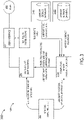
- the system 300 may include ground control (e.g., air traffic control (not shown)) and the aircraft 104, which may include at least one user 302, at least one user interface 304, at least one display unit computing device 306, sensors 308, at least one computing device 310A, at least one computing device 310B, and/or at least one computing device 310C, some or all of which may be communicatively coupled at any given time.
- ground control e.g., air traffic control (not shown)
- the aircraft 104 which may include at least one user 302, at least one user interface 304, at least one display unit computing device 306, sensors 308, at least one computing device 310A, at least one computing device 310B, and/or at least one computing device 310C, some or all of which may be communicatively coupled at any given time.
- the at least one display unit computing device 306, the at least one computing device 310A, the at least one computing device 310B, and/or the at least one computing device 310C may be implemented as a single computing device or any number of computing devices configured to perform any or all of the operations disclosed throughout.
- the user 302 may be a pilot or crew member.
- the user 302 may be configured to interface with the system via the user interface 304, for example, to engage, disengage, or override automatic changes to map ranges for the AMM and/or to enter information regarding an instructed taxi route.
- the at least one user interface 304 may be implemented as any suitable user interface, such as a touchscreen (e.g., of the display unit computing device 306 and/or another display unit), a multipurpose control panel, a cursor control panel, a keyboard, a mouse, a trackpad, a button, a switch, an eye tracking system, and/or a voice recognition system.
- the user interface 304 may be configured to receive a user selection and to output the user selection to a computing device (e.g., the display unit computing device 306).
- the display unit computing device 306 may be implemented as any suitable computing device, such as an MFW computing device. As shown in FIG. 4 , the display unit computing device 306 may include at least one display 402, at least one processor 404, at least one memory 406, and/or storage 408, some or all of which may be communicatively coupled at any given time.
- the processor 404 may be configured to run various software applications (e.g., a map window application) or computer code stored (e.g., maintained) in a non-transitory computer-readable medium (e.g., memory 406 and/or storage 408) and configured to execute various instructions or operations.
- the processor 404 may be configured to perform any or all of the operations disclosed throughout.
- the processor 404 may be configured to: receive sensor data from the sensors 308; execute the map window application; receive data and views of the AMM 102; receive taxi route data (e.g., instructed taxi route data or predicted taxi route data); receive approaching runway annunciations; receive taxi routing guidance content; output the views of the AMM to the display 402; and/or output the taxi routing guidance content to the display 402.
- the display 402 may be configured to: present the view of the AMM; and/or present the taxi routing guidance content.
- the sensors 308 may be any suitable sensors configured to output sensor data to another computing device (e.g., 306, 310A, and/or 310B).
- the sensors 308 may include any or all of the following: at least one global positioning system (GPS) sensor; at least one inertial reference system (IRS) sensor; at least one throttle position sensor; at least one aircraft position sensor; at least one groundspeed sensor; and/or any other sensors commonly installed in aircraft.
- GPS global positioning system
- IRS inertial reference system
- the sensors 308 may be configured to output sensor data (e.g., aircraft position and/or speed) to some or all of the computing devices (e.g., 306, 310A, 310B, and/or 310C).
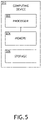
- the computing device 310A may be implemented as any suitable computing device, such as an AMM computing device. As shown in FIG. 5 , the computing device 310A may include the elements of the computing device 310 and may include at least one processor 502, at least one memory 504, and/or at least one storage 506, some or all of which may be communicatively coupled at any given time.
- the processor 502 may be configured to run various software applications (e.g., an AMM application) or computer code stored (e.g., maintained) in a non-transitory computer-readable medium (e.g., memory 504 and/or storage 506) and configured to execute various instructions or operations.
- the processor 502 of the computing device 310A may be configured to perform any or all of the operations disclosed throughout.
- the processor 502 of the computing device 310A may be configured to: receive sensor data from the sensors 308; receive aircraft state data and/or airport surface data; execute the AMM application; receive taxi route data; receive ownship data parameters (e.g., from the computing device 310C); generate data and views of an AMM; output, to the at least one display (e.g., 402), a view of an AMM, the AMM depicting a location of the aircraft 104 on an airport surface; based at least on the taxi route data, the aircraft state data, and the airport surface data, generate taxi routing guidance content, wherein the taxi route data includes information of a taxi route 202 for the aircraft 104 on the airport surface, wherein the taxi routing guidance content includes at least one of graphical or audio content to be presented to a flight crew to guide the aircraft 104 along the taxi route 202; and/or output (e.g., to the at least one display 402) the taxi routing guidance content.
- the taxi route data includes information of a taxi route 202 for the aircraft 104 on the
- the taxi routing guidance content may include the taxi route 202 (e.g., an instructed taxi route or a predicted taxi route), runway boundaries (e.g., 206A, 206B), textual guidance directions, arrows indicating to turn or move straight, at least one approaching runway annunciation, and/or audible cues or directions.
- the taxi route 202 e.g., an instructed taxi route or a predicted taxi route
- runway boundaries e.g., 206A, 206B
- textual guidance directions e.g., arrows indicating to turn or move straight, at least one approaching runway annunciation, and/or audible cues or directions.
- the aircraft state data includes the sensor data, is derived from the sensor data, or includes some sensor data and is derived from at least one other portion of the sensor data.
- the aircraft state data may include information of at least one of: an aircraft position relative to the airport surface or a ground speed of the aircraft 104.
- the computing device 310B may be implemented as any suitable computing device, such as an airport surface database computing device. As shown in FIG. 5 , the computing device 310B may include the elements of the computing device 310 and may include at least one processor 502, at least one memory 504, and/or at least one storage 506, some or all of which may be communicatively coupled at any given time.
- the processor 502 may be configured to run various software applications (e.g., a database application) or computer code stored (e.g., maintained) in a non-transitory computer-readable medium (e.g., memory 504 and/or storage 506) and configured to execute various instructions or operations.
- the processor 502 of the computing device 310B may be configured to perform any or all of the operations disclosed throughout. For example, the processor 502 of the computing device 310B may be configured to output airport surface data (which may be stored in the memory 504 and/or storage 506 of the computing device 310B) to the computing device 310A.
- the computing device 310C may be implemented as any suitable computing device, such as an aircraft details database computing device. As shown in FIG. 5 , the computing device 310C may include the elements of the computing device 310 and may include at least one processor 502, at least one memory 504, and/or at least one storage 506, some or all of which may be communicatively coupled at any given time.
- the processor 502 may be configured to run various software applications (e.g., a database application) or computer code stored (e.g., maintained) in a non-transitory computer-readable medium (e.g., memory 504 and/or storage 506) and configured to execute various instructions or operations.
- the processor 502 of the computing device 310C may be configured to perform any or all of the operations disclosed throughout.
- the processor 502 of the computing device 310C may be configured to output ownship data parameters (which may be stored in the memory 504 and/or storage 506 of the computing device 310B) to the computing device 310A.
- the ownship data parameters may include a current position of the aircraft 104, a ground speed of the aircraft 104, a direction of the aircraft 104, braking parameters of the aircraft 104, a size of the aircraft 104, a weight of the aircraft 104, an aircraft category of the aircraft 104, and/or common routes taken by other aircraft of a same category as the aircraft 104.
- aircraft categories may include any or all of the following: military aircraft (e.g., likely heading to or from hangars or other areas of the airport associated with military use; general aviation aircraft (e.g., likely heading to or from hangars or terminals typically used by general aviation aircraft; business aircraft (e.g., likely heading to or from a fixed base operator (FBO) area, such as a corporate jet likely heading to or from a corporate hangar; commercial aircraft (e.g., likely heading to or from a commercial terminal); carrier specific aircraft (e.g., a given airline aircraft likely heading to or from a terminal associated with the given airline; and/or cargo aircraft (e.g., likely going to or from cargo terminals, such as may be associated with a given cargo carrier (e.g., FedEx or UPS).
- military aircraft e.g., likely heading to or from hangars or other areas of the airport associated with military use
- general aviation aircraft e.g., likely heading to or from hangars or terminals typically used by general aviation aircraft
- business aircraft
- At least one processor may be configured to perform (e.g., collectively perform, if more than one processor) any or all of the operations disclosed throughout.
- the at least one processor may be configured to perform (e.g., collectively perform, if more than one processor) to perform any or all of the following: output, to the at least one display 402, a view of an airport moving map (AMM), the AMM depicting a location of an aircraft 104 on an airport surface; receive aircraft state data and airport surface data, wherein the airport surface data includes information of the airport surface, wherein the aircraft state data includes a current position of the aircraft 104, a ground speed, and/or a direction; based at least on taxi route data, the aircraft state data, and the airport surface data, generate taxi routing guidance content, wherein the taxi route data includes information of a taxi route 202 (e.g., an instructed taxi route or a predicted taxi route) for the aircraft
- AMM airport moving map
- the taxi routing guidance content further includes at least one approaching runway annunciation along the taxi route 202, wherein each of the at least one approaching runway annunciation indicates that the aircraft 104 is approaching a runway.
- the airport surface includes parallel runways, wherein the taxi route 202 includes at least one curve, wherein the at least one approaching runway annunciation ignores a given runway in front of the aircraft if the given runway is not along the taxi route 202.
- the at least one processor may be configured to determine a predicted taxi route 202 based at least on the airport surface data and ownship data parameters, wherein the ownship data parameters include the current position of the aircraft 104, a ground speed of the aircraft 104, a direction of the aircraft 104, braking parameters of the aircraft 104, a size of the aircraft 104, a weight of the aircraft 104, an aircraft category of the aircraft 104, and/or common routes taken by other aircraft of a same category as the aircraft 104.
- the ownship data parameters include the current position of the aircraft 104, a ground speed of the aircraft 104, a direction of the aircraft 104, braking parameters of the aircraft 104, a size of the aircraft 104, a weight of the aircraft 104, an aircraft category of the aircraft 104, and/or common routes taken by other aircraft of a same category as the aircraft 104.
- the airport surface data includes information of nodes and edges, wherein the at least one processor being configured to determine the predicted taxi route includes the at least one processor being configured to: determine possible valid maneuvers for possible valid taxi routes based at least on at least one proximate node proximate to the current position of the aircraft 104.
- the at least one processor being configured to determine possible valid maneuvers for possible valid taxi routes further includes the at least one processor being configured to: follow first edges connected to the at least one proximate node and subsequent edges connected back to the first edge via intervening edges such that the possible valid taxi routes are formed; and compute at least one metric (e.g., at least one of: a total distance of a given possible valid taxi route or a total estimated time to traverse the given possible valid taxi route) for each of the possible valid taxi routes.
- the at least one processor being configured to determine the possible valid maneuvers for possible valid taxi routes further includes the at least one processor being configured to: avoid edges that would cause the aircraft to traverse a given node a second time.
- the at least one processor being configured to determine the possible valid maneuvers for possible valid taxi routes further includes the at least one processor being configured to: only following edges within bounds of the aircraft's 104 orientation and maneuvering capabilities; and determine whether each of the possible valid taxi routes would trigger an approaching runway alert, wherein triggering the approaching runway alert occurs if (a) a cumulative route length of a given possible valid taxi route exceeds a defined threshold distance or (b) a cumulative time-to-intercept for the given possible valid taxi route exceeds a defined threshold duration.
- the at least one processor is further configured to determine the predicted taxi route at least by: comparing possible valid taxi routes to a predetermined list of typically used taxi routes.
- the at least one processor is configured to determine the predicted taxi route at least by: using at least one of artificial intelligence, neural network, or machine learning operations, such as exemplarily disclosed throughout.
- the AMM shows the aircraft 104, a taxi route 602 (e.g., an instructed taxi route or a predicted taxi route), and runway boundaries 606A, 606B.
- the AMM shows edges 702 and nodes 704.
- the aircraft 104 may follow the taxi route 602.
- the runway boundaries 606A, 606B indicate runway edges.
- the approaching runway alert might be triggered when the aircraft 104 is positioned at or near intersection 604 and the aircraft track is towards (e.g., momentarily towards) the runway boundary 606B.
- the approaching runway alert would not be annunciated for runway boundary 606B, and instead, would only be triggered when the conditions have been met and the aircraft is approaching runway boundary 606A.
- an exemplary embodiment of a method 800 may include one or more of the following steps. Additionally, for example, some embodiments may include performing one or more instances of the method 800 iteratively, concurrently, and/or sequentially. Additionally, for example, at least some of the steps of the method 800 may be performed in parallel and/or concurrently. Additionally, in some embodiments, at least some of the steps of the method 800 may be performed non-sequentially.
- a step 802 may include outputting, by at least one processor to at least one display, a view of an airport moving map (AMM), the AMM depicting a location of an aircraft on an airport surface, wherein the at least one processor is communicatively coupled to the at least one display.
- AMM airport moving map
- a step 804 may include receiving, by the at least one processor, aircraft state data and airport surface data, wherein the airport surface data includes information of the airport surface, wherein the aircraft state data includes a current position of the aircraft.
- a step 806 may include based at least on taxi route data, the aircraft state data, and the airport surface data, generating, by the at least one processor, taxi routing guidance content, wherein the taxi route data includes information of a taxi route for the aircraft on the airport surface, wherein the taxi routing guidance content includes at least one of graphical or audio content to be presented to a flight crew to guide the aircraft along the taxi route.
- a step 808 may include outputting, by the at least one processor to the at least one display, the taxi routing guidance content.
- a step 810 may include presenting, by the at least one display, the view of the AMM.
- a step 812 may include presenting, by the at least one display, the taxi routing guidance content.
- method 800 may include any of the operations disclosed throughout.
- embodiments of the inventive concepts disclosed herein may be directed to a system and a method configured to present a view of an AMM and taxi routing guidance content.
- At least one non-transitory computer-readable medium may refer to as at least one non-transitory computer-readable medium (e.g., at least one computer-readable medium implemented as hardware; e.g., at least one non-transitory processor-readable medium, at least one memory (e.g., at least one nonvolatile memory, at least one volatile memory, or a combination thereof; e.g., at least one random-access memory, at least one flash memory, at least one read-only memory (ROM) (e.g., at least one electrically erasable programmable read-only memory (EEPROM)), at least one on-processor memory (e.g., at least one on-processor cache, at least one on-processor buffer, at least one on-processor flash memory, at least one on-processor EEPROM, or a combination thereof), or a combination thereof), at least one storage device (e.g., at least one hard-disk drive, at
- At least one means one or a plurality of; for example, “at least one” may comprise one, two, three, ..., one hundred, or more.
- one or more means one or a plurality of; for example, “one or more” may comprise one, two, three, ..., one hundred, or more.
- zero or more means zero, one, or a plurality of; for example, “zero or more” may comprise zero, one, two, three, ..., one hundred, or more.
- the methods, operations, and/or functionality disclosed may be implemented as sets of instructions or software readable by a device. Further, it is understood that the specific order or hierarchy of steps in the methods, operations, and/or functionality disclosed are examples of exemplary approaches. Based upon design preferences, it is understood that the specific order or hierarchy of steps in the methods, operations, and/or functionality can be rearranged while remaining within the scope of the inventive concepts disclosed herein.
- the accompanying claims may present elements of the various steps in a sample order, and are not necessarily meant to be limited to the specific order or hierarchy presented.
- embodiments of the methods according to the inventive concepts disclosed herein may include one or more of the steps described herein. Further, such steps may be carried out in any desired order and two or more of the steps may be carried out simultaneously with one another. Two or more of the steps disclosed herein may be combined in a single step, and in some embodiments, one or more of the steps may be carried out as two or more sub-steps. Further, other steps or sub-steps may be carried in addition to, or as substitutes to one or more of the steps disclosed herein.
Landscapes
- Engineering & Computer Science (AREA)
- Radar, Positioning & Navigation (AREA)
- Remote Sensing (AREA)
- Physics & Mathematics (AREA)
- General Physics & Mathematics (AREA)
- Theoretical Computer Science (AREA)
- Automation & Control Theory (AREA)
- Aviation & Aerospace Engineering (AREA)
- Software Systems (AREA)
- General Engineering & Computer Science (AREA)
- Mathematical Physics (AREA)
- Computing Systems (AREA)
- Artificial Intelligence (AREA)
- Evolutionary Computation (AREA)
- Data Mining & Analysis (AREA)
- Life Sciences & Earth Sciences (AREA)
- Ecology (AREA)
- Biodiversity & Conservation Biology (AREA)
- Atmospheric Sciences (AREA)
- Medical Informatics (AREA)
- Computer Vision & Pattern Recognition (AREA)
- Computational Linguistics (AREA)
- Multimedia (AREA)
- General Health & Medical Sciences (AREA)
- Audiology, Speech & Language Pathology (AREA)
- Health & Medical Sciences (AREA)
- Human Computer Interaction (AREA)
- Environmental Sciences (AREA)
- Environmental & Geological Engineering (AREA)
- Educational Technology (AREA)
- Educational Administration (AREA)
- Business, Economics & Management (AREA)
- Traffic Control Systems (AREA)
- Computer Networks & Wireless Communication (AREA)
Abstract
Description
- Currently, flight crew members spend significant amounts of time determining a taxi route while on airport surfaces, which can detract from the flight crew's ability to perform other flight tasks. Flight crews benefit from being able to easily navigate airports to determine where an aircraft is and where the aircraft needs to go. Additionally, current implementations of approaching runway features fail to cover real-world situations, such as parallel taxiways or curved taxiways leading to runways.
- In one aspect, embodiments of the inventive concepts disclosed herein are directed to a system. The system may include a display and a processor communicatively coupled to the display. The processor may be configured to: output, to the display, a view of an airport moving map (AMM), the AMM depicting a location of an aircraft on an airport surface; receive aircraft state data and airport surface data, wherein the airport surface data includes information of the airport surface, wherein the aircraft state data includes a current position of the aircraft; based on taxi route data, the aircraft state data, and the airport surface data, generate taxi routing guidance content, wherein the taxi route data includes information of a taxi route for the aircraft on the airport surface, wherein the taxi routing guidance content includes graphical and/or audio content to be presented to a flight crew to guide the aircraft along the taxi route, wherein the taxi routing guidance content further includes an approaching runway annunciation along the taxi route, wherein the approaching runway annunciation indicates that the aircraft is approaching a runway; and output, to the display, the taxi routing guidance content. The display may be configured to: present the view of the AMM; and present the taxi routing guidance content.
- In a further aspect, embodiments of the inventive concepts disclosed herein are directed to a method. The method may include: outputting, by a processor to a display, a view of an airport moving map (AMM), the AMM depicting a location of an aircraft on an airport surface, wherein the processor is communicatively coupled to the display; receiving, by the processor, aircraft state data and airport surface data, wherein the airport surface data includes information of the airport surface, wherein the aircraft state data includes a current position of the aircraft; based on taxi route data, the aircraft state data, and the airport surface data, generating, by the processor, taxi routing guidance content, wherein the taxi route data includes information of a taxi route for the aircraft on the airport surface, wherein the taxi routing guidance content includes graphical and/or audio content to be presented to a flight crew to guide the aircraft along the taxi route, wherein the taxi routing guidance content further includes an approaching runway annunciation along the taxi route, wherein the approaching runway annunciation indicates that the aircraft is approaching a runway; outputting, by the processor to the display, the taxi routing guidance content; presenting, by the display, the view of the AMM; and presenting, by the display, the taxi routing guidance content.
- Implementations of the inventive concepts disclosed herein may be better understood when consideration is given to the following detailed description thereof. Such description makes reference to the included drawings, which are not necessarily to scale, and in which some features may be exaggerated and some features may be omitted or may be represented schematically in the interest of clarity. Like reference numerals in the drawings may represent and refer to the same or similar element, feature, or function. In the drawings:
-
FIG. 1 is an exemplary view of an AMM of an exemplary embodiment according to the inventive concepts disclosed herein. -
FIG. 2 is a further exemplary view of an AMM of an exemplary embodiment according to the inventive concepts disclosed herein. -
FIG. 3 is a view of an exemplary embodiment of a system including an aircraft according to the inventive concepts disclosed herein. -
FIG. 4 is a view of an exemplary embodiment of the display unit computing device ofFIG. 3 according to the inventive concepts disclosed herein. -
FIG. 5 is a view of an exemplary embodiment of a computing device ofFIG. 3 according to the inventive concepts disclosed herein. -
FIG. 6 is a further exemplary view of an AMM of an exemplary embodiment according to the inventive concepts disclosed herein. -
FIG. 7 is a further exemplary view of an AMM of an exemplary embodiment according to the inventive concepts disclosed herein. -
FIG. 8 is a diagram of an exemplary embodiment of a method according to the inventive concepts disclosed herein. - Before explaining at least one embodiment of the inventive concepts disclosed herein in detail, it is to be understood that the inventive concepts are not limited in their application to the details of construction and the arrangement of the components or steps or methodologies set forth in the following description or illustrated in the drawings. In the following detailed description of embodiments of the instant inventive concepts, numerous specific details are set forth in order to provide a more thorough understanding of the inventive concepts. However, it will be apparent to one of ordinary skill in the art having the benefit of the instant disclosure that the inventive concepts disclosed herein may be practiced without these specific details. In other instances, well-known features may not be described in detail to avoid unnecessarily complicating the instant disclosure. The inventive concepts disclosed herein are capable of other embodiments or of being practiced or carried out in various ways. Also, it is to be understood that the phraseology and terminology employed herein is for the purpose of description and should not be regarded as limiting.
- As used herein a letter following a reference numeral is intended to reference an embodiment of the feature or element that may be similar, but not necessarily identical, to a previously described element or feature bearing the same reference numeral (e.g., 1, 1a, 1b). Such shorthand notations are used for purposes of convenience only, and should not be construed to limit the inventive concepts disclosed herein in any way unless expressly stated to the contrary.
- Further, unless expressly stated to the contrary, "or" refers to an inclusive or and not to an exclusive or. For example, a condition A or B is satisfied by anyone of the following: A is true (or present) and B is false (or not present), A is false (or not present) and B is true (or present), and both A and B are true (or present).
- In addition, use of "a" or "an" are employed to describe elements and components of embodiments of the instant inventive concepts. This is done merely for convenience and to give a general sense of the inventive concepts, and "a" and "an" are intended to include one or at least one and the singular also includes the plural unless it is obvious that it is meant otherwise.
- Finally, as used herein any reference to "one embodiment," or "some embodiments" means that a particular element, feature, structure, or characteristic described in connection with the embodiment is included in at least one embodiment of the inventive concepts disclosed herein. The appearances of the phrase "in some embodiments" in various places in the specification are not necessarily all referring to the same embodiment, and embodiments of the inventive concepts disclosed may include one or more of the features expressly described or inherently present herein, or any combination or sub-combination of two or more such features, along with any other features which may not necessarily be expressly described or inherently present in the instant disclosure.
- Broadly, embodiments of the inventive concepts disclosed herein may be directed to a system and a method configured to present a view of an AMM and taxi routing guidance content.
- Some embodiments include use of a taxi route (e.g., an instructed taxi route or a predicted taxi route) along with a current aircraft position along the taxi route to determine when to provide an "approaching runway" annunciation to the crew. Some embodiments may provide a more robust functionality of the approaching runway feature functionality to alert the crew to nearing runways in more instances than just a straight-line approach. Informing the crew of approaching runways reduces the risk of unintentionally entering runways.
- Referring now to
FIG. 1 , an exemplary embodiment of anexemplary view 102 of an AMM according to the inventive concepts disclosed herein is depicted. The AMM may include a depiction of anaircraft 104. The AMM may utilize a multi-function window (MFW) map window to provide a more detailed view of airport map data (e.g., at ranges below 2 NM). Often, flight crews will utilize the AMM 102 map ranges (e.g., less than 2 NM) to provide a detailed representation of an airport during ground operations. As shown inFIG. 1 , theview 102 of the AMM has an exemplary map range. The AMM may provide a given level of detail within the map based on a selected map range (e.g., automatically declutters or clutters map details based on the selected map range). One of the features provided by the AMM 102 is the ability to determine when the aircraft's 104 ownship track is projected to intersect with a boundary(ies) of a runway and provide an annunciation (e.g., an approaching runway annunciation) to the crew to this effect. - In some embodiments, airport surface database(s) may include airport surface data, which includes information of an airport surface. Such airport surface databases may include the Airport Surface Database (ASDB) and/or the Airport Surface Routing Network
- (ASRN). For example, the ASRN is a data set containing "nodes" identifying the location and various other characteristics of navigable airport surface features (such as taxiway-taxiway intersections, runway-taxiway intersections, parking stands, etc.) and "edges" providing information how nodes are interconnected from a navigation standpoint. This information can be used to construct possible paths or routes from one location to another at a given airport.
- Currently, an aircraft's ownship track projection is a straight line extending some distance from a nose of such aircraft, and the aircraft's ownship track projection does not cover all possible scenarios that would correlate with real-world situations, such as situations involving parallel taxiways and/or curved taxiways leading to a runway.
- Some embodiments may include using a taxi route (e.g., an instructed taxi route or a predicted taxi route), aircraft state data, and airport surface data to generate taxi routing guidance content.
- Some embodiments may include using an instructed (e.g., an intended) taxi route that has been provided by ground control entered into the aircraft's computing device(s), and combining the instructed taxi route with airport surface data (e.g., ASRN data). The instructed taxi route may be entered via any suitable means, such as via a datalink and/or by interfacing with a user interface system (e.g., 304, as shown in
FIG. 3 ) (e.g., via voice, eye tracking, keyboard entry, mouse, and/or trackpad). Combining the instructed taxi route with the information provided in airport surface data may allow for taxi routing guidance. For example, by using a known current aircraft position and a known instructed taxi route, at least one processor may generate and provide a crew taxi routing guidance content, which may include at least one approaching runway annunciation. For example, the approaching runway annunciation may indicate that theaircraft 104 is approaching a runway along the instructed taxi route, which is accurate even if the instructed taxi route traverses and/or is proximate to parallel taxiways, curves, etc. - Some embodiments may include using a predicted taxi route. For example, in the absence of direct tum-by-turn taxi routing information to determine approaching runway annunciations, a predicted taxi route may be used as part of a more desirable solution. For example, by using airport surface data (e.g., from ASDB and/or ASRN) with various ownship data parameters (e.g., position, direction, speed, braking, aircraft size, aircraft weight, aircraft category, and/or typical/common taxi routes taken by these types of aircraft), some embodiments may be capable of predicting a most likely taxi route the
aircraft 104 will or should take. With the most likely taxi route determined, the system may initiate an approaching runway alert to be presented to the crew at appropriate times. At any given time, the system can determine a proximate node(s) in the ASRN (e.g., where theaircraft 104 is relative to ASRN data points). For example, by using this information, the system can determine the predicted taxi route at least in part by determining all possible valid maneuvers emanating from that node, by traversing the ASRN. - For example, determining all possible valid maneuvers emanating from that node may include: (a) following each edge from each node, while computing a metric for each route (e.g., a total distance, or a total estimated time based upon other data such as maneuvering speeds or distances); (b) avoiding edges which cause the route to traverse the same node a second time (e.g., to avoid circular routes); and/or (c) constraining each node by only following edges within bounds of the aircraft's 104 orientation and maneuvering capabilities (e.g. if the aircraft's 104 heading is North, then a South edge can be disregarded).
- Processing for a given possible taxi route may be complete when the system determines whether the given possible taxi route will or will not trigger an approaching runway alert (e.g., if the cumulative route length exceeds a defined threshold distance for alerting, or the cumulative time-to-intercept computed along the route exceeds a defined threshold duration, an alert would not be triggered based upon this particular route). In an opposite case, where a possible taxi route has been identified that, if taken, would result in the cumulative route length and/or time-to-intercept to be less than a defined threshold, an alert would be triggered, notifying the pilot of the approaching runway.
- Some embodiments may include other methods of determining a predicted taxi route, for example, to reduce a number of possible taxi routes to consider and/or to avoid nuisance alerts. For example, determining a predicted taxi route may include: comparing possible taxi routes to a list of typically used taxi routes; and if the possible taxi route is not among this list, a shorter distance or time-to-intercept could be used. For example, determining a predicted taxi route may include the use of artificial intelligence, neural network, and/or machine learning operations (e.g., determining the probability of a given possible taxi route being taken and/or using a weighting factor to dynamically adjust the distance and/or time-to-intercept thresholds).
- In at least one embodiment, Al, neural networks, or other machine learning algorithms may be employed to refine the relationships between an arbitrary set of input parameters and a set of outputs. Relevant data may also be logged and correlated to provide context for later process steps. AI and machine learning in general, and neural networks in particular, employ processing layers organized in a feed forward architecture where neurons (nodes) only receive inputs from the previous layer and deliver outputs only to the following layer, or a recurrent architecture, or some combination thereof. Each layer defines an activation function, comprised of neuron propagation functions, such as a Hyperbolic tangent function, a linear output function, and/or a logistic function, or some combination thereof. AI and machine learning in general, and neural networks in particular, utilize supervised learning conducted during the design phase to establish weighting factors and activation functions for each node. During supervised training, a designer may adjust one or more input biases or synaptic weights of the nodes in one or more processing layers of the neural network according to a loss function that defines an expected performance. Alternatively, or in addition, the designer may utilize certain training data sets, categorized as selection data sets, to choose a predictive model for use by the neural networks. During unsupervised training, the neural network adjusts one or more input biases or synaptic weights of the nodes in one or more processing layers according to an algorithm. In at least one embodiment, where the training data sets include both stable and unstable approaches, the training algorithm may comprise a first component to minimize disparity with approaches labeled "stable" and a second component to prevent close approximation with approaches labeled "unstable." A person skilled in the art may appreciate that maximizing disparity with unstable approaches may be undesirable until the neural network has been sufficiently trained or designed so as to define constraints of normal operation within which both stable and unstable approaches are conceivable. In at least one embodiment, training data sets may be categorized based on a defined level of stability or instability, and provided in ascending order of convergence such that the disparities between stable and unstable approaches diminish during training and necessary adjustments presumably become smaller over time according to first and second order deviations of the corresponding loss function. The loss function may define error according to mean square, root mean square, normalized square, a weighted square, or some combination thereof, where the gradient of the loss function may be calculated via backpropagation.
- Referring now to
FIG. 2 , an exemplary embodiment of an exemplary view of the AMM for an exemplary situation according to the inventive concepts disclosed herein is depicted. As shown, the AMM shows theaircraft 104, a taxi route 202 (e.g., an instructed taxi route or a predicted taxi route), anintersection 204, andrunway boundaries aircraft 104 is headed approximately north on thetaxi route 202, which includes curves. With respect to the intersection 204 (e.g., a taxiway intersection), current systems (e.g., using existing approaching runway indication logic) may trigger an approaching runway annunciation for therunway boundary 206A (e.g., identifying thatRWY 06 / 24 is being approached along the current track or direction of travel with the boundary at dotted line "A"); however,runway boundary 206A is not along thetaxi route 202, and therefore, such an unneeded approaching runway annunciation may distract the flight crew. Rather, thetaxi route 202 shows that the approaching runway indication should be triggered when within an appropriate predefined range ofrunway boundary 206B (e.g., to cross RWY 01 / 19) while following thetaxi route 202, regardless of current track or direction of travel at the shown current position of theaircraft 104. - Referring now to
FIGS. 3 ,4 and5 , an exemplary embodiment of asystem 300 according to the inventive concepts disclosed herein is depicted. In some embodiments, thesystem 300 may include ground control (e.g., air traffic control (not shown)) and theaircraft 104, which may include at least oneuser 302, at least oneuser interface 304, at least one displayunit computing device 306,sensors 308, at least onecomputing device 310A, at least onecomputing device 310B, and/or at least onecomputing device 310C, some or all of which may be communicatively coupled at any given time. In some embodiments, the at least one displayunit computing device 306, the at least onecomputing device 310A, the at least onecomputing device 310B, and/or the at least onecomputing device 310C may be implemented as a single computing device or any number of computing devices configured to perform any or all of the operations disclosed throughout. - The
user 302 may be a pilot or crew member. Theuser 302 may be configured to interface with the system via theuser interface 304, for example, to engage, disengage, or override automatic changes to map ranges for the AMM and/or to enter information regarding an instructed taxi route. The at least oneuser interface 304 may be implemented as any suitable user interface, such as a touchscreen (e.g., of the displayunit computing device 306 and/or another display unit), a multipurpose control panel, a cursor control panel, a keyboard, a mouse, a trackpad, a button, a switch, an eye tracking system, and/or a voice recognition system. Theuser interface 304 may be configured to receive a user selection and to output the user selection to a computing device (e.g., the display unit computing device 306). - The display
unit computing device 306 may be implemented as any suitable computing device, such as an MFW computing device. As shown inFIG. 4 , the displayunit computing device 306 may include at least onedisplay 402, at least oneprocessor 404, at least one memory 406, and/orstorage 408, some or all of which may be communicatively coupled at any given time. Theprocessor 404 may be configured to run various software applications (e.g., a map window application) or computer code stored (e.g., maintained) in a non-transitory computer-readable medium (e.g., memory 406 and/or storage 408) and configured to execute various instructions or operations. Theprocessor 404 may be configured to perform any or all of the operations disclosed throughout. For example, theprocessor 404 may be configured to: receive sensor data from thesensors 308; execute the map window application; receive data and views of theAMM 102; receive taxi route data (e.g., instructed taxi route data or predicted taxi route data); receive approaching runway annunciations; receive taxi routing guidance content; output the views of the AMM to thedisplay 402; and/or output the taxi routing guidance content to thedisplay 402. Thedisplay 402 may be configured to: present the view of the AMM; and/or present the taxi routing guidance content. - The
sensors 308 may be any suitable sensors configured to output sensor data to another computing device (e.g., 306, 310A, and/or 310B). For example, thesensors 308 may include any or all of the following: at least one global positioning system (GPS) sensor; at least one inertial reference system (IRS) sensor; at least one throttle position sensor; at least one aircraft position sensor; at least one groundspeed sensor; and/or any other sensors commonly installed in aircraft. Thesensors 308 may be configured to output sensor data (e.g., aircraft position and/or speed) to some or all of the computing devices (e.g., 306, 310A, 310B, and/or 310C). - The
computing device 310A may be implemented as any suitable computing device, such as an AMM computing device. As shown inFIG. 5 , thecomputing device 310A may include the elements of thecomputing device 310 and may include at least one processor 502, at least onememory 504, and/or at least onestorage 506, some or all of which may be communicatively coupled at any given time. The processor 502 may be configured to run various software applications (e.g., an AMM application) or computer code stored (e.g., maintained) in a non-transitory computer-readable medium (e.g.,memory 504 and/or storage 506) and configured to execute various instructions or operations. The processor 502 of thecomputing device 310A may be configured to perform any or all of the operations disclosed throughout. For example, the processor 502 of thecomputing device 310A may be configured to: receive sensor data from thesensors 308; receive aircraft state data and/or airport surface data; execute the AMM application; receive taxi route data; receive ownship data parameters (e.g., from thecomputing device 310C); generate data and views of an AMM; output, to the at least one display (e.g., 402), a view of an AMM, the AMM depicting a location of theaircraft 104 on an airport surface; based at least on the taxi route data, the aircraft state data, and the airport surface data, generate taxi routing guidance content, wherein the taxi route data includes information of ataxi route 202 for theaircraft 104 on the airport surface, wherein the taxi routing guidance content includes at least one of graphical or audio content to be presented to a flight crew to guide theaircraft 104 along thetaxi route 202; and/or output (e.g., to the at least one display 402) the taxi routing guidance content. In some embodiments, the taxi routing guidance content may include the taxi route 202 (e.g., an instructed taxi route or a predicted taxi route), runway boundaries (e.g., 206A, 206B), textual guidance directions, arrows indicating to turn or move straight, at least one approaching runway annunciation, and/or audible cues or directions. - In some embodiments, the aircraft state data includes the sensor data, is derived from the sensor data, or includes some sensor data and is derived from at least one other portion of the sensor data. For example, the aircraft state data may include information of at least one of: an aircraft position relative to the airport surface or a ground speed of the
aircraft 104. - The
computing device 310B may be implemented as any suitable computing device, such as an airport surface database computing device. As shown inFIG. 5 , thecomputing device 310B may include the elements of thecomputing device 310 and may include at least one processor 502, at least onememory 504, and/or at least onestorage 506, some or all of which may be communicatively coupled at any given time. The processor 502 may be configured to run various software applications (e.g., a database application) or computer code stored (e.g., maintained) in a non-transitory computer-readable medium (e.g.,memory 504 and/or storage 506) and configured to execute various instructions or operations. The processor 502 of thecomputing device 310B may be configured to perform any or all of the operations disclosed throughout. For example, the processor 502 of thecomputing device 310B may be configured to output airport surface data (which may be stored in thememory 504 and/orstorage 506 of thecomputing device 310B) to thecomputing device 310A. - The
computing device 310C may be implemented as any suitable computing device, such as an aircraft details database computing device. As shown inFIG. 5 , thecomputing device 310C may include the elements of thecomputing device 310 and may include at least one processor 502, at least onememory 504, and/or at least onestorage 506, some or all of which may be communicatively coupled at any given time. The processor 502 may be configured to run various software applications (e.g., a database application) or computer code stored (e.g., maintained) in a non-transitory computer-readable medium (e.g.,memory 504 and/or storage 506) and configured to execute various instructions or operations. The processor 502 of thecomputing device 310C may be configured to perform any or all of the operations disclosed throughout. For example, the processor 502 of thecomputing device 310C may be configured to output ownship data parameters (which may be stored in thememory 504 and/orstorage 506 of thecomputing device 310B) to thecomputing device 310A. For example, the ownship data parameters may include a current position of theaircraft 104, a ground speed of theaircraft 104, a direction of theaircraft 104, braking parameters of theaircraft 104, a size of theaircraft 104, a weight of theaircraft 104, an aircraft category of theaircraft 104, and/or common routes taken by other aircraft of a same category as theaircraft 104. For example, aircraft categories may include any or all of the following: military aircraft (e.g., likely heading to or from hangars or other areas of the airport associated with military use; general aviation aircraft (e.g., likely heading to or from hangars or terminals typically used by general aviation aircraft; business aircraft (e.g., likely heading to or from a fixed base operator (FBO) area, such as a corporate jet likely heading to or from a corporate hangar; commercial aircraft (e.g., likely heading to or from a commercial terminal); carrier specific aircraft (e.g., a given airline aircraft likely heading to or from a terminal associated with the given airline; and/or cargo aircraft (e.g., likely going to or from cargo terminals, such as may be associated with a given cargo carrier (e.g., FedEx or UPS). - For example, at least one processor (e.g., the at least one
processor 404, the at least one processor 502 of thecomputing device 310A, the at least one processor 502 of thecomputing device 310B, and/or the at least one processor 502 of thecomputing device 310C) may be configured to perform (e.g., collectively perform, if more than one processor) any or all of the operations disclosed throughout. - In some embodiments, the at least one processor (e.g., the at least one processor 404, the at least one processor 502 of the computing device 310A, the at least one processor 502 of the computing device 310B, and/or the at least one processor 502 of the computing device 310C) may be configured to perform (e.g., collectively perform, if more than one processor) to perform any or all of the following: output, to the at least one display 402, a view of an airport moving map (AMM), the AMM depicting a location of an aircraft 104 on an airport surface; receive aircraft state data and airport surface data, wherein the airport surface data includes information of the airport surface, wherein the aircraft state data includes a current position of the aircraft 104, a ground speed, and/or a direction; based at least on taxi route data, the aircraft state data, and the airport surface data, generate taxi routing guidance content, wherein the taxi route data includes information of a taxi route 202 (e.g., an instructed taxi route or a predicted taxi route) for the aircraft 104 on the airport surface, wherein the taxi routing guidance content includes at least one of graphical or audio content to be presented to a flight crew to guide the aircraft 104 along the taxi route 202; and/or output, to the at least one display 402, the taxi routing guidance content.
- In some embodiments, the taxi routing guidance content further includes at least one approaching runway annunciation along the
taxi route 202, wherein each of the at least one approaching runway annunciation indicates that theaircraft 104 is approaching a runway. In some embodiments, the airport surface includes parallel runways, wherein thetaxi route 202 includes at least one curve, wherein the at least one approaching runway annunciation ignores a given runway in front of the aircraft if the given runway is not along thetaxi route 202. - In some embodiments, the at least one processor (e.g., the at least one
processor 404, the at least one processor 502 of thecomputing device 310A, the at least one processor 502 of thecomputing device 310B, and/or the at least one processor 502 of thecomputing device 310C) may be configured to determine a predictedtaxi route 202 based at least on the airport surface data and ownship data parameters, wherein the ownship data parameters include the current position of theaircraft 104, a ground speed of theaircraft 104, a direction of theaircraft 104, braking parameters of theaircraft 104, a size of theaircraft 104, a weight of theaircraft 104, an aircraft category of theaircraft 104, and/or common routes taken by other aircraft of a same category as theaircraft 104. In some embodiments, the airport surface data includes information of nodes and edges, wherein the at least one processor being configured to determine the predicted taxi route includes the at least one processor being configured to: determine possible valid maneuvers for possible valid taxi routes based at least on at least one proximate node proximate to the current position of theaircraft 104. In some embodiments, the at least one processor being configured to determine possible valid maneuvers for possible valid taxi routes further includes the at least one processor being configured to: follow first edges connected to the at least one proximate node and subsequent edges connected back to the first edge via intervening edges such that the possible valid taxi routes are formed; and compute at least one metric (e.g., at least one of: a total distance of a given possible valid taxi route or a total estimated time to traverse the given possible valid taxi route) for each of the possible valid taxi routes. In some embodiments, the at least one processor being configured to determine the possible valid maneuvers for possible valid taxi routes further includes the at least one processor being configured to: avoid edges that would cause the aircraft to traverse a given node a second time. In some embodiments, the at least one processor being configured to determine the possible valid maneuvers for possible valid taxi routes further includes the at least one processor being configured to: only following edges within bounds of the aircraft's 104 orientation and maneuvering capabilities; and determine whether each of the possible valid taxi routes would trigger an approaching runway alert, wherein triggering the approaching runway alert occurs if (a) a cumulative route length of a given possible valid taxi route exceeds a defined threshold distance or (b) a cumulative time-to-intercept for the given possible valid taxi route exceeds a defined threshold duration. - In some embodiments, the at least one processor is further configured to determine the predicted taxi route at least by: comparing possible valid taxi routes to a predetermined list of typically used taxi routes.
- In some embodiments, the at least one processor is configured to determine the predicted taxi route at least by: using at least one of artificial intelligence, neural network, or machine learning operations, such as exemplarily disclosed throughout.
- Referring now to
FIGS. 6-7 , an exemplary embodiment of exemplary views of the AMM for an exemplary situation according to the inventive concepts disclosed herein is depicted. As shown inFIG. 6 , the AMM shows theaircraft 104, a taxi route 602 (e.g., an instructed taxi route or a predicted taxi route), andrunway boundaries FIG. 7 , the AMM showsedges 702 andnodes 704. As shown inFIG. 6 , theaircraft 104 may follow thetaxi route 602. Therunway boundaries aircraft 104 is positioned at or nearintersection 604 and the aircraft track is towards (e.g., momentarily towards) therunway boundary 606B. However, with respect to some embodiments, the approaching runway alert would not be annunciated forrunway boundary 606B, and instead, would only be triggered when the conditions have been met and the aircraft is approachingrunway boundary 606A. - Referring now to
FIG. 8 , an exemplary embodiment of amethod 800 according to the inventive concepts disclosed herein may include one or more of the following steps. Additionally, for example, some embodiments may include performing one or more instances of themethod 800 iteratively, concurrently, and/or sequentially. Additionally, for example, at least some of the steps of themethod 800 may be performed in parallel and/or concurrently. Additionally, in some embodiments, at least some of the steps of themethod 800 may be performed non-sequentially. - A
step 802 may include outputting, by at least one processor to at least one display, a view of an airport moving map (AMM), the AMM depicting a location of an aircraft on an airport surface, wherein the at least one processor is communicatively coupled to the at least one display. - A
step 804 may include receiving, by the at least one processor, aircraft state data and airport surface data, wherein the airport surface data includes information of the airport surface, wherein the aircraft state data includes a current position of the aircraft. - A
step 806 may include based at least on taxi route data, the aircraft state data, and the airport surface data, generating, by the at least one processor, taxi routing guidance content, wherein the taxi route data includes information of a taxi route for the aircraft on the airport surface, wherein the taxi routing guidance content includes at least one of graphical or audio content to be presented to a flight crew to guide the aircraft along the taxi route. - A
step 808 may include outputting, by the at least one processor to the at least one display, the taxi routing guidance content. - A
step 810 may include presenting, by the at least one display, the view of the AMM. - A
step 812 may include presenting, by the at least one display, the taxi routing guidance content. - Further, the
method 800 may include any of the operations disclosed throughout. - As will be appreciated from the above, embodiments of the inventive concepts disclosed herein may be directed to a system and a method configured to present a view of an AMM and taxi routing guidance content.
- As used throughout and as would be appreciated by those skilled in the art, "at least one non-transitory computer-readable medium" may refer to as at least one non-transitory computer-readable medium (e.g., at least one computer-readable medium implemented as hardware; e.g., at least one non-transitory processor-readable medium, at least one memory (e.g., at least one nonvolatile memory, at least one volatile memory, or a combination thereof; e.g., at least one random-access memory, at least one flash memory, at least one read-only memory (ROM) (e.g., at least one electrically erasable programmable read-only memory (EEPROM)), at least one on-processor memory (e.g., at least one on-processor cache, at least one on-processor buffer, at least one on-processor flash memory, at least one on-processor EEPROM, or a combination thereof), or a combination thereof), at least one storage device (e.g., at least one hard-disk drive, at least one tape drive, at least one solid-state drive, at least one flash drive, at least one readable and/or writable disk of at least one optical drive configured to read from and/or write to the at least one readable and/or writable disk, or a combination thereof), or a combination thereof).
- As used throughout, "at least one" means one or a plurality of; for example, "at least one" may comprise one, two, three, ..., one hundred, or more. Similarly, as used throughout, "one or more" means one or a plurality of; for example, "one or more" may comprise one, two, three, ..., one hundred, or more. Further, as used throughout, "zero or more" means zero, one, or a plurality of; for example, "zero or more" may comprise zero, one, two, three, ..., one hundred, or more.
- In the present disclosure, the methods, operations, and/or functionality disclosed may be implemented as sets of instructions or software readable by a device. Further, it is understood that the specific order or hierarchy of steps in the methods, operations, and/or functionality disclosed are examples of exemplary approaches. Based upon design preferences, it is understood that the specific order or hierarchy of steps in the methods, operations, and/or functionality can be rearranged while remaining within the scope of the inventive concepts disclosed herein. The accompanying claims may present elements of the various steps in a sample order, and are not necessarily meant to be limited to the specific order or hierarchy presented.
- It is to be understood that embodiments of the methods according to the inventive concepts disclosed herein may include one or more of the steps described herein. Further, such steps may be carried out in any desired order and two or more of the steps may be carried out simultaneously with one another. Two or more of the steps disclosed herein may be combined in a single step, and in some embodiments, one or more of the steps may be carried out as two or more sub-steps. Further, other steps or sub-steps may be carried in addition to, or as substitutes to one or more of the steps disclosed herein.
- From the above description, it is clear that the inventive concepts disclosed herein are well adapted to carry out the objects and to attain the advantages mentioned herein as well as those inherent in the inventive concepts disclosed herein. While presently preferred embodiments of the inventive concepts disclosed herein have been described for purposes of this disclosure, it will be understood that numerous changes may be made which will readily suggest themselves to those skilled in the art and which are within the scope of the invention as defined by the claims.
Claims (15)
- A system, comprising:at least one display (306); andat least one processor (502) communicatively coupled to the at least one display, the at least one processor configured to:output, to the at least one display, a view of an airport moving map, AMM, the AMM depicting a location of an aircraft on an airport surface;receive aircraft state data and airport surface data, wherein the airport surface data includes information of the airport surface, wherein the aircraft state data includes a current position of the aircraft;based at least on taxi route data, the aircraft state data, and the airport surface data, generate taxi routing guidance content, wherein the taxi route data includes information of a taxi route for the aircraft on the airport surface, wherein the taxi routing guidance content includes at least one of graphical or audio content to be presented to a flight crew to guide the aircraft along the taxi route, wherein the taxi routing guidance content further includes at least one approaching runway annunciation along the taxi route, wherein each of the at least one approaching runway annunciation indicates that the aircraft is approaching a runway; andoutput, to the at least one display, the taxi routing guidance content;wherein the at least one display is configured to:present the view of the AMM; andpresent the taxi routing guidance content.
- The system of claim 1, wherein the aircraft state data further includes a ground speed and a direction.
- The system of claim 1 or 2, wherein the airport surface includes parallel runways, wherein the taxi route includes at least one curve.
- The system of claim 3, wherein the at least one approaching runway annunciation ignores a given runway in front of the aircraft if the given runway is not along the taxi route.
- The system of any preceding claim, wherein the taxi route is instructed by ground control.
- The system of any of claims 1 to 4, wherein the taxi route is a predicted taxi route.
- The system of claim 6, wherein the at least one processor (502) is configured to determine the predicted taxi route based at least on the airport surface data and ownship data parameters, wherein the ownship data parameters include the current position of the aircraft, a ground speed of the aircraft, a direction of the aircraft, and at least two of: braking parameters of the aircraft, size of the aircraft, weight of the aircraft, aircraft category of the aircraft, or common routes taken by other aircraft of a same category as the aircraft.
- The system of claim 6, wherein the airport surface data includes information of nodes and edges, wherein the at least one processor being configured to determine the predicted taxi route includes the at least one processor being configured to: determine possible valid maneuvers for possible valid taxi routes based at least on at least one proximate node proximate to the current position of the aircraft.
- The system of claim 8, wherein the at least one processor (502) being configured to determine possible valid maneuvers for possible valid taxi routes further includes the at least one processor being configured to: follow first edges connected to the at least one proximate node and subsequent edges connected back to the first edge via intervening edges such that the possible valid taxi routes are formed; and compute at least one metric for each of the possible valid taxi routes.
- The system of claim 9, wherein the at least one metric includes at least one of: a total distance of a given possible valid taxi route or a total estimated time to traverse the given possible valid taxi route.
- The system of claim 10, wherein the at least one processor (502) being configured to determine the possible valid maneuvers for possible valid taxi routes further includes the at least one processor being configured to: avoid edges that would cause the aircraft to traverse a given node a second time.
- The system of claim 11, wherein the at least one processor (502) being configured to determine the possible valid maneuvers for possible valid taxi routes further includes the at least one processor being configured to: only following edges within bounds of the aircraft's orientation and maneuvering capabilities; and determine whether each of the possible valid taxi routes would trigger an approaching runway alert, wherein triggering the approaching runway alert occurs if (a) a cumulative route length of a given possible valid taxi route exceeds a defined threshold distance or (b) a cumulative time-to-intercept for the given possible valid taxi route exceeds a defined threshold duration.
- The system of claim 6, wherein the at least one processor (502) is further configured to determine the predicted taxi route at least by: comparing possible valid taxi routes to a predetermined list of typically used taxi routes.
- The system of claim 6, wherein the at least one processor is configured to determine the predicted taxi route at least by: using at least one of artificial intelligence, neural network, or machine learning operations.
- A method, comprising:outputting, by at least one processor (502) to at least one display (306), a view of an airport moving map, AMM, the AMM depicting a location of an aircraft on an airport surface, wherein the at least one processor is communicatively coupled to the at least one display;receiving, by the at least one processor, aircraft state data and airport surface data, wherein the airport surface data includes information of the airport surface, wherein the aircraft state data includes a current position of the aircraft;based at least on taxi route data, the aircraft state data, and the airport surface data, generating, by the at least one processor, taxi routing guidance content, wherein the taxi route data includes information of a taxi route for the aircraft on the airport surface, wherein the taxi routing guidance content includes at least one of graphical or audio content to be presented to a flight crew to guide the aircraft along the taxi route, wherein the taxi routing guidance content further includes at least one approaching runway annunciation along the taxi route, wherein each of the at least one approaching runway annunciation indicates that the aircraft is approaching a runway;outputting, by the at least one processor to the at least one display, the taxi routing guidance content;presenting, by the at least one display, the view of the AMM; andpresenting, by the at least one display, the taxi routing guidance content.
Applications Claiming Priority (1)
| Application Number | Priority Date | Filing Date | Title |
|---|---|---|---|
| US17/215,290 US12025456B2 (en) | 2021-03-29 | 2021-03-29 | System and method to display airport moving map and taxi routing guidance content |
Publications (1)
| Publication Number | Publication Date |
|---|---|
| EP4068246A1 true EP4068246A1 (en) | 2022-10-05 |
Family
ID=80999970
Family Applications (1)
| Application Number | Title | Priority Date | Filing Date |
|---|---|---|---|
| EP22165221.7A Ceased EP4068246A1 (en) | 2021-03-29 | 2022-03-29 | System and method to display airport moving map and taxi routing guidance content |
Country Status (2)
| Country | Link |
|---|---|
| US (1) | US12025456B2 (en) |
| EP (1) | EP4068246A1 (en) |
Families Citing this family (5)
| Publication number | Priority date | Publication date | Assignee | Title |
|---|---|---|---|---|
| EP4141843A1 (en) | 2021-08-27 | 2023-03-01 | Honeywell International Inc. | Aircraft taxi route generation |
| US12424114B2 (en) * | 2022-02-17 | 2025-09-23 | Airbus Sas | Method and apparatus for operating an aircraft having two engines |
| US12536914B2 (en) * | 2023-08-23 | 2026-01-27 | Honeywell International Inc. | Method and system for taxi assist path generation based on guidance lines of an airport |
| US20250078670A1 (en) * | 2023-08-31 | 2025-03-06 | Airbus Sas | Method for managing taxiing paths |
| EP4600936A1 (en) | 2024-02-09 | 2025-08-13 | ARINC Incorporated | Datalink message transformer apparatus |
Citations (7)
| Publication number | Priority date | Publication date | Assignee | Title |
|---|---|---|---|---|
| US20080106438A1 (en) * | 2006-11-02 | 2008-05-08 | The Boeing Company | Runway Status Indication and Traffic Information Display and Filtering |
| US8019529B1 (en) * | 2007-08-17 | 2011-09-13 | Rockwell Collins, Inc. | Runway and airport incursion alerting system and method |
| US20140278037A1 (en) * | 2013-03-16 | 2014-09-18 | Hardik Choksi | Aircraft taxiing system |
| US20160063869A1 (en) * | 2014-08-29 | 2016-03-03 | Honeywell International Inc. | System and method for displaying traffic and associated alerts on a three-dimensional airport moving map display |
| EP3200171A1 (en) * | 2016-01-28 | 2017-08-02 | Airbus Operations S.A.S. | Systems and methods for providing optimized taxiing path operation for an aircraft |
| US20180357911A1 (en) * | 2017-03-14 | 2018-12-13 | Architecture Technology Corporation | Advisor system and method |
| CN109754643A (en) * | 2019-01-29 | 2019-05-14 | 中国航空无线电电子研究所 | Ground taxi based on map guides system |
Family Cites Families (60)
| Publication number | Priority date | Publication date | Assignee | Title |
|---|---|---|---|---|
| GB1592780A (en) | 1976-12-21 | 1981-07-08 | Plessey Co Ltd | Frequency control systems |
| JPH02204787A (en) | 1989-02-02 | 1990-08-14 | Matsushita Electric Ind Co Ltd | How to display your computer |
| JPH06168001A (en) | 1992-11-28 | 1994-06-14 | Meiki Co Ltd | Setting/alteration device for control data by picture display |
| EP0880827A1 (en) | 1996-02-07 | 1998-12-02 | L.S. Research, Inc. | Digital wireless speaker system |
| WO1998052174A1 (en) | 1997-05-13 | 1998-11-19 | Leo Hatjasalo | Method and control system for operative traffic |
| US6535545B1 (en) | 1999-10-15 | 2003-03-18 | Rf Waves Ltd. | RF modem utilizing saw resonator and correlator and communications transceiver constructed therefrom |
| FR2814254B1 (en) | 2000-09-15 | 2006-07-21 | Thomson Csf | METHOD OF PROCESSING THE DISPLACEMENT OF A CURSOR ON A SCREEN |
| US6784869B1 (en) | 2000-11-15 | 2004-08-31 | The Boeing Company | Cursor and display management system for multi-function control and display system |
| FR2821446B1 (en) | 2001-02-26 | 2003-06-13 | Eads Airbus Sa | AIRCRAFT DIALOGUE DEVICE FOR DIALOGUE WITH AN AIRCRAFT SYSTEM |
| WO2003071228A2 (en) | 2002-02-19 | 2003-08-28 | Jeppesen Sanderson, Inc. | Airport taxway navigation system |
| US7375678B2 (en) | 2005-06-29 | 2008-05-20 | Honeywell International, Inc. | Displaying obstacles in perspective view |
| US7286062B2 (en) | 2005-06-29 | 2007-10-23 | Honeywell International, Inc. | Perspective view conformal traffic targets display |
| US7620095B2 (en) | 2006-06-14 | 2009-11-17 | Vishay Intertechnology Inc | RF modem utilizing saw device with pulse shaping and programmable frequency synthesizer |
| US7499794B1 (en) | 2006-09-28 | 2009-03-03 | Rockwell Collins, Inc. | System and method for improved mapping of a location |
| US7966125B2 (en) | 2006-11-29 | 2011-06-21 | The Boeing Company | System and method for terminal charts, airport maps and aeronautical context display |
| US7908082B2 (en) | 2007-05-04 | 2011-03-15 | The Boeing Company | Methods and systems for displaying airport moving map information |
| US7974773B1 (en) | 2007-06-21 | 2011-07-05 | Rockwell Collins, Inc. | Methods and devices of an aircraft taxi navigation system |
| US8159416B1 (en) | 2007-08-06 | 2012-04-17 | Rockwell Collins, Inc. | Synthetic vision dynamic field of view |
| FR2921190B1 (en) | 2007-09-18 | 2010-08-27 | Thales Sa | DEVICE FOR PRESENTING AND SELECTING DATA ON A DISPLAY SCREEN |
| US20100283636A1 (en) | 2007-11-14 | 2010-11-11 | The Boeing Company | Multi-function switches for a display |
| US8786467B2 (en) | 2007-11-14 | 2014-07-22 | The Boeing Company | Methods and systems for filtering traffic information for display |
| US8560214B1 (en) | 2008-06-06 | 2013-10-15 | Rockwell Collins, Inc. | Method and system for capturing and displaying aircraft taxi routes |
| US9189964B1 (en) | 2009-02-03 | 2015-11-17 | Rockwell Collins, Inc. | System, module, and method for presenting runway traffic information |
| US7965223B1 (en) | 2009-02-03 | 2011-06-21 | Rockwell Collins, Inc. | Forward-looking radar system, module, and method for generating and/or presenting airport surface traffic information |
| US8209122B2 (en) | 2009-03-27 | 2012-06-26 | Honeywell International Inc. | System and method for rendering visible features of a target location on a synthetic flight display |
| US9046369B2 (en) | 2009-04-29 | 2015-06-02 | Honeywell International Inc. | Methods and systems for updating a map in response to selection of content for display on the map |
| FR2949013B1 (en) | 2009-08-04 | 2011-07-22 | Thales Sa | AIRCRAFT GUIDING DEVICE FOR AIRCRAFT NAVIGATION AID |
| US8193948B1 (en) | 2009-09-30 | 2012-06-05 | Rockwell Collins, Inc. | System, module, and method for presenting runway advisory information to a pilot |
| US20110196598A1 (en) | 2010-02-09 | 2011-08-11 | Honeywell International Inc. | System and methods for rendering taxiway and runway signage in a synthetic display of an airport field |
| US20120194556A1 (en) | 2011-01-28 | 2012-08-02 | L3 Communications Avionics Systems, Inc. | 3d avionics viewpoint control system |
| US8698654B2 (en) | 2011-12-28 | 2014-04-15 | Honeywell International Inc. | System and method for selecting images to be displayed |
| US9222800B1 (en) | 2012-08-06 | 2015-12-29 | Rockwell Collins, Inc. | Taxi information presentation system, device, and method |
| US9347794B1 (en) | 2012-09-21 | 2016-05-24 | Rockwell Collins, Inc. | Image data combining systems and methods of multiple vision systems |
| EP2901178A4 (en) | 2012-09-27 | 2016-03-30 | Honeywell Int Inc | SYSTEMS AND METHODS FOR USING ADAPTIVE RADAR BEAM CONFIGURATION FOR WINGBORNE PROTECTION |
| US9527601B2 (en) | 2013-02-05 | 2016-12-27 | Honeywell International Inc. | Method and apparatus for generating a virtual inner marker for an aircraft landing approach |
| FR3004250B1 (en) | 2013-04-03 | 2015-03-27 | Thales Sa | METHOD FOR DETERMINING A TRACKING PATH OF AN AIRCRAFT ON AN AIRPORT ZONE. |
| FR3006050B1 (en) | 2013-05-27 | 2016-05-06 | Airbus Operations Sas | METHOD AND SYSTEM FOR AIDING NAVIGATION OF AN AIRCRAFT |
| US9000952B1 (en) | 2013-06-25 | 2015-04-07 | Rockwell Collins, Inc. | Airport surface information presentation methods for the pilot including taxi information |
| US9487304B1 (en) | 2013-09-10 | 2016-11-08 | Rockwell Collins, Inc. | Advisory generating system, device, and method |
| US9517844B2 (en) | 2013-09-25 | 2016-12-13 | Honeywell International Inc. | System and method for displaying airport features on a dynamic airport moving map display |
| US9718558B2 (en) | 2014-02-26 | 2017-08-01 | Honeywell International Inc. | Pilot centered system and method for decluttering aircraft displays |
| US9389082B2 (en) | 2014-03-25 | 2016-07-12 | Honeywell International Inc. | System and method for automatic generation of aerodrome surface movement models |
| WO2015150994A1 (en) | 2014-03-31 | 2015-10-08 | Bombardier Inc. | Cursor control for aircraft display device |
| US9523580B2 (en) | 2014-12-02 | 2016-12-20 | Honeywell International Inc. | System and method for aiding a pilot in locating an out of view landing site |
| US9996232B2 (en) | 2014-12-15 | 2018-06-12 | International Business Machines Corporation | Creating multiple cursors for duplicated entry |
| FR3030853B1 (en) * | 2014-12-19 | 2017-01-27 | Thales Sa | METHOD AND APPARATUS FOR CALCULATING A COMBINED AIR NAVIGATION GRAPH, METHOD AND SYSTEM FOR GENERATING AN AIRCRAFT GROUND TRAILER, COMPUTER PROGRAM PRODUCT |
| FR3030854B1 (en) | 2014-12-19 | 2017-01-27 | Thales Sa | METHOD AND SYSTEM FOR GENERATING A GROUND RUNWAY TRACK FROM AN AIRCRAFT IN A AIRPORT DOMAIN, COMPUTER PROGRAM PRODUCT |
| US9561865B2 (en) | 2015-02-16 | 2017-02-07 | Honeywell International Inc. | Systems and methods for improving positional awareness within an airport moving map |
| JP2016170951A (en) | 2015-03-12 | 2016-09-23 | 日本電子株式会社 | Phase plate, manufacturing method thereof, and electron microscope |
| US9799225B2 (en) | 2015-05-08 | 2017-10-24 | The Boeing Company | Method and apparatus for building a taxiing route |
| US11106329B2 (en) | 2015-09-18 | 2021-08-31 | Honeywell International Inc. | Flight deck display systems and methods for generating cockpit displays including dynamic taxi turnoff icons |
| FR3068481B1 (en) | 2017-06-29 | 2019-07-26 | Airbus Operations (S.A.S.) | DISPLAY SYSTEM AND METHOD FOR AN AIRCRAFT |
| US10796404B2 (en) | 2017-08-01 | 2020-10-06 | Honeywell International Inc. | Aircraft systems and methods for adjusting a displayed sensor image field of view |
| US10217371B1 (en) | 2017-08-22 | 2019-02-26 | Rosemount Aerospace Inc. | Method and system for aircraft taxi strike alerting using adaptive field of view |
| EP3476743A1 (en) | 2017-10-25 | 2019-05-01 | BAE SYSTEMS plc | Control of diverse types of crew interface for flight control |
| US10535276B2 (en) * | 2017-12-04 | 2020-01-14 | Ge Aviation Systems Llc | Route planning and movement of an aircraft on the ground based on a navigation model trained to increase aircraft operational efficiency |
| US20190228668A1 (en) | 2018-01-24 | 2019-07-25 | Honeywell International Inc. | Method and system for automatically predicting a surface movement path for an aircraft based on historical trajectory data |
| US10234303B1 (en) | 2018-02-28 | 2019-03-19 | Honeywell International Inc. | Methods and systems for providing visually automated in-cockpit aircraft docking guidance with use of airport moving map applications |
| CN110826788A (en) | 2019-10-30 | 2020-02-21 | 南京智慧航空研究院有限公司 | Airport scene variable slide-out time prediction method based on big data deep learning |
| US10789854B1 (en) | 2019-11-05 | 2020-09-29 | Rockwell Collins, Inc. | Graphical depiction of an exclusion zone on an airport movement surface |
-
2021
- 2021-03-29 US US17/215,290 patent/US12025456B2/en active Active
-
2022
- 2022-03-29 EP EP22165221.7A patent/EP4068246A1/en not_active Ceased
Patent Citations (7)
| Publication number | Priority date | Publication date | Assignee | Title |
|---|---|---|---|---|
| US20080106438A1 (en) * | 2006-11-02 | 2008-05-08 | The Boeing Company | Runway Status Indication and Traffic Information Display and Filtering |
| US8019529B1 (en) * | 2007-08-17 | 2011-09-13 | Rockwell Collins, Inc. | Runway and airport incursion alerting system and method |
| US20140278037A1 (en) * | 2013-03-16 | 2014-09-18 | Hardik Choksi | Aircraft taxiing system |
| US20160063869A1 (en) * | 2014-08-29 | 2016-03-03 | Honeywell International Inc. | System and method for displaying traffic and associated alerts on a three-dimensional airport moving map display |
| EP3200171A1 (en) * | 2016-01-28 | 2017-08-02 | Airbus Operations S.A.S. | Systems and methods for providing optimized taxiing path operation for an aircraft |
| US20180357911A1 (en) * | 2017-03-14 | 2018-12-13 | Architecture Technology Corporation | Advisor system and method |
| CN109754643A (en) * | 2019-01-29 | 2019-05-14 | 中国航空无线电电子研究所 | Ground taxi based on map guides system |
Non-Patent Citations (1)
| Title |
|---|
| HILTUNEN DANIELLE ET AL: "Cockpit Display of Traffic Information (CDTI) and Airport Moving Map Industry Survey", 1 August 2016 (2016-08-01), XP055784896, Retrieved from the Internet <URL:https://rosap.ntl.bts.gov/view/dot/12357> * |
Also Published As
| Publication number | Publication date |
|---|---|
| US12025456B2 (en) | 2024-07-02 |
| US20220307853A1 (en) | 2022-09-29 |
Similar Documents
| Publication | Publication Date | Title |
|---|---|---|
| EP4068246A1 (en) | System and method to display airport moving map and taxi routing guidance content | |
| US11724820B2 (en) | Decision-support system for aircraft requiring emergency landings | |
| KR101772556B1 (en) | Aircraft trajectory predicting method and system by real-time track data monitoring | |
| US10777086B2 (en) | Method for detecting conflicts between aircraft | |
| CA2634103C (en) | Automatic strategic offset function | |
| US9540005B1 (en) | Aircraft systems and methods with multiple SAP speed profiles | |
| US10380901B2 (en) | Method for automatically rejoining a reference vertical profile of an aircraft | |
| KR102901881B1 (en) | System and method for handling terrain in detect and avoid | |
| US10839701B2 (en) | Methods and systems for stabilized approach energy management | |
| US20250054399A1 (en) | System and method to display view of airport moving map depicting runway overrun awareness and alerting system (roaas)-based indicators | |
| US7917254B2 (en) | Aircraft guidance using localizer capture criteria for rectilinear displacement data | |
| CN101476892A (en) | Prioritizing alternative landing facilities in flight planning | |
| WO2009045664A2 (en) | Vehicle-based automatic traffic conflict and collision avoidance | |
| EP3816972B1 (en) | System and method to change svs mode | |
| US11525699B2 (en) | Radar vectoring energy management guidance methods and systems | |
| US11842629B2 (en) | Dynamic radar vectoring guidance methods and systems | |
| EP1899938A1 (en) | Method, apparatus, and database products for automated runway selection | |
| US9734728B2 (en) | Systems and methods for destination selection for vehicle indications and alerts | |
| US7941251B2 (en) | Consistent localizer captures | |
| US10788325B1 (en) | Systems and methods for hybrid graph and grid three-dimensional routing | |
| US12017792B2 (en) | System and method to change map range of airport moving map | |
| US20210304623A1 (en) | System and method to change map format and range for aircraft | |
| EP3819896B1 (en) | System and method to change synthetic vision system (svs) mode | |
| US12249244B2 (en) | System and method to display airport moving map and taxi routing guidance content for commonly used taxi route | |
| JP2020184316A (en) | Navigation performance in urban air vehicle |
Legal Events
| Date | Code | Title | Description |
|---|---|---|---|
| PUAI | Public reference made under article 153(3) epc to a published international application that has entered the european phase |
Free format text: ORIGINAL CODE: 0009012 |
|
| STAA | Information on the status of an ep patent application or granted ep patent |
Free format text: STATUS: THE APPLICATION HAS BEEN PUBLISHED |
|
| AK | Designated contracting states |
Kind code of ref document: A1 Designated state(s): AL AT BE BG CH CY CZ DE DK EE ES FI FR GB GR HR HU IE IS IT LI LT LU LV MC MK MT NL NO PL PT RO RS SE SI SK SM TR |
|
| STAA | Information on the status of an ep patent application or granted ep patent |
Free format text: STATUS: REQUEST FOR EXAMINATION WAS MADE |
|
| 17P | Request for examination filed |
Effective date: 20230329 |
|
| RBV | Designated contracting states (corrected) |
Designated state(s): AL AT BE BG CH CY CZ DE DK EE ES FI FR GB GR HR HU IE IS IT LI LT LU LV MC MK MT NL NO PL PT RO RS SE SI SK SM TR |
|
| STAA | Information on the status of an ep patent application or granted ep patent |
Free format text: STATUS: EXAMINATION IS IN PROGRESS |
|
| 17Q | First examination report despatched |
Effective date: 20240226 |
|
| STAA | Information on the status of an ep patent application or granted ep patent |
Free format text: STATUS: THE APPLICATION HAS BEEN REFUSED |
|
| 18R | Application refused |
Effective date: 20250917 |