EP4059829A1 - Sea route evaluation device, sea route evaluation program, and sea route evaluation method - Google Patents
Sea route evaluation device, sea route evaluation program, and sea route evaluation method Download PDFInfo
- Publication number
- EP4059829A1 EP4059829A1 EP22156608.6A EP22156608A EP4059829A1 EP 4059829 A1 EP4059829 A1 EP 4059829A1 EP 22156608 A EP22156608 A EP 22156608A EP 4059829 A1 EP4059829 A1 EP 4059829A1
- Authority
- EP
- European Patent Office
- Prior art keywords
- sea route
- evaluation
- created
- sea
- route
- Prior art date
- Legal status (The legal status is an assumption and is not a legal conclusion. Google has not performed a legal analysis and makes no representation as to the accuracy of the status listed.)
- Pending
Links
Images



Classifications
-
- G—PHYSICS
- G01—MEASURING; TESTING
- G01C—MEASURING DISTANCES, LEVELS OR BEARINGS; SURVEYING; NAVIGATION; GYROSCOPIC INSTRUMENTS; PHOTOGRAMMETRY OR VIDEOGRAMMETRY
- G01C21/00—Navigation; Navigational instruments not provided for in groups G01C1/00 - G01C19/00
- G01C21/20—Instruments for performing navigational calculations
- G01C21/203—Instruments for performing navigational calculations specially adapted for water-borne vessels
-
- B—PERFORMING OPERATIONS; TRANSPORTING
- B63—SHIPS OR OTHER WATERBORNE VESSELS; RELATED EQUIPMENT
- B63B—SHIPS OR OTHER WATERBORNE VESSELS; EQUIPMENT FOR SHIPPING
- B63B49/00—Arrangements of nautical instruments or navigational aids
Definitions
- the present invention relates to a sea route evaluation device, a sea route evaluation program, and a sea route evaluation method.
- the sea route created by the device is adjusted by the user, but the sea route conceived by the user is not evaluated. In response to this, it has been required to increase the motivation of the user himself/herself to find the optimal sea route by evaluating the sea route created by the user.
- an object of the present invention is to provide a sea route evaluation device, a sea route evaluation program, and a sea route evaluation method that can increase the motivation of a user to create a sea route.
- a sea route evaluation device including: a created sea route acquisition unit that acquires a sea route of a ship created by a user; and an evaluation unit that performs evaluation of the sea route acquired by the created sea route acquisition unit, in which the evaluation unit outputs the evaluation of the sea route to the user.
- the sea route evaluation device includes the evaluation unit that performs the evaluation of the sea route acquired by the created sea route acquisition unit. Accordingly, the evaluation unit can evaluate the sea route of the ship created by the user. Further, the evaluation unit can output the evaluation of the sea route to the user. Therefore, the user can easily identify the good or bad of the sea route created by himself/herself by referring to the evaluation of the sea route. In this way, the user identifies the evaluation of the sea route in an easy-to-understand manner, so that it is possible to increase the motivation of the user to create the sea route.
- the sea route evaluation device may further include a comparative sea route acquisition unit that acquires at least one of a sea route created by artificial intelligence and a sea route created in the past, as a comparative sea route, in which the evaluation unit may compare the comparative sea route with the sea route created by the user to output the evaluation of the sea route to the user.
- the user can identify the good or bad of the sea route created by himself/herself as compared with the sea route created by artificial intelligence or the sea route created in the past.
- the sea route evaluation device may further include a navigation assistance information computation unit that computes navigation assistance information based on an evaluation result by the evaluation unit. With this, the user can acquire the navigation assistance information based on the evaluation result, for the sea route created by himself/herself.
- a sea route evaluation program causing a computer to execute: a created sea route acquisition step of acquiring a sea route of a ship created by a user; and an evaluation step of performing evaluation of the sea route acquired in the created sea route acquisition step, in which in the evaluation step, the evaluation of the sea route is output to the user.
- a sea route evaluation method including: a created sea route acquisition step of acquiring a sea route of a ship created by a user; and an evaluation step of performing evaluation of the sea route acquired in the created sea route acquisition step, in which in the evaluation step, the evaluation of the sea route is output to the user.
- a sea route evaluation device a sea route evaluation program, and a sea route evaluation method that can increase the motivation of a user to create a sea route.
- FIG. 1 is a block diagram showing a sea route evaluation device 100 according to an embodiment of the present invention.
- the sea route evaluation device 100 is a device that evaluates the sea route of a ship created by a user.
- the sea route evaluation device 100 is provided in, for example, a ship.
- the sea route evaluation device 100 includes an input unit 2, an output unit 3, and a computation unit 10.
- the input unit 2 is a user interface that is used for the user to input various information to the computation unit 10.
- the input unit 2 is formed of an input device such as a keyboard, a touch panel, a mouse, and a microphone.
- the output unit 3 is a user interface that is used to output various information to the user based on the signal from the computation unit 10.
- the output unit 3 is formed of an output device such as a monitor and a speaker.
- the user operates the input unit 2 to create a sea route indicating a route from the departure point to the destination for navigation. In this case, the user may refer to the departure point, destination, and various other conditions that are output to the output unit 3.
- the computation unit 10 is a device that performs various computation for sea route evaluation.
- the computation unit 10 includes a processor, a memory, a storage, and a communication interface, and is formed as a general computer.
- the processor is a computation device such as a central processing unit (CPU).
- the memory is a storage medium such as a read only memory (ROM) or a random access memory (RAM).
- the storage is a storage medium such as a hard disk drive (HDD).
- the communication interface is a communication device that realizes data communication.
- the processor controls the memory, the storage, and the communication interface in an integrated manner, and realizes the function of the computation unit 10, which will described be later.
- the computation unit 10 realizes various functions by, for example, loading a program stored on the ROM into the RAM and executing the program loaded in the RAM using the CPU.
- the computation unit 10 may be formed of a plurality of computers.
- the computation unit 10 includes a created sea route acquisition unit 11, a comparative sea route acquisition unit 12, an evaluation unit 13, a navigation assistance information computation unit 14, and a database 16.
- the created sea route acquisition unit 11 acquires a created sea route R1 (see FIG. 2 ) of the ship created by the user.
- the created sea route acquisition unit 11 acquires the created sea route R1 created by the user operating the input unit 2.
- the created sea route acquisition unit 11 may acquire the created sea route R1, for example, through a storage medium such as a memory or by downloading the sea route from a network.
- the created sea route R1 created by the user includes at least information such as a departure point, a destination, a waypoint, and which route to take. For example, when heading from Tokyo to New York, the created sea route acquisition unit 11 sets the departure point to "Tokyo" and the destination to "New York", and acquires information such as how to cross the Pacific Ocean.
- the comparative sea route acquisition unit 12 acquires at least one of a sea route created by artificial intelligence (AI) and a sea route created in the past, as a comparative sea route.
- the comparative sea route acquisition unit 12 may acquire a comparative sea route R2 (see FIG. 2 ) by performing computation using artificial intelligence.
- the comparative sea route acquisition unit 12 has artificial intelligence that has been trained in advance using training data of a large number of past sea routes stored on the database 16.
- the artificial intelligence receives the input of information regarding navigation conditions, in addition to the same departure point, destination, and ship condition (size, weight of cargo, and the like) as those of the created sea route R1 created by the user, from the comparative sea route acquisition unit 12.
- the created sea route acquisition unit 11 acquires the result computed by the artificial intelligence using the input information, as a comparative sea route R2.
- the comparative sea route acquisition unit 12 may acquire a comparative sea route R3 (see FIG. 2 ) by selecting a sea route from among sea routes created in the past.
- the comparative sea route acquisition unit 12 collates information regarding navigation conditions, in addition to the same departure point, destination, and ship condition (size, weight of cargo, and the like) as those of the created sea route R1 created by the user with the data of the database 16 to select the comparative sea route R3.
- the comparative sea route acquisition unit 12 may acquire any sea route (for example, a sea route with the highest evaluation) as the comparative sea route R3.
- the comparative sea route acquisition unit 12 may select a sea route having similar conditions and acquire the sea route of which the conditions have been adjusted by computation, as the comparative sea route R3.
- Another terminal may create the comparative sea route R2 by artificial intelligence, or may select a past sea route as the comparative sea route R3.
- the comparative sea route acquisition unit 12 may acquire the comparative sea routes R2 and R3, for example, through a storage medium such as a memory or by downloading the sea routes from a network.
- the evaluation unit 13 evaluates the created sea route R1 acquired by the created sea route acquisition unit 11.
- the evaluation unit 13 scores the evaluation of the created sea route R1.
- the scoring is the conversion of the good or bad of the evaluation into numbers.
- the evaluation unit 13 may score the evaluation of the created sea route R1 by comparing the comparative sea routes R2 and R3 with the created sea route R1 created by the user.
- the evaluation unit 13 outputs the evaluation result using the output unit 3. It should be noted that how the evaluation unit 13 outputs the evaluation to the user is not particularly limited.
- the evaluation unit 13 may not score the evaluation, and output, for example, medals (gold, silver, bronze) or simple rankings that are not based on the scoring (the sea route of the own ship need only be compared with the other sea route) to the user, as the evaluation result.
- medals gold, silver, bronze
- simple rankings that are not based on the scoring (the sea route of the own ship need only be compared with the other sea route) to the user, as the evaluation result.
- the evaluation unit 13 computes each item to be evaluated for the created sea route R1 and the comparative sea routes R2 and R3.
- Examples of the item to be evaluated include “fuel consumption”, “difference from estimated time”, “CO 2 emission quantity”, “sulfur oxide (SO x ) emission quantity”, and “nitrogen oxide (NO x ) emission quantity”.
- the type of fuel may differ depending on the selection of the sea route. Therefore, the CO 2 emission quantity and the SO x or NO x emission quantity do not necessarily have a linear correlation with each other. Accordingly, the above evaluation item is added, so that more accurate evaluation is possible.
- the evaluation unit 13 compares the computation result of the created sea route R1 with the computation results of the comparative sea routes R2 and R3, for each item.
- the evaluation unit 13 determines whether the computation result of the created sea route R1 is better or worse than the computation results of the comparative sea routes R2 and R3, and scores how good or bad the computation result is.
- the evaluation unit 13 may show the computation result with a positive score in a case where the computation result of the created sea route R1 is better than the computation results of the comparative sea routes R2 and R3, and may increase the number as the computation result is better.
- the evaluation unit 13 may show the computation result with a negative score in a case where the computation result of the created sea route R1 is worse than the computation results of the comparative sea routes R2 and R3, and may increase the number as the computation result is worse. Further, the evaluation unit 13 may calculate the score for each item and then compute a score in which all the items are comprehensively evaluated.
- the method in which the evaluation unit 13 scores each item and the comprehensive evaluation is not particularly limited.
- an evaluation reference table may be stored on the database, and the evaluation unit 13 may calculate the score by collating the computation result with the evaluation reference table.
- the difference rate between the computation result of the created sea route R1 and the computation results of the comparative sea routes R2 and R3 may be associated with the size of the score.
- a mathematical expression that is used to calculate the score may be stored on the database, and the evaluation unit 13 may calculate the score using the mathematical expression.
- the evaluation unit 13 may output the evaluation result as shown in FIG. 3 , using the output unit 3.
- the column of "user” shows the computation result of each item for the created sea route R1.
- the column of "reference calculated from AI and another person in past” shows the computation result of each item for the comparative sea routes R2 and R3.
- a reference decided by arbitrarily selecting any one of the computation result of the comparative sea route R2, the computation result of the comparative sea route R3, and the average of the comparative sea route R2 and the comparative sea route R3 is shown.
- the score which shows the computation result of each item for the comparative sea routes R2 and R3, is negative because the fuel consumption of the created sea route R1 is higher than the fuel consumption of the comparative sea routes R2 and R3.
- the score is positive because the difference from the estimated time of the created sea route R1 is smaller than the difference from the estimated time of the comparative sea routes R2 and R3.
- the score is positive because the CO 2 emission quantity of the created sea route R1 is smaller than the CO 2 emission quantity of the comparative sea routes R2 and R3.
- the evaluation unit 13 evaluates the effect of reducing the CO 2 emission quantity higher than the effect of reducing the difference from the estimated time, to give a higher score to the effect of reducing the CO 2 emission quantity. Further, the evaluation unit 13 computes the total of the score of each item as a comprehensive evaluation for each item.
- the evaluation unit 13 may make a difference in the importance of each evaluation item by multiplying the computed score of each evaluation item by any coefficient to obtain the final score.
- the output unit 3 may output the evaluation result as shown in FIG. 4 .
- the evaluation unit 13 obtains the final score by multiplying each item of the evaluation result shown in FIG. 3 by an arbitrarily set coefficient.
- the timing at which the evaluation unit 13 performs evaluation is not particularly limited.
- the evaluation unit 13 may perform evaluation at the time of departure or before departure.
- the evaluation unit 13 computes the evaluation for the created sea route R1 based on the estimation.
- the evaluation unit 13 may perform evaluation after arrival at the destination.
- the evaluation unit 13 since the created sea route R1 is a sea route that has been used in the actual navigation, the evaluation unit 13 may evaluate the created sea route R1 based on the actual navigation result. For example, the evaluation unit 13 can evaluate the fuel consumption of the created sea route R1 based on the fuel actually used.
- the navigation assistance information computation unit 14 computes navigation assistance information based on the score evaluated by the evaluation unit 13.
- the navigation assistance information is information that can be used to assist the user in navigating a ship.
- the navigation assistance information computation unit 14 may output a comment regarding the created sea route R1 to the output unit 3 based on the score.
- the navigation assistance information computation unit 14 may output advice on which sea route should be set in order to improve fuel consumption.
- the navigation assistance information computation unit 14 may propose that it is better to adopt the comparative sea routes R2 and R3 instead of the created sea route R1.
- the navigation assistance information computation unit 14 may automatically correct the created sea route R1, for example, such that the created sea route R1 has a higher score and may propose the corrected sea route.
- the navigation assistance information computation unit 14 may provide navigation assistance information in which the user can change/adjust the created sea route R1 based on the evaluation.
- the navigation assistance information can be provided as information that can be useful for the next and subsequent navigation, to be used to assist the user in navigating the ship.
- the database 16 stores information that is used to perform various processing in the sea route evaluation device 100.
- the database 16 may store a plurality of past sea routes that are used to create the comparative sea route R3.
- the database 16 may store, for example, a plurality of evaluation reference tables that are used for the evaluation unit 13 to perform evaluation.
- FIG. 5 is a flowchart showing processing contents of the sea route evaluation method according to the present embodiment.
- the created sea route acquisition unit 11 acquires the created sea route R1 of the ship created by the user (step S10: created sea route acquisition step).
- the comparative sea route acquisition unit 12 acquires the comparative sea routes R2 and R3 (step S20).
- step S30 evaluates the created sea route R1 acquired in the created sea route acquisition step S10 (step S30: evaluation step).
- the evaluation unit 13 evaluates the created sea route R1 by comparing the created sea route R1 with the comparative sea routes R2 and R3.
- the evaluation of the created sea route R1 is scored.
- the evaluation unit 13 outputs the evaluation result scored in the evaluation step S30 using the output unit 3 (step S40). As a result, the processing shown in FIG. 5 is completed.
- the sea route evaluation device 100 includes the evaluation unit 13 that evaluates the created sea route R1 acquired by the created sea route acquisition unit 11. Therefore, the evaluation unit 13 can evaluate the created sea route R1 of the ship created by the user. Further, the evaluation unit 13 can output the evaluation of the created sea route R1 to the user. Therefore, the user can easily identify the good or bad of the created sea route R1 created by himself/herself by referring to the evaluation result of the created sea route R1. In this way, the user identifies the evaluation of the created sea route R1 in an easy-to-understand manner, so that it is possible to increase the motivation of the user to create the sea route. It is also possible to use the score of the evaluation unit for the evaluation of a sailor.
- the sea route evaluation device 100 may further include the comparative sea route acquisition unit 12 that acquires at least one of a sea route created by artificial intelligence and a sea route created in the past, as a comparative sea route, in which the evaluation unit 13 may compare the comparative sea route with the created sea route R1 created by the user to output the evaluation of the created sea route R1 to the user. With this, the user can identify the good or bad of the created sea route R1 created by himself/herself as compared with the comparative sea route R2 created by artificial intelligence or the comparative sea route R3 created in the past.
- the sea route evaluation device 100 may further include the navigation assistance information computation unit 14 that computes navigation assistance information based on the evaluation result evaluated by the evaluation unit 13. With this, the user can acquire navigation assistance information based on the evaluation result, for the created sea route R1 created by himself/herself.
- the sea route evaluation program causes a computer to execute the created sea route acquisition step S10 of acquiring the created sea route R1 of the ship created by the user, and the evaluation step S30 of evaluating the created sea route R1 acquired in the created sea route acquisition step S10, in which in the evaluation step S30, the evaluation of the created sea route R1 is output to the user.
- the sea route evaluation method includes the created sea route acquisition step S10 of acquiring the created sea route R1 of the ship created by the user, and the evaluation step S30 of evaluating the created sea route R1 acquired in the created sea route acquisition step S10, in which in the evaluation step S30, the evaluation of the created sea route R1 is scored.
- the present invention is not limited to the above-described embodiment.
- the evaluation unit 13 evaluates the created sea route by comparing the created sea route with the comparative sea route, but the evaluation method is not particularly limited, and the evaluation may be performed without comparing the created sea route with the comparative sea route.
Landscapes
- Engineering & Computer Science (AREA)
- Radar, Positioning & Navigation (AREA)
- Remote Sensing (AREA)
- Automation & Control Theory (AREA)
- Physics & Mathematics (AREA)
- General Physics & Mathematics (AREA)
- Navigation (AREA)
Abstract
Provided are a sea route evaluation device (100), a sea route evaluation program, and a sea route evaluation method that can increase the motivation of a user to create a sea route.A sea route evaluation device (100) includes an evaluation unit (13) that performs evaluation of a created sea route (R1) acquired by a created sea route acquisition unit (11). Therefore, the evaluation unit (13) can evaluate the created sea route (R1) of the ship created by the user. Further, the evaluation unit (13) can output the evaluation of the created sea route (R1) to the user. Therefore, the user can easily identify the good or bad of the created sea route (R1) created by himself/herself by referring to the evaluation result of the created sea route (R1). In this way, the user identifies the evaluation of the created sea route (R1) in an easy-to-understand manner, so that it is possible to increase the motivation of the user to create the sea route.
Description
- The present invention relates to a sea route evaluation device, a sea route evaluation program, and a sea route evaluation method.
- There has been known a device described in
Japanese Unexamined Patent Publication No. 2007-57499 - Here, in the device as described above, the sea route created by the device is adjusted by the user, but the sea route conceived by the user is not evaluated. In response to this, it has been required to increase the motivation of the user himself/herself to find the optimal sea route by evaluating the sea route created by the user.
- In that regard, an object of the present invention is to provide a sea route evaluation device, a sea route evaluation program, and a sea route evaluation method that can increase the motivation of a user to create a sea route.
- There is provided a sea route evaluation device according to the present invention including: a created sea route acquisition unit that acquires a sea route of a ship created by a user; and an evaluation unit that performs evaluation of the sea route acquired by the created sea route acquisition unit, in which the evaluation unit outputs the evaluation of the sea route to the user.
- The sea route evaluation device includes the evaluation unit that performs the evaluation of the sea route acquired by the created sea route acquisition unit. Accordingly, the evaluation unit can evaluate the sea route of the ship created by the user. Further, the evaluation unit can output the evaluation of the sea route to the user. Therefore, the user can easily identify the good or bad of the sea route created by himself/herself by referring to the evaluation of the sea route. In this way, the user identifies the evaluation of the sea route in an easy-to-understand manner, so that it is possible to increase the motivation of the user to create the sea route.
- The sea route evaluation device may further include a comparative sea route acquisition unit that acquires at least one of a sea route created by artificial intelligence and a sea route created in the past, as a comparative sea route, in which the evaluation unit may compare the comparative sea route with the sea route created by the user to output the evaluation of the sea route to the user. With this, the user can identify the good or bad of the sea route created by himself/herself as compared with the sea route created by artificial intelligence or the sea route created in the past.
- The sea route evaluation device may further include a navigation assistance information computation unit that computes navigation assistance information based on an evaluation result by the evaluation unit. With this, the user can acquire the navigation assistance information based on the evaluation result, for the sea route created by himself/herself.
- There is provided a sea route evaluation program according to the present invention causing a computer to execute: a created sea route acquisition step of acquiring a sea route of a ship created by a user; and an evaluation step of performing evaluation of the sea route acquired in the created sea route acquisition step, in which in the evaluation step, the evaluation of the sea route is output to the user.
- There is provided a sea route evaluation method according to the present invention including: a created sea route acquisition step of acquiring a sea route of a ship created by a user; and an evaluation step of performing evaluation of the sea route acquired in the created sea route acquisition step, in which in the evaluation step, the evaluation of the sea route is output to the user.
- With the sea route evaluation program and the sea route evaluation method according to the present invention, the same operations and effects as those of the above-described sea route evaluation device can be obtained.
- According to the present invention, it is possible to provide a sea route evaluation device, a sea route evaluation program, and a sea route evaluation method that can increase the motivation of a user to create a sea route.
-
-
FIG. 1 is a block diagram showing a sea route evaluation device according to an embodiment of the present invention. -
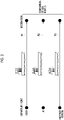
FIG. 2 is a conceptual diagram showing a state in which a created sea route and a comparative sea route are compared with each other and are evaluated. -
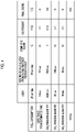
FIG. 3 is a table showing an example of an evaluation result. -
FIG. 4 is a table showing another example of the evaluation result. -
FIG. 5 is a flowchart showing processing contents of a sea route evaluation method according to the embodiment of the present invention. - Hereinafter, a preferred embodiment of the present invention will be described in detail with reference to the accompanying drawings. In the following description, the same or corresponding portions will be designated by the same reference numerals, and duplicate description will not be repeated.
-
FIG. 1 is a block diagram showing a searoute evaluation device 100 according to an embodiment of the present invention. The searoute evaluation device 100 is a device that evaluates the sea route of a ship created by a user. The searoute evaluation device 100 is provided in, for example, a ship. As shown inFIG. 1 , the searoute evaluation device 100 includes aninput unit 2, anoutput unit 3, and acomputation unit 10. - The
input unit 2 is a user interface that is used for the user to input various information to thecomputation unit 10. Theinput unit 2 is formed of an input device such as a keyboard, a touch panel, a mouse, and a microphone. Theoutput unit 3 is a user interface that is used to output various information to the user based on the signal from thecomputation unit 10. Theoutput unit 3 is formed of an output device such as a monitor and a speaker. In the present embodiment, the user operates theinput unit 2 to create a sea route indicating a route from the departure point to the destination for navigation. In this case, the user may refer to the departure point, destination, and various other conditions that are output to theoutput unit 3. - The
computation unit 10 is a device that performs various computation for sea route evaluation. Thecomputation unit 10 includes a processor, a memory, a storage, and a communication interface, and is formed as a general computer. The processor is a computation device such as a central processing unit (CPU). The memory is a storage medium such as a read only memory (ROM) or a random access memory (RAM). The storage is a storage medium such as a hard disk drive (HDD). The communication interface is a communication device that realizes data communication. The processor controls the memory, the storage, and the communication interface in an integrated manner, and realizes the function of thecomputation unit 10, which will described be later. Thecomputation unit 10 realizes various functions by, for example, loading a program stored on the ROM into the RAM and executing the program loaded in the RAM using the CPU. Thecomputation unit 10 may be formed of a plurality of computers. Thecomputation unit 10 includes a created searoute acquisition unit 11, a comparative searoute acquisition unit 12, anevaluation unit 13, a navigation assistanceinformation computation unit 14, and adatabase 16. - The created sea
route acquisition unit 11 acquires a created sea route R1 (seeFIG. 2 ) of the ship created by the user. The created searoute acquisition unit 11 acquires the created sea route R1 created by the user operating theinput unit 2. Alternatively, in a case where the user creates a sea route with another terminal, the created searoute acquisition unit 11 may acquire the created sea route R1, for example, through a storage medium such as a memory or by downloading the sea route from a network. The created sea route R1 created by the user includes at least information such as a departure point, a destination, a waypoint, and which route to take. For example, when heading from Tokyo to New York, the created searoute acquisition unit 11 sets the departure point to "Tokyo" and the destination to "New York", and acquires information such as how to cross the Pacific Ocean. - The comparative sea
route acquisition unit 12 acquires at least one of a sea route created by artificial intelligence (AI) and a sea route created in the past, as a comparative sea route. The comparative searoute acquisition unit 12 may acquire a comparative sea route R2 (seeFIG. 2 ) by performing computation using artificial intelligence. In this case, the comparative searoute acquisition unit 12 has artificial intelligence that has been trained in advance using training data of a large number of past sea routes stored on thedatabase 16. The artificial intelligence receives the input of information regarding navigation conditions, in addition to the same departure point, destination, and ship condition (size, weight of cargo, and the like) as those of the created sea route R1 created by the user, from the comparative searoute acquisition unit 12. The created searoute acquisition unit 11 acquires the result computed by the artificial intelligence using the input information, as a comparative sea route R2. Alternatively, the comparative searoute acquisition unit 12 may acquire a comparative sea route R3 (seeFIG. 2 ) by selecting a sea route from among sea routes created in the past. The comparative searoute acquisition unit 12 collates information regarding navigation conditions, in addition to the same departure point, destination, and ship condition (size, weight of cargo, and the like) as those of the created sea route R1 created by the user with the data of thedatabase 16 to select the comparative sea route R3. In a case where a plurality of sea routes having the same conditions are found, the comparative searoute acquisition unit 12 may acquire any sea route (for example, a sea route with the highest evaluation) as the comparative sea route R3. Alternatively, in a case where a sea route having the same conditions is not found from thedatabase 16, the comparative searoute acquisition unit 12 may select a sea route having similar conditions and acquire the sea route of which the conditions have been adjusted by computation, as the comparative sea route R3. - Another terminal may create the comparative sea route R2 by artificial intelligence, or may select a past sea route as the comparative sea route R3. In this case, the comparative sea
route acquisition unit 12 may acquire the comparative sea routes R2 and R3, for example, through a storage medium such as a memory or by downloading the sea routes from a network. - The
evaluation unit 13 evaluates the created sea route R1 acquired by the created searoute acquisition unit 11. Theevaluation unit 13 scores the evaluation of the created sea route R1. The scoring is the conversion of the good or bad of the evaluation into numbers. Theevaluation unit 13 may score the evaluation of the created sea route R1 by comparing the comparative sea routes R2 and R3 with the created sea route R1 created by the user. Theevaluation unit 13 outputs the evaluation result using theoutput unit 3. It should be noted that how theevaluation unit 13 outputs the evaluation to the user is not particularly limited. For example, theevaluation unit 13 may not score the evaluation, and output, for example, medals (gold, silver, bronze) or simple rankings that are not based on the scoring (the sea route of the own ship need only be compared with the other sea route) to the user, as the evaluation result. - The
evaluation unit 13 computes each item to be evaluated for the created sea route R1 and the comparative sea routes R2 and R3. Examples of the item to be evaluated include "fuel consumption", "difference from estimated time", "CO2 emission quantity", "sulfur oxide (SOx) emission quantity", and "nitrogen oxide (NOx) emission quantity". The type of fuel may differ depending on the selection of the sea route. Therefore, the CO2 emission quantity and the SOx or NOx emission quantity do not necessarily have a linear correlation with each other. Accordingly, the above evaluation item is added, so that more accurate evaluation is possible. Theevaluation unit 13 compares the computation result of the created sea route R1 with the computation results of the comparative sea routes R2 and R3, for each item. Theevaluation unit 13 determines whether the computation result of the created sea route R1 is better or worse than the computation results of the comparative sea routes R2 and R3, and scores how good or bad the computation result is. Theevaluation unit 13 may show the computation result with a positive score in a case where the computation result of the created sea route R1 is better than the computation results of the comparative sea routes R2 and R3, and may increase the number as the computation result is better. Theevaluation unit 13 may show the computation result with a negative score in a case where the computation result of the created sea route R1 is worse than the computation results of the comparative sea routes R2 and R3, and may increase the number as the computation result is worse. Further, theevaluation unit 13 may calculate the score for each item and then compute a score in which all the items are comprehensively evaluated. - The method in which the
evaluation unit 13 scores each item and the comprehensive evaluation is not particularly limited. For example, an evaluation reference table may be stored on the database, and theevaluation unit 13 may calculate the score by collating the computation result with the evaluation reference table. For example, in the evaluation reference table, the difference rate between the computation result of the created sea route R1 and the computation results of the comparative sea routes R2 and R3 may be associated with the size of the score. Alternatively, a mathematical expression that is used to calculate the score may be stored on the database, and theevaluation unit 13 may calculate the score using the mathematical expression. - For example, the
evaluation unit 13 may output the evaluation result as shown inFIG. 3 , using theoutput unit 3. In the table ofFIG. 3 , the column of "user" shows the computation result of each item for the created sea route R1. The column of "reference calculated from AI and another person in past" shows the computation result of each item for the comparative sea routes R2 and R3. Here, a reference decided by arbitrarily selecting any one of the computation result of the comparative sea route R2, the computation result of the comparative sea route R3, and the average of the comparative sea route R2 and the comparative sea route R3 is shown. The score, which shows the computation result of each item for the comparative sea routes R2 and R3, is negative because the fuel consumption of the created sea route R1 is higher than the fuel consumption of the comparative sea routes R2 and R3. The score is positive because the difference from the estimated time of the created sea route R1 is smaller than the difference from the estimated time of the comparative sea routes R2 and R3. The score is positive because the CO2 emission quantity of the created sea route R1 is smaller than the CO2 emission quantity of the comparative sea routes R2 and R3. Theevaluation unit 13 evaluates the effect of reducing the CO2 emission quantity higher than the effect of reducing the difference from the estimated time, to give a higher score to the effect of reducing the CO2 emission quantity. Further, theevaluation unit 13 computes the total of the score of each item as a comprehensive evaluation for each item. - Further, the
evaluation unit 13 may make a difference in the importance of each evaluation item by multiplying the computed score of each evaluation item by any coefficient to obtain the final score. For example, theoutput unit 3 may output the evaluation result as shown inFIG. 4 . Theevaluation unit 13 obtains the final score by multiplying each item of the evaluation result shown inFIG. 3 by an arbitrarily set coefficient. - The timing at which the
evaluation unit 13 performs evaluation is not particularly limited. For example, theevaluation unit 13 may perform evaluation at the time of departure or before departure. In this case, since the created sea route R1 is a sea route before the created sea route R1 is used in actual navigation, theevaluation unit 13 computes the evaluation for the created sea route R1 based on the estimation. Alternatively, theevaluation unit 13 may perform evaluation after arrival at the destination. In this case, since the created sea route R1 is a sea route that has been used in the actual navigation, theevaluation unit 13 may evaluate the created sea route R1 based on the actual navigation result. For example, theevaluation unit 13 can evaluate the fuel consumption of the created sea route R1 based on the fuel actually used. - The navigation assistance
information computation unit 14 computes navigation assistance information based on the score evaluated by theevaluation unit 13. The navigation assistance information is information that can be used to assist the user in navigating a ship. For example, the navigation assistanceinformation computation unit 14 may output a comment regarding the created sea route R1 to theoutput unit 3 based on the score. For example, in a case where the evaluation of fuel consumption is low, the navigation assistanceinformation computation unit 14 may output advice on which sea route should be set in order to improve fuel consumption. The navigation assistanceinformation computation unit 14 may propose that it is better to adopt the comparative sea routes R2 and R3 instead of the created sea route R1. The navigation assistanceinformation computation unit 14 may automatically correct the created sea route R1, for example, such that the created sea route R1 has a higher score and may propose the corrected sea route. In a case where theevaluation unit 13 performs evaluation before the start of the navigation or during the navigation, the navigation assistanceinformation computation unit 14 may provide navigation assistance information in which the user can change/adjust the created sea route R1 based on the evaluation. In a case where theevaluation unit 13 performs evaluation after arrival at the destination, the navigation assistance information can be provided as information that can be useful for the next and subsequent navigation, to be used to assist the user in navigating the ship. - The
database 16 stores information that is used to perform various processing in the searoute evaluation device 100. For example, thedatabase 16 may store a plurality of past sea routes that are used to create the comparative sea route R3. Thedatabase 16 may store, for example, a plurality of evaluation reference tables that are used for theevaluation unit 13 to perform evaluation. - Next, the contents of a sea route evaluation method according to the present embodiment will be described with reference to
FIG. 5. FIG. 5 is a flowchart showing processing contents of the sea route evaluation method according to the present embodiment. As shown inFIG. 5 , the created searoute acquisition unit 11 acquires the created sea route R1 of the ship created by the user (step S10: created sea route acquisition step). Next, the comparative searoute acquisition unit 12 acquires the comparative sea routes R2 and R3 (step S20). - Next, the
evaluation unit 13 evaluates the created sea route R1 acquired in the created sea route acquisition step S10 (step S30: evaluation step). In step S30, theevaluation unit 13 evaluates the created sea route R1 by comparing the created sea route R1 with the comparative sea routes R2 and R3. In the evaluation step S30, the evaluation of the created sea route R1 is scored. Next, theevaluation unit 13 outputs the evaluation result scored in the evaluation step S30 using the output unit 3 (step S40). As a result, the processing shown inFIG. 5 is completed. - Next, the operations and effects of the sea
route evaluation device 100, the sea route evaluation program, and the sea route evaluation method according to the present embodiment will be described. - The sea
route evaluation device 100 includes theevaluation unit 13 that evaluates the created sea route R1 acquired by the created searoute acquisition unit 11. Therefore, theevaluation unit 13 can evaluate the created sea route R1 of the ship created by the user. Further, theevaluation unit 13 can output the evaluation of the created sea route R1 to the user. Therefore, the user can easily identify the good or bad of the created sea route R1 created by himself/herself by referring to the evaluation result of the created sea route R1. In this way, the user identifies the evaluation of the created sea route R1 in an easy-to-understand manner, so that it is possible to increase the motivation of the user to create the sea route. It is also possible to use the score of the evaluation unit for the evaluation of a sailor. - The sea
route evaluation device 100 may further include the comparative searoute acquisition unit 12 that acquires at least one of a sea route created by artificial intelligence and a sea route created in the past, as a comparative sea route, in which theevaluation unit 13 may compare the comparative sea route with the created sea route R1 created by the user to output the evaluation of the created sea route R1 to the user. With this, the user can identify the good or bad of the created sea route R1 created by himself/herself as compared with the comparative sea route R2 created by artificial intelligence or the comparative sea route R3 created in the past. - The sea
route evaluation device 100 may further include the navigation assistanceinformation computation unit 14 that computes navigation assistance information based on the evaluation result evaluated by theevaluation unit 13. With this, the user can acquire navigation assistance information based on the evaluation result, for the created sea route R1 created by himself/herself. - The sea route evaluation program according to the present embodiment causes a computer to execute the created sea route acquisition step S10 of acquiring the created sea route R1 of the ship created by the user, and the evaluation step S30 of evaluating the created sea route R1 acquired in the created sea route acquisition step S10, in which in the evaluation step S30, the evaluation of the created sea route R1 is output to the user.
- The sea route evaluation method according to the present embodiment includes the created sea route acquisition step S10 of acquiring the created sea route R1 of the ship created by the user, and the evaluation step S30 of evaluating the created sea route R1 acquired in the created sea route acquisition step S10, in which in the evaluation step S30, the evaluation of the created sea route R1 is scored.
- The present invention is not limited to the above-described embodiment.
- In the above-described embodiment, the
evaluation unit 13 evaluates the created sea route by comparing the created sea route with the comparative sea route, but the evaluation method is not particularly limited, and the evaluation may be performed without comparing the created sea route with the comparative sea route. -
- 11:
- created sea route acquisition unit
- 12:
- comparative sea route acquisition unit
- 13:
- evaluation unit
- 14:
- navigation assistance information computation unit
- 100:
- sea route evaluation device
Claims (5)
- A sea route evaluation device (100) comprising:a created sea route acquisition unit (11) that acquires a sea route (R1) of a ship created by a user; andan evaluation unit (13) that performs evaluation of the sea route (R1) acquired by the created sea route acquisition unit (11),wherein the evaluation unit (13) outputs the evaluation of the sea route (R1).
- The sea route evaluation device (100) according to claim 1, further comprising:a comparative sea route acquisition unit (12) that acquires at least one of a sea route (R2) created by artificial intelligence and a sea route (R3) created in the past, as a comparative sea route (R2, R3),wherein the evaluation unit (13) compares the comparative sea route (R2, R3) with the sea route (R1) created by the user to output the evaluation of the sea route (R1).
- The sea route evaluation device (100) according to claim 1 or 2, further comprising:
a navigation assistance information computation unit (14) that computes navigation assistance information based on an evaluation result by the evaluation unit (13). - A sea route evaluation program causing a computer to execute:a created sea route acquisition step of acquiring a sea route (R1) of a ship created by a user; andan evaluation step of performing evaluation of the sea route (R1) acquired in the created sea route acquisition step,wherein in the evaluation step, the evaluation of the sea route (R1) is output.
- A sea route evaluation method comprising:a created sea route acquisition step of acquiring a sea route (R1) of a ship created by a user; andan evaluation step of performing evaluation of the sea route (R1) acquired in the created sea route acquisition step,wherein in the evaluation step, the evaluation of the sea route (R1) is output.
Applications Claiming Priority (1)
| Application Number | Priority Date | Filing Date | Title |
|---|---|---|---|
| JP2021043865A JP7555859B2 (en) | 2021-03-17 | 2021-03-17 | Route evaluation device, route evaluation program, and route evaluation method |
Publications (1)
| Publication Number | Publication Date |
|---|---|
| EP4059829A1 true EP4059829A1 (en) | 2022-09-21 |
Family
ID=80682583
Family Applications (1)
| Application Number | Title | Priority Date | Filing Date |
|---|---|---|---|
| EP22156608.6A Pending EP4059829A1 (en) | 2021-03-17 | 2022-02-14 | Sea route evaluation device, sea route evaluation program, and sea route evaluation method |
Country Status (2)
| Country | Link |
|---|---|
| EP (1) | EP4059829A1 (en) |
| JP (1) | JP7555859B2 (en) |
Citations (5)
| Publication number | Priority date | Publication date | Assignee | Title |
|---|---|---|---|---|
| JP2007057499A (en) | 2005-08-26 | 2007-03-08 | Universal Shipbuilding Corp | Optimal route search system |
| US20080133131A1 (en) * | 2006-11-30 | 2008-06-05 | Raytheon Company | Route-planning interactive navigation system and method |
| US20100185471A1 (en) * | 2009-01-16 | 2010-07-22 | Henry Chen | Analyzing voyage efficiencies |
| US20140200806A1 (en) * | 2012-12-21 | 2014-07-17 | Giuseppe Carnevali | Apparatus and methods for routing |
| EP3209969B1 (en) * | 2014-10-20 | 2020-03-04 | TomTom Navigation B.V. | Alternative routes |
Family Cites Families (5)
| Publication number | Priority date | Publication date | Assignee | Title |
|---|---|---|---|---|
| JP5077013B2 (en) * | 2008-03-27 | 2012-11-21 | 富士通株式会社 | Taxi dispatch program and taxi dispatch system |
| JP6045159B2 (en) * | 2012-02-28 | 2016-12-14 | 三菱重工業株式会社 | Operation proficiency evaluation system |
| JP6194550B2 (en) * | 2013-04-26 | 2017-09-13 | 学校法人自治医科大学 | Procedure simulator |
| JP2017033378A (en) * | 2015-08-04 | 2017-02-09 | 国立研究開発法人 海上・港湾・航空技術研究所 | Ship allocation plan development support method and ship allocation plan development support system |
| JP6998576B2 (en) * | 2017-03-31 | 2022-01-18 | 国立研究開発法人 海上・港湾・航空技術研究所 | Navigation support method and navigation support system adapted to the risks on the route |
-
2021
- 2021-03-17 JP JP2021043865A patent/JP7555859B2/en active Active
-
2022
- 2022-02-14 EP EP22156608.6A patent/EP4059829A1/en active Pending
Patent Citations (5)
| Publication number | Priority date | Publication date | Assignee | Title |
|---|---|---|---|---|
| JP2007057499A (en) | 2005-08-26 | 2007-03-08 | Universal Shipbuilding Corp | Optimal route search system |
| US20080133131A1 (en) * | 2006-11-30 | 2008-06-05 | Raytheon Company | Route-planning interactive navigation system and method |
| US20100185471A1 (en) * | 2009-01-16 | 2010-07-22 | Henry Chen | Analyzing voyage efficiencies |
| US20140200806A1 (en) * | 2012-12-21 | 2014-07-17 | Giuseppe Carnevali | Apparatus and methods for routing |
| EP3209969B1 (en) * | 2014-10-20 | 2020-03-04 | TomTom Navigation B.V. | Alternative routes |
Non-Patent Citations (1)
| Title |
|---|
| ANONYMOUS: "Opisometer - Wikipedia", WIKIPEDIA, 21 January 2021 (2021-01-21), pages 1 - 2, XP055944468, Retrieved from the Internet <URL:https://en.wikipedia.org/w/index.php?title=Opisometer&oldid=1001717199#cite_note-3> [retrieved on 20220720] * |
Also Published As
| Publication number | Publication date |
|---|---|
| JP7555859B2 (en) | 2024-09-25 |
| JP2022143386A (en) | 2022-10-03 |
Similar Documents
| Publication | Publication Date | Title |
|---|---|---|
| CN107609101B (en) | Intelligent interaction method, equipment and storage medium | |
| US9471644B2 (en) | Method and system for scoring texts | |
| JP3981734B2 (en) | Question answering system and question answering processing method | |
| US12437214B2 (en) | Machine-learning system and method for identifying same person in genealogical databases | |
| JP5731281B2 (en) | Character input device and program | |
| JP2005122533A (en) | Question answering system and question answering processing method | |
| US20200364270A1 (en) | Feedback-based improvement of cosine similarity | |
| CN109492085A (en) | Method, apparatus, terminal and storage medium are determined based on the answer of data processing | |
| US20200293717A1 (en) | Interactive control system, interactive control method, and computer program product | |
| US20120322043A1 (en) | Adaptively-spaced repetition learning system and method | |
| JP2008250378A (en) | Input character string prediction device and input character string prediction program | |
| JP2008276459A (en) | Input character string prediction device, input character string prediction program and electronic medical chart system | |
| US11942086B2 (en) | Description support device and description support method | |
| US9720914B2 (en) | Navigational aid for electronic books and documents | |
| EP4059829A1 (en) | Sea route evaluation device, sea route evaluation program, and sea route evaluation method | |
| JP2022102306A (en) | Agent display method, program, and agent display system | |
| CN112905026B (en) | Method, device, storage medium and computer equipment for showing word suggestion | |
| JPH11218806A (en) | Data processing apparatus and method, and storage medium storing the program | |
| CN120181077A (en) | An entity linking method and system based on large language model | |
| US20190163839A1 (en) | Computer-readable recording medium, estimation method and estimation device | |
| JPH11213004A (en) | Data processing apparatus and method, and storage medium storing the program | |
| CN114038462B (en) | A voice service processing method, electronic device and computer-readable storage medium | |
| JP5393816B2 (en) | Information search apparatus and information search method | |
| CN114254148A (en) | Navigation path selection method, device and medium based on image aesthetics, and server | |
| CN106227364A (en) | For determining the method and apparatus representing order of name result |
Legal Events
| Date | Code | Title | Description |
|---|---|---|---|
| PUAI | Public reference made under article 153(3) epc to a published international application that has entered the european phase |
Free format text: ORIGINAL CODE: 0009012 |
|
| STAA | Information on the status of an ep patent application or granted ep patent |
Free format text: STATUS: EXAMINATION IS IN PROGRESS |
|
| 17P | Request for examination filed |
Effective date: 20220214 |
|
| AK | Designated contracting states |
Kind code of ref document: A1 Designated state(s): AL AT BE BG CH CY CZ DE DK EE ES FI FR GB GR HR HU IE IS IT LI LT LU LV MC MK MT NL NO PL PT RO RS SE SI SK SM TR |