EP4049914A2 - Object detection and alert method and system for a railway vehicle - Google Patents
Object detection and alert method and system for a railway vehicle Download PDFInfo
- Publication number
- EP4049914A2 EP4049914A2 EP21178972.2A EP21178972A EP4049914A2 EP 4049914 A2 EP4049914 A2 EP 4049914A2 EP 21178972 A EP21178972 A EP 21178972A EP 4049914 A2 EP4049914 A2 EP 4049914A2
- Authority
- EP
- European Patent Office
- Prior art keywords
- images
- geospatial
- clearance zone
- environment
- railway vehicle
- Prior art date
- Legal status (The legal status is an assumption and is not a legal conclusion. Google has not performed a legal analysis and makes no representation as to the accuracy of the status listed.)
- Withdrawn
Links
Images





Classifications
-
- B—PERFORMING OPERATIONS; TRANSPORTING
- B61—RAILWAYS
- B61L—GUIDING RAILWAY TRAFFIC; ENSURING THE SAFETY OF RAILWAY TRAFFIC
- B61L23/00—Control, warning or like safety means along the route or between vehicles or trains
- B61L23/04—Control, warning or like safety means along the route or between vehicles or trains for monitoring the mechanical state of the route
- B61L23/041—Obstacle detection
-
- B—PERFORMING OPERATIONS; TRANSPORTING
- B61—RAILWAYS
- B61L—GUIDING RAILWAY TRAFFIC; ENSURING THE SAFETY OF RAILWAY TRAFFIC
- B61L25/00—Recording or indicating positions or identities of vehicles or trains or setting of track apparatus
- B61L25/02—Indicating or recording positions or identities of vehicles or trains
- B61L25/025—Absolute localisation, e.g. providing geodetic coordinates
-
- G—PHYSICS
- G06—COMPUTING OR CALCULATING; COUNTING
- G06T—IMAGE DATA PROCESSING OR GENERATION, IN GENERAL
- G06T17/00—Three-dimensional [3D] modelling for computer graphics
- G06T17/05—Geographic models
-
- G—PHYSICS
- G06—COMPUTING OR CALCULATING; COUNTING
- G06V—IMAGE OR VIDEO RECOGNITION OR UNDERSTANDING
- G06V20/00—Scenes; Scene-specific elements
- G06V20/10—Terrestrial scenes
- G06V20/188—Vegetation
-
- B—PERFORMING OPERATIONS; TRANSPORTING
- B61—RAILWAYS
- B61L—GUIDING RAILWAY TRAFFIC; ENSURING THE SAFETY OF RAILWAY TRAFFIC
- B61L2205/00—Communication or navigation systems for railway traffic
- B61L2205/04—Satellite based navigation systems, e.g. global positioning system [GPS]
Definitions
- the present disclosure relates generally to vegetation detection and, in particular, to a vegetation detection and alert system for a railway vehicle.
- Vegetation control provides a number of benefits to railroad tracks and railroad operation. Vegetation control improves sight distance for visibility of trains and at railroad crossings to avoid hazards at intersections. Vegetation control maintains a clearance zone for railroad right-of-ways and improves sight distance and safety along track segments between crossings. Vegetation control also provides proper drainage around tracks and reduces damage to signal and communication lines on tracks. In a number of jurisdictions, vegetation control is required by law.
- example implementations of the present disclosure are directed to a vegetation detection and alert system for a railway vehicle, including in more particular examples, detection of vegetation obstructing or at-risk of obstructing a clearance zone around the railroad track.
- the present disclosure thus includes, without limitation, the following example implementations.
- Some example implementations provide an acquisition device mountable to a railway vehicle for detecting vegetation, the acquisition device comprising an imaging sensor configured to capture images of an environment of the railway vehicle and tracks including but not limited to a clearance zone around a railroad track on which the railway vehicle moves, the imaging sensor being configured to capture the images from the railway vehicle as the railway vehicle moves on the railroad track; a geospatial position sensor configured to determine a geolocation of the geospatial position sensor and thereby the environment imaged by the imaging sensor; and a processor coupled to the imaging sensor and geospatial position sensor, and programmed to at least: reference the images captured by the imaging sensor to the geolocation determined by the geospatial position sensor to form geospatial images of the environment including the clearance zone; and for one or more geospatial images of the geospatial images, process the one or more geospatial images to produce a geometric computer model of the environment in which objects in the environment are represented by a collection of geometry; detect vegetation in the clearance zone based on the geometric computer model; and upload the one or more geo
- Some example implementations provide a method comprising detecting vegetation using an acquisition device mountable to a railway vehicle, the acquisition device including an imaging sensor and a geospatial position sensor, the method comprising capturing, by the imaging sensor, images of an environment of the railway vehicle including a clearance zone around a railroad track on which a railway vehicle moves, the imaging sensor capturing the images from the railway vehicle as the railway vehicle moves on the railroad track; determining, by the geospatial position sensor, a geolocation of the geospatial position sensor and thereby the environment imaged by the imaging sensor; referencing the images captured by the imaging sensor to the geolocation determined by the geospatial position sensor to form geospatial images of the environment including the clearance zone; and for one or more geospatial images of the geospatial images, processing the one or more geospatial images to produce a geometric computer model of the environment in which objects in the environment are represented by a collection of geometry; detecting vegetation in the clearance zone based on the geometric computer model; and uploading the one or more geospatial image
- data may be used interchangeably, according to some example implementations of the present invention, to refer to data capable of being transmitted, received, operated on, and/or stored.
- reference may be made herein to quantitative measures, values, relationships or the like. Unless otherwise stated, any one or more if not all of these may be absolute or approximate to account for acceptable variations that may occur, such as those due to engineering tolerances or the like.
- Like reference numerals refer to like elements throughout.
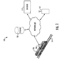
- FIG. 1 illustrates a vegetation detection and alert system 100 for a railway vehicle (at times simply referred to as the system).
- the system may be implemented with an Internet-based computing architecture including a computer network or a number of interconnected computer networks 102 in or over which a number of systems, (optionally including a back end), computers and the like communicate or otherwise operate.
- these include an acquisition device 104 onboard a railway vehicle 106, and a cloud storage 108, backend server 110 and client 112.
- the system may implemented with any of a number of different network-based architectures including implementation as a stand-alone system connected or disconnected from a computer network.
- the network 102 may be implemented as one or more wired networks, wireless networks or some combination of wired and wireless networks.
- the network may include private, public, academic, business or government networks, or any of a number of different combinations thereof, and in the context of an Internet-based computing architecture, includes the Internet.
- the network may support one or more of any of a number of different communications protocols, technologies or the like, such as cellular telephone, Wi-Fi, satellite, cable, digital subscriber line (DSL), fiber optics and the like.
- the systems and computers connected to the network 102 may also be implemented in a number of different manners.
- the acquisition device 104 is a special-purpose computer and sensing system configured to acquire, generate and process geospatially localized images of an environment of the railway vehicle 106 including a clearance zone around a railroad track 114 on which the railway vehicle moves.
- the railway vehicle is any of a number of different vehicles designed to run on railroad track. Examples of suitable railway vehicles include locomotives, railroad cars hauled by locomotives (forming trains), track maintenance vehicles, trucks designed to run on either tracks or roadways, and the like.
- the clearance zone is a three-dimensional zone defined from the railroad track 114, extending a distance on either side of the centerline of the track, and a distance above the track.
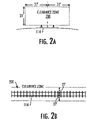
- FIGS. 2A and 2B illustrate forward and top views of a clearance zone 200 around a straight section of railroad track, according to some example implementations.
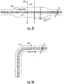
- FIGS. 2C and 2D illustrate top views of the clearance zone for other sections of railroad track, according to some example implementations.
- the clearance zone 200 extends some default horizontal distance (e.g., twenty-seven feet) on either side of the centerline of the track 114, and some default vertical distance (e.g., twenty-three feet) above the track.
- the clearance zone extends a greater horizontal distance (e.g., fifty feet) on either side of the centerline of the track in the vicinity of the intersection. This is shown at the intersection where the railroad track crosses a road 202.
- the clearance zone gradually changes between these distances as the track approaches the crossing, extends through the crossing, and then gradually changes back as the track clears the crossing.
- FIG. 2D illustrates the clearance zone around a curved section of railroad track. The distances shown in FIGS. 2A, 2B , 2C and 2D are by example and should not be taken to limit the scope of the present disclosure.
- the acquisition device 104 includes one or more of each of a number of components including an imaging sensor and a geospatial positioning sensor that cooperate to generate geospatially localized images of the environment of the railway vehicle 106 including the clearance zone around the railroad track 114.
- the imaging sensor (or in some examples a plurality of imaging sensors) is generally configured to capture images of the environment, and the geospatial positioning sensor is generally configured to contribute to determining the localization of the sensor in geographic space and thereby localization of the environment imaged by the imaging sensors.
- the images are referenced to a geolocation and thereby constitute geospatially referenced images.
- each geospatial image is an image of an environment accurately referenced to, or localized in, the geolocation of the environment.
- the GPS sensor will contribute to, but does not necessarily have to be the sensor or if used, even the exclusive source of localization of images, and therefore a 3D model derived therefrom.
- a track positioning derived from the images using for example, any suitable computer vision technique as known in the art, can be used together with GPS and/or alone.
- the acquisition device 104 is configured to process the geospatial images to model the environment including the clearance zone.
- the geospatial images may be processed to produce a three-dimensional geometric computer model of the environment in which objects in the environment including the clearance zone are represented by a collection of geometry and images.
- the acquisition device may produce the geometric computer model of the environment in any of a number of different manners.
- the image of the environment is a point cloud of points on the surfaces of objects in the environment, and the geometric computer model is produced from the point cloud.
- the acquisition device 104 may use commercially-available, open-source or custom-developed tools for this purpose, such as the image processing and analysis tools of OpenCV, KWTVER Map-Tk, and OpenMVG.
- One example of a suitable computer model is a three-dimensional digital point cloud model of the environment including the clearance zone.
- the computer model of the environment is also referenced to the environment's geolocation and thereby constitutes a geospatially localized (or geospatially-referenced), geometric computer model.
- the acquisition device 104 is configured to detect vegetation in the environment including vegetation obstructing or at-risk of obstructing the clearance zone based on the geometric computer model.
- the acquisition device may accomplish this in a number of different manners, such as by recognition of known vegetation geometry in the geometric computer model and by recognition of optical signatures in the images corresponding to the geometric computer model.
- the acquisition device may further detect the type of vegetation based on known types with distinguishable geometry, alone or perhaps with other information such as spectral information acquired from or coextensive with the imaging sensors.
- the acquisition device may use a number of different techniques to detect vegetation. Examples of suitable techniques include artificial intelligence (AI) techniques such as machine learning and computer vision.
- AI artificial intelligence
- the acquisition device 104 may generate and process geospatially localized images of the environment of the railway vehicle 106 including the clearance zone around the railroad track 114 in real-time or near real-time as the railway vehicle moves, each image and corresponding geometric computer model covering a respective portion of the clearance zone along the railroad track.
- the images in some examples may be frames of video captured by the acquisition device.
- the acquisition device records at least some of the acquired information including at least some of the images, geometric computer models and detected vegetation in onboard storage.
- the acquisition device 104 is configured to upload at least some of the acquired information to the storage 108.
- This may in some examples include the acquisition device uploading at least the geospatial images and notifications of detected vegetation, the notifications in some examples including the corresponding geometric computer models in which vegetation is detected.
- the detected vegetation may be recorded and/or uploaded in a number of different manners, from a simple notification to identification of the vegetation geometry in the geometric computer model, which may be extracted from the localized images and laid over the geometric computer model.
- the storage 108 is any of a number of different devices configured to receive and store at least some of the geospatial images and perhaps other output of the acquisition device 104.
- One example of suitable storage is cloud storage composed of physical storage across a plurality of server computers.
- Other examples of suitable storage include file storage, database storage and the like.
- the backend server 110 is configured to access the storage 108 and generate alerts for detected vegetation, which are then delivered to the client 112.
- the backend server more actively participates in geometric model generation and vegetation detection.
- the acquisition device 104 may generate and upload the geospatial images to the storage, and the backend server may process the images to detect vegetation, such as in a manner the same as or similar to that described above for the acquisition device. More particularly, for example, the backend server may process the geospatially referenced images to produce a geometric computer model localized in the environment, and detect vegetation in the clearance zone based on the geometric computer model, as described above.
- the backend server 110 is commonly implemented as a server computer although other implementations are contemplated (e.g., mainframe computer, personal computer).
- the client 112 is generally hardware or software configured to receive or access a service on the backend server or acquisition device 104.
- the client is a fixed or mobile computing device such as a desktop computer, portable computer (e.g., laptop computer, tablet computer), mobile phone (e.g., smartphone, cellular phone), wearable computer (e.g., smartwatch, optical head-mounted display) or the like.
- the backend server may be embodied as one or more servers, a network of interworking computing devices (e.g., a distributed computer implemented by multiple computers) or the like. In implementations in which the backend server is implemented as a distributed computer, its multiple computers may communicate over a network such as network 102.
- An alert generated by the backend server 110 and delivered to the client 112 may be as simple as a notification that identifies the geolocation along the railroad track 114 at which the acquisition device 104 detected vegetation within the clearance zone. Other relevant information may also be provided.
- the alert may indicate the type of vegetation.
- the alert may provide an alert rating for the detected vegetation based on its proximity to the railroad track, such as in order of closest proximity, "severe,” “high” or “moderate.”
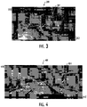
- an alert may include a composite image 300, 400.
- the composite image includes the geospatial image 302, 402 that depicts the detected vegetation, with an overlay of the clearance zone 304, 404.
- the geospatial image covers more than the clearance zone, and the portion outside the clearance zone is blurred to highlight the portion within the clearance zone with greater detail.
- the composite image 300, 400 includes an overlay of the geometry 306, 406 of the detected vegetation from the geometric model, which may be color-coded for the alert rating of the detected vegetation.
- the composite image includes callouts 308, 408 with information regarding the detected vegetation, such as their alert rating; geolocation, type and/or detected date.
- the composite image may also identify the distance of the clearance zone from the center of the track, and include more general information 310, 410 such as the geolocation for the environment depicted in the image.
- Even further information 312, 412 may include various information for the railway vehicle 106 and environment when the image was captured, such as the vehicle's speed and direction, and the environmental temperature, humidity, pressure, wind speed and the like.
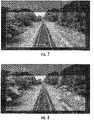
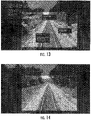
- FIGS. 5-14 illustrate a sequence of composite images covering movement of a railway vehicle up to and passing a crossing.
- FIGS. 8 , 12 and 13 illustrate images in which vegetation within the clearance zone is detected.
- the system 100 and its subsystems including the acquisition device 104, cloud storage 108, backend server 110 and client 112 may be implemented by various means.
- Means for implementing the system and its subsystems may include hardware, alone or under direction of one or more computer programs from a computer-readable storage medium.
- one or more apparatuses may be configured to function as or otherwise implement the system and its subsystems shown and described herein.
- the respective apparatuses may be connected to or otherwise in communication with one another in a number of different manners, such as directly or indirectly via a wired or wireless network or the like.
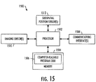
- FIG. 15 illustrates an apparatus 1500 configured to implement the acquisition device 112 according to some example implementations of the present disclosure.
- FIG. 16 illustrates a similar apparatus 1600 that may be configured to implement the backend server 110 or client 112.
- an apparatus of exemplary implementations of the present disclosure may comprise, include or be embodied in one or more fixed or portable electronic devices.
- the apparatus may include one or more of each of a number of components such as, for example, a processor 1502 connected to a memory 1504 (e.g., storage device).
- the processor 1502 may be composed of one or more processors alone or in combination with one or more memories.
- the processor is generally any piece of computer hardware that is capable of processing information such as, for example, data, computer programs and/or other suitable electronic information.
- the processor is composed of a collection of electronic circuits some of which may be packaged as an integrated circuit or multiple interconnected integrated circuits (an integrated circuit at times more commonly referred to as a "chip").
- the processor may be configured to execute computer programs, which may be stored onboard the processor or otherwise stored in the memory 1504 (of the same or another apparatus).
- the processor 1502 may be a number of processors, a multi-core processor or some other type of processor, depending on the particular implementation. Further, the processor may be implemented using a number of heterogeneous processor systems in which a main processor is present with one or more secondary processors on a single chip. As another illustrative example, the processor may be a symmetric multi-processor system containing multiple processors of the same type. In yet another example, the processor may be embodied as or otherwise include one or more ASICs, FPGAs, GPUs or the like, such as Nvidia Drive Platform. Thus, although the processor may be capable of executing a computer program to perform one or more functions, the processor of various examples may be capable of performing one or more functions without the aid of a computer program. In either instance, the processor may be appropriately programmed to perform functions or operations according to example implementations of the present disclosure.
- the memory 1504 is generally any piece of fixed or removable computer hardware that is capable of storing information such as, for example, data, computer programs (e.g., computer-readable program code 1506) and/or other suitable information either on a temporary basis and/or a permanent basis.
- the memory may include volatile and/or nonvolatile memory, and may be fixed or removable. Examples of suitable memory include random access memory (RAM), read-only memory (ROM), a hard drive, a flash memory, a thumb drive, a removable computer diskette, an optical disk, a magnetic tape or some combination of the above.
- Optical disks may include compact disk - read only memory (CD-ROM), compact disk - read/write (CD-R/W), DVD or the like.
- the memory may be referred to as a computer-readable storage medium.
- the computer-readable storage medium is a non-transitory device capable of storing information, and is distinguishable from computer-readable transmission media such as electronic transitory signals capable of carrying information from one location to another.
- Computer-readable medium as described herein may generally refer to a computer-readable storage medium or computer-readable transmission medium.
- the processor 1502 may also be connected to one or more communication interfaces 1508.
- the communications interface(s) may be configured to transmit and/or receive information, such as to and/or from other apparatus(es), network(s) or the like.
- the communications interface may be configured to transmit and/or receive information by physical (wired) and/or wireless communications links to a network (e.g., network 102) using technologies such as cellular telephone, Wi-Fi, satellite, cable, DSL, fiber optics or the like.
- the processor 1502 may also be connected to one or more sensors such as one or more imaging sensors 1510 and one or more geospatial positioning sensors 1512.
- the imaging sensor is generally configured to capture images of the environment
- the geospatial positioning sensor is generally configured to contribute to determining the geolocation of the sensor
- computer vision algorithms are employed in combination with the geo-positioning information to localize the environment imaged by the imaging sensor. Optimally both GPS and computer vision are both utilized in order to create instantiation of the capability for the most accurate localization.
- imaging sensors include digital cameras, infrared cameras, thermal cameras, depth-aware or range cameras, stereo cameras, light detection and ranging (LIDAR) sensors, radio detection and ranging (RADAR) sensors and the like.
- LIDAR light detection and ranging
- RADAR radio detection and ranging
- geospatial positioning sensors include satellite-navigation system sensors (e.g., GPS, GLONASS, BeiDou-2, Galileo), inertial navigation system (INS) sensors and the like.
- the apparatus 1500, 1600 may additionally include one or more user interfaces, as shown in particular in FIG. 16 for the apparatus configured to implement the backend server 110 or client 112.
- the user interfaces may include a display 1610 and/or one or more user input interfaces 1612.
- the display may be configured to present or otherwise display information to a user, suitable examples of which include a liquid crystal display (LCD), light-emitting diode display (LED), plasma display panel (PDP) or the like.
- the user input interfaces may be wired or wireless, and may be configured to receive information from a user into the apparatus, such as for processing, storage and/or display.
- Suitable examples of user input interfaces include a microphone, image or video capture device, keyboard or keypad, joystick, touch-sensitive surface (separate from or integrated into a touchscreen) or the like.
- the user interfaces may further include one or more interfaces for communicating with peripherals such as printers, scanners or the like.
- program code instructions may be stored in memory, and executed by a processor that is thereby programmed, to implement functions of the systems, subsystems, tools and their respective elements described herein.
- any suitable program code instructions may be loaded onto a computer or other programmable apparatus from a computer-readable storage medium to produce a particular machine, such that the particular machine becomes a means for implementing the functions specified herein.
- These program code instructions may also be stored in a computer-readable storage medium that can direct a computer, processor or other programmable apparatus to function in a particular manner to thereby generate a particular machine or particular article of manufacture.
- the instructions stored in the computer-readable storage medium may produce an article of manufacture, where the article of manufacture becomes a means for implementing functions described herein.
- the program code instructions may be retrieved from a computer-readable storage medium and loaded into a computer, processor or other programmable apparatus to configure the computer, processor or other programmable apparatus to execute operations to be performed on or by the computer, processor or other programmable apparatus.
- Retrieval, loading and execution of the program code instructions may be performed sequentially such that one instruction is retrieved, loaded and executed at a time. In some example implementations, retrieval, loading and/or execution may be performed in parallel such that multiple instructions are retrieved, loaded, and/or executed together. Execution of the program code instructions may produce a computer-implemented process such that the instructions executed by the computer, processor or other programmable apparatus provide operations for implementing functions described herein.
- an apparatus 1500, 1600 may include processor 1502 and a computer-readable storage medium or memory 1504 coupled to the processor, where the processor is configured to execute computer-readable program code 1506 stored in the memory. It will also be understood that one or more functions, and combinations of functions, may be implemented by special purpose hardware-based computer systems and/or processor which perform the specified functions, or combinations of special purpose hardware and program code instructions.
- the algorithm flowchart, FIG. 17 identifies a logical path of data processing and execution flow from the start of the system, the imaging systems 1700 (one or more of the same type or different type of imaging sensor, as described above) recording image sequences, and the end of the example implementation, the wireless communication systems 1712.
- the entire system will be a portable unit or series of units that can be moved from rail vehicle to rail vehicle, as needed.
- Raw images and video data are gathered as input from the imaging sensor sub-system 1700 and transmitted to the image capture controller 1701.
- the image capture controller sets the sensor capture rates and compression processing for the image sensors.
- the controller ensures multiple images are captured simultaneously so that the set of images can be optimally used to reconstruct the geometry of the environment at the time of capture. This provides the ability for downstream processing to accurately georeference the images and to create and localize 3-dimensional digital representations of the rail vehicle's environment as it moves along the rail path.
- the image capture controller then transmits data to both a storage medium 1710 and downstream for further data processing in the image/video localization and georectification process 1702.
- images, video and associated telemetry and metadata are stored in a queue onboard the device for a configurable duration of time. If additional storage is needed, the data may be offloaded from the local storage to other storage media or over wireless by the communications controller and progressively removed from the short-term memory or data storage.
- the image/video localization and georectification process 1702 acquires data from the geospatial positioning sensors (GPS) 1703 and the image capture controller 1701, binding the GPS data to each image and video frame.
- Image georectification and localization may utilize computer vision techniques and methods such as, for example, stereo photogrammetry, simultaneous location and mapping, automatic feature identification and tracking, 3-dimensional pose estimation, and machine learning algorithms.
- the railroad tracks are identified using computer vision techniques and then used to localize the instantaneous image set.
- the multiple sequential images, the fixed image parameters, the GPS location, and the known geometry of the rails and the ground plane in the images, are photogrammetrically combined to yield a highly accurate mapping of the image pixels and geometry to the environment of the railroad right of way.
- This processing step maps every image or video pixel to a geospatial coordinate space, so that the images can be used for accurate mensuration of the right-of-way (R.O.W.) or clearance zone volume and measurement of objects inside of or intersecting the right of way volume.
- a 3D volumetric model of the right-of-way is created for the instant in time of image capture.
- the volume is most accurate around the image acquisition device and extends a limited distance fore and aft of the device.
- Consecutively captured image sets are used to construct consecutive, time-sliced volumes that are joined together to create an accurate right-of-way volume around the track and along the rail bed.
- a point cloud of object surfaces in the images is generated 1705 using multiple image time slices. Standard computer vision and photogrammetric techniques are used to build the point cloud around the right-of-way.
- point cloud 1705 and right of way volume generation 1704 the point cloud is intersected with the volume 1706 to classify those points inside the 3D volume. These points represent objects including vegetation that are inside the right of way.
- the density and distances within the point cloud indicate the relative size of the objects and vegetation inside the right-of-way.
- imagery, point cloud, and volume are joined in a machine learning algorithm to identify the types (classes) of objects intruding into the 3D right of way volume.
- This step is not essential for alert generation 1709, but may be useful for further discrimination on the level of risk and the nature of the mitigation that will need to be applied.
- the point cloud density classification and thresholding processing step 1708 classifies the density and intrusion distance of objects in the volume to determine a severity level for the intrusion.
- the severity and number of levels is user-configurable. This provides the capability to determine vegetation encroachment into the clearance zone.
- Alert notifications are created in the alert data composition process 1709 based on the severity classifications and types of objects in the volume.
- An alert message is compiled for a specific length of track.
- the alert message may or may not contain vegetation and object recognition information.
- the communications controller 1711 sends the alert messages and/or image data packets over a wireless communications system 1712.
- the alert messages are also optionally stored in the local storage if desired, or if wireless connections are not available.
- the wireless transfer of information is not an essential function and the messages may be stored locally until the unit returns to a base station and can be downloaded to fixed processing systems (e.g., desktop computer).
- the clearance zone environment is represented by a collection of geometry and images. That is, not the geometric representation alone but also advantageously with images, such as from computer vision. While georeferencing the images could be done, this is more akin to situations where 2D overhead mapping applications are utilized.
- obliquely acquired, near-field images are preferably used and in this case, the images are georeferenced and the pixels and objects in the images are preferably localized in space.
- the present disclosure includes any combination of two, three, four or more features or elements set forth in this disclosure, regardless of whether such features or elements are expressly combined or otherwise recited in a specific example implementation described herein.
- This disclosure is intended to be read holistically such that any separable features or elements of the disclosure, in any of its aspects and example implementations, should be viewed as combinable, unless the context of the disclosure clearly dictates otherwise.
Landscapes
- Engineering & Computer Science (AREA)
- Physics & Mathematics (AREA)
- Mechanical Engineering (AREA)
- Software Systems (AREA)
- Geometry (AREA)
- General Physics & Mathematics (AREA)
- Theoretical Computer Science (AREA)
- Remote Sensing (AREA)
- Computer Graphics (AREA)
- Multimedia (AREA)
- Health & Medical Sciences (AREA)
- General Health & Medical Sciences (AREA)
- Image Analysis (AREA)
- Image Processing (AREA)
- Train Traffic Observation, Control, And Security (AREA)
- Emergency Alarm Devices (AREA)
Abstract
Description
- This application claims the benefit of
U.S. Provisional Application Serial No. 62/485,678, filed April 14, 2017 - The present disclosure relates generally to vegetation detection and, in particular, to a vegetation detection and alert system for a railway vehicle.
- Railroads spend a significant amount of time and resources to control vegetation around railroad tracks. Vegetation control provides a number of benefits to railroad tracks and railroad operation. Vegetation control improves sight distance for visibility of trains and at railroad crossings to avoid hazards at intersections. Vegetation control maintains a clearance zone for railroad right-of-ways and improves sight distance and safety along track segments between crossings. Vegetation control also provides proper drainage around tracks and reduces damage to signal and communication lines on tracks. In a number of jurisdictions, vegetation control is required by law.
- Railroad companies employ in-house and third-party vegetation control inspectors and engineers who implement vegetation control programs, notably within track and right-of-way clearance zones. These programs are very time and resource consuming, and are difficult to implement and keep up. Therefore it would be desirable to have systems and methods that take into account at least some of these issues discussed above, as well as other possible issues.
- In view of the foregoing background, example implementations of the present disclosure are directed to a vegetation detection and alert system for a railway vehicle, including in more particular examples, detection of vegetation obstructing or at-risk of obstructing a clearance zone around the railroad track. The present disclosure thus includes, without limitation, the following example implementations.
- Some example implementations provide an acquisition device mountable to a railway vehicle for detecting vegetation, the acquisition device comprising an imaging sensor configured to capture images of an environment of the railway vehicle and tracks including but not limited to a clearance zone around a railroad track on which the railway vehicle moves, the imaging sensor being configured to capture the images from the railway vehicle as the railway vehicle moves on the railroad track; a geospatial position sensor configured to determine a geolocation of the geospatial position sensor and thereby the environment imaged by the imaging sensor; and a processor coupled to the imaging sensor and geospatial position sensor, and programmed to at least: reference the images captured by the imaging sensor to the geolocation determined by the geospatial position sensor to form geospatial images of the environment including the clearance zone; and for one or more geospatial images of the geospatial images, process the one or more geospatial images to produce a geometric computer model of the environment in which objects in the environment are represented by a collection of geometry; detect vegetation in the clearance zone based on the geometric computer model; and upload the one or more geospatial images and a notification of detected vegetation from which the device or a backend server is configured to generate an alert for one or more client systems.
- Some example implementations provide a method comprising detecting vegetation using an acquisition device mountable to a railway vehicle, the acquisition device including an imaging sensor and a geospatial position sensor, the method comprising capturing, by the imaging sensor, images of an environment of the railway vehicle including a clearance zone around a railroad track on which a railway vehicle moves, the imaging sensor capturing the images from the railway vehicle as the railway vehicle moves on the railroad track; determining, by the geospatial position sensor, a geolocation of the geospatial position sensor and thereby the environment imaged by the imaging sensor; referencing the images captured by the imaging sensor to the geolocation determined by the geospatial position sensor to form geospatial images of the environment including the clearance zone; and for one or more geospatial images of the geospatial images, processing the one or more geospatial images to produce a geometric computer model of the environment in which objects in the environment are represented by a collection of geometry; detecting vegetation in the clearance zone based on the geometric computer model; and uploading the one or more geospatial image and a notification of detected vegetation from which a backend server is configured to generate an alert for a client.
- Features, aspects, and advantages of the present disclosure will be apparent from a reading of the following detailed description together with the accompanying drawings, which are briefly described below. The present disclosure includes any combination of two, three, four or more features or elements set forth in this disclosure, regardless of whether such features or elements are expressly combined or otherwise recited in a specific example implementation described herein. This disclosure is intended to be read holistically such that any separable features or elements of the disclosure, in any of its aspects and example implementations, should be viewed as combinable, unless the context of the disclosure clearly dictates otherwise.
- Having thus described the disclosure in general terms, reference will now be made to the accompanying drawings, which are not necessarily drawn to scale, and wherein:
-
FIG. 1 illustrates a vegetation detection and alert system for a railway vehicle, according to example implementations of the present disclosure; -
FIGS. 2A and 2B illustrate forward and top views of a clearance zone around various sections of railroad track, according to some example implementations; -
FIGS. 2C and 2D illustrate top views of the clearance zone for other sections of railroad track, according to some example implementations; -
FIGS. 3, 4 and5-14 are composite images that may be generated according to some example implementations; -
FIGS. 15 and16 illustrate apparatuses according to example implementations; and -
FIG. 17 illustrates a suitable algorithm flowchart of the system and method described herein. - Some implementations of the present disclosure will now be described more fully hereinafter with reference to the accompanying drawings, in which some, but not all implementations of the disclosure are shown. Indeed, various implementations of the disclosure may be embodied in many different forms and should not be construed as limited to the implementations set forth herein; rather, these example implementations are provided so that this disclosure will be thorough and complete, and will fully convey the scope of the disclosure to those skilled in the art. As used herein, for example, the singular forms "a," "an," "the" and the like include plural referents unless the context clearly dictates otherwise. The terms "data," "information," "content" and similar terms may be used interchangeably, according to some example implementations of the present invention, to refer to data capable of being transmitted, received, operated on, and/or stored. Also, for example, reference may be made herein to quantitative measures, values, relationships or the like. Unless otherwise stated, any one or more if not all of these may be absolute or approximate to account for acceptable variations that may occur, such as those due to engineering tolerances or the like. Like reference numerals refer to like elements throughout.
-
FIG. 1 illustrates a vegetation detection andalert system 100 for a railway vehicle (at times simply referred to as the system). As shown, the system may be implemented with an Internet-based computing architecture including a computer network or a number of interconnectedcomputer networks 102 in or over which a number of systems, (optionally including a back end), computers and the like communicate or otherwise operate. As shown, these include anacquisition device 104 onboard arailway vehicle 106, and acloud storage 108,backend server 110 andclient 112. Although shown and described herein in the context of an Internet-based computing architecture, it should be understood that the system may implemented with any of a number of different network-based architectures including implementation as a stand-alone system connected or disconnected from a computer network. - The
network 102 may be implemented as one or more wired networks, wireless networks or some combination of wired and wireless networks. The network may include private, public, academic, business or government networks, or any of a number of different combinations thereof, and in the context of an Internet-based computing architecture, includes the Internet. The network may support one or more of any of a number of different communications protocols, technologies or the like, such as cellular telephone, Wi-Fi, satellite, cable, digital subscriber line (DSL), fiber optics and the like. - The systems and computers connected to the
network 102 may also be implemented in a number of different manners. Theacquisition device 104 is a special-purpose computer and sensing system configured to acquire, generate and process geospatially localized images of an environment of therailway vehicle 106 including a clearance zone around arailroad track 114 on which the railway vehicle moves. The railway vehicle is any of a number of different vehicles designed to run on railroad track. Examples of suitable railway vehicles include locomotives, railroad cars hauled by locomotives (forming trains), track maintenance vehicles, trucks designed to run on either tracks or roadways, and the like. - The clearance zone is a three-dimensional zone defined from the
railroad track 114, extending a distance on either side of the centerline of the track, and a distance above the track.FIGS. 2A and 2B illustrate forward and top views of aclearance zone 200 around a straight section of railroad track, according to some example implementations.FIGS. 2C and 2D illustrate top views of the clearance zone for other sections of railroad track, according to some example implementations. - As shown in
FIGS. 2A and 2B , theclearance zone 200 extends some default horizontal distance (e.g., twenty-seven feet) on either side of the centerline of thetrack 114, and some default vertical distance (e.g., twenty-three feet) above the track. At railroad crossings, as shown inFIG. 2C , the clearance zone extends a greater horizontal distance (e.g., fifty feet) on either side of the centerline of the track in the vicinity of the intersection. This is shown at the intersection where the railroad track crosses aroad 202. As also shown inFIG. 2C , the clearance zone gradually changes between these distances as the track approaches the crossing, extends through the crossing, and then gradually changes back as the track clears the crossing.FIG. 2D illustrates the clearance zone around a curved section of railroad track. The distances shown inFIGS. 2A, 2B ,2C and 2D are by example and should not be taken to limit the scope of the present disclosure. - Referring back to
FIG. 1 . according to example implementations, theacquisition device 104 includes one or more of each of a number of components including an imaging sensor and a geospatial positioning sensor that cooperate to generate geospatially localized images of the environment of therailway vehicle 106 including the clearance zone around therailroad track 114. The imaging sensor (or in some examples a plurality of imaging sensors) is generally configured to capture images of the environment, and the geospatial positioning sensor is generally configured to contribute to determining the localization of the sensor in geographic space and thereby localization of the environment imaged by the imaging sensors. Using computer vision techniques for object detection and measurement, along with the geospatial positioning information, the images are referenced to a geolocation and thereby constitute geospatially referenced images. That is, each geospatial image is an image of an environment accurately referenced to, or localized in, the geolocation of the environment. It should be understood that the GPS sensor will contribute to, but does not necessarily have to be the sensor or if used, even the exclusive source of localization of images, and therefore a 3D model derived therefrom. A track positioning derived from the images using for example, any suitable computer vision technique as known in the art, can be used together with GPS and/or alone. - In some examples, the
acquisition device 104 is configured to process the geospatial images to model the environment including the clearance zone. The geospatial images may be processed to produce a three-dimensional geometric computer model of the environment in which objects in the environment including the clearance zone are represented by a collection of geometry and images. The acquisition device may produce the geometric computer model of the environment in any of a number of different manners. - In some examples, the image of the environment is a point cloud of points on the surfaces of objects in the environment, and the geometric computer model is produced from the point cloud. The
acquisition device 104 may use commercially-available, open-source or custom-developed tools for this purpose, such as the image processing and analysis tools of OpenCV, KWTVER Map-Tk, and OpenMVG. One example of a suitable computer model is a three-dimensional digital point cloud model of the environment including the clearance zone. The computer model of the environment is also referenced to the environment's geolocation and thereby constitutes a geospatially localized (or geospatially-referenced), geometric computer model. - In some examples, the
acquisition device 104 is configured to detect vegetation in the environment including vegetation obstructing or at-risk of obstructing the clearance zone based on the geometric computer model. The acquisition device may accomplish this in a number of different manners, such as by recognition of known vegetation geometry in the geometric computer model and by recognition of optical signatures in the images corresponding to the geometric computer model. In some examples, the acquisition device may further detect the type of vegetation based on known types with distinguishable geometry, alone or perhaps with other information such as spectral information acquired from or coextensive with the imaging sensors. The acquisition device may use a number of different techniques to detect vegetation. Examples of suitable techniques include artificial intelligence (AI) techniques such as machine learning and computer vision. - The
acquisition device 104 may generate and process geospatially localized images of the environment of therailway vehicle 106 including the clearance zone around therailroad track 114 in real-time or near real-time as the railway vehicle moves, each image and corresponding geometric computer model covering a respective portion of the clearance zone along the railroad track. The images in some examples may be frames of video captured by the acquisition device. In some examples, the acquisition device records at least some of the acquired information including at least some of the images, geometric computer models and detected vegetation in onboard storage. - In some examples, as or after the localized images are processed, the
acquisition device 104 is configured to upload at least some of the acquired information to thestorage 108. This may in some examples include the acquisition device uploading at least the geospatial images and notifications of detected vegetation, the notifications in some examples including the corresponding geometric computer models in which vegetation is detected. In these examples, the detected vegetation may be recorded and/or uploaded in a number of different manners, from a simple notification to identification of the vegetation geometry in the geometric computer model, which may be extracted from the localized images and laid over the geometric computer model. - The
storage 108 is any of a number of different devices configured to receive and store at least some of the geospatial images and perhaps other output of theacquisition device 104. One example of suitable storage is cloud storage composed of physical storage across a plurality of server computers. Other examples of suitable storage include file storage, database storage and the like. - The
backend server 110 is configured to access thestorage 108 and generate alerts for detected vegetation, which are then delivered to theclient 112. In some examples, the backend server more actively participates in geometric model generation and vegetation detection. In these examples, theacquisition device 104 may generate and upload the geospatial images to the storage, and the backend server may process the images to detect vegetation, such as in a manner the same as or similar to that described above for the acquisition device. More particularly, for example, the backend server may process the geospatially referenced images to produce a geometric computer model localized in the environment, and detect vegetation in the clearance zone based on the geometric computer model, as described above. - The
backend server 110 is commonly implemented as a server computer although other implementations are contemplated (e.g., mainframe computer, personal computer). Theclient 112 is generally hardware or software configured to receive or access a service on the backend server oracquisition device 104. In some examples, the client is a fixed or mobile computing device such as a desktop computer, portable computer (e.g., laptop computer, tablet computer), mobile phone (e.g., smartphone, cellular phone), wearable computer (e.g., smartwatch, optical head-mounted display) or the like. The backend server may be embodied as one or more servers, a network of interworking computing devices (e.g., a distributed computer implemented by multiple computers) or the like. In implementations in which the backend server is implemented as a distributed computer, its multiple computers may communicate over a network such asnetwork 102. - An alert generated by the
backend server 110 and delivered to theclient 112 may be as simple as a notification that identifies the geolocation along therailroad track 114 at which theacquisition device 104 detected vegetation within the clearance zone. Other relevant information may also be provided. The alert may indicate the type of vegetation. The alert may provide an alert rating for the detected vegetation based on its proximity to the railroad track, such as in order of closest proximity, "severe," "high" or "moderate." - As shown in
FIGS, 3 and 4 , in some examples, an alert may include acomposite image geospatial image clearance zone - As also shown, the
composite image geometry callouts 308, 408 with information regarding the detected vegetation, such as their alert rating; geolocation, type and/or detected date. The composite image may also identify the distance of the clearance zone from the center of the track, and include moregeneral information further information railway vehicle 106 and environment when the image was captured, such as the vehicle's speed and direction, and the environmental temperature, humidity, pressure, wind speed and the like. -
FIGS. 5-14 illustrate a sequence of composite images covering movement of a railway vehicle up to and passing a crossing.FIGS. 8 ,12 and13 illustrate images in which vegetation within the clearance zone is detected. - According to example implementations of the present disclosure, the
system 100 and its subsystems including theacquisition device 104,cloud storage 108,backend server 110 andclient 112 may be implemented by various means. Means for implementing the system and its subsystems may include hardware, alone or under direction of one or more computer programs from a computer-readable storage medium. In some examples, one or more apparatuses may be configured to function as or otherwise implement the system and its subsystems shown and described herein. In examples involving more than one apparatus, the respective apparatuses may be connected to or otherwise in communication with one another in a number of different manners, such as directly or indirectly via a wired or wireless network or the like. -
FIG. 15 illustrates anapparatus 1500 configured to implement theacquisition device 112 according to some example implementations of the present disclosure.FIG. 16 illustrates asimilar apparatus 1600 that may be configured to implement thebackend server 110 orclient 112. Generally, an apparatus of exemplary implementations of the present disclosure may comprise, include or be embodied in one or more fixed or portable electronic devices. The apparatus may include one or more of each of a number of components such as, for example, aprocessor 1502 connected to a memory 1504 (e.g., storage device). - The
processor 1502 may be composed of one or more processors alone or in combination with one or more memories. The processor is generally any piece of computer hardware that is capable of processing information such as, for example, data, computer programs and/or other suitable electronic information. The processor is composed of a collection of electronic circuits some of which may be packaged as an integrated circuit or multiple interconnected integrated circuits (an integrated circuit at times more commonly referred to as a "chip"). The processor may be configured to execute computer programs, which may be stored onboard the processor or otherwise stored in the memory 1504 (of the same or another apparatus). - The
processor 1502 may be a number of processors, a multi-core processor or some other type of processor, depending on the particular implementation. Further, the processor may be implemented using a number of heterogeneous processor systems in which a main processor is present with one or more secondary processors on a single chip. As another illustrative example, the processor may be a symmetric multi-processor system containing multiple processors of the same type. In yet another example, the processor may be embodied as or otherwise include one or more ASICs, FPGAs, GPUs or the like, such as Nvidia Drive Platform. Thus, although the processor may be capable of executing a computer program to perform one or more functions, the processor of various examples may be capable of performing one or more functions without the aid of a computer program. In either instance, the processor may be appropriately programmed to perform functions or operations according to example implementations of the present disclosure. - The
memory 1504 is generally any piece of fixed or removable computer hardware that is capable of storing information such as, for example, data, computer programs (e.g., computer-readable program code 1506) and/or other suitable information either on a temporary basis and/or a permanent basis. The memory may include volatile and/or nonvolatile memory, and may be fixed or removable. Examples of suitable memory include random access memory (RAM), read-only memory (ROM), a hard drive, a flash memory, a thumb drive, a removable computer diskette, an optical disk, a magnetic tape or some combination of the above. Optical disks may include compact disk - read only memory (CD-ROM), compact disk - read/write (CD-R/W), DVD or the like. In various instances, the memory may be referred to as a computer-readable storage medium. The computer-readable storage medium is a non-transitory device capable of storing information, and is distinguishable from computer-readable transmission media such as electronic transitory signals capable of carrying information from one location to another. Computer-readable medium as described herein may generally refer to a computer-readable storage medium or computer-readable transmission medium. - In addition to the
memory 1504, theprocessor 1502 may also be connected to one or more communication interfaces 1508. The communications interface(s) may be configured to transmit and/or receive information, such as to and/or from other apparatus(es), network(s) or the like. The communications interface may be configured to transmit and/or receive information by physical (wired) and/or wireless communications links to a network (e.g., network 102) using technologies such as cellular telephone, Wi-Fi, satellite, cable, DSL, fiber optics or the like. - As shown for the
apparatus 1500 configured to implement theacquisition device 112, theprocessor 1502 may also be connected to one or more sensors such as one ormore imaging sensors 1510 and one or moregeospatial positioning sensors 1512. As described above, the imaging sensor is generally configured to capture images of the environment, the geospatial positioning sensor is generally configured to contribute to determining the geolocation of the sensor, and/or computer vision algorithms are employed in combination with the geo-positioning information to localize the environment imaged by the imaging sensor. Optimally both GPS and computer vision are both utilized in order to create instantiation of the capability for the most accurate localization. Examples of suitable imaging sensors include digital cameras, infrared cameras, thermal cameras, depth-aware or range cameras, stereo cameras, light detection and ranging (LIDAR) sensors, radio detection and ranging (RADAR) sensors and the like. Examples of suitable geospatial positioning sensors include satellite-navigation system sensors (e.g., GPS, GLONASS, BeiDou-2, Galileo), inertial navigation system (INS) sensors and the like. - The
apparatus FIG. 16 for the apparatus configured to implement thebackend server 110 orclient 112. The user interfaces may include adisplay 1610 and/or one or more user input interfaces 1612. The display may be configured to present or otherwise display information to a user, suitable examples of which include a liquid crystal display (LCD), light-emitting diode display (LED), plasma display panel (PDP) or the like. The user input interfaces may be wired or wireless, and may be configured to receive information from a user into the apparatus, such as for processing, storage and/or display. Suitable examples of user input interfaces include a microphone, image or video capture device, keyboard or keypad, joystick, touch-sensitive surface (separate from or integrated into a touchscreen) or the like. The user interfaces may further include one or more interfaces for communicating with peripherals such as printers, scanners or the like. - As indicated above, program code instructions may be stored in memory, and executed by a processor that is thereby programmed, to implement functions of the systems, subsystems, tools and their respective elements described herein. As will be appreciated, any suitable program code instructions may be loaded onto a computer or other programmable apparatus from a computer-readable storage medium to produce a particular machine, such that the particular machine becomes a means for implementing the functions specified herein. These program code instructions may also be stored in a computer-readable storage medium that can direct a computer, processor or other programmable apparatus to function in a particular manner to thereby generate a particular machine or particular article of manufacture. The instructions stored in the computer-readable storage medium may produce an article of manufacture, where the article of manufacture becomes a means for implementing functions described herein. The program code instructions may be retrieved from a computer-readable storage medium and loaded into a computer, processor or other programmable apparatus to configure the computer, processor or other programmable apparatus to execute operations to be performed on or by the computer, processor or other programmable apparatus.
- Retrieval, loading and execution of the program code instructions may be performed sequentially such that one instruction is retrieved, loaded and executed at a time. In some example implementations, retrieval, loading and/or execution may be performed in parallel such that multiple instructions are retrieved, loaded, and/or executed together. Execution of the program code instructions may produce a computer-implemented process such that the instructions executed by the computer, processor or other programmable apparatus provide operations for implementing functions described herein.
- Execution of instructions by processor, or storage of instructions in a computer-readable storage medium, supports combinations of operations for performing the specified functions. In this manner, an
apparatus processor 1502 and a computer-readable storage medium ormemory 1504 coupled to the processor, where the processor is configured to execute computer-readable program code 1506 stored in the memory. It will also be understood that one or more functions, and combinations of functions, may be implemented by special purpose hardware-based computer systems and/or processor which perform the specified functions, or combinations of special purpose hardware and program code instructions. - According to one exemplary embodiment, the algorithm flowchart,
FIG. 17 , identifies a logical path of data processing and execution flow from the start of the system, the imaging systems 1700 (one or more of the same type or different type of imaging sensor, as described above) recording image sequences, and the end of the example implementation, thewireless communication systems 1712. As stated above the entire system will be a portable unit or series of units that can be moved from rail vehicle to rail vehicle, as needed. - Raw images and video data are gathered as input from the
imaging sensor sub-system 1700 and transmitted to theimage capture controller 1701. The image capture controller sets the sensor capture rates and compression processing for the image sensors. The controller ensures multiple images are captured simultaneously so that the set of images can be optimally used to reconstruct the geometry of the environment at the time of capture. This provides the ability for downstream processing to accurately georeference the images and to create and localize 3-dimensional digital representations of the rail vehicle's environment as it moves along the rail path. The image capture controller then transmits data to both astorage medium 1710 and downstream for further data processing in the image/video localization andgeorectification process 1702. - As part of the
storage medium 1710, images, video and associated telemetry and metadata are stored in a queue onboard the device for a configurable duration of time. If additional storage is needed, the data may be offloaded from the local storage to other storage media or over wireless by the communications controller and progressively removed from the short-term memory or data storage. - The image/video localization and
georectification process 1702 acquires data from the geospatial positioning sensors (GPS) 1703 and theimage capture controller 1701, binding the GPS data to each image and video frame. Image georectification and localization may utilize computer vision techniques and methods such as, for example, stereo photogrammetry, simultaneous location and mapping, automatic feature identification and tracking, 3-dimensional pose estimation, and machine learning algorithms. - Using each overlapping simultaneously collected image, and the known dimensions and placement of each pixel in the images, the railroad tracks are identified using computer vision techniques and then used to localize the instantaneous image set. The multiple sequential images, the fixed image parameters, the GPS location, and the known geometry of the rails and the ground plane in the images, are photogrammetrically combined to yield a highly accurate mapping of the image pixels and geometry to the environment of the railroad right of way. This processing step maps every image or video pixel to a geospatial coordinate space, so that the images can be used for accurate mensuration of the right-of-way (R.O.W.) or clearance zone volume and measurement of objects inside of or intersecting the right of way volume.
- From the detailed track localization and image geometry, a 3D volumetric model of the right-of-way is created for the instant in time of image capture. The volume is most accurate around the image acquisition device and extends a limited distance fore and aft of the device. Consecutively captured image sets are used to construct consecutive, time-sliced volumes that are joined together to create an accurate right-of-way volume around the track and along the rail bed.
- In parallel with the 3D
photogrammetric volume construction 1704 step above, a point cloud of object surfaces in the images is generated 1705 using multiple image time slices. Standard computer vision and photogrammetric techniques are used to build the point cloud around the right-of-way. - Subsequent to point
cloud 1705 and right ofway volume generation 1704, the point cloud is intersected with thevolume 1706 to classify those points inside the 3D volume. These points represent objects including vegetation that are inside the right of way. The density and distances within the point cloud indicate the relative size of the objects and vegetation inside the right-of-way. - In an optional processing step, the imagery, point cloud, and volume are joined in a machine learning algorithm to identify the types (classes) of objects intruding into the 3D right of way volume. This step is not essential for
alert generation 1709, but may be useful for further discrimination on the level of risk and the nature of the mitigation that will need to be applied. - The point cloud density classification and
thresholding processing step 1708 classifies the density and intrusion distance of objects in the volume to determine a severity level for the intrusion. The severity and number of levels is user-configurable. This provides the capability to determine vegetation encroachment into the clearance zone. - Alert notifications are created in the alert
data composition process 1709 based on the severity classifications and types of objects in the volume. An alert message is compiled for a specific length of track. The alert message may or may not contain vegetation and object recognition information. - In the final processing step, the
communications controller 1711 sends the alert messages and/or image data packets over awireless communications system 1712. The alert messages are also optionally stored in the local storage if desired, or if wireless connections are not available. The wireless transfer of information is not an essential function and the messages may be stored locally until the unit returns to a base station and can be downloaded to fixed processing systems (e.g., desktop computer). - In a particularly advantageous embodiment, the clearance zone environment is represented by a collection of geometry and images. That is, not the geometric representation alone but also advantageously with images, such as from computer vision. While georeferencing the images could be done, this is more akin to situations where 2D overhead mapping applications are utilized. Here, obliquely acquired, near-field images are preferably used and in this case, the images are georeferenced and the pixels and objects in the images are preferably localized in space.
- As explained above, the present disclosure includes any combination of two, three, four or more features or elements set forth in this disclosure, regardless of whether such features or elements are expressly combined or otherwise recited in a specific example implementation described herein. This disclosure is intended to be read holistically such that any separable features or elements of the disclosure, in any of its aspects and example implementations, should be viewed as combinable, unless the context of the disclosure clearly dictates otherwise.
- Many modifications and other implementations of the disclosure set forth herein will come to mind to one skilled in the art to which the disclosure pertains having the benefit of the teachings presented in the foregoing description and the associated drawings. Therefore, it is to be understood that the disclosure is not to be limited to the specific implementations disclosed and that modifications and other implementations are intended to be included within the scope of the appended claims. Moreover, although the foregoing description and the associated drawings describe example implementations in the context of certain example combinations of elements and/or functions, it should be appreciated that different combinations of elements and/or functions may be provided by alternative implementations without departing from the scope of the appended claims. In this regard, for example, different combinations of elements and/or functions than those explicitly described above are also contemplated as may be set forth in some of the appended claims. Although specific terms are employed herein, they are used in a generic and descriptive sense only and not for purposes of limitation.
Claims (15)
- An acquisition device mountable to a railway vehicle for detecting objects, optionally vegetation, the acquisition device comprising:an imaging sensor configured to capture images of an environment of the railway vehicle including a volumetric clearance zone around a railroad track on which the railway vehicle moves, the imaging sensor being configured to capture images from the railway vehicle as the railway vehicle moves on the railroad track;a geospatial position sensor configured to determine a geolocation of the geospatial position sensor and together with computer vision as needed to thereby contribute to accurate localization of the environment and objects imaged by the imaging sensor; anda processor coupled to the imaging sensor and geospatial position sensor, and programmed to at least:reference the images captured by the imaging sensor to the geolocation determined by the geospatial position sensor, the geometric parameters of the imaging sensors and object properties in the images to form geospatially referenced images of the environment including the clearance zone; and for one or more geospatial images of the geospatial images,process the one or more geospatially referenced images to produce a localized geometric computer model of the volumetric environment in which objects in the environment are represented by a collection of geometry and plurality of image pixels and whole images;detect and localize objects in the clearance zone based on the geometric computer model and the plurality of image pixels and whole images; andupload the one or more geospatial images and a notification of detected and localized objects from which an alert can optionally be generated.
- The acquisition device of claim 1, wherein in parallel with 3D photogrammetric volume construction, there is provided a means for creating a point cloud of object surfaces in the images which can be generated using multiple image time slices, and further wherein there is provided means for utilizing computer vision and photogrammetric techniques to build the point cloud around the clearance zone.
- The acquisition device according to claim 1, wherein the clearance zone is a three-dimensional zone defined from the railroad track, extending a distance on either side of the centerline of the track, and a distance above the track.
- The acquisition device according to claim 2, wherein at railroad crossings the clearance zone extends a greater horizontal distance on either side of the centerline of the track in the vicinity of the intersection.
- The acquisition device according to claim 1, wherein the detection of vegetation in the clearance zone includes the detection of the type of vegetation based on known types with distinguishable geometry.
- The acquisition device according to claim 1, wherein the acquisition device generates and processes geospatially localized images of the environment of the railway vehicle including the clearance zone around the railroad track in real-time or near real time as the railway vehicle moves, each image and corresponding geometric computer model covering a respective portion of the clearance zone along the railroad track.
- A method comprising detecting objects, optionally vegetation, using an acquisition device of claim 1 mountable to a railway vehicle, the acquisition device including one or more imaging sensors and a geospatial position sensor, the method comprising:capturing, by the imaging sensor, images of an environment occupied by the railway vehicle including a volume clearance zone around a railroad track on which a railway vehicle moves, the imaging sensor capturing a plurality of images from the railway vehicle as the railway vehicle moves on the railroad track;determining, by the geospatial positioning sensor, a geolocation of the geospatial positioning sensor and thereby contributing to localization of the environment imaged by the imaging sensor;referencing the images captured by the imaging sensor to the geolocation determined by the geospatial position sensor and image object geometry to form geospatial images of the environment including the clearance zone; and for one or more geospatial images of the geospatial images,processing the one or more geospatial images to produce a geometric computer model of the environment in which objects in the environment are represented by a collection of geometry and images;detecting objects in the clearance zone based on the geometric computer model and images; andoptionally uploading the one or more geospatial images to a desired format, and/or to an environment model, and a notification of detected object can optionally be generated.
- The method of claim 7 wherein in parallel with 3D photogrammetric volume construction, a point cloud of object surfaces in the images is generated using multiple image time slices, and further wherein computer vision and photogrammetric techniques are used to build the point cloud around the clearance zone.
- The method according to claim 7, wherein consecutively captured image sets are used to construct consecutive, time-sliced volumes that are joined together to create an accurate right-of-way volume around the track and along the rail bed.
- The method according to claim 8, wherein in parallel with the 3D photogrammetric volume construction, a point cloud of object surfaces in the images is generated using multiple image time slices, and standard computer vision and photogrammetric techniques are used to build a point cloud around the right-of-way.
- The method according to claim 10, wherein the point cloud is intersected with the volume to classify the points inside the 3D volume.
- The method according to claim 11, the imagery, point cloud, and volume are joined in a machine learning algorithm to identify the types of objects intruding into the 3D right of way volume.
- The method according to claim 12 further comprising
determining a severity level for intrusion of objects intruding into the right of volume. - The method according to claim 7 further comprising:
generating and delivering the alert to the client, wherein the alert includes a notification that identifies the geolocation along the railroad track at which the acquisition device detected vegetation within the clearance zone. - The method according to claim 7 further comprising:
generating and delivering the alert to the client, wherein the alert includes a composite image, the composite image including the geospatial image that depicts the detected vegetation, with an overlay of the clearance zone.
Applications Claiming Priority (3)
| Application Number | Priority Date | Filing Date | Title |
|---|---|---|---|
| US201762485678P | 2017-04-14 | 2017-04-14 | |
| EP18721643.7A EP3609766A1 (en) | 2017-04-14 | 2018-04-13 | Vegetation detection and alert method and system for a railway vehicle |
| PCT/US2018/027480 WO2018191613A1 (en) | 2017-04-14 | 2018-04-13 | Vegetation detection and alert method and system for a railway vehicle |
Related Parent Applications (2)
| Application Number | Title | Priority Date | Filing Date |
|---|---|---|---|
| EP18721643.7A Division EP3609766A1 (en) | 2017-04-14 | 2018-04-13 | Vegetation detection and alert method and system for a railway vehicle |
| PCT/US2018/027480 Previously-Filed-Application WO2018191613A1 (en) | 2017-04-14 | 2018-04-13 | Vegetation detection and alert method and system for a railway vehicle |
Publications (2)
| Publication Number | Publication Date |
|---|---|
| EP4049914A2 true EP4049914A2 (en) | 2022-08-31 |
| EP4049914A3 EP4049914A3 (en) | 2023-02-22 |
Family
ID=62092344
Family Applications (3)
| Application Number | Title | Priority Date | Filing Date |
|---|---|---|---|
| EP22175055.7A Pending EP4095012A3 (en) | 2017-04-14 | 2018-04-13 | Vegetation detection and alert method and system for a railway vehicle |
| EP18721643.7A Ceased EP3609766A1 (en) | 2017-04-14 | 2018-04-13 | Vegetation detection and alert method and system for a railway vehicle |
| EP21178972.2A Withdrawn EP4049914A3 (en) | 2017-04-14 | 2018-04-13 | Object detection and alert method and system for a railway vehicle |
Family Applications Before (2)
| Application Number | Title | Priority Date | Filing Date |
|---|---|---|---|
| EP22175055.7A Pending EP4095012A3 (en) | 2017-04-14 | 2018-04-13 | Vegetation detection and alert method and system for a railway vehicle |
| EP18721643.7A Ceased EP3609766A1 (en) | 2017-04-14 | 2018-04-13 | Vegetation detection and alert method and system for a railway vehicle |
Country Status (7)
| Country | Link |
|---|---|
| US (3) | US20180297621A1 (en) |
| EP (3) | EP4095012A3 (en) |
| CN (1) | CN110662687B (en) |
| AR (1) | AR112184A1 (en) |
| AU (2) | AU2018253281B2 (en) |
| CA (1) | CA3059970A1 (en) |
| WO (1) | WO2018191613A1 (en) |
Families Citing this family (14)
| Publication number | Priority date | Publication date | Assignee | Title |
|---|---|---|---|---|
| EP4095012A3 (en) * | 2017-04-14 | 2023-05-03 | Bayer CropScience LP | Vegetation detection and alert method and system for a railway vehicle |
| US10807623B2 (en) | 2018-06-01 | 2020-10-20 | Tetra Tech, Inc. | Apparatus and method for gathering data from sensors oriented at an oblique angle relative to a railway track |
| CN111736167B (en) * | 2019-03-25 | 2024-04-12 | 北京京东乾石科技有限公司 | A method and device for obtaining laser point cloud density |
| WO2020232443A1 (en) | 2019-05-16 | 2020-11-19 | Tetra Tech, Inc. | Autonomous track assessment system |
| AT17358U1 (en) | 2019-12-16 | 2022-02-15 | Plasser & Theurer Export Von Bahnbaumaschinen Gmbh | Method and monitoring system for determining a position of a rail vehicle |
| US11100658B2 (en) | 2020-01-10 | 2021-08-24 | United States Of America As Represented By The Secretary Of The Navy | Image georectification with mobile object removal |
| US10919546B1 (en) * | 2020-04-22 | 2021-02-16 | Bnsf Railway Company | Systems and methods for detecting tanks in railway environments |
| US11233591B1 (en) * | 2020-08-19 | 2022-01-25 | FPL Smart Services, LLC | Vegetation growth detection via radio propagation |
| JP7209913B2 (en) * | 2020-11-26 | 2023-01-20 | 三菱電機株式会社 | Outlook Information Generating Device, Outlook Information Generating Method, and Outlook Information Generating Program |
| DE102021200767A1 (en) * | 2021-01-28 | 2022-07-28 | Siemens Mobility GmbH | Self-learning warning system for rail vehicles |
| GB2602896B (en) * | 2022-03-02 | 2023-01-04 | Hack Partners Ltd | Automatic digital inspection of railway environment |
| GB2625549B (en) * | 2022-12-20 | 2025-04-30 | Hack Partners Ltd | System and method for monitoring level crossing |
| AT527463A1 (en) * | 2023-07-27 | 2025-02-15 | Plasser & Theurer Export Von Bahnbaumaschinen Gmbh | Method for determining a reference position of a reference object in a track environment, measuring device and system |
| EP4678505A1 (en) * | 2024-07-10 | 2026-01-14 | Isam S.r.l. | Apparatus and method for weeding railway tracks |
Family Cites Families (22)
| Publication number | Priority date | Publication date | Assignee | Title |
|---|---|---|---|---|
| AU9337798A (en) | 1997-09-24 | 1999-04-27 | Hardi International A/S | A method and an apparatus for detecting, classifying and treatment of vegetation |
| US20150235094A1 (en) * | 2014-02-17 | 2015-08-20 | General Electric Company | Vehicle imaging system and method |
| US9919723B2 (en) * | 2002-06-04 | 2018-03-20 | General Electric Company | Aerial camera system and method for determining size parameters of vehicle systems |
| US7046841B1 (en) | 2003-08-29 | 2006-05-16 | Aerotec, Llc | Method and system for direct classification from three dimensional digital imaging |
| DE10353212A1 (en) * | 2003-11-13 | 2005-06-23 | Db Netz Ag | Method and device for detecting and measuring vegetation in the vicinity of traffic routes |
| US8275547B2 (en) | 2009-09-30 | 2012-09-25 | Utility Risk Management Corporation, Llc | Method and system for locating a stem of a target tree |
| US8352410B2 (en) | 2009-12-17 | 2013-01-08 | Utility Risk Management Corporation, Llc | Method and system for estimating vegetation growth relative to an object of interest |
| WO2012092554A1 (en) | 2010-12-30 | 2012-07-05 | Utility Risk Management Corporation, Llc | Method for locating vegetation having a potential to impact a structure |
| US8625878B2 (en) | 2011-04-15 | 2014-01-07 | International Business Machines Corporation | Method and system of rail component detection using vision technology |
| US10202135B2 (en) * | 2013-05-17 | 2019-02-12 | International Electronic Machines Corp. | Operations monitoring in an area |
| US9796400B2 (en) * | 2013-11-27 | 2017-10-24 | Solfice Research, Inc. | Real time machine vision and point-cloud analysis for remote sensing and vehicle control |
| CN103978996B (en) * | 2014-05-15 | 2015-12-30 | 南京理工大学 | A kind of high speed railway environment information acquisition, assessment and prior-warning device and method |
| CN104192174B (en) * | 2014-08-29 | 2015-05-27 | 北京交通大学 | Train early warning system and train early warning method |
| JP6697797B2 (en) * | 2014-09-08 | 2020-05-27 | トランスポーテーション アイピー ホールディングス,エルエルシー | Optical path survey system and method |
| GB2530104A (en) | 2014-09-15 | 2016-03-16 | Point4Uk Ltd | Vegetation catergorisation |
| DE102014222900A1 (en) * | 2014-11-10 | 2016-05-12 | Bombardier Transportation Gmbh | Operation of a rail vehicle with an imaging system |
| JP2018508418A (en) * | 2015-01-20 | 2018-03-29 | ソルフィス リサーチ、インコーポレイテッド | Real-time machine vision and point cloud analysis for remote sensing and vehicle control |
| EP3048559A1 (en) * | 2015-01-21 | 2016-07-27 | RindInvest AB | Method and system for detecting a rail track |
| CN108139876B (en) * | 2015-03-04 | 2022-02-25 | 杭州凌感科技有限公司 | System and method for immersive and interactive multimedia generation |
| RU2694016C1 (en) | 2015-08-06 | 2019-07-08 | Эксенчер Глобал Сервисез Лимитед | Detecting the state of objects using an image processing system, a corresponding method and a persistent machine-readable medium |
| GB2542115B (en) * | 2015-09-03 | 2017-11-15 | Rail Vision Europe Ltd | Rail track asset survey system |
| EP4095012A3 (en) * | 2017-04-14 | 2023-05-03 | Bayer CropScience LP | Vegetation detection and alert method and system for a railway vehicle |
-
2018
- 2018-04-13 EP EP22175055.7A patent/EP4095012A3/en active Pending
- 2018-04-13 AR ARP180100932 patent/AR112184A1/en unknown
- 2018-04-13 US US15/952,604 patent/US20180297621A1/en not_active Abandoned
- 2018-04-13 CA CA3059970A patent/CA3059970A1/en active Pending
- 2018-04-13 AU AU2018253281A patent/AU2018253281B2/en active Active
- 2018-04-13 WO PCT/US2018/027480 patent/WO2018191613A1/en not_active Ceased
- 2018-04-13 EP EP18721643.7A patent/EP3609766A1/en not_active Ceased
- 2018-04-13 CN CN201880025015.XA patent/CN110662687B/en active Active
- 2018-04-13 EP EP21178972.2A patent/EP4049914A3/en not_active Withdrawn
- 2018-10-22 US US16/166,945 patent/US10370014B2/en active Active
-
2019
- 2019-06-27 US US16/454,840 patent/US11046340B2/en active Active
-
2022
- 2022-11-04 AU AU2022263574A patent/AU2022263574B2/en active Active
Also Published As
| Publication number | Publication date |
|---|---|
| EP4095012A2 (en) | 2022-11-30 |
| AU2022263574B2 (en) | 2023-06-15 |
| WO2018191613A1 (en) | 2018-10-18 |
| US20180297621A1 (en) | 2018-10-18 |
| US20190054938A1 (en) | 2019-02-21 |
| CN110662687A (en) | 2020-01-07 |
| CN110662687B (en) | 2021-12-28 |
| AR112184A1 (en) | 2019-10-02 |
| US10370014B2 (en) | 2019-08-06 |
| AU2022263574A1 (en) | 2022-12-08 |
| AU2018253281B2 (en) | 2022-08-04 |
| US20190367059A1 (en) | 2019-12-05 |
| EP3609766A1 (en) | 2020-02-19 |
| AU2018253281A1 (en) | 2019-10-17 |
| EP4049914A3 (en) | 2023-02-22 |
| CA3059970A1 (en) | 2018-10-18 |
| US11046340B2 (en) | 2021-06-29 |
| EP4095012A3 (en) | 2023-05-03 |
Similar Documents
| Publication | Publication Date | Title |
|---|---|---|
| AU2022263574B2 (en) | Vegetation detection and alert method and system for a railway vehicle | |
| KR102193950B1 (en) | Vehicle and sensing device of utilizing spatial information acquired using sensor, and server for the same | |
| TWI451283B (en) | Accident information aggregation and management systems and methods for accident information aggregation and management thereof | |
| US9529803B2 (en) | Image modification | |
| EP4334186B1 (en) | Automatic digital inspection of railway environment | |
| WO2016118672A2 (en) | Real time machine vision and point-cloud analysis for remote sensing and vehicle control | |
| CN113221756B (en) | Traffic sign detection method and related equipment | |
| WO2024018726A1 (en) | Program, method, system, road map, and road map creation method | |
| US20240270294A1 (en) | Systems and methods for auditing assets | |
| US20240117575A1 (en) | Infrastructure diagnostic device, infrastructure diagnostic method, and recording medium | |
| KR102396329B1 (en) | System and method for safety inspection of airport facilities based on imange and xai | |
| AU2019203180B2 (en) | Vehicle recognition apparatus and vehicle recognition method | |
| JP2024072568A (en) | Information processing program, information processing device, information processing method, and model generation method | |
| US11443619B2 (en) | Vehicle recognition apparatus and vehicle recognition method | |
| EP4601929A1 (en) | Automated safety management in environment | |
| JP7229111B2 (en) | MAP UPDATE DATA GENERATION DEVICE AND MAP UPDATE DATA GENERATION METHOD | |
| Zhao et al. | Road Surface State Change Detection Based on Binocular Vision for Autonomous Driving System | |
| GB2620460A (en) | Automatic digital inspection of railway environment | |
| Boschi et al. | Dynamic Bird’s Eye View Reconstruction of Driving Accidents | |
| US20220390252A1 (en) | Use of predefined (pre-built) graphical representations of roads for autonomous driving of vehicles and display of route planning | |
| Yashas et al. | Machine Learning–Based Smart Road Surface Anomaly Detection |
Legal Events
| Date | Code | Title | Description |
|---|---|---|---|
| PUAI | Public reference made under article 153(3) epc to a published international application that has entered the european phase |
Free format text: ORIGINAL CODE: 0009012 |
|
| STAA | Information on the status of an ep patent application or granted ep patent |
Free format text: STATUS: THE APPLICATION HAS BEEN PUBLISHED |
|
| AC | Divisional application: reference to earlier application |
Ref document number: 3609766 Country of ref document: EP Kind code of ref document: P |
|
| AK | Designated contracting states |
Kind code of ref document: A2 Designated state(s): AL AT BE BG CH CY CZ DE DK EE ES FI FR GB GR HR HU IE IS IT LI LT LU LV MC MK MT NL NO PL PT RO RS SE SI SK SM TR |
|
| RAP3 | Party data changed (applicant data changed or rights of an application transferred) |
Owner name: BAYER CROPSCIENCE LP |
|
| PUAL | Search report despatched |
Free format text: ORIGINAL CODE: 0009013 |
|
| AK | Designated contracting states |
Kind code of ref document: A3 Designated state(s): AL AT BE BG CH CY CZ DE DK EE ES FI FR GB GR HR HU IE IS IT LI LT LU LV MC MK MT NL NO PL PT RO RS SE SI SK SM TR |
|
| RIC1 | Information provided on ipc code assigned before grant |
Ipc: B61L 25/02 20060101ALI20230116BHEP Ipc: B61L 23/04 20060101AFI20230116BHEP |
|
| P01 | Opt-out of the competence of the unified patent court (upc) registered |
Effective date: 20230421 |
|
| STAA | Information on the status of an ep patent application or granted ep patent |
Free format text: STATUS: THE APPLICATION IS DEEMED TO BE WITHDRAWN |
|
| 18D | Application deemed to be withdrawn |
Effective date: 20230823 |