EP3964798A1 - Route determination system, route determination method, and route determination program - Google Patents
Route determination system, route determination method, and route determination program Download PDFInfo
- Publication number
- EP3964798A1 EP3964798A1 EP21193310.6A EP21193310A EP3964798A1 EP 3964798 A1 EP3964798 A1 EP 3964798A1 EP 21193310 A EP21193310 A EP 21193310A EP 3964798 A1 EP3964798 A1 EP 3964798A1
- Authority
- EP
- European Patent Office
- Prior art keywords
- route
- dangerous
- person
- area
- route determination
- Prior art date
- Legal status (The legal status is an assumption and is not a legal conclusion. Google has not performed a legal analysis and makes no representation as to the accuracy of the status listed.)
- Withdrawn
Links
Images




Classifications
-
- G—PHYSICS
- G01—MEASURING; TESTING
- G01C—MEASURING DISTANCES, LEVELS OR BEARINGS; SURVEYING; NAVIGATION; GYROSCOPIC INSTRUMENTS; PHOTOGRAMMETRY OR VIDEOGRAMMETRY
- G01C21/00—Navigation; Navigational instruments not provided for in groups G01C1/00 - G01C19/00
- G01C21/26—Navigation; Navigational instruments not provided for in groups G01C1/00 - G01C19/00 specially adapted for navigation in a road network
- G01C21/34—Route searching; Route guidance
- G01C21/3453—Special cost functions, i.e. other than distance or default speed limit of road segments
- G01C21/3461—Preferred or disfavoured areas, e.g. dangerous zones, toll or emission zones, intersections, manoeuvre types or segments such as motorways, toll roads or ferries
-
- G—PHYSICS
- G06—COMPUTING OR CALCULATING; COUNTING
- G06Q—INFORMATION AND COMMUNICATION TECHNOLOGY [ICT] SPECIALLY ADAPTED FOR ADMINISTRATIVE, COMMERCIAL, FINANCIAL, MANAGERIAL OR SUPERVISORY PURPOSES; SYSTEMS OR METHODS SPECIALLY ADAPTED FOR ADMINISTRATIVE, COMMERCIAL, FINANCIAL, MANAGERIAL OR SUPERVISORY PURPOSES, NOT OTHERWISE PROVIDED FOR
- G06Q10/00—Administration; Management
- G06Q10/08—Logistics, e.g. warehousing, loading or distribution; Inventory or stock management
- G06Q10/083—Shipping
- G06Q10/08355—Routing methods
-
- G—PHYSICS
- G01—MEASURING; TESTING
- G01C—MEASURING DISTANCES, LEVELS OR BEARINGS; SURVEYING; NAVIGATION; GYROSCOPIC INSTRUMENTS; PHOTOGRAMMETRY OR VIDEOGRAMMETRY
- G01C21/00—Navigation; Navigational instruments not provided for in groups G01C1/00 - G01C19/00
- G01C21/26—Navigation; Navigational instruments not provided for in groups G01C1/00 - G01C19/00 specially adapted for navigation in a road network
- G01C21/34—Route searching; Route guidance
- G01C21/3407—Route searching; Route guidance specially adapted for specific applications
- G01C21/3415—Dynamic re-routing, e.g. recalculating the route when the user deviates from calculated route or after detecting real-time traffic data or accidents
-
- G—PHYSICS
- G01—MEASURING; TESTING
- G01C—MEASURING DISTANCES, LEVELS OR BEARINGS; SURVEYING; NAVIGATION; GYROSCOPIC INSTRUMENTS; PHOTOGRAMMETRY OR VIDEOGRAMMETRY
- G01C21/00—Navigation; Navigational instruments not provided for in groups G01C1/00 - G01C19/00
- G01C21/26—Navigation; Navigational instruments not provided for in groups G01C1/00 - G01C19/00 specially adapted for navigation in a road network
- G01C21/34—Route searching; Route guidance
- G01C21/36—Input/output arrangements for on-board computers
- G01C21/3605—Destination input or retrieval
- G01C21/3617—Destination input or retrieval using user history, behaviour, conditions or preferences, e.g. predicted or inferred from previous use or current movement
-
- G—PHYSICS
- G06—COMPUTING OR CALCULATING; COUNTING
- G06Q—INFORMATION AND COMMUNICATION TECHNOLOGY [ICT] SPECIALLY ADAPTED FOR ADMINISTRATIVE, COMMERCIAL, FINANCIAL, MANAGERIAL OR SUPERVISORY PURPOSES; SYSTEMS OR METHODS SPECIALLY ADAPTED FOR ADMINISTRATIVE, COMMERCIAL, FINANCIAL, MANAGERIAL OR SUPERVISORY PURPOSES, NOT OTHERWISE PROVIDED FOR
- G06Q10/00—Administration; Management
- G06Q10/04—Forecasting or optimisation specially adapted for administrative or management purposes, e.g. linear programming or "cutting stock problem"
- G06Q10/047—Optimisation of routes or paths, e.g. travelling salesman problem
-
- G—PHYSICS
- G06—COMPUTING OR CALCULATING; COUNTING
- G06Q—INFORMATION AND COMMUNICATION TECHNOLOGY [ICT] SPECIALLY ADAPTED FOR ADMINISTRATIVE, COMMERCIAL, FINANCIAL, MANAGERIAL OR SUPERVISORY PURPOSES; SYSTEMS OR METHODS SPECIALLY ADAPTED FOR ADMINISTRATIVE, COMMERCIAL, FINANCIAL, MANAGERIAL OR SUPERVISORY PURPOSES, NOT OTHERWISE PROVIDED FOR
- G06Q10/00—Administration; Management
- G06Q10/08—Logistics, e.g. warehousing, loading or distribution; Inventory or stock management
-
- G—PHYSICS
- G06—COMPUTING OR CALCULATING; COUNTING
- G06Q—INFORMATION AND COMMUNICATION TECHNOLOGY [ICT] SPECIALLY ADAPTED FOR ADMINISTRATIVE, COMMERCIAL, FINANCIAL, MANAGERIAL OR SUPERVISORY PURPOSES; SYSTEMS OR METHODS SPECIALLY ADAPTED FOR ADMINISTRATIVE, COMMERCIAL, FINANCIAL, MANAGERIAL OR SUPERVISORY PURPOSES, NOT OTHERWISE PROVIDED FOR
- G06Q10/00—Administration; Management
- G06Q10/08—Logistics, e.g. warehousing, loading or distribution; Inventory or stock management
- G06Q10/083—Shipping
-
- G—PHYSICS
- G06—COMPUTING OR CALCULATING; COUNTING
- G06Q—INFORMATION AND COMMUNICATION TECHNOLOGY [ICT] SPECIALLY ADAPTED FOR ADMINISTRATIVE, COMMERCIAL, FINANCIAL, MANAGERIAL OR SUPERVISORY PURPOSES; SYSTEMS OR METHODS SPECIALLY ADAPTED FOR ADMINISTRATIVE, COMMERCIAL, FINANCIAL, MANAGERIAL OR SUPERVISORY PURPOSES, NOT OTHERWISE PROVIDED FOR
- G06Q40/00—Finance; Insurance; Tax strategies; Processing of corporate or income taxes
- G06Q40/03—Credit; Loans; Processing thereof
Definitions
- the present disclosure relates to a route determination system, a route determination method, and a route determination program.
- Japanese Unexamined Patent Application Publication No. 2002-96913 discloses a technique in which a measurement value and position information of a sensor are recorded on an electronic tag of a delivery article, and the recorded data is used to improve the delivery service. According to the technique disclosed in Japanese Unexamined Patent Application Publication No. 2002-96913 , it is possible to select a route with fewer vibrations using the history in which the position information of a vehicle is associated with vibration data.
- the present disclosure achieves a method for determining a transport route of an autonomous mobile body capable of determining a transport route with little risk of theft.
- a route determination system is for determining a transport route for an autonomous mobile body to transport an article on.
- the route determination system includes: a judgement unit configured to judge whether or not an area including a position of a person is dangerous based on position information of the person and a credit rank of the person; and a route determination unit configured to determine, as the transport route, a bypass route for bypassing a dangerous area when a candidate of the transport route passes through the dangerous area judged to be dangerous by the judgement unit.
- a route determination method is for determining a transport route for an autonomous mobile body to transport an article on.
- the route determination method includes: judging whether or not an area including a position of a person is dangerous based on position information of the person and a credit rank of the person; and determining, as the transport route, a bypass route for bypassing a dangerous area when a candidate of the transport route passes through the dangerous area judged to be dangerous in the determining of whether or not the area including the position of the person is dangerous.
- a route determination program is for determining a transport route for an autonomous mobile body to transport an article on.
- the route determination program causes a computer to execute: judging whether or not an area including a position of a person is dangerous based on position information of the person and a credit rank of the person; and determining, as the transport route, a bypass route for bypassing a dangerous area when a candidate of the transport route passes through the dangerous area judged to be dangerous in the determining of whether or not the area including the position of the person is dangerous.
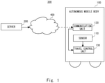
- Fig. 1 is a configuration diagram showing a configuration example of a route determination system 300 according to a first embodiment.
- the route determination system 300 includes a server 200 and an autonomous mobile body 100.
- the autonomous mobile body 100 may be an automatic drive vehicle traveling on a roadway or a smaller delivery robot traveling on a sidewalk.
- the autonomous mobile body 100 autonomously moves along a predetermined transport route to deliver a package.
- the autonomous mobile body 100 and the server 200 are connected to each other via a network 400.
- the network 400 is a communication line network such as the Internet, an intranet, a cellular phone network, and a LAN (Local Area Network).
- the route determination system 300 may include a plurality of the autonomous mobile bodies 100.
- the transport route may be determined on the autonomous mobile body 100 side.
- the autonomous mobile body 100 includes a sensor 110, a communication unit 120, and a travel control unit 130.
- the sensor 110 collects environmental data around the autonomous mobile body 100 and outputs it to the travel control unit 130.
- the sensor 110 is, for example, a camera, radar, LIDAR, or the like.
- the communication unit 120 is a communication interface for performing wireless communication with the network 400.
- the communication unit 120 receives the transport route determined by the server 200 via the network 400.
- the communication unit 120 may transmit position information indicating a position of the autonomous mobile body 100 to the server 200.
- the travel control unit 130 controls the autonomous mobile body 100 to autonomously move along the transport route using the environmental data collected by the sensor 110.
- the autonomous mobile body 100 acquires the position of the autonomous mobile body 100 by GPS (Global Positioning System), the sensor 110, or the like.
- the transport route may be determined not on the server 200 side but on the autonomous mobile body 100 side.
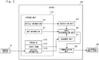
- the server 200 determines the transport route for the autonomous mobile body 100 to transport the package.
- the server 200 includes a storage unit 210, a judgement unit 221, a route determination unit 222, an acquisition unit 223, and a communication unit 230.
- the storage unit 210 is a storage apparatus such as a hard disk or a flash memory.
- the storage unit 210 may also include a volatile storage apparatus such as a RAM (Random Access Memory) which is a storage area for temporarily holding information.
- the communication unit 230 is a communication interface with the network 400.
- the storage unit 210 stores article information 214, map information 211, a person ID 2121, a credit rank 2122, and position information 2123.
- the article information 214 is information representing a starting point and a destination point in transporting an article. As the starting point, a current position of the autonomous mobile body 100 received from the autonomous mobile body 100 may be used.
- the article information 214 may also include information indicating whether or not the article to be transported is a valuable article.
- the map information 211 is map data including a delivery area, and is used when the route determination unit 222 to be described later determines the transport route.
- the map information 211 may be, for example, data of a road map in which nodes representing intersections and links representing passages are numbered.
- the map information 211 may be an environmental map showing an area of a building as an obstacle or the like.
- the storage unit 210 stores the person ID 2121, the credit rank 2122, and the position information 2123 in association with each other.
- the person ID 2121 is an identifier for identifying a person for whom the credit rank 2122 described later is set.
- the person ID 2121 may be, for example, a public identifier such as My Number, or may be a user ID given by a service provider providing a predetermined service.
- the credit rank 2122 is an evaluation value indicating the social creditworthiness of the person.
- the credit rank 2122 is calculated, for example, based on the person's past crime history, delinquency history of the financial institution, income, etc.
- the credit rank may be calculated, for example, between 0 and 100.
- the position information 2123 indicates the position of the person for whom the credit rank 2122 is set.
- the position information 2123 is determined based on position information such as GPS information received from a terminal device 10.
- the terminal device 10 is, for example, a mobile phone, a smartphone, or the like.
- the position information 2123 may be information related to an area where the person is present.
- the server 200 may receive the position information 2123 from the terminal device 10, and the autonomous mobile body 100 may receive the position information 2123 from the terminal device 10.
- the position information 2123 may be a predetermined location such as an address.
- the position information 2123 may be determined based on the position of a monitoring camera installed on the street. For example, it is assumed that the storage unit 210 stores the person ID 2121 and face feature information in association with each other. The server 200 performs face authentication on a photographed image acquired from the monitoring camera using the stored face feature information, so that the position information 2123 of the person whose face authentication is successful can be determined as the position of the monitoring camera.
- the judgement unit 221 judges whether or not an area including the position of the person is dangerous based on the position information 2123 and the credit rank 2122. For example, the judgement unit 221 may judge whether or not an area in a predetermined range including a low credit person whose credit rank is a predetermined value or less is dangerous. A threshold used in the judgement need not be constant. For example, when there are many low credit persons, the judgement unit 221 can appropriately judge whether or not the area is dangerous by changing the threshold.
- the acquisition unit 223 acquires the article information 214 from the storage unit 210 and outputs it to the route determination unit 222.
- the acquisition unit 223 may acquire information representing the starting point from the autonomous mobile body 100 via the communication unit 230.
- the route determination unit 222 determines the transport route using the map information 211 and outputs it to the communication unit 230.
- the route determination unit 222 specifies a candidate of the transport route using a known algorithm. When the candidate of the transport route passes through a dangerous area judged to be dangerous by the judgement unit 221, the route determination unit 222 determines a bypass route that bypasses the dangerous area as the transport route using the map information 211.
- the route determination unit 222 may determine the candidate of the transport route as the transport route, whereas when the article to be transported is expensive, the route determination unit 222 may determine the transport route not to pass through the dangerous area. Further alternatively, the judgement unit 221 may acquire the price or the like of the article to be transported from the acquisition unit 223, and judge whether or not the area is dangerous based on the price or the like. For example, the judgement unit 221 may set the threshold used for the judgement in such a way that the threshold becomes lower as the price increases, so that the number of dangerous areas increases.
- the functions of the judgement unit 221, the route determination unit 222, and the acquisition unit 223 may be implemented by a processor (not shown) reading a program into a RAM and executing the program.
- Fig. 3 is a schematic diagram showing an example of the transport route to be determined.
- the position of the autonomous mobile body 100 is set as the starting point, and a delivery destination X is set as a destination point. It is assumed that a low credit person K1 is present around the delivery area. It is assumed that the server 200 or the autonomous mobile body 100 receives the position information 2123 of the low credit person K1 from the terminal device 10. In such a case, the judgement unit 221 judges, for example, that an area Y1 around the low credit person K1 is dangerous. Here, a candidate P1 of the transport route as the shortest path passes through the area Y1. Therefore, the route determination unit 222 determines the bypass route R1 as the transport route. Since the route R1 does not pass around the low credit person K1, it is considered that the risk of theft is lower than that in the case of the candidate P1.
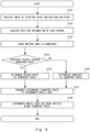
- Fig. 4 is a flowchart showing an operation of the route determination system 300 according to the first embodiment. It is assumed that the server 200 stores the person ID 2121 and the credit rank 2122 in association with each other.
- the route determination system 300 acquires information related to the starting point and the destination point (Step S101).
- the starting point may be the current position of the autonomous mobile body 100 or a warehouse for storing delivery articles.
- the destination point is information indicating the delivery destination of the article.
- the route determination system 300 receives the position information 2123 from the terminal device 10 of the person for whom the credit rank 2122 is set (Step S102).
- the route determination system 300 may use information such as an address registered in advance as the position information 2123 of each person.
- the judgement unit 221 judges whether or not the area including the position of the person is dangerous based on the position information 2123 and the credit rank 2122 (Step S103).
- the route determination unit 222 judges whether or not the candidate of the transport route passes through the dangerous area judged to be dangerous in Step S103 (Step S104). If the candidate of the transport route passes through the dangerous area (Yes in Step S104), the route determination unit 222 determines the bypass route that bypasses the dangerous area as the transport route (Step S105). If the candidate of the transport route does not pass through the dangerous area (No in Step S104), the route determination unit 222 determines the candidate of the transport route as the transport route (Step S106).
- Step S107 the server 200 transmits the determined transport route to the autonomous mobile body 100 (Step S107).
- the processing of Step S107 is not necessary.
- the autonomous mobile body 100 autonomously moves along the transport route acquired in Step S107, and delivers the article to the destination point (Step S108).
- the route determination system 300 determines the transport route based on the position information 2123 of the person for whom the credit rank 2122 is set. In this way, the route determination system 300 can reduce the risk of theft by a person whose credit rank 2122 is lower than that in the case of another person.
- the autonomous mobile body 100 may acquire the information of the delivery destination and determine the transport route from the current position to the delivery destination. That is, the processing performed by the judgement unit 221 and the route determination unit 222 may be performed on the autonomous mobile body 100 side.
- the autonomous mobile body 100 autonomously moves along the transport route determined by the autonomous mobile body 100 itself to deliver articles.
- the route determination system 300 may not include the server 200. That is, a system in which the processing is completed within the autonomous mobile body 100 can also be included in the route determination system 300 according to the first embodiment.
- a route determination system 300a uses the credit rank 2122 and the position information 2123 to judge whether or not an area in a predetermined range is dangerous.
- Fig. 5 is a configuration diagram showing a configuration example of the route determination system 300a.
- the route determination system 300a includes a server 200a and the autonomous mobile body 100. Since the system configuration of the route determination system 300a is the same as that shown in Fig. 1 , description thereof will be omitted.
- an area ID 2131 and area information 2132 are stored in the storage unit 210.
- the area is a divided delivery area where the autonomous mobile body 100 performs delivery. A municipality or a block may be used as the area. Alternatively, each region obtained by dividing the delivery area into predetermined sizes may be used as the area.
- the area ID 2131 is an identifier for identifying each area.
- the area information 2132 is information related to a range of each area.
- the judgement unit 221 identifies a person positioned inside each area based on the area information 2132 and the position information 2123. The judgement unit 221 judges whether or not the area is a dangerous area based on the credit rank 2122 of the identified person.
- the judgement unit 221 may judge that it is dangerous when at least one low credit person is present in the area. Further, the judgement unit 221 may judge whether or not there is a risk based on the number of low credit persons or the number of low credit persons per unit area. That is, the judgement unit 221 may perform the judgement based on the density of the low credit persons. In a manner similar to the first embodiment, the route determination unit 222 determines, as the transport route, the bypass route that bypasses the dangerous area when the candidate of the transport route passes through the dangerous area.
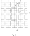
- Fig. 7 is a schematic diagram showing an example of the transport route determined by the route determination system 300a.
- the delivery area is divided into squares as shown by dotted lines, and each of the squares corresponds to the area.
- the position of the autonomous mobile body 100 is set as the starting point.
- a delivery destination X shall be the destination point. It is assumed that there is a low credit person K2 in the area Y2. Further, it is assumed that there is no person whose credit rank 2122 is lower than a predetermined value in areas other than the area Y2. In such a case, the judgement unit 221 judges, for example, that the area Y2 is dangerous. Since a candidate P2 of the transport route passes through the area Y2, the route determination unit 222 determines a bypass route R2 that bypasses the area Y2 as the transport route.
- the shortest route is the candidate P2 passing through the area Y2, but it is considered that the risk of theft by the low credit person K2 is high. Therefore, the route determination system 300a determines the bypass route R2, which has a lower risk of theft than that in the case of the shortest route, as the transport route.
- a case will be described in which it is judged whether or not the area is dangerous based on the number of low credit persons.
- the judgement unit 221 judges, for example, that an area Y3 in which two or more low credit persons are present is dangerous.
- the number of persons used as a threshold may be set so that an appropriate bypass route is determined.
- the route determination unit 222 determines a bypass route R3 as the transport route, because a candidate P3 of the transport route as the shortest route passes through the area Y3.
- the bypass route R3 passes through the area where the low credit person K3 is present. However, this area is considered to have a lower risk of theft than that of the area Y3 where two low credit persons K4 and K5 are present.
- the route determination system 300 determines the bypass route R3 having a lower risk of theft than that of the shortest route as the transport route.
- the route determination system 300a judges whether or not an area in a predetermined range is dangerous, and determines the transport route for bypassing the dangerous area. Thus, the route determination system 300a can determine the transport route to avoid areas where low credit persons are more concentrated, so that the risk of theft of articles is reduced.
- the autonomous mobile body 100 may accept an input of the delivery destination and determine the transport route from the current position to the delivery destination. That is, the processing performed by the judgement unit 221 or the route determination unit 222 may be performed on the autonomous mobile body 100 side.
- present disclosure is not limited thereto.
- present disclosure may be implemented by causing a CPU to execute a computer program for executing specified processing.
- the program includes instructions (or software codes) that, when loaded into a computer, cause the computer to perform one or more of the functions described in the embodiments.
- the program may be stored in a non-transitory computer readable medium or a tangible storage medium.
- non-transitory computer readable media or tangible storage media can include a random-access memory (RAM), a read-only memory (ROM), a flash memory, a solid-state drive (SSD) or other types of memory technologies, a CD-ROM, a digital versatile disc (DVD), a Blu-ray disc or other types of optical disc storage, and magnetic cassettes, magnetic tape, magnetic disk storage or other types of magnetic storage devices.
- the program may be transmitted on a transitory computer readable medium or a communication medium.
- transitory computer readable media or communication media can include electrical, optical, acoustical, or other forms of propagated signals.
Landscapes
- Engineering & Computer Science (AREA)
- Remote Sensing (AREA)
- Radar, Positioning & Navigation (AREA)
- Business, Economics & Management (AREA)
- Physics & Mathematics (AREA)
- General Physics & Mathematics (AREA)
- Economics (AREA)
- Strategic Management (AREA)
- Human Resources & Organizations (AREA)
- Automation & Control Theory (AREA)
- General Business, Economics & Management (AREA)
- Marketing (AREA)
- Theoretical Computer Science (AREA)
- Development Economics (AREA)
- Entrepreneurship & Innovation (AREA)
- Operations Research (AREA)
- Quality & Reliability (AREA)
- Tourism & Hospitality (AREA)
- Accounting & Taxation (AREA)
- Finance (AREA)
- Health & Medical Sciences (AREA)
- General Health & Medical Sciences (AREA)
- Social Psychology (AREA)
- Technology Law (AREA)
- Game Theory and Decision Science (AREA)
- Alarm Systems (AREA)
- Navigation (AREA)
- Traffic Control Systems (AREA)
- Control Of Position, Course, Altitude, Or Attitude Of Moving Bodies (AREA)
Abstract

Description
- The present disclosure relates to a route determination system, a route determination method, and a route determination program.
-
Japanese Unexamined Patent Application Publication No. 2002-96913 Japanese Unexamined Patent Application Publication No. 2002-96913 - In this case, there is a problem that the risk of theft is high when a package is delivered using an autonomous mobile body. In particular, when the size of the autonomous mobile body is small, not only the package but also the autonomous mobile body itself has a risk of theft.
- The present disclosure achieves a method for determining a transport route of an autonomous mobile body capable of determining a transport route with little risk of theft.
- A route determination system according to the present disclosure is for determining a transport route for an autonomous mobile body to transport an article on. The route determination system includes: a judgement unit configured to judge whether or not an area including a position of a person is dangerous based on position information of the person and a credit rank of the person; and a route determination unit configured to determine, as the transport route, a bypass route for bypassing a dangerous area when a candidate of the transport route passes through the dangerous area judged to be dangerous by the judgement unit.
- A route determination method according to the present disclosure is for determining a transport route for an autonomous mobile body to transport an article on. The route determination method includes: judging whether or not an area including a position of a person is dangerous based on position information of the person and a credit rank of the person; and determining, as the transport route, a bypass route for bypassing a dangerous area when a candidate of the transport route passes through the dangerous area judged to be dangerous in the determining of whether or not the area including the position of the person is dangerous.
- A route determination program according to the present disclosure is for determining a transport route for an autonomous mobile body to transport an article on. The route determination program causes a computer to execute: judging whether or not an area including a position of a person is dangerous based on position information of the person and a credit rank of the person; and determining, as the transport route, a bypass route for bypassing a dangerous area when a candidate of the transport route passes through the dangerous area judged to be dangerous in the determining of whether or not the area including the position of the person is dangerous.
- According to the present disclosure, it is possible to reduce a risk of theft in transporting by an autonomous mobile body.
- The above and other objects, features and advantages of the present disclosure will become more fully understood from the detailed description given hereinbelow and the accompanying drawings which are given by way of illustration only, and thus are not to be considered as limiting the present disclosure.
-
-
Fig. 1 is a configuration diagram showing a configuration example of a route determination system according to a first embodiment; -
Fig. 2 is a block diagram showing a functional configuration of a server according to the first embodiment; -
Fig. 3 is a schematic diagram showing an example of a transport route determined by the route determination system according to the first embodiment. -
Fig. 4 is a flowchart showing an operation example of the route determination system according to the first embodiment; -
Fig. 5 is a configuration diagram showing a configuration example of a route determination system according to a second embodiment; -
Fig. 6 is a block diagram showing a functional configuration of a server according to the second embodiment; -
Fig. 7 is a schematic diagram showing an example of a transport route determined by the route determination system according to the second embodiment; and -
Fig. 8 is a schematic diagram showing an example of a transport route determined by the route determination system according to the second embodiment. - Embodiments of the present disclosure will be described below with reference to the drawings.
Fig. 1 is a configuration diagram showing a configuration example of aroute determination system 300 according to a first embodiment. Theroute determination system 300 includes aserver 200 and an autonomousmobile body 100. - The autonomous
mobile body 100 may be an automatic drive vehicle traveling on a roadway or a smaller delivery robot traveling on a sidewalk. The autonomousmobile body 100 autonomously moves along a predetermined transport route to deliver a package. The autonomousmobile body 100 and theserver 200 are connected to each other via anetwork 400. Thenetwork 400 is a communication line network such as the Internet, an intranet, a cellular phone network, and a LAN (Local Area Network). - The
route determination system 300 may include a plurality of the autonomousmobile bodies 100. Hereinafter, although the case in which the transport route is determined on theserver 200 side will be described, the transport route may be determined on the autonomousmobile body 100 side. - The autonomous
mobile body 100 includes asensor 110, acommunication unit 120, and atravel control unit 130. Thesensor 110 collects environmental data around the autonomousmobile body 100 and outputs it to thetravel control unit 130. Thesensor 110 is, for example, a camera, radar, LIDAR, or the like. Thecommunication unit 120 is a communication interface for performing wireless communication with thenetwork 400. Thecommunication unit 120 receives the transport route determined by theserver 200 via thenetwork 400. Thecommunication unit 120 may transmit position information indicating a position of the autonomousmobile body 100 to theserver 200. - The
travel control unit 130 controls the autonomousmobile body 100 to autonomously move along the transport route using the environmental data collected by thesensor 110. Here, it is assumed that the autonomousmobile body 100 acquires the position of the autonomousmobile body 100 by GPS (Global Positioning System), thesensor 110, or the like. As described above, the transport route may be determined not on theserver 200 side but on the autonomousmobile body 100 side. - Next, the
server 200 will be described in detail with reference toFig. 2 . Theserver 200 determines the transport route for the autonomousmobile body 100 to transport the package. Theserver 200 includes astorage unit 210, ajudgement unit 221, aroute determination unit 222, anacquisition unit 223, and acommunication unit 230. Thestorage unit 210 is a storage apparatus such as a hard disk or a flash memory. Thestorage unit 210 may also include a volatile storage apparatus such as a RAM (Random Access Memory) which is a storage area for temporarily holding information. Thecommunication unit 230 is a communication interface with thenetwork 400. - The
storage unit 210 storesarticle information 214,map information 211, aperson ID 2121, acredit rank 2122, andposition information 2123. Thearticle information 214 is information representing a starting point and a destination point in transporting an article. As the starting point, a current position of the autonomousmobile body 100 received from the autonomousmobile body 100 may be used. Thearticle information 214 may also include information indicating whether or not the article to be transported is a valuable article. - The
map information 211 is map data including a delivery area, and is used when theroute determination unit 222 to be described later determines the transport route. Themap information 211 may be, for example, data of a road map in which nodes representing intersections and links representing passages are numbered. Themap information 211 may be an environmental map showing an area of a building as an obstacle or the like. - The
storage unit 210 stores theperson ID 2121, thecredit rank 2122, and theposition information 2123 in association with each other. Theperson ID 2121 is an identifier for identifying a person for whom thecredit rank 2122 described later is set. Theperson ID 2121 may be, for example, a public identifier such as My Number, or may be a user ID given by a service provider providing a predetermined service. - The
credit rank 2122 is an evaluation value indicating the social creditworthiness of the person. Thecredit rank 2122 is calculated, for example, based on the person's past crime history, delinquency history of the financial institution, income, etc. The credit rank may be calculated, for example, between 0 and 100. When the autonomousmobile body 100 travels close to a person whosecredit rank 2122 is below a threshold, the risk of theft is considered high. - The
position information 2123 indicates the position of the person for whom thecredit rank 2122 is set. Theposition information 2123 is determined based on position information such as GPS information received from aterminal device 10. Theterminal device 10 is, for example, a mobile phone, a smartphone, or the like. Theposition information 2123 may be information related to an area where the person is present. Here, theserver 200 may receive theposition information 2123 from theterminal device 10, and the autonomousmobile body 100 may receive theposition information 2123 from theterminal device 10. Theposition information 2123 may be a predetermined location such as an address. - The
position information 2123 may be determined based on the position of a monitoring camera installed on the street. For example, it is assumed that thestorage unit 210 stores theperson ID 2121 and face feature information in association with each other. Theserver 200 performs face authentication on a photographed image acquired from the monitoring camera using the stored face feature information, so that theposition information 2123 of the person whose face authentication is successful can be determined as the position of the monitoring camera. - The
judgement unit 221 judges whether or not an area including the position of the person is dangerous based on theposition information 2123 and thecredit rank 2122. For example, thejudgement unit 221 may judge whether or not an area in a predetermined range including a low credit person whose credit rank is a predetermined value or less is dangerous. A threshold used in the judgement need not be constant. For example, when there are many low credit persons, thejudgement unit 221 can appropriately judge whether or not the area is dangerous by changing the threshold. - The
acquisition unit 223 acquires thearticle information 214 from thestorage unit 210 and outputs it to theroute determination unit 222. Theacquisition unit 223 may acquire information representing the starting point from the autonomousmobile body 100 via thecommunication unit 230. - The
route determination unit 222 determines the transport route using themap information 211 and outputs it to thecommunication unit 230. Theroute determination unit 222 specifies a candidate of the transport route using a known algorithm. When the candidate of the transport route passes through a dangerous area judged to be dangerous by thejudgement unit 221, theroute determination unit 222 determines a bypass route that bypasses the dangerous area as the transport route using themap information 211. - Alternatively, when the article to be transported is not expensive, the
route determination unit 222 may determine the candidate of the transport route as the transport route, whereas when the article to be transported is expensive, theroute determination unit 222 may determine the transport route not to pass through the dangerous area. Further alternatively, thejudgement unit 221 may acquire the price or the like of the article to be transported from theacquisition unit 223, and judge whether or not the area is dangerous based on the price or the like. For example, thejudgement unit 221 may set the threshold used for the judgement in such a way that the threshold becomes lower as the price increases, so that the number of dangerous areas increases. The functions of thejudgement unit 221, theroute determination unit 222, and theacquisition unit 223 may be implemented by a processor (not shown) reading a program into a RAM and executing the program. -
Fig. 3 is a schematic diagram showing an example of the transport route to be determined. The position of the autonomousmobile body 100 is set as the starting point, and a delivery destination X is set as a destination point. It is assumed that a low credit person K1 is present around the delivery area. It is assumed that theserver 200 or the autonomousmobile body 100 receives theposition information 2123 of the low credit person K1 from theterminal device 10. In such a case, thejudgement unit 221 judges, for example, that an area Y1 around the low credit person K1 is dangerous. Here, a candidate P1 of the transport route as the shortest path passes through the area Y1. Therefore, theroute determination unit 222 determines the bypass route R1 as the transport route. Since the route R1 does not pass around the low credit person K1, it is considered that the risk of theft is lower than that in the case of the candidate P1. -
Fig. 4 is a flowchart showing an operation of theroute determination system 300 according to the first embodiment. It is assumed that theserver 200 stores theperson ID 2121 and thecredit rank 2122 in association with each other. First, theroute determination system 300 acquires information related to the starting point and the destination point (Step S101). The starting point may be the current position of the autonomousmobile body 100 or a warehouse for storing delivery articles. The destination point is information indicating the delivery destination of the article. - Next, the
route determination system 300 receives theposition information 2123 from theterminal device 10 of the person for whom thecredit rank 2122 is set (Step S102). Theroute determination system 300 may use information such as an address registered in advance as theposition information 2123 of each person. Next, thejudgement unit 221 judges whether or not the area including the position of the person is dangerous based on theposition information 2123 and the credit rank 2122 (Step S103). Next, theroute determination unit 222 judges whether or not the candidate of the transport route passes through the dangerous area judged to be dangerous in Step S103 (Step S104). If the candidate of the transport route passes through the dangerous area (Yes in Step S104), theroute determination unit 222 determines the bypass route that bypasses the dangerous area as the transport route (Step S105). If the candidate of the transport route does not pass through the dangerous area (No in Step S104), theroute determination unit 222 determines the candidate of the transport route as the transport route (Step S106). - Next, the
server 200 transmits the determined transport route to the autonomous mobile body 100 (Step S107). When the autonomousmobile body 100 determines the transport route, the processing of Step S107 is not necessary. Finally, the autonomousmobile body 100 autonomously moves along the transport route acquired in Step S107, and delivers the article to the destination point (Step S108). - The
route determination system 300 determines the transport route based on theposition information 2123 of the person for whom thecredit rank 2122 is set. In this way, theroute determination system 300 can reduce the risk of theft by a person whosecredit rank 2122 is lower than that in the case of another person. - Although the case in which the
server 200 determines the transport route has been described, the autonomousmobile body 100 may acquire the information of the delivery destination and determine the transport route from the current position to the delivery destination. That is, the processing performed by thejudgement unit 221 and theroute determination unit 222 may be performed on the autonomousmobile body 100 side. - The autonomous
mobile body 100 autonomously moves along the transport route determined by the autonomousmobile body 100 itself to deliver articles. In such a case, theroute determination system 300 may not include theserver 200. That is, a system in which the processing is completed within the autonomousmobile body 100 can also be included in theroute determination system 300 according to the first embodiment. - A
route determination system 300a according to a second embodiment uses thecredit rank 2122 and theposition information 2123 to judge whether or not an area in a predetermined range is dangerous.Fig. 5 is a configuration diagram showing a configuration example of theroute determination system 300a. Theroute determination system 300a includes aserver 200a and the autonomousmobile body 100. Since the system configuration of theroute determination system 300a is the same as that shown inFig. 1 , description thereof will be omitted. - Next, the
server 200a will be described with reference toFig. 6 . This embodiment differs from the first embodiment in that, in this embodiment, anarea ID 2131 andarea information 2132 are stored in thestorage unit 210. The area is a divided delivery area where the autonomousmobile body 100 performs delivery. A municipality or a block may be used as the area. Alternatively, each region obtained by dividing the delivery area into predetermined sizes may be used as the area. Thearea ID 2131 is an identifier for identifying each area. Thearea information 2132 is information related to a range of each area. - The
judgement unit 221 identifies a person positioned inside each area based on thearea information 2132 and theposition information 2123. Thejudgement unit 221 judges whether or not the area is a dangerous area based on thecredit rank 2122 of the identified person. - The
judgement unit 221 may judge that it is dangerous when at least one low credit person is present in the area. Further, thejudgement unit 221 may judge whether or not there is a risk based on the number of low credit persons or the number of low credit persons per unit area. That is, thejudgement unit 221 may perform the judgement based on the density of the low credit persons. In a manner similar to the first embodiment, theroute determination unit 222 determines, as the transport route, the bypass route that bypasses the dangerous area when the candidate of the transport route passes through the dangerous area. -
Fig. 7 is a schematic diagram showing an example of the transport route determined by theroute determination system 300a. The delivery area is divided into squares as shown by dotted lines, and each of the squares corresponds to the area. The position of the autonomousmobile body 100 is set as the starting point. A delivery destination X shall be the destination point. It is assumed that there is a low credit person K2 in the area Y2. Further, it is assumed that there is no person whosecredit rank 2122 is lower than a predetermined value in areas other than the area Y2. In such a case, thejudgement unit 221 judges, for example, that the area Y2 is dangerous. Since a candidate P2 of the transport route passes through the area Y2, theroute determination unit 222 determines a bypass route R2 that bypasses the area Y2 as the transport route. - The shortest route is the candidate P2 passing through the area Y2, but it is considered that the risk of theft by the low credit person K2 is high. Therefore, the
route determination system 300a determines the bypass route R2, which has a lower risk of theft than that in the case of the shortest route, as the transport route. - With reference to
Fig. 8 , a case will be described in which it is judged whether or not the area is dangerous based on the number of low credit persons. There are low credit persons K3 to K8 in the delivery area. In such a case, thejudgement unit 221 judges, for example, that an area Y3 in which two or more low credit persons are present is dangerous. Here, the number of persons used as a threshold may be set so that an appropriate bypass route is determined. Theroute determination unit 222 determines a bypass route R3 as the transport route, because a candidate P3 of the transport route as the shortest route passes through the area Y3. - The bypass route R3 passes through the area where the low credit person K3 is present. However, this area is considered to have a lower risk of theft than that of the area Y3 where two low credit persons K4 and K5 are present. The
route determination system 300 determines the bypass route R3 having a lower risk of theft than that of the shortest route as the transport route. - The
route determination system 300a judges whether or not an area in a predetermined range is dangerous, and determines the transport route for bypassing the dangerous area. Thus, theroute determination system 300a can determine the transport route to avoid areas where low credit persons are more concentrated, so that the risk of theft of articles is reduced. - Although the case in which the
server 200a determines the transport route has been described above, the autonomousmobile body 100 may accept an input of the delivery destination and determine the transport route from the current position to the delivery destination. That is, the processing performed by thejudgement unit 221 or theroute determination unit 222 may be performed on the autonomousmobile body 100 side. - Although the above embodiments have been described as a hardware configuration, the present disclosure is not limited thereto. The present disclosure may be implemented by causing a CPU to execute a computer program for executing specified processing.
- In the above example, the program includes instructions (or software codes) that, when loaded into a computer, cause the computer to perform one or more of the functions described in the embodiments. The program may be stored in a non-transitory computer readable medium or a tangible storage medium. By way of example, and not a limitation, non-transitory computer readable media or tangible storage media can include a random-access memory (RAM), a read-only memory (ROM), a flash memory, a solid-state drive (SSD) or other types of memory technologies, a CD-ROM, a digital versatile disc (DVD), a Blu-ray disc or other types of optical disc storage, and magnetic cassettes, magnetic tape, magnetic disk storage or other types of magnetic storage devices. The program may be transmitted on a transitory computer readable medium or a communication medium. By way of example, and not a limitation, transitory computer readable media or communication media can include electrical, optical, acoustical, or other forms of propagated signals.
- Note that the present disclosure is not limited to the embodiments described above, and may be appropriately modified without departing from the spirit thereof.
- From the disclosure thus described, it will be obvious that the embodiments of the disclosure may be varied in many ways. Such variations are not to be regarded as a departure from the spirit and scope of the disclosure, and all such modifications as would be obvious to one skilled in the art are intended for inclusion within the scope of the following claims.
Claims (7)
- A route determination system for determining a transport route for an autonomous mobile body (100) to transport an article on, the route determination system comprising:a judgement unit (221) configured to judge whether or not an area including a position of a person is dangerous based on position information of the person and a credit rank of the person; anda route determination unit (222) configured to determine, as the transport route, a bypass route for bypassing a dangerous area when a candidate of the transport route passes through the dangerous area judged to be dangerous by the judgement unit (221).
- The route determination system according to Claim 1, wherein
the judgement unit (221) is configured to judge whether or not an area in a predetermined range including the position of the person is dangerous based on the credit rank of the person. - The route determination system according to Claim 1, wherein
the judgement unit (221) is configured to judge whether or not the area is dangerous based on the number of persons in the area of a predetermined range whose credit rank is a predetermined value or less. - The route determination system according to any one of Claims 1 to 3, whereinthe route determination system further comprises an acquisition unit (223) configured to acquire information indicating whether or not the article is a valuable article, whereinthe route determination unit (222) is configured to determine the candidate as the transport route when the article is not the valuable article, and determine the bypass route as the transport route when the article is the valuable article.
- The route determination system according to any one of Claims 1 to 4, wherein
the judgement unit (221) is configured to judge whether or not the area is dangerous based on the position information acquired from a terminal device (10) possessed by the person. - A route determination method for determining a transport route for an autonomous mobile body (100) to transport an article on, the route determination method comprising:judging whether or not an area including a position of a person is dangerous based on position information of the person and a credit rank of the person; anddetermining, as the transport route, a bypass route for bypassing a dangerous area when a candidate of the transport route passes through the dangerous area judged to be dangerous in the determining of whether or not the area including the position of the person is dangerous.
- A route determination program for determining a transport route for an autonomous mobile body (100) to transport an article on, the route determination program causing a computer to execute:judging whether or not an area including a position of a person is dangerous based on position information of the person and a credit rank of the person; anddetermining, as the transport route, a bypass route for bypassing a dangerous area when a candidate of the transport route passes through the dangerous area judged to be dangerous in the determining of whether or not the area including the position of the person is dangerous.
Applications Claiming Priority (1)
| Application Number | Priority Date | Filing Date | Title |
|---|---|---|---|
| JP2020142461A JP7347371B2 (en) | 2020-08-26 | 2020-08-26 | Route determination system, route determination method and route determination program |
Publications (1)
| Publication Number | Publication Date |
|---|---|
| EP3964798A1 true EP3964798A1 (en) | 2022-03-09 |
Family
ID=77914226
Family Applications (1)
| Application Number | Title | Priority Date | Filing Date |
|---|---|---|---|
| EP21193310.6A Withdrawn EP3964798A1 (en) | 2020-08-26 | 2021-08-26 | Route determination system, route determination method, and route determination program |
Country Status (4)
| Country | Link |
|---|---|
| US (1) | US11927453B2 (en) |
| EP (1) | EP3964798A1 (en) |
| JP (1) | JP7347371B2 (en) |
| CN (1) | CN114118895A (en) |
Citations (4)
| Publication number | Priority date | Publication date | Assignee | Title |
|---|---|---|---|---|
| JP2002096913A (en) | 2000-09-21 | 2002-04-02 | Mitsubishi Electric Corp | Cargo collection and delivery management system, delivery vehicles, electronic tags |
| US20090248292A1 (en) * | 2006-03-30 | 2009-10-01 | Pioneer Corporation | Route guidance device, route guidance method, and route guidance processing program |
| US20150253142A1 (en) * | 2012-09-17 | 2015-09-10 | Alk Technologies, Inc. | Semi-autonomous route compliance navigation system and method |
| US20190236667A1 (en) * | 2018-02-01 | 2019-08-01 | Capital One Services, Llc | Systems and methods for authenticated delivery by unmanned vehicle (uv) |
Family Cites Families (11)
| Publication number | Priority date | Publication date | Assignee | Title |
|---|---|---|---|---|
| US8606512B1 (en) * | 2007-05-10 | 2013-12-10 | Allstate Insurance Company | Route risk mitigation |
| JP2011133278A (en) * | 2009-12-23 | 2011-07-07 | Toyota Home Kk | Route search system |
| US8364395B2 (en) * | 2010-12-14 | 2013-01-29 | International Business Machines Corporation | Human emotion metrics for navigation plans and maps |
| WO2016013040A1 (en) * | 2014-07-22 | 2016-01-28 | 三菱電機株式会社 | Driving assistance system, driving assistance method, and program |
| CN105160173B (en) * | 2015-08-31 | 2018-04-06 | 小米科技有限责任公司 | Safety evaluation method and device |
| JP6958243B2 (en) * | 2017-11-01 | 2021-11-02 | トヨタ自動車株式会社 | Self-driving vehicle |
| JP2019085244A (en) * | 2017-11-08 | 2019-06-06 | 日立オムロンターミナルソリューションズ株式会社 | Apparatus for generating cash delivery route and method for generating cash distribution route |
| JP2019158562A (en) * | 2018-03-13 | 2019-09-19 | アイシン・エィ・ダブリュ株式会社 | Route search system, route guide system, route search program and route guide program |
| JP7057874B2 (en) * | 2018-06-29 | 2022-04-21 | バイドゥドットコム タイムズ テクノロジー (ベイジン) カンパニー リミテッド | Anti-theft technology for autonomous vehicles to transport cargo |
| CN108974016A (en) * | 2018-07-12 | 2018-12-11 | 北京海纳川汽车部件股份有限公司 | Safety prompting system, control method and the vehicle of automatic driving vehicle |
| CN109615051A (en) * | 2018-12-25 | 2019-04-12 | 公安部第研究所 | A system and method for grading the danger degree of delivery items based on waybill information |
-
2020
- 2020-08-26 JP JP2020142461A patent/JP7347371B2/en active Active
-
2021
- 2021-08-24 US US17/410,315 patent/US11927453B2/en active Active
- 2021-08-25 CN CN202110979979.1A patent/CN114118895A/en active Pending
- 2021-08-26 EP EP21193310.6A patent/EP3964798A1/en not_active Withdrawn
Patent Citations (4)
| Publication number | Priority date | Publication date | Assignee | Title |
|---|---|---|---|---|
| JP2002096913A (en) | 2000-09-21 | 2002-04-02 | Mitsubishi Electric Corp | Cargo collection and delivery management system, delivery vehicles, electronic tags |
| US20090248292A1 (en) * | 2006-03-30 | 2009-10-01 | Pioneer Corporation | Route guidance device, route guidance method, and route guidance processing program |
| US20150253142A1 (en) * | 2012-09-17 | 2015-09-10 | Alk Technologies, Inc. | Semi-autonomous route compliance navigation system and method |
| US20190236667A1 (en) * | 2018-02-01 | 2019-08-01 | Capital One Services, Llc | Systems and methods for authenticated delivery by unmanned vehicle (uv) |
Also Published As
| Publication number | Publication date |
|---|---|
| US20220065640A1 (en) | 2022-03-03 |
| JP2022038134A (en) | 2022-03-10 |
| JP7347371B2 (en) | 2023-09-20 |
| US11927453B2 (en) | 2024-03-12 |
| CN114118895A (en) | 2022-03-01 |
Similar Documents
| Publication | Publication Date | Title |
|---|---|---|
| US12175871B2 (en) | Network computer system to evaluate an operator of a freight vehicle | |
| US12113807B2 (en) | Location-spoofing detection system for a network service | |
| US9441981B2 (en) | Variable bus stops across a bus route in a regional transportation network | |
| CN107919013B (en) | A boarding point processing method and server | |
| JP7063377B2 (en) | Pathfinding system, route guidance system, route search program and route guidance program | |
| EP3526744A1 (en) | Autonomous vehicle | |
| KR102364082B1 (en) | A method for managing transportation of load | |
| CN116634361B (en) | Information processing apparatus, mobile body, server, computer-readable storage medium and method | |
| JP2020052836A (en) | Delivery route creation device | |
| US11967235B2 (en) | Method for determining the position of a non-motorized road user and traffic device | |
| JP2012198790A (en) | Moving-body position estimation server | |
| US11927453B2 (en) | Route determination system, route determination method, and route determination program | |
| KR20230032524A (en) | Platform system and method for freight brokerage using transportaion history matching based on blockchain and computer program for the same | |
| JP2019158562A (en) | Route search system, route guide system, route search program and route guide program | |
| JP2019137474A (en) | Safety support device and safety support method | |
| EP3964799A1 (en) | Route determination system, route determination method, and route determination program | |
| US8692692B2 (en) | Identifying a potential vehicle incident within a communication black spot | |
| US11043128B1 (en) | Merging support information distribution apparatus, merging support system, merging support information distribution method, and computer program | |
| CN116151507A (en) | Path planning method and device | |
| US11113962B2 (en) | Terminal device, rearward server, in-vehicle transponder, determination system, determination method, and program | |
| KR102662365B1 (en) | Apparatus and method for generating traffic information | |
| Chen et al. | A high-efficiency mobile positioning system by using commercial vehicle operation data based on cloud computing techniques | |
| CN118038678A (en) | Method and device for pushing congestion road conditions, electronic equipment and storage medium | |
| JP2025105327A (en) | PROGRAM, INFORMATION PROCESSING APPARATUS AND INFORMATION PROCESSING METHOD | |
| JP2016151835A (en) | Monitor device, operation management system, operation management method and operation management program |
Legal Events
| Date | Code | Title | Description |
|---|---|---|---|
| PUAI | Public reference made under article 153(3) epc to a published international application that has entered the european phase |
Free format text: ORIGINAL CODE: 0009012 |
|
| STAA | Information on the status of an ep patent application or granted ep patent |
Free format text: STATUS: REQUEST FOR EXAMINATION WAS MADE |
|
| 17P | Request for examination filed |
Effective date: 20210912 |
|
| AK | Designated contracting states |
Kind code of ref document: A1 Designated state(s): AL AT BE BG CH CY CZ DE DK EE ES FI FR GB GR HR HU IE IS IT LI LT LU LV MC MK MT NL NO PL PT RO RS SE SI SK SM TR |
|
| RIC1 | Information provided on ipc code assigned before grant |
Ipc: G06Q 10/047 20230101ALI20230306BHEP Ipc: G06Q 50/28 20120101ALI20230306BHEP Ipc: G06Q 10/083 20230101ALI20230306BHEP Ipc: G01C 21/34 20060101AFI20230306BHEP |
|
| GRAP | Despatch of communication of intention to grant a patent |
Free format text: ORIGINAL CODE: EPIDOSNIGR1 |
|
| STAA | Information on the status of an ep patent application or granted ep patent |
Free format text: STATUS: GRANT OF PATENT IS INTENDED |
|
| INTG | Intention to grant announced |
Effective date: 20230414 |
|
| STAA | Information on the status of an ep patent application or granted ep patent |
Free format text: STATUS: THE APPLICATION IS DEEMED TO BE WITHDRAWN |
|
| 18D | Application deemed to be withdrawn |
Effective date: 20230825 |