EP3889797A1 - Database index and database query processing method, apparatus, and device - Google Patents
Database index and database query processing method, apparatus, and device Download PDFInfo
- Publication number
- EP3889797A1 EP3889797A1 EP19889311.7A EP19889311A EP3889797A1 EP 3889797 A1 EP3889797 A1 EP 3889797A1 EP 19889311 A EP19889311 A EP 19889311A EP 3889797 A1 EP3889797 A1 EP 3889797A1
- Authority
- EP
- European Patent Office
- Prior art keywords
- spatial
- index
- field
- query
- database table
- Prior art date
- Legal status (The legal status is an assumption and is not a legal conclusion. Google has not performed a legal analysis and makes no representation as to the accuracy of the status listed.)
- Pending
Links
Images



Classifications
-
- G—PHYSICS
- G06—COMPUTING OR CALCULATING; COUNTING
- G06F—ELECTRIC DIGITAL DATA PROCESSING
- G06F16/00—Information retrieval; Database structures therefor; File system structures therefor
- G06F16/20—Information retrieval; Database structures therefor; File system structures therefor of structured data, e.g. relational data
- G06F16/22—Indexing; Data structures therefor; Storage structures
- G06F16/2228—Indexing structures
- G06F16/2246—Trees, e.g. B+trees
-
- G—PHYSICS
- G06—COMPUTING OR CALCULATING; COUNTING
- G06F—ELECTRIC DIGITAL DATA PROCESSING
- G06F11/00—Error detection; Error correction; Monitoring
- G06F11/30—Monitoring
- G06F11/34—Recording or statistical evaluation of computer activity, e.g. of down time, of input/output operation ; Recording or statistical evaluation of user activity, e.g. usability assessment
- G06F11/3409—Recording or statistical evaluation of computer activity, e.g. of down time, of input/output operation ; Recording or statistical evaluation of user activity, e.g. usability assessment for performance assessment
-
- G—PHYSICS
- G06—COMPUTING OR CALCULATING; COUNTING
- G06F—ELECTRIC DIGITAL DATA PROCESSING
- G06F16/00—Information retrieval; Database structures therefor; File system structures therefor
- G06F16/20—Information retrieval; Database structures therefor; File system structures therefor of structured data, e.g. relational data
- G06F16/22—Indexing; Data structures therefor; Storage structures
- G06F16/2282—Tablespace storage structures; Management thereof
-
- G—PHYSICS
- G06—COMPUTING OR CALCULATING; COUNTING
- G06F—ELECTRIC DIGITAL DATA PROCESSING
- G06F16/00—Information retrieval; Database structures therefor; File system structures therefor
- G06F16/20—Information retrieval; Database structures therefor; File system structures therefor of structured data, e.g. relational data
- G06F16/24—Querying
- G06F16/245—Query processing
- G06F16/2453—Query optimisation
-
- G—PHYSICS
- G06—COMPUTING OR CALCULATING; COUNTING
- G06F—ELECTRIC DIGITAL DATA PROCESSING
- G06F16/00—Information retrieval; Database structures therefor; File system structures therefor
- G06F16/90—Details of database functions independent of the retrieved data types
- G06F16/95—Retrieval from the web
- G06F16/953—Querying, e.g. by the use of web search engines
- G06F16/9537—Spatial or temporal dependent retrieval, e.g. spatiotemporal queries
-
- Y—GENERAL TAGGING OF NEW TECHNOLOGICAL DEVELOPMENTS; GENERAL TAGGING OF CROSS-SECTIONAL TECHNOLOGIES SPANNING OVER SEVERAL SECTIONS OF THE IPC; TECHNICAL SUBJECTS COVERED BY FORMER USPC CROSS-REFERENCE ART COLLECTIONS [XRACs] AND DIGESTS
- Y02—TECHNOLOGIES OR APPLICATIONS FOR MITIGATION OR ADAPTATION AGAINST CLIMATE CHANGE
- Y02D—CLIMATE CHANGE MITIGATION TECHNOLOGIES IN INFORMATION AND COMMUNICATION TECHNOLOGIES [ICT], I.E. INFORMATION AND COMMUNICATION TECHNOLOGIES AIMING AT THE REDUCTION OF THEIR OWN ENERGY USE
- Y02D10/00—Energy efficient computing, e.g. low power processors, power management or thermal management
Definitions
- the present application relates to the field of data processing, and, more particularly, to a method, apparatus, electronic device, and storage device for processing database indexes.
- the present application also relates to a method, apparatus, electronic device, and storage device for processing database queries.
- spatial data and databases supporting spatial data storage and management have been widely used in various industries, such as urban planning, transportation, banking, and aerospace.
- the so-called spatial data also known as geometric data, is a special type of data that can be processed by a computer to show information containing spatial coordinates. Examples of such data include spatial data representing architectural design drawings, mechanical design drawings, and maps.
- the spatial data may quantitatively describe objects and occurrences of things having positioning significance in the real world, such as identifying locations, shapes, sizes, and distribution characteristics of a spatial entity.
- the so-called spatial entity is a result of abstracting geographic objects and occurrences of things, and is also referred to as geographic entity or entity.
- a database that supports storing and managing spatial data generally provides spatial indexing for fast reading and integrity check of the spatial data stored therein.
- the so-called spatial indexing is a data structure arranged in a certain order according to positions and shapes of spatial objects or certain spatial relationships among the spatial objects.
- the existing spatial indexing only stores information that may cover minimum bounding rectangle (MBR) of the spatial objects.
- MBR refers to a minimum bounding rectangle that covers the spatial objects in two dimensions.
- the present application provides a database index processing method and a database query processing method to improve the query efficiency of spatial data.
- the present application provides a database index processing method, comprising:
- the spatial filter condition comprises spatial field prefix information
- the generating, according to the spatial filter condition, the tree-structured spatial index for the database table comprises:
- the spatial filter condition comprises a filter condition of a minimum bounding rectangle operation type
- the spatial field prefix information comprises a condition for indicating a length of spatial data stored in the spatial field
- the generating, according to the spatial filter condition, the tree-structured spatial index for the database table comprises:
- the generating, according to the spatial filter condition, the tree-structured spatial index for the database table comprises:
- an index column of the tree-structured spatial index comprises a spatial field; and a non-leaf node of the tree-structured spatial index stores therein a minimum bounding rectangle for retrieving the spatial data and a page ID for searching a next-level page.
- the method further comprises:
- the present application further provides a database query processing method, comprising:
- the querying, according to the spatial query field of the query condition, the composite spatial index of the database table to obtain the query result meeting the query condition comprises:
- the querying, according to the query condition, the composite spatial index of the database table using the covering index scan comprises:
- the querying the composite spatial index using the covering index scan according to the length condition included in prefix information of the spatial query field comprises:
- the acquiring, according to the spatial query field of the query condition and from the alternative record, the query result meeting the query condition comprises:
- spatial query information of the query condition is a minimum bounding rectangle operation comprising the spatial query field.
- an index column of the tree-structured spatial index comprises a spatial field; and a non-leaf node of the tree-structured spatial index stores therein a minimum bounding rectangle for retrieving the spatial data and a page ID for searching a next-level page.
- the present application further provides a database index processing apparatus, comprising:
- the present application further provides a database query processing apparatus, comprising:
- the present application further provides an electronic device, comprising:
- the present application further provides an electronic device, comprising:
- the present application further provides a storage device having instructions stored therein, and the instructions can be loaded by a processor to execute the following steps:
- the present application further provides a storage device having instructions stored therein, and the instructions can be loaded by a processor to execute the following steps:
- the database index processing method provided by the present application generates, according to a spatial filter condition of a database table including a spatial filed, a tree-structured spatial index for the database table, and stores spatial data meeting the spatial filter condition in a leaf node of the tree-structured spatial index. Storing spatial data in an index improves the query efficiency of the spatial data, thereby solving the problem of low efficiency in querying spatial data. Further, when the tree-structured spatial index is a composite spatial index including a non-spatial field, a filtering of a non-spatial column may further be provided, thereby reducing the number of table access by index rowid operations, and improving the query efficiency.
- the database query processing method provided by the present application queries a tree-structured spatial index of the database table to obtain a query result.
- a leaf node of the tree-structured spatial index stores spatial data
- the overhead for querying spatial data is reduced, thereby solving the problem of low efficiency in querying spatial data.
- a filtering of a non-spatial column may further be provided, thereby reducing the number of table access by index rowid operations, and improving the query efficiency.
- the present application provides a method, apparatus, electronic device, and storage device for processing database indexes.
- the present application also relates to a method, apparatus, electronic device, and storage device for processing database queries. Detailed description is provided in each of the following embodiments.
- a first embodiment of the present application provides a database index processing method.
- the database index processing method shown in FIG. 1 includes: steps S 101 to S 103.
- Step S101 Determine a database table for which a database index is to be created, wherein the database table comprises a spatial field for storing spatial data.
- MBB and MBR refer to a minimum bounding range that encompasses a spatial object.
- MBR minimum bounding rectangle
- MB minimum bounding box
- the table access by index rowid operation means that, after an alternative record meeting a spatial filter condition of filter conditions is queried and selected, the process returns to a primary key table for a further query to obtain all fields, and to determine whether other non-spatial filter conditions in the filter conditions are met.
- the table access by index rowid operation for the clustered index table is inefficient and slow, which results in inefficient query of spatial data.
- the so-called clustered index table is a commonly used form for organizing a database table, which means that all records in the database table are organized in accordance with a primary key order. Indexing is used for storing data in a database table, and data is indexed using the primary key of the database table.
- a database index generated based on a clustered index table is a secondary index of the database table.
- the secondary index refers to a non-primary key index.
- CPU and IO overhead for the table access by index rowid operation to obtain the complete record is relatively large, resulting in a relatively low efficiency in spatial data queries.
- the database index processing method provided by the present application may also be used for heap tables.
- a leaf node of a tree-structured spatial index of the obtained database table stores spatial data that meets the spatial filter condition, and a query meeting a certain condition directly obtains a query result from the tree-structured spatial index of the database table.
- Not all queries need the table access by index rowid operation to obtain complete records, which makes transactions containing querying of spatial data faster and more efficient for spatial filtering queries.
- This step is to determine a database table for which a database index is to be created, the database table containing a spatial field.
- the example here uses a database table test of a database A (test is the table name).
- the table test uses a GEOM field to store Geo-Information system (GIS) spatial data.
- GIS spatial data falls into the Geometry data type.
- GEOM is a field ID (or called field name) of the table test.
- Geometry is a type of spatial data supported by a database, which maybe longitudinal and latitudinal information representing a geographic location.
- the table test further includes other non-spatial fields, i.e., ordinary fields, such as ID int, NAME varchar (500), PRICE double, VERSION int, Primary key (id), and others, respectively corresponding to an ID (identification) of an integer type, a NAME (name) of a character type with a length of 500, a PRICE (price) of a double precision type, and the ID being used as a primary key.
- a record of the table test includes the identification, name, price, and location information of an object.
- the GEOM field is a spatial field, whereas other fields storing non-spatial data are ordinary fields or non-spatial fields.
- Step S102 Acquire, for the database table, a spatial filter condition comprising a spatial field ID.
- This step is to determine the spatial filter condition for generating a spatial index, also known as a filter condition.
- the spatial filter condition includes a spatial field
- an index column of a tree-structured spatial index obtained in a corresponding subsequent step includes the spatial field
- the spatial filter condition includes a spatial field prefix.
- Spatial data may be alternatively stored in a tree-structured index generated subsequently using the spatial field prefix.
- a constraint condition of the spatial data stored in the index may be defined or specified through the spatial field prefix.
- the constraint condition is determined according to the actual situation of the spatial data of the spatial field in a database table record and by taking into account the balance between query efficiency and space occupation. For example, when the space occupation is still available, the condition for storing the spatial data in the index is loosened so as to store in the index as much spatial data as possible, which improves the query efficiency.
- the spatial filter condition further includes at least one of the following: a non-spatial field and a non-spatial field prefix.
- the spatial indexes generated according to different spatial filter conditions in the subsequent steps include different field types. If the spatial filter condition refers to a spatial field prefix, the obtained spatial index is a spatial prefix index, and an index column of the spatial prefix index includes the spatial field prefix. If the spatial filter condition refers to a spatial field prefix and a non-spatial field, a spatial field prefix and a non-spatial field prefix, a spatial field prefix, a non-spatial field, or a non-spatial field prefix, then the spatial index obtained subsequently is a composite prefix spatial index. An index column of the composite prefix spatial index includes the spatial field prefix, and further includes at least one of the following: a non-spatial field and a non-spatial field prefix.
- index-creation instruction information may be obtained at the stage when a database table is created, or it may be obtained after the database table is created or after the database table has been created and data has been inserted.
- the process specifically includes:
- the above-mentioned index-creation instruction information of the spatial index sck included in the creation command for table test includes a 30-byte prefix of the spatial field GEOM, a VERSION field, and a primary key ID automatically included as a secondary index. It may also be created by using "create index" after the table test is created or after data is inserted into the table test.
- the index-creation instruction information of the spatial index sck1 includes a 30-byte prefix of the spatial field GEOM, a PRICE field, and a primary key ID automatically included as a secondary index.
- the command is as follows: create spatial key sck1(geom(20), price).
- Step S103 Generate, according to the spatial filter condition, a tree-structured spatial index for the database table, wherein a leaf node of the tree-structured spatial index stores therein spatial data meeting the spatial filter condition and a primary key ID.
- This step is to generate a tree-structured spatial index storing the spatial data.
- the tree-structured spatial index for the database table is generated specifically through the following processing:
- the tree-structured spatial index for the database table is generated specifically through the following processing:
- an index column of the generated tree-structured spatial index includes a spatial field; and a non-leaf node of the tree-structured spatial index stores therein a minimum bounding rectangle for retrieving the spatial data and a page ID for searching a next-level page.
- an index column of the generated tree-structured spatial index includes spatial field prefix information; and a non-leaf node of the tree-structured spatial index stores therein a minimum bounding rectangle for retrieving the spatial data and a page ID for searching a next-level page.
- the tree-structured spatial index for the database table is generated specifically through the following processing:
- the spatial filter condition includes a filter condition for a minimum bounding rectangle operation type. Accordingly, the processing of generating the spatial prefix index of the database table according to the spatial field prefix information includes the following:
- the so-called geospatial information standard byte stream refers to the Well-known Binary (WKB), which uses a continuous binary stream to express geometric information.
- WKB Well-known Binary
- the spatial field prefix information includes a condition for indicating a length of the spatial data stored in the spatial field. Accordingly, the generating the spatial prefix index of the database table according to the spatial data on which the standard byte-stream encoding for geospatial information is performed and the spatial field prefix information specifically includes:
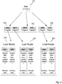
- FIG. 2 shows a schematic structural diagram of the tree-structured composite prefix spatial index.
- the structure of the composite prefix spatial index is a structure of an R-tree index.
- 201 indicates that Root is a root node of the R-tree, which stores a maximum rectangular space.
- the non-leaf node indicated by 202 only stores a minimum bounding rectangle (MBR) for spatial retrieval and a pageid (page identification) for searching a next page.
- MLR minimum bounding rectangle
- Content stored in the leaf node indicated by 203 is different from that stored in the non-leaf node indicated by 202.
- the content stored in the leaf node indicated by 203 includes not only the MBR, but also spatial data of a constraint condition included in the spatial field prefix, and it certainly further includes a conventional non-spatial field, such as Coll included in 202 of the figure.
- the content specifically includes a VERSION field and a NAME field, as well as a primary key PK automatically included in the composite prefix spatial index as a secondary index, such as PK included in 202 of the figure.
- the leaf node of the specific composite prefix spatial index also includes an ID field.
- a second embodiment of the present application further provides a database query processing method.
- FIG. 3 shows a database query processing method provided by the second embodiment of the present application.
- this embodiment is based on the first embodiment, the description therefor is relatively concise.
- the database query processing method provided by the second embodiment of the present application includes: steps S301 to S304.
- Step S301 Determine a database table within which spatial data is to be queried, wherein the database table comprises a spatial field for storing spatial data.
- This step is to determine a database table within which spatial data is to be queried.
- the database table is determined by acquiring a query command.
- the database table test of the database A is still used as an example.
- An example of the query command is as follows:
- Step S302. Acquire, for the database table, a query condition comprising a spatial query field.
- This step is to determine a query condition comprising a spatial query field.
- spatial query information of the query condition includes a spatial query field
- the spatial query information is specifically a minimum bounding rectangle operation including the spatial query field.
- the query condition further includes at least one of the following: a non-spatial field and a non-spatial field prefix.
- Step S303 Acquire a tree-structured spatial index of the database table, wherein a leaf node of the tree-structured spatial index stores therein spatial data.
- This step is to acquire a tree-structured spatial index.
- the step specifically includes the following processing: acquiring a query condition for the database table, determining that the query condition includes a spatial query field, and obtaining a spatial index or a composite spatial index established for the database table.
- an index column of the tree-structured spatial index comprises a spatial field; and a non-leaf node of the tree-structured spatial index stores therein a minimum bounding rectangle for retrieving the spatial data and a page ID for searching a next-level page.
- the leaf node further includes a primary key ID.
- FIG. 2 shows a schematic structural diagram of the tree-structured composite prefix spatial index.
- the structure of the composite prefix spatial index is a structure of an R-tree index.
- 201 indicates that Root is a root node of the R-tree, which stores a maximum rectangular space.
- the non-leaf node indicated by 202 only stores a minimum bounding rectangle (MBR) for spatial retrieval and a pageid (page identification) for searching a next page.
- MLR minimum bounding rectangle
- Content stored in the leaf node indicated by 203 is different from that stored in the non-leaf node indicated by 202.
- the content stored in the leaf node indicated by 203 includes not only the MBR, but also spatial data of a constraint condition included in the spatial field prefix, and it certainly further includes a conventional non-spatial field, such as a VERSION field, a NAME field, and a primary key PK automatically included in the composite prefix spatial index as a secondary index. Since the primary key of the table test is ID, the leaf node of the specific composite prefix spatial index also includes an ID field.
- Step S304 Query, according to the query condition, the tree-structured spatial index to obtain a query result.
- This step is to query, according to the query condition, the tree-structured spatial index.
- the query condition further includes a non-spatial field
- the query result is obtained specifically through the following processing:
- the querying, according to the spatial query field of the query condition, the composite spatial index of the database table to obtain the query result meeting the query condition is done through the following processing:
- the querying, according to the query condition, the composite spatial index of the database table using the covering index scan is done through the following processing:
- the querying the composite spatial index using the covering index scan according to the length condition included in prefix information of the spatial query field is done through the following processing:
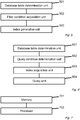
- FIG. 4 shows a flowchart of a specific implementation of the database query processing method provided by the second embodiment of the present application.
- the implementation comprises the following steps:
- S405. Determine whether a spatial field is required to be queried in the query command. If the spatial field is required to be acquired in the query command, proceed to S406; and if the spatial field is not required to be obtained in the query command, then proceed to S406-1.
- S406 Determine whether a length of recorded spatial data meets a length condition of a spatial field prefix. If the length of the spatial data meets the length condition of the spatial field prefix, then proceed to S406-1; and if the length of the spatial data does not meet the length condition of the spatial field prefix, then proceed to S405-1.
- the above select command is to select, from the table test, recorded ID, GEOM, and VERSION information meeting a query condition that is specified by the where clause.
- the query condition in this example includes a spatial query condition and a non-spatial query condition.
- the spatial query condition is an MBRIntersects operation
- the non-spatial query condition is a VERSION condition, namely version in (2, 3).
- a composite prefix spatial index sck is created when the table test is created. The sck records a 30-byte prefix of the GEOM field, VERSION, and a primary key ID automatically included as a secondary index.
- condition of the query there is first a filter condition of a minimum bounding rectangle operation, which meets the query filtering of the spatial index; and then other filter conditions and queried content are index columns of this sck index.
- S405 is executed.
- whether a spatial index query mode may be used is determined.
- the spatial field of the composite spatial index has been filtered by a condition that the spatial index can perform is further determined, such as a bounding rectangle operation, a distance operation, etc., and whether the composite spatial index further includes filtering of other ordinary fields.
- the process continues to S406 to further determine the length condition of the spatial prefix.
- the process continues to S406-1 for the covering index scan. If it is a very large multi polygon and the wkb encoding length exceeds 30 bytes, the record of this situation is marked on the sck index, and the table access by index rowid operation is performed according to the mark, which means that the process continues to S405-1 and check the primary key index again to obtain a complete record of geom.
- a third embodiment of the present application further provides a database index processing apparatus.
- FIG. 5 shows a schematic diagram of a database index processing apparatus provided according to the third embodiment of the present application. Since the apparatus embodiment is basically similar to the method embodiment, the description is relatively concise. For related parts, reference may be made to the corresponding description of the method embodiment.
- the present application provides a database index processing apparatus, comprising:
- the spatial filter condition includes spatial field prefix information; and the index generation unit 503 is specifically configured to:
- the spatial filter condition includes a filter condition of a minimum bounding rectangle operation type; and the index generation unit 503 is specifically configured to:
- the spatial field prefix information includes a condition for indicating a length of the spatial data stored in the spatial field; and the index generation unit 503 is specifically configured to:
- the index generation unit 503 is specifically configured to:
- the index generation unit 503 is specifically configured to:
- An index column of the tree-structured spatial index comprises a spatial field; and a non-leaf node of the tree-structured spatial index stores therein a minimum bounding rectangle for retrieving the spatial data and a page ID for searching a next-level page.
- the apparatus further includes a command unit, and the command unit is configured to:
- a fourth embodiment of the present application further provides a database query processing apparatus.
- FIG. 6 shows a schematic diagram of a database query processing apparatus provided according to the fourth embodiment of the present application. Since the apparatus embodiment is basically similar to the method embodiment, the description is relatively concise. For related parts, reference may be made to the corresponding description of the method embodiment.
- the database query processing apparatus shown in FIG. 6 comprises:
- the query condition further includes a non-spatial field; and the query unit 604 is specifically configured to:
- the query unit 604 is specifically configured to: acquire a non-spatial query field of the query condition;
- the query unit 604 includes a covering index scan subunit, and the covering index scan subunit is configured to: determine, according to the spatial query field, whether a spatial field of the composite spatial index of the database table is queried;
- the covering index scan subunit is specifically configured to: acquire the length condition included in the prefix information of the spatial query field; determine whether a length of a row record of the composite spatial index meets the length condition; and if so, use the row record as a query result of the covering index scan; and if not, query the database table according to primary key information.
- the query unit 604 is specifically configured to:
- spatial query information of the query condition is a minimum bounding rectangle operation comprising the spatial query field.
- An index column of the tree-structured spatial index comprises a spatial field; and a non-leaf node of the tree-structured spatial index stores therein a minimum bounding rectangle for retrieving the spatial data and a page ID for searching a next-level page.
- the leaf node further includes a primary key ID.
- a fifth embodiment of the present application further provides an electronic device for implementing the database index processing method. Please refer to FIG. 7 , which shows a schematic diagram of the electronic device provided by the fifth embodiment.
- the fifth embodiment of the present application provides an electronic device, comprising:
- the spatial filter condition includes spatial field prefix information; and the processor 702 is further configured to execute the following computer-executable instructi ons:
- the spatial filter condition includes a filter condition of a minimum bounding rectangle operation type; and the processor 702 is further configured to execute the following computer-executable instructions:
- the spatial field prefix information includes a condition for indicating a length of the spatial data stored in the spatial field; and the processor 702 is further configured to execute the following computer-executable instructions:
- processor 702 is further configured to execute the following computer-executable instructions:
- processor 702 is further configured to execute the following computer-executable instructions:
- an index column of the tree-structured spatial index comprises a spatial field; and a non-leaf node of the tree-structured spatial index stores therein a minimum bounding rectangle for retrieving the spatial data and a page ID for searching a next-level page.
- processor 702 is further configured to execute the following computer-executable instructions:
- a sixth embodiment of the present application further provides an electronic device for implementing the database query processing method, the structure of which is similar to that shown in FIG. 7 .
- the sixth embodiment of the present application provides an electronic device, comprising:
- the leaf node further includes a primary key ID.
- the query condition further includes a non-spatial field
- the processor is further configured to execute the following computer-executable instructions:
- the processor is further configured to execute the following computer-executable instructions:
- the processor is further configured to execute the following computer-executable instructions:
- the processor is further configured to execute the following computer-executable instructions:
- the processor is further configured to execute the following computer-executable instructions:
- spatial query information of the query condition is a minimum bounding rectangle operation comprising the spatial query field.
- an index column of the tree-structured spatial index comprises a spatial field; and a non-leaf node of the tree-structured spatial index stores therein a minimum bounding rectangle for retrieving the spatial data and a page ID for searching a next-level page.
- the seventh embodiment of the present application further provides a storage device, which is described in a relatively simple manner.
- a storage device which is described in a relatively simple manner.
- the present application provides a storage device having instructions stored therein, and the instructions can be loaded by a processor to execute the following steps:
- the eighth embodiment of the present application further provides a storage device, which is described in a relatively simple manner.
- a storage device which is described in a relatively simple manner.
- the present application provides a storage device having instructions stored therein, and the instructions can be loaded by a processor to execute the following steps: the memory is configured to store computer-executable instructions, and the processor is configured to execute the computer-executable instructions:
- a computing device includes one or more processors (CPU), an input/output interface, a network interface, and a memory.
- the memory may include a volatile memory on a computer-readable medium, a random access memory (RAM) and/or a non-volatile memory, and the like, such as a read-only memory (ROM) or a flash random access memory (flash RAM).
- RAM random access memory
- ROM read-only memory
- flash RAM flash random access memory
Landscapes
- Engineering & Computer Science (AREA)
- Theoretical Computer Science (AREA)
- Databases & Information Systems (AREA)
- General Engineering & Computer Science (AREA)
- Physics & Mathematics (AREA)
- General Physics & Mathematics (AREA)
- Data Mining & Analysis (AREA)
- Software Systems (AREA)
- Computational Linguistics (AREA)
- Computer Hardware Design (AREA)
- Quality & Reliability (AREA)
- Information Retrieval, Db Structures And Fs Structures Therefor (AREA)
Abstract
Description
- The present application claims priority to the
Chinese patent application No. 201811422523.X filed on November 27, 2018 - The present application relates to the field of data processing, and, more particularly, to a method, apparatus, electronic device, and storage device for processing database indexes. The present application also relates to a method, apparatus, electronic device, and storage device for processing database queries.
- With the development of computer and information technology, spatial data and databases supporting spatial data storage and management have been widely used in various industries, such as urban planning, transportation, banking, and aerospace. The so-called spatial data, also known as geometric data, is a special type of data that can be processed by a computer to show information containing spatial coordinates. Examples of such data include spatial data representing architectural design drawings, mechanical design drawings, and maps. The spatial data may quantitatively describe objects and occurrences of things having positioning significance in the real world, such as identifying locations, shapes, sizes, and distribution characteristics of a spatial entity. The so-called spatial entity is a result of abstracting geographic objects and occurrences of things, and is also referred to as geographic entity or entity.
- At present, a database that supports storing and managing spatial data generally provides spatial indexing for fast reading and integrity check of the spatial data stored therein. The so-called spatial indexing is a data structure arranged in a certain order according to positions and shapes of spatial objects or certain spatial relationships among the spatial objects. The existing spatial indexing only stores information that may cover minimum bounding rectangle (MBR) of the spatial objects. The so-called MBR refers to a minimum bounding rectangle that covers the spatial objects in two dimensions. When spatial data is queried, spatial data meeting a spatial filter condition is filtered and selected first; and then returning to a primary key table is needed for a further filtering to obtain a complete record. Therefore, when the number of records matching the spatial filter condition is relatively large during the query, CPU and IO overhead for returning to the primary key table to obtain the complete record is relatively large, resulting in a relatively low efficiency in spatial data queries.
- The present application provides a database index processing method and a database query processing method to improve the query efficiency of spatial data.
- The present application provides a database index processing method, comprising:
- determining a database table for which a database index is to be created, wherein the database table comprises a spatial field for storing spatial data;
- acquiring, for the database table, a spatial filter condition comprising a spatial field ID; and
- generating, according to the spatial filter condition, a tree-structured spatial index for the database table, wherein a leaf node of the tree-structured spatial index stores therein spatial data meeting the spatial filter condition and a primary key ID.
- Optionally, the spatial filter condition comprises spatial field prefix information;
the generating, according to the spatial filter condition, the tree-structured spatial index for the database table comprises: - acquiring, according to the spatial filter condition, spatial field prefix information used for generating the tree-structured spatial index;
- generating, according to the spatial field prefix information, a spatial prefix index for the database table, wherein an index column of the spatial prefix index comprises the spatial field prefix information; and
- using the spatial prefix index as the tree-structured spatial index.
- Optionally, the spatial filter condition comprises a filter condition of a minimum bounding rectangle operation type;
- the generating, according to the spatial field prefix information, the spatial prefix index of the database table comprises:
- performing, according to the filter condition of the minimum bounding rectangle operation type, minimum bounding box filtering on the database table to obtain an alternative spatial field meeting the filter condition of the minimum bounding rectangle operation type;
- performing standard byte-stream encoding for geospatial information on spatial data stored in the alternative spatial field; and
- generating the spatial prefix index of the database table according to the spatial data on which the standard byte-stream encoding for geospatial information is performed and the spatial field prefix information.
- Optionally, the spatial field prefix information comprises a condition for indicating a length of spatial data stored in the spatial field;
- the generating the spatial prefix index of the database table according to the spatial data on which the standard byte-stream encoding for geospatial information is performed and the spatial field prefix information comprises:
- acquiring a length of the spatial data on which the standard byte-stream encoding for geospatial information is performed;
- acquiring the length condition according to the spatial field prefix information; and
- if the length of the spatial data on which the standard byte-stream encoding for geospatial information is performed meets the length condition, storing in a leaf node of the spatial prefix index the spatial data meeting the length condition;
- otherwise, the leaf node of the spatial prefix index does not save the spatial data.
- Optionally, the generating, according to the spatial filter condition, the tree-structured spatial index for the database table comprises:
- acquiring, according to the spatial filter condition, information of a spatial field used for generating the tree-structured spatial index;
- acquiring information of a non-spatial field used for generating the tree-structured spatial index;
- generating, according to the information of the spatial field and the information of the non-spatial field, a composite spatial index of the database table, wherein an index column of the spatial composite index comprises the spatial field and the non-spatial field; and
- using the composite spatial index as the tree-structured spatial index.
- Optionally, the generating, according to the spatial filter condition, the tree-structured spatial index for the database table comprises:
- acquiring, according to the spatial filter condition, information of a spatial field prefix used for generating the tree-structured spatial index;
- acquiring information of a non-spatial field used for generating the tree-structured spatial index;
- generating, according to the information of the spatial field prefix and the information of the non-spatial field, a composite prefix spatial index, wherein an index column of the composite prefix spatial index comprises the spatial field prefix and the non-spatial field; and
- using the spatial composite prefix index as the tree-structured spatial index.
- Optionally, an index column of the tree-structured spatial index comprises a spatial field; and a non-leaf node of the tree-structured spatial index stores therein a minimum bounding rectangle for retrieving the spatial data and a page ID for searching a next-level page.
- Optionally, the method further comprises:
- creating, according to a database table creation command, the database table, wherein the database table creation command comprises an index creation command for generating the tree-structured spatial index; or
- creating, according to the index creation command, the tree-structured spatial index.
- The present application further provides a database query processing method, comprising:
- determining a database table within which spatial data is to be queried, wherein the database table comprises a spatial field for storing spatial data;
- acquiring, for the database table, a query condition comprising a spatial query field;
- acquiring a tree-structured spatial index of the database table, wherein a leaf node of the tree-structured spatial index stores therein spatial data; and
- querying, according to the query condition, the tree-structured spatial index to obtain a query result.
- Optionally, the query condition further comprises a non-spatial field;
the querying, according to the query condition, the tree-structured spatial index to obtain the query result comprises: - acquiring a spatial field of the query condition;
- determining whether the spatial field matches a spatial field ID of an index column of the tree-structured spatial index;
- if so, querying, according to the spatial query field of the query condition, a composite spatial index of the database table to obtain a query result meeting the query condition; and
- if not, obtaining an alternative record of a non-spatial query field matching the query condition in the database table; and acquiring, according to the spatial query field of the query condition and from the alternative record, a query result meeting the query condition.
- Optionally, the querying, according to the spatial query field of the query condition, the composite spatial index of the database table to obtain the query result meeting the query condition comprises:
- acquiring a non-spatial query field of the query condition;
- determining whether the spatial query field and the non-spatial query field are index columns comprised in the composite spatial index of the database table;
- if so, determining that the query condition meets a spatial index query mode of the database table, and querying, according to the query condition, the composite spatial index of the database table using a covering index scan; and
- if not, querying to find, according to the query condition, an alternative record meeting the query condition from the composite spatial index of the database table, and according to a primary key of the alternative record, returning to the database table for further querying and obtaining a complete row record that meets the query condition.
- Optionally, the querying, according to the query condition, the composite spatial index of the database table using the covering index scan comprises:
- determining, according to the spatial query field, whether the spatial query field is a spatial field of the composite spatial index of the database table that is queried;
- if so, querying the composite spatial index using the covering index scan according to a length condition included in prefix information of the spatial query field; and
- if not, querying the composite spatial index of the database table using the covering index scan.
- Optionally, the querying the composite spatial index using the covering index scan according to the length condition included in prefix information of the spatial query field comprises:
- acquiring the length condition included in the prefix information of the spatial query field;
- determining whether a length of a row record of the composite spatial index meets the length condition; and if so, using the row record as a query result of the covering index scan; and
- if not, querying the database table according to primary key information.
- Optionally, the acquiring, according to the spatial query field of the query condition and from the alternative record, the query result meeting the query condition comprises:
- performing spatial computation on data of the alternative row record, and according to a computation result, acquiring, from the alternative row record, a row record that accords with the spatial query field; and
- using the row record that meets the spatial query field as the query result meeting the query condition.
- Optionally, spatial query information of the query condition is a minimum bounding rectangle operation comprising the spatial query field.
- Optionally, an index column of the tree-structured spatial index comprises a spatial field; and a non-leaf node of the tree-structured spatial index stores therein a minimum bounding rectangle for retrieving the spatial data and a page ID for searching a next-level page.
- The present application further provides a database index processing apparatus, comprising:
- a database table determination unit, configured to determine a database table for which a database index is to be created, wherein the database table comprises a spatial field for storing spatial data;
- a filter condition acquisition unit, configured to acquire, for the database table, a spatial filter condition comprising a spatial field ID; and
- an index generation unit, configured to generate, according to the spatial filter condition, a tree-structured spatial index for the database table, wherein a leaf node of the tree-structured spatial index stores therein spatial data meeting the spatial filter condition and a primary key ID.
- The present application further provides a database query processing apparatus, comprising:
- a database table determination unit, configured to determine a database table within which spatial data is to be queried, wherein the database table comprises a spatial field for storing spatial data;
- a query condition determination unit, configured to acquire, for the database table, a query condition comprising a spatial query field;
- an index acquisition unit, configured to acquire a tree-structured spatial index of the database table, wherein a leaf node of the tree-structured spatial index stores therein the spatial data; and
- a query unit, configured to query, according to the query condition, the tree-structured spatial index to obtain a query result.
- The present application further provides an electronic device, comprising:
- a memory and a processor;
- the memory is configured to store computer-executable instructions, and the processor is configured to execute the computer-executable instructions:
- determining a database table for which a database index is to be created, wherein the database table comprises a spatial field for storing spatial data;
- acquiring, for the database table, a spatial filter condition comprising a spatial field ID; and
- generating, according to the spatial filter condition, a tree-structured spatial index for the database table, wherein a leaf node of the tree-structured spatial index stores therein spatial data meeting the spatial filter condition and a primary key ID.
- The present application further provides an electronic device, comprising:
- a memory and a processor;
- the memory is configured to store computer-executable instructions, and the processor is configured to execute the computer-executable instructions:
- determining a database table within which spatial data is to be queried, wherein the database table comprises a spatial field for storing spatial data;
- acquiring, for the database table, a query condition comprising a spatial query field;
- acquiring a tree-structured spatial index of the database table, wherein a leaf node of the tree-structured spatial index stores therein spatial data; and
- querying, according to the query condition, the tree-structured spatial index to obtain a query result.
- The present application further provides a storage device having instructions stored therein, and the instructions can be loaded by a processor to execute the following steps:
- determining a database table for which a database index is to be created, wherein the database table comprises a spatial field for storing spatial data;
- acquiring, for the database table, a spatial filter condition comprising a spatial field ID; and
- generating, according to the spatial filter condition, a tree-structured spatial index for the database table, wherein a leaf node of the tree-structured spatial index stores therein spatial data meeting the spatial filter condition and a primary key ID.
- The present application further provides a storage device having instructions stored therein, and the instructions can be loaded by a processor to execute the following steps:
- determining a database table within which spatial data is to be queried, wherein the database table comprises a spatial field for storing spatial data;
- acquiring, for the database table, a query condition comprising a spatial query field;
- acquiring a tree-structured spatial index of the database table, wherein a leaf node of the tree-structured spatial index stores therein spatial data; and
- querying, according to the query condition, the tree-structured spatial index to obtain a query result.
- Compared with the prior art, the present application has the following advantages:
the database index processing method provided by the present application generates, according to a spatial filter condition of a database table including a spatial filed, a tree-structured spatial index for the database table, and stores spatial data meeting the spatial filter condition in a leaf node of the tree-structured spatial index. Storing spatial data in an index improves the query efficiency of the spatial data, thereby solving the problem of low efficiency in querying spatial data. Further, when the tree-structured spatial index is a composite spatial index including a non-spatial field, a filtering of a non-spatial column may further be provided, thereby reducing the number of table access by index rowid operations, and improving the query efficiency. - According to a query condition containing a spatial query field, the database query processing method provided by the present application queries a tree-structured spatial index of the database table to obtain a query result. As a leaf node of the tree-structured spatial index stores spatial data, the overhead for querying spatial data is reduced, thereby solving the problem of low efficiency in querying spatial data. Further, when the tree-structured spatial index is a composite spatial index including a non-spatial field, a filtering of a non-spatial column may further be provided, thereby reducing the number of table access by index rowid operations, and improving the query efficiency.
-
-
FIG. 1 is a processing flowchart of a database index processing method according to a first embodiment of the present application; -
FIG. 2 is a schematic structural diagram of a database index according to the first embodiment of the present application; -
FIG. 3 is a processing flowchart of a database query processing method according to a second embodiment of the present application; -
FIG. 4 is a flowchart of actual implementation of a database query according to the second embodiment of the present application; -
FIG. 5 is a schematic diagram of a database index processing apparatus according to a third embodiment of the present application; -
FIG. 6 is a schematic diagram of a database query processing apparatus according to a fourth embodiment of the present application; and -
FIG. 7 is a schematic diagram of an electronic device according to a fifth embodiment of the present application. - In the following description, many specific details are explained in order for those skilled in the art to fully understand the present application. However, the present application can be implemented in many other manners different from those described herein. Those skilled in the art may make similar generalization without departing from the spirit of the present application. Therefore, the present application is not limited by the specific implementations disclosed below.
- The present application provides a method, apparatus, electronic device, and storage device for processing database indexes. The present application also relates to a method, apparatus, electronic device, and storage device for processing database queries. Detailed description is provided in each of the following embodiments.
- A first embodiment of the present application provides a database index processing method.
- The database index processing method provided by the embodiment of the present application will be described below in combination with
FIG. 1 andFIG. 2 . - The database index processing method shown in
FIG. 1 includes: steps S 101 to S 103. - Step S101. Determine a database table for which a database index is to be created, wherein the database table comprises a spatial field for storing spatial data.
- In practical applications, a database that supports spatial data generally provides spatial indexing. As traditional spatial indexing only stores MBR information and/or minimum bounding box (MBB) information, a further table access by index rowid operation is needed. The so-called MBB and MBR refer to a minimum bounding range that encompasses a spatial object. The minimum bounding range that encompasses a spatial object in two-dimensions is a minimum bounding rectangle (MBR), and the minimum bounding range that encompasses a spatial object in three-dimensions is a minimum bounding box (MBB). The table access by index rowid operation means that, after an alternative record meeting a spatial filter condition of filter conditions is queried and selected, the process returns to a primary key table for a further query to obtain all fields, and to determine whether other non-spatial filter conditions in the filter conditions are met. Taking a database of a clustered index table as an example. The table access by index rowid operation for the clustered index table is inefficient and slow, which results in inefficient query of spatial data. The so-called clustered index table is a commonly used form for organizing a database table, which means that all records in the database table are organized in accordance with a primary key order. Indexing is used for storing data in a database table, and data is indexed using the primary key of the database table. A database index generated based on a clustered index table is a secondary index of the database table. The secondary index refers to a non-primary key index. In addition, when the number of records matching the spatial filter condition is relatively large during the query, CPU and IO overhead for the table access by index rowid operation to obtain the complete record is relatively large, resulting in a relatively low efficiency in spatial data queries. It should be noted that the database index processing method provided by the present application may also be used for heap tables.
- In the database index processing method proposed by the present application, a leaf node of a tree-structured spatial index of the obtained database table stores spatial data that meets the spatial filter condition, and a query meeting a certain condition directly obtains a query result from the tree-structured spatial index of the database table. Not all queries need the table access by index rowid operation to obtain complete records, which makes transactions containing querying of spatial data faster and more efficient for spatial filtering queries.
- This step is to determine a database table for which a database index is to be created, the database table containing a spatial field. The example here uses a database table test of a database A (test is the table name). The table test uses a GEOM field to store Geo-Information system (GIS) spatial data. The GIS spatial data falls into the Geometry data type. GEOM is a field ID (or called field name) of the table test. Geometry is a type of spatial data supported by a database, which maybe longitudinal and latitudinal information representing a geographic location. The table test further includes other non-spatial fields, i.e., ordinary fields, such as ID int, NAME varchar (500), PRICE double, VERSION int, Primary key (id), and others, respectively corresponding to an ID (identification) of an integer type, a NAME (name) of a character type with a length of 500, a PRICE (price) of a double precision type, and the ID being used as a primary key. As such, a record of the table test includes the identification, name, price, and location information of an object. The GEOM field is a spatial field, whereas other fields storing non-spatial data are ordinary fields or non-spatial fields.
- Step S102. Acquire, for the database table, a spatial filter condition comprising a spatial field ID.
- This step is to determine the spatial filter condition for generating a spatial index, also known as a filter condition.
- In an implementation manner provided by the embodiment of the present application, the spatial filter condition includes a spatial field, and an index column of a tree-structured spatial index obtained in a corresponding subsequent step includes the spatial field.
- In another implementation manner provided by the embodiment of the present application, the spatial filter condition includes a spatial field prefix. Spatial data may be alternatively stored in a tree-structured index generated subsequently using the spatial field prefix. In other words, a constraint condition of the spatial data stored in the index may be defined or specified through the spatial field prefix. Specifically, the constraint condition is determined according to the actual situation of the spatial data of the spatial field in a database table record and by taking into account the balance between query efficiency and space occupation. For example, when the space occupation is still available, the condition for storing the spatial data in the index is loosened so as to store in the index as much spatial data as possible, which improves the query efficiency.
- Further, the spatial filter condition further includes at least one of the following: a non-spatial field and a non-spatial field prefix. The spatial indexes generated according to different spatial filter conditions in the subsequent steps include different field types. If the spatial filter condition refers to a spatial field prefix, the obtained spatial index is a spatial prefix index, and an index column of the spatial prefix index includes the spatial field prefix. If the spatial filter condition refers to a spatial field prefix and a non-spatial field, a spatial field prefix and a non-spatial field prefix, a spatial field prefix, a non-spatial field, or a non-spatial field prefix, then the spatial index obtained subsequently is a composite prefix spatial index. An index column of the composite prefix spatial index includes the spatial field prefix, and further includes at least one of the following: a non-spatial field and a non-spatial field prefix.
- In the embodiment of the present application, index-creation instruction information may be obtained at the stage when a database table is created, or it may be obtained after the database table is created or after the database table has been created and data has been inserted. The process specifically includes:
- creating, according to a database table creation command, the database table, wherein the database table creation command comprises an index creation command for generating the tree-structured spatial index; or
- creating, according to the index creation command, the tree-structured spatial index.
- Still use the database table test of the database A as an example. Creating test with the following command is to obtain the index-creation instruction information for creating a spatial index sck:
- Create table test (
- ID int,
- NAME varchar(500),
- PRICE double,
- GEOM. Geometry,
- VERSION int,
- Primary key(id),
- Spatial key sck (geom(30), version)
- );
- The above-mentioned index-creation instruction information of the spatial index sck included in the creation command for table test includes a 30-byte prefix of the spatial field GEOM, a VERSION field, and a primary key ID automatically included as a secondary index. It may also be created by using "create index" after the table test is created or after data is inserted into the table test. For example, the index-creation instruction information of the spatial index sck1 includes a 30-byte prefix of the spatial field GEOM, a PRICE field, and a primary key ID automatically included as a secondary index. The command is as follows: create spatial key sck1(geom(20), price).
- Step S103. Generate, according to the spatial filter condition, a tree-structured spatial index for the database table, wherein a leaf node of the tree-structured spatial index stores therein spatial data meeting the spatial filter condition and a primary key ID.
- This step is to generate a tree-structured spatial index storing the spatial data.
- In the embodiment of the present application, when the spatial filter condition includes a spatial field and a non-spatial field, the tree-structured spatial index for the database table is generated specifically through the following processing:
- acquiring, according to the spatial filter condition, information of a spatial field used for generating the tree-structured spatial index;
- acquiring information of a non-spatial field used for generating the tree-structured spatial index;
- generating, according to the information of the spatial field and the information of the non-spatial field, a composite spatial index of the database table, wherein an index column of the spatial composite index comprises the spatial field and the non-spatial field; and
- using the composite spatial index as the tree-structured spatial index.
- In the embodiment of the present application, when the spatial filter condition includes information of a spatial field prefix and information of a non-spatial field, the tree-structured spatial index for the database table is generated specifically through the following processing:
- acquiring, according to the spatial filter condition, information of a spatial field prefix used for generating the tree-structured spatial index;
- acquiring information of a non-spatial field used for generating the tree-structured spatial index;
- generating, according to the information of the spatial field prefix and the information of the non-spatial field, a composite prefix spatial index, wherein an index column of the composite prefix spatial index comprises the spatial field prefix and the non-spatial field; and
- using the spatial composite prefix index as the tree-structured spatial index.
- In a specific implementation manner provided by the embodiment of the present application, an index column of the generated tree-structured spatial index includes a spatial field; and a non-leaf node of the tree-structured spatial index stores therein a minimum bounding rectangle for retrieving the spatial data and a page ID for searching a next-level page.
- In another specific implementation manner provided by the embodiment of the present application, an index column of the generated tree-structured spatial index includes spatial field prefix information; and a non-leaf node of the tree-structured spatial index stores therein a minimum bounding rectangle for retrieving the spatial data and a page ID for searching a next-level page. The tree-structured spatial index for the database table is generated specifically through the following processing:
- acquiring, according to the spatial filter condition, spatial field prefix information used for generating the tree-structured spatial index;
- generating, according to the spatial field prefix information, a spatial prefix index for the database table, wherein an index column of the spatial prefix index comprises the spatial field prefix information; and
- using the spatial prefix index as the tree-structured spatial index.
- Further, the spatial filter condition includes a filter condition for a minimum bounding rectangle operation type. Accordingly, the processing of generating the spatial prefix index of the database table according to the spatial field prefix information includes the following:
- performing, according to the filter condition of the minimum bounding rectangle operation type, minimum bounding box filtering on the database table to obtain an alternative spatial field meeting the filter condition of the minimum bounding rectangle operation type;
- performing standard byte-stream encoding for geospatial information on spatial data stored in the alternative spatial field; and
- generating the spatial prefix index of the database table according to the spatial data on which the standard byte-stream encoding for geospatial information is performed and the spatial field prefix information.
- The so-called geospatial information standard byte stream refers to the Well-known Binary (WKB), which uses a continuous binary stream to express geometric information.
- In a specific implementation manner provided by the embodiment of the present application, the spatial field prefix information includes a condition for indicating a length of the spatial data stored in the spatial field. Accordingly, the generating the spatial prefix index of the database table according to the spatial data on which the standard byte-stream encoding for geospatial information is performed and the spatial field prefix information specifically includes:
- acquiring a length of the spatial data on which the standard byte-stream encoding for geospatial information is performed;
- acquiring the length condition according to the spatial field prefix information; and
- if the length of the spatial data on which the standard byte-stream encoding for geospatial information is performed meets the length condition, storing in a leaf node of the spatial prefix index the spatial data meeting the length condition;
- otherwise, the leaf node of the spatial prefix index does not save the spatial data.
- Still using the database table test of the database A as an example. A tree-structured composite prefix spatial index is generated based on GEOM, VERSION, and NAME. The structure of the index is shown in
FIG. 2. FIG. 2 shows a schematic structural diagram of the tree-structured composite prefix spatial index. The structure of the composite prefix spatial index is a structure of an R-tree index. In the figure, 201 indicates that Root is a root node of the R-tree, which stores a maximum rectangular space. The non-leaf node indicated by 202 only stores a minimum bounding rectangle (MBR) for spatial retrieval and a pageid (page identification) for searching a next page. Content stored in the leaf node indicated by 203 is different from that stored in the non-leaf node indicated by 202. The content stored in the leaf node indicated by 203 includes not only the MBR, but also spatial data of a constraint condition included in the spatial field prefix, and it certainly further includes a conventional non-spatial field, such as Coll included in 202 of the figure. In this example, the content specifically includes a VERSION field and a NAME field, as well as a primary key PK automatically included in the composite prefix spatial index as a secondary index, such as PK included in 202 of the figure. In this example, since the primary key of the table test is ID, the leaf node of the specific composite prefix spatial index also includes an ID field. - Based on the above-described first embodiment, a second embodiment of the present application further provides a database query processing method.
- Please refer to
FIG. 3 , which shows a database query processing method provided by the second embodiment of the present application. As this embodiment is based on the first embodiment, the description therefor is relatively concise. For related parts, reference may be made to the corresponding description of the first embodiment. - The database query processing method provided by the second embodiment of the present application includes: steps S301 to S304.
- Step S301. Determine a database table within which spatial data is to be queried, wherein the database table comprises a spatial field for storing spatial data.
- This step is to determine a database table within which spatial data is to be queried.
- In this embodiment of the present application, the database table is determined by acquiring a query command. The database table test of the database A is still used as an example. An example of the query command is as follows:
- select ID, GEOM, VERSION from test where MBRIntersects(GEOM"ST_GeomFr omText('POLYGON ((113.22779059410095 23.077155641028952, 113.22927117347716 23.077155641028952, 113.22927117347716 23.078517734365768, 113.22779059410095 23.078517734365768, 113.22779059410095 23.077155641028952))',4326)) and version i n (2, 3);
- a record of the table test includes an identification, name, price, and location information of an object, and the table test uses a spatial field GEOM to store GIS spatial data including longitudinal and latitudinal information. The table test further includes other non-spatial fields: ID int, NAME varchar (500), PRICE double, VERSION int, Primary key (id), and other fields, respectively corresponding to an ID (identification) of an integer type, a NAME (name) of a character type with a length of 500, a PRICE (price) of a double precision type, and the primary key being specified as the ID field. The above query command is to select, from the table test, recorded ID, GEOM, and VERSION information meeting a query condition that is specified by the where clause. The query condition in this example includes a spatial query condition and a non-spatial query condition.
- Step S302. Acquire, for the database table, a query condition comprising a spatial query field.
- This step is to determine a query condition comprising a spatial query field.
- In the embodiment of the present application, spatial query information of the query condition includes a spatial query field, and the spatial query information is specifically a minimum bounding rectangle operation including the spatial query field.
- Still using the query command of the database table test of the database A as an example.
- MBRIntersects(GEOM"ST_GeomFromText('POLYGON ((113.22779059410095 23.077155641028952, 113.22927117347716 23.077155641028952, 113.22927117347716 23.078517734365768, 113.22779059410095 23.078517734365768, 113.22779059410095 23.077155641028952))',4326))
in the where clause of the above-mentioned command is to determine whether the minimum bounding rectangle operation is one involving intersecting or overlapping. - In the embodiment of the present application, the query condition further includes at least one of the following: a non-spatial field and a non-spatial field prefix.
- Step S303. Acquire a tree-structured spatial index of the database table, wherein a leaf node of the tree-structured spatial index stores therein spatial data.
- This step is to acquire a tree-structured spatial index.
- In the embodiment of the present application, the step specifically includes the following processing: acquiring a query condition for the database table, determining that the query condition includes a spatial query field, and obtaining a spatial index or a composite spatial index established for the database table. Specifically, an index column of the tree-structured spatial index comprises a spatial field; and a non-leaf node of the tree-structured spatial index stores therein a minimum bounding rectangle for retrieving the spatial data and a page ID for searching a next-level page. Preferably, the leaf node further includes a primary key ID.
- Still using the database table test of the database A as an example. A tree-structured composite prefix spatial index generated based on GEOM, VERSION, and NAME is obtained for the table test. The structure of the index is shown in
FIG. 2. FIG. 2 shows a schematic structural diagram of the tree-structured composite prefix spatial index. The structure of the composite prefix spatial index is a structure of an R-tree index. In the figure, 201 indicates that Root is a root node of the R-tree, which stores a maximum rectangular space. The non-leaf node indicated by 202 only stores a minimum bounding rectangle (MBR) for spatial retrieval and a pageid (page identification) for searching a next page. Content stored in the leaf node indicated by 203 is different from that stored in the non-leaf node indicated by 202. The content stored in the leaf node indicated by 203 includes not only the MBR, but also spatial data of a constraint condition included in the spatial field prefix, and it certainly further includes a conventional non-spatial field, such as a VERSION field, a NAME field, and a primary key PK automatically included in the composite prefix spatial index as a secondary index. Since the primary key of the table test is ID, the leaf node of the specific composite prefix spatial index also includes an ID field. - Step S304. Query, according to the query condition, the tree-structured spatial index to obtain a query result.
- This step is to query, according to the query condition, the tree-structured spatial index.
- In the embodiment of the present application, the query condition further includes a non-spatial field, and the query result is obtained specifically through the following processing:
- acquiring a spatial field of the query condition;
- determining whether the spatial field matches a spatial field ID of an index column of the tree-structured spatial index;
- if so, querying, according to the spatial query field of the query condition, a composite spatial index of the database table to obtain a query result meeting the query condition; and
- if not, obtaining an alternative record of a non-spatial query field matching the query condition in the database table; and acquiring, according to the spatial query field of the query condition and from the alternative record, a query result meeting the query condition. In the embodiment of the present application, the acquiring, from the alternative record, a query result meeting the query condition specifically includes the following processing:
- performing spatial computation on data of the alternative row record, and according to a computation result, acquiring, from the alternative row record, a row record that accords with the spatial query field; and
- using the row record that meets the spatial query field as the query result meeting the query condition.
- In the embodiment of the present application, if it is determined that the spatial field matches the spatial field ID of the index column of the tree-structured spatial index, then the querying, according to the spatial query field of the query condition, the composite spatial index of the database table to obtain the query result meeting the query condition is done through the following processing:
- acquiring a non-spatial query field of the query condition;
- determining whether the spatial query field and the non-spatial query field are index columns comprised in the composite spatial index of the database table;
- if so, determining that the query condition meets a spatial index query mode of the database table, and querying, according to the query condition, the composite spatial index of the database table using a covering index scan;
- if not, querying to find, according to the query condition, an alternative record meeting the query condition from the composite spatial index of the database table, and according to a primary key of the alternative record, returning to the database table for further querying and obtaining a complete row record that meets the query condition.
- Specifically, the querying, according to the query condition, the composite spatial index of the database table using the covering index scan is done through the following processing:
- determining, according to the spatial query field, whether the spatial query field is a spatial field of the composite spatial index of the database table that is queried;
- if so, querying the composite spatial index using the covering index scan according to a length condition included in prefix information of the spatial query field; and
- if not, querying the composite spatial index of the database table using the covering index scan.
- In the embodiment of the present application, specifically, the querying the composite spatial index using the covering index scan according to the length condition included in prefix information of the spatial query field is done through the following processing:
- acquiring the length condition included in the prefix information of the spatial query field;
- determining whether a length of a row record of the composite spatial index meets the length condition; and if so, using the row record as a query result of the covering index scan; and
- if not, querying the database table according to primary key information.
- Please refer to
FIG. 4 , which shows a flowchart of a specific implementation of the database query processing method provided by the second embodiment of the present application. In the figure, the implementation comprises the following steps: - S401. Query start; that is, a query command is received, and a query process is started.
- S402. Query optimization; that is, a statement of the query command is parsed, and a query condition is split into various tokens to be used for subsequent steps.
- S403. Determine whether to query using a spatial index. In the embodiment of the present application, if the query condition includes geometric operators for spatial data, such as intersection, containing, orientation, distance between, distance sorting, etc., then the spatial index will be determined to be used preferentially; if so, proceed to S404; if not, proceed to S404-1.
- S404. Determine whether a composite spatial index includes a to-be-queried field; that is, whether the composite spatial index includes a field required to be queried in the query command is determined. In the embodiment of the present application, it is determined whether a composite spatial index of the database table includes a field (or a column of the database table) required to be queried in the query command according to each token obtained through splitting. If the composite spatial index includes the field required to be queried in the query command, proceed to S405; and if the composite spatial index does not include the field required to be queried in the query command, proceed to S405-1.
- S404-1. Enter a processing flow for other non-spatial field indexes. That is, the spatial index query cannot be preferentially performed, and the query needs to be based on a non-spatial field. In the embodiment of the present application, the following operations are performed: obtaining an alternative record of a non-spatial query field matching the query condition in the database table; and acquiring, according to the spatial query field of the query condition and from the alternative record, a query result meeting the query condition. Specifically, the following processing is included:
- performing spatial computation on data of the alternative row record, and according to a computation result, acquiring, from the alternative row record, a row record that accords with the spatial query field; and
- using the row record that meets the spatial query field as the query result meeting the query condition.
- In this processing, it is necessary to query complete data recorded in each row, and then standard spatial functions are used to compute and decide whether the query condition is met in which geometric spatial operations such as intersection, containing, orientation, distance between, distance sorting, etc. may be performed.
- S405. Determine whether a spatial field is required to be queried in the query command. If the spatial field is required to be acquired in the query command, proceed to S406; and if the spatial field is not required to be obtained in the query command, then proceed to S406-1.
- S405-1. Perform a table access by index rowid operation, which specifically means that, after an alternative record meeting a spatial query condition of a query condition is queried and selected, the process returns to a primary key table for a further query to obtain all fields, and to determine whether other non-spatial query conditions in the query condition are met.
- S406. Determine whether a length of recorded spatial data meets a length condition of a spatial field prefix. If the length of the spatial data meets the length condition of the spatial field prefix, then proceed to S406-1; and if the length of the spatial data does not meet the length condition of the spatial field prefix, then proceed to S405-1.
- S406-1. Perform a covering index scan operation; that is, perform a covering index scan on the composite spatial index to obtain a required query result.
- Still use the query command of the database table test of the database A as an example. The above select command is to select, from the table test, recorded ID, GEOM, and VERSION information meeting a query condition that is specified by the where clause. The query condition in this example includes a spatial query condition and a non-spatial query condition. The spatial query condition is an MBRIntersects operation, and the non-spatial query condition is a VERSION condition, namely version in (2, 3). A composite prefix spatial index sck is created when the table test is created. The sck records a 30-byte prefix of the GEOM field, VERSION, and a primary key ID automatically included as a secondary index. In the where condition of the query, there is first a filter condition of a minimum bounding rectangle operation, which meets the query filtering of the spatial index; and then other filter conditions and queried content are index columns of this sck index. As a result, S405 is executed. In addition, whether a spatial index query mode may be used is determined. Whether the spatial field of the composite spatial index has been filtered by a condition that the spatial index can perform is further determined, such as a bounding rectangle operation, a distance operation, etc., and whether the composite spatial index further includes filtering of other ordinary fields. During the execution of S405, since the geom field is selected, the process continues to S406 to further determine the length condition of the spatial prefix. If the geom in the result meeting bounding rectangle filtering in the index is less than 30 bytes after encoded using wkb, for example, point(1 13.228, 23.078), which correspondingly has a wkb length of 25, then complete geom wkb information may be recorded in a leaf node of the sck index. In this case, the process continues to S406-1 for the covering index scan. If it is a very large multi polygon and the wkb encoding length exceeds 30 bytes, the record of this situation is marked on the sck index, and the table access by index rowid operation is performed according to the mark, which means that the process continues to S405-1 and check the primary key index again to obtain a complete record of geom.
- In accordance with the database index processing method provided by the first embodiment of the present application, a third embodiment of the present application further provides a database index processing apparatus.
- Please refer to
FIG. 5 , which shows a schematic diagram of a database index processing apparatus provided according to the third embodiment of the present application. Since the apparatus embodiment is basically similar to the method embodiment, the description is relatively concise. For related parts, reference may be made to the corresponding description of the method embodiment. - The present application provides a database index processing apparatus, comprising:
- a database
table determination unit 501, configured to determine a database table for which a database index is to be created, wherein the database table comprises a spatial field for storing spatial data; - a filter
condition acquisition unit 502, configured to acquire, for the database table, a spatial filter condition comprising a spatial field ID; and - an
index generation unit 503, configured to generate, according to the spatial filter condition, a tree-structured spatial index for the database table, wherein a leaf node of the tree-structured spatial index stores therein spatial data meeting the spatial filter condition and a primary key ID. - Herein, the spatial filter condition includes spatial field prefix information; and the
index generation unit 503 is specifically configured to: - acquire, according to the spatial filter condition, spatial field prefix information used for generating the tree-structured spatial index;
- generate, according to the spatial field prefix information, a spatial prefix index for the database table, wherein an index column of the spatial prefix index comprises the spatial field prefix information; and
- use the spatial prefix index as the tree-structured spatial index.
- Herein, the spatial filter condition includes a filter condition of a minimum bounding rectangle operation type; and the
index generation unit 503 is specifically configured to: - perform, according to the filter condition of the minimum bounding rectangle operation type, minimum bounding box filtering on the database table to obtain an alternative spatial field meeting the filter condition of the minimum bounding rectangle operation type;
- perform a standard byte-stream encoding for geospatial information on spatial data stored in the alternative spatial field; and
- generate the spatial prefix index of the database table according to the spatial data on which the standard byte-stream encoding for geospatial information is performed and the spatial field prefix information.
- Herein, the spatial field prefix information includes a condition for indicating a length of the spatial data stored in the spatial field; and the
index generation unit 503 is specifically configured to: - acquire a length of the spatial data on which the standard byte-stream encoding for geospatial information is performed;
- acquire the length condition according to the spatial field prefix information; and
- if the length of the spatial data on which the standard byte-stream encoding for geospatial information is performed meets the length condition, store in a leaf node of the spatial prefix index the spatial data meeting the length condition;
- otherwise, the leaf node of the spatial prefix index does not save the spatial data.
- Herein, the
index generation unit 503 is specifically configured to: - acquire, according to the spatial filter condition, information of a spatial field used for generating the tree-structured spatial index;
- acquire information of a non-spatial field used for generating the tree-structured spatial index;
- generate, according to the information of the spatial field and the information of the non-spatial field, a composite spatial index of the database table, wherein an index column of the spatial composite index comprises the spatial field and the non-spatial field; and
- use the composite spatial index as the tree-structured spatial index.
- Herein, the
index generation unit 503 is specifically configured to: - acquire, according to the spatial filter condition, information of a spatial field prefix used for generating the tree-structured spatial index;
- acquire information of a non-spatial field used for generating the tree-structured spatial index;
- generate, according to the information of the spatial field prefix and the information of the non-spatial field, a composite prefix spatial index, wherein an index column of the composite prefix spatial index comprises the spatial field prefix and the non-spatial field; and
- use the composite prefix spatial index as the tree-structured spatial index.
- An index column of the tree-structured spatial index comprises a spatial field; and a non-leaf node of the tree-structured spatial index stores therein a minimum bounding rectangle for retrieving the spatial data and a page ID for searching a next-level page.
- Herein, the apparatus further includes a command unit, and the command unit is configured to:
- create, according to a database table creation command, the database table, wherein the database table creation command comprises an index creation command for generating the tree-structured spatial index; or
- create, according to the index creation command, the tree-structured spatial index.
- In accordance with the database query processing method provided by the second embodiment of the present application, a fourth embodiment of the present application further provides a database query processing apparatus.
- Please refer to
FIG. 6 , which shows a schematic diagram of a database query processing apparatus provided according to the fourth embodiment of the present application. Since the apparatus embodiment is basically similar to the method embodiment, the description is relatively concise. For related parts, reference may be made to the corresponding description of the method embodiment. - The database query processing apparatus shown in
FIG. 6 comprises: - a database
table determination unit 601, configured to determine a database table within which spatial data is to be queried, wherein the database table comprises a spatial field for storing spatial data; - a query
condition determination unit 602, configured to acquire, for the database table, a query condition comprising a spatial query field; - an
index acquisition unit 603, configured to acquire a tree-structured spatial index of the database table, wherein a leaf node of the tree-structured spatial index stores therein the spatial data; and - a
query unit 604, configured to query, according to the query condition, the tree-structured spatial index to obtain a query result. - The query condition further includes a non-spatial field; and the
query unit 604 is specifically configured to: - acquire a spatial field of the query condition;
- determine whether the spatial field matches a spatial field ID of an index column of the tree-structured spatial index;
- if so, query, according to the spatial query field of the query condition, a composite spatial index of the database table to obtain a query result meeting the query condition; and
- if not, obtain an alternative record of a non-spatial query field matching the query condition in the database table; and acquire, according to the spatial query field of the query condition and from the alternative record, a query result meeting the query condition.
- Herein, the
query unit 604 is specifically configured to: acquire a non-spatial query field of the query condition; - determine whether the spatial query field and the non-spatial query field are index columns comprised in the composite spatial index of the database table;
- if so, determine that the query condition meets a spatial index query mode of the database table, and query, according to the query condition, the composite spatial index of the database table using a covering index scan;
- if not, query to find, according to the query condition, an alternative record meeting the query condition from the composite spatial index of the database table, and according to a primary key of the alternative record, return to the database table for further querying and obtaining a complete row record that meets the query condition.
- Herein, the
query unit 604 includes a covering index scan subunit, and the covering index scan subunit is configured to: determine, according to the spatial query field, whether a spatial field of the composite spatial index of the database table is queried; - if so, query the composite spatial index using the covering index scan according to a length condition included in prefix information of the spatial query field; and
- if not, query the composite spatial index of the database table using the covering index scan.
- Herein, the covering index scan subunit is specifically configured to: acquire the length condition included in the prefix information of the spatial query field;
determine whether a length of a row record of the composite spatial index meets the length condition; and if so, use the row record as a query result of the covering index scan; and if not, query the database table according to primary key information. - Herein, the
query unit 604 is specifically configured to: - perform spatial calculation on data of the alternative row record, and according to a calculation result, acquire, from the alternative row record, a row record that meets the spatial query field; and
- use the row record that meets the spatial query field as the query result meeting the query condition.
- Herein, spatial query information of the query condition is a minimum bounding rectangle operation comprising the spatial query field.
- An index column of the tree-structured spatial index comprises a spatial field; and a non-leaf node of the tree-structured spatial index stores therein a minimum bounding rectangle for retrieving the spatial data and a page ID for searching a next-level page.
- Herein, the leaf node further includes a primary key ID.
- Based on the foregoing embodiments, a fifth embodiment of the present application further provides an electronic device for implementing the database index processing method. Please refer to
FIG. 7 , which shows a schematic diagram of the electronic device provided by the fifth embodiment. - The fifth embodiment of the present application is described in a relatively concise manner. For related parts, reference may be made to the corresponding description of the foregoing embodiments.
- The fifth embodiment of the present application provides an electronic device, comprising:
- a
memory 701 and aprocessor 702; - the
memory 701 is configured to store computer-executable instructions, and theprocessor 702 is configured to execute the computer-executable instructions:- determining a database table for which a database index is to be created, wherein the database table comprises a spatial field for storing spatial data;
- acquiring, for the database table, a spatial filter condition comprising a spatial field ID; and
- generating, according to the spatial filter condition, a tree-structured spatial index for the database table, wherein a leaf node of the tree-structured spatial index stores therein spatial data meeting the spatial filter condition and a primary key ID.
- Optionally, the spatial filter condition includes spatial field prefix information; and the
processor 702 is further configured to execute the following computer-executable instructi ons: - acquiring, according to the spatial filter condition, spatial field prefix information used for generating the tree-structured spatial index;
- generating, according to the spatial field prefix information, a spatial prefix index for the database table, wherein an index column of the spatial prefix index comprises the spatial field prefix information; and
- using the spatial prefix index as the tree-structured spatial index.
- Optionally, the spatial filter condition includes a filter condition of a minimum bounding rectangle operation type; and the
processor 702 is further configured to execute the following computer-executable instructions: - performing, according to the filter condition of the minimum bounding rectangle operation type, minimum bounding box filtering on the database table to obtain an alternative spatial field meeting the filter condition of the minimum bounding rectangle operation type;
- performing standard byte-stream encoding for geospatial information on spatial data stored in the alternative spatial field; and
- generating the spatial prefix index of the database table according to the spatial data on which the standard byte-stream encoding for geospatial information is performed and the spatial field prefix information.
- Optionally, the spatial field prefix information includes a condition for indicating a length of the spatial data stored in the spatial field; and the
processor 702 is further configured to execute the following computer-executable instructions: - acquiring a length of the spatial data on which the standard byte-stream encoding for geospatial information is performed;
- acquiring the length condition according to the spatial field prefix information; and
- if the length of the spatial data on which the standard byte-stream encoding for geospatial information is performed meets the length condition, storing in a leaf node of the spatial prefix index the spatial data meeting the length condition;
- otherwise, the leaf node of the spatial prefix index does not save the spatial data.
- Optionally, the
processor 702 is further configured to execute the following computer-executable instructions: - acquiring, according to the spatial filter condition, information of a spatial field used for generating the tree-structured spatial index;
- acquiring information of a non-spatial field used for generating the tree-structured spatial index;
- generating, according to the information of the spatial field and the information of the non-spatial field, a composite spatial index of the database table, wherein an index column of the spatial composite index comprises the spatial field and the non-spatial field; and
- using the composite spatial index as the tree-structured spatial index.
- Optionally, the
processor 702 is further configured to execute the following computer-executable instructions: - acquiring, according to the spatial filter condition, information of a spatial field prefix used for generating the tree-structured spatial index;
- acquiring information of a non-spatial field used for generating the tree-structured spatial index;
- generating, according to the information of the spatial field prefix and the information of the non-spatial field, a composite prefix spatial index, wherein an index column of the composite prefix spatial index comprises the spatial field prefix and the non-spatial field; and
- using the composite prefix spatial index as the tree-structured spatial index.
- Optionally, an index column of the tree-structured spatial index comprises a spatial field; and a non-leaf node of the tree-structured spatial index stores therein a minimum bounding rectangle for retrieving the spatial data and a page ID for searching a next-level page.
- Optionally, the
processor 702 is further configured to execute the following computer-executable instructions: - creating, according to a database table creation command, the database table, wherein the database table creation command comprises an index creation command for generating the tree-structured spatial index; or
- creating, according to the index creation command, the tree-structured spatial index.
- Based on the foregoing embodiments, a sixth embodiment of the present application further provides an electronic device for implementing the database query processing method, the structure of which is similar to that shown in
FIG. 7 . - The six embodiment of the present application is described in a relatively concise manner. For related parts, reference may be made to the corresponding description of the foregoing embodiments.
- The sixth embodiment of the present application provides an electronic device, comprising:
- a memory and a processor;
- the memory is configured to store computer-executable instructions, and the processor is configured to execute the computer-executable instructions:
the memory is configured to store computer-executable instructions, and the processor is configured to execute the computer-executable instructions:- determining a database table within which spatial data is to be queried, wherein the database table comprises a spatial field for storing spatial data;
- acquiring, for the database table, a query condition comprising a spatial query field;
- acquiring a tree-structured spatial index of the database table, wherein a leaf node of the tree-structured spatial index stores therein spatial data; and
- querying, according to the query condition, the tree-structured spatial index to obtain a query result.
- Optionally, the leaf node further includes a primary key ID.
- Optionally, the query condition further includes a non-spatial field; and the processor is further configured to execute the following computer-executable instructions:
- acquiring a spatial field of the query condition;
- determining whether the spatial field matches a spatial field ID of an index column of the tree-structured spatial index;
- if so, querying, according to the spatial query field of the query condition, a composite spatial index of the database table to obtain a query result meeting the query condition; and
- if not, obtaining an alternative record of a non-spatial query field matching the query condition in the database table; and acquiring, according to the spatial query field of the query condition and from the alternative record, a query result meeting the query condition.
- Optionally, the processor is further configured to execute the following computer-executable instructions:
- acquiring a non-spatial query field of the query condition;
- determining whether the spatial query field and the non-spatial query field are index columns comprised in the composite spatial index of the database table;
- if so, determining that the query condition meets a spatial index query mode of the database table, and querying, according to the query condition, the composite spatial index of the database table using a covering index scan;
- if not, querying to find, according to the query condition, an alternative record meeting the query condition from the composite spatial index of the database table, and according to a primary key of the alternative record, returning to the database table for further querying and obtaining a complete row record that meets the query condition.
- Optionally, the processor is further configured to execute the following computer-executable instructions:
- determining, according to the spatial query field, whether the spatial query field is a spatial field of the composite spatial index of the database table that is queried;
- if so, querying the composite spatial index using the covering index scan according to a length condition included in prefix information of the spatial query field; and
- if not, querying the composite spatial index of the database table using the covering index scan.
- Optionally, the processor is further configured to execute the following computer-executable instructions:
- acquiring the length condition included in the prefix information of the spatial query field;
- determining whether a length of a row record of the composite spatial index meets the length condition; and if so, using the row record as a query result of the covering index scan; and
- if not, querying the database table according to primary key information.
- Optionally, the processor is further configured to execute the following computer-executable instructions:
- performing spatial computation on data of the alternative row record, and according to a computation result, acquiring, from the alternative row record, a row record that accords with the spatial query field; and
- using the row record that meets the spatial query field as the query result meeting the query condition.
- Optionally, spatial query information of the query condition is a minimum bounding rectangle operation comprising the spatial query field.
- Optionally, an index column of the tree-structured spatial index comprises a spatial field; and a non-leaf node of the tree-structured spatial index stores therein a minimum bounding rectangle for retrieving the spatial data and a page ID for searching a next-level page.
- The seventh embodiment of the present application further provides a storage device, which is described in a relatively simple manner. For related parts, reference may be made to the corresponding description of the foregoing embodiments.
- The present application provides a storage device having instructions stored therein, and the instructions can be loaded by a processor to execute the following steps:
- determining a database table for which a database index is to be created, wherein the database table comprises a spatial field for storing spatial data;
- acquiring, for the database table, a spatial filter condition comprising a spatial field ID; and
- generating, according to the spatial filter condition, a tree-structured spatial index for the database table, wherein a leaf node of the tree-structured spatial index stores therein spatial data meeting the spatial filter condition and a primary key ID.
- The eighth embodiment of the present application further provides a storage device, which is described in a relatively simple manner. For related parts, reference may be made to the corresponding description of the foregoing embodiments.
- The present application provides a storage device having instructions stored therein, and the instructions can be loaded by a processor to execute the following steps:
the memory is configured to store computer-executable instructions, and the processor is configured to execute the computer-executable instructions: - determining a database table within which spatial data is to be queried, wherein the database table comprises a spatial field for storing spatial data;
- acquiring, for the database table, a query condition comprising a spatial query field;
- acquiring a tree-structured spatial index of the database table, wherein a leaf node of the tree-structured spatial index stores therein spatial data; and
- querying, according to the query condition, the tree-structured spatial index to obtain a query result.
- In a typical configuration, a computing device includes one or more processors (CPU), an input/output interface, a network interface, and a memory.
- The memory may include a volatile memory on a computer-readable medium, a random access memory (RAM) and/or a non-volatile memory, and the like, such as a read-only memory (ROM) or a flash random access memory (flash RAM). The memory is an example of the computer-readable media.
- 1. Computer-readable media further include nonvolatile and volatile, removable and non-removable media employing any method or technique to achieve information storage. The information may be computer readable instructions, data structures, modules of programs, or other data. Examples of computer storage media include, but are not limited to, a phase-change random access memory (PRAM), a static random access memory (SRAM), a dynamic random access memory (DRAM), other types of random access memories (RAM), a read-only memory (ROM), an electrically erasable programmable read-only memory (EEPROM), a flash memory or other memory technologies, a compact disc read-only memory (CD-ROM), a digital versatile disc (DVD) or other optical memories, a magnetic cassette tape, a magnetic tape, a magnetic disk storage or other magnetic storage devices or any other non-transmission medium, which may be used to store information that can be accessed by a computing device. As defined herein, the computer-readable media do not include transitory media, such as modulated data signals and carriers
- 2. Those skilled in the art should understand that the embodiments of the present application can be provided as a method, a system, or a computer program product. Therefore, the present application may take a form of an entirely hardware embodiment, an entirely software embodiment, or an embodiment combining software and hardware elements. Furthermore, the present invention may take the form of a computer program product which is embodied on one or more computer-usable storage media (including, but not limited to, disk storage, CD-ROM, optical storage, and so forth) having computer-usable program code included therein.
- Although the present application is disclosed as above in preferred embodiments, the present application is not to be limited thereby. Any person skilled in the art may make possible changes and modifications without departing from the spirit and scope of the present application. Therefore, the protection scope of the present application shall be defined by the claims of the present application.
Claims (22)
- A database index processing method, the method comprising:determining a database table for which a database index is to be created, the database table comprising a spatial field for storing spatial data;acquiring, for the database table, a spatial filter condition comprising a spatial field ID; andgenerating, according to the spatial filter condition, a tree-structured spatial index for the database table, a leaf node of the tree-structured spatial index storing therein spatial data meeting the spatial filter condition and a primary key ID.
- The method according to claim 1, wherein:the spatial filter condition comprises spatial field prefix information; andthe generating, according to the spatial filter condition, the tree-structured spatial index for the database table comprises:acquiring, according to the spatial filter condition, spatial field prefix information used for generating the tree-structured spatial index;generating, according to the spatial field prefix information, a spatial prefix index for the database table, an index column of the spatial prefix index comprising the spatial field prefix information; andusing the spatial prefix index as the tree-structured spatial index.
- The method according to claim 2, wherein:the spatial filter condition comprises a filter condition of a minimum bounding rectangle operation type; andthe generating, according to the spatial field prefix information, the spatial prefix index for the database table comprises:performing, according to the filter condition of the minimum bounding rectangle operation type, a minimum bounding box filtering on the database table to obtain an alternative spatial field meeting the filter condition of the minimum bounding rectangle operation type;performing a standard byte-stream encoding for geospatial information on spatial data stored in the alternative spatial field; andgenerating the spatial prefix index of the database table according to the spatial data on which the standard byte-stream encoding for geospatial information is performed and the spatial field prefix information.
- The method according to claim 3, wherein:the spatial field prefix information comprises a condition for indicating a length of spatial data stored in the spatial field; andthe generating the spatial prefix index of the database table according to the spatial data on which the standard byte-stream encoding for geospatial information is performed and the spatial field prefix information comprises:acquiring a length of the spatial data on which the standard byte-stream encoding for geospatial information is performed;acquiring a length condition according to the spatial field prefix information; andin response to determining that the length of the spatial data on which the standard byte-stream encoding for geospatial information is performed meets the length condition, storing in a leaf node of the spatial prefix index the spatial data meeting the length condition; orin response to determining that the length of the spatial data on which the standard byte-stream encoding for geospatial information is not performed meets the length condition, determining not to store in the leaf node of the spatial prefix index the spatial data.
- The method according to claim 1, wherein the generating, according to the spatial filter condition, the tree-structured spatial index for the database table comprises:acquiring, according to the spatial filter condition, information of a spatial field used for generating the tree-structured spatial index;acquiring information of a non-spatial field used for generating the tree-structured spatial index;generating, according to the information of the spatial field and the information of the non-spatial field, a composite spatial index of the database table, an index column of the spatial composite index comprising the spatial field and the non-spatial field; andusing the composite spatial index as the tree-structured spatial index.
- The method according to claim 1, wherein the generating, according to the spatial filter condition, the tree-structured spatial index for the database table comprises:acquiring, according to the spatial filter condition, information of a spatial field prefix used for generating the tree-structured spatial index;acquiring information of a non-spatial field used for generating the tree-structured spatial index;generating, according to the information of the spatial field prefix and the information of the non-spatial field, a composite prefix spatial index, an index column of the composite prefix spatial index comprising the spatial field prefix and the non-spatial field; andusing the spatial composite prefix index as the tree-structured spatial index.
- The method according to claim 1, wherein:an index column of the tree-structured spatial index comprises a spatial field; anda non-leaf node of the tree-structured spatial index stores therein a minimum bounding rectangle for retrieving the spatial data and a page ID for searching a next-level page.
- The method according to claim 1, further comprising:creating, according to a database table creation command, the database table, the database table creation command comprising an index creation command for generating the tree-structured spatial index; orcreating, according to the index creation command, the tree-structured spatial index.
- A database query processing method, the method comprising:determining a database table within which spatial data is to be queried, the database table comprising a spatial field for storing spatial data;acquiring, for the database table, a query condition comprising a spatial query field;acquiring a tree-structured spatial index of the database table, a leaf node of the tree-structured spatial index storing therein spatial data; andquerying, according to the query condition, the tree-structured spatial index to obtain a query result.
- The method according to claim 9, wherein:the query condition further comprises a non-spatial field; andthe querying, according to the query condition, the tree-structured spatial index to obtain the query result comprises:acquiring a spatial field of the query condition;determining whether the spatial field matches a spatial field ID of an index column of the tree-structured spatial index; andin response to determining that the spatial field matches a spatial field ID of an index column of the tree-structured spatial index, querying, according to the spatial query field of the query condition, a composite spatial index of the database table to obtain a query result meeting the query condition; orin response to determining that the spatial field does not match a spatial field ID of an index column of the tree-structured spatial index, obtaining an alternative record of a non-spatial query field matching the query condition in the database table, and acquiring, according to the spatial query field of the query condition and from the alternative record, a query result meeting the query condition.
- The method according to claim 10, wherein the querying, according to the spatial query field of the query condition, the composite spatial index of the database table to obtain the query result meeting the query condition comprises:acquiring a non-spatial query field of the query condition;determining whether the spatial query field and the non-spatial query field are at in index column comprised in the composite spatial index of the database table; andin response to determining that the spatial query field and the non-spatial query field are at in index column comprised in the composite spatial index of the database table, determining that the query condition meets a spatial index query mode of the database table, and querying, according to the query condition, the composite spatial index of the database table using a covering index scan; orin response to determining that the spatial query field and the non-spatial query field are not at in index column comprised in the composite spatial index of the database table, querying to find, according to the query condition, an alternative record meeting the query condition from the composite spatial index of the database table, and according to a primary key of the alternative record, returning to the database table for further querying and obtaining a complete row record that meets the query condition.
- The method according to claim 11, wherein the querying, according to the query condition, the composite spatial index of the database table using the covering index scan comprises:
determining, according to the spatial query field, whether the spatial query field is a spatial field of the composite spatial index of the database table that is queried; andin response to determining, according to the spatial query field, that the spatial query field is a spatial field of the composite spatial index of the database table that is queried, querying the composite spatial index using the covering index scan according to a length condition included in prefix information of the spatial query field; orin response to determining, according to the spatial query field, that the spatial query field is not a spatial field of the composite spatial index of the database table that is queried, querying the composite spatial index of the database table using the covering index scan. - The method according to claim 12, wherein the querying the composite spatial index using the covering index scan according to the length condition included in prefix information of the spatial query field comprises:acquiring the length condition included in the prefix information of the spatial query field;determining whether a length of a row record of the composite spatial index meets the length condition; andin response to determining that the length of the row record of the composite spatial index meets the length condition, using the row record as a query result of the covering index scan; andin response to determining that the length of the row record of the composite spatial index does not meet the length condition, querying the database table according to primary key information.
- The method according to claim 10, wherein the acquiring, according to the spatial query field of the query condition and from the alternative record, the query result meeting the query condition comprises:performing a spatial computation on data of the alternative row record, and, according to a computation result, acquiring, from the alternative row record, a row record that accords with the spatial query field; andusing the row record that accords with the spatial query field as the query result meeting the query condition.
- The method according to claim 9, wherein spatial query information of the query condition is a minimum bounding rectangle operation comprising the spatial query field.
- The method according to claim 9, wherein:an index column of the tree-structured spatial index comprises the spatial field; anda non-leaf node of the tree-structured spatial index stores therein a minimum bounding rectangle for retrieving the spatial data and a page ID for searching a next-level page.
- A database index processing apparatus, the apparatus comprising:a database table determination unit, configured to determine a database table for which a database index is to be created, the database table comprising a spatial field for storing spatial data;a filter condition acquisition unit, configured to acquire, for the database table, a spatial filter condition comprising a spatial field ID; andan index generation unit, configured to generate, according to the spatial filter condition, a tree-structured spatial index for the database table, a leaf node of the tree-structured spatial index storing therein spatial data meeting the spatial filter condition and a primary key ID.
- A database query processing apparatus, the apparatus comprising:a database table determination unit, configured to determine a database table within which spatial data is to be queried, the database table comprising a spatial field for storing spatial data;a query condition determination unit, configured to acquire, for the database table, a query condition comprising a spatial query field;an index acquisition unit, configured to acquire a tree-structured spatial index of the database table, a leaf node of the tree-structured spatial index storing therein the spatial data; anda query unit, configured to query, according to the query condition, the tree-structured spatial index to obtain a query result.
- An electronic device comprising:a memory and a processor; andthe memory is configured to store computer-executable instructions, and the processor is configured to execute the computer-executable instructions to perform acts comprising:determining a database table for which a database index is to be created, the database table comprising a spatial field for storing spatial data;acquiring, for the database table, a spatial filter condition comprising a spatial field ID; andgenerating, according to the spatial filter condition, a tree-structured spatial index for the database table, wherein a leaf node of the tree-structured spatial index stores therein spatial data meeting the spatial filter condition and a primary key ID.
- An electronic device comprising:a memory and a processor; andthe memory is configured to store computer-executable instructions, and the processor is configured to execute the computer-executable instructions to perform acts comprising:determining a database table within which spatial data is to be queried, the database table comprising a spatial field for storing spatial data;acquiring, for the database table, a query condition comprising a spatial query field;acquiring a tree-structured spatial index of the database table, wherein a leaf node of the tree-structured spatial index stores therein spatial data; andquerying, according to the query condition, the tree-structured spatial index to obtain a query result.
- A storage device having instructions stored therein, and the instructions are executable by a processor to cause the processor to perform acts comprising:determining a database table for which a database index is to be created, the database table comprising a spatial field for storing spatial data;acquiring, for the database table, a spatial filter condition comprising a spatial field ID; andgenerating, according to the spatial filter condition, a tree-structured spatial index for the database table, a leaf node of the tree-structured spatial index storing therein spatial data meeting the spatial filter condition and a primary key ID.
- A storage device having instructions stored therein, and the instructions are executable by a processor to cause the processor to perform acts comprising:determining a database table within which spatial data is to be queried, the database table comprising a spatial field for storing spatial data;acquiring, for the database table, a query condition comprising a spatial query field;acquiring a tree-structured spatial index of the database table, a leaf node of the tree-structured spatial index storing therein spatial data; andquerying, according to the query condition, the tree-structured spatial index to obtain a query result.
Applications Claiming Priority (2)
| Application Number | Priority Date | Filing Date | Title |
|---|---|---|---|
| CN201811422523.XA CN111221813B (en) | 2018-11-27 | 2018-11-27 | Database index and processing method, device and equipment for database query |
| PCT/CN2019/119394 WO2020108345A1 (en) | 2018-11-27 | 2019-11-19 | Database index and database query processing method, apparatus, and device |
Publications (2)
| Publication Number | Publication Date |
|---|---|
| EP3889797A1 true EP3889797A1 (en) | 2021-10-06 |
| EP3889797A4 EP3889797A4 (en) | 2022-08-17 |
Family
ID=70827421
Family Applications (1)
| Application Number | Title | Priority Date | Filing Date |
|---|---|---|---|
| EP19889311.7A Pending EP3889797A4 (en) | 2018-11-27 | 2019-11-19 | DATABASE INDEX AND DATABASE REQUEST PROCESSING METHOD, ESTABLISHMENT AND APPARATUS |
Country Status (5)
| Country | Link |
|---|---|
| US (2) | US11995059B2 (en) |
| EP (1) | EP3889797A4 (en) |
| JP (1) | JP7539884B2 (en) |
| CN (1) | CN111221813B (en) |
| WO (1) | WO2020108345A1 (en) |
Cited By (2)
| Publication number | Priority date | Publication date | Assignee | Title |
|---|---|---|---|---|
| CN113641681A (en) * | 2021-10-13 | 2021-11-12 | 南京大数据集团有限公司 | Space self-adaptive mass data query method |
| WO2026005260A1 (en) * | 2024-06-25 | 2026-01-02 | 네이버 주식회사 | Method and system for directly querying index data by using piggyback method in nosql environment |
Families Citing this family (7)
| Publication number | Priority date | Publication date | Assignee | Title |
|---|---|---|---|---|
| CN113886414B (en) * | 2020-07-03 | 2025-01-24 | 金篆信科有限责任公司 | A database maximum value query method and device |
| CN112328629B (en) * | 2020-09-14 | 2024-06-04 | 咪咕文化科技有限公司 | Entity object processing method and device and electronic equipment |
| CN116795906B (en) * | 2022-03-14 | 2026-01-02 | 北京天耀宏图科技股份有限公司 | Multi-source heterogeneous data storage method, device and medium for land spatial planning |
| CN117425887A (en) * | 2022-05-18 | 2024-01-19 | 京东方科技集团股份有限公司 | Data processing methods, devices, electronic equipment and computer-readable storage media |
| CN115391346A (en) * | 2022-08-26 | 2022-11-25 | 北京人大金仓信息技术股份有限公司 | Database aggregation index generation method, storage medium and computer equipment |
| CN115587094B (en) * | 2022-09-29 | 2026-01-27 | 中国科学技术大学 | Network measurement data management method based on dynamic multi-copy index |
| CN117555906B (en) * | 2024-01-12 | 2024-04-05 | 腾讯科技(深圳)有限公司 | Data processing method, device, electronic equipment and storage medium |
Family Cites Families (29)
| Publication number | Priority date | Publication date | Assignee | Title |
|---|---|---|---|---|
| US5963956A (en) | 1997-02-27 | 1999-10-05 | Telcontar | System and method of optimizing database queries in two or more dimensions |
| US7383275B2 (en) * | 2002-05-10 | 2008-06-03 | International Business Machines Corporation | Methods to improve indexing of multidimensional databases |
| US7945569B2 (en) | 2004-03-31 | 2011-05-17 | Hewlett-Packard Development Company, L.P. | Method and apparatus for querying spatial data |
| US20070168370A1 (en) | 2004-11-16 | 2007-07-19 | Hardy Mark D | System and methods for provisioning geospatial data |
| US7389283B2 (en) | 2004-12-07 | 2008-06-17 | International Business Machines Corporation | Method for determining an optimal grid index specification for multidimensional data |
| US7877405B2 (en) | 2005-01-07 | 2011-01-25 | Oracle International Corporation | Pruning of spatial queries using index root MBRS on partitioned indexes |
| JP4878178B2 (en) | 2006-02-28 | 2012-02-15 | 株式会社日立製作所 | Data processing method and apparatus, and processing program therefor |
| US20070233720A1 (en) * | 2006-04-04 | 2007-10-04 | Inha-Industry Partnership Institute | Lazy bulk insertion method for moving object indexing |
| US8243081B2 (en) * | 2006-08-22 | 2012-08-14 | International Business Machines Corporation | Methods and systems for partitioning a spatial index |
| US7737974B2 (en) * | 2006-09-27 | 2010-06-15 | International Business Machines Corporation | Reallocation of spatial index traversal between processing elements in response to changes in ray tracing graphics workload |
| US10783526B2 (en) | 2006-12-19 | 2020-09-22 | Celeritasworks, Llc | Campaign awareness management systems and methods |
| US8171014B2 (en) | 2007-08-29 | 2012-05-01 | International Business Machines Corporation | Apparatus, system, and method for executing a distributed spatial data query |
| US8145641B2 (en) * | 2008-01-18 | 2012-03-27 | Oracle International Corporation | Managing feature data based on spatial collections |
| US8155880B2 (en) * | 2008-05-09 | 2012-04-10 | Locomatix Inc. | Location tracking optimizations |
| WO2009155741A1 (en) | 2008-06-23 | 2009-12-30 | Shanghai Hewlett-Packard Co., Ltd | Spatial querying in a data warehouse |
| WO2010061260A1 (en) * | 2008-11-03 | 2010-06-03 | Elvin Slavik | Method, system, and product for managing spatial data in a database |
| JP2010182097A (en) | 2009-02-05 | 2010-08-19 | Nec Software Chubu Ltd | Space extraction device, extraction method for the same, and program |
| US8386468B2 (en) | 2010-08-26 | 2013-02-26 | Oracle International Corporation | Spatial query processing with query window index |
| WO2012082859A1 (en) * | 2010-12-14 | 2012-06-21 | The Regents Of The University Of California | High efficiency prefix search algorithm supporting interactive, fuzzy search on geographical structured data |
| US8892569B2 (en) | 2010-12-23 | 2014-11-18 | Ianywhere Solutions, Inc. | Indexing spatial data with a quadtree index having cost-based query decomposition |
| JP5765253B2 (en) | 2012-01-24 | 2015-08-19 | 富士通株式会社 | Area search method, area search program, and information processing apparatus |
| KR101440475B1 (en) * | 2012-10-17 | 2014-09-17 | 주식회사 리얼타임테크 | Method for creating index for mixed query process, method for processing mixed query, and recording media for recording index data structure |
| US9104770B2 (en) * | 2013-02-28 | 2015-08-11 | Oracle International Corporation | Methods for query processing of topological relationships among complex spatial objects |
| US10929501B2 (en) | 2013-08-08 | 2021-02-23 | Sap Se | Managing and querying spatial point data in column stores |
| JP2015055914A (en) | 2013-09-10 | 2015-03-23 | キヤノン株式会社 | Information processor, information processing method, and program |
| US10007677B1 (en) * | 2014-12-04 | 2018-06-26 | Google Llc | System and method for geospatial indexing |
| US11210279B2 (en) * | 2016-04-15 | 2021-12-28 | Apple Inc. | Distributed offline indexing |
| CN107391502B (en) * | 2016-05-16 | 2020-08-04 | 阿里巴巴集团控股有限公司 | Time interval data query method and device and index construction method and device |
| CN108628969B (en) * | 2018-04-24 | 2022-05-06 | 咪咕文化科技有限公司 | A spatial keyword indexing method, platform and storage medium |
-
2018
- 2018-11-27 CN CN201811422523.XA patent/CN111221813B/en active Active
-
2019
- 2019-11-19 EP EP19889311.7A patent/EP3889797A4/en active Pending
- 2019-11-19 WO PCT/CN2019/119394 patent/WO2020108345A1/en not_active Ceased
- 2019-11-19 JP JP2021529833A patent/JP7539884B2/en active Active
-
2021
- 2021-05-27 US US17/332,724 patent/US11995059B2/en active Active
-
2024
- 2024-03-22 US US18/614,408 patent/US20240232157A1/en not_active Abandoned
Cited By (3)
| Publication number | Priority date | Publication date | Assignee | Title |
|---|---|---|---|---|
| CN113641681A (en) * | 2021-10-13 | 2021-11-12 | 南京大数据集团有限公司 | Space self-adaptive mass data query method |
| CN113641681B (en) * | 2021-10-13 | 2022-02-22 | 南京大数据集团有限公司 | Space self-adaptive mass data query method |
| WO2026005260A1 (en) * | 2024-06-25 | 2026-01-02 | 네이버 주식회사 | Method and system for directly querying index data by using piggyback method in nosql environment |
Also Published As
| Publication number | Publication date |
|---|---|
| US20240232157A1 (en) | 2024-07-11 |
| CN111221813B (en) | 2023-06-23 |
| CN111221813A (en) | 2020-06-02 |
| US11995059B2 (en) | 2024-05-28 |
| JP7539884B2 (en) | 2024-08-26 |
| EP3889797A4 (en) | 2022-08-17 |
| WO2020108345A1 (en) | 2020-06-04 |
| JP2022510184A (en) | 2022-01-26 |
| US20210286795A1 (en) | 2021-09-16 |
Similar Documents
| Publication | Publication Date | Title |
|---|---|---|
| US11995059B2 (en) | Database index and database query processing method, apparatus, and device | |
| CN107247808B (en) | Distributed NewSQL database system and picture data query method | |
| US10789231B2 (en) | Spatial indexing for distributed storage using local indexes | |
| US8862566B2 (en) | Systems and methods for intelligent parallel searching | |
| CN107038207A (en) | A kind of data query method, data processing method and device | |
| CN109241159B (en) | Partition query method and system for data cube and terminal equipment | |
| CN114297204B (en) | Data storage and retrieval method and device for heterogeneous data sources | |
| WO2017161540A1 (en) | Data query method, data object storage method and data system | |
| JP5075653B2 (en) | Database management method, database management apparatus, database management program, and database system | |
| CN111209296A (en) | Database access method and device, electronic equipment and storage medium | |
| CN111259003B (en) | Database establishment method and device | |
| CN115129777A (en) | Data table conversion method and device, electronic equipment and storage medium | |
| CN113722296A (en) | Agricultural information processing method and device, electronic equipment and storage medium | |
| CN115809268B (en) | Adaptive query method and device based on fragment index | |
| CN106933824A (en) | The method and apparatus that the collection of document similar to destination document is determined in multiple documents | |
| CN118606566A (en) | Data processing method and device, program product, electronic device and storage medium | |
| CN117609303A (en) | Multi-table joint query method, device, equipment and storage medium | |
| CN111125216A (en) | Method and device for importing data into Phoenix | |
| CN114996270A (en) | Method and device for inquiring paging data | |
| JP6666312B2 (en) | Multidimensional data management system and multidimensional data management method | |
| US12265535B1 (en) | Dataset summary metadata providing improved query performance | |
| US12265514B1 (en) | Efficient sorting techniques facilitating the creation and use of dataset summary metadata | |
| US20260127190A1 (en) | Data query method and apparatus | |
| CN109033201A (en) | A kind of acquisition methods, device and the electronic equipment of file difference data | |
| CN108460059A (en) | Data manipulation method, apparatus and system based on distributed data base |
Legal Events
| Date | Code | Title | Description |
|---|---|---|---|
| STAA | Information on the status of an ep patent application or granted ep patent |
Free format text: STATUS: THE INTERNATIONAL PUBLICATION HAS BEEN MADE |
|
| PUAI | Public reference made under article 153(3) epc to a published international application that has entered the european phase |
Free format text: ORIGINAL CODE: 0009012 |
|
| STAA | Information on the status of an ep patent application or granted ep patent |
Free format text: STATUS: REQUEST FOR EXAMINATION WAS MADE |
|
| 17P | Request for examination filed |
Effective date: 20210527 |
|
| AK | Designated contracting states |
Kind code of ref document: A1 Designated state(s): AL AT BE BG CH CY CZ DE DK EE ES FI FR GB GR HR HU IE IS IT LI LT LU LV MC MK MT NL NO PL PT RO RS SE SI SK SM TR |
|
| DAV | Request for validation of the european patent (deleted) | ||
| DAX | Request for extension of the european patent (deleted) | ||
| A4 | Supplementary search report drawn up and despatched |
Effective date: 20220720 |
|
| RIC1 | Information provided on ipc code assigned before grant |
Ipc: G06F 16/2453 20190101ALI20220714BHEP Ipc: G06F 16/22 20190101ALI20220714BHEP Ipc: G06F 16/25 20190101AFI20220714BHEP |
|
| P01 | Opt-out of the competence of the unified patent court (upc) registered |
Effective date: 20230418 |
|
| STAA | Information on the status of an ep patent application or granted ep patent |
Free format text: STATUS: EXAMINATION IS IN PROGRESS |
|
| 17Q | First examination report despatched |
Effective date: 20240610 |