EP3816655A1 - Multi-domain neighborhood embedding and weighting of point cloud data - Google Patents
Multi-domain neighborhood embedding and weighting of point cloud data Download PDFInfo
- Publication number
- EP3816655A1 EP3816655A1 EP20204179.4A EP20204179A EP3816655A1 EP 3816655 A1 EP3816655 A1 EP 3816655A1 EP 20204179 A EP20204179 A EP 20204179A EP 3816655 A1 EP3816655 A1 EP 3816655A1
- Authority
- EP
- European Patent Office
- Prior art keywords
- point cloud
- cloud data
- feature
- point
- mnew
- Prior art date
- Legal status (The legal status is an assumption and is not a legal conclusion. Google has not performed a legal analysis and makes no representation as to the accuracy of the status listed.)
- Granted
Links
Images




Classifications
-
- G—PHYSICS
- G01—MEASURING; TESTING
- G01S—RADIO DIRECTION-FINDING; RADIO NAVIGATION; DETERMINING DISTANCE OR VELOCITY BY USE OF RADIO WAVES; LOCATING OR PRESENCE-DETECTING BY USE OF THE REFLECTION OR RERADIATION OF RADIO WAVES; ANALOGOUS ARRANGEMENTS USING OTHER WAVES
- G01S7/00—Details of systems according to groups G01S13/00, G01S15/00, G01S17/00
- G01S7/02—Details of systems according to groups G01S13/00, G01S15/00, G01S17/00 of systems according to group G01S13/00
- G01S7/41—Details of systems according to groups G01S13/00, G01S15/00, G01S17/00 of systems according to group G01S13/00 using analysis of echo signal for target characterisation; Target signature; Target cross-section
- G01S7/414—Discriminating targets with respect to background clutter
-
- G—PHYSICS
- G01—MEASURING; TESTING
- G01S—RADIO DIRECTION-FINDING; RADIO NAVIGATION; DETERMINING DISTANCE OR VELOCITY BY USE OF RADIO WAVES; LOCATING OR PRESENCE-DETECTING BY USE OF THE REFLECTION OR RERADIATION OF RADIO WAVES; ANALOGOUS ARRANGEMENTS USING OTHER WAVES
- G01S13/00—Systems using the reflection or reradiation of radio waves, e.g. radar systems; Analogous systems using reflection or reradiation of waves whose nature or wavelength is irrelevant or unspecified
- G01S13/88—Radar or analogous systems specially adapted for specific applications
- G01S13/89—Radar or analogous systems specially adapted for specific applications for mapping or imaging
-
- G—PHYSICS
- G01—MEASURING; TESTING
- G01S—RADIO DIRECTION-FINDING; RADIO NAVIGATION; DETERMINING DISTANCE OR VELOCITY BY USE OF RADIO WAVES; LOCATING OR PRESENCE-DETECTING BY USE OF THE REFLECTION OR RERADIATION OF RADIO WAVES; ANALOGOUS ARRANGEMENTS USING OTHER WAVES
- G01S13/00—Systems using the reflection or reradiation of radio waves, e.g. radar systems; Analogous systems using reflection or reradiation of waves whose nature or wavelength is irrelevant or unspecified
- G01S13/88—Radar or analogous systems specially adapted for specific applications
- G01S13/93—Radar or analogous systems specially adapted for specific applications for anti-collision purposes
- G01S13/931—Radar or analogous systems specially adapted for specific applications for anti-collision purposes of land vehicles
-
- G—PHYSICS
- G01—MEASURING; TESTING
- G01S—RADIO DIRECTION-FINDING; RADIO NAVIGATION; DETERMINING DISTANCE OR VELOCITY BY USE OF RADIO WAVES; LOCATING OR PRESENCE-DETECTING BY USE OF THE REFLECTION OR RERADIATION OF RADIO WAVES; ANALOGOUS ARRANGEMENTS USING OTHER WAVES
- G01S17/00—Systems using the reflection or reradiation of electromagnetic waves other than radio waves, e.g. lidar systems
- G01S17/88—Lidar systems specially adapted for specific applications
- G01S17/89—Lidar systems specially adapted for specific applications for mapping or imaging
-
- G—PHYSICS
- G01—MEASURING; TESTING
- G01S—RADIO DIRECTION-FINDING; RADIO NAVIGATION; DETERMINING DISTANCE OR VELOCITY BY USE OF RADIO WAVES; LOCATING OR PRESENCE-DETECTING BY USE OF THE REFLECTION OR RERADIATION OF RADIO WAVES; ANALOGOUS ARRANGEMENTS USING OTHER WAVES
- G01S17/00—Systems using the reflection or reradiation of electromagnetic waves other than radio waves, e.g. lidar systems
- G01S17/88—Lidar systems specially adapted for specific applications
- G01S17/89—Lidar systems specially adapted for specific applications for mapping or imaging
- G01S17/894—Three-dimensional [3D] imaging with simultaneous measurement of time-of-flight at a two-dimensional [2D] array of receiver pixels, e.g. time-of-flight cameras or flash lidar
-
- G—PHYSICS
- G01—MEASURING; TESTING
- G01S—RADIO DIRECTION-FINDING; RADIO NAVIGATION; DETERMINING DISTANCE OR VELOCITY BY USE OF RADIO WAVES; LOCATING OR PRESENCE-DETECTING BY USE OF THE REFLECTION OR RERADIATION OF RADIO WAVES; ANALOGOUS ARRANGEMENTS USING OTHER WAVES
- G01S17/00—Systems using the reflection or reradiation of electromagnetic waves other than radio waves, e.g. lidar systems
- G01S17/88—Lidar systems specially adapted for specific applications
- G01S17/93—Lidar systems specially adapted for specific applications for anti-collision purposes
- G01S17/931—Lidar systems specially adapted for specific applications for anti-collision purposes of land vehicles
-
- G—PHYSICS
- G01—MEASURING; TESTING
- G01S—RADIO DIRECTION-FINDING; RADIO NAVIGATION; DETERMINING DISTANCE OR VELOCITY BY USE OF RADIO WAVES; LOCATING OR PRESENCE-DETECTING BY USE OF THE REFLECTION OR RERADIATION OF RADIO WAVES; ANALOGOUS ARRANGEMENTS USING OTHER WAVES
- G01S7/00—Details of systems according to groups G01S13/00, G01S15/00, G01S17/00
- G01S7/02—Details of systems according to groups G01S13/00, G01S15/00, G01S17/00 of systems according to group G01S13/00
- G01S7/41—Details of systems according to groups G01S13/00, G01S15/00, G01S17/00 of systems according to group G01S13/00 using analysis of echo signal for target characterisation; Target signature; Target cross-section
- G01S7/417—Details of systems according to groups G01S13/00, G01S15/00, G01S17/00 of systems according to group G01S13/00 using analysis of echo signal for target characterisation; Target signature; Target cross-section involving the use of neural networks
-
- G—PHYSICS
- G01—MEASURING; TESTING
- G01S—RADIO DIRECTION-FINDING; RADIO NAVIGATION; DETERMINING DISTANCE OR VELOCITY BY USE OF RADIO WAVES; LOCATING OR PRESENCE-DETECTING BY USE OF THE REFLECTION OR RERADIATION OF RADIO WAVES; ANALOGOUS ARRANGEMENTS USING OTHER WAVES
- G01S7/00—Details of systems according to groups G01S13/00, G01S15/00, G01S17/00
- G01S7/48—Details of systems according to groups G01S13/00, G01S15/00, G01S17/00 of systems according to group G01S17/00
- G01S7/4802—Details of systems according to groups G01S13/00, G01S15/00, G01S17/00 of systems according to group G01S17/00 using analysis of echo signal for target characterisation; Target signature; Target cross-section
-
- G—PHYSICS
- G05—CONTROLLING; REGULATING
- G05D—SYSTEMS FOR CONTROLLING OR REGULATING NON-ELECTRIC VARIABLES
- G05D1/00—Control of position, course, altitude or attitude of land, water, air or space vehicles, e.g. using automatic pilots
- G05D1/02—Control of position or course in two dimensions
- G05D1/021—Control of position or course in two dimensions specially adapted to land vehicles
- G05D1/0231—Control of position or course in two dimensions specially adapted to land vehicles using optical position detecting means
- G05D1/0246—Control of position or course in two dimensions specially adapted to land vehicles using optical position detecting means using a video camera in combination with image processing means
- G05D1/0251—Control of position or course in two dimensions specially adapted to land vehicles using optical position detecting means using a video camera in combination with image processing means extracting 3D information from a plurality of images taken from different locations, e.g. stereo vision
-
- G—PHYSICS
- G05—CONTROLLING; REGULATING
- G05D—SYSTEMS FOR CONTROLLING OR REGULATING NON-ELECTRIC VARIABLES
- G05D1/00—Control of position, course, altitude or attitude of land, water, air or space vehicles, e.g. using automatic pilots
- G05D1/02—Control of position or course in two dimensions
- G05D1/021—Control of position or course in two dimensions specially adapted to land vehicles
- G05D1/0257—Control of position or course in two dimensions specially adapted to land vehicles using a radar
-
- G—PHYSICS
- G05—CONTROLLING; REGULATING
- G05D—SYSTEMS FOR CONTROLLING OR REGULATING NON-ELECTRIC VARIABLES
- G05D1/00—Control of position, course, altitude or attitude of land, water, air or space vehicles, e.g. using automatic pilots
- G05D1/02—Control of position or course in two dimensions
- G05D1/021—Control of position or course in two dimensions specially adapted to land vehicles
- G05D1/0276—Control of position or course in two dimensions specially adapted to land vehicles using signals provided by a source external to the vehicle
- G05D1/0278—Control of position or course in two dimensions specially adapted to land vehicles using signals provided by a source external to the vehicle using satellite positioning signals, e.g. GPS
-
- G—PHYSICS
- G06—COMPUTING OR CALCULATING; COUNTING
- G06F—ELECTRIC DIGITAL DATA PROCESSING
- G06F18/00—Pattern recognition
- G06F18/20—Analysing
- G06F18/21—Design or setup of recognition systems or techniques; Extraction of features in feature space; Blind source separation
- G06F18/213—Feature extraction, e.g. by transforming the feature space; Summarisation; Mappings, e.g. subspace methods
- G06F18/2136—Feature extraction, e.g. by transforming the feature space; Summarisation; Mappings, e.g. subspace methods based on sparsity criteria, e.g. with an overcomplete basis
-
- G—PHYSICS
- G06—COMPUTING OR CALCULATING; COUNTING
- G06F—ELECTRIC DIGITAL DATA PROCESSING
- G06F18/00—Pattern recognition
- G06F18/20—Analysing
- G06F18/22—Matching criteria, e.g. proximity measures
-
- G—PHYSICS
- G06—COMPUTING OR CALCULATING; COUNTING
- G06N—COMPUTING ARRANGEMENTS BASED ON SPECIFIC COMPUTATIONAL MODELS
- G06N3/00—Computing arrangements based on biological models
- G06N3/02—Neural networks
- G06N3/04—Architecture, e.g. interconnection topology
- G06N3/045—Combinations of networks
-
- G—PHYSICS
- G06—COMPUTING OR CALCULATING; COUNTING
- G06V—IMAGE OR VIDEO RECOGNITION OR UNDERSTANDING
- G06V10/00—Arrangements for image or video recognition or understanding
- G06V10/70—Arrangements for image or video recognition or understanding using pattern recognition or machine learning
- G06V10/764—Arrangements for image or video recognition or understanding using pattern recognition or machine learning using classification, e.g. of video objects
-
- G—PHYSICS
- G06—COMPUTING OR CALCULATING; COUNTING
- G06V—IMAGE OR VIDEO RECOGNITION OR UNDERSTANDING
- G06V10/00—Arrangements for image or video recognition or understanding
- G06V10/70—Arrangements for image or video recognition or understanding using pattern recognition or machine learning
- G06V10/82—Arrangements for image or video recognition or understanding using pattern recognition or machine learning using neural networks
-
- G—PHYSICS
- G06—COMPUTING OR CALCULATING; COUNTING
- G06V—IMAGE OR VIDEO RECOGNITION OR UNDERSTANDING
- G06V20/00—Scenes; Scene-specific elements
- G06V20/50—Context or environment of the image
- G06V20/56—Context or environment of the image exterior to a vehicle by using sensors mounted on the vehicle
-
- G—PHYSICS
- G01—MEASURING; TESTING
- G01S—RADIO DIRECTION-FINDING; RADIO NAVIGATION; DETERMINING DISTANCE OR VELOCITY BY USE OF RADIO WAVES; LOCATING OR PRESENCE-DETECTING BY USE OF THE REFLECTION OR RERADIATION OF RADIO WAVES; ANALOGOUS ARRANGEMENTS USING OTHER WAVES
- G01S15/00—Systems using the reflection or reradiation of acoustic waves, e.g. sonar systems
- G01S15/88—Sonar systems specially adapted for specific applications
- G01S15/93—Sonar systems specially adapted for specific applications for anti-collision purposes
- G01S15/931—Sonar systems specially adapted for specific applications for anti-collision purposes of land vehicles
-
- G—PHYSICS
- G01—MEASURING; TESTING
- G01S—RADIO DIRECTION-FINDING; RADIO NAVIGATION; DETERMINING DISTANCE OR VELOCITY BY USE OF RADIO WAVES; LOCATING OR PRESENCE-DETECTING BY USE OF THE REFLECTION OR RERADIATION OF RADIO WAVES; ANALOGOUS ARRANGEMENTS USING OTHER WAVES
- G01S13/00—Systems using the reflection or reradiation of radio waves, e.g. radar systems; Analogous systems using reflection or reradiation of waves whose nature or wavelength is irrelevant or unspecified
- G01S13/88—Radar or analogous systems specially adapted for specific applications
- G01S13/93—Radar or analogous systems specially adapted for specific applications for anti-collision purposes
- G01S13/931—Radar or analogous systems specially adapted for specific applications for anti-collision purposes of land vehicles
- G01S2013/9323—Alternative operation using light waves
-
- G—PHYSICS
- G01—MEASURING; TESTING
- G01S—RADIO DIRECTION-FINDING; RADIO NAVIGATION; DETERMINING DISTANCE OR VELOCITY BY USE OF RADIO WAVES; LOCATING OR PRESENCE-DETECTING BY USE OF THE REFLECTION OR RERADIATION OF RADIO WAVES; ANALOGOUS ARRANGEMENTS USING OTHER WAVES
- G01S13/00—Systems using the reflection or reradiation of radio waves, e.g. radar systems; Analogous systems using reflection or reradiation of waves whose nature or wavelength is irrelevant or unspecified
- G01S13/88—Radar or analogous systems specially adapted for specific applications
- G01S13/93—Radar or analogous systems specially adapted for specific applications for anti-collision purposes
- G01S13/931—Radar or analogous systems specially adapted for specific applications for anti-collision purposes of land vehicles
- G01S2013/9324—Alternative operation using ultrasonic waves
Definitions
- Point cloud data e.g., lidar data, radar data, ultrasound data, camera data, other sensor data
- Point cloud data obtained in furtherance of many common automotive tasks, for example, shape segmentation or indoor scenario parsing, is typically much denser than other point cloud data normally acquired while interpreting semantics of an outdoor scene.
- MNEW Multi-domain Neighborhood Embedding and Weighting
- MNEW is a process based on a dilation architecture that captures pointwise and global features of the point cloud data involving multi-scale local semantics adopted from a hierarchical encoder-decoder structure. Neighborhood information is embedded in both static geometric and dynamic feature domains. A geometric distance, feature similarity, and local sparsity can be computed and transformed into adaptive weighting factors that are reapplied to the point cloud data. This enables an automotive system to obtain outstanding performance with sparse and dense point cloud data. Processing point cloud data via the MNEW techniques promotes greater adoption of sensor-based autonomous driving and perception-based systems.
- a method includes obtaining point cloud data from one or more sensors of a vehicle, determining geometric properties of the point cloud data by at least determining geometric distances between points in the point cloud data, and determining feature properties of the point cloud data including feature similarities of the points.
- the method further includes modifying the point cloud data by embedding a respective weighting at each point in the point cloud data, the respective weighting being based on: the geometric distances that are between that point and other points in the point cloud data; a sparsity of the point cloud data at that point; and the feature similarities of that point and the other points in the point cloud data.
- the method further includes responsive to modifying the point cloud, executing a vehicle operation using the respective weightings embedded in the modified point cloud data.
- This document a system includes a processor configured to perform the above-summarized method, as well as, describing means for performing the above-summarized method and other methods set forth herein, in addition to describing methods performed by the above-summarized systems and methods performed by other systems set forth herein.
- Point cloud data is preferred for executing some autonomous driving or other vehicle perception-related tasks, for example, three-dimensional shape recognition, scene segmentation, indoor scenario parsing, and outdoor scene interpretation on a large-scale.
- Lidar point clouds when compared against point cloud data generated from other types of sensors, for example, camera and radar, have an advantage in vehicle-perception because lidar point clouds can capture both real distance measurements and fine semantic descriptions.
- studies about point clouds are most concerned with dense data sets. For example, topics for example: three-dimensional shape recognition, part segmentation, indoor scenario parsing, and large-scale outdoor scene interpretations are studied using densely populated point clouds or data sets.
- ModelNet40 ModelNet40
- ShapeNet ShapeNet
- S3DIS Semantic3D
- Semantic3D Semantic3D
- These data sets have spatial properties that are unlike spatial properties of actual data obtained during real-world sensor scans (e.g., by an on-board lidar or another vehicle-mounted sensor).
- point cloud data tends to be even sparser when generated from a real-world sweep of a vehicle's surrounding environment as compared to an interior scan of a cabin; this is because sparsity of a point cloud increases as distance to an object becomes greater.
- a first approach is to generate a projection from two-dimensional (2D) representations; the basic idea of this approach is to transform and stitch together unstructured point clouds into 2D images, which can be directly input into an image-based convolutional neural network. This works for a fusion-sensor system that combines sensor data from multiple different sources.
- a drawback to these 2D projections is a potential loss of information when a large number of points are occluded from a field-of-view.
- Another approach involves voxelization into 3D volumetric grids of cells or a structural variation thereof (e.g., octree, spherical).
- 3D voxelization is better at maintaining points in a 3D space, a 3D convolution may suffer a similar loss of information due to occlusions, and a 3D convolution can also be computationally expensive. There may also be processing difficulty when working with a 3D convolution.
- PointNet a fundamental model called PointNet can process an unordered and unstructured point cloud, which inspires many other studies to research point cloud classification and segmentation.
- performance is only reported against several dense data benchmarks and their effectiveness for processing sparse data clouds is unknown.
- VirtualKITTI, SemanticKITTI, and DeepenaiKITTI are some publicly available datasets that provide semantic labels for sparse point clouds.
- a comparison of the above-three approaches to directly processing raw point clouds reveals their ineffectiveness on processing sparse data.
- the network architecture, the neighbor points collection method, and local sparsity are the essential factors that cause changes to each of their performance.
- MNEW Multi-domain Neighborhood Embedding and Weighting
- MNEW techniques can configure an automotive system to achieve top performance processing sparsely populated point cloud data and dense data alike, including meeting or exceeding various state-of-the-art performance benchmarks (e.g., Semantic3D, S3DIS) that test performance against dense point cloud data.
- state-of-the-art performance benchmarks e.g., Semantic3D, S3DIS
- Fig. 1 illustrates an example of an environment 100 in which multi-domain neighborhood embedding and weighting for point cloud processing is performed by an automotive system 104.
- the automotive system 104 is mounted to, or integrated within, a vehicle 102 that can travel on a roadway.
- the automotive system 104 can embed weightings in point cloud data generated by one or more sensors 106 onboard the vehicle 102.
- the vehicle 102 can represent other types of motorized vehicles (e.g., a motorcycle, a bus, a tractor, a semi-trailer truck, or construction equipment). In general, manufacturers can mount the automotive system 104 to any moving platform that can travel.
- a portion of the automotive system 104 is mounted into a taillight module or bumper.
- the automotive system 104 can project a field-of-view from any exterior surface of the vehicle 102.
- vehicle manufacturers can integrate at least a part of the automotive system 104 into a rearview mirror, a side mirror, roof, or any other interior or exterior location.
- vehicle manufacturers can design the location of the automotive system 104 to provide a particular field-of-view that sufficiently encompasses a roadway and surrounding environment in which the vehicle 102 may be traveling.
- the automotive system 104 includes one or more sensors 106, a processor 108, and a non-transitory computer-readable storage media 110.
- the processor 108 can be a microprocessor or a system-on-chip of a computing device.
- the processor 108 executes computer-executable instructions stored within the non-transitory computer-readable storage media 110.
- the processor 108 can execute the MNEW module 114 and the sensor interface 112 to modify point cloud data for use in operating the vehicle 102.
- the processor 108 can also retrieve or store point cloud data from or to the non-transitory computer-readable storage media 110.
- the sensors 106 generate point cloud data, including sparse and dense point cloud data.
- the point cloud data generated by the sensors 106 is obtained by a processor 108.
- the processor 108 receives the point cloud data as input and processes the data to embed weightings in the data that enable more efficient downstream processing by another system of the vehicle 102, for example, an object detection system or an autonomous or semiautonomous navigation system (neither is shown).
- the sensors 106 can include a camera, a radar system, a global positioning system (GPS), a lidar system, or any combination thereof.
- a camera can take photographic images or video of the road.
- a radar system or a lidar system can use electromagnetic signals to detect objects in the road.
- a GPS can determine a position and/or navigation of the vehicle 102.
- the non-transitory computer-readable storage media 110 maintains instructions that when executed by the processor 108, cause the automotive system 104 to perform an operation or function.
- the non-transitory computer-readable storage media 110 can also store data for processing and processed data.
- the non-transitory computer-readable storage media 110 includes a sensor interface 112, a MNEW module 114, a raw data store 116, and a segmented data store 118.
- the sensor interface 112 receives point cloud data generated by the sensors 106 and stores the point cloud data in the raw data store 116.
- the processor 108 may execute the MNEW module 114 to process contents of the raw data store 116 and produce modified or segmented data for the segmented data store 118.
- This document describes the operations of the MNEW module 114 of the automotive system 104 in greater detail with respect to FIG. 2 .
- Fig. 2 illustrates an example process 200 to modify point cloud data using multi-domain neighborhood embedding and weighting.
- the MNEW module 114 when executed by the processor 108, obtains information contained in the raw data store 116 as input, and outputs segmented data for the segmented data store 118.
- the process 200 inherits aspects of the PointNet model mentioned above, which is able to capture pointwise details and global semantics in point cloud data. Going beyond PointNet, however, the MNEW module 114 enables point cloud data to embody local contextual information. In this way, unlike PointNet, the MNEW module 114 makes even sparse point cloud data usable for vehicle control or object detection.
- the process 200 excludes or refrains from subsampling and interpolation processing of point cloud data, which differs from previous systems that process point cloud data based on a hierarchical encoder-decoder structure.
- the MNEW module 114 is configured to process raw point cloud data from the raw data store 116 by collecting static geometry neighbors and further collecting dynamic feature neighbors. For a query point (e.g., a star) within a set of point clouds ( e.g., dots), the MNEW module 114 groups geometry neighbors based on distance (e.g ., Euclid distance) towards a query point. This separation by distance (represented as two radius) is shown in Fig. 2 in the upper branch of the process 200. Through grouping feature neighbors based on similarities (e.g ., using multiple k-nearest neighbors algorithms) that change across different network layers (as illustrated in the lower branch of the process 200), the MNEW module 114 generates a feature (dynamic) neighborhood domain 202-2.
- distance e.g., Euclid distance
- the MNEW module 114 By grouping the geometry neighbors, the MNEW module 114 produces a geometry (static) neighborhood domain 202-1. Sparsity 204-1 and 204-2 of each neighbor point is computed in the geometry and feature domains 202-1, 202-2. A geometry sparsity 204-1 and a feature sparsity 204-2 at each neighbor point can be transformed into weighting factors 206-1 and 206-2. For each of the neighborhood points, the MNEW module 114 indicates a distance and similarity, which can then be used as weighting factors 206-1 and 206-2 that are applied to the raw point cloud data from the raw data store 116.
- Applying the weighting factors 206-1 and 206-2 to the raw point cloud data produces modified (e.g ., segmented) point cloud data for the segmented data store 118, which adopts the point cloud data for multiple scaling in multiple domains.
- modified e.g ., segmented
- the MNEW module 114 treats geometry distance, feature similarity, and local contextual information including local sparsity each as trainable features of point cloud data that can be applied as embeddings and weightings. This is distinct with other techniques where neighbors, if even collected, are collected in only a single domain (e.g., either geometry or feature but not both).
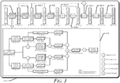
- Fig. 3 illustrates in an example of a module configured to process point clouds through multi-domain neighborhood embedding and weighting.
- MNEW module 114-1 is an example of the MNEW module 114.
- the MNEW module 114 receives point cloud data as input from the raw data store 116.
- the output from the MNEW module 114 is saved as segmented data including the raw point cloud data, having been embedded with weightings, including a segmentation score.
- the overall architecture inherits a dilated structure like PointNet, which excludes down-sampling and up-sampling operations for changing resolution.
- the MNEW module 114-1 obtains (e.g., in batches) input N p points, and passes through a sequence of multiple MNEW submodules 300-1, 300-2, and 300-3 to extract pointwise features L 1 , L 2 , and L 3 in a hierarchical order.
- Three MNEW submodules are used in this example, however, additional, or fewer MNEW submodules may be used in other examples.
- MNEW submodules 300 are carried forward through the MNEW module 114-1, and through the MNEW submodules 300-1, 300-2, 300-3 (collectively “MNEW submodules 300"), which yields an improvement over PointNet and other techniques that cannot carry local neighborhood information through to the end.
- the MNEW module 114-1 increases a quantity of neighbors in L 1 , L 2 , and L 3 , but maintains a quantity of query points unchanged.
- the point cloud data stored at the raw data store 116 includes a same quantity of sampled points after being modified and stored as point cloud data at the segmented data store 118.
- the MNEW module 114-1 includes a global 2D convolution and max pooling module 302, and two fully convolution layers 304-1, 304-2 are followed to aggregate the global feature G 3 .
- the hierarchical pointwise features and tiled global feature are concatenated as a descriptor for each point and passed through multiple ( e.g ., three) regular 1D convolutions 306-1, 306-2, 306-3 to get the segmentation score.
- the segmentation score can indicate a probability or degree of likelihood associated with one or more possible, pointwise classifications.
- each of the MNEW submodules 300 is shown inside the MNEW module 114-1.
- the input of each of the MNEW submodules 300 includes batches of points with their x, y, z coordinates and original features, shaped as [ B, N p , D xyz + D fea ].
- the MNEW submodules 300 compute pairwise distances in both the geometry and feature domains, resulting in two matrices 312-1, 312-2, each with shape [ B, Np, Np ] representing, respectively, the geometry distance and feature similarity between every two points.
- Radius-based geometry neighborhood selections are typically more robust than k-nearest neighbor in a non-uniform sampling of cloud data.
- feature neighborhoods may dynamically shift and be hard to encircle. Therefore, multiple radii are used the geometry domain and multiple k-nearest neighbor algorithms are used in the feature domain to collect multiple scales of neighbor indices.
- x i denotes the i th query point
- x n j denotes the j th neighboring points.
- Equation 4 S ( x i , n j ) is the estimated sparsity, which is an inverse of the average density, where we also take the log-scale value to obtain a better sparsity distribution.
- Geometry sparsity S g and feature sparsity S f are computed separately, which are transformed as the weighting factor for the activation of the 2D convolution.
- the MNEW module 114-1 refrains from performing subsampling and interpolation processing, which differs from other point cloud data processing, for instance, that which is based on a hierarchical encoder-decoder structure.
- the MNEW module 114-1 Compared with PointNet whose feature contains pointwise and global information, the MNEW module 114-1 also include local neighborhood features. Unlike other techniques that collect neighbors in feature space only, the MNEW module 114-1 embeds neighbor points in both the geometry and feature domains. In terms of the neighborhood embedding, the MNEW module 114-1 adopts multi-scaling in multiple domains. This distinct with all other processes for handling point cloud data where neighbors are collected in only a single domain ( e.g ., either geometry or feature but not both). There may exist overlapping points selected by the MNEW module 114-1 in both geometry and feature neighborhoods. However, the multiple-domain distance and sparsity are calculated and transformed separately, which yield different weighting effects for the learning results.
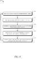
- Fig. 4 illustrates an example method 400 for processing point clouds through multi-domain neighborhood embedding and weighting.
- Fig. 4 is described in the context of the MNEW module 114-1, the automotive system 104, and the vehicle 102.
- the method 400 is shown as sets of operations (or acts) performed, but not necessarily limited to the order or combinations in which the operations are shown herein. Further, any of one or more of the operations may be repeated, combined, or reorganized to provide other methods.
- reference may be made to elements of the Figs. 1 through 3 reference to which is made for example only.
- the techniques are not limited to performance by one entity or multiple entities.
- point cloud data is obtained from one or more sensors of a vehicle.
- the automotive system 104 includes the processor 108 and receives, via the sensor interface 112, and from the sensors 106, point cloud data captured by the sensors 106 as the vehicle 102 is performing a vehicle operation (e.g ., autonomously navigating down a roadway).
- geometric properties of the point cloud data are determined.
- the MNEW module 114 executes on the processor 108 and by grouping geometry neighbors in the point cloud data, the MNEW module 114 produces the geometry neighborhood domain 202-1.
- feature properties of the point cloud data are determined including feature similarities of the points.
- the MNEW module 114 executes on the processor 108 and by through grouping feature neighbors based on similarities (e.g ., using multiple k-nearest neighbors algorithms) that change across different network layers, the MNEW module 114 generates a feature neighborhood domain 202-2.
- the point cloud data is modified by embedding a respective weighting at each point in the point cloud data.
- the processor determines a sparsity for each point in the two domains 202-1 and 202-2. This can include determining a geometric sparsity of that point in the geometry neighborhood domain and determining a feature sparsity of that point in the feature neighborhood domain.
- the geometry sparsity 204-1 and the feature sparsity 204-2 at each point is transformed into the weighting factors 206-1 and 206-2, which are applied to the raw point cloud data from the raw data store 116.
- Each respective weighting is based on the geometric sparsity and the feature sparsity, rather than only being based on one or the other, which improves object detections and classifications.
- the method 400 can be repeated to improve its effectiveness in accurately weighting point cloud data. This can include recomputing weightings to be applied to the point cloud data. Feature properties of the modified point cloud data are determined, as are geometric properties of the modified point cloud data. The processor 108 can further modify previously modified point cloud data using new weightings based in part on the geometric properties of the modified point cloud data and the feature properties of the modified point cloud data.
- a vehicle operation is executed using the respective weightings embedded in the modified point cloud data.
- the automotive system 104 performs a vehicle function based on objects detected from the segmented point cloud data store 118. With weightings embedded in the data, the automotive system 104 can use sparsely populated point cloud data to confidently identify and classify objects and other obstacles that would otherwise impede the vehicle 102 from performing an autonomous or semi-autonomous perception-navigation task.
- Fig. 5-1 illustrates an example of a dense point cloud 500-1 processed by an automotive system configured to process point clouds using multi-domain neighborhood embedding and weighting.
- Fig. 5-2 illustrates an example of a sparse point cloud 500-2 processed by an automotive system configured to process point clouds using multi-domain neighborhood embedding and weighting.
- Figs. 5-3 and 5-4 are grey scale versions 500-3 and 500-4 of the point clouds 500-1 and 500-2 shown in Figs. 5-1 and 5-2 , respectively.
- Figs. 5-5 and 5-6 are black and white versions 500-5 and 500-6 of the point clouds shown in Figs. 5-1 and 5-2 , respectively.
- Fig. 6-1 illustrates an example point cloud distribution and performance variation by distance.
- Fig. 6-2 illustrates an example point cloud distribution and performance variation by sparsity.
- the MNEW 114-1 can segment even sparse point cloud data at the raw data store 116.
- Figs. 6-1 and 6-2 show the effectiveness of the MNEW module 114-1 for points at different distances ( e.g., with respect to a LiDAR sensor as one of the sensors 106) and sparsity (with respect to nearby points).
- Figs. 6-1 and 6-2 distribution histograms of distance and sparsity are demonstrated, and performance variations are investigated. Observe in Fig. 6-1 , there exists an abrupt performance elevation at approximately fifty meters distance. To be explicit, points at far distances (e.g., greater than fifty meters) may be limited in quantity but are generally involved with well-learned classes (e.g., road, building, terrain) which contains relatively higher percentages of samples.
- well-learned classes e.g., road, building, terrain
- Fig. 6-2 what is shown, is as the sparsity increases, the performance of the MNEW module 114-1 starts to decrease until 0.7 ⁇ 0.8 and then increases. This is associated with the sparsity distribution histogram, implying that the number of samples affect the performance.
- the MNEW module 114-1 infers information that improves the effectiveness of the data. For the neighborhood selection, the MNEW module 114-1 compares the neighbors collected by geometry location and feature similarity, in both domains. For the attention and weighting, the MNEW module 114-1 may optionally enable the factor of neighbor distance and local sparsity in geometry and feature domain, and optionally set them as fixed values ( D g , D f , S g , S f ) or transform them.
- Example 1 A method comprising: obtaining point cloud data from one or more sensors of a vehicle; determining geometric properties of the point cloud data by at least: determining geometric distances between points in the point cloud data; and determining a sparsity of the point cloud data at each of the points; determining feature properties of the point cloud data including feature similarities of the points; modifying the point cloud data by embedding a respective weighting at each point in the point cloud data, the respective weighting being based on: the geometric distances that are between that point and other points in the point cloud data; the sparsity of the point cloud data at that point; and the feature similarities of that point and the other points in the point cloud data; and responsive to modifying the point cloud, executing a vehicle operation using the respective weightings embedded in the modified point cloud data.
- Example 2 The method of any preceding example, wherein the point cloud data includes a same quantity of sampled points after modifying the point cloud data as before modifying the point cloud data.
- Example 3 The method of any preceding example, wherein the point cloud data comprises sparse data.
- Example 4 The method of any preceding example, wherein the point cloud data comprises dense data.
- Example 5 The method of any preceding example, wherein determining the geometric properties of the point cloud data comprises grouping geometry neighbors in the point cloud data to produce a geometry neighborhood domain.
- Example 6 The method of any preceding example, wherein determining the feature properties of the point cloud data comprises grouping feature neighbors in the point cloud data to produce a feature neighborhood domain.
- Example 7 The method of any preceding example, further comprising: determining the sparsity of the point cloud data at that point, wherein the sparsity is determined by: determining a geometric sparsity of that point in the geometry neighborhood domain; and determining a feature sparsity of that point in the feature neighborhood domain, wherein the respective weighting is further based on the geometric sparsity and the feature sparsity.
- Example 8 The method of any preceding example, further comprising: determining geometric properties of the modified point cloud data; determining feature properties of the modified point cloud data; modifying the modified point cloud data using weighting based in part on the geometric properties of the modified point cloud data and the feature properties of the modified point cloud data.
- Example 9 A system comprising means for performing the method of any of the preceding examples.
- Example 10 A computer readable storage medium comprising instructions that, when executed, configure a processor to perform the method of any of the preceding examples.
- "at least one of: a, b, or c” is intended to cover a, b, c, a-b, a-c, b-c, and a-b-c, as well as any combination with multiples of the same element ( e.g., a-a, a-a-a, a-a-b, a-a-c, a-b-b, a-c-c, b-b, b-b-b, b-b-c, c-c, and c-c-c or any other ordering of a, b, and c).
Landscapes
- Engineering & Computer Science (AREA)
- Physics & Mathematics (AREA)
- General Physics & Mathematics (AREA)
- Theoretical Computer Science (AREA)
- Remote Sensing (AREA)
- Radar, Positioning & Navigation (AREA)
- Computer Vision & Pattern Recognition (AREA)
- Evolutionary Computation (AREA)
- Artificial Intelligence (AREA)
- Computer Networks & Wireless Communication (AREA)
- Data Mining & Analysis (AREA)
- Multimedia (AREA)
- Electromagnetism (AREA)
- General Engineering & Computer Science (AREA)
- Software Systems (AREA)
- General Health & Medical Sciences (AREA)
- Computing Systems (AREA)
- Health & Medical Sciences (AREA)
- Life Sciences & Earth Sciences (AREA)
- Aviation & Aerospace Engineering (AREA)
- Automation & Control Theory (AREA)
- Medical Informatics (AREA)
- Evolutionary Biology (AREA)
- Bioinformatics & Cheminformatics (AREA)
- Databases & Information Systems (AREA)
- Bioinformatics & Computational Biology (AREA)
- Computational Linguistics (AREA)
- Molecular Biology (AREA)
- Biophysics (AREA)
- Mathematical Physics (AREA)
- Biomedical Technology (AREA)
- Traffic Control Systems (AREA)
- Image Processing (AREA)
Abstract
Description
- This application claims the benefit of
U.S. Provisional Patent Application No. 62/928,572, filed October 31, 2019 - Some automotive systems include sophisticated sensor equipment configured to capture and process point cloud data for representing and interpreting semantics of a three-dimensional (3D) scene. Point cloud data (e.g., lidar data, radar data, ultrasound data, camera data, other sensor data) obtained in furtherance of many common automotive tasks, for example, shape segmentation or indoor scenario parsing, is typically much denser than other point cloud data normally acquired while interpreting semantics of an outdoor scene. Although many ways to process point cloud data exist, their effectiveness depreciates as the point cloud data becomes less dense.
- This document describes point cloud processing through "Multi-domain Neighborhood Embedding and Weighting" (MNEW) for use in processing point cloud data, including sparsely populated data obtained from a lidar, a camera, a radar, or combination thereof. MNEW is a process based on a dilation architecture that captures pointwise and global features of the point cloud data involving multi-scale local semantics adopted from a hierarchical encoder-decoder structure. Neighborhood information is embedded in both static geometric and dynamic feature domains. A geometric distance, feature similarity, and local sparsity can be computed and transformed into adaptive weighting factors that are reapplied to the point cloud data. This enables an automotive system to obtain outstanding performance with sparse and dense point cloud data. Processing point cloud data via the MNEW techniques promotes greater adoption of sensor-based autonomous driving and perception-based systems.
- In one example, a method includes obtaining point cloud data from one or more sensors of a vehicle, determining geometric properties of the point cloud data by at least determining geometric distances between points in the point cloud data, and determining feature properties of the point cloud data including feature similarities of the points. The method further includes modifying the point cloud data by embedding a respective weighting at each point in the point cloud data, the respective weighting being based on: the geometric distances that are between that point and other points in the point cloud data; a sparsity of the point cloud data at that point; and the feature similarities of that point and the other points in the point cloud data. The method further includes responsive to modifying the point cloud, executing a vehicle operation using the respective weightings embedded in the modified point cloud data.
- This document a system includes a processor configured to perform the above-summarized method, as well as, describing means for performing the above-summarized method and other methods set forth herein, in addition to describing methods performed by the above-summarized systems and methods performed by other systems set forth herein.
- This summary introduces simplified concepts of multi-domain neighborhood embedding and weighting for point cloud processing, which are further described below in the Detailed Description and Drawings. This summary is not intended to identify essential features of the claimed subject matter, nor is it intended for use in determining the scope of the claimed subject matter.
- The details of one or more aspects of multi-domain neighborhood embedding and weighting for point cloud processing are described in this document with reference to the following figures. The same numbers are often used throughout the drawings to reference like features and components.
-
Fig. 1 illustrates an example of an environment in which multi-domain neighborhood embedding and weighting for point cloud processing is performed by an automotive system. -
Fig. 2 illustrates an example process to modify point cloud data using multi-domain neighborhood embedding and weighting. -
Fig. 3 illustrates in an example of a module configured to process point clouds through multi-domain neighborhood embedding and weighting. -
Fig. 4 illustrates an example method for processing point clouds through multi-domain neighborhood embedding and weighting. -
Fig. 5-1 illustrates an example of a dense point cloud processed by an automotive system configured to process point clouds using multi-domain neighborhood embedding and weighting. -
Fig. 5-2 illustrates an example of a sparse point cloud processed by an automotive system configured to process point clouds using multi-domain neighborhood embedding and weighting. -
Fig. 6-1 illustrates an example point cloud distribution and performance variation by distance. -
Fig. 6-2 illustrates an example point cloud distribution and performance variation by sparsity. - Point cloud data is preferred for executing some autonomous driving or other vehicle perception-related tasks, for example, three-dimensional shape recognition, scene segmentation, indoor scenario parsing, and outdoor scene interpretation on a large-scale. Lidar point clouds, when compared against point cloud data generated from other types of sensors, for example, camera and radar, have an advantage in vehicle-perception because lidar point clouds can capture both real distance measurements and fine semantic descriptions. In research areas related to computer vision, studies about point clouds are most concerned with dense data sets. For example, topics for example: three-dimensional shape recognition, part segmentation, indoor scenario parsing, and large-scale outdoor scene interpretations are studied using densely populated point clouds or data sets. Several benchmark data sets, including ModelNet40, ShapeNet, S3DIS, and Semantic3D, have been established to test performance related to these topics. These data sets have spatial properties that are unlike spatial properties of actual data obtained during real-world sensor scans (e.g., by an on-board lidar or another vehicle-mounted sensor). Furthermore, point cloud data tends to be even sparser when generated from a real-world sweep of a vehicle's surrounding environment as compared to an interior scan of a cabin; this is because sparsity of a point cloud increases as distance to an object becomes greater.
- There have generally been three different approaches to processing point clouds. A first approach is to generate a projection from two-dimensional (2D) representations; the basic idea of this approach is to transform and stitch together unstructured point clouds into 2D images, which can be directly input into an image-based convolutional neural network. This works for a fusion-sensor system that combines sensor data from multiple different sources. A drawback to these 2D projections is a potential loss of information when a large number of points are occluded from a field-of-view.
- Another approach involves voxelization into 3D volumetric grids of cells or a structural variation thereof (e.g., octree, spherical). Although 3D voxelization is better at maintaining points in a 3D space, a 3D convolution may suffer a similar loss of information due to occlusions, and a 3D convolution can also be computationally expensive. There may also be processing difficulty when working with a 3D convolution.
- Thirdly, a fundamental model called PointNet can process an unordered and unstructured point cloud, which inspires many other studies to research point cloud classification and segmentation. However, performance is only reported against several dense data benchmarks and their effectiveness for processing sparse data clouds is unknown.
- VirtualKITTI, SemanticKITTI, and DeepenaiKITTI are some publicly available datasets that provide semantic labels for sparse point clouds. A comparison of the above-three approaches to directly processing raw point clouds reveals their ineffectiveness on processing sparse data. The network architecture, the neighbor points collection method, and local sparsity are the essential factors that cause changes to each of their performance.
- In contrast to other approaches to point cloud processing and segmentation, this document describes Multi-domain Neighborhood Embedding and Weighting (MNEW), which is a process of embedding weights in point cloud data based on geometric distance, feature similarity, and/or neighborhood sparsity, no matter if the point cloud data is densely or sparsely populated. Particular point-wise details and global semantics are captured from the point cloud data, which is then applied to the point cloud data during a multi-scale local neighborhood segmentation process that executes in a static geometric domain and a dynamic feature space. These MNEW techniques, can configure an automotive system to achieve top performance processing sparsely populated point cloud data and dense data alike, including meeting or exceeding various state-of-the-art performance benchmarks (e.g., Semantic3D, S3DIS) that test performance against dense point cloud data.
-
Fig. 1 illustrates an example of anenvironment 100 in which multi-domain neighborhood embedding and weighting for point cloud processing is performed by anautomotive system 104. In the depictedenvironment 100, theautomotive system 104 is mounted to, or integrated within, avehicle 102 that can travel on a roadway. Theautomotive system 104 can embed weightings in point cloud data generated by one ormore sensors 106 onboard thevehicle 102. Although illustrated as a car, thevehicle 102 can represent other types of motorized vehicles (e.g., a motorcycle, a bus, a tractor, a semi-trailer truck, or construction equipment). In general, manufacturers can mount theautomotive system 104 to any moving platform that can travel. - In the depicted implementation, a portion of the
automotive system 104 is mounted into a taillight module or bumper. Theautomotive system 104 can project a field-of-view from any exterior surface of thevehicle 102. For example, vehicle manufacturers can integrate at least a part of theautomotive system 104 into a rearview mirror, a side mirror, roof, or any other interior or exterior location. In general, vehicle manufacturers can design the location of theautomotive system 104 to provide a particular field-of-view that sufficiently encompasses a roadway and surrounding environment in which thevehicle 102 may be traveling. Theautomotive system 104 includes one ormore sensors 106, aprocessor 108, and a non-transitory computer-readable storage media 110. - The
processor 108 can be a microprocessor or a system-on-chip of a computing device. Theprocessor 108 executes computer-executable instructions stored within the non-transitory computer-readable storage media 110. As an example, theprocessor 108 can execute theMNEW module 114 and thesensor interface 112 to modify point cloud data for use in operating thevehicle 102. Theprocessor 108 can also retrieve or store point cloud data from or to the non-transitory computer-readable storage media 110. - The
sensors 106 generate point cloud data, including sparse and dense point cloud data. The point cloud data generated by thesensors 106 is obtained by aprocessor 108. Theprocessor 108 receives the point cloud data as input and processes the data to embed weightings in the data that enable more efficient downstream processing by another system of thevehicle 102, for example, an object detection system or an autonomous or semiautonomous navigation system (neither is shown). Thesensors 106 can include a camera, a radar system, a global positioning system (GPS), a lidar system, or any combination thereof. A camera can take photographic images or video of the road. A radar system or a lidar system can use electromagnetic signals to detect objects in the road. A GPS can determine a position and/or navigation of thevehicle 102. - The non-transitory computer-
readable storage media 110 maintains instructions that when executed by theprocessor 108, cause theautomotive system 104 to perform an operation or function. The non-transitory computer-readable storage media 110 can also store data for processing and processed data. For example, the non-transitory computer-readable storage media 110 includes asensor interface 112, aMNEW module 114, araw data store 116, and asegmented data store 118. When executed by theprocessor 108, thesensor interface 112 receives point cloud data generated by thesensors 106 and stores the point cloud data in theraw data store 116. Theprocessor 108 may execute theMNEW module 114 to process contents of theraw data store 116 and produce modified or segmented data for thesegmented data store 118. This document describes the operations of theMNEW module 114 of theautomotive system 104 in greater detail with respect toFIG. 2 . -
Fig. 2 illustrates anexample process 200 to modify point cloud data using multi-domain neighborhood embedding and weighting. TheMNEW module 114, when executed by theprocessor 108, obtains information contained in theraw data store 116 as input, and outputs segmented data for thesegmented data store 118. Theprocess 200 inherits aspects of the PointNet model mentioned above, which is able to capture pointwise details and global semantics in point cloud data. Going beyond PointNet, however, theMNEW module 114 enables point cloud data to embody local contextual information. In this way, unlike PointNet, theMNEW module 114 makes even sparse point cloud data usable for vehicle control or object detection. Theprocess 200 excludes or refrains from subsampling and interpolation processing of point cloud data, which differs from previous systems that process point cloud data based on a hierarchical encoder-decoder structure. - The
MNEW module 114 is configured to process raw point cloud data from theraw data store 116 by collecting static geometry neighbors and further collecting dynamic feature neighbors. For a query point (e.g., a star) within a set of point clouds (e.g., dots), theMNEW module 114 groups geometry neighbors based on distance (e.g., Euclid distance) towards a query point. This separation by distance (represented as two radius) is shown inFig. 2 in the upper branch of theprocess 200. Through grouping feature neighbors based on similarities (e.g., using multiple k-nearest neighbors algorithms) that change across different network layers (as illustrated in the lower branch of the process 200), theMNEW module 114 generates a feature (dynamic) neighborhood domain 202-2. By grouping the geometry neighbors, theMNEW module 114 produces a geometry (static) neighborhood domain 202-1. Sparsity 204-1 and 204-2 of each neighbor point is computed in the geometry and feature domains 202-1, 202-2. A geometry sparsity 204-1 and a feature sparsity 204-2 at each neighbor point can be transformed into weighting factors 206-1 and 206-2. For each of the neighborhood points, theMNEW module 114 indicates a distance and similarity, which can then be used as weighting factors 206-1 and 206-2 that are applied to the raw point cloud data from theraw data store 116. - Applying the weighting factors 206-1 and 206-2 to the raw point cloud data produces modified (e.g., segmented) point cloud data for the
segmented data store 118, which adopts the point cloud data for multiple scaling in multiple domains. In this way, while some other techniques for processing point cloud data compute geometry distance or feature similarity as fixed weighting factors, and while still others transform local sparsity as a machine learned variable, theMNEW module 114 treats geometry distance, feature similarity, and local contextual information including local sparsity each as trainable features of point cloud data that can be applied as embeddings and weightings. This is distinct with other techniques where neighbors, if even collected, are collected in only a single domain (e.g., either geometry or feature but not both). -
Fig. 3 illustrates in an example of a module configured to process point clouds through multi-domain neighborhood embedding and weighting. MNEW module 114-1 is an example of theMNEW module 114. TheMNEW module 114 receives point cloud data as input from theraw data store 116. The output from theMNEW module 114 is saved as segmented data including the raw point cloud data, having been embedded with weightings, including a segmentation score. - The overall architecture inherits a dilated structure like PointNet, which excludes down-sampling and up-sampling operations for changing resolution. Through access to the
raw data store 116, the MNEW module 114-1 obtains (e.g., in batches) input Np points, and passes through a sequence of multiple MNEW submodules 300-1, 300-2, and 300-3 to extract pointwise features L 1, L 2 , and L 3 in a hierarchical order. Three MNEW submodules are used in this example, however, additional, or fewer MNEW submodules may be used in other examples. Note that local neighborhood information is carried forward through the MNEW module 114-1, and through the MNEW submodules 300-1, 300-2, 300-3 (collectively "MNEW submodules 300"), which yields an improvement over PointNet and other techniques that cannot carry local neighborhood information through to the end. - The MNEW module 114-1 increases a quantity of neighbors in L 1 , L 2 , and L 3, but maintains a quantity of query points unchanged. The point cloud data stored at the
raw data store 116 includes a same quantity of sampled points after being modified and stored as point cloud data at thesegmented data store 118. - Following the MNEW modules 300, the MNEW module 114-1 includes a global 2D convolution and
max pooling module 302, and two fully convolution layers 304-1, 304-2 are followed to aggregate the global feature G 3. The hierarchical pointwise features and tiled global feature are concatenated as a descriptor for each point and passed through multiple (e.g., three) regular 1D convolutions 306-1, 306-2, 306-3 to get the segmentation score. The segmentation score can indicate a probability or degree of likelihood associated with one or more possible, pointwise classifications. - An exploded
view 310 of each of the MNEW submodules 300 is shown inside the MNEW module 114-1. As drawn in the explodedview 310, the input of each of the MNEW submodules 300 includes batches of points with their x, y, z coordinates and original features, shaped as [B, Np, Dxyz +Dfea ]. The MNEW submodules 300 compute pairwise distances in both the geometry and feature domains, resulting in two matrices 312-1, 312-2, each with shape [B, Np, Np] representing, respectively, the geometry distance and feature similarity between every two points. - Radius-based geometry neighborhood selections are typically more robust than k-nearest neighbor in a non-uniform sampling of cloud data. However, feature neighborhoods may dynamically shift and be hard to encircle. Therefore, multiple radii are used the geometry domain and multiple k-nearest neighbor algorithms are used in the feature domain to collect multiple scales of neighbor indices.
- The MNEW submodules 300 each gather original features to compose two initial neighborhood embedding
matrices 

matrices 


Equation 1, xi denotes the ith query point, and xnj denotes the jth neighboring points. Because the geometry distance matrix Dg (shape [B, Np, Nng, 1]) and feature similarity matrix Df (shape [B, Np, Nng, 1], represented by pairwise distances in the feature space) are already computed and gathered, a transformation function T(di , nj ) = wi, nj · f(di , nj ) can be applied to obtain learning-based (wi , nj ) attention weights and apply on


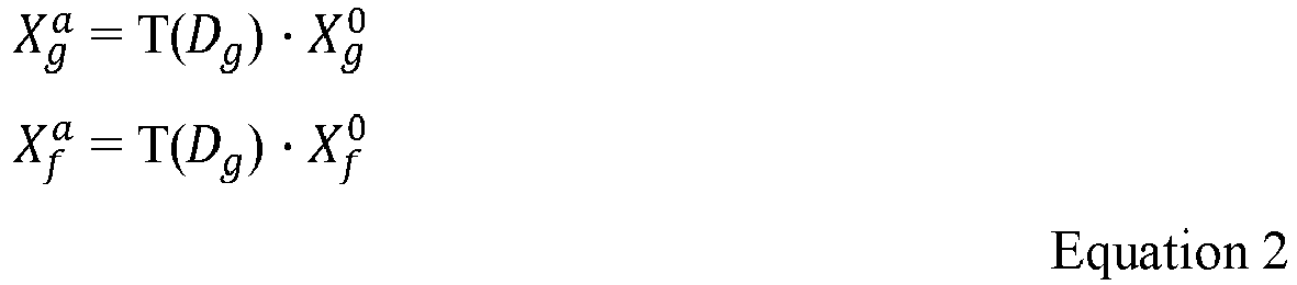
Equations 3 and 4 that follow:

Equation 3,


- After concatenating the neighborhood information from the geometry and feature domain, an average pooling operation is followed to aggregate a feature vector for each query point, which yields the output of the MNEW submodules 300 as

 and adjusted regularization loss
 by λ. Because the task is semantic segmentation only (i.e., no instance-level labels), there is little to no discriminative loss, as shown in Equation 7:

- In this way, the MNEW module 114-1 refrains from performing subsampling and interpolation processing, which differs from other point cloud data processing, for instance, that which is based on a hierarchical encoder-decoder structure.
- Compared with PointNet whose feature contains pointwise and global information, the MNEW module 114-1 also include local neighborhood features. Unlike other techniques that collect neighbors in feature space only, the MNEW module 114-1 embeds neighbor points in both the geometry and feature domains. In terms of the neighborhood embedding, the MNEW module 114-1 adopts multi-scaling in multiple domains. This distinct with all other processes for handling point cloud data where neighbors are collected in only a single domain (e.g., either geometry or feature but not both). There may exist overlapping points selected by the MNEW module 114-1 in both geometry and feature neighborhoods. However, the multiple-domain distance and sparsity are calculated and transformed separately, which yield different weighting effects for the learning results.
-
Fig. 4 illustrates anexample method 400 for processing point clouds through multi-domain neighborhood embedding and weighting.Fig. 4 is described in the context of the MNEW module 114-1, theautomotive system 104, and thevehicle 102. Themethod 400 is shown as sets of operations (or acts) performed, but not necessarily limited to the order or combinations in which the operations are shown herein. Further, any of one or more of the operations may be repeated, combined, or reorganized to provide other methods. In portions of the following discussion, reference may be made to elements of theFigs. 1 through 3 , reference to which is made for example only. The techniques are not limited to performance by one entity or multiple entities. - At 402, point cloud data is obtained from one or more sensors of a vehicle. For example, the
automotive system 104 includes theprocessor 108 and receives, via thesensor interface 112, and from thesensors 106, point cloud data captured by thesensors 106 as thevehicle 102 is performing a vehicle operation (e.g., autonomously navigating down a roadway). - At 404, geometric properties of the point cloud data are determined. For example, the
MNEW module 114 executes on theprocessor 108 and by grouping geometry neighbors in the point cloud data, theMNEW module 114 produces the geometry neighborhood domain 202-1. - At 406, feature properties of the point cloud data are determined including feature similarities of the points. For example, the
MNEW module 114 executes on theprocessor 108 and by through grouping feature neighbors based on similarities (e.g., using multiple k-nearest neighbors algorithms) that change across different network layers, theMNEW module 114 generates a feature neighborhood domain 202-2. - At 408, the point cloud data is modified by embedding a respective weighting at each point in the point cloud data. For example, the processor determines a sparsity for each point in the two domains 202-1 and 202-2. This can include determining a geometric sparsity of that point in the geometry neighborhood domain and determining a feature sparsity of that point in the feature neighborhood domain. The geometry sparsity 204-1 and the feature sparsity 204-2 at each point is transformed into the weighting factors 206-1 and 206-2, which are applied to the raw point cloud data from the
raw data store 116. Each respective weighting is based on the geometric sparsity and the feature sparsity, rather than only being based on one or the other, which improves object detections and classifications. - The
method 400, can be repeated to improve its effectiveness in accurately weighting point cloud data. This can include recomputing weightings to be applied to the point cloud data. Feature properties of the modified point cloud data are determined, as are geometric properties of the modified point cloud data. Theprocessor 108 can further modify previously modified point cloud data using new weightings based in part on the geometric properties of the modified point cloud data and the feature properties of the modified point cloud data. - At 410, a vehicle operation is executed using the respective weightings embedded in the modified point cloud data. For example, the
automotive system 104 performs a vehicle function based on objects detected from the segmented pointcloud data store 118. With weightings embedded in the data, theautomotive system 104 can use sparsely populated point cloud data to confidently identify and classify objects and other obstacles that would otherwise impede thevehicle 102 from performing an autonomous or semi-autonomous perception-navigation task. -
Fig. 5-1 illustrates an example of a dense point cloud 500-1 processed by an automotive system configured to process point clouds using multi-domain neighborhood embedding and weighting.Fig. 5-2 illustrates an example of a sparse point cloud 500-2 processed by an automotive system configured to process point clouds using multi-domain neighborhood embedding and weighting.Figs. 5-3 and 5-4 are grey scale versions 500-3 and 500-4 of the point clouds 500-1 and 500-2 shown inFigs. 5-1 and5-2 , respectively.Figs. 5-5 and 5-6 are black and white versions 500-5 and 500-6 of the point clouds shown inFigs. 5-1 and5-2 , respectively. -
Fig. 6-1 illustrates an example point cloud distribution and performance variation by distance.Fig. 6-2 illustrates an example point cloud distribution and performance variation by sparsity. In particular, when applied to the application of autonomous driving task, the MNEW 114-1 can segment even sparse point cloud data at theraw data store 116.Figs. 6-1 and6-2 show the effectiveness of the MNEW module 114-1 for points at different distances (e.g., with respect to a LiDAR sensor as one of the sensors 106) and sparsity (with respect to nearby points). - In
Figs. 6-1 and6-2 , distribution histograms of distance and sparsity are demonstrated, and performance variations are investigated. Observe inFig. 6-1 , there exists an abrupt performance elevation at approximately fifty meters distance. To be explicit, points at far distances (e.g., greater than fifty meters) may be limited in quantity but are generally involved with well-learned classes (e.g., road, building, terrain) which contains relatively higher percentages of samples. - In
Fig. 6-2 , what is shown, is as the sparsity increases, the performance of the MNEW module 114-1 starts to decrease until 0.7∼0.8 and then increases. This is associated with the sparsity distribution histogram, implying that the number of samples affect the performance. - Because the sparsity distribution for dense datasets is more even than for sparse datasets, the MNEW module 114-1 infers information that improves the effectiveness of the data. For
the neighborhood selection, the MNEW module 114-1 compares the neighbors collected by geometry location and feature similarity, in both domains. For the attention and weighting, the MNEW module 114-1 may optionally enable the factor of neighbor distance and local sparsity in geometry and feature domain, and optionally set them as fixed values (Dg, Df, Sg, Sf ) or transform them. - Some additional examples of implementing multi-domain neighborhood embedding and weighting for point cloud processing are described in the following section of examples.
- Example 1. A method comprising: obtaining point cloud data from one or more sensors of a vehicle; determining geometric properties of the point cloud data by at least: determining geometric distances between points in the point cloud data; and determining a sparsity of the point cloud data at each of the points; determining feature properties of the point cloud data including feature similarities of the points; modifying the point cloud data by embedding a respective weighting at each point in the point cloud data, the respective weighting being based on: the geometric distances that are between that point and other points in the point cloud data; the sparsity of the point cloud data at that point; and the feature similarities of that point and the other points in the point cloud data; and responsive to modifying the point cloud, executing a vehicle operation using the respective weightings embedded in the modified point cloud data.
- Example 2. The method of any preceding example, wherein the point cloud data includes a same quantity of sampled points after modifying the point cloud data as before modifying the point cloud data.
- Example 3. The method of any preceding example, wherein the point cloud data comprises sparse data.
- Example 4. The method of any preceding example, wherein the point cloud data comprises dense data.
- Example 5. The method of any preceding example, wherein determining the geometric properties of the point cloud data comprises grouping geometry neighbors in the point cloud data to produce a geometry neighborhood domain.
- Example 6. The method of any preceding example, wherein determining the feature properties of the point cloud data comprises grouping feature neighbors in the point cloud data to produce a feature neighborhood domain.
- Example 7. The method of any preceding example, further comprising: determining the sparsity of the point cloud data at that point, wherein the sparsity is determined by: determining a geometric sparsity of that point in the geometry neighborhood domain; and determining a feature sparsity of that point in the feature neighborhood domain, wherein the respective weighting is further based on the geometric sparsity and the feature sparsity.
- Example 8. The method of any preceding example, further comprising: determining geometric properties of the modified point cloud data; determining feature properties of the modified point cloud data; modifying the modified point cloud data using weighting based in part on the geometric properties of the modified point cloud data and the feature properties of the modified point cloud data.
- Example 9. A system comprising means for performing the method of any of the preceding examples.
- Example 10. A computer readable storage medium comprising instructions that, when executed, configure a processor to perform the method of any of the preceding examples.
- While various embodiments of the disclosure are described in the foregoing description and shown in the drawings, it is to be understood that this disclosure is not limited thereto but may be variously embodied to practice within the scope of the following claims. From the foregoing Description, it will be apparent that various changes may be made without departing from the spirit and scope of the disclosure as defined by the following claims.
- The use of "or" and grammatically related terms indicates non-exclusive alternatives without limitation unless the context clearly dictates otherwise. As used herein, a phrase referring to "at least one of" a list of items refers to any combination of those items, including single members. As an example, "at least one of: a, b, or c" is intended to cover a, b, c, a-b, a-c, b-c, and a-b-c, as well as any combination with multiples of the same element (e.g., a-a, a-a-a, a-a-b, a-a-c, a-b-b, a-c-c, b-b, b-b-b, b-b-c, c-c, and c-c-c or any other ordering of a, b, and c).
Claims (10)
- A method comprising:obtaining point cloud data from one or more sensors of a vehicle;determining geometric properties of the point cloud data by at least determining geometric distances between points in the point cloud data; anddetermining feature properties of the point cloud data including feature similarities of the points;modifying the point cloud data by embedding a respective weighting at each point in the point cloud data, the respective weighting being based on:the geometric distances that are between that point and other points in the point cloud data;a sparsity of the point cloud data at that point; andthe feature similarities of that point and the other points in the point cloud data; andresponsive to modifying the point cloud, executing a vehicle operation using the respective weightings embedded in the modified point cloud data.
- The method of claim 1, wherein the point cloud data includes a same quantity of sampled points after modifying the point cloud data as before modifying the point cloud data.
- The method of claim 1 or 2, wherein the point cloud data comprises sparse data.
- The method of claim 1 or 2, wherein the point cloud data comprises dense data.
- The method of any of the claims 1-4, wherein determining the geometric properties of the point cloud data comprises grouping geometry neighbors in the point cloud data to produce a geometry neighborhood domain.
- The method of claim 5, wherein determining the feature properties of the point cloud data comprises grouping feature neighbors in the point cloud data to produce a feature neighborhood domain.
- The method of claim 6, further comprising:
determining the sparsity of the point cloud data at that point, wherein the sparsity is determined by:determining a geometric sparsity of that point in the geometry neighborhood domain; anddetermining a feature sparsity of that point in the feature neighborhood domain,wherein the respective weighting is further based on the geometric sparsity and the feature sparsity. - The method of any of the claims 1-6, further comprising:determining geometric properties of the modified point cloud data;determining feature properties of the modified point cloud data;modifying the modified point cloud data using weighting based in part on the geometric properties of the modified point cloud data and the feature properties of the modified point cloud data.
- A system comprising means for performing the method of any of the claims 1-8.
- An automotive system comprising a processor configured to perform the method of any of the claims 1-8.
Applications Claiming Priority (1)
| Application Number | Priority Date | Filing Date | Title |
|---|---|---|---|
| US201962928572P | 2019-10-31 | 2019-10-31 |
Publications (2)
| Publication Number | Publication Date |
|---|---|
| EP3816655A1 true EP3816655A1 (en) | 2021-05-05 |
| EP3816655B1 EP3816655B1 (en) | 2026-01-28 |
Family
ID=73029959
Family Applications (1)
| Application Number | Title | Priority Date | Filing Date |
|---|---|---|---|
| EP20204179.4A Active EP3816655B1 (en) | 2019-10-31 | 2020-10-27 | Multi-domain neighborhood embedding and weighting of point cloud data |
Country Status (3)
| Country | Link |
|---|---|
| US (2) | US11281917B2 (en) |
| EP (1) | EP3816655B1 (en) |
| CN (1) | CN112749616B (en) |
Cited By (3)
| Publication number | Priority date | Publication date | Assignee | Title |
|---|---|---|---|---|
| CN114373104A (en) * | 2021-12-13 | 2022-04-19 | 同济大学 | A 3D point cloud semantic segmentation method and system based on dynamic aggregation |
| CN114494609A (en) * | 2022-04-02 | 2022-05-13 | 中国科学技术大学 | 3D target detection model construction method and device and electronic equipment |
| CN120599434A (en) * | 2025-08-07 | 2025-09-05 | 中国人民解放军国防科技大学 | Point cloud learning feature representation method and device based on neighborhood geometry embedding |
Families Citing this family (9)
| Publication number | Priority date | Publication date | Assignee | Title |
|---|---|---|---|---|
| CN115474050B (en) * | 2021-06-11 | 2026-02-13 | 维沃移动通信有限公司 | Entropy encoding, decoding methods and apparatus |
| CN113486963B (en) * | 2021-07-12 | 2023-07-07 | 厦门大学 | Point cloud end-to-end sampling method with self-adaptive density |
| US12079934B1 (en) * | 2021-07-27 | 2024-09-03 | Apple Inc. | Point cloud re-sampling using hierarchical sphere or disk distributions |
| CN117409161A (en) * | 2022-07-06 | 2024-01-16 | 戴尔产品有限公司 | Point cloud processing method and electronic device |
| CN115019048B (en) * | 2022-07-08 | 2023-04-07 | 北京百度网讯科技有限公司 | Three-dimensional scene segmentation method, model training method and device and electronic equipment |
| CN114937081B (en) * | 2022-07-20 | 2022-11-18 | 之江实验室 | Internet vehicle position estimation method and device based on independent non-uniform incremental sampling |
| CN116168366B (en) * | 2023-01-19 | 2023-12-05 | 北京百度网讯科技有限公司 | Point cloud data generation method, model training method, target detection method and device |
| CN116152611B (en) * | 2023-04-14 | 2023-08-25 | 山东省凯麟环保设备股份有限公司 | A multi-level and multi-scale point cloud completion method, system, device and storage medium |
| CN120259674B (en) * | 2025-06-04 | 2025-09-19 | 南昌大学 | Weakly supervised point cloud semantic segmentation method and system based on multi-scale feature extraction and classification |
Citations (2)
| Publication number | Priority date | Publication date | Assignee | Title |
|---|---|---|---|---|
| US20180121765A1 (en) * | 2016-11-02 | 2018-05-03 | Canon Kabushiki Kaisha | Information processing apparatus, information processing method, and storage medium |
| US20180341263A1 (en) * | 2017-05-25 | 2018-11-29 | GM Global Technology Operations LLC | Methods and systems for moving object velocity determination |
Family Cites Families (33)
| Publication number | Priority date | Publication date | Assignee | Title |
|---|---|---|---|---|
| JP3565749B2 (en) * | 1999-09-22 | 2004-09-15 | 富士重工業株式会社 | Inspection method of imaging direction of on-vehicle camera and its inspection device |
| JP4235729B2 (en) * | 2003-02-03 | 2009-03-11 | 国立大学法人静岡大学 | Distance image sensor |
| DE102007036277A1 (en) * | 2007-07-31 | 2009-02-05 | Technische Universität Berlin | Method and device for automatic pattern recognition |
| WO2012134419A1 (en) * | 2010-04-13 | 2012-10-04 | Visual Intelligence, LP | Self-calibrated, remote imaging and data processing system |
| US8872851B2 (en) * | 2010-09-24 | 2014-10-28 | Intel Corporation | Augmenting image data based on related 3D point cloud data |
| US9378431B2 (en) * | 2011-11-18 | 2016-06-28 | Metaio Gmbh | Method of matching image features with reference features and integrated circuit therefor |
| US9817125B2 (en) * | 2012-09-07 | 2017-11-14 | Microsoft Technology Licensing, Llc | Estimating and predicting structures proximate to a mobile device |
| US10860683B2 (en) * | 2012-10-25 | 2020-12-08 | The Research Foundation For The State University Of New York | Pattern change discovery between high dimensional data sets |
| FR3021938B1 (en) * | 2014-06-04 | 2016-05-27 | Commissariat Energie Atomique | PARKING ASSIST DEVICE AND VEHICLE EQUIPPED WITH SUCH A DEVICE. |
| JP2018508418A (en) * | 2015-01-20 | 2018-03-29 | ソルフィス リサーチ、インコーポレイテッド | Real-time machine vision and point cloud analysis for remote sensing and vehicle control |
| US9760996B2 (en) * | 2015-08-11 | 2017-09-12 | Nokia Technologies Oy | Non-rigid registration for large-scale space-time 3D point cloud alignment |
| US20210258486A1 (en) * | 2015-08-28 | 2021-08-19 | State Farm Mutual Automobile Insurance Company | Electric vehicle battery conservation |
| GB201607639D0 (en) * | 2016-05-02 | 2016-06-15 | Univ Leuven Kath | Sensing method |
| WO2018027206A1 (en) * | 2016-08-04 | 2018-02-08 | Reification Inc. | Methods for simultaneous localization and mapping (slam) and related apparatus and systems |
| WO2018028799A1 (en) * | 2016-08-12 | 2018-02-15 | Swiss Reinsurance Company Ltd. | Telematics system with vehicle-embedded telematics devices (oem line fitted) for score-driven, automated insurance and corresponding method |
| US20180095450A1 (en) * | 2016-09-30 | 2018-04-05 | Velo3D, Inc. | Three-dimensional objects and their formation |
| US10837773B2 (en) * | 2016-12-30 | 2020-11-17 | DeepMap Inc. | Detection of vertical structures based on LiDAR scanner data for high-definition maps for autonomous vehicles |
| BR102017005171A8 (en) * | 2017-03-15 | 2021-05-18 | Velsis Sist E Tecnologia Viaria S/A | embedded system for instantaneous measurement of weight, vibration, deformation, pressure, acceleration and temperature of vehicles and containers |
| US11010630B2 (en) * | 2017-04-27 | 2021-05-18 | Washington University | Systems and methods for detecting landmark pairs in images |
| US10897269B2 (en) * | 2017-09-14 | 2021-01-19 | Apple Inc. | Hierarchical point cloud compression |
| US10438371B2 (en) * | 2017-09-22 | 2019-10-08 | Zoox, Inc. | Three-dimensional bounding box from two-dimensional image and point cloud data |
| US20190120931A1 (en) * | 2017-10-24 | 2019-04-25 | Novelic D.O.O. | Millimeter-wave System-in-Package for Parking Assistance |
| US10529089B2 (en) * | 2018-02-23 | 2020-01-07 | GM Global Technology Operations LLC | Crowd-sensed point cloud map |
| WO2019175686A1 (en) * | 2018-03-12 | 2019-09-19 | Ratti Jayant | On-demand artificial intelligence and roadway stewardship system |
| JP7376496B2 (en) * | 2018-03-20 | 2023-11-08 | ピーシーエムエス ホールディングス インコーポレイテッド | System and method for optimizing dynamic point clouds based on prioritized transformations |
| US11010928B2 (en) * | 2018-04-10 | 2021-05-18 | Apple Inc. | Adaptive distance based point cloud compression |
| US11294060B2 (en) * | 2018-04-18 | 2022-04-05 | Faraday & Future Inc. | System and method for lidar-based vehicular localization relating to autonomous navigation |
| US11562168B2 (en) * | 2018-07-16 | 2023-01-24 | Here Global B.V. | Clustering for K-anonymity in location trajectory data |
| US11783707B2 (en) * | 2018-10-09 | 2023-10-10 | Ford Global Technologies, Llc | Vehicle path planning |
| US10733745B2 (en) * | 2019-01-07 | 2020-08-04 | The University Of North Carolina At Chapel Hill | Methods, systems, and computer readable media for deriving a three-dimensional (3D) textured surface from endoscopic video |
| EP3714290B1 (en) * | 2019-01-30 | 2022-08-03 | Baidu.com Times Technology (Beijing) Co., Ltd. | Lidar localization using 3d cnn network for solution inference in autonomous driving vehicles |
| US10964068B2 (en) * | 2019-03-18 | 2021-03-30 | Blackberry Limited | Methods and devices for predictive point cloud attribute coding |
| CN110223298A (en) * | 2019-05-27 | 2019-09-10 | 东南大学 | Semantic segmentation innovatory algorithm based on point cloud local structure |
-
2020
- 2020-10-26 US US17/080,822 patent/US11281917B2/en active Active
- 2020-10-27 EP EP20204179.4A patent/EP3816655B1/en active Active
- 2020-10-28 CN CN202011171145.XA patent/CN112749616B/en active Active
-
2022
- 2022-02-10 US US17/650,661 patent/US11693090B2/en active Active
Patent Citations (2)
| Publication number | Priority date | Publication date | Assignee | Title |
|---|---|---|---|---|
| US20180121765A1 (en) * | 2016-11-02 | 2018-05-03 | Canon Kabushiki Kaisha | Information processing apparatus, information processing method, and storage medium |
| US20180341263A1 (en) * | 2017-05-25 | 2018-11-29 | GM Global Technology Operations LLC | Methods and systems for moving object velocity determination |
Non-Patent Citations (2)
| Title |
|---|
| DIXIT VEER SAIN ET AL: "Recommendations with Sparsity Based Weighted Context Framework", 4 July 2018, ICIAP: INTERNATIONAL CONFERENCE ON IMAGE ANALYSIS AND PROCESSING, 17TH INTERNATIONAL CONFERENCE, NAPLES, ITALY, SEPTEMBER 9-13, 2013. PROCEEDINGS; [LECTURE NOTES IN COMPUTER SCIENCE; LECT.NOTES COMPUTER], SPRINGER, BERLIN, HEIDELBERG, PAGE(S) 289 - 3, ISBN: 978-3-642-17318-9, XP047477703 * |
| YANG ZHENG ET AL: "MNEW: Multi-domain Neighborhood Embedding and Weighting for Sparse Point Clouds Segmentation", ARXIV.ORG, CORNELL UNIVERSITY LIBRARY, 201 OLIN LIBRARY CORNELL UNIVERSITY ITHACA, NY 14853, 5 April 2020 (2020-04-05), XP081639355 * |
Cited By (4)
| Publication number | Priority date | Publication date | Assignee | Title |
|---|---|---|---|---|
| CN114373104A (en) * | 2021-12-13 | 2022-04-19 | 同济大学 | A 3D point cloud semantic segmentation method and system based on dynamic aggregation |
| CN114494609A (en) * | 2022-04-02 | 2022-05-13 | 中国科学技术大学 | 3D target detection model construction method and device and electronic equipment |
| CN114494609B (en) * | 2022-04-02 | 2022-09-06 | 中国科学技术大学 | 3D target detection model construction method and device and electronic equipment |
| CN120599434A (en) * | 2025-08-07 | 2025-09-05 | 中国人民解放军国防科技大学 | Point cloud learning feature representation method and device based on neighborhood geometry embedding |
Also Published As
| Publication number | Publication date |
|---|---|
| US11693090B2 (en) | 2023-07-04 |
| CN112749616A (en) | 2021-05-04 |
| US20210133463A1 (en) | 2021-05-06 |
| EP3816655B1 (en) | 2026-01-28 |
| US20220165065A1 (en) | 2022-05-26 |
| US11281917B2 (en) | 2022-03-22 |
| CN112749616B (en) | 2024-02-27 |
Similar Documents
| Publication | Publication Date | Title |
|---|---|---|
| EP3816655B1 (en) | Multi-domain neighborhood embedding and weighting of point cloud data | |
| US11720799B2 (en) | Object detection neural networks | |
| US12125298B2 (en) | Efficient three-dimensional object detection from point clouds | |
| CN111310574B (en) | Vehicle-mounted visual real-time multi-target multi-task joint sensing method and device | |
| CN113412505B (en) | Processing unit and method for ordered representation and feature extraction of point clouds obtained by detection and ranging sensors | |
| AU2018288720B2 (en) | Rare instance classifiers | |
| Qaddour et al. | Automatic damaged vehicle estimator using enhanced deep learning algorithm | |
| CN116106842A (en) | Machine Learning-Based Super-Resolution of Radar Data | |
| EP4350385A1 (en) | Stationary object detection and classification based on low-level radar data | |
| CN116403177B (en) | A Mirror-Completed Point Cloud 3D Target Cascade Detection Method for Autonomous Driving | |
| CN115082875B (en) | Image classification using shape biases with deep convolutional networks | |
| US12380684B2 (en) | Deep association for sensor fusion | |
| Patel et al. | Driving with Deep Learning: A Robust Traffic Sign Detection and Classification System | |
| US20240232647A9 (en) | Efficient search for data augmentation policies | |
| Danzer | Object detection in high-resolution radar data | |
| CN118608755A (en) | Point cloud target detection method and system based on voxel occupancy technology | |
| Aach et al. | Automotive Foundation Models: Fundamentals, Training Concepts and Applications |
Legal Events
| Date | Code | Title | Description |
|---|---|---|---|
| PUAI | Public reference made under article 153(3) epc to a published international application that has entered the european phase |
Free format text: ORIGINAL CODE: 0009012 |
|
| STAA | Information on the status of an ep patent application or granted ep patent |
Free format text: STATUS: THE APPLICATION HAS BEEN PUBLISHED |
|
| AK | Designated contracting states |
Kind code of ref document: A1 Designated state(s): AL AT BE BG CH CY CZ DE DK EE ES FI FR GB GR HR HU IE IS IT LI LT LU LV MC MK MT NL NO PL PT RO RS SE SI SK SM TR |
|
| STAA | Information on the status of an ep patent application or granted ep patent |
Free format text: STATUS: REQUEST FOR EXAMINATION WAS MADE |
|
| 17P | Request for examination filed |
Effective date: 20211026 |
|
| RBV | Designated contracting states (corrected) |
Designated state(s): AL AT BE BG CH CY CZ DE DK EE ES FI FR GB GR HR HU IE IS IT LI LT LU LV MC MK MT NL NO PL PT RO RS SE SI SK SM TR |
|
| RAP3 | Party data changed (applicant data changed or rights of an application transferred) |
Owner name: APTIV TECHNOLOGIES LIMITED |
|
| STAA | Information on the status of an ep patent application or granted ep patent |
Free format text: STATUS: EXAMINATION IS IN PROGRESS |
|
| 17Q | First examination report despatched |
Effective date: 20231116 |
|
| RAP1 | Party data changed (applicant data changed or rights of an application transferred) |
Owner name: APTIV TECHNOLOGIES AG |
|
| RAP3 | Party data changed (applicant data changed or rights of an application transferred) |
Owner name: APTIV TECHNOLOGIES AG |
|
| GRAP | Despatch of communication of intention to grant a patent |
Free format text: ORIGINAL CODE: EPIDOSNIGR1 |
|
| STAA | Information on the status of an ep patent application or granted ep patent |
Free format text: STATUS: GRANT OF PATENT IS INTENDED |
|
| RIC1 | Information provided on ipc code assigned before grant |
Ipc: G01S 7/41 20060101AFI20250901BHEP Ipc: G01S 13/89 20060101ALI20250901BHEP Ipc: G01S 13/931 20200101ALI20250901BHEP Ipc: G01S 17/89 20200101ALI20250901BHEP Ipc: G01S 17/931 20200101ALI20250901BHEP Ipc: G06V 10/764 20220101ALI20250901BHEP Ipc: G06V 10/82 20220101ALI20250901BHEP Ipc: G06V 20/56 20220101ALI20250901BHEP Ipc: G01S 7/48 20060101ALN20250901BHEP Ipc: G01S 15/931 20200101ALN20250901BHEP |
|
| INTG | Intention to grant announced |
Effective date: 20250915 |
|
| P01 | Opt-out of the competence of the unified patent court (upc) registered |
Free format text: CASE NUMBER: UPC_APP_0010738_3816655/2025 Effective date: 20251022 |
|
| GRAS | Grant fee paid |
Free format text: ORIGINAL CODE: EPIDOSNIGR3 |
|
| GRAA | (expected) grant |
Free format text: ORIGINAL CODE: 0009210 |
|
| STAA | Information on the status of an ep patent application or granted ep patent |
Free format text: STATUS: THE PATENT HAS BEEN GRANTED |
|
| AK | Designated contracting states |
Kind code of ref document: B1 Designated state(s): AL AT BE BG CH CY CZ DE DK EE ES FI FR GB GR HR HU IE IS IT LI LT LU LV MC MK MT NL NO PL PT RO RS SE SI SK SM TR |
|
| REG | Reference to a national code |
Ref country code: CH Ref legal event code: F10 Free format text: ST27 STATUS EVENT CODE: U-0-0-F10-F00 (AS PROVIDED BY THE NATIONAL OFFICE) Effective date: 20260128 Ref country code: GB Ref legal event code: FG4D |
|
| REG | Reference to a national code |
Ref country code: DE Ref legal event code: R096 Ref document number: 602020065806 Country of ref document: DE |
|
| REG | Reference to a national code |
Ref country code: IE Ref legal event code: FG4D |
|
| REG | Reference to a national code |
Ref country code: NL Ref legal event code: MP Effective date: 20260128 |
|
| PG25 | Lapsed in a contracting state [announced via postgrant information from national office to epo] |
Ref country code: NL Free format text: LAPSE BECAUSE OF FAILURE TO SUBMIT A TRANSLATION OF THE DESCRIPTION OR TO PAY THE FEE WITHIN THE PRESCRIBED TIME-LIMIT Effective date: 20260128 |
|
| REG | Reference to a national code |
Ref country code: AT Ref legal event code: MK05 Ref document number: 1881956 Country of ref document: AT Kind code of ref document: T Effective date: 20260128 |
|
| PG25 | Lapsed in a contracting state [announced via postgrant information from national office to epo] |
Ref country code: RS Free format text: LAPSE BECAUSE OF FAILURE TO SUBMIT A TRANSLATION OF THE DESCRIPTION OR TO PAY THE FEE WITHIN THE PRESCRIBED TIME-LIMIT Effective date: 20260428 |
|
| PG25 | Lapsed in a contracting state [announced via postgrant information from national office to epo] |
Ref country code: ES Free format text: LAPSE BECAUSE OF FAILURE TO SUBMIT A TRANSLATION OF THE DESCRIPTION OR TO PAY THE FEE WITHIN THE PRESCRIBED TIME-LIMIT Effective date: 20260128 |
|
| PG25 | Lapsed in a contracting state [announced via postgrant information from national office to epo] |
Ref country code: PL Free format text: LAPSE BECAUSE OF FAILURE TO SUBMIT A TRANSLATION OF THE DESCRIPTION OR TO PAY THE FEE WITHIN THE PRESCRIBED TIME-LIMIT Effective date: 20260128 |
|
| PG25 | Lapsed in a contracting state [announced via postgrant information from national office to epo] |
Ref country code: GR Free format text: LAPSE BECAUSE OF FAILURE TO SUBMIT A TRANSLATION OF THE DESCRIPTION OR TO PAY THE FEE WITHIN THE PRESCRIBED TIME-LIMIT Effective date: 20260429 |
|
| REG | Reference to a national code |
Ref country code: LT Ref legal event code: MG9D |
|
| PG25 | Lapsed in a contracting state [announced via postgrant information from national office to epo] |
Ref country code: LT Free format text: LAPSE BECAUSE OF FAILURE TO SUBMIT A TRANSLATION OF THE DESCRIPTION OR TO PAY THE FEE WITHIN THE PRESCRIBED TIME-LIMIT Effective date: 20260128 |
|
| PG25 | Lapsed in a contracting state [announced via postgrant information from national office to epo] |
Ref country code: NO Free format text: LAPSE BECAUSE OF FAILURE TO SUBMIT A TRANSLATION OF THE DESCRIPTION OR TO PAY THE FEE WITHIN THE PRESCRIBED TIME-LIMIT Effective date: 20260428 |
|
| PG25 | Lapsed in a contracting state [announced via postgrant information from national office to epo] |
Ref country code: FI Free format text: LAPSE BECAUSE OF FAILURE TO SUBMIT A TRANSLATION OF THE DESCRIPTION OR TO PAY THE FEE WITHIN THE PRESCRIBED TIME-LIMIT Effective date: 20260128 Ref country code: SE Free format text: LAPSE BECAUSE OF FAILURE TO SUBMIT A TRANSLATION OF THE DESCRIPTION OR TO PAY THE FEE WITHIN THE PRESCRIBED TIME-LIMIT Effective date: 20260128 Ref country code: AT Free format text: LAPSE BECAUSE OF FAILURE TO SUBMIT A TRANSLATION OF THE DESCRIPTION OR TO PAY THE FEE WITHIN THE PRESCRIBED TIME-LIMIT Effective date: 20260128 |
|
| PG25 | Lapsed in a contracting state [announced via postgrant information from national office to epo] |
Ref country code: HR Free format text: LAPSE BECAUSE OF FAILURE TO SUBMIT A TRANSLATION OF THE DESCRIPTION OR TO PAY THE FEE WITHIN THE PRESCRIBED TIME-LIMIT Effective date: 20260128 |
|
| PG25 | Lapsed in a contracting state [announced via postgrant information from national office to epo] |
Ref country code: IS Free format text: LAPSE BECAUSE OF FAILURE TO SUBMIT A TRANSLATION OF THE DESCRIPTION OR TO PAY THE FEE WITHIN THE PRESCRIBED TIME-LIMIT Effective date: 20260528 Ref country code: PT Free format text: LAPSE BECAUSE OF FAILURE TO SUBMIT A TRANSLATION OF THE DESCRIPTION OR TO PAY THE FEE WITHIN THE PRESCRIBED TIME-LIMIT Effective date: 20260528 |
|
| PG25 | Lapsed in a contracting state [announced via postgrant information from national office to epo] |
Ref country code: LV Free format text: LAPSE BECAUSE OF FAILURE TO SUBMIT A TRANSLATION OF THE DESCRIPTION OR TO PAY THE FEE WITHIN THE PRESCRIBED TIME-LIMIT Effective date: 20260128 |
|
| PG25 | Lapsed in a contracting state [announced via postgrant information from national office to epo] |
Ref country code: BG Free format text: LAPSE BECAUSE OF FAILURE TO SUBMIT A TRANSLATION OF THE DESCRIPTION OR TO PAY THE FEE WITHIN THE PRESCRIBED TIME-LIMIT Effective date: 20260128 |