EP3805804A1 - Fast and precise positioning method and system - Google Patents
Fast and precise positioning method and system Download PDFInfo
- Publication number
- EP3805804A1 EP3805804A1 EP18921490.1A EP18921490A EP3805804A1 EP 3805804 A1 EP3805804 A1 EP 3805804A1 EP 18921490 A EP18921490 A EP 18921490A EP 3805804 A1 EP3805804 A1 EP 3805804A1
- Authority
- EP
- European Patent Office
- Prior art keywords
- positioning
- navigation
- satellite
- observation
- velocity measurement
- Prior art date
- Legal status (The legal status is an assumption and is not a legal conclusion. Google has not performed a legal analysis and makes no representation as to the accuracy of the status listed.)
- Granted
Links
Images
Classifications
-
- G—PHYSICS
- G01—MEASURING; TESTING
- G01S—RADIO DIRECTION-FINDING; RADIO NAVIGATION; DETERMINING DISTANCE OR VELOCITY BY USE OF RADIO WAVES; LOCATING OR PRESENCE-DETECTING BY USE OF THE REFLECTION OR RERADIATION OF RADIO WAVES; ANALOGOUS ARRANGEMENTS USING OTHER WAVES
- G01S5/00—Position-fixing by co-ordinating two or more direction or position line determinations; Position-fixing by co-ordinating two or more distance determinations
- G01S5/02—Position-fixing by co-ordinating two or more direction or position line determinations; Position-fixing by co-ordinating two or more distance determinations using radio waves
- G01S5/14—Determining absolute distances from a plurality of spaced points of known location
-
- G—PHYSICS
- G01—MEASURING; TESTING
- G01S—RADIO DIRECTION-FINDING; RADIO NAVIGATION; DETERMINING DISTANCE OR VELOCITY BY USE OF RADIO WAVES; LOCATING OR PRESENCE-DETECTING BY USE OF THE REFLECTION OR RERADIATION OF RADIO WAVES; ANALOGOUS ARRANGEMENTS USING OTHER WAVES
- G01S19/00—Satellite radio beacon positioning systems; Determining position, velocity or attitude using signals transmitted by such systems
- G01S19/38—Determining a navigation solution using signals transmitted by a satellite radio beacon positioning system
- G01S19/39—Determining a navigation solution using signals transmitted by a satellite radio beacon positioning system the satellite radio beacon positioning system transmitting time-stamped messages, e.g. GPS [Global Positioning System], GLONASS [Global Orbiting Navigation Satellite System] or GALILEO
- G01S19/40—Correcting position, velocity or attitude
-
- G—PHYSICS
- G01—MEASURING; TESTING
- G01S—RADIO DIRECTION-FINDING; RADIO NAVIGATION; DETERMINING DISTANCE OR VELOCITY BY USE OF RADIO WAVES; LOCATING OR PRESENCE-DETECTING BY USE OF THE REFLECTION OR RERADIATION OF RADIO WAVES; ANALOGOUS ARRANGEMENTS USING OTHER WAVES
- G01S19/00—Satellite radio beacon positioning systems; Determining position, velocity or attitude using signals transmitted by such systems
- G01S19/38—Determining a navigation solution using signals transmitted by a satellite radio beacon positioning system
- G01S19/39—Determining a navigation solution using signals transmitted by a satellite radio beacon positioning system the satellite radio beacon positioning system transmitting time-stamped messages, e.g. GPS [Global Positioning System], GLONASS [Global Orbiting Navigation Satellite System] or GALILEO
- G01S19/42—Determining position
- G01S19/45—Determining position by combining measurements of signals from the satellite radio beacon positioning system with a supplementary measurement
- G01S19/46—Determining position by combining measurements of signals from the satellite radio beacon positioning system with a supplementary measurement the supplementary measurement being of a radio-wave signal type
-
- G—PHYSICS
- G01—MEASURING; TESTING
- G01S—RADIO DIRECTION-FINDING; RADIO NAVIGATION; DETERMINING DISTANCE OR VELOCITY BY USE OF RADIO WAVES; LOCATING OR PRESENCE-DETECTING BY USE OF THE REFLECTION OR RERADIATION OF RADIO WAVES; ANALOGOUS ARRANGEMENTS USING OTHER WAVES
- G01S19/00—Satellite radio beacon positioning systems; Determining position, velocity or attitude using signals transmitted by such systems
- G01S19/38—Determining a navigation solution using signals transmitted by a satellite radio beacon positioning system
- G01S19/39—Determining a navigation solution using signals transmitted by a satellite radio beacon positioning system the satellite radio beacon positioning system transmitting time-stamped messages, e.g. GPS [Global Positioning System], GLONASS [Global Orbiting Navigation Satellite System] or GALILEO
- G01S19/52—Determining velocity
-
- H—ELECTRICITY
- H04—ELECTRIC COMMUNICATION TECHNIQUE
- H04B—TRANSMISSION
- H04B7/00—Radio transmission systems, i.e. using radiation field
- H04B7/14—Relay systems
- H04B7/15—Active relay systems
- H04B7/185—Space-based or airborne stations; Stations for satellite systems
- H04B7/1853—Satellite systems for providing telephony service to a mobile station, i.e. mobile satellite service
- H04B7/18545—Arrangements for managing station mobility, i.e. for station registration or localisation
- H04B7/18547—Arrangements for managing station mobility, i.e. for station registration or localisation for geolocalisation of a station
- H04B7/1855—Arrangements for managing station mobility, i.e. for station registration or localisation for geolocalisation of a station using a telephonic control signal, e.g. propagation delay variation, Doppler frequency variation, power variation, beam identification
- H04B7/18552—Arrangements for managing station mobility, i.e. for station registration or localisation for geolocalisation of a station using a telephonic control signal, e.g. propagation delay variation, Doppler frequency variation, power variation, beam identification using a telephonic control signal and a second ranging satellite
-
- H—ELECTRICITY
- H04—ELECTRIC COMMUNICATION TECHNIQUE
- H04B—TRANSMISSION
- H04B7/00—Radio transmission systems, i.e. using radiation field
- H04B7/14—Relay systems
- H04B7/15—Active relay systems
- H04B7/185—Space-based or airborne stations; Stations for satellite systems
- H04B7/19—Earth-synchronous stations
-
- G—PHYSICS
- G01—MEASURING; TESTING
- G01S—RADIO DIRECTION-FINDING; RADIO NAVIGATION; DETERMINING DISTANCE OR VELOCITY BY USE OF RADIO WAVES; LOCATING OR PRESENCE-DETECTING BY USE OF THE REFLECTION OR RERADIATION OF RADIO WAVES; ANALOGOUS ARRANGEMENTS USING OTHER WAVES
- G01S19/00—Satellite radio beacon positioning systems; Determining position, velocity or attitude using signals transmitted by such systems
- G01S19/01—Satellite radio beacon positioning systems transmitting time-stamped messages, e.g. GPS [Global Positioning System], GLONASS [Global Orbiting Navigation Satellite System] or GALILEO
- G01S19/03—Cooperating elements; Interaction or communication between different cooperating elements or between cooperating elements and receivers
- G01S19/05—Cooperating elements; Interaction or communication between different cooperating elements or between cooperating elements and receivers providing aiding data
- G01S19/06—Cooperating elements; Interaction or communication between different cooperating elements or between cooperating elements and receivers providing aiding data employing an initial estimate of the location of the receiver as aiding data or in generating aiding data
-
- G—PHYSICS
- G01—MEASURING; TESTING
- G01S—RADIO DIRECTION-FINDING; RADIO NAVIGATION; DETERMINING DISTANCE OR VELOCITY BY USE OF RADIO WAVES; LOCATING OR PRESENCE-DETECTING BY USE OF THE REFLECTION OR RERADIATION OF RADIO WAVES; ANALOGOUS ARRANGEMENTS USING OTHER WAVES
- G01S19/00—Satellite radio beacon positioning systems; Determining position, velocity or attitude using signals transmitted by such systems
- G01S19/01—Satellite radio beacon positioning systems transmitting time-stamped messages, e.g. GPS [Global Positioning System], GLONASS [Global Orbiting Navigation Satellite System] or GALILEO
- G01S19/03—Cooperating elements; Interaction or communication between different cooperating elements or between cooperating elements and receivers
- G01S19/07—Cooperating elements; Interaction or communication between different cooperating elements or between cooperating elements and receivers providing data for correcting measured positioning data, e.g. DGPS [differential GPS] or ionosphere corrections
-
- G—PHYSICS
- G01—MEASURING; TESTING
- G01S—RADIO DIRECTION-FINDING; RADIO NAVIGATION; DETERMINING DISTANCE OR VELOCITY BY USE OF RADIO WAVES; LOCATING OR PRESENCE-DETECTING BY USE OF THE REFLECTION OR RERADIATION OF RADIO WAVES; ANALOGOUS ARRANGEMENTS USING OTHER WAVES
- G01S19/00—Satellite radio beacon positioning systems; Determining position, velocity or attitude using signals transmitted by such systems
- G01S19/01—Satellite radio beacon positioning systems transmitting time-stamped messages, e.g. GPS [Global Positioning System], GLONASS [Global Orbiting Navigation Satellite System] or GALILEO
- G01S19/03—Cooperating elements; Interaction or communication between different cooperating elements or between cooperating elements and receivers
- G01S19/10—Cooperating elements; Interaction or communication between different cooperating elements or between cooperating elements and receivers providing dedicated supplementary positioning signals
- G01S19/11—Cooperating elements; Interaction or communication between different cooperating elements or between cooperating elements and receivers providing dedicated supplementary positioning signals wherein the cooperating elements are pseudolites or satellite radio beacon positioning system signal repeaters
- G01S19/115—Airborne or satellite based pseudolites or repeaters
-
- G—PHYSICS
- G01—MEASURING; TESTING
- G01S—RADIO DIRECTION-FINDING; RADIO NAVIGATION; DETERMINING DISTANCE OR VELOCITY BY USE OF RADIO WAVES; LOCATING OR PRESENCE-DETECTING BY USE OF THE REFLECTION OR RERADIATION OF RADIO WAVES; ANALOGOUS ARRANGEMENTS USING OTHER WAVES
- G01S19/00—Satellite radio beacon positioning systems; Determining position, velocity or attitude using signals transmitted by such systems
- G01S19/01—Satellite radio beacon positioning systems transmitting time-stamped messages, e.g. GPS [Global Positioning System], GLONASS [Global Orbiting Navigation Satellite System] or GALILEO
- G01S19/13—Receivers
- G01S19/23—Testing, monitoring, correcting or calibrating of receiver elements
-
- G—PHYSICS
- G01—MEASURING; TESTING
- G01S—RADIO DIRECTION-FINDING; RADIO NAVIGATION; DETERMINING DISTANCE OR VELOCITY BY USE OF RADIO WAVES; LOCATING OR PRESENCE-DETECTING BY USE OF THE REFLECTION OR RERADIATION OF RADIO WAVES; ANALOGOUS ARRANGEMENTS USING OTHER WAVES
- G01S19/00—Satellite radio beacon positioning systems; Determining position, velocity or attitude using signals transmitted by such systems
- G01S19/38—Determining a navigation solution using signals transmitted by a satellite radio beacon positioning system
- G01S19/39—Determining a navigation solution using signals transmitted by a satellite radio beacon positioning system the satellite radio beacon positioning system transmitting time-stamped messages, e.g. GPS [Global Positioning System], GLONASS [Global Orbiting Navigation Satellite System] or GALILEO
- G01S19/42—Determining position
- G01S19/43—Determining position using carrier phase measurements, e.g. kinematic positioning; using long or short baseline interferometry
- G01S19/44—Carrier phase ambiguity resolution; Floating ambiguity; LAMBDA [Least-squares AMBiguity Decorrelation Adjustment] method
-
- H—ELECTRICITY
- H04—ELECTRIC COMMUNICATION TECHNIQUE
- H04B—TRANSMISSION
- H04B7/00—Radio transmission systems, i.e. using radiation field
- H04B7/14—Relay systems
- H04B7/15—Active relay systems
- H04B7/185—Space-based or airborne stations; Stations for satellite systems
- H04B7/195—Non-synchronous stations
Definitions
- the present application relates to satellite navigation technology, and for example to a fast and precise positioning method and system.
- GNSS Global Navigation Satellite Systems
- GPS Global Positioning System
- GLONASS Russian GLONASS Global Navigation Satellite System
- EU Galileo Positioning System Galileo
- Beidou System Beidou System
- QZSS Japanese Quasi-Zenith Satellite System
- IRNSS Indian India Regional Navigation Satellite System
- PVT Position Velocity Time
- the PVT performance of the satellite navigation systems is not only limited by the accuracy of satellite orbits and clock bias products, but also related to the accuracy of the error models of the ionosphere, troposphere and the like and the correctness of the ambiguity parameter fixation.
- the convergence velocity of orientation parameter solution for positioning, velocity measurement and timing mainly depends on the spatial geometric configurations of the navigation satellites.
- the precise positioning convergence process ranges from 15 minutes to 30 minutes, and the long convergence time cannot meet the requirements of high-precision real time positioning.
- regional augmentation or joint solution of multiple navigation systems is currently mainly used.
- regional augmentation systems such as Real Time Kinematic (RTK), Real-Time extended (RTX), and Precise Point Positioning-Real Time Kinematic (PPP-RTK)
- error information of the ionosphere, troposphere and the like of the current region is solved by using regional reference stations, to correct the corresponding errors at the mobile station, so as to achieve a rapid separation of the ambiguity parameter and the position parameter, that is, the ambiguity parameter can be fixed within a few epochs, and positioning results in the order of centimeter and velocity measurement and timing results of a corresponding accuracy are achieved.
- the number of observable satellites can be greatly increased, the spatial geometric configurations of the satellites can be improved, and the convergence velocity of parameter solutions can be accelerated, thereby improving the PVT performance.
- the regional augmentation system can only provide high-precision PVT services within a certain range, and the multi-navigation satellite system has a limited effect on accelerating the convergence of Precise Point Positioning (PPP).
- PPP Precise Point Positioning
- the regional augmentation system is restricted by regions. Generally, it can only provide high-precision PVT services within a certain range. If the functioning scope is exceeded, the augmentation information is no longer available.
- the multi-navigation satellite system can improve its convergence velocity, because the relevant navigation satellites are located in medium-to-high orbits, and the angle swept by the satellites at the zenith in a short time is small, and the changes in the spatial geometric configurations of the satellites are not obvious, this method has a limited effect on accelerating the convergence of Precise Point Positioning, and its convergence time still needs at least 6 minutes in the case that the ambiguity is fixed.
- an effective way to break through the bottleneck of the current high-precision PVT services is to combine the medium-, high-, low-orbit augmentation satellites for navigation services.
- the present application proposes a positioning method and system based on navigation satellites and Low Earth Orbit (LEO) augmentation satellites, which use LEO augmentation satellite constellations to broadcast navigation satellite signals, thereby realizing large-scale rapid and high-precision PVT services by combining high-, middle-, low-orbit navigation satellites.
- LEO Low Earth Orbit
- the present application adopts the following technical solutions:
- the present application provides a fast and precise positioning method, which includes: a step 1 of acquiring observation data of navigation satellites and LEO augmentation satellites at a current epoch and preprocessing the observation data; a step 2 of respectively acquiring navigation telegrams of the navigation satellites and the LEO augmentation satellites, and obtaining precise orbit and clock bias of the navigation satellites and precise orbit and clock bias of the LEO augmentation satellites according to the acquired navigation telegrams of the LEO augmentation satellites; a step 3 of correcting errors received in the positioning process according to the acquired navigation telegrams; a step 4 of normalizing by taking a type of satellite navigation system as reference to obtain unified linear observation equations, and calculating observation values of positioning and velocity measurement parameters; a step 5 of obtaining estimated values of positioning and velocity measurement parameters at the current epoch through a state equation according to the calculated observation values of positioning and velocity measurement parameters and estimated values of positioning and velocity measurement parameters at the previous epoch;
- step 2 includes: collecting the state space representation SSR correction information in real time through the network to obtain high-precision real-time orbit and real-time clock bias.
- ⁇ ⁇ i , a S , s denotes the rate of phase change between the monitoring station and the satellite in the unit of cycle/s
- ⁇ t denotes the sampling interval
- ⁇ s , ⁇ s and ⁇ s are the rates of the satellite
- ⁇ a , ⁇ a and ⁇ a are the rates of the monitoring station
- ⁇ t ⁇ ⁇ a denotes the receiver clock velocity
- ⁇ a denotes the rate of change of the troposphere.
- navigation satellites comprise at least one of the US Global Positioning System GPS, China Beidou, EU Galileo, and Russian GLONASS satellite navigation systems.
- the present application provides a positioning system, which includes: a atellite observation data receiving and processing apparatus configured for acquiring observation data of navigation satellites and LEO augmentation satellites at each epoch and preprocessing the observation data; a satellite navigation telegram receiving and processing apparatus configured for respectively acquiring navigation telegrams of the navigation satellites and the LEO augmentation satellites at each epoch, and obtaining precise orbit and clock bias of the navigation satellites and precise orbit and clock bias of the LEO augmentation satellites according to the acquired navigation telegrams of the LEO augmentation satellites; a positioning error correcting apparatus configured for correcting errors received in the positioning process according to the acquired navigation telegrams; a positioning and velocity measurement parameter observation value calculating apparatus configured for normalizing by taking a type of satellite navigation system as reference to obtain unified linear observation equations, and calculating observation values of positioning and velocity measurement parameters; a positioning and velocity measurement parameter estimated value calculating apparatus configured for obtaining estimated values of positioning and velocity measurement parameters through a state equation according to the calculated observation values of positioning and
- a positioning and velocity measurement result saving apparatus is configured for generating and saving positioning and velocity measurement results at the current epoch according to the estimated values of positioning and velocity measurement parameters at the current epoch.
- the satellite navigation telegram receiving and processing apparatus comprises a navigation satellite navigation telegram receiving and processing unit and a LEO augmentation satellite navigation telegram receiving and processing unit.
- the positioning error correcting apparatus comprises a navigation satellite error correcting unit and a LEO augmentation satellite error correcting unit.
- ⁇ ⁇ i , a S , s l x ⁇ a ⁇ x ⁇ S + m x ⁇ a ⁇ x ⁇ S + n x ⁇ a ⁇ x ⁇ S + m a S , s T ⁇ a + c ⁇ t a ⁇ .
- ⁇ ⁇ i , a S , s denotes the rate of phase change between the monitoring station and the satellite in the unit of cycle/s
- ⁇ t denotes the sampling interval
- ⁇ s , ⁇ s and ⁇ s are the rates of the satellite
- ⁇ a , ⁇ a and ⁇ a are the rates of the monitoring station
- ⁇ t ⁇ ⁇ a denotes the receiver clock velocity
- ⁇ a denotes the rate of change of the troposphere.
- An embodiment of the present application provides a computer-readable storage medium, which includes a stored program, wherein the positioning method as described in any one of the above is executed when the program is running.
- An embodiment of the present application provides a processor, which is configured to run a program, and the positioning method as described in any one of the above is executed when the program is running.
- multi-frequency information sources of the medium-, high-, low-orbit constellation include multi-frequency information sources of at least one of all existing satellite navigation systems and the LEO augmentation satellite navigation system.
- the navigation satellites and the LEO augmentation satellites have the same positioning methods, and observation values of the two can be put together for adjustment solution.
- the mathematical model of the observation equations themself is a nonlinear equation, so it is necessary to perform Taylor expansion of the equation, and a linear equation can be obtained after discarding the second-order terms.
- the observation values of the navigation satellites and the LEO augmentation satellites can be expressed as a linear equation system of the positions and the receiver clock biases.
- the observation equations related to the monitoring station velocity term and the rate of change of the receiver clock biases can be obtained.
- the basic observation values of the navigation satellites acquired by the receiver from navigation telegrams include two type of pseudo-ranges ⁇ and carrier phases ⁇ at multiple frequency points.
- the zenith tropospheric delay parameter T a and the receiver clock bias ⁇ t a are only related to the monitoring station
- the satellite clock bias ⁇ t s is only related to the satellite
- the oblique ionospheric delay parameter I a s is related to the monitoring station and the satellite
- the hardware delay parameters of the pseudo-range and phase at the satellite side or the receiver side are mainly related to the monitoring station, the satellite, types of observation values, tracking frequency and the like, respectively.
- the carrier frequencies of different satellites thereof are the same, so the hardware delays of the pseudo-range and carrier phase observation values at the receiver side are the same for all single-system satellites.
- the GLONASS system uses frequency division multiple access technology, its corresponding hardware delays of the pseudo-range and phase at the receiver side are also related to the satellite (frequency), and different GLONASS satellites (frequency) correspond to different hardware delays at the receiver side.
- the receiver clock bias parameter will absorb the hardware delay of the observation value of the pseudo-range at the receiver side, and this delay parameter is related to the signal frequency and the navigation system, which thus results in that different systems correspond to different receiver clock biases c ⁇ t ⁇ a .
- This constant bias parameter and the Differential Code Bias (DCB) parameter will constitute the Inter-System Bias (ISB) parameter.
- ISB Inter-System Bias
- all satellites thereof correspond to the same ISB parameters, and because the GLONASS system uses frequency division multiple access technology, different satellites (frequencies) thereof correspond to different ISB parameters, and at this time the ISB parameters are actually the combination of different inter-system code biases, time reference differences and Inter-Frequency Biases (IFB) of different satellites in the GLONASS system.
- the LEO augmentation satellite constellation has the same positioning mathematical model as the related GNSS system.
- the LEO augmentation satellite navigation system can be regarded as a new navigation system, and only needs to estimate additional ISB parameters.
- the GNSS observation equation itself is a nonlinear equation, and related parameter estimation methods are generally applicable to linear systems, so it needs to be Taylor expanded.
- ⁇ ⁇ a S , s ⁇ ⁇ a S , s k + 1 ⁇ ⁇ ⁇ a S , s k ⁇ 1 2 ⁇ t
- ⁇ ⁇ i , a S , s denotes the rate of phase change between the monitoring station and the satellite in the unit of cycle/s
- ⁇ t denotes the sampling interval
- ⁇ s , ⁇ s and ⁇ s are the rates of the satellite
- ⁇ a , ⁇ a and ⁇ a are the rates of the monitoring station
- ⁇ t ⁇ ⁇ a denotes the receiver clock velocity
- ⁇ a denotes the rate of change of the troposphere.
- the root-mean-square filtering algorithm is used to perform state estimation on the positioning and velocity measurement parameters. Due to the addition of the LEO augmentation satellite observation values, the rapid convergence of the PPP can be realized and parameters information with higher precision can be obtained.
- x k ⁇ t k t k ⁇ 1 x k ⁇ 1 + ⁇ t k t k ⁇ 1 u k ⁇ 1
- x k -1 has priori value x k -1 and priori variance P k -1 , and is the position, velocity or clock bias parameter to be estimated.
- J ⁇ k ⁇ 1 ⁇ R ⁇ k ⁇ 1 H k ⁇ 1 x k ⁇ 1 ⁇ b ⁇ k ⁇ 1 y k ⁇ 1 ⁇ 2 + ⁇ R u u k ⁇ 1 ⁇ b ⁇ u k ⁇ 1 ⁇ 2 ,
- J ⁇ k ⁇ 1 ⁇ R ⁇ k ⁇ 1 0 x k ⁇ 1 ⁇ b ⁇ k ⁇ 1 e k ⁇ 1 ⁇ 2 + ⁇ R u u k ⁇ 1 ⁇ b ⁇ u k ⁇ 1 ⁇ 2 .
- J ⁇ k e k ⁇ 1 2 + ⁇ R ⁇ k ⁇ 1 ⁇ ⁇ 1 t k t k ⁇ 1 x k ⁇ ⁇ t k t k ⁇ 1 u k ⁇ 1 ⁇ b ⁇ k ⁇ 1 ⁇ 2 + ⁇ R u u k ⁇ 1 ⁇ b ⁇ u k ⁇ 1 ⁇ 2
- J ⁇ k e k ⁇ 1 2 + ⁇ R u 0 ⁇ R ⁇ k ⁇ t k t k ⁇ 1 R ⁇ k u k ⁇ 1 x k ⁇ b ⁇ u k ⁇ 1 b ⁇ k ⁇ 1 ⁇
- R ⁇ k R ⁇ k -1 ⁇ -1 ( t k , t k -1 )
- J ⁇ k e k ⁇ 1 2 + ⁇ R ⁇ u k R ⁇ ux k 0 R ⁇ k u k ⁇ 1 x k ⁇ b ⁇ u k ⁇ 1 b ⁇ k ⁇ 1 ⁇
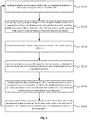
- Fig. 1 shows a flowchart of a positioning method according to an embodiment of the present application.
- the method may be executed by a positioning system which may be implemented in at least one of software and hardware.
- the medium-, high-, low-orbit constellation multi-frequency information sources include the multi-frequency information sources of at least one of all existing satellite navigation systems and the LEO augmentation satellite navigation system.
- the positioning method according to an embodiment of the present application includes a step S110 to a step S160.
- observation data of navigation satellites and LEO augmentation satellites are acquired at a current epoch and preprocessed.
- the process is as follows: acquiring multi-system multi-band observation values and LEO augmentation satellite observation values through receiver tracking and observations, and preprocessing the data.
- navigation satellites include at least one of the US GPS, China Beidou, EU Galileo, and Russian GLONASS satellite navigation systems.
- step S120 navigation telegrams of the navigation satellites and the LEO augmentation satellites are acquired, and precise orbits and clock biases of the navigation satellites and of the LEO augmentation satellites are obtained at the same time according to the acquired navigation telegrams of the LEO augmentation satellites.
- the process is: acquiring the navigation telegrams of the navigation satellites and the LEO augmentation satellites, and using the number of orbits and the clock bias coefficients provided by the navigation telegrams to interpolate to obtain the satellite position and the satellite clock bias at the current time point.
- the LEO augmentation satellites have different characteristics from the navigation satellites, the navigation telegrams of the LEO augmentation satellites are different from the navigation telegrams of the navigation satellites.
- the navigation telegrams of the LEO augmentation satellites have more types of parameters. Therefore, the calculation of the orbits and clock biases of the LEO augmentation satellites is also different from the calculation of the orbits and clock biases of the navigation satellites. For example, compared with the calculation of the orbits of the navigation satellites, in the calculation of the orbits of the LEO augmentation satellites, more perturbation factors need to be considered. Because the accuracy of the orbits and satellite clock biases of the LEO augmentation satellites and the navigation satellites given by the broadcast ephemeris generally cannot meet the high-precision positioning requirements. In an embodiment, in order to obtain real-time orbits and real-time clock biases with high precision, State Space Representation (SSR) correction information can be received in real time through the network.
- SSR State Space Representation
- step S130 errors received in the positioning process are corrected according to the acquired navigation telegrams.
- Errors that can be corrected by the error model are corrected in the step 130, and then errors that cannot be corrected by the error model are corrected through the calculation of the positioning and velocity measurement parameter observation values in the step S140 and the estimation of the positioning and velocity measurement parameters in the step S150.
- some errors are different, and the errors need to be corrected correspondingly according to different satellite navigation systems.
- the positioning result is often affected by multiple terms of errors, and weakening each error is the basis for obtaining high-precision positioning results.
- these errors can be divided into errors related to the monitoring stations, errors related to the satellites, and errors related to satellite signal propagation.
- the commonly used methods to weaken the positioning errors include model correction and parameter estimation.
- observation values of positioning and velocity measurement parameters are calculated according to unified linear observation equations obtained by normalizing by taking a type of satellite navigation system as reference.
- the process is as follows: according to the obtained observation data and navigation telegrams, the position of the receiver through the above formula (9) is calculated, and the clock bias of the receiver can also be calculated at the same time; the velocity of the receiver can also be calculated through the above formula (10).
- step S150 according to the calculated observation values of positioning and velocity measurement parameters and estimated values of positioning and velocity measurement parameters at the previous epoch, estimating positioning and velocity measurement parameters at the present epoch through a state equation, to obtain estimated values of positioning and velocity measurement parameters at the current epoch.
- the process is as follows: according to the calculated observation values of positioning and velocity measurement parameters and estimated values of positioning and velocity measurement parameters at the previous epoch, calculating estimated values of positioning and velocity measurement parameters at the present epoch through the above formula (11), and saving the calculated estimated values of positioning and velocity measurement parameters.
- step S160 according to the estimated values of positioning and velocity measurement parameters at the current epoch, positioning and velocity measurement results at the current epoch are generated and saved, and the processing returns to the step S110.
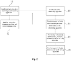
- Fig. 2 shows a positioning system according to an embodiment of the present application.
- the medium-, high-, low-orbit constellation multi-frequency information sources include the multi-frequency information sources of at least one of all existing satellite navigation systems and the LEO augmentation satellite navigation system.
- the positioning system includes: a satellite observation data receiving and processing apparatus 11, a satellite navigation telegram receiving and processing apparatus 12, a positioning error correcting apparatus 13, a positioning and velocity measurement parameter observation value calculating apparatus 14, a positioning and velocity measurement parameter estimated value calculating apparatus 15 and a positioning and velocity measurement result saving apparatus 16.
- the satellite observation data receiving and processing apparatus 11 is configured for acquiring observation data of navigation satellites and LEO augmentation satellites at each epoch and preprocessing the data.
- the satellite navigation telegram receiving and processing apparatus 12 is configured for acquiring navigation telegrams of the navigation satellites and the LEO augmentation satellites at each epoch, and at the same time obtaining precise orbit and clock bias of the navigation satellites and of the LEO augmentation satellites according to the acquired navigation telegrams of the LEO augmentation satellites.
- the satellite navigation telegram receiving and processing apparatus 12 includes a navigation satellite navigation telegram receiving and processing unit and a LEO augmentation satellite navigation telegram receiving and processing unit.
- the positioning error correcting apparatus 13 is configured for correcting errors received in the positioning process according to the acquired navigation telegrams.
- the positioning error correcting apparatus 13 includes a navigation satellite error correcting unit and a LEO augmentation satellite error correcting unit.
- the positioning and velocity measurement parameter observation value calculating apparatus 14 is configured for normalizing by taking a type of satellite navigation system as reference to obtain unified linear observation equations, and calculating observation values of positioning and velocity measurement parameters according the unified linear observation equations.
- the positioning and velocity measurement parameter estimated value calculating apparatus 15 is configured for estimating positioning and velocity measurement parameters at the present epoch according to the calculated observation values of positioning and velocity measurement parameters and the saved estimated values of positioning and velocity measurement parameters at the previous epoch, to obtain estimated values of positioning and velocity measurement parameters at the current epoch through a state equation.
- the positioning and velocity measurement result saving apparatus 16 configured for generating and saving positioning and velocity measurement results at the current epoch according to the estimated values of positioning and velocity measurement parameters at the current epoch.
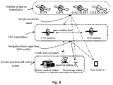
- Fig. 3 is a schematic diagram of the working principle of a fast and precise positioning method provided by an embodiment of the present application.
- the implementation of the positioning method may include a navigation satellite constellation, a LEO constellations, a ground operation and control system, and a user receiver.
- the navigation satellite constellation includes at least one of the US GPS, China Beidou, EU Galileo and Russian GLONASS satellite navigation systems, and is configured for broadcasting navigation satellite signals.
- the LEO constellation includes multiple LEO satellites distributed on multiple orbital planes, and the multiple LEO satellites broadcast navigation direct signals based on high-precision time-frequency references through specific frequency bands to provide stable coverage of the world or specific service areas, and is configured for broadcasting navigation direct signals and navigation augmentation information.
- the ground operation and control system performs business calculation and processing, and controls and manages the satellites and the constellations.
- the user receiver receives navigation direct signals broadcasted by the navigation satellites and the LEO satellites, as well as the navigation augmentation information broadcasted by the LEO satellites, and performs precise positioning, velocity measurement and timing based on the navigation direct signals from the navigation satellites and the LEO satellites and the navigation augmentation information.
Landscapes
- Engineering & Computer Science (AREA)
- Radar, Positioning & Navigation (AREA)
- Remote Sensing (AREA)
- Physics & Mathematics (AREA)
- General Physics & Mathematics (AREA)
- Computer Networks & Wireless Communication (AREA)
- Astronomy & Astrophysics (AREA)
- Aviation & Aerospace Engineering (AREA)
- Signal Processing (AREA)
- Position Fixing By Use Of Radio Waves (AREA)
Abstract
Description
- The present application claims the priority of the Chinese patent application filed with the Chinese Patent Office with application number
201810566043.4 on June 04, 2018 - The present application relates to satellite navigation technology, and for example to a fast and precise positioning method and system.
- Global Navigation Satellite Systems (GNSS) include the US Global Positioning System (GPS), Russian GLONASS Global Navigation Satellite System (GLONASS), EU Galileo Positioning System (Galileo), China Beidou System, Japanese Quasi-Zenith Satellite System (QZSS) and Indian India Regional Navigation Satellite System (IRNSS), etc. The global satellite navigation system mainly determines the position, velocity and time (Position Velocity Time, PVT) of the moving carrier by using the principle of distance rear intersection through measuring the distance from the satellite to the receiver. The PVT performance of the satellite navigation systems is not only limited by the accuracy of satellite orbits and clock bias products, but also related to the accuracy of the error models of the ionosphere, troposphere and the like and the correctness of the ambiguity parameter fixation. However, the convergence velocity of orientation parameter solution for positioning, velocity measurement and timing mainly depends on the spatial geometric configurations of the navigation satellites. Currently, the precise positioning convergence process ranges from 15 minutes to 30 minutes, and the long convergence time cannot meet the requirements of high-precision real time positioning.
- In order to reduce the convergence time, regional augmentation or joint solution of multiple navigation systems is currently mainly used. In regional augmentation systems, such as Real Time Kinematic (RTK), Real-Time extended (RTX), and Precise Point Positioning-Real Time Kinematic (PPP-RTK), error information of the ionosphere, troposphere and the like of the current region is solved by using regional reference stations, to correct the corresponding errors at the mobile station, so as to achieve a rapid separation of the ambiguity parameter and the position parameter, that is, the ambiguity parameter can be fixed within a few epochs, and positioning results in the order of centimeter and velocity measurement and timing results of a corresponding accuracy are achieved. By using multi-navigation satellite system, the number of observable satellites can be greatly increased, the spatial geometric configurations of the satellites can be improved, and the convergence velocity of parameter solutions can be accelerated, thereby improving the PVT performance.
- However, all of the above methods have their limitations. For example, the regional augmentation system can only provide high-precision PVT services within a certain range, and the multi-navigation satellite system has a limited effect on accelerating the convergence of Precise Point Positioning (PPP).
- The following is an overview of the subject matters described in detail herein. The present overview is not intended to limit the scope of protection of the claims.
- The regional augmentation system is restricted by regions. Generally, it can only provide high-precision PVT services within a certain range. If the functioning scope is exceeded, the augmentation information is no longer available. Although the multi-navigation satellite system can improve its convergence velocity, because the relevant navigation satellites are located in medium-to-high orbits, and the angle swept by the satellites at the zenith in a short time is small, and the changes in the spatial geometric configurations of the satellites are not obvious, this method has a limited effect on accelerating the convergence of Precise Point Positioning, and its convergence time still needs at least 6 minutes in the case that the ambiguity is fixed. Considering that the LEO augmentation satellites move relatively fast relative to the ground monitoring station, it will lead to rapid geometric structure changes and rapid separation of the ambiguity parameters and the position parameters, thereby accelerating the convergence velocity of PVT. Therefore, an effective way to break through the bottleneck of the current high-precision PVT services is to combine the medium-, high-, low-orbit augmentation satellites for navigation services.
- The present application proposes a positioning method and system based on navigation satellites and Low Earth Orbit (LEO) augmentation satellites, which use LEO augmentation satellite constellations to broadcast navigation satellite signals, thereby realizing large-scale rapid and high-precision PVT services by combining high-, middle-, low-orbit navigation satellites.
- The present application adopts the following technical solutions:
The present application provides a fast and precise positioning method, which includes: a step 1 of acquiring observation data of navigation satellites and LEO augmentation satellites at a current epoch and preprocessing the observation data; a step 2 of respectively acquiring navigation telegrams of the navigation satellites and the LEO augmentation satellites, and obtaining precise orbit and clock bias of the navigation satellites and precise orbit and clock bias of the LEO augmentation satellites according to the acquired navigation telegrams of the LEO augmentation satellites; a step 3 of correcting errors received in the positioning process according to the acquired navigation telegrams; a step 4 of normalizing by taking a type of satellite navigation system as reference to obtain unified linear observation equations, and calculating observation values of positioning and velocity measurement parameters; a step 5 of obtaining estimated values of positioning and velocity measurement parameters at the current epoch through a state equation according to the calculated observation values of positioning and velocity measurement parameters and estimated values of positioning and velocity measurement parameters at the previous epoch; a step 6 of generating and saving positioning and velocity measurement results at the current epoch according to the estimated values of positioning and velocity measurement parameters at the current epoch and returning to the step 1. - Wherein the step 2 includes: collecting the state space representation SSR correction information in real time through the network to obtain high-precision real-time orbit and real-time clock bias.
- Wherein if receiver clock bias


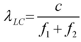


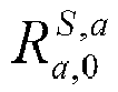


- Wherein the observation equation is:

- In the equation,


- Wherein the navigation satellites comprise at least one of the US Global Positioning System GPS, China Beidou, EU Galileo, and Russian GLONASS satellite navigation systems.
- The present application provides a positioning system, which includes: a atellite observation data receiving and processing apparatus configured for acquiring observation data of navigation satellites and LEO augmentation satellites at each epoch and preprocessing the observation data; a satellite navigation telegram receiving and processing apparatus configured for respectively acquiring navigation telegrams of the navigation satellites and the LEO augmentation satellites at each epoch, and obtaining precise orbit and clock bias of the navigation satellites and precise orbit and clock bias of the LEO augmentation satellites according to the acquired navigation telegrams of the LEO augmentation satellites; a positioning error correcting apparatus configured for correcting errors received in the positioning process according to the acquired navigation telegrams; a positioning and velocity measurement parameter observation value calculating apparatus configured for normalizing by taking a type of satellite navigation system as reference to obtain unified linear observation equations, and calculating observation values of positioning and velocity measurement parameters; a positioning and velocity measurement parameter estimated value calculating apparatus configured for obtaining estimated values of positioning and velocity measurement parameters through a state equation according to the calculated observation values of positioning and velocity measurement parameters and the saved estimated values of positioning and velocity measurement parameters at the previous epoch.
- A positioning and velocity measurement result saving apparatus is configured for generating and saving positioning and velocity measurement results at the current epoch according to the estimated values of positioning and velocity measurement parameters at the current epoch.
- Wherein the satellite navigation telegram receiving and processing apparatus comprises a navigation satellite navigation telegram receiving and processing unit and a LEO augmentation satellite navigation telegram receiving and processing unit.
- Wherein the positioning error correcting apparatus comprises a navigation satellite error correcting unit and a LEO augmentation satellite error correcting unit.
- Wherein if receiver clock bias


- Wherein the velocity measurement observation equation is:



- An embodiment of the present application provides a computer-readable storage medium, which includes a stored program, wherein the positioning method as described in any one of the above is executed when the program is running.
- An embodiment of the present application provides a processor, which is configured to run a program, and the positioning method as described in any one of the above is executed when the program is running.
- After reading and understanding the drawings and the detailed description, other aspects can be understood.
- The drawings are only used to illustrate example embodiments, and are not considered as limitation to the present application. And throughout the drawings, the same reference symbols are used to denote the same components.
- In the drawings:
-
Fig. 1 is a flowchart of a fast and precise positioning method according to an embodiment of the present application; -
Fig. 2 is a schematic structural diagram of a rapid and precise positioning system according to an embodiment of the present application; -
Fig. 3 is a flow chart of a fast and precise positioning method according to an embodiment of the present application. - Hereinafter, exemplary embodiments of the present disclosure will be described in more detail with reference to the accompanying drawings. Although the drawings show exemplary embodiments of the present disclosure, it should be understood that the present disclosure can be implemented in various forms and should not be limited by the embodiments set forth herein.
- To implement the positioning method provided by the present application, it is first necessary to construct and linearize unified observation equations for the medium-, high-, low-orbit augmentation satellites, and the receiver obtains the observation values of positioning and velocity measurement parameters according to the constructed linear observation equations. Wherein multi-frequency information sources of the medium-, high-, low-orbit constellation include multi-frequency information sources of at least one of all existing satellite navigation systems and the LEO augmentation satellite navigation system. The navigation satellites and the LEO augmentation satellites have the same positioning methods, and observation values of the two can be put together for adjustment solution. The mathematical model of the observation equations themself is a nonlinear equation, so it is necessary to perform Taylor expansion of the equation, and a linear equation can be obtained after discarding the second-order terms. The observation values of the navigation satellites and the LEO augmentation satellites can be expressed as a linear equation system of the positions and the receiver clock biases. Using differential observation values, the observation equations related to the monitoring station velocity term and the rate of change of the receiver clock biases can be obtained. By combining these two types of observation equations, the optimal estimation of the three parameters of PVT can be obtained.
- The basic observation values of the navigation satellites acquired by the receiver from navigation telegrams include two type of pseudo-ranges ρ and carrier phases φ at multiple frequency points. The observation values of the pseudo-range and phase from the satellite s to the monitoring station a at the frequency point i can be expressed as:


- In the equation (1), the zenith tropospheric delay parameter Ta and the receiver clock bias δta are only related to the monitoring station, the satellite clock bias δts is only related to the satellite, the oblique ionospheric delay parameter

- In navigation satellite data processing, different types of combinations of phase and pseudo-range observation values are often constructed as needed, wherein because the influence of the first-order ionosphere is eliminated in the ionosphere-free combination, it is widely used to construct observation equations for high-precision data processing. The observation equation can be expressed as:


- The hardware delays


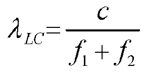
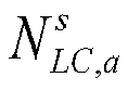

- Taking into account the correlation of each parameter in the equation (2) with the monitoring stations, the satellites and the signal frequencies, etc., for multi-system observations, the equation (2) can be extended to:

- Since in the PVT model, the clock biases of the navigation satellites are the same and they will absorb the hardware delay



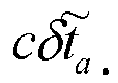


- The GNSS observation equation itself is a nonlinear equation, and related parameter estimation methods are generally applicable to linear systems, so it needs to be Taylor expanded. The GNSS observation equation is expanded at the approximate coordinates of the monitoring station according to the Taylor's formula, and its second-order terms are discarded, so that linear expressions about position and time are obtained as follows:


- In the equation (9), only the timing and positioning functions are completed, and the velocity measurement observation equation is:


- After establishing position and time observation equations and velocity observation equations, the root-mean-square filtering algorithm is used to perform state estimation on the positioning and velocity measurement parameters. Due to the addition of the LEO augmentation satellite observation values, the rapid convergence of the PPP can be realized and parameters information with higher precision can be obtained.
- The main steps of root-mean-square information filtering will be given below, and its state equation is:

x k-1 and priori varianceP k-1, and is the position, velocity or clock bias parameter to be estimated. The square root of the priori variance (Cholesky decomposition) is calculated to construct a virtual observation equation: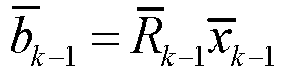
x k-1 = x k-1+η k-1,

- E[α k-1] = 0, E[α k-1 α k-1 T ] = Q, thereby constructing the virtual observation equation of state noise:

- The flitering observation equation is:

- According to the minimum variance criterion, the observation update function of the root-mean-square information filtering algorithm can be constructed:

- If it is written in matrix form, then:

- By orthogonally changing the above equation, the following can be obained:

- It is also possible to construct the state update function of the root-mean-square information filtering algorithm according to the minimum variance criterion:

- If it is written in matrix form, then:


- When using medium and high orbit information sources to solve positioning and velocity measurement parameters, due to the limitations of the satellite constellation, the accuracy of the solution and the convergence time often cannot meet the requirements of fast and high-precision positioning. The use of medium-, high-, low-orbit multi-frequency information source fusion positioning can augment the geometric structure of the visible satellites, achieve rapid convergence, and thereby improve the accuracy of positioning solution.
Fig. 1 shows a flowchart of a positioning method according to an embodiment of the present application. The method may be executed by a positioning system which may be implemented in at least one of software and hardware. Wherein the medium-, high-, low-orbit constellation multi-frequency information sources include the multi-frequency information sources of at least one of all existing satellite navigation systems and the LEO augmentation satellite navigation system. As shown inFig. 1 , the positioning method according to an embodiment of the present application includes a step S110 to a step S160. - In the step S110, observation data of navigation satellites and LEO augmentation satellites are acquired at a current epoch and preprocessed. The process is as follows: acquiring multi-system multi-band observation values and LEO augmentation satellite observation values through receiver tracking and observations, and preprocessing the data.
- Wherein the navigation satellites include at least one of the US GPS, China Beidou, EU Galileo, and Russian GLONASS satellite navigation systems.
- In the step S120, navigation telegrams of the navigation satellites and the LEO augmentation satellites are acquired, and precise orbits and clock biases of the navigation satellites and of the LEO augmentation satellites are obtained at the same time according to the acquired navigation telegrams of the LEO augmentation satellites. The process is: acquiring the navigation telegrams of the navigation satellites and the LEO augmentation satellites, and using the number of orbits and the clock bias coefficients provided by the navigation telegrams to interpolate to obtain the satellite position and the satellite clock bias at the current time point. Wherein because the LEO augmentation satellites have different characteristics from the navigation satellites, the navigation telegrams of the LEO augmentation satellites are different from the navigation telegrams of the navigation satellites. For example, the navigation telegrams of the LEO augmentation satellites have more types of parameters. Therefore, the calculation of the orbits and clock biases of the LEO augmentation satellites is also different from the calculation of the orbits and clock biases of the navigation satellites. For example, compared with the calculation of the orbits of the navigation satellites, in the calculation of the orbits of the LEO augmentation satellites, more perturbation factors need to be considered. Because the accuracy of the orbits and satellite clock biases of the LEO augmentation satellites and the navigation satellites given by the broadcast ephemeris generally cannot meet the high-precision positioning requirements. In an embodiment, in order to obtain real-time orbits and real-time clock biases with high precision, State Space Representation (SSR) correction information can be received in real time through the network.
- In the step S130, errors received in the positioning process are corrected according to the acquired navigation telegrams.
- Errors that can be corrected by the error model are corrected in the step 130, and then errors that cannot be corrected by the error model are corrected through the calculation of the positioning and velocity measurement parameter observation values in the step S140 and the estimation of the positioning and velocity measurement parameters in the step S150. For the LEO augmentation satellites and the navigation satellites, some errors are different, and the errors need to be corrected correspondingly according to different satellite navigation systems.
- In the positioning process, the positioning result is often affected by multiple terms of errors, and weakening each error is the basis for obtaining high-precision positioning results. According to the correlation, these errors can be divided into errors related to the monitoring stations, errors related to the satellites, and errors related to satellite signal propagation. The commonly used methods to weaken the positioning errors include model correction and parameter estimation. For some error terms, the physical characteristics of which has been understood, their effects can be accurately eliminated by using correction formulas, such as relativistic effects, earth rotation effects, etc.; for some error terms that can be fitted with a model, their effects can be eliminated by using model values obtained by the fitting model, such as solid earth tide correction, tropospheric correction, etc.; and for some other error terms with unknown physical characteristics and poor model fitting, parameter estimation methods can be used to eliminate their impact on positioning, such as receiver clock biases, etc..
- In the step S140, observation values of positioning and velocity measurement parameters are calculated according to unified linear observation equations obtained by normalizing by taking a type of satellite navigation system as reference. The process is as follows: according to the obtained observation data and navigation telegrams, the position of the receiver through the above formula (9) is calculated, and the clock bias of the receiver can also be calculated at the same time; the velocity of the receiver can also be calculated through the above formula (10).
- In the step S150, according to the calculated observation values of positioning and velocity measurement parameters and estimated values of positioning and velocity measurement parameters at the previous epoch, estimating positioning and velocity measurement parameters at the present epoch through a state equation, to obtain estimated values of positioning and velocity measurement parameters at the current epoch. The process is as follows: according to the calculated observation values of positioning and velocity measurement parameters and estimated values of positioning and velocity measurement parameters at the previous epoch, calculating estimated values of positioning and velocity measurement parameters at the present epoch through the above formula (11), and saving the calculated estimated values of positioning and velocity measurement parameters.
- In the step S160, according to the estimated values of positioning and velocity measurement parameters at the current epoch, positioning and velocity measurement results at the current epoch are generated and saved, and the processing returns to the step S110.
-
Fig. 2 shows a positioning system according to an embodiment of the present application. Wherein the medium-, high-, low-orbit constellation multi-frequency information sources include the multi-frequency information sources of at least one of all existing satellite navigation systems and the LEO augmentation satellite navigation system. - As shown in
Fig. 2 , the positioning system according to an embodiment of the present application includes: a satellite observation data receiving andprocessing apparatus 11, a satellite navigation telegram receiving andprocessing apparatus 12, a positioningerror correcting apparatus 13, a positioning and velocity measurement parameter observationvalue calculating apparatus 14, a positioning and velocity measurement parameter estimatedvalue calculating apparatus 15 and a positioning and velocity measurementresult saving apparatus 16. - Wherein the satellite observation data receiving and
processing apparatus 11 is configured for acquiring observation data of navigation satellites and LEO augmentation satellites at each epoch and preprocessing the data. - The satellite navigation telegram receiving and
processing apparatus 12 is configured for acquiring navigation telegrams of the navigation satellites and the LEO augmentation satellites at each epoch, and at the same time obtaining precise orbit and clock bias of the navigation satellites and of the LEO augmentation satellites according to the acquired navigation telegrams of the LEO augmentation satellites. In an embodiment, the satellite navigation telegram receiving andprocessing apparatus 12 includes a navigation satellite navigation telegram receiving and processing unit and a LEO augmentation satellite navigation telegram receiving and processing unit. The positioningerror correcting apparatus 13 is configured for correcting errors received in the positioning process according to the acquired navigation telegrams. In an embodiment, the positioningerror correcting apparatus 13 includes a navigation satellite error correcting unit and a LEO augmentation satellite error correcting unit. - The positioning and velocity measurement parameter observation
value calculating apparatus 14 is configured for normalizing by taking a type of satellite navigation system as reference to obtain unified linear observation equations, and calculating observation values of positioning and velocity measurement parameters according the unified linear observation equations. - The positioning and velocity measurement parameter estimated
value calculating apparatus 15 is configured for estimating positioning and velocity measurement parameters at the present epoch according to the calculated observation values of positioning and velocity measurement parameters and the saved estimated values of positioning and velocity measurement parameters at the previous epoch, to obtain estimated values of positioning and velocity measurement parameters at the current epoch through a state equation. - The positioning and velocity measurement
result saving apparatus 16 configured for generating and saving positioning and velocity measurement results at the current epoch according to the estimated values of positioning and velocity measurement parameters at the current epoch. -
Fig. 3 is a schematic diagram of the working principle of a fast and precise positioning method provided by an embodiment of the present application. Wherein the implementation of the positioning method may include a navigation satellite constellation, a LEO constellations, a ground operation and control system, and a user receiver. Wherein: the navigation satellite constellation includes at least one of the US GPS, China Beidou, EU Galileo and Russian GLONASS satellite navigation systems, and is configured for broadcasting navigation satellite signals. The LEO constellation includes multiple LEO satellites distributed on multiple orbital planes, and the multiple LEO satellites broadcast navigation direct signals based on high-precision time-frequency references through specific frequency bands to provide stable coverage of the world or specific service areas, and is configured for broadcasting navigation direct signals and navigation augmentation information. The ground operation and control system performs business calculation and processing, and controls and manages the satellites and the constellations. The user receiver receives navigation direct signals broadcasted by the navigation satellites and the LEO satellites, as well as the navigation augmentation information broadcasted by the LEO satellites, and performs precise positioning, velocity measurement and timing based on the navigation direct signals from the navigation satellites and the LEO satellites and the navigation augmentation information.
Claims (11)
- A fast and precise positioning method, comprising:a step 1 of acquiring observation data of navigation satellites and Low Earth Orbit (LEO) augmentation satellites at a current epoch and preprocessing the observation data;a step 2 of respectively acquiring navigation telegrams of the navigation satellites and the LEO augmentation satellites, and obtaining precise orbit and clock bias of the navigation satellites and precise orbit and clock bias of the LEO augmentation satellites according to the acquired navigation telegrams of the LEO augmentation satellites;a step 3 of correcting errors received in the positioning process according to the acquired navigation telegrams;a step 4 of normalizing by taking a type of satellite navigation system as reference to obtain unified linear observation equations, and calculating observation values of positioning and velocity measurement parameters;a step 5 of obtaining estimated values of positioning and velocity measurement parameters at the current epoch through a state equation according to the calculated observation values of positioning and velocity measurement parameters and estimated values of positioning and velocity measurement parameters at the previous epoch;a step 6 of generating and saving positioning and velocity measurement results at the current epoch according to the estimated values of positioning and velocity measurement parameters at the current epoch and returning to the step 1.
- The positioning method as claimed in claim 1, wherein the unified linear observation equations comprise positioning observation equations, and if receiver clock bias


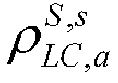


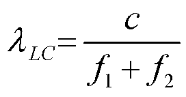


- The positioning method as claimed in claim 2, wherein the unified linear observation equations comprise a velocity measurement observation equation, which is:


- The positioning method as claimed in claim 2, wherein the navigation satellites comprise at least one of the US Global Positioning System GPS, China Beidou, EU Galileo, and Russian GLONASS satellite navigation systems.
- A fast and precise positioning system, comprising:a satellite observation data receiving and processing apparatus configured for acquiring observation data of navigation satellites and Low Earth Orbit (LEO) augmentation satellites at each epoch and preprocessing the observation data;a satellite navigation telegram receiving and processing apparatus configured for respectively acquiring navigation telegrams of the navigation satellites and the LEO augmentation satellites at each epoch, and obtaining precise orbit and clock bias of the navigation satellites and precise orbit and clock bias of the LEO augmentation satellites according to the acquired navigation telegrams of the LEO augmentation satellites;a positioning error correcting apparatus configured for correcting errors received in the positioning process according to the acquired navigation telegrams;a positioning and velocity measurement parameter observation value calculating apparatus configured for normalizing by taking a type of satellite navigation system as reference to obtain unified linear observation equations, and calculating observation values of positioning and velocity measurement parameters;a positioning and velocity measurement parameter estimated value calculating apparatus configured for obtaining estimated values of positioning and velocity measurement parameters at the current epoch through a state equation according to the calculated observation values of positioning and velocity measurement parameters and the saved estimated values of positioning and velocity measurement parameters at the previous epoch;a positioning and velocity measurement result saving apparatus configured for generating and saving positioning and velocity measurement results at the current epoch according to the estimated values of positioning and velocity measurement parameters at the current epoch.
- The positioning system as claimed in claim 5, wherein the satellite navigation telegram receiving and processing apparatus comprises a navigation satellite navigation telegram receiving and processing unit and a LEO augmentation satellite navigation telegram receiving and processing unit.
- The positioning system as claimed in claim 5, wherein the positioning error correcting apparatus comprises a navigation satellite error correcting unit and a LEO augmentation satellite error correcting unit.
- The positioning system as claimed in claim 5, wherein the unified linear observation equations comprise positioning observation equations, and if receiver clock bias


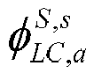


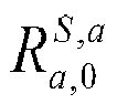


- The positioning system as claimed in claim 8, wherein the unified linear observation equations comprise a velocity measurement observation equation, which is:


- A computer-readable storage medium, which comprises a stored program, wherein the method as claimed in any one of claims 1 to 4 is executed when the program is running.
- A processor, which is configured to run a program, and the method as claimed in any one of claims 1 to 4 is executed when the program is running.
Applications Claiming Priority (2)
| Application Number | Priority Date | Filing Date | Title |
|---|---|---|---|
| CN201810566043.4A CN109001786B (en) | 2018-06-04 | 2018-06-04 | A positioning method and system based on navigation satellites and low-orbit augmentation satellites |
| PCT/CN2018/117070 WO2019233045A1 (en) | 2018-06-04 | 2018-11-23 | Fast and precise positioning method and system |
Publications (4)
| Publication Number | Publication Date |
|---|---|
| EP3805804A1 true EP3805804A1 (en) | 2021-04-14 |
| EP3805804A4 EP3805804A4 (en) | 2021-09-22 |
| EP3805804B1 EP3805804B1 (en) | 2025-08-20 |
| EP3805804C0 EP3805804C0 (en) | 2025-08-20 |
Family
ID=64574307
Family Applications (1)
| Application Number | Title | Priority Date | Filing Date |
|---|---|---|---|
| EP18921490.1A Active EP3805804B1 (en) | 2018-06-04 | 2018-11-23 | Fast and precise positioning method and system |
Country Status (11)
| Country | Link |
|---|---|
| US (1) | US11726213B2 (en) |
| EP (1) | EP3805804B1 (en) |
| JP (1) | JP7122023B2 (en) |
| KR (1) | KR102547522B1 (en) |
| CN (1) | CN109001786B (en) |
| AU (1) | AU2018426890B2 (en) |
| CA (1) | CA3102481C (en) |
| ES (1) | ES3042812T3 (en) |
| PL (1) | PL3805804T3 (en) |
| RU (1) | RU2749667C1 (en) |
| WO (1) | WO2019233045A1 (en) |
Cited By (1)
| Publication number | Priority date | Publication date | Assignee | Title |
|---|---|---|---|---|
| CN113504557A (en) * | 2021-06-22 | 2021-10-15 | 北京建筑大学 | GPS inter-frequency clock error new forecasting method for real-time application |
Families Citing this family (51)
| Publication number | Priority date | Publication date | Assignee | Title |
|---|---|---|---|---|
| CN109520512A (en) * | 2018-12-28 | 2019-03-26 | 上海海积信息科技股份有限公司 | A kind of precision orbit determination method and device |
| CN109752747B (en) * | 2019-01-16 | 2023-01-17 | 上海华测导航技术股份有限公司 | Differential data determination method, device, server and storage medium |
| CN109856656B (en) * | 2019-02-14 | 2022-10-28 | 上海华测导航技术股份有限公司 | A navigation and positioning method, device, electronic device and storage medium |
| CN110118978B (en) * | 2019-04-15 | 2020-05-19 | 中国人民解放军军事科学院国防科技创新研究院 | Navigation anti-interference system and navigation anti-interference method based on low-earth-orbit satellite |
| CN110187364B (en) * | 2019-06-14 | 2023-06-09 | 火眼位置数智科技服务有限公司 | Low-rail navigation enhanced precision correction data generation and uploading system and method |
| CN111045042B (en) * | 2019-12-20 | 2022-03-04 | 西安空间无线电技术研究所 | A PPP-RTK enhancement method and system based on "cloud-end" architecture |
| CN111045066A (en) * | 2019-12-30 | 2020-04-21 | 威海欧瑞亚信息科技有限公司 | Method for determining GNSS position change based on parameter equivalence reduction principle |
| CN113805204B (en) * | 2020-06-16 | 2023-07-25 | 千寻位置网络有限公司 | Updating method and device for receiver DCB |
| CN111947667B (en) * | 2020-06-24 | 2022-08-12 | 火眼位置数智科技服务有限公司 | A real-time high-precision orbit determination method for low-orbit satellites based on the combination of kinematics and dynamics |
| US11742933B1 (en) * | 2020-07-31 | 2023-08-29 | Amazon Technologies, Inc. | Antenna control using real-time sensor fusion |
| CN112327341B (en) * | 2020-10-21 | 2023-07-14 | 北京航空航天大学 | A method for realizing sub-meter level positioning through network-assisted GNSS terminal |
| CN112462396B (en) * | 2020-11-20 | 2023-06-16 | 中国人民解放军战略支援部队信息工程大学 | Real-time parallel determination method for clock error of navigation satellite with high sampling rate |
| CN112612043A (en) * | 2020-12-10 | 2021-04-06 | 国网四川省电力公司信息通信公司 | High-speed wireless communication and navigation positioning integrated area enhancement system and method |
| CN115236705B (en) * | 2021-04-25 | 2025-03-14 | 千寻位置网络(浙江)有限公司 | Fast reconvergence method, device, equipment and storage medium for precise single-point positioning |
| CN113447971A (en) * | 2021-06-28 | 2021-09-28 | 中国科学院国家授时中心 | LEO and GNSS fusion precise point positioning method and system |
| CN115542354B (en) * | 2021-06-30 | 2026-03-06 | 博通集成电路(上海)股份有限公司 | Apparatus and method for calculating receiver position-velocity-time results |
| WO2023283867A1 (en) * | 2021-07-15 | 2023-01-19 | Qualcomm Incorporated | Low-Earth Orbit (LEO) Satellite Position, Velocity, and Time (PVT) Determination for LEO-based Positioning |
| CN113641949B (en) * | 2021-08-05 | 2023-03-28 | 中国西安卫星测控中心 | High-precision fitting method for number of orbits in geosynchronous transfer section |
| CN113848574B (en) * | 2021-08-31 | 2025-05-02 | 北方信息控制研究院集团有限公司 | A real-time state space expression product evaluation method |
| CN113933780A (en) * | 2021-09-02 | 2022-01-14 | 国网浙江省电力有限公司丽水供电公司 | Reverse positioning method for deception interference source of power Beidou satellite time service system based on TDOA |
| CN113687402B (en) * | 2021-09-07 | 2024-03-19 | 中国电子科技集团公司第五十四研究所 | A low-orbit navigation enhanced real-time positioning method that takes into account satellite orbit errors |
| CN113885055B (en) * | 2021-09-07 | 2025-10-14 | 中国科学院上海天文台 | Navigation satellite multi-satellite orbit determination system and method with satellite-ground two-way clock error constraints |
| CN113884704B (en) * | 2021-09-23 | 2023-07-14 | 中国人民解放军63620部队 | High-precision Alignment Method for Velocity Reference of Multi-source and Multi-type Measurement Data of Launch Vehicle |
| CN113866808B (en) * | 2021-09-29 | 2024-08-02 | 哈尔滨工程大学 | GNSS oscillator level real-time cycle slip detection and repair method |
| KR102586143B1 (en) * | 2021-11-01 | 2023-10-10 | 한국항공우주연구원 | System and method for positioning using low earth orbit satellite |
| CN114137585B (en) * | 2021-11-03 | 2024-06-25 | 中国电子科技集团公司第二十研究所 | A Beidou satellite-based enhanced hybrid enhanced positioning method |
| CN114280645A (en) * | 2021-12-27 | 2022-04-05 | 深圳供电局有限公司 | GNSS navigation message checking method and system |
| CN114280650B (en) * | 2021-12-29 | 2025-07-15 | 重庆两江卫星移动通信有限公司 | Method and system for obtaining GNSS satellite inter-frequency deviation based on LEO |
| CN114325788B (en) * | 2021-12-30 | 2025-09-05 | 重庆两江卫星移动通信有限公司 | A PPP-RTK positioning method and system based on edge computing |
| CN114488229B (en) * | 2022-01-28 | 2026-05-15 | 阿里巴巴(中国)有限公司 | Positioning accuracy determination method, positioning method, device, equipment and storage medium |
| CN114646992B (en) * | 2022-03-21 | 2024-08-02 | 腾讯科技(深圳)有限公司 | Positioning method, apparatus, computer device, storage medium and computer program product |
| CN114594507B (en) * | 2022-05-11 | 2022-07-29 | 长安大学 | GNSS data quality comprehensive evaluation method fusing K-means and KNN |
| CN114966773B (en) * | 2022-05-23 | 2024-11-12 | 湘潭大学 | A PPP fast positioning convergence method, device and storage medium |
| CN115276769B (en) * | 2022-07-22 | 2024-07-09 | 福建鼎旸信息科技股份有限公司 | Satellite data accurate broadcasting and service coverage method and system |
| CN115061174B (en) * | 2022-07-26 | 2024-06-21 | 中国民航大学 | PBN operation-oriented GPS/DME deep combination navigation data fusion method and system |
| CN115792997B (en) * | 2022-08-09 | 2026-04-28 | 东南大学 | Nearshore long baseline positioning method based on BeiDou-3 multi-frequency signals |
| CN115407367B (en) * | 2022-08-17 | 2023-04-07 | 南京信息工程大学 | Method for estimating navigation positioning precision attenuation factor of mixed constellation satellite |
| CN115657085B (en) * | 2022-09-21 | 2024-04-16 | 北京跟踪与通信技术研究所 | Multi-channel anti-interference device and signal processing method |
| CN115776326A (en) * | 2022-11-09 | 2023-03-10 | 北京航天科工世纪卫星科技有限公司 | Time-frequency synchronization method based on satellite spread spectrum communication |
| CN116299618B (en) * | 2023-03-24 | 2024-03-19 | 中国科学院精密测量科学与技术创新研究院 | Carrier phase satellite common view time transfer method based on PPP (point-to-point protocol) calculation parameters |
| WO2024253253A1 (en) * | 2023-06-08 | 2024-12-12 | 아주대학교산학협력단 | Factor graph optimization-based positioning method and device using multiple low earth orbit satellites |
| CN116720050B (en) * | 2023-06-12 | 2026-01-23 | 东南大学 | Signal quality evaluation method of ground pseudo satellite enhancement system |
| CN116859420A (en) * | 2023-06-16 | 2023-10-10 | 同济大学 | Low-orbit satellite-enhanced global navigation satellite system (LeGNSS) data simulation method |
| CN116973948B (en) * | 2023-07-31 | 2024-02-23 | 中国科学院空天信息创新研究院 | A method and system for accurate deviation processing of hybrid satellite navigation receivers |
| CN117687296A (en) * | 2023-10-26 | 2024-03-12 | 广东工业大学 | A multipath noise control method of Beidou positioning system for vehicle urban navigation |
| CN117148394B (en) * | 2023-11-01 | 2024-01-02 | 北京凯芯微科技有限公司 | Satellite screening method |
| CN117492054B (en) * | 2023-11-15 | 2024-04-09 | 武汉理工大学 | A global precise point positioning method enhanced by low-orbit satellites with the support of regional ground stations |
| CN118604863B (en) * | 2024-06-19 | 2025-09-05 | 武汉大学 | 5G TDOA positioning method and system based on Beidou non-differential non-combined wide-area real-time PPT |
| CN119687936B (en) * | 2025-02-21 | 2025-06-24 | 航天宏图信息技术股份有限公司 | Machine learning-based low-orbit satellite precise orbit determination method, device and equipment |
| CN120446987B (en) * | 2025-05-22 | 2026-07-17 | 航天恒星科技有限公司 | Navigation satellite real-time clock error estimation method, system and storage medium |
| CN120703806B (en) * | 2025-07-29 | 2026-03-27 | 中国星网网络系统研究院有限公司 | LEO-GNSS Precise Point Positioning Method Based on Independent Estimation of System Bias |
Family Cites Families (30)
| Publication number | Priority date | Publication date | Assignee | Title |
|---|---|---|---|---|
| AU733187B2 (en) * | 1995-10-24 | 2001-05-10 | Inmarsat Global Limited | Satellite radiodetermination |
| DE69841174D1 (en) * | 1997-03-21 | 2009-11-05 | Univ R | NAVIGATION SYSTEM WITH CENTRALIZED ACCURACY USING LOW-SATELLITE SATELLITES |
| US6725158B1 (en) * | 1999-07-12 | 2004-04-20 | Skybitz, Inc. | System and method for fast acquisition reporting using communication satellite range measurement |
| US6480788B2 (en) * | 1999-07-12 | 2002-11-12 | Eagle-Eye, Inc. | System and method for fast acquisition reporting using communication satellite range measurement |
| US6560536B1 (en) * | 1999-07-12 | 2003-05-06 | Eagle-Eye, Inc. | System and method for rapid telepositioning |
| US20040143392A1 (en) * | 1999-07-12 | 2004-07-22 | Skybitz, Inc. | System and method for fast acquisition reporting using communication satellite range measurement |
| EP2698644B1 (en) | 2004-01-15 | 2016-03-30 | The Boeing Company | Methods and systems for enhanced navigational performance |
| KR100685780B1 (en) | 2004-11-04 | 2007-02-22 | 한국전자통신연구원 | Ion Layer Error Correction Method and Precision Track Determination System Using the Method |
| AU2011265571B2 (en) * | 2005-11-07 | 2012-02-16 | The Boeing Company | Methods and apparatus for a navigation system with reduced susceptibility to interference and jamming |
| RU2428714C2 (en) * | 2006-05-18 | 2011-09-10 | Дзе Боинг Компани | Universal high-performance navigation system |
| US7583225B2 (en) * | 2006-05-18 | 2009-09-01 | The Boeing Company | Low earth orbit satellite data uplink |
| US7969352B2 (en) * | 2008-01-08 | 2011-06-28 | The Boeing Company | Global positioning system accuracy enhancement |
| US8260551B2 (en) * | 2008-01-10 | 2012-09-04 | Trimble Navigation Limited | System and method for refining a position estimate of a low earth orbiting satellite |
| US9121932B2 (en) * | 2008-01-10 | 2015-09-01 | Trimble Navigation Limited | Refining a position estimate of a low earth orbiting satellite |
| US8989652B2 (en) * | 2011-09-09 | 2015-03-24 | The Boeing Company | Advanced timing and time transfer for satellite constellations using crosslink ranging and an accurate time source |
| EP2815253B1 (en) * | 2012-02-17 | 2018-11-21 | Topcon Positioning Systems, Inc. | Improving the positioning quality of global navigation satellite system receivers |
| EP3014298A1 (en) | 2013-06-27 | 2016-05-04 | Trimble Navigation Limited | Refining a position estimate of a low earth orbiting satellite |
| CA2940652C (en) | 2014-02-26 | 2022-07-12 | Clark Emerson Cohen | An improved performance and cost global navigation satellite system architecture |
| US20150247931A1 (en) | 2014-02-28 | 2015-09-03 | Hemisphere Gnss Inc. | Locally enhanced gnss wide-area augmentation system |
| CN105158780B (en) * | 2015-07-24 | 2017-11-07 | 北京跟踪与通信技术研究所 | One kind is based on the interchangeable navigation locating method of a variety of aeronautical satellites |
| CN106443739B (en) * | 2016-09-09 | 2019-03-01 | 清华大学 | Assisted and enhanced navigation method and device |
| CN106569241B (en) * | 2016-09-27 | 2019-04-23 | 北京航空航天大学 | A single-frequency high-precision positioning method based on GNSS |
| CN106646564B (en) * | 2016-10-31 | 2019-10-29 | 电子科技大学 | One kind being based on low orbit satellite enhanced navigation method |
| CN107153209B (en) * | 2017-07-06 | 2019-07-30 | 武汉大学 | A real-time precise orbit determination method for short-arc low-orbit navigation satellites |
| CN107229061B (en) * | 2017-07-18 | 2019-09-03 | 武汉大学 | A real-time precision positioning method based on low-orbit satellites |
| CN107390233B (en) * | 2017-07-18 | 2020-04-17 | 武汉大学 | Low-earth-orbit satellite navigation enhanced ionosphere delay correction parameter method |
| CN109001763B (en) * | 2018-06-04 | 2020-06-30 | 北京未来导航科技有限公司 | Navigation enhancement method and system based on low-orbit constellation |
| CN108415050B (en) * | 2018-06-04 | 2020-05-26 | 北京未来导航科技有限公司 | PPP-RTK positioning method based on low-orbit constellation navigation enhancement system |
| US11513232B2 (en) * | 2019-05-28 | 2022-11-29 | Xona Space Systems Inc. | Satellite for broadcasting high precision data |
| US11681052B2 (en) * | 2020-01-07 | 2023-06-20 | All. Space Networks Limited | Non-cooperative position, navigation, and timing extraction from VSAT communications signals using multi-beam phased array antenna |
-
2018
- 2018-06-04 CN CN201810566043.4A patent/CN109001786B/en active Active
- 2018-11-23 KR KR1020207035116A patent/KR102547522B1/en active Active
- 2018-11-23 PL PL18921490.1T patent/PL3805804T3/en unknown
- 2018-11-23 WO PCT/CN2018/117070 patent/WO2019233045A1/en not_active Ceased
- 2018-11-23 JP JP2020568476A patent/JP7122023B2/en active Active
- 2018-11-23 US US15/734,446 patent/US11726213B2/en active Active
- 2018-11-23 RU RU2020139312A patent/RU2749667C1/en active
- 2018-11-23 CA CA3102481A patent/CA3102481C/en active Active
- 2018-11-23 EP EP18921490.1A patent/EP3805804B1/en active Active
- 2018-11-23 AU AU2018426890A patent/AU2018426890B2/en active Active
- 2018-11-23 ES ES18921490T patent/ES3042812T3/en active Active
Cited By (1)
| Publication number | Priority date | Publication date | Assignee | Title |
|---|---|---|---|---|
| CN113504557A (en) * | 2021-06-22 | 2021-10-15 | 北京建筑大学 | GPS inter-frequency clock error new forecasting method for real-time application |
Also Published As
| Publication number | Publication date |
|---|---|
| RU2749667C1 (en) | 2021-06-16 |
| CN109001786A (en) | 2018-12-14 |
| JP7122023B2 (en) | 2022-08-19 |
| JP2021526217A (en) | 2021-09-30 |
| CA3102481A1 (en) | 2019-12-12 |
| EP3805804B1 (en) | 2025-08-20 |
| PL3805804T3 (en) | 2026-01-26 |
| US11726213B2 (en) | 2023-08-15 |
| EP3805804A4 (en) | 2021-09-22 |
| AU2018426890A1 (en) | 2020-12-24 |
| KR20210008384A (en) | 2021-01-21 |
| ES3042812T3 (en) | 2025-11-24 |
| EP3805804C0 (en) | 2025-08-20 |
| AU2018426890B2 (en) | 2021-09-23 |
| KR102547522B1 (en) | 2023-06-23 |
| CA3102481C (en) | 2024-01-09 |
| WO2019233045A1 (en) | 2019-12-12 |
| US20210223405A1 (en) | 2021-07-22 |
| CN109001786B (en) | 2020-06-16 |
Similar Documents
| Publication | Publication Date | Title |
|---|---|---|
| EP3805804B1 (en) | Fast and precise positioning method and system | |
| Li et al. | Review of PPP–RTK: Achievements, challenges, and opportunities | |
| US11852735B2 (en) | Navigation enhancement method and system | |
| EP3805803B1 (en) | Positioning method and device | |
| US10281587B2 (en) | Navigation satellite system positioning involving the generation of correction information | |
| US11409005B2 (en) | GNSS receiver adapted to produce, use, and communicate software-generated satellite signal data | |
| EP2673658B1 (en) | Method and system for determining clock corrections | |
| CN105842720B (en) | A wide-area precise real-time positioning method based on carrier phase | |
| US20170269216A1 (en) | Rapid determination of precise position by aiding data | |
| CN111983641B (en) | Method for generating Beidou satellite-based augmentation system integrity parameters in real time | |
| CN104483689B (en) | Determination method for BDS reference station three-frequency carrier phase whole cycle ambiguities | |
| CN110068843A (en) | Satellite positioning receiver, method and apparatus | |
| CN108535749B (en) | Positioning enhancement method and system based on CORS and positioning system | |
| CN107607971A (en) | Temporal frequency transmission method and receiver based on GNSS common-view time alignment algorithms | |
| CN108508470A (en) | Towards the instantaneous decimeter grade navigation locating method that the whole world is seamless | |
| Zhang et al. | An overview on GNSS carrier-phase time transfer research | |
| CN118425998A (en) | A GNSS full-time real-time satellite clock error estimation method and system | |
| Choy et al. | An evaluation of various ionospheric error mitigation methods used in single frequency PPP | |
| CN105425248A (en) | High-frequency epoch-by-epoch phase difference method for single-frequency GNSS phase stability monitoring | |
| Xin et al. | Estimating GPS BLOCK IIF L5 satellite antenna phase center offsets for rapid triple-frequency PPP ambiguity resolution | |
| Lee et al. | An Architecture for Seamless Handover of PPP-RTK Corrections Across Redundant Networks | |
| Shi et al. | A Performance Analysis of Real-Time Precise Point Positioning for Deformation Monitorin | |
| Wu et al. | Performance Evaluation of Leo Constellation Augmented Bds-3 Ppp-B2b Service |
Legal Events
| Date | Code | Title | Description |
|---|---|---|---|
| STAA | Information on the status of an ep patent application or granted ep patent |
Free format text: STATUS: THE INTERNATIONAL PUBLICATION HAS BEEN MADE |
|
| PUAI | Public reference made under article 153(3) epc to a published international application that has entered the european phase |
Free format text: ORIGINAL CODE: 0009012 |
|
| STAA | Information on the status of an ep patent application or granted ep patent |
Free format text: STATUS: REQUEST FOR EXAMINATION WAS MADE |
|
| 17P | Request for examination filed |
Effective date: 20201215 |
|
| AK | Designated contracting states |
Kind code of ref document: A1 Designated state(s): AL AT BE BG CH CY CZ DE DK EE ES FI FR GB GR HR HU IE IS IT LI LT LU LV MC MK MT NL NO PL PT RO RS SE SI SK SM TR |
|
| AX | Request for extension of the european patent |
Extension state: BA ME |
|
| DAV | Request for validation of the european patent (deleted) | ||
| DAX | Request for extension of the european patent (deleted) | ||
| A4 | Supplementary search report drawn up and despatched |
Effective date: 20210823 |
|
| RIC1 | Information provided on ipc code assigned before grant |
Ipc: H04B 7/185 20060101ALI20210817BHEP Ipc: G01S 19/46 20100101AFI20210817BHEP |
|
| RIC1 | Information provided on ipc code assigned before grant |
Ipc: H04B 7/185 20060101ALI20250213BHEP Ipc: G01S 19/46 20100101AFI20250213BHEP |
|
| GRAP | Despatch of communication of intention to grant a patent |
Free format text: ORIGINAL CODE: EPIDOSNIGR1 |
|
| STAA | Information on the status of an ep patent application or granted ep patent |
Free format text: STATUS: GRANT OF PATENT IS INTENDED |
|
| INTG | Intention to grant announced |
Effective date: 20250324 |
|
| GRAS | Grant fee paid |
Free format text: ORIGINAL CODE: EPIDOSNIGR3 |
|
| GRAA | (expected) grant |
Free format text: ORIGINAL CODE: 0009210 |
|
| STAA | Information on the status of an ep patent application or granted ep patent |
Free format text: STATUS: THE PATENT HAS BEEN GRANTED |
|
| AK | Designated contracting states |
Kind code of ref document: B1 Designated state(s): AL AT BE BG CH CY CZ DE DK EE ES FI FR GB GR HR HU IE IS IT LI LT LU LV MC MK MT NL NO PL PT RO RS SE SI SK SM TR |
|
| REG | Reference to a national code |
Ref country code: GB Ref legal event code: FG4D |
|
| REG | Reference to a national code |
Ref country code: CH Ref legal event code: EP |
|
| REG | Reference to a national code |
Ref country code: DE Ref legal event code: R096 Ref document number: 602018084863 Country of ref document: DE |
|
| REG | Reference to a national code |
Ref country code: IE Ref legal event code: FG4D |
|
| U01 | Request for unitary effect filed |
Effective date: 20250918 |
|
| U07 | Unitary effect registered |
Designated state(s): AT BE BG DE DK EE FI FR IT LT LU LV MT NL PT RO SE SI Effective date: 20250924 |
|
| REG | Reference to a national code |
Ref country code: ES Ref legal event code: FG2A Ref document number: 3042812 Country of ref document: ES Kind code of ref document: T3 Effective date: 20251124 |
|
| U20 | Renewal fee for the european patent with unitary effect paid |
Year of fee payment: 8 Effective date: 20251117 |
|
| PG25 | Lapsed in a contracting state [announced via postgrant information from national office to epo] |
Ref country code: IS Free format text: LAPSE BECAUSE OF FAILURE TO SUBMIT A TRANSLATION OF THE DESCRIPTION OR TO PAY THE FEE WITHIN THE PRESCRIBED TIME-LIMIT Effective date: 20251220 |
|
| PGFP | Annual fee paid to national office [announced via postgrant information from national office to epo] |
Ref country code: GB Payment date: 20251030 Year of fee payment: 8 |
|
| PG25 | Lapsed in a contracting state [announced via postgrant information from national office to epo] |
Ref country code: NO Free format text: LAPSE BECAUSE OF FAILURE TO SUBMIT A TRANSLATION OF THE DESCRIPTION OR TO PAY THE FEE WITHIN THE PRESCRIBED TIME-LIMIT Effective date: 20251120 |
|
| PG25 | Lapsed in a contracting state [announced via postgrant information from national office to epo] |
Ref country code: HR Free format text: LAPSE BECAUSE OF FAILURE TO SUBMIT A TRANSLATION OF THE DESCRIPTION OR TO PAY THE FEE WITHIN THE PRESCRIBED TIME-LIMIT Effective date: 20250820 |
|
| PG25 | Lapsed in a contracting state [announced via postgrant information from national office to epo] |
Ref country code: GR Free format text: LAPSE BECAUSE OF FAILURE TO SUBMIT A TRANSLATION OF THE DESCRIPTION OR TO PAY THE FEE WITHIN THE PRESCRIBED TIME-LIMIT Effective date: 20251121 |
|
| PGFP | Annual fee paid to national office [announced via postgrant information from national office to epo] |
Ref country code: TR Payment date: 20251117 Year of fee payment: 8 |
|
| PGFP | Annual fee paid to national office [announced via postgrant information from national office to epo] |
Ref country code: IE Payment date: 20251111 Year of fee payment: 8 |
|
| PG25 | Lapsed in a contracting state [announced via postgrant information from national office to epo] |
Ref country code: RS Free format text: LAPSE BECAUSE OF FAILURE TO SUBMIT A TRANSLATION OF THE DESCRIPTION OR TO PAY THE FEE WITHIN THE PRESCRIBED TIME-LIMIT Effective date: 20251120 |
|
| PG25 | Lapsed in a contracting state [announced via postgrant information from national office to epo] |
Ref country code: SM Free format text: LAPSE BECAUSE OF FAILURE TO SUBMIT A TRANSLATION OF THE DESCRIPTION OR TO PAY THE FEE WITHIN THE PRESCRIBED TIME-LIMIT Effective date: 20250820 |
|
| PGFP | Annual fee paid to national office [announced via postgrant information from national office to epo] |
Ref country code: ES Payment date: 20260121 Year of fee payment: 8 |
|
| PG25 | Lapsed in a contracting state [announced via postgrant information from national office to epo] |
Ref country code: CZ Free format text: LAPSE BECAUSE OF FAILURE TO SUBMIT A TRANSLATION OF THE DESCRIPTION OR TO PAY THE FEE WITHIN THE PRESCRIBED TIME-LIMIT Effective date: 20250820 |
|
| PG25 | Lapsed in a contracting state [announced via postgrant information from national office to epo] |
Ref country code: SK Free format text: LAPSE BECAUSE OF FAILURE TO SUBMIT A TRANSLATION OF THE DESCRIPTION OR TO PAY THE FEE WITHIN THE PRESCRIBED TIME-LIMIT Effective date: 20250820 |
|
| REG | Reference to a national code |
Ref country code: CH Ref legal event code: H13 Free format text: ST27 STATUS EVENT CODE: U-0-0-H10-H13 (AS PROVIDED BY THE NATIONAL OFFICE) Effective date: 20260623 |
|
| PLBE | No opposition filed within time limit |
Free format text: ORIGINAL CODE: 0009261 |
|
| STAA | Information on the status of an ep patent application or granted ep patent |
Free format text: STATUS: NO OPPOSITION FILED WITHIN TIME LIMIT |
|
| PG25 | Lapsed in a contracting state [announced via postgrant information from national office to epo] |
Ref country code: MC Free format text: LAPSE BECAUSE OF FAILURE TO SUBMIT A TRANSLATION OF THE DESCRIPTION OR TO PAY THE FEE WITHIN THE PRESCRIBED TIME-LIMIT Effective date: 20250820 |
|
| REG | Reference to a national code |
Ref country code: CH Ref legal event code: L10 Free format text: ST27 STATUS EVENT CODE: U-0-0-L10-L00 (AS PROVIDED BY THE NATIONAL OFFICE) Effective date: 20260701 |
|
| PGFP | Annual fee paid to national office [announced via postgrant information from national office to epo] |
Ref country code: PL Payment date: 20260601 Year of fee payment: 9 |
|
| PG25 | Lapsed in a contracting state [announced via postgrant information from national office to epo] |
Ref country code: CH Free format text: LAPSE BECAUSE OF NON-PAYMENT OF DUE FEES Effective date: 20251130 |
|
| 26N | No opposition filed |
Effective date: 20260521 |