EP3756971A1 - Method for transmitting obstacle detection enhancement data to a moving conveyance - Google Patents
Method for transmitting obstacle detection enhancement data to a moving conveyance Download PDFInfo
- Publication number
- EP3756971A1 EP3756971A1 EP19181988.7A EP19181988A EP3756971A1 EP 3756971 A1 EP3756971 A1 EP 3756971A1 EP 19181988 A EP19181988 A EP 19181988A EP 3756971 A1 EP3756971 A1 EP 3756971A1
- Authority
- EP
- European Patent Office
- Prior art keywords
- obstacle detection
- enhancement data
- detection enhancement
- moving conveyance
- wireless radio
- Prior art date
- Legal status (The legal status is an assumption and is not a legal conclusion. Google has not performed a legal analysis and makes no representation as to the accuracy of the status listed.)
- Withdrawn
Links
Images


Classifications
-
- B—PERFORMING OPERATIONS; TRANSPORTING
- B61—RAILWAYS
- B61L—GUIDING RAILWAY TRAFFIC; ENSURING THE SAFETY OF RAILWAY TRAFFIC
- B61L25/00—Recording or indicating positions or identities of vehicles or trains or setting of track apparatus
- B61L25/02—Indicating or recording positions or identities of vehicles or trains
- B61L25/025—Absolute localisation, e.g. providing geodetic coordinates
-
- B—PERFORMING OPERATIONS; TRANSPORTING
- B61—RAILWAYS
- B61L—GUIDING RAILWAY TRAFFIC; ENSURING THE SAFETY OF RAILWAY TRAFFIC
- B61L15/00—Indicators provided on the vehicle or train for signalling purposes
- B61L15/0018—Communication with or on the vehicle or train
- B61L15/0027—Radio-based, e.g. using GSM-R
-
- B—PERFORMING OPERATIONS; TRANSPORTING
- B61—RAILWAYS
- B61L—GUIDING RAILWAY TRAFFIC; ENSURING THE SAFETY OF RAILWAY TRAFFIC
- B61L23/00—Control, warning or like safety means along the route or between vehicles or trains
- B61L23/04—Control, warning or like safety means along the route or between vehicles or trains for monitoring the mechanical state of the route
- B61L23/041—Obstacle detection
-
- B—PERFORMING OPERATIONS; TRANSPORTING
- B61—RAILWAYS
- B61L—GUIDING RAILWAY TRAFFIC; ENSURING THE SAFETY OF RAILWAY TRAFFIC
- B61L25/00—Recording or indicating positions or identities of vehicles or trains or setting of track apparatus
- B61L25/02—Indicating or recording positions or identities of vehicles or trains
- B61L25/021—Measuring and recording of train speed
Definitions
- the present invention generally relates to adapting volume and contents of obstacle detection enhancement data to be transmitted from a server to an on-board controller in a moving conveyance according to transmission resources made available thereto and to transmitting the obstacle detection enhancement data from the server to the on-board controller in accordance.
- Moving conveyances such as trains, can travel on predefined paths, such as railroads, without being driven by a human operator.
- Such moving conveyances may be automatically controlled using obstacle detection systems.
- the obstacle detection systems can include passive (visible and/or infrared camcorders), as well as possibly active sensors (radar, laser-scanner, sonar).
- the obstacle detection systems thus capture information about environment ahead the moving conveyance so as to be able to detect presence of a potential obstacle and, if any, take appropriate countermeasures (reduce the moving conveyances' speed, even stop the moving conveyances, trigger alarm horns).
- Such obstacle detection systems may also be used to assist a human operator driving the moving conveyance.
- a remote server may be wirelessly connected to an on-board control unit in the moving conveyance.
- a remote server can thus provide obstacle detection enhancement data previously stored in a database connected to said remote server.
- the obstacle detection enhancement data depend on the location of a considered moving conveyance on a predefined path, and may include descriptors of items surrounding the predefined path, descriptors of active work zones along the predefined path, or any other data that might be helpful to enable the obstacle detection system to refine obstacle detection decisions.
- Such obstacle detection enhancement data may be based on 3D-map information.
- Such a database thus stores a description of the predefined paths on which the moving conveyances are subject to travel, as well as obstacle detection enhancement data associated therewith.
- Transmission resources allocation usually takes into account effective propagation conditions (presence of interferences%) from the server to the on-board control unit in the moving conveyance, but may not be large enough to be able to timely provide all available obstacle detection enhancement data.
- the obstacle detection is able to operate in stand-alone mode, it is particularly desirable to provide a solution in which selection of obstacle detection enhancement data transmitted from the server to the on-board control unit in the moving conveyance is optimized so as to improve obstacle detection (e.g., reducing false alarms). It is more particularly desirable to provide a solution that is simple and cost-effective.
- the present invention concerns a method for obtaining obstacle detection enhancement data to be transmitted to an on-board wireless radio unit of a moving conveyance travelling on a predefined path, the moving conveyance embedding an obstacle detection system, the obstacle detection enhancement data being stored in a database and including map descriptors describing knowledge of environment surrounding the predefined path in association with a geographical reference, time being divided in transmission cycles, the method being performed by a server and comprising, for determining which obstacle detection enhancement data to be transmitted toward the on-board wireless radio unit in a transmission cycle C n : obtaining information about actual speed and location of the moving conveyance on the predefined path; computing a distance d k travelled by the moving conveyance during one transmission cycle at the actual speed of the moving conveyance; estimating location on said predefined path from which the obstacle detection system would need the obstacle detection enhancement data to be transmitted in the transmission cycle C n , from the actual speed and location of the moving conveyance; determining a relevant map portion in the database, from the estimated location and the geographical references; prioritizing
- selection of obstacle detection enhancement data transmitted from the server to the on-board control unit in the moving conveyance is optimized so as to improve obstacle detection in view of transmission resources made available to do so. False alarms avoidance by the obstacle detection is thus improved.
- obstacle detection enhancement data the closest to the moving conveyance MC 140 in absolute distance at the estimated location have higher weights.
- obstacle detection enhancement data the closest to the moving conveyance MC 140 in forward distance at the estimated location have higher weights.
- obstacle detection enhancement data corresponding to points providing a lower information resolution have, according to a figure of merit F3, higher weight than obstacle detection enhancement data corresponding to points providing a better information resolution.
- raw obstacle detection enhancement data are transmitted in priority.
- refinement level is a hierarchical refinement of polytopes, and according to a figure of merit F3, the more obstacle detection enhancement data corresponding to polytope information provide refinement details, the lower the weight attributed to this obstacle detection enhancement data.
- raw obstacle detection enhancement data are transmitted in priority.
- lower weight is attributed to obstacle detection enhancement data that have already been provided to the on-board wireless radio unit and that have not changed since than to other obstacle detection enhancement data that have not yet been provided to the on-board wireless radio unit or that have changed since.
- new obstacle detection enhancement data are transmitted in priority.
- the weights are attributed to the obstacle detection enhancement data by a combination of the figures of merit F1, F2, F3 and F4. Therefore a trade-off combination of the advantages expressed above is achieved.
- the present invention also concerns a method for transmitting obstacle detection enhancement data to an on-board wireless radio unit of a moving conveyance travelling on a predefined path, the method being performed by the server and comprising obtaining obstacle detection enhancement data as mentioned above, and further comprising: when the start of the transmission cycle C n is reached, transmitting the retrieved obstacle detection enhancement data to the on-board wireless radio unit in the transmission resources made available thereto.
- the present invention also concerns a server configured for obtaining obstacle detection enhancement data to be transmitted to an on-board wireless radio unit of a moving conveyance travelling on a predefined path, the moving conveyance further embedding an obstacle detection system, the obstacle detection enhancement data being stored in a database and including map descriptors describing knowledge of environment surrounding the predefined path in association with a geographical reference, time being divided in transmission cycles, wherein the server comprises, for determining which obstacle detection enhancement data to be transmitted toward the on-board wireless radio unit in a transmission cycle C n : means for obtaining information about actual speed and location of the moving conveyance on the predefined path; means for computing a distance d k travelled by the moving conveyance during one transmission cycle at the actual speed of the moving conveyance; means for estimating location on said predefined path from which the obstacle detection system would need the obstacle detection enhancement data to be transmitted in the transmission cycle C n , from the actual speed and location of the moving conveyance; means for determining a relevant map portion in the database, from the estimated location and the geographical references; means
- the present invention also concerns a server configured for transmitting obstacle detection enhancement data to an on-board wireless radio unit of a moving conveyance travelling on a predefined path, wherein the server is as defined above and further comprises: when the start of the transmission cycle C n is reached, means for transmitting the retrieved obstacle detection enhancement data to the on-board wireless radio unit in the transmission resources made available thereto.
- the present invention also concerns a computer program that can be downloaded from a communication network and/or stored on a non-transitory information storage medium that comprises code instructions that can be read and executed by a processing device such as a microprocessor for causing implementation of the aforementioned methods above in any one of their embodiments.
- the present invention also concerns a non-transitory information storage medium, storing such a computer program.
- Fig. 1 schematically represents an obstacle detection enhancement system 100 intended to provide support for improving obstacle detection during a journey of a moving conveyance MC 140 along a predefined path 130. On Fig. 1 another moving conveyance MC 141 performs a journey along another predefined path 131.
- the moving conveyance MC 140 is a train and the predefined path 130 is railways on which the moving conveyance MC 140 travels.
- the obstacle detection enhancement system 100 comprises a server SERV 120 and an on-board wireless radio unit OWRU 160 located in the moving conveyance MC 140.
- the on-board wireless radio unit OWRU 160 is a controller having wireless communication capabilities.
- the server SERV 120 and the on-board wireless radio unit OWRU 160 wirelessly communicate with each other, potentially via wireless radio units such as wayside wireless radio units WWRU 0 , WWRU 1 110 located along the predefined path 130.
- the wireless radio units such as the wayside wireless radio units WWRU 0 , WWRU 1 110 are geographically installed such that wireless communication continuity can be ensured as much as possible between the server SERV 120 and the on-board wireless radio unit OWRU 160 whatever is the effective location of the moving conveyance MC 140 on the predefined path 130.
- the wireless radio units such as the wayside wireless radio units WWRU 0 , WWRU 1 110 are access points of a telecommunication system, for instance an LTE ("Long Term Evolution") telecommunication system or the like.
- the server SERV 120 is connected to the wireless radio units such as the wayside wireless radio units WWRU 0 , WWRU 1 110 using copper wires or optical links.
- the moving conveyance MC 141 comprises an on-board wireless radio unit OWRU 161 wirelessly communicating with the server SERV 120.
- the server SERV 120 knows, for instance by configuration, on which predefined respective path 130, 131 each moving conveyance MC 140, 141 currently travels.
- the moving conveyance MC 140 embeds an obstacle detection system ODS 170.
- the obstacle detection system ODS 170 can include passive (visible and/or infrared camcorders), as well as possibly active sensors (radar, laser-scanner, sonar).
- the obstacle detection system ODS 170 thus captures information about environment ahead the moving conveyance so as to be able to detect presence of an obstacle and, if any, to take appropriate countermeasures.
- the obstacle detection system ODS 170 may instruct the moving conveyance MC 140 to perform emergency break in order to avoid potential collision.
- the obstacle detection system ODS 170 may provide emergency warning signals to indicate the human operator that emergency procedure shall be activated in order to avoid potential collision.
- the moving conveyance MC 141 comprises an obstacle detection system ODS 171.
- the obstacle detection system ODS 170 communicates with the server SERV 120 via the on-board wireless radio unit OWRU 160.
- the server SERV 120 thus provides obstacle detection enhancement data to the obstacle detection system ODS 170 so as to speed up obstacle detection processing and/or to reduce ratio of false alarm occurrences. False alarms occur when the obstacle detection system ODS 170 erroneously detects collision risks ahead the corresponding moving conveyance.
- the obstacle detection enhancement data include descriptors of physical items (buildings, trees, crossing roads, work areas%) known to be present in the vicinity of the corresponding predefined path 130 ahead the effective location of the moving conveyance MC 140.
- the obstacle detection enhancement data include 3D scene descriptors describing samples of a 3D scene of environment surrounding the corresponding predefined path 130.
- Such a 3D scene is for instance obtained from 3D modelling of video images captured by a camera installed on the front of a moving conveyance MC during training journeys on the corresponding predefined path 130. The samples in question can thus be polytopes extracted from the 3D modelling.
- Such obstacle detection enhancement data allow the obstacle detection system ODS 170 to refine decision regarding the potential obstacle character of objects detected by the obstacle detection system ODS 170 ahead the moving conveyance MC 140.
- the obstacle detection enhancement system 100 further includes a database DB 150 used to store a description of the predefined path 130 or at least of one or more sections thereof, as well as obstacle detection enhancement data associated therewith which include surrounding environment descriptions.
- the obstacle detection enhancement data stored in the database DB 150 thus include map descriptors describing knowledge of environment surrounding the predefined path 130.
- Each surrounding environment items described in the database DB 150 is associated with a geographical reference, typically a set of 3D absolute coordinates (x,y,z).
- the obstacle detection enhancement data corresponding to each 3D-space point are an association of geographical position of said 3D-space point and a bit indicating known presence or not of an object at this geographical position (building, tree).
- the geographical position of each volume is referenced by a noticeable point of the volume, such as the barycentre of the polytope, or the barycentre of a surface of the polytope, or a vertex of the polytope .
- map descriptors may indicate known presence of an object at a specific geographical position or indicate a priori absence of any object at a specific geographical position.
- the database DB 150 is used by the server SERV 120 to retrieve obstacle detection enhancement data per portions of the predefined path 130.
- Some portions of the predefined path 130 may imply more or less obstacle detection enhancement data than others. Indeed, the surrounding environment may for example be more complex to describe for some portions of the predefined path 130 than for others.
- the obstacle detection system ODS 170 should be able to perform obstacle detection without requiring the obstacle detection enhancement data, it is of interest to be able to transmit to the on-board wireless radio unit OWRU 160 obstacle detection enhancement data as relevant as possible among the obstacle detection enhancement data available in the database DB 150. Indeed, transmission resources made available to allow wirelessly transmitting obstacle detection enhancement data from the server SERV 120 to the on-board wireless radio unit OWRU 160 might not be large enough to transmit all obstacle detection enhancement data that might be helpful for obstacle detection where the moving conveyance MC 140 is located.
- Transmission resources allocation is performed on a per-cycle basis.
- the transmission resources allocation may be performed by the server SERV 120 or by another equipment, which informs the server SERV 120 of the transmission resources allocation effectively performed.
- Time is thus divided in transmission cycles of equal duration T, one frame being transmitted from the server SERV 120 to the on-board wireless radio unit OWRU 160 at each transmission cycle. Transmission resources are then time and frequency resources within said transmission cycles.
- Transmission resources effectively made available for transmissions toward the on-board wireless radio unit OWRU 160 may differ from one transmission cycle to another. Indeed, quality of wireless link between the server SERV 120 and the on-board wireless radio unit OWRU 160 may change and thus reduce or increase available bandwidth. Moreover, available bandwidth may be shared by plural concurrent transmissions, for instance when the server SERV 120 further communicates with another on-board wireless radio unit OWRU 161 present in the vicinity of the on-board wireless radio unit OWRU 160. As detailed hereafter with respect to Fig. 3 , relevant obstacle detection enhancement data to be transmitted by the server SERV 120 to the on-board wireless radio unit OWRU 160 have to be adequately selected so as to match the transmission resources effectively made available for transmissions from the server SERV 120 toward the on-board wireless radio unit OWRU 160.
- the on-board wireless radio unit OWRU 160 thus receives obstacle detection enhancement data for a portion of the predefined path 130 (on the predefined path 130 or in the vicinity of the predefined path 130) on which the considered moving conveyance MC 140 travels which is at a certain distance ahead the considered moving conveyance MC 140. Processing of the obstacle detection enhancement data thus received is detailed hereafter with respect to Fig. 4 .
- Fig. 2 schematically represents an example of hardware architecture of a processing device 200 of the obstacle detection enhancement system 100.
- the on-board wireless radio unit OWRU 160 and/or or the obstacle detection system ODS 170 and/or the server SERV 120 can be built on the basis of such example of hardware architecture.
- the processing device 200 comprises at least the following components interconnected by a communication bus 210: a processor, microprocessor, microcontroller or CPU (Central Processing Unit) 201; a RAM (Random-Access Memory) 202; a ROM (Read-Only Memory) 203; an HDD (Hard-Disk Drive) or an SD (Secure Digital) card reader 204, or any other device adapted to read information stored on non-transitory information storage medium; at least one communication interface COM 205.
- a processor, microprocessor, microcontroller or CPU Central Processing Unit
- RAM Random-Access Memory
- ROM Read-Only Memory
- HDD Hard-Disk Drive
- SD Secure Digital
- the at least one communication interface COM 205 enables the server SERV 120 to communicate with the wayside wireless radio units WWRU 0 , WWRU 1 110.
- the at least one communication interface COM 205 enables the server SERV 120 to wirelessly communicate directly with the on-board wireless radio unit OWRU 160.
- the at least one communication interface COM 205 enables the on-board wireless radio unit OWRU 160 to wirelessly communicate with the wayside wireless radio units WWRU 0 , WWRU 1 110 and to communicate with the obstacle detection system ODS 170.
- the at least one communication interface COM 205 enables the on-board wireless radio unit OWRU 160 to wirelessly communicate directly with the server SERV 120 instead of with the wayside wireless radio units WWRU 0 , WWRU 1 110.
- the communication interface COM 205 enables the obstacle detection system ODS 170 to communicate with the on-board wireless radio unit OWRU 160.
- CPU 201 is capable of executing instructions loaded into RAM 202 from ROM 203 or from an external memory, such as an SD card via the SD card reader 204. After the processing device 200 has been powered on, CPU 201 is capable of reading instructions from RAM 202 and executing these instructions.
- the instructions form one computer program that causes CPU 201 to perform some or all of the steps of the algorithms described herein with respect to the processing device 200 in question.
- any and all steps of the algorithm described herein may be implemented in software form by execution of a set of instructions or program by a programmable computing machine, such as a PC (Personal Computer), a DSP (Digital Signal Processor) or a microcontroller; or else implemented in hardware form by a machine or a dedicated chip or chipset, such as an FPGA (Field-Programmable Gate Array) or an ASIC (Application-Specific Integrated Circuit).
- the server SERV 120, the on-board wireless radio unit OWRU 160 and the obstacle detection system ODS 170 comprise processing electronics circuitry adapted and configured for implementing the relevant steps as described herein with respect to the processing device 200 in question.
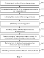
- Fig. 3 schematically represents an algorithm for deciding which obstacle detection enhancement data to be transmitted from the server SERV 120 to the on-board wireless radio unit OWRU 160 according to the transmission resources made available thereto and for transmitting said obstacle detection enhancement data in accordance.
- the server SERV 120 obtains information on actual speed of the moving conveyance MC 140.
- the information on actual speed of the moving conveyance MC 140 is provided by the on-board wireless radio unit OWRU 160.
- the server SERV 120 further obtains information on actual location of the moving conveyance MC 140 on the predefined path 130 on which the moving conveyance MC 140 is travelling.
- the information on actual location of the moving conveyance MC 140 may be provided by the on-board wireless radio unit OWRU 160.
- Information on actual location of the moving conveyance MC 140 may in a variant be provided to the server SERV 120 by wayside conveyance (e.g., train) detection system.
- the server SERV 120 determines, as function of the actual speed of the moving conveyance MC 140 what distance d k is travelled by the at least one moving conveyance MC 140 during one transmission cycle of duration T.
- the server SERV 120 estimates what is the (future) location on the predefined path 130 from which the obstacle detection system ODS 170 would need the obstacle detection enhancement data to be transmitted during the transmission cycle C n .
- the location estimation may take into account an estimated braking distance BD.
- the estimated braking distance BD depends on the actual speed of the moving conveyance MC 140 and may be obtained from a braking model as a function of the actual speed of the moving conveyance MC 140.
- the server SERV 120 determines a relevant map portion from the location, on the predefined path 130, estimated in the step S303.
- the relevant map portion is the part of the map as described in the database DB 150 which is of interest for the obstacle detection system ODS 170 from said estimated location. It may include forecast information based on absolute time in view of the location, on the predefined path 130, estimated in the step S303 and at what time the moving conveyance MC 140 is expected to be at said location (forecast presence of a moving conveyance on the predefined path 130 or on an adjacent path, forecast presence of temporary works along the predefined path 130).
- the relevant map portion is preferably the part of the map comprised between the estimated location (step 303) and a position ahead on the predefined path 130 at a distance equal to the field of view FOV plus potentially a predefined margin.
- the server SERV 120 may also determine the relevant map portion beyond the field of view FOV, i.e. at least one transmission cycle in advance compared with the moment the concerned obstacle detection enhancement data are effectively consumed by the obstacle detection system ODS 170.
- the server SERV 120 shifts the geographical reference of the items of the map portion in an orthonormal coordinate system which is centred on the location estimated in the step S303 and in which the first basis vector, allocated with coordinate notation x is collinear to the trajectory of the predefined path 130 at said location estimated in the step S303.
- the server SERV 120 prioritizes obstacle detection enhancement data in the relevant map portion determined in the step S304.
- Prioritizing the obstacle detection enhancement data means attributing a weight to each one of the obstacle detection enhancement data in said relevant map portion. Weight can be attributed according to a figure of merit.
- the server SERV 120 attributes weights to the obstacle detection enhancement data in the relevant map portion according to distance separating the location estimated in the step S303 and the geographical reference of the items of the map portion to which the obstacle detection enhancement data refer.
- the figure of merit (denoted F1) ensures the weight decreases with absolute distance or forward distance.
- the distance in question may thus be the absolute distance.
- F1 figure of merit
- (x,y,z) denotes said geographical reference in the orthonormal coordinate system centred on the location estimated in the step S303
- an example of figure of merit F1 may be defined as follows, which involves that the map items closest to the moving conveyance MC 140 (at the estimated location) have higher weights than the others:
- F 1 x y z ⁇ . exp ⁇ x 2 + y 2 + z 2 wherein ⁇ is a real constant.
- the distance in question may thus be the forward distance, which is the distance (see X MO on Fig. 5 ) between the location estimated in the step S303 and an orthogonal projection of said geographical reference on the x axis of coordinate, which is directed identically as the direction (or speed vector) of the moving conveyance MC 140 on the predefined path 130.
- Providing obstacle detection enhancement data for items that are located at a distance shorter than the estimated braking distance BD of the moving conveyance MC 140 might be seen as irrelevant since the moving conveyance MC 140 might not be able to avoid collision with the obstacle, but it might help anticipating a need for reducing the speed of the moving conveyance MC 140, which would limit damage in case of effective collision.
- the server SERV 120 attributes weights to the obstacle detection enhancement data in the relevant map portion according to distance separating the location estimated in the step S303 and the geographical reference of the items of the map portion to which the obstacle detection enhancement data refer, and further according to the estimated braking distance BD.
- the figure of merit F1 ensures that low priority is attributed to items within the estimated braking distance BD.
- the server SERV 120 attributes weights to the obstacle detection enhancement data in the relevant map portion according to distance separating the location estimated in the step S303 and the geographical reference of the items of the map portion to which the obstacle detection enhancement data refer.
- the figure of merit (denoted F2) ensures the weight decreases with lateral distance.
- Lateral distance is represented by an angle ⁇ between the direction of the moving conveyance MC 140 and a line joining the moving conveyance MC 140 and the geographical reference in question, as shown in Fig. 5 .
- the objective is to help detecting potential moving obstacle MO 500 that is moving in a direction perpendicular to the predefined path 130 with a speed V MO , or located very close to the predefined path.
- the server SERV 120 attributes weights to the obstacle detection enhancement data in the relevant map portion according to a ratio between forward distance and lateral distance.
- a moving object MO 500 e.g., a car
- the predefined path 130 e.g., railways track
- whether or not there is an effective risk of collision with the moving conveyance MC 140 depends on speed V MC of the moving conveyance MC 140 and on the considered speed V MO of the considered moving object MO 500, and further depending on the geographical location of the considered moving object MO 500.
- V MO V MC . Y MO / X MO
- a given position with 2D coordinates (X MO ,Y MO ) is associated with a considered speed V MO of an object which would be a threat of collision if it would move at the considered speed V MO in the direction of the railroad with the shortest path to it.
- the obstacle detection enhancement data corresponds to indication of geographical zones with a priori absence of objects. When a train detects an object in a position which should be empty, this object is a threat of collision only if it would move at the considered speed V MO in the direction of the railroad with the shortest path to it.
- the item located in a given position can thus be associated with a considered speed V MO of potential threat.
- a weight can be computed for each item as a function of the considered speed V MO , for example by considering the inverse of the considered speed V MO associated to the position of the item, which involves that weights are higher for items corresponding to smaller considered speeds V MO .
- the figure of merit F2 ensures that, when the obstacle detection enhancement data corresponds to indication of geographical zones with a priori absence of objects, higher priority is attributed to items allowing enhanced protection from moving objects with low speed.
- the server SERV 120 attributes weights to the obstacle detection enhancement data in the relevant map portion according to a refinement level of the obstacle detection enhancement data in question.
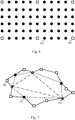
- the refinement level is, in the fifth embodiment, space sampling granularity of the map. Space is therefore sampled, thus forming points.
- Several layers with respective granularities are then defined: for example, a first layer with granularity of 0.1 meter, a second layer with granularity of 0.5 meter, a third layer with granularity of 1 meter and a fourth layer with granularity of 5 meters.
- the layer of order "n-1" does not contain points information already present in the layer of order "n".
- a two-layer example is shown in Fig.
- the server SERV 120 attributes weights to the obstacle detection enhancement data in the relevant map portion again according to a refinement level of the obstacle detection enhancement data in question, and the figure of merit F3 is representative thereof.
- the refinement level is here a hierarchical refinement of polytopes. The more the polytope information provide refinement details, the lower the weight attributed to this polytope information. Thus, each volume represented by a polytope follows a hierarchical construction such as illustrated in Fig.
- the server SERV 120 further attributes lower weight to obstacle detection enhancement data that have already been provided to the on-board wireless radio unit OWRU 160 and that have not changed since.
- obstacle detection enhancement data may have been provided to the on-board wireless radio unit OWRU 160 during a previous transmission cycle.
- Such obstacle detection enhancement data may have been provided to the on-board wireless radio unit OWRU 160 in a preloaded manner, for instance when the moving conveyance MC 140 was stationary before starting the journey on the predefined path 130 (e.g., the moving conveyance MC 140 is a train and preload is performed when the train was waiting for departure in a railway station).
- the server SERV 120 sets a flag associated with the obstacle detection enhancement data stored in the database DB 150 when said obstacle detection enhancement data have already been provided to the on-board wireless radio unit OWRU 160.
- the server SERV 120 resets the associated flag, so that the obstacle detection enhancement data that have been updated are retransmitted to the on-board wireless radio unit OWRU 160.
- the server SERV 120 thus attributes weight according to the status of such a flag, for instance a null weight (low priority) when the flag is set and a positive weight (higher priority) when the flag is not set. Let's denote F4 a figure of merit modelling such a weight attribution rule.
- the server SERV 120 attributes weights by applying a combination among the first to seventh embodiments described above so as to perform multi-criteria weight attribution.
- the figure of merit F3 is combined with the figure of merit F1 so that obstacle detection enhancement data associated with geographical references up to a predefined distance ahead the moving conveyance MC 140 with low space sampling resolution are attributed high priority. Then, obstacle detection enhancement data associated with positions geographical references up to the predefined distance ahead the moving conveyance MC 140 with higher space sampling resolution come next, and so on.
- F x y z ⁇ 1 F 1 x y z max F 1 + ⁇ 2 F 2 x y z max F 2 + ⁇ 3 F 3 x y z max F 3 wherein ⁇ 1 , ⁇ 2 and ⁇ 3 are the adaptation coefficients.
- FIG. 1 A product of a product of a product that is a product of a product.
- F x y z F 1 x y z ⁇ F 2 x y z ⁇ F 3 x y z ⁇ F 4 x y z
- the server SERV 120 obtains a quantity of transmission resources available for transmitting obstacle detection enhancement data to the on-board wireless radio unit OWRU 160 during the transmission cycle C n .
- the server SERV 120 retrieves from the database DB 150 the obstacle detection enhancement data to be transmitted in the transmission cycle C n .
- the server SERV 120 gathers obstacle detection enhancement data so as to fill the transmission resources according to priority attributed in the step S305.
- the quantity of obstacle detection enhancement data intended for the obstacle detection system ODS 170 in the transmission cycle C n is limited to the transmission resources effectively made available to the transmissions toward the on-board wireless radio unit OWRU 160. Therefore, obstacle detection enhancement data with higher priority than others are privileged for transmission to the on-board wireless radio unit OWRU 160.
- a step S308 when the start of the transmission cycle C n is reached, the server SERV 120 transmits the retrieved obstacle detection enhancement data to the on-board wireless radio unit OWRU 160.
- the obstacle detection enhancement data are then processed as detailed hereafter with respect to Fig. 4 .
- Fig. 4 schematically represents an algorithm for obtaining and processing the obstacle detection enhancement data.
- the algorithm of Fig. 4 is implemented by the on-board wireless radio unit OWRU 160.
- the on-board wireless radio unit OWRU 160 obtains and transmits to the server SERV 120 information on actual speed of the moving conveyance MC 140.
- the on-board wireless radio unit OWRU 160 obtains such information for instance from a GPS (Global Positioning System) device or a speedometer installed in the concerned moving conveyance MC 140.
- GPS Global Positioning System
- the on-board wireless radio unit OWRU 160 may further obtain and transmit to the server SERV 120 information on actual location of the moving conveyance MC 140 on the predefined path 130.
- the on-board wireless radio unit OWRU 160 may obtain such information for instance from a GPS (Global Positioning System) device installed in the concerned moving conveyance MC 140, or from cab signalling.
- GPS Global Positioning System
- the on-board wireless radio unit OWRU 160 receives in the transmission cycle C n obstacle detection enhancement data from the server SERV 120.
- the obstacle detection enhancement data are transmitted in the transmission resources that have been made available to transmissions from the server SERV 120 toward the on-board wireless radio unit OWRU 160 for the transmission cycle C n , as already addressed above.
- the on-board wireless radio unit OWRU 160 forwards, to the obstacle detection system ODS 170 the obstacle detection enhancement data received in the step S402.
- the obstacle detection system ODS 170 is thus able to enhance obstacle detection at least from the transmission cycle C n + 1 with said obstacle detection enhancement data. Accordingly the obstacle detection system ODS 170 proceeds with enhancing obstacle detection at least from the transmission cycle C n + 1 with said obstacle detection enhancement data.
Landscapes
- Engineering & Computer Science (AREA)
- Mechanical Engineering (AREA)
- Train Traffic Observation, Control, And Security (AREA)
- Traffic Control Systems (AREA)
Abstract
Description
- The present invention generally relates to adapting volume and contents of obstacle detection enhancement data to be transmitted from a server to an on-board controller in a moving conveyance according to transmission resources made available thereto and to transmitting the obstacle detection enhancement data from the server to the on-board controller in accordance.
- Moving conveyances, such as trains, can travel on predefined paths, such as railroads, without being driven by a human operator. Such moving conveyances may be automatically controlled using obstacle detection systems. The obstacle detection systems can include passive (visible and/or infrared camcorders), as well as possibly active sensors (radar, laser-scanner, sonar). The obstacle detection systems thus capture information about environment ahead the moving conveyance so as to be able to detect presence of a potential obstacle and, if any, take appropriate countermeasures (reduce the moving conveyances' speed, even stop the moving conveyances, trigger alarm horns...). Similarly such obstacle detection systems may also be used to assist a human operator driving the moving conveyance.
- In order to enhance obstacle detection for such moving conveyance travelling on predefined paths (such as railroads), a remote server may be wirelessly connected to an on-board control unit in the moving conveyance. Such a remote server can thus provide obstacle detection enhancement data previously stored in a database connected to said remote server. The obstacle detection enhancement data depend on the location of a considered moving conveyance on a predefined path, and may include descriptors of items surrounding the predefined path, descriptors of active work zones along the predefined path, or any other data that might be helpful to enable the obstacle detection system to refine obstacle detection decisions. Such obstacle detection enhancement data may be based on 3D-map information. Such a database thus stores a description of the predefined paths on which the moving conveyances are subject to travel, as well as obstacle detection enhancement data associated therewith.
- Transmission resources allocation usually takes into account effective propagation conditions (presence of interferences...) from the server to the on-board control unit in the moving conveyance, but may not be large enough to be able to timely provide all available obstacle detection enhancement data.
- Even though the obstacle detection is able to operate in stand-alone mode, it is particularly desirable to provide a solution in which selection of obstacle detection enhancement data transmitted from the server to the on-board control unit in the moving conveyance is optimized so as to improve obstacle detection (e.g., reducing false alarms). It is more particularly desirable to provide a solution that is simple and cost-effective.
- To that end, the present invention concerns a method for obtaining obstacle detection enhancement data to be transmitted to an on-board wireless radio unit of a moving conveyance travelling on a predefined path, the moving conveyance embedding an obstacle detection system, the obstacle detection enhancement data being stored in a database and including map descriptors describing knowledge of environment surrounding the predefined path in association with a geographical reference, time being divided in transmission cycles, the method being performed by a server and comprising, for determining which obstacle detection enhancement data to be transmitted toward the on-board wireless radio unit in a transmission cycle Cn : obtaining information about actual speed and location of the moving conveyance on the predefined path; computing a distance dk travelled by the moving conveyance during one transmission cycle at the actual speed of the moving conveyance; estimating location on said predefined path from which the obstacle detection system would need the obstacle detection enhancement data to be transmitted in the transmission cycle Cn , from the actual speed and location of the moving conveyance; determining a relevant map portion in the database, from the estimated location and the geographical references; prioritizing obstacle detection enhancement data in the determined relevant map portion by attributing a weight to each one of the obstacle detection enhancement data in said relevant map portion, wherein the weights are attributed according to distance separating the estimated location and the geographical reference associated with the obstacle detection enhancement data and/or refinement level of the obstacle detection enhancement data; and obtaining transmission resources made available for transmissions toward the on-board wireless radio unit during the transmission cycle Cn ; retrieving from the database the obstacle detection enhancement data to be transmitted in the transmission cycle Cn ; so as to fill said transmission resources, according to the attributed weights.
- Thus, selection of obstacle detection enhancement data transmitted from the server to the on-board control unit in the moving conveyance is optimized so as to improve obstacle detection in view of transmission resources made available to do so. False alarms avoidance by the obstacle detection is thus improved.
- According to a particular embodiment, considering that "(x,y,z)" denotes said geographical reference in an orthonormal coordinate system centred on said estimated location, the weights are attributed according to a figure of merit F1 such that

- Thus, obstacle detection enhancement data the closest to the moving
conveyance MC 140 in absolute distance at the estimated location have higher weights. - According to a particular embodiment, considering that "(x,y,z)" denotes said geographical reference in an orthonormal coordinate system centred on said estimated location and that x axis is directed identically as direction of the moving conveyance on the predefined path, the weights are attributed according to a figure of merit F1 such that

- Thus, obstacle detection enhancement data the closest to the moving
conveyance MC 140 in forward distance at the estimated location have higher weights. - According to a particular embodiment, considering that "(x,y,z)" denotes said geographical reference in an orthonormal coordinate system centred on said estimated location and that x axis is directed identically as direction of the moving conveyance on the predefined path, the weights are attributed according to a figure of merit F1 such that

- Thus, low priority is attributed to obstacle detection enhancement data within the estimated braking distance BD.
- According to a particular embodiment, considering that "(x,y,z)" denotes said geographical reference in an orthonormal coordinate system centred on said estimated location, that x axis is directed identically as direction of the moving conveyance on the predefined path, and that z axis is directed upwards, the weights are attributed according to a figure of merit F2 such that

- Thus, the further the geographical reference of obstacle detection enhancement data to which the obstacle detection enhancement data refers is from the predefined path, the lower its weight.
- According to a particular embodiment, considering that "(x,y,z)" denotes said geographical reference in an orthonormal coordinate system centred on said estimated location, that x axis is directed identically as direction of the moving conveyance on the predefined path, and that z axis is directed upwards, the weights are attributed according to a figure of merit F2 such that

- Thus, higher priority is attributed to items allowing enhanced protection from moving objects with low speed and/or moving objects located near the railroad.
- According to a particular embodiment, considering that "(x,y,z)" denotes said geographical reference in an orthonormal coordinate system centred on said estimated location, that x axis is directed identically as direction of the moving conveyance on the predefined path, and that z axis is directed upwards, the weights are attributed according to a figure of merit F2 such that

- Thus, higher priority is attributed to items allowing enhanced protection from moving objects with low speed, and/or moving objects located near the railroad, in a simpler variant.
- According to a particular embodiment, space being sampled hierarchically by using lattice structures with different granularities so as to form points in space associated with different refinement levels, obstacle detection enhancement data corresponding to points providing a lower information resolution have, according to a figure of merit F3, higher weight than obstacle detection enhancement data corresponding to points providing a better information resolution.
- Thus, raw obstacle detection enhancement data are transmitted in priority.
- According to a particular embodiment, refinement level is a hierarchical refinement of polytopes, and according to a figure of merit F3, the more obstacle detection enhancement data corresponding to polytope information provide refinement details, the lower the weight attributed to this obstacle detection enhancement data.
- Thus, raw obstacle detection enhancement data are transmitted in priority.
- According to a particular embodiment, further according to a figure of merit F4, lower weight is attributed to obstacle detection enhancement data that have already been provided to the on-board wireless radio unit and that have not changed since than to other obstacle detection enhancement data that have not yet been provided to the on-board wireless radio unit or that have changed since.
- Thus, new obstacle detection enhancement data are transmitted in priority.
- According to a particular embodiment, the weights are attributed to the obstacle detection enhancement data by a combination of the figures of merit F1, F2, F3 and F4. Therefore a trade-off combination of the advantages expressed above is achieved.
- The present invention also concerns a method for transmitting obstacle detection enhancement data to an on-board wireless radio unit of a moving conveyance travelling on a predefined path, the method being performed by the server and comprising obtaining obstacle detection enhancement data as mentioned above, and further comprising: when the start of the transmission cycle Cn is reached, transmitting the retrieved obstacle detection enhancement data to the on-board wireless radio unit in the transmission resources made available thereto.
- The present invention also concerns a server configured for obtaining obstacle detection enhancement data to be transmitted to an on-board wireless radio unit of a moving conveyance travelling on a predefined path, the moving conveyance further embedding an obstacle detection system, the obstacle detection enhancement data being stored in a database and including map descriptors describing knowledge of environment surrounding the predefined path in association with a geographical reference, time being divided in transmission cycles, wherein the server comprises, for determining which obstacle detection enhancement data to be transmitted toward the on-board wireless radio unit in a transmission cycle Cn : means for obtaining information about actual speed and location of the moving conveyance on the predefined path; means for computing a distance dk travelled by the moving conveyance during one transmission cycle at the actual speed of the moving conveyance; means for estimating location on said predefined path from which the obstacle detection system would need the obstacle detection enhancement data to be transmitted in the transmission cycle Cn , from the actual speed and location of the moving conveyance; means for determining a relevant map portion in the database, from the estimated location and the geographical references; means for prioritizing obstacle detection enhancement data in the determined relevant map portion by attributing a weight to each one of the obstacle detection enhancement data in said relevant map portion, wherein the weights are attributed according to distance separating the estimated location and the geographical reference associated with the obstacle detection enhancement data and/or refinement level of the obstacle detection enhancement data; means for obtaining transmission resources made available for transmissions toward the on-board wireless radio unit during the transmission cycle Cn ; and means for retrieving from the database the obstacle detection enhancement data to be transmitted in the transmission cycle Cn ; so as to fill said transmission resources, according to the attributed weights.
- The present invention also concerns a server configured for transmitting obstacle detection enhancement data to an on-board wireless radio unit of a moving conveyance travelling on a predefined path, wherein the server is as defined above and further comprises: when the start of the transmission cycle Cn is reached, means for transmitting the retrieved obstacle detection enhancement data to the on-board wireless radio unit in the transmission resources made available thereto.
- The present invention also concerns a computer program that can be downloaded from a communication network and/or stored on a non-transitory information storage medium that comprises code instructions that can be read and executed by a processing device such as a microprocessor for causing implementation of the aforementioned methods above in any one of their embodiments. The present invention also concerns a non-transitory information storage medium, storing such a computer program.
- The characteristics of the invention will emerge more clearly from a reading of the following description of at least one example of embodiment, said description being produced with reference to the accompanying drawings, among which:
-
Fig. 1 schematically represents an obstacle detection enhancement system in which the present invention may be implemented; -
Fig. 2 schematically represents an example of hardware architecture of a processing device of the obstacle detection enhancement system; -
Fig. 3 schematically represents an algorithm for deciding which obstacle detection enhancement data to be transmitted from a server to an on-board controller in a moving conveyance according to transmission resources made available thereto and for transmitting said obstacle detection enhancement data in accordance; -
Fig. 4 schematically represents an algorithm, implemented by the on-board controller in the moving conveyance for receiving and processing the obstacle detection enhancement data; -
Fig. 5 schematically represents an example of obstacle detection enhancement data selection according to lateral distance from a predefined path on which the moving conveyance travels; -
Fig. 6 schematically represents an example of obstacle detection enhancement data selection according to obstacle detection enhancement data granularity; and -
Fig. 7 schematically represents an example of obstacle detection enhancement data selection according to definition level of obstacle detection enhancement data. -
Fig. 1 schematically represents an obstacledetection enhancement system 100 intended to provide support for improving obstacle detection during a journey of a movingconveyance MC 140 along apredefined path 130. OnFig. 1 another movingconveyance MC 141 performs a journey along anotherpredefined path 131. - In a preferred embodiment, the moving
conveyance MC 140 is a train and thepredefined path 130 is railways on which the movingconveyance MC 140 travels. - The obstacle
detection enhancement system 100 comprises aserver SERV 120 and an on-board wireless radio unit OWRU 160 located in the movingconveyance MC 140. The on-board wireless radio unit OWRU 160 is a controller having wireless communication capabilities. - The server SERV 120 and the on-board wireless radio unit OWRU 160 wirelessly communicate with each other, potentially via wireless radio units such as wayside wireless radio units WWRU0, WWRU1 110 located along the
predefined path 130. The wireless radio units such as the wayside wireless radio units WWRU0,WWRU 1 110 are geographically installed such that wireless communication continuity can be ensured as much as possible between theserver SERV 120 and the on-board wirelessradio unit OWRU 160 whatever is the effective location of the movingconveyance MC 140 on thepredefined path 130. - For example, the wireless radio units such as the wayside wireless radio units WWRU0,
WWRU 1 110 are access points of a telecommunication system, for instance an LTE ("Long Term Evolution") telecommunication system or the like. For example, theserver SERV 120 is connected to the wireless radio units such as the wayside wireless radio units WWRU0,WWRU 1 110 using copper wires or optical links. - Similarly, the moving
conveyance MC 141 comprises an on-board wirelessradio unit OWRU 161 wirelessly communicating with theserver SERV 120. - The
server SERV 120 knows, for instance by configuration, on which predefinedrespective path conveyance MC - The moving
conveyance MC 140 embeds an obstacledetection system ODS 170. The obstacledetection system ODS 170 can include passive (visible and/or infrared camcorders), as well as possibly active sensors (radar, laser-scanner, sonar). The obstacledetection system ODS 170 thus captures information about environment ahead the moving conveyance so as to be able to detect presence of an obstacle and, if any, to take appropriate countermeasures. When the movingconveyance MC 140 is automatically driven, the obstacledetection system ODS 170 may instruct the movingconveyance MC 140 to perform emergency break in order to avoid potential collision. When the movingconveyance MC 140 is driven by a human operator, the obstacledetection system ODS 170 may provide emergency warning signals to indicate the human operator that emergency procedure shall be activated in order to avoid potential collision. - Similarly, the moving
conveyance MC 141 comprises an obstacledetection system ODS 171. - In order to enhance obstacle detection performance, the obstacle
detection system ODS 170 communicates with theserver SERV 120 via the on-board wirelessradio unit OWRU 160. Theserver SERV 120 thus provides obstacle detection enhancement data to the obstacledetection system ODS 170 so as to speed up obstacle detection processing and/or to reduce ratio of false alarm occurrences. False alarms occur when the obstacledetection system ODS 170 erroneously detects collision risks ahead the corresponding moving conveyance. - For example, the obstacle detection enhancement data include descriptors of physical items (buildings, trees, crossing roads, work areas...) known to be present in the vicinity of the corresponding
predefined path 130 ahead the effective location of the movingconveyance MC 140. In a particular embodiment, the obstacle detection enhancement data include 3D scene descriptors describing samples of a 3D scene of environment surrounding the correspondingpredefined path 130. Such a 3D scene is for instance obtained from 3D modelling of video images captured by a camera installed on the front of a moving conveyance MC during training journeys on the correspondingpredefined path 130. The samples in question can thus be polytopes extracted from the 3D modelling. - Such obstacle detection enhancement data allow the obstacle
detection system ODS 170 to refine decision regarding the potential obstacle character of objects detected by the obstacledetection system ODS 170 ahead the movingconveyance MC 140. - In order to store such obstacle detection enhancement data, the obstacle
detection enhancement system 100 further includes adatabase DB 150 used to store a description of thepredefined path 130 or at least of one or more sections thereof, as well as obstacle detection enhancement data associated therewith which include surrounding environment descriptions. The obstacle detection enhancement data stored in thedatabase DB 150 thus include map descriptors describing knowledge of environment surrounding thepredefined path 130. Each surrounding environment items described in thedatabase DB 150 is associated with a geographical reference, typically a set of 3D absolute coordinates (x,y,z). - According to one example, when the map descriptors are 3D-space points, the obstacle detection enhancement data corresponding to each 3D-space point are an association of geographical position of said 3D-space point and a bit indicating known presence or not of an object at this geographical position (building, tree...).
- According to another example, when the map descriptors are descriptions of volumes such as polytopes, the geographical position of each volume is referenced by a noticeable point of the volume, such as the barycentre of the polytope, or the barycentre of a surface of the polytope, or a vertex of the polytope .
- It might further be noted that the map descriptors may indicate known presence of an object at a specific geographical position or indicate a priori absence of any object at a specific geographical position.
- The
database DB 150 is used by theserver SERV 120 to retrieve obstacle detection enhancement data per portions of thepredefined path 130. Some portions of thepredefined path 130 may imply more or less obstacle detection enhancement data than others. Indeed, the surrounding environment may for example be more complex to describe for some portions of thepredefined path 130 than for others. - Even though the obstacle
detection system ODS 170 should be able to perform obstacle detection without requiring the obstacle detection enhancement data, it is of interest to be able to transmit to the on-board wirelessradio unit OWRU 160 obstacle detection enhancement data as relevant as possible among the obstacle detection enhancement data available in thedatabase DB 150. Indeed, transmission resources made available to allow wirelessly transmitting obstacle detection enhancement data from theserver SERV 120 to the on-board wirelessradio unit OWRU 160 might not be large enough to transmit all obstacle detection enhancement data that might be helpful for obstacle detection where the movingconveyance MC 140 is located. - Transmission resources allocation is performed on a per-cycle basis. The transmission resources allocation may be performed by the
server SERV 120 or by another equipment, which informs theserver SERV 120 of the transmission resources allocation effectively performed. Time is thus divided in transmission cycles of equal duration T, one frame being transmitted from theserver SERV 120 to the on-board wirelessradio unit OWRU 160 at each transmission cycle. Transmission resources are then time and frequency resources within said transmission cycles. - Transmission resources effectively made available for transmissions toward the on-board wireless
radio unit OWRU 160 may differ from one transmission cycle to another. Indeed, quality of wireless link between theserver SERV 120 and the on-board wirelessradio unit OWRU 160 may change and thus reduce or increase available bandwidth. Moreover, available bandwidth may be shared by plural concurrent transmissions, for instance when theserver SERV 120 further communicates with another on-board wirelessradio unit OWRU 161 present in the vicinity of the on-board wirelessradio unit OWRU 160. As detailed hereafter with respect toFig. 3 , relevant obstacle detection enhancement data to be transmitted by theserver SERV 120 to the on-board wirelessradio unit OWRU 160 have to be adequately selected so as to match the transmission resources effectively made available for transmissions from theserver SERV 120 toward the on-board wirelessradio unit OWRU 160. - During a transmission cycle Cn (wherein n is a transmission cycle sequence number), the on-board wireless
radio unit OWRU 160 thus receives obstacle detection enhancement data for a portion of the predefined path 130 (on thepredefined path 130 or in the vicinity of the predefined path 130) on which the considered movingconveyance MC 140 travels which is at a certain distance ahead the considered movingconveyance MC 140. Processing of the obstacle detection enhancement data thus received is detailed hereafter with respect toFig. 4 . -
Fig. 2 schematically represents an example of hardware architecture of a processing device 200 of the obstacledetection enhancement system 100. The on-board wirelessradio unit OWRU 160 and/or or the obstacledetection system ODS 170 and/or theserver SERV 120 can be built on the basis of such example of hardware architecture. - According to the shown example of hardware architecture, the processing device 200 comprises at least the following components interconnected by a communication bus 210: a processor, microprocessor, microcontroller or CPU (Central Processing Unit) 201; a RAM (Random-Access Memory) 202; a ROM (Read-Only Memory) 203; an HDD (Hard-Disk Drive) or an SD (Secure Digital)
card reader 204, or any other device adapted to read information stored on non-transitory information storage medium; at least onecommunication interface COM 205. - When the hardware architecture concerns the
server SERV 120, the at least onecommunication interface COM 205 enables theserver SERV 120 to communicate with the wayside wireless radio units WWRU0,WWRU 1 110. In a variant, the at least onecommunication interface COM 205 enables theserver SERV 120 to wirelessly communicate directly with the on-board wirelessradio unit OWRU 160. - When the hardware architecture concerns the on-board wireless
radio unit OWRU 160, the at least onecommunication interface COM 205 enables the on-board wirelessradio unit OWRU 160 to wirelessly communicate with the wayside wireless radio units WWRU0,WWRU 1 110 and to communicate with the obstacledetection system ODS 170. In a variant, the at least onecommunication interface COM 205 enables the on-board wirelessradio unit OWRU 160 to wirelessly communicate directly with theserver SERV 120 instead of with the wayside wireless radio units WWRU0,WWRU 1 110. - When the hardware architecture concerns the obstacle
detection system ODS 170, thecommunication interface COM 205 enables the obstacledetection system ODS 170 to communicate with the on-board wirelessradio unit OWRU 160. -
CPU 201 is capable of executing instructions loaded intoRAM 202 fromROM 203 or from an external memory, such as an SD card via theSD card reader 204. After the processing device 200 has been powered on,CPU 201 is capable of reading instructions fromRAM 202 and executing these instructions. The instructions form one computer program that causesCPU 201 to perform some or all of the steps of the algorithms described herein with respect to the processing device 200 in question. - Consequently, it is understood that any and all steps of the algorithm described herein may be implemented in software form by execution of a set of instructions or program by a programmable computing machine, such as a PC (Personal Computer), a DSP (Digital Signal Processor) or a microcontroller; or else implemented in hardware form by a machine or a dedicated chip or chipset, such as an FPGA (Field-Programmable Gate Array) or an ASIC (Application-Specific Integrated Circuit). In general, the
server SERV 120, the on-board wirelessradio unit OWRU 160 and the obstacledetection system ODS 170 comprise processing electronics circuitry adapted and configured for implementing the relevant steps as described herein with respect to the processing device 200 in question. -
Fig. 3 schematically represents an algorithm for deciding which obstacle detection enhancement data to be transmitted from theserver SERV 120 to the on-board wirelessradio unit OWRU 160 according to the transmission resources made available thereto and for transmitting said obstacle detection enhancement data in accordance. - In a step S301, the
server SERV 120 obtains information on actual speed of the movingconveyance MC 140. The information on actual speed of the movingconveyance MC 140 is provided by the on-board wirelessradio unit OWRU 160. - The
server SERV 120 further obtains information on actual location of the movingconveyance MC 140 on thepredefined path 130 on which the movingconveyance MC 140 is travelling. The information on actual location of the movingconveyance MC 140 may be provided by the on-board wirelessradio unit OWRU 160. Information on actual location of the movingconveyance MC 140 may in a variant be provided to theserver SERV 120 by wayside conveyance (e.g., train) detection system. - In a step S302, the
server SERV 120 determines, as function of the actual speed of the movingconveyance MC 140 what distance dk is travelled by the at least one movingconveyance MC 140 during one transmission cycle of duration T. - In a step S303, from the actual speed and location of the moving
conveyance MC 140, theserver SERV 120 estimates what is the (future) location on thepredefined path 130 from which the obstacledetection system ODS 170 would need the obstacle detection enhancement data to be transmitted during the transmission cycle Cn. The location estimation may take into account an estimated braking distance BD. The estimated braking distance BD depends on the actual speed of the movingconveyance MC 140 and may be obtained from a braking model as a function of the actual speed of the movingconveyance MC 140. - In a step S304, the
server SERV 120 determines a relevant map portion from the location, on thepredefined path 130, estimated in the step S303. The relevant map portion is the part of the map as described in thedatabase DB 150 which is of interest for the obstacledetection system ODS 170 from said estimated location. It may include forecast information based on absolute time in view of the location, on thepredefined path 130, estimated in the step S303 and at what time the movingconveyance MC 140 is expected to be at said location (forecast presence of a moving conveyance on thepredefined path 130 or on an adjacent path, forecast presence of temporary works along thepredefined path 130...). When considering that one feature of the obstacledetection system ODS 170 is field of view FOV (which is the maximum distance ahead the movingconveyance MC 140 in which the obstacledetection system ODS 170 is able to detect presence of physical items having dimensions greater than a predefined size), the relevant map portion is preferably the part of the map comprised between the estimated location (step 303) and a position ahead on thepredefined path 130 at a distance equal to the field of view FOV plus potentially a predefined margin. Theserver SERV 120 may also determine the relevant map portion beyond the field of view FOV, i.e. at least one transmission cycle in advance compared with the moment the concerned obstacle detection enhancement data are effectively consumed by the obstacledetection system ODS 170. - Preferably, the
server SERV 120 shifts the geographical reference of the items of the map portion in an orthonormal coordinate system which is centred on the location estimated in the step S303 and in which the first basis vector, allocated with coordinate notation x is collinear to the trajectory of thepredefined path 130 at said location estimated in the step S303. - In a step S305, the
server SERV 120 prioritizes obstacle detection enhancement data in the relevant map portion determined in the step S304. Prioritizing the obstacle detection enhancement data means attributing a weight to each one of the obstacle detection enhancement data in said relevant map portion. Weight can be attributed according to a figure of merit. - According to a first embodiment, the
server SERV 120 attributes weights to the obstacle detection enhancement data in the relevant map portion according to distance separating the location estimated in the step S303 and the geographical reference of the items of the map portion to which the obstacle detection enhancement data refer. In this first embodiment, the figure of merit (denoted F1) ensures the weight decreases with absolute distance or forward distance. - The distance in question may thus be the absolute distance. In this case, considering that (x,y,z) denotes said geographical reference in the orthonormal coordinate system centred on the location estimated in the step S303, an example of figure of merit F1 may be defined as follows, which involves that the map items closest to the moving conveyance MC 140 (at the estimated location) have higher weights than the others:

- The distance in question may thus be the forward distance, which is the distance (see XMO on
Fig. 5 ) between the location estimated in the step S303 and an orthogonal projection of said geographical reference on the x axis of coordinate, which is directed identically as the direction (or speed vector) of the movingconveyance MC 140 on thepredefined path 130. Another example of figure of merit F1 may thus be defined as follows:
- A selection of information which lies only in position ahead in the direction of the x axis can be obtained by the following weighting:

- A step-by-step decrease weight function can also be defined with the same principle as follows:

- Providing obstacle detection enhancement data for items that are located at a distance shorter than the estimated braking distance BD of the moving
conveyance MC 140 might be seen as irrelevant since the movingconveyance MC 140 might not be able to avoid collision with the obstacle, but it might help anticipating a need for reducing the speed of the movingconveyance MC 140, which would limit damage in case of effective collision. - According to a second embodiment, the
server SERV 120 attributes weights to the obstacle detection enhancement data in the relevant map portion according to distance separating the location estimated in the step S303 and the geographical reference of the items of the map portion to which the obstacle detection enhancement data refer, and further according to the estimated braking distance BD. In this second embodiment, the figure of merit F1 ensures that low priority is attributed to items within the estimated braking distance BD. An example of figure of merit F1 may be defined as follows:
- According to a third embodiment, the
server SERV 120 attributes weights to the obstacle detection enhancement data in the relevant map portion according to distance separating the location estimated in the step S303 and the geographical reference of the items of the map portion to which the obstacle detection enhancement data refer. In this third embodiment, the figure of merit (denoted F2) ensures the weight decreases with lateral distance. Lateral distance is represented by an angle α between the direction of the movingconveyance MC 140 and a line joining the movingconveyance MC 140 and the geographical reference in question, as shown inFig. 5 . The objective is to help detecting potential movingobstacle MO 500 that is moving in a direction perpendicular to thepredefined path 130 with a speed VMO, or located very close to the predefined path. When considering that the movingconveyance MC 140 is a train, examples are maintenance workers working near the railways or a car travelling on a crossing road. An example of figure of merit F2 may be defined as follows:
- According to a fourth embodiment, the
server SERV 120 attributes weights to the obstacle detection enhancement data in the relevant map portion according to a ratio between forward distance and lateral distance. Indeed, considering a moving object MO 500 (e.g., a car) moving toward the predefined path 130 (e.g., railways track), whether or not there is an effective risk of collision with the moving conveyance MC 140 (e.g., a train) depends on speed VMC of the movingconveyance MC 140 and on the considered speed VMO of the considered movingobject MO 500, and further depending on the geographical location of the considered movingobject MO 500. There is a risk of collision if the time it takes to the movingconveyance MC 140 to cover the distance XMO onFig. 5 is substantially equal to the time it takes to the movingobject MO 500 to cover the distance YMO onFig. 5 . It is highly probable that the collision would occur if the following equality is met:
- Thus, by assuming that the moving
object MO 500 would move on a 2D-lane (i.e., z = 0, since z axis is directed upwards), it is highly probable that the collision would occur when the considered speed VMO of the considered movingobject MO 500 meets the following relationship:
- A given position with 2D coordinates (XMO,YMO) is associated with a considered speed VMO of an object which would be a threat of collision if it would move at the considered speed VMO in the direction of the railroad with the shortest path to it. Thus, two different positions may be associated with different considered speeds VMO. This allows to compare these two different positions with two different weights. The obstacle detection enhancement data corresponds to indication of geographical zones with a priori absence of objects. When a train detects an object in a position which should be empty, this object is a threat of collision only if it would move at the considered speed VMO in the direction of the railroad with the shortest path to it. The item located in a given position can thus be associated with a considered speed VMO of potential threat. A weight can be computed for each item as a function of the considered speed VMO, for example by considering the inverse of the considered speed VMO associated to the position of the item, which involves that weights are higher for items corresponding to smaller considered speeds VMO.
- This leads to consider that the weight should be inversely proportional to the speed VMO of the considered moving
object MO 500 that moves toward thepredefined path 130 ahead the movingconveyance MC 140. In this fourth embodiment, the figure of merit F2 ensures that, when the obstacle detection enhancement data corresponds to indication of geographical zones with a priori absence of objects, higher priority is attributed to items allowing enhanced protection from moving objects with low speed. An example of figure of merit F2 may thus be defined as follows:

- According to a fifth embodiment, the
server SERV 120 attributes weights to the obstacle detection enhancement data in the relevant map portion according to a refinement level of the obstacle detection enhancement data in question. The refinement level is, in the fifth embodiment, space sampling granularity of the map. Space is therefore sampled, thus forming points. Several layers with respective granularities are then defined: for example, a first layer with granularity of 0.1 meter, a second layer with granularity of 0.5 meter, a third layer with granularity of 1 meter and a fourth layer with granularity of 5 meters. To be noted that the layer of order "n-1" does not contain points information already present in the layer of order "n". A two-layer example is shown inFig. 6 , wherein the points represented by thesquares 600 are sampled according to a less accurate granularity than the points represented by thediscs 601. Thus, space is sampled hierarchically by using a lattice structure. Points belonging to sub-lattices with a larger minimal distance between points would have a higher weight. Thus, the points providing a lower information resolution are prioritized with respect to points providing a better information resolution. Let's denote F3 a figure of merit modelling such a weight attribution rule. - According to a sixth embodiment, the
server SERV 120 attributes weights to the obstacle detection enhancement data in the relevant map portion again according to a refinement level of the obstacle detection enhancement data in question, and the figure of merit F3 is representative thereof. The refinement level is here a hierarchical refinement of polytopes. The more the polytope information provide refinement details, the lower the weight attributed to this polytope information. Thus, each volume represented by a polytope follows a hierarchical construction such as illustrated inFig. 7 , wherein the vertices linking the polytope points represented bytriangles 702 are associated with a high weight, the vertices linking the polytope points represented bydiscs 701 which provide more refined description of the polytope are associated with a medium weight, and the vertices linking the polytope points represented bysquares 700 which provide even more refined description of the polytope are associated with a low weight. - According to a seventh embodiment, the
server SERV 120 further attributes lower weight to obstacle detection enhancement data that have already been provided to the on-board wirelessradio unit OWRU 160 and that have not changed since. Such obstacle detection enhancement data may have been provided to the on-board wirelessradio unit OWRU 160 during a previous transmission cycle. Such obstacle detection enhancement data may have been provided to the on-board wirelessradio unit OWRU 160 in a preloaded manner, for instance when the movingconveyance MC 140 was stationary before starting the journey on the predefined path 130 (e.g., the movingconveyance MC 140 is a train and preload is performed when the train was waiting for departure in a railway station). To do so, theserver SERV 120 sets a flag associated with the obstacle detection enhancement data stored in thedatabase DB 150 when said obstacle detection enhancement data have already been provided to the on-board wirelessradio unit OWRU 160. When the obstacle detection enhancement data in question change from the previous time said obstacle detection enhancement data have been provided to the on-board wirelessradio unit OWRU 160, theserver SERV 120 resets the associated flag, so that the obstacle detection enhancement data that have been updated are retransmitted to the on-board wirelessradio unit OWRU 160. Theserver SERV 120 thus attributes weight according to the status of such a flag, for instance a null weight (low priority) when the flag is set and a positive weight (higher priority) when the flag is not set. Let's denote F4 a figure of merit modelling such a weight attribution rule. - In a particular embodiment, the
server SERV 120 attributes weights by applying a combination among the first to seventh embodiments described above so as to perform multi-criteria weight attribution. For example, the figure of merit F3 is combined with the figure of merit F1 so that obstacle detection enhancement data associated with geographical references up to a predefined distance ahead the movingconveyance MC 140 with low space sampling resolution are attributed high priority. Then, obstacle detection enhancement data associated with positions geographical references up to the predefined distance ahead the movingconveyance MC 140 with higher space sampling resolution come next, and so on. - Another example of combining the different figures of merit expressed above in a combined figure of merit F is to normalise values in the range [0,1] and combine them linearly with adaptation coefficients:

- Yet another example of combining the different figures of merit expressed above in a combined figure of merit F is to use the figure of merit F4 to apply a mask. The figure of merit F4 is thus used as a multiplicative factor (forcing the weight to null for obstacle detection enhancement data already provided to the on-board wireless radio unit OWRU 160). Thus, the combined figure of merit F may be based on a product, such as:

- Yet another example of combining the different figures of merit expressed above in a combined figure of merit F is to consider both lateral distance and forward distance by multiplying the figures of merit F2 and F1, and normalizing the result in the range [0,1], and further add the weight corresponding to the figure of merit F3, and then apply a mask thanks to the figure of merit F4 to ensure that non-useful retransmission is avoided, such as:

- Many other combination of the figures of merit expressed above can be derived by the one with ordinary skills in the art.
- In a step S306, the
server SERV 120 obtains a quantity of transmission resources available for transmitting obstacle detection enhancement data to the on-board wirelessradio unit OWRU 160 during the transmission cycle Cn. - In a step S307, the
server SERV 120 retrieves from thedatabase DB 150 the obstacle detection enhancement data to be transmitted in the transmission cycle Cn. Among the obstacle detection enhancement data of the relevant map portion determined in the step S304, theserver SERV 120 gathers obstacle detection enhancement data so as to fill the transmission resources according to priority attributed in the step S305. The quantity of obstacle detection enhancement data intended for the obstacledetection system ODS 170 in the transmission cycle Cn is limited to the transmission resources effectively made available to the transmissions toward the on-board wirelessradio unit OWRU 160. Therefore, obstacle detection enhancement data with higher priority than others are privileged for transmission to the on-board wirelessradio unit OWRU 160. - In a step S308, when the start of the transmission cycle Cn is reached, the
server SERV 120 transmits the retrieved obstacle detection enhancement data to the on-board wirelessradio unit OWRU 160. The obstacle detection enhancement data are then processed as detailed hereafter with respect toFig. 4 . -
Fig. 4 schematically represents an algorithm for obtaining and processing the obstacle detection enhancement data. The algorithm ofFig. 4 is implemented by the on-board wirelessradio unit OWRU 160. - In a step S401, the on-board wireless
radio unit OWRU 160 obtains and transmits to theserver SERV 120 information on actual speed of the movingconveyance MC 140. The on-board wirelessradio unit OWRU 160 obtains such information for instance from a GPS (Global Positioning System) device or a speedometer installed in the concerned movingconveyance MC 140. - The on-board wireless
radio unit OWRU 160 may further obtain and transmit to theserver SERV 120 information on actual location of the movingconveyance MC 140 on thepredefined path 130. The on-board wirelessradio unit OWRU 160 may obtain such information for instance from a GPS (Global Positioning System) device installed in the concerned movingconveyance MC 140, or from cab signalling. - In a step S402, considering that the step S401 is performed during the transmission cycle Cn-1, the on-board wireless
radio unit OWRU 160 receives in the transmission cycle Cn obstacle detection enhancement data from theserver SERV 120. The obstacle detection enhancement data are transmitted in the transmission resources that have been made available to transmissions from theserver SERV 120 toward the on-board wirelessradio unit OWRU 160 for the transmission cycle Cn , as already addressed above. - In a step S403, the on-board wireless
radio unit OWRU 160 forwards, to the obstacledetection system ODS 170 the obstacle detection enhancement data received in the step S402. The obstacledetection system ODS 170 is thus able to enhance obstacle detection at least from the transmission cycle C n+1 with said obstacle detection enhancement data. Accordingly the obstacledetection system ODS 170 proceeds with enhancing obstacle detection at least from the transmission cycle C n+1 with said obstacle detection enhancement data.
Claims (16)
- A method for obtaining obstacle detection enhancement data to be transmitted to an on-board wireless radio unit (160) of a moving conveyance (140) travelling on a predefined path (130), the moving conveyance (140) embedding an obstacle detection system (170), the obstacle detection enhancement data being stored in a database (150) and including map descriptors describing knowledge of environment surrounding the predefined path (130) in association with a geographical reference, time being divided in transmission cycles, the method being performed by a server (120) and comprising, for determining which obstacle detection enhancement data to be transmitted toward the on-board wireless radio unit (160) in a transmission cycle Cn :- obtaining (S301) information about actual speed and location of the moving conveyance (140) on the predefined path (130);- computing (S302) a distance dk travelled by the moving conveyance (140) during one transmission cycle at the actual speed of the moving conveyance (140);- estimating (S303) location on said predefined path (130) from which the obstacle detection system (170) would need the obstacle detection enhancement data to be transmitted in the transmission cycle Cn , from the actual speed and location of the moving conveyance (140);- determining (S304) a relevant map portion in the database (150), from the estimated location and the geographical references;- prioritizing (S305) obstacle detection enhancement data in the determined relevant map portion by attributing a weight to each one of the obstacle detection enhancement data in said relevant map portion, wherein the weights are attributed according to distance separating the estimated location and the geographical reference associated with the obstacle detection enhancement data and/or refinement level of the obstacle detection enhancement data; and- obtaining (S306) transmission resources made available for transmissions toward the on-board wireless radio unit (160) during the transmission cycle Cn ;- retrieving (S307) from the database (150) the obstacle detection enhancement data to be transmitted in the transmission cycle Cn ; so as to fill said transmission resources, according to the attributed weights.
- The method according to claim 1, wherein, considering that "(x,y,z)" denotes said geographical reference in an orthonormal coordinate system centred on said estimated location, the weights are attributed according to a figure of merit F1 such that

- The method according to claim 1, wherein, considering that "(x,y,z)" denotes said geographical reference in an orthonormal coordinate system centred on said estimated location and that x axis is directed identically as direction of the moving conveyance on the predefined path, the weights are attributed according to a figure of merit F1 such that

- The method according to claim 1, wherein, considering that "(x,y,z)" denotes said geographical reference in an orthonormal coordinate system centred on said estimated location and that x axis is directed identically as direction of the moving conveyance (140) on the predefined path (130), the weights are attributed according to a figure of merit F1 such that

- The method according to claim 1, wherein, considering that "(x,y,z)" denotes said geographical reference in an orthonormal coordinate system centred on said estimated location, that x axis is directed identically as direction of the moving conveyance (140) on the predefined path (130), and that z axis is directed upwards, the weights are attributed according to a figure of merit F2 such that

- The method according to claim 1, wherein, considering that "(x,y,z)" denotes said geographical reference in an orthonormal coordinate system centred on said estimated location, that x axis is directed identically as direction of the moving conveyance (140) on the predefined path (130), and that z axis is directed upwards, the weights are attributed according to a figure of merit F2 such that

- The method according to claim 1, wherein, considering that "(x,y,z)" denotes said geographical reference in an orthonormal coordinate system centred on said estimated location, that x axis is directed identically as direction of the moving conveyance (140) on the predefined path (130), and that z axis is directed upwards, the weights are attributed according to a figure of merit F2 such that

- The method according to claim 1, wherein, space being sampled hierarchically by using lattice structures with different granularities so as to form points in space associated with different refinement levels, obstacle detection enhancement data corresponding to points providing a lower information resolution have, according to a figure of merit F3, higher weight than obstacle detection enhancement data corresponding to points providing a better information resolution.
- The method according to claim 1, wherein refinement level is a hierarchical refinement of polytopes, and according to a figure of merit F3, the more obstacle detection enhancement data corresponding to polytope information provide refinement details, the lower the weight attributed to this obstacle detection enhancement data.
- The method according to claim 1, wherein, further according to a figure of merit F4, lower weight is attributed to obstacle detection enhancement data that have already been provided to the on-board wireless radio unit (160) and that have not changed since than to other obstacle detection enhancement data that have not yet been provided to the on-board wireless radio unit (160) or that have changed since.
- The method according to any one of claims 2 to 4, further according to any one of claims 5 to 7, further according to claim 8 or 9, further according to claim 10, wherein the weights are attributed to the obstacle detection enhancement data by a combination of the figures of merit F1, F2, F3 and F4.
- A method for transmitting obstacle detection enhancement data to an on-board wireless radio unit (160) of a moving conveyance (140) travelling on a predefined path (130), the method being performed by the server (120) and comprising obtaining obstacle detection enhancement data according to any one of claims 1 to 7, and further comprising:
when the start of the transmission cycle Cn is reached, transmitting (S308) the retrieved obstacle detection enhancement data to the on-board wireless radio unit (160) in the transmission resources made available thereto. - A computer program product comprising program code instructions that can be loaded in a programmable device for implementing the method according to any one of claims 1 to 11 or to claim 12, when the program code instructions are run by the programmable device.
- A non-transitory information storage medium storing a computer program comprising program code instructions that can be loaded in a programmable device for implementing the method according to any one of claims 1 to 11 or to claim 12, when the program code instructions are read from the non-transitory information storage medium and run by the programmable device.
- A server (120) configured for obtaining obstacle detection enhancement data to be transmitted to an on-board wireless radio unit (160) of a moving conveyance (140) travelling on a predefined path (130), the moving conveyance (140) further embedding an obstacle detection system (170), the obstacle detection enhancement data being stored in a database (150) and including map descriptors describing knowledge of environment surrounding the predefined path (130) in association with a geographical reference, time being divided in transmission cycles,
wherein the server (120) comprises, for determining which obstacle detection enhancement data to be transmitted toward the on-board wireless radio unit (160) in a transmission cycle Cn :- means for obtaining (S301) information about actual speed and location of the moving conveyance (140) on the predefined path (130);- means for computing (S302) a distance dk travelled by the moving conveyance (140) during one transmission cycle at the actual speed of the moving conveyance (140);- means for estimating (S303) location on said predefined path (130) from which the obstacle detection system (170) would need the obstacle detection enhancement data to be transmitted in the transmission cycle Cn , from the actual speed and location of the moving conveyance (140);- means for determining (S304) a relevant map portion in the database (150), from the estimated location and the geographical references;- means for prioritizing (S305) obstacle detection enhancement data in the determined relevant map portion by attributing a weight to each one of the obstacle detection enhancement data in said relevant map portion, wherein the weights are attributed according to distance separating the estimated location and the geographical reference associated with the obstacle detection enhancement data and/or refinement level of the obstacle detection enhancement data;- means for obtaining (S306) transmission resources made available for transmissions toward the on-board wireless radio unit (160) during the transmission cycle Cn ; and- means for retrieving (S307) from the database (150) the obstacle detection enhancement data to be transmitted in the transmission cycle Cn ; so as to fill said transmission resources, according to the attributed weights. - A server (120) configured for transmitting obstacle detection enhancement data to an on-board wireless radio unit (160) of a moving conveyance (140) travelling on a predefined path (130), wherein the server (120) is according to claim 15 and further comprises:
when the start of the transmission cycle Cn is reached, means for transmitting (S308) the retrieved obstacle detection enhancement data to the on-board wireless radio unit (160) in the transmission resources made available thereto.
Priority Applications (3)
| Application Number | Priority Date | Filing Date | Title |
|---|---|---|---|
| EP19181988.7A EP3756971A1 (en) | 2019-06-24 | 2019-06-24 | Method for transmitting obstacle detection enhancement data to a moving conveyance |
| JP2021575595A JP7170922B2 (en) | 2019-06-24 | 2020-04-06 | Methods for Obtaining and Transmitting Obstacle Detection Enhanced Data |
| PCT/JP2020/016229 WO2020261714A1 (en) | 2019-06-24 | 2020-04-06 | Method for obtaining and transmitting obstacle detection enhancement data |
Applications Claiming Priority (1)
| Application Number | Priority Date | Filing Date | Title |
|---|---|---|---|
| EP19181988.7A EP3756971A1 (en) | 2019-06-24 | 2019-06-24 | Method for transmitting obstacle detection enhancement data to a moving conveyance |
Publications (1)
| Publication Number | Publication Date |
|---|---|
| EP3756971A1 true EP3756971A1 (en) | 2020-12-30 |
Family
ID=67003285
Family Applications (1)
| Application Number | Title | Priority Date | Filing Date |
|---|---|---|---|
| EP19181988.7A Withdrawn EP3756971A1 (en) | 2019-06-24 | 2019-06-24 | Method for transmitting obstacle detection enhancement data to a moving conveyance |
Country Status (3)
| Country | Link |
|---|---|
| EP (1) | EP3756971A1 (en) |
| JP (1) | JP7170922B2 (en) |
| WO (1) | WO2020261714A1 (en) |
Families Citing this family (1)
| Publication number | Priority date | Publication date | Assignee | Title |
|---|---|---|---|---|
| CN114148379B (en) * | 2021-12-28 | 2023-12-01 | 卡斯柯信号有限公司 | An electronic map sending method that dynamically adjusts the transmission rate |
Citations (3)
| Publication number | Priority date | Publication date | Assignee | Title |
|---|---|---|---|---|
| EP2990295A1 (en) * | 2014-08-27 | 2016-03-02 | Hitachi, Ltd. | Vehicle control system |
| WO2018104454A2 (en) * | 2016-12-07 | 2018-06-14 | Siemens Aktiengesellschaft | Method, system and track-bound vehicle, in particular rail vehicle, for recognizing obstacles in track-bound traffic, in particular in rail traffic |
| EP3492338A1 (en) * | 2017-11-30 | 2019-06-05 | Mitsubishi Electric R & D Centre Europe B.V. | Method for automatic remote control of a moving conveyance |
Family Cites Families (3)
| Publication number | Priority date | Publication date | Assignee | Title |
|---|---|---|---|---|
| JP2003217088A (en) | 2002-01-17 | 2003-07-31 | Toyota Motor Corp | Traffic information transmission method, traffic information transmission device, and traffic information output terminal |
| JP6633458B2 (en) | 2016-06-02 | 2020-01-22 | 株式会社日立製作所 | Vehicle control system |
| EP3493535B1 (en) | 2017-11-29 | 2020-09-09 | Mitsubishi Electric R & D Centre Europe B.V. | Method for controlling a video encoder of a video camera installed on a moving conveyance |
-
2019
- 2019-06-24 EP EP19181988.7A patent/EP3756971A1/en not_active Withdrawn
-
2020
- 2020-04-06 JP JP2021575595A patent/JP7170922B2/en active Active
- 2020-04-06 WO PCT/JP2020/016229 patent/WO2020261714A1/en not_active Ceased
Patent Citations (3)
| Publication number | Priority date | Publication date | Assignee | Title |
|---|---|---|---|---|
| EP2990295A1 (en) * | 2014-08-27 | 2016-03-02 | Hitachi, Ltd. | Vehicle control system |
| WO2018104454A2 (en) * | 2016-12-07 | 2018-06-14 | Siemens Aktiengesellschaft | Method, system and track-bound vehicle, in particular rail vehicle, for recognizing obstacles in track-bound traffic, in particular in rail traffic |
| EP3492338A1 (en) * | 2017-11-30 | 2019-06-05 | Mitsubishi Electric R & D Centre Europe B.V. | Method for automatic remote control of a moving conveyance |
Also Published As
| Publication number | Publication date |
|---|---|
| JP2022522908A (en) | 2022-04-20 |
| WO2020261714A1 (en) | 2020-12-30 |
| JP7170922B2 (en) | 2022-11-14 |
Similar Documents
| Publication | Publication Date | Title |
|---|---|---|
| US11859990B2 (en) | Routing autonomous vehicles using temporal data | |
| CN111383480B (en) | Method, apparatus, apparatus and medium for hazard warning of vehicles | |
| EP3245614B1 (en) | Object detection using location data and scale space representations of image data | |
| JP7638055B2 (en) | Modified trajectory planning for autonomous vehicle operation in heterogeneous vehicle environments | |
| JP6714513B2 (en) | An in-vehicle device that informs the navigation module of the vehicle of the presence of an object | |
| KR102565573B1 (en) | Metric back-propagation for subsystem performance evaluation | |
| US11094194B2 (en) | Operation management system and operation management program | |
| CN116710976A (en) | Autonomous vehicle system for intelligent onboard selection of data for training remote machine learning models | |
| WO2021038294A1 (en) | Systems and methods for identifying potential communication impediments | |
| EP4222035A1 (en) | Methods and systems for performing outlet inference by an autonomous vehicle to determine feasible paths through an intersection | |
| US11288886B2 (en) | People-gathering analysis device, movement destination prediction creation device, people-gathering analysis system, vehicle, and recording medium | |
| US20170344021A1 (en) | Information processing apparatus, vehicle, and information processing method | |
| CN116724214A (en) | Methods and systems for generating lane-level maps of areas of interest for navigation of autonomous vehicles | |
| CN114323693A (en) | Test method, device, equipment and storage medium for vehicle road cloud perception system | |
| CN121844541A (en) | Tracker-based security solutions for camera systems | |
| KR20230068350A (en) | System for localizing three-dimensional objects | |
| US20190385456A1 (en) | Driving assistance device, map providing device, driving assistance program, map providing program, and driving assistance system | |
| CN114604241A (en) | Vehicle driving risk assessment method and device, electronic equipment and edge computing equipment | |
| CN117693459A (en) | Trajectory consistency measurement for autonomous vehicle operation | |
| CN120080839A (en) | Vehicle control decision method, device and electronic equipment based on perception fusion technology | |
| CN118182517A (en) | System and method for velocity transfer of early trajectory associated with radar detection | |
| CN116486374A (en) | Risky obstacle determination method, self-driving vehicle, electronic device and medium | |
| US20250181711A1 (en) | Plausibility And Consistency Checkers For Vehicle Apparatus Cameras | |
| US20230234617A1 (en) | Determining perceptual spatial relevancy of objects and road actors for automated driving | |
| WO2020261714A1 (en) | Method for obtaining and transmitting obstacle detection enhancement data |
Legal Events
| Date | Code | Title | Description |
|---|---|---|---|
| PUAI | Public reference made under article 153(3) epc to a published international application that has entered the european phase |
Free format text: ORIGINAL CODE: 0009012 |
|
| STAA | Information on the status of an ep patent application or granted ep patent |
Free format text: STATUS: THE APPLICATION HAS BEEN PUBLISHED |
|
| AK | Designated contracting states |
Kind code of ref document: A1 Designated state(s): AL AT BE BG CH CY CZ DE DK EE ES FI FR GB GR HR HU IE IS IT LI LT LU LV MC MK MT NL NO PL PT RO RS SE SI SK SM TR |
|
| AX | Request for extension of the european patent |
Extension state: BA ME |
|
| STAA | Information on the status of an ep patent application or granted ep patent |
Free format text: STATUS: REQUEST FOR EXAMINATION WAS MADE |
|
| 17P | Request for examination filed |
Effective date: 20210608 |
|
| RBV | Designated contracting states (corrected) |
Designated state(s): AL AT BE BG CH CY CZ DE DK EE ES FI FR GB GR HR HU IE IS IT LI LT LU LV MC MK MT NL NO PL PT RO RS SE SI SK SM TR |
|
| REG | Reference to a national code |
Ref country code: DE Ref legal event code: R079 Free format text: PREVIOUS MAIN CLASS: B61L0023040000 Ipc: B61L0015000000 |
|
| RIC1 | Information provided on ipc code assigned before grant |
Ipc: B61L 25/02 20060101ALI20230727BHEP Ipc: B61L 15/00 20060101AFI20230727BHEP |
|
| GRAP | Despatch of communication of intention to grant a patent |
Free format text: ORIGINAL CODE: EPIDOSNIGR1 |
|
| STAA | Information on the status of an ep patent application or granted ep patent |
Free format text: STATUS: GRANT OF PATENT IS INTENDED |
|
| INTG | Intention to grant announced |
Effective date: 20231013 |
|
| P01 | Opt-out of the competence of the unified patent court (upc) registered |
Effective date: 20231122 |
|
| 18D | Application deemed to be withdrawn |
Effective date: 20240224 |