EP3730970A1 - Providing atmospheric correction data for a gnss network-rtk system by encoding the data according to a quad-tree hierarchy - Google Patents
Providing atmospheric correction data for a gnss network-rtk system by encoding the data according to a quad-tree hierarchy Download PDFInfo
- Publication number
- EP3730970A1 EP3730970A1 EP19170710.8A EP19170710A EP3730970A1 EP 3730970 A1 EP3730970 A1 EP 3730970A1 EP 19170710 A EP19170710 A EP 19170710A EP 3730970 A1 EP3730970 A1 EP 3730970A1
- Authority
- EP
- European Patent Office
- Prior art keywords
- data
- network
- rtk
- child
- tree
- Prior art date
- Legal status (The legal status is an assumption and is not a legal conclusion. Google has not performed a legal analysis and makes no representation as to the accuracy of the status listed.)
- Granted
Links
Images


Classifications
-
- G—PHYSICS
- G01—MEASURING; TESTING
- G01S—RADIO DIRECTION-FINDING; RADIO NAVIGATION; DETERMINING DISTANCE OR VELOCITY BY USE OF RADIO WAVES; LOCATING OR PRESENCE-DETECTING BY USE OF THE REFLECTION OR RERADIATION OF RADIO WAVES; ANALOGOUS ARRANGEMENTS USING OTHER WAVES
- G01S19/00—Satellite radio beacon positioning systems; Determining position, velocity or attitude using signals transmitted by such systems
- G01S19/38—Determining a navigation solution using signals transmitted by a satellite radio beacon positioning system
- G01S19/39—Determining a navigation solution using signals transmitted by a satellite radio beacon positioning system the satellite radio beacon positioning system transmitting time-stamped messages, e.g. GPS [Global Positioning System], GLONASS [Global Orbiting Navigation Satellite System] or GALILEO
- G01S19/40—Correcting position, velocity or attitude
- G01S19/41—Differential correction, e.g. DGPS [differential GPS]
-
- G—PHYSICS
- G01—MEASURING; TESTING
- G01S—RADIO DIRECTION-FINDING; RADIO NAVIGATION; DETERMINING DISTANCE OR VELOCITY BY USE OF RADIO WAVES; LOCATING OR PRESENCE-DETECTING BY USE OF THE REFLECTION OR RERADIATION OF RADIO WAVES; ANALOGOUS ARRANGEMENTS USING OTHER WAVES
- G01S19/00—Satellite radio beacon positioning systems; Determining position, velocity or attitude using signals transmitted by such systems
- G01S19/01—Satellite radio beacon positioning systems transmitting time-stamped messages, e.g. GPS [Global Positioning System], GLONASS [Global Orbiting Navigation Satellite System] or GALILEO
- G01S19/03—Cooperating elements; Interaction or communication between different cooperating elements or between cooperating elements and receivers
- G01S19/07—Cooperating elements; Interaction or communication between different cooperating elements or between cooperating elements and receivers providing data for correcting measured positioning data, e.g. DGPS [differential GPS] or ionosphere corrections
- G01S19/071—DGPS corrections
-
- G—PHYSICS
- G01—MEASURING; TESTING
- G01S—RADIO DIRECTION-FINDING; RADIO NAVIGATION; DETERMINING DISTANCE OR VELOCITY BY USE OF RADIO WAVES; LOCATING OR PRESENCE-DETECTING BY USE OF THE REFLECTION OR RERADIATION OF RADIO WAVES; ANALOGOUS ARRANGEMENTS USING OTHER WAVES
- G01S19/00—Satellite radio beacon positioning systems; Determining position, velocity or attitude using signals transmitted by such systems
- G01S19/01—Satellite radio beacon positioning systems transmitting time-stamped messages, e.g. GPS [Global Positioning System], GLONASS [Global Orbiting Navigation Satellite System] or GALILEO
- G01S19/03—Cooperating elements; Interaction or communication between different cooperating elements or between cooperating elements and receivers
- G01S19/07—Cooperating elements; Interaction or communication between different cooperating elements or between cooperating elements and receivers providing data for correcting measured positioning data, e.g. DGPS [differential GPS] or ionosphere corrections
- G01S19/072—Ionosphere corrections
-
- G—PHYSICS
- G01—MEASURING; TESTING
- G01S—RADIO DIRECTION-FINDING; RADIO NAVIGATION; DETERMINING DISTANCE OR VELOCITY BY USE OF RADIO WAVES; LOCATING OR PRESENCE-DETECTING BY USE OF THE REFLECTION OR RERADIATION OF RADIO WAVES; ANALOGOUS ARRANGEMENTS USING OTHER WAVES
- G01S19/00—Satellite radio beacon positioning systems; Determining position, velocity or attitude using signals transmitted by such systems
- G01S19/01—Satellite radio beacon positioning systems transmitting time-stamped messages, e.g. GPS [Global Positioning System], GLONASS [Global Orbiting Navigation Satellite System] or GALILEO
- G01S19/03—Cooperating elements; Interaction or communication between different cooperating elements or between cooperating elements and receivers
- G01S19/07—Cooperating elements; Interaction or communication between different cooperating elements or between cooperating elements and receivers providing data for correcting measured positioning data, e.g. DGPS [differential GPS] or ionosphere corrections
- G01S19/073—Cooperating elements; Interaction or communication between different cooperating elements or between cooperating elements and receivers providing data for correcting measured positioning data, e.g. DGPS [differential GPS] or ionosphere corrections involving a network of fixed stations
-
- G—PHYSICS
- G01—MEASURING; TESTING
- G01S—RADIO DIRECTION-FINDING; RADIO NAVIGATION; DETERMINING DISTANCE OR VELOCITY BY USE OF RADIO WAVES; LOCATING OR PRESENCE-DETECTING BY USE OF THE REFLECTION OR RERADIATION OF RADIO WAVES; ANALOGOUS ARRANGEMENTS USING OTHER WAVES
- G01S19/00—Satellite radio beacon positioning systems; Determining position, velocity or attitude using signals transmitted by such systems
- G01S19/01—Satellite radio beacon positioning systems transmitting time-stamped messages, e.g. GPS [Global Positioning System], GLONASS [Global Orbiting Navigation Satellite System] or GALILEO
- G01S19/13—Receivers
- G01S19/24—Acquisition or tracking or demodulation of signals transmitted by the system
- G01S19/27—Acquisition or tracking or demodulation of signals transmitted by the system creating, predicting or correcting ephemeris or almanac data within the receiver
-
- G—PHYSICS
- G01—MEASURING; TESTING
- G01S—RADIO DIRECTION-FINDING; RADIO NAVIGATION; DETERMINING DISTANCE OR VELOCITY BY USE OF RADIO WAVES; LOCATING OR PRESENCE-DETECTING BY USE OF THE REFLECTION OR RERADIATION OF RADIO WAVES; ANALOGOUS ARRANGEMENTS USING OTHER WAVES
- G01S19/00—Satellite radio beacon positioning systems; Determining position, velocity or attitude using signals transmitted by such systems
- G01S19/01—Satellite radio beacon positioning systems transmitting time-stamped messages, e.g. GPS [Global Positioning System], GLONASS [Global Orbiting Navigation Satellite System] or GALILEO
- G01S19/13—Receivers
- G01S19/24—Acquisition or tracking or demodulation of signals transmitted by the system
- G01S19/30—Acquisition or tracking or demodulation of signals transmitted by the system code related
-
- G—PHYSICS
- G01—MEASURING; TESTING
- G01S—RADIO DIRECTION-FINDING; RADIO NAVIGATION; DETERMINING DISTANCE OR VELOCITY BY USE OF RADIO WAVES; LOCATING OR PRESENCE-DETECTING BY USE OF THE REFLECTION OR RERADIATION OF RADIO WAVES; ANALOGOUS ARRANGEMENTS USING OTHER WAVES
- G01S19/00—Satellite radio beacon positioning systems; Determining position, velocity or attitude using signals transmitted by such systems
- G01S19/38—Determining a navigation solution using signals transmitted by a satellite radio beacon positioning system
- G01S19/39—Determining a navigation solution using signals transmitted by a satellite radio beacon positioning system the satellite radio beacon positioning system transmitting time-stamped messages, e.g. GPS [Global Positioning System], GLONASS [Global Orbiting Navigation Satellite System] or GALILEO
- G01S19/42—Determining position
-
- G—PHYSICS
- G01—MEASURING; TESTING
- G01S—RADIO DIRECTION-FINDING; RADIO NAVIGATION; DETERMINING DISTANCE OR VELOCITY BY USE OF RADIO WAVES; LOCATING OR PRESENCE-DETECTING BY USE OF THE REFLECTION OR RERADIATION OF RADIO WAVES; ANALOGOUS ARRANGEMENTS USING OTHER WAVES
- G01S19/00—Satellite radio beacon positioning systems; Determining position, velocity or attitude using signals transmitted by such systems
- G01S19/38—Determining a navigation solution using signals transmitted by a satellite radio beacon positioning system
- G01S19/39—Determining a navigation solution using signals transmitted by a satellite radio beacon positioning system the satellite radio beacon positioning system transmitting time-stamped messages, e.g. GPS [Global Positioning System], GLONASS [Global Orbiting Navigation Satellite System] or GALILEO
- G01S19/42—Determining position
- G01S19/43—Determining position using carrier phase measurements, e.g. kinematic positioning; using long or short baseline interferometry
-
- G—PHYSICS
- G01—MEASURING; TESTING
- G01S—RADIO DIRECTION-FINDING; RADIO NAVIGATION; DETERMINING DISTANCE OR VELOCITY BY USE OF RADIO WAVES; LOCATING OR PRESENCE-DETECTING BY USE OF THE REFLECTION OR RERADIATION OF RADIO WAVES; ANALOGOUS ARRANGEMENTS USING OTHER WAVES
- G01S19/00—Satellite radio beacon positioning systems; Determining position, velocity or attitude using signals transmitted by such systems
- G01S19/01—Satellite radio beacon positioning systems transmitting time-stamped messages, e.g. GPS [Global Positioning System], GLONASS [Global Orbiting Navigation Satellite System] or GALILEO
- G01S19/03—Cooperating elements; Interaction or communication between different cooperating elements or between cooperating elements and receivers
- G01S19/04—Cooperating elements; Interaction or communication between different cooperating elements or between cooperating elements and receivers providing carrier phase data
Definitions
- the present invention relates to a method for providing correction data in a GNSS network-RTK system according to claim 1, a network-RTK network element according to claim 9, a network-RTK rover according to claim 11, a computer program product according to claim 10 and 14, and a GNSS network-RTK system according to claim 15.
- Positioning by a global navigation satellite system is subject to dispersive and non-dispersive atmospheric influences on the positioning signal, e.g. wherein, as a function of varying electron density due to solar radiation and activity, the ionosphere exerts a dispersive delay on the GNSS signal exchanged between a satellite and a rover of the GNSS system, whereas the troposphere exerts non-dispersive delay on the same GNSS signal.
- GNSS global navigation satellite system
- a network-RTK (Real Time Kinematic) system is a differential positioning technique, e.g. for providing high positioning performance in combination with GNSS positioning, wherein reference measurements based on known positions of reference stations are combined to provide corrections for the GNSS satellite signal, including correction for atmospheric biases.
- a GNSS network-RTK system comprises a network of reference stations whose locations are well known, wherein correction information is derived based on a comparison of GNSS positioning measurements with respect to the reference stations and the known locations of the reference stations.
- the network of reference stations typically bounds a region of service, e.g. a province, a country, a continent, or even the entire globe.
- the correction information is then transmitted, typically in real time, to one or several users of the GNSS network-RTK system in order to improve the GNSS positioning performance.
- the derived correction data are valid along the ray path between the network stations and the satellites in view, i.e. for the case that the user is located at a reference station or at least in the vicinity of a reference station, whereas the quality of correction is reduced when the user is at a location further away from a reference station.
- Such models may rely on the assumption that the disturbance is spatially correlated and continuous over a region or even the globe.
- spherical harmonics is an approach commonly applied to model the ionosphere over the entire globe.
- spherical harmonics have some disadvantages for modelling regional ionosphere that has led to the development of other modelling methods.
- RTK network-RTK positioning/processing techniques
- VRS virtual reference station
- PPP precise point positioning
- PPP-AR PPP positioning with ambiguity resolution
- PPP-RTK PPP-RTK
- One common approach is to represent the continuous disturbance region using a, e.g. uniform, grid of values over the region of service, wherein an expected correction for a specific location is interpolated from the surrounding grid points using linear or non-linear functions, particularly based on a triangulation principle.
- interpolation may be based on a Delaunay-triangulation-network, e.g. as described by CN 106970404 A relating to a multi-redundant network RTK atmospheric error interpolation method for VRS processing.
- WO 2016/185500 A1 relates to discretizing space into Delaunay triangles and discloses a method for forecasting ionosphere total electron content (TEC) and/or scintillation parameters to feed mitigation algorithms aiming at improving accuracy on GNSS precise positioning techniques (RTK, NRTK, and PPP).
- TEC ionosphere total electron content
- RTK GNSS precise positioning techniques
- US 9,651,668 B2 relates to another possible interpolation approach commonly referred to as the TRIN model (TRiangular INterpolation), wherein the ionosphere is likened to a thin layer around the terrestrial globe, in which the entire electron charge of the ionosphere is accumulated.
- TRIN model TRiangular INterpolation
- the model is constructed using a basic regular polyhedron, which is refined by successive subdivision into triangular faces.
- Some precise positioning techniques further require providing to the GNSS processing unit not only the atmospheric model itself but also information on the accuracy of the model.
- US 2014/0292573 A1 relates to GNSS positioning, wherein both an ionosphere model and its accuracy are provided to an apparatus for the rover GNSS data processing in order to improve the convergence time of PPP, i.e. the waiting time for the float position solution to converge to centimeter accuracy.
- correction data may be derived and/or provided for a region of service at an arbitrary spatial resolution.
- the performance of the GNSS network-RTK system i.e. the provision of appropriate correction data at any spatial resolution, is typically limited because of limited bandwidth for broadcasting correction data within the network-RTK system, a lack of available reference stations in some areas to sufficiently measure the atmospheric delay, and a deficiency of the model itself to represent the true behavior of the atmospheric delay.
- US 7,031,730 B1 the problem of limited memory and processing power of a GPS rover is addressed by US 7,031,730 B1 .
- a current position of a GPS receiver is determined and a boundary is created based on the current position.
- One or more bands and one or more blocks of grid point correction data are analyzed in order to determine if they are within the boundary, e.g. based on latitude and longitude of individual grid points.
- the GPS device then purges unnecessary data and only uses appropriate ionospheric grid point corrections that lie in the boundary for correcting the initially determined current position.
- the invention relates to a method for providing correction data in a GNSS network-RTK system having reference stations.
- the method comprises the following steps: determining basic data with respect to the reference stations, the basic data for each of the reference stations respectively indicating influences on a signal propagation exerted by the atmosphere on a satellite signal of a GNSS associated with the respective reference station; defining a base triangulation that encloses at least part of the reference stations; subdividing the base triangulation into child triangles by means of a recursive division of parent triangles into four child triangles; determining synthetic data for each of the child triangles based on a triangulation algorithm applied to the basic data such that the synthetic data represent a gridded representation of the basic data; and providing access to correction data, wherein the correction data comprise at least part of the synthetic data arranged in a quad-tree hierarchy.
- the method is used within the framework of a network-RTK GNSS comprising a GNSS network processing facility that receives formatted raw GNSS measurements for a set of satellites plus other ancillary information from a network of three or more reference stations distributed in an area enclosed by a base triangulation.
- the processing facility includes a data processing module with mathematical models and algorithms for estimating measurement biases, and the processing facility feeds the measurements to the data processing module which subsequently estimates the line-of-sight atmospheric delays for each satellite and receiver in the network, carries out the recursive division of the base triangulation, determines synthetic data for each of the child triangles, and stores the synthetic data in a quad-tree hierarchy.
- the correction data set is then transmitted to a network-RTK rover configured for decoding the data set and for interpolating the atmospheric delay for any arbitrary point within the base triangulation using the same interpolation functions used for the initial generation of the correction data.
- Quad-tree data structures are known in the field of image processing and, for example, allow the storage of image files with changing resolution or tree depth of the image pixel indexing.
- the division is based on triangulation.
- the base triangulation enclosing at least part of the reference stations may be calculated or pre-defined, wherein the vertices need not correspond to coordinates of reference stations.
- the base triangulation forms the base level of the quad-tree.
- the base level is iteratively subdivided a number of times as determined by a given set of criteria, which may vary for different applications.
- Providing the correction data based on a quad-tree hierarchy enables a reduction of the data volume to be broadcasted within the GNSS network-RTK system.
- overhead of unnecessary information is minimized thus enabling to provide appropriate correction data at a higher spatial resolution without requiring an increased bandwidth.
- the order of nodes for each subdivision level is also deterministic.
- a deterministic unambiguous order is not strictly required as the order may also be provided with the quad-tree.
- the accuracy that can be realized for a respective tree level may also be transmitted as part of the data comprising the correction data, i.e. the correction model may provide a combination of accuracy and correction information at the same time.
- a variation in the spatial resolution of the correction model due to the variable distribution of reference stations and/or precision requirements can be mapped by the quad-tree without generating data overhead.
- the estimated precision of the interpolated correction at an arbitrary point can be inferred from the encoded precision of the quad-tree level.
- An empty (0 bit) level may be used to preserve the hierarchy of subsequent levels in the tree without the overhead of encoding any correction information for that level, and wherein a single bit level may be used to define the tree hierarchy at subsequent levels without the overhead of transmitting correction information.
- the correction data comprise at least the coordinates of the vertices of the base triangulation.
- the quad-tree hierarchy provides ordering of the synthetic data into nodes and child nodes of different tree levels, wherein for each tree level each node comprises exactly four or zero child nodes, and wherein: the nodes of a first tree level comprise synthetic data corresponding to the vertices of those child triangles which were created in a first step of the recursive division; the nodes of a second or further tree level respectively comprise synthetic data corresponding to the vertices of those child triangles which were created in a second or further step of the recursive division; the synthetic data are divided into a group of valid data and a group of invalid data; and each node is partitioned into child nodes only in case at least one of its child nodes would comprise synthetic data of the group of valid data.
- values associated with child triangles that should not be provided in the final quad-tree can be excluded based on a set of exclusion criteria.
- the synthetic data are divided into the group of valid data and the group of invalid data by marking at least part of the synthetic data as invalid, particularly in case an uncertainty of the at least part of the synthetic data exceeds a pre-defined uncertainty threshold.
- the uncertainty of the at least part of the synthetic data is derived based on at least one of an uncertainty in the basic data, an interpolation uncertainty of the triangulation algorithm, and a spatial distance of the child triangle corresponding to the at least part of the synthetic data to the closest reference station.
- the correction data are configured such that for each child node differential data are provided with respect to data of its parent node, namely the node of the previous tree level which was partitioned into those child nodes which comprise the respective child node.
- the quad-tree hierarchy is configured such that partitioning of the nodes into child nodes is stopped based on at least one of a predefined total number of nodes in the quad-tree hierarchy, and a predefined minimum surface area for each child triangle represented by a node of the quad-tree hierarchy.
- the quad-tree size and/or the maximum spatial resolution for providing correction data is/are fixed a-priori.
- the correction data comprise metadata indicative of an accuracy range for the accuracy of respective synthetic data, particularly as a function of the tree level of the node representing the respective synthetic data.
- the correction data comprise basic data with respect to the reference stations.
- basic data of the reference stations can be provided as a triangulation formed from the reference site coordinates without subsequent tessellation.
- a further embodiment is characterized in that the step of providing the correction data comprises a selection of synthetic data based on an accuracy criterion and/or based on a maximum tree level of the quad-tree hierarchy, particularly wherein only synthetic data with respect to one of the tree levels are selected.
- the invention further relates to a network-RTK network element, e.g. a network-RTK server, comprising a computing unit and communication means, wherein the network-RTK network element is configured for carrying out the method according to any one of the embodiments described above.
- a network-RTK network element e.g. a network-RTK server, comprising a computing unit and communication means, wherein the network-RTK network element is configured for carrying out the method according to any one of the embodiments described above.
- the invention also relates to a computer program product comprising program code, which is stored on a machine-readable medium or embodied by an electromagnetic wave comprising a program code segment, and which has computer-executable instructions for performing, particularly when run on a computing unit of a network-RTK network element as descried above, at least the following steps: reading basic data with respect to reference stations of a GNSS network-RTK system, the basic data for each of the reference stations respectively indicating influences on a signal propagation exerted by the atmosphere on a satellite signal of a GNSS associated with the respective reference station; reading definition data of a base triangulation or determining a base triangulation, the base triangulation enclosing at least part of the reference stations; subdividing the base triangulation into child triangles by means of a recursive division of parent triangles into four child triangles; determining synthetic data for each of the child triangles based on a triangulation algorithm applied to the basic data such that the synthetic data represent a gridded representation of the basic
- the invention further relates to a network-RTK rover, e.g. a network-RTK client, with a computing unit and communication means configured for receiving network-RTK data, wherein the network-RTK rover is configured for determining a position based on GNSS data associated with a satellite signal of a GNSS, wherein a correction of the GNSS data is carried out based on the network-RTK data in order to take into account influences on a signal propagation exerted by the atmosphere on the satellite signal.
- a network-RTK rover e.g. a network-RTK client
- the network-RTK rover is configured for determining a position based on GNSS data associated with a satellite signal of a GNSS, wherein a correction of the GNSS data is carried out based on the network-RTK data in order to take into account influences on a signal propagation exerted by the atmosphere on the satellite signal.
- the network-RTK rover is configured for receiving correction data as described above, the correction data being the network-RTK data, for decoding the quad-tree hierarchy as it is described above and for providing from the correction data a reconstruction of at least a fraction of the child triangles with corresponding synthetic data as described above, and for carrying out the correction based on the reconstruction.
- the network-RTK rover may be configured for reading the metadata within the correction data as described with respect to the above method, and/or for reading the synthetic and/or basic data within the correction data as described with respect to the above method.
- the network-RTK rover is configured for determining an accuracy of the correction from the tree levels of nodes of the quad-tree hierarchy.
- the network-RTK rover is configured for requesting the correction data based on an accuracy criterion for the synthetic data and/or based on a maximum tree level of the quad-tree hierarchy, particularly for requesting only synthetic data with respect to one of the tree levels.
- the invention further relates to a computer program product comprising program code, which is stored on a machine-readable medium or embodied by an electromagnetic wave comprising a program code segment, and which has computer-executable instructions for performing, particularly when run on a computing unit of a network-RTK device described above, at least the following steps: reading GNSS data associated with a satellite signal of a GNSS; reading correction data as they are described above; decoding the quad-tree hierarchy as it is described above and providing from the correction data a reconstruction of at least a fraction of the child triangles with corresponding synthetic data as described above; and correcting the GNSS data based on the reconstruction, namely correcting influences on a signal propagation exerted by the atmosphere on the satellite signal based on the reconstruction.
- the invention further relates to a GNSS network-RTK system, configured for carrying out the method according to any one of the embodiments described above, with at least a network-RTK network element as described above, and at least a network-RTK rover according to any one of the embodiments described above.
- GNSS network-RTK system according to the invention is described or explained in more detail below, purely by way of example, with reference to working examples shown schematically in the drawing. Identical elements are labelled with the same reference numerals in the figures. The described embodiments are generally not shown true to scale and they are also not to be interpreted as limiting the invention. Specifically,
- Figure 1 shows an exemplary embodiment of a GNSS network-RTK system according to the invention, comprising a network-RTK network element 1 that receives formatted raw GNSS measurements for a set of satellites 2 plus other ancillary information from three or more reference stations 3 covering a region of service 4, e.g. a province, a country, or a continent.
- the network-RTK network element 1 comprises a computing unit 5 configured for estimating the line-of-sight atmospheric delays associated with each reference station 3 within the region of service 4, wherein the computing unit 5 is further configured for the definition and recursive division of a base triangulation, e.g. based on one or a plurality of base triangles 6, for determining synthetic data for the child triangles of the recursive division, and for deriving correction data 7 based on the synthetic data being stored in quad-tree hierarchy.
- a base triangulation e.g. based on one or a plurality of base triangles 6, for determining synthetic data for the child triangle
- the network-RTK network element 1 further comprises communication means 8 configured for transmission of the correction data 7 to a network-RTK rover 9, wherein the network-RTK rover 9 is configured for decoding the quad-tree hierarchy in order to derive appropriate correction data to be applied in GNSS positioning carried out at its current location.
- the network-RTK rover 9 is configured for decoding the correction data and for interpolating the atmospheric delay for any arbitrary point within a base triangle 6 using the same interpolation functions used for the initial generation of the correction data.
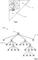
- Figures 2 and 3 exemplarily illustrate the storage of the correction data according to a quad-tree hierarchy, wherein figure 2 shows a tessellation of a single base triangle into child triangles 10, wherein synthetic data points 11 are assigned to the child triangles 10 according to the quad-tree structure 100 depicted by figure 3 .
- each node 12 has exactly four or zero children (child nodes), wherein quad-trees can be used to partition a two-dimensional space by recursively subdividing it into four areas 10, each area being assigned to a node 12 of the tree structure.
- leaf nodes 13 represent a unit of information, which may be defined differently depending on the application, e.g. wherein the unit of information is defined to represent correction data of a desired quality and/or correction data associated with a minimum spatial resolution to be achieved. Except for leaf nodes 13 and areas corresponding to leaf nodes, the areas 10 / nodes 12 are further subdivided a number of times as determined by a given set of criteria, which may vary for different applications.
- the tree directory follows the spatial decomposition of the quad-tree, wherein the data in the tree-pyramid can be stored compactly in an array as an implicit data structure, similar to the way a complete binary tree can be stored compactly in an array.
- the quad-tree 100 is based upon a unique base level triangulation of a base primitive defined by a set of arbitrary points, e.g. the base primitive being a triangle, a square, or a polygon of more than four points.
- the arbitrary points may represent the physical coordinates of reference stations 3 ( Fig. 1 ) or an arbitrary set of base level vertices for gridded data.
- a base triangulation is defined, e.g. as indicated by Fig. 1 , where a base triangle 6 is defined within a square region of service 4 (base primitive).
- Each base triangle is then recursively subdivided into four child triangles 10 as depicted by Fig. 2 , wherein data associated with the child triangles are stored in a quad-tree 100 as depicted by Fig. 3 , wherein data at each child level are stored differentially to the parent level.
- the format allows for data at the child level and all subsequent levels to be removed from the data stream on a per vertex basis. This enables higher compression to be achieved and also allows for the encoding of spatially variable precision across the modelled region of service as indicated by the distribution of data points 11, i.e. units of information, depicted by Fig. 2 , wherein the data points 11 correspond to leaf nodes 13 in the quad-tree depicted by Fig. 3 .
- the variable distribution of reference stations and/or precision requirements can be mapped by the quad-tree without generating data overhead.
- Figures 4 and 5 show an exemplary way for defining the quad-tree hierarchy, wherein values of NaN for the bounding vertex indices of parent triangles are used for removing child triangles and associated nodes from the quad-tree.
- NaN standing for Not a Number, is a numeric data type value representing an undefined value that is used to define the quad-tree hierarchy.
- Figure 4 depicts triangle faces of three different parent levels and figure 5 depicts corresponding resulting child levels.
- tessellation involves a uniform subdivision of each of the parent level triangle faces in sequence.
- Each triangle face may be defined by its three bounding vertex indices 14, wherein data values for the next tessellation level at each unique vertex index 15 are stored as the difference from the average of the data values associated with the parent level vertices 14. Data for each vertex is stored sequentially in the output data stream, firstly for the base level and then for subsequent child levels.
- Data values set to NaN are used to define the quad-tree hierarchy.
- a parent level vertex 16 having a value of NaN implies that a child face associated with this vertex 16 is removed from the quad-tree.
- the NaN is treated as zero.
- figure 5 shows the child faces that are encoded for the three different parent levels of Fig. 4 by interpolated vertex values 15, wherein for some child vertex indices 17 no data are transmitted.
- the maximum level at which data are encoded can be used to provide an estimate of the precision of the data values at each vertex. Note that the ordering of vertices in the encoded stream is invariant on their existence.
Landscapes
- Engineering & Computer Science (AREA)
- Radar, Positioning & Navigation (AREA)
- Remote Sensing (AREA)
- Computer Networks & Wireless Communication (AREA)
- Physics & Mathematics (AREA)
- General Physics & Mathematics (AREA)
- Power Engineering (AREA)
- Position Fixing By Use Of Radio Waves (AREA)
- Image Generation (AREA)
- Processing Or Creating Images (AREA)
Abstract
Description
- The present invention relates to a method for providing correction data in a GNSS network-RTK system according to claim 1, a network-RTK network element according to claim 9, a network-RTK rover according to
claim 11, a computer program product according toclaim claim 15. - Positioning by a global navigation satellite system (GNSS) is subject to dispersive and non-dispersive atmospheric influences on the positioning signal, e.g. wherein, as a function of varying electron density due to solar radiation and activity, the ionosphere exerts a dispersive delay on the GNSS signal exchanged between a satellite and a rover of the GNSS system, whereas the troposphere exerts non-dispersive delay on the same GNSS signal.
- A network-RTK (Real Time Kinematic) system is a differential positioning technique, e.g. for providing high positioning performance in combination with GNSS positioning, wherein reference measurements based on known positions of reference stations are combined to provide corrections for the GNSS satellite signal, including correction for atmospheric biases.
- For example, a GNSS network-RTK system comprises a network of reference stations whose locations are well known, wherein correction information is derived based on a comparison of GNSS positioning measurements with respect to the reference stations and the known locations of the reference stations. The network of reference stations typically bounds a region of service, e.g. a province, a country, a continent, or even the entire globe. The correction information is then transmitted, typically in real time, to one or several users of the GNSS network-RTK system in order to improve the GNSS positioning performance.
- The derived correction data are valid along the ray path between the network stations and the satellites in view, i.e. for the case that the user is located at a reference station or at least in the vicinity of a reference station, whereas the quality of correction is reduced when the user is at a location further away from a reference station.
- Therefore, a model is required to estimate the correction at any arbitrary point in the network.
- Such models may rely on the assumption that the disturbance is spatially correlated and continuous over a region or even the globe. For example, spherical harmonics is an approach commonly applied to model the ionosphere over the entire globe. However, spherical harmonics have some disadvantages for modelling regional ionosphere that has led to the development of other modelling methods.
- Many different network-RTK positioning/processing techniques are known, e.g. so-called RTK, VRS (virtual reference station), PPP (precise point positioning), PPP-AR (PPP positioning with ambiguity resolution), and PPP-RTK.
- One common approach is to represent the continuous disturbance region using a, e.g. uniform, grid of values over the region of service, wherein an expected correction for a specific location is interpolated from the surrounding grid points using linear or non-linear functions, particularly based on a triangulation principle.
- For example, interpolation may be based on a Delaunay-triangulation-network, e.g. as described by
CN 106970404 A relating to a multi-redundant network RTK atmospheric error interpolation method for VRS processing. - By way of another example,
WO 2016/185500 A1 relates to discretizing space into Delaunay triangles and discloses a method for forecasting ionosphere total electron content (TEC) and/or scintillation parameters to feed mitigation algorithms aiming at improving accuracy on GNSS precise positioning techniques (RTK, NRTK, and PPP). -
US 9,651,668 B2 - Some precise positioning techniques further require providing to the GNSS processing unit not only the atmospheric model itself but also information on the accuracy of the model. For example,
US 2014/0292573 A1 relates to GNSS positioning, wherein both an ionosphere model and its accuracy are provided to an apparatus for the rover GNSS data processing in order to improve the convergence time of PPP, i.e. the waiting time for the float position solution to converge to centimeter accuracy. - In theory, i.e. given an essentially uniform and sufficiently dense distribution of available reference stations, correction data may be derived and/or provided for a region of service at an arbitrary spatial resolution. However, in practice the performance of the GNSS network-RTK system, i.e. the provision of appropriate correction data at any spatial resolution, is typically limited because of limited bandwidth for broadcasting correction data within the network-RTK system, a lack of available reference stations in some areas to sufficiently measure the atmospheric delay, and a deficiency of the model itself to represent the true behavior of the atmospheric delay.
- For example, the problem of limited memory and processing power of a GPS rover is addressed by
US 7,031,730 B1 . A current position of a GPS receiver is determined and a boundary is created based on the current position. One or more bands and one or more blocks of grid point correction data are analyzed in order to determine if they are within the boundary, e.g. based on latitude and longitude of individual grid points. The GPS device then purges unnecessary data and only uses appropriate ionospheric grid point corrections that lie in the boundary for correcting the initially determined current position. - However, still a large data overhead is transmitted to the GPS device, which limits the effective information content of the transmitted data for a given available bandwidth.
- It is an object of the present invention to provide an improved GNSS network-RTK system which overcomes the deficiencies of the prior art, particularly to provide better access to atmospheric correction data as well as to provide an improved quality control of the correction data. These objects are achieved by realizing at least part of the features of the independent claims or one of the dependent claims. Features which further develop the invention in an alternative or advantageous manner are described in the dependent patent claims.
- The invention relates to a method for providing correction data in a GNSS network-RTK system having reference stations. According to the invention, the method comprises the following steps: determining basic data with respect to the reference stations, the basic data for each of the reference stations respectively indicating influences on a signal propagation exerted by the atmosphere on a satellite signal of a GNSS associated with the respective reference station; defining a base triangulation that encloses at least part of the reference stations; subdividing the base triangulation into child triangles by means of a recursive division of parent triangles into four child triangles; determining synthetic data for each of the child triangles based on a triangulation algorithm applied to the basic data such that the synthetic data represent a gridded representation of the basic data; and providing access to correction data, wherein the correction data comprise at least part of the synthetic data arranged in a quad-tree hierarchy.
- By way of example, the method is used within the framework of a network-RTK GNSS comprising a GNSS network processing facility that receives formatted raw GNSS measurements for a set of satellites plus other ancillary information from a network of three or more reference stations distributed in an area enclosed by a base triangulation. The processing facility includes a data processing module with mathematical models and algorithms for estimating measurement biases, and the processing facility feeds the measurements to the data processing module which subsequently estimates the line-of-sight atmospheric delays for each satellite and receiver in the network, carries out the recursive division of the base triangulation, determines synthetic data for each of the child triangles, and stores the synthetic data in a quad-tree hierarchy. The correction data set is then transmitted to a network-RTK rover configured for decoding the data set and for interpolating the atmospheric delay for any arbitrary point within the base triangulation using the same interpolation functions used for the initial generation of the correction data.
- Quad-tree data structures are known in the field of image processing and, for example, allow the storage of image files with changing resolution or tree depth of the image pixel indexing. However, in contrast to the division into squares or rectangles used in the field of image processing, here the division is based on triangulation.
- For example, the base triangulation enclosing at least part of the reference stations may be calculated or pre-defined, wherein the vertices need not correspond to coordinates of reference stations. The base triangulation forms the base level of the quad-tree. The base level is iteratively subdivided a number of times as determined by a given set of criteria, which may vary for different applications.
- Providing the correction data based on a quad-tree hierarchy enables a reduction of the data volume to be broadcasted within the GNSS network-RTK system. In particular, overhead of unnecessary information is minimized thus enabling to provide appropriate correction data at a higher spatial resolution without requiring an increased bandwidth.
- For example, only the coordinates of the base level need to be transmitted with the quad-tree when using a deterministic recursive division to generate the child triangles, i.e. the order of nodes for each subdivision level is also deterministic. However, a deterministic unambiguous order is not strictly required as the order may also be provided with the quad-tree.
- In addition, the accuracy that can be realized for a respective tree level may also be transmitted as part of the data comprising the correction data, i.e. the correction model may provide a combination of accuracy and correction information at the same time.
- In particular, a variation in the spatial resolution of the correction model due to the variable distribution of reference stations and/or precision requirements can be mapped by the quad-tree without generating data overhead. For example, the estimated precision of the interpolated correction at an arbitrary point can be inferred from the encoded precision of the quad-tree level.
- An empty (0 bit) level may be used to preserve the hierarchy of subsequent levels in the tree without the overhead of encoding any correction information for that level, and wherein a single bit level may be used to define the tree hierarchy at subsequent levels without the overhead of transmitting correction information.
- In one embodiment, the correction data comprise at least the coordinates of the vertices of the base triangulation. In a further embodiment, the quad-tree hierarchy provides ordering of the synthetic data into nodes and child nodes of different tree levels, wherein for each tree level each node comprises exactly four or zero child nodes, and wherein: the nodes of a first tree level comprise synthetic data corresponding to the vertices of those child triangles which were created in a first step of the recursive division; the nodes of a second or further tree level respectively comprise synthetic data corresponding to the vertices of those child triangles which were created in a second or further step of the recursive division; the synthetic data are divided into a group of valid data and a group of invalid data; and each node is partitioned into child nodes only in case at least one of its child nodes would comprise synthetic data of the group of valid data. Thus, values associated with child triangles that should not be provided in the final quad-tree can be excluded based on a set of exclusion criteria.
- By way of example, the synthetic data are divided into the group of valid data and the group of invalid data by marking at least part of the synthetic data as invalid, particularly in case an uncertainty of the at least part of the synthetic data exceeds a pre-defined uncertainty threshold. For example, the uncertainty of the at least part of the synthetic data is derived based on at least one of an uncertainty in the basic data, an interpolation uncertainty of the triangulation algorithm, and a spatial distance of the child triangle corresponding to the at least part of the synthetic data to the closest reference station.
- According to a further embodiment, the correction data are configured such that for each child node differential data are provided with respect to data of its parent node, namely the node of the previous tree level which was partitioned into those child nodes which comprise the respective child node.
- In another embodiment, the quad-tree hierarchy is configured such that partitioning of the nodes into child nodes is stopped based on at least one of a predefined total number of nodes in the quad-tree hierarchy, and a predefined minimum surface area for each child triangle represented by a node of the quad-tree hierarchy. In other words, the quad-tree size and/or the maximum spatial resolution for providing correction data is/are fixed a-priori.
- According to another embodiment, the correction data comprise metadata indicative of an accuracy range for the accuracy of respective synthetic data, particularly as a function of the tree level of the node representing the respective synthetic data.
- In a further embodiment, the correction data comprise basic data with respect to the reference stations. In particular, thanks to the quad-tree data format, basic data of the reference stations can be provided as a triangulation formed from the reference site coordinates without subsequent tessellation.
- A further embodiment is characterized in that the step of providing the correction data comprises a selection of synthetic data based on an accuracy criterion and/or based on a maximum tree level of the quad-tree hierarchy, particularly wherein only synthetic data with respect to one of the tree levels are selected.
- The invention further relates to a network-RTK network element, e.g. a network-RTK server, comprising a computing unit and communication means, wherein the network-RTK network element is configured for carrying out the method according to any one of the embodiments described above.
- The invention also relates to a computer program product comprising program code, which is stored on a machine-readable medium or embodied by an electromagnetic wave comprising a program code segment, and which has computer-executable instructions for performing, particularly when run on a computing unit of a network-RTK network element as descried above, at least the following steps: reading basic data with respect to reference stations of a GNSS network-RTK system, the basic data for each of the reference stations respectively indicating influences on a signal propagation exerted by the atmosphere on a satellite signal of a GNSS associated with the respective reference station; reading definition data of a base triangulation or determining a base triangulation, the base triangulation enclosing at least part of the reference stations; subdividing the base triangulation into child triangles by means of a recursive division of parent triangles into four child triangles; determining synthetic data for each of the child triangles based on a triangulation algorithm applied to the basic data such that the synthetic data represent a gridded representation of the basic data; and providing access to correction data, wherein the correction data comprise at least part of the synthetic data arranged in a quad-tree hierarchy.
- The invention further relates to a network-RTK rover, e.g. a network-RTK client, with a computing unit and communication means configured for receiving network-RTK data, wherein the network-RTK rover is configured for determining a position based on GNSS data associated with a satellite signal of a GNSS, wherein a correction of the GNSS data is carried out based on the network-RTK data in order to take into account influences on a signal propagation exerted by the atmosphere on the satellite signal. The network-RTK rover is configured for receiving correction data as described above, the correction data being the network-RTK data, for decoding the quad-tree hierarchy as it is described above and for providing from the correction data a reconstruction of at least a fraction of the child triangles with corresponding synthetic data as described above, and for carrying out the correction based on the reconstruction.
- In particular, the network-RTK rover may be configured for reading the metadata within the correction data as described with respect to the above method, and/or for reading the synthetic and/or basic data within the correction data as described with respect to the above method.
- In another embodiment, the network-RTK rover is configured for determining an accuracy of the correction from the tree levels of nodes of the quad-tree hierarchy.
- In a further embodiment, the network-RTK rover is configured for requesting the correction data based on an accuracy criterion for the synthetic data and/or based on a maximum tree level of the quad-tree hierarchy, particularly for requesting only synthetic data with respect to one of the tree levels.
- The invention further relates to a computer program product comprising program code, which is stored on a machine-readable medium or embodied by an electromagnetic wave comprising a program code segment, and which has computer-executable instructions for performing, particularly when run on a computing unit of a network-RTK device described above, at least the following steps: reading GNSS data associated with a satellite signal of a GNSS; reading correction data as they are described above; decoding the quad-tree hierarchy as it is described above and providing from the correction data a reconstruction of at least a fraction of the child triangles with corresponding synthetic data as described above; and correcting the GNSS data based on the reconstruction, namely correcting influences on a signal propagation exerted by the atmosphere on the satellite signal based on the reconstruction.
- The invention further relates to a GNSS network-RTK system, configured for carrying out the method according to any one of the embodiments described above, with at least a network-RTK network element as described above, and at least a network-RTK rover according to any one of the embodiments described above.
- The GNSS network-RTK system according to the invention is described or explained in more detail below, purely by way of example, with reference to working examples shown schematically in the drawing. Identical elements are labelled with the same reference numerals in the figures. The described embodiments are generally not shown true to scale and they are also not to be interpreted as limiting the invention. Specifically,
- Fig. 1:
- an exemplary embodiment of a GNSS network-RTK system according to the invention;
- Fig. 2:
- an exemplary tessellation of a base triangle into child triangles;
- Fig. 3:
- an exemplary quad-tree structure corresponding to the tessellation of the base triangle of
Fig. 2 ; - Fig. 4:
- exemplary triangle faces of three different parent levels with corresponding bounding vertices;
- Fig. 5:
- resulting child levels corresponding to the parent level triangles of
Fig. 4 , with interpolated vertex values. -
Figure 1 shows an exemplary embodiment of a GNSS network-RTK system according to the invention, comprising a network-RTK network element 1 that receives formatted raw GNSS measurements for a set ofsatellites 2 plus other ancillary information from three ormore reference stations 3 covering a region ofservice 4, e.g. a province, a country, or a continent. The network-RTK network element 1 comprises acomputing unit 5 configured for estimating the line-of-sight atmospheric delays associated with eachreference station 3 within the region ofservice 4, wherein thecomputing unit 5 is further configured for the definition and recursive division of a base triangulation, e.g. based on one or a plurality ofbase triangles 6, for determining synthetic data for the child triangles of the recursive division, and for derivingcorrection data 7 based on the synthetic data being stored in quad-tree hierarchy. - The network-RTK network element 1 further comprises communication means 8 configured for transmission of the
correction data 7 to a network-RTK rover 9, wherein the network-RTK rover 9 is configured for decoding the quad-tree hierarchy in order to derive appropriate correction data to be applied in GNSS positioning carried out at its current location. In other words, the network-RTK rover 9 is configured for decoding the correction data and for interpolating the atmospheric delay for any arbitrary point within abase triangle 6 using the same interpolation functions used for the initial generation of the correction data. -
Figures 2 and 3 exemplarily illustrate the storage of the correction data according to a quad-tree hierarchy, whereinfigure 2 shows a tessellation of a single base triangle intochild triangles 10, wherein synthetic data points 11 are assigned to thechild triangles 10 according to the quad-tree structure 100 depicted byfigure 3 . - In a quad-tree each
node 12 has exactly four or zero children (child nodes), wherein quad-trees can be used to partition a two-dimensional space by recursively subdividing it into fourareas 10, each area being assigned to anode 12 of the tree structure. So called leaf nodes 13 represent a unit of information, which may be defined differently depending on the application, e.g. wherein the unit of information is defined to represent correction data of a desired quality and/or correction data associated with a minimum spatial resolution to be achieved. Except for leaf nodes 13 and areas corresponding to leaf nodes, theareas 10 /nodes 12 are further subdivided a number of times as determined by a given set of criteria, which may vary for different applications. - The tree directory follows the spatial decomposition of the quad-tree, wherein the data in the tree-pyramid can be stored compactly in an array as an implicit data structure, similar to the way a complete binary tree can be stored compactly in an array.
- According to the invention, the quad-
tree 100 is based upon a unique base level triangulation of a base primitive defined by a set of arbitrary points, e.g. the base primitive being a triangle, a square, or a polygon of more than four points. The arbitrary points may represent the physical coordinates of reference stations 3 (Fig. 1 ) or an arbitrary set of base level vertices for gridded data. - Based on the base primitive, a base triangulation is defined, e.g. as indicated by
Fig. 1 , where abase triangle 6 is defined within a square region of service 4 (base primitive). - Each base triangle is then recursively subdivided into four
child triangles 10 as depicted byFig. 2 , wherein data associated with the child triangles are stored in a quad-tree 100 as depicted byFig. 3 , wherein data at each child level are stored differentially to the parent level. The format allows for data at the child level and all subsequent levels to be removed from the data stream on a per vertex basis. This enables higher compression to be achieved and also allows for the encoding of spatially variable precision across the modelled region of service as indicated by the distribution ofdata points 11, i.e. units of information, depicted byFig. 2 , wherein the data points 11 correspond to leaf nodes 13 in the quad-tree depicted byFig. 3 . Thus, the variable distribution of reference stations and/or precision requirements can be mapped by the quad-tree without generating data overhead. -
Figures 4 and 5 show an exemplary way for defining the quad-tree hierarchy, wherein values of NaN for the bounding vertex indices of parent triangles are used for removing child triangles and associated nodes from the quad-tree. NaN, standing for Not a Number, is a numeric data type value representing an undefined value that is used to define the quad-tree hierarchy. -
Figure 4 depicts triangle faces of three different parent levels andfigure 5 depicts corresponding resulting child levels. Here, tessellation involves a uniform subdivision of each of the parent level triangle faces in sequence. - Each triangle face may be defined by its three bounding
vertex indices 14, wherein data values for the next tessellation level at eachunique vertex index 15 are stored as the difference from the average of the data values associated with theparent level vertices 14. Data for each vertex is stored sequentially in the output data stream, firstly for the base level and then for subsequent child levels. - Data values set to NaN are used to define the quad-tree hierarchy. A parent level vertex 16 having a value of NaN implies that a child face associated with this vertex 16 is removed from the quad-tree. In the case of interpolation between a pair of
vertices 14 on the parent level consisting of a single vertex 16 with NaN, the NaN is treated as zero. For interpolation where two parent vertices 16 are NaN then no child vertex exists. Accordingly,figure 5 shows the child faces that are encoded for the three different parent levels ofFig. 4 by interpolated vertex values 15, wherein for some child vertex indices 17 no data are transmitted. - The maximum level at which data are encoded can be used to provide an estimate of the precision of the data values at each vertex. Note that the ordering of vertices in the encoded stream is invariant on their existence.
- Although the invention is illustrated above, partly with reference to some preferred embodiments, it must be understood that numerous modifications and combinations of different features of the embodiments can be made. All of these modifications lie within the scope of the appended claims.
Claims (15)
- Method for providing correction data in a GNSS network-RTK system having reference stations (3), the method comprising• obtaining basic data with respect to the reference stations (3), the basic data for each of the reference stations (3) respectively indicating influences on a signal propagation exerted by the atmosphere on a satellite signal of a GNSS associated with the respective reference station (3),• defining a base triangulation (6) that encloses at least part of the reference stations (3),• subdividing the base triangulation (6) into child triangles (10) by means of a recursive division of parent triangles (10) into four child triangles,• determining synthetic data (11) for each of the child triangles (10) based on a triangulation algorithm applied to the basic data such that the synthetic data (11) represent a gridded representation of the basic data, and• providing access to correction data, wherein the correction data comprise at least part of the synthetic data (11) arranged in a quad-tree hierarchy (100).
- Method according to claim 1,
characterized in that
the correction data comprise at least the coordinates of the vertices of the base triangulation (6). - Method according to claim 1 or 2,
characterized in that
the quad-tree hierarchy (100) provides ordering of the synthetic data (11) into nodes (12,13) and child nodes (12,13) of different tree levels, wherein for each tree level each node (12) comprises exactly four or zero child nodes (12,13), and wherein• the nodes (12,13) of a first tree level comprise synthetic data (11) corresponding to the vertices of those child triangles (10) which were created in a first step of the recursive division,• the nodes (12,13) of a second or further tree level respectively comprise synthetic data (11) corresponding to the vertices of those child triangles (10) which were created in a second or further step of the recursive division,• the synthetic data (11) are divided into a group of valid data and a group of invalid data, and• each node (12) is partitioned into child nodes (12,13) only in case at least one of its child nodes (12,13) would comprise synthetic data (11) of the group of valid data. - Method according to claim 3,
characterized in that
the synthetic data (11) are divided into the group of valid data and the group of invalid data by marking at least part of the synthetic data as invalid, particularly in case an uncertainty of the at least part of the synthetic data exceeds a pre-defined uncertainty threshold,
more particularly wherein the uncertainty of the at least part of the synthetic data is derived based on at least one of• an uncertainty in the basic data,• an interpolation uncertainty of the triangulation algorithm, and• a spatial distance of the child triangle (10) corresponding to the at least part of the synthetic data to the closest reference station (3). - Method according to any one of the preceding claims,
characterized in that
the correction data are configured that for each child node (12,13) differential data are provided with respect to data of its parent node (12,13), namely the node of the previous tree level which was partitioned into those child nodes which comprise the respective child node. - Method according to any one of the preceding claims,
characterized in that
the quad-tree hierarchy (100) is configured such that partitioning of the nodes (12,13) into child nodes (12,13) is stopped based on at least one of• a predefined total number of nodes (12,13) in the quad-tree hierarchy, and• a predefined minimum surface area for each child triangle (10) represented by a node (12,13) of the quad-tree hierarchy (100). - Method according to any one of the preceding claims,
characterized in that
the correction data comprise at least one of• metadata indicative of an accuracy range for the accuracy of respective synthetic data (11), particularly as a function of the tree level of the node (12,13) representing the respective synthetic data (11), and• basic data with respect to the reference stations. - Method according to any one of the preceding claims,
characterized in that
the step of providing access to the correction data comprises a selection of synthetic data (11) based on an accuracy criterion and/or based on a maximum tree level of the quad-tree hierarchy (100), particularly wherein only synthetic data with respect to one of the tree levels are selected. - Network-RTK network element (1) comprising a computing unit (5) and communication means (8),
characterized in that
the network-RTK network element (1) is configured for carrying out the method according to any one of claims 1 to 8. - Computer program product comprising program code, which is stored on a machine-readable medium or embodied by an electromagnetic wave comprising a program code segment, and which has computer-executable instructions for performing, particularly when run on a computing unit of a network-RTK network element (1) according to claim 9, at least the following steps,• reading basic data with respect to reference stations (3) of a GNSS network-RTK system, the basic data for each of the reference stations (3) respectively indicating influences on a signal propagation exerted by the atmosphere on a satellite signal of a GNSS associated with the respective reference station (3),• reading definition data of a base triangulation (6) or determining a base triangulation (6), the base triangulation (6) enclosing at least part of the reference stations (3),• subdividing the base triangulation (6) into child triangles (10) by means of a recursive division of parent triangles (10) into four child triangles,• determining synthetic data (11) for each of the child triangles (10) based on a triangulation algorithm applied to the basic data such that the synthetic data (11) represent a gridded representation of the basic data, and• providing access to correction data, wherein the correction data comprise at least part of the synthetic data (11) arranged in a quad-tree hierarchy (100).
- Network-RTK rover (9) for a GNSS network-RTK system, with a computing unit and communication means configured for receiving network-RTK data, wherein the network-RTK rover (9) is configured for determining a position based on GNSS data associated with a satellite signal of a GNSS, wherein a correction of the GNSS data is carried out based on the network-RTK data in order to take into account influences on a signal propagation exerted by the atmosphere on the satellite signal,
characterized in that
the network-RTK rover (9) is configured• for receiving correction data defined according to claim 10, the correction data being the network-RTK data,• for decoding the quad-tree hierarchy (100) defined according to claim 10 and for providing from the correction data a reconstruction of at least a fraction of the child triangles (10) with corresponding synthetic data (11) as defined according to claim 10, and• for carrying out the correction based on the reconstruction. - Network-RTK rover (9) according to claim 11,
characterized in that
the network-RTK rover (9) is configured for determining an accuracy of the correction from the tree levels of nodes (12,13) of the quad-tree hierarchy (100). - Network-RTK rover (9) according to claim 11 or 12,
characterized in that
the network-RTK rover (9) is configured for requesting the correction data based on an accuracy criterion for the synthetic data (11) and/or based on a maximum tree level of the quad-tree hierarchy (100), particularly for requesting only synthetic data (11) with respect to one of the tree levels. - Computer program product comprising program code, which is stored on a machine-readable medium or embodied by an electromagnetic wave comprising a program code segment, and which has computer-executable instructions for performing, particularly when run on a computing unit of a network-RTK rover (9) according to claim 11, at least the following steps,• reading GNSS data associated with a satellite signal of a GNSS,• reading correction data as defined according to claim 10,• decoding the quad-tree hierarchy (100) as defined according to claim 10 and providing from the correction data a reconstruction of at least a fraction of the child triangles (10) with corresponding synthetic data (11) as defined according to claim 10, and• correcting the GNSS data based on the reconstruction.
- GNSS network-RTK system, configured for carrying out the method according to any one of claims 1 to 8, with• at least a network-RTK network element (1) according to claim 9, and• at least a network-RTK rover (9) according to claim 11.
Priority Applications (3)
| Application Number | Priority Date | Filing Date | Title |
|---|---|---|---|
| EP19170710.8A EP3730970B1 (en) | 2019-04-23 | 2019-04-23 | Providing atmospheric correction data for a gnss network-rtk system by encoding the data according to a quad-tree hierarchy |
| CN202010285301.9A CN111830543B (en) | 2019-04-23 | 2020-04-13 | Method for providing correction data, network-RTK network element and network-RTK rover |
| US16/855,859 US11327184B2 (en) | 2019-04-23 | 2020-04-22 | Providing atmospheric correction data for a GNSS network-RTK system by encoding the data according to a quad-tree hierarchy |
Applications Claiming Priority (1)
| Application Number | Priority Date | Filing Date | Title |
|---|---|---|---|
| EP19170710.8A EP3730970B1 (en) | 2019-04-23 | 2019-04-23 | Providing atmospheric correction data for a gnss network-rtk system by encoding the data according to a quad-tree hierarchy |
Publications (2)
| Publication Number | Publication Date |
|---|---|
| EP3730970A1 true EP3730970A1 (en) | 2020-10-28 |
| EP3730970B1 EP3730970B1 (en) | 2023-10-04 |
Family
ID=66251603
Family Applications (1)
| Application Number | Title | Priority Date | Filing Date |
|---|---|---|---|
| EP19170710.8A Active EP3730970B1 (en) | 2019-04-23 | 2019-04-23 | Providing atmospheric correction data for a gnss network-rtk system by encoding the data according to a quad-tree hierarchy |
Country Status (3)
| Country | Link |
|---|---|
| US (1) | US11327184B2 (en) |
| EP (1) | EP3730970B1 (en) |
| CN (1) | CN111830543B (en) |
Families Citing this family (9)
| Publication number | Priority date | Publication date | Assignee | Title |
|---|---|---|---|---|
| EP3206050B1 (en) * | 2011-03-22 | 2025-01-08 | Trimble Inc. | Gnss sinal processing with delta phase |
| KR102205679B1 (en) * | 2019-05-10 | 2021-01-21 | 이상주 | Method and apparatus for distribution of RTK correcting data using virtual cell structure |
| CN112987037B (en) * | 2021-02-10 | 2023-02-28 | 北京敏视达雷达有限公司 | Detection method and related device for spoofing attack |
| CN113238268A (en) * | 2021-04-02 | 2021-08-10 | 广州市中海达测绘仪器有限公司 | Positioning method and system for enhancing atmospheric correction data based on PPP-RTK (Point-to-Point protocol-real time kinematic) area |
| CN112989673B (en) * | 2021-04-16 | 2022-03-15 | 中国空气动力研究与发展中心计算空气动力研究所 | Discrete grid point fast re-regularization method based on binary tree model |
| CN114236583B (en) * | 2021-12-23 | 2022-10-11 | 国汽大有时空科技(安庆)有限公司 | Space geographic range coding method and global-range GNSS differential enhanced positioning method |
| US12618979B1 (en) * | 2022-09-15 | 2026-05-05 | The United States Of America As Represented By The Secretary Of The Army | Precise wide area ionosphere correction solution for multi-spectrum alternative sources of space based PNT signals |
| CN115826011B (en) * | 2023-01-06 | 2023-05-05 | 北京讯腾智慧科技股份有限公司 | RTK (real-time kinematic) method and device for dynamic grid network of image layer |
| CN119001797B (en) * | 2024-10-18 | 2024-12-24 | 中国测绘科学研究院 | Grid network RTK positioning method, equipment and system |
Citations (7)
| Publication number | Priority date | Publication date | Assignee | Title |
|---|---|---|---|---|
| US7031730B1 (en) | 2001-10-01 | 2006-04-18 | Garmin Ltd. | Method and system for minimizing storage and processing of ionospheric grid point correction information in a wireless communications device |
| US20130234886A1 (en) * | 2012-03-09 | 2013-09-12 | Thales | Adaptive Method for Estimating the Electron Content of the Ionosphere |
| US20140292573A1 (en) | 2012-12-18 | 2014-10-02 | Trimble Navigation Limited | Methods for generating accuracy information on an ionosphere model for satellite navigation applications |
| WO2016185500A1 (en) | 2015-05-19 | 2016-11-24 | Spacearth Technology S.R.L. | Method for forecasting ionosphere total electron content and/or scintillation parameters |
| US9651668B2 (en) | 2012-11-30 | 2017-05-16 | Thales | Method and system for determining an error in the estimation of the time taken to cross the ionosphere |
| CN106970404A (en) | 2017-03-31 | 2017-07-21 | 东南大学 | A kind of many redundant network RTK atmosphere errors interpolating methods based on Delaunay triangulation network |
| US20190004206A1 (en) * | 2015-08-13 | 2019-01-03 | Cgg Services Sas | System and method for gravity and/or gravity gradient terrain corrections |
Family Cites Families (12)
| Publication number | Priority date | Publication date | Assignee | Title |
|---|---|---|---|---|
| US6775802B2 (en) * | 2000-08-08 | 2004-08-10 | Qualcomm Incorporated | Method, apparatus, and system for signal prediction |
| US20090157566A1 (en) * | 2006-03-21 | 2009-06-18 | Bernard Grush | Method and process to ensure that a vehicular travel path recording that includes positional errors can be used to determine a reliable and repeatable road user charge |
| EP1868009A1 (en) * | 2006-06-13 | 2007-12-19 | Leica Geosystems AG | Calculation method for network specific values in a network of reference stations for a satellite based positioning system |
| EP2040090A1 (en) * | 2007-09-18 | 2009-03-25 | Leica Geosystems AG | Method for accuracy estimation of network based corrections for a satellite-aided positioning system |
| CN101661096A (en) * | 2008-08-29 | 2010-03-03 | 夏晓清 | Method and system for generating virtual reference station based on triangular approximation algorithm |
| DE112011100528T5 (en) * | 2010-02-14 | 2012-12-06 | Trimble Navigation Limited | GNSS signal processing with regional augmentation message |
| US8559975B2 (en) * | 2011-07-22 | 2013-10-15 | Microsoft Corporation | Location determination based on weighted received signal strengths |
| US9121922B2 (en) * | 2012-06-26 | 2015-09-01 | Cambridge Silicon Radio Limited | Access point location identification methods and apparatus based on absolute and relative harvesting |
| EP3130943B1 (en) * | 2015-08-14 | 2022-03-09 | Trimble Inc. | Navigation satellite system positioning involving the generation of tropospheric correction information |
| EP3635976B1 (en) * | 2017-05-05 | 2021-03-10 | Telefonaktiebolaget LM Ericsson (publ) | First network node, wireless device and methods therein for handling broadcast information |
| CN110622566B (en) * | 2017-05-05 | 2021-04-20 | 华为技术有限公司 | A kind of auxiliary data transmission method, equipment and system |
| CN109284338B (en) * | 2018-10-25 | 2021-12-10 | 南京航空航天大学 | Satellite remote sensing big data optimization query method based on mixed index |
-
2019
- 2019-04-23 EP EP19170710.8A patent/EP3730970B1/en active Active
-
2020
- 2020-04-13 CN CN202010285301.9A patent/CN111830543B/en active Active
- 2020-04-22 US US16/855,859 patent/US11327184B2/en active Active
Patent Citations (7)
| Publication number | Priority date | Publication date | Assignee | Title |
|---|---|---|---|---|
| US7031730B1 (en) | 2001-10-01 | 2006-04-18 | Garmin Ltd. | Method and system for minimizing storage and processing of ionospheric grid point correction information in a wireless communications device |
| US20130234886A1 (en) * | 2012-03-09 | 2013-09-12 | Thales | Adaptive Method for Estimating the Electron Content of the Ionosphere |
| US9651668B2 (en) | 2012-11-30 | 2017-05-16 | Thales | Method and system for determining an error in the estimation of the time taken to cross the ionosphere |
| US20140292573A1 (en) | 2012-12-18 | 2014-10-02 | Trimble Navigation Limited | Methods for generating accuracy information on an ionosphere model for satellite navigation applications |
| WO2016185500A1 (en) | 2015-05-19 | 2016-11-24 | Spacearth Technology S.R.L. | Method for forecasting ionosphere total electron content and/or scintillation parameters |
| US20190004206A1 (en) * | 2015-08-13 | 2019-01-03 | Cgg Services Sas | System and method for gravity and/or gravity gradient terrain corrections |
| CN106970404A (en) | 2017-03-31 | 2017-07-21 | 东南大学 | A kind of many redundant network RTK atmosphere errors interpolating methods based on Delaunay triangulation network |
Non-Patent Citations (2)
| Title |
|---|
| GOODCHILD M F ET AL: "A HIERARCHICAL SPATIAL DATA STRUCTURE FOR GLOBAL GEOGRAPHIC INFORMATION SYSTEMS", CVGIP GRAPHICAL MODELS AND IMAGE PROCESSING, ACADEMIC PRESS, DULUTH, MA, US, vol. 54, no. 1, 1 January 1992 (1992-01-01), pages 31 - 44, XP000243521, ISSN: 1077-3169, DOI: 10.1016/1049-9652(92)90032-S * |
| TAKAC FRANK ET AL: "The Relationship Between Network RTK Solutions MAC, VRS, PRS, FKP and i-MAX", GNSS 2008 - PROCEEDINGS OF THE 21ST INTERNATIONAL TECHNICAL MEETING OF THE SATELLITE DIVISION OF THE INSTITUTE OF NAVIGATION (ION GNSS 2008), THE INSTITUTE OF NAVIGATION, 8551 RIXLEW LANE SUITE 360 MANASSAS, VA 20109, USA, 19 September 2008 (2008-09-19), pages 348 - 355, XP056002626 * |
Also Published As
| Publication number | Publication date |
|---|---|
| US11327184B2 (en) | 2022-05-10 |
| US20200341154A1 (en) | 2020-10-29 |
| EP3730970B1 (en) | 2023-10-04 |
| CN111830543A (en) | 2020-10-27 |
| CN111830543B (en) | 2024-12-27 |
Similar Documents
| Publication | Publication Date | Title |
|---|---|---|
| US11327184B2 (en) | Providing atmospheric correction data for a GNSS network-RTK system by encoding the data according to a quad-tree hierarchy | |
| Lu et al. | TropNet: a deep spatiotemporal neural network for tropospheric delay modeling and forecasting: C. Lu et al. | |
| Wilgan et al. | Real-time precise point positioning augmented with high-resolution numerical weather prediction model | |
| Yao et al. | Global ionospheric modeling based on multi-GNSS, satellite altimetry, and Formosat-3/COSMIC data | |
| EP2191290B1 (en) | Method for accuracy estimation of network based corrections for a satellite-aided positioning system | |
| Saito et al. | Real‐time ionosphere monitoring by three‐dimensional tomography over Japan | |
| CN110488332B (en) | Positioning information processing method and device based on network RTK technology | |
| CN101467064A (en) | Calculation method for network-specific factors in a network of reference stations for a satellite-based positioning system | |
| CN110954931A (en) | Positioning method, positioning device and computer readable storage medium | |
| CN110291420B (en) | Method for determining an adaptive model of electron density distribution | |
| CN105452901A (en) | Method and apparatus for providing a compact extended ephemeris package for GNSS processing | |
| Zhao et al. | An optimal tropospheric tomography approach with the support of an auxiliary area | |
| Innerkofler et al. | GNSS radio occultation excess-phase processing for climate applications including uncertainty estimation | |
| CN101661096A (en) | Method and system for generating virtual reference station based on triangular approximation algorithm | |
| CN114384556B (en) | Regional high-resolution ionosphere TEC map reconstruction method | |
| Yang et al. | Numerical weather modeling-based slant tropospheric delay estimation and its enhancement by GNSS data | |
| Li et al. | Research into GNSS levelling using network RTK in Taiwan | |
| CN120957093A (en) | Adaptive Positioning Method and System for Railway User Terminals | |
| Altamimi et al. | ITRF2000: from theory to implementation | |
| Gong et al. | Improving GNSS PPP performance in the South China under different weather conditions by using the Weather Research and Forecasting (WRF) model‐derived wet delay corrections | |
| Yang et al. | Random Optimization Algorithm on GNSS Monitoring Stations Selection for Ultra‐Rapid Orbit Determination and Real‐Time Satellite Clock Offset Estimation | |
| CN115327574B (en) | A satellite-based high-precision ionospheric delay coding broadcasting method and system | |
| Poniatowski et al. | Deep learning approach for combining global ionospheric maps for GNSS positioning | |
| Wang et al. | A novel robust high‐precision ionospheric delay modeling for PPP‐RTK using crowdsourced data | |
| Silva et al. | Computation and analysis of geopotential number in São Paulo, Brazil |
Legal Events
| Date | Code | Title | Description |
|---|---|---|---|
| PUAI | Public reference made under article 153(3) epc to a published international application that has entered the european phase |
Free format text: ORIGINAL CODE: 0009012 |
|
| STAA | Information on the status of an ep patent application or granted ep patent |
Free format text: STATUS: THE APPLICATION HAS BEEN PUBLISHED |
|
| AK | Designated contracting states |
Kind code of ref document: A1 Designated state(s): AL AT BE BG CH CY CZ DE DK EE ES FI FR GB GR HR HU IE IS IT LI LT LU LV MC MK MT NL NO PL PT RO RS SE SI SK SM TR |
|
| AX | Request for extension of the european patent |
Extension state: BA ME |
|
| STAA | Information on the status of an ep patent application or granted ep patent |
Free format text: STATUS: REQUEST FOR EXAMINATION WAS MADE |
|
| 17P | Request for examination filed |
Effective date: 20210210 |
|
| RBV | Designated contracting states (corrected) |
Designated state(s): AL AT BE BG CH CY CZ DE DK EE ES FI FR GB GR HR HU IE IS IT LI LT LU LV MC MK MT NL NO PL PT RO RS SE SI SK SM TR |
|
| GRAP | Despatch of communication of intention to grant a patent |
Free format text: ORIGINAL CODE: EPIDOSNIGR1 |
|
| STAA | Information on the status of an ep patent application or granted ep patent |
Free format text: STATUS: GRANT OF PATENT IS INTENDED |
|
| INTG | Intention to grant announced |
Effective date: 20230503 |
|
| GRAS | Grant fee paid |
Free format text: ORIGINAL CODE: EPIDOSNIGR3 |
|
| GRAA | (expected) grant |
Free format text: ORIGINAL CODE: 0009210 |
|
| STAA | Information on the status of an ep patent application or granted ep patent |
Free format text: STATUS: THE PATENT HAS BEEN GRANTED |
|
| AK | Designated contracting states |
Kind code of ref document: B1 Designated state(s): AL AT BE BG CH CY CZ DE DK EE ES FI FR GB GR HR HU IE IS IT LI LT LU LV MC MK MT NL NO PL PT RO RS SE SI SK SM TR |
|
| REG | Reference to a national code |
Ref country code: GB Ref legal event code: FG4D |
|
| REG | Reference to a national code |
Ref country code: CH Ref legal event code: EP |
|
| REG | Reference to a national code |
Ref country code: IE Ref legal event code: FG4D |
|
| REG | Reference to a national code |
Ref country code: DE Ref legal event code: R096 Ref document number: 602019038491 Country of ref document: DE |
|
| REG | Reference to a national code |
Ref country code: LT Ref legal event code: MG9D |
|
| REG | Reference to a national code |
Ref country code: NL Ref legal event code: MP Effective date: 20231004 |
|
| REG | Reference to a national code |
Ref country code: AT Ref legal event code: MK05 Ref document number: 1618291 Country of ref document: AT Kind code of ref document: T Effective date: 20231004 |
|
| PG25 | Lapsed in a contracting state [announced via postgrant information from national office to epo] |
Ref country code: NL Free format text: LAPSE BECAUSE OF FAILURE TO SUBMIT A TRANSLATION OF THE DESCRIPTION OR TO PAY THE FEE WITHIN THE PRESCRIBED TIME-LIMIT Effective date: 20231004 |
|
| PG25 | Lapsed in a contracting state [announced via postgrant information from national office to epo] |
Ref country code: GR Free format text: LAPSE BECAUSE OF FAILURE TO SUBMIT A TRANSLATION OF THE DESCRIPTION OR TO PAY THE FEE WITHIN THE PRESCRIBED TIME-LIMIT Effective date: 20240105 |
|
| PG25 | Lapsed in a contracting state [announced via postgrant information from national office to epo] |
Ref country code: IS Free format text: LAPSE BECAUSE OF FAILURE TO SUBMIT A TRANSLATION OF THE DESCRIPTION OR TO PAY THE FEE WITHIN THE PRESCRIBED TIME-LIMIT Effective date: 20240204 |
|
| PG25 | Lapsed in a contracting state [announced via postgrant information from national office to epo] |
Ref country code: LT Free format text: LAPSE BECAUSE OF FAILURE TO SUBMIT A TRANSLATION OF THE DESCRIPTION OR TO PAY THE FEE WITHIN THE PRESCRIBED TIME-LIMIT Effective date: 20231004 |
|
| PG25 | Lapsed in a contracting state [announced via postgrant information from national office to epo] |
Ref country code: AT Free format text: LAPSE BECAUSE OF FAILURE TO SUBMIT A TRANSLATION OF THE DESCRIPTION OR TO PAY THE FEE WITHIN THE PRESCRIBED TIME-LIMIT Effective date: 20231004 |
|
| PG25 | Lapsed in a contracting state [announced via postgrant information from national office to epo] |
Ref country code: ES Free format text: LAPSE BECAUSE OF FAILURE TO SUBMIT A TRANSLATION OF THE DESCRIPTION OR TO PAY THE FEE WITHIN THE PRESCRIBED TIME-LIMIT Effective date: 20231004 |
|
| PG25 | Lapsed in a contracting state [announced via postgrant information from national office to epo] |
Ref country code: LT Free format text: LAPSE BECAUSE OF FAILURE TO SUBMIT A TRANSLATION OF THE DESCRIPTION OR TO PAY THE FEE WITHIN THE PRESCRIBED TIME-LIMIT Effective date: 20231004 Ref country code: IS Free format text: LAPSE BECAUSE OF FAILURE TO SUBMIT A TRANSLATION OF THE DESCRIPTION OR TO PAY THE FEE WITHIN THE PRESCRIBED TIME-LIMIT Effective date: 20240204 Ref country code: GR Free format text: LAPSE BECAUSE OF FAILURE TO SUBMIT A TRANSLATION OF THE DESCRIPTION OR TO PAY THE FEE WITHIN THE PRESCRIBED TIME-LIMIT Effective date: 20240105 Ref country code: ES Free format text: LAPSE BECAUSE OF FAILURE TO SUBMIT A TRANSLATION OF THE DESCRIPTION OR TO PAY THE FEE WITHIN THE PRESCRIBED TIME-LIMIT Effective date: 20231004 Ref country code: BG Free format text: LAPSE BECAUSE OF FAILURE TO SUBMIT A TRANSLATION OF THE DESCRIPTION OR TO PAY THE FEE WITHIN THE PRESCRIBED TIME-LIMIT Effective date: 20240104 Ref country code: AT Free format text: LAPSE BECAUSE OF FAILURE TO SUBMIT A TRANSLATION OF THE DESCRIPTION OR TO PAY THE FEE WITHIN THE PRESCRIBED TIME-LIMIT Effective date: 20231004 Ref country code: PT Free format text: LAPSE BECAUSE OF FAILURE TO SUBMIT A TRANSLATION OF THE DESCRIPTION OR TO PAY THE FEE WITHIN THE PRESCRIBED TIME-LIMIT Effective date: 20240205 |
|
| PG25 | Lapsed in a contracting state [announced via postgrant information from national office to epo] |
Ref country code: SE Free format text: LAPSE BECAUSE OF FAILURE TO SUBMIT A TRANSLATION OF THE DESCRIPTION OR TO PAY THE FEE WITHIN THE PRESCRIBED TIME-LIMIT Effective date: 20231004 Ref country code: RS Free format text: LAPSE BECAUSE OF FAILURE TO SUBMIT A TRANSLATION OF THE DESCRIPTION OR TO PAY THE FEE WITHIN THE PRESCRIBED TIME-LIMIT Effective date: 20231004 Ref country code: PL Free format text: LAPSE BECAUSE OF FAILURE TO SUBMIT A TRANSLATION OF THE DESCRIPTION OR TO PAY THE FEE WITHIN THE PRESCRIBED TIME-LIMIT Effective date: 20231004 Ref country code: NO Free format text: LAPSE BECAUSE OF FAILURE TO SUBMIT A TRANSLATION OF THE DESCRIPTION OR TO PAY THE FEE WITHIN THE PRESCRIBED TIME-LIMIT Effective date: 20240104 Ref country code: LV Free format text: LAPSE BECAUSE OF FAILURE TO SUBMIT A TRANSLATION OF THE DESCRIPTION OR TO PAY THE FEE WITHIN THE PRESCRIBED TIME-LIMIT Effective date: 20231004 Ref country code: HR Free format text: LAPSE BECAUSE OF FAILURE TO SUBMIT A TRANSLATION OF THE DESCRIPTION OR TO PAY THE FEE WITHIN THE PRESCRIBED TIME-LIMIT Effective date: 20231004 |
|
| REG | Reference to a national code |
Ref country code: DE Ref legal event code: R097 Ref document number: 602019038491 Country of ref document: DE |
|
| PG25 | Lapsed in a contracting state [announced via postgrant information from national office to epo] |
Ref country code: DK Free format text: LAPSE BECAUSE OF FAILURE TO SUBMIT A TRANSLATION OF THE DESCRIPTION OR TO PAY THE FEE WITHIN THE PRESCRIBED TIME-LIMIT Effective date: 20231004 |
|
| PG25 | Lapsed in a contracting state [announced via postgrant information from national office to epo] |
Ref country code: CZ Free format text: LAPSE BECAUSE OF FAILURE TO SUBMIT A TRANSLATION OF THE DESCRIPTION OR TO PAY THE FEE WITHIN THE PRESCRIBED TIME-LIMIT Effective date: 20231004 |
|
| PG25 | Lapsed in a contracting state [announced via postgrant information from national office to epo] |
Ref country code: SK Free format text: LAPSE BECAUSE OF FAILURE TO SUBMIT A TRANSLATION OF THE DESCRIPTION OR TO PAY THE FEE WITHIN THE PRESCRIBED TIME-LIMIT Effective date: 20231004 |
|
| PG25 | Lapsed in a contracting state [announced via postgrant information from national office to epo] |
Ref country code: SM Free format text: LAPSE BECAUSE OF FAILURE TO SUBMIT A TRANSLATION OF THE DESCRIPTION OR TO PAY THE FEE WITHIN THE PRESCRIBED TIME-LIMIT Effective date: 20231004 Ref country code: SK Free format text: LAPSE BECAUSE OF FAILURE TO SUBMIT A TRANSLATION OF THE DESCRIPTION OR TO PAY THE FEE WITHIN THE PRESCRIBED TIME-LIMIT Effective date: 20231004 Ref country code: RO Free format text: LAPSE BECAUSE OF FAILURE TO SUBMIT A TRANSLATION OF THE DESCRIPTION OR TO PAY THE FEE WITHIN THE PRESCRIBED TIME-LIMIT Effective date: 20231004 Ref country code: IT Free format text: LAPSE BECAUSE OF FAILURE TO SUBMIT A TRANSLATION OF THE DESCRIPTION OR TO PAY THE FEE WITHIN THE PRESCRIBED TIME-LIMIT Effective date: 20231004 Ref country code: EE Free format text: LAPSE BECAUSE OF FAILURE TO SUBMIT A TRANSLATION OF THE DESCRIPTION OR TO PAY THE FEE WITHIN THE PRESCRIBED TIME-LIMIT Effective date: 20231004 Ref country code: DK Free format text: LAPSE BECAUSE OF FAILURE TO SUBMIT A TRANSLATION OF THE DESCRIPTION OR TO PAY THE FEE WITHIN THE PRESCRIBED TIME-LIMIT Effective date: 20231004 Ref country code: CZ Free format text: LAPSE BECAUSE OF FAILURE TO SUBMIT A TRANSLATION OF THE DESCRIPTION OR TO PAY THE FEE WITHIN THE PRESCRIBED TIME-LIMIT Effective date: 20231004 |
|
| PLBE | No opposition filed within time limit |
Free format text: ORIGINAL CODE: 0009261 |
|
| STAA | Information on the status of an ep patent application or granted ep patent |
Free format text: STATUS: NO OPPOSITION FILED WITHIN TIME LIMIT |
|
| 26N | No opposition filed |
Effective date: 20240705 |
|
| PG25 | Lapsed in a contracting state [announced via postgrant information from national office to epo] |
Ref country code: SI Free format text: LAPSE BECAUSE OF FAILURE TO SUBMIT A TRANSLATION OF THE DESCRIPTION OR TO PAY THE FEE WITHIN THE PRESCRIBED TIME-LIMIT Effective date: 20231004 |
|
| PG25 | Lapsed in a contracting state [announced via postgrant information from national office to epo] |
Ref country code: SI Free format text: LAPSE BECAUSE OF FAILURE TO SUBMIT A TRANSLATION OF THE DESCRIPTION OR TO PAY THE FEE WITHIN THE PRESCRIBED TIME-LIMIT Effective date: 20231004 |
|
| PG25 | Lapsed in a contracting state [announced via postgrant information from national office to epo] |
Ref country code: MC Free format text: LAPSE BECAUSE OF FAILURE TO SUBMIT A TRANSLATION OF THE DESCRIPTION OR TO PAY THE FEE WITHIN THE PRESCRIBED TIME-LIMIT Effective date: 20231004 |
|
| PG25 | Lapsed in a contracting state [announced via postgrant information from national office to epo] |
Ref country code: MC Free format text: LAPSE BECAUSE OF FAILURE TO SUBMIT A TRANSLATION OF THE DESCRIPTION OR TO PAY THE FEE WITHIN THE PRESCRIBED TIME-LIMIT Effective date: 20231004 |
|
| PG25 | Lapsed in a contracting state [announced via postgrant information from national office to epo] |
Ref country code: LU Free format text: LAPSE BECAUSE OF NON-PAYMENT OF DUE FEES Effective date: 20240423 |
|
| REG | Reference to a national code |
Ref country code: BE Ref legal event code: MM Effective date: 20240430 |
|
| PG25 | Lapsed in a contracting state [announced via postgrant information from national office to epo] |
Ref country code: LU Free format text: LAPSE BECAUSE OF NON-PAYMENT OF DUE FEES Effective date: 20240423 |
|
| PG25 | Lapsed in a contracting state [announced via postgrant information from national office to epo] |
Ref country code: BE Free format text: LAPSE BECAUSE OF NON-PAYMENT OF DUE FEES Effective date: 20240430 |
|
| PG25 | Lapsed in a contracting state [announced via postgrant information from national office to epo] |
Ref country code: BE Free format text: LAPSE BECAUSE OF NON-PAYMENT OF DUE FEES Effective date: 20240430 |
|
| PG25 | Lapsed in a contracting state [announced via postgrant information from national office to epo] |
Ref country code: IE Free format text: LAPSE BECAUSE OF NON-PAYMENT OF DUE FEES Effective date: 20240423 |
|
| PG25 | Lapsed in a contracting state [announced via postgrant information from national office to epo] |
Ref country code: CY Free format text: LAPSE BECAUSE OF FAILURE TO SUBMIT A TRANSLATION OF THE DESCRIPTION OR TO PAY THE FEE WITHIN THE PRESCRIBED TIME-LIMIT; INVALID AB INITIO Effective date: 20190423 |
|
| PG25 | Lapsed in a contracting state [announced via postgrant information from national office to epo] |
Ref country code: HU Free format text: LAPSE BECAUSE OF FAILURE TO SUBMIT A TRANSLATION OF THE DESCRIPTION OR TO PAY THE FEE WITHIN THE PRESCRIBED TIME-LIMIT; INVALID AB INITIO Effective date: 20190423 |
|
| PG25 | Lapsed in a contracting state [announced via postgrant information from national office to epo] |
Ref country code: FI Free format text: LAPSE BECAUSE OF FAILURE TO SUBMIT A TRANSLATION OF THE DESCRIPTION OR TO PAY THE FEE WITHIN THE PRESCRIBED TIME-LIMIT Effective date: 20231004 |
|
| REG | Reference to a national code |
Ref country code: CH Ref legal event code: U11 Free format text: ST27 STATUS EVENT CODE: U-0-0-U10-U11 (AS PROVIDED BY THE NATIONAL OFFICE) Effective date: 20260501 |
|
| PG25 | Lapsed in a contracting state [announced via postgrant information from national office to epo] |
Ref country code: TR Free format text: LAPSE BECAUSE OF FAILURE TO SUBMIT A TRANSLATION OF THE DESCRIPTION OR TO PAY THE FEE WITHIN THE PRESCRIBED TIME-LIMIT Effective date: 20231004 |
|
| PGFP | Annual fee paid to national office [announced via postgrant information from national office to epo] |
Ref country code: GB Payment date: 20260423 Year of fee payment: 8 |
|
| PGFP | Annual fee paid to national office [announced via postgrant information from national office to epo] |
Ref country code: DE Payment date: 20260422 Year of fee payment: 8 |
|
| PGFP | Annual fee paid to national office [announced via postgrant information from national office to epo] |
Ref country code: CH Payment date: 20260501 Year of fee payment: 8 |
|
| PGFP | Annual fee paid to national office [announced via postgrant information from national office to epo] |
Ref country code: FR Payment date: 20260420 Year of fee payment: 8 |