EP3667903A1 - Photovoltaic panel recognition method, ground station, control apparatus, and unmanned aerial vehicle - Google Patents
Photovoltaic panel recognition method, ground station, control apparatus, and unmanned aerial vehicle Download PDFInfo
- Publication number
- EP3667903A1 EP3667903A1 EP17930545.3A EP17930545A EP3667903A1 EP 3667903 A1 EP3667903 A1 EP 3667903A1 EP 17930545 A EP17930545 A EP 17930545A EP 3667903 A1 EP3667903 A1 EP 3667903A1
- Authority
- EP
- European Patent Office
- Prior art keywords
- lines
- monochrome image
- horizontal line
- image
- horizontal
- Prior art date
- Legal status (The legal status is an assumption and is not a legal conclusion. Google has not performed a legal analysis and makes no representation as to the accuracy of the status listed.)
- Granted
Links
Images


Classifications
-
- G—PHYSICS
- G06—COMPUTING OR CALCULATING; COUNTING
- G06T—IMAGE DATA PROCESSING OR GENERATION, IN GENERAL
- G06T7/00—Image analysis
- G06T7/10—Segmentation; Edge detection
- G06T7/13—Edge detection
-
- H—ELECTRICITY
- H02—GENERATION; CONVERSION OR DISTRIBUTION OF ELECTRIC POWER
- H02S—GENERATION OF ELECTRIC POWER BY CONVERSION OF INFRARED RADIATION, VISIBLE LIGHT OR ULTRAVIOLET LIGHT, e.g. USING PHOTOVOLTAIC [PV] MODULES
- H02S50/00—Monitoring or testing of PV systems, e.g. load balancing or fault identification
- H02S50/10—Testing of PV devices, e.g. of PV modules or single PV cells
- H02S50/15—Testing of PV devices, e.g. of PV modules or single PV cells using optical means, e.g. using electroluminescence
-
- G—PHYSICS
- G06—COMPUTING OR CALCULATING; COUNTING
- G06T—IMAGE DATA PROCESSING OR GENERATION, IN GENERAL
- G06T7/00—Image analysis
- G06T7/0002—Inspection of images, e.g. flaw detection
-
- G—PHYSICS
- G06—COMPUTING OR CALCULATING; COUNTING
- G06T—IMAGE DATA PROCESSING OR GENERATION, IN GENERAL
- G06T7/00—Image analysis
- G06T7/10—Segmentation; Edge detection
- G06T7/11—Region-based segmentation
-
- G—PHYSICS
- G06—COMPUTING OR CALCULATING; COUNTING
- G06T—IMAGE DATA PROCESSING OR GENERATION, IN GENERAL
- G06T7/00—Image analysis
- G06T7/10—Segmentation; Edge detection
- G06T7/136—Segmentation; Edge detection involving thresholding
-
- G—PHYSICS
- G06—COMPUTING OR CALCULATING; COUNTING
- G06T—IMAGE DATA PROCESSING OR GENERATION, IN GENERAL
- G06T7/00—Image analysis
- G06T7/90—Determination of colour characteristics
-
- G—PHYSICS
- G06—COMPUTING OR CALCULATING; COUNTING
- G06V—IMAGE OR VIDEO RECOGNITION OR UNDERSTANDING
- G06V20/00—Scenes; Scene-specific elements
- G06V20/10—Terrestrial scenes
- G06V20/176—Urban or other man-made structures
-
- G—PHYSICS
- G06—COMPUTING OR CALCULATING; COUNTING
- G06V—IMAGE OR VIDEO RECOGNITION OR UNDERSTANDING
- G06V20/00—Scenes; Scene-specific elements
- G06V20/20—Scenes; Scene-specific elements in augmented reality scenes
-
- G—PHYSICS
- G06—COMPUTING OR CALCULATING; COUNTING
- G06V—IMAGE OR VIDEO RECOGNITION OR UNDERSTANDING
- G06V20/00—Scenes; Scene-specific elements
- G06V20/10—Terrestrial scenes
- G06V20/194—Terrestrial scenes using hyperspectral data, i.e. more or other wavelengths than RGB
-
- Y—GENERAL TAGGING OF NEW TECHNOLOGICAL DEVELOPMENTS; GENERAL TAGGING OF CROSS-SECTIONAL TECHNOLOGIES SPANNING OVER SEVERAL SECTIONS OF THE IPC; TECHNICAL SUBJECTS COVERED BY FORMER USPC CROSS-REFERENCE ART COLLECTIONS [XRACs] AND DIGESTS
- Y02—TECHNOLOGIES OR APPLICATIONS FOR MITIGATION OR ADAPTATION AGAINST CLIMATE CHANGE
- Y02E—REDUCTION OF GREENHOUSE GAS [GHG] EMISSIONS, RELATED TO ENERGY GENERATION, TRANSMISSION OR DISTRIBUTION
- Y02E10/00—Energy generation through renewable energy sources
- Y02E10/50—Photovoltaic [PV] energy
Definitions
- the present disclosure relates to the technical field of unmanned aerial vehicle (UAV), and in particular relates to a photovoltaic panel recognition method, an apparatus, and a UAV.
- UAV unmanned aerial vehicle
- a photovoltaic panel is a device that converts light energy into electricity. When it is exposed to sunlight, it collects heat and converts light energy into direct current. Often, also due to its long-term exposure to sunlight, it is more prone to strain and damage.
- Existing technologies for maintaining photovoltaic panels generally include two methods: manual inspection and inverter monitoring.
- the manual inspection requires technicians to regularly visit the project site for inspection, which generates a large workload and the efficiency is low.
- the inverter monitoring method the inverter monitors a total current or voltage of the photovoltaic panels in a certain area in real time. When an abnormality occurs in the current or voltage in the area, it can only be determined that the photovoltaic panels in the area may be malfunctioning and it is impossible to pinpoint which photovoltaic panel is malfunctioning. Accordingly, technicians are still required to go to the site for troubleshooting, and the problem of low efficiency still remains.
- Embodiments of the present disclosure provide a method, an apparatus, and a UAV for identifying a photovoltaic panel to improve a detection efficiency of the photovoltaic panel in an electric field.
- a first aspect of the embodiments of the present disclosure provides a method for identifying a photovoltaic panel, including: acquiring a grayscale image of an infrared image captured by a camera mounted on a UAV, the grayscale image including an image of a photovoltaic panel; performing edge extraction processing on the image in the grayscale image to obtain a monochrome image including a plurality of horizontal lines and a plurality of vertical lines, the horizontal lines being lines in a first direction, an average length being greater than a preset length, the vertical line being a line in a second direction, and an average length of the line in the second direction being less than the preset length; and identifying the photovoltaic panel the monochrome image based on a relative positional relationship between the horizontal lines and the vertical lines in the monochrome image.
- a second aspect of the embodiments of the present disclosure is to provide a ground station, including: a communication interface, and one or more processors.
- the one or more processors operate individually or in collaboration, and the communication interface is connected to the one or more processors.
- the communication interface is configured to obtain a grayscale image of an infrared image captured by a camera mounted on the UAV, and the grayscale image includes an image of a photovoltaic panel.
- the processor is configured to perform edge extraction processing on an image in the grayscale image to obtain a monochrome image including a plurality of horizontal lines and a plurality of vertical lines.
- the horizontal lines are lines in a first direction, a first average length of the lines in one direction is greater than a preset length, the vertical lines are lines in a second direction, and an average length of the lines in the second direction is less than the preset length.
- the processor is configured to identify the photovoltaic panel from the monochrome image based on a relative positional relationship between the horizontal lines and the vertical lines in the monochrome image.
- a third aspect of the embodiments of the present disclosure is to provide a control apparatus, including: a communication interface, and one or more processors.
- the one or more processors operate individually or in collaboration, and the communication interface is connected to the one or more processors.
- the communication interface is configured to obtain a grayscale image of an infrared image captured by a camera mounted on the UAV, the grayscale image including an image of a photovoltaic panel.
- the processor is configured to perform edge extraction processing on an image in the grayscale image to obtain a monochrome image including a plurality of horizontal lines and a plurality of vertical lines.
- the horizontal lines are lines in a first direction, a first average length of the lines in one direction is greater than the preset length, the vertical lines are lines in a second direction, and an average length of the lines in the second direction is less than the preset length.
- the processor is configured to identify the photovoltaic panel from the monochrome image based on a relative position relationship between the horizontal lines and the vertical lines in the monochrome image.
- a fourth aspect of the embodiments of the present disclosure provides a UAV, including: a body, a power system mounted on the body for supplying flight power, an infrared camera mounted on the body configured to capture infrared images, and the control apparatus according to the third aspect.
- a grayscale image of an infrared image captured by a camera mounted on the UAV is acquired, and edge extraction processing on the image in the grayscale image is performed to obtain a monochrome image including a plurality of horizontal lines and a plurality of vertical lines, thereby identifying a photovoltaic panel from the monochrome image based on a relative positional relationship between the horizontal lines and the vertical lines in the monochrome image.
- a photovoltaic panel in the electric field can be inspected by a UAV by identifying the photovoltaic panel in the electric field based on the infrared image captured by the UAV, thereby avoiding the waste of human resources caused by manual inspection.
- the UAV inspection method has high inspection efficiency, and the malfunctioning photovoltaic panel can be timely and accurately identified based on the identification of the photovoltaic panel, which can enhance the safety of electric field power generation, improve the power generation of the electric field, and avoid the losses caused by the accumulation of photovoltaic panel problems.
- a component when a component is called “fixed to” another component, it may be directly placed on another component or be placed on an intermediate component which is on the component.
- a component When a component is considered to be “connected” to another component, it can be directly connected to another component or a connecting component may exist at the same time.
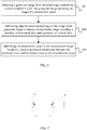
- FIG. 1 is a flowchart of a photovoltaic panel recognition method provided by the present disclosure. As shown in FIG. 1 , the method in this embodiment includes:
- Step 101 Obtaining a grayscale image of an infrared image captured by a camera mounted a UAV, the grayscale image including an image of a photovoltaic panel.
- the ground station of this embodiment is a device having computing functions and/or processing capacity.
- the device may be: a remote control, a smart phone, a tablet computer, a laptop computer, a watch, a bracelet, etc., and a combination thereof.
- the ground station 21 and the UAV 22 are connected through an application programming interface (API) 23.
- API application programming interface
- the ground station 21 and the UAV 22 can be connected wirelessly.
- the UAV may automatically cruise in an electric field according to a predetermined route, and the UAV may be controlled to cruise in the electric field by the ground station.
- the UAV carries an infrared camera, and a control apparatus mounted on the UAV or the ground performs image processing on an infrared image captured by the infrared camera to obtain a corresponding grayscale image.
- Step 102 Performing edge extraction processing on the image in the grayscale image to obtain a monochrome image including a plurality of horizontal lines and a plurality of vertical lines.
- performing edge extraction processing on the image in the grayscale image to obtain a monochrome image including a plurality of horizontal lines and a plurality of vertical lines includes: based on a preset segmentation template, a portion of the grayscale image having a grayscale value greater than a preset threshold may be set to white, and a portion of the grayscale image having a grayscale value less than the preset threshold may be set to black, to obtain a monochrome image including multiple horizontal lines and vertical lines.
- a direction of the horizontal line is defined as a first direction, and an average length of the lines in the first direction is greater than a preset length.
- a direction of the vertical line is defined as a second direction, and an average length of the lines in the second direction is smaller than the preset length.
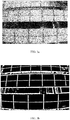
- FIG. 3a is a grayscale image of an infrared image captured by a UAV according to some embodiment of the present disclosure.
- an adaptive binary segmentation method is implemented to extract black lines in FIG. 3a to obtain a monochrome image as shown in FIG. 3a .
- a segmentation template having a size of 21 ⁇ 21 may be used to traverse the entire monochrome image, a portion having a gray value greater than or equal to the segmentation threshold (that is, the preset threshold), -5, is set to white, and a portion having a gray value smaller than -5 is set to black. Accordingly, a monochrome image as shown in FIG. 3b can be obtained.
- a plurality of white horizontal lines and white vertical lines are included in FIG. 3b . These white lines represent edges of the image in the grayscale image, which includes edges of a photovoltaic panel image.
- the purpose of this embodiment is to determine the edges of the photovoltaic panel from these horizontal and vertical lines, so as to identify the photovoltaic panel from the monochrome image.
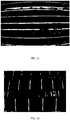
- a 21 ⁇ 1 template and a 1 ⁇ 21 template are each implemented to etch the monochrome image shown in FIG. 3b , to obtain a FIG. 3c including only white horizontal lines and a FIG. 3d including only white vertical lines.
- a horizontal line or a vertical line that should have been continuous will break, and this may cause errors during the process of searching an edge of the photovoltaic panel.
- this embodiment may further provide a method of continuously processing the horizontal lines and vertical lines in the monochrome image for a preset number of times after obtaining the monochrome image.
- the specific processing method is as follows.
- a possible processing method for each processing in the preset number of times, two lines in the same direction in the monochrome image are found. If extension lines of the two lines intersect in the monochrome image, and the distance between the two lines is less than a preset distance, then the two lines are two straight lines broken from one straight line. At this time, the two straight lines are connected.
- the above-mentioned preset distance and preset number of times can be set as needed, which is not specifically limited in this embodiment. Taking FIG. 3c as an example, a horizontal line a1 and a horizontal line a2 are on the same direction, and extension lines of the horizontal line a1 and the horizontal line a2 intersect as shown in FIG. 3c .
- FIG. 4 is a flowchart of a continuous line processing method according to some embodiment of the present disclosure. The method includes the following steps:
- FIG. 3c Still taking FIG. 3c as an example, assuming that for a pixel, P, of FIG. 3c , a total number of white pixels from 42 pixels on its left side are counted as A, a total number of white pixels from 42 pixels on its right side are counted as B, a total number of white pixels from 42 pixels above it are counted as C, and a total number of white pixels from pixels 42 below it are counted as D. If at the same time, both A and B exceed the first preset number, the white pixels located on the left and right sides of P are connected, which is repeated in the same way. After the preset number of continuous processing, the broken portion at P can be connected.
- the first preset number and the second preset number may be the same or different.
- the number of times of continuous processing i.e., the above-described preset number of times
- the number of times of continuous processing may be determined based on the number of pixels selected (e.g., 42 pixels on a side of P). In general, when more pixels are selected, the times of continuous processing may be set to be less, and when less pixels are selected, the times of continuous processing may be set to be more.
- the description herein is merely exemplary, but not exclusive limitation to the present embodiment. In fact, in actual scenarios, the number of times for continuous processing may be set based on specific needs.
- the monochrome image prior to continuous processing and the monochrome image after the continuous processing may be displayed.
- they may be displayed as shown in FIGS. 3c and 3e (or FIG. 3f ), may be displayed as shown in FIG. 3b or as an image obtained after continuous processing of the image FIG. 3b (including horizontal lines and vertical lines).
- Step 103 based on a relative positional relationship between the vertical lines and the horizontal lines in the monochrome image, identifying the photovoltaic panel from the monochrome image.
- the method of the present embodiment for identifying the photovoltaic panel in the monochrome image is as follows:
- the first horizontal line may be marked in the monochrome image, and the monochrome image with the mark may be displayed.
- the first horizontal line is marked with a dashed frame, but in actual scenarios, the first horizontal line may not be limited to the form of a dashed frame, but may be set as needed.
- a second horizontal line is searched on both sides of the first horizontal line.
- the second horizontal line satisfies the following conditions:
- an average distance between the second horizontal line and endpoints of all vertical lines crossed by the first horizontal line near the second horizontal line is less than a preset pixel distance.
- an average distance between a point on the second horizontal line and the first horizontal line is within a second preset range.
- an area formed by the first horizontal line, the second horizontal line, and the vertical lines crossed by the first horizontal line is an area where the photovoltaic panel is located.
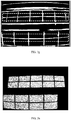
- FIG. 3b based on the monochrome image shown in FIG. 3b , the photovoltaic panel shown in FIG. 3h can be identified in FIG. 3b .
- this embodiment may further provide a step of marking the location having the photovoltaic panel in the monochrome image, and a step of displaying a monochrome image marked with this location.
- FIG. 3i shows an example of marking the photovoltaic panel in dashed frame, but it imposes no limitation to the form of the dashed frame in actual scenarios, and it may be in any form.
- a grayscale image of an infrared image captured by a camera mounted on a UAV is obtained, and edge extraction processing is performed on the image in the grayscale image to obtain a monochrome image of multiple horizontal lines and multiple vertical lines, so that a photovoltaic panel is identified in the monochrome image based on the relative positional relationship between the horizontal lines and vertical lines in the monochrome image.
- the photovoltaic panel in the electric field can be identified based on the infrared image captured by the UAV, and the purpose of inspecting the photovoltaic panel in the electric field by the UAV is achieved, thereby avoiding the waste of human resources caused by manual inspection.
- the UAV inspection method has high inspection efficiency, and the malfunctioning photovoltaic panel can be timely and accurately identified from the identification of the photovoltaic panel, which can enhance electric field power generation, improve the safety of the power generation of the electric field, and avoid the losses caused by the accumulation of photovoltaic panel problems.
- FIG. 5 is a schematic structural diagram of a ground station according to some embodiment of the present disclosure.
- the ground station 10 includes: a communication interface 11 and one or more processors 12.
- the one or more processors operate individually or in collaboration, and the communication interface 11 is connected to the processor 12.
- the communication interface 11 is configured to: obtain a grayscale image of an infrared image captured by a camera mounted on the UAV, the grayscale image including an image of a photovoltaic panel.
- the processor 12 is configured to: perform edge extraction processing on the image in the grayscale image to obtain a monochrome image which includes a plurality of horizontal lines and a plurality of vertical lines.
- the horizontal lines are lines in a first direction, and an average of the lines in the first direction is greater than a preset length, the vertical lines are in a second direction, and an average length of the lines in the second direction is less than the preset length.
- the processor 12 is configured to identify the photovoltaic panel in the monochrome image based on a relative positional relationship between the horizontal lines and the vertical lines in the monochrome image.
- the processor 12 is configured to set a portion of the grayscale image having a grayscale value greater than a preset threshold to white based on a preset segmentation template and set a portion of the grayscale image having a grayscale value less than the preset threshold to black, to obtain a monochrome image including a plurality of horizontal lines and a plurality of vertical lines.
- the processor is further configured to perform continuous processing on the vertical lines and horizontal lines in the monochrome image for a preset number of times.
- the ground station 10 further includes a displaying component 13 which is communicatively connected to the processor 12.
- the displaying component 13 is configured to display a monochrome image before the continuous processing and display a monochrome image after the continuous processing.
- the processor 12 is configured to: search for a first horizontal line in the monochrome image, the first horizontal line crossing more than three vertical lines at the same time, and a length ratio of two adjacent line segments being within a first preset range among line segments divided by the crossed vertical lines; search for a second horizontal line on both sides of the first horizontal line, an average distance between the second horizontal line and endpoints of all the vertical lines crossed by the first horizontal line near the second horizontal line being less than a preset pixel distance, or an average distance between a point on the second horizontal line and the first horizontal line being within a second preset range; and determine an area formed by the first horizontal line, the second horizontal line, and a vertical line crossed by the first horizontal line to be an area where the photovoltaic panel is located.
- the processor 12 is configured to mark the first horizontal line in the monochrome image after obtaining the first horizontal line.
- the display component 13 is configured to display a monochrome image with the mark.
- the processor 12 is configured to mark a location of the photovoltaic panel in the monochrome image.
- the display component 13 is configured to display a monochrome image marked with the location of the area.
- the ground station provided in this embodiment can implement the technical solution of the embodiment in FIG. 1 .
- the implementation manner and beneficial effects thereof are similar, and details are not described herein again.
- the embodiment of the present disclosure further provides a ground station.
- the processor 12 is configured to: set each point in the monochrome image as a base point, respectively, for each continuous processing for the preset number of times; connect pixels located on the left and right sides of the base point in a same color with the line color if both a first preset number of pixels located on a left side of the base point and the first preset number of pixels located on a right side of the base point include pixels more than the first preset number being in the same color as a line color; and connect pixel points above and below the base point in the same color as the line color if a second preset number of pixels located below the base point and the first preset number of pixels located above the base point both include pixels more than the second preset number being in the same color as the line color.
- the processor 12 is configured to connect the two lines, if extension lines of the two lines intersect in the monochrome image, and the distance between the two lines is less than a preset distance.
- the ground station provided by this embodiment can implement the technical solution of the embodiment in FIG. 4 .
- the implementation manner and beneficial effects thereof are similar, and details are not described herein again.
- FIG. 6 is a schematic structural diagram of a control apparatus according to some embodiment of the present disclosure.
- the control apparatus 20 includes a communication interface 21 and one or more processors 22.
- the one or more processors work individually or in collaboration, and the communication interface 21 is connected to the processor 22.
- the communication interface 21 is configured to obtain a grayscale image of the infrared image captured by the camera mounted on the UAV, the grayscale image including an image of a photovoltaic panel.
- the processor 22 is configured to perform edge extraction processing on the image in the grayscale image to obtain a monochrome image including a plurality of horizontal lines and a plurality of vertical lines.
- the horizontal lines are lines in a first direction, and an average length of the lines in the first direction is greater than a preset length.
- the vertical lines are lines in a second direction, and an average length of the lines in the second direction is less than the preset length.
- the processor 22 is configured to identify the photovoltaic panel in the monochrome image based on a relative positional relationship between the horizontals and the vertical lines in the monochrome image.
- the processor 22 is configured to: set a portion of the grayscale image having a grayscale value greater than a preset threshold to be white based on a preset segmentation template, and set a portion having a grayscale value less than the preset threshold to black, to obtain a monochrome image including a plurality of horizontal lines and a plurality of vertical lines.
- the processor 22 is further configured to perform continuous processing on the vertical lines and the horizontal lines in the monochrome image for a preset number of times.
- the processor 22 is configured to search for a first horizontal line in the monochrome image, the first horizontal line crossing more than three vertical lines at the same time. Among the line segments divided by the vertical lines being crossed, a length ratio between two adjacent line segments is within a first preset range.
- the processor 22 is further configured to search for a second horizontal line on both sides of the first horizontal line. An average distance between the second horizontal line and endpoints of all the vertical lines crossed by the first horizontal line near the second horizontal line is less than a preset pixel distance, or an average distance between a point of the second horizontal line and the first horizontal line is within a second preset range.
- the processor 22 is further configured to determine an area formed by the first horizontal line, the second horizontal line, and the vertical lines crossed by the first horizontal line to be an area where the photovoltaic panel is located.
- the processor 22 is configured to mark the first horizontal line in the monochrome image after obtaining the first horizontal line.
- the processor 22 is configured to mark a location of the photovoltaic panel in the monochrome image.
- control apparatus provided in this embodiment can implement the technical solution of the embodiment in FIG. 1 , and the implementation manner and beneficial effects are similar, and are not described herein again.
- the embodiment of the present disclosure further provides a control apparatus.
- the processor 22 is further configured to: set each point in the monochrome image as a base point, respectively, for each continuous processing; connect pixels located on the left and right sides of the base point in a same color with the line color if both a first preset number of pixels located on a left side of the base point and the first preset number of pixels located on a right side of the base point include pixels more than the first preset number being in the same color as a line color; and connect pixel points above and below the base point in the same color as the line color if a second preset number of pixels located below the base point and the first preset number of pixels located above the base point both include pixels more than the second preset number being in the same color as the line color.
- the processor 22 is further configured to connect the two lines, if extension lines of the two lines intersect in the monochrome image, and the distance between the two lines is less than a preset distance.
- control apparatus provided in this embodiment can implement the technical solution of the embodiment in FIG. 4 .
- the implementation manner and beneficial effects thereof are similar, and details are not described herein again.
- the UAV includes: a body, a power system mounted on the body for supplying flight power, an infrared camera mounted on the body for capturing infrared images, and the control apparatus according to the above embodiment.
- the disclosed apparatus and method may be implemented in other ways.
- the device embodiments described above are only schematic.
- the division of the unit is only a logical function division.
- multiple units or components may be combined or may be integrated into another system, or some features can be ignored or not implemented.
- a mutual coupling or direct coupling or connection as shown or discussed, may be through indirect coupling or connection of some interfaces, devices or units, which may be electrical, mechanical or other forms.
- the units described as separate components may or may not be physically separated, and the components displayed as units may or may not be physical units, that is, may be located in one place, or may be distributed on multiple network units. Some or all of the units may be selected according to actual needs to achieve the objective of the solution of this embodiment.
- each functional unit in each embodiment of the present disclosure may be integrated into one processing unit, or each unit may exist separately physically, or two or more units may be integrated into one unit.
- the above integrated unit may be implemented in the form of hardware, or in the form of hardware plus software functional units.
- the above integrated unit implemented in the form of a software functional unit may be stored in a computer-readable storage medium.
- the above software functional unit is stored in a storage medium, including several instructions for causing a computer device (which may be a personal computer, a server, or a network device) or a processor to implement the methods described in the embodiments of the present disclosure Some steps.
- the foregoing storage medium includes: flash drive, movable hard disks, read-only memory (ROM), random-access memory (RAM), magnetic disks or optical disks, and other mediums that can store program codes.
Landscapes
- Engineering & Computer Science (AREA)
- Physics & Mathematics (AREA)
- General Physics & Mathematics (AREA)
- Theoretical Computer Science (AREA)
- Computer Vision & Pattern Recognition (AREA)
- Multimedia (AREA)
- Quality & Reliability (AREA)
- Image Analysis (AREA)
- Image Processing (AREA)
Abstract
Description
- The present disclosure relates to the technical field of unmanned aerial vehicle (UAV), and in particular relates to a photovoltaic panel recognition method, an apparatus, and a UAV.
- A photovoltaic panel is a device that converts light energy into electricity. When it is exposed to sunlight, it collects heat and converts light energy into direct current. Often, also due to its long-term exposure to sunlight, it is more prone to strain and damage.
- Existing technologies for maintaining photovoltaic panels generally include two methods: manual inspection and inverter monitoring. The manual inspection requires technicians to regularly visit the project site for inspection, which generates a large workload and the efficiency is low. The inverter monitoring method, the inverter monitors a total current or voltage of the photovoltaic panels in a certain area in real time. When an abnormality occurs in the current or voltage in the area, it can only be determined that the photovoltaic panels in the area may be malfunctioning and it is impossible to pinpoint which photovoltaic panel is malfunctioning. Accordingly, technicians are still required to go to the site for troubleshooting, and the problem of low efficiency still remains.
- Embodiments of the present disclosure provide a method, an apparatus, and a UAV for identifying a photovoltaic panel to improve a detection efficiency of the photovoltaic panel in an electric field.
- A first aspect of the embodiments of the present disclosure provides a method for identifying a photovoltaic panel, including: acquiring a grayscale image of an infrared image captured by a camera mounted on a UAV, the grayscale image including an image of a photovoltaic panel; performing edge extraction processing on the image in the grayscale image to obtain a monochrome image including a plurality of horizontal lines and a plurality of vertical lines, the horizontal lines being lines in a first direction, an average length being greater than a preset length, the vertical line being a line in a second direction, and an average length of the line in the second direction being less than the preset length; and identifying the photovoltaic panel the monochrome image based on a relative positional relationship between the horizontal lines and the vertical lines in the monochrome image.
- A second aspect of the embodiments of the present disclosure is to provide a ground station, including: a communication interface, and one or more processors. The one or more processors operate individually or in collaboration, and the communication interface is connected to the one or more processors.
- The communication interface is configured to obtain a grayscale image of an infrared image captured by a camera mounted on the UAV, and the grayscale image includes an image of a photovoltaic panel.
- The processor is configured to perform edge extraction processing on an image in the grayscale image to obtain a monochrome image including a plurality of horizontal lines and a plurality of vertical lines. The horizontal lines are lines in a first direction, a first average length of the lines in one direction is greater than a preset length, the vertical lines are lines in a second direction, and an average length of the lines in the second direction is less than the preset length.
- The processor is configured to identify the photovoltaic panel from the monochrome image based on a relative positional relationship between the horizontal lines and the vertical lines in the monochrome image.
- A third aspect of the embodiments of the present disclosure is to provide a control apparatus, including: a communication interface, and one or more processors. The one or more processors operate individually or in collaboration, and the communication interface is connected to the one or more processors.
- The communication interface is configured to obtain a grayscale image of an infrared image captured by a camera mounted on the UAV, the grayscale image including an image of a photovoltaic panel.
- The processor is configured to perform edge extraction processing on an image in the grayscale image to obtain a monochrome image including a plurality of horizontal lines and a plurality of vertical lines. The horizontal lines are lines in a first direction, a first average length of the lines in one direction is greater than the preset length, the vertical lines are lines in a second direction, and an average length of the lines in the second direction is less than the preset length.
- The processor is configured to identify the photovoltaic panel from the monochrome image based on a relative position relationship between the horizontal lines and the vertical lines in the monochrome image.
- A fourth aspect of the embodiments of the present disclosure provides a UAV, including: a body, a power system mounted on the body for supplying flight power, an infrared camera mounted on the body configured to capture infrared images, and the control apparatus according to the third aspect.
- In the photovoltaic panel recognition method, the apparatus, and the UAV provided by the embodiments of the present disclosure, a grayscale image of an infrared image captured by a camera mounted on the UAV is acquired, and edge extraction processing on the image in the grayscale image is performed to obtain a monochrome image including a plurality of horizontal lines and a plurality of vertical lines, thereby identifying a photovoltaic panel from the monochrome image based on a relative positional relationship between the horizontal lines and the vertical lines in the monochrome image. As such, a photovoltaic panel in the electric field can be inspected by a UAV by identifying the photovoltaic panel in the electric field based on the infrared image captured by the UAV, thereby avoiding the waste of human resources caused by manual inspection. Compared with the existing manual inspection method and the inverter monitoring method, the UAV inspection method has high inspection efficiency, and the malfunctioning photovoltaic panel can be timely and accurately identified based on the identification of the photovoltaic panel, which can enhance the safety of electric field power generation, improve the power generation of the electric field, and avoid the losses caused by the accumulation of photovoltaic panel problems.
-
-
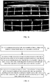
FIG. 1 is a flowchart of a photovoltaic panel recognition method provided by the present disclosure; -
FIG. 2 is a schematic diagram of a connection between a ground station and a UAV consistent with the embodiments of the present disclosure; -
FIG. 3a is a grayscale image of an infrared image captured by a UAV according to some embodiment of the present disclosure; -
FIG. 3b is a monochrome image obtained from the grayscale image shown inFIG. 3a ; -
FIG. 3c is another monochrome image obtained from the monochrome image shown inFIG. 3b ; -
FIG. 3d is another monochrome image obtained from the monochrome image shown inFIG. 3b ; -
FIG. 3e is a monochrome image obtained after continuous processing of the image inFIG. 3c ; -
FIG. 3f is a monochrome image obtained after continuous processing of the image inFIG. 3c ; -
FIG. 3g is a monochrome image after marking a first horizontal line; -
FIG. 3h is a monochrome image after identifying a photovoltaic panel. -
FIG. 3i is a monochrome image after marking the photovoltaic panel; -
FIG. 4 is a flowchart of a continuous line processing method according to some embodiment of the present disclosure; -
FIG. 5 is a schematic structural diagram of a ground station according to some embodiment of the present disclosure; and -
FIG. 6 is a schematic structural diagram of a control apparatus according to some embodiment of the present disclosure. - The technical solutions in the embodiments of the present disclosure will be clearly described below with reference to the accompanying drawings in the embodiments of the present disclosure. Obviously, the described embodiments are only a portion of the embodiments of the present disclosure, but not all the embodiments. Based on the embodiments of the present disclosure, all other embodiments obtained by a person of ordinary skill in the art without creative efforts shall fall within the protected scope of the present disclosure.
- It should be noted that when a component is called "fixed to" another component, it may be directly placed on another component or be placed on an intermediate component which is on the component. When a component is considered to be "connected" to another component, it can be directly connected to another component or a connecting component may exist at the same time.
- Unless defined otherwise, all technical and scientific terminology used here have the same meaning as commonly understood by one of ordinary skill in the art to which this disclosure relates. The terminology used in the description of the present disclosure is only for the purpose of describing specific embodiments, and is not intended to limit the present disclosure. The term "and/or" as used herein includes any and all combinations of one or more of the associated listed items.
- Hereinafter, some embodiments of the present disclosure will be described in detail with reference to the drawings. When causing no conflicts, the following embodiments and features in the embodiments can be combined with each other.
- According to some embodiment of the present disclosure, a method for identifying a photovoltaic panel is provided. The method may be performed by a ground station or a control apparatus mounted on a UAV. The following embodiments are specifically described by taking a ground station as an example. An execution manner of the control apparatus is similar to that of a ground station, and details are not described in this embodiment. Referring to
FIG. 1, FIG. 1 is a flowchart of a photovoltaic panel recognition method provided by the present disclosure. As shown inFIG. 1 , the method in this embodiment includes: - Step 101: Obtaining a grayscale image of an infrared image captured by a camera mounted a UAV, the grayscale image including an image of a photovoltaic panel.
- The ground station of this embodiment is a device having computing functions and/or processing capacity. Specifically, the device may be: a remote control, a smart phone, a tablet computer, a laptop computer, a watch, a bracelet, etc., and a combination thereof.
- As shown in
FIG. 2 , theground station 21 and theUAV 22 are connected through an application programming interface (API) 23. Specifically, theground station 21 and theUAV 22 can be connected wirelessly. For example, they connected in at least one of the following ways: wireless fidelity (Wi-Fi), Bluetooth, software defined radio (SDR), or other custom protocols. - Optionally, in this embodiment, the UAV may automatically cruise in an electric field according to a predetermined route, and the UAV may be controlled to cruise in the electric field by the ground station.
- In this embodiment, the UAV carries an infrared camera, and a control apparatus mounted on the UAV or the ground performs image processing on an infrared image captured by the infrared camera to obtain a corresponding grayscale image.
- Step 102: Performing edge extraction processing on the image in the grayscale image to obtain a monochrome image including a plurality of horizontal lines and a plurality of vertical lines.
- Optionally, according to this embodiment, performing edge extraction processing on the image in the grayscale image to obtain a monochrome image including a plurality of horizontal lines and a plurality of vertical lines includes: based on a preset segmentation template, a portion of the grayscale image having a grayscale value greater than a preset threshold may be set to white, and a portion of the grayscale image having a grayscale value less than the preset threshold may be set to black, to obtain a monochrome image including multiple horizontal lines and vertical lines. In this embodiment, a direction of the horizontal line is defined as a first direction, and an average length of the lines in the first direction is greater than a preset length. In this embodiment, a direction of the vertical line is defined as a second direction, and an average length of the lines in the second direction is smaller than the preset length.
- For example,
FIG. 3a is a grayscale image of an infrared image captured by a UAV according to some embodiment of the present disclosure. Based onFIG. 3a , an adaptive binary segmentation method is implemented to extract black lines inFIG. 3a to obtain a monochrome image as shown inFIG. 3a . For example, a segmentation template having a size of 21 ∗ 21 may be used to traverse the entire monochrome image, a portion having a gray value greater than or equal to the segmentation threshold (that is, the preset threshold), -5, is set to white, and a portion having a gray value smaller than -5 is set to black. Accordingly, a monochrome image as shown inFIG. 3b can be obtained. Of course, only a 21 ∗ 21 segmentation template and a preset threshold of -5 are taken here for illustration, but they are not the specific limitation on the method to obtain the monochrome image. In fact, in actual scenarios, different segmentation templates and different preset thresholds can be used to obtain the required monochrome image. - A plurality of white horizontal lines and white vertical lines are included in
FIG. 3b . These white lines represent edges of the image in the grayscale image, which includes edges of a photovoltaic panel image. The purpose of this embodiment is to determine the edges of the photovoltaic panel from these horizontal and vertical lines, so as to identify the photovoltaic panel from the monochrome image. - Further, in this embodiment, a 21 ∗ 1 template and a 1 ∗ 21 template are each implemented to etch the monochrome image shown in
FIG. 3b , to obtain aFIG. 3c including only white horizontal lines and aFIG. 3d including only white vertical lines. As shown inFIG. 3c and FIG. 3d , in some scenarios, a horizontal line or a vertical line that should have been continuous will break, and this may cause errors during the process of searching an edge of the photovoltaic panel. In order to avoid the errors caused in the above situation, this embodiment may further provide a method of continuously processing the horizontal lines and vertical lines in the monochrome image for a preset number of times after obtaining the monochrome image. The specific processing method is as follows. - In a possible processing method, for each processing in the preset number of times, two lines in the same direction in the monochrome image are found. If extension lines of the two lines intersect in the monochrome image, and the distance between the two lines is less than a preset distance, then the two lines are two straight lines broken from one straight line. At this time, the two straight lines are connected. In this processing method, the above-mentioned preset distance and preset number of times can be set as needed, which is not specifically limited in this embodiment. Taking
FIG. 3c as an example, a horizontal line a1 and a horizontal line a2 are on the same direction, and extension lines of the horizontal line a1 and the horizontal line a2 intersect as shown inFIG. 3c . Assuming that if the distance between the horizontal line a1 and the horizontal line a2 is smaller than the preset distance, then the horizontal line a1 and the horizontal line a2 are connected as shown inFIG. 3c to form a completed horizontal line, and to obtainFIG. 3e . - In another possible processing method, the processing method is shown in
FIG. 4. FIG. 4 is a flowchart of a continuous line processing method according to some embodiment of the present disclosure. The method includes the following steps: - Step 401: For each continuous processing in the preset number of times, setting each point in the monochrome image as a base point, respectively.
- Step 402: If both a first preset number of pixels located on a left side of the base point and the first preset number of pixels located on a right side of the base point include pixels more than the first preset number being in a same color as a line color, connecting pixels located on the left and right sides of the base point being in the same color with the line color.
- Step 403: If a second preset number of pixels located below the base point and the first preset number of pixels located above the base point both include pixels more than the second preset number in the same color as the line color, connecting pixel points above and below the base point being in the same color as the line color.
- Still taking
FIG. 3c as an example, assuming that for a pixel, P, ofFIG. 3c , a total number of white pixels from 42 pixels on its left side are counted as A, a total number of white pixels from 42 pixels on its right side are counted as B, a total number of white pixels from 42 pixels above it are counted as C, and a total number of white pixels from pixels 42 below it are counted as D. If at the same time, both A and B exceed the first preset number, the white pixels located on the left and right sides of P are connected, which is repeated in the same way. After the preset number of continuous processing, the broken portion at P can be connected. Similarly, if both C and D exceed the second preset number, the white points located above and below P are connected. But fromFIG. 3c , no breakage exists above and below P. Therefore, only the white pixels on the left and ride sides of P are connected, and the pixels above and below P are not connected. Accordingly, a monochrome image shown inFIG 3f is obtained. - It should be noted that, in this embodiment the first preset number and the second preset number may be the same or different. The number of times of continuous processing (i.e., the above-described preset number of times) can be set as needed. In this embodiment, for example, the number of times of continuous processing may be determined based on the number of pixels selected (e.g., 42 pixels on a side of P). In general, when more pixels are selected, the times of continuous processing may be set to be less, and when less pixels are selected, the times of continuous processing may be set to be more. However, the description herein is merely exemplary, but not exclusive limitation to the present embodiment. In fact, in actual scenarios, the number of times for continuous processing may be set based on specific needs.
- Optionally, to increase the visual processing effect, in the present embodiment, the monochrome image prior to continuous processing and the monochrome image after the continuous processing may be displayed. For example, they may be displayed as shown in
FIGS. 3c and3e (or FIG. 3f ), may be displayed as shown inFIG. 3b or as an image obtained after continuous processing of the imageFIG. 3b (including horizontal lines and vertical lines). - Step 103: based on a relative positional relationship between the vertical lines and the horizontal lines in the monochrome image, identifying the photovoltaic panel from the monochrome image.
- Optionally, the method of the present embodiment for identifying the photovoltaic panel in the monochrome image is as follows:
- First, in the obtained monochrome image, searching for a first horizontal line that simultaneously crosses more than three vertical lines. Among line segments of the first horizontal line divided by the vertical lines being crossed, the length ratio of two adjacent line segments being in a first preset range.
- Optionally, as shown in
FIG. 3g , after the first horizontal line is obtained, in this embodiment, the first horizontal line may be marked in the monochrome image, and the monochrome image with the mark may be displayed. As an example, inFIG. 3g , the first horizontal line is marked with a dashed frame, but in actual scenarios, the first horizontal line may not be limited to the form of a dashed frame, but may be set as needed. - Further, based on the first horizontal line, a second horizontal line is searched on both sides of the first horizontal line. The second horizontal line satisfies the following conditions:
- In a possible condition, an average distance between the second horizontal line and endpoints of all vertical lines crossed by the first horizontal line near the second horizontal line is less than a preset pixel distance.
- In another possible condition, an average distance between a point on the second horizontal line and the first horizontal line is within a second preset range.
- Accordingly, an area formed by the first horizontal line, the second horizontal line, and the vertical lines crossed by the first horizontal line is an area where the photovoltaic panel is located. Taking
FIG. 3b as an example, based on the monochrome image shown inFIG. 3b , the photovoltaic panel shown inFIG. 3h can be identified inFIG. 3b . - Optionally, as shown in
FIG. 3i , after the photovoltaic panel is identified in the monochrome image, this embodiment may further provide a step of marking the location having the photovoltaic panel in the monochrome image, and a step of displaying a monochrome image marked with this location.FIG. 3i shows an example of marking the photovoltaic panel in dashed frame, but it imposes no limitation to the form of the dashed frame in actual scenarios, and it may be in any form. - In the photovoltaic panel recognition method provided in this embodiment a grayscale image of an infrared image captured by a camera mounted on a UAV is obtained, and edge extraction processing is performed on the image in the grayscale image to obtain a monochrome image of multiple horizontal lines and multiple vertical lines, so that a photovoltaic panel is identified in the monochrome image based on the relative positional relationship between the horizontal lines and vertical lines in the monochrome image. As such, the photovoltaic panel in the electric field can be identified based on the infrared image captured by the UAV, and the purpose of inspecting the photovoltaic panel in the electric field by the UAV is achieved, thereby avoiding the waste of human resources caused by manual inspection. Compared with the existing manual inspection and inverter monitoring methods, the UAV inspection method has high inspection efficiency, and the malfunctioning photovoltaic panel can be timely and accurately identified from the identification of the photovoltaic panel, which can enhance electric field power generation, improve the safety of the power generation of the electric field, and avoid the losses caused by the accumulation of photovoltaic panel problems.
- According to some embodiment of the present disclosure, a ground station is provided, and the ground station may be the ground station described in the foregoing embodiment.
FIG. 5 is a schematic structural diagram of a ground station according to some embodiment of the present disclosure. As shown inFIG. 5 , theground station 10 includes: acommunication interface 11 and one ormore processors 12. The one or more processors operate individually or in collaboration, and thecommunication interface 11 is connected to theprocessor 12. Thecommunication interface 11 is configured to: obtain a grayscale image of an infrared image captured by a camera mounted on the UAV, the grayscale image including an image of a photovoltaic panel. Theprocessor 12 is configured to: perform edge extraction processing on the image in the grayscale image to obtain a monochrome image which includes a plurality of horizontal lines and a plurality of vertical lines. The horizontal lines are lines in a first direction, and an average of the lines in the first direction is greater than a preset length, the vertical lines are in a second direction, and an average length of the lines in the second direction is less than the preset length. Theprocessor 12 is configured to identify the photovoltaic panel in the monochrome image based on a relative positional relationship between the horizontal lines and the vertical lines in the monochrome image. - Optionally, the
processor 12 is configured to set a portion of the grayscale image having a grayscale value greater than a preset threshold to white based on a preset segmentation template and set a portion of the grayscale image having a grayscale value less than the preset threshold to black, to obtain a monochrome image including a plurality of horizontal lines and a plurality of vertical lines. - Optionally, the processor is further configured to perform continuous processing on the vertical lines and horizontal lines in the monochrome image for a preset number of times.
- Optionally, the
ground station 10 further includes a displayingcomponent 13 which is communicatively connected to theprocessor 12. The displayingcomponent 13 is configured to display a monochrome image before the continuous processing and display a monochrome image after the continuous processing. - Optionally, the
processor 12 is configured to: search for a first horizontal line in the monochrome image, the first horizontal line crossing more than three vertical lines at the same time, and a length ratio of two adjacent line segments being within a first preset range among line segments divided by the crossed vertical lines; search for a second horizontal line on both sides of the first horizontal line, an average distance between the second horizontal line and endpoints of all the vertical lines crossed by the first horizontal line near the second horizontal line being less than a preset pixel distance, or an average distance between a point on the second horizontal line and the first horizontal line being within a second preset range; and determine an area formed by the first horizontal line, the second horizontal line, and a vertical line crossed by the first horizontal line to be an area where the photovoltaic panel is located. - Optionally, the
processor 12 is configured to mark the first horizontal line in the monochrome image after obtaining the first horizontal line. - The
display component 13 is configured to display a monochrome image with the mark. - Optionally, the
processor 12 is configured to mark a location of the photovoltaic panel in the monochrome image. - The
display component 13 is configured to display a monochrome image marked with the location of the area. - The ground station provided in this embodiment can implement the technical solution of the embodiment in
FIG. 1 . The implementation manner and beneficial effects thereof are similar, and details are not described herein again. - The embodiment of the present disclosure further provides a ground station. Based on the embodiment of
FIG. 5 , theprocessor 12 is configured to: set each point in the monochrome image as a base point, respectively, for each continuous processing for the preset number of times; connect pixels located on the left and right sides of the base point in a same color with the line color if both a first preset number of pixels located on a left side of the base point and the first preset number of pixels located on a right side of the base point include pixels more than the first preset number being in the same color as a line color; and connect pixel points above and below the base point in the same color as the line color if a second preset number of pixels located below the base point and the first preset number of pixels located above the base point both include pixels more than the second preset number being in the same color as the line color. - Alternatively, the
processor 12 is configured to connect the two lines, if extension lines of the two lines intersect in the monochrome image, and the distance between the two lines is less than a preset distance. - The ground station provided by this embodiment can implement the technical solution of the embodiment in
FIG. 4 . The implementation manner and beneficial effects thereof are similar, and details are not described herein again. - According to some embodiment of the present disclosure, a control apparatus is provided. Referring to
FIG. 6, FIG. 6 is a schematic structural diagram of a control apparatus according to some embodiment of the present disclosure. As shown inFIG. 6 , thecontrol apparatus 20 includes acommunication interface 21 and one ormore processors 22. The one or more processors work individually or in collaboration, and thecommunication interface 21 is connected to theprocessor 22. Thecommunication interface 21 is configured to obtain a grayscale image of the infrared image captured by the camera mounted on the UAV, the grayscale image including an image of a photovoltaic panel. Theprocessor 22 is configured to perform edge extraction processing on the image in the grayscale image to obtain a monochrome image including a plurality of horizontal lines and a plurality of vertical lines. The horizontal lines are lines in a first direction, and an average length of the lines in the first direction is greater than a preset length. The vertical lines are lines in a second direction, and an average length of the lines in the second direction is less than the preset length. Theprocessor 22 is configured to identify the photovoltaic panel in the monochrome image based on a relative positional relationship between the horizontals and the vertical lines in the monochrome image. - Optionally, the
processor 22 is configured to: set a portion of the grayscale image having a grayscale value greater than a preset threshold to be white based on a preset segmentation template, and set a portion having a grayscale value less than the preset threshold to black, to obtain a monochrome image including a plurality of horizontal lines and a plurality of vertical lines. - Optionally, the
processor 22 is further configured to perform continuous processing on the vertical lines and the horizontal lines in the monochrome image for a preset number of times. - Optionally, the
processor 22 is configured to search for a first horizontal line in the monochrome image, the first horizontal line crossing more than three vertical lines at the same time. Among the line segments divided by the vertical lines being crossed, a length ratio between two adjacent line segments is within a first preset range. Theprocessor 22 is further configured to search for a second horizontal line on both sides of the first horizontal line. An average distance between the second horizontal line and endpoints of all the vertical lines crossed by the first horizontal line near the second horizontal line is less than a preset pixel distance, or an average distance between a point of the second horizontal line and the first horizontal line is within a second preset range. Theprocessor 22 is further configured to determine an area formed by the first horizontal line, the second horizontal line, and the vertical lines crossed by the first horizontal line to be an area where the photovoltaic panel is located. - Optionally, the
processor 22 is configured to mark the first horizontal line in the monochrome image after obtaining the first horizontal line. - Optionally, the
processor 22 is configured to mark a location of the photovoltaic panel in the monochrome image. - The control apparatus provided in this embodiment can implement the technical solution of the embodiment in
FIG. 1 , and the implementation manner and beneficial effects are similar, and are not described herein again. - The embodiment of the present disclosure further provides a control apparatus. Based on the embodiment in
FIG. 6 , theprocessor 22 is further configured to: set each point in the monochrome image as a base point, respectively, for each continuous processing; connect pixels located on the left and right sides of the base point in a same color with the line color if both a first preset number of pixels located on a left side of the base point and the first preset number of pixels located on a right side of the base point include pixels more than the first preset number being in the same color as a line color; and connect pixel points above and below the base point in the same color as the line color if a second preset number of pixels located below the base point and the first preset number of pixels located above the base point both include pixels more than the second preset number being in the same color as the line color. - Alternatively, the
processor 22 is further configured to connect the two lines, if extension lines of the two lines intersect in the monochrome image, and the distance between the two lines is less than a preset distance. - The control apparatus provided in this embodiment can implement the technical solution of the embodiment in
FIG. 4 . The implementation manner and beneficial effects thereof are similar, and details are not described herein again. - Some embodiment of the present disclosure provides a UAV. The UAV includes: a body, a power system mounted on the body for supplying flight power, an infrared camera mounted on the body for capturing infrared images, and the control apparatus according to the above embodiment.
- The implementation method and beneficial effects of the UAV provided by this embodiment are the same as those of the control apparatus involved in the foregoing embodiment, and details are not described herein again.
- In some embodiments provided by the present disclosure, it can be understood that the disclosed apparatus and method may be implemented in other ways. For example, the device embodiments described above are only schematic. For example, the division of the unit is only a logical function division. In actual implementation, there may be other division manners. For example, multiple units or components may be combined or may be integrated into another system, or some features can be ignored or not implemented. In addition, a mutual coupling or direct coupling or connection, as shown or discussed, may be through indirect coupling or connection of some interfaces, devices or units, which may be electrical, mechanical or other forms.
- The units described as separate components may or may not be physically separated, and the components displayed as units may or may not be physical units, that is, may be located in one place, or may be distributed on multiple network units. Some or all of the units may be selected according to actual needs to achieve the objective of the solution of this embodiment.
- In addition, each functional unit in each embodiment of the present disclosure may be integrated into one processing unit, or each unit may exist separately physically, or two or more units may be integrated into one unit. The above integrated unit may be implemented in the form of hardware, or in the form of hardware plus software functional units.
- The above integrated unit implemented in the form of a software functional unit may be stored in a computer-readable storage medium. The above software functional unit is stored in a storage medium, including several instructions for causing a computer device (which may be a personal computer, a server, or a network device) or a processor to implement the methods described in the embodiments of the present disclosure Some steps. The foregoing storage medium includes: flash drive, movable hard disks, read-only memory (ROM), random-access memory (RAM), magnetic disks or optical disks, and other mediums that can store program codes.
- Those skilled in the art can clearly understand that for the convenience and brevity of the description, only the division of the above-mentioned functional modules is taken as an example. In actual applications, the above-mentioned functions can be allocated by different functional modules according to needs, that is, an internal structure of the device is divided into different functional modules to complete all or portion of the functions described above. For the specific operating process of the device described above, reference may be made to the corresponding process in the foregoing method embodiments, and details are not described herein again.
- Finally, it should be noted that the above embodiments are only used to illustrate but not to limit the technical solution of the present disclosure. Although the present disclosure has been described in detail with reference to the foregoing embodiments, those skilled in the art should understand that the technical solutions described in the foregoing embodiments can still be modified, or some or all of the technical features can be equivalently substituted; and these modifications or substitutions do not cause the essence of the corresponding technical solutions to depart from the range of the technical solutions of present disclosure.
Claims (27)
- A method for identifying a photovoltaic panel, comprising:acquiring a grayscale image of an infrared image captured by a camera mounted on a UAV, the grayscale image including an image of a photovoltaic panel;performing edge extraction processing on an image in the grayscale image to obtain a monochrome image including a plurality of horizontal lines and a plurality of vertical lines, the horizontal lines being lines in a first direction, an average length of the lines in the first direction being greater than a preset length, the vertical lines being lines in a second direction, and an average length of the lines in the second direction being less than the preset length; andidentifying the photovoltaic panel in the monochrome image based on a relative positional relationship between the horizontal lines and the vertical lines in the monochrome image.
- The method according to claim 1, wherein performing edge extraction processing on an image in the grayscale image to obtain a monochrome image including a plurality of horizontal lines and a plurality of vertical lines comprises:
setting a portion of the grayscale image having a grayscale value greater than a preset threshold to white based on a preset segmentation template, and setting a portion of the grayscale image having a grayscale value less than the preset threshold to black to obtain a monochrome image including the plurality of horizontal lines and the plurality of vertical lines. - The method according to claim 1, wherein before identifying the photovoltaic panel in the monochrome image, based on the relative positional relationship between the horizontal lines and the vertical lines in the monochrome image, the method further comprises:
performing continuous processing on the vertical lines and the horizontal lines in the monochrome image for a preset number of times. - The method according to claim 3, wherein performing continuous processing on the vertical lines and the horizontal lines in the monochrome image for a preset number of times comprises:for each continuous processing, setting each point in the monochrome image as a base point;if both a first preset number of pixels located on a left side of the base point and the first preset number of pixels located on a right side of the base point include pixels more than the first preset number being in a same color as a line color, connecting pixels located on the left and right sides of the base point being in the same color with the line color; andif a second preset number of pixels located below the base point and the first preset number of pixels located above the base point both include pixels more than the second preset number in the same color as the line color, connecting pixel points above and below the base point being in the same color as the line color.
- The method according to claim 3, wherein performing continuous processing on the vertical lines and the horizontal lines in the monochrome image for a preset number of times comprises:
for each continuous processing, if extension lines of two lines intersect in the monochrome image, and a distance between the two lines is less than a preset distance, connecting the two lines into one line. - The method according to any one of claims 3-5, wherein the method further comprises:
displaying a monochrome image before the continuous processing and displaying a monochrome image after the continuous processing. - The method according to claim 6, wherein the identifying the photovoltaic panel in the monochrome image based on the relative positional relationship between the horizontal lines and the vertical lines in the monochrome image comprises:searching for a first horizontal line in the monochrome image, the first horizontal line simultaneously crossing more than three vertical lines, and among the line segments divided by the vertical lines being crossed, a length ratio between two adjacent line segments being within a first preset range;searching for a second horizontal line on both sides of the first horizontal line, an average distance between the second horizontal line and endpoints of all the vertical lines crossed by the first horizontal line near the second horizontal line being less than a preset pixel distance, or an average distance between a point of the second horizontal line and the first horizontal line being within a second preset range; anddetermining an area formed by the first horizontal line, the second horizontal line, and the vertical lines crossed by the first horizontal line to be an area where the photovoltaic panel is located.
- The method according to claim 7, further comprising:after finding the first horizontal line, marking the first horizontal line in the monochrome image; anddisplaying a monochrome image with the mark.
- The method according to claim 1, wherein based on the relative positional relationship between the horizontal lines and the vertical lines in the monochrome image, after identifying the photovoltaic panel in the monochrome image, the method further comprises:marking a location of the photovoltaic panel in the monochrome image;displaying the monochrome image marked with the location.
- A ground station, comprising:a communication interface, andone or more processors, the one or more processors operating individually or in collaboration, and the communication interface being connected to the processor; wherein:the communication interface is configured to obtain a grayscale image of an infrared image captured by a camera mounted on the UAV, the grayscale image including an image of a photovoltaic panel;the processor is configured to perform edge extraction processing on an image in the grayscale image to obtain a monochrome image including a plurality of horizontal lines and a plurality of vertical lines, the horizontal lines being lines in a first direction, an average length of the lines in the first direction being greater than a preset length, the vertical lines being lines in a second direction, and an average length of the lines in the second direction being less than the preset length; andthe processor is configured to identify the photovoltaic panel in the monochrome image based on a relative position relationship between the horizontal lines and the vertical lines in the monochrome image.
- The ground station according to claim 10, wherein the processor is configured to set a portion of the grayscale image having a grayscale value greater than a preset threshold to white based on a preset segmentation template and a portion of the grayscale image having a grayscale value less than the preset threshold to black, to obtain a monochrome image including a plurality of horizontal lines and a plurality of vertical lines.
- The ground station according to claim 10, wherein the processor is further configured to perform continuous processing on the vertical lines and the horizontal lines in the monochrome image for a preset number of times.
- The ground station according to claim 12, wherein the processor is configured to:for each continuous processing, set each point in the monochrome image as a base point;if both a first preset number of pixels located on a left side of the base point and the first preset number of pixels located on a right side of the base point include pixels more than the first preset number being in a same color as a line color, connect pixels located on the left and right sides of the base point being in the same color with the line color; andif a second preset number of pixels located below the base point and the first preset number of pixels located above the base point both include pixels more than the second preset number in the same color as the line color, connect pixel points above and below the base point being in the same color as the line color.
- The ground station according to claim 12, wherein the processor is configured to: for each continuous processing, if extension lines of two lines intersect in the monochrome image, and the distance between the two lines is less than a preset distance, connect the two lines into one line.
- The ground station according to any one of claims 12-14, wherein the ground station further comprises: a displaying component, the displaying component being connected to the processor;
the displaying component is configured to display a monochrome image before the continuous processing and display a monochrome image after the continuous processing. - The ground station according to claim 15, wherein the processor is configured to:search for a first horizontal line in the monochrome image, the first horizontal line simultaneously crossing more than three vertical lines, and among the line segments divided by the vertical lines being crossed, a length ratio between two adjacent line segments being within a first preset range;search for a second horizontal line on both sides of the first horizontal line, an average distance between the second horizontal line and endpoints of all the vertical lines crossed by the first horizontal line near the second horizontal line being less than a preset pixel distance, or an average distance between a point of the second horizontal line and the first horizontal line being within a second preset range; anddetermine an area formed by the first horizontal line, the second horizontal line, and the vertical lines crossed by the first horizontal line to be an area where the photovoltaic panel is located.
- The ground station according to claim 16, wherein:the processor is configured to mark the first horizontal line in the monochrome image after obtaining the first horizontal lines; andthe displaying component is configured to display a monochrome image with the mark.
- The ground station according to claim 10, wherein:the processor is configured to mark the location having the photovoltaic panel in the monochrome image; andthe displaying component is configured to display the monochrome image marked with the location.
- A control apparatus, comprising:a communication interface, andone or more processors;the one or more processors being configured to work individually or in collaboration, and the communication interface being connected to the processor;the communication interface being configured to obtain a grayscale image of an infrared image captured by a camera mounted on a UAV, the grayscale image including an image of a photovoltaic panel;the processor further being configured to perform edge extraction processing on an image in the grayscale image to obtain a monochrome image including a plurality of horizontal lines and a plurality of vertical lines, the horizontal lines being lines in a first direction, a first average length of the lines in the first direction being greater than a preset length, the vertical lines being lines in a second direction, and an average length of the lines in the second direction being less than the preset length; and to identify the photovoltaic panel from the monochrome image based on a relative position relationship between the horizontal lines and the vertical lines in the monochrome image.
- The control apparatus according to claim 19, wherein the processor is configured to set a portion of the grayscale image having a grayscale value greater than a preset threshold to white based on a preset segmentation template and set a portion of the grayscale image having a grayscale value less than the preset threshold to black, to obtain the monochrome image including the plurality of horizontal lines and the plurality of vertical lines.
- The control apparatus according to claim 19, wherein the processor is further configured to perform continuous processing for a preset number of times on the vertical lines and the horizontal lines in the monochrome image.
- The control apparatus according to claim 21, wherein the processor is configured to:for each continuous processing, set each point in the monochrome image as a base point;if both a first preset number of pixels located on a left side of the base point and the first preset number of pixels located on a right side of the base point include pixels more than the first preset number being in a same color as a line color, connect pixels located on the left and right sides of the base point being in the same color with the line color; andif a second preset number of pixels located below the base point and the first preset number of pixels located above the base point both include pixels more than the second preset number in the same color as the line color, connect pixel points above and below the base point being in the same color as the line color.
- The control apparatus according to claim 22, wherein the processor is configured to: for each continuous processing, if extension lines of two lines in the same direction intersect in the monochrome image and a distance between the two lines is less than a preset distance, connect the two lines into one line.
- The control apparatus according to any one of claims 19-23, wherein the processor is configured to:search for a first horizontal line in the monochrome image, the first horizontal line simultaneously crossing more than three vertical lines, and among the line segments divided by the vertical lines being crossed, a length ratio between two adjacent line segments being within a first preset range;search for a second horizontal line on both sides of the first horizontal line, an average distance between the second horizontal line and endpoints of all the vertical lines crossed by the first horizontal line near the second horizontal line being less than a preset pixel distance, or an average distance between a point of the second horizontal line and the first horizontal line being within a second preset range;determine an area formed by the first horizontal line, the second horizontal line, and the vertical lines crossed by the first horizontal line to be an area where the photovoltaic panel is located.
- The control apparatus according to claim 24, wherein the processor is configured to mark the first horizontal line in the monochrome image after obtaining the first horizontal line.
- The control apparatus according to claim 19, wherein the processor is configured to mark a location having the photovoltaic panel in the monochrome image.
- A UAV, comprising:body;a power system mounted on the body, the power system configured to supply flight power;an infrared camera mounted on the body, the infrared camera configured to capture infrared images; andthe control device according to any one of claims 19-26.
Applications Claiming Priority (1)
| Application Number | Priority Date | Filing Date | Title |
|---|---|---|---|
| PCT/CN2017/108683 WO2019084803A1 (en) | 2017-10-31 | 2017-10-31 | Photovoltaic panel recognition method, ground station, control apparatus, and unmanned aerial vehicle |
Publications (3)
| Publication Number | Publication Date |
|---|---|
| EP3667903A1 true EP3667903A1 (en) | 2020-06-17 |
| EP3667903A4 EP3667903A4 (en) | 2020-06-17 |
| EP3667903B1 EP3667903B1 (en) | 2021-04-28 |
Family
ID=64948915
Family Applications (1)
| Application Number | Title | Priority Date | Filing Date |
|---|---|---|---|
| EP17930545.3A Active EP3667903B1 (en) | 2017-10-31 | 2017-10-31 | Photovoltaic panel recognition method, ground station, control apparatus, and unmanned aerial vehicle |
Country Status (4)
| Country | Link |
|---|---|
| US (1) | US11113529B2 (en) |
| EP (1) | EP3667903B1 (en) |
| CN (1) | CN109196553B (en) |
| WO (1) | WO2019084803A1 (en) |
Cited By (1)
| Publication number | Priority date | Publication date | Assignee | Title |
|---|---|---|---|---|
| CN113110518A (en) * | 2021-05-25 | 2021-07-13 | 广东博通新能源科技有限公司 | Photovoltaic power generation station intelligence system of patrolling and examining |
Families Citing this family (10)
| Publication number | Priority date | Publication date | Assignee | Title |
|---|---|---|---|---|
| EP4158332A4 (en) | 2020-05-29 | 2024-07-10 | Constellation Clearsight, LLC | METHODS AND SYSTEMS FOR CONSTRUCTION IDENTIFICATION AND ANALYSIS |
| CN114667493A (en) * | 2020-10-22 | 2022-06-24 | 华为数字能源技术有限公司 | Power station patrol system and power station patrol method |
| AU2021429051A1 (en) * | 2021-02-23 | 2023-09-07 | Huawei Digital Power Technologies Co., Ltd. | Photovoltaic cell testing method and apparatus, and system, medium, and chip |
| CN115018877B (en) * | 2021-03-03 | 2024-09-17 | 腾讯科技(深圳)有限公司 | Method, device, equipment and storage medium for displaying special effects in ground area |
| CN115239893B (en) * | 2022-09-23 | 2022-12-23 | 运易通科技有限公司 | Image reconstruction method for detecting defects of solar panel of warehouse ceiling |
| CN116488573B (en) * | 2023-04-24 | 2023-11-03 | 湖北国网华中科技开发有限责任公司 | Intelligent operation and maintenance method and device for photovoltaic station |
| CN117036339B (en) * | 2023-09-28 | 2023-12-22 | 南通广文光伏新能源有限责任公司 | A method for monitoring the operational health of solar photovoltaic panels |
| CN118876120B (en) * | 2024-09-24 | 2024-12-27 | 湖州丽天智能科技有限公司 | Positioning method, device and system of photovoltaic robot |
| CN119006498B (en) * | 2024-10-15 | 2025-05-16 | 西北师范大学 | An ultra-lightweight photovoltaic module image segmentation method based on SegMamba |
| CN119809247B (en) * | 2024-12-19 | 2025-11-25 | 星逻人工智能技术(上海)有限公司 | Methods, devices, equipment, and media for inspecting photovoltaic power plants based on unmanned aerial vehicles (UAVs). |
Family Cites Families (14)
| Publication number | Priority date | Publication date | Assignee | Title |
|---|---|---|---|---|
| CN101551851B (en) * | 2008-03-31 | 2011-03-23 | 中国科学院沈阳自动化研究所 | Infrared image target recognition method |
| US9665931B2 (en) * | 2011-12-28 | 2017-05-30 | Sunedison Semiconductor Limited (Uen201334164H) | Air pocket detection methods and systems |
| CN103136531B (en) * | 2013-03-26 | 2016-01-13 | 华北电力大学(保定) | A kind of insulator chain infrared image automatic identifying method |
| CN104952060B (en) * | 2015-03-19 | 2017-10-31 | 杭州电子科技大学 | A kind of infrared pedestrian's area-of-interest adaptivenon-uniform sampling extracting method |
| KR101705876B1 (en) * | 2015-05-26 | 2017-02-13 | 라온피플 주식회사 | Method for detecting pedestrian candidate and method for recognizing pedestrian using the same |
| CN105263000A (en) * | 2015-10-16 | 2016-01-20 | 广西大学 | Large-scale photovoltaic power station inspection device based on double cameras carried on unmanned aerial vehicle |
| CN205176658U (en) * | 2015-11-10 | 2016-04-20 | 华电电力科学研究院 | Infrared unmanned aerial vehicle of photovoltaic power plant intelligence fortune dimension device |
| EP3387398B1 (en) * | 2015-12-09 | 2026-03-25 | Teledyne Flir, LLC | Unmanned aerial system based thermal imaging systems and methods |
| GB201601303D0 (en) * | 2016-01-25 | 2016-03-09 | Above Surveying Ltd | Utilising UAVs for detecting defects in solar panel arrays |
| CN105678310B (en) * | 2016-02-03 | 2019-08-06 | 北京京东方多媒体科技有限公司 | Thermal-induced imagery contour extraction method and device |
| CN105868696B (en) * | 2016-03-23 | 2019-06-14 | 奇瑞汽车股份有限公司 | Method and device for detecting multi-lane lane lines |
| US10402671B2 (en) * | 2016-03-28 | 2019-09-03 | General Dynamics Mission Systems, Inc. | System and methods for automatic solar panel recognition and defect detection using infrared imaging |
| EP3239929B1 (en) * | 2016-04-27 | 2019-06-12 | Canon Kabushiki Kaisha | Image processing apparatus, image processing method and program |
| KR101660456B1 (en) * | 2016-06-08 | 2016-09-28 | (주)대연씨앤아이 | Monitoring apparatus for photovoltaic generating system |
-
2017
- 2017-10-31 WO PCT/CN2017/108683 patent/WO2019084803A1/en not_active Ceased
- 2017-10-31 CN CN201780026746.1A patent/CN109196553B/en not_active Expired - Fee Related
- 2017-10-31 EP EP17930545.3A patent/EP3667903B1/en active Active
-
2019
- 2019-12-23 US US16/725,874 patent/US11113529B2/en active Active
Cited By (1)
| Publication number | Priority date | Publication date | Assignee | Title |
|---|---|---|---|---|
| CN113110518A (en) * | 2021-05-25 | 2021-07-13 | 广东博通新能源科技有限公司 | Photovoltaic power generation station intelligence system of patrolling and examining |
Also Published As
| Publication number | Publication date |
|---|---|
| CN109196553A (en) | 2019-01-11 |
| WO2019084803A1 (en) | 2019-05-09 |
| EP3667903B1 (en) | 2021-04-28 |
| CN109196553B (en) | 2022-03-29 |
| EP3667903A4 (en) | 2020-06-17 |
| US20200134318A1 (en) | 2020-04-30 |
| US11113529B2 (en) | 2021-09-07 |
Similar Documents
| Publication | Publication Date | Title |
|---|---|---|
| US11113529B2 (en) | Photovoltaic panel recognition method, ground station, control apparatus, and unmanned aerial vehicle | |
| CN108370233B (en) | Method, equipment and drone for detecting photovoltaic panels | |
| CN109559310B (en) | Image quality evaluation method and system for power transmission and transformation inspection based on saliency detection | |
| CN108446698B (en) | Method, device, medium and electronic equipment for detecting text in image | |
| US20190228529A1 (en) | Image Segmentation Method, Apparatus, and Fully Convolutional Network System | |
| US20210073973A1 (en) | Method and apparatus for component fault detection based on image | |
| WO2019085621A1 (en) | Target tracking method and device, and tracker | |
| CN109828845B (en) | A thermal imaging real-time diagnostic system for insulators based on edge computing | |
| KR102426275B1 (en) | Image classification method and apparatus for solar cell | |
| CN110536074B (en) | Intelligent inspection system and inspection method | |
| CN112508865A (en) | Unmanned aerial vehicle inspection obstacle avoidance method and device, computer equipment and storage medium | |
| EP4080479A2 (en) | Method for identifying traffic light, device, cloud control platform and vehicle-road coordination system | |
| CN113486739B (en) | Screw detection method, device, electronic equipment and storage medium | |
| CN107688795A (en) | A kind of monitoring method and terminal of power system video image | |
| CN113449639B (en) | Non-contact data acquisition method of gateway of Internet of things for instrument | |
| CN105303158A (en) | Line-fitting video intelligent analysis algorithm for disconnecting switch of transformer station | |
| CN111488819B (en) | Disaster damage monitoring, sensing and collecting method and device for power equipment | |
| CN112700410A (en) | Signal lamp position determination method, signal lamp position determination device, storage medium, program, and road side device | |
| CN105260716A (en) | Fault indicator state identification method and fault indicator state identification device | |
| CN109214251B (en) | Image recognition device and method for machine room monitoring | |
| CN114244975A (en) | Mobile operation process control method and system based on video edge calculation | |
| CN117912129A (en) | Unmanned aerial vehicle inspection method, unmanned aerial vehicle inspection device, unmanned aerial vehicle inspection system and nonvolatile storage medium | |
| CN115620185A (en) | An identification method, identification device and terminal equipment for the light-emitting state of an indicator light | |
| JP2021069169A (en) | Inspection system and inspection method | |
| CN114333345A (en) | Early warning method, device, storage medium and program product when parking space is blocked |
Legal Events
| Date | Code | Title | Description |
|---|---|---|---|
| STAA | Information on the status of an ep patent application or granted ep patent |
Free format text: STATUS: THE INTERNATIONAL PUBLICATION HAS BEEN MADE |
|
| PUAI | Public reference made under article 153(3) epc to a published international application that has entered the european phase |
Free format text: ORIGINAL CODE: 0009012 |
|
| STAA | Information on the status of an ep patent application or granted ep patent |
Free format text: STATUS: REQUEST FOR EXAMINATION WAS MADE |
|
| 17P | Request for examination filed |
Effective date: 20191220 |
|
| A4 | Supplementary search report drawn up and despatched |
Effective date: 20200403 |
|
| AK | Designated contracting states |
Kind code of ref document: A1 Designated state(s): AL AT BE BG CH CY CZ DE DK EE ES FI FR GB GR HR HU IE IS IT LI LT LU LV MC MK MT NL NO PL PT RO RS SE SI SK SM TR |
|
| AX | Request for extension of the european patent |
Extension state: BA ME |
|
| GRAP | Despatch of communication of intention to grant a patent |
Free format text: ORIGINAL CODE: EPIDOSNIGR1 |
|
| STAA | Information on the status of an ep patent application or granted ep patent |
Free format text: STATUS: GRANT OF PATENT IS INTENDED |
|
| DAX | Request for extension of the european patent (deleted) | ||
| INTG | Intention to grant announced |
Effective date: 20201208 |
|
| DAV | Request for validation of the european patent (deleted) | ||
| GRAS | Grant fee paid |
Free format text: ORIGINAL CODE: EPIDOSNIGR3 |
|
| GRAA | (expected) grant |
Free format text: ORIGINAL CODE: 0009210 |
|
| STAA | Information on the status of an ep patent application or granted ep patent |
Free format text: STATUS: THE PATENT HAS BEEN GRANTED |
|
| AK | Designated contracting states |
Kind code of ref document: B1 Designated state(s): AL AT BE BG CH CY CZ DE DK EE ES FI FR GB GR HR HU IE IS IT LI LT LU LV MC MK MT NL NO PL PT RO RS SE SI SK SM TR |
|
| REG | Reference to a national code |
Ref country code: GB Ref legal event code: FG4D |
|
| REG | Reference to a national code |
Ref country code: CH Ref legal event code: EP |
|
| REG | Reference to a national code |
Ref country code: AT Ref legal event code: REF Ref document number: 1388289 Country of ref document: AT Kind code of ref document: T Effective date: 20210515 |
|
| REG | Reference to a national code |
Ref country code: DE Ref legal event code: R096 Ref document number: 602017037877 Country of ref document: DE |
|
| REG | Reference to a national code |
Ref country code: IE Ref legal event code: FG4D |
|
| REG | Reference to a national code |
Ref country code: LT Ref legal event code: MG9D |
|
| REG | Reference to a national code |
Ref country code: AT Ref legal event code: MK05 Ref document number: 1388289 Country of ref document: AT Kind code of ref document: T Effective date: 20210428 |
|
| PG25 | Lapsed in a contracting state [announced via postgrant information from national office to epo] |
Ref country code: FI Free format text: LAPSE BECAUSE OF FAILURE TO SUBMIT A TRANSLATION OF THE DESCRIPTION OR TO PAY THE FEE WITHIN THE PRESCRIBED TIME-LIMIT Effective date: 20210428 Ref country code: LT Free format text: LAPSE BECAUSE OF FAILURE TO SUBMIT A TRANSLATION OF THE DESCRIPTION OR TO PAY THE FEE WITHIN THE PRESCRIBED TIME-LIMIT Effective date: 20210428 Ref country code: NL Free format text: LAPSE BECAUSE OF FAILURE TO SUBMIT A TRANSLATION OF THE DESCRIPTION OR TO PAY THE FEE WITHIN THE PRESCRIBED TIME-LIMIT Effective date: 20210428 Ref country code: HR Free format text: LAPSE BECAUSE OF FAILURE TO SUBMIT A TRANSLATION OF THE DESCRIPTION OR TO PAY THE FEE WITHIN THE PRESCRIBED TIME-LIMIT Effective date: 20210428 Ref country code: BG Free format text: LAPSE BECAUSE OF FAILURE TO SUBMIT A TRANSLATION OF THE DESCRIPTION OR TO PAY THE FEE WITHIN THE PRESCRIBED TIME-LIMIT Effective date: 20210728 Ref country code: AT Free format text: LAPSE BECAUSE OF FAILURE TO SUBMIT A TRANSLATION OF THE DESCRIPTION OR TO PAY THE FEE WITHIN THE PRESCRIBED TIME-LIMIT Effective date: 20210428 |
|
| PG25 | Lapsed in a contracting state [announced via postgrant information from national office to epo] |
Ref country code: IS Free format text: LAPSE BECAUSE OF FAILURE TO SUBMIT A TRANSLATION OF THE DESCRIPTION OR TO PAY THE FEE WITHIN THE PRESCRIBED TIME-LIMIT Effective date: 20210828 Ref country code: GR Free format text: LAPSE BECAUSE OF FAILURE TO SUBMIT A TRANSLATION OF THE DESCRIPTION OR TO PAY THE FEE WITHIN THE PRESCRIBED TIME-LIMIT Effective date: 20210729 Ref country code: LV Free format text: LAPSE BECAUSE OF FAILURE TO SUBMIT A TRANSLATION OF THE DESCRIPTION OR TO PAY THE FEE WITHIN THE PRESCRIBED TIME-LIMIT Effective date: 20210428 Ref country code: PT Free format text: LAPSE BECAUSE OF FAILURE TO SUBMIT A TRANSLATION OF THE DESCRIPTION OR TO PAY THE FEE WITHIN THE PRESCRIBED TIME-LIMIT Effective date: 20210830 Ref country code: PL Free format text: LAPSE BECAUSE OF FAILURE TO SUBMIT A TRANSLATION OF THE DESCRIPTION OR TO PAY THE FEE WITHIN THE PRESCRIBED TIME-LIMIT Effective date: 20210428 Ref country code: NO Free format text: LAPSE BECAUSE OF FAILURE TO SUBMIT A TRANSLATION OF THE DESCRIPTION OR TO PAY THE FEE WITHIN THE PRESCRIBED TIME-LIMIT Effective date: 20210728 Ref country code: RS Free format text: LAPSE BECAUSE OF FAILURE TO SUBMIT A TRANSLATION OF THE DESCRIPTION OR TO PAY THE FEE WITHIN THE PRESCRIBED TIME-LIMIT Effective date: 20210428 Ref country code: SE Free format text: LAPSE BECAUSE OF FAILURE TO SUBMIT A TRANSLATION OF THE DESCRIPTION OR TO PAY THE FEE WITHIN THE PRESCRIBED TIME-LIMIT Effective date: 20210428 |
|
| REG | Reference to a national code |
Ref country code: NL Ref legal event code: MP Effective date: 20210428 |
|
| PG25 | Lapsed in a contracting state [announced via postgrant information from national office to epo] |
Ref country code: SK Free format text: LAPSE BECAUSE OF FAILURE TO SUBMIT A TRANSLATION OF THE DESCRIPTION OR TO PAY THE FEE WITHIN THE PRESCRIBED TIME-LIMIT Effective date: 20210428 Ref country code: SM Free format text: LAPSE BECAUSE OF FAILURE TO SUBMIT A TRANSLATION OF THE DESCRIPTION OR TO PAY THE FEE WITHIN THE PRESCRIBED TIME-LIMIT Effective date: 20210428 Ref country code: ES Free format text: LAPSE BECAUSE OF FAILURE TO SUBMIT A TRANSLATION OF THE DESCRIPTION OR TO PAY THE FEE WITHIN THE PRESCRIBED TIME-LIMIT Effective date: 20210428 Ref country code: EE Free format text: LAPSE BECAUSE OF FAILURE TO SUBMIT A TRANSLATION OF THE DESCRIPTION OR TO PAY THE FEE WITHIN THE PRESCRIBED TIME-LIMIT Effective date: 20210428 Ref country code: DK Free format text: LAPSE BECAUSE OF FAILURE TO SUBMIT A TRANSLATION OF THE DESCRIPTION OR TO PAY THE FEE WITHIN THE PRESCRIBED TIME-LIMIT Effective date: 20210428 Ref country code: CZ Free format text: LAPSE BECAUSE OF FAILURE TO SUBMIT A TRANSLATION OF THE DESCRIPTION OR TO PAY THE FEE WITHIN THE PRESCRIBED TIME-LIMIT Effective date: 20210428 Ref country code: RO Free format text: LAPSE BECAUSE OF FAILURE TO SUBMIT A TRANSLATION OF THE DESCRIPTION OR TO PAY THE FEE WITHIN THE PRESCRIBED TIME-LIMIT Effective date: 20210428 |
|
| PGFP | Annual fee paid to national office [announced via postgrant information from national office to epo] |
Ref country code: DE Payment date: 20211020 Year of fee payment: 5 Ref country code: GB Payment date: 20211022 Year of fee payment: 5 |
|
| REG | Reference to a national code |
Ref country code: DE Ref legal event code: R097 Ref document number: 602017037877 Country of ref document: DE |
|
| PGFP | Annual fee paid to national office [announced via postgrant information from national office to epo] |
Ref country code: FR Payment date: 20211022 Year of fee payment: 5 |
|
| PLBE | No opposition filed within time limit |
Free format text: ORIGINAL CODE: 0009261 |
|
| STAA | Information on the status of an ep patent application or granted ep patent |
Free format text: STATUS: NO OPPOSITION FILED WITHIN TIME LIMIT |
|
| 26N | No opposition filed |
Effective date: 20220131 |
|
| REG | Reference to a national code |
Ref country code: CH Ref legal event code: PL |
|
| PG25 | Lapsed in a contracting state [announced via postgrant information from national office to epo] |
Ref country code: IS Free format text: LAPSE BECAUSE OF FAILURE TO SUBMIT A TRANSLATION OF THE DESCRIPTION OR TO PAY THE FEE WITHIN THE PRESCRIBED TIME-LIMIT Effective date: 20210828 Ref country code: AL Free format text: LAPSE BECAUSE OF FAILURE TO SUBMIT A TRANSLATION OF THE DESCRIPTION OR TO PAY THE FEE WITHIN THE PRESCRIBED TIME-LIMIT Effective date: 20210428 |
|
| REG | Reference to a national code |
Ref country code: BE Ref legal event code: MM Effective date: 20211031 |
|
| PG25 | Lapsed in a contracting state [announced via postgrant information from national office to epo] |
Ref country code: MC Free format text: LAPSE BECAUSE OF FAILURE TO SUBMIT A TRANSLATION OF THE DESCRIPTION OR TO PAY THE FEE WITHIN THE PRESCRIBED TIME-LIMIT Effective date: 20210428 |
|
| PG25 | Lapsed in a contracting state [announced via postgrant information from national office to epo] |
Ref country code: LU Free format text: LAPSE BECAUSE OF NON-PAYMENT OF DUE FEES Effective date: 20211031 Ref country code: IT Free format text: LAPSE BECAUSE OF FAILURE TO SUBMIT A TRANSLATION OF THE DESCRIPTION OR TO PAY THE FEE WITHIN THE PRESCRIBED TIME-LIMIT Effective date: 20210428 Ref country code: BE Free format text: LAPSE BECAUSE OF NON-PAYMENT OF DUE FEES Effective date: 20211031 |
|
| PG25 | Lapsed in a contracting state [announced via postgrant information from national office to epo] |
Ref country code: LI Free format text: LAPSE BECAUSE OF NON-PAYMENT OF DUE FEES Effective date: 20211031 Ref country code: CH Free format text: LAPSE BECAUSE OF NON-PAYMENT OF DUE FEES Effective date: 20211031 |
|
| PG25 | Lapsed in a contracting state [announced via postgrant information from national office to epo] |
Ref country code: IE Free format text: LAPSE BECAUSE OF NON-PAYMENT OF DUE FEES Effective date: 20211031 |
|
| REG | Reference to a national code |
Ref country code: DE Ref legal event code: R119 Ref document number: 602017037877 Country of ref document: DE |
|
| GBPC | Gb: european patent ceased through non-payment of renewal fee |
Effective date: 20221031 |
|
| P01 | Opt-out of the competence of the unified patent court (upc) registered |
Effective date: 20230523 |
|
| PG25 | Lapsed in a contracting state [announced via postgrant information from national office to epo] |
Ref country code: CY Free format text: LAPSE BECAUSE OF FAILURE TO SUBMIT A TRANSLATION OF THE DESCRIPTION OR TO PAY THE FEE WITHIN THE PRESCRIBED TIME-LIMIT Effective date: 20210428 |
|
| PG25 | Lapsed in a contracting state [announced via postgrant information from national office to epo] |
Ref country code: HU Free format text: LAPSE BECAUSE OF FAILURE TO SUBMIT A TRANSLATION OF THE DESCRIPTION OR TO PAY THE FEE WITHIN THE PRESCRIBED TIME-LIMIT; INVALID AB INITIO Effective date: 20171031 Ref country code: FR Free format text: LAPSE BECAUSE OF NON-PAYMENT OF DUE FEES Effective date: 20221031 Ref country code: DE Free format text: LAPSE BECAUSE OF NON-PAYMENT OF DUE FEES Effective date: 20230503 |
|
| PG25 | Lapsed in a contracting state [announced via postgrant information from national office to epo] |
Ref country code: GB Free format text: LAPSE BECAUSE OF NON-PAYMENT OF DUE FEES Effective date: 20221031 |
|
| PG25 | Lapsed in a contracting state [announced via postgrant information from national office to epo] |
Ref country code: MK Free format text: LAPSE BECAUSE OF FAILURE TO SUBMIT A TRANSLATION OF THE DESCRIPTION OR TO PAY THE FEE WITHIN THE PRESCRIBED TIME-LIMIT Effective date: 20210428 |
|
| PG25 | Lapsed in a contracting state [announced via postgrant information from national office to epo] |
Ref country code: MT Free format text: LAPSE BECAUSE OF FAILURE TO SUBMIT A TRANSLATION OF THE DESCRIPTION OR TO PAY THE FEE WITHIN THE PRESCRIBED TIME-LIMIT Effective date: 20210428 |
|
| PG25 | Lapsed in a contracting state [announced via postgrant information from national office to epo] |
Ref country code: TR Free format text: LAPSE BECAUSE OF FAILURE TO SUBMIT A TRANSLATION OF THE DESCRIPTION OR TO PAY THE FEE WITHIN THE PRESCRIBED TIME-LIMIT Effective date: 20210428 |