EP3648077B1 - Method, apparatus, and computer program product for creating traffic information for specialized vehicle types - Google Patents
Method, apparatus, and computer program product for creating traffic information for specialized vehicle types Download PDFInfo
- Publication number
- EP3648077B1 EP3648077B1 EP19205978.0A EP19205978A EP3648077B1 EP 3648077 B1 EP3648077 B1 EP 3648077B1 EP 19205978 A EP19205978 A EP 19205978A EP 3648077 B1 EP3648077 B1 EP 3648077B1
- Authority
- EP
- European Patent Office
- Prior art keywords
- vehicle
- specialized
- vehicles
- type
- driving information
- Prior art date
- Legal status (The legal status is an assumption and is not a legal conclusion. Google has not performed a legal analysis and makes no representation as to the accuracy of the status listed.)
- Active
Links
Images

Classifications
-
- G—PHYSICS
- G08—SIGNALLING
- G08G—TRAFFIC CONTROL SYSTEMS
- G08G1/00—Traffic control systems for road vehicles
- G08G1/09—Arrangements for giving variable traffic instructions
- G08G1/0962—Arrangements for giving variable traffic instructions having an indicator mounted inside the vehicle, e.g. giving voice messages
- G08G1/0968—Systems involving transmission of navigation instructions to the vehicle
- G08G1/096805—Systems involving transmission of navigation instructions to the vehicle where the transmitted instructions are used to compute a route
- G08G1/096827—Systems involving transmission of navigation instructions to the vehicle where the transmitted instructions are used to compute a route where the route is computed onboard
-
- G—PHYSICS
- G01—MEASURING; TESTING
- G01C—MEASURING DISTANCES, LEVELS OR BEARINGS; SURVEYING; NAVIGATION; GYROSCOPIC INSTRUMENTS; PHOTOGRAMMETRY OR VIDEOGRAMMETRY
- G01C21/00—Navigation; Navigational instruments not provided for in groups G01C1/00 - G01C19/00
- G01C21/26—Navigation; Navigational instruments not provided for in groups G01C1/00 - G01C19/00 specially adapted for navigation in a road network
- G01C21/34—Route searching; Route guidance
- G01C21/3453—Special cost functions, i.e. other than distance or default speed limit of road segments
- G01C21/3492—Special cost functions, i.e. other than distance or default speed limit of road segments employing speed data or traffic data, e.g. real-time or historical
-
- G—PHYSICS
- G01—MEASURING; TESTING
- G01C—MEASURING DISTANCES, LEVELS OR BEARINGS; SURVEYING; NAVIGATION; GYROSCOPIC INSTRUMENTS; PHOTOGRAMMETRY OR VIDEOGRAMMETRY
- G01C21/00—Navigation; Navigational instruments not provided for in groups G01C1/00 - G01C19/00
- G01C21/26—Navigation; Navigational instruments not provided for in groups G01C1/00 - G01C19/00 specially adapted for navigation in a road network
- G01C21/34—Route searching; Route guidance
- G01C21/3446—Details of route searching algorithms, e.g. Dijkstra, A*, arc-flags or using precalculated routes
-
- G—PHYSICS
- G06—COMPUTING OR CALCULATING; COUNTING
- G06N—COMPUTING ARRANGEMENTS BASED ON SPECIFIC COMPUTATIONAL MODELS
- G06N20/00—Machine learning
-
- G—PHYSICS
- G08—SIGNALLING
- G08G—TRAFFIC CONTROL SYSTEMS
- G08G1/00—Traffic control systems for road vehicles
- G08G1/01—Detecting movement of traffic to be counted or controlled
- G08G1/0104—Measuring and analyzing of parameters relative to traffic conditions
- G08G1/0125—Traffic data processing
-
- G—PHYSICS
- G08—SIGNALLING
- G08G—TRAFFIC CONTROL SYSTEMS
- G08G1/00—Traffic control systems for road vehicles
- G08G1/01—Detecting movement of traffic to be counted or controlled
- G08G1/0104—Measuring and analyzing of parameters relative to traffic conditions
- G08G1/0125—Traffic data processing
- G08G1/0129—Traffic data processing for creating historical data or processing based on historical data
-
- G—PHYSICS
- G08—SIGNALLING
- G08G—TRAFFIC CONTROL SYSTEMS
- G08G1/00—Traffic control systems for road vehicles
- G08G1/01—Detecting movement of traffic to be counted or controlled
- G08G1/0104—Measuring and analyzing of parameters relative to traffic conditions
- G08G1/0137—Measuring and analyzing of parameters relative to traffic conditions for specific applications
- G08G1/0141—Measuring and analyzing of parameters relative to traffic conditions for specific applications for traffic information dissemination
-
- G—PHYSICS
- G08—SIGNALLING
- G08G—TRAFFIC CONTROL SYSTEMS
- G08G1/00—Traffic control systems for road vehicles
- G08G1/01—Detecting movement of traffic to be counted or controlled
- G08G1/015—Detecting movement of traffic to be counted or controlled with provision for distinguishing between two or more types of vehicles, e.g. between motor-cars and cycles
-
- G—PHYSICS
- G08—SIGNALLING
- G08G—TRAFFIC CONTROL SYSTEMS
- G08G1/00—Traffic control systems for road vehicles
- G08G1/09—Arrangements for giving variable traffic instructions
- G08G1/0962—Arrangements for giving variable traffic instructions having an indicator mounted inside the vehicle, e.g. giving voice messages
- G08G1/0968—Systems involving transmission of navigation instructions to the vehicle
- G08G1/096833—Systems involving transmission of navigation instructions to the vehicle where different aspects are considered when computing the route
-
- G—PHYSICS
- G08—SIGNALLING
- G08G—TRAFFIC CONTROL SYSTEMS
- G08G1/00—Traffic control systems for road vehicles
- G08G1/09—Arrangements for giving variable traffic instructions
- G08G1/0962—Arrangements for giving variable traffic instructions having an indicator mounted inside the vehicle, e.g. giving voice messages
- G08G1/0968—Systems involving transmission of navigation instructions to the vehicle
- G08G1/0969—Systems involving transmission of navigation instructions to the vehicle having a display in the form of a map
-
- G—PHYSICS
- G05—CONTROLLING; REGULATING
- G05D—SYSTEMS FOR CONTROLLING OR REGULATING NON-ELECTRIC VARIABLES
- G05D1/00—Control of position, course, altitude or attitude of land, water, air or space vehicles, e.g. using automatic pilots
- G05D1/0088—Control of position, course, altitude or attitude of land, water, air or space vehicles, e.g. using automatic pilots characterized by the autonomous decision making process, e.g. artificial intelligence, predefined behaviours
Definitions
- Example embodiments of the present disclosure relate generally to a method and associated apparatus and computer program product for creating traffic information, and more particularly, to a method and associated apparatus and computer program product for creating traffic information for specialized vehicle types.
- Navigation systems often use a compilation of data from various individual vehicles, both past and present, in order to predict traffic conditions and travel times for future routes.
- the information is gathered from various types of vehicle, but is typically most accurate for the most common vehicles on the road.
- this difference in travel time is not generally taken into account. Indeed, many specialized vehicles are not represented on the road in sufficient numbers to obtain reliable data to create traffic information tailored to those vehicles.
- US2011224893A1 discloses generating and using information regarding road traffic in various ways, including by obtaining and analyzing road traffic information regarding actual behavior of drivers of vehicles on a network of roads. Obtained actual driver behavior information may in some situations be analyzed to determine actual delays for vehicles encountering various particular road features in the network of roads, such as for identified decision points at which drivers face choices corresponding to possible alternative routes through the network of roads (e.g., intersections, highway exits and/or entrances, etc.) and/or for other traffic flow impediments. The identified and determined information from the analysis may then be used in various manners, including in some situations to assist in determining particular recommended or preferred routes of vehicles through the network of roads based at least in part on actual driver behavior information.
- US2013297211A1 discloses a system and method for providing traffic information. For each segment of a route between an origin point and a destination point, a time-dependent journey planning calculation is performed, based on a time during which a vehicle is predicted to be traveling through the segment, to produce a segment result; a route result is formed, based on a plurality of the segment results, and stored for use in responding to a user request for traffic information. A portion of a recommended most economic route between an origin point and a destination point can be pre-determined and stored. With reference to a first network of geographical boundaries and second network of digital map nodes, a recommended most economic route between an origin point and a destination point can be determined and transmitted to a user.
- a computer-implemented method, apparatus, and computer program product are provided for creating traffic information for a specialized type of vehicle according to appended claims 1, 9 and 10 respectively.
- a method, apparatus and computer program product are provided that create updated driving information for specialized vehicles.
- the method, apparatus, and computer program product of an example embodiment allow for data collected by a variety of generic types of vehicles to be adjusted in a way that allows specialized types of vehicles to use the data effectively.
- Specialized types of vehicles may not have enough vehicles traveling along a given road to reliably create traffic data using specialized type of vehicle data alone, while the data from generic types of vehicles may not be accurate for specialized types of vehicles.
- the method, apparatus, and computer program product of an example embodiment allows specialized types of vehicles to use information from generic type vehicles in a reliable way.
- a method for creating traffic information for a specialized type of vehicle includes receiving initial driving information for a generic type of vehicle along a planned traffic route, wherein the generic type of vehicle travels along the planned traffic route in larger numbers than the specialized type of vehicle.
- the method also includes determining, for the specialized type of vehicle along the planned traffic route, an adjustment to the initial driving information of the generic type of vehicle along the planned traffic route.
- the method further includes creating specialized driving information based on the initial driving information and the adjustment that was determined.
- the method still further includes causing the specialized driving information relating to the planned traffic route for the specialized type of vehicle to be provided.
- the adjustment is based on vehicle progress information from a set of reference trips made by vehicles of the specialized type of vehicle. In such an embodiment, the adjustment may be further based on a performance factor of the specialized type of vehicle associated with traffic flow. In another example embodiment, the adjustment is further based on a performance factor of the specialized type of vehicle associated with at least one of a speed limit, a maneuver type, a traffic incident, a time of day, a weather condition, a road type, a road surface, or a number of lanes.
- the adjustment is determined using a machine learning algorithm trained using the set of reference trips made by vehicles of the specialized type of vehicle. In another example embodiment, the adjustment is determined for at least one individual road link of the planned traffic route. In still another example embodiment, the specialized driving information includes at least one of a time to destination, an estimated speed, or an alternate route. In another example embodiment, the method also includes updating the set of reference trips by adding actual driving information gathered during a trip by the specialized type of vehicle on the planned traffic route.
- an apparatus in another embodiment, includes at least one processor and at least one memory including computer program code instructions, the computer program code instructions configured to cause the apparatus to create traffic information for a specialized type of vehicle.
- the computer program instructions are configured to, when executed, cause the apparatus to receive initial driving information for a generic type of vehicle along a planned traffic route, wherein the generic type of vehicle travels along the planned traffic route in larger numbers than the specialized type of vehicle.
- the computer program instructions are further configured to, when executed, cause the apparatus to determine an adjustment to the initial driving information for the specialized type of vehicle along the planned traffic route.
- the computer program instructions are also configured to, when executed, cause the apparatus to create specialized driving information based on the initial driving information and the adjustment that was determined.
- the computer program instructions are still further configured to, when executed, cause the apparatus to cause the specialized driving information relating to the planned traffic route for the specialized type of vehicle to be provided.
- the adjustment is based on vehicle progress information from a set of reference trips made by vehicles of the specialized type of vehicle. In such an embodiment, the adjustment may be further based on a performance factor of the specialized type of vehicle associated with traffic flow. In another example embodiment, the adjustment is further based on a performance factor of the specialized type of vehicle associated with at least one of a speed limit, a maneuver type, a traffic incident, a time of day, a weather condition, a road type, a road surface, or a number of lanes.
- the adjustment is determined using a machine learning algorithm trained using the set of reference trips made by vehicles of the specialized type of vehicle. In another example embodiment, the adjustment is determined for at least one individual road link of the planned traffic route. In still another example embodiment, the specialized driving information includes at least one of a time to destination, an estimated speed, or an alternate route. In another example embodiment, the computer program instructions are also configured to, when executed, cause the apparatus to update the set of reference trips by adding actual driving information gathered during a trip by the specialized type of vehicle on the planned traffic route.
- a computer program product includes at least one non-transitory computer-readable storage medium having computer-executable program code portions stored therein with the computer-executable program code portions including program code instructions configured to create traffic information for a specialized type of vehicle.
- the computer-executable program code portions include program code instructions configured to receive initial driving information for a generic type of vehicle along a planned traffic route, wherein the generic type of vehicle travels along the planned traffic route in larger numbers than the specialized type of vehicle.
- the computer-executable program code portions also include program code instructions configured to determine an adjustment to the initial driving information for the specialized type of vehicle along the planned traffic route.
- the computer-executable program code portions further include program code instructions configured to create specialized driving information based on the initial driving information and the adjustment that was determined.
- the computer-executable program code portions still further include program code instructions configured to cause the specialized driving information relating to the planned traffic route for the specialized type of vehicle to be provided.
- the adjustment is based on vehicle progress information from a set of reference trips made by vehicles of the specialized type of vehicle. In such an embodiment, the adjustment may be further based on a performance factor of the specialized type of vehicle associated with traffic flow. In another example embodiment, the adjustment is further based on a performance factor of the specialized type of vehicle associated with at least one of a speed limit, a maneuver type, a traffic incident, a time of day, a weather condition, a road type, a road surface, or a number of lanes.
- the adjustment is determined using a machine learning algorithm trained using the set of reference trips made by vehicles of the specialized type of vehicle. In another example embodiment, the adjustment is determined for at least one individual road link of the planned traffic route. In still another example embodiment, the specialized driving information includes at least one of a time to destination, an estimated speed, or an alternate route. In another example embodiment, the computer code instructions are further configured to update the set of reference trips by adding actual driving information gathered during a trip by the specialized type of vehicle on the planned traffic route.
- an apparatus for creating traffic information for a specialized type of vehicle.
- the apparatus includes means for receiving initial driving information for a generic type of vehicle along a planned traffic route, wherein the generic type of vehicle travels along the planned traffic route in larger numbers than the specialized type of vehicle.
- the apparatus also includes means for determining an adjustment to the initial driving information for the specialized type of vehicle along the planned traffic route.
- the apparatus further includes means for creating specialized driving information based on the initial driving information and the adjustment that was determined.
- the apparatus still further includes means for causing the specialized driving information relating to the planned traffic route for the specialized type of vehicle to be provided.
- the adjustment is based on vehicle progress information from a set of reference trips made by vehicles of the specialized type of vehicle. In such an embodiment, the adjustment may be further based on a performance factor of the specialized type of vehicle associated with traffic flow. In another example embodiment, the adjustment is further based on a performance factor of the specialized type of vehicle associated with at least one of a speed limit, a maneuver type, a traffic incident, a time of day, a weather condition, a road type, a road surface, or a number of lanes.
- the adjustment is determined using a machine learning algorithm trained using the set of reference trips made by vehicles of the specialized type of vehicle. In another example embodiment, the adjustment is determined for at least one individual road link of the planned traffic route. In still another example embodiment, the specialized driving information includes at least one of a time to destination, an estimated speed, or an alternate route. In another example embodiment, the apparatus also includes means for updating the set of reference trips by adding actual driving information gathered during a trip by the specialized type of vehicle on the planned traffic route.
- a method, apparatus and computer program product are provided in accordance with an example embodiment of the present disclosure for facilitating the driving of a first type of vehicle, referenced as a specialized type of vehicles herein.
- Specialized vehicles or those that are different in size or function from a second type of vehicle, such as traditional automobiles, trucks, sport utility vehicles or other full sized passenger vehicles, often have vastly different driving experiences along a route than the second type of vehicles, referenced as a generic type of vehicles herein, do along the same route. These differences may become noticeable when the specialized type of vehicles uses traffic information based on the experience of the generic type of vehicles to plan and predict planned routes of travel, such as provided by a navigation system.
- mapping systems Most information created by mapping systems is independent of the type of vehicle and therefore is usually most accurate for the generic type of vehicle, such as traditional automobiles, trucks, sport utility vehicles or other full sized passenger vehicles, since the generic type of vehicles travel along the planned traffic route in larger numbers than the specialized type of vehicles and, as a result, provide more probe data upon which the traffic information is based.
- specialized types of vehicles including undersized vehicles, such as mopeds, scooters, Segway personal transports, or the like, and oversized vehicles, such as delivery trucks, are often not accounted for in large enough amounts and therefore navigation assistance may be inaccurate for these specialized types of vehicles.
- Figure 1 is a schematic diagram of an example apparatus configured for performing any of the operations described herein.
- Apparatus 10 is an example embodiment that may be embodied by or associated with any of a variety of computing devices that include or are otherwise associated with a device configured for providing advanced driver assistance features which may include a navigation system user interface.
- the computing device may be a computing device, such as an infotainment system, a built-in vehicular navigation device, an assisted driving device, or the like.
- embodiments described herein may optionally be used for map generation, map updating, and map accuracy confirmation
- embodiments of the apparatus may be embodied or partially embodied as a mobile terminal, such as a personal digital assistant (PDA), mobile telephone, smart phone, personal navigation device, smart watch, tablet computer, camera or any combination of the aforementioned and other types of voice and text communications systems.
- PDA personal digital assistant
- the apparatus 10 is embodied or partially embodied by an electronic control unit of a vehicle that supports safety-critical systems such as the powertrain (engine, transmission, electric drive motors, etc.), steering (e.g., steering assist or steer-by-wire), and braking (e.g., brake assist or brake-by-wire).
- the computing device may be an Advanced Driver Assistance System module (ADAS) which may at least partially control autonomous or semi-autonomous features of a vehicle.
- ADAS Advanced Driver Assistance System module
- the apparatus may be embodied by or associated with a plurality of computing devices that are in communication with or otherwise networked with one another such that the various functions performed by the apparatus may be divided between the plurality of computing devices that operate in collaboration with one another.
- the apparatus 10 may be equipped or associated with any number of sensors (not shown), such as a global positioning system (GPS), accelerometer, LiDAR, radar, and/or gyroscope. Any of the sensors may be used to sense information regarding the movement, positioning, or orientation of the device for use in navigation assistance, as described herein according to example embodiments. In some example embodiments, such sensors may be implemented in a vehicle or other remote apparatus, and the information detected may be transmitted to the apparatus 10, such as by near field communication (NFC) including, but not limited to, Bluetooth TM communication, or the like.
- NFC near field communication
- the apparatus 10 comprises at least one processor 14 and may include, be associated with, or may otherwise be in communication with a communication interface 20, a memory device 16 and a user interface 22.
- the processor (and/or co-processors or any other processing circuitry assisting or otherwise associated with the processor) may be in communication with the memory device via a bus for passing information among components of the apparatus.
- the memory device is non-transitory and may include, for example, one or more volatile and/or non-volatile memories.
- the memory device may be an electronic storage device (for example, a computer readable storage medium) comprising gates configured to store data (for example, bits) that may be retrievable by a machine (for example, a computing device such as the processor).
- the memory device is configured to store information, data, content, applications, instructions, or the like for enabling the apparatus to carry out various functions in accordance with an example embodiment of the present disclosure.
- the memory device could be configured to buffer input data for processing by the processor.
- the memory device is configured to store instructions for execution by the processor.
- the processor 14 may be embodied in a number of different ways.
- the processor may be embodied as one or more of various hardware processing means such as a coprocessor, a microprocessor, a controller, a digital signal processor (DSP), a processing element with or without an accompanying DSP, or various other processing circuitry including integrated circuits such as, for example, an ASIC (application specific integrated circuit), an FPGA (field programmable gate array), a microcontroller unit (MCU), a hardware accelerator, a special-purpose computer chip, or the like.
- the processor may include one or more processing cores configured to perform independently.
- a multi-core processor may enable multiprocessing within a single physical package.
- the processor may include one or more processors configured in tandem via the bus to enable independent execution of instructions, pipelining and/or multithreading.
- the processor 14 may be configured to execute instructions stored in the memory device 16 or otherwise accessible to the processor.
- the processor may be configured to execute hard coded functionality.
- the processor may represent an entity (for example, physically embodied in circuitry) capable of performing operations according to an embodiment of the present disclosure while configured accordingly.
- the processor when the processor is embodied as an ASIC, FPGA or the like, the processor may be specifically configured hardware for conducting the operations described herein.
- the processor when the processor is embodied as an executor of software instructions, the instructions specifically configure the processor to perform the algorithms and/or operations described herein when the instructions are executed.
- the processor may be a processor of a specific device (for example, the computing device) configured to employ an embodiment of the present disclosure by further configuration of the processor by instructions for performing the algorithms and/or operations described herein.
- the processor may include, among other things, a clock, an arithmetic logic unit (ALU) and logic gates configured to support operation of the processor.
- ALU arithmetic logic unit
- the apparatus 10 of an example embodiment may also include or otherwise be in communication with a user interface 22.
- the user interface may include a touch screen display, a speaker, physical buttons, and/or other input/output mechanisms.
- the processor 14 may comprise user interface circuitry configured to control at least some functions of one or more input/output mechanisms.
- the processor and/or user interface circuitry comprising the processor may be configured to control one or more functions of one or more input/output mechanisms through computer program instructions (for example, software and/or firmware) stored on a memory accessible to the processor (for example, memory device 24, and/or the like).
- the apparatus 10 may interpret positioning data collected by its sensors and provide a destination preview including visual and audio feedback, to a user, for example.
- the apparatus 10 of an example embodiment may also optionally include a communication interface 20 that may be any means such as a device or circuitry embodied in either hardware or a combination of hardware and software that is configured to receive and/or transmit data from/to other electronic devices in communication with the apparatus, such as by NFC, described above. Additionally or alternatively, the communication interface 20 may be configured to communicate over wireless communication protocols including Global System for Mobile Communications (GSM), such as but not limited to Long Term Evolution (LTE). In this regard, the communication interface 20 may include, for example, an antenna (or multiple antennas) and supporting hardware and/or software for enabling communications with a wireless communication network.
- GSM Global System for Mobile Communications
- LTE Long Term Evolution
- the communication interface 20 may include the circuitry for interacting with the antenna(s) to cause transmission of signals via the antenna(s) or to handle receipt of signals received via the antenna(s).
- the communication interface 20 may alternatively or also support wired communication and/or may alternatively support vehicle to vehicle or vehicle to infrastructure wireless links.
- the apparatus 10 may support a mapping or navigation application so as to present maps or otherwise provide navigation or driver assistance, such as in an example embodiment in which map data is created or updated using methods described herein.
- the apparatus 10 may provide for display of a map and/or instructions for following a route within a network of roads via user interface 22.
- the computing device may include or otherwise be in communication with a map database, such as the map database 340 shown in Figure 3 .
- the map database may be stored in memory 16.
- the map database may include node data records, road segment or link data records, point of interest (POI) data records, and other data records. More, fewer, or different data records can be provided.
- POI point of interest
- the other data records include cartographic data records, routing data, and maneuver data.
- One or more portions, components, areas, layers, features, text, and/or symbols of the POI or event data can be stored in, linked to, and/or associated with one or more of these data records.
- one or more portions of the POI, event data, or recorded route information can be matched with respective map or geographic records via position or GPS data associations (such as using known or future map matching or geo-coding techniques), for example.
- position or GPS data associations such as using known or future map matching or geo-coding techniques
- other positioning technology may be used, such as electronic horizon sensors, radar, LiDAR, ultrasonic and/or infrared sensors.
- the user interface 22 may be provided as a navigation system to provide driver assistance to a user traveling along a network of roadways whose geometry and details may be generated and/or updated according to methods described herein.
- the navigation system may allow the user to input the vehicle type or the apparatus may be configured to determine the vehicle type, such as a generic type of vehicle or a specialized type of vehicle.
- a navigation system may be configured to be dedicated to one or more types of vehicle exclusively.
- a navigation system is in communication with the network and/or map database in order to be updated based on the vehicle type desired.
- embodiments described herein may provide assistance for autonomous or semi-autonomous vehicle control.
- Autonomous vehicle control may include driverless vehicle capability where all vehicle functions are provided by software and hardware to safely drive the vehicle along a path identified by the vehicle.
- Semi-autonomous vehicle control may be any level of driver assistance from adaptive cruise control, to lane-keep assist, or the like. Identifying objects along road segments or road links that a vehicle may traverse may provide information useful to navigation and autonomous or semi-autonomous vehicle control by establishing barriers defining roadway width, identifying roadway curvature, or any boundary related details of the road links that may be traversed by the vehicle.
- HD maps have a high precision at resolutions that may be down to several centimeters that identify objects proximate a road segment, and features of a road segment including lane widths, lane markings, traffic direction, speed limits, lane restrictions, etc.
- Autonomous and semi-autonomous vehicles use these HD maps to facilitate the autonomous control features, such as traveling within a lane of a road segment at a prescribed speed limit.
- Autonomous vehicles may also be equipped with a plurality of sensors to facilitate autonomous vehicle control.
- Sensors may include image sensors/cameras, Light Distancing and Ranging (LiDAR), Global Positioning Systems (GPS), Inertial Measurement Units (IMUs), or the like which may measure the surroundings of a vehicle and communicate information regarding the surroundings to a vehicle control module to process and adapt vehicle control accordingly.
- the information gathered may be aggregated with information from other vehicles to create a more robust map.
- HD maps may be generated and updated based on sensor data from vehicles traveling along road segments of a road network. These vehicles may have various degrees of autonomy and may be equipped with a variety of different levels of sensors. Sensors from fully autonomous vehicles, for example, may be used to update map data or generate new map data in a form of crowd-sourced data from vehicles traveling along road segments. Sensor data received can be used with other sensor data from other vehicles to create more reliable mapping information. When data is being gathered from multiple sensors, and in this case multiple vehicle types, the data may prove unreliable for vehicles with a low share of representation.
- the sensor data may be unreliable or less reliable for those types of vehicles, that is, specialized types of vehicles, which travel the road network in smaller numbers and, therefore, provide less sensor data than other types of vehicles, such as generic types of vehicles that travel the road network in larger numbers.
- the present disclosure uses this information provided by a generic type of vehicle to create reliable driving information for specialized vehicles.
- an autonomous vehicle may be classified as a specialized vehicle, as its behavior in traffic may exhibit some unique characteristics.
- autonomous vehicles may implement reliable and standardized ways of negotiating intersections, reacting to traffic light changes, adhering to speed limits, predicting acceleration, and/or braking profiles which may result in specialized estimated time of arrival (ETA) estimates for such specialized types of vehicles deviating from the "bulk data" based estimates premised on data collected by a generic type of vehicle.
- ETA estimated time of arrival
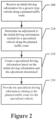
- the apparatus of an example embodiment includes means, such as the processing circuitry 12, processor 14, or the like, for receiving an initial driving information for a generic type of vehicle along a planned traffic route.
- Driving information may include any information relating to road class, road surface type, number of lanes on the road, area of city being travelled, junction type, traffic conditions, or a combination thereof.
- this driving information may include estimated drive times.
- this initial driving information may be based on real time information about vehicles traveling along a planned route. Additionally or alternatively, the initial driving information may be based on historical information about vehicles along a planned route. In some embodiments, the initial driving information may be gathered from one or more vehicles that previously traveled along the same or similar route.
- the initial driving information may be provided either by, or in part by, the map database 340, described in more detail in reference to Figure 3 below.
- the initial driving information for a generic type of vehicle may come from all types of vehicles including average sized vehicles (e.g., private car) and specialized vehicles (e.g., fleets of delivery vehicles of different sizes). In some embodiments, the amount of generic types of vehicles will be substantial enough that the generic vehicle information may reliably be used by generic types of vehicles.
- the initial driving information may be a filtered data set (e.g., the filtering may aim to obtain probe data that corresponds to typical private passenger car behavior without a guarantee that the filtered data actually comes from a passenger vehicle). For example, this filtering may be done because even taxis, which have the dimensions of passenger vehicles, may be allowed to use high occupancy vehicle (HOV) lanes, public transportation lanes, etc.
- the dataset may be labeled as taxi data, which may not be taken into account for the traffic estimate since the behavior of a taxi may not be representative of the behavior of a generic type of vehicle.
- a generic type of vehicle may be any vehicle that is not substantially helped or harmed in travelling based on size and/or function.
- the generic type of vehicles may be defined as a given range of vehicle sizes that the majority of vehicles on the road make up (e.g., 75% of the vehicles on the road may be compact).
- a generic type of vehicle may be defined as all vehicles within a certain range of sizes (e.g., all vehicles that are greater than 4 feet across in width and less than 8 feet across in width may be designated as a generic type of vehicle).
- Other potential factors that may determine whether a vehicle is considered a generic type of vehicle include vehicle length, maximum speed, function, number of wheels, or the like.
- the generic type of vehicle may be defined using government classifications (e.g., the United States defines vehicle size based on weight and/or interior space). Additionally or alternatively, the generic type of vehicle may be defined by the type of license required to operate said vehicle (e.g., vehicles requiring a class B license in Europe may be considered a generic type of vehicle). In various embodiments, the determination of what qualifies as a generic type of vehicle is dynamic (e.g., the generic type of vehicle may be based on the vehicle type that makes up the majority of vehicles on a given road).
- the generic type of vehicles may actually be a vehicle commonly thought as a specialized vehicle (e.g., some roads have more travel from mopeds due to the size of the road and therefore it may be easier to get driving information for mopeds on the route than other vehicles).
- the processor may determine what qualifies as a generic type of vehicle, such as based upon information identifying the types of vehicles that use the roadway and their respective usage percentage, or the generic type of vehicle may be predetermined.
- the driving information received by the apparatus such as from the map database 340, may determine what falls into the category of a generic type of vehicles and what does not.
- the planned route may be any stretch of road a vehicle is predicted to travel along at a point in the future.
- the projected route may be designated by a user of a specialized vehicle.
- the processor 14 or the like may be configured to create a planned route based on the input of a user and/or a predictive computation by the apparatus.
- the predictive computations by the processor or the like may be based on past routes made by the vehicle and/or frequent routes by that vehicle type.
- the planned route may include multiple routes in order to compare the travel time along each path (e.g., there may be two options for reaching a destination and the apparatus creates specialized driving information for both to determine which option is the better choice).
- the apparatus of an example embodiment includes means, such as the processing circuitry 12, processor 14, or the like, for determining an adjustment to the initial driving information for a specialized vehicle along the planned traffic route.
- An adjustment may be any change to the driving information that increases the accuracy of the driving information for a specialized vehicle.
- the adjustment may be to some or all of the driving information for a generic type of vehicles.
- the adjustment may include changes in time to destination. The adjustments may be made either to an entire route or to individual links of the route (e.g., there may be busy and non-busy streets along a planned route).
- the vehicle type or the road class, or any other factor, alone may be the only consideration for the adjustment (e.g., the same adjustment may be made to all driving information for a particular type of vehicle regardless of road class or otherwise).
- the adjustment may be different for various types of specialized vehicles along the same route (e.g., mopeds may need different adjustments than delivery trucks).
- the adjustment may be created using a predetermined performance factor.
- the performance factor may be created using vehicle progress information from a set of reference trips made by specialized type of vehicles.
- the vehicle progress information may include information relating to a plurality of trips along a specific road by one or more specialized vehicle type (e.g., data relating to scooters over a given road may be recorded for a set length of time).
- the vehicle progress information may be specific to travel time, comparisons to other vehicle types, and the like.
- the actual driving information about a completed route of a specialized vehicle may be used to update or generate a new performance factor (e.g., if an example embodiment predicts a route will take a specialized vehicle 10 minutes and actually takes 15 minutes, then the performance factor may be reduced to account for the longer travel time).
- the apparatus such as the processor, of this example embodiment is configured to combine the performance factor with the initial driving information, such as by multiplying or dividing the initial driving information, such as the estimated length of time to traverse a route, by the performance factor.
- the performance factor may be used in other manners to create the specialized driving information from the initial driving information in other embodiments.
- the map database 340 may already have driving information for the specialized vehicle along a route (e.g., for busy roads, there may be enough specialized vehicles travelling along the road to allow an example embodiment to update the driving information directly). In such a case, an example embodiment, may provide the previously determined driver information for the specialized type of vehicle. In some embodiments, such as when there is not predetermined driving information for a route for a specialized vehicle, the apparatus may then look for an adjustment made on similar roads for similar specialized vehicles (e.g., the adjustment for a moped on a stretch of interstate may be similar to the adjustment for a moped on a different stretch of similar interstate).
- the processor may have to interpolate the adjustment based on multiple possible adjustments.
- the interpolation may be linear (e.g., discrete/binary values may be present, so that a value may be chosen).
- the interpolation may be more complex than linear (e.g., quadratic interpolation may be used when the lane count doubles).
- a specialized types of vehicle may be any vehicle that does not fall into the generic type of vehicles, such as average sized vehicles, for a given embodiment. Therefore, vehicles that fall into the category of specialized vehicle may change based on how the generic type of vehicles are defined (e.g., vehicles outside of a certain width range may be considered specialized). In some embodiments, there may be multiple subcategories of specialized vehicles (e.g., there may be a subcategory for undersized vehicles and another subcategory for oversized vehicles).
- the user may input information to determine the type of vehicle or the apparatus may be able to determine the vehicle type without user input (e.g., the apparatus can detect the vehicle type based on the motion of the vehicle).
- the specialized driving information produced may be across all specialized vehicles or across a subcategory of specialized vehicles.
- the type of vehicle for which the apparatus determines the specialized driving information may be predetermined (e.g., an in-vehicle navigation system may be set specifically to create driving information for the type of vehicle that it is carried by).
- the type of vehicle for which the apparatus determines the specialized driving information may be changeable (e.g., a mobile device may allow the user to input the specific type of vehicle).
- specialized vehicles may include undersized vehicles, such as mopeds, electric scooters, motorcycles, or the like.
- specialized vehicles may include oversized vehicles, such as delivery trucks, tractor-trailers, and the like.
- different subcategories may have different levels of accuracy (e.g., more specific subcategories may not have enough data points to give accurate adjustments).
- the user of the vehicle may be able to define either a category or specific subcategory based on the desired level of accuracy (e.g., a moped driver may select the type of specialized vehicle as two wheeled vehicles which may have more data points or may select the type of specialized vehicle as moped specifically, which may not have as many data points but each data point is more relevant).
- the processor or the like may be in communication with the map database to determine whether there is sufficient data for a specific subcategory to be used (e.g., some road types may have enough moped specific data to give accurate adjustments using such data, while others may not).
- a specialized vehicle type may not have a large enough usage rate to produce reliable driving information for that vehicle type and then may need to use a broader category or subcategory of specialized vehilces. In such cases, the apparatus may use driving information from similar conditions or use a different specialized category or subcategory if possible.
- the size, max speed, acceleration, and/or weight of the vehicle may be used to place specialized vehicles into specific subcategories (e.g., scooters and motorcycles may have vastly different max speeds and therefore may not be as accurate in determining the adjustment for one another).
- specific subcategories e.g., scooters and motorcycles may have vastly different max speeds and therefore may not be as accurate in determining the adjustment for one another.
- the apparatus of an example embodiment includes means, such as the processing circuitry 12, processor 14, or the like, for creating specialized driving information based on the initial driving information and the adjustment determined.
- Specialized driving information may be any information about driving along a planned route that is normalized in some way for one or more types of specialized vehicle.
- the specialized driving information may include the same type of data as the initial driving information for generic type of vehicles, discussed above, with the only difference being some type of normalization for specialized vehicles.
- the specialized driving information may include one or more of a time to destination, an estimated speed, or an alternate route.
- specialized vehicles may include undersized vehicles, such as mopeds, electric scooters, motorcycles, Segway personal transports, or the like, and/or oversized vehicles, such as delivery trucks and tractor-trailers.
- undersized vehicles such as mopeds, electric scooters, motorcycles, Segway personal transports, or the like
- oversized vehicles such as delivery trucks and tractor-trailers.
- specialized vehicles may be defined independent of size.
- the specialized driving information will be based on a combination of the initial driving information for a generic type of vehicle along a planned route and the adjustment determined.
- the apparatus may revert to the driving information for a generic type of vehicle.
- the planned route may not be similar to any specialized information that the map database possesses ( e.g., there is a new type of road that is completely different than the road types of data in the map database) and the apparatus may determine to combine multiple adjustments to create the specialized driving information.
- there may be specialized driving information for various subcategories of specialized vehicles e.g., there may be distinct driving information for both undersized and oversized vehicles). The processor and/or the user may determine which and how much driving information should be provided.
- the apparatus of an example embodiment includes means, such as the processing circuitry 12, processor 14, or the like, for providing the specialized driving information relating to the planned traffic route for the specialized vehicle.
- the specialized driving information may be provided to a user through a user interface 22, such as a mobile device or in-vehicle navigation system.
- the information may be provided, either audibly (e.g., an audible update on the length of time to destination) and/or visually ( e.g., an update on the map of a navigation system that the current route is delayed).
- the amount of information provided about the specialized driving information may vary based on the capabilities of an example embodiment of the present disclosure.
- the information provided may include time to destination, traffic conditions, alternate routes, preferred lanes, and/or the like.
- the user may be able to select what information may be communicated to them about the specialized driving information (e.g., a driver may care about the time to destination and not about other information about the driving information).
- the specialized driving information may be provided to the vehicle itself, or the processor therein, in order to update the route of the vehicle. Some or all of the driving information may also be communicated to the passengers of the vehicle, similarly to above.
- the apparatus may be able to update the map database based on previous uses.
- the apparatus may be configured to collect information about the completed routes of the specialized vehicle in order to compare the collected information to the specialized driving information predicted. In such embodiments, this comparison may be used to determine the accuracy of the adjustment. In some embodiments, the comparison may be used to update the apparatus in order to improve future adjustments.
- the map database 340 discussed in more detail in relation to Figure 3 , may be updated based on the comparison therein.
- autonomous vehicles may be equipped with an example embodiment of the apparatus.
- autonomous vehicles may follow a route that may have been built using adjusted traffic information.
- the adjustment may affect the operation of the autonomous vehicle, directly or indirectly.
- the autonomous vehicle may display the remaining travel time to destination to its passengers.
- a map service provider database may be used to provide driver assistance via a navigation system and/or through an ADAS having autonomous or semi-autonomous vehicle control features.
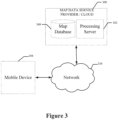
- Figure 3 illustrates a communication diagram of an example embodiment of a system for implementing example embodiments described herein.
- the illustrated embodiment of Figure 3 includes a mobile device 104, which may be embodied as at least a portion of the user interface 22 in an example embodiment of the apparatus 10 shown in Figure 1 .
- the mobile device may include a mobile phone, an in-vehicle navigation system, an ADAS, or the like.
- a map data service provider or cloud service 300 is also provided in the illustrated embodiment.
- Each of the mobile device 104 and map data service provider 300 may be in communication with at least one of the other elements illustrated in Figure 3 via a network 330, which may be in the form of a wireless, either fully or partially, and/or wired network as will be described further below. Additional, different, or fewer components may be provided. For example, many mobile devices 104 may connect with the network 330.
- the map data service provider 300 may provide cloud-based services and/or may operate via a hosting server that receives, processes, and provides data to other elements of the system.
- the map data service provider 300 may include a map database 340 that may include node data, road segment data or link data, point of interest (POI) data, traffic data or the like.
- the map database 340 may also include cartographic data, routing data, and/or maneuvering data.
- the road segment data records may be links or segments representing roads, streets, or paths, as may be used in calculating a route or recorded route information for determination of one or more personalized routes.
- the node data may be end points corresponding to the respective links or segments of road segment data.
- the road link data and the node data may represent a road network, such as used by vehicles, cars, trucks, buses, motorcycles, and/or other entities.
- the map database 340 may contain path segment and node data records or other data that may represent pedestrian paths or areas in addition to or instead of the vehicle road record data, for example.
- the road/link segments and nodes can be associated with attributes, such as geographic coordinates, street names, address ranges, speed limits, turn restrictions at intersections, and other navigation related attributes, as well as POIs, such as fueling stations, hotels, restaurants, museums, stadiums, offices, auto repair shops, buildings, stores, parks, etc.
- the map database 340 can include data about the POIs and their respective locations in the POI records.
- the map database 340 may include data about places, such as cities, towns, or other communities, and other geographic features such as bodies of water, mountain ranges, etc.
- Such place or feature data can be part of the POI data or can be associated with POIs or POI data records (such as a data point used for displaying or representing a position of a city).
- the map database 340 can include event data (e.g., traffic incidents, construction activities, scheduled events, unscheduled events, etc.) associated with the POI data records or other records of the map database 340.
- the map database 340 may also contain information about various roads including road class, road surface types, number of lanes, zoning around roads, junction types, and the like.
- the map database 340 may contain information relating to differences in traffic patterns based on factors such as the level of traffic, time of day, day of week, or the like.
- the map database 340 may be maintained by a content provider e.g., the map data service provider and may be accessed, for example, by the content or service provider processing server 102.
- the map data service provider can collect geographic data and dynamic data to generate and enhance the map database 340 and dynamic data such as traffic-related data contained therein.
- the map developer can employ field personnel to travel by vehicle along roads throughout the geographic region to observe features and/or record information about them, for example.
- remote sensing such as aerial or satellite photography and/or LiDAR
- vehicle data provided by vehicles, such as mobile device 104, as they travel the roads throughout a region.
- the map database 340 may be a master map database, such as an HD map database, stored in a format that facilitates updates, maintenance, and development.
- the master map database or data in the master map database can be in an Oracle spatial format or other spatial format, such as for development or production purposes.
- the Oracle spatial format or development/production database can be compiled into a delivery format, such as a geographic data files (GDF) format.
- GDF geographic data files
- the data in the production and/or delivery formats can be compiled or further compiled to form map database products or databases, which can be used in end user navigation devices or systems.
- geographic data may be compiled (such as into a platform specification format (PSF) format) to organize and/or configure the data for performing navigation-related functions and/or services, such as route calculation, route guidance, map display, speed calculation, distance and travel time functions, and other functions, by a navigation device, such as by a vehicle represented by mobile device 104, for example.
- the navigation-related functions can correspond to vehicle navigation, pedestrian navigation, or other types of navigation.
- the compilation to produce the end user databases can be performed by a party or entity separate from the map developer. For example, a customer of the map developer, such as a navigation device developer or other end user device developer, can perform compilation on a received map database in a delivery format to produce one or more compiled navigation databases.
- the map database 340 may be a master map database, but in alternate embodiments, a client side map database may represent a compiled navigation database that may be used in or with end user devices (e.g., mobile device 104) to provide navigation and/or map-related functions.
- the map database 340 may be used with the mobile device 104 to provide an end user with navigation features.
- the map database 340 can be downloaded or stored on the end user device which can access the map database 340 through a wireless or wired connection, such as via a processing server 102 and/or the network 330, for example.
- the map database 340 may also have information relating to specialized vehicles along certain routes. This information may be based on the type of specialized vehicle, road class, road surface type, number of lanes on the road, traffic information, the time of day, the day of the week, the size of the road, or the like. As discussed herein, the map database may provide this information to the processor circuitry 12, which may then provide information about a planned route for a specialized vehicles. The map database may get this information from the network 330 or have it stored in the apparatus, such as in the memory device 16. The information relating to specialized vehicles may be combined with information from other vehicles, both specialized and generic types of vehicles. In an example embodiment, the information relating to specialized vehicles along certain routes may include one or more performance factors. In some embodiments, the performance factor may be based on a set of reference trips made by specialized vehicles along a given road. The map database may contain some of the information about the reference trips. Additionally or alternatively, the map database may contain one or more performance factors.
- the apparatus 10 of Figure 1 can be embodied by an infotainment in-vehicle system or an in-vehicle navigation system, and/or devices such as a personal navigation device (PND), a portable navigation device, a cellular telephone, a smart phone, a personal digital assistant (PDA), a watch, a camera, a computer, and/or other device that can perform navigation-related functions, such as digital routing and map display.
- PND personal navigation device
- PDA personal digital assistant
- An end user can use the mobile device 104 for navigation and map functions such as guidance and map display, for example, and for determination of useful driver assistance information, according to some example embodiments.
- the map data service provider is embodied together as one device, such as a navigation system. In such cases, the components may be connected through wired, wireless, or a combination of wired and wireless connections.
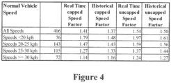
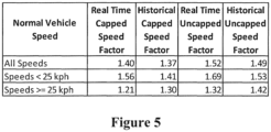
- test data to be used by an example embodiments of the present disclosure is shown.
- the specialized vehicle being monitored was a moped.
- the data was collected over a 3 day period along a 2.5 kilometer stretch of road during weekdays.
- the data an example of a reference trip, was compiled and then transformed to create a performance factor to use in determining the traffic information for a specialized vehicle.
- the performance factor may be used by an example embodiment to determine the correct adjustment to be to the driving information of generic type of vehicles to create driving information for specialized vehicles.
- the performance factor may be combined with the driving information, such as by being mathematically combined, such as by addition, multiplication or division, or by otherwise being combined or used to determine the specialized driving information for the specialized type of vehicle.
- a performance factor may be based one or more of the type of specialized vehicle, time of day, day of week, level of traffic, road class, road surface types, roads with different lane numbers, road location, road condition, junction types, speed limit, and the like.
Landscapes
- Engineering & Computer Science (AREA)
- Radar, Positioning & Navigation (AREA)
- Remote Sensing (AREA)
- Physics & Mathematics (AREA)
- General Physics & Mathematics (AREA)
- Automation & Control Theory (AREA)
- Analytical Chemistry (AREA)
- Chemical & Material Sciences (AREA)
- Software Systems (AREA)
- Theoretical Computer Science (AREA)
- Mathematical Physics (AREA)
- Data Mining & Analysis (AREA)
- Medical Informatics (AREA)
- Evolutionary Computation (AREA)
- Computing Systems (AREA)
- General Engineering & Computer Science (AREA)
- Computer Vision & Pattern Recognition (AREA)
- Artificial Intelligence (AREA)
- Traffic Control Systems (AREA)
- Navigation (AREA)
Description
- Example embodiments of the present disclosure relate generally to a method and associated apparatus and computer program product for creating traffic information, and more particularly, to a method and associated apparatus and computer program product for creating traffic information for specialized vehicle types.
- Navigation systems often use a compilation of data from various individual vehicles, both past and present, in order to predict traffic conditions and travel times for future routes. The information is gathered from various types of vehicle, but is typically most accurate for the most common vehicles on the road. Often specialized vehicles, such as mopeds, scooters, or the like, have vastly different travel times than an automobile, truck or other full size vehicles along the same route. However, due to the relatively small number of specialized vehicles, this difference in travel time is not generally taken into account. Indeed, many specialized vehicles are not represented on the road in sufficient numbers to obtain reliable data to create traffic information tailored to those vehicles.
-
US2011224893A1 discloses generating and using information regarding road traffic in various ways, including by obtaining and analyzing road traffic information regarding actual behavior of drivers of vehicles on a network of roads. Obtained actual driver behavior information may in some situations be analyzed to determine actual delays for vehicles encountering various particular road features in the network of roads, such as for identified decision points at which drivers face choices corresponding to possible alternative routes through the network of roads (e.g., intersections, highway exits and/or entrances, etc.) and/or for other traffic flow impediments. The identified and determined information from the analysis may then be used in various manners, including in some situations to assist in determining particular recommended or preferred routes of vehicles through the network of roads based at least in part on actual driver behavior information. -
US2013297211A1 discloses a system and method for providing traffic information. For each segment of a route between an origin point and a destination point, a time-dependent journey planning calculation is performed, based on a time during which a vehicle is predicted to be traveling through the segment, to produce a segment result; a route result is formed, based on a plurality of the segment results, and stored for use in responding to a user request for traffic information. A portion of a recommended most economic route between an origin point and a destination point can be pre-determined and stored. With reference to a first network of geographical boundaries and second network of digital map nodes, a recommended most economic route between an origin point and a destination point can be determined and transmitted to a user. - The invention is defined by the claims. A computer-implemented method, apparatus, and computer program product are provided for creating traffic information for a specialized type of vehicle according to appended
claims 1, 9 and 10 respectively. In an example embodiment, a method, apparatus and computer program product are provided that create updated driving information for specialized vehicles. In this regard, the method, apparatus, and computer program product of an example embodiment, allow for data collected by a variety of generic types of vehicles to be adjusted in a way that allows specialized types of vehicles to use the data effectively. Specialized types of vehicles may not have enough vehicles traveling along a given road to reliably create traffic data using specialized type of vehicle data alone, while the data from generic types of vehicles may not be accurate for specialized types of vehicles. The method, apparatus, and computer program product of an example embodiment allows specialized types of vehicles to use information from generic type vehicles in a reliable way. - A method is provided for creating traffic information for a specialized type of vehicle. The method includes receiving initial driving information for a generic type of vehicle along a planned traffic route, wherein the generic type of vehicle travels along the planned traffic route in larger numbers than the specialized type of vehicle. The method also includes determining, for the specialized type of vehicle along the planned traffic route, an adjustment to the initial driving information of the generic type of vehicle along the planned traffic route. The method further includes creating specialized driving information based on the initial driving information and the adjustment that was determined. The method still further includes causing the specialized driving information relating to the planned traffic route for the specialized type of vehicle to be provided.
- In an example embodiment, the adjustment is based on vehicle progress information from a set of reference trips made by vehicles of the specialized type of vehicle. In such an embodiment, the adjustment may be further based on a performance factor of the specialized type of vehicle associated with traffic flow. In another example embodiment, the adjustment is further based on a performance factor of the specialized type of vehicle associated with at least one of a speed limit, a maneuver type, a traffic incident, a time of day, a weather condition, a road type, a road surface, or a number of lanes.
- In an example embodiment, the adjustment is determined using a machine learning algorithm trained using the set of reference trips made by vehicles of the specialized type of vehicle. In another example embodiment, the adjustment is determined for at least one individual road link of the planned traffic route. In still another example embodiment, the specialized driving information includes at least one of a time to destination, an estimated speed, or an alternate route. In another example embodiment, the method also includes updating the set of reference trips by adding actual driving information gathered during a trip by the specialized type of vehicle on the planned traffic route.
- In another embodiment, an apparatus is provided that includes at least one processor and at least one memory including computer program code instructions, the computer program code instructions configured to cause the apparatus to create traffic information for a specialized type of vehicle. The computer program instructions are configured to, when executed, cause the apparatus to receive initial driving information for a generic type of vehicle along a planned traffic route, wherein the generic type of vehicle travels along the planned traffic route in larger numbers than the specialized type of vehicle. The computer program instructions are further configured to, when executed, cause the apparatus to determine an adjustment to the initial driving information for the specialized type of vehicle along the planned traffic route. The computer program instructions are also configured to, when executed, cause the apparatus to create specialized driving information based on the initial driving information and the adjustment that was determined. The computer program instructions are still further configured to, when executed, cause the apparatus to cause the specialized driving information relating to the planned traffic route for the specialized type of vehicle to be provided.
- In an example embodiment, the adjustment is based on vehicle progress information from a set of reference trips made by vehicles of the specialized type of vehicle. In such an embodiment, the adjustment may be further based on a performance factor of the specialized type of vehicle associated with traffic flow. In another example embodiment, the adjustment is further based on a performance factor of the specialized type of vehicle associated with at least one of a speed limit, a maneuver type, a traffic incident, a time of day, a weather condition, a road type, a road surface, or a number of lanes.
- In an example embodiment, the adjustment is determined using a machine learning algorithm trained using the set of reference trips made by vehicles of the specialized type of vehicle. In another example embodiment, the adjustment is determined for at least one individual road link of the planned traffic route. In still another example embodiment, the specialized driving information includes at least one of a time to destination, an estimated speed, or an alternate route. In another example embodiment, the computer program instructions are also configured to, when executed, cause the apparatus to update the set of reference trips by adding actual driving information gathered during a trip by the specialized type of vehicle on the planned traffic route.
- In yet another example embodiment, a computer program product is provided that includes at least one non-transitory computer-readable storage medium having computer-executable program code portions stored therein with the computer-executable program code portions including program code instructions configured to create traffic information for a specialized type of vehicle. The computer-executable program code portions include program code instructions configured to receive initial driving information for a generic type of vehicle along a planned traffic route, wherein the generic type of vehicle travels along the planned traffic route in larger numbers than the specialized type of vehicle. The computer-executable program code portions also include program code instructions configured to determine an adjustment to the initial driving information for the specialized type of vehicle along the planned traffic route. The computer-executable program code portions further include program code instructions configured to create specialized driving information based on the initial driving information and the adjustment that was determined. The computer-executable program code portions still further include program code instructions configured to cause the specialized driving information relating to the planned traffic route for the specialized type of vehicle to be provided.
- In an example embodiment, the adjustment is based on vehicle progress information from a set of reference trips made by vehicles of the specialized type of vehicle. In such an embodiment, the adjustment may be further based on a performance factor of the specialized type of vehicle associated with traffic flow. In another example embodiment, the adjustment is further based on a performance factor of the specialized type of vehicle associated with at least one of a speed limit, a maneuver type, a traffic incident, a time of day, a weather condition, a road type, a road surface, or a number of lanes.
- In an example embodiment, the adjustment is determined using a machine learning algorithm trained using the set of reference trips made by vehicles of the specialized type of vehicle. In another example embodiment, the adjustment is determined for at least one individual road link of the planned traffic route. In still another example embodiment, the specialized driving information includes at least one of a time to destination, an estimated speed, or an alternate route. In another example embodiment, the computer code instructions are further configured to update the set of reference trips by adding actual driving information gathered during a trip by the specialized type of vehicle on the planned traffic route.
- In an example embodiment, an apparatus is provided for creating traffic information for a specialized type of vehicle. The apparatus includes means for receiving initial driving information for a generic type of vehicle along a planned traffic route, wherein the generic type of vehicle travels along the planned traffic route in larger numbers than the specialized type of vehicle. The apparatus also includes means for determining an adjustment to the initial driving information for the specialized type of vehicle along the planned traffic route. The apparatus further includes means for creating specialized driving information based on the initial driving information and the adjustment that was determined. The apparatus still further includes means for causing the specialized driving information relating to the planned traffic route for the specialized type of vehicle to be provided.
- In an example embodiment, the adjustment is based on vehicle progress information from a set of reference trips made by vehicles of the specialized type of vehicle. In such an embodiment, the adjustment may be further based on a performance factor of the specialized type of vehicle associated with traffic flow. In another example embodiment, the adjustment is further based on a performance factor of the specialized type of vehicle associated with at least one of a speed limit, a maneuver type, a traffic incident, a time of day, a weather condition, a road type, a road surface, or a number of lanes.
- In an example embodiment, the adjustment is determined using a machine learning algorithm trained using the set of reference trips made by vehicles of the specialized type of vehicle. In another example embodiment, the adjustment is determined for at least one individual road link of the planned traffic route. In still another example embodiment, the specialized driving information includes at least one of a time to destination, an estimated speed, or an alternate route. In another example embodiment, the apparatus also includes means for updating the set of reference trips by adding actual driving information gathered during a trip by the specialized type of vehicle on the planned traffic route.
- Having thus described certain example embodiments of the present disclosure in general terms, reference will hereinafter be made to the accompanying drawings which are not necessarily drawn to scale, and wherein:
-
Figure 1 is a block diagram of an apparatus according to an example embodiment of the present disclosure; -
Figure 2 is a flowchart of operations for creating traffic information for specialized vehicles according to an example embodiment of the present disclosure; -
Figure 3 is a block diagram of a system for creating traffic information for specialized vehicles according to an example embodiment of the present disclosure; -
Figure 4 is a chart illustrating test data of an example embodiment of the present disclosure; and -
Figure 5 is a chart illustrating test data of another example embodiment of the present disclosure. - Some embodiments of the present disclosure will now be described more fully hereinafter with reference to the accompanying drawings, in which some, but not all, embodiments of the invention are shown. Indeed, various embodiments of the invention may be embodied in many different forms and should not be construed as limited to the embodiments set forth herein; rather, these embodiments are provided so that this disclosure will satisfy applicable legal requirements. Like reference numerals refer to like elements throughout. As used herein, the terms "data," "content," "information," and similar terms may be used interchangeably to refer to data capable of being transmitted, received and/or stored in accordance with embodiments of the present disclosure.
- A method, apparatus and computer program product are provided in accordance with an example embodiment of the present disclosure for facilitating the driving of a first type of vehicle, referenced as a specialized type of vehicles herein. Specialized vehicles, or those that are different in size or function from a second type of vehicle, such as traditional automobiles, trucks, sport utility vehicles or other full sized passenger vehicles, often have vastly different driving experiences along a route than the second type of vehicles, referenced as a generic type of vehicles herein, do along the same route. These differences may become noticeable when the specialized type of vehicles uses traffic information based on the experience of the generic type of vehicles to plan and predict planned routes of travel, such as provided by a navigation system. Most information created by mapping systems is independent of the type of vehicle and therefore is usually most accurate for the generic type of vehicle, such as traditional automobiles, trucks, sport utility vehicles or other full sized passenger vehicles, since the generic type of vehicles travel along the planned traffic route in larger numbers than the specialized type of vehicles and, as a result, provide more probe data upon which the traffic information is based. However, specialized types of vehicles, including undersized vehicles, such as mopeds, scooters, Segway personal transports, or the like, and oversized vehicles, such as delivery trucks, are often not accounted for in large enough amounts and therefore navigation assistance may be inaccurate for these specialized types of vehicles. The relatively small comparative representation of specialized vehicles on the road may make getting accurate driving information difficult since aggregation of probe data from the vehicle is a large aid in creating accurate traffic information. The present disclosure aims to use existing data for generic type of vehicles to create driving information for specialized types of vehicles, but to do so in a manner that adjusts the driving information to be adapted for specialized types of vehicles.
-
Figure 1 is a schematic diagram of an example apparatus configured for performing any of the operations described herein.Apparatus 10 is an example embodiment that may be embodied by or associated with any of a variety of computing devices that include or are otherwise associated with a device configured for providing advanced driver assistance features which may include a navigation system user interface. For example, the computing device may be a computing device, such as an infotainment system, a built-in vehicular navigation device, an assisted driving device, or the like. Some embodiments described herein may optionally be used for map generation, map updating, and map accuracy confirmation, embodiments of the apparatus may be embodied or partially embodied as a mobile terminal, such as a personal digital assistant (PDA), mobile telephone, smart phone, personal navigation device, smart watch, tablet computer, camera or any combination of the aforementioned and other types of voice and text communications systems. In an embodiment where some level of vehicle autonomy is involved, theapparatus 10 is embodied or partially embodied by an electronic control unit of a vehicle that supports safety-critical systems such as the powertrain (engine, transmission, electric drive motors, etc.), steering (e.g., steering assist or steer-by-wire), and braking (e.g., brake assist or brake-by-wire). Optionally, the computing device may be an Advanced Driver Assistance System module (ADAS) which may at least partially control autonomous or semi-autonomous features of a vehicle. - Optionally, the apparatus may be embodied by or associated with a plurality of computing devices that are in communication with or otherwise networked with one another such that the various functions performed by the apparatus may be divided between the plurality of computing devices that operate in collaboration with one another.
- The
apparatus 10 may be equipped or associated with any number of sensors (not shown), such as a global positioning system (GPS), accelerometer, LiDAR, radar, and/or gyroscope. Any of the sensors may be used to sense information regarding the movement, positioning, or orientation of the device for use in navigation assistance, as described herein according to example embodiments. In some example embodiments, such sensors may be implemented in a vehicle or other remote apparatus, and the information detected may be transmitted to theapparatus 10, such as by near field communication (NFC) including, but not limited to, Bluetooth™ communication, or the like. - The
apparatus 10 comprises at least oneprocessor 14 and may include, be associated with, or may otherwise be in communication with acommunication interface 20, amemory device 16 and auser interface 22. In some embodiments, the processor (and/or co-processors or any other processing circuitry assisting or otherwise associated with the processor) may be in communication with the memory device via a bus for passing information among components of the apparatus. The memory device is non-transitory and may include, for example, one or more volatile and/or non-volatile memories. In other words, for example, the memory device may be an electronic storage device (for example, a computer readable storage medium) comprising gates configured to store data (for example, bits) that may be retrievable by a machine (for example, a computing device such as the processor). The memory device is configured to store information, data, content, applications, instructions, or the like for enabling the apparatus to carry out various functions in accordance with an example embodiment of the present disclosure. For example, the memory device could be configured to buffer input data for processing by the processor. Additionally, the memory device is configured to store instructions for execution by the processor. - The
processor 14 may be embodied in a number of different ways. For example, the processor may be embodied as one or more of various hardware processing means such as a coprocessor, a microprocessor, a controller, a digital signal processor (DSP), a processing element with or without an accompanying DSP, or various other processing circuitry including integrated circuits such as, for example, an ASIC (application specific integrated circuit), an FPGA (field programmable gate array), a microcontroller unit (MCU), a hardware accelerator, a special-purpose computer chip, or the like. As such, in some embodiments, the processor may include one or more processing cores configured to perform independently. A multi-core processor may enable multiprocessing within a single physical package. Additionally or alternatively, the processor may include one or more processors configured in tandem via the bus to enable independent execution of instructions, pipelining and/or multithreading. - In an example embodiment, the
processor 14 may be configured to execute instructions stored in thememory device 16 or otherwise accessible to the processor. Alternatively or additionally, the processor may be configured to execute hard coded functionality. As such, whether configured by hardware or software methods, or by a combination thereof, the processor may represent an entity (for example, physically embodied in circuitry) capable of performing operations according to an embodiment of the present disclosure while configured accordingly. Thus, for example, when the processor is embodied as an ASIC, FPGA or the like, the processor may be specifically configured hardware for conducting the operations described herein. Alternatively, as another example, when the processor is embodied as an executor of software instructions, the instructions specifically configure the processor to perform the algorithms and/or operations described herein when the instructions are executed. However, in some cases, the processor may be a processor of a specific device (for example, the computing device) configured to employ an embodiment of the present disclosure by further configuration of the processor by instructions for performing the algorithms and/or operations described herein. The processor may include, among other things, a clock, an arithmetic logic unit (ALU) and logic gates configured to support operation of the processor. - The
apparatus 10 of an example embodiment may also include or otherwise be in communication with auser interface 22. The user interface may include a touch screen display, a speaker, physical buttons, and/or other input/output mechanisms. In an example embodiment, theprocessor 14 may comprise user interface circuitry configured to control at least some functions of one or more input/output mechanisms. The processor and/or user interface circuitry comprising the processor may be configured to control one or more functions of one or more input/output mechanisms through computer program instructions (for example, software and/or firmware) stored on a memory accessible to the processor (for example, memory device 24, and/or the like). In this regard, theapparatus 10 may interpret positioning data collected by its sensors and provide a destination preview including visual and audio feedback, to a user, for example. - The
apparatus 10 of an example embodiment may also optionally include acommunication interface 20 that may be any means such as a device or circuitry embodied in either hardware or a combination of hardware and software that is configured to receive and/or transmit data from/to other electronic devices in communication with the apparatus, such as by NFC, described above. Additionally or alternatively, thecommunication interface 20 may be configured to communicate over wireless communication protocols including Global System for Mobile Communications (GSM), such as but not limited to Long Term Evolution (LTE). In this regard, thecommunication interface 20 may include, for example, an antenna (or multiple antennas) and supporting hardware and/or software for enabling communications with a wireless communication network. Additionally or alternatively, thecommunication interface 20 may include the circuitry for interacting with the antenna(s) to cause transmission of signals via the antenna(s) or to handle receipt of signals received via the antenna(s). In some environments, thecommunication interface 20 may alternatively or also support wired communication and/or may alternatively support vehicle to vehicle or vehicle to infrastructure wireless links. - The
apparatus 10 may support a mapping or navigation application so as to present maps or otherwise provide navigation or driver assistance, such as in an example embodiment in which map data is created or updated using methods described herein. For example, theapparatus 10 may provide for display of a map and/or instructions for following a route within a network of roads viauser interface 22. In order to support a mapping application, the computing device may include or otherwise be in communication with a map database, such as themap database 340 shown inFigure 3 . The map database may be stored inmemory 16. For example, the map database may include node data records, road segment or link data records, point of interest (POI) data records, and other data records. More, fewer, or different data records can be provided. In one embodiment, the other data records include cartographic data records, routing data, and maneuver data. One or more portions, components, areas, layers, features, text, and/or symbols of the POI or event data can be stored in, linked to, and/or associated with one or more of these data records. For example, one or more portions of the POI, event data, or recorded route information can be matched with respective map or geographic records via position or GPS data associations (such as using known or future map matching or geo-coding techniques), for example. Furthermore, other positioning technology may be used, such as electronic horizon sensors, radar, LiDAR, ultrasonic and/or infrared sensors. - In example embodiments, the
user interface 22 may be provided as a navigation system to provide driver assistance to a user traveling along a network of roadways whose geometry and details may be generated and/or updated according to methods described herein. The navigation system may allow the user to input the vehicle type or the apparatus may be configured to determine the vehicle type, such as a generic type of vehicle or a specialized type of vehicle. In some embodiments, a navigation system may be configured to be dedicated to one or more types of vehicle exclusively. In an example embodiment, a navigation system is in communication with the network and/or map database in order to be updated based on the vehicle type desired. - Optionally, embodiments described herein may provide assistance for autonomous or semi-autonomous vehicle control. Autonomous vehicle control may include driverless vehicle capability where all vehicle functions are provided by software and hardware to safely drive the vehicle along a path identified by the vehicle. Semi-autonomous vehicle control may be any level of driver assistance from adaptive cruise control, to lane-keep assist, or the like. Identifying objects along road segments or road links that a vehicle may traverse may provide information useful to navigation and autonomous or semi-autonomous vehicle control by establishing barriers defining roadway width, identifying roadway curvature, or any boundary related details of the road links that may be traversed by the vehicle.
- HD maps have a high precision at resolutions that may be down to several centimeters that identify objects proximate a road segment, and features of a road segment including lane widths, lane markings, traffic direction, speed limits, lane restrictions, etc. Autonomous and semi-autonomous vehicles use these HD maps to facilitate the autonomous control features, such as traveling within a lane of a road segment at a prescribed speed limit. Autonomous vehicles may also be equipped with a plurality of sensors to facilitate autonomous vehicle control. Sensors may include image sensors/cameras, Light Distancing and Ranging (LiDAR), Global Positioning Systems (GPS), Inertial Measurement Units (IMUs), or the like which may measure the surroundings of a vehicle and communicate information regarding the surroundings to a vehicle control module to process and adapt vehicle control accordingly. The information gathered may be aggregated with information from other vehicles to create a more robust map.
- HD maps may be generated and updated based on sensor data from vehicles traveling along road segments of a road network. These vehicles may have various degrees of autonomy and may be equipped with a variety of different levels of sensors. Sensors from fully autonomous vehicles, for example, may be used to update map data or generate new map data in a form of crowd-sourced data from vehicles traveling along road segments. Sensor data received can be used with other sensor data from other vehicles to create more reliable mapping information. When data is being gathered from multiple sensors, and in this case multiple vehicle types, the data may prove unreliable for vehicles with a low share of representation. In this regard, the sensor data may be unreliable or less reliable for those types of vehicles, that is, specialized types of vehicles, which travel the road network in smaller numbers and, therefore, provide less sensor data than other types of vehicles, such as generic types of vehicles that travel the road network in larger numbers. The present disclosure uses this information provided by a generic type of vehicle to create reliable driving information for specialized vehicles. In some cases, an autonomous vehicle may be classified as a specialized vehicle, as its behavior in traffic may exhibit some unique characteristics. For instance, autonomous vehicles may implement reliable and standardized ways of negotiating intersections, reacting to traffic light changes, adhering to speed limits, predicting acceleration, and/or braking profiles which may result in specialized estimated time of arrival (ETA) estimates for such specialized types of vehicles deviating from the "bulk data" based estimates premised on data collected by a generic type of vehicle.
- Referring now to
Figure 2 , the operations performed by theapparatus 10 of an example embodiment are depicted. As shown inBlock 200 ofFigure 2 , the apparatus of an example embodiment includes means, such as theprocessing circuitry 12,processor 14, or the like, for receiving an initial driving information for a generic type of vehicle along a planned traffic route. Driving information may include any information relating to road class, road surface type, number of lanes on the road, area of city being travelled, junction type, traffic conditions, or a combination thereof. In some embodiments, this driving information may include estimated drive times. In some embodiments, this initial driving information may be based on real time information about vehicles traveling along a planned route. Additionally or alternatively, the initial driving information may be based on historical information about vehicles along a planned route. In some embodiments, the initial driving information may be gathered from one or more vehicles that previously traveled along the same or similar route. The initial driving information may be provided either by, or in part by, themap database 340, described in more detail in reference toFigure 3 below. - The initial driving information for a generic type of vehicle may come from all types of vehicles including average sized vehicles (e.g., private car) and specialized vehicles (e.g., fleets of delivery vehicles of different sizes). In some embodiments, the amount of generic types of vehicles will be substantial enough that the generic vehicle information may reliably be used by generic types of vehicles. In some cases, the initial driving information may be a filtered data set (e.g., the filtering may aim to obtain probe data that corresponds to typical private passenger car behavior without a guarantee that the filtered data actually comes from a passenger vehicle). For example, this filtering may be done because even taxis, which have the dimensions of passenger vehicles, may be allowed to use high occupancy vehicle (HOV) lanes, public transportation lanes, etc. In the example of the taxi data, the dataset may be labeled as taxi data, which may not be taken into account for the traffic estimate since the behavior of a taxi may not be representative of the behavior of a generic type of vehicle.
- A generic type of vehicle may be any vehicle that is not substantially helped or harmed in travelling based on size and/or function. In some embodiments, the generic type of vehicles may be defined as a given range of vehicle sizes that the majority of vehicles on the road make up (e.g., 75% of the vehicles on the road may be compact). In an example embodiment, a generic type of vehicle may be defined as all vehicles within a certain range of sizes (e.g., all vehicles that are greater than 4 feet across in width and less than 8 feet across in width may be designated as a generic type of vehicle). Other potential factors that may determine whether a vehicle is considered a generic type of vehicle include vehicle length, maximum speed, function, number of wheels, or the like. In some embodiments, the generic type of vehicle may be defined using government classifications (e.g., the United States defines vehicle size based on weight and/or interior space). Additionally or alternatively, the generic type of vehicle may be defined by the type of license required to operate said vehicle (e.g., vehicles requiring a class B license in Europe may be considered a generic type of vehicle). In various embodiments, the determination of what qualifies as a generic type of vehicle is dynamic (e.g., the generic type of vehicle may be based on the vehicle type that makes up the majority of vehicles on a given road). In some embodiments, the generic type of vehicles may actually be a vehicle commonly thought as a specialized vehicle (e.g., some roads have more travel from mopeds due to the size of the road and therefore it may be easier to get driving information for mopeds on the route than other vehicles). The processor may determine what qualifies as a generic type of vehicle, such as based upon information identifying the types of vehicles that use the roadway and their respective usage percentage, or the generic type of vehicle may be predetermined. In some embodiments, the driving information received by the apparatus, such as from the
map database 340, may determine what falls into the category of a generic type of vehicles and what does not. - The planned route may be any stretch of road a vehicle is predicted to travel along at a point in the future. In some embodiments, the projected route may be designated by a user of a specialized vehicle. In an example embodiment, the
processor 14 or the like may be configured to create a planned route based on the input of a user and/or a predictive computation by the apparatus. In some embodiments, the predictive computations by the processor or the like may be based on past routes made by the vehicle and/or frequent routes by that vehicle type. The planned route may include multiple routes in order to compare the travel time along each path (e.g., there may be two options for reaching a destination and the apparatus creates specialized driving information for both to determine which option is the better choice). - As shown in
Block 210 ofFigure 2 , the apparatus of an example embodiment includes means, such as theprocessing circuitry 12,processor 14, or the like, for determining an adjustment to the initial driving information for a specialized vehicle along the planned traffic route. An adjustment may be any change to the driving information that increases the accuracy of the driving information for a specialized vehicle. In some embodiments, the adjustment may be to some or all of the driving information for a generic type of vehicles. In some embodiments, the adjustment may include changes in time to destination. The adjustments may be made either to an entire route or to individual links of the route (e.g., there may be busy and non-busy streets along a planned route). - In some embodiments, the adjustment may be based on one or more factors including type of specialized vehicle, time of day, day of week, level of traffic, road class, road surface types, roads with different lane numbers, road location, road condition, junction types, speed limit, and the like. In various embodiments, these factors may have varying degrees of weight in the determination of the adjustment. The weight given to each factor may be determined by localized knowledge of the area and/or continuous adjustment through machine learning, discussed below. For example, in an example embodiment, the road class and vehicle type may be the two most important factors and therefore are weighted more heavily, or in some cases may be the only factors considered. In some embodiments, the vehicle type or the road class, or any other factor, alone may be the only consideration for the adjustment (e.g., the same adjustment may be made to all driving information for a particular type of vehicle regardless of road class or otherwise). The adjustment may be different for various types of specialized vehicles along the same route (e.g., mopeds may need different adjustments than delivery trucks).
- As discussed in more detail in reference to
Figures 4 and5 , the adjustment may be created using a predetermined performance factor. The performance factor may be created using vehicle progress information from a set of reference trips made by specialized type of vehicles. The vehicle progress information may include information relating to a plurality of trips along a specific road by one or more specialized vehicle type (e.g., data relating to scooters over a given road may be recorded for a set length of time). The vehicle progress information may be specific to travel time, comparisons to other vehicle types, and the like. In some embodiments, the actual driving information about a completed route of a specialized vehicle may be used to update or generate a new performance factor (e.g., if an example embodiment predicts a route will take aspecialized vehicle 10 minutes and actually takes 15 minutes, then the performance factor may be reduced to account for the longer travel time). Once the performance factor has been determined, the apparatus, such as the processor, of this example embodiment is configured to combine the performance factor with the initial driving information, such as by multiplying or dividing the initial driving information, such as the estimated length of time to traverse a route, by the performance factor. However, the performance factor may be used in other manners to create the specialized driving information from the initial driving information in other embodiments. - In some embodiments, adjustments may be made for each individual link on a route, checking which links of a road network are part of the route and the individual adjustments due to features of the links and involved maneuvers. The length of a given link may be different based on the apparatus configuration (e.g., in some cases, a link may be defined between intersections, while in some cases a link may be defined in uniform distances). For example, a useful part of the ETA calculation may be to analyze the route link-wise, to determine which attributes of the link and/or how the vehicle type-dependent adjustment needs to be applied in view of the different link attributes.
- In some embodiments, the
map database 340 may already have driving information for the specialized vehicle along a route (e.g., for busy roads, there may be enough specialized vehicles travelling along the road to allow an example embodiment to update the driving information directly). In such a case, an example embodiment, may provide the previously determined driver information for the specialized type of vehicle. In some embodiments, such as when there is not predetermined driving information for a route for a specialized vehicle, the apparatus may then look for an adjustment made on similar roads for similar specialized vehicles (e.g., the adjustment for a moped on a stretch of interstate may be similar to the adjustment for a moped on a different stretch of similar interstate). In some examples, there may not be an exact comparable adjustment and the processor may have to interpolate the adjustment based on multiple possible adjustments. In some embodiments, the interpolation may be linear (e.g., discrete/binary values may be present, so that a value may be chosen). Alternatively or additionally, the interpolation may be more complex than linear (e.g., quadratic interpolation may be used when the lane count doubles). - As noted above, a specialized types of vehicle may be any vehicle that does not fall into the generic type of vehicles, such as average sized vehicles, for a given embodiment. Therefore, vehicles that fall into the category of specialized vehicle may change based on how the generic type of vehicles are defined (e.g., vehicles outside of a certain width range may be considered specialized). In some embodiments, there may be multiple subcategories of specialized vehicles (e.g., there may be a subcategory for undersized vehicles and another subcategory for oversized vehicles). The user may input information to determine the type of vehicle or the apparatus may be able to determine the vehicle type without user input (e.g., the apparatus can detect the vehicle type based on the motion of the vehicle). The specialized driving information produced may be across all specialized vehicles or across a subcategory of specialized vehicles. In some embodiments, the type of vehicle for which the apparatus determines the specialized driving information may be predetermined (e.g., an in-vehicle navigation system may be set specifically to create driving information for the type of vehicle that it is carried by). In an example embodiment, the type of vehicle for which the apparatus determines the specialized driving information may be changeable (e.g., a mobile device may allow the user to input the specific type of vehicle). In some embodiments, specialized vehicles may include undersized vehicles, such as mopeds, electric scooters, motorcycles, or the like. In various embodiments, specialized vehicles may include oversized vehicles, such as delivery trucks, tractor-trailers, and the like.
- In some embodiments, different subcategories may have different levels of accuracy (e.g., more specific subcategories may not have enough data points to give accurate adjustments). In such embodiments, the user of the vehicle may be able to define either a category or specific subcategory based on the desired level of accuracy (e.g., a moped driver may select the type of specialized vehicle as two wheeled vehicles which may have more data points or may select the type of specialized vehicle as moped specifically, which may not have as many data points but each data point is more relevant). In some embodiments, the processor or the like may be in communication with the map database to determine whether there is sufficient data for a specific subcategory to be used (e.g., some road types may have enough moped specific data to give accurate adjustments using such data, while others may not). In various embodiments, a specialized vehicle type may not have a large enough usage rate to produce reliable driving information for that vehicle type and then may need to use a broader category or subcategory of specialized vehilces. In such cases, the apparatus may use driving information from similar conditions or use a different specialized category or subcategory if possible. For example, the size, max speed, acceleration, and/or weight of the vehicle may be used to place specialized vehicles into specific subcategories (e.g., scooters and motorcycles may have vastly different max speeds and therefore may not be as accurate in determining the adjustment for one another).
- As shown in
Block 220 ofFigure 2 , the apparatus of an example embodiment includes means, such as theprocessing circuitry 12,processor 14, or the like, for creating specialized driving information based on the initial driving information and the adjustment determined. Specialized driving information may be any information about driving along a planned route that is normalized in some way for one or more types of specialized vehicle. As such, the specialized driving information may include the same type of data as the initial driving information for generic type of vehicles, discussed above, with the only difference being some type of normalization for specialized vehicles. In an example embodiment, the specialized driving information may include one or more of a time to destination, an estimated speed, or an alternate route. In some embodiments, specialized vehicles may include undersized vehicles, such as mopeds, electric scooters, motorcycles, Segway personal transports, or the like, and/or oversized vehicles, such as delivery trucks and tractor-trailers. In some embodiments, as discussed in relation to generic type of vehicles above, specialized vehicles may be defined independent of size. In some embodiments, the specialized driving information will be based on a combination of the initial driving information for a generic type of vehicle along a planned route and the adjustment determined. - As discussed in reference to the adjustment above, there may be various different factors considered in determining the adjustment. In some embodiments, there may be more weight given to the initial driving information for generic type of vehicles than the recommended adjustment (e.g., when the confidence rate of the adjustment is low, the apparatus may revert to the driving information for a generic type of vehicle). In various embodiments, the planned route may not be similar to any specialized information that the map database possesses (e.g., there is a new type of road that is completely different than the road types of data in the map database) and the apparatus may determine to combine multiple adjustments to create the specialized driving information. In some embodiments, there may be specialized driving information for various subcategories of specialized vehicles (e.g., there may be distinct driving information for both undersized and oversized vehicles). The processor and/or the user may determine which and how much driving information should be provided.
- As shown in
Block 230 ofFigure 2 , the apparatus of an example embodiment includes means, such as theprocessing circuitry 12,processor 14, or the like, for providing the specialized driving information relating to the planned traffic route for the specialized vehicle. The specialized driving information may be provided to a user through auser interface 22, such as a mobile device or in-vehicle navigation system. The information may be provided, either audibly (e.g., an audible update on the length of time to destination) and/or visually (e.g., an update on the map of a navigation system that the current route is delayed). The amount of information provided about the specialized driving information may vary based on the capabilities of an example embodiment of the present disclosure. The information provided may include time to destination, traffic conditions, alternate routes, preferred lanes, and/or the like. In some embodiments, the user may be able to select what information may be communicated to them about the specialized driving information (e.g., a driver may care about the time to destination and not about other information about the driving information). In various embodiments, such as those in connection with fully or partially autonomous vehicles, the specialized driving information may be provided to the vehicle itself, or the processor therein, in order to update the route of the vehicle. Some or all of the driving information may also be communicated to the passengers of the vehicle, similarly to above. - In various embodiments, the apparatus may be able to update the map database based on previous uses. For example, in some embodiments the apparatus may be configured to collect information about the completed routes of the specialized vehicle in order to compare the collected information to the specialized driving information predicted. In such embodiments, this comparison may be used to determine the accuracy of the adjustment. In some embodiments, the comparison may be used to update the apparatus in order to improve future adjustments. In various embodiments, the
map database 340, discussed in more detail in relation toFigure 3 , may be updated based on the comparison therein. - In some embodiments, autonomous vehicles may be equipped with an example embodiment of the apparatus. In such cases, autonomous vehicles may follow a route that may have been built using adjusted traffic information. The adjustment may affect the operation of the autonomous vehicle, directly or indirectly. For example, the autonomous vehicle may display the remaining travel time to destination to its passengers.
- Referring now to
Figure 3 , a map service provider database may be used to provide driver assistance via a navigation system and/or through an ADAS having autonomous or semi-autonomous vehicle control features.Figure 3 illustrates a communication diagram of an example embodiment of a system for implementing example embodiments described herein. The illustrated embodiment ofFigure 3 includes amobile device 104, which may be embodied as at least a portion of theuser interface 22 in an example embodiment of theapparatus 10 shown inFigure 1 . The mobile device may include a mobile phone, an in-vehicle navigation system, an ADAS, or the like. A map data service provider orcloud service 300 is also provided in the illustrated embodiment. Each of themobile device 104 and mapdata service provider 300 may be in communication with at least one of the other elements illustrated inFigure 3 via anetwork 330, which may be in the form of a wireless, either fully or partially, and/or wired network as will be described further below. Additional, different, or fewer components may be provided. For example, manymobile devices 104 may connect with thenetwork 330. The mapdata service provider 300 may provide cloud-based services and/or may operate via a hosting server that receives, processes, and provides data to other elements of the system. - The map
data service provider 300 may include amap database 340 that may include node data, road segment data or link data, point of interest (POI) data, traffic data or the like. Themap database 340 may also include cartographic data, routing data, and/or maneuvering data. According to some example embodiments, the road segment data records may be links or segments representing roads, streets, or paths, as may be used in calculating a route or recorded route information for determination of one or more personalized routes. The node data may be end points corresponding to the respective links or segments of road segment data. The road link data and the node data may represent a road network, such as used by vehicles, cars, trucks, buses, motorcycles, and/or other entities. Optionally, themap database 340 may contain path segment and node data records or other data that may represent pedestrian paths or areas in addition to or instead of the vehicle road record data, for example. The road/link segments and nodes can be associated with attributes, such as geographic coordinates, street names, address ranges, speed limits, turn restrictions at intersections, and other navigation related attributes, as well as POIs, such as fueling stations, hotels, restaurants, museums, stadiums, offices, auto repair shops, buildings, stores, parks, etc. Themap database 340 can include data about the POIs and their respective locations in the POI records. Themap database 340 may include data about places, such as cities, towns, or other communities, and other geographic features such as bodies of water, mountain ranges, etc. Such place or feature data can be part of the POI data or can be associated with POIs or POI data records (such as a data point used for displaying or representing a position of a city). In addition, themap database 340 can include event data (e.g., traffic incidents, construction activities, scheduled events, unscheduled events, etc.) associated with the POI data records or other records of themap database 340. Themap database 340 may also contain information about various roads including road class, road surface types, number of lanes, zoning around roads, junction types, and the like. In some embodiments, themap database 340 may contain information relating to differences in traffic patterns based on factors such as the level of traffic, time of day, day of week, or the like. - The
map database 340 may be maintained by a content provider e.g., the map data service provider and may be accessed, for example, by the content or serviceprovider processing server 102. By way of example, the map data service provider can collect geographic data and dynamic data to generate and enhance themap database 340 and dynamic data such as traffic-related data contained therein. There can be different ways used by the map developer to collect data. These ways can include obtaining data from other sources, such as municipalities or respective geographic authorities, such as via global information system databases. In addition, the map developer can employ field personnel to travel by vehicle along roads throughout the geographic region to observe features and/or record information about them, for example. Also, remote sensing, such as aerial or satellite photography and/or LiDAR, can be used to generate map geometries directly or through machine learning as described herein. However, the most ubiquitous form of data that may be available is vehicle data provided by vehicles, such asmobile device 104, as they travel the roads throughout a region. - The
map database 340 may be a master map database, such as an HD map database, stored in a format that facilitates updates, maintenance, and development. For example, the master map database or data in the master map database can be in an Oracle spatial format or other spatial format, such as for development or production purposes. The Oracle spatial format or development/production database can be compiled into a delivery format, such as a geographic data files (GDF) format. The data in the production and/or delivery formats can be compiled or further compiled to form map database products or databases, which can be used in end user navigation devices or systems. - For example, geographic data may be compiled (such as into a platform specification format (PSF) format) to organize and/or configure the data for performing navigation-related functions and/or services, such as route calculation, route guidance, map display, speed calculation, distance and travel time functions, and other functions, by a navigation device, such as by a vehicle represented by
mobile device 104, for example. The navigation-related functions can correspond to vehicle navigation, pedestrian navigation, or other types of navigation. The compilation to produce the end user databases can be performed by a party or entity separate from the map developer. For example, a customer of the map developer, such as a navigation device developer or other end user device developer, can perform compilation on a received map database in a delivery format to produce one or more compiled navigation databases. - As mentioned above, the
map database 340 may be a master map database, but in alternate embodiments, a client side map database may represent a compiled navigation database that may be used in or with end user devices (e.g., mobile device 104) to provide navigation and/or map-related functions. For example, themap database 340 may be used with themobile device 104 to provide an end user with navigation features. In such a case, themap database 340 can be downloaded or stored on the end user device which can access themap database 340 through a wireless or wired connection, such as via aprocessing server 102 and/or thenetwork 330, for example. - The
map database 340 may also have information relating to specialized vehicles along certain routes. This information may be based on the type of specialized vehicle, road class, road surface type, number of lanes on the road, traffic information, the time of day, the day of the week, the size of the road, or the like. As discussed herein, the map database may provide this information to theprocessor circuitry 12, which may then provide information about a planned route for a specialized vehicles. The map database may get this information from thenetwork 330 or have it stored in the apparatus, such as in thememory device 16. The information relating to specialized vehicles may be combined with information from other vehicles, both specialized and generic types of vehicles. In an example embodiment, the information relating to specialized vehicles along certain routes may include one or more performance factors. In some embodiments, the performance factor may be based on a set of reference trips made by specialized vehicles along a given road. The map database may contain some of the information about the reference trips. Additionally or alternatively, the map database may contain one or more performance factors. - In one embodiment, as noted above, the
apparatus 10 ofFigure 1 can be embodied by an infotainment in-vehicle system or an in-vehicle navigation system, and/or devices such as a personal navigation device (PND), a portable navigation device, a cellular telephone, a smart phone, a personal digital assistant (PDA), a watch, a camera, a computer, and/or other device that can perform navigation-related functions, such as digital routing and map display. An end user can use themobile device 104 for navigation and map functions such as guidance and map display, for example, and for determination of useful driver assistance information, according to some example embodiments. In some embodiments, the map data service provider is embodied together as one device, such as a navigation system. In such cases, the components may be connected through wired, wireless, or a combination of wired and wireless connections. - Referring now to both
Figures 4 and5 , test data to be used by an example embodiments of the present disclosure is shown. In the data shown inFigure 4 , the specialized vehicle being monitored was a moped. The data was collected over a 3 day period along a 2.5 kilometer stretch of road during weekdays. The data, an example of a reference trip, was compiled and then transformed to create a performance factor to use in determining the traffic information for a specialized vehicle. The performance factor may be used by an example embodiment to determine the correct adjustment to be to the driving information of generic type of vehicles to create driving information for specialized vehicles. In order to adjust the driving information of a generic type of vehicle, the performance factor may be combined with the driving information, such as by being mathematically combined, such as by addition, multiplication or division, or by otherwise being combined or used to determine the specialized driving information for the specialized type of vehicle. A performance factor may be based one or more of the type of specialized vehicle, time of day, day of week, level of traffic, road class, road surface types, roads with different lane numbers, road location, road condition, junction types, speed limit, and the like. In some embodiments, the apparatus itself may make the determination of a performance factor, while in other embodiments, the performance factors may be predetermined (e.g., the apparatus may be able to collect data to create or update performance factors or may merely receive performance factors from thememory device 16,network 330, or the like). In various embodiments, there may be many performance factors for each specialized vehicle along different routes. In some embodiments, the performance factor may be constant for every type of specialized vehicle. - As shown in
Figure 4 , the apparatus may use the same performance factor regardless of the vehicle speed of the generic type of vehicle on the planned route or may use a specific performance factor based on the range of speeds of the generic type of vehicles along the planned route (e.g. a moped traveling in traffic where a generic type of vehicle is currently, and/or normally would travel less than 20 kilometers per hour (kph), may use the performance factor for the <20 kph category or the all speeds category). In this example, the performance factor may be used by dividing the speed, e.g., the average speed, of a generic type of vehicle as provided by the initial driving information by the performance factor to determine the speed of a specialized type of vehicle. Additionally, there may be different performance factors based on the various information used. For example, in this case there are performance factors using real time data and performance factors using historical data. Within each of these subdivisions, there may be a capped or uncapped performance factor. The uncapped performance factor for each does not take into consideration the speed limit or maximum speed capabilities of the specialized vehicle, while the capped performance factor may take these limitations into consideration (e.g., a moped may not be able to travel above a certain speed and therefore it does not matter how clear the path is for the vehicle, they cannot travel above said speed). The data may be used to assist improving driving information for other similar vehicles, such as motorcycles, bicycles, electric scooters, or the like. - Referring now to
Figure 5 , more test data to be used by another example embodiment of the present disclosure is shown. In this example, similar to the test data shown inFigure 4 , the specialized vehicle being monitored was a moped. The data, another example of a reference trip, was collected over a 3 day period along a 4 kilometer stretch of road during weekdays. The data was compiled and then transformed using an example embodiment of the present disclosure to create performance factors to use along the route in various situations. For example, the performance factor may be different based on the speed of travel down a route for generic type of vehicles (e.g., when cars are going slow, smaller mopeds may be able to maneuver around them easier). Additionally, the performance factor may come from real time traffic information, historical traffic information, or a combination thereof. The performance factor may be used to create the adjustment to the initial driving information (e.g., the time to destination for a generic type of vehicle may be combined with the performance factor such as by being divided by the performance factor to determine the time to destination for the specialized vehicle). The user may be able to select which performance factor to use at any given time (e.g., user may choose to use real time data when traffic is abnormal compared to historical). In some embodiments, the apparatus, such as by theprocessor 14 or the like, may determine which performance factor to use. In some embodiments, the performance factor to be used may be predetermined. - In some embodiments, the performance factor is combined with the initial driving information directly in order to create the specialized driving information for the specialized vehicle (e.g., SpecializedDrivingInfo= InitialDrivingInfo*PerformanceFactor) wherein * represents any of various mathematical operations. In various embodiments, the performance factor may be combined with other information to determine the specialized driving information. For example, the adjustment based on the performance factor may be associated with at least one of a speed limit, a maneuver type, a traffic incident, a time of day, a weather condition, a road type (e.g., material used to make roads), a road surface (e.g., potholes, bumps, or other surface features), or a number of lanes. In some cases, other non-traffic flow related data may be used to derive the required adjustment (e.g., how a scooter behaves when confronted with such specific conditions on the route). In some embodiments, as discussed above, the performance factor may be created using a set of reference trips made by the vehicles. In some cases, the set of reference trips will be updated based on the actual driving information obtained from an example apparatus after trip is complete.
- In some embodiments, the apparatus, such as the processor, may update one or more performance factors using machine learning. For example, the apparatus, such as the processor, may be configured to find the deviations between the generic traffic information and the reference routes for the specialized vehicles. Through machine learning, the apparatus, such as by the processor, can determine the appropriate adjustment to be made so that the specialized driving information is aligned with the initial driving information, that is, the generic traffic information. In an example embodiment wherein the apparatus, such as the processor, uses a machine learning algorithm, a larger set of link attributes may be considered to generate the adjustments. While a traffic expert may propose a model considering a limited list of important link attributes to observe in the reference routes, a training set for a supervised machine learning algorithm may comprise all (or a large portion of) available link attributes in
map database 340. By using the larger set of attributes, the machine learning algorithm may be able to determine relations between link attributes and performance factors previously unknown to traffic experts. In some embodiments, the machine learning may use supervised methods, such as linear regression, to provide accurate results. However, other methods such as Support Vector Machines, logistic regression, naive Bayes, linear discriminant analysis, decision trees, k-nearest neighbor algorithm, and Neural Networks (Multilayer perceptron) may be used.. - The automation of driving, both assisting and supplanting humans, has become a focus of recent technology with advances in machine learning, computer vision, and computing power able to conduct real-time mapping. Accurate traffic information enables vehicles to travel more efficiently. Specifically, when specialized vehicles are also allowed accurate traffic information, the travel experiences for all may be improved. Specialized vehicles may be able to take routes that may not be the fastest route for generic types of vehicles, which can improve the efficiency of specialized vehicles and also increases the efficiency of generic types of vehicles as there may be less congestion on their fastest route. Maps, such as those described herein, help to increase the efficiency of vehicles and when specialized vehicles are able to receive accurate information, then all vehicles may benefit. The present disclosure allows traditionally marginalized vehicle types, e.g., specialized types of vehicles, which do not typically have high enough usage rates to get reliable traffic data, to have improved driving information, such as mapping and navigation service.
- As described above,
Figure 2 illustrates a flowchart of anapparatus 10, method, and computer program product according to example embodiments of the invention. It will be understood that each block of the flowchart, and combinations of blocks in the flowchart, may be implemented by various means, such as hardware, firmware, processor, circuitry, and/or other devices associated with execution of software including one or more computer program instructions. For example, one or more of the procedures described above may be embodied by computer program instructions. In this regard, the computer program instructions which embody the procedures described above may be stored by thememory device 16 of an apparatus employing an embodiment of the present disclosure and executed by theprocessing circuitry 12, theprocessor 14 or the like of the apparatus. As will be appreciated, any such computer program instructions may be loaded onto a computer or other programmable apparatus (e.g., hardware) to produce a machine, such that the resulting computer or other programmable apparatus implements the functions specified in the flowchart blocks. These computer program instructions may also be stored in a computer-readable memory that may direct a computer or other programmable apparatus to function in a particular manner, such that the instructions stored in the computer-readable memory produce an article of manufacture the execution of which implements the function specified in the flowchart blocks. The computer program instructions may also be loaded onto a computer or other programmable apparatus to cause a series of operations to be performed on the computer or other programmable apparatus to produce a computer-implemented process such that the instructions which execute on the computer or other programmable apparatus provide operations for implementing the functions specified in the flowchart blocks. - Accordingly, blocks of the flowchart support combinations of means for performing the specified functions and combinations of operations for performing the specified functions for performing the specified functions. It will also be understood that one or more blocks of the flowchart, and combinations of blocks in the flowchart, can be implemented by special purpose hardware-based computer systems which perform the specified functions, or combinations of special purpose hardware and computer instructions.
Claims (10)
- A computer-implemented method for creating traffic information for a specialized type of vehicle, including undersized vehicles, such as mopeds, scooters, Segway personal transports, or the like, and oversized vehicles, such as delivery trucks and tractor-trailers, the method comprising:receiving (200) initial driving information for a generic type of vehicle along a planned traffic route, wherein the generic type of vehicle travels along the planned traffic route in larger numbers than the specialized type of vehicle;determining (210), for the specialized type of vehicle along the planned traffic route, an adjustment to the initial driving information of the generic type of vehicle along the planned traffic route;creating (220) specialized driving information based on the initial driving information and the adjustment that was determined; andcausing (230) the specialized driving information relating to the planned traffic route for the specialized type of vehicle to be provided.
- The method according to Claim 1, wherein the adjustment is based on vehicle progress information from a set of reference trips made by vehicles of the specialized type of vehicle.
- The method according to Claim 2, wherein the adjustment is further based on a performance factor of the specialized type of vehicle associated with traffic flow.
- The method according to Claim 2, wherein the adjustment is further based on a performance factor of the specialized type of vehicle associated with at least one of a speed limit, a maneuver type, a traffic incident, a time of day, a weather condition, a road type, a road surface, or a number of lanes.
- The method according to Claim 2, wherein the adjustment is determined using a machine learning algorithm trained using the set of reference trips made by vehicles of the specialized type of vehicle.
- The method according to Claim 1, wherein the adjustment is determined for at least one individual road link of the planned traffic route.
- The method according to Claim 1, wherein the specialized driving information and/or the initial driving information include at least one of a time to destination, an estimated speed, or an alternate route.
- The method according to Claim 2 further comprising updating the set of reference trips by adding actual driving information gathered during a trip by the specialized type of vehicle on the planned traffic route.
- An apparatus for creating traffic information for a specialized type of vehicle, the apparatus comprising at least one processor (14), the apparatus being caused to perform the method of any of claims 1 to 8,
wherein the processor is: (i) in communication with a non-transitory memory comprising computer program code instructions which, when executed, cause the apparatus to perform said method of any of claims 1 to 8, and/or (ii) embodied by hardware specifically configured to cause the apparatus to perform said method of any of claims 1 to 8. - A computer program product for creating traffic information for a specialized type of vehicle, the computer program product comprising at least one non-transitory computer-readable storage medium having computer-executable program code portions stored therein, the computer-executable program code portions comprising the program code instructions which, when executed, cause the apparatus of claim 9 to perform the method of any of claims 1 to 8.
Applications Claiming Priority (1)
| Application Number | Priority Date | Filing Date | Title |
|---|---|---|---|
| US16/177,895 US10962381B2 (en) | 2018-11-01 | 2018-11-01 | Method, apparatus, and computer program product for creating traffic information for specialized vehicle types |
Publications (2)
| Publication Number | Publication Date |
|---|---|
| EP3648077A1 EP3648077A1 (en) | 2020-05-06 |
| EP3648077B1 true EP3648077B1 (en) | 2025-03-19 |
Family
ID=68392796
Family Applications (1)
| Application Number | Title | Priority Date | Filing Date |
|---|---|---|---|
| EP19205978.0A Active EP3648077B1 (en) | 2018-11-01 | 2019-10-29 | Method, apparatus, and computer program product for creating traffic information for specialized vehicle types |
Country Status (2)
| Country | Link |
|---|---|
| US (1) | US10962381B2 (en) |
| EP (1) | EP3648077B1 (en) |
Families Citing this family (8)
| Publication number | Priority date | Publication date | Assignee | Title |
|---|---|---|---|---|
| EP3882069A4 (en) * | 2018-11-16 | 2021-11-24 | Sumitomo Electric Industries, Ltd. | CHARGING ASSISTANCE SYSTEM, PROCESS AND COMPUTER PROGRAM |
| WO2020142717A1 (en) | 2019-01-04 | 2020-07-09 | Cerence Operating Company | Methods and systems for increasing autonomous vehicle safety and flexibility using voice interaction |
| CN112598916B (en) * | 2020-12-07 | 2022-03-29 | 腾讯科技(深圳)有限公司 | Navigation reminding method and device, electronic equipment and storage medium |
| US12503133B2 (en) * | 2021-02-26 | 2025-12-23 | Nissan North America, Inc. | System and method for vehicle gamification |
| CN113325261B (en) * | 2021-07-15 | 2023-03-14 | 北京智能车联产业创新中心有限公司 | Temperature and humidity adaptability test method and system for industrial control hardware of automatic driving vehicle |
| CN115158337A (en) * | 2022-06-17 | 2022-10-11 | 重庆长安汽车股份有限公司 | Driving assistance method, system and readable storage medium based on crowdsourcing map update |
| FR3152312A1 (en) * | 2023-08-25 | 2025-02-28 | Psa Automobiles Sa | Method and device for determining a road route for a two-wheeled vehicle |
| CN120994756B (en) * | 2025-10-24 | 2026-03-24 | 台州市城乡规划设计研究院有限公司 | Construction method, system and medium of homeland space planning database |
Family Cites Families (27)
| Publication number | Priority date | Publication date | Assignee | Title |
|---|---|---|---|---|
| AU2003259357B2 (en) | 2002-08-29 | 2009-08-13 | Inrix Uk Limited | Apparatus and method for providing traffic information |
| JP2006523903A (en) | 2003-04-15 | 2006-10-19 | ユナイテッド パーセル サービス オブ アメリカ インコーポレイテッド | Rush hour modeling for routing and scheduling |
| CA2661569A1 (en) | 2008-04-04 | 2009-10-04 | Otman A. Basir | System and method for collecting data from many vehicles |
| CA2789699C (en) | 2010-03-11 | 2016-05-03 | Inrix, Inc. | Learning road navigation paths based on aggregate driver behavior |
| US9014888B2 (en) | 2011-07-21 | 2015-04-21 | Saturna Green Systems Inc. | Vehicle communication, analysis and operation system |
| DE102011083677A1 (en) | 2011-09-29 | 2013-04-04 | Bayerische Motoren Werke Aktiengesellschaft | Method for predicting traffic conditions for e.g. electric car, involves determining future information for traffic conditions of vehicle based on current state of vehicle and historical data |
| US9045041B2 (en) | 2013-02-27 | 2015-06-02 | Here Global B.V. | Driver behavior from probe data for augmenting a data model |
| US9751534B2 (en) * | 2013-03-15 | 2017-09-05 | Honda Motor Co., Ltd. | System and method for responding to driver state |
| US9779557B2 (en) | 2015-08-18 | 2017-10-03 | Carfit Corp. | Automotive activity monitor |
| US20180283895A1 (en) * | 2015-09-24 | 2018-10-04 | Apple Inc. | Navigation system and method |
| EP3400419B1 (en) * | 2016-01-05 | 2025-08-27 | Mobileye Vision Technologies Ltd. | Trained navigational system with imposed constraints |
| WO2018053175A1 (en) * | 2016-09-14 | 2018-03-22 | Nauto Global Limited | Systems and methods for near-crash determination |
| WO2018160724A1 (en) * | 2017-02-28 | 2018-09-07 | Wayfarer, Inc. | Transportation system |
| US10281920B2 (en) * | 2017-03-07 | 2019-05-07 | nuTonomy Inc. | Planning for unknown objects by an autonomous vehicle |
| US10527437B2 (en) * | 2017-03-27 | 2020-01-07 | International Business Machines Corporation | Cognitive journey companion system |
| US10384690B2 (en) * | 2017-04-03 | 2019-08-20 | nuTonomy Inc. | Processing a request signal regarding operation of an autonomous vehicle |
| US10373490B2 (en) * | 2017-04-10 | 2019-08-06 | Bitsensing Inc. | Real-time traffic information collection |
| US10332320B2 (en) * | 2017-04-17 | 2019-06-25 | Intel Corporation | Autonomous vehicle advanced sensing and response |
| US10134279B1 (en) * | 2017-05-05 | 2018-11-20 | Toyota Motor Engineering & Manufacturing North America, Inc. | Systems and methods for visualizing potential risks |
| US10528059B2 (en) * | 2017-05-24 | 2020-01-07 | Uatc, Llc | Systems and methods for controlling autonomous vehicles that provide a vehicle service to users |
| US11216004B2 (en) * | 2017-11-07 | 2022-01-04 | Uatc, Llc | Map automation—lane classification |
| US20190146508A1 (en) * | 2017-11-14 | 2019-05-16 | Uber Technologies, Inc. | Dynamic vehicle routing using annotated maps and profiles |
| US10996679B2 (en) * | 2018-04-17 | 2021-05-04 | Baidu Usa Llc | Method to evaluate trajectory candidates for autonomous driving vehicles (ADVs) |
| JP2021530069A (en) * | 2018-06-26 | 2021-11-04 | カッツ,イテイ | Situational driver monitoring system |
| US20200041303A1 (en) * | 2018-08-06 | 2020-02-06 | Toyota Motor Engineering & Manufacturing North America, Inc. | Method and apparatus for weather support for an autonomous vehicle |
| US11022457B2 (en) * | 2018-10-23 | 2021-06-01 | Here Global B.V. | Method, apparatus, and computer program product for lane-level route guidance |
| US11087173B2 (en) * | 2018-12-27 | 2021-08-10 | Beijing Didi Infinity Technology And Development Co., Ltd. | Using image pre-processing to generate a machine learning model |
-
2018
- 2018-11-01 US US16/177,895 patent/US10962381B2/en active Active
-
2019
- 2019-10-29 EP EP19205978.0A patent/EP3648077B1/en active Active
Also Published As
| Publication number | Publication date |
|---|---|
| EP3648077A1 (en) | 2020-05-06 |
| US10962381B2 (en) | 2021-03-30 |
| US20200141748A1 (en) | 2020-05-07 |
Similar Documents
| Publication | Publication Date | Title |
|---|---|---|
| EP3648077B1 (en) | Method, apparatus, and computer program product for creating traffic information for specialized vehicle types | |
| EP3745087B1 (en) | Method, apparatus, and computer program product for determining lane level vehicle speed profiles | |
| US10140854B2 (en) | Vehicle traffic state determination | |
| EP3561453B1 (en) | Method, apparatus and computer program product for determining likelihood of a route | |
| EP3472561A2 (en) | Vehicle usage-based pricing alerts | |
| US11290326B2 (en) | Method and apparatus for regulating resource consumption by one or more sensors of a sensor array | |
| US20210287541A1 (en) | Method and system for providing parking recommendations | |
| US20220137641A1 (en) | Method, apparatus, and computer program product for generating an autonomous driving profile map index | |
| US11193789B2 (en) | Method, apparatus, and computer program product for identifying at-risk road infrastructure | |
| US12078990B2 (en) | Method, apparatus and computer program product for identifying road work within a road network | |
| EP3961154A1 (en) | Method, apparatus, and computer program product for generating an automated driving capability map index | |
| US12326342B2 (en) | Method, apparatus and computer program product for lane level toll plaza congestion modeling | |
| US12071135B2 (en) | Method, apparatus and computer program product for autonomous vehicle management at unsignalized intersections | |
| US12510370B2 (en) | Method, apparatus, and computer program product for determining benefit of restricted travel lane | |
| US20220063639A1 (en) | Method, apparatus, and computer program product for predicting autonomous transition regions using historical information | |
| US20230160713A1 (en) | Method, apparatus and computer program product for identifying work zones within a map | |
| US20210072748A1 (en) | Method, apparatus and computer program product for differential policy enforcement for roadways | |
| US20220057218A1 (en) | Method and apparatus for automatic generation of context-based guidance information from behavior and context-based machine learning models | |
| US11713979B2 (en) | Method, apparatus, and computer program product for generating a transition variability index related to autonomous driving | |
| US20230177955A1 (en) | Method, apparatus and computer program product for identifying road work speed funnels within a road network | |
| US20240375678A1 (en) | Method, apparatus, and computer program product for generating speed profiles for autonomous vehicles in safety risk situations for a road segment | |
| US11687094B2 (en) | Method, apparatus, and computer program product for organizing autonomous vehicles in an autonomous transition region | |
| US20240378998A1 (en) | Method, apparatus, and computer program product for defining a geo-defense area related to presence of a roadworker entity | |
| US12325426B2 (en) | Method and apparatus for generating personalized splines | |
| US20240153376A1 (en) | Method, apparatus, and computer program product for data attribution |
Legal Events
| Date | Code | Title | Description |
|---|---|---|---|
| PUAI | Public reference made under article 153(3) epc to a published international application that has entered the european phase |
Free format text: ORIGINAL CODE: 0009012 |
|
| STAA | Information on the status of an ep patent application or granted ep patent |
Free format text: STATUS: THE APPLICATION HAS BEEN PUBLISHED |
|
| AK | Designated contracting states |
Kind code of ref document: A1 Designated state(s): AL AT BE BG CH CY CZ DE DK EE ES FI FR GB GR HR HU IE IS IT LI LT LU LV MC MK MT NL NO PL PT RO RS SE SI SK SM TR |
|
| AX | Request for extension of the european patent |
Extension state: BA ME |
|
| STAA | Information on the status of an ep patent application or granted ep patent |
Free format text: STATUS: REQUEST FOR EXAMINATION WAS MADE |
|
| 17P | Request for examination filed |
Effective date: 20201030 |
|
| RBV | Designated contracting states (corrected) |
Designated state(s): AL AT BE BG CH CY CZ DE DK EE ES FI FR GB GR HR HU IE IS IT LI LT LU LV MC MK MT NL NO PL PT RO RS SE SI SK SM TR |
|
| P01 | Opt-out of the competence of the unified patent court (upc) registered |
Effective date: 20230516 |
|
| RIC1 | Information provided on ipc code assigned before grant |
Ipc: G08G 1/015 20060101ALI20230525BHEP Ipc: G08G 1/01 20060101ALI20230525BHEP Ipc: G08G 1/0969 20060101ALI20230525BHEP Ipc: G08G 1/0968 20060101AFI20230525BHEP |
|
| GRAP | Despatch of communication of intention to grant a patent |
Free format text: ORIGINAL CODE: EPIDOSNIGR1 |
|
| STAA | Information on the status of an ep patent application or granted ep patent |
Free format text: STATUS: GRANT OF PATENT IS INTENDED |
|
| INTG | Intention to grant announced |
Effective date: 20230811 |
|
| RAP3 | Party data changed (applicant data changed or rights of an application transferred) |
Owner name: HERE GLOBAL B.V. |
|
| GRAJ | Information related to disapproval of communication of intention to grant by the applicant or resumption of examination proceedings by the epo deleted |
Free format text: ORIGINAL CODE: EPIDOSDIGR1 |
|
| STAA | Information on the status of an ep patent application or granted ep patent |
Free format text: STATUS: REQUEST FOR EXAMINATION WAS MADE |
|
| INTC | Intention to grant announced (deleted) | ||
| GRAP | Despatch of communication of intention to grant a patent |
Free format text: ORIGINAL CODE: EPIDOSNIGR1 |
|
| STAA | Information on the status of an ep patent application or granted ep patent |
Free format text: STATUS: GRANT OF PATENT IS INTENDED |
|
| INTG | Intention to grant announced |
Effective date: 20240404 |
|
| GRAJ | Information related to disapproval of communication of intention to grant by the applicant or resumption of examination proceedings by the epo deleted |
Free format text: ORIGINAL CODE: EPIDOSDIGR1 |
|
| STAA | Information on the status of an ep patent application or granted ep patent |
Free format text: STATUS: REQUEST FOR EXAMINATION WAS MADE |
|
| INTC | Intention to grant announced (deleted) | ||
| GRAP | Despatch of communication of intention to grant a patent |
Free format text: ORIGINAL CODE: EPIDOSNIGR1 |
|
| STAA | Information on the status of an ep patent application or granted ep patent |
Free format text: STATUS: GRANT OF PATENT IS INTENDED |
|
| INTG | Intention to grant announced |
Effective date: 20241008 |
|
| GRAS | Grant fee paid |
Free format text: ORIGINAL CODE: EPIDOSNIGR3 |
|
| GRAA | (expected) grant |
Free format text: ORIGINAL CODE: 0009210 |
|
| STAA | Information on the status of an ep patent application or granted ep patent |
Free format text: STATUS: THE PATENT HAS BEEN GRANTED |
|
| AK | Designated contracting states |
Kind code of ref document: B1 Designated state(s): AL AT BE BG CH CY CZ DE DK EE ES FI FR GB GR HR HU IE IS IT LI LT LU LV MC MK MT NL NO PL PT RO RS SE SI SK SM TR |
|
| REG | Reference to a national code |
Ref country code: GB Ref legal event code: FG4D |
|
| REG | Reference to a national code |
Ref country code: CH Ref legal event code: EP |
|
| REG | Reference to a national code |
Ref country code: DE Ref legal event code: R096 Ref document number: 602019067417 Country of ref document: DE |
|
| REG | Reference to a national code |
Ref country code: IE Ref legal event code: FG4D |
|
| REG | Reference to a national code |
Ref country code: NL Ref legal event code: FP |
|
| PG25 | Lapsed in a contracting state [announced via postgrant information from national office to epo] |
Ref country code: RS Free format text: LAPSE BECAUSE OF FAILURE TO SUBMIT A TRANSLATION OF THE DESCRIPTION OR TO PAY THE FEE WITHIN THE PRESCRIBED TIME-LIMIT Effective date: 20250619 |
|
| PG25 | Lapsed in a contracting state [announced via postgrant information from national office to epo] |
Ref country code: FI Free format text: LAPSE BECAUSE OF FAILURE TO SUBMIT A TRANSLATION OF THE DESCRIPTION OR TO PAY THE FEE WITHIN THE PRESCRIBED TIME-LIMIT Effective date: 20250319 |
|
| REG | Reference to a national code |
Ref country code: LT Ref legal event code: MG9D |
|
| PG25 | Lapsed in a contracting state [announced via postgrant information from national office to epo] |
Ref country code: NO Free format text: LAPSE BECAUSE OF FAILURE TO SUBMIT A TRANSLATION OF THE DESCRIPTION OR TO PAY THE FEE WITHIN THE PRESCRIBED TIME-LIMIT Effective date: 20250619 |
|
| PG25 | Lapsed in a contracting state [announced via postgrant information from national office to epo] |
Ref country code: HR Free format text: LAPSE BECAUSE OF FAILURE TO SUBMIT A TRANSLATION OF THE DESCRIPTION OR TO PAY THE FEE WITHIN THE PRESCRIBED TIME-LIMIT Effective date: 20250319 |
|
| PG25 | Lapsed in a contracting state [announced via postgrant information from national office to epo] |
Ref country code: LV Free format text: LAPSE BECAUSE OF FAILURE TO SUBMIT A TRANSLATION OF THE DESCRIPTION OR TO PAY THE FEE WITHIN THE PRESCRIBED TIME-LIMIT Effective date: 20250319 |
|
| PG25 | Lapsed in a contracting state [announced via postgrant information from national office to epo] |
Ref country code: BG Free format text: LAPSE BECAUSE OF FAILURE TO SUBMIT A TRANSLATION OF THE DESCRIPTION OR TO PAY THE FEE WITHIN THE PRESCRIBED TIME-LIMIT Effective date: 20250319 Ref country code: GR Free format text: LAPSE BECAUSE OF FAILURE TO SUBMIT A TRANSLATION OF THE DESCRIPTION OR TO PAY THE FEE WITHIN THE PRESCRIBED TIME-LIMIT Effective date: 20250620 |
|
| REG | Reference to a national code |
Ref country code: AT Ref legal event code: MK05 Ref document number: 1777635 Country of ref document: AT Kind code of ref document: T Effective date: 20250319 |
|
| PG25 | Lapsed in a contracting state [announced via postgrant information from national office to epo] |
Ref country code: SE Free format text: LAPSE BECAUSE OF FAILURE TO SUBMIT A TRANSLATION OF THE DESCRIPTION OR TO PAY THE FEE WITHIN THE PRESCRIBED TIME-LIMIT Effective date: 20250319 |
|
| PG25 | Lapsed in a contracting state [announced via postgrant information from national office to epo] |
Ref country code: SM Free format text: LAPSE BECAUSE OF FAILURE TO SUBMIT A TRANSLATION OF THE DESCRIPTION OR TO PAY THE FEE WITHIN THE PRESCRIBED TIME-LIMIT Effective date: 20250319 |
|
| PG25 | Lapsed in a contracting state [announced via postgrant information from national office to epo] |
Ref country code: PT Free format text: LAPSE BECAUSE OF FAILURE TO SUBMIT A TRANSLATION OF THE DESCRIPTION OR TO PAY THE FEE WITHIN THE PRESCRIBED TIME-LIMIT Effective date: 20250721 Ref country code: ES Free format text: LAPSE BECAUSE OF FAILURE TO SUBMIT A TRANSLATION OF THE DESCRIPTION OR TO PAY THE FEE WITHIN THE PRESCRIBED TIME-LIMIT Effective date: 20250319 |
|
| PG25 | Lapsed in a contracting state [announced via postgrant information from national office to epo] |
Ref country code: PL Free format text: LAPSE BECAUSE OF FAILURE TO SUBMIT A TRANSLATION OF THE DESCRIPTION OR TO PAY THE FEE WITHIN THE PRESCRIBED TIME-LIMIT Effective date: 20250319 Ref country code: IT Free format text: LAPSE BECAUSE OF FAILURE TO SUBMIT A TRANSLATION OF THE DESCRIPTION OR TO PAY THE FEE WITHIN THE PRESCRIBED TIME-LIMIT Effective date: 20250319 |
|
| PGFP | Annual fee paid to national office [announced via postgrant information from national office to epo] |
Ref country code: NL Payment date: 20250912 Year of fee payment: 7 |
|
| PGFP | Annual fee paid to national office [announced via postgrant information from national office to epo] |
Ref country code: GB Payment date: 20250904 Year of fee payment: 7 |
|
| PG25 | Lapsed in a contracting state [announced via postgrant information from national office to epo] |
Ref country code: AT Free format text: LAPSE BECAUSE OF FAILURE TO SUBMIT A TRANSLATION OF THE DESCRIPTION OR TO PAY THE FEE WITHIN THE PRESCRIBED TIME-LIMIT Effective date: 20250319 |
|
| PGFP | Annual fee paid to national office [announced via postgrant information from national office to epo] |
Ref country code: FR Payment date: 20250908 Year of fee payment: 7 |
|
| PG25 | Lapsed in a contracting state [announced via postgrant information from national office to epo] |
Ref country code: CZ Free format text: LAPSE BECAUSE OF FAILURE TO SUBMIT A TRANSLATION OF THE DESCRIPTION OR TO PAY THE FEE WITHIN THE PRESCRIBED TIME-LIMIT Effective date: 20250319 Ref country code: EE Free format text: LAPSE BECAUSE OF FAILURE TO SUBMIT A TRANSLATION OF THE DESCRIPTION OR TO PAY THE FEE WITHIN THE PRESCRIBED TIME-LIMIT Effective date: 20250319 |
|
| PG25 | Lapsed in a contracting state [announced via postgrant information from national office to epo] |
Ref country code: RO Free format text: LAPSE BECAUSE OF FAILURE TO SUBMIT A TRANSLATION OF THE DESCRIPTION OR TO PAY THE FEE WITHIN THE PRESCRIBED TIME-LIMIT Effective date: 20250319 |
|
| PG25 | Lapsed in a contracting state [announced via postgrant information from national office to epo] |
Ref country code: SK Free format text: LAPSE BECAUSE OF FAILURE TO SUBMIT A TRANSLATION OF THE DESCRIPTION OR TO PAY THE FEE WITHIN THE PRESCRIBED TIME-LIMIT Effective date: 20250319 |
|
| PG25 | Lapsed in a contracting state [announced via postgrant information from national office to epo] |
Ref country code: IS Free format text: LAPSE BECAUSE OF FAILURE TO SUBMIT A TRANSLATION OF THE DESCRIPTION OR TO PAY THE FEE WITHIN THE PRESCRIBED TIME-LIMIT Effective date: 20250719 |
|
| REG | Reference to a national code |
Ref country code: DE Ref legal event code: R097 Ref document number: 602019067417 Country of ref document: DE |
|
| PGFP | Annual fee paid to national office [announced via postgrant information from national office to epo] |
Ref country code: DE Payment date: 20250902 Year of fee payment: 7 |
|
| PG25 | Lapsed in a contracting state [announced via postgrant information from national office to epo] |
Ref country code: DK Free format text: LAPSE BECAUSE OF FAILURE TO SUBMIT A TRANSLATION OF THE DESCRIPTION OR TO PAY THE FEE WITHIN THE PRESCRIBED TIME-LIMIT Effective date: 20250319 |
|
| PLBE | No opposition filed within time limit |
Free format text: ORIGINAL CODE: 0009261 |
|
| STAA | Information on the status of an ep patent application or granted ep patent |
Free format text: STATUS: NO OPPOSITION FILED WITHIN TIME LIMIT |
|
| REG | Reference to a national code |
Ref country code: CH Ref legal event code: L10 Free format text: ST27 STATUS EVENT CODE: U-0-0-L10-L00 (AS PROVIDED BY THE NATIONAL OFFICE) Effective date: 20260128 |
|
| 26N | No opposition filed |
Effective date: 20251222 |