EP3640597A1 - Map data storage method and device - Google Patents
Map data storage method and device Download PDFInfo
- Publication number
- EP3640597A1 EP3640597A1 EP17913411.9A EP17913411A EP3640597A1 EP 3640597 A1 EP3640597 A1 EP 3640597A1 EP 17913411 A EP17913411 A EP 17913411A EP 3640597 A1 EP3640597 A1 EP 3640597A1
- Authority
- EP
- European Patent Office
- Prior art keywords
- map data
- lane
- database
- content
- data content
- Prior art date
- Legal status (The legal status is an assumption and is not a legal conclusion. Google has not performed a legal analysis and makes no representation as to the accuracy of the status listed.)
- Granted
Links
Images






Classifications
-
- G—PHYSICS
- G01—MEASURING; TESTING
- G01C—MEASURING DISTANCES, LEVELS OR BEARINGS; SURVEYING; NAVIGATION; GYROSCOPIC INSTRUMENTS; PHOTOGRAMMETRY OR VIDEOGRAMMETRY
- G01C21/00—Navigation; Navigational instruments not provided for in groups G01C1/00 - G01C19/00
- G01C21/38—Electronic maps specially adapted for navigation; Updating thereof
- G01C21/3804—Creation or updating of map data
- G01C21/3807—Creation or updating of map data characterised by the type of data
- G01C21/3815—Road data
- G01C21/3819—Road shape data, e.g. outline of a route
-
- G—PHYSICS
- G01—MEASURING; TESTING
- G01C—MEASURING DISTANCES, LEVELS OR BEARINGS; SURVEYING; NAVIGATION; GYROSCOPIC INSTRUMENTS; PHOTOGRAMMETRY OR VIDEOGRAMMETRY
- G01C21/00—Navigation; Navigational instruments not provided for in groups G01C1/00 - G01C19/00
- G01C21/26—Navigation; Navigational instruments not provided for in groups G01C1/00 - G01C19/00 specially adapted for navigation in a road network
- G01C21/34—Route searching; Route guidance
- G01C21/36—Input/output arrangements for on-board computers
- G01C21/3667—Display of a road map
-
- G—PHYSICS
- G01—MEASURING; TESTING
- G01C—MEASURING DISTANCES, LEVELS OR BEARINGS; SURVEYING; NAVIGATION; GYROSCOPIC INSTRUMENTS; PHOTOGRAMMETRY OR VIDEOGRAMMETRY
- G01C21/00—Navigation; Navigational instruments not provided for in groups G01C1/00 - G01C19/00
- G01C21/38—Electronic maps specially adapted for navigation; Updating thereof
- G01C21/3804—Creation or updating of map data
- G01C21/3833—Creation or updating of map data characterised by the source of data
- G01C21/3837—Data obtained from a single source
-
- G—PHYSICS
- G01—MEASURING; TESTING
- G01C—MEASURING DISTANCES, LEVELS OR BEARINGS; SURVEYING; NAVIGATION; GYROSCOPIC INSTRUMENTS; PHOTOGRAMMETRY OR VIDEOGRAMMETRY
- G01C21/00—Navigation; Navigational instruments not provided for in groups G01C1/00 - G01C19/00
- G01C21/38—Electronic maps specially adapted for navigation; Updating thereof
- G01C21/3804—Creation or updating of map data
- G01C21/3859—Differential updating map data
-
- G—PHYSICS
- G01—MEASURING; TESTING
- G01C—MEASURING DISTANCES, LEVELS OR BEARINGS; SURVEYING; NAVIGATION; GYROSCOPIC INSTRUMENTS; PHOTOGRAMMETRY OR VIDEOGRAMMETRY
- G01C21/00—Navigation; Navigational instruments not provided for in groups G01C1/00 - G01C19/00
- G01C21/38—Electronic maps specially adapted for navigation; Updating thereof
- G01C21/3863—Structures of map data
- G01C21/387—Organisation of map data, e.g. version management or database structures
-
- G—PHYSICS
- G06—COMPUTING OR CALCULATING; COUNTING
- G06T—IMAGE DATA PROCESSING OR GENERATION, IN GENERAL
- G06T11/00—Two-dimensional [2D] image generation
- G06T11/20—Drawing from basic elements
- G06T11/23—Drawing from basic elements using straight lines or curves
-
- G—PHYSICS
- G08—SIGNALLING
- G08G—TRAFFIC CONTROL SYSTEMS
- G08G1/00—Traffic control systems for road vehicles
- G08G1/01—Detecting movement of traffic to be counted or controlled
-
- G—PHYSICS
- G08—SIGNALLING
- G08G—TRAFFIC CONTROL SYSTEMS
- G08G1/00—Traffic control systems for road vehicles
- G08G1/123—Traffic control systems for road vehicles indicating the position of vehicles, e.g. scheduled vehicles; Managing passenger vehicles circulating according to a fixed timetable, e.g. buses, trains, trams
- G08G1/127—Traffic control systems for road vehicles indicating the position of vehicles, e.g. scheduled vehicles; Managing passenger vehicles circulating according to a fixed timetable, e.g. buses, trains, trams to a central station ; Indicators in a central station
- G08G1/13—Traffic control systems for road vehicles indicating the position of vehicles, e.g. scheduled vehicles; Managing passenger vehicles circulating according to a fixed timetable, e.g. buses, trains, trams to a central station ; Indicators in a central station the indicator being in the form of a map
-
- G—PHYSICS
- G09—EDUCATION; CRYPTOGRAPHY; DISPLAY; ADVERTISING; SEALS
- G09B—EDUCATIONAL OR DEMONSTRATION APPLIANCES; APPLIANCES FOR TEACHING, OR COMMUNICATING WITH, THE BLIND, DEAF OR MUTE; MODELS; PLANETARIA; GLOBES; MAPS; DIAGRAMS
- G09B29/00—Maps; Plans; Charts; Diagrams, e.g. route diagram
-
- G—PHYSICS
- G09—EDUCATION; CRYPTOGRAPHY; DISPLAY; ADVERTISING; SEALS
- G09B—EDUCATIONAL OR DEMONSTRATION APPLIANCES; APPLIANCES FOR TEACHING, OR COMMUNICATING WITH, THE BLIND, DEAF OR MUTE; MODELS; PLANETARIA; GLOBES; MAPS; DIAGRAMS
- G09B29/00—Maps; Plans; Charts; Diagrams, e.g. route diagram
- G09B29/003—Maps
Definitions
- the present invention relates to a map data storage method and a map data storage device.
- a method of updating a map stored in a navigation device is known (see Patent Document 1: WO2016/067849 , for example).
- This method includes creating difference data between map data being currently referred to by the navigation device and map data of a newest generation, updating the map data on the basis of the difference data, and writing the updated map data to different areas than the areas in which the pre-update map data are stored. If some trouble occurs in the updated map data, the pre-update map data can be referred to.
- Patent Document 1 WO2016/067849
- Patent Document 1 The method described in Patent Document 1, however, can only be applied to the map data content in a specific format, and if the map data content in a different type of format is provided, the map data content used in the subject vehicle cannot be edited.
- a problem to be solved by the present invention is to provide a map data storage method and a map data storage device with which, even when map data content in a different format than that used in the subject vehicle is acquired, the map data content used in the subject vehicle can be edited on the basis of the acquired map data content.
- the present invention solves the above problem through converting a format of the acquired map data content to a predetermined format that can be used in the subject vehicle, storing the map data content converted into the predetermined format in a database, acquiring update information regarding the map data content stored in the database, and editing the map data content in the predetermined format stored in the database on the basis of the acquired update information.
- the map data content used in the subject vehicle can be edited on the basis of the acquired map data content.
- FIG. 1 is a block diagram illustrating the outline of a map data storage device 100 according to one or more embodiments of the present invention.
- the map data storage device 100 illustrated in the figure operates to store the content of a high-definition map (HD map, referred simply to as "map data,” hereinafter) in a common database 110.
- the content of the HD map includes at least lane information and is used in driving assistance or autonomous (automated) driving (referred to as “autonomous driving or the like,” hereinafter).
- the map data storage device 100 operates to: acquire the content in different formats from a plurality of map databases A, B, C, ...
- this execution mode will be referred to as an "online mode,” hereinafter; convert the formats of the acquired content to a predetermined format compatible with programs for the autonomous driving or the like of the vehicle; and store the content in the converted format in the common database 110.
- the map data storage device 100 operates to acquire update information of the map data from external during the online mode and edit the content stored in the common database 110 on the basis of the acquired update information.
- the map data storage device 100 includes map data 101, the common database 110, a database standardization unit 120, a common database access unit 130, an update information acquisition unit 140, and a database editing unit 150.
- the map data 101 is map data possessed by the subject vehicle, and the format of the content of the map data 101 is a format compatible with programs for the autonomous driving or the like of the subject vehicle.
- the map data 101 is updated at regular intervals (e.g., every six months or every year), but is not directly edited by the map data storage device 100.
- the common database 110 stores the content of the map data 101 and the content acquired from the external map databases A, B, C, ....
- the format of the content acquired from the external map databases A, B, C, ... and stored in the common database 110 is the same as the format of the content of the map data 101.
- Examples of the content stored in the common database 110 include a lane centerline, a lane boundary line, a stop line, a crosswalk, a traffic sign, a traffic signal, and a road surface paint. These items of the content are each assigned an ID indicating the type of content, a substance represented by the content, and an index indicating the order of the stored content.
- the common database access unit 130 reads the content from the map data 101 and stores the content in the common database 110.
- the common database access unit 130 reads the map data content from the common database 110 and outputs the map data content to the system which executes the functions A, B, C, D, E, ....
- the common database access unit 130 reads the map data content in accordance with the index order.
- Examples of information on the map data content read by the common database access unit 130 include an index, a position (three-dimensional absolute position) at which a lane boundary, a stop line, or the like is drawn, and a position (three-dimensional absolute position) at which a traffic sign, a traffic signal, or the like is installed.
- the common database access unit 130 designates an area of the map data for which the content is stored in the common database 110, in accordance with the traveling area (current position) of the subject vehicle.
- FIG. 2 is a diagram for describing map tiles. As illustrated in the figure, the map data is usually divided into tiles. Each tile of the map data is assigned an ID. The common database access unit 130 specifies the ID of a tile thereby to designate an area of the map data for which the content is stored in the common database 110.
- FIG. 3 is a diagram illustrating a curve of a road. With reference to the curve of the road illustrated in the figure, formats of lane boundary lines and lane centerlines of the map data to be stored in the common database 110 in one or more embodiments of the present invention will be described.
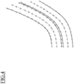
- FIG. 4 and FIG. 5 are each a diagram illustrating an example of a format of lane boundary lines (white circles and triangles in the figure) and lane centerlines (diamond shapes in the figure) along the curve of the road.
- a format for expressing curves or straight lines by discrete point sequences can be exemplified as the format of the lane boundary lines and lane centerlines of the map data to be stored in the common database 110.
- the common database 110 Through expressing the lane boundary lines and the lane centerlines by discrete point sequences, information on the point sequences can be stored in the common database 110 without editing.
- FIG. 4 illustrates the format of lane boundary lines (white circles and triangles in the figure) and lane centerlines (diamond shapes in the figure) along the curve of the road.
- a format for expressing curves or straight lines by discrete point sequences can be exemplified as the format of the lane boundary lines and lane centerlines of the map data to be stored in the common database 110.
- a format for expressing curves or straight lines by mathematical formulae can also be exemplified as the format of the lane boundary lines and lane centerlines of the map data to be stored in the common database 110.
- this format include Basic-Spline (B-Spline) curves and Non-Uniform Rational Basis-Spline (NURBS) curves.
- B-Spline Basic-Spline
- NURBS Non-Uniform Rational Basis-Spline
- the database standardization unit 120 includes a format conversion unit 121A for map database A, a format conversion unit 121B for map database B, a format conversion unit 121C for map database C, ... and content acquisition units 122A, 122B, 122C, ....
- the content acquisition unit 122A acquires the content from the map database A and transmits the content to the format conversion unit 121A for map database A.
- the content acquisition unit 122B acquires the content from the map database B and transmits the content to the format conversion unit 121B for map database B.
- the content acquisition unit 122C acquires the content from the map database C and transmits the content to the format conversion unit 121C for map database C.
- the formats of content included in the map databases A, B, C, ... are different from one another.
- the format of map data content treated by a system that executes the functions A, B, C, D, E, ... regarding the autonomous driving or the like of the vehicle according to one or more embodiments of the present invention is a format that expresses curves or straight lines by discrete point sequences. In the map data storage device 100 according to one or more embodiments of the present invention, therefore, when the formats of content acquired from the map databases A, B, C, ... by the content acquisition units 122A, 122B, 122C, ...
- the format conversion unit 121A for map database A converts the formats of content acquired by the content acquisition units 122A, 122B, 122C, ... to a format that expresses curves or straight lines by discrete point sequences.
- the format conversion unit 121A for map database A the format conversion unit 121B for map database B, the format conversion unit 121C for map database C, ... reconstruct the curves on the basis of the definition of B-Spline curves or the like and perform sampling of the reconstructed curves at regular intervals thereby to convert the format of B-Spline curves or the like to a format for expressing curves or straight lines by discrete point sequences.
- the format conversion unit 121A for map database A, the format conversion unit 121B for map database B, the format conversion unit 121C for map database C, ... store the content, which has been converted into the format for expressing curves or straight lines by discrete point sequences, in the common database 110.
- FIG. 6 is a diagram illustrating lane boundary lines as the content to be stored in the common database 110.
- the format conversion unit 121A for map database A and other format conversion units store, in the common database 110, indexes 0, 1, 2, 3, ...
- three-dimensional absolute positions (xL0, yL0, zL0), (xL1, yL1, zL1), (xL2, yL2, zL2), (xL3, yL3, zL3), ... of the left-side lane boundary line
- three-dimensional absolute positions (xR0, yR0, zR0), (xR1, yR1, zR1), (xR2, yR2, zR2), (xR3, yR3, zR3), ... of the right-side lane boundary line.
- the content acquisition units 122A, 122B, 122C, ... acquire content that should be stored in the common database 110 but is not stored at the moment, from the map databases A, B, C, ....
- Examples of the content that should be stored in the common database 110 but is not stored at the moment include content that is required from a system executing the functions A, B, C, D, E, ... regarding the autonomous driving or the like and is not stored in the common database 110.
- Examples of the content that is required from a system executing the functions A, B, C, D, E, ... regarding the autonomous driving or the like and is not stored in the common database 110 include stop lines and crosswalks.
- FIG. 7 is a diagram illustrating stop lines as the content acquired from the map databases A, B, C, ....
- the content acquisition units 122A, 122B, 122C acquire indexes 0, 1, 2, 3, ... that indicate the order of storing the content, three-dimensional absolute positions (x01, y01, z01), (x11, y11, z11), (x21, y21, z21), (x31, y31, z31), ... of one end points of the stop lines, and three-dimensional absolute positions (x02, y02, z02), (x12, y12, z12), (x22, y22, z22), (x32, y32, z32), ...
- a format represented by a plurality of points of absolute coordinates such as the format of stop lines
- a common format to the format represented by point sequences. That is, when content in the format represented by a plurality of points of absolute coordinates is acquired by the content acquisition units 122A, 122B, 122C, ..., the acquired content is stored in the common database 110 without format conversion by the format conversion unit 121A for map database A, format conversion unit 121B for map database B, format conversion unit 121C for map database C,
- the content acquisition units 122A, 122B, 122C, ... acquire the content from the map databases A, B, C, ... in accordance with the set priority levels.
- the common database access unit 130 reads the map data content from the common database 110 on the basis of an acquisition request for the map data content from a system that executes the functions A, B, C, D, E, ... regarding the autonomous driving or the like of the vehicle, and outputs the map data content to the functions A, B, C, D, E, ....
- the common database access unit 130 reads the content in accordance with the index order. Examples of information on the content read by the common database access unit 130 include an index, a position (latitude/longitude) at which a lane boundary, a stop line, or the like is drawn, and a position (latitude/longitude) at which a traffic sign, a traffic signal, or the like is installed.
- the common database access unit 130 reads the requested content from the common database 110 and outputs the requested content to the system which executes the functions A, B, C, D, E, ... regarding the autonomous driving or the like.
- the content acquisition units 122A, 122B, 122C, ... acquire the requested content from the map databases A, B, C, ....
- any of the content acquisition units 122A, 122B, 122C, ... acquires the information on stop lines from the corresponding map database A, B, C, ....
- the common database access unit 130 may calculate the requested content on the basis of the content stored in the common database 110. For example, information on the remaining distance for the subject vehicle to reach a stop line is useful information when the subject vehicle travels in the vicinity of an intersection of a general road, but such information is not stored in the common database 110.
- the common database access unit 130 therefore calculates the remaining distance for the subject vehicle to reach the stop line, for example, using information on a lane centerline and information on the stop line that are acquired from the map databases A, B, C, ....
- the common database access unit 130 then stores information on the calculated remaining distance for the subject vehicle to reach the stop line in the common database 110.
- FIG. 8 is a diagram for describing information on the remaining distance for the subject vehicle to reach a stop line, which remaining distance is to be stored in the common database 110.
- the common database access unit 130 stores, in the common database 110, indexes that indicate the order of storing the information, the IDs of lane centerlines, the IDs of stop lines that intersect with the lane centerlines to which their IDs are assigned, and the absolute coordinates of intersection points between the lane centerlines and the stop lines.
- Examples of the content output from the common database access unit 130 to a system that executes the functions A, B, C, D, E, ... regarding the autonomous driving or the like include a function of a lane centerline with an argument of the ID assigned to the lane centerline, a function of a lane centerline with an argument of the position of the subject vehicle, and a function of a remaining distance from the subject vehicle to a stop line with an argument of the position of the subject vehicle.
- Examples of the function of a lane centerline with an argument of the ID assigned to the lane centerline and the function of a lane centerline with an argument of the position of the subject vehicle include coordinates of the point sequence of the lane centerline and information on an attribute of the lane (such as a speed limit, a curvature, or a gradient). Examples of the function of a remaining distance from the subject vehicle to a stop line with an argument of the position of the subject vehicle include the distance to a stop line which the subject vehicle encounters first when continuing to travel in the current lane.
- the update information acquisition unit 140 illustrated in FIG. 1 receives update information from external of the subject vehicle via an onboard communication terminal using wireless communication such as the Long Term Evolution (LTE) line, 4G line, or 5G line.
- Examples of the update information include information transmitted from a server owned by an automobile manufacturer, other business company, or the like and information delivered from a server that delivers road traffic information.
- Examples of the update information transmitted from a server owned by an automobile manufacture or the like include information on a difference between the new generation map data and the old generation map data.
- examples of the information delivered from a server that delivers road traffic information include information on lane closure, information regarding lane connection change, and information regarding lane shape change.
- the lane closure, lane connection change, lane shape change, etc. are represented by information generated in a server that delivers road traffic information on the basis of road construction information, road accident information, new road information, etc.
- the database editing unit 150 edits the content stored in the common database 110 in accordance with the update information acquired by the update information acquisition unit 140. For example, when the update information acquired by the update information acquisition unit 140 includes information on lane closure and/or information regarding lane connection change, the database editing unit 150 deletes the corresponding lane or lanes stored in the common database 110 and/or deletes the connection between the corresponding lane or lanes and the relating lane or lanes located ahead.
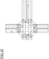
- FIG. 9 and FIG. 10 are each a diagram illustrating an example of editing lanes stored in the common database 110 when the update information acquired by the update information acquisition unit 140 includes information on lane closure.
- the update information acquired by the update information acquisition unit 140 includes information on lane closure.
- FIG. 9 when a lane located before the intersection is closed, the closed lane located before the intersection and stored in the common database 110 is deleted.
- FIG. 10 when a lane immediately after the subject vehicle passes through the intersection is closed and the subject vehicle is traveling before the intersection, the closed lane immediately after the subject vehicle passes through the intersection is deleted, and the connection between the closed lane and a relating lane before the intersection is deleted. This can avoid the risk that the subject vehicle enters the closed lane after passing through the intersection.
- the database editing unit 150 deletes the closed lane and/or deletes the connection between the closed lane and a relating lane located ahead, but does not change the lane shape.
- FIG. 11 is a diagram illustrating an example of editing lanes stored in the common database 110 when the update information acquired by the update information acquisition unit 140 is information in which the traveling direction in the central lane is reversed depending on the time slot.
- the traveling direction in the central lane is reversed between the morning time slot and the early-evening time slot (the traveling direction in the daytime time slot is the same as that in the morning time slot or the early-evening time slot)
- the central lane is deleted and the connection between the central lane and another lane relating to the central lane is deleted for a certain period before and after the time when the traveling direction in the central lane is changed. This can avoid the risk that the subject vehicle enters the central lane in the opposite direction to the traveling direction in the central lane before and after the traveling direction is changed.
- the database editing unit 150 has a database editing function of editing the content stored in the common database 110 in accordance with the update information acquired by the update information acquisition unit 140.
- Examples of the database editing function include a lane connection information editing function.
- the lane connection information editing function is a function of deleting, when the update information acquired by the update information acquisition unit 140 includes information on lane closure and/or information regarding lane connection change, the corresponding lane or lanes stored in the common database 110 and/or deleting the connection between the corresponding lane or lanes and the relating lane or lanes located ahead.
- Examples of the database editing function of the database editing unit 150 further include a lane shape editing function.
- the lane shape editing function is a function of changing, when the update information acquired by the update information acquisition unit 140 includes information regarding lane shape change, the shape of the corresponding lane stored in the common database 110.
- the database editing unit 150 changes the shape of the corresponding lane on the basis of the shape of the lane and the shapes of lanes connecting to the lane from ahead and/or behind.
- FIG. 12 is a diagram illustrating an example of editing lanes stored in the common database 110 when the update information acquired by the update information acquisition unit 140 includes lane shape change.
- the database editing unit 150 changes the lane shape stored in the common database 110 on the basis of the lane immediately after passing through the intersection. For example, when such an impassable position exists on the right-side lane before the intersection and the vehicle is to turn right at the intersection, the lane shape is changed to a shape such that the vehicle changes lanes to the adjacent lane before the impassable position and returns to the original lane immediately after passing through the impassable position.
- the lane information may be generated on the basis of travel trajectory information of the vehicle in a tile that is set on the basis of the traveling area of the subject vehicle.
- the lane boundary lines may be generated on the basis of the lane width based on the road attribute included in the map data and the travel trajectory information of the vehicle.
- FIG. 13 is a flowchart for describing a process of storing the map data content in the common database 110.
- the common database access unit 130 designates an area of the map data for which the content is stored in the common database 110, in accordance with the traveling area of the subject vehicle.
- the common database access unit 130 reads the content of the area designated in step S101 from the map data 101 and stores the content in the common database 110.
- step S103 the format conversion unit 121A for map database A, the format conversion unit 121B for map database B, the format conversion unit 121C for map database C, ... set the priority levels of content to be acquired in accordance with the levels for achieving the functions A, B, C, D, E, ... regarding the autonomous driving or the like.
- step S104 the content acquisition units 122A, 122B, 122C, ... determine whether or not the priority levels of content that can be acquired from the map databases A, B, C, ... are higher than a predetermined reference level.
- An affirmative determination in step S104 is followed by step S105 while a negative determination in step S104 is followed by step S108.
- step S105 the content acquisition units 122A, 122B, 122C, ... acquire the content with higher priority levels than the predetermined reference level from the map databases A, B, C, ....
- step S106 the format conversion unit 121A for map database A, the format conversion unit 121B for map database B, the format conversion unit 121C for map database C, ... convert the formats of the content, which is acquired from the map databases A, B, C, ... by the content acquisition units 122A, 122B, 122C, ..., to a format compatible with a system that executes the functions A, B, C, D, E, ... regarding the autonomous driving or the like.
- step S107 the format conversion unit 121A for map database A, the format conversion unit 121B for map database B, the format conversion unit 121C for map database C, ... store the content in the converted format in the common database 110.
- step S108 the content acquisition units 122A, 122B, 122C, ... determine whether or not there is content that is not included in the map data 101 but should be stored in the common database 110.
- An affirmative determination in step S108 is followed by step S109 while a negative determination in step S108 is followed by step S112.
- step S109 the content acquisition units 122A, 122B, 122C, ... acquire the content that is not included in the map data 101 but should be stored in the common database 110, from the map databases A, B, C, ....
- step S110 the format conversion unit 121A for map database A, the format conversion unit 121B for map database B, the format conversion unit 121C for map database C, ...
- step S111 the format conversion unit 121A for map database A, the format conversion unit 121B for map database B, the format conversion unit 121C for map database C, ... store the content in the converted format in the common database 110.
- step S112 the content acquisition units 122A, 122B, 122C, ... determine whether or not there is content that should be calculated on the basis of the content stored in the common database 110. An affirmative determination in step S112 is followed by step S113 while a negative determination in step S112 is followed by step S115.
- step S113 the content acquisition units 122A, 122B, 122C, ... calculate content that is not stored in the common database 110 on the basis of the content stored in the common database 110.
- step S114 the format conversion unit 121A for map database A, the format conversion unit 121B for map database B, the format conversion unit 121C for map database C, ... store the calculated content in the common database 110.
- step S115 the common database access unit 130 determines whether or not there is a content acquisition request from a system that executes the functions A, B, C, D, E, ... regarding the autonomous driving or the like. An affirmative determination in step S115 is followed by step S116.
- step S116 the common database access unit 130 reads the requested content from the common database 110 and outputs the content to the system which executes the functions A, B, C, D, E, .... The process of storing the map data content in the common database 110 is thus completed.
- FIG. 14 is a flowchart for describing a process of editing the map data content stored in the common database 110.
- the update information acquisition unit 140 receives update information from external of the subject vehicle during the online mode (step S201).
- the database editing unit 150 determines whether or not the update information acquired by the update information acquisition unit 140 is different from the information stored in the common database 110 (step S202).
- An affirmative determination in step S202 is followed by step S203 while a negative determination in step S202 is followed by completion of the process.
- step S203 the database editing unit 150 determines whether or not the update information acquired by the update information acquisition unit 140 is information regarding lane closure or information regarding lane connection change. An affirmative determination in step S203 is followed by step S204 while a negative determination in step S203 is followed by step S205.
- step S204 the database editing unit 150 deletes the corresponding lane stored in the common database 110 and changes the connection between the corresponding lane and another lane relating to the corresponding lane.
- step S205 the database editing unit 150 determines whether or not the update information acquired by the update information acquisition unit 140 is information regarding lane connection change or information regarding lane shape change. An affirmative determination in step S205 is followed by step S206 while a negative determination in step S205 is followed by completion of the process.
- step S206 the database editing unit 150 changes the shape of the corresponding lane stored in the common database 110. The process of editing the map data content stored in the common database 110 is thus completed.
- formats of the acquired map data content are converted to a predetermined format that can be used in the subject vehicle, the map data content converted into the predetermined format is stored in the common database 110, update information regarding the map data content stored in the common database 110 is acquired, and the map data content in the above predetermined format stored in the common database 110 is edited on the basis of the acquired update information.
- the map data content can be used to edit the map data content used in the subject vehicle.
- one type of the above predetermined format is set for each item of the map data content.
- the formats of lane boundary lines and lane centerlines are unified to a format in which the lane boundary lines and the lane centerlines are expressed by point sequences (see FIG. 4 ).
- one type of the predetermined format is set for each item of the content to be compatible with programs of a system that executes the functions A, B, C, ... regarding the autonomous driving or the like on the vehicle side, and the acquired map data content can thereby be used to run the system without changing the programs of the system.
- content in formats in which lines are expressed by point sequences may have a larger data capacity as compared with a format in which lines are expressed by mathematical formulae such as B-Spline curves (see FIG. 5 ).
- one type of the predetermined format set for each item of the map data content is made to a format in which lines are expressed by point sequences, and the capacity of data to be stored in the common database 110 is thereby suppressed.
- a priority level is assigned to the map data content in accordance with a use frequency in the subject vehicle, the map data content with a higher priority level is preferentially acquired, and the acquired map data content is converted into the predetermined format and stored in the database. That is, the content subjected to the format conversion process and the storage process into the common database 110 is limited to content that has a high degree of necessity, such as lane boundary lines and lane connections. This can prevent a shortage of necessary content in a system that executes the functions A, B, C, ... regarding the autonomous driving or the like on the vehicle side. Moreover, the processing amount can be reduced in the format conversion process for the content and the storage process into the common database 110, and the memory usage in the common database 110 can also be suppressed.
- map data content that is not included in the map data possessed by the subject vehicle is acquired from the map databases A, B, C, ..., the formats of the acquired map data content are converted to the above predetermined format, and the map data content in the converted format is stored in the common database 110 (see FIG. 8 ).
- map data storage method and device In the map data storage method and device according to one or more embodiments of the present invention, content that is not included in the map data 101 possessed by the subject vehicle is generated on the basis of the map data content stored in the common database 110, and the generated map data content is stored in the common database 110 (see FIG. 8 ).
- the generated map data content is stored in the common database 110 (see FIG. 8 ).
- the map data content is acquired in accordance with information on the current position of the subject vehicle (see FIG. 2 ).
- the map data content can be converted into the format in accordance with the current position of the subject vehicle and stored in the common database 110, and a system that executes the functions A, B, C, ... regarding the autonomous driving or the like on the vehicle side can use the map data content in accordance with the current position of the subject vehicle.
- the information regarding the lane connection stored in the common database 110 is edited (see FIG. 10 ).
- the subject vehicle can be prevented from entering a closed lane.
- map data storage method and device when information regarding lane closure immediately after an intersection is acquired during travel of the subject vehicle before the intersection, a lane located before the intersection and connected to the closed lane and connection between the lane located before the intersection and another lane relating to the lane, as the update information stored in the common database 110, are deleted (see FIG. 10 ).
- the update information stored in the common database 110 are deleted (see FIG. 10 ).
- the traveling direction in a lane is changed, the lane and connection between the lane and another lane relating to the lane are deleted for a predetermined time (see FIG. 11 ).
- the subject vehicle can be prevented from entering the lane in the opposite direction to the traveling direction in the lane which has been changed.
- information regarding a lane shape stored in the common database 110 is edited (see FIG. 12 ). For example, when an impassable position exists on the right-side lane before an intersection and the vehicle is to turn right at the intersection, the lane shape is changed to a shape such that the vehicle changes lanes to an adjacent lane before the impassable position and returns to the original lane immediately after passing through the impassable position.
- information regarding a lane shape is generated on the basis of information on a travel trajectory of the subject vehicle, and the information regarding the lane shape stored in the common database 110 is edited on the basis of the generated information regarding the lane shape.
- the information regarding the lane shape stored in the common database 110 can be edited.
- a lane boundary line as the lane shape is generated on the basis of information on the travel trajectory of the subject vehicle and a lane width as road attribute information, and the information regarding the lane boundary line stored in the common database 110 is edited on the basis of the generated lane boundary line.
- the shape of a corresponding lane stored in the common database 110 is changed on the basis of the shape of a lane located ahead of and/or behind the corresponding lane (see FIG. 12 ). Through this operation, when the lane shape stored in the common database 110 is changed, the lane shape can be changed to a smooth lane shape.
- the formats of the acquired content may not have to be converted to one type of format and may be changed to a format selected from among the two or more types of formats or modified in an appropriate manner.
Landscapes
- Engineering & Computer Science (AREA)
- Remote Sensing (AREA)
- Radar, Positioning & Navigation (AREA)
- Physics & Mathematics (AREA)
- General Physics & Mathematics (AREA)
- Automation & Control Theory (AREA)
- Theoretical Computer Science (AREA)
- Mathematical Physics (AREA)
- Business, Economics & Management (AREA)
- Educational Administration (AREA)
- Educational Technology (AREA)
- Databases & Information Systems (AREA)
- Navigation (AREA)
- Traffic Control Systems (AREA)
- Instructional Devices (AREA)
Abstract
Description
- The present invention relates to a map data storage method and a map data storage device.
- A method of updating a map stored in a navigation device is known (see Patent Document 1:
WO2016/067849 , for example). This method includes creating difference data between map data being currently referred to by the navigation device and map data of a newest generation, updating the map data on the basis of the difference data, and writing the updated map data to different areas than the areas in which the pre-update map data are stored. If some trouble occurs in the updated map data, the pre-update map data can be referred to. - [Patent Document 1]
WO2016/067849 - The method described in
Patent Document 1, however, can only be applied to the map data content in a specific format, and if the map data content in a different type of format is provided, the map data content used in the subject vehicle cannot be edited. - A problem to be solved by the present invention is to provide a map data storage method and a map data storage device with which, even when map data content in a different format than that used in the subject vehicle is acquired, the map data content used in the subject vehicle can be edited on the basis of the acquired map data content.
- The present invention solves the above problem through converting a format of the acquired map data content to a predetermined format that can be used in the subject vehicle, storing the map data content converted into the predetermined format in a database, acquiring update information regarding the map data content stored in the database, and editing the map data content in the predetermined format stored in the database on the basis of the acquired update information.
- According to the present invention, even when map data content in a different format than that used in the subject vehicle is acquired, the map data content used in the subject vehicle can be edited on the basis of the acquired map data content.
-
-
FIG. 1 is a block diagram illustrating the outline of a map data storage device according to one or more embodiments of the present invention. -
FIG. 2 is a diagram for describing map tiles. -
FIG. 3 is a diagram illustrating a curve of a road. -
FIG. 4 is a diagram illustrating an example of a format of lane boundary lines and lane centerlines along the curve of the road. -
FIG. 5 is a diagram illustrating an example of a format of lane boundary lines and lane centerlines along the curve of the road. -
FIG. 6 is a diagram illustrating lane boundary lines as content to be stored in a common database. -
FIG. 7 is a diagram illustrating stop lines as content acquired from map databases A, B, C, .... -
FIG. 8 is a diagram for describing information on a remaining distance for the subject vehicle to reach a stop line, which remaining distance is to be stored in the common database. -
FIG. 9 is a diagram illustrating an example of editing lanes stored in the common database when update information acquired by an update information acquisition unit includes information on lane closure. -
FIG. 10 is a diagram illustrating an example of editing lanes stored in the common database when the update information acquired by the update information acquisition unit includes information on lane closure. -
FIG. 11 is a diagram illustrating an example of editing lanes stored in the common database when the update information acquired by the update information acquisition unit is information in which the traveling direction in a central lane is reversed depending on the time slot. -
FIG. 12 is a diagram illustrating an example of editing lanes stored in the common database when the update information acquired by the update information acquisition unit includes lane shape change. -
FIG. 13 is a flowchart for describing a process of storing map data content in the common database. -
FIG. 14 is a flowchart for describing a process of editing the map data content stored in the common database. - Hereinafter, one or more embodiments of the present invention will be described with reference to the drawings.
FIG. 1 is a block diagram illustrating the outline of a mapdata storage device 100 according to one or more embodiments of the present invention. The mapdata storage device 100 illustrated in the figure operates to store the content of a high-definition map (HD map, referred simply to as "map data," hereinafter) in acommon database 110. The content of the HD map includes at least lane information and is used in driving assistance or autonomous (automated) driving (referred to as "autonomous driving or the like," hereinafter). Here, the mapdata storage device 100 operates to: acquire the content in different formats from a plurality of map databases A, B, C, ... having different formats of content when the vehicle executes the autonomous driving or the like (this execution mode will be referred to as an "online mode," hereinafter); convert the formats of the acquired content to a predetermined format compatible with programs for the autonomous driving or the like of the vehicle; and store the content in the converted format in thecommon database 110. In addition, the mapdata storage device 100 operates to acquire update information of the map data from external during the online mode and edit the content stored in thecommon database 110 on the basis of the acquired update information. - The map
data storage device 100 includesmap data 101, thecommon database 110, adatabase standardization unit 120, a commondatabase access unit 130, an updateinformation acquisition unit 140, and adatabase editing unit 150. Themap data 101 is map data possessed by the subject vehicle, and the format of the content of themap data 101 is a format compatible with programs for the autonomous driving or the like of the subject vehicle. Themap data 101 is updated at regular intervals (e.g., every six months or every year), but is not directly edited by the mapdata storage device 100. - The
common database 110 stores the content of themap data 101 and the content acquired from the external map databases A, B, C, .... The format of the content acquired from the external map databases A, B, C, ... and stored in thecommon database 110 is the same as the format of the content of themap data 101. Examples of the content stored in thecommon database 110 include a lane centerline, a lane boundary line, a stop line, a crosswalk, a traffic sign, a traffic signal, and a road surface paint. These items of the content are each assigned an ID indicating the type of content, a substance represented by the content, and an index indicating the order of the stored content. - The common
database access unit 130 reads the content from themap data 101 and stores the content in thecommon database 110. In addition, on the basis of an acquisition request for the map data content from a system that executes functions A, B, C, D, E, ... regarding the autonomous driving or the like, the commondatabase access unit 130 reads the map data content from thecommon database 110 and outputs the map data content to the system which executes the functions A, B, C, D, E, .... The commondatabase access unit 130 reads the map data content in accordance with the index order. Examples of information on the map data content read by the commondatabase access unit 130 include an index, a position (three-dimensional absolute position) at which a lane boundary, a stop line, or the like is drawn, and a position (three-dimensional absolute position) at which a traffic sign, a traffic signal, or the like is installed. - The common
database access unit 130 designates an area of the map data for which the content is stored in thecommon database 110, in accordance with the traveling area (current position) of the subject vehicle.FIG. 2 is a diagram for describing map tiles. As illustrated in the figure, the map data is usually divided into tiles. Each tile of the map data is assigned an ID. The commondatabase access unit 130 specifies the ID of a tile thereby to designate an area of the map data for which the content is stored in thecommon database 110. -
FIG. 3 is a diagram illustrating a curve of a road. With reference to the curve of the road illustrated in the figure, formats of lane boundary lines and lane centerlines of the map data to be stored in thecommon database 110 in one or more embodiments of the present invention will be described. -
FIG. 4 andFIG. 5 are each a diagram illustrating an example of a format of lane boundary lines (white circles and triangles in the figure) and lane centerlines (diamond shapes in the figure) along the curve of the road. As illustrated inFIG. 4 , a format for expressing curves or straight lines by discrete point sequences can be exemplified as the format of the lane boundary lines and lane centerlines of the map data to be stored in thecommon database 110. Through expressing the lane boundary lines and the lane centerlines by discrete point sequences, information on the point sequences can be stored in thecommon database 110 without editing. On the other hand, as illustrated inFIG. 5 , a format for expressing curves or straight lines by mathematical formulae can also be exemplified as the format of the lane boundary lines and lane centerlines of the map data to be stored in thecommon database 110. Examples of this format include Basic-Spline (B-Spline) curves and Non-Uniform Rational Basis-Spline (NURBS) curves. The B-Spline curve is a smooth curve defined by a plurality of control points, and the NURBS curve is a smooth curve defined by a plurality of control points and a knot vector. - The
database standardization unit 120 includes aformat conversion unit 121A for map database A, aformat conversion unit 121B for map database B, aformat conversion unit 121C for map database C, ... andcontent acquisition units content acquisition unit 122A acquires the content from the map database A and transmits the content to theformat conversion unit 121A for map database A. Thecontent acquisition unit 122B acquires the content from the map database B and transmits the content to theformat conversion unit 121B for map database B. Thecontent acquisition unit 122C acquires the content from the map database C and transmits the content to theformat conversion unit 121C for map database C. - Here, the formats of content included in the map databases A, B, C, ... are different from one another. On the other hand, the format of map data content treated by a system that executes the functions A, B, C, D, E, ... regarding the autonomous driving or the like of the vehicle according to one or more embodiments of the present invention is a format that expresses curves or straight lines by discrete point sequences. In the map
data storage device 100 according to one or more embodiments of the present invention, therefore, when the formats of content acquired from the map databases A, B, C, ... by thecontent acquisition units format conversion unit 121A for map database A, theformat conversion unit 121B for map database B, theformat conversion unit 121C for map database C, ... convert the formats of content acquired by thecontent acquisition units content acquisition units format conversion unit 121A for map database A, theformat conversion unit 121B for map database B, theformat conversion unit 121C for map database C, ... reconstruct the curves on the basis of the definition of B-Spline curves or the like and perform sampling of the reconstructed curves at regular intervals thereby to convert the format of B-Spline curves or the like to a format for expressing curves or straight lines by discrete point sequences. - The
format conversion unit 121A for map database A, theformat conversion unit 121B for map database B, theformat conversion unit 121C for map database C, ... store the content, which has been converted into the format for expressing curves or straight lines by discrete point sequences, in thecommon database 110.FIG. 6 is a diagram illustrating lane boundary lines as the content to be stored in thecommon database 110. As illustrated in the figure, theformat conversion unit 121A for map database A and other format conversion units store, in thecommon database 110,indexes - The
content acquisition units common database 110 but is not stored at the moment, from the map databases A, B, C, .... Examples of the content that should be stored in thecommon database 110 but is not stored at the moment include content that is required from a system executing the functions A, B, C, D, E, ... regarding the autonomous driving or the like and is not stored in thecommon database 110. Examples of the content that is required from a system executing the functions A, B, C, D, E, ... regarding the autonomous driving or the like and is not stored in thecommon database 110 include stop lines and crosswalks. -
FIG. 7 is a diagram illustrating stop lines as the content acquired from the map databases A, B, C, .... As illustrated in the figure, thecontent acquisition units indexes data storage device 100 according to one or more embodiments of the present invention, a format represented by a plurality of points of absolute coordinates, such as the format of stop lines, is processed as a common format to the format represented by point sequences. That is, when content in the format represented by a plurality of points of absolute coordinates is acquired by thecontent acquisition units common database 110 without format conversion by theformat conversion unit 121A for map database A,format conversion unit 121B for map database B,format conversion unit 121C for map database C, - Here, when executing the functions A, B, C, D, E, ... regarding the autonomous driving or the like, there are high and low levels for achieving the functions, and depending on the level, the type of necessary map data content and the number of items of the map data content are different. For example, to achieve a lane-keeping function on an expressway, lane boundary lines and lane centerlines are required as the map data content. Additionally or alternatively, to achieve an autonomous driving function on a general road, stop lines, crosswalks, traffic signs, etc. are required as the map data content in addition to lane boundary lines and lane centerlines. Accordingly, each of the
format conversion unit 121A for map database A, theformat conversion unit 121B for map database B, theformat conversion unit 121C for map database C, ... has a priority level assignment function and sets the priority level of content to be acquired in accordance with the level for achieving the corresponding function A, B, C, D, E, .... Thecontent acquisition units - The common
database access unit 130 reads the map data content from thecommon database 110 on the basis of an acquisition request for the map data content from a system that executes the functions A, B, C, D, E, ... regarding the autonomous driving or the like of the vehicle, and outputs the map data content to the functions A, B, C, D, E, .... The commondatabase access unit 130 reads the content in accordance with the index order. Examples of information on the content read by the commondatabase access unit 130 include an index, a position (latitude/longitude) at which a lane boundary, a stop line, or the like is drawn, and a position (latitude/longitude) at which a traffic sign, a traffic signal, or the like is installed. - Here, when the map data content requested by a system that executes the functions A, B, C, D, E, ... regarding the autonomous driving or the like is stored in the
common database 110, the commondatabase access unit 130 reads the requested content from thecommon database 110 and outputs the requested content to the system which executes the functions A, B, C, D, E, ... regarding the autonomous driving or the like. On the other hand, when the map data content requested by a system that executes the functions A, B, C, D, E, ... regarding the autonomous driving or the like is not stored in thecommon database 110, thecontent acquisition units common database 110 but is stored in any of the map databases A, B, C, ..., any of thecontent acquisition units - When the map data content requested by a system that executes the functions A, B, C, D, E, ... regarding the autonomous driving or the like is not stored in the
common database 110, the commondatabase access unit 130 may calculate the requested content on the basis of the content stored in thecommon database 110. For example, information on the remaining distance for the subject vehicle to reach a stop line is useful information when the subject vehicle travels in the vicinity of an intersection of a general road, but such information is not stored in thecommon database 110. The commondatabase access unit 130 therefore calculates the remaining distance for the subject vehicle to reach the stop line, for example, using information on a lane centerline and information on the stop line that are acquired from the map databases A, B, C, .... The commondatabase access unit 130 then stores information on the calculated remaining distance for the subject vehicle to reach the stop line in thecommon database 110. -
FIG. 8 is a diagram for describing information on the remaining distance for the subject vehicle to reach a stop line, which remaining distance is to be stored in thecommon database 110. As illustrated in the figure, the commondatabase access unit 130 stores, in thecommon database 110, indexes that indicate the order of storing the information, the IDs of lane centerlines, the IDs of stop lines that intersect with the lane centerlines to which their IDs are assigned, and the absolute coordinates of intersection points between the lane centerlines and the stop lines. - Examples of the content output from the common
database access unit 130 to a system that executes the functions A, B, C, D, E, ... regarding the autonomous driving or the like include a function of a lane centerline with an argument of the ID assigned to the lane centerline, a function of a lane centerline with an argument of the position of the subject vehicle, and a function of a remaining distance from the subject vehicle to a stop line with an argument of the position of the subject vehicle. Examples of the function of a lane centerline with an argument of the ID assigned to the lane centerline and the function of a lane centerline with an argument of the position of the subject vehicle include coordinates of the point sequence of the lane centerline and information on an attribute of the lane (such as a speed limit, a curvature, or a gradient). Examples of the function of a remaining distance from the subject vehicle to a stop line with an argument of the position of the subject vehicle include the distance to a stop line which the subject vehicle encounters first when continuing to travel in the current lane. - The update
information acquisition unit 140 illustrated inFIG. 1 receives update information from external of the subject vehicle via an onboard communication terminal using wireless communication such as the Long Term Evolution (LTE) line, 4G line, or 5G line. Examples of the update information include information transmitted from a server owned by an automobile manufacturer, other business company, or the like and information delivered from a server that delivers road traffic information. Examples of the update information transmitted from a server owned by an automobile manufacture or the like include information on a difference between the new generation map data and the old generation map data. On the other hand, examples of the information delivered from a server that delivers road traffic information include information on lane closure, information regarding lane connection change, and information regarding lane shape change. The lane closure, lane connection change, lane shape change, etc. are represented by information generated in a server that delivers road traffic information on the basis of road construction information, road accident information, new road information, etc. - The
database editing unit 150 edits the content stored in thecommon database 110 in accordance with the update information acquired by the updateinformation acquisition unit 140. For example, when the update information acquired by the updateinformation acquisition unit 140 includes information on lane closure and/or information regarding lane connection change, thedatabase editing unit 150 deletes the corresponding lane or lanes stored in thecommon database 110 and/or deletes the connection between the corresponding lane or lanes and the relating lane or lanes located ahead. -
FIG. 9 andFIG. 10 are each a diagram illustrating an example of editing lanes stored in thecommon database 110 when the update information acquired by the updateinformation acquisition unit 140 includes information on lane closure. As illustrated inFIG. 9 , when a lane located before the intersection is closed, the closed lane located before the intersection and stored in thecommon database 110 is deleted. On the other hand, as illustrated inFIG. 10 , when a lane immediately after the subject vehicle passes through the intersection is closed and the subject vehicle is traveling before the intersection, the closed lane immediately after the subject vehicle passes through the intersection is deleted, and the connection between the closed lane and a relating lane before the intersection is deleted. This can avoid the risk that the subject vehicle enters the closed lane after passing through the intersection. - Here, when a lane is closed, it is necessary to prevent the vehicle from entering the closed lane, so it is necessary to delete the closed lane and/or delete the connection between the closed lane and a relating lane located ahead, but it is not necessary to change the lane shape. In one or more embodiments of the present invention, therefore, from the viewpoint of suppressing an increase in the processing amount related to the content editing and also suppressing the usage of resources, when a lane is closed, the
database editing unit 150 deletes the closed lane and/or deletes the connection between the closed lane and a relating lane located ahead, but does not change the lane shape. -
FIG. 11 is a diagram illustrating an example of editing lanes stored in thecommon database 110 when the update information acquired by the updateinformation acquisition unit 140 is information in which the traveling direction in the central lane is reversed depending on the time slot. As illustrated in the figure, when the traveling direction in the central lane is reversed between the morning time slot and the early-evening time slot (the traveling direction in the daytime time slot is the same as that in the morning time slot or the early-evening time slot), for example, the central lane is deleted and the connection between the central lane and another lane relating to the central lane is deleted for a certain period before and after the time when the traveling direction in the central lane is changed. This can avoid the risk that the subject vehicle enters the central lane in the opposite direction to the traveling direction in the central lane before and after the traveling direction is changed. - The
database editing unit 150 has a database editing function of editing the content stored in thecommon database 110 in accordance with the update information acquired by the updateinformation acquisition unit 140. Examples of the database editing function include a lane connection information editing function. The lane connection information editing function is a function of deleting, when the update information acquired by the updateinformation acquisition unit 140 includes information on lane closure and/or information regarding lane connection change, the corresponding lane or lanes stored in thecommon database 110 and/or deleting the connection between the corresponding lane or lanes and the relating lane or lanes located ahead. - Examples of the database editing function of the
database editing unit 150 further include a lane shape editing function. The lane shape editing function is a function of changing, when the update information acquired by the updateinformation acquisition unit 140 includes information regarding lane shape change, the shape of the corresponding lane stored in thecommon database 110. In one or more embodiments of the present invention, when the update information acquired by the updateinformation acquisition unit 140 includes information regarding lane shape change, thedatabase editing unit 150 changes the shape of the corresponding lane on the basis of the shape of the lane and the shapes of lanes connecting to the lane from ahead and/or behind. -
FIG. 12 is a diagram illustrating an example of editing lanes stored in thecommon database 110 when the update information acquired by the updateinformation acquisition unit 140 includes lane shape change. As illustrated in the figure, when the lane located before the intersection is not completely closed and part of the lane located before the intersection is impassable, thedatabase editing unit 150 changes the lane shape stored in thecommon database 110 on the basis of the lane immediately after passing through the intersection. For example, when such an impassable position exists on the right-side lane before the intersection and the vehicle is to turn right at the intersection, the lane shape is changed to a shape such that the vehicle changes lanes to the adjacent lane before the impassable position and returns to the original lane immediately after passing through the impassable position. - Here, when the update information acquired by the update
information acquisition unit 140 does not include the lane shape itself, the lane information may be generated on the basis of travel trajectory information of the vehicle in a tile that is set on the basis of the traveling area of the subject vehicle. For example, the lane boundary lines may be generated on the basis of the lane width based on the road attribute included in the map data and the travel trajectory information of the vehicle. -
FIG. 13 is a flowchart for describing a process of storing the map data content in thecommon database 110. As illustrated in the flowchart, first, in step S101, the commondatabase access unit 130 designates an area of the map data for which the content is stored in thecommon database 110, in accordance with the traveling area of the subject vehicle. Then, in step S102, the commondatabase access unit 130 reads the content of the area designated in step S101 from themap data 101 and stores the content in thecommon database 110. - Then, in step S103, the
format conversion unit 121A for map database A, theformat conversion unit 121B for map database B, theformat conversion unit 121C for map database C, ... set the priority levels of content to be acquired in accordance with the levels for achieving the functions A, B, C, D, E, ... regarding the autonomous driving or the like. Then, in step S104, thecontent acquisition units - In step S105, the
content acquisition units format conversion unit 121A for map database A, theformat conversion unit 121B for map database B, theformat conversion unit 121C for map database C, ... convert the formats of the content, which is acquired from the map databases A, B, C, ... by thecontent acquisition units format conversion unit 121A for map database A, theformat conversion unit 121B for map database B, theformat conversion unit 121C for map database C, ... store the content in the converted format in thecommon database 110. - Then, in step S108, the
content acquisition units map data 101 but should be stored in thecommon database 110. An affirmative determination in step S108 is followed by step S109 while a negative determination in step S108 is followed by step S112. In step S109, thecontent acquisition units map data 101 but should be stored in thecommon database 110, from the map databases A, B, C, .... Then, in step S110, theformat conversion unit 121A for map database A, theformat conversion unit 121B for map database B, theformat conversion unit 121C for map database C, ... convert the formats of the content, which is acquired from the map databases A, B, C, ... by thecontent acquisition units format conversion unit 121A for map database A, theformat conversion unit 121B for map database B, theformat conversion unit 121C for map database C, ... store the content in the converted format in thecommon database 110. - In step S112, the
content acquisition units common database 110. An affirmative determination in step S112 is followed by step S113 while a negative determination in step S112 is followed by step S115. - In step S113, the
content acquisition units common database 110 on the basis of the content stored in thecommon database 110. Then, in step S114, theformat conversion unit 121A for map database A, theformat conversion unit 121B for map database B, theformat conversion unit 121C for map database C, ... store the calculated content in thecommon database 110. - Then, in step S115, the common
database access unit 130 determines whether or not there is a content acquisition request from a system that executes the functions A, B, C, D, E, ... regarding the autonomous driving or the like. An affirmative determination in step S115 is followed by step S116. In step S116, the commondatabase access unit 130 reads the requested content from thecommon database 110 and outputs the content to the system which executes the functions A, B, C, D, E, .... The process of storing the map data content in thecommon database 110 is thus completed. -
FIG. 14 is a flowchart for describing a process of editing the map data content stored in thecommon database 110. As illustrated in the flowchart, the updateinformation acquisition unit 140 receives update information from external of the subject vehicle during the online mode (step S201). Then, thedatabase editing unit 150 determines whether or not the update information acquired by the updateinformation acquisition unit 140 is different from the information stored in the common database 110 (step S202). An affirmative determination in step S202 is followed by step S203 while a negative determination in step S202 is followed by completion of the process. - In step S203, the
database editing unit 150 determines whether or not the update information acquired by the updateinformation acquisition unit 140 is information regarding lane closure or information regarding lane connection change. An affirmative determination in step S203 is followed by step S204 while a negative determination in step S203 is followed by step S205. In step S204, thedatabase editing unit 150 deletes the corresponding lane stored in thecommon database 110 and changes the connection between the corresponding lane and another lane relating to the corresponding lane. - Then, in step S205, the
database editing unit 150 determines whether or not the update information acquired by the updateinformation acquisition unit 140 is information regarding lane connection change or information regarding lane shape change. An affirmative determination in step S205 is followed by step S206 while a negative determination in step S205 is followed by completion of the process. - In step S206, the
database editing unit 150 changes the shape of the corresponding lane stored in thecommon database 110. The process of editing the map data content stored in thecommon database 110 is thus completed. - As described above, in the map data storage method and device according to one or more embodiments of the present invention, formats of the acquired map data content are converted to a predetermined format that can be used in the subject vehicle, the map data content converted into the predetermined format is stored in the
common database 110, update information regarding the map data content stored in thecommon database 110 is acquired, and the map data content in the above predetermined format stored in thecommon database 110 is edited on the basis of the acquired update information. Through this operation, whatever be the formats of the map data content acquired from external map databases A, B, C, ..., the map data content can be used to edit the map data content used in the subject vehicle. - In one or more embodiments of the present invention, one type of the above predetermined format is set for each item of the map data content. For example, as described above, the formats of lane boundary lines and lane centerlines are unified to a format in which the lane boundary lines and the lane centerlines are expressed by point sequences (see
FIG. 4 ). According to the above feature, one type of the predetermined format is set for each item of the content to be compatible with programs of a system that executes the functions A, B, C, ... regarding the autonomous driving or the like on the vehicle side, and the acquired map data content can thereby be used to run the system without changing the programs of the system. - Here, content in formats in which lines are expressed by point sequences may have a larger data capacity as compared with a format in which lines are expressed by mathematical formulae such as B-Spline curves (see
FIG. 5 ). In one or more embodiments of the present invention, therefore, one type of the predetermined format set for each item of the map data content is made to a format in which lines are expressed by point sequences, and the capacity of data to be stored in thecommon database 110 is thereby suppressed. - In the map data storage method and device according to one or more embodiments of the present invention, a priority level is assigned to the map data content in accordance with a use frequency in the subject vehicle, the map data content with a higher priority level is preferentially acquired, and the acquired map data content is converted into the predetermined format and stored in the database. That is, the content subjected to the format conversion process and the storage process into the
common database 110 is limited to content that has a high degree of necessity, such as lane boundary lines and lane connections. This can prevent a shortage of necessary content in a system that executes the functions A, B, C, ... regarding the autonomous driving or the like on the vehicle side. Moreover, the processing amount can be reduced in the format conversion process for the content and the storage process into thecommon database 110, and the memory usage in thecommon database 110 can also be suppressed. - In the map data storage method and device according to one or more embodiments of the present invention, map data content that is not included in the map data possessed by the subject vehicle is acquired from the map databases A, B, C, ..., the formats of the acquired map data content are converted to the above predetermined format, and the map data content in the converted format is stored in the common database 110 (see
FIG. 8 ). Through this operation, even when the necessary content increases in a system that executes the functions A, B, C, ... regarding the autonomous driving or the like on the vehicle side, the shortage of the increased content can be prevented. - In the map data storage method and device according to one or more embodiments of the present invention, content that is not included in the
map data 101 possessed by the subject vehicle is generated on the basis of the map data content stored in thecommon database 110, and the generated map data content is stored in the common database 110 (seeFIG. 8 ). Through this operation, even when the necessary content increases in a system that executes the functions A, B, C, ... regarding the autonomous driving or the like on the vehicle side, the shortage of the increased content can be prevented. Moreover, by storing the generated content in thecommon database 110, it is unnecessary to generate the content every time the content is requested from a system that executes the functions A, B, C, ... regarding the autonomous driving or the like on the vehicle side, and the processing amount in the process of generating the content can be suppressed. - In the map data storage method and device according to one or more embodiments of the present invention, the map data content is acquired in accordance with information on the current position of the subject vehicle (see
FIG. 2 ). Through this operation, the map data content can be converted into the format in accordance with the current position of the subject vehicle and stored in thecommon database 110, and a system that executes the functions A, B, C, ... regarding the autonomous driving or the like on the vehicle side can use the map data content in accordance with the current position of the subject vehicle. - In the map data storage method and device according to one or more embodiments of the present invention, when information regarding lane closure or information regarding lane connection as the update information is acquired, the information regarding the lane connection stored in the
common database 110 is edited (seeFIG. 10 ). Through this operation, when a system that executes the autonomous driving function of the subject vehicle uses the map data content stored in thecommon database 110, the subject vehicle can be prevented from entering a closed lane. Here, when a lane is closed, it is necessary to delete the closed lane and/or delete the connection between the closed lane and a relating lane located ahead, but it is not necessary to change the lane shape. In one or more embodiments of the present invention, therefore, when a lane is closed, only the closed lane and the connection between the closed lane and another lane relating to the closed lane are deleted without changing the lane shape. This can suppress an increase in the processing amount related to the content editing and also suppress the usage of resources. - In the map data storage method and device according to one or more embodiments of the present invention, when information regarding lane closure immediately after an intersection is acquired during travel of the subject vehicle before the intersection, a lane located before the intersection and connected to the closed lane and connection between the lane located before the intersection and another lane relating to the lane, as the update information stored in the
common database 110, are deleted (seeFIG. 10 ). Through this operation, when a system that executes the autonomous driving function of the subject vehicle uses the map data content stored in thecommon database 110, the subject vehicle can be prevented from entering the closed lane after passing through the intersection. - In the map data storage method and device according to one or more embodiments of the present invention, when the traveling direction in a lane is changed, the lane and connection between the lane and another lane relating to the lane are deleted for a predetermined time (see
FIG. 11 ). Through this operation, when a system that executes the autonomous driving function of the subject vehicle uses the map data content stored in thecommon database 110, the subject vehicle can be prevented from entering the lane in the opposite direction to the traveling direction in the lane which has been changed. - In the map data storage method and device according to one or more embodiments of the present invention, when information regarding lane connection or information regarding lane shape change as the update information is acquired, information regarding a lane shape stored in the
common database 110 is edited (seeFIG. 12 ). For example, when an impassable position exists on the right-side lane before an intersection and the vehicle is to turn right at the intersection, the lane shape is changed to a shape such that the vehicle changes lanes to an adjacent lane before the impassable position and returns to the original lane immediately after passing through the impassable position. Through this operation, when a system that executes the autonomous driving function of the subject vehicle uses the map data content stored in thecommon database 110, even if an impassable position exists in the traveling direction, the subject vehicle can be controlled to travel in a desired direction while avoiding the impassable position. - In the map data storage method and device according to one or more embodiments of the present invention, information regarding a lane shape is generated on the basis of information on a travel trajectory of the subject vehicle, and the information regarding the lane shape stored in the
common database 110 is edited on the basis of the generated information regarding the lane shape. Through this operation, even when information on lane boundary lines cannot be acquired from the map databases A, B, C, ..., the information regarding the lane shape stored in thecommon database 110 can be edited. - In the map data storage method and device according to one or more embodiments of the present invention, a lane boundary line as the lane shape is generated on the basis of information on the travel trajectory of the subject vehicle and a lane width as road attribute information, and the information regarding the lane boundary line stored in the
common database 110 is edited on the basis of the generated lane boundary line. Through this operation, even when information on lane boundary lines cannot be acquired from the map databases A, B, C, ..., the information regarding the lane boundary lines stored in thecommon database 110 can be edited. - In the map data storage method and device according to one or more embodiments of the present invention, the shape of a corresponding lane stored in the
common database 110 is changed on the basis of the shape of a lane located ahead of and/or behind the corresponding lane (seeFIG. 12 ). Through this operation, when the lane shape stored in thecommon database 110 is changed, the lane shape can be changed to a smooth lane shape. - Embodiments heretofore explained are described to facilitate understanding of the present invention and are not described to limit the present invention. It is therefore intended that the elements disclosed in the above embodiments include all design changes and equivalents to fall within the technical scope of the present invention. For example, when there are two or more types of formats of content compatible with a system that execute the functions A, B, C, ... regarding the autonomous driving or the like of the subject vehicle, the formats of the acquired content may not have to be converted to one type of format and may be changed to a format selected from among the two or more types of formats or modified in an appropriate manner.
-
- 100
- Map data storage device
- 110
- Common database
- 120
- Database standardization unit
- 130
- Common database access unit
- 140
- Update information acquisition unit
- 150
- Database editing unit
Claims (17)
- A map data storage method for acquiring map data content used in a subject vehicle and storing the map data content in a database by using a controller, comprising:converting a format of the acquired map data content to a predetermined format that can be used in the subject vehicle;storing the map data content converted into the predetermined format in the database;acquiring update information regarding the map data content stored in the database; andediting the map data content in the predetermined format stored in the database on a basis of the acquired update information.
- The map data storage method according to claim 1, wherein one type of the predetermined format is set for each item of the map data content.
- The map data storage method according to claim 2, wherein the predetermined format is a format in which a line is expressed by a point sequence.
- The map data storage method according to any one of claims 1 to 3, comprising:assigning a priority level to the map data content in accordance with a use frequency of the map data content in the subject vehicle; andpreferentially acquiring the map data content with the higher priority level, converting the map data content into the predetermined format, and storing the map data content in the database.
- The map data storage method according to claim 4, comprising
setting the priority level of a lane boundary line and lane connection as the map data content to a level that allows the map data content to be acquired, converted into the predetermined format, and stored in the database. - The map data storage method according to any one of claims 1 to 5, comprising:acquiring content that is not included in the map data possessed by the subject vehicle;converting the format of the acquired map data content to the predetermined format; andstoring the map data content converted into the predetermined format in the database.
- The map data storage method according to any one of claims 1 to 6, comprising:generating content that is not included in the map data possessed by the subject vehicle on a basis of the map data content stored in the database; andstoring the generated map data content in the database.
- The map data storage method according to any one of claims 1 to 7, comprising
acquiring the map data content in accordance with current positional information of the subject vehicle. - The map data storage method according to any one of claims 1 to 8, comprising,
when acquiring information regarding lane closure or information regarding lane connection as the update information, editing the information regarding the lane connection stored in the database. - The map data storage method according to any one of claims 1 to 9, comprising,
when acquiring information regarding lane closure as the update information, deleting the closed lane and connection between the closed lane and another lane relating to the closed lane, the closed lane and the connection being stored in the database. - The map data storage method according to any one of claims 1 to 10, comprising,
when acquiring information regarding lane closure immediately after an intersection during travel of the subject vehicle before the intersection, deleting a lane located before the intersection and connected to the closed lane and connection between the lane located before the intersection and another lane relating to the lane, the lane and the connection being stored in the database as the update information. - The map data storage method according to any one of claims 1 to 11, comprising,
when a traveling direction in a lane is changed, deleting the lane and connection between the lane and another lane relating to the lane for a predetermined time. - The map data storage method according to any one of claims 1 to 12, comprising,
when acquiring information regarding lane connection or information regarding lane shape change as the update information, editing information regarding a lane shape stored in the database. - The map data storage method according to any one of claims 1 to 13, comprising:generating information regarding a lane shape on a basis of information on a travel trajectory of the subject vehicle; andediting the information regarding the lane shape stored in the database, on a basis of the generated information regarding the lane shape.
- The map data storage method according to claim 14, comprising:generating a lane boundary line as the lane shape on a basis of the information on the travel trajectory of the subject vehicle and a lane width as road attribute information; andediting information regarding the lane boundary line stored in the database on a basis of the generated lane boundary line.
- The map data storage method according to any one of claims 13 to 15, comprising,
changing a shape of a corresponding lane stored in the database on a basis of a shape of a lane located ahead of and/or behind the corresponding lane. - A map data storage device comprising a controller configured to acquire map data content used in a subject vehicle and store the map data content in a database, the controller being further configured to:convert a format of the acquired map data content to a predetermined format that allows the map data content to be used in the subject vehicle;store the map data content converted into the predetermined format in the database;acquire update information regarding the map data content stored in the database; andedit the map data content in the predetermined format stored in the database on a basis of the acquired update information.
Applications Claiming Priority (1)
| Application Number | Priority Date | Filing Date | Title |
|---|---|---|---|
| PCT/JP2017/021829 WO2018229872A1 (en) | 2017-06-13 | 2017-06-13 | Map data storage method and device |
Publications (3)
| Publication Number | Publication Date |
|---|---|
| EP3640597A1 true EP3640597A1 (en) | 2020-04-22 |
| EP3640597A4 EP3640597A4 (en) | 2020-08-12 |
| EP3640597B1 EP3640597B1 (en) | 2024-07-17 |
Family
ID=64660138
Family Applications (1)
| Application Number | Title | Priority Date | Filing Date |
|---|---|---|---|
| EP17913411.9A Active EP3640597B1 (en) | 2017-06-13 | 2017-06-13 | Map data storage method and device |
Country Status (10)
| Country | Link |
|---|---|
| US (1) | US11262210B2 (en) |
| EP (1) | EP3640597B1 (en) |
| JP (1) | JP6753529B2 (en) |
| KR (1) | KR20200012016A (en) |
| CN (1) | CN110770541A (en) |
| BR (1) | BR112019026404B1 (en) |
| CA (1) | CA3066993A1 (en) |
| MX (1) | MX391248B (en) |
| RU (1) | RU2755871C2 (en) |
| WO (1) | WO2018229872A1 (en) |
Families Citing this family (10)
| Publication number | Priority date | Publication date | Assignee | Title |
|---|---|---|---|---|
| WO2019065429A1 (en) * | 2017-09-29 | 2019-04-04 | 日立オートモティブシステムズ株式会社 | Autonomous driving control device and method |
| CN109752009B (en) * | 2017-11-03 | 2023-01-06 | 华为技术有限公司 | Method and device for generating road network data in intersection area |
| JP7016276B2 (en) * | 2018-03-05 | 2022-02-04 | 株式会社日立製作所 | Train position estimator |
| JP7269103B2 (en) * | 2019-06-05 | 2023-05-08 | 日立Astemo株式会社 | Electronic control device, control method, automatic driving system |
| JP7461181B2 (en) * | 2020-03-16 | 2024-04-03 | 本田技研工業株式会社 | CONTROL DEVICE, SYSTEM, PROGRAM, AND CONTROL METHOD |
| CN111767360B (en) * | 2020-07-02 | 2024-06-11 | 阿波罗智能技术(北京)有限公司 | Method and device for marking virtual lanes at intersections |
| US20240061823A1 (en) * | 2021-01-04 | 2024-02-22 | Alibaba Group Holding Limited | Memory-frugal index design in storage engine |
| JP2023023229A (en) * | 2021-08-04 | 2023-02-16 | トヨタ自動車株式会社 | Map update device, map update method, and map update computer program |
| CN114812582B (en) * | 2022-06-24 | 2022-10-14 | 阿里巴巴达摩院(杭州)科技有限公司 | Lane topology updating method, device, equipment and storage medium |
| CN115507863A (en) * | 2022-10-10 | 2022-12-23 | 重庆长安汽车股份有限公司 | Global path planning method and device for vehicle, electronic equipment and storage medium |
Family Cites Families (21)
| Publication number | Priority date | Publication date | Assignee | Title |
|---|---|---|---|---|
| US6058350A (en) * | 1996-05-16 | 2000-05-02 | Matsushita Electric Industrial Co., Ltd. | Road map information readout apparatus, recording medium and transmitting method |
| JP2003091443A (en) * | 2001-09-17 | 2003-03-28 | Mitsubishi Electric Corp | Communication terminal device, information management server, information management communication system, information management method, and information providing method |
| WO2004038335A1 (en) * | 2002-10-22 | 2004-05-06 | Hitachi, Ltd. | Map data delivering method for communication-type navigation system |
| JP2005291872A (en) * | 2004-03-31 | 2005-10-20 | Clarion Co Ltd | Apparatus, method, and program for processing map data, and navigation apparatus, method, and program having the same |
| JP4357386B2 (en) * | 2004-08-10 | 2009-11-04 | アルパイン株式会社 | Automotive electronic devices |
| KR100496814B1 (en) | 2005-03-02 | 2005-06-22 | (주)신한항업 | Method for obtaining road coordinates information and producing digital map using gps measurement |
| JP4822062B2 (en) * | 2006-09-29 | 2011-11-24 | アイシン・エィ・ダブリュ株式会社 | DATA UPDATE SYSTEM, NAVIGATION DEVICE, AND DATA UPDATE METHOD |
| DE112007003769B4 (en) * | 2006-10-18 | 2015-10-15 | Mitsubishi Electric Corp. | The map information processing device |
| JP4897516B2 (en) * | 2007-02-28 | 2012-03-14 | アイシン・エィ・ダブリュ株式会社 | Navigation device and data update system |
| JP5064870B2 (en) * | 2007-04-17 | 2012-10-31 | 株式会社日立製作所 | Digital road map generation method and map generation system |
| JP4926891B2 (en) * | 2007-08-30 | 2012-05-09 | 株式会社日立製作所 | Geographic information system and geographic information management method |
| JP4743256B2 (en) * | 2008-10-30 | 2011-08-10 | 株式会社デンソー | Data processing device |
| DE112010005654T5 (en) | 2010-06-08 | 2013-05-29 | Toyota Jidosha Kabushiki Kaisha | Driving model generating device and driving support device |
| US8612138B2 (en) * | 2010-09-15 | 2013-12-17 | The University Of Hong Kong | Lane-based road transport information generation |
| JP5918597B2 (en) | 2012-04-04 | 2016-05-18 | 株式会社日本自動車部品総合研究所 | Parking space detector |
| KR101480721B1 (en) * | 2013-03-05 | 2015-01-09 | 주식회사 다비오 | User based map manufacturing apparatus |
| JP6036509B2 (en) | 2013-04-16 | 2016-11-30 | 株式会社デンソー | Map difference data distribution system, map difference data distribution device, map data holding device, update management server, and map difference extraction server |
| JP2015148703A (en) * | 2014-02-06 | 2015-08-20 | シャープ株式会社 | map creating apparatus |
| US10533859B2 (en) | 2014-10-29 | 2020-01-14 | Toyota Mapmaster Incorporated | Map update system, navigation device, server device, map update method, navigation method, server device control method, and tangible non-transitory computer-readable storage medium containing computer program |
| JP2017019421A (en) | 2015-07-13 | 2017-01-26 | 日立オートモティブシステムズ株式会社 | Peripheral environment recognition device, and peripheral environment recognition program |
| CN108139217B (en) | 2015-09-30 | 2022-04-26 | 日产自动车株式会社 | Travel control method and travel control device |
-
2017
- 2017-06-13 US US16/622,013 patent/US11262210B2/en active Active
- 2017-06-13 CN CN201780091926.8A patent/CN110770541A/en active Pending
- 2017-06-13 MX MX2019015121A patent/MX391248B/en unknown
- 2017-06-13 JP JP2019524601A patent/JP6753529B2/en active Active
- 2017-06-13 RU RU2019144369A patent/RU2755871C2/en active
- 2017-06-13 WO PCT/JP2017/021829 patent/WO2018229872A1/en not_active Ceased
- 2017-06-13 BR BR112019026404-3A patent/BR112019026404B1/en not_active IP Right Cessation
- 2017-06-13 KR KR1020207000126A patent/KR20200012016A/en not_active Ceased
- 2017-06-13 EP EP17913411.9A patent/EP3640597B1/en active Active
- 2017-06-13 CA CA3066993A patent/CA3066993A1/en not_active Abandoned
Also Published As
| Publication number | Publication date |
|---|---|
| CN110770541A (en) | 2020-02-07 |
| RU2019144369A (en) | 2021-07-13 |
| MX2019015121A (en) | 2020-02-05 |
| US11262210B2 (en) | 2022-03-01 |
| EP3640597A4 (en) | 2020-08-12 |
| MX391248B (en) | 2025-03-21 |
| BR112019026404B1 (en) | 2023-02-07 |
| RU2755871C2 (en) | 2021-09-22 |
| US20200378788A1 (en) | 2020-12-03 |
| EP3640597B1 (en) | 2024-07-17 |
| RU2019144369A3 (en) | 2021-07-13 |
| JPWO2018229872A1 (en) | 2020-04-23 |
| WO2018229872A1 (en) | 2018-12-20 |
| KR20200012016A (en) | 2020-02-04 |
| BR112019026404A2 (en) | 2020-07-21 |
| CA3066993A1 (en) | 2018-12-20 |
| JP6753529B2 (en) | 2020-09-09 |
Similar Documents
| Publication | Publication Date | Title |
|---|---|---|
| EP3640597B1 (en) | Map data storage method and device | |
| CN110861650B (en) | Vehicle path planning method and device, vehicle-mounted equipment and storage medium | |
| US11619502B2 (en) | Monitoring autonomous vehicle route conformance for improved efficiency | |
| US20210148711A1 (en) | Map updating method and apparatus, and storage medium | |
| EP3786586B1 (en) | Path planning for autonomous and semi-autonomous vehicles | |
| JP2022502654A (en) | How to build a running coordinate system and its use | |
| CN110837092B (en) | Method and device for vehicle positioning and lane-level path planning | |
| JP5773206B2 (en) | Elevation reliability determination system, data maintenance system, travel support system, travel support program and method, data maintenance program and method, and elevation reliability determination program and method | |
| KR102671687B1 (en) | Method and apparatus for estimating the driving distance of a vehicle | |
| CN115511901B (en) | Mine map processing method, device and system, computer equipment and storage medium | |
| AU2021426704A1 (en) | Map editing device and method and map updating system for unmanned transport system for surface mines | |
| CN114168698B (en) | A method, device and electronic device for constructing discrete high-precision maps | |
| US20190147072A1 (en) | Method and device for creating and providing a map | |
| CN118587372A (en) | A mining road mapping method based on trajectory and point cloud | |
| CN115808184A (en) | Vehicle positioning to map data | |
| US20250308260A1 (en) | Method for perceiving road environment, vehicle control method, training method, electronic device, autonomous driving vehicle, and storage medium | |
| US11687094B2 (en) | Method, apparatus, and computer program product for organizing autonomous vehicles in an autonomous transition region | |
| US20200264610A1 (en) | Autonomous Driving Control Device and Method | |
| CN117708152A (en) | Surface mine unmanned map boundary updating method and system | |
| US20200033136A1 (en) | Section determination device and section determination method | |
| CN116303866B (en) | Data processing methods, devices, electronic equipment and storage media | |
| US20230194287A1 (en) | Creation of following distance profiles | |
| CN111637898B (en) | Processing method and device for high-precision navigation electronic map | |
| CN118031998A (en) | Automatic generation method and system of lane-level map data connector | |
| CN120403671A (en) | Method and device for generating map information |
Legal Events
| Date | Code | Title | Description |
|---|---|---|---|
| STAA | Information on the status of an ep patent application or granted ep patent |
Free format text: STATUS: THE INTERNATIONAL PUBLICATION HAS BEEN MADE |
|
| PUAI | Public reference made under article 153(3) epc to a published international application that has entered the european phase |
Free format text: ORIGINAL CODE: 0009012 |
|
| STAA | Information on the status of an ep patent application or granted ep patent |
Free format text: STATUS: REQUEST FOR EXAMINATION WAS MADE |
|
| 17P | Request for examination filed |
Effective date: 20200110 |
|
| AK | Designated contracting states |
Kind code of ref document: A1 Designated state(s): AL AT BE BG CH CY CZ DE DK EE ES FI FR GB GR HR HU IE IS IT LI LT LU LV MC MK MT NL NO PL PT RO RS SE SI SK SM TR |
|
| AX | Request for extension of the european patent |
Extension state: BA ME |
|
| A4 | Supplementary search report drawn up and despatched |
Effective date: 20200713 |
|
| RIC1 | Information provided on ipc code assigned before grant |
Ipc: G01C 21/32 20060101AFI20200707BHEP Ipc: G08G 1/13 20060101ALI20200707BHEP Ipc: G08G 1/01 20060101ALI20200707BHEP Ipc: G09B 29/00 20060101ALI20200707BHEP |
|
| DAV | Request for validation of the european patent (deleted) | ||
| DAX | Request for extension of the european patent (deleted) | ||
| STAA | Information on the status of an ep patent application or granted ep patent |
Free format text: STATUS: EXAMINATION IS IN PROGRESS |
|
| 17Q | First examination report despatched |
Effective date: 20210608 |
|
| RIC1 | Information provided on ipc code assigned before grant |
Ipc: G09B 29/00 20060101ALI20231205BHEP Ipc: G08G 1/13 20060101ALI20231205BHEP Ipc: G08G 1/01 20060101ALI20231205BHEP Ipc: G01C 21/32 20060101AFI20231205BHEP |
|
| GRAP | Despatch of communication of intention to grant a patent |
Free format text: ORIGINAL CODE: EPIDOSNIGR1 |
|
| STAA | Information on the status of an ep patent application or granted ep patent |
Free format text: STATUS: GRANT OF PATENT IS INTENDED |
|
| INTG | Intention to grant announced |
Effective date: 20240227 |
|
| GRAS | Grant fee paid |
Free format text: ORIGINAL CODE: EPIDOSNIGR3 |
|
| GRAA | (expected) grant |
Free format text: ORIGINAL CODE: 0009210 |
|
| STAA | Information on the status of an ep patent application or granted ep patent |
Free format text: STATUS: THE PATENT HAS BEEN GRANTED |
|
| AK | Designated contracting states |
Kind code of ref document: B1 Designated state(s): AL AT BE BG CH CY CZ DE DK EE ES FI FR GB GR HR HU IE IS IT LI LT LU LV MC MK MT NL NO PL PT RO RS SE SI SK SM TR |
|
| REG | Reference to a national code |
Ref country code: CH Ref legal event code: EP |
|
| REG | Reference to a national code |
Ref country code: DE Ref legal event code: R096 Ref document number: 602017083432 Country of ref document: DE |
|
| REG | Reference to a national code |
Ref country code: IE Ref legal event code: FG4D |
|
| REG | Reference to a national code |
Ref country code: LT Ref legal event code: MG9D |
|
| REG | Reference to a national code |
Ref country code: NL Ref legal event code: MP Effective date: 20240717 |
|
| PG25 | Lapsed in a contracting state [announced via postgrant information from national office to epo] |
Ref country code: PT Free format text: LAPSE BECAUSE OF FAILURE TO SUBMIT A TRANSLATION OF THE DESCRIPTION OR TO PAY THE FEE WITHIN THE PRESCRIBED TIME-LIMIT Effective date: 20241118 |
|
| REG | Reference to a national code |
Ref country code: AT Ref legal event code: MK05 Ref document number: 1704527 Country of ref document: AT Kind code of ref document: T Effective date: 20240717 |
|
| PG25 | Lapsed in a contracting state [announced via postgrant information from national office to epo] |
Ref country code: NL Free format text: LAPSE BECAUSE OF FAILURE TO SUBMIT A TRANSLATION OF THE DESCRIPTION OR TO PAY THE FEE WITHIN THE PRESCRIBED TIME-LIMIT Effective date: 20240717 |
|
| PG25 | Lapsed in a contracting state [announced via postgrant information from national office to epo] |
Ref country code: PT Free format text: LAPSE BECAUSE OF FAILURE TO SUBMIT A TRANSLATION OF THE DESCRIPTION OR TO PAY THE FEE WITHIN THE PRESCRIBED TIME-LIMIT Effective date: 20241118 Ref country code: NL Free format text: LAPSE BECAUSE OF FAILURE TO SUBMIT A TRANSLATION OF THE DESCRIPTION OR TO PAY THE FEE WITHIN THE PRESCRIBED TIME-LIMIT Effective date: 20240717 |
|
| PG25 | Lapsed in a contracting state [announced via postgrant information from national office to epo] |
Ref country code: NO Free format text: LAPSE BECAUSE OF FAILURE TO SUBMIT A TRANSLATION OF THE DESCRIPTION OR TO PAY THE FEE WITHIN THE PRESCRIBED TIME-LIMIT Effective date: 20241017 |
|
| PG25 | Lapsed in a contracting state [announced via postgrant information from national office to epo] |
Ref country code: FI Free format text: LAPSE BECAUSE OF FAILURE TO SUBMIT A TRANSLATION OF THE DESCRIPTION OR TO PAY THE FEE WITHIN THE PRESCRIBED TIME-LIMIT Effective date: 20240717 Ref country code: GR Free format text: LAPSE BECAUSE OF FAILURE TO SUBMIT A TRANSLATION OF THE DESCRIPTION OR TO PAY THE FEE WITHIN THE PRESCRIBED TIME-LIMIT Effective date: 20241018 Ref country code: PL Free format text: LAPSE BECAUSE OF FAILURE TO SUBMIT A TRANSLATION OF THE DESCRIPTION OR TO PAY THE FEE WITHIN THE PRESCRIBED TIME-LIMIT Effective date: 20240717 |
|
| PG25 | Lapsed in a contracting state [announced via postgrant information from national office to epo] |
Ref country code: BG Free format text: LAPSE BECAUSE OF FAILURE TO SUBMIT A TRANSLATION OF THE DESCRIPTION OR TO PAY THE FEE WITHIN THE PRESCRIBED TIME-LIMIT Effective date: 20240717 |
|
| PG25 | Lapsed in a contracting state [announced via postgrant information from national office to epo] |
Ref country code: LV Free format text: LAPSE BECAUSE OF FAILURE TO SUBMIT A TRANSLATION OF THE DESCRIPTION OR TO PAY THE FEE WITHIN THE PRESCRIBED TIME-LIMIT Effective date: 20240717 |
|
| PG25 | Lapsed in a contracting state [announced via postgrant information from national office to epo] |
Ref country code: IS Free format text: LAPSE BECAUSE OF FAILURE TO SUBMIT A TRANSLATION OF THE DESCRIPTION OR TO PAY THE FEE WITHIN THE PRESCRIBED TIME-LIMIT Effective date: 20241117 Ref country code: AT Free format text: LAPSE BECAUSE OF FAILURE TO SUBMIT A TRANSLATION OF THE DESCRIPTION OR TO PAY THE FEE WITHIN THE PRESCRIBED TIME-LIMIT Effective date: 20240717 |
|
| PG25 | Lapsed in a contracting state [announced via postgrant information from national office to epo] |
Ref country code: HR Free format text: LAPSE BECAUSE OF FAILURE TO SUBMIT A TRANSLATION OF THE DESCRIPTION OR TO PAY THE FEE WITHIN THE PRESCRIBED TIME-LIMIT Effective date: 20240717 |
|
| PG25 | Lapsed in a contracting state [announced via postgrant information from national office to epo] |
Ref country code: ES Free format text: LAPSE BECAUSE OF FAILURE TO SUBMIT A TRANSLATION OF THE DESCRIPTION OR TO PAY THE FEE WITHIN THE PRESCRIBED TIME-LIMIT Effective date: 20240717 Ref country code: RS Free format text: LAPSE BECAUSE OF FAILURE TO SUBMIT A TRANSLATION OF THE DESCRIPTION OR TO PAY THE FEE WITHIN THE PRESCRIBED TIME-LIMIT Effective date: 20241017 |
|
| PG25 | Lapsed in a contracting state [announced via postgrant information from national office to epo] |
Ref country code: RS Free format text: LAPSE BECAUSE OF FAILURE TO SUBMIT A TRANSLATION OF THE DESCRIPTION OR TO PAY THE FEE WITHIN THE PRESCRIBED TIME-LIMIT Effective date: 20241017 Ref country code: PL Free format text: LAPSE BECAUSE OF FAILURE TO SUBMIT A TRANSLATION OF THE DESCRIPTION OR TO PAY THE FEE WITHIN THE PRESCRIBED TIME-LIMIT Effective date: 20240717 Ref country code: NO Free format text: LAPSE BECAUSE OF FAILURE TO SUBMIT A TRANSLATION OF THE DESCRIPTION OR TO PAY THE FEE WITHIN THE PRESCRIBED TIME-LIMIT Effective date: 20241017 Ref country code: LV Free format text: LAPSE BECAUSE OF FAILURE TO SUBMIT A TRANSLATION OF THE DESCRIPTION OR TO PAY THE FEE WITHIN THE PRESCRIBED TIME-LIMIT Effective date: 20240717 Ref country code: IS Free format text: LAPSE BECAUSE OF FAILURE TO SUBMIT A TRANSLATION OF THE DESCRIPTION OR TO PAY THE FEE WITHIN THE PRESCRIBED TIME-LIMIT Effective date: 20241117 Ref country code: HR Free format text: LAPSE BECAUSE OF FAILURE TO SUBMIT A TRANSLATION OF THE DESCRIPTION OR TO PAY THE FEE WITHIN THE PRESCRIBED TIME-LIMIT Effective date: 20240717 Ref country code: GR Free format text: LAPSE BECAUSE OF FAILURE TO SUBMIT A TRANSLATION OF THE DESCRIPTION OR TO PAY THE FEE WITHIN THE PRESCRIBED TIME-LIMIT Effective date: 20241018 Ref country code: FI Free format text: LAPSE BECAUSE OF FAILURE TO SUBMIT A TRANSLATION OF THE DESCRIPTION OR TO PAY THE FEE WITHIN THE PRESCRIBED TIME-LIMIT Effective date: 20240717 Ref country code: ES Free format text: LAPSE BECAUSE OF FAILURE TO SUBMIT A TRANSLATION OF THE DESCRIPTION OR TO PAY THE FEE WITHIN THE PRESCRIBED TIME-LIMIT Effective date: 20240717 Ref country code: BG Free format text: LAPSE BECAUSE OF FAILURE TO SUBMIT A TRANSLATION OF THE DESCRIPTION OR TO PAY THE FEE WITHIN THE PRESCRIBED TIME-LIMIT Effective date: 20240717 Ref country code: AT Free format text: LAPSE BECAUSE OF FAILURE TO SUBMIT A TRANSLATION OF THE DESCRIPTION OR TO PAY THE FEE WITHIN THE PRESCRIBED TIME-LIMIT Effective date: 20240717 |
|
| PG25 | Lapsed in a contracting state [announced via postgrant information from national office to epo] |
Ref country code: RO Free format text: LAPSE BECAUSE OF FAILURE TO SUBMIT A TRANSLATION OF THE DESCRIPTION OR TO PAY THE FEE WITHIN THE PRESCRIBED TIME-LIMIT Effective date: 20240717 Ref country code: DK Free format text: LAPSE BECAUSE OF FAILURE TO SUBMIT A TRANSLATION OF THE DESCRIPTION OR TO PAY THE FEE WITHIN THE PRESCRIBED TIME-LIMIT Effective date: 20240717 Ref country code: SM Free format text: LAPSE BECAUSE OF FAILURE TO SUBMIT A TRANSLATION OF THE DESCRIPTION OR TO PAY THE FEE WITHIN THE PRESCRIBED TIME-LIMIT Effective date: 20240717 |
|
| REG | Reference to a national code |
Ref country code: DE Ref legal event code: R097 Ref document number: 602017083432 Country of ref document: DE |
|
| PG25 | Lapsed in a contracting state [announced via postgrant information from national office to epo] |
Ref country code: EE Free format text: LAPSE BECAUSE OF FAILURE TO SUBMIT A TRANSLATION OF THE DESCRIPTION OR TO PAY THE FEE WITHIN THE PRESCRIBED TIME-LIMIT Effective date: 20240717 |
|
| PG25 | Lapsed in a contracting state [announced via postgrant information from national office to epo] |
Ref country code: CZ Free format text: LAPSE BECAUSE OF FAILURE TO SUBMIT A TRANSLATION OF THE DESCRIPTION OR TO PAY THE FEE WITHIN THE PRESCRIBED TIME-LIMIT Effective date: 20240717 |
|
| PG25 | Lapsed in a contracting state [announced via postgrant information from national office to epo] |
Ref country code: SK Free format text: LAPSE BECAUSE OF FAILURE TO SUBMIT A TRANSLATION OF THE DESCRIPTION OR TO PAY THE FEE WITHIN THE PRESCRIBED TIME-LIMIT Effective date: 20240717 |
|
| PLBE | No opposition filed within time limit |
Free format text: ORIGINAL CODE: 0009261 |
|
| STAA | Information on the status of an ep patent application or granted ep patent |
Free format text: STATUS: NO OPPOSITION FILED WITHIN TIME LIMIT |
|
| 26N | No opposition filed |
Effective date: 20250422 |
|
| PGFP | Annual fee paid to national office [announced via postgrant information from national office to epo] |
Ref country code: DE Payment date: 20250520 Year of fee payment: 9 |
|
| PGFP | Annual fee paid to national office [announced via postgrant information from national office to epo] |
Ref country code: GB Payment date: 20250520 Year of fee payment: 9 |
|
| PGFP | Annual fee paid to national office [announced via postgrant information from national office to epo] |
Ref country code: FR Payment date: 20250520 Year of fee payment: 9 |
|
| PG25 | Lapsed in a contracting state [announced via postgrant information from national office to epo] |
Ref country code: SE Free format text: LAPSE BECAUSE OF FAILURE TO SUBMIT A TRANSLATION OF THE DESCRIPTION OR TO PAY THE FEE WITHIN THE PRESCRIBED TIME-LIMIT Effective date: 20240717 |
|
| REG | Reference to a national code |
Ref country code: CH Ref legal event code: H13 Free format text: ST27 STATUS EVENT CODE: U-0-0-H10-H13 (AS PROVIDED BY THE NATIONAL OFFICE) Effective date: 20260127 |
|
| PG25 | Lapsed in a contracting state [announced via postgrant information from national office to epo] |
Ref country code: IT Free format text: LAPSE BECAUSE OF FAILURE TO SUBMIT A TRANSLATION OF THE DESCRIPTION OR TO PAY THE FEE WITHIN THE PRESCRIBED TIME-LIMIT Effective date: 20240717 |
|
| PG25 | Lapsed in a contracting state [announced via postgrant information from national office to epo] |
Ref country code: MC Free format text: LAPSE BECAUSE OF FAILURE TO SUBMIT A TRANSLATION OF THE DESCRIPTION OR TO PAY THE FEE WITHIN THE PRESCRIBED TIME-LIMIT Effective date: 20240717 |
|
| PG25 | Lapsed in a contracting state [announced via postgrant information from national office to epo] |
Ref country code: LU Free format text: LAPSE BECAUSE OF NON-PAYMENT OF DUE FEES Effective date: 20250613 |
|
| REG | Reference to a national code |
Ref country code: BE Ref legal event code: MM Effective date: 20250630 |
|
| PG25 | Lapsed in a contracting state [announced via postgrant information from national office to epo] |
Ref country code: IE Free format text: LAPSE BECAUSE OF NON-PAYMENT OF DUE FEES Effective date: 20250613 |
|
| PG25 | Lapsed in a contracting state [announced via postgrant information from national office to epo] |
Ref country code: BE Free format text: LAPSE BECAUSE OF NON-PAYMENT OF DUE FEES Effective date: 20250630 |
|
| PG25 | Lapsed in a contracting state [announced via postgrant information from national office to epo] |
Ref country code: CH Free format text: LAPSE BECAUSE OF NON-PAYMENT OF DUE FEES Effective date: 20250630 |