EP3566173B1 - Systems and methods for mapping based on multi-journey data - Google Patents
Systems and methods for mapping based on multi-journey data Download PDFInfo
- Publication number
- EP3566173B1 EP3566173B1 EP17795151.4A EP17795151A EP3566173B1 EP 3566173 B1 EP3566173 B1 EP 3566173B1 EP 17795151 A EP17795151 A EP 17795151A EP 3566173 B1 EP3566173 B1 EP 3566173B1
- Authority
- EP
- European Patent Office
- Prior art keywords
- data
- clustering
- journey
- sign
- similarity metric
- Prior art date
- Legal status (The legal status is an assumption and is not a legal conclusion. Google has not performed a legal analysis and makes no representation as to the accuracy of the status listed.)
- Active
Links
Images




Classifications
-
- G—PHYSICS
- G06—COMPUTING OR CALCULATING; COUNTING
- G06V—IMAGE OR VIDEO RECOGNITION OR UNDERSTANDING
- G06V20/00—Scenes; Scene-specific elements
- G06V20/50—Context or environment of the image
- G06V20/56—Context or environment of the image exterior to a vehicle by using sensors mounted on the vehicle
- G06V20/58—Recognition of moving objects or obstacles, e.g. vehicles or pedestrians; Recognition of traffic objects, e.g. traffic signs, traffic lights or roads
- G06V20/582—Recognition of moving objects or obstacles, e.g. vehicles or pedestrians; Recognition of traffic objects, e.g. traffic signs, traffic lights or roads of traffic signs
-
- G—PHYSICS
- G01—MEASURING; TESTING
- G01C—MEASURING DISTANCES, LEVELS OR BEARINGS; SURVEYING; NAVIGATION; GYROSCOPIC INSTRUMENTS; PHOTOGRAMMETRY OR VIDEOGRAMMETRY
- G01C21/00—Navigation; Navigational instruments not provided for in groups G01C1/00 - G01C19/00
- G01C21/26—Navigation; Navigational instruments not provided for in groups G01C1/00 - G01C19/00 specially adapted for navigation in a road network
- G01C21/28—Navigation; Navigational instruments not provided for in groups G01C1/00 - G01C19/00 specially adapted for navigation in a road network with correlation of data from several navigational instruments
- G01C21/30—Map- or contour-matching
-
- G—PHYSICS
- G01—MEASURING; TESTING
- G01C—MEASURING DISTANCES, LEVELS OR BEARINGS; SURVEYING; NAVIGATION; GYROSCOPIC INSTRUMENTS; PHOTOGRAMMETRY OR VIDEOGRAMMETRY
- G01C21/00—Navigation; Navigational instruments not provided for in groups G01C1/00 - G01C19/00
- G01C21/26—Navigation; Navigational instruments not provided for in groups G01C1/00 - G01C19/00 specially adapted for navigation in a road network
- G01C21/28—Navigation; Navigational instruments not provided for in groups G01C1/00 - G01C19/00 specially adapted for navigation in a road network with correlation of data from several navigational instruments
- G01C21/30—Map- or contour-matching
- G01C21/32—Structuring or formatting of map data
-
- G—PHYSICS
- G01—MEASURING; TESTING
- G01C—MEASURING DISTANCES, LEVELS OR BEARINGS; SURVEYING; NAVIGATION; GYROSCOPIC INSTRUMENTS; PHOTOGRAMMETRY OR VIDEOGRAMMETRY
- G01C21/00—Navigation; Navigational instruments not provided for in groups G01C1/00 - G01C19/00
- G01C21/26—Navigation; Navigational instruments not provided for in groups G01C1/00 - G01C19/00 specially adapted for navigation in a road network
- G01C21/34—Route searching; Route guidance
- G01C21/36—Input/output arrangements for on-board computers
- G01C21/3602—Input other than that of destination using image analysis, e.g. detection of road signs, lanes, buildings, real preceding vehicles using a camera
-
- G—PHYSICS
- G01—MEASURING; TESTING
- G01C—MEASURING DISTANCES, LEVELS OR BEARINGS; SURVEYING; NAVIGATION; GYROSCOPIC INSTRUMENTS; PHOTOGRAMMETRY OR VIDEOGRAMMETRY
- G01C21/00—Navigation; Navigational instruments not provided for in groups G01C1/00 - G01C19/00
- G01C21/38—Electronic maps specially adapted for navigation; Updating thereof
- G01C21/3804—Creation or updating of map data
- G01C21/3833—Creation or updating of map data characterised by the source of data
- G01C21/3841—Data obtained from two or more sources, e.g. probe vehicles
-
- G—PHYSICS
- G01—MEASURING; TESTING
- G01C—MEASURING DISTANCES, LEVELS OR BEARINGS; SURVEYING; NAVIGATION; GYROSCOPIC INSTRUMENTS; PHOTOGRAMMETRY OR VIDEOGRAMMETRY
- G01C21/00—Navigation; Navigational instruments not provided for in groups G01C1/00 - G01C19/00
- G01C21/38—Electronic maps specially adapted for navigation; Updating thereof
- G01C21/3863—Structures of map data
- G01C21/3867—Geometry of map features, e.g. shape points, polygons or for simplified maps
-
- G—PHYSICS
- G01—MEASURING; TESTING
- G01C—MEASURING DISTANCES, LEVELS OR BEARINGS; SURVEYING; NAVIGATION; GYROSCOPIC INSTRUMENTS; PHOTOGRAMMETRY OR VIDEOGRAMMETRY
- G01C21/00—Navigation; Navigational instruments not provided for in groups G01C1/00 - G01C19/00
- G01C21/38—Electronic maps specially adapted for navigation; Updating thereof
- G01C21/3863—Structures of map data
- G01C21/387—Organisation of map data, e.g. version management or database structures
- G01C21/3881—Tile-based structures
-
- G—PHYSICS
- G06—COMPUTING OR CALCULATING; COUNTING
- G06F—ELECTRIC DIGITAL DATA PROCESSING
- G06F18/00—Pattern recognition
- G06F18/20—Analysing
- G06F18/21—Design or setup of recognition systems or techniques; Extraction of features in feature space; Blind source separation
- G06F18/213—Feature extraction, e.g. by transforming the feature space; Summarisation; Mappings, e.g. subspace methods
- G06F18/2135—Feature extraction, e.g. by transforming the feature space; Summarisation; Mappings, e.g. subspace methods based on approximation criteria, e.g. principal component analysis
-
- G—PHYSICS
- G06—COMPUTING OR CALCULATING; COUNTING
- G06F—ELECTRIC DIGITAL DATA PROCESSING
- G06F18/00—Pattern recognition
- G06F18/20—Analysing
- G06F18/22—Matching criteria, e.g. proximity measures
-
- G—PHYSICS
- G06—COMPUTING OR CALCULATING; COUNTING
- G06F—ELECTRIC DIGITAL DATA PROCESSING
- G06F18/00—Pattern recognition
- G06F18/20—Analysing
- G06F18/23—Clustering techniques
- G06F18/231—Hierarchical techniques, i.e. dividing or merging pattern sets so as to obtain a dendrogram
-
- G—PHYSICS
- G06—COMPUTING OR CALCULATING; COUNTING
- G06F—ELECTRIC DIGITAL DATA PROCESSING
- G06F18/00—Pattern recognition
- G06F18/20—Analysing
- G06F18/23—Clustering techniques
- G06F18/232—Non-hierarchical techniques
- G06F18/2321—Non-hierarchical techniques using statistics or function optimisation, e.g. modelling of probability density functions
- G06F18/23213—Non-hierarchical techniques using statistics or function optimisation, e.g. modelling of probability density functions with fixed number of clusters, e.g. K-means clustering
-
- G—PHYSICS
- G06—COMPUTING OR CALCULATING; COUNTING
- G06T—IMAGE DATA PROCESSING OR GENERATION, IN GENERAL
- G06T17/00—Three-dimensional [3D] modelling for computer graphics
- G06T17/05—Geographic models
-
- G—PHYSICS
- G06—COMPUTING OR CALCULATING; COUNTING
- G06V—IMAGE OR VIDEO RECOGNITION OR UNDERSTANDING
- G06V10/00—Arrangements for image or video recognition or understanding
- G06V10/70—Arrangements for image or video recognition or understanding using pattern recognition or machine learning
- G06V10/74—Image or video pattern matching; Proximity measures in feature spaces
- G06V10/761—Proximity, similarity or dissimilarity measures
-
- G—PHYSICS
- G06—COMPUTING OR CALCULATING; COUNTING
- G06V—IMAGE OR VIDEO RECOGNITION OR UNDERSTANDING
- G06V10/00—Arrangements for image or video recognition or understanding
- G06V10/70—Arrangements for image or video recognition or understanding using pattern recognition or machine learning
- G06V10/762—Arrangements for image or video recognition or understanding using pattern recognition or machine learning using clustering, e.g. of similar faces in social networks
-
- G—PHYSICS
- G06—COMPUTING OR CALCULATING; COUNTING
- G06V—IMAGE OR VIDEO RECOGNITION OR UNDERSTANDING
- G06V10/00—Arrangements for image or video recognition or understanding
- G06V10/70—Arrangements for image or video recognition or understanding using pattern recognition or machine learning
- G06V10/762—Arrangements for image or video recognition or understanding using pattern recognition or machine learning using clustering, e.g. of similar faces in social networks
- G06V10/7625—Hierarchical techniques, i.e. dividing or merging patterns to obtain a tree-like representation; Dendograms
-
- G—PHYSICS
- G06—COMPUTING OR CALCULATING; COUNTING
- G06V—IMAGE OR VIDEO RECOGNITION OR UNDERSTANDING
- G06V10/00—Arrangements for image or video recognition or understanding
- G06V10/70—Arrangements for image or video recognition or understanding using pattern recognition or machine learning
- G06V10/762—Arrangements for image or video recognition or understanding using pattern recognition or machine learning using clustering, e.g. of similar faces in social networks
- G06V10/763—Non-hierarchical techniques, e.g. based on statistics of modelling distributions
-
- G—PHYSICS
- G06—COMPUTING OR CALCULATING; COUNTING
- G06V—IMAGE OR VIDEO RECOGNITION OR UNDERSTANDING
- G06V10/00—Arrangements for image or video recognition or understanding
- G06V10/70—Arrangements for image or video recognition or understanding using pattern recognition or machine learning
- G06V10/77—Processing image or video features in feature spaces; using data integration or data reduction, e.g. principal component analysis [PCA] or independent component analysis [ICA] or self-organising maps [SOM]; Blind source separation
- G06V10/7715—Feature extraction, e.g. by transforming the feature space, e.g. multi-dimensional scaling [MDS]; Mappings, e.g. subspace methods
-
- G—PHYSICS
- G06—COMPUTING OR CALCULATING; COUNTING
- G06V—IMAGE OR VIDEO RECOGNITION OR UNDERSTANDING
- G06V20/00—Scenes; Scene-specific elements
- G06V20/10—Terrestrial scenes
-
- G—PHYSICS
- G06—COMPUTING OR CALCULATING; COUNTING
- G06V—IMAGE OR VIDEO RECOGNITION OR UNDERSTANDING
- G06V20/00—Scenes; Scene-specific elements
- G06V20/50—Context or environment of the image
- G06V20/56—Context or environment of the image exterior to a vehicle by using sensors mounted on the vehicle
-
- G—PHYSICS
- G06—COMPUTING OR CALCULATING; COUNTING
- G06V—IMAGE OR VIDEO RECOGNITION OR UNDERSTANDING
- G06V20/00—Scenes; Scene-specific elements
- G06V20/50—Context or environment of the image
- G06V20/56—Context or environment of the image exterior to a vehicle by using sensors mounted on the vehicle
- G06V20/588—Recognition of the road, e.g. of lane markings; Recognition of the vehicle driving pattern in relation to the road
Definitions
- the present disclosure relates generally to electronic devices. More specifically, the present disclosure relates to systems and methods for mapping based on multi-journey data.
- Some electronic devices e.g., cameras, video camcorders, digital cameras, cellular phones, smart phones, computers, televisions, automobiles, personal cameras, wearable cameras, virtual reality devices (e.g., headsets), augmented reality devices (e.g., headsets), mixed reality devices (e.g., headsets), action cameras, surveillance cameras, mounted cameras, connected cameras, robots, drones, healthcare equipment, set-top boxes, etc.) capture and/or utilize images.
- a smart phone may capture and/or process still and/or video images.
- the images may be processed, displayed, stored and/or transmitted.
- the images may portray a scene including a landscape and/or objects, for example.
- US2016/0189004 discloses a method, apparatus and computer program for object identification and location correlation based on received images.
- a method is provided including receiving identity data associated with an object derived from one or more of a plurality of images determining an identity of an object in one or more of the plurality of images, receiving location information associated with a camera which captured the plurality of images, and correlating the identified object with a location for each of the respective images of the plurality of images.
- US2013/158855 discloses a system and method for estimating journey destinations.
- the system comprises a conversion module, a frequency module, a metric module, a quality module and a summary module.
- the conversion module converts a set of driver history data to a set of learning parameters.
- the frequency module analyzes the set of learning parameters and current journey data to generate estimated journey data describing one or more potential journeys.
- the metric module analyzes the estimated journey data and the set of current status data to determine one or more metrics associated with the estimated journey data.
- the quality module determines one or more quality scores associated with the estimated journey data.
- the summary module determines one or more status summaries and one or more estimate summaries.
- DE102015203016A1 discloses a method for localizing a motor vehicle in an environment, comprising the following steps: in a first method section, executing a learning drive (100) which comprises: receiving odometry data from the motor vehicle via an interface of a camera (101), capturing at least two images with the camera while driving at different positions of the motor vehicle (102), extraction of features in the at least two images (103), finding pairs of identical features in the at least two images (104), stereoscopic determination of a three-dimensional position of the features using the odometry data (105 ), Creating a three-dimensional map (106) and entering the features at their three-dimensional positions (107), then, in one or more second process sections, executing a follow-up journey (200), which comprises: capturing at least one further image with the camera ( 202), Find multiple r features in the at least one further map (203), determining relative orientations of the multiple features to the motor vehicle based on the imaging position (204), finding the multiple features in the map (205), triang
- Some configurations of the systems and methods disclosed herein may relate to systems and methods for mapping based on multi-journey data. For example, some configurations may involve multi-journey association and refinement (e.g., optimization) for building precise three-dimensional (3D) maps using crowdsourced data. Some configurations may include multi-journey sign association and/or batch adjustment.
- Autonomous apparatuses may rely on precise 3D maps to localize themselves and obtain local semantic information such as speed limits.
- Some approaches build these maps with expensive precisely calibrated equipment and are difficult to maintain due to the dynamic nature of the information. For example, roads may change, road markings and traffic signs may be updated, and/or some signage (e.g., road work signs) may be temporary.
- Some configurations of the systems and methods disclosed herein may describe one or more procedures (e.g., a pipeline) for building precise 3D maps using crowdsourced data (e.g., multiple journeys).
- some configurations may take, as inputs, object location data (e.g., triangulator outputs) and related inputs from perception (e.g., detection) and positioning from multiple journeys (e.g., from the same vehicle at different times and/or from different vehicles).
- An output may be a map with objects (e.g., signs (a 6 degrees of freedom pose for each sign, for example) and lanes (3D splines, for example)).
- Some configurations may include incremental map updates and/or joint multi-journey processing.
- 3D map creation may include two functions: multi journey association and refinement (e.g., optimization) of the 6 degrees of freedom (DOF) landmark poses.
- Some configurations of the systems and methods disclosed herein may include an incremental update of existing maps and/or cold start or periodic map creation using all data available at the time. Data from multiple journeys (using multiple cars and/or times (e.g., days), for example) may be collected in a repository (e.g., a central repository in the cloud). The data may include landmark detections in image (e.g., camera) frames, relevant image features, and/or 6 DOF camera poses.
- image e.g., camera
- Multi-journey association may include estimating the number of true landmarks in the map to be generated and/or clustering all the data.
- the clustering of landmarks may depend on the type of landmark.
- Some approaches may include creating distance metrics and/or using the distance metrics for spectral clustering and/or hierarchical clustering.
- clustering traffic signs is given as follows.
- semantic information may be used for partitioning the signs into clusters.
- shape of a sign e.g., rectangle, diamond, etc.
- sign center-based distance metrics may be utilized to cluster signs from the first round clusters into geographically nearby clusters. This may correctly cluster signs that are not near other signs. In some cases, different signs that are geographically nearby, such as signs on a pole may incorrectly fall in one cluster.
- image features specific to the sign detections may be used to separate close-by signs (e.g., two cross street signs on the same pole).
- clustering traffic lanes An example of clustering traffic lanes is given as follows. For traffic lanes, one or more different metrics may be employed and/or multiple rounds of clustering may be used. For example, distance metrics between lane triangulations may include several individual metrics: longitudinal distance between two lane triangulations, lateral distance, and/or number of points within a threshold distance, etc. To create long chains of lane triangulations, multiple rounds of clustering may be used.
- the 6 DOF landmark poses may be refined (e.g., optimized) as well as camera parameters such as intrinsics and 6 DOF pose to best explain all the image level detections from all the data in the repository.
- This refinement e.g., optimization
- One or more multi-journey association options may be implemented in some configurations of the systems and methods disclosed herein. For example, joint multi-journey association using all data up to a current time may be implemented. Incremental multi-journey association using a map estimate at current time may be implemented. In some approaches, joint multi-journey association may be utilized during cold-start (without previous data, for example). Once the existing high definition (HD) map reaches a confidence level, incremental multi-journey association may be used on a frequent basis. Occasional joint multi-journey association may be performed to reduce and/or eliminate any incremental multi-journey association inaccuracies.
- HD high definition
- the landmark triangulations along with corresponding confidence measure(s) may be compared to the existing map, local optimizations around that landmark may be performed, and/or the map may be updated.
- the full map may be built periodically using all data available at that point, for example.
- Figure 1 is a block diagram illustrating one example of an apparatus 102 in which systems and methods mapping based on multi-journey data may be implemented.
- the apparatus 102 may be configured to locate one or more objects in an environment (e.g., three dimensional (3D) map) based on object location data from multiple journeys (e.g., multiple vehicles, multiple trips, and/or multiple times, etc.).
- an environment e.g., three dimensional (3D) map
- object location data e.g., multiple vehicles, multiple trips, and/or multiple times, etc.
- Examples of the apparatus 102 include electronic devices, servers, computers (e.g., desktop computers, laptop computers, etc.), network devices, cameras, video camcorders, digital cameras, cellular phones, smart phones, tablet devices, vehicles, automobiles, personal cameras, wearable cameras, virtual reality devices (e.g., headsets), augmented reality devices (e.g., headsets), mixed reality devices (e.g., headsets), action cameras, surveillance cameras, mounted cameras, connected cameras, robots, aircraft, drones, unmanned aerial vehicles (UAVs), gaming consoles, appliances, etc.
- the apparatus 102 may include one or more components or elements. One or more of the components or elements may be implemented in hardware (e.g., circuitry), a combination of hardware and software (e.g., a processor with instructions), and/or a combination of hardware and firmware.
- the apparatus 102 may be a network device (e.g., server, cloud device, etc.) that communicates with one or more vehicles.
- one or more of the vehicles may be an autonomous vehicle, a self-driving vehicle, and/or may have an Advanced Driver Assistance System (ADAS), etc.
- ADAS Advanced Driver Assistance System
- the apparatus 102 may receive information (e.g., journey data, object detection data, pose data, raw image data, object data, etc.) from one or more vehicles.
- the apparatus 102 may determine mapping information (e.g., 3D mapping data, refined object location data, etc.), which the apparatus 102 may provide to one or more vehicles.
- the apparatus 102 may be a vehicle configured to produce mapping information.
- the apparatus 102 may determine mapping information based on multiple journeys.
- the apparatus 102 may be a vehicle in communication with one or more other vehicles.
- the apparatus 102 may receive information (e.g., journey data, object detection data, pose data, raw image data, object data, etc.) from one or more vehicles and/or may send information to one or more vehicles (e.g., may share information).
- the apparatus 102 may produce and/or receive mapping information, which may be shared with one or more other vehicles.
- the apparatus 102 may include a processor 112, a memory 126, one or more displays 132, one or more image sensors 104, one or more optical systems 106, and/or one or more communication interfaces 108.
- the processor 112 may be coupled to (e.g., in electronic communication with) the memory 126, display(s) 132, image sensor(s) 104, optical system(s) 106, and/or communication interface(s) 108.
- the apparatus 102 may not include one or more of the elements illustrated in Figure 1 in some configurations.
- the apparatus 102 may or may not include an image sensor 104 and/or optical system 106.
- the apparatus 102 may or may not include a display 132.
- the apparatus 102 may or may not include a communication interface 108 and/or antenna(s) 110.
- the apparatus 102 may perform one or more of the functions, procedures, methods, steps, etc., described in connection with one or more of Figures 1-11 . Additionally or alternatively, the apparatus 102 may include one or more of the structures described in connection with one or more of Figures 1-11 .
- the communication interface(s) 108 may enable the apparatus 102 to communicate with one or more other apparatuses (e.g., electronic devices, vehicles, etc.).
- the communication interface(s) 108 may provide an interface for wired and/or wireless communications.
- the communication interface(s) 108 may be coupled to one or more antennas 110 for transmitting and/or receiving radio frequency (RF) signals.
- RF radio frequency
- the communication interface(s) 108 may enable one or more kinds of wireline (e.g., Universal Serial Bus (USB), Ethernet, etc.) communication.
- multiple communication interfaces 108 may be implemented and/or utilized.
- one communication interface may be a cellular (e.g., 3G, Long Term Evolution (LTE), CDMA, etc.) communication interface
- another communication interface may be an Ethernet interface
- another communication interface may be a universal serial bus (USB) interface
- yet another communication interface may be a wireless local area network (WLAN) interface (e.g., Institute of Electrical and Electronics Engineers (IEEE) 802.11 interface).
- WLAN wireless local area network
- the communication interface may send information to and/or receive information (e.g., image information, pose information, location information, object detection information, map information, object data, etc.) from another apparatus 102 or device (e.g., a vehicle, a smart phone, a camera, a display, a remote server, etc.).
- information e.g., image information, pose information, location information, object detection information, map information, object data, etc.
- another apparatus 102 or device e.g., a vehicle, a smart phone, a camera, a display, a remote server, etc.
- the apparatus 102 may obtain one or more images (e.g., digital images, image frames, video, etc.).
- the apparatus 102 may include the image sensor(s) 104 and the optical system(s) 106 (e.g., lenses) that focus images of scene(s) and/or object(s) that are located within the field of view of the optical system onto the image sensor.
- the optical system(s) 106 may be coupled to and/or controlled by the processor 112.
- a camera may include at least one image sensor and at least one optical system. Accordingly, the apparatus 102 may be one or more cameras and/or may include one or more cameras in some implementations.
- the image sensor(s) 104 may capture the one or more images (e.g., image frames, video, still images, burst mode images, stereoscopic images, etc.). In some configurations, the image sensor(s) 104 may capture the one or more images.
- the apparatus 102 may include a single image sensor 104 and/or a single optical system 106.
- a single camera with a particular resolution e.g., video graphics array (VGA) resolution, 1280 ⁇ 800 pixels, etc.
- a particular frame rate e.g., 30 frames per second (fps), 60 fps, 120 fps, etc.
- the apparatus 102 may include multiple optical system(s) 106 and/or multiple image sensors 104.
- the apparatus 102 may include two or more lenses in some configurations. The lenses may have the same focal length or different focal lengths.
- the apparatus 102 may request and/or receive the one or more images from another apparatus or device (e.g., vehicle camera(s), one or more external cameras coupled to the apparatus 102, a network server, traffic camera(s), etc.).
- the apparatus 102 may request and/or receive the one or more images via the communication interface.
- the apparatus 102 may or may not include camera(s) (e.g., image sensor(s) 104 and/or optical system(s) 106) and may receive images from one or more remote devices (e.g., vehicles).
- One or more of the images may include one or more scene(s) and/or one or more object(s).
- the image(s) may include one or more objects (e.g., landmarks, road signs, lane markers, traffic lights, construction zone cones, barriers, light poles, road markings, stationary objects, etc.).
- the image sensor(s) 104 and/or the optical system(s) 106 may be mechanically coupled to the apparatus 102 or to a remote apparatus (e.g., may be attached to, mounted on, and/or integrated into the body of a vehicle, the hood of a car, a rear-view mirror mount, a side-view mirror, a bumper, etc., and/or may be integrated into a smart phone or another device, etc.).
- the image sensor(s) 104 and/or optical system(s) 106 may be linked to the apparatus 102 via wired and/or wireless link.
- the image sensor(s) 104 and/or optical system(s) 106 may be hardwired to a control mechanism (e.g., processor 112) in a vehicle or information captured by the image sensor(s) 104 and/or optical system(s) 106 may be wirelessly transmitted (e.g., streamed or otherwise wirelessly transported) to the control mechanism (e.g., processor 112).
- a control mechanism e.g., processor 112
- the control mechanism e.g., processor 112
- the memory 126 may store instructions and/or data.
- the processor 112 may access (e.g., read from and/or write to) the memory 126.
- Examples of instructions and/or data that may be stored by the memory 126 may include multi-journey data 128, image data, object detection data, object location data, 2D object location data (e.g., pixel data), feature points, key points, corners, object mapping data, 3D object location data, camera pose information, road normal vector data, etc., image obtainer instructions, multi-journey data obtainer 114 instructions, similarity metric determiner 116 instructions, object clusterer 118 instructions, mapper 120 instructions, and/or instructions for one or more other elements, etc.
- the apparatus 102 may include an image data buffer (not shown).
- the image data buffer may buffer (e.g., store) image data from the image sensor(s) 104 and/or external camera(s).
- the buffered image data may be provided to the processor 112.
- the apparatus 102 may include one or more displays 132.
- images e.g., scenes and/or objects
- these images may be displayed in rapid succession at a relatively high frame rate so that, at any given moment in time, the objects that are located within the field of view of the optical system 106 may be presented on the display 132.
- the one or more images obtained by the apparatus 102 may be one or more video frames and/or one or more still images.
- the display(s) 132 may be configured to output a view of one or more objects (e.g., signs, lane markers, landmarks, etc.).
- the display(s) 132 may be integrated into the apparatus 102 and/or may be coupled to the apparatus 102.
- the apparatus 102 may be virtual reality headset with integrated displays 132.
- the apparatus 102 may be a computer that is coupled to a virtual reality headset with the displays 132.
- the apparatus 102 may be a vehicle.
- the apparatus 102 may present a user interface 134 on the display 132.
- the user interface 134 may enable a user to interact with the apparatus 102.
- the display 132 may be a touchscreen that receives input from physical touch (by a finger, stylus, or other tool, for example).
- the apparatus 102 may include or be coupled to another input interface.
- the apparatus 102 may include a camera facing a user and may detect user gestures (e.g., hand gestures, arm gestures, eye tracking, eyelid blink, etc.).
- the apparatus 102 may be coupled to a mouse and may detect a mouse click.
- one or more of the images described herein may be presented on the display 132 and/or user interface 134.
- the user interface 134 may enable a user to indicate preferences (e.g., view settings) and/or interact with the view.
- the apparatus 102 may optionally be coupled to, be part of (e.g., be integrated into), include, and/or implement one or more kinds of devices.
- the apparatus 102 may be implemented in a vehicle equipped with one or more cameras.
- the processor 112 may be configured to implement one or more of the methods disclosed herein.
- the processor 112 may be configured to produce object mapping data (e.g., object location information in a 3D map, object pose information, etc.).
- the processor 112 may include and/or implement an image obtainer in some configurations.
- One or more image frames may be provided to the image obtainer.
- the image obtainer may obtain images from one or more cameras (e.g., normal cameras, wide-angle cameras, fisheye cameras, stereoscopic cameras, etc.).
- the image obtainer may receive image data from one or more image sensors 104, from one or more external cameras, and/or from one or more remote cameras (e.g., remote vehicle cameras).
- the images may be captured from one or multiple cameras (at different locations, for example).
- the image(s) may be captured from the image sensor(s) 104 included in the apparatus 102 or may be captured from one or more remote camera(s).
- the image obtainer may request and/or receive one or more images.
- the image obtainer may request and/or receive one or more images from a remote device (e.g., external camera(s), remote server(s), remote electronic device(s), remote vehicle(s), etc.) via the communication interface 108.
- a remote device e.g., external camera(s), remote server(s), remote electronic device(s), remote vehicle(s), etc.
- the processor 112 may include and/or implement a multi-journey data obtainer 114.
- the multi-journey data obtainer 114 may obtain (e.g., request and/or receive) data corresponding to multiple journeys (e.g., multi-journey data 128).
- the multi-journey data obtainer 114 may obtain object data, object detection information (e.g., one or more feature points, keypoints, two-dimensional (2D) object location data (in an image plane, for example), etc.), timestamps, object type (e.g., sign, rectangular sign, octagonal sign, triangular sign, circular sign, etc., lane marker, road markings, etc.)), object pose information (e.g., 2D sign parameters, 2D lane parameters, 3D sign parameters, 3D lane parameters, 3D location data, and/or orientation data, etc.), camera pose information (e.g., 6 DOF camera pose, camera location data, and/or orientation data, etc.), triangulation outputs, road normal vectors, vehicle location data, vehicle orientation data, raw data (e.g., raw image data and/or raw object detection data, etc.), etc.
- object detection information e.g., one or more feature points, keypoints, two-dimensional (2D) object location data (in an image plane
- Object data may include object position data (e.g., 3D object position, 3D object translation, etc.) and/or object orientation data (e.g., 3D object rotation).
- object data e.g., object pose information
- the multi-journey data may correspond to multiple vehicles, to a single vehicle at multiple times, to multiple vehicles at multiple times, to multiple journeys traveled by one or more vehicles, etc.
- the apparatus 102 may receive the multi-journey data 128 corresponding to multiple vehicles and/or to multiple journeys.
- the multi-journey data 128 may be obtained as data from individual journeys that is combined into multi-journey data 128.
- one or more vehicles may collect data while traveling on individual journeys. The data from each individual journey may be provided to the apparatus 102.
- the apparatus 102 may receive the multi-journey data 128 via the communication interface(s) 108. Additionally or alternatively, the apparatus 102 (e.g., multi-journey data obtainer 114) may obtain, receive, and/or produce the multi-journey data 128 based on performing one or more object location functions (e.g., triangulation, inter-frame object association, inter-frame sign association, mid-point determination, corner adjustment, sign pose adjustment, inter-frame lane marker association, normal vector estimation, spline fitting, spline parameter adjustment, etc.).
- object location functions e.g., triangulation, inter-frame object association, inter-frame sign association, mid-point determination, corner adjustment, sign pose adjustment, inter-frame lane marker association, normal vector estimation, spline fitting, spline parameter adjustment, etc.
- the processor 112 may include and/or implement an inter-frame associator in some configurations.
- the inter-frame associator may associate one or more objects between frames (in a series of frames, for example) collected during a journey to produce two-dimensional object location data.
- the inter-frame associator may associate one or more objects between frames based on one or more object pixels (e.g., one or more pixels of an object in one or more images), one or more object features (e.g., feature points, keypoints, corners, center points, etc.), and/or one or more pixel camera positions (e.g., camera pose information corresponding to one or more pixels).
- the inter-frame associator may perform inter-frame association for one or more road signs.
- the inter-frame associator may perform inter-frame association for one or more lane markers.
- the processor 112 may estimate a road normal vector.
- the object location data e.g., sign location data, sign pose data, lane marker location data, etc.
- journey data e.g., part of multi-journey data 128,.
- the processor 112 may include and/or implement a similarity metric determiner 116.
- the similarity metric determiner 116 may determine one or more similarity metrics between object data (e.g., 3D object location data and/or orientation data, etc.) corresponding to two or more journeys.
- the similarity metric may indicate a distance between objects from the object data.
- the similarity metric may be based on object type. For instance, different similarity metrics may be determined and/or utilized for different object types. For example, one kind of similarity metric may be utilized for a sign object type (e.g., road signs) and another similarity metric may be used for a lane marker object type (e.g., lane stripes).
- the similarity metric may indicate one or more respective distances between respective point(s) (e.g., center points, corners, etc.) for sign objects from different journeys. Additionally or alternatively, a similarity metric may indicate a distance (e.g., minimum distance) between lane markers and/or points of lane markers (from different journeys, for instance). For example, the similarity metric may indicate a longitudinal distance between lane markers (e.g., lane triangulations), lateral distance, and/or number of points of lanes within an area (e.g., within a threshold distance, within a radial area, etc.). In some configurations, a kernel function may also be used.
- the similarity metric may be based on the kernel function.
- the shape and size of a distance threshold may be controlled. More detail may be provided in relation to one or more of the Figures herein.
- the similarity metric may be based on pose information (e.g., 3D geometric information).
- the similarity metric calculation may not factor in other types of information (e.g., color, image data, etc.).
- An example of an approach for determining sign similarity metrics is given as follows.
- this approach shows a similarity metric between object locations (e.g., two signs from different journeys, two triangulation outputs, etc.).
- signs of different types e.g., shapes
- lane markers may be clustered separately in some approaches.
- a similarity metric may be within a range of values.
- a similarity metric may have a value in a range of [0, 1].
- 0 may indicate different objects and/or 1 may indicate a perfect match.
- sign observations e.g., object location data
- O s 1 and O s 2 may be expressed as O s 1 and O s 2 .
- O s 1 may denote one or more points (e.g., corners, feature points, center point, 3D coordinate(s), etc.) for a first sign observation and O s 2 may denote one or more points (e.g., corners, feature points, center point, 3D coordinate(s), etc.) for a second sign observation.
- Equation (1) One example of a similarity metric is given in Equation (1).
- S is the similarity metric (between O s 1 and O s 2 , for example),
- O s 1 is a first sign observation (e.g., object location from a first journey),
- O s 2 is a second sign observation (e.g., object location from a second journey),
- L () is a kernel function,
- d () is a distance function, and
- d c is a distance parameter that implicitly controls the clustering radius (e.g., a larger d c clusters signs in a larger geographical area or a smaller d c clusters signs in a smaller geographical area).
- d c may be a tunable parameter.
- a default d c 5 meters (m), although d c may be fine-tuned to other values.
- the distance function d () may be given as shown in Equation (2).
- d O s 1 O s 2 ⁇ corners O s 1 ⁇ corners O s 2 ⁇
- corners () is a set of corners (e.g., 3D locations of sign corners) for a sign, and ⁇ ⁇ denotes the norm.
- the distance function d () may be alternatively given as shown in Equation (3).
- d 2 O s 1 O s 2 ⁇ t O s 1 ⁇ t O s 2 ⁇ 2 + C ⁇ R O s 1 ⁇ R O s 2 ⁇ 2 + D ⁇ size O s 1 ⁇ size O s 2 ⁇ 2
- t e.g., translation t
- R e.g., rotation matrix R
- C and D are constants (or coefficients) (e.g., selected and/or predetermined coefficients) that determine a relative weight and/or importance of the various factors
- size () is a sign size.
- d ( O s 1 , O s 2 ) ⁇ t ( O s 1 ) - t ( O s 2 ) ⁇ may be a relatively robust measure if the sign triangulations are noisy.
- the kernel function L ( u ) may be given as shown in Equation (4).
- L u exp ⁇ K ⁇ u 2
- u is an input value for the kernel function
- K is a tunable scaling factor
- exp() denotes an exponential function.
- the kernel function L ( u ) may be alternatively given as shown in Equation (5).
- L u exp ⁇ Ku
- a default K 1.
- the kernel function may have a "waterfall" near 1 and/or L ( u ) may be an indicator in a range of [0, 1].
- lane marker observations may be expressed as O l 1 and O l 2 .
- the lane marker observations may be expressed as splines (e.g., 3D splines).
- x i and y j is a sampling of points on the lane markers (e.g., stripes), where the minimum is taken over i and j .
- This approach may allow chaining of lane markers (e.g., stripes).
- points in 3D world coordinates, for example may be sampled on O l 1 .
- the points may be evenly sampled along the spline.
- the points may be denoted x 1 , x 2 , ..., x M .
- the points y 1 , y 2 , ..., y M may be the nearest corresponding points on O l 2 .
- Equation (8) Another example of a similarity metric is given in Equation (8).
- S O l 1 O l 2 L d O l 1 O l 2 d c
- a similarity metric S may be determined for different object types (e.g., lane markers, signs, etc.).
- the similarity metric determiner 116 may determine a first similarity metric for signs and a second similarity metric for lane markers.
- the similarity metrics for different object types may employ different observations, different distance functions, different kernel functions, and/or different distance parameters, etc.
- different similarity metrics may be determined and/or utilized for different levels of hierarchical clustering. For example, one level of sign clustering may utilize sign center points to determine a similarity metric, while another level of sign clustering may utilize sign corner points.
- similarity metrics may be determined for pairs of observations only within an association tile and/or only within a cluster.
- An association tile may be an area (e.g., geographic area) of a map region within which similarity metrics may be determined and/or within which clustering may be performed. For example, only observations within one association tile may be compared. In some configurations, overlapping association tiles may be utilized.
- a range of object data (e.g., range of all triangulation outputs) may be denoted [minE, maxE] (e.g., minimum east to maximum east) and [minN, maxN] (e.g., minimum north to maximum north).
- the range of object data may cover all journeys and/or may be the maximum extent of a map.
- pose translation may be utilized for signs.
- lane markers e.g., lane stripes
- a minimum and/or maximum along the spline may be utilized.
- the map (e.g., map region) may be covered with association tiles.
- Association tiles may be square, rectangular, circular, and/or irregularly shaped.
- a tile size may be denoted as assocTileSize x assocTileSize for each tile.
- Tiles may be overlapping with strideE and strideN steps in east and north, respectively.
- a flag may be maintained for each tile.
- a dataPresentFlag may be maintained for each association tile. Only tiles with data may be processed. Other approaches to tiling may be utilized in accordance with the systems and methods disclosed herein.
- Association tiles and association tile occupancy may be updated incrementally as more data is obtained.
- the similarity metric determiner 116 may form a similarity matrix (e.g., full similarity matrix).
- Sim may denote a similarity matrix between all object data (e.g., all object data for a particular landmark type), such as triangulation outputs.
- the similarity matrix may be symmetric, with entries in a range of [0, 1].
- the similarity matrix (e.g., Sim ) may be initialized to an identity matrix or other initial value.
- tile.dataPresentFlag Evaluate Sim (.,.) for all pairs of observations in tile (if the observations have not been compared yet, for example);
- the processor 112 may include and/or implement an object clusterer 118.
- the object clusterer 118 may cluster objects from the object data (e.g., multi-journey data 128) based on the one or more similarity metrics to produce one or more object clusters.
- the object clusterer 118 may group objects (e.g., object data corresponding to the same or difference physical objects) into one or more clusters.
- a cluster may include object data (e.g., a group of observations corresponding to one or more physical objects).
- a cluster may include a first observation (e.g., object location data, object pose, etc.) from a first journey and a second observation (e.g., object location data, object pose, etc.) from a second journey.
- a single cluster may correspond to one or multiple physical objects.
- the object clusterer 118 may produce one or more clusters.
- the one or more clusters may be provided to the mapper 120. It should be noted that the object clusterer 118 may perform unsupervised clustering in some configurations. In some cases, a cluster (e.g., singleton cluster) with only one object observation may result from clustering.
- the object clusterer 118 may perform clustering that is limited to objects located within each association tile. This may help to reduce processing burden for large areas.
- the object clusterer 118 may determine (e.g., estimate) a number of objects (e.g., actual objects, physical objects, ground truth objects, etc.).
- Sim may denote a similarity matrix (e.g., a similarity matrix between all objects).
- the number of objects may be determined in accordance with the following.
- the object clusterer 118 may determine eigenvectors and eigenvalues for a matrix W that is based on Sim and D.
- W D -1/2 Sim D -1/2 .
- eigenvalues( W ) eigenvalues(random walk transition matrix D -1 Sim )
- eigenvectors( W ) D 1/2 eigenvectors( D -1 Sim ) .
- a number of clusters K C may be a number of eigenvalues (of matrix W, for example) that are greater than an eigenvalue threshold.
- the eigenValueThreshold may be a default value (e.g., 0.75) or some other value.
- the multiplicity of eigenvalue 1 would equal the number of clusters.
- a number of clusters K C (e.g., a number of objects) may be a number of eigenvalues (of matrix L , for example) that are less than an eigenvalue threshold.
- the eigenValueThreshold may be a default value (e.g., 0.3) or some other value.
- clustering may include performing multi-journey association.
- the object clusterer 118 may associate objects (e.g., object data) from multiple journeys.
- U may denote an N x K C matrix corresponding to the eigenvectors of the K C dominant eigenvalues.
- the multi-journey association may be clusters from row clustering of U.
- Row clustering may be accomplished with k-means clustering (e.g., a k-means function) with a Euclidean metric in some implementations.
- k-means clustering e.g., a k-means function
- Euclidean metric Euclidean metric
- an alternative approach may be utilized.
- the alternative approach may include taking the sign of columns 2 to K C . Column 1 may be non-negative and may not impact the outcome.
- a binary code of each row may give the cluster index.
- K C may be adjusted in some approaches to improve performance.
- D ⁇ 1 Sim 0.9 0.1 0 0 0.2 0.4 0.4 0 0 0.4 0.4 0.2 0 0 0.1 0.9 This matrix may lead to clusters of rows ⁇ 1, 2 ⁇ & ⁇ 3, 4 ⁇ instead of ⁇ 1 ⁇ , ⁇ 2, 3 ⁇ , ⁇ 4 ⁇ .
- nearby objects e.g., nearby triangulated objects, nearby physical objects, etc.
- O s 1 ( J 1 ) and Os 2 ( J 2 ) two nearby signs observed in two journeys J 1 and J 2 .
- Setting the S ( O s 1 ( J i ), O s 2 ( J i )) 0 may not be sufficient to split observations corresponding to O s 1 and O s 2 into different clusters.
- the distance parameter e.g., critical distance, d c , etc.
- these 4 sign objects may be merged. This may be a limitation of some clustering approaches.
- the object clusterer 118 may perform hierarchical clustering and/or constrained spectral clustering.
- Hierarchical clustering includes multiple levels and/or steps of clustering (e.g., different levels and/or steps of clustering).
- hierarchical clustering may include multi-stage (e.g., two-stage, three-stage, etc.) clustering.
- Hierarchical clustering may have one or more differences between clustering levels and/or steps.
- one or more parameters e.g., distance parameter
- similarity metrics e.g., similarity metrics that utilize different distance functions, different kernel functions, different distance parameters, and/or different observations, etc.
- initial clusters may be different between two or more levels.
- the number of clusters may expand or contract (or may be equal, in some cases) at each level. For example, “top-down" and/or "bottom-up" clustering may be performed. In some approaches, signs may be split into increasing numbers of clusters over a number of clustering levels. In some approaches, lane markers may be consolidated into decreasing numbers of clusters over a number of clustering levels. In some configurations, some or all of the clustering performed at a previous level may be undone for a next level.
- the object clusterer 118 performs hierarchical clustering where a distance parameter is different for two or more levels and/or steps of clustering.
- a first step (e.g., level) of clustering may include clustering all signs that are close to each other (e.g., multiple signs on the same pole).
- a second step (e.g., level) of clustering may then include clustering individual signs on poles.
- a cluster may include two signs attached to the same pole.
- Further clustering may be performed to produce clusters, where each cluster represents only a single physical object. For instance, clustering may be performed based on a cluster of two signs to produce two clusters, where each of the clusters corresponds to only one of the signs.
- cluster separation of both nearby and far-away landmarks may be different.
- hierarchical clustering may include performing two levels of clustering.
- a first level of clustering e.g., level 1
- landmarks e.g., signs
- landmarks e.g., signs
- the object clusterer 118 may perform constrained spectral clustering in some configurations.
- Spectral clustering may be a kind of unsupervised clustering. Beliefs that certain observations may belong to different clusters (e.g., nearby signs from the same trajectory) may be encoded using a constraint matrix.
- An example of a constraint matrix Q is given in Equation (10).
- the object clusterer 118 may perform constrained spectral clustering in accordance with the following approach.
- this approach may provide an algorithm for constrained spectral clustering for K C -way partitioning.
- Sim is a similarity matrix (which may additionally or alternatively be referred to as an affinity matrix, for example).
- ⁇ is a threshold on the number of constraints that need to be satisfied.
- K C is a number of clusters. In some implementations, K C may be determined from a spectral gap of Equation (11).
- L ⁇ v ⁇ Q ⁇ ⁇ ⁇ vol I v
- L is the symmetric version of the Laplacian L of the graph (called the constraint graph, for example) corresponding to the elements to be clustered
- v is the non-trivial eigen vector of L
- ⁇ is the corresponding eigen value
- vol is the sum of the degrees of all nodes of the constraint graph.
- Listing (2) provides an example of an algorithm for constrained spectral clustering.
- the algorithm may take a similarity matrix Sim, a constraint matrix Q , ⁇ , and K C as inputs.
- the algorithm may output a cluster assignment indicator u ⁇ .
- the processor 112 may include and/or implement a mapper 120.
- the mapper 120 may produce map data based on the one or more object clusters. For example, the mapper 120 may produce and/or update a three-dimensional (3D) map of an area that is populated by one or more objects corresponding to the one or more object clusters. For instance, each object cluster may represent a single object (e.g., multiple measurement instances of a single object for multiple journeys). In some configurations, the mapper 120 may produce a map with signs (e.g., 6 DOF poses) and lanes (e.g., 3D splines).
- signs e.g., 6 DOF poses
- lanes e.g., 3D splines
- the processor 112 may perform an incremental map update. For example, the processor 112 (e.g., mapper 120) may add a new object to a map in a case that a confidence threshold is met for an object. Additionally or alternatively, the processor 112 (e.g., mapper 120) may remove an object from a map in a case that the object is not indicated in the object data with a confidence threshold.
- multi-journey mapping may be performed by the apparatus 102 in some configurations of the systems and methods disclosed herein. For example, one or more of the following operations, functions, approaches, etc., may be performed by the processor 112 (e.g., the multi-journey data obtainer 114, the similarity metric determiner 116, the object clusterer 118, and/or the mapper 120).
- the processor 112 e.g., the multi-journey data obtainer 114, the similarity metric determiner 116, the object clusterer 118, and/or the mapper 120.
- the apparatus 102 may perform 3D reconstruction of sign and lane landmarks using information that is aggregated from multiple journeys.
- the apparatus 102 e.g., processor 112
- landmarks may be represented as follows.
- a sign Sign i may be represented as an ordered sequence of 3D sign corners, ⁇ Sign ij ,1 ⁇ j ⁇ C sign ⁇ , where C sign is a number of sign corners of the sign face.
- Lane markers may be represented as cubic splines with multiple (e.g., 2, 3, 4, 5, etc.) control points.
- a lane marker L i may be given by a sequence of control points ⁇ L ij ,1 ⁇ j ⁇ C L ⁇ , where C L is the number of controls points.
- the apparatus 102 e.g., processor 112 may perform association across multiple journeys for signs and lane markers independently. Examples of algorithms for signs and lane markers (e.g., multi-journey landmark clustering) are given as follows.
- Triangulated landmarks from individual journeys and their associated positioning and geometric observations may be stored (e.g., in the apparatus 102, in the memory 126, in a vehicle, and/or in a backend mapping server, etc.).
- the aim of multi-journey sign and/or lane marker clustering may be to identify the group of triangulation outputs for several individual journeys (from different vehicles, across different times, etc.) that correspond to the same true underlying landmark object (e.g., physical object). Clustering may be utilized to address this problem.
- spectral clustering may be utilized, since spectral clustering may be able to estimate the number of clusters (e.g., the number of true landmarks) underlying the triangulation outputs from multiple journeys. Given any two landmarks, a similarity metric may be defined between the landmarks. In some approaches, the similarity metric may take values in the range of [0, 1], with a value of 1 indicating a perfect match, while 0 may imply different objects. Spectral clustering may rely on the eigenvalues and eigenvectors of the similarity matrix (or associated probability transition matrix or Laplacian, for example) to form the clusters.
- the similarity matrix may be expressed as a block diagonal matrix, where each of the P diagonal blocks is the all ones matrix. For example, the matrix may have an eigenvalue 1 repeated P times and all other eigenvalues are zero.
- a spectral gap may be apparent, which may allow estimating the number of clusters. Once the number of clusters is identified, a k-means clustering of the rows of the Laplacian eigenvector matrix may yield the final clusters. As follows, specific similarity metrics used for traffic signs and lane markers are described.
- sign clustering across multiple journeys may be performed.
- visual features e.g., image patches
- geometric information e.g., 3D geometric information
- visual information e.g., 3D geometric information
- Utilizing geometric information may provide sufficient accuracy for some highway and suburban roads.
- visual features may be utilized for sign clustering.
- superscript ( k ) notation may be utilized to denote the k -th journey associated with a landmark.
- the center of the sign face of Sign i k may be used, which may be denoted Sign i k ⁇ .
- the sign center may be less sensitive to triangulation noise for the clustering process.
- a Gaussian kernel may be utilized in some approaches to modulate the distance metrics as illustrated in Equation (12).
- d c is a tunable distance parameter (e.g., critical distance parameter) that implicitly controls the clustering radius. For example, a larger d c will cluster sign triangulations in a larger geographical area, and a smaller d c will cluster sign triangulations in a smaller geographical area.
- hierarchical clustering may be performed.
- the apparatus 102 e.g., processor 112, object clusterer 118, etc.
- some single-journey reconstructed objects Sign i k may have high errors, which may form outlier points for a clustering approach.
- all clusters may be discarded that have less than a threshold number of signs.
- only sign clusters that have only one sign object e.g., singleton clusters
- the data loss of this scheme may be quantified.
- the cluster-head sign Sign i Si obtained by averaging over respective sign-corners of all signs in a given cluster may be defined. Thereafter, Sign i may be used as the representative sign to uniquely describe the sign. The sign corners of Sign i may be used in the initialization step of a bundle adjustment procedure.
- the apparatus 102 may perform lane marker clustering across multiple journeys.
- lane markers Lane i may be defined by spline control-points Lane i,j , and may be obtained from each journey. Lane marker information obtained from different journeys may be aggregated.
- Lane i k may denote a triangulated lane marker from journey k .
- the apparatus 102 may determine which lane markers come from the same real-world lane marker (e.g., physical lane marker). To determine which lane markers correspond to the same real-world lane marker, the apparatus 102 (e.g., similarity metric determiner 116) may determine a similarity metric for a pair of splines and create a similarity matrix by computing the similarity metric for every pair of splines (e.g., every pair of splines within an association tile, for example). Spectral clustering may be performed on the similarity matrix. In some configurations, the apparatus 102 may utilize the similarity metric and hierarchical clustering for lane markers.
- the apparatus 102 may utilize the similarity metric and hierarchical clustering for lane markers.
- a similarity metric for lane markers is given as follows.
- splines may be defined by an adaptive number of control points depending on length.
- the apparatus 102 e.g., processor 112, similarity metric determiner 116, etc.
- each spline may be sampled to have a particular density of samples (e.g., having as many sample points as the approximate spline length in meters).
- the apparatus 102 may find the L 2 distance between each pair of sample points a i and b j : d ( a i , b j ).
- the metric D min ⁇ min d a i b j may indicate how close the splines get to each other.
- Equation (13) may be computed. N ⁇ a i b j : d a i b j ⁇ r A B
- N is a number (e.g., normalized number) of sample point pairs for which the two splines are within a distance r of each other. This may indicate a portion for which the splines run alongside each other.
- a Gaussian kernel may also be used as illustrated in Equation (14).
- Sim Lane i Lane j exp ⁇ 1 2 D min dN 2
- d may be a tunable parameter.
- the apparatus 102 may perform hierarchical clustering in some configurations. Once a similarity matrix is computed, the apparatus (e.g., object clusterer 118) may compute the eigenvalues of the similarity matrix, may determine a number of clusters, and/or may obtain the clusters by binning the eigenvectors.
- Cluster hierarchically may be beneficial. For example, instead of creating a number of clusters in a single step, hierarchical clustering may include multiple stages (e.g., levels, steps, etc.). In some configurations, hierarchical clustering may include performing a subsequent round of clustering on the output clusters of a previous round of clustering. For example, two, three, or more stages of clustering may be performed. Hierarchical clustering may provide better error performance than performing only one round of clustering. In some approaches, hierarchical clustering may reduce the number of clusters for each stage of clustering.
- Clustering may determine which triangulated lane marker objects to aggregate together. By creating a point cloud from the control points of these triangulated lane markers, and fitting a spline to the point cloud, lane marker objects Lane i may be obtained. The lane marker objects Lane i may be used in landmark reconstruction. Lane, may serve as the cluster-head lane marker object of the all lane marker objects of the given cluster.
- the apparatus 102 may perform landmark reconstruction. Landmarks (e.g., sign and lane marker landmarks) may be reconstructed using a procedure called bundle adjustment (BA) that refines both the 3D location of landmarks and camera poses.
- the processor 112 e.g., similarity metric determiner 116, object clusterer 118, and/or mapper 120
- triangulation may include fixing camera 6 DOF pose and estimating object location information (e.g., sign 6 DOF pose, size, lane marker splines, etc.). Bundle adjustment may include jointly estimating both camera and object pose (e.g., sign 6 DOF pose and/or size, etc.). Triangulation and bundle adjustment may be utilized to avoid bad local minima of a re-projection error.
- the map produced may provide 6 DOF sign pose, size, sign type, content, etc.
- Initialization may utilize a "mean" of landmark (e.g., sign) poses in a cluster for a baseline map.
- a non-linear bundle adjustment may include two constraints: re-projection error and reference cost.
- the re-projection error may be the error between projection of the estimated 3D objects (e.g., signs corners and lane markers) to the image plane observed detections (from perception and/or object detection, for example).
- a common bias variable (6 DOF) may be added to the camera pose variable per journey. There may be one such variable for every journey.
- the reference cost may be the error between the camera pose variable and the camera pose observation from an ego-positioning system.
- the BA primitive may be a non-linear optimization that jointly refines (e.g., optimizes) the camera poses p n and the landmark locations. BA may use a camera re-projection error as an error metric for the refinement (e.g., optimization).
- Each sign Sign i may have an associated set of image observations. For all frames f n with poses p n that have observations of sign Sign i , denoted by s n , i , the sign re-projection cost may be defined as ⁇ n ⁇ p n ( Sign i )- s n , i ⁇ 2 , where ⁇ p n is the projection of the sign corners to the image coordinates for pose p n .
- the error may be computed as the L2 distance between the sign corners in the image coordinates.
- Each lane marker Lane i may also have an associated set of image observations.
- the lane marker re-projection cost may be defined as ⁇ n ⁇ ⁇ p n Lan e ′ i ⁇ l n , i ⁇ 2 , where Lan e ′ i is the spline point that comes closest to observation l n,i when projected, and ⁇ p n is the projection to the image coordinates of that spline point, for pose p n .
- the error may be computed as the L2 distance between the sign corners in the image coordinates.
- the BA optimization may perform refinement (e.g., optimization) in accordance with Equation (15). arg min p n Sign i Lane i ⁇ n ⁇ ⁇ p n Sign i ⁇ s n , i ⁇ 2 + ⁇ n ⁇ ⁇ p n Lane i ′ ⁇ l n , i ⁇ 2
- Solving Equation (15) may produce the refined camera poses, sign corners, and lane marker parameters (spline parameters).
- the problem may be a highly non-convex problem.
- an iterative Levenberg-Marquardt algorithm may be used to find a local minimum.
- the fidelity of the reconstruction may be sensitive to the initialization of the camera pose and landmark parameters.
- the cluster heads from clustering may be used.
- the camera pose parameter p n value(s) information from multiple journeys may be aggregated to compensate for observed bias in the single-journey camera poses. The bias may be inferred by averaging the camera poses and landmark reconstructions across the multiple journeys. Bias-compensated camera poses may be used to initialize the p n value(s).
- a Tukey weighing function may be applied to the above cost function to robustify the optimization primitives.
- the multi-journey data obtainer 114, the similarity metric determiner 116, the object clusterer 118, and/or the mapper 120 may be combined. Additionally or alternatively, the multi-journey data obtainer 114, the similarity metric determiner 116, the object clusterer 118, and/or the mapper 120 may be divided into elements or components that perform a subset of the operations thereof.
- the apparatus 102 may or may not include and/or may or may not implement the multi-journey data obtainer 114, the similarity metric determiner 116, the object clusterer 118, and/or the mapper 120 in some configurations.
- the multi-journey data obtainer 114, the similarity metric determiner 116, the object clusterer 118, and/or the mapper 120 may be implemented as independent circuitry (not as part of a processor 112, for example).
- a group of apparatuses e.g., a drone swarm, group of vehicles, etc.
- a set of apparatuses 102 may provide (e.g., send, transmit, etc.) journey data to another apparatus (e.g., server, vehicle, etc.) that may map one or more objects.
- Figure 2 is a flow diagram illustrating one configuration of a method 200 for mapping based on multi-journey data.
- the method 200 may be performed by the apparatus 102 described in connection with Figure 1 .
- the apparatus 102 may determine 202 a similarity metric between object data corresponding to multiple journeys. This may be accomplished as described in connection with Figure 1 .
- the apparatus 102 may determine a similarity metric that indicates a distance between objects (e.g., object corners, object centers, nearest points, etc.) from object data of multiple journeys.
- the apparatus 102 may cluster 204 objects from the object data based on the similarity metric to produce one or more object clusters. This may be accomplished as described in connection with Figure 1 .
- the apparatus 102 may group objects between multiple journeys. It should be noted that the "objects" from multiple journeys may correspond to the same or different physical objects in some cases.
- clustering may include hierarchical clustering and/or constrained spectral clustering.
- the apparatus 102 may produce 206 map data based on the one or more object clusters. This may be accomplished as described in connection with Figure 1 .
- the apparatus 102 may produce a map that includes one or more objects corresponding to the one or more object clusters.
- Figure 3 is a block diagram illustrating an example of one or more components, elements, and/or functions that may be performed in accordance with some configurations of the systems and methods disclosed herein.
- Figure 3 illustrates a single-journey adjuster 338, an inter-journey sign associator 342, a sign pose initializer 344, an inter-journey lane marker associator, a lane marker pose initializer 352, and a multi-journey adjuster 346.
- One or more of the components, elements, and/or functions described in connection with Figure 3 may be implemented in the apparatus 102 described in connection with Figure 1 in some configurations.
- An apparatus 102 may obtain (e.g., receive) journey data 336 (e.g., single-journey and/or multi-journey data).
- the data 336 may include raw data (e.g., images, detection outputs, etc.) and/or triangulation outputs from one or more vehicles from one or more journeys.
- the journey data 336 may be provided to the single-journey adjuster 338.
- the single-journey adjuster 338 may perform single-journey bundle adjustment.
- the single-journey adjuster 338 may refine camera poses and landmark locations within a single-journey (e.g., within each of one or more single journeys). Bundle adjustment may be performed as described in connection with Figure 1 in some configurations. It should be noted that single-journey bundle adjustment may be optional (e.g., may or may not be implemented and/or performed in some configurations and/or for some data).
- Journey data 340 (e.g., raw data, triangulation outputs, object location data, object pose data, single-journey refined data (e.g., bundle adjustment outputs), associations, subsets thereof, etc.) may be provided to the inter-journey sign associator 342, to the inter-journey lane marker associator 350, and/or the multi-journey adjuster 346.
- the inter-journey sign associator 342 may associate signs (e.g., sign observations, sign data, sign poses, etc.) between journeys. This may be accomplished as described in connection with Figure 1 .
- the inter-journey sign associator 342 may determine one or more similarity metrics between sign data corresponding to multiple journeys.
- the inter-journey sign associator 342 may also cluster the sign data (e.g., sign observations, sign poses, etc.) based on the similarity metric(s).
- the sign pose initializer 344 may perform sign pose initialization. This may be accomplished as described in connection with Figure 1 .
- the sign pose initializer 344 may utilize cluster heads from sign clustering.
- the sign pose initializer output may be provided to the multi-journey adjuster 346.
- the inter-journey lane marker associator 350 may associate lane markers (e.g., lane marker observations, lane marker data, splines, etc.) between journeys. This may be accomplished as described in connection with Figure 1 .
- the inter-journey lane marker associator 350 may determine one or more similarity metrics between lane marker data corresponding to multiple journeys.
- the inter-journey lane marker associator 350 may also cluster the lane marker data (e.g., lane marker observations, lane marker poses, etc.) based on the similarity metric(s).
- the output of the inter-journey lane marker associator 350 may be provided to the lane marker pose initializer 352.
- the lane marker pose initializer 352 may perform lane marker pose initialization. This may be accomplished as described in connection with Figure 1 .
- the lane marker pose initializer 352 may utilize cluster heads from lane marker clustering.
- the lane marker pose initializer 352 output may be provided to the multi-journey adjuster 346.
- the multi-journey adjuster 346 may perform multi-journey bundle adjustment based on the sign pose initialization data, the lane marker pose initialization data, and/or the raw data. This may be accomplished as described in connection with Figure 1 .
- the multi-journey adjuster 346 may refine camera poses and/or landmark (e.g., sign and lane marker) locations.
- the multi-journey adjuster 346 may produce a map 348.
- the map 348 may include one or more locations of one or more landmarks (e.g., signs and/or lane markers) in a 3D map.
- the map 348 may indicate the landmark locations relative to 3D world coordinates.
- the map 348 and/or feedback e.g., corrective feedback
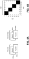
- Figure 4A is a diagram illustrating an example of using spectral clustering to associate triangulated signs across multiple journeys.
- Figure 4A illustrates observations of two signs, a first sign and a second sign, from two journeys, J 1 and J 2 .
- Figure 4A illustrates a first observation 460a of the first sign from a first journey (e.g., O s 1 ( J 1 )) and a second observation 460b of the first sign from a second journey (e.g., O s 2 ( J 2 )).
- Figure 4A also illustrates a first observation 462a of the second sign from a first journey (e.g., O s 3 ( J 1 )) and a second observation 462b of the second sign from a second journey (e.g., O s 4 ( J 2 )).
- an objective of some of the configurations of the systems and methods disclosed herein may be to split the 4 observations O s 1 , O s 2 , O s 3 , and O s 4 into two clusters.
- the two clusters may correspond to the two signs (e.g., two actual signs, two physical signs, etc.).
- Figure 4B is a diagram illustrating an example of an approach for multi-journey sign association.
- the apparatus 102 may perform spectral clustering as described in connection with Figure 4B in order to cluster the signs described in connection with Figure 4A .
- Different shapes may be clustered separately in some approaches.
- Other binning criteria may be utilized in other approaches.
- the apparatus 102 may compute a distance matrix of triangulation outputs, normalize entries with d c , and/or map to similarities (taking values in [0, 1], for example).
- Clusters may be strongly connected components.
- a number of signs (e.g., "numSigns") may be a number of Laplacian eigenvalues near zero.
- the apparatus 102 may cluster rows of a corresponding eigenvector matrix using a k-means approach or a sign approach (e.g., sign of columns) as described in connection with Figure 1 .
- Figure 4B illustrates an example 454 of a similarity matrix.
- the example 454 is a graph illustrated in rows 456 over columns 458.
- high values e.g., 1 are illustrated in black, while low values (e.g., 0) are illustrated in white.
- Spectral clustering may utilize block diagonal-like structures in a similarity matrix to infer the number of unique signs. Clustering may be performed based on this cue.
- d c 4 m
- Figure 5 is a diagram illustrating examples of single-journey triangulations 564a-c.
- Figure 5 illustrates examples of camera poses 566 and sign poses 568 for three single-journey triangulations.
- a vehicle may collect single-journey data (e.g., the single-journey triangulations 564a-c). Additionally or alternatively, multiple vehicles may collect single-journey data (e.g., the single-journey triangulations 564a-c).
- the single-journey triangulations 564a-c may be provided to an apparatus 102 in some approaches.
- Figure 6 is a diagram illustrating an example of a reconstruction 670 (e.g., map) from multi-journey bundle adjustment.
- Figure 6 illustrates examples of camera poses 672 and sign poses 674 that may be reconstructed based on some configurations of the systems and methods disclosed herein (e.g., a multi-journey pipeline).
- the apparatus 102 described in connection with Figure 1 may utilize the single-journey triangulations 564a-c from Figure 5 to produce the reconstruction 670 illustrated in Figure 6 .
- the reconstruction 670 (e.g., map) may be produced by determining similarity metrics between sign observations and by clustering the sign observations in accordance with some configurations of the systems and methods disclosed herein.
- Table (1) illustrates an example of reconstruction results with initialization by averaging.
- Table (1) signID t1 t2 t3 rotX rotY rotZ w h 1 29.9 1.4 2.3 91.7 -6.4 106.5 0.8 0.8 2 40.0 1.5 2.5 95.3 -11.7 110.8 1.0 0.6 3 69.3 5.9 1.5 82.4 -7.8 92.9 1.3 1.6 4 49.9 1.5 2.2 92.5 -5.6 91.8 0.8 0.7 5 60.0 1.5 2.1 91.7 -4.8 90.8 0.7 0.6
- Table (2) illustrates an example of reconstruction results after bundle adjustment.
- Figure 7 is a diagram illustrating a lane marker simulation setup.
- Figure 7 illustrates lane marker A 780a and lane marker B 780b.
- the Y (e.g., vertical in Figure 7 ) axis 782 is illustrated in meters
- the X (e.g., horizontal in Figure 7 ) axis 784 is illustrated in meters.
- two simulated "lane markers" may be formed with a constant gradient in Z from left to right.
- the lane width 4 m
- inner radius 100 m
- a 1 m sampling along the stripe for computations was utilized.
- Triangulation noise was also added (e.g., IID Gaussian, zero mean, 1 m std dev noise in X, Y, Z directions).
- Figure 8 is diagram illustrating some sample stripes in the X-Y plane.
- Figure 8 illustrates some lane marker samples 886 from a simulation using the lane markers 780a-b described in connection with Figure 7 .
- the Y (e.g., vertical in Figure 8 ) axis 888 is illustrated in meters
- the X (e.g., horizontal in Figure 8 ) axis 890 is illustrated in meters.
- Different symbols are used to illustrate groups of samples.
- the apparatus 102 described in connection with Figure 1 may perform spectral clustering of lane markers in accordance with one or more aspects of the following. Pairwise "distances" (e.g., similarity metrics) between stripes may be computed.
- a baseline may be to use a minimum distance between two stripes ( mindist ) (e.g., find where the stripes are closest to each other and use that distance). Each stripe may be sampled finely. For a pair of stripes, the number of pairwise points that are within a threshold may be counted (e.g., count ) . This is high when stripes run alongside/on top of each other for all or part of the way. In some approaches, the above two may be combined, perhaps with a kernel function. For example, count ⁇ exp(- K mindist 2 ). The distance may be mapped to the similarity score in [0, 1]. In a baseline approach, if mindist ⁇ 2 m, then the similarity metric may be 1, else 0 (e.g., indicator L (.)) Spectral clustering as for sign clustering may be performed in some approaches.
- Hierarchical clustering for lane markers may also be performed in some approaches.
- the apparatus 102 may cluster in two or three stages. For instance, starting with 200 stripes, the apparatus 102 may determine 75 clusters. The apparatus 102 may further reduce the clusters to 25, and then to 12. A second and/or third round of clustering on the "point cloud" may be given by the previous round.
- the apparatus 102 may fit a new stripe to the cluster and the next clustering stage may work based on the new splines. The distance may be mapped to similarity score in [0, 1]. In a baseline approach, if mindist ⁇ 2 m, then the similarity metric is 1, else 0 (indicator L (.)).
- Spectral clustering may be applied as for sign clustering. The number of clusters may increase or decrease at each level, for example.
- Figure 9 is a flow diagram illustrating a more specific configuration of a method 900 for mapping based on multi-journey data.
- the method 900 may be performed by the apparatus 102 described in connection with Figure 1 .
- the apparatus 102 may obtain 902 multi-journey sign data. This may be accomplished as described in connection with one or more of Figures 1 and 3 .
- the apparatus 102 may capture, determine and/or may receive multi-journey sign data.
- the apparatus 102 may determine 904 one or more similarity metrics between sign data corresponding to multiple journeys. This may be accomplished as described in connection with one or more of Figures 1-3 .
- the apparatus 102 may determine a similarity metric that indicates a distance between signs (e.g., sign corners, sign centers, etc.) from sign data of multiple journeys.
- similarity metrics may be determined 904 for pairs of sign observations within an association tile.
- the apparatus 102 may cluster 906 sign data (e.g., one or more signs from the multi-journey sign data) to produce one or more object clusters. This may be accomplished as described in connection with one or more of Figures 1-4B and 6 .
- Clustering 906 sign data (e.g., signs) may be based on the one or more similarity metrics. In some configurations, clustering may include hierarchical clustering and/or constrained spectral clustering. In some approaches, the sign data (e.g., signs) may be clustered based on sign shape (e.g., semantic data indicating whether a sign is rectangular, diamond shaped, triangular, octagonal, etc.).
- hierarchical clustering may be performed, where a distance parameter (e.g., critical distance) is changed for each stage or level of clustering. For example, similarity metrics may be determined 904 with a first distance parameter (e.g., a larger distance parameter) and clustering 906 may be performed at a first level. Then, similarity metrics may be determined 904 with a second distance parameter (e.g., a smaller distance parameter) and clustering 906 may be performed at a second level, etc.
- image features may be utilized to perform a level of clustering 906. Spectral clustering may additionally or alternatively be performed in some approaches.
- the apparatus 102 may refine 908 the sign data to produce map data. This may be accomplished as described in connection with one or more of Figures 1 and 3 .
- the apparatus 102 may perform multi-journey bundle adjustment based on the sign clusters to produce map data.
- the apparatus 102 may refine the map data.
- the apparatus 102 may perform bundle adjustment to refine map data (e.g., object pose information and/or camera pose information corresponding to a map) and/or may update the map based on object (e.g., sign) data and/or subsequent object data.
- Figure 10 is a flow diagram illustrating another more specific configuration of a method 1000 for mapping based on multi-journey data.
- the method 1000 may be performed by the apparatus 102 described in connection with Figure 1 .
- the apparatus 102 may obtain 1002 multi-journey lane marker data. This may be accomplished as described in connection with one or more of Figures 1 and 3 .
- the apparatus 102 may capture, determine and/or may receive multi-journey lane marker data.
- the apparatus 102 may determine 1004 one or more similarity metrics between lane marker data corresponding to multiple journeys. This may be accomplished as described in connection with one or more of Figures 1-3 . For example, the apparatus 102 may determine a similarity metric that indicates a distance between lane markers from lane marker data of multiple journeys. In some approaches, similarity metrics may be determined 1004 for lane marker observations within an association tile.
- the apparatus 102 may cluster 1006 lane marker data (e.g., one or more lane markers from the multi-journey lane marker data) to produce one or more object clusters. This may be accomplished as described in connection with one or more of Figures 1-3 and 8 .
- Clustering 1006 lane marker data (e.g., lane markers) may be based on the one or more similarity metrics.
- clustering may include hierarchical clustering and/or constrained spectral clustering.
- hierarchical clustering may be performed, where a similarity metric is changed for each stage or level of clustering.
- Spectral clustering may additionally or alternatively be performed in some approaches.
- the apparatus 102 may refine 1008 the lane marker data to produce map data. This may be accomplished as described in connection with one or more of Figures 1 and 3 .
- the apparatus 102 may perform multi-journey bundle adjustment based on the lane marker clusters to produce map data. Additionally or alternatively, the apparatus 102 may refine the map data. For instance, the apparatus 102 may perform bundle adjustment to refine map data (e.g., object pose information and/or camera pose information corresponding to a map) and/or may update the map based on object (e.g., lane marker) data and/or subsequent object data.
- map data e.g., object pose information and/or camera pose information corresponding to a map
- Figure 11 illustrates certain components that may be included within an apparatus 1102 configured to implement various configurations of the systems and methods disclosed herein.
- the apparatus 1102 may include servers, cameras, video camcorders, digital cameras, cellular phones, smart phones, computers (e.g., desktop computers, laptop computers, etc.), tablet devices, media players, televisions, vehicles, automobiles, personal cameras, wearable cameras, virtual reality devices (e.g., headsets), augmented reality devices (e.g., headsets), mixed reality devices (e.g., headsets), action cameras, surveillance cameras, mounted cameras, connected cameras, robots, aircraft, drones, unmanned aerial vehicles (UAVs), healthcare equipment, gaming consoles, personal digital assistants (PDAs), set-top boxes, etc.
- the apparatus 1102 may be implemented in accordance with one or more of the apparatuses described herein.
- the apparatus 1102 includes a processor 1121.
- the processor 1121 may be a general purpose single- or multi-chip microprocessor (e.g., an ARM), a special purpose microprocessor (e.g., a digital signal processor (DSP)), a microcontroller, a programmable gate array, etc.
- the processor 1121 may be referred to as a central processing unit (CPU). Although just a single processor 1121 is shown in the apparatus 1102, in an alternative configuration, a combination of processors (e.g., an ARM and DSP) could be implemented.
- the apparatus 1102 also includes memory 1101.
- the memory 1101 may be any electronic component capable of storing electronic information.
- the memory 1101 may be embodied as random access memory (RAM), read-only memory (ROM), magnetic disk storage media, optical storage media, flash memory devices in RAM, on-board memory included with the processor, EPROM memory, EEPROM memory, registers, and so forth, including combinations thereof.
- Data 1105a and instructions 1103a may be stored in the memory 1101.
- the instructions 1103a may be executable by the processor 1121 to implement one or more of the methods, procedures, steps, and/or functions described herein. Executing the instructions 1103a may involve the use of the data 1105a that is stored in the memory 1101.
- various portions of the instructions 1103b may be loaded onto the processor 1121 and/or various pieces of data 1105b may be loaded onto the processor 1121.
- the apparatus 1102 may also include a transmitter 1111 and/or a receiver 1113 to allow transmission and reception of signals to and from the apparatus 1102.
- the transmitter 1111 and receiver 1113 may be collectively referred to as a transceiver 1115.
- One or more antennas 1109a-b may be electrically coupled to the transceiver 1115.
- the apparatus 1102 may also include (not shown) multiple transmitters, multiple receivers, multiple transceivers and/or additional antennas.
- the apparatus 1102 may include a digital signal processor (DSP) 1117.
- the apparatus 1102 may also include a communications interface 1119.
- the communications interface 1119 may allow and/or enable one or more kinds of input and/or output.
- the communications interface 1119 may include one or more ports and/or communication devices for linking other devices to the apparatus 1102.
- the communications interface 1119 may include the transmitter 1111, the receiver 1113, or both (e.g., the transceiver 1115).
- the communications interface 1119 may include one or more other interfaces (e.g., touchscreen, keypad, keyboard, microphone, camera, etc.).
- the communication interface 1119 may enable a user to interact with the apparatus 1102.
- the various components of the apparatus 1102 may be coupled together by one or more buses, which may include a power bus, a control signal bus, a status signal bus, a data bus, etc.
- buses may include a power bus, a control signal bus, a status signal bus, a data bus, etc.
- the various buses are illustrated in Figure 11 as a bus system 1107.
- determining encompasses a wide variety of actions and, therefore, “determining” can include calculating, computing, processing, deriving, investigating, looking up (e.g., looking up in a table, a database or another data structure), ascertaining and the like. Also, “determining” can include receiving (e.g., receiving information), accessing (e.g., accessing data in a memory) and the like. Also, “determining” can include resolving, selecting, choosing, establishing and the like.
- processor should be interpreted broadly to encompass a general purpose processor, a central processing unit (CPU), a microprocessor, a digital signal processor (DSP), a controller, a microcontroller, a state machine, and so forth. Under some circumstances, a “processor” may refer to an application specific integrated circuit (ASIC), a programmable logic device (PLD), a field programmable gate array (FPGA), etc.
- ASIC application specific integrated circuit
- PLD programmable logic device
- FPGA field programmable gate array
- processor may refer to a combination of processing devices, e.g., a combination of a DSP and a microprocessor, a plurality of microprocessors, one or more microprocessors in conjunction with a DSP core, or any other such configuration.
- memory should be interpreted broadly to encompass any electronic component capable of storing electronic information.
- the term memory may refer to various types of processor-readable media such as random access memory (RAM), read-only memory (ROM), non-volatile random access memory (NVRAM), programmable read-only memory (PROM), erasable programmable read-only memory (EPROM), electrically erasable PROM (EEPROM), flash memory, magnetic or optical data storage, registers, etc.
- RAM random access memory
- ROM read-only memory
- NVRAM non-volatile random access memory
- PROM programmable read-only memory
- EPROM erasable programmable read-only memory
- EEPROM electrically erasable PROM
- flash memory magnetic or optical data storage, registers, etc.
- instructions and “code” should be interpreted broadly to include any type of computer-readable statement(s).
- the terms “instructions” and “code” may refer to one or more programs, routines, sub-routines, functions, procedures, etc.
- “Instructions” and “code” may comprise a single computer-readable statement or many computer-readable statements.
- a computer-readable medium or “computer-program product” refers to any tangible storage medium that can be accessed by a computer or a processor.
- a computer-readable medium may comprise RAM, ROM, EEPROM, CD-ROM or other optical disk storage, magnetic disk storage or other magnetic storage devices, or any other medium that can be used to carry or store desired program code in the form of instructions or data structures and that can be accessed by a computer.
- Disk and disc includes compact disc (CD), laser disc, optical disc, digital versatile disc (DVD), floppy disk and Blu-ray ® disc where disks usually reproduce data magnetically, while discs reproduce data optically with lasers.
- a computer-readable medium may be tangible and non-transitory.
- the term "computer-program product” refers to a computing device or processor in combination with code or instructions (e.g., a "program”) that may be executed, processed, or computed by the computing device or processor.
- code may refer to software, instructions, code, or data that is/are executable by a computing device or processor.
- Software or instructions may also be transmitted over a transmission medium.
- a transmission medium For example, if the software is transmitted from a website, server, or other remote source using a coaxial cable, fiber optic cable, twisted pair, digital subscriber line (DSL), or wireless technologies such as infrared, radio and microwave, then the coaxial cable, fiber optic cable, twisted pair, DSL, or wireless technologies such as infrared, radio and microwave are included in the definition of transmission medium.
- DSL digital subscriber line
- the methods disclosed herein comprise one or more steps or actions for achieving the described method.
- the method steps and/or actions may be interchanged with one another without departing from the scope of the claims.
- the order and/or use of specific steps and/or actions may be modified without departing from the scope of the claims.
- modules and/or other appropriate means for performing the methods and techniques described herein can be downloaded, and/or otherwise obtained by a device.
- a device may be coupled to a server to facilitate the transfer of means for performing the methods described herein.
- various methods described herein can be provided via a storage means (e.g., random access memory (RAM), read-only memory (ROM), a physical storage medium such as a compact disc (CD) or floppy disk, etc.), such that a device may obtain the various methods upon coupling or providing the storage means to the device.
- RAM random access memory
- ROM read-only memory
- CD compact disc
- floppy disk floppy disk
- the term "and/or” should be interpreted to mean one or more items.
- the phrase "A, B, and/or C” should be interpreted to mean any of only A, only B, only C, A and B (but not C), B and C (but not A), A and C (but not B), or all of A, B, and C.
- the phrase "at least one of” should be interpreted to mean one or more items.
- the phrase "at least one of A, B, and C” or the phrase “at least one of A, B, or C” should be interpreted to mean any of: only A, only B, only C, A and B (but not C), B and C (but not A), A and C (but not B), or all of A, B, and C.
- the phrase "one or more of” should be interpreted to mean one or more items.
- the phrase “one or more of A, B, and C” or the phrase “one or more of A, B, or C” should be interpreted to mean any of: only A, only B, only C, A and B (but not C), B and C (but not A), A and C (but not B), or all of A, B, and C.
Landscapes
- Engineering & Computer Science (AREA)
- Physics & Mathematics (AREA)
- Theoretical Computer Science (AREA)
- General Physics & Mathematics (AREA)
- Remote Sensing (AREA)
- Radar, Positioning & Navigation (AREA)
- Computer Vision & Pattern Recognition (AREA)
- Multimedia (AREA)
- Data Mining & Analysis (AREA)
- Evolutionary Computation (AREA)
- Artificial Intelligence (AREA)
- Software Systems (AREA)
- Databases & Information Systems (AREA)
- Automation & Control Theory (AREA)
- General Health & Medical Sciences (AREA)
- Medical Informatics (AREA)
- Computing Systems (AREA)
- Health & Medical Sciences (AREA)
- Bioinformatics & Computational Biology (AREA)
- Evolutionary Biology (AREA)
- General Engineering & Computer Science (AREA)
- Bioinformatics & Cheminformatics (AREA)
- Life Sciences & Earth Sciences (AREA)
- Geometry (AREA)
- Probability & Statistics with Applications (AREA)
- Computer Graphics (AREA)
- Traffic Control Systems (AREA)
- Image Analysis (AREA)
- Navigation (AREA)
Description
- This application is related to and claims priority to
U.S. Provisional Patent Application Serial No. 62/442,404, filed January 4, 2017 - The present disclosure relates generally to electronic devices. More specifically, the present disclosure relates to systems and methods for mapping based on multi-journey data.
- Some electronic devices (e.g., cameras, video camcorders, digital cameras, cellular phones, smart phones, computers, televisions, automobiles, personal cameras, wearable cameras, virtual reality devices (e.g., headsets), augmented reality devices (e.g., headsets), mixed reality devices (e.g., headsets), action cameras, surveillance cameras, mounted cameras, connected cameras, robots, drones, healthcare equipment, set-top boxes, etc.) capture and/or utilize images. For example, a smart phone may capture and/or process still and/or video images. The images may be processed, displayed, stored and/or transmitted. The images may portray a scene including a landscape and/or objects, for example.
- In some cases, it may be difficult to locate objects. For example, it may be difficult to locate objects based on images. As can be observed from this discussion, systems and methods that improve locating objects may be beneficial.
US2016/0189004 discloses a method, apparatus and computer program for object identification and location correlation based on received images. A method is provided including receiving identity data associated with an object derived from one or more of a plurality of images determining an identity of an object in one or more of the plurality of images, receiving location information associated with a camera which captured the plurality of images, and correlating the identified object with a location for each of the respective images of the plurality of images.US2013/158855 discloses a system and method for estimating journey destinations. The system comprises a conversion module, a frequency module, a metric module, a quality module and a summary module. The conversion module converts a set of driver history data to a set of learning parameters. The frequency module analyzes the set of learning parameters and current journey data to generate estimated journey data describing one or more potential journeys. The metric module analyzes the estimated journey data and the set of current status data to determine one or more metrics associated with the estimated journey data. The quality module determines one or more quality scores associated with the estimated journey data. The summary module determines one or more status summaries and one or more estimate summaries.DE102015203016A1 discloses a method for localizing a motor vehicle in an environment, comprising the following steps: in a first method section, executing a learning drive (100) which comprises: receiving odometry data from the motor vehicle via an interface of a camera (101), capturing at least two images with the camera while driving at different positions of the motor vehicle (102), extraction of features in the at least two images (103), finding pairs of identical features in the at least two images (104), stereoscopic determination of a three-dimensional position of the features using the odometry data (105 ), Creating a three-dimensional map (106) and entering the features at their three-dimensional positions (107), then, in one or more second process sections, executing a follow-up journey (200), which comprises: capturing at least one further image with the camera ( 202), Find multiple r features in the at least one further map (203), determining relative orientations of the multiple features to the motor vehicle based on the imaging position (204), finding the multiple features in the map (205), triangulating based on the features and the relative orientations and inferring localization information of the motor vehicle in the map (206), output of the localization information at the interface (207), with all process steps of the two process sections being carried out in the camera. - The invention is set out in the appended independent claims. Embodiments are set out in the dependent claims.
-
-
Figure 1 is a block diagram illustrating one example of an apparatus in which systems and methods mapping based on multi-journey data may be implemented; -
Figure 2 is a flow diagram illustrating one configuration of a method for mapping based on multi-journey data; -
Figure 3 is a block diagram illustrating an example of one or more components, elements, and/or functions that may be performed in accordance with some configurations of the systems and methods disclosed herein; -
Figure 4A is a diagram illustrating an example of using spectral clustering to associate triangulated signs across multiple journeys; -
Figure 4B is a diagram illustrating an example of an approach for multi-journey sign association; -
Figure 5 is a diagram illustrating examples of singlejourney triangulations; -
Figure 6 is a diagram illustrating an example of a reconstruction from multi-journey bundle adjustment; -
Figure 7 is a diagram illustrating a lane marker simulation setup; -
Figure 8 is diagram illustrating some sample stripes in the X-Y plane; -
Figure 9 is a flow diagram illustrating a more specific configuration of a method for mapping based on multi-journey data; -
Figure 10 is a flow diagram illustrating another more specific configuration of a method for mapping based on multi-journey data; and -
Figure 11 illustrates certain components that may be included within an apparatus configured to implement various configurations of the systems and methods disclosed herein. - Some configurations of the systems and methods disclosed herein may relate to systems and methods for mapping based on multi-journey data. For example, some configurations may involve multi-journey association and refinement (e.g., optimization) for building precise three-dimensional (3D) maps using crowdsourced data. Some configurations may include multi-journey sign association and/or batch adjustment.
- Autonomous apparatuses (e.g., vehicles, robots, etc.) may rely on precise 3D maps to localize themselves and obtain local semantic information such as speed limits. Some approaches build these maps with expensive precisely calibrated equipment and are difficult to maintain due to the dynamic nature of the information. For example, roads may change, road markings and traffic signs may be updated, and/or some signage (e.g., road work signs) may be temporary. Some configurations of the systems and methods disclosed herein may describe one or more procedures (e.g., a pipeline) for building precise 3D maps using crowdsourced data (e.g., multiple journeys). For example, some configurations may take, as inputs, object location data (e.g., triangulator outputs) and related inputs from perception (e.g., detection) and positioning from multiple journeys (e.g., from the same vehicle at different times and/or from different vehicles). An output may be a map with objects (e.g., signs (a 6 degrees of freedom pose for each sign, for example) and lanes (3D splines, for example)). Some configurations may include incremental map updates and/or joint multi-journey processing.
- In some approaches, 3D map creation may include two functions: multi journey association and refinement (e.g., optimization) of the 6 degrees of freedom (DOF) landmark poses. Some configurations of the systems and methods disclosed herein may include an incremental update of existing maps and/or cold start or periodic map creation using all data available at the time. Data from multiple journeys (using multiple cars and/or times (e.g., days), for example) may be collected in a repository (e.g., a central repository in the cloud). The data may include landmark detections in image (e.g., camera) frames, relevant image features, and/or 6 DOF camera poses.
- Multi-journey association may include estimating the number of true landmarks in the map to be generated and/or clustering all the data. The clustering of landmarks may depend on the type of landmark. Some approaches may include creating distance metrics and/or using the distance metrics for spectral clustering and/or hierarchical clustering.
- An example of clustering traffic signs is given as follows. In a first round of clustering for traffic signs, for instance, semantic information may be used for partitioning the signs into clusters. For example, the shape of a sign (e.g., rectangle, diamond, etc.) may be used to partition the signs into clusters. In a second round of clustering, sign center-based distance metrics may be utilized to cluster signs from the first round clusters into geographically nearby clusters. This may correctly cluster signs that are not near other signs. In some cases, different signs that are geographically nearby, such as signs on a pole may incorrectly fall in one cluster. In a third round (e.g., final round), image features specific to the sign detections may be used to separate close-by signs (e.g., two cross street signs on the same pole).
- An example of clustering traffic lanes is given as follows. For traffic lanes, one or more different metrics may be employed and/or multiple rounds of clustering may be used. For example, distance metrics between lane triangulations may include several individual metrics: longitudinal distance between two lane triangulations, lateral distance, and/or number of points within a threshold distance, etc. To create long chains of lane triangulations, multiple rounds of clustering may be used.
- Once the data is clustered, the 6 DOF landmark poses may be refined (e.g., optimized) as well as camera parameters such as intrinsics and 6 DOF pose to best explain all the image level detections from all the data in the repository. This refinement (e.g., optimization) may lead to better accuracy and/or may make the map resilient to calibration errors and biases in camera positions in one journey.
- One or more multi-journey association options may be implemented in some configurations of the systems and methods disclosed herein. For example, joint multi-journey association using all data up to a current time may be implemented. Incremental multi-journey association using a map estimate at current time may be implemented. In some approaches, joint multi-journey association may be utilized during cold-start (without previous data, for example). Once the existing high definition (HD) map reaches a confidence level, incremental multi-journey association may be used on a frequent basis. Occasional joint multi-journey association may be performed to reduce and/or eliminate any incremental multi-journey association inaccuracies.
- For incremental updates to the map (such as a lane closure sign that is put in temporarily, for example) the landmark triangulations along with corresponding confidence measure(s) may be compared to the existing map, local optimizations around that landmark may be performed, and/or the map may be updated. To ensure errors due to many incremental updates do not accumulate, the full map may be built periodically using all data available at that point, for example.
- Various configurations are now described with reference to the Figures, where like reference numbers may indicate functionally similar elements. The systems and methods as generally described and illustrated in the Figures herein could be arranged and designed in a wide variety of different configurations. Thus, the following more detailed description of several configurations, as represented in the Figures, is not intended to limit scope, as claimed, but is merely representative of the systems and methods.
-
Figure 1 is a block diagram illustrating one example of an apparatus 102 in which systems and methods mapping based on multi-journey data may be implemented. For instance, the apparatus 102 may be configured to locate one or more objects in an environment (e.g., three dimensional (3D) map) based on object location data from multiple journeys (e.g., multiple vehicles, multiple trips, and/or multiple times, etc.). Examples of the apparatus 102 include electronic devices, servers, computers (e.g., desktop computers, laptop computers, etc.), network devices, cameras, video camcorders, digital cameras, cellular phones, smart phones, tablet devices, vehicles, automobiles, personal cameras, wearable cameras, virtual reality devices (e.g., headsets), augmented reality devices (e.g., headsets), mixed reality devices (e.g., headsets), action cameras, surveillance cameras, mounted cameras, connected cameras, robots, aircraft, drones, unmanned aerial vehicles (UAVs), gaming consoles, appliances, etc. The apparatus 102 may include one or more components or elements. One or more of the components or elements may be implemented in hardware (e.g., circuitry), a combination of hardware and software (e.g., a processor with instructions), and/or a combination of hardware and firmware. - In some configurations, the apparatus 102 may be a network device (e.g., server, cloud device, etc.) that communicates with one or more vehicles. In some approaches, one or more of the vehicles may be an autonomous vehicle, a self-driving vehicle, and/or may have an Advanced Driver Assistance System (ADAS), etc. For example, the apparatus 102 may receive information (e.g., journey data, object detection data, pose data, raw image data, object data, etc.) from one or more vehicles. The apparatus 102 may determine mapping information (e.g., 3D mapping data, refined object location data, etc.), which the apparatus 102 may provide to one or more vehicles.
- Additionally or alternatively, the apparatus 102 may be a vehicle configured to produce mapping information. For example, the apparatus 102 may determine mapping information based on multiple journeys. In some configurations, the apparatus 102 may be a vehicle in communication with one or more other vehicles. For example, the apparatus 102 may receive information (e.g., journey data, object detection data, pose data, raw image data, object data, etc.) from one or more vehicles and/or may send information to one or more vehicles (e.g., may share information). The apparatus 102 may produce and/or receive mapping information, which may be shared with one or more other vehicles.
- In some configurations, the apparatus 102 may include a
processor 112, amemory 126, one ormore displays 132, one ormore image sensors 104, one or moreoptical systems 106, and/or one or more communication interfaces 108. Theprocessor 112 may be coupled to (e.g., in electronic communication with) thememory 126, display(s) 132, image sensor(s) 104, optical system(s) 106, and/or communication interface(s) 108. It should be noted that one or more of the elements illustrated inFigure 1 may be optional. In particular, the apparatus 102 may not include one or more of the elements illustrated inFigure 1 in some configurations. For example, the apparatus 102 may or may not include animage sensor 104 and/oroptical system 106. Additionally or alternatively, the apparatus 102 may or may not include adisplay 132. Additionally or alternatively, the apparatus 102 may or may not include acommunication interface 108 and/or antenna(s) 110. - In some configurations, the apparatus 102 may perform one or more of the functions, procedures, methods, steps, etc., described in connection with one or more of
Figures 1-11 . Additionally or alternatively, the apparatus 102 may include one or more of the structures described in connection with one or more ofFigures 1-11 . - The communication interface(s) 108 may enable the apparatus 102 to communicate with one or more other apparatuses (e.g., electronic devices, vehicles, etc.). For example, the communication interface(s) 108 may provide an interface for wired and/or wireless communications. In some configurations, the communication interface(s) 108 may be coupled to one or
more antennas 110 for transmitting and/or receiving radio frequency (RF) signals. Additionally or alternatively, the communication interface(s) 108 may enable one or more kinds of wireline (e.g., Universal Serial Bus (USB), Ethernet, etc.) communication. - In some configurations,
multiple communication interfaces 108 may be implemented and/or utilized. For example, one communication interface may be a cellular (e.g., 3G, Long Term Evolution (LTE), CDMA, etc.) communication interface, another communication interface may be an Ethernet interface, another communication interface may be a universal serial bus (USB) interface, and yet another communication interface may be a wireless local area network (WLAN) interface (e.g., Institute of Electrical and Electronics Engineers (IEEE) 802.11 interface). In some configurations, the communication interface may send information to and/or receive information (e.g., image information, pose information, location information, object detection information, map information, object data, etc.) from another apparatus 102 or device (e.g., a vehicle, a smart phone, a camera, a display, a remote server, etc.). - In some configurations, the apparatus 102 may obtain one or more images (e.g., digital images, image frames, video, etc.). For example, the apparatus 102 may include the image sensor(s) 104 and the optical system(s) 106 (e.g., lenses) that focus images of scene(s) and/or object(s) that are located within the field of view of the optical system onto the image sensor. The optical system(s) 106 may be coupled to and/or controlled by the
processor 112. - A camera (e.g., a visual spectrum camera or otherwise) may include at least one image sensor and at least one optical system. Accordingly, the apparatus 102 may be one or more cameras and/or may include one or more cameras in some implementations. In some configurations, the image sensor(s) 104 may capture the one or more images (e.g., image frames, video, still images, burst mode images, stereoscopic images, etc.). In some configurations, the image sensor(s) 104 may capture the one or more images. In some implementations, the apparatus 102 may include a
single image sensor 104 and/or a singleoptical system 106. For example, a single camera with a particular resolution (e.g., video graphics array (VGA) resolution, 1280 × 800 pixels, etc.), at a particular frame rate (e.g., 30 frames per second (fps), 60 fps, 120 fps, etc.) may be utilized. In other implementations, the apparatus 102 may include multiple optical system(s) 106 and/ormultiple image sensors 104. For example, the apparatus 102 may include two or more lenses in some configurations. The lenses may have the same focal length or different focal lengths. - Additionally or alternatively, the apparatus 102 may request and/or receive the one or more images from another apparatus or device (e.g., vehicle camera(s), one or more external cameras coupled to the apparatus 102, a network server, traffic camera(s), etc.). In some configurations, the apparatus 102 may request and/or receive the one or more images via the communication interface. For example, the apparatus 102 may or may not include camera(s) (e.g., image sensor(s) 104 and/or optical system(s) 106) and may receive images from one or more remote devices (e.g., vehicles).
- One or more of the images (e.g., image frames) may include one or more scene(s) and/or one or more object(s). In some cases, the image(s) may include one or more objects (e.g., landmarks, road signs, lane markers, traffic lights, construction zone cones, barriers, light poles, road markings, stationary objects, etc.).
- In some examples, the image sensor(s) 104 and/or the optical system(s) 106 may be mechanically coupled to the apparatus 102 or to a remote apparatus (e.g., may be attached to, mounted on, and/or integrated into the body of a vehicle, the hood of a car, a rear-view mirror mount, a side-view mirror, a bumper, etc., and/or may be integrated into a smart phone or another device, etc.). The image sensor(s) 104 and/or optical system(s) 106 may be linked to the apparatus 102 via wired and/or wireless link. For example, the image sensor(s) 104 and/or optical system(s) 106 may be hardwired to a control mechanism (e.g., processor 112) in a vehicle or information captured by the image sensor(s) 104 and/or optical system(s) 106 may be wirelessly transmitted (e.g., streamed or otherwise wirelessly transported) to the control mechanism (e.g., processor 112).
- The
memory 126 may store instructions and/or data. Theprocessor 112 may access (e.g., read from and/or write to) thememory 126. Examples of instructions and/or data that may be stored by thememory 126 may includemulti-journey data 128, image data, object detection data, object location data, 2D object location data (e.g., pixel data), feature points, key points, corners, object mapping data, 3D object location data, camera pose information, road normal vector data, etc., image obtainer instructions, multi-journey data obtainer 114 instructions, similaritymetric determiner 116 instructions, object clusterer 118 instructions,mapper 120 instructions, and/or instructions for one or more other elements, etc. - In some configurations, the apparatus 102 may include an image data buffer (not shown). The image data buffer may buffer (e.g., store) image data from the image sensor(s) 104 and/or external camera(s). The buffered image data may be provided to the
processor 112. - In some configurations, the apparatus 102 may include one or
more displays 132. In some approaches, images (e.g., scenes and/or objects) that are being captured by the image sensor(s) 104 may be presented on thedisplay 132. In some configurations, these images may be displayed in rapid succession at a relatively high frame rate so that, at any given moment in time, the objects that are located within the field of view of theoptical system 106 may be presented on thedisplay 132. The one or more images obtained by the apparatus 102 may be one or more video frames and/or one or more still images. For example, the display(s) 132 may be configured to output a view of one or more objects (e.g., signs, lane markers, landmarks, etc.). - The display(s) 132 may be integrated into the apparatus 102 and/or may be coupled to the apparatus 102. For example, the apparatus 102 may be virtual reality headset with
integrated displays 132. In another example, the apparatus 102 may be a computer that is coupled to a virtual reality headset with thedisplays 132. In yet another example, the apparatus 102 may be a vehicle. - In some configurations, the apparatus 102 may present a
user interface 134 on thedisplay 132. For example, theuser interface 134 may enable a user to interact with the apparatus 102. In some configurations, thedisplay 132 may be a touchscreen that receives input from physical touch (by a finger, stylus, or other tool, for example). Additionally or alternatively, the apparatus 102 may include or be coupled to another input interface. For example, the apparatus 102 may include a camera facing a user and may detect user gestures (e.g., hand gestures, arm gestures, eye tracking, eyelid blink, etc.). In another example, the apparatus 102 may be coupled to a mouse and may detect a mouse click. In some configurations, one or more of the images described herein may be presented on thedisplay 132 and/oruser interface 134. In some configurations, theuser interface 134 may enable a user to indicate preferences (e.g., view settings) and/or interact with the view. - In some configurations, the apparatus 102 (e.g., processor 112) may optionally be coupled to, be part of (e.g., be integrated into), include, and/or implement one or more kinds of devices. For example, the apparatus 102 may be implemented in a vehicle equipped with one or more cameras.
- The
processor 112 may be configured to implement one or more of the methods disclosed herein. For example, theprocessor 112 may be configured to produce object mapping data (e.g., object location information in a 3D map, object pose information, etc.). - The
processor 112 may include and/or implement an image obtainer in some configurations. One or more image frames may be provided to the image obtainer. For example, the image obtainer may obtain images from one or more cameras (e.g., normal cameras, wide-angle cameras, fisheye cameras, stereoscopic cameras, etc.). For example, the image obtainer may receive image data from one ormore image sensors 104, from one or more external cameras, and/or from one or more remote cameras (e.g., remote vehicle cameras). The images may be captured from one or multiple cameras (at different locations, for example). As described above, the image(s) may be captured from the image sensor(s) 104 included in the apparatus 102 or may be captured from one or more remote camera(s). - In some configurations, the image obtainer may request and/or receive one or more images. For example, the image obtainer may request and/or receive one or more images from a remote device (e.g., external camera(s), remote server(s), remote electronic device(s), remote vehicle(s), etc.) via the
communication interface 108. - The
processor 112 may include and/or implement amulti-journey data obtainer 114. Themulti-journey data obtainer 114 may obtain (e.g., request and/or receive) data corresponding to multiple journeys (e.g., multi-journey data 128). For example, themulti-journey data obtainer 114 may obtain object data, object detection information (e.g., one or more feature points, keypoints, two-dimensional (2D) object location data (in an image plane, for example), etc.), timestamps, object type (e.g., sign, rectangular sign, octagonal sign, triangular sign, circular sign, etc., lane marker, road markings, etc.)), object pose information (e.g., 2D sign parameters, 2D lane parameters, 3D sign parameters, 3D lane parameters, 3D location data, and/or orientation data, etc.), camera pose information (e.g., 6 DOF camera pose, camera location data, and/or orientation data, etc.), triangulation outputs, road normal vectors, vehicle location data, vehicle orientation data, raw data (e.g., raw image data and/or raw object detection data, etc.), etc. Object data (e.g., object pose information) may include object position data (e.g., 3D object position, 3D object translation, etc.) and/or object orientation data (e.g., 3D object rotation). In some configurations, object data (e.g., object pose information) may include camera pose information. The multi-journey data may correspond to multiple vehicles, to a single vehicle at multiple times, to multiple vehicles at multiple times, to multiple journeys traveled by one or more vehicles, etc. For example, the apparatus 102 may receive themulti-journey data 128 corresponding to multiple vehicles and/or to multiple journeys. In some configurations, themulti-journey data 128 may be obtained as data from individual journeys that is combined intomulti-journey data 128. For example, one or more vehicles may collect data while traveling on individual journeys. The data from each individual journey may be provided to the apparatus 102. - In some configurations, the apparatus 102 (e.g., multi-journey data obtainer 114) may receive the
multi-journey data 128 via the communication interface(s) 108. Additionally or alternatively, the apparatus 102 (e.g., multi-journey data obtainer 114) may obtain, receive, and/or produce themulti-journey data 128 based on performing one or more object location functions (e.g., triangulation, inter-frame object association, inter-frame sign association, mid-point determination, corner adjustment, sign pose adjustment, inter-frame lane marker association, normal vector estimation, spline fitting, spline parameter adjustment, etc.). - For example, the
processor 112 may include and/or implement an inter-frame associator in some configurations. The inter-frame associator may associate one or more objects between frames (in a series of frames, for example) collected during a journey to produce two-dimensional object location data. In some configurations, the inter-frame associator may associate one or more objects between frames based on one or more object pixels (e.g., one or more pixels of an object in one or more images), one or more object features (e.g., feature points, keypoints, corners, center points, etc.), and/or one or more pixel camera positions (e.g., camera pose information corresponding to one or more pixels). In some configurations, the inter-frame associator may perform inter-frame association for one or more road signs. Additionally or alternatively, the inter-frame associator may perform inter-frame association for one or more lane markers. In some approaches (for lane marker pose estimation, for example), theprocessor 112 may estimate a road normal vector. In some configurations, the object location data (e.g., sign location data, sign pose data, lane marker location data, etc.) produced from inter-frame association may be stored, sent, and/or utilized as journey data (e.g., part of multi-journey data 128). - The
processor 112 may include and/or implement a similaritymetric determiner 116. The similaritymetric determiner 116 may determine one or more similarity metrics between object data (e.g., 3D object location data and/or orientation data, etc.) corresponding to two or more journeys. The similarity metric may indicate a distance between objects from the object data. In some approaches, the similarity metric may be based on object type. For instance, different similarity metrics may be determined and/or utilized for different object types. For example, one kind of similarity metric may be utilized for a sign object type (e.g., road signs) and another similarity metric may be used for a lane marker object type (e.g., lane stripes). - In some configurations, the similarity metric may indicate one or more respective distances between respective point(s) (e.g., center points, corners, etc.) for sign objects from different journeys. Additionally or alternatively, a similarity metric may indicate a distance (e.g., minimum distance) between lane markers and/or points of lane markers (from different journeys, for instance). For example, the similarity metric may indicate a longitudinal distance between lane markers (e.g., lane triangulations), lateral distance, and/or number of points of lanes within an area (e.g., within a threshold distance, within a radial area, etc.). In some configurations, a kernel function may also be used. For example, the similarity metric may be based on the kernel function. The shape and size of a distance threshold may be controlled. More detail may be provided in relation to one or more of the Figures herein. In some configurations, the similarity metric may be based on pose information (e.g., 3D geometric information). For example, the similarity metric calculation may not factor in other types of information (e.g., color, image data, etc.).
- An example of an approach for determining sign similarity metrics is given as follows. In particular, this approach shows a similarity metric between object locations (e.g., two signs from different journeys, two triangulation outputs, etc.). It should be noted that signs of different types (e.g., shapes) and/or lane markers may be clustered separately in some approaches.
- In some configurations, a similarity metric may be within a range of values. For instance, a similarity metric may have a value in a range of [0, 1]. For example, 0 may indicate different objects and/or 1 may indicate a perfect match. In some approaches, sign observations (e.g., object location data) of the same shape and from different journeys may be expressed as O s1 and O s2 . For instance, O s1 may denote one or more points (e.g., corners, feature points, center point, 3D coordinate(s), etc.) for a first sign observation and O s2 may denote one or more points (e.g., corners, feature points, center point, 3D coordinate(s), etc.) for a second sign observation. One example of a similarity metric is given in Equation (1).

- In some configurations, the distance function d() may be given as shown in Equation (2).

- In some configurations, the distance function d() may be alternatively given as shown in Equation (3).

- In some configurations, the kernel function L(u) may be given as shown in Equation (4).

- In some configurations, the kernel function L(u) may be alternatively given as shown in Equation (5).

- An example of an approach for determining lane similarity metrics is given as follows. In particular, this approach shows a similarity metric between object locations (e.g., lane observations, etc.). In some configurations, lane marker observations may be expressed as O l1 and O l2. In some approaches, the lane marker observations may be expressed as splines (e.g., 3D splines). A distance function may be given as shown in Equation (6).

- Additionally or alternatively, points (in 3D world coordinates, for example) may be sampled on O l1. In some configurations, the points may be evenly sampled along the spline. The points may be denoted x1, x2, ..., xM. The points y1, y2, ..., yM may be the nearest corresponding points on O l2. An alternative distance function may be given as shown in Equation (7).

- Another example of a similarity metric is given in Equation (8).

- As may be observed, a similarity metric S(O 1, O 2) may be determined for different object types (e.g., lane markers, signs, etc.). For example, the similarity
metric determiner 116 may determine a first similarity metric for signs and a second similarity metric for lane markers. The similarity metrics for different object types may employ different observations, different distance functions, different kernel functions, and/or different distance parameters, etc. - In some approaches, different similarity metrics (e.g., similarity metrics that utilize different distance functions, different kernel functions, different distance parameters, and/or different observations, etc.) may be determined and/or utilized for different levels of hierarchical clustering. For example, one level of sign clustering may utilize sign center points to determine a similarity metric, while another level of sign clustering may utilize sign corner points.
- In some configurations, similarity metrics may be determined for pairs of observations only within an association tile and/or only within a cluster. An association tile may be an area (e.g., geographic area) of a map region within which similarity metrics may be determined and/or within which clustering may be performed. For example, only observations within one association tile may be compared. In some configurations, overlapping association tiles may be utilized.
- In some configurations, a range of object data (e.g., range of all triangulation outputs) may be denoted [minE, maxE] (e.g., minimum east to maximum east) and [minN, maxN] (e.g., minimum north to maximum north). The range of object data may cover all journeys and/or may be the maximum extent of a map. In some approaches, pose translation may be utilized for signs. For lane markers (e.g., lane stripes), a minimum and/or maximum along the spline may be utilized.
- The map (e.g., map region) may be covered with association tiles. Association tiles may be square, rectangular, circular, and/or irregularly shaped. For example, a tile size may be denoted as assocTileSize x assocTileSize for each tile. Tiles may be overlapping with strideE and strideN steps in east and north, respectively. In some configurations, a flag may be maintained for each tile. For example, a dataPresentFlag may be maintained for each association tile. Only tiles with data may be processed. Other approaches to tiling may be utilized in accordance with the systems and methods disclosed herein. Association tiles and association tile occupancy may be updated incrementally as more data is obtained.
- In some configurations, the similarity
metric determiner 116 may form a similarity matrix (e.g., full similarity matrix). For example, Sim may denote a similarity matrix between all object data (e.g., all object data for a particular landmark type), such as triangulation outputs. The similarity matrix may be symmetric, with entries in a range of [0, 1]. In some approaches, the similarity matrix (e.g., Sim) may be initialized to an identity matrix or other initial value. - An example of pseudocode for forming a similarity matrix for each association tile is provided in Listing (1).
- For each tile in assocTiles:
If tile.dataPresentFlag:
Evaluate Sim(.,.) for all pairs of observations in tile (if the observations have not been compared yet, for example); - A sign belongs to a tile if (E, N) of pose translation are in the tile;
- A lane marker belongs to a tile if some point on the lane marker (e.g., stripe) has (E, N) within the tile;
- Update both Sim(O 1,O 2) and Sim(O 2,O 1) to ensure Sim is symmetric.
Listing (1) - The
processor 112 may include and/or implement an object clusterer 118. The object clusterer 118 may cluster objects from the object data (e.g., multi-journey data 128) based on the one or more similarity metrics to produce one or more object clusters. For example, the object clusterer 118 may group objects (e.g., object data corresponding to the same or difference physical objects) into one or more clusters. A cluster may include object data (e.g., a group of observations corresponding to one or more physical objects). For example, a cluster may include a first observation (e.g., object location data, object pose, etc.) from a first journey and a second observation (e.g., object location data, object pose, etc.) from a second journey. In some configurations and/or cases, a single cluster may correspond to one or multiple physical objects. The object clusterer 118 may produce one or more clusters. In some configurations, the one or more clusters may be provided to themapper 120. It should be noted that the object clusterer 118 may perform unsupervised clustering in some configurations. In some cases, a cluster (e.g., singleton cluster) with only one object observation may result from clustering. - In some configurations, the object clusterer 118 may perform clustering that is limited to objects located within each association tile. This may help to reduce processing burden for large areas.
- In some configurations, the object clusterer 118 may determine (e.g., estimate) a number of objects (e.g., actual objects, physical objects, ground truth objects, etc.). As described above, Sim may denote a similarity matrix (e.g., a similarity matrix between all objects). In some approaches, the number of objects may be determined in accordance with the following. A matrix D may be a diagonal matrix, where the diagonal values are the sums of corresponding rows from the similarity matrix, (e.g., D = diag(rowsum(Sim))). The object clusterer 118 may determine eigenvectors and eigenvalues for a matrix W that is based on Sim and D. For example, [eigenvectors, eigenvalues] = eig(W), where W = D -1/2 Sim D -1/2. This may provide a symmetric formulation. In some configurations, eigenvalues(W) = eigenvalues(random walk transition matrix D -1 Sim) and eigenvectors(W) = D 1/2 eigenvectors(D -1 Sim).
- In some approaches, a number of clusters KC (e.g., a number of objects) may be a number of eigenvalues (of matrix W, for example) that are greater than an eigenvalue threshold. For example, KC may be determined in accordance with the following formula: KC = number of eigenvalues > eigenValueThreshold. In some configurations, the eigenValueThreshold may be a default value (e.g., 0.75) or some other value. For perfect clusters, for example, the multiplicity of
eigenvalue 1 would equal the number of clusters. - An alternative formulation for determining the number of clusters is given as follows: L = I - W. In this approach, a number of clusters KC (e.g., a number of objects) may be a number of eigenvalues (of matrix L, for example) that are less than an eigenvalue threshold. For example, KC may be determined in accordance with the following formula: KC = number of eigenvalues < eigenValueThreshold. In some configurations, the eigenValueThreshold may be a default value (e.g., 0.3) or some other value.
- In some configurations, clustering may include performing multi-journey association. For example, the object clusterer 118 may associate objects (e.g., object data) from multiple journeys. In some approaches, U may denote an N x KC matrix corresponding to the eigenvectors of the KC dominant eigenvalues. The multi-journey association may be clusters from row clustering of U. Row clustering may be accomplished with k-means clustering (e.g., a k-means function) with a Euclidean metric in some implementations. In other implementations, an alternative approach may be utilized. The alternative approach may include taking the sign of columns 2 to KC. Column 1 may be non-negative and may not impact the outcome. A binary code of each row may give the cluster index. It should be noted that the number of clusters may not necessarily be KC. KC may be adjusted in some approaches to improve performance. In a counter-example, consider the matrix in Equation (9).

- In utilizing a clustering approach, nearby objects (e.g., nearby triangulated objects, nearby physical objects, etc.) of a single journey may be confused and hence merged to a single object. For example, assume two nearby signs observed in two journeys J 1 and J 2, denoted by O s1(J 1) and Os 2(J 2). Setting the S(O s1(Ji ), O s2(Ji )) = 0 may not be sufficient to split observations corresponding to O s1 and O s2 into different clusters. Without a proper choice of the distance parameter (e.g., critical distance, dc, etc.), these 4 sign objects may be merged. This may be a limitation of some clustering approaches.
- In order to alleviate this problem, one or more enhancements are made to one or more of the clustering algorithms. For example, the object clusterer 118 may perform hierarchical clustering and/or constrained spectral clustering.
- More detail regarding hierarchical clustering is given as follows. Hierarchical clustering includes multiple levels and/or steps of clustering (e.g., different levels and/or steps of clustering). For example, hierarchical clustering may include multi-stage (e.g., two-stage, three-stage, etc.) clustering. Hierarchical clustering may have one or more differences between clustering levels and/or steps. For example, one or more parameters (e.g., distance parameter) may be different between two or more levels, similarity metrics (e.g., similarity metrics that utilize different distance functions, different kernel functions, different distance parameters, and/or different observations, etc.) may be different between two or more levels, and/or initial clusters may be different between two or more levels. It should be noted that the number of clusters may expand or contract (or may be equal, in some cases) at each level. For example, "top-down" and/or "bottom-up" clustering may be performed. In some approaches, signs may be split into increasing numbers of clusters over a number of clustering levels. In some approaches, lane markers may be consolidated into decreasing numbers of clusters over a number of clustering levels. In some configurations, some or all of the clustering performed at a previous level may be undone for a next level.
- In some configurations, the object clusterer 118 performs hierarchical clustering where a distance parameter is different for two or more levels and/or steps of clustering. For example, a first step (e.g., level) of clustering may include clustering all signs that are close to each other (e.g., multiple signs on the same pole). A second step (e.g., level) of clustering may then include clustering individual signs on poles. For example, a cluster may include two signs attached to the same pole. Further clustering may be performed to produce clusters, where each cluster represents only a single physical object. For instance, clustering may be performed based on a cluster of two signs to produce two clusters, where each of the clusters corresponds to only one of the signs.
- Without a proper choice of the distance parameter (e.g., critical distance, dc, etc.), cluster separation of both nearby and far-away landmarks (e.g., signs) may be different. In one example, hierarchical clustering may include performing two levels of clustering. In a first level of clustering (e.g., level 1), landmarks (e.g., signs) may be clustered with a high value of the distance parameter to discern signs that are relatively far part. For instance, a default distance parameter may be 4 m (e.g., dc = 4 m and eigenvalueThreshold = 0.3). This may cluster signs from different intersections, for example. In a second level of clustering (e.g., level 2), landmarks (e.g., signs) may be clustered with a lower value of the distance parameter for the similarity metric to discern signs that are nearby each other. For instance, a default distance parameter may be 1 m (e.g., dc = 1 m and eigenvalueThreshold = 0.3). This may cluster different signs in a given intersection, for example.
- In addition to or alternatively from hierarchical clustering, the object clusterer 118 may perform constrained spectral clustering in some configurations. Spectral clustering may be a kind of unsupervised clustering. Beliefs that certain observations may belong to different clusters (e.g., nearby signs from the same trajectory) may be encoded using a constraint matrix. An example of a constraint matrix Q is given in Equation (10).

- In some configurations, the object clusterer 118 may perform constrained spectral clustering in accordance with the following approach. For example, this approach may provide an algorithm for constrained spectral clustering for KC -way partitioning. Sim is a similarity matrix (which may additionally or alternatively be referred to as an affinity matrix, for example). β is a threshold on the number of constraints that need to be satisfied. KC is a number of clusters. In some implementations, KC may be determined from a spectral gap of Equation (11).

L is the symmetric version of the Laplacian L of the graph (called the constraint graph, for example) corresponding to the elements to be clustered, v is the non-trivial eigen vector ofL , λ is the corresponding eigen value and vol is the sum of the degrees of all nodes of the constraint graph. Listing (2) provides an example of an algorithm for constrained spectral clustering. The algorithm may take a similarity matrix Sim, a constraint matrix Q, β, and KC as inputs. The algorithm may output a cluster assignment indicator u∗.

- The
processor 112 may include and/or implement amapper 120. Themapper 120 may produce map data based on the one or more object clusters. For example, themapper 120 may produce and/or update a three-dimensional (3D) map of an area that is populated by one or more objects corresponding to the one or more object clusters. For instance, each object cluster may represent a single object (e.g., multiple measurement instances of a single object for multiple journeys). In some configurations, themapper 120 may produce a map with signs (e.g., 6 DOF poses) and lanes (e.g., 3D splines). In some configurations, the processor 112 (e.g., similaritymetric determiner 116, object clusterer 118, and/or mapper 120) may perform an incremental map update. For example, the processor 112 (e.g., mapper 120) may add a new object to a map in a case that a confidence threshold is met for an object. Additionally or alternatively, the processor 112 (e.g., mapper 120) may remove an object from a map in a case that the object is not indicated in the object data with a confidence threshold. - Additional detail regarding multi-journey mapping that may be performed by the apparatus 102 in some configurations of the systems and methods disclosed herein is given as follows. For example, one or more of the following operations, functions, approaches, etc., may be performed by the processor 112 (e.g., the
multi-journey data obtainer 114, the similaritymetric determiner 116, the object clusterer 118, and/or the mapper 120). - The apparatus 102 may perform 3D reconstruction of sign and lane landmarks using information that is aggregated from multiple journeys. For example, the apparatus 102 (e.g., processor 112) may utilize inter-journey association schemes for signs and lane markers and may utilize an algorithm for 3D reconstruction of these landmarks.
- In some configurations, landmarks may be represented as follows. A sign Signi may be represented as an ordered sequence of 3D sign corners, {Signij ,1 ≤ j ≤ Csign }, where Csign is a number of sign corners of the sign face. Lane markers may be represented as cubic splines with multiple (e.g., 2, 3, 4, 5, etc.) control points. A lane marker Li may be given by a sequence of control points {Lij ,1 ≤ j ≤ CL }, where CL is the number of controls points. The apparatus 102 (e.g., processor 112) may perform association across multiple journeys for signs and lane markers independently. Examples of algorithms for signs and lane markers (e.g., multi-journey landmark clustering) are given as follows.
- Triangulated landmarks from individual journeys and their associated positioning and geometric observations may be stored (e.g., in the apparatus 102, in the
memory 126, in a vehicle, and/or in a backend mapping server, etc.). The aim of multi-journey sign and/or lane marker clustering may be to identify the group of triangulation outputs for several individual journeys (from different vehicles, across different times, etc.) that correspond to the same true underlying landmark object (e.g., physical object). Clustering may be utilized to address this problem. - In some configurations, spectral clustering may be utilized, since spectral clustering may be able to estimate the number of clusters (e.g., the number of true landmarks) underlying the triangulation outputs from multiple journeys. Given any two landmarks, a similarity metric may be defined between the landmarks. In some approaches, the similarity metric may take values in the range of [0, 1], with a value of 1 indicating a perfect match, while 0 may imply different objects. Spectral clustering may rely on the eigenvalues and eigenvectors of the similarity matrix (or associated probability transition matrix or Laplacian, for example) to form the clusters.
- In a noiseless scenario, if there are exactly P distinct landmarks, then the similarity matrix may be expressed as a block diagonal matrix, where each of the P diagonal blocks is the all ones matrix. For example, the matrix may have an
eigenvalue 1 repeated P times and all other eigenvalues are zero. In a real-world scenario, in spite of non-idealities, a spectral gap may be apparent, which may allow estimating the number of clusters. Once the number of clusters is identified, a k-means clustering of the rows of the Laplacian eigenvector matrix may yield the final clusters. As follows, specific similarity metrics used for traffic signs and lane markers are described. - In some configurations, sign clustering across multiple journeys may be performed. In some approaches, visual features (e.g., image patches) may not be available and/or may not be utilized to perform data association across the different triangulated signs from multiple journeys. For example, geometric information (e.g., 3D geometric information) (and not visual information, for example) about the triangulated signs may be utilized in some approaches. Utilizing geometric information may provide sufficient accuracy for some highway and suburban roads. In other approaches, visual features may be utilized for sign clustering.
- In the multi-journey setting, superscript (k) notation may be utilized to denote the k-th journey associated with a landmark. To perform data association via spectral clustering (in some configurations and/or at one or more hierarchical levels), the center of the sign face of


- Once the similarity matrix is computed, spectral clustering may be performed to cluster the sign triangulations to different clusters. For example, setting dc = 4 m may enable clustering signs from different sign posts, but the clustering algorithm may have difficulty in separating signs in a given signpost. Using a smaller distance parameter (e.g., dc = 1 m) initially may create many clusters yielding several duplicate signs even after clustering. To address this issue, hierarchical clustering may be performed. For example, the apparatus 102 (e.g.,
processor 112, object clusterer 118, etc.) may perform two-stage hierarchical clustering in a top-down fashion. For instance, the first stage of clustering may be performed with dc = 4 m. In a second stage of clustering, each of the signs of the clusters from the first stage may be clustered further using dc = 1 m. This approach may provide improved clustering and data association. - In a multi-journey framework (e.g., multi-journey crowd-sourced framework), some single-journey reconstructed objects

- In some approaches, for each cluster, the cluster-head sign Sign i Si obtained by averaging over respective sign-corners of all signs in a given cluster may be defined. Thereafter, Sign i may be used as the representative sign to uniquely describe the sign. The sign corners of Sign i may be used in the initialization step of a bundle adjustment procedure.
- The apparatus 102 may perform lane marker clustering across multiple journeys. In some approaches, lane markers Lanei may be defined by spline control-points Lanei,j, and may be obtained from each journey. Lane marker information obtained from different journeys may be aggregated. In some configurations,

- Given triangulated lane markers from multiple journeys (which may be parametrized by splines, for example), the apparatus 102 (e.g., processor 112) may determine which lane markers come from the same real-world lane marker (e.g., physical lane marker). To determine which lane markers correspond to the same real-world lane marker, the apparatus 102 (e.g., similarity metric determiner 116) may determine a similarity metric for a pair of splines and create a similarity matrix by computing the similarity metric for every pair of splines (e.g., every pair of splines within an association tile, for example). Spectral clustering may be performed on the similarity matrix. In some configurations, the apparatus 102 may utilize the similarity metric and hierarchical clustering for lane markers.
- An example of a similarity metric for lane markers is given as follows. In the triangulation output, splines may be defined by an adaptive number of control points depending on length. To compute the similarity metric the apparatus 102 (e.g.,
processor 112, similaritymetric determiner 116, etc.) may sample each spline more finely. For example, each spline may be sampled to have a particular density of samples (e.g., having as many sample points as the approximate spline length in meters). For two splines Lanei and Lane j , with sample points given by the sets A = {ai } and B = {bj }, the apparatus 102 (e.g., similarity metric determiner 116) may find the L 2 distance between each pair of sample points ai and bj : d(ai ,bj ). The metric

- In Equation (13), N is a number (e.g., normalized number) of sample point pairs for which the two splines are within a distance r of each other. This may indicate a portion for which the splines run alongside each other. Each of these metrics may be useful independently. In some configurations, a similarity metric that combines two metrics may be computed as


- The apparatus 102 (e.g.,
processor 112, object clusterer 118) may perform hierarchical clustering in some configurations. Once a similarity matrix is computed, the apparatus (e.g., object clusterer 118) may compute the eigenvalues of the similarity matrix, may determine a number of clusters, and/or may obtain the clusters by binning the eigenvectors. Cluster hierarchically may be beneficial. For example, instead of creating a number of clusters in a single step, hierarchical clustering may include multiple stages (e.g., levels, steps, etc.). In some configurations, hierarchical clustering may include performing a subsequent round of clustering on the output clusters of a previous round of clustering. For example, two, three, or more stages of clustering may be performed. Hierarchical clustering may provide better error performance than performing only one round of clustering. In some approaches, hierarchical clustering may reduce the number of clusters for each stage of clustering. - Clustering may determine which triangulated lane marker objects to aggregate together. By creating a point cloud from the control points of these triangulated lane markers, and fitting a spline to the point cloud, lane marker objects Lane i may be obtained. The lane marker objects Lane i may be used in landmark reconstruction. Lane, may serve as the cluster-head lane marker object of the all lane marker objects of the given cluster.
- In some configurations, the apparatus 102 may perform landmark reconstruction. Landmarks (e.g., sign and lane marker landmarks) may be reconstructed using a procedure called bundle adjustment (BA) that refines both the 3D location of landmarks and camera poses. In some configurations, the processor 112 (e.g., similarity
metric determiner 116, object clusterer 118, and/or mapper 120) may perform bundle adjustment. - In some approaches, triangulation may include fixing camera 6 DOF pose and estimating object location information (e.g., sign 6 DOF pose, size, lane marker splines, etc.). Bundle adjustment may include jointly estimating both camera and object pose (e.g., sign 6 DOF pose and/or size, etc.). Triangulation and bundle adjustment may be utilized to avoid bad local minima of a re-projection error. The map produced may provide 6 DOF sign pose, size, sign type, content, etc.
- More detail on bundle adjustment (e.g., BA) and a cost function is given as follows. In particular, some configurations of the systems and methods disclosed herein with a multi-journey setup may be implemented in accordance with one or more aspects of the following. Initialization may utilize a "mean" of landmark (e.g., sign) poses in a cluster for a baseline map. A non-linear bundle adjustment may include two constraints: re-projection error and reference cost. The re-projection error may be the error between projection of the estimated 3D objects (e.g., signs corners and lane markers) to the image plane observed detections (from perception and/or object detection, for example). A common bias variable (6 DOF) may be added to the camera pose variable per journey. There may be one such variable for every journey. The reference cost may be the error between the camera pose variable and the camera pose observation from an ego-positioning system.
- The BA primitive may be a non-linear optimization that jointly refines (e.g., optimizes) the camera poses pn and the landmark locations. BA may use a camera re-projection error as an error metric for the refinement (e.g., optimization). Each sign Sign i may have an associated set of image observations. For all frames fn with poses pn that have observations of sign Sign i , denoted by s n,i , the sign re-projection cost may be defined as ∑ n ∥Π p
n (Sign i )-s n,i ∥2, where Π pn is the projection of the sign corners to the image coordinates for pose pn. The error may be computed as the L2 distance between the sign corners in the image coordinates. Each lane marker Lane i may also have an associated set of image observations. For all frames fn with poses pn that contain observations of lane marker Lane i , the lane marker re-projection cost may be defined as

n is the projection to the image coordinates of that spline point, for pose pn. The error may be computed as the L2 distance between the sign corners in the image coordinates. The BA optimization may perform refinement (e.g., optimization) in accordance with Equation (15).
- Solving Equation (15) may produce the refined camera poses, sign corners, and lane marker parameters (spline parameters). The problem may be a highly non-convex problem. In some configurations, an iterative Levenberg-Marquardt algorithm may be used to find a local minimum. The fidelity of the reconstruction may be sensitive to the initialization of the camera pose and landmark parameters. To initialize the landmark parameter value(s) of Sign i and Lane i , the cluster heads from clustering may be used. To initialize the camera pose parameter pn value(s), information from multiple journeys may be aggregated to compensate for observed bias in the single-journey camera poses. The bias may be inferred by averaging the camera poses and landmark reconstructions across the multiple journeys. Bias-compensated camera poses may be used to initialize the pn value(s). To make the above optimization problem less sensitive to outlier observations, a Tukey weighing function may be applied to the above cost function to robustify the optimization primitives.
- It should be noted that one or more of the elements or components of the electronic device may be combined and/or divided. For example, the
multi-journey data obtainer 114, the similaritymetric determiner 116, the object clusterer 118, and/or themapper 120 may be combined. Additionally or alternatively, themulti-journey data obtainer 114, the similaritymetric determiner 116, the object clusterer 118, and/or themapper 120 may be divided into elements or components that perform a subset of the operations thereof. - It should be noted that one or more of the elements or components described in connection with the
processor 112 may be optional. For example, the apparatus 102 may or may not include and/or may or may not implement themulti-journey data obtainer 114, the similaritymetric determiner 116, the object clusterer 118, and/or themapper 120 in some configurations. In some implementations, themulti-journey data obtainer 114, the similaritymetric determiner 116, the object clusterer 118, and/or themapper 120 may be implemented as independent circuitry (not as part of aprocessor 112, for example). In some configurations, a group of apparatuses (e.g., a drone swarm, group of vehicles, etc.) may coordinate. For example, a set of apparatuses 102 may provide (e.g., send, transmit, etc.) journey data to another apparatus (e.g., server, vehicle, etc.) that may map one or more objects. -
Figure 2 is a flow diagram illustrating one configuration of amethod 200 for mapping based on multi-journey data. Themethod 200 may be performed by the apparatus 102 described in connection withFigure 1 . The apparatus 102 may determine 202 a similarity metric between object data corresponding to multiple journeys. This may be accomplished as described in connection withFigure 1 . For example, the apparatus 102 may determine a similarity metric that indicates a distance between objects (e.g., object corners, object centers, nearest points, etc.) from object data of multiple journeys. - The apparatus 102 may cluster 204 objects from the object data based on the similarity metric to produce one or more object clusters. This may be accomplished as described in connection with
Figure 1 . For example, the apparatus 102 may group objects between multiple journeys. It should be noted that the "objects" from multiple journeys may correspond to the same or different physical objects in some cases. In some configurations, clustering may include hierarchical clustering and/or constrained spectral clustering. - The apparatus 102 may produce 206 map data based on the one or more object clusters. This may be accomplished as described in connection with
Figure 1 . For example, the apparatus 102 may produce a map that includes one or more objects corresponding to the one or more object clusters. -
Figure 3 is a block diagram illustrating an example of one or more components, elements, and/or functions that may be performed in accordance with some configurations of the systems and methods disclosed herein. In particular,Figure 3 illustrates a single-journey adjuster 338, aninter-journey sign associator 342, asign pose initializer 344, an inter-journey lane marker associator, a lane marker poseinitializer 352, and a multi-journey adjuster 346. One or more of the components, elements, and/or functions described in connection withFigure 3 may be implemented in the apparatus 102 described in connection withFigure 1 in some configurations. - An apparatus 102 may obtain (e.g., receive) journey data 336 (e.g., single-journey and/or multi-journey data). For example, the
data 336 may include raw data (e.g., images, detection outputs, etc.) and/or triangulation outputs from one or more vehicles from one or more journeys. In some configurations, thejourney data 336 may be provided to the single-journey adjuster 338. The single-journey adjuster 338 may perform single-journey bundle adjustment. For example, the single-journey adjuster 338 may refine camera poses and landmark locations within a single-journey (e.g., within each of one or more single journeys). Bundle adjustment may be performed as described in connection withFigure 1 in some configurations. It should be noted that single-journey bundle adjustment may be optional (e.g., may or may not be implemented and/or performed in some configurations and/or for some data). - Journey data 340 (e.g., raw data, triangulation outputs, object location data, object pose data, single-journey refined data (e.g., bundle adjustment outputs), associations, subsets thereof, etc.) may be provided to the
inter-journey sign associator 342, to the inter-journeylane marker associator 350, and/or the multi-journey adjuster 346. Theinter-journey sign associator 342 may associate signs (e.g., sign observations, sign data, sign poses, etc.) between journeys. This may be accomplished as described in connection withFigure 1 . For example, theinter-journey sign associator 342 may determine one or more similarity metrics between sign data corresponding to multiple journeys. Theinter-journey sign associator 342 may also cluster the sign data (e.g., sign observations, sign poses, etc.) based on the similarity metric(s). - The sign pose
initializer 344 may perform sign pose initialization. This may be accomplished as described in connection withFigure 1 . For example, the sign poseinitializer 344 may utilize cluster heads from sign clustering. The sign pose initializer output may be provided to the multi-journey adjuster 346. - The inter-journey
lane marker associator 350 may associate lane markers (e.g., lane marker observations, lane marker data, splines, etc.) between journeys. This may be accomplished as described in connection withFigure 1 . For example, the inter-journeylane marker associator 350 may determine one or more similarity metrics between lane marker data corresponding to multiple journeys. The inter-journeylane marker associator 350 may also cluster the lane marker data (e.g., lane marker observations, lane marker poses, etc.) based on the similarity metric(s). The output of the inter-journeylane marker associator 350 may be provided to the lane marker poseinitializer 352. - The lane marker pose
initializer 352 may perform lane marker pose initialization. This may be accomplished as described in connection withFigure 1 . For example, the lane marker poseinitializer 352 may utilize cluster heads from lane marker clustering. The lane marker poseinitializer 352 output may be provided to the multi-journey adjuster 346. - The multi-journey adjuster 346 may perform multi-journey bundle adjustment based on the sign pose initialization data, the lane marker pose initialization data, and/or the raw data. This may be accomplished as described in connection with
Figure 1 . For example, the multi-journey adjuster 346 may refine camera poses and/or landmark (e.g., sign and lane marker) locations. The multi-journey adjuster 346 may produce amap 348. For example, themap 348 may include one or more locations of one or more landmarks (e.g., signs and/or lane markers) in a 3D map. In some configurations, themap 348 may indicate the landmark locations relative to 3D world coordinates. In some configurations, themap 348 and/or feedback (e.g., corrective feedback) may be provided to theinter-journey sign associator 342 and/or to the inter-journeylane marker associator 350. -
Figure 4A is a diagram illustrating an example of using spectral clustering to associate triangulated signs across multiple journeys. For example,Figure 4A illustrates observations of two signs, a first sign and a second sign, from two journeys, J 1 and J 2 . In particular,Figure 4A illustrates afirst observation 460a of the first sign from a first journey (e.g., O s1(J 1)) and asecond observation 460b of the first sign from a second journey (e.g., O s2(J 2)).Figure 4A also illustrates afirst observation 462a of the second sign from a first journey (e.g., O s3(J 1)) and asecond observation 462b of the second sign from a second journey (e.g., O s4(J 2)). In this example, an objective of some of the configurations of the systems and methods disclosed herein may be to split the 4 observations O s1 , O s2, O s3, and O s4 into two clusters. The two clusters may correspond to the two signs (e.g., two actual signs, two physical signs, etc.). -
Figure 4B is a diagram illustrating an example of an approach for multi-journey sign association. For example, the apparatus 102 may perform spectral clustering as described in connection withFigure 4B in order to cluster the signs described in connection withFigure 4A . Different shapes may be clustered separately in some approaches. Other binning criteria may be utilized in other approaches. In some configurations, the apparatus 102 may compute a distance matrix of triangulation outputs, normalize entries with dc, and/or map to similarities (taking values in [0, 1], for example). Clusters may be strongly connected components. A number of signs (e.g., "numSigns") may be a number of Laplacian eigenvalues near zero. The apparatus 102 may cluster rows of a corresponding eigenvector matrix using a k-means approach or a sign approach (e.g., sign of columns) as described in connection withFigure 1 . - In particular,
Figure 4B illustrates an example 454 of a similarity matrix. The example 454 is a graph illustrated inrows 456 overcolumns 458. In the example 454 high values (e.g., 1) are illustrated in black, while low values (e.g., 0) are illustrated in white. Spectral clustering may utilize block diagonal-like structures in a similarity matrix to infer the number of unique signs. Clustering may be performed based on this cue. - In some configurations, the apparatus 102 may perform hierarchical clustering (e.g., multiple-stage clustering, two-stage clustering, etc.). To resolve signs at different magnitudes of separation, for example, two levels of clustering may be performed. At a first level, the apparatus 102 may cluster the signs with a higher value of critical distance (e.g., dc = 4 m) to discern signs separated at a relatively large distance (e.g., signs from different intersections). At a second level, the apparatus 102 may cluster signs with a lower value of critical distance (e.g., dc = 1 m) for the similarity metric to discern signs that are relatively nearby (e.g., in a given intersection).
-
Figure 5 is a diagram illustrating examples of single-journey triangulations 564a-c. In particular,Figure 5 illustrates examples of camera poses 566 and sign poses 568 for three single-journey triangulations. As described herein, a vehicle may collect single-journey data (e.g., the single-journey triangulations 564a-c). Additionally or alternatively, multiple vehicles may collect single-journey data (e.g., the single-journey triangulations 564a-c). The single-journey triangulations 564a-c may be provided to an apparatus 102 in some approaches. -
Figure 6 is a diagram illustrating an example of a reconstruction 670 (e.g., map) from multi-journey bundle adjustment. In particular,Figure 6 illustrates examples of camera poses 672 and sign poses 674 that may be reconstructed based on some configurations of the systems and methods disclosed herein (e.g., a multi-journey pipeline). For example, the apparatus 102 described in connection withFigure 1 may utilize the single-journey triangulations 564a-c fromFigure 5 to produce thereconstruction 670 illustrated inFigure 6 . The reconstruction 670 (e.g., map) may be produced by determining similarity metrics between sign observations and by clustering the sign observations in accordance with some configurations of the systems and methods disclosed herein. Table (1) illustrates an example of reconstruction results with initialization by averaging.Table (1) signID t1 t2 t3 rotX rotY rotZ w h 1 29.9 1.4 2.3 91.7 -6.4 106.5 0.8 0.8 2 40.0 1.5 2.5 95.3 -11.7 110.8 1.0 0.6 3 69.3 5.9 1.5 82.4 -7.8 92.9 1.3 1.6 4 49.9 1.5 2.2 92.5 -5.6 91.8 0.8 0.7 5 60.0 1.5 2.1 91.7 -4.8 90.8 0.7 0.6 Table (2) signID t1 t2 t3 rotX rotY rotZ w h 1 29.7 1.1 2.6 90.6 -5.8 99.7 0.8 0.8 2 39.9 1.3 2.3 95.2 -6.1 104.4 0.7 0.6 3 69.3 6.1 1.3 95.3 -4.4 91.1 1.2 1.3 4 50.1 1.8 1.9 96.0 -6.0 91.9 0.9 0.7 5 60.2 1.8 1.9 93.3 -5.0 90.5 0.7 0.7 -
Figure 7 is a diagram illustrating a lane marker simulation setup. In particular,Figure 7 illustrateslane marker A 780a andlane marker B 780b. The Y (e.g., vertical inFigure 7 )axis 782 is illustrated in meters, and the X (e.g., horizontal inFigure 7 )axis 784 is illustrated in meters. For example, two simulated "lane markers" may be formed with a constant gradient in Z from left to right. In this setup, the lane width = 4 m, inner radius = 100 m, and stripe length = 30 m. 200 stripes per lane marker were utilized. A 1 m sampling along the stripe for computations was utilized. Triangulation noise was also added (e.g., IID Gaussian, zero mean, 1 m std dev noise in X, Y, Z directions). -
Figure 8 is diagram illustrating some sample stripes in the X-Y plane. In particular,Figure 8 illustrates somelane marker samples 886 from a simulation using thelane markers 780a-b described in connection withFigure 7 . The Y (e.g., vertical inFigure 8 )axis 888 is illustrated in meters, and the X (e.g., horizontal inFigure 8 )axis 890 is illustrated in meters. Different symbols are used to illustrate groups of samples. In some approaches, the apparatus 102 described in connection withFigure 1 may perform spectral clustering of lane markers in accordance with one or more aspects of the following. Pairwise "distances" (e.g., similarity metrics) between stripes may be computed. For distance metrics, a baseline may be to use a minimum distance between two stripes (mindist) (e.g., find where the stripes are closest to each other and use that distance). Each stripe may be sampled finely. For a pair of stripes, the number of pairwise points that are within a threshold may be counted (e.g., count). This is high when stripes run alongside/on top of each other for all or part of the way. In some approaches, the above two may be combined, perhaps with a kernel function. For example, count ∗ exp(- K mindist 2). The distance may be mapped to the similarity score in [0, 1]. In a baseline approach, if mindist < 2 m, then the similarity metric may be 1, else 0 (e.g., indicator L(.)) Spectral clustering as for sign clustering may be performed in some approaches. - Hierarchical clustering for lane markers may also be performed in some approaches. For example, the apparatus 102 may cluster in two or three stages. For instance, starting with 200 stripes, the apparatus 102 may determine 75 clusters. The apparatus 102 may further reduce the clusters to 25, and then to 12. A second and/or third round of clustering on the "point cloud" may be given by the previous round. Alternatively, after each clustering stage, the apparatus 102 may fit a new stripe to the cluster and the next clustering stage may work based on the new splines. The distance may be mapped to similarity score in [0, 1]. In a baseline approach, if mindist < 2 m, then the similarity metric is 1, else 0 (indicator L(.)). Spectral clustering may be applied as for sign clustering. The number of clusters may increase or decrease at each level, for example.
-
Figure 9 is a flow diagram illustrating a more specific configuration of amethod 900 for mapping based on multi-journey data. Themethod 900 may be performed by the apparatus 102 described in connection withFigure 1 . The apparatus 102 may obtain 902 multi-journey sign data. This may be accomplished as described in connection with one or more ofFigures 1 and3 . For example, the apparatus 102 may capture, determine and/or may receive multi-journey sign data. - The apparatus 102 may determine 904 one or more similarity metrics between sign data corresponding to multiple journeys. This may be accomplished as described in connection with one or more of
Figures 1-3 . For example, the apparatus 102 may determine a similarity metric that indicates a distance between signs (e.g., sign corners, sign centers, etc.) from sign data of multiple journeys. In some approaches, similarity metrics may be determined 904 for pairs of sign observations within an association tile. - The apparatus 102 may cluster 906 sign data (e.g., one or more signs from the multi-journey sign data) to produce one or more object clusters. This may be accomplished as described in connection with one or more of
Figures 1-4B and6 .Clustering 906 sign data (e.g., signs) may be based on the one or more similarity metrics. In some configurations, clustering may include hierarchical clustering and/or constrained spectral clustering. In some approaches, the sign data (e.g., signs) may be clustered based on sign shape (e.g., semantic data indicating whether a sign is rectangular, diamond shaped, triangular, octagonal, etc.). In some approaches, hierarchical clustering may be performed, where a distance parameter (e.g., critical distance) is changed for each stage or level of clustering. For example, similarity metrics may be determined 904 with a first distance parameter (e.g., a larger distance parameter) andclustering 906 may be performed at a first level. Then, similarity metrics may be determined 904 with a second distance parameter (e.g., a smaller distance parameter) andclustering 906 may be performed at a second level, etc. In some approaches, image features may be utilized to perform a level ofclustering 906. Spectral clustering may additionally or alternatively be performed in some approaches. - The apparatus 102 may refine 908 the sign data to produce map data. This may be accomplished as described in connection with one or more of
Figures 1 and3 . For example, the apparatus 102 may perform multi-journey bundle adjustment based on the sign clusters to produce map data. Additionally or alternatively, the apparatus 102 may refine the map data. For instance, the apparatus 102 may perform bundle adjustment to refine map data (e.g., object pose information and/or camera pose information corresponding to a map) and/or may update the map based on object (e.g., sign) data and/or subsequent object data. -
Figure 10 is a flow diagram illustrating another more specific configuration of amethod 1000 for mapping based on multi-journey data. Themethod 1000 may be performed by the apparatus 102 described in connection withFigure 1 . The apparatus 102 may obtain 1002 multi-journey lane marker data. This may be accomplished as described in connection with one or more ofFigures 1 and3 . For example, the apparatus 102 may capture, determine and/or may receive multi-journey lane marker data. - The apparatus 102 may determine 1004 one or more similarity metrics between lane marker data corresponding to multiple journeys. This may be accomplished as described in connection with one or more of
Figures 1-3 . For example, the apparatus 102 may determine a similarity metric that indicates a distance between lane markers from lane marker data of multiple journeys. In some approaches, similarity metrics may be determined 1004 for lane marker observations within an association tile. - The apparatus 102 may cluster 1006 lane marker data (e.g., one or more lane markers from the multi-journey lane marker data) to produce one or more object clusters. This may be accomplished as described in connection with one or more of
Figures 1-3 and8 .Clustering 1006 lane marker data (e.g., lane markers) may be based on the one or more similarity metrics. In some configurations, clustering may include hierarchical clustering and/or constrained spectral clustering. In some approaches, hierarchical clustering may be performed, where a similarity metric is changed for each stage or level of clustering. Spectral clustering may additionally or alternatively be performed in some approaches. - The apparatus 102 may refine 1008 the lane marker data to produce map data. This may be accomplished as described in connection with one or more of
Figures 1 and3 . For example, the apparatus 102 may perform multi-journey bundle adjustment based on the lane marker clusters to produce map data. Additionally or alternatively, the apparatus 102 may refine the map data. For instance, the apparatus 102 may perform bundle adjustment to refine map data (e.g., object pose information and/or camera pose information corresponding to a map) and/or may update the map based on object (e.g., lane marker) data and/or subsequent object data. -
Figure 11 illustrates certain components that may be included within an apparatus 1102 configured to implement various configurations of the systems and methods disclosed herein. Examples of the apparatus 1102 may include servers, cameras, video camcorders, digital cameras, cellular phones, smart phones, computers (e.g., desktop computers, laptop computers, etc.), tablet devices, media players, televisions, vehicles, automobiles, personal cameras, wearable cameras, virtual reality devices (e.g., headsets), augmented reality devices (e.g., headsets), mixed reality devices (e.g., headsets), action cameras, surveillance cameras, mounted cameras, connected cameras, robots, aircraft, drones, unmanned aerial vehicles (UAVs), healthcare equipment, gaming consoles, personal digital assistants (PDAs), set-top boxes, etc. The apparatus 1102 may be implemented in accordance with one or more of the apparatuses described herein. - The apparatus 1102 includes a
processor 1121. Theprocessor 1121 may be a general purpose single- or multi-chip microprocessor (e.g., an ARM), a special purpose microprocessor (e.g., a digital signal processor (DSP)), a microcontroller, a programmable gate array, etc. Theprocessor 1121 may be referred to as a central processing unit (CPU). Although just asingle processor 1121 is shown in the apparatus 1102, in an alternative configuration, a combination of processors (e.g., an ARM and DSP) could be implemented. - The apparatus 1102 also includes
memory 1101. Thememory 1101 may be any electronic component capable of storing electronic information. Thememory 1101 may be embodied as random access memory (RAM), read-only memory (ROM), magnetic disk storage media, optical storage media, flash memory devices in RAM, on-board memory included with the processor, EPROM memory, EEPROM memory, registers, and so forth, including combinations thereof. -
Data 1105a andinstructions 1103a may be stored in thememory 1101. Theinstructions 1103a may be executable by theprocessor 1121 to implement one or more of the methods, procedures, steps, and/or functions described herein. Executing theinstructions 1103a may involve the use of thedata 1105a that is stored in thememory 1101. When theprocessor 1121 executes the instructions 1103, various portions of theinstructions 1103b may be loaded onto theprocessor 1121 and/or various pieces ofdata 1105b may be loaded onto theprocessor 1121. - The apparatus 1102 may also include a
transmitter 1111 and/or areceiver 1113 to allow transmission and reception of signals to and from the apparatus 1102. Thetransmitter 1111 andreceiver 1113 may be collectively referred to as atransceiver 1115. One ormore antennas 1109a-b may be electrically coupled to thetransceiver 1115. The apparatus 1102 may also include (not shown) multiple transmitters, multiple receivers, multiple transceivers and/or additional antennas. - The apparatus 1102 may include a digital signal processor (DSP) 1117. The apparatus 1102 may also include a
communications interface 1119. Thecommunications interface 1119 may allow and/or enable one or more kinds of input and/or output. For example, thecommunications interface 1119 may include one or more ports and/or communication devices for linking other devices to the apparatus 1102. In some configurations, thecommunications interface 1119 may include thetransmitter 1111, thereceiver 1113, or both (e.g., the transceiver 1115). Additionally or alternatively, thecommunications interface 1119 may include one or more other interfaces (e.g., touchscreen, keypad, keyboard, microphone, camera, etc.). For example, thecommunication interface 1119 may enable a user to interact with the apparatus 1102. - The various components of the apparatus 1102 may be coupled together by one or more buses, which may include a power bus, a control signal bus, a status signal bus, a data bus, etc. For the sake of clarity, the various buses are illustrated in
Figure 11 as abus system 1107. - The term "determining" encompasses a wide variety of actions and, therefore, "determining" can include calculating, computing, processing, deriving, investigating, looking up (e.g., looking up in a table, a database or another data structure), ascertaining and the like. Also, "determining" can include receiving (e.g., receiving information), accessing (e.g., accessing data in a memory) and the like. Also, "determining" can include resolving, selecting, choosing, establishing and the like.
- The phrase "based on" does not mean "based only on," unless expressly specified otherwise. In other words, the phrase "based on" describes both "based only on" and "based at least on."
- The term "processor" should be interpreted broadly to encompass a general purpose processor, a central processing unit (CPU), a microprocessor, a digital signal processor (DSP), a controller, a microcontroller, a state machine, and so forth. Under some circumstances, a "processor" may refer to an application specific integrated circuit (ASIC), a programmable logic device (PLD), a field programmable gate array (FPGA), etc. The term "processor" may refer to a combination of processing devices, e.g., a combination of a DSP and a microprocessor, a plurality of microprocessors, one or more microprocessors in conjunction with a DSP core, or any other such configuration.
- The term "memory" should be interpreted broadly to encompass any electronic component capable of storing electronic information. The term memory may refer to various types of processor-readable media such as random access memory (RAM), read-only memory (ROM), non-volatile random access memory (NVRAM), programmable read-only memory (PROM), erasable programmable read-only memory (EPROM), electrically erasable PROM (EEPROM), flash memory, magnetic or optical data storage, registers, etc. Memory is said to be in electronic communication with a processor if the processor can read information from and/or write information to the memory. Memory that is integral to a processor is in electronic communication with the processor.
- The terms "instructions" and "code" should be interpreted broadly to include any type of computer-readable statement(s). For example, the terms "instructions" and "code" may refer to one or more programs, routines, sub-routines, functions, procedures, etc. "Instructions" and "code" may comprise a single computer-readable statement or many computer-readable statements.
- The functions described herein may be implemented in software or firmware being executed by hardware. The functions may be stored as one or more instructions on a computer-readable medium. The terms "computer-readable medium" or "computer-program product" refers to any tangible storage medium that can be accessed by a computer or a processor. By way of example, and not limitation, a computer-readable medium may comprise RAM, ROM, EEPROM, CD-ROM or other optical disk storage, magnetic disk storage or other magnetic storage devices, or any other medium that can be used to carry or store desired program code in the form of instructions or data structures and that can be accessed by a computer. Disk and disc, as used herein, includes compact disc (CD), laser disc, optical disc, digital versatile disc (DVD), floppy disk and Blu-ray® disc where disks usually reproduce data magnetically, while discs reproduce data optically with lasers. It should be noted that a computer-readable medium may be tangible and non-transitory. The term "computer-program product" refers to a computing device or processor in combination with code or instructions (e.g., a "program") that may be executed, processed, or computed by the computing device or processor. As used herein, the term "code" may refer to software, instructions, code, or data that is/are executable by a computing device or processor.
- Software or instructions may also be transmitted over a transmission medium. For example, if the software is transmitted from a website, server, or other remote source using a coaxial cable, fiber optic cable, twisted pair, digital subscriber line (DSL), or wireless technologies such as infrared, radio and microwave, then the coaxial cable, fiber optic cable, twisted pair, DSL, or wireless technologies such as infrared, radio and microwave are included in the definition of transmission medium.
- The methods disclosed herein comprise one or more steps or actions for achieving the described method. The method steps and/or actions may be interchanged with one another without departing from the scope of the claims. In other words, unless a specific order of steps or actions is required for proper operation of the method that is being described, the order and/or use of specific steps and/or actions may be modified without departing from the scope of the claims.
- Further, it should be appreciated that modules and/or other appropriate means for performing the methods and techniques described herein, can be downloaded, and/or otherwise obtained by a device. For example, a device may be coupled to a server to facilitate the transfer of means for performing the methods described herein. Alternatively, various methods described herein can be provided via a storage means (e.g., random access memory (RAM), read-only memory (ROM), a physical storage medium such as a compact disc (CD) or floppy disk, etc.), such that a device may obtain the various methods upon coupling or providing the storage means to the device.
- As used herein, the term "and/or" should be interpreted to mean one or more items. For example, the phrase "A, B, and/or C" should be interpreted to mean any of only A, only B, only C, A and B (but not C), B and C (but not A), A and C (but not B), or all of A, B, and C. As used herein, the phrase "at least one of" should be interpreted to mean one or more items. For example, the phrase "at least one of A, B, and C" or the phrase "at least one of A, B, or C" should be interpreted to mean any of: only A, only B, only C, A and B (but not C), B and C (but not A), A and C (but not B), or all of A, B, and C. As used herein, the phrase "one or more of" should be interpreted to mean one or more items. For example, the phrase "one or more of A, B, and C" or the phrase "one or more of A, B, or C" should be interpreted to mean any of: only A, only B, only C, A and B (but not C), B and C (but not A), A and C (but not B), or all of A, B, and C.
Claims (15)
- A method performed by one or more vehicles for mapping based on multi-journey data, comprising:providing a first set of object data corresponding to a first journey to an apparatus;providing a second set of object data corresponding to a second journey to the apparatus;receiving map data from the apparatus, wherein the map data is generated by the apparatus based ona similarity metric between the first set of object data and the second set of object data, wherein the similarity metric indicates a physical distance between a point of the first set of object data and a point of the second set of object data for at least one object; wherein the map data is further generated based onclustering the first set of object data and the second set of object data for the at least one object based on the similarity metric to produce at least one object cluster; andwherein the clustering comprises performing hierarchical clustering using the similarity metric, wherein the physical distance is used as a parameter which is different for two or more levels and/or steps of clustering.
- The method of claim 1, wherein the similarity metric is based on an object type.
- The method of claim 2, wherein the similarity metric is determined for a sign object type, and wherein the method further comprises determining a second similarity metric for a lane marker object type.
- The method of claim 1, wherein the first set of object data and the second set of object data comprise sign data, and wherein the similarity metric indicates the distance between points for a sign from different journeys.
- The method of claim 1, wherein the first set of object data and the second set of object data comprise lane marker data, and wherein the similarity metric indicates at least one of a minimum distance between the lane marker data from different journeys or between points of the lane marker data within an area.
- The method of claim 1, wherein a first step of clustering comprises clustering based on a first distance parameter and a second step of clustering comprises clustering based on a second distance parameter, wherein the second distance parameter is less than the first distance parameter.
- The method of claim 1, wherein clustering the first set of object data and the second set of object data comprises performing spectral clustering.
- The method of claim 1, further comprising performing bundle adjustment based on the at least one object cluster.
- The method of claim 1, wherein clustering is performed within each of one or more association tiles.
- The method of claim 1, wherein producing the map data includes refining map data based on the at least one object cluster.
- The method of claim 1, further comprising transmitting the produced map data to at least one vehicle.
- The method of claim 1, wherein the object data comprises object pose information.
- A non-transitory tangible computer-readable medium storing computer executable code for using mapping based on multiple journeys, comprising a code for causing one or more vehicles to operate the method of any of claims 1 to 12.
- An apparatus at one or more vehicles for mapping based on multi-journey data, comprising:means for providing a first set of object data corresponding to a first journey at an apparatus;means for providing a second set of object data corresponding to a second journey at the apparatus;means for receiving map data from the apparatus, wherein the map data is generated by the aparatus based ona similarity metric between the first set of object data and the second set of object data, wherein the similarity metric indicates a physical distance between a point of the first set of object data and a point of the second set of object data for at least one object; wherein the map data is further generated based onmeans for clustering the first set of object data and the second set of object data for the at least one object based on the similarity metric to produce at least one object cluster;wherein the clustering comprises performing hierarchical clustering using the similarity metric, wherein the physical distance is used as a parameter which is different for two or more levels and/or steps of clustering.
- The apparatus of claim 14, wherein the similarity metric is based on an object type.
Applications Claiming Priority (3)
| Application Number | Priority Date | Filing Date | Title |
|---|---|---|---|
| US201762442404P | 2017-01-04 | 2017-01-04 | |
| US15/620,167 US10296812B2 (en) | 2017-01-04 | 2017-06-12 | Systems and methods for mapping based on multi-journey data |
| PCT/US2017/058240 WO2018128674A1 (en) | 2017-01-04 | 2017-10-25 | Systems and methods for mapping based on multi-journey data |
Publications (2)
| Publication Number | Publication Date |
|---|---|
| EP3566173A1 EP3566173A1 (en) | 2019-11-13 |
| EP3566173B1 true EP3566173B1 (en) | 2023-06-21 |
Family
ID=62711757
Family Applications (1)
| Application Number | Title | Priority Date | Filing Date |
|---|---|---|---|
| EP17795151.4A Active EP3566173B1 (en) | 2017-01-04 | 2017-10-25 | Systems and methods for mapping based on multi-journey data |
Country Status (4)
| Country | Link |
|---|---|
| US (4) | US10296812B2 (en) |
| EP (1) | EP3566173B1 (en) |
| CN (2) | CN110036392B (en) |
| WO (1) | WO2018128674A1 (en) |
Families Citing this family (35)
| Publication number | Priority date | Publication date | Assignee | Title |
|---|---|---|---|---|
| JP6552979B2 (en) * | 2016-02-16 | 2019-07-31 | 株式会社日立製作所 | Image processing device, warning device, image processing system, and image processing method |
| US10296812B2 (en) | 2017-01-04 | 2019-05-21 | Qualcomm Incorporated | Systems and methods for mapping based on multi-journey data |
| US10713940B2 (en) | 2017-10-31 | 2020-07-14 | Waymo Llc | Detecting and responding to traffic redirection for autonomous vehicles |
| US10401862B2 (en) * | 2017-10-31 | 2019-09-03 | Waymo Llc | Semantic object clustering for autonomous vehicle decision making |
| US10852731B1 (en) * | 2017-12-28 | 2020-12-01 | Waymo Llc | Method and system for calibrating a plurality of detection systems in a vehicle |
| US20190325349A1 (en) * | 2018-04-19 | 2019-10-24 | Here Global B.V. | Method, apparatus, and system for traffic sign learning based on road network connectivity |
| DE102018209607A1 (en) * | 2018-06-14 | 2019-12-19 | Volkswagen Aktiengesellschaft | Method and device for determining a position of a motor vehicle |
| US11023752B2 (en) * | 2018-08-29 | 2021-06-01 | Here Global B.V. | Method and system for learning about road signs using hierarchical clustering |
| FR3085761B1 (en) * | 2018-09-11 | 2021-01-15 | Continental Automotive France | SYSTEM AND METHOD FOR LOCATING THE POSITION OF A ROAD OBJECT BY NON-SUPERVISED AUTOMATIC LEARNING |
| US10706587B1 (en) * | 2018-09-25 | 2020-07-07 | Amazon Technologies, Inc. | Calibration of multiple cameras |
| US10782136B2 (en) * | 2018-09-28 | 2020-09-22 | Zoox, Inc. | Modifying map elements associated with map data |
| US11244177B2 (en) * | 2018-12-12 | 2022-02-08 | Here Global B.V. | Methods and systems for roadwork zone identification |
| US11790667B2 (en) * | 2018-12-20 | 2023-10-17 | Here Global B.V. | Method and apparatus for localization using search space pruning |
| EP4057225B1 (en) | 2019-01-28 | 2023-10-25 | Fraunhofer-Gesellschaft zur Förderung der angewandten Forschung e.V. | Localization of elements in the space |
| US11681030B2 (en) | 2019-03-05 | 2023-06-20 | Waymo Llc | Range calibration of light detectors |
| JP7245084B2 (en) * | 2019-03-15 | 2023-03-23 | 日立Astemo株式会社 | Autonomous driving system |
| US10887928B2 (en) | 2019-04-24 | 2021-01-05 | Here Global B.V. | Lane aware clusters for vehicle to vehicle communication |
| CN114463367B (en) * | 2019-04-30 | 2026-03-31 | 腾讯科技(深圳)有限公司 | An image processing method and apparatus |
| CN112219206B (en) * | 2019-07-25 | 2024-09-06 | 北京航迹科技有限公司 | System and method for determining pose |
| US11315431B2 (en) * | 2019-10-09 | 2022-04-26 | Uatc, Llc | Systems and methods for autonomous vehicle controls |
| US11747453B1 (en) | 2019-11-04 | 2023-09-05 | Waymo Llc | Calibration system for light detection and ranging (lidar) devices |
| DE102019217658A1 (en) * | 2019-11-15 | 2021-05-20 | Robert Bosch Gmbh | Method for extracting features from crowd-based collected measurement data |
| CN110991336B (en) * | 2019-12-02 | 2023-04-28 | 深圳大学 | Auxiliary sensing method and system based on sensory substitution |
| CN113129438B (en) * | 2020-01-15 | 2023-06-23 | 阿里巴巴集团控股有限公司 | A method, device, and readable storage medium for improving the accuracy of lane markings |
| DE102020128391A1 (en) * | 2020-10-28 | 2022-04-28 | Bayerische Motoren Werke Aktiengesellschaft | Device and method for determining map data based on observations |
| US20220178718A1 (en) * | 2020-12-04 | 2022-06-09 | Mitsubishi Electric Automotive America, Inc. | Sensor fusion for dynamic mapping |
| EP4268193A4 (en) * | 2020-12-22 | 2024-11-20 | Magic Leap, Inc. | CALIBRATION FOR VIRTUAL OR AUGMENTED REALITY SYSTEMS |
| US12353966B2 (en) * | 2021-07-23 | 2025-07-08 | International Business Machines Corporation | Spectral clustering of high-dimensional data |
| CN113673582B (en) * | 2021-07-30 | 2023-05-09 | 西南交通大学 | A multi-level grouping method for railway dynamic reference points based on systematic clustering analysis |
| CN114492619B (en) * | 2022-01-22 | 2023-08-01 | 电子科技大学 | A method and device for constructing a point cloud dataset based on statistics and concavity |
| CN115272681B (en) * | 2022-09-22 | 2022-12-20 | 中国海洋大学 | Method and system for semantic segmentation of marine remote sensing images based on decoupling of high-order feature classes |
| US12422276B1 (en) * | 2022-11-16 | 2025-09-23 | Amazon Technologies, Inc. | System to determine map data for autonomous mobile device map |
| CN117058360B (en) * | 2023-08-25 | 2026-02-24 | 成都维怿科技有限公司 | ROI automatic acquisition system and method based on human body posture clustering |
| CN118509566B (en) * | 2024-06-17 | 2024-11-22 | 深圳市强普光电有限公司 | Projector control parameter analysis method, device and equipment |
| CN119292671B (en) * | 2024-12-13 | 2025-05-02 | 杭州宇泛智能科技股份有限公司 | Cross-chip platform instruction conversion method |
Family Cites Families (33)
| Publication number | Priority date | Publication date | Assignee | Title |
|---|---|---|---|---|
| US7164797B2 (en) * | 2002-04-25 | 2007-01-16 | Microsoft Corporation | Clustering |
| US7353109B2 (en) | 2004-02-05 | 2008-04-01 | Alpine Electronics, Inc. | Display method and apparatus for navigation system for performing cluster search of objects |
| US7512487B1 (en) | 2006-11-02 | 2009-03-31 | Google Inc. | Adaptive and personalized navigation system |
| JP4420011B2 (en) * | 2006-11-16 | 2010-02-24 | 株式会社日立製作所 | Object detection device |
| KR100923723B1 (en) | 2007-03-16 | 2009-10-27 | 제주대학교 산학협력단 | Similar Trajectory Clustering Method for Moving Objects in Road Network Space |
| JP4990115B2 (en) | 2007-12-06 | 2012-08-01 | 株式会社デンソー | Position range setting device, control method and control device for moving object mounting device, and control method and control device for vehicle air conditioner |
| AU2009211435A1 (en) * | 2008-02-04 | 2009-08-13 | Tele Atlas B.V. | Method for map matching with sensor detected objects |
| KR100955483B1 (en) * | 2008-08-12 | 2010-04-30 | 삼성전자주식회사 | 3D grid map making method and control method of automatic driving device using same |
| US20120047087A1 (en) | 2009-03-25 | 2012-02-23 | Waldeck Technology Llc | Smart encounters |
| JP4957747B2 (en) * | 2009-05-18 | 2012-06-20 | トヨタ自動車株式会社 | Vehicle environment estimation device |
| WO2011020101A2 (en) | 2009-08-14 | 2011-02-17 | Telogis, Inc. | Real time map rendering with data clustering and expansion and overlay |
| US20120033896A1 (en) * | 2010-08-08 | 2012-02-09 | Geoffrey Louis Barrows | Visual Motion Processing with Offset Downsampling |
| CN103123722B (en) * | 2011-11-18 | 2016-04-27 | 株式会社理光 | Road object detection method and system |
| US8892350B2 (en) | 2011-12-16 | 2014-11-18 | Toyoda Jidosha Kabushiki Kaisha | Journey learning system |
| US9116981B2 (en) * | 2012-07-05 | 2015-08-25 | Canon Kabushiki Kaisha | Systems and methods for cluster analysis with relational truth |
| US20140012494A1 (en) * | 2012-07-06 | 2014-01-09 | International Business Machines Corporation | Collaborative gps tracking |
| WO2014102568A1 (en) * | 2012-12-27 | 2014-07-03 | Arria Data2Text Limited | Method and apparatus for motion detection |
| CN103699578B (en) * | 2013-12-01 | 2017-01-11 | 北京航空航天大学 | Image retrieval method based on spectrum analysis |
| US9600930B2 (en) * | 2013-12-11 | 2017-03-21 | Qualcomm Incorporated | Method and apparatus for optimized presentation of complex maps |
| US20150285639A1 (en) | 2014-04-04 | 2015-10-08 | Umm-Al-Qura University | Method and system for crowd sensing to be used for automatic semantic identification |
| US9733097B2 (en) * | 2014-10-31 | 2017-08-15 | Toyota Jidosha Kabushiki Kaisha | Classifying routes of travel |
| US10185775B2 (en) | 2014-12-19 | 2019-01-22 | Qualcomm Technologies, Inc. | Scalable 3D mapping system |
| US9569693B2 (en) | 2014-12-31 | 2017-02-14 | Here Global B.V. | Method and apparatus for object identification and location correlation based on received images |
| CN111380545B (en) | 2015-02-10 | 2024-11-12 | 御眼视觉技术有限公司 | Method, server, autonomous vehicle and medium for autonomous vehicle navigation |
| DE102015203016B4 (en) | 2015-02-19 | 2019-08-01 | Volkswagen Aktiengesellschaft | Method and device for optical self-localization of a motor vehicle in an environment |
| CN104766058B (en) * | 2015-03-31 | 2018-04-27 | 百度在线网络技术(北京)有限公司 | A kind of method and apparatus for obtaining lane line |
| US9631932B2 (en) | 2015-06-05 | 2017-04-25 | Nokia Technologies Oy | Crowd sourced interaction of browsing behavior in a 3D map |
| US10534814B2 (en) * | 2015-11-11 | 2020-01-14 | Facebook, Inc. | Generating snippets on online social networks |
| US20170276504A1 (en) * | 2016-03-22 | 2017-09-28 | Toyota Jidosha Kabushiki Kaisha | Vehicular Traffic Assistance Based on Traffic Management Decisions |
| US10248124B2 (en) | 2016-07-21 | 2019-04-02 | Mobileye Vision Technologies, Inc. | Localizing vehicle navigation using lane measurements |
| WO2018126079A1 (en) * | 2016-12-30 | 2018-07-05 | DeepMap Inc. | High definition map and route storage management system for autonomous vehicles |
| US10296812B2 (en) | 2017-01-04 | 2019-05-21 | Qualcomm Incorporated | Systems and methods for mapping based on multi-journey data |
| US10803361B2 (en) * | 2017-05-11 | 2020-10-13 | Facebook, Inc. | Systems and methods for partitioning geographic regions |
-
2017
- 2017-06-12 US US15/620,167 patent/US10296812B2/en active Active
- 2017-10-25 CN CN201780075008.6A patent/CN110036392B/en active Active
- 2017-10-25 CN CN202410054447.0A patent/CN117889874A/en active Pending
- 2017-10-25 EP EP17795151.4A patent/EP3566173B1/en active Active
- 2017-10-25 WO PCT/US2017/058240 patent/WO2018128674A1/en not_active Ceased
-
2019
- 2019-04-04 US US16/375,761 patent/US11120296B2/en active Active
-
2021
- 2021-08-31 US US17/446,618 patent/US11776280B2/en active Active
-
2023
- 2023-09-01 US US18/460,306 patent/US12573208B2/en active Active
Also Published As
| Publication number | Publication date |
|---|---|
| US20180189601A1 (en) | 2018-07-05 |
| US12573208B2 (en) | 2026-03-10 |
| US11776280B2 (en) | 2023-10-03 |
| US11120296B2 (en) | 2021-09-14 |
| WO2018128674A1 (en) | 2018-07-12 |
| US20210397884A1 (en) | 2021-12-23 |
| EP3566173A1 (en) | 2019-11-13 |
| CN117889874A (en) | 2024-04-16 |
| US20190236405A1 (en) | 2019-08-01 |
| CN110036392B (en) | 2024-01-05 |
| CN110036392A (en) | 2019-07-19 |
| US10296812B2 (en) | 2019-05-21 |
| US20230419685A1 (en) | 2023-12-28 |
Similar Documents
| Publication | Publication Date | Title |
|---|---|---|
| US12573208B2 (en) | Systems and methods for mapping based on multi-journey data | |
| US10630962B2 (en) | Systems and methods for object location | |
| CN110148185B (en) | Method and device for determining coordinate system conversion parameters of imaging equipment and electronic equipment | |
| US10867189B2 (en) | Systems and methods for lane-marker detection | |
| CN110869700B (en) | System and method for determining vehicle position | |
| EP3378033B1 (en) | Systems and methods for correcting erroneous depth information | |
| US10659768B2 (en) | System and method for virtually-augmented visual simultaneous localization and mapping | |
| US20180040133A1 (en) | Systems and methods for determining feature point motion | |
| US10846541B2 (en) | Systems and methods for classifying road features | |
| US20200184668A1 (en) | Systems and methods for three-dimensional pose determination | |
| Eynard et al. | Real time UAV altitude, attitude and motion estimation from hybrid stereovision | |
| US11842440B2 (en) | Landmark location reconstruction in autonomous machine applications | |
| US20200074747A1 (en) | Systems and methods for reconstructing a moving three-dimensional object | |
| US10636205B2 (en) | Systems and methods for outlier edge rejection | |
| CN111324139A (en) | UAV landing method, device, equipment and storage medium | |
| US20200242779A1 (en) | Systems and methods for extracting a surface normal from a depth image | |
| Chen et al. | Visual odometry with improved adaptive feature tracking | |
| CN120672563A (en) | Visible light multi-navigation-band image stitching method of light small unmanned aerial vehicle system combined with pose information | |
| AL-MANSOUB | Integration of Dead Reckoning, Wi-Fi, and Vision for Vehicle Localization in Underground Parking Lots | |
| WO2022089723A1 (en) | Mapping server and device communicating with mapping server |
Legal Events
| Date | Code | Title | Description |
|---|---|---|---|
| STAA | Information on the status of an ep patent application or granted ep patent |
Free format text: STATUS: UNKNOWN |
|
| STAA | Information on the status of an ep patent application or granted ep patent |
Free format text: STATUS: THE INTERNATIONAL PUBLICATION HAS BEEN MADE |
|
| PUAI | Public reference made under article 153(3) epc to a published international application that has entered the european phase |
Free format text: ORIGINAL CODE: 0009012 |
|
| STAA | Information on the status of an ep patent application or granted ep patent |
Free format text: STATUS: REQUEST FOR EXAMINATION WAS MADE |
|
| 17P | Request for examination filed |
Effective date: 20190711 |
|
| AK | Designated contracting states |
Kind code of ref document: A1 Designated state(s): AL AT BE BG CH CY CZ DE DK EE ES FI FR GB GR HR HU IE IS IT LI LT LU LV MC MK MT NL NO PL PT RO RS SE SI SK SM TR |
|
| AX | Request for extension of the european patent |
Extension state: BA ME |
|
| DAV | Request for validation of the european patent (deleted) | ||
| DAX | Request for extension of the european patent (deleted) | ||
| STAA | Information on the status of an ep patent application or granted ep patent |
Free format text: STATUS: EXAMINATION IS IN PROGRESS |
|
| 17Q | First examination report despatched |
Effective date: 20210622 |
|
| REG | Reference to a national code |
Ref country code: DE Ref legal event code: R079 Ref document number: 602017070474 Country of ref document: DE Free format text: PREVIOUS MAIN CLASS: G06K0009000000 Ipc: G01C0021320000 |
|
| GRAP | Despatch of communication of intention to grant a patent |
Free format text: ORIGINAL CODE: EPIDOSNIGR1 |
|
| STAA | Information on the status of an ep patent application or granted ep patent |
Free format text: STATUS: GRANT OF PATENT IS INTENDED |
|
| RIC1 | Information provided on ipc code assigned before grant |
Ipc: G06K 9/62 20060101ALI20221213BHEP Ipc: G06V 20/58 20220101ALI20221213BHEP Ipc: G06V 20/56 20220101ALI20221213BHEP Ipc: G06V 20/10 20220101ALI20221213BHEP Ipc: G06V 10/77 20220101ALI20221213BHEP Ipc: G06V 10/762 20220101ALI20221213BHEP Ipc: G01C 21/36 20060101ALI20221213BHEP Ipc: G01C 21/32 20060101AFI20221213BHEP |
|
| INTG | Intention to grant announced |
Effective date: 20230105 |
|
| GRAS | Grant fee paid |
Free format text: ORIGINAL CODE: EPIDOSNIGR3 |
|
| GRAA | (expected) grant |
Free format text: ORIGINAL CODE: 0009210 |
|
| STAA | Information on the status of an ep patent application or granted ep patent |
Free format text: STATUS: THE PATENT HAS BEEN GRANTED |
|
| AK | Designated contracting states |
Kind code of ref document: B1 Designated state(s): AL AT BE BG CH CY CZ DE DK EE ES FI FR GB GR HR HU IE IS IT LI LT LU LV MC MK MT NL NO PL PT RO RS SE SI SK SM TR |
|
| REG | Reference to a national code |
Ref country code: CH Ref legal event code: EP |
|
| REG | Reference to a national code |
Ref country code: DE Ref legal event code: R096 Ref document number: 602017070474 Country of ref document: DE |
|
| REG | Reference to a national code |
Ref country code: AT Ref legal event code: REF Ref document number: 1581186 Country of ref document: AT Kind code of ref document: T Effective date: 20230715 |
|
| REG | Reference to a national code |
Ref country code: IE Ref legal event code: FG4D |
|
| REG | Reference to a national code |
Ref country code: LT Ref legal event code: MG9D |
|
| REG | Reference to a national code |
Ref country code: NL Ref legal event code: MP Effective date: 20230621 |
|
| PG25 | Lapsed in a contracting state [announced via postgrant information from national office to epo] |
Ref country code: SE Free format text: LAPSE BECAUSE OF FAILURE TO SUBMIT A TRANSLATION OF THE DESCRIPTION OR TO PAY THE FEE WITHIN THE PRESCRIBED TIME-LIMIT Effective date: 20230621 Ref country code: NO Free format text: LAPSE BECAUSE OF FAILURE TO SUBMIT A TRANSLATION OF THE DESCRIPTION OR TO PAY THE FEE WITHIN THE PRESCRIBED TIME-LIMIT Effective date: 20230921 |
|
| REG | Reference to a national code |
Ref country code: AT Ref legal event code: MK05 Ref document number: 1581186 Country of ref document: AT Kind code of ref document: T Effective date: 20230621 |
|
| PG25 | Lapsed in a contracting state [announced via postgrant information from national office to epo] |
Ref country code: RS Free format text: LAPSE BECAUSE OF FAILURE TO SUBMIT A TRANSLATION OF THE DESCRIPTION OR TO PAY THE FEE WITHIN THE PRESCRIBED TIME-LIMIT Effective date: 20230621 Ref country code: NL Free format text: LAPSE BECAUSE OF FAILURE TO SUBMIT A TRANSLATION OF THE DESCRIPTION OR TO PAY THE FEE WITHIN THE PRESCRIBED TIME-LIMIT Effective date: 20230621 Ref country code: LV Free format text: LAPSE BECAUSE OF FAILURE TO SUBMIT A TRANSLATION OF THE DESCRIPTION OR TO PAY THE FEE WITHIN THE PRESCRIBED TIME-LIMIT Effective date: 20230621 Ref country code: LT Free format text: LAPSE BECAUSE OF FAILURE TO SUBMIT A TRANSLATION OF THE DESCRIPTION OR TO PAY THE FEE WITHIN THE PRESCRIBED TIME-LIMIT Effective date: 20230621 Ref country code: HR Free format text: LAPSE BECAUSE OF FAILURE TO SUBMIT A TRANSLATION OF THE DESCRIPTION OR TO PAY THE FEE WITHIN THE PRESCRIBED TIME-LIMIT Effective date: 20230621 Ref country code: GR Free format text: LAPSE BECAUSE OF FAILURE TO SUBMIT A TRANSLATION OF THE DESCRIPTION OR TO PAY THE FEE WITHIN THE PRESCRIBED TIME-LIMIT Effective date: 20230922 |
|
| PG25 | Lapsed in a contracting state [announced via postgrant information from national office to epo] |
Ref country code: FI Free format text: LAPSE BECAUSE OF FAILURE TO SUBMIT A TRANSLATION OF THE DESCRIPTION OR TO PAY THE FEE WITHIN THE PRESCRIBED TIME-LIMIT Effective date: 20230621 |
|
| PG25 | Lapsed in a contracting state [announced via postgrant information from national office to epo] |
Ref country code: SK Free format text: LAPSE BECAUSE OF FAILURE TO SUBMIT A TRANSLATION OF THE DESCRIPTION OR TO PAY THE FEE WITHIN THE PRESCRIBED TIME-LIMIT Effective date: 20230621 |
|
| PG25 | Lapsed in a contracting state [announced via postgrant information from national office to epo] |
Ref country code: ES Free format text: LAPSE BECAUSE OF FAILURE TO SUBMIT A TRANSLATION OF THE DESCRIPTION OR TO PAY THE FEE WITHIN THE PRESCRIBED TIME-LIMIT Effective date: 20230621 |
|
| PG25 | Lapsed in a contracting state [announced via postgrant information from national office to epo] |
Ref country code: IS Free format text: LAPSE BECAUSE OF FAILURE TO SUBMIT A TRANSLATION OF THE DESCRIPTION OR TO PAY THE FEE WITHIN THE PRESCRIBED TIME-LIMIT Effective date: 20231021 |
|
| PG25 | Lapsed in a contracting state [announced via postgrant information from national office to epo] |
Ref country code: SM Free format text: LAPSE BECAUSE OF FAILURE TO SUBMIT A TRANSLATION OF THE DESCRIPTION OR TO PAY THE FEE WITHIN THE PRESCRIBED TIME-LIMIT Effective date: 20230621 Ref country code: SK Free format text: LAPSE BECAUSE OF FAILURE TO SUBMIT A TRANSLATION OF THE DESCRIPTION OR TO PAY THE FEE WITHIN THE PRESCRIBED TIME-LIMIT Effective date: 20230621 Ref country code: RO Free format text: LAPSE BECAUSE OF FAILURE TO SUBMIT A TRANSLATION OF THE DESCRIPTION OR TO PAY THE FEE WITHIN THE PRESCRIBED TIME-LIMIT Effective date: 20230621 Ref country code: PT Free format text: LAPSE BECAUSE OF FAILURE TO SUBMIT A TRANSLATION OF THE DESCRIPTION OR TO PAY THE FEE WITHIN THE PRESCRIBED TIME-LIMIT Effective date: 20231023 Ref country code: IS Free format text: LAPSE BECAUSE OF FAILURE TO SUBMIT A TRANSLATION OF THE DESCRIPTION OR TO PAY THE FEE WITHIN THE PRESCRIBED TIME-LIMIT Effective date: 20231021 Ref country code: ES Free format text: LAPSE BECAUSE OF FAILURE TO SUBMIT A TRANSLATION OF THE DESCRIPTION OR TO PAY THE FEE WITHIN THE PRESCRIBED TIME-LIMIT Effective date: 20230621 Ref country code: EE Free format text: LAPSE BECAUSE OF FAILURE TO SUBMIT A TRANSLATION OF THE DESCRIPTION OR TO PAY THE FEE WITHIN THE PRESCRIBED TIME-LIMIT Effective date: 20230621 Ref country code: CZ Free format text: LAPSE BECAUSE OF FAILURE TO SUBMIT A TRANSLATION OF THE DESCRIPTION OR TO PAY THE FEE WITHIN THE PRESCRIBED TIME-LIMIT Effective date: 20230621 Ref country code: AT Free format text: LAPSE BECAUSE OF FAILURE TO SUBMIT A TRANSLATION OF THE DESCRIPTION OR TO PAY THE FEE WITHIN THE PRESCRIBED TIME-LIMIT Effective date: 20230621 |
|
| PG25 | Lapsed in a contracting state [announced via postgrant information from national office to epo] |
Ref country code: PL Free format text: LAPSE BECAUSE OF FAILURE TO SUBMIT A TRANSLATION OF THE DESCRIPTION OR TO PAY THE FEE WITHIN THE PRESCRIBED TIME-LIMIT Effective date: 20230621 |
|
| REG | Reference to a national code |
Ref country code: DE Ref legal event code: R097 Ref document number: 602017070474 Country of ref document: DE |
|
| PLBE | No opposition filed within time limit |
Free format text: ORIGINAL CODE: 0009261 |
|
| STAA | Information on the status of an ep patent application or granted ep patent |
Free format text: STATUS: NO OPPOSITION FILED WITHIN TIME LIMIT |
|
| PG25 | Lapsed in a contracting state [announced via postgrant information from national office to epo] |
Ref country code: DK Free format text: LAPSE BECAUSE OF FAILURE TO SUBMIT A TRANSLATION OF THE DESCRIPTION OR TO PAY THE FEE WITHIN THE PRESCRIBED TIME-LIMIT Effective date: 20230621 |
|
| PG25 | Lapsed in a contracting state [announced via postgrant information from national office to epo] |
Ref country code: SI Free format text: LAPSE BECAUSE OF FAILURE TO SUBMIT A TRANSLATION OF THE DESCRIPTION OR TO PAY THE FEE WITHIN THE PRESCRIBED TIME-LIMIT Effective date: 20230621 |
|
| 26N | No opposition filed |
Effective date: 20240322 |
|
| PG25 | Lapsed in a contracting state [announced via postgrant information from national office to epo] |
Ref country code: SI Free format text: LAPSE BECAUSE OF FAILURE TO SUBMIT A TRANSLATION OF THE DESCRIPTION OR TO PAY THE FEE WITHIN THE PRESCRIBED TIME-LIMIT Effective date: 20230621 Ref country code: IT Free format text: LAPSE BECAUSE OF FAILURE TO SUBMIT A TRANSLATION OF THE DESCRIPTION OR TO PAY THE FEE WITHIN THE PRESCRIBED TIME-LIMIT Effective date: 20230621 Ref country code: MC Free format text: LAPSE BECAUSE OF FAILURE TO SUBMIT A TRANSLATION OF THE DESCRIPTION OR TO PAY THE FEE WITHIN THE PRESCRIBED TIME-LIMIT Effective date: 20230621 |
|
| REG | Reference to a national code |
Ref country code: CH Ref legal event code: PL |
|
| REG | Reference to a national code |
Ref country code: BE Ref legal event code: MM Effective date: 20231031 |
|
| PG25 | Lapsed in a contracting state [announced via postgrant information from national office to epo] |
Ref country code: LU Free format text: LAPSE BECAUSE OF NON-PAYMENT OF DUE FEES Effective date: 20231025 |
|
| PG25 | Lapsed in a contracting state [announced via postgrant information from national office to epo] |
Ref country code: LU Free format text: LAPSE BECAUSE OF NON-PAYMENT OF DUE FEES Effective date: 20231025 |
|
| PG25 | Lapsed in a contracting state [announced via postgrant information from national office to epo] |
Ref country code: CH Free format text: LAPSE BECAUSE OF NON-PAYMENT OF DUE FEES Effective date: 20231031 |
|
| PG25 | Lapsed in a contracting state [announced via postgrant information from national office to epo] |
Ref country code: CH Free format text: LAPSE BECAUSE OF NON-PAYMENT OF DUE FEES Effective date: 20231031 |
|
| PG25 | Lapsed in a contracting state [announced via postgrant information from national office to epo] |
Ref country code: BE Free format text: LAPSE BECAUSE OF NON-PAYMENT OF DUE FEES Effective date: 20231031 |
|
| PG25 | Lapsed in a contracting state [announced via postgrant information from national office to epo] |
Ref country code: IE Free format text: LAPSE BECAUSE OF NON-PAYMENT OF DUE FEES Effective date: 20231025 |
|
| PG25 | Lapsed in a contracting state [announced via postgrant information from national office to epo] |
Ref country code: IE Free format text: LAPSE BECAUSE OF NON-PAYMENT OF DUE FEES Effective date: 20231025 |
|
| PG25 | Lapsed in a contracting state [announced via postgrant information from national office to epo] |
Ref country code: BG Free format text: LAPSE BECAUSE OF FAILURE TO SUBMIT A TRANSLATION OF THE DESCRIPTION OR TO PAY THE FEE WITHIN THE PRESCRIBED TIME-LIMIT Effective date: 20230621 |
|
| PG25 | Lapsed in a contracting state [announced via postgrant information from national office to epo] |
Ref country code: BG Free format text: LAPSE BECAUSE OF FAILURE TO SUBMIT A TRANSLATION OF THE DESCRIPTION OR TO PAY THE FEE WITHIN THE PRESCRIBED TIME-LIMIT Effective date: 20230621 |
|
| PG25 | Lapsed in a contracting state [announced via postgrant information from national office to epo] |
Ref country code: CY Free format text: LAPSE BECAUSE OF FAILURE TO SUBMIT A TRANSLATION OF THE DESCRIPTION OR TO PAY THE FEE WITHIN THE PRESCRIBED TIME-LIMIT; INVALID AB INITIO Effective date: 20171025 |
|
| PG25 | Lapsed in a contracting state [announced via postgrant information from national office to epo] |
Ref country code: HU Free format text: LAPSE BECAUSE OF FAILURE TO SUBMIT A TRANSLATION OF THE DESCRIPTION OR TO PAY THE FEE WITHIN THE PRESCRIBED TIME-LIMIT; INVALID AB INITIO Effective date: 20171025 |
|
| PGFP | Annual fee paid to national office [announced via postgrant information from national office to epo] |
Ref country code: GB Payment date: 20250911 Year of fee payment: 9 |
|
| PGFP | Annual fee paid to national office [announced via postgrant information from national office to epo] |
Ref country code: FR Payment date: 20250912 Year of fee payment: 9 |
|
| PG25 | Lapsed in a contracting state [announced via postgrant information from national office to epo] |
Ref country code: TR Free format text: LAPSE BECAUSE OF FAILURE TO SUBMIT A TRANSLATION OF THE DESCRIPTION OR TO PAY THE FEE WITHIN THE PRESCRIBED TIME-LIMIT Effective date: 20230621 |
|
| PGFP | Annual fee paid to national office [announced via postgrant information from national office to epo] |
Ref country code: DE Payment date: 20250912 Year of fee payment: 9 |