EP3546890A1 - Method, system and computer program product for computing routes - Google Patents
Method, system and computer program product for computing routes Download PDFInfo
- Publication number
- EP3546890A1 EP3546890A1 EP18382211.3A EP18382211A EP3546890A1 EP 3546890 A1 EP3546890 A1 EP 3546890A1 EP 18382211 A EP18382211 A EP 18382211A EP 3546890 A1 EP3546890 A1 EP 3546890A1
- Authority
- EP
- European Patent Office
- Prior art keywords
- route
- value
- preference
- routes
- max
- Prior art date
- Legal status (The legal status is an assumption and is not a legal conclusion. Google has not performed a legal analysis and makes no representation as to the accuracy of the status listed.)
- Granted
Links
Images



Classifications
-
- G—PHYSICS
- G01—MEASURING; TESTING
- G01C—MEASURING DISTANCES, LEVELS OR BEARINGS; SURVEYING; NAVIGATION; GYROSCOPIC INSTRUMENTS; PHOTOGRAMMETRY OR VIDEOGRAMMETRY
- G01C22/00—Measuring distance traversed on the ground by vehicles, persons, animals or other moving solid bodies, e.g. using odometers, using pedometers
- G01C22/002—Measuring distance traversed on the ground by vehicles, persons, animals or other moving solid bodies, e.g. using odometers, using pedometers for cycles
-
- G—PHYSICS
- G01—MEASURING; TESTING
- G01C—MEASURING DISTANCES, LEVELS OR BEARINGS; SURVEYING; NAVIGATION; GYROSCOPIC INSTRUMENTS; PHOTOGRAMMETRY OR VIDEOGRAMMETRY
- G01C21/00—Navigation; Navigational instruments not provided for in groups G01C1/00 - G01C19/00
- G01C21/26—Navigation; Navigational instruments not provided for in groups G01C1/00 - G01C19/00 specially adapted for navigation in a road network
- G01C21/34—Route searching; Route guidance
- G01C21/3453—Special cost functions, i.e. other than distance or default speed limit of road segments
- G01C21/3484—Personalized, e.g. from learned user behaviour or user-defined profiles
Definitions
- the present invention relates to the field of transportation and mobility.
- it relates to methods and systems for route calculation and planning.
- the invention focuses especially on the calculation and construction of routes to be performed by bike or on foot.
- route planning systems In the last couple of decades a growing number of route planning systems have been developed, which are available for the community of users, such as bikers, runners or hikers. These tools, mostly accessible from different platforms, with deployable versions for computers, smartphones or tablets, are flexible enough to let users comfortably query routes in any place and time. In all cases, one of the characteristics shared by all route planners is that the provided portfolio of routes are strictly based on parameters that the user enters as an input.
- Hrnc ⁇ r J. et al. (Practical multicriteria urban bicycle routing. IEEE Transactions on Intelligent Transportation Systems 18(3) (2017) 493-504 ) tackle a multi-criteria bicycle routing problem and develop a set of heuristics for speeding up the multi-criteria route search between two points (origin and destination) by optimizing the comfort, duration and inclination of the route.
- the heuristic used in this proposal is an extension of the standard multi-criteria label-setting algorithm ( Martins, E.Q.V.: On a multicriteria shortest path problem. European Journal of Operational Research 16(2) (1984) 236-245 ).
- Another interesting example is the one proposed by Caggiani, L. et al. (A real time multi-objective cyclists route choice model for a bike-sharing mobile application. In: IEEE International Conference on Models and Technologies for Intelligent Transportation Systems, IEEE (2017) 645-650 ), which provides users with an appropriate starting and ending bike hiring station. To this end, the suggested origin station is set to the nearest one satisfying the requirements of the user, whereas a similar criterion is applied for selecting the destination station. Besides, the system informs the user with the best path to follow according to time, distance, pollution and safety. Additionally, users can select an alternative route according to the parameter that they are willing to prioritize.
- the computer-implemented method and system for open routes planning described in the present disclosure intends to solve the shortcomings of prior-art methods.
- the method and system of the present disclosure computes routes starting from a known location and complying with and certain time constraints.
- the method and system also bear in mind two different objectives: distance and safety of the route.
- the method and system are grounded on heuristics algorithms, such as multi-objective bio-inspired optimization algorithms.
- the time duration tolerance value is either provided by the user or assigned by default.
- the heuristic algorithm is a population-based bio-inspired algorithm.
- the security value associated to each route depends on the route length, inclination profile of the route and maximum speed admitted for motor vehicles in the route.
- the heuristic algorithm further ranks and sorts the selected routes in terms of safety and distance.
- the method further comprises depicting on a digital map displayed on a screen of an electronic device a plurality of selected routes, together with their distance values a safety values.
- the method is preferably a method for computing open bike routes.
- a second aspect of the invention relates to a route planning system comprising processing means, a routing platform having route generation functionality and a framework for multi-objective optimization for implementing a multi-objective solver, the system being configured to perform the steps of the method previously disclosed.
- the routing platform comprises at least one of a map-based web, a smartphone interface and a REST API for its use with third-party applications.
- system further comprises a digital street map file or files and a digital elevation model.
- the system is preferably a system for computing open bike routes.
- a third aspect of the invention relates to a computer program product comprising computer program instructions/code for performing the method of the first aspect of the invention.
- a fourth aspect of the invention relates to a computer-readable memory/medium that stores program instructions/code for performing the method of the first aspect of the invention.
- the method formulates the optimality of explored routes from a multi-criteria or multi-objective approach.
- the method provides the users (such as cyclists, runners or hikers) with diverse sets of suggested routes, hence narrowing the amount and diversity of information provided to users for making their decision.
- the method and system of the present disclosure take into account, for the problem formulation, the consideration of time constraints (at least upper trip time constraints and tolerance to upper trip time constraint) to model the case where the planning system is used for e.g. leisure/sport, and the derivation of a quantitative metric to evaluate the degree of safety associated to a given route with respect to its topological profile and the speed of motor vehicles along its segments.
- time constraints at least upper trip time constraints and tolerance to upper trip time constraint
- a quantitative metric to evaluate the degree of safety associated to a given route with respect to its topological profile and the speed of motor vehicles along its segments.
- different bio-inspired multi-objective solvers may be used to efficiently balance the Pareto trade-off between the safety level and the distance of the route, always subject to the imposed time constraints.
- solvers examples include NSGA-II, MOEA/D, SMS-EMOA and SMPSO.
- a Pareto-optimal set of routes produced by any of these bio-inspired multi-objective solvers is provided to the user, so that he/she has the freedom to choose the one that matches his/her preferences with respect to the considered objectives.
- the method and system of the present disclosure optimize the planning of routes, such as bike routes, bearing in mind two different objectives: distance and safety of the route.
- the calculated routes must comply with certain time constraints, including maximum time duration for the route and preferably also minimum time duration for the route.
- the minimum time duration for the route may be given with respect to the maximum time duration, such as a percentage thereof, for example representing how flexible the user is to accept a route time duration lower than the selected maximum time duration.
- the minimum time duration may be given as a fixed value provided by the user.
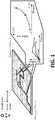
- Figure 1 shows the scenario model on which the method and system of this disclosure is based.
- a set of routes R is calculated.
- R is a variable-length set of trip routes rooted on ( lat O , lon O ) .
- the initial location (represented as a grey circle in the figure) needs to be provided.
- the coordinates ( lat O , lon O ) of this initial position indicate the geographical point where all potential routes depart from, emulating e.g. a bike ride (or walk, or running) that a user is willing to enjoy from home within his/her limited leisure time.
- ( lat O , lon O ) ⁇ [ lat min , lat max ] x [ lon min , lon max ] , i.e. the scenario and the produced routes themselves are located within a maximum square area, as represented in figure 1 .
- This parameter ⁇ is input by the user to reflect his/her tolerance (lower threshold) with respect to the admissible maximum time for the bike ride.
- a second parameter ⁇ > 1 may be used to reflect the user's tolerance to exceed the maximum time duration T max for the route.
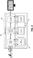
- FIG. 2 shows a block diagram of the architecture of a developed route planning system according to embodiments of the invention.
- the system uses a routing platform 20 having route generation functionality.
- the routing platform 20 comprises two main blocks: a planner resource block 21 and a problem solving block 22 (also referred to as Problem OTP).
- the planner resource block 21 manages the generation of routing requests, the building of routing requests, the heuristic for time constraint route calculation and the formatting for routes output, as schematized in figure 2 .
- the problem solving block 22 comprises a route planning engine, also referred to as routing engine or route planner in this text, which performs the path evaluation and the generation of complete routes, as schematized in figure 2 .
- the route planning engine is called by a heuristic algorithm for the computation and evaluation of open routes.
- the path evaluation is implemented as a function which is recurrently called by the algorithm to return the length and safety of the route provided as an input, as disclosed next.
- the generator of complete routes is implemented as a function which returns the entire path calculated by the route planning engine of the routing platform 20 from its encoded representation for visualization and further analysis.
- the route planning engine calculates the routes using the heuristic algorithm.
- the heuristic algorithm iteratively generates new petitions for route calculation (routing requests), as shown in the planner resource block 21, and calls the route planning engine comprised in the problem solving block 22 in order to obtain a route and evaluate its quality in terms of the established criteria.
- the OTP (Open Trip Planner) platform is used (https://github.com/opentripplanner Accessed: 2017-11-30) as routing platform 20.
- OTP is an open source framework for mono and multi-modal journey planning. It follows a client-server model, and provides a map-based web and smartphone interface, as well as a REST API for its use with third-party applications.
- OTP is open source in its entirety, easing its adaptation to specific simulation scenarios; OTP efficiently works with OSM, providing the structure to automatically build the street network; OTP is well documented, updated, with an active, growing community of developers.
- OTP includes a REST API for journey planning and a map-based Javascript client.
- OTP is open source, both parts have been adapted and modified to enable constraining the routes in time, and the output of all segments comprising the generated route. Consequently, several Java classes have been created in order to deploy these functionalities.
- OTP can also create travel time contour visualizations and compute accessibility indicators for planning and research applications.
- OTP operates with different open data standards, such as GeoTIFF, Protocol Buffers, General Transit Feed Specification (GTFS) and Open Street Map (OSM).
- GTFS General Transit Feed Specification
- OSM Open Street Map
- the shown architecture also integrates a java framework for multi-objective optimization, such as the jMetal framework, jointly with OTP, for implementing the considered multi-objective solvers which are described later in this text.
- the route planning system requires processing means, such as a processor, and data storage means, such as a memory, in order to store and execute the heuristic algorithm for the route calculation and evaluation.
- the planner resource block 21 has enough memory resources to store the best routes that are being obtained from the calls or requests performed to the problem solving block 22.
- the planner resource block 21 stores in the data storage means the routes configurations that are considered optimal, in order to later dump the optimal routes configurations to different files.
- OSM files are directly consumed by OTP, which automatically constructs the full road network.
- a Digital Elevation Model has been used and directly consumed by OTP in GeoTIFF format. This format is a public domain metadata standard, which allows georeferencing information to be embedded within a TIFF file. OTP uses these files for assigning the corresponding elevation to the entire street network, and it is employed for calculating the route flatness and safety.
- the algorithm calculates each route of the set of routes R as follows: First, coordinates for a destination location are randomly assigned, taking into account that they belong to a certain square area. For example, they may belong to a maximum square area [ lat min , lat max ] x [ lon min , lon max ], as illustrated in figure 1 . This may be implemented as follows: latitude varies with respect to the origin in a random value between 0 and
- the algorithm randomly assigns a value of safety preference S p ⁇ R [0, 1], a value of inclination preference I p ⁇ R [0, 1] and a value of duration preference D p ⁇ R [0, 1].
- the safety preference S p stands for the priority that the routing platform 20, such as the OTP route planner, should grant to the safety of the route. If this value is high, routes with a high safety will be better rated and output by the engine.
- the inclination preference I p refers to the importance that the planner endows to the aggregate inclination of the route.
- each candidate route r p within the P-sized populations is a vector comprising the following five values: latitude lat p Np and longitude lon p Np of the destination location of the route r p , safety preference S p , inclination preference I p and duration preference D p .
- route r p is a route that belongs to population P.
- the latitude lat p Np and longitude lon p Np rather than using the true coordinates in the candidate, the relative difference between the origin location (lat O , lon O ) and the coordinates lat p Np lon p Np is preferably used instead.
- preferences S p , I p and D p are criteria to be prioritized according to their value when a route is calculated.
- the route planning engine calculates routes making use of a heuristic algorithm.
- a route is calculated, that starts at the initial position ( lat O , lon O ) provided by the user and whose duration is within the time constraints also introduced by the user.
- the route planning engine calculates a new route, for example route A, which has certain inclination (inclination of route A), certain security (security of route A) and certain duration (duration of route A). These values inclination, security and duration are calculated while the route is calculated and traced.
- the route is considered candidate route. If the time constraints are not fulfilled, the route is discarded.
- the candidate route is then evaluated in terms of safety and distance. In other words, a security value and a distance value are calculated for that route. As explained later, the security value depends on the distance (route length), inclination profile and maximum speed admitted for motor vehicles in the route.
- the algorithm used for modifying route parameters, calculating the routes and evaluating the routes in a computationally efficient fashion is a heuristic algorithm, preferably a population-based bio-inspired algorithm or solver, used to efficiently balance the Pareto trade-off between the safety level and the distance of the route, always subject to the imposed time constraints.
- the route safety must be maximized while the overall distance of the route must also be maximized.
- the planning of routes must be optimized by balancing two parameters associated to each route: distance and safety of the route.
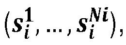
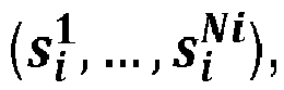
- a route r i is given by a variable-length sequence of segments s i 1 , ... , s i Ni , wherein s i j denotes the j-th segment of route r i and N i the overall number of segments of the entire route.
- the route planner of the routing platform 20 provides the calculated route. The calculated route is divided into segments.
- the inclination profile ⁇ i j is obtained from the digital elevation model (DEM).
- the maximum speed v i j , max is obtained from the information available at the digital street map file, such as OSM.
- the level of safety when a bike, runner or hiker or the like traverses route r i should be driven by two different aspects: first, the inclination of its segments should be as close to 0 as possible (namely, a flat segment) so that the user has good visibility and, for example in the case of a bike, the rider does not lose control of the bike due to either a high speed and risk to encounter unavoidable moving obstacles along the segment (downhill), or a physically demanding uphill segment that could put in danger the health of the user and his/her capacity to react against vehicles in the opposite direction. So, in embodiments of the invention, the inclination of the segment as per ⁇ i j is very relevant when quantifying the degree of safety of a segment.
- an algorithm in particular a bio-inspired muti-objective solver, which makes use of the route planner, is executed in order to obtain a set of routes R that fulfill the imposed constraints (origin and temporal constrains).
- R denotes a variable-length set of trip routes rooted on ( lat, lon ) .
- the routing problem address by the method and system of this disclosure can be formulated as the discovery of a set of routes that balances their safety and distance values in a Pareto optimal fashion satisfying, at the same time, at least upper bounds in regards to their total duration.
- a tolerance parameter p is assigned by the algorithm.
- the value of the assigned tolerance parameter p may be, for example, 0.7.
- the algorithm calculates new routes by randomly changing the coordinates for a destination location and the safety, inclination and distance preferences and repeating the checking for determining whether they are candidates or not. All the candidates are evaluated in terms of safety and distance by a heuristic algorithm, and then ranked and sorted as defined by the heuristic algorithm at hand.
- the algorithm used for evaluating the routes in a computationally efficient fashion is preferably a population-based bio-inspired algorithm or solver.
- the user is thus provided with a set P [r 1 , r 2 , r 3 ... r P ] having the best found routes with their associated values of security and distance (length).
- Each route provided by the route planning engine has associated values of security and distance, which are then evaluated by the heuristic algorithm in order to select the best routes.
- two graphs are depicted (right side of figure 1 ) with information regarding the routes evaluation obtained from the execution of the heuristic algorithm. In a first graph, for each route, its length (distance) is represented versus its inclination. Thus, a comparison between distance and inclination of all the selected routes can be established.
- the red point represents the value of the objective function of the red route on the map.
- the blue point represents the value of the objective function of the blue route on the map.
- the green point represents the value of the objective function of the green route on the map.
- the red route is the longest in distance, but at the same time the least secured.
- the green route is the shortest one, but the safest one.
- the heuristic algorithm used for calculating and evaluating the routes in a computationally efficient fashion is preferably a population-based bio-inspired algorithm or solver.
- the population-based bio-inspired algorithm may be NSGA-II (Non-dominated Sorting Genetic Algorithm II).
- NSGA-II is a generational genetic algorithm that applies a Pareto ranking scheme to foster the convergence to the Pareto front and the crowding distance density estimator to promote the diversity of the front of solutions it is managing.
- NSGA-II is reported by Kalyanmoy D. et. al. in "A Fast and Elitist Multiobjective Genetic Algorithm: NSGA-II", IEEE Transactions on Evolutionary Computation, Vol. 6, n° 2, April 2002, p. 182-197 .
- the population-based bio-inspired algorithm may be MOEA/D (Multi-Objective Evolutionary Algorithm Based on Decomposition).
- MOEA/D is a steady-state evolutionary algorithm based on an aggregative approach with the aim of decomposing a multi-objective problem in a set of single-objective subproblems that are solved at the same time by taking into account information of a number of neighbors (see for example Qingfu Zhang and Hui Li, "MOEA/D: A Multiobjective Evolutionary Algorithm Based on Decomposition", IEEE Transactions on Evolutionary Computation, Vol. 11, no 6, December 2007, p. 712-731 ).
- the MOEA/DE version may be used, which uses differential evolution instead of the mutation and crossover operators of the original proposal.
- the population-based bio-inspired algorithm may be SMS-EMOA (S-Metric Selection EMOA).
- SMS-EMOA is also a steady-state evolutionary algorithm which is based on NSGA-II but, instead of using the crowding distance density estimator, it applies the concept of hypervolume contribution. The idea is that, after applying the ranking procedure, the solution belonging to the last rank having the lowest contribution to the hypervolume of the set of solutions of that rank is removed. SMS-EMOA is reported by Beume N. et. al. in "SMS-EMOA: Multiobjective selection based on dominant hypervolume", European Journal of Operational Research (2006), doi:10.1016/j.ejor.2006.08.008 .
- the population-based bio-inspired algorithm may be SMPSO (Speed-constrained Multi-objective PSO).
- SMPSO is particle swarm optimization al gorithm whose main features is the use of a velocity constraint mechanism, to avoid the particles to fly beyond the limits of the search space, and an external bounded- sized archive to store the non-dominated solutions found during the search. This archive is used also for leader selection and the crowding distance density estimator is used to remove solutions when it becomes full.
- SMPSO is reported by Nebro, A.J. et al. in "SMPSO: A New PSO-based Metaheuristic for Multi-objective Optimization", IEEE Symposium on Computational intelligence in multi-criteria decision-making, IEEE (2009) 66-73 .
- the algorithm is executed until a termination criterion is fulfilled.
- the termination criterion is a previously defined maximum number of evaluations. This maximum number can be defined, for example, to be 5,000.
- OTP Open Trip Planner
- the proposed method and system have been assessed as bike route planner in a realistic environment using Open Trip Planner (OTP) as the simulation framework.
- OTP Open Trip Planner
- Experimental results from three different use cases located in the city of Bilbao (Spain) are discussed next, all using real data sources, namely, the Open Street Map of the city and its Digital Elevation Model (DEM).
- OTP Open Trip Planner
- Both NSGA-II and SMS-EMOA apply a simulated binary crossover, with a probability of 1.0 and a distributed index equal to 20.0.
- the values of the neighborhood size, the neighborhood selection probability, and maximum number of replace solutions are 20, 0.9, and 2, respectively.
- SMSPO has an external archive of a maximum size of 100 particles and applies the crowding distance density estimator. Table 1. Parameter setting of the heuristics considered in the experimental benchmark.
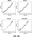
- figures 3A to 3C show the approximations corresponding to the best hypervolume values for the flat ( figure 3A ), hybrid ( figure 3B ) and hilly scenario ( figure 3C ).
- the reference Pareto front is included as a continuous line. It can be observed how SMPSO excels at generating a set of solutions that are on top of the reference Pareto front and that are uniformly spread, including the extreme solutions. By contrast, MOEA/D fails to generate a front with accurate convergence and widespread diversity.
- the results of the hypervolume values obtained by the four metaheuristics are presented in Table 2, which includes the median and interquartile range of the 15 independent runs per algorithm and problem instance.
- the three cells of SMPSO have the best indicator values.
- the two upper cells of NSGA-II (flat and hybrid scenarios) and the lower cell of SMS-EMOA have the second best indicator values. It can be observed that the particle swarm optimization algorithm SMPSO has produced the best (highest) values in the three considered scenarios.
- NSGA-II and SMS-EMOA have yielded, respectively, two and one second best values.
- Table 2 Median and Inter Quartile Range (IQR) of the hypervolume values obtained by the algorithms. Best and second best median results have dark and light gray backgrounds, respectively.
- IQR Median and Inter Quartile Range
- figure 4 shows (up) the reference Pareto fronts for each of the three scenarios, and (down) a visual representation of the routes corresponding to the points in the estimated Pareto front of the hilly scenario. Indeed, differences are visually clear in regards to the distance of every route: interesting is to note that the one in green traverses a urban area with sharp slopes (namely, the urban core of the town of Portugalete within the metropolitan area of Gran Bilbao ).
- a method and system for designing time-constrained routes have been developed from a multi-criteria perspective.
- the focus has been placed on generating a group of open-destination routes based on three input parameters: origin, maximum trip time and tolerance.
- the problem has been modeled as a bi-objective paradigm balancing two conflicting objectives: the distance of the route and its safety level, the latter blending together the inclination of segments composing the route, their length and the speed of vehicles along each segment.
- four bio-inspired multi-objective optimization methods have been used (namely, NSGA-II, SMS-EMOA, MOEA/D, and SMPSO), and applied to three different real-world scenarios placed in Bilbao, Spain.
- Experiments have been conducted in a realistic simulation environment based on Open Trip Planner as the software simulation platform.
Landscapes
- Engineering & Computer Science (AREA)
- Radar, Positioning & Navigation (AREA)
- Remote Sensing (AREA)
- Physics & Mathematics (AREA)
- General Physics & Mathematics (AREA)
- Health & Medical Sciences (AREA)
- General Health & Medical Sciences (AREA)
- Social Psychology (AREA)
- Automation & Control Theory (AREA)
- Navigation (AREA)
Abstract
Description
- The present invention relates to the field of transportation and mobility. In particular, it relates to methods and systems for route calculation and planning. The invention focuses especially on the calculation and construction of routes to be performed by bike or on foot.
- In the last couple of decades a growing number of route planning systems have been developed, which are available for the community of users, such as bikers, runners or hikers. These tools, mostly accessible from different platforms, with deployable versions for computers, smartphones or tablets, are flexible enough to let users comfortably query routes in any place and time. In all cases, one of the characteristics shared by all route planners is that the provided portfolio of routes are strictly based on parameters that the user enters as an input.
- Regarding bike route planning, some proposals have been made. For example, Turverey, R.J. et al. have proposed (Charlottesville bike router planner. In: Systems and Information Engineering Design Symposium, IEEE (2010) 68-72) a web-based platform to help cyclists determine safe and efficient routes by calculating routes using a weighted combination of five different metrics, which are considered to optimize a trade-off among various safety and distance-related factors.
- In another proposal, Hrncír, J. et al. (Practical multicriteria urban bicycle routing. IEEE Transactions on Intelligent Transportation Systems 18(3) (2017) 493-504) tackle a multi-criteria bicycle routing problem and develop a set of heuristics for speeding up the multi-criteria route search between two points (origin and destination) by optimizing the comfort, duration and inclination of the route. The heuristic used in this proposal is an extension of the standard multi-criteria label-setting algorithm (Martins, E.Q.V.: On a multicriteria shortest path problem. European Journal of Operational Research 16(2) (1984) 236-245).
- Another interesting example is the one proposed by Caggiani, L. et al. (A real time multi-objective cyclists route choice model for a bike-sharing mobile application. In: IEEE International Conference on Models and Technologies for Intelligent Transportation Systems, IEEE (2017) 645-650), which provides users with an appropriate starting and ending bike hiring station. To this end, the suggested origin station is set to the nearest one satisfying the requirements of the user, whereas a similar criterion is applied for selecting the destination station. Besides, the system informs the user with the best path to follow according to time, distance, pollution and safety. Additionally, users can select an alternative route according to the parameter that they are willing to prioritize.
- However, there is a need to develop new multi-objective route planning methods and systems for generation of open random routes, that is to say, for computing routes starting from a certain location, without imposing a route destination.
- The computer-implemented method and system for open routes planning described in the present disclosure intends to solve the shortcomings of prior-art methods. The method and system of the present disclosure computes routes starting from a known location and complying with and certain time constraints. The method and system also bear in mind two different objectives: distance and safety of the route. The method and system are grounded on heuristics algorithms, such as multi-objective bio-inspired optimization algorithms.
- A first aspect of the invention relates to a computer-implemented method for computing open routes, comprising: providing the initial location coordinates (latO, lonO) of the user and a maximum time duration Tmax for a route, digitally assigning in a random way destination location coordinates


- In embodiments of the invention, the time duration tolerance value is either provided by the user or assigned by default.
- In embodiments of the invention, the heuristic algorithm is a population-based bio-inspired algorithm.
- In embodiments of the invention, the security value associated to each route depends on the route length, inclination profile of the route and maximum speed admitted for motor vehicles in the route.
- In embodiments of the invention, each calculated route r¡ is given by a variable-length sequence of segments


- In embodiments of the invention, each calculated route has a measure of route safety calculated as follows:

- In embodiments of the invention, the heuristic algorithm further ranks and sorts the selected routes in terms of safety and distance.
- In embodiments of the invention, the method further comprises depicting on a digital map displayed on a screen of an electronic device a plurality of selected routes, together with their distance values a safety values.
- The method is preferably a method for computing open bike routes.
- A second aspect of the invention relates to a route planning system comprising processing means, a routing platform having route generation functionality and a framework for multi-objective optimization for implementing a multi-objective solver, the system being configured to perform the steps of the method previously disclosed.
- In embodiments of the invention, the routing platform comprises at least one of a map-based web, a smartphone interface and a REST API for its use with third-party applications.
- In embodiments of the invention, the system further comprises a digital street map file or files and a digital elevation model.
- The system is preferably a system for computing open bike routes.
- A third aspect of the invention relates to a computer program product comprising computer program instructions/code for performing the method of the first aspect of the invention.
- A fourth aspect of the invention relates to a computer-readable memory/medium that stores program instructions/code for performing the method of the first aspect of the invention.
- In sum, a method for planning routes has been proposed. The method formulates the optimality of explored routes from a multi-criteria or multi-objective approach. The method provides the users (such as cyclists, runners or hikers) with diverse sets of suggested routes, hence narrowing the amount and diversity of information provided to users for making their decision.
- With respect to conventional methods and systems for route planning, such as routes by bike, which are typically calculated by choosing origin and destination points, the method and system of the present disclosure take into account, for the problem formulation, the consideration of time constraints (at least upper trip time constraints and tolerance to upper trip time constraint) to model the case where the planning system is used for e.g. leisure/sport, and the derivation of a quantitative metric to evaluate the degree of safety associated to a given route with respect to its topological profile and the speed of motor vehicles along its segments. Besides, different bio-inspired multi-objective solvers may be used to efficiently balance the Pareto trade-off between the safety level and the distance of the route, always subject to the imposed time constraints. Examples of the solvers are: NSGA-II, MOEA/D, SMS-EMOA and SMPSO. A Pareto-optimal set of routes produced by any of these bio-inspired multi-objective solvers is provided to the user, so that he/she has the freedom to choose the one that matches his/her preferences with respect to the considered objectives.
- Additional advantages and features of the invention will become apparent from the detail description that follows and will be particularly pointed out in the appended claims.
- To complete the description and in order to provide for a better understanding of the invention, a set of drawings is provided. Said drawings form an integral part of the description and illustrate an embodiment of the invention, which should not be interpreted as restricting the scope of the invention, but just as an example of how the invention can be carried out. The drawings comprise the following figures:
-
Figure 1 shows a schematic diagram of the routing scenario on which the method and system according to embodiments of the invention are based. It also shows three possible examples of routes provided by the system and their objective functions. -
Figure 2 shows a block diagram of the architecture of the system deployed in the present disclosure. -
Figures 3A to 3C show estimated Pareto fronts with the best hypervolume values obtained by four compared algorithms for the flat (figure 3A ), hybrid (figure 3B ) and hilly (figure 3C ) scenarios. The line stands for the reference Pareto front approximation. -
Figure 4 shows (up) reference Pareto fronts obtained for the three considered scenarios (flat, hybrid, hilly) and (down) routes corresponding to the colored points in the reference Pareto front of the hilly scenario. - The method and system of the present disclosure optimize the planning of routes, such as bike routes, bearing in mind two different objectives: distance and safety of the route. In addition, the calculated routes must comply with certain time constraints, including maximum time duration for the route and preferably also minimum time duration for the route. The minimum time duration for the route may be given with respect to the maximum time duration, such as a percentage thereof, for example representing how flexible the user is to accept a route time duration lower than the selected maximum time duration. Alternatively, the minimum time duration may be given as a fixed value provided by the user.
Figure 1 shows the scenario model on which the method and system of this disclosure is based. A set of routes R is calculated. R is a variable-length set of trip routes rooted on (lat O , lon O). As shown infigure 1 (left), in order to perform the calculation of routes, the initial location (represented as a grey circle in the figure) needs to be provided. The coordinates (lat O , lon O) of this initial position indicate the geographical point where all potential routes depart from, emulating e.g. a bike ride (or walk, or running) that a user is willing to enjoy from home within his/her limited leisure time. For simplicity in subsequent algorithm explanations, it is assumed that (lat O , lon O) ∈ [latmin, latmax ] x [lonmin, lonmax ], i.e. the scenario and the produced routes themselves are located within a maximum square area, as represented infigure 1 . On the scenario model offigure 1 (left), three exemplary possible routes have been depicted. The three of them start from the initial position (lat O , lon O), while each route has a different destination point. The three exemplary routes shown infigure 1 have different destinations, because the method and system compute open routes. - In order for the method and system to calculate a set of open routes ri, the user must provide the initial position (lat O , lon O) from which the calculated routes must depart and certain time constraints that the routes must fulfil including maximum time duration Tmax for the route. In other words, an upper bound Tmax for the trip time T(ri) needed to complete route ri is imposed, meaning that routes ri' for which T(ri) > Tmax are not allowed to appear in the eventually output set of routes. This means that the computed routes have in principle different time duration, and therefore different distance, provided that the duration of each route is shorter than Tmax.
- Other time constraints that may be additionally used are, among others: user's tolerance with respect to the admissible maximum time for the route or with respect to minimum time duration for the route. In embodiments of the invention, the minimum trip time may be defined as a fraction ρ ∈ R [0, 1] of Tmax, such that a feasible route ri should meet T(ri) ≥ Tmin = ρ ·Tmax in all cases. This parameter ρ is input by the user to reflect his/her tolerance (lower threshold) with respect to the admissible maximum time for the bike ride. In embodiments of the invention, the user must provide the tolerance parameter p or the algorithm assigns a value for this parameter by default (for example, ρ = 0.7). In embodiments of the invention, a second parameter β > 1 may be used to reflect the user's tolerance to exceed the maximum time duration Tmax for the route.
-
Figure 2 shows a block diagram of the architecture of a developed route planning system according to embodiments of the invention. The system uses arouting platform 20 having route generation functionality. Therouting platform 20 comprises two main blocks: aplanner resource block 21 and a problem solving block 22 (also referred to as Problem OTP). Theplanner resource block 21 manages the generation of routing requests, the building of routing requests, the heuristic for time constraint route calculation and the formatting for routes output, as schematized infigure 2 . Theproblem solving block 22 comprises a route planning engine, also referred to as routing engine or route planner in this text, which performs the path evaluation and the generation of complete routes, as schematized infigure 2 . The route planning engine is called by a heuristic algorithm for the computation and evaluation of open routes. The path evaluation is implemented as a function which is recurrently called by the algorithm to return the length and safety of the route provided as an input, as disclosed next. The generator of complete routes is implemented as a function which returns the entire path calculated by the route planning engine of therouting platform 20 from its encoded representation for visualization and further analysis. The route planning engine calculates the routes using the heuristic algorithm. The heuristic algorithm iteratively generates new petitions for route calculation (routing requests), as shown in theplanner resource block 21, and calls the route planning engine comprised in theproblem solving block 22 in order to obtain a route and evaluate its quality in terms of the established criteria. - In embodiments of the invention, the OTP (Open Trip Planner) platform is used (https://github.com/opentripplanner Accessed: 2017-11-30) as
routing platform 20. OTP is an open source framework for mono and multi-modal journey planning. It follows a client-server model, and provides a map-based web and smartphone interface, as well as a REST API for its use with third-party applications. Among the advantages of OTP platform: OTP is open source in its entirety, easing its adaptation to specific simulation scenarios; OTP efficiently works with OSM, providing the structure to automatically build the street network; OTP is well documented, updated, with an active, growing community of developers. OTP includes a REST API for journey planning and a map-based Javascript client. As OTP is open source, both parts have been adapted and modified to enable constraining the routes in time, and the output of all segments comprising the generated route. Consequently, several Java classes have been created in order to deploy these functionalities. OTP can also create travel time contour visualizations and compute accessibility indicators for planning and research applications. OTP operates with different open data standards, such as GeoTIFF, Protocol Buffers, General Transit Feed Specification (GTFS) and Open Street Map (OSM). The shown architecture also integrates a java framework for multi-objective optimization, such as the jMetal framework, jointly with OTP, for implementing the considered multi-objective solvers which are described later in this text. - In addition to the
routing platform 20 shown infigure 2 , the route planning system requires processing means, such as a processor, and data storage means, such as a memory, in order to store and execute the heuristic algorithm for the route calculation and evaluation. Theplanner resource block 21 has enough memory resources to store the best routes that are being obtained from the calls or requests performed to theproblem solving block 22. In addition, theplanner resource block 21 stores in the data storage means the routes configurations that are considered optimal, in order to later dump the optimal routes configurations to different files. - Besides, in order to verify how the proposed system and method and the considered heuristic solvers behave in geographically diverse setups, two different real data sources are required: 1) a digital street map file or files; and 2) a digital elevation model. Experimental results have been obtained (later discussed) using these real data sources. In embodiments of the invention, in both cases open data sources are used. Regarding the digital street map file, in embodiments of the invention, OSM (Open Street Map) map files are used. The maps and street networks of the simulated scenarios have been retrieved in the form of OSM map files from the Planet OSM public repository (https://planet.osm.org/. Accessed: 2017-11-30). The downloaded OSM tiles contain all nodes, ways and relations required to build the map. OSM files are directly consumed by OTP, which automatically constructs the full road network. Regarding the digital elevation model, in embodiments of the invention, a Digital Elevation Model has been used and directly consumed by OTP in GeoTIFF format. This format is a public domain metadata standard, which allows georeferencing information to be embedded within a TIFF file. OTP uses these files for assigning the corresponding elevation to the entire street network, and it is employed for calculating the route flatness and safety.
- Once the user has provided the initial position (lat O , lon O) from which the calculated routes must depart and certain time constraints he/she wishes to impose to the calculated routes, the algorithm calculates each route of the set of routes R as follows:
First, coordinates for a destination location are randomly assigned, taking into account that they belong to a certain square area. For example, they may belong to a maximum square area [latmin, latmax ] x [lonmin, lonmax ], as illustrated infigure 1 . This may be implemented as follows: latitude varies with respect to the origin in a random value between 0 and |latmax - latmin |. If this random value implies that the destination latitude is out of the range [latmin , latmax ], then the random value is corrected to be either latmax or latmin , depending on which of the two ends is exceeded. The same is done for the longitude. - Then, in order to be able to take into account safety and distance preferences for the potential routes, the algorithm randomly assigns a value of safety preference Sp ∈ R [0, 1], a value of inclination preference Ip ∈ R [0, 1] and a value of duration preference Dp ∈ R [0, 1]. The safety preference Sp stands for the priority that the
routing platform 20, such as the OTP route planner, should grant to the safety of the route. If this value is high, routes with a high safety will be better rated and output by the engine. The inclination preference Ip refers to the importance that the planner endows to the aggregate inclination of the route. The duration preference Dp refers to the importance that the route planner gives to the duration of the route. It must be ensured that Sp + Ip + Dp = 1 ∀rp in the population. - So, regarding the encoding of routes -so that they can be handled by their heuristic operators, which are operators comprised in the heuristic algorithm or solver in order to deal with routes-, the numerical encoding does not represent a route by itself, but rather a set of factors that can be used to calculate a route by means of the route planning generation engine (such as OTP engine). This way, each candidate route rp within the P-sized populations is a vector comprising the following five values: latitude


- Along execution of the algorithm, these values (latitude
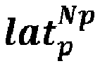

figure 2 ) to produce routes based on the new set of preferences. In other words, the route planning engine calculates routes making use of a heuristic algorithm. So, for each set of five values assigned by the algorithm, a route is calculated, that starts at the initial position (lat O , lon O) provided by the user and whose duration is within the time constraints also introduced by the user. This is done by the route planning engine, such as OTP route planning engine. This is done as follows: while the route planning engine calculates a new route, it scores the paths it chooses in order to decide which paths (streets, etc.) to use. This score is assigned as a function of the three parameters Sp, Ip, Dp, as follows (for a route called route A): score_route_A = security of route A * Sp + inclination of route_A * Ip + duration of route A * Dp. The route planning engine calculates a new route, for example route A, which has certain inclination (inclination of route A), certain security (security of route A) and certain duration (duration of route A). These values inclination, security and duration are calculated while the route is calculated and traced. - For every new route calculated, it is checked whether the time constraints are indeed fulfilled. This is done by the solver. If they are fulfilled, the route is considered candidate route. If the time constraints are not fulfilled, the route is discarded. The candidate route is then evaluated in terms of safety and distance. In other words, a security value and a distance value are calculated for that route. As explained later, the security value depends on the distance (route length), inclination profile and maximum speed admitted for motor vehicles in the route. The algorithm used for modifying route parameters, calculating the routes and evaluating the routes in a computationally efficient fashion is a heuristic algorithm, preferably a population-based bio-inspired algorithm or solver, used to efficiently balance the Pareto trade-off between the safety level and the distance of the route, always subject to the imposed time constraints.

- So, for all the routes in the set R (a variable-length set of trip routes rooted on (lat O , lon O)), that belong to set (the number of all possible route sets satisfying the time constraints), the route safety must be maximized while the overall distance of the route must also be maximized. In other words, the planning of routes must be optimized by balancing two parameters associated to each route: distance and safety of the route.
- In embodiments of the invention, a route ri is given by a variable-length sequence of segments

routing platform 20 provides the calculated route. The calculated route is divided into segments. Each segment





- Based on the above notation, the overall distance of the route is given by


- The level of safety when a bike, runner or hiker or the like traverses route ri should be driven by two different aspects: first, the inclination of its segments should be as close to 0 as possible (namely, a flat segment) so that the user has good visibility and, for example in the case of a bike, the rider does not lose control of the bike due to either a high speed and risk to encounter unavoidable moving obstacles along the segment (downhill), or a physically demanding uphill segment that could put in danger the health of the user and his/her capacity to react against vehicles in the opposite direction. So, in embodiments of the invention, the inclination of the segment as per


- So, once the user has introduced the desired route origin (lat O , lon O) and the temporal constraints (at least Tmax), an algorithm, in particular a bio-inspired muti-objective solver, which makes use of the route planner, is executed in order to obtain a set of routes R that fulfill the imposed constraints (origin and temporal constrains). R denotes a variable-length set of trip routes rooted on (lat, lon). The routing problem address by the method and system of this disclosure can be formulated as the discovery of a set of routes that balances their safety and distance values in a Pareto optimal fashion satisfying, at the same time, at least upper bounds in regards to their total duration. In embodiments in which the imposed time constraints are the maximum time duration Tmax for the route and minimum time duration for the route Tmin = ρ ·Tmax (ρ ∈ R [0, 1] of Tmax), the routing problem can be mathematically expressed as follows:



 is the number of all possible route sets satisfying the time constraints.
- In embodiments of the invention, if the duration tolerance parameter p is not provided by the user together with the maximum time duration Tmax, a tolerance parameter p is assigned by the algorithm. The value of the assigned tolerance parameter p may be, for example, 0.7.
- The algorithm calculates new routes by randomly changing the coordinates for a destination location and the safety, inclination and distance preferences and repeating the checking for determining whether they are candidates or not. All the candidates are evaluated in terms of safety and distance by a heuristic algorithm, and then ranked and sorted as defined by the heuristic algorithm at hand. The algorithm used for evaluating the routes in a computationally efficient fashion is preferably a population-based bio-inspired algorithm or solver.
- The user is thus provided with a set P [r1, r2, r3 ... rP] having the best found routes with their associated values of security and distance (length). Each route provided by the route planning engine has associated values of security and distance, which are then evaluated by the heuristic algorithm in order to select the best routes. Turning back to
figure 1 , two graphs are depicted (right side offigure 1 ) with information regarding the routes evaluation obtained from the execution of the heuristic algorithm. In a first graph, for each route, its length (distance) is represented versus its inclination. Thus, a comparison between distance and inclination of all the selected routes can be established. In a second graph, providing the safety risk versus distance, all the routes shown in the map (left side offigure 1 ) are depicted. The red point represents the value of the objective function of the red route on the map. The blue point represents the value of the objective function of the blue route on the map. The green point represents the value of the objective function of the green route on the map. This means that the red route is the longest in distance, but at the same time the least secured. On the contrary, the green route is the shortest one, but the safest one. As already said, the heuristic algorithm used for calculating and evaluating the routes in a computationally efficient fashion is preferably a population-based bio-inspired algorithm or solver. In embodiments of the invention, the population-based bio-inspired algorithm may be NSGA-II (Non-dominated Sorting Genetic Algorithm II). NSGA-II is a generational genetic algorithm that applies a Pareto ranking scheme to foster the convergence to the Pareto front and the crowding distance density estimator to promote the diversity of the front of solutions it is managing. NSGA-II is reported by Kalyanmoy D. et. al. in "A Fast and Elitist Multiobjective Genetic Algorithm: NSGA-II", IEEE Transactions on Evolutionary Computation, Vol. 6, n° 2, April 2002, p. 182-197. - In embodiments of the invention, the population-based bio-inspired algorithm may be MOEA/D (Multi-Objective Evolutionary Algorithm Based on Decomposition). MOEA/D is a steady-state evolutionary algorithm based on an aggregative approach with the aim of decomposing a multi-objective problem in a set of single-objective subproblems that are solved at the same time by taking into account information of a number of neighbors (see for example Qingfu Zhang and Hui Li, "MOEA/D: A Multiobjective Evolutionary Algorithm Based on Decomposition", IEEE Transactions on Evolutionary Computation, Vol. 11, nº 6, December 2007, p. 712-731). In particular, the MOEA/DE version may be used, which uses differential evolution instead of the mutation and crossover operators of the original proposal.
- In embodiments of the invention, the population-based bio-inspired algorithm may be SMS-EMOA (S-Metric Selection EMOA). SMS-EMOA is also a steady-state evolutionary algorithm which is based on NSGA-II but, instead of using the crowding distance density estimator, it applies the concept of hypervolume contribution. The idea is that, after applying the ranking procedure, the solution belonging to the last rank having the lowest contribution to the hypervolume of the set of solutions of that rank is removed. SMS-EMOA is reported by Beume N. et. al. in "SMS-EMOA: Multiobjective selection based on dominant hypervolume", European Journal of Operational Research (2006), doi:10.1016/j.ejor.2006.08.008.
- In embodiments of the invention, the population-based bio-inspired algorithm may be SMPSO (Speed-constrained Multi-objective PSO). SMPSO is particle swarm optimization al gorithm whose main features is the use of a velocity constraint mechanism, to avoid the particles to fly beyond the limits of the search space, and an external bounded- sized archive to store the non-dominated solutions found during the search. This archive is used also for leader selection and the crowding distance density estimator is used to remove solutions when it becomes full. SMPSO is reported by Nebro, A.J. et al. in "SMPSO: A New PSO-based Metaheuristic for Multi-objective Optimization", IEEE Symposium on Computational intelligence in multi-criteria decision-making, IEEE (2009) 66-73.
- So, a set of routes P [r1, r2, r3 ... rP] has been discovered and provided, that balances their safety and distance values in a Pareto optimal fashion satisfying, at the same time, the time constraints imposed by the user.
- The algorithm is executed until a termination criterion is fulfilled. The termination criterion is a previously defined maximum number of evaluations. This maximum number can be defined, for example, to be 5,000.The proposed method and system have been assessed as bike route planner in a realistic environment using Open Trip Planner (OTP) as the simulation framework. Experimental results from three different use cases located in the city of Bilbao (Spain) are discussed next, all using real data sources, namely, the Open Street Map of the city and its Digital Elevation Model (DEM). In order to assess the empirical performance of the 4 multi-objective optimization algorithms considered to deal with the posed routing problem, several computer experiments have been carried out over different square areas located in the city of Bilbao (Spain), bounded by coordinates (latmin , latmax ) = (lat O - 0.1425, lat O + 0.1425) and (lonmin, lonmax ) = (lon O -0.0665, lon O +0.0665). Differences between scenarios yield from the selection of different initial points (lon O , lat O) for the routes, so that topological changes in the urban areas enclosed by such squares are expected to arise from the performed experiments. These selected scenarios are characterized by a flat, a highly slopped (hilly) and a hybrid terrain profile. This tailored choice permits to verify how the proposed system and method and the considered heuristic solvers behave in geographically diverse setups.
- The NSGA-II, SMS-EMOA, MOEA/D and SMPSO algorithms have been used. As the bike routing is a continuous optimization problem, the algorithms have been configured with commonly accepted settings, without any attempt at finding their best parameter configuration. A summary of the parameters is included in Table 1. All the algorithms have a population size of 100 individuals (or particles in the case of SMPSO) and use a polynomial mutation operator which is applied with a probability of 0.2 (according to the typical value of 1.0 / L, where L = 5 is the number of decision variables of the problem) and a distributed index equal to 20.0; the maximum number of function evaluations has been fixed to 5000. Both NSGA-II and SMS-EMOA apply a simulated binary crossover, with a probability of 1.0 and a distributed index equal to 20.0. MOEA/D follows a rand/1/bin differential evolution scheme, with parameters CR = 1.0 and F = 0.5. The values of the neighborhood size, the neighborhood selection probability, and maximum number of replace solutions are 20, 0.9, and 2, respectively. SMSPO has an external archive of a maximum size of 100 particles and applies the crowding distance density estimator.
Table 1. Parameter setting of the heuristics considered in the experimental benchmark. Algorithm Parameter Value All Population/ swarm size 100 individuals/ particles Evaluations 5000 Independent runs 15 Mutation Polynomial mutation | Probability 0.2 (once per every 5 decision variables) | Distribution index ηm 20.0 NSGA-II Crossover Simulated binary crossover SMS-EMOA | Probability 1.0 | Distribution index ηm 20 MOEA/D Differential evolution scheme Rand/1/bin | CR 1.0 | F 0.5 Neighborhood size 20 Neighborhood selection probability 0.9 Max. number of replaced solutions 2 SMPSO Archive size 100 Density estimator Crowding distance - For proving the robustness of the methods and extracting fair and rigorous conclusions, 15 independent runs have been made per algorithm for all problem scenarios. To assess the performance of the algorithms, the so-called hypervolume has been used, a Pareto compliant quality indicator that takes into account both the convergence and diversity of the Pareto front approximations returned by the solvers included in the benchmark.
- Since the true Pareto front of the optimization problem is unknown, a reference Pareto front for each instance has been generated by combining all the non- dominated solutions computed in all the executions of all the algorithms. This front will be used as a reference to compute the hypervolume. Furthermore, in order to assess whether the differences between the algorithm results have statistical significance, the Wilcoxon rank-sum text has been applied, a non-parametric statistical hypothesis test which allows for a pairwise comparison between two samples. A significance level of 5% has been considered, meaning that the differences are unlikely to have occurred by chance with a probability of 95%.
- To illustrate the fronts that each of the four compared algorithms have produced,
figures 3A to 3C show the approximations corresponding to the best hypervolume values for the flat (figure 3A ), hybrid (figure 3B ) and hilly scenario (figure 3C ). To ease the visualization of the solutions, the reference Pareto front is included as a continuous line. It can be observed how SMPSO excels at generating a set of solutions that are on top of the reference Pareto front and that are uniformly spread, including the extreme solutions. By contrast, MOEA/D fails to generate a front with accurate convergence and widespread diversity. - The results of the hypervolume values obtained by the four metaheuristics are presented in Table 2, which includes the median and interquartile range of the 15 independent runs per algorithm and problem instance. The three cells of SMPSO have the best indicator values. The two upper cells of NSGA-II (flat and hybrid scenarios) and the lower cell of SMS-EMOA have the second best indicator values. It can be observed that the particle swarm optimization algorithm SMPSO has produced the best (highest) values in the three considered scenarios. NSGA-II and SMS-EMOA have yielded, respectively, two and one second best values.
Table 2. Median and Inter Quartile Range (IQR) of the hypervolume values obtained by the algorithms. Best and second best median results have dark and light gray backgrounds, respectively. SMPSO NSGA-II MOEA/D SMS-EMOA Flat scenario 5.80e-018.8e-03 5.68e-016.2e-03 5.27e-017.5e-03 5.64e-011.2e-02 Hybrid scenario 5.95e-013.8e-03 5.79e-011.0e-02 5.30e-011.8e-02 5.74e-011.2e-02 Hilly scenario 7.00e-018.4e-03 6.13e-015.0e-02 5.71e-012.2e-02 6.20e-018.2e-02 - In order to assess the quality of the solutions,
figure 4 shows (up) the reference Pareto fronts for each of the three scenarios, and (down) a visual representation of the routes corresponding to the points in the estimated Pareto front of the hilly scenario. Indeed, differences are visually clear in regards to the distance of every route: interesting is to note that the one in green traverses a urban area with sharp slopes (namely, the urban core of the town of Portugalete within the metropolitan area of Gran Bilbao). - In sum, a method and system for designing time-constrained routes have been developed from a multi-criteria perspective. The focus has been placed on generating a group of open-destination routes based on three input parameters: origin, maximum trip time and tolerance. The problem has been modeled as a bi-objective paradigm balancing two conflicting objectives: the distance of the route and its safety level, the latter blending together the inclination of segments composing the route, their length and the speed of vehicles along each segment. For efficiently tackling this problem, four bio-inspired multi-objective optimization methods have been used (namely, NSGA-II, SMS-EMOA, MOEA/D, and SMPSO), and applied to three different real-world scenarios placed in Bilbao, Spain. Experiments have been conducted in a realistic simulation environment based on Open Trip Planner as the software simulation platform.
- The invention is obviously not limited to the specific embodiment(s) described herein, but also encompasses any variations that may be considered by any person skilled in the art (for example, as regards the choice of materials, dimensions, components, configuration, etc.), within the general scope of the invention as defined in the claims.
Claims (15)
- A computer-implemented method for computing open routes, comprising:providing the initial location coordinates (lat O , lonO) of the user and a maximum time duration Tmax for a route,digitally assigning in a random way destination location coordinates
 applying a heuristic algorithm for digitally calculating a candidate route rp by means of a route planning engine, said candidate route rp starting at the initial location coordinates (latO, lonO), ending at the destination location coordinates
 if the time constraints are fulfilled, selecting said route and calculating a security value and a distance value associated to the route, andif the time constraints are not fulfilled, discarding the candidate route,repeating the steps of digitally assigning in a random way destination location coordinates, a value of safety preference, a value of inclination preference and a value of duration preference, digitally calculating a candidate route and digitally checking the fulfilment of time constraints in the calculated route and if applicable, calculating a security value and a distance value for the route, until a set of selected routes has been obtained by balancing the Pareto trade-off between the route safety level and the distance of the route.
 - The method of claim 1, wherein the time duration tolerance value is either provided by the user or assigned by default.
- The method of any preceding claim, wherein the heuristic algorithm is a population-based bio-inspired algorithm.
- The method of any preceding claim, wherein the security value associated to each route depends on the route length, inclination profile of the route and maximum speed admitted for motor vehicles in the route.
- The method of any preceding claim, wherein each calculated route ri is given by a variable-length sequence of segments


- The method of claim 5, wherein the overall distance of the calculated route is given by the sum of the segments' distance

- The method of either claim 5 or 6, wherein the overall time of the calculated route is given by the sum of segments' time

- The method of any of claims 5-7, wherein each calculated route has a measure of route safety calculated as follows:

- The method of any preceding claim, wherein the heuristic algorithm further ranks and sorts the selected routes in terms of safety and distance.
- The method of any preceding claim, further comprising depicting on a digital map displayed on a screen of an electronic device a plurality of selected routes, together with their distance values a safety values.
- A route planning system comprising processing means, a routing platform (20) having route generation functionality and a framework for multi-objective optimization for implementing a multi-objective solver, the system configured to perform the steps of the method of any claims 1-10.
- The system of claim 11, wherein the routing platform (20) comprises at least one of a map-based web, a smartphone interface and a REST API for its use with third-party applications.
- The system of any of claims 11-12, further comprising a digital street map file or files and a digital elevation model.
- The method of any of claims 1-10 or the system of any of claims 11-13, for computing open bike routes.
- A computer program product comprising computer program instructions/code or a computer-readable memory/medium that stores program instructions/code for performing the method according to any of claims 1-10.
Priority Applications (2)
| Application Number | Priority Date | Filing Date | Title |
|---|---|---|---|
| EP18382211.3A EP3546890B1 (en) | 2018-03-27 | 2018-03-27 | Method, system and computer program product for computing routes |
| ES18382211T ES2864448T3 (en) | 2018-03-27 | 2018-03-27 | Method, system and software product for calculating routes |
Applications Claiming Priority (1)
| Application Number | Priority Date | Filing Date | Title |
|---|---|---|---|
| EP18382211.3A EP3546890B1 (en) | 2018-03-27 | 2018-03-27 | Method, system and computer program product for computing routes |
Publications (2)
| Publication Number | Publication Date |
|---|---|
| EP3546890A1 true EP3546890A1 (en) | 2019-10-02 |
| EP3546890B1 EP3546890B1 (en) | 2020-12-23 |
Family
ID=62046834
Family Applications (1)
| Application Number | Title | Priority Date | Filing Date |
|---|---|---|---|
| EP18382211.3A Active EP3546890B1 (en) | 2018-03-27 | 2018-03-27 | Method, system and computer program product for computing routes |
Country Status (2)
| Country | Link |
|---|---|
| EP (1) | EP3546890B1 (en) |
| ES (1) | ES2864448T3 (en) |
Cited By (8)
| Publication number | Priority date | Publication date | Assignee | Title |
|---|---|---|---|---|
| CN109584099A (en) * | 2018-10-24 | 2019-04-05 | 华中科技大学 | The short-term multiple target generation schedule preparation method in the power station of peak load regulation network and system |
| CN110825093A (en) * | 2019-11-28 | 2020-02-21 | 安徽江淮汽车集团股份有限公司 | Automatic driving strategy generation method, device, equipment and storage medium |
| CN110715664B (en) * | 2019-11-05 | 2021-04-20 | 大连理工大学 | Rapid trajectory planning method for intelligent unmanned aerial vehicle under multiple constraints |
| WO2022090830A1 (en) * | 2020-10-01 | 2022-05-05 | Naxos Finance Sa | Method and device for determining a route |
| CN116127857A (en) * | 2023-04-12 | 2023-05-16 | 中国科学院地理科学与资源研究所 | Classification-oriented household garbage collection and transportation path multi-objective optimization method and system |
| CN117367456A (en) * | 2023-12-05 | 2024-01-09 | 文诚恒远(天津)供应链管理服务有限公司 | Vehicle route deviation detection method and device, storage medium and electronic equipment |
| CN118464016A (en) * | 2024-07-09 | 2024-08-09 | 中科星图智慧科技有限公司 | Method and device for planning flight route of low-altitude airspace aircraft |
| CN120702494A (en) * | 2025-06-25 | 2025-09-26 | 中国农业大学 | A path planning method for greenhouse agricultural robots based on multi-objective optimization |
-
2018
- 2018-03-27 ES ES18382211T patent/ES2864448T3/en active Active
- 2018-03-27 EP EP18382211.3A patent/EP3546890B1/en active Active
Non-Patent Citations (10)
| Title |
|---|
| BEUME N.: "SMS-EMOA: Multiobjective selection based on dominant hypervolume", EUROPEAN JOURNAL OF OPERATIONAL RESEARCH, 2006 |
| CAGGIANI LEONARDO ET AL: "A real time multi-objective cyclists route choice model for a bike-sharing mobile application", 2017 5TH IEEE INTERNATIONAL CONFERENCE ON MODELS AND TECHNOLOGIES FOR INTELLIGENT TRANSPORTATION SYSTEMS (MT-ITS), IEEE, 26 June 2017 (2017-06-26), pages 645 - 650, XP033138602, DOI: 10.1109/MTITS.2017.8005593 * |
| CAGGIANI, L. ET AL.: "IEEE International Conference on Models and Technologies for Intelligent Transportation Systems", 2017, IEEE, article "A real time multi-objective cyclists route choice model for a bike-sharing mobile application", pages: 645 - 650 |
| HRNCFR, J. ET AL.: "Practical multicriteria urban bicycle routing", IEEE TRANSACTIONS ON INTELLIGENT TRANSPORTATION SYSTEMS, vol. 18, no. 3, 2017, pages 493 - 504 |
| HRNCIR J ET AL: "Practical Multicriteria Urban Bicycle Routing", IEEE TRANSACTIONS ON INTELLIGENT TRANSPORTATION SYSTEMS IEEE USA, vol. 18, no. 3, March 2017 (2017-03-01), pages 493 - 504, XP002784966, ISSN: 1524-9050, DOI: 10.1109/TITS.2016.2577047 * |
| KALYANMOY D.: "A Fast and Elitist Multiobjective Genetic Algorithm: NSGA-II", IEEE TRANSACTIONS ON EVOLUTIONARY COMPUTATION, vol. 6, no. 2, April 2002 (2002-04-01), pages 182 - 197, XP011072884 |
| MARTINS, E.Q.V.: "On a multicriteria shortest path problem", EUROPEAN JOURNAL OF OPERATIONAL RESEARCH, vol. 16, no. 2, 1984, pages 236 - 245 |
| NEBRO, A.J. ET AL.: "IEEE Symposium on Computational intelligence in multi-criteria decision-making", 2009, IEEE, article "SMPSO: A New PSO-based Metaheuristic for Multi-objective Optimization", pages: 66 - 73 |
| QINGFU ZHANG; HUI LI: "MOEA/D: A Multiobjective Evolutionary Algorithm Based on Decomposition", IEEE TRANSACTIONS ON EVOLUTIONARY COMPUTATION, vol. 11, no. 6, December 2007 (2007-12-01), pages 712 - 731, XP011345786, DOI: doi:10.1109/TEVC.2007.892759 |
| TURVEREY, R.J. ET AL.: "Systems and Information Engineering Design Symposium", 2010, IEEE, article "Charlottesville bike router planner", pages: 68 - 72 |
Cited By (10)
| Publication number | Priority date | Publication date | Assignee | Title |
|---|---|---|---|---|
| CN109584099A (en) * | 2018-10-24 | 2019-04-05 | 华中科技大学 | The short-term multiple target generation schedule preparation method in the power station of peak load regulation network and system |
| CN110715664B (en) * | 2019-11-05 | 2021-04-20 | 大连理工大学 | Rapid trajectory planning method for intelligent unmanned aerial vehicle under multiple constraints |
| CN110825093A (en) * | 2019-11-28 | 2020-02-21 | 安徽江淮汽车集团股份有限公司 | Automatic driving strategy generation method, device, equipment and storage medium |
| WO2022090830A1 (en) * | 2020-10-01 | 2022-05-05 | Naxos Finance Sa | Method and device for determining a route |
| CN116127857A (en) * | 2023-04-12 | 2023-05-16 | 中国科学院地理科学与资源研究所 | Classification-oriented household garbage collection and transportation path multi-objective optimization method and system |
| CN116127857B (en) * | 2023-04-12 | 2023-09-22 | 中国科学院地理科学与资源研究所 | Classification-oriented multi-objective optimization method and system for domestic waste collection and transportation paths |
| CN117367456A (en) * | 2023-12-05 | 2024-01-09 | 文诚恒远(天津)供应链管理服务有限公司 | Vehicle route deviation detection method and device, storage medium and electronic equipment |
| CN117367456B (en) * | 2023-12-05 | 2024-05-28 | 文诚恒远(天津)供应链管理服务有限公司 | Vehicle route deviation detection method and device, storage medium and electronic equipment |
| CN118464016A (en) * | 2024-07-09 | 2024-08-09 | 中科星图智慧科技有限公司 | Method and device for planning flight route of low-altitude airspace aircraft |
| CN120702494A (en) * | 2025-06-25 | 2025-09-26 | 中国农业大学 | A path planning method for greenhouse agricultural robots based on multi-objective optimization |
Also Published As
| Publication number | Publication date |
|---|---|
| ES2864448T3 (en) | 2021-10-13 |
| EP3546890B1 (en) | 2020-12-23 |
Similar Documents
| Publication | Publication Date | Title |
|---|---|---|
| EP3546890B1 (en) | Method, system and computer program product for computing routes | |
| Bahat et al. | Incorporating ridesharing in the static traffic assignment model | |
| Beed et al. | A hybrid multi‐objective tour route optimization algorithm based on particle swarm optimization and artificial bee colony optimization | |
| Fogue et al. | A novel approach for traffic accidents sanitary resource allocation based on multi-objective genetic algorithms | |
| Aissat et al. | A priori approach of real-time ridesharing problem with intermediate meeting locations | |
| Osaba et al. | Multi-objective optimization of bike routes for last-mile package delivery with drop-offs | |
| CN106971245A (en) | A kind of determining method of path and system based on improvement ant group algorithm | |
| CN110097218B (en) | Unmanned commodity distribution method and system in time-varying environment | |
| Blue et al. | Real-time multiple-objective path search for in-vehicle route guidance systems | |
| Rashid et al. | Network-wide evacuation traffic prediction in a rapidly intensifying hurricane from traffic detectors and Facebook movement data: Deep-learning approach | |
| Boukhater et al. | An intelligent and fair GA carpooling scheduler as a social solution for greener transportation | |
| Osaba et al. | Multi-objective design of time-constrained bike routes using bio-inspired meta-heuristics | |
| Todkar et al. | Aspiration level-based non-dominated sorting genetic algorithm II & III to solve fuzzy multi-objective shortest path problem | |
| CN119417001A (en) | A personalized path planning method and system based on federated learning and edge computing | |
| Muñoz | A method for generating multiple tour routes balancing user satisfaction and resource consumption | |
| Lobato et al. | A cache strategy for intelligent transportation system to connected autonomous vehicles | |
| Rong et al. | Tesla: A centralized taxi dispatching approach to optimizing revenue efficiency with global fairness | |
| Stolfi et al. | Red Swarm: Smart mobility in cities with EAS | |
| Liu et al. | Sustainability-oriented route generation for ridesharing services | |
| Lu et al. | An adaptive large neighborhood search for the multi-point dynamic aggregation problem | |
| Johnson et al. | Improvements to worker assignment in bike sharing systems | |
| Amar et al. | Traveler centric trip planning: A behavioral-driven system | |
| Lin et al. | Conntrans: a two-stage concentric annealing approach for multi-criteria distributed competitive stationary resource searching | |
| Jiang et al. | Optimizing Ride-Pooling Operations with Extended Pickup and Drop-Off Flexibility | |
| Jakhotiya et al. | Smart Route: A GIS-Based Solution for Mass Transit Design and Optimization |
Legal Events
| Date | Code | Title | Description |
|---|---|---|---|
| PUAI | Public reference made under article 153(3) epc to a published international application that has entered the european phase |
Free format text: ORIGINAL CODE: 0009012 |
|
| STAA | Information on the status of an ep patent application or granted ep patent |
Free format text: STATUS: THE APPLICATION HAS BEEN PUBLISHED |
|
| AK | Designated contracting states |
Kind code of ref document: A1 Designated state(s): AL AT BE BG CH CY CZ DE DK EE ES FI FR GB GR HR HU IE IS IT LI LT LU LV MC MK MT NL NO PL PT RO RS SE SI SK SM TR |
|
| AX | Request for extension of the european patent |
Extension state: BA ME |
|
| STAA | Information on the status of an ep patent application or granted ep patent |
Free format text: STATUS: REQUEST FOR EXAMINATION WAS MADE |
|
| 17P | Request for examination filed |
Effective date: 20200228 |
|
| RBV | Designated contracting states (corrected) |
Designated state(s): AL AT BE BG CH CY CZ DE DK EE ES FI FR GB GR HR HU IE IS IT LI LT LU LV MC MK MT NL NO PL PT RO RS SE SI SK SM TR |
|
| RIC1 | Information provided on ipc code assigned before grant |
Ipc: A63B 22/06 20060101ALI20200518BHEP Ipc: G01C 22/00 20060101ALI20200518BHEP Ipc: G01C 21/34 20060101AFI20200518BHEP |
|
| GRAP | Despatch of communication of intention to grant a patent |
Free format text: ORIGINAL CODE: EPIDOSNIGR1 |
|
| STAA | Information on the status of an ep patent application or granted ep patent |
Free format text: STATUS: GRANT OF PATENT IS INTENDED |
|
| INTG | Intention to grant announced |
Effective date: 20200710 |
|
| RAP1 | Party data changed (applicant data changed or rights of an application transferred) |
Owner name: UNIVERSIDAD DE MALAGA Owner name: FUNDACION TECNALIA RESEARCH & INNOVATION Owner name: UNIVERSIDAD DEL PAIS VASCO - EUSKAL HERRIKO UNIBERTSITATEA (UPV/EHU) |
|
| RIN1 | Information on inventor provided before grant (corrected) |
Inventor name: NEBRO, ANTONIO Inventor name: DEL SER, JAVIER Inventor name: OSABA, ENEKO Inventor name: BILBAO, MIREN NEKANE |
|
| GRAS | Grant fee paid |
Free format text: ORIGINAL CODE: EPIDOSNIGR3 |
|
| GRAA | (expected) grant |
Free format text: ORIGINAL CODE: 0009210 |
|
| STAA | Information on the status of an ep patent application or granted ep patent |
Free format text: STATUS: THE PATENT HAS BEEN GRANTED |
|
| AK | Designated contracting states |
Kind code of ref document: B1 Designated state(s): AL AT BE BG CH CY CZ DE DK EE ES FI FR GB GR HR HU IE IS IT LI LT LU LV MC MK MT NL NO PL PT RO RS SE SI SK SM TR |
|
| REG | Reference to a national code |
Ref country code: GB Ref legal event code: FG4D |
|
| REG | Reference to a national code |
Ref country code: DE Ref legal event code: R096 Ref document number: 602018011091 Country of ref document: DE |
|
| REG | Reference to a national code |
Ref country code: AT Ref legal event code: REF Ref document number: 1348167 Country of ref document: AT Kind code of ref document: T Effective date: 20210115 |
|
| REG | Reference to a national code |
Ref country code: IE Ref legal event code: FG4D |
|
| PG25 | Lapsed in a contracting state [announced via postgrant information from national office to epo] |
Ref country code: NO Free format text: LAPSE BECAUSE OF FAILURE TO SUBMIT A TRANSLATION OF THE DESCRIPTION OR TO PAY THE FEE WITHIN THE PRESCRIBED TIME-LIMIT Effective date: 20210323 Ref country code: RS Free format text: LAPSE BECAUSE OF FAILURE TO SUBMIT A TRANSLATION OF THE DESCRIPTION OR TO PAY THE FEE WITHIN THE PRESCRIBED TIME-LIMIT Effective date: 20201223 Ref country code: FI Free format text: LAPSE BECAUSE OF FAILURE TO SUBMIT A TRANSLATION OF THE DESCRIPTION OR TO PAY THE FEE WITHIN THE PRESCRIBED TIME-LIMIT Effective date: 20201223 |
|
| REG | Reference to a national code |
Ref country code: AT Ref legal event code: MK05 Ref document number: 1348167 Country of ref document: AT Kind code of ref document: T Effective date: 20201223 |
|
| REG | Reference to a national code |
Ref country code: NL Ref legal event code: MP Effective date: 20201223 |
|
| PG25 | Lapsed in a contracting state [announced via postgrant information from national office to epo] |
Ref country code: SE Free format text: LAPSE BECAUSE OF FAILURE TO SUBMIT A TRANSLATION OF THE DESCRIPTION OR TO PAY THE FEE WITHIN THE PRESCRIBED TIME-LIMIT Effective date: 20201223 Ref country code: LV Free format text: LAPSE BECAUSE OF FAILURE TO SUBMIT A TRANSLATION OF THE DESCRIPTION OR TO PAY THE FEE WITHIN THE PRESCRIBED TIME-LIMIT Effective date: 20201223 Ref country code: BG Free format text: LAPSE BECAUSE OF FAILURE TO SUBMIT A TRANSLATION OF THE DESCRIPTION OR TO PAY THE FEE WITHIN THE PRESCRIBED TIME-LIMIT Effective date: 20210323 |
|
| PG25 | Lapsed in a contracting state [announced via postgrant information from national office to epo] |
Ref country code: HR Free format text: LAPSE BECAUSE OF FAILURE TO SUBMIT A TRANSLATION OF THE DESCRIPTION OR TO PAY THE FEE WITHIN THE PRESCRIBED TIME-LIMIT Effective date: 20201223 Ref country code: NL Free format text: LAPSE BECAUSE OF FAILURE TO SUBMIT A TRANSLATION OF THE DESCRIPTION OR TO PAY THE FEE WITHIN THE PRESCRIBED TIME-LIMIT Effective date: 20201223 |
|
| REG | Reference to a national code |
Ref country code: LT Ref legal event code: MG9D |
|
| PG25 | Lapsed in a contracting state [announced via postgrant information from national office to epo] |
Ref country code: SM Free format text: LAPSE BECAUSE OF FAILURE TO SUBMIT A TRANSLATION OF THE DESCRIPTION OR TO PAY THE FEE WITHIN THE PRESCRIBED TIME-LIMIT Effective date: 20201223 Ref country code: SK Free format text: LAPSE BECAUSE OF FAILURE TO SUBMIT A TRANSLATION OF THE DESCRIPTION OR TO PAY THE FEE WITHIN THE PRESCRIBED TIME-LIMIT Effective date: 20201223 Ref country code: EE Free format text: LAPSE BECAUSE OF FAILURE TO SUBMIT A TRANSLATION OF THE DESCRIPTION OR TO PAY THE FEE WITHIN THE PRESCRIBED TIME-LIMIT Effective date: 20201223 Ref country code: CZ Free format text: LAPSE BECAUSE OF FAILURE TO SUBMIT A TRANSLATION OF THE DESCRIPTION OR TO PAY THE FEE WITHIN THE PRESCRIBED TIME-LIMIT Effective date: 20201223 Ref country code: PT Free format text: LAPSE BECAUSE OF FAILURE TO SUBMIT A TRANSLATION OF THE DESCRIPTION OR TO PAY THE FEE WITHIN THE PRESCRIBED TIME-LIMIT Effective date: 20210423 Ref country code: RO Free format text: LAPSE BECAUSE OF FAILURE TO SUBMIT A TRANSLATION OF THE DESCRIPTION OR TO PAY THE FEE WITHIN THE PRESCRIBED TIME-LIMIT Effective date: 20201223 Ref country code: LT Free format text: LAPSE BECAUSE OF FAILURE TO SUBMIT A TRANSLATION OF THE DESCRIPTION OR TO PAY THE FEE WITHIN THE PRESCRIBED TIME-LIMIT Effective date: 20201223 |
|
| PG25 | Lapsed in a contracting state [announced via postgrant information from national office to epo] |
Ref country code: AT Free format text: LAPSE BECAUSE OF FAILURE TO SUBMIT A TRANSLATION OF THE DESCRIPTION OR TO PAY THE FEE WITHIN THE PRESCRIBED TIME-LIMIT Effective date: 20201223 Ref country code: PL Free format text: LAPSE BECAUSE OF FAILURE TO SUBMIT A TRANSLATION OF THE DESCRIPTION OR TO PAY THE FEE WITHIN THE PRESCRIBED TIME-LIMIT Effective date: 20201223 |
|
| REG | Reference to a national code |
Ref country code: DE Ref legal event code: R097 Ref document number: 602018011091 Country of ref document: DE |
|
| PG25 | Lapsed in a contracting state [announced via postgrant information from national office to epo] |
Ref country code: IS Free format text: LAPSE BECAUSE OF FAILURE TO SUBMIT A TRANSLATION OF THE DESCRIPTION OR TO PAY THE FEE WITHIN THE PRESCRIBED TIME-LIMIT Effective date: 20210423 |
|
| REG | Reference to a national code |
Ref country code: ES Ref legal event code: FG2A Ref document number: 2864448 Country of ref document: ES Kind code of ref document: T3 Effective date: 20211013 |
|
| PG25 | Lapsed in a contracting state [announced via postgrant information from national office to epo] |
Ref country code: AL Free format text: LAPSE BECAUSE OF FAILURE TO SUBMIT A TRANSLATION OF THE DESCRIPTION OR TO PAY THE FEE WITHIN THE PRESCRIBED TIME-LIMIT Effective date: 20201223 Ref country code: MC Free format text: LAPSE BECAUSE OF FAILURE TO SUBMIT A TRANSLATION OF THE DESCRIPTION OR TO PAY THE FEE WITHIN THE PRESCRIBED TIME-LIMIT Effective date: 20201223 Ref country code: IT Free format text: LAPSE BECAUSE OF FAILURE TO SUBMIT A TRANSLATION OF THE DESCRIPTION OR TO PAY THE FEE WITHIN THE PRESCRIBED TIME-LIMIT Effective date: 20201223 |
|
| PLBE | No opposition filed within time limit |
Free format text: ORIGINAL CODE: 0009261 |
|
| REG | Reference to a national code |
Ref country code: CH Ref legal event code: PL |
|
| STAA | Information on the status of an ep patent application or granted ep patent |
Free format text: STATUS: NO OPPOSITION FILED WITHIN TIME LIMIT |
|
| PG25 | Lapsed in a contracting state [announced via postgrant information from national office to epo] |
Ref country code: DK Free format text: LAPSE BECAUSE OF FAILURE TO SUBMIT A TRANSLATION OF THE DESCRIPTION OR TO PAY THE FEE WITHIN THE PRESCRIBED TIME-LIMIT Effective date: 20201223 |
|
| 26N | No opposition filed |
Effective date: 20210924 |
|
| REG | Reference to a national code |
Ref country code: BE Ref legal event code: MM Effective date: 20210331 |
|
| PG25 | Lapsed in a contracting state [announced via postgrant information from national office to epo] |
Ref country code: LU Free format text: LAPSE BECAUSE OF NON-PAYMENT OF DUE FEES Effective date: 20210327 Ref country code: IE Free format text: LAPSE BECAUSE OF NON-PAYMENT OF DUE FEES Effective date: 20210327 Ref country code: LI Free format text: LAPSE BECAUSE OF NON-PAYMENT OF DUE FEES Effective date: 20210331 Ref country code: CH Free format text: LAPSE BECAUSE OF NON-PAYMENT OF DUE FEES Effective date: 20210331 |
|
| PG25 | Lapsed in a contracting state [announced via postgrant information from national office to epo] |
Ref country code: SI Free format text: LAPSE BECAUSE OF FAILURE TO SUBMIT A TRANSLATION OF THE DESCRIPTION OR TO PAY THE FEE WITHIN THE PRESCRIBED TIME-LIMIT Effective date: 20201223 |
|
| PG25 | Lapsed in a contracting state [announced via postgrant information from national office to epo] |
Ref country code: IS Free format text: LAPSE BECAUSE OF FAILURE TO SUBMIT A TRANSLATION OF THE DESCRIPTION OR TO PAY THE FEE WITHIN THE PRESCRIBED TIME-LIMIT Effective date: 20210423 |
|
| PG25 | Lapsed in a contracting state [announced via postgrant information from national office to epo] |
Ref country code: BE Free format text: LAPSE BECAUSE OF NON-PAYMENT OF DUE FEES Effective date: 20210331 |
|
| PG25 | Lapsed in a contracting state [announced via postgrant information from national office to epo] |
Ref country code: CY Free format text: LAPSE BECAUSE OF FAILURE TO SUBMIT A TRANSLATION OF THE DESCRIPTION OR TO PAY THE FEE WITHIN THE PRESCRIBED TIME-LIMIT Effective date: 20201223 |
|
| P01 | Opt-out of the competence of the unified patent court (upc) registered |
Effective date: 20230525 |
|
| PG25 | Lapsed in a contracting state [announced via postgrant information from national office to epo] |
Ref country code: HU Free format text: LAPSE BECAUSE OF FAILURE TO SUBMIT A TRANSLATION OF THE DESCRIPTION OR TO PAY THE FEE WITHIN THE PRESCRIBED TIME-LIMIT; INVALID AB INITIO Effective date: 20180327 Ref country code: GR Free format text: LAPSE BECAUSE OF FAILURE TO SUBMIT A TRANSLATION OF THE DESCRIPTION OR TO PAY THE FEE WITHIN THE PRESCRIBED TIME-LIMIT Effective date: 20201223 |
|
| REG | Reference to a national code |
Ref country code: DE Ref legal event code: R082 Ref document number: 602018011091 Country of ref document: DE Representative=s name: KRAUS & LEDERER PARTGMBB, DE |
|
| PG25 | Lapsed in a contracting state [announced via postgrant information from national office to epo] |
Ref country code: MK Free format text: LAPSE BECAUSE OF FAILURE TO SUBMIT A TRANSLATION OF THE DESCRIPTION OR TO PAY THE FEE WITHIN THE PRESCRIBED TIME-LIMIT Effective date: 20201223 |
|
| PGFP | Annual fee paid to national office [announced via postgrant information from national office to epo] |
Ref country code: DE Payment date: 20240327 Year of fee payment: 7 Ref country code: GB Payment date: 20240220 Year of fee payment: 7 |
|
| PGFP | Annual fee paid to national office [announced via postgrant information from national office to epo] |
Ref country code: FR Payment date: 20240220 Year of fee payment: 7 |
|
| PG25 | Lapsed in a contracting state [announced via postgrant information from national office to epo] |
Ref country code: TR Free format text: LAPSE BECAUSE OF FAILURE TO SUBMIT A TRANSLATION OF THE DESCRIPTION OR TO PAY THE FEE WITHIN THE PRESCRIBED TIME-LIMIT Effective date: 20201223 |
|
| PGFP | Annual fee paid to national office [announced via postgrant information from national office to epo] |
Ref country code: ES Payment date: 20240401 Year of fee payment: 7 |
|
| PG25 | Lapsed in a contracting state [announced via postgrant information from national office to epo] |
Ref country code: MT Free format text: LAPSE BECAUSE OF FAILURE TO SUBMIT A TRANSLATION OF THE DESCRIPTION OR TO PAY THE FEE WITHIN THE PRESCRIBED TIME-LIMIT Effective date: 20201223 |
|
| REG | Reference to a national code |
Ref country code: DE Ref legal event code: R119 Ref document number: 602018011091 Country of ref document: DE |
|
| GBPC | Gb: european patent ceased through non-payment of renewal fee |
Effective date: 20250327 |
|
| PG25 | Lapsed in a contracting state [announced via postgrant information from national office to epo] |
Ref country code: DE Free format text: LAPSE BECAUSE OF NON-PAYMENT OF DUE FEES Effective date: 20251001 |
|
| PG25 | Lapsed in a contracting state [announced via postgrant information from national office to epo] |
Ref country code: GB Free format text: LAPSE BECAUSE OF NON-PAYMENT OF DUE FEES Effective date: 20250327 |
|
| PG25 | Lapsed in a contracting state [announced via postgrant information from national office to epo] |
Ref country code: FR Free format text: LAPSE BECAUSE OF NON-PAYMENT OF DUE FEES Effective date: 20250331 |