EP3543650B1 - Locating method, terminal and server - Google Patents
Locating method, terminal and server Download PDFInfo
- Publication number
- EP3543650B1 EP3543650B1 EP16924422.5A EP16924422A EP3543650B1 EP 3543650 B1 EP3543650 B1 EP 3543650B1 EP 16924422 A EP16924422 A EP 16924422A EP 3543650 B1 EP3543650 B1 EP 3543650B1
- Authority
- EP
- European Patent Office
- Prior art keywords
- coordinate
- local
- map data
- global
- current location
- Prior art date
- Legal status (The legal status is an assumption and is not a legal conclusion. Google has not performed a legal analysis and makes no representation as to the accuracy of the status listed.)
- Active
Links
Images




Classifications
-
- H—ELECTRICITY
- H04—ELECTRIC COMMUNICATION TECHNIQUE
- H04W—WIRELESS COMMUNICATION NETWORKS
- H04W4/00—Services specially adapted for wireless communication networks; Facilities therefor
- H04W4/02—Services making use of location information
- H04W4/029—Location-based management or tracking services
-
- G—PHYSICS
- G01—MEASURING; TESTING
- G01C—MEASURING DISTANCES, LEVELS OR BEARINGS; SURVEYING; NAVIGATION; GYROSCOPIC INSTRUMENTS; PHOTOGRAMMETRY OR VIDEOGRAMMETRY
- G01C21/00—Navigation; Navigational instruments not provided for in groups G01C1/00 - G01C19/00
- G01C21/20—Instruments for performing navigational calculations
-
- G—PHYSICS
- G01—MEASURING; TESTING
- G01C—MEASURING DISTANCES, LEVELS OR BEARINGS; SURVEYING; NAVIGATION; GYROSCOPIC INSTRUMENTS; PHOTOGRAMMETRY OR VIDEOGRAMMETRY
- G01C21/00—Navigation; Navigational instruments not provided for in groups G01C1/00 - G01C19/00
- G01C21/26—Navigation; Navigational instruments not provided for in groups G01C1/00 - G01C19/00 specially adapted for navigation in a road network
- G01C21/28—Navigation; Navigational instruments not provided for in groups G01C1/00 - G01C19/00 specially adapted for navigation in a road network with correlation of data from several navigational instruments
-
- G—PHYSICS
- G01—MEASURING; TESTING
- G01S—RADIO DIRECTION-FINDING; RADIO NAVIGATION; DETERMINING DISTANCE OR VELOCITY BY USE OF RADIO WAVES; LOCATING OR PRESENCE-DETECTING BY USE OF THE REFLECTION OR RERADIATION OF RADIO WAVES; ANALOGOUS ARRANGEMENTS USING OTHER WAVES
- G01S19/00—Satellite radio beacon positioning systems; Determining position, velocity or attitude using signals transmitted by such systems
- G01S19/38—Determining a navigation solution using signals transmitted by a satellite radio beacon positioning system
- G01S19/39—Determining a navigation solution using signals transmitted by a satellite radio beacon positioning system the satellite radio beacon positioning system transmitting time-stamped messages, e.g. GPS [Global Positioning System], GLONASS [Global Orbiting Navigation Satellite System] or GALILEO
-
- G—PHYSICS
- G01—MEASURING; TESTING
- G01S—RADIO DIRECTION-FINDING; RADIO NAVIGATION; DETERMINING DISTANCE OR VELOCITY BY USE OF RADIO WAVES; LOCATING OR PRESENCE-DETECTING BY USE OF THE REFLECTION OR RERADIATION OF RADIO WAVES; ANALOGOUS ARRANGEMENTS USING OTHER WAVES
- G01S19/00—Satellite radio beacon positioning systems; Determining position, velocity or attitude using signals transmitted by such systems
- G01S19/38—Determining a navigation solution using signals transmitted by a satellite radio beacon positioning system
- G01S19/39—Determining a navigation solution using signals transmitted by a satellite radio beacon positioning system the satellite radio beacon positioning system transmitting time-stamped messages, e.g. GPS [Global Positioning System], GLONASS [Global Orbiting Navigation Satellite System] or GALILEO
- G01S19/42—Determining position
-
- G—PHYSICS
- G06—COMPUTING OR CALCULATING; COUNTING
- G06F—ELECTRIC DIGITAL DATA PROCESSING
- G06F16/00—Information retrieval; Database structures therefor; File system structures therefor
- G06F16/20—Information retrieval; Database structures therefor; File system structures therefor of structured data, e.g. relational data
- G06F16/29—Geographical information databases
-
- H—ELECTRICITY
- H04—ELECTRIC COMMUNICATION TECHNIQUE
- H04W—WIRELESS COMMUNICATION NETWORKS
- H04W4/00—Services specially adapted for wireless communication networks; Facilities therefor
- H04W4/02—Services making use of location information
-
- H—ELECTRICITY
- H04—ELECTRIC COMMUNICATION TECHNIQUE
- H04W—WIRELESS COMMUNICATION NETWORKS
- H04W4/00—Services specially adapted for wireless communication networks; Facilities therefor
- H04W4/02—Services making use of location information
- H04W4/024—Guidance services
Definitions
- the present invention relates to the field of positioning and navigation, and in particular, to a positioning method, a terminal, and a server.
- the civil positioning and navigation technology generally relies on the GNSS (global navigation satellite system), the accuracy of such navigation technology for global positioning is not high, and the error is usually at a meter level.
- GNSS global navigation satellite system
- the SLAM (simultaneous localization and mapping) technology in the field of robotics may provide an accurate positioning function, global positioning cannot be performed since the SLAM map data are only a relative local map.
- the document US 2014/3230148 A1 refers to a method of performing wide area localization at a mobile device, comprising: receiving, one or more images of a local environment of the mobile device; initializing, a keyframe based simultaneous localization and mapping (SLAM) map of the local environment with the one or more images, wherein the initializing comprises selecting a first keyframe from one of the images; determining, a respective localization of the mobile device within the local environment, wherein the respective localization is based on the keyframe based SLAM map; sending, the first keyframe to a server; and receiving, a first global localization response from the server.
- SLAM simultaneous localization and mapping
- US 2014/0309925 A1 refers to a visual positioning system for indoor locations with associated content.
- the system has a map creator and a viewer.
- the map creator maps the indoor location by acquiring plans thereof, detects paths through the location and associates with the paths frames relating to objects and views of the paths.
- the viewer allows a user to orient in the indoor location by locating the user with respect to a path.
- the viewer enhances GPS/WIFI/3G data by matching user-captured images with the frames, and then interactively displaying the user data from the mapped paths with respect to user queries.
- EP 2 372 582 A2 refers to an information processing device including: a global map acquiring unit that acquires at least a part of a global map representing positions of objects in a real space where a plurality of users are in activity; a local map generating unit that generates a local map representing positions of nearby objects detectable by a device of one user among the plurality of users; and an updating unit that updates the global map based on position data of objects included in the local map.
- ALIMC Activity Landmark-Based Indoor Mapping via Crowdsourcing
- ITS intelligent transportation systems
- the authors of the publication propose ALIMC, i.e., Activity Landmark-based Indoor Mapping system via Crowdsourcing.
- ALIMC can automatically construct indoor maps for anonymous buildings without any prior knowledge using crowdsourcing data collected by smartphones.
- ALIMC abstracts the indoor map using a link-node model in which the pathways are the links and the intersections of the pathways are the nodes, such as corners, elevators, and stairs. When passing through the nodes, pedestrians do the corresponding activities, which are detected by smartphones.
- ALIMC After activity detection, ALIMC extracts the activity landmarks from the crowdsourcing data and clusters the activity landmarks into different clusters, each of which is treated as a node of the indoor map. ALIMC then estimates the relative distances between all the nodes and obtains a distance matrix. Based on the distance matrix, ALIMC generates a relative indoor map using the multidimensional scaling technique. Finally, ALIMC converts the relative indoor map into an absolute one based on several reference points. To evaluate ALIMC, we implement ALIMC in an office building.
- the embodiments of the present invention provide for accurately performing global positioning.
- the embodiment of the present invention adopts the technical solutions taught in the methods of independent claims 1 and 3, the computer storage media of independent claims 5 and 8, the computer program products of independent claims 6 and 9, the terminal of independent claim 7 and the server of independent claim 10.
- the terminal and the server searched for matched local map data and mapping parameters and sends the same to the terminal according to the first global coordinate which has relatively low precision sent by the terminal, and then the terminal performs positioning from the local map data according to the surrounding environment information of the current location obtained in real time to obtain the local coordinate corresponding to the surrounding environment information of the current location, the precision of the local coordinate obtained at this time is relatively high, then the obtained local coordinate is converted into the second global coordinate of the current position according to the mapping parameters. Since the second global coordinate are converted from the local coordinate with higher precision, the precision of the second global coordinate is also relatively high, thereby completing accurate global positioning.
- the embodiment of the present invention provides a positioning system, as shown in Fig.1 , including: a terminal 11 located on site and a server 12 located in the cloud, the terminal 11 obtains current global coordinate data through a global sensor and sends the current global coordinate data to the server 12 in the cloud for retrieval and matching, then the server 12 sends corresponding local map data to the terminal 11, and the terminal 11 compares the information collected by a current local sensor with the local map data to complete accurate global positioning.
- the terminal 11 may be a smart device such as a blind guide helmet, a robot and the like, referring to Fig.2 , the terminal 11 may include a sensor 1101, a processor 1102, a memory 1103 and a communication interface 1104, which are connected with each other by a bus.
- the memory 1103 is configured to store codes and data and the like executed by the processor 1102, and the processor 1102 controls the sensor 1101 to collect surrounding environment information of a current location, performs preliminary processing, and then sends the surrounding environment information to the server 12 through the communication interface 1104 in a wired or wireless manner.
- the server 12 may include a communication interface 1201, a processor 1202 and a memory 1203, which are connected with each other by a bus.
- the memory 1203 is configured to store codes and map data and the like executed by the processor 1202, and the processor 1202 controls the communication interface 1201 to receive the surrounding environment information of the current location from the terminal 11 in a wired or wireless manner, then processes the surrounding environment information and sends the processed map data to the terminal 11 via the communication interface 1201.
- the local coordinate in the embodiment of the present invention includes relative coordinate within a local geographic range obtained by sensors such as visual, infrared, ultrasonic, laser radar and IMU (inertial measurement unit); and the global coordinate are absolute coordinate within global geographic range.
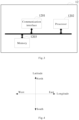
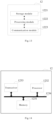
- the local coordinate and the global coordinate may be two-dimensional plane coordinate shown in Fig.4 or three-dimensional space coordinate shown in Fig.5 .
- the plane coordinate obtained by means of GNSS satellite positioning e.g., GPS (global position system), WIFI (wireless-fidelityy) positioning, base station positioning and other manners are two-dimensional plane coordinate, which may include longitude and latitude information and are generally applied to robots, self-driving cars, ships and other devices running on the land or in the ocean.
- three-dimensional space coordinate is constituted by adding height information obtained by an ultrasonic sensor or a height sensor or the like, and is generally applied to devices running in the air such as unmanned aerial vehicles, airplanes, hot air balloons and the like.
- the terminal during the process of positioning, the server firstly performs coarse positioning according to the global data provided by the terminal to obtain corresponding local map data, then the terminal performs accurate global positioning according to the local map data and the surrounding environment information of the current location obtained in real time, so that the calculation amount of map positioning may be effectively reduced.
- the server since various processing and storage works are completed in the cloud, the resource requirements, the power consumption and the cost of the terminal side are effectively reduced.
- the positioning method according to the embodiment of the present invention firstly needs to create a map database on the server, as shown in Fig.6 , specifically including: S101.
- the terminal obtains a third global coordinate of a current location and corresponding local map data.
- the terminal simultaneously records the global coordinates and corresponding local map data while traveling along a specific trajectory, and forms data pairs from the global coordinates and the corresponding local map data (i.e, one-to-one correspondence), and the dimension of the global coordinates is the same as the dimension of the local coordinates in the local map data.
- the global coordinates are GPS latitude and longitude coordinates
- the local map data are vSLAM (visual simultaneous localization and mapping) map data (i.e., including frame numbers of corresponding image frames and corresponding local coordinates).
- the global coordinates and the local coordinates are two-dimensional plane coordinates
- the global coordinates latitude and longitude
- the global coordinates may be collected by a GPS sensor, and meanwhile, an optical center of a first frame camera is taken as the origin, an image of the environment is collected by a visual sensor, a vSLAM map creation operation is performed on the collected image, a vSLAM frame corresponding to the global coordinates and corresponding two-dimensional local coordinates are output, and the two-dimensional local coordinates at this time are horizontal and vertical axis direction coordinates of the screen.
- the global coordinates and the local coordinates are three-dimensional space coordinates
- height information may also be obtained by an ultrasonic sensor or a height sensor or the like at the same time, and the two-dimensional plane coordinates and the height information are collectively used as the global coordinates; and meanwhile, the optical center of the first frame camera is taken as the origin, the image of the environment is collected by the visual sensor, the vSLAM map creation operation is performed on the collected image, frame numbers of image frames corresponding to the global coordinates and corresponding three-dimensional local coordinates are output, and the three-dimensional local coordinates at this time are horizontal and vertical axis direction coordinates and optical axis direction coordinates of the screen.
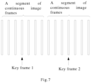
- the frame numbers of key frames and corresponding key frame local coordinates may also be output during the process of vSLAM map creation, and each key frame represents a segment of continuous image frames in the collected image.
- the local map data are the vSLAM map data
- the local map data includes: the frame numbers of image frames and local coordinates corresponding to the global coordinates, the frame numbers of key frames and the key frame local coordinates.
- the terminal sends the third global coordinate of the current location and corresponding local map data to the server.
- the server receives the third global coordinate of the current location and corresponding local map data from the terminal.
- Y is an N*1 matrix, representing the global coordinates
- X is an N* 1 matrix, representing the local coordinates in the local map data corresponding to the global coordinates
- the mapping parameters indicate the mapping relationship between the global coordinates and the local coordinates, and specifically indicate transformation parameters used in a process of mapping the local coordinates to the global coordinates
- R is an N*N matrix
- T is an N*1 matrix
- R and T represent translation rotation parameters
- s is a scaling factor
- N is the dimension of the global coordinates or the local coordinates.
- the mapping parameters R, T, and s calculated via each group of global coordinates and corresponding local map data are the same.
- mapping parameters R, T, and s may be solved by using the least square method according to the above formula, wherein X may be all local coordinates in a group of local map data, Y represents corresponding global coordinates, and the calculated mapping parameters at this time are more accurate due to more data, but more computing resources are consumed; or, X may be the key frame local coordinates in a group of local map data, Y represents corresponding global coordinates, and the accuracy of the calculated mapping parameters at this time is reduced, but less computing resources are consumed.
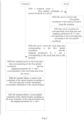
- the positioning method provided by the embodiment of the present invention specifically includes: S201.
- the terminal sends a first global coordinate of a current location to a server.
- the first global coordinate may be two-dimensional plane coordinate or three-dimensional space coordinate.
- the server receives the first global coordinate of the current location from the terminal.
- the server searches for corresponding local map data and mapping parameters R, T, and s corresponding to the local map data according to the first global coordinate.
- the server may query the column of the global coordinate of Table 1 to find the global coordinate with the closest Euclidean distance and to find a group of corresponding local map data and mapping parameters R, T and s simultaneously.
- the found global coordinate with the closest Euclidean distance is 40.0016370000, 116.4854780000
- the corresponding local map data is "vSLAM map 1”
- the mapping parameters are R1, T1, s1.
- the server may query the column of the global coordinate of Table 2 to find the global coordinate with the closest Euclidean distance and to find a group of corresponding local map data and corresponding mapping parameters R, T and s simultaneously.
- the server sends the local map data corresponding to the first global coordinate and the mapping parameters R, T, and s corresponding to the local map data to the terminal.
- the terminal receives the local map data corresponding to the first global coordinate and the mapping parameters R, T, and s corresponding to the local map data from the server.
- the terminal obtains the local coordinate of the current location according to the local map data and the surrounding environment information of the current location.
- the local map data is vSLAM map data and the surrounding environment information of the current location is a current image frame obtain by the visual sensor
- the coordinate obtained by the terminal by performing vSLAM positioning operation according to the current image frame and the vSLAM map data is used as the local coordinate corresponding to the current image frame.
- the terminal obtains a second global coordinate of the current location according to the local coordinate of the current location and the mapping parameters R, T, and s.
- the server searches for matched local map data and the mapping parameters and sends the same to the terminal according to the first global coordinate which has relatively low precision sent by the terminal, and then the terminal performs positioning from the local map data according to the surrounding environment information of the current location obtained in real time to obtain the local coordinate corresponding to the surrounding environment information of the current location, the precision of the local coordinate obtained at this time is relatively high, then the obtained local coordinate is converted into the second global coordinate of the current position according to the mapping parameters. Since the second global coordinate are converted from the local coordinate with higher precision, the precision of the second global coordinate is also relatively high, thereby completing accurate global positioning.
- the embodiment of the present invention may divide the function modules of the terminal according to the above method example, for example, the function modules may be divided according to the functions, and two or more functions may also be integrated into one processing module.
- the above integrated module may be implemented in the form of hardware and may also be implemented in the form of a software function module. It should be noted that the division of the modules in the embodiment of the present invention is schematic and is only a logical function division, and other division manners may be provided during the actual implementation.
- the terminal 11 includes a receiving unit 1111, an obtaining unit 1112 and a sending unit 1113.
- the receiving unit 1111 is configured to support the terminal to execute the process S205 in Fig.8 ;
- the obtaining unit 1112 is configured to support the terminal to execute the process S101 in Fig.6 and the processes S206, S207 in Fig.8 ;
- the sending unit 1113 is configured to support the terminal to execute the process S102 in Fig.6 and the process S201 in Fig.8 . All the related contents of the steps involved in the foregoing method embodiment may be quoted to the function descriptions of the corresponding function modules, and thus details are not described herein again.
- Fig.10 shows a possible structural schematic diagram of the terminal involved in the above embodiments.
- the terminal 11 includes a processing module 1122 and a communication module 1123.
- the processing module 1122 is configured to perform control and management on the actions of the terminal, for example, the processing module 1122 is configured to support the terminal to execute the process S101 in Fig.6 and the processes S206, S207 in Fig.8 .
- the communication module 1123 is configured to support the communication between the terminal and other entities, for example, the communication between the terminal and the function modules or network entities shown in Fig.1 .
- the terminal 11 may further include a storage module 1121, configured to store a program code and data of the terminal.
- the processing module 1122 may be a processor or a controller, for example, may be a central processing unit (CPU), a general purpose processor, a digital signal processor (DSP), an application-specific integrated circuit (ASIC), a field programmable gate array (FPGA) or other programmable logic devices, transistor logic devices, hardware components or any combinations thereof.
- the processing module may implement or execute logic boxes, modules and circuits of various examples described in combination with the contents disclosed by the present invention.
- the processor may also be a combination for implementing a computing function, for example, a combination including one or more microprocessors, a combination of a DSP and a microprocessor, and the like.
- the communication module 1123 may be a transceiver, a transceiver circuit or a communication interface and the like.
- the storage module 1121 may be a memory.
- the terminal involved in the embodiment of the present invention may be the terminal as shown in Fig.11 .
- the terminal 11 includes a processor 1132, a transceiver 1133, a memory 1131 and a bus 1134.
- the transceiver 1133, the processor 1132 and the memory 1131 are connected to each other through the bus 1134;
- the bus 1134 may be a peripheral component interconnect (PCI) bus or an extended industry standard architecture (EISA) bus or the like.
- PCI peripheral component interconnect
- EISA extended industry standard architecture
- the bus may be divided into an address bus, a data bus, a control bus and the like.
- the bus is only expressed by a thick line in Fig.11 , but it does not mean that there is only one bus or one type of bus.
- the steps of the method or algorithm described in combination with the contents disclosed by the present invention may be implemented in the form of hardware and may also be implemented by a processor executing software instructions.
- the embodiment of the present invention further provides a storage medium, the storage medium may include a memory 1131, configured to store a computer software instruction used by the terminal, and the computer software instruction includes a program code designed to execute the positioning method.
- the software instruction may be composed of corresponding software modules, the software modules may be stored in a random access memory (RAM), a flash memory, a read only memory (ROM), an erasable programmable read-only memory (EPROM), an electrically EPROM (EEPROM), or any other form of storage medium known in the art.
- An exemplary storage medium is coupled to the processor, so that the processor may read information from and write information to the storage medium.
- the storage medium may also be a constituent part of the processor.
- the processor and the storage medium may be located in an ASIC. Additionally, the ASIC may be located in the terminal.
- the processor and the storage medium may also exist as discrete components in the terminal.
- the embodiment of the present invention further provides a computer program, the computer program may be directly loaded into the memory 1131 and contains a software code, and the computer program may implement the above positioning method after being loaded and executed by a computer.
- Fig.12 shows a possible structural schematic diagram of the server involved in the above embodiments
- the server 12 includes a receiving unit 1211, an obtaining unit 1212 and a sending unit 1213.
- the receiving unit 1211 is configured to support the server to execute the process S103 in Fig.6 and the process S202 in Fig.8 ;
- the obtaining unit 1212 is configured to support the server to execute the process S104 in Fig.6 and the process S203 in Fig.8 ;
- the sending unit 1213 is configured to support the server to execute the process S204 in Fig.8 . All the related contents of the steps involved in the foregoing method embodiment may be quoted to the function descriptions of the corresponding function modules, and thus details are not described herein again.
- Fig.13 shows a possible structural schematic diagram of the server involved in the above embodiments.
- the server 12 includes a processing module 1222 and a communication module 1223.
- the processing module 1222 is configured to perform control and management on the actions of the server, for example, the processing module 1222 is configured to support the server to execute the process S104 in Fig.6 and the process S203 in Fig.8 .
- the communication module 1223 is configured to support the communication between the server and other entities, for example, the communication between the server and the function modules or network entities shown in Fig.1 .
- the server 12 may further include a storage module 1221, configured to store a program code and data of the server.
- the processing module 1222 may be a processor or a controller, for example, may be a central processing unit (CPU), a general purpose processor, a digital signal processor (DSP), an application-specific integrated circuit (ASIC), a field programmable gate array (FPGA) or other programmable logic devices, transistor logic devices, hardware components or any combinations thereof.
- the processing module may implement or execute logic boxes, modules and circuits of various examples described in combination with the contents disclosed by the present invention.
- the processor may also be a combination for implementing a computing function, for example, a combination including one or more microprocessors, a combination of a DSP and a microprocessor, and the like.
- the communication module 1223 may be a transceiver, a transceiver circuit or a communication interface and the like.
- the storage module 1221 may be a memory.
- the server involved in the embodiments of the present invention may be the server as shown in Fig.14 .
- the server 12 includes a processor 1232, a transceiver 1233, a memory 1231 and a bus 1234.
- the transceiver 1233, the processor 1232 and the memory 1231 are connected to each other through the bus 1234;
- the bus 1234 may be a peripheral component interconnect (PCI) bus or an extended industry standard architecture (EISA) bus or the like.
- PCI peripheral component interconnect
- EISA extended industry standard architecture
- the bus may be divided into an address bus, a data bus, a control bus and the like.
- the bus is only expressed by a thick line in Fig.11 , but it does not mean that there is only one bus or one type of bus.
- the steps of the method or algorithm described in combination with the contents disclosed by the present invention may be implemented in the form of hardware and may also be implemented by a processor executing software instructions.
- the embodiment of the present invention further provides a storage medium, the storage medium may include a memory 1231, configured to store a computer software instruction used by the server, and the computer software instruction includes a program code designed to execute the positioning method.
- the software instruction may be composed of corresponding software modules, the software modules may be stored in a random access memory (RAM), a flash memory, a read only memory (ROM), an erasable programmable read-only memory (EPROM), an electrically EPROM (EEPROM), or any other form of storage medium known in the art.
- An exemplary storage medium is coupled to the processor, so that the processor may read information from and write information to the storage medium.
- the storage medium may also be a constituent part of the processor.
- the processor and the storage medium may be located in an ASIC. Additionally, the ASIC may be located in the server.
- the processor and the storage medium may also exist as discrete components in the server.
- the embodiment of the present invention further provides a computer program, the computer program may be directly loaded into the memory 1231 and contains a software code, and the computer program may implement the above positioning method after being loaded and executed by a computer.
Landscapes
- Engineering & Computer Science (AREA)
- Remote Sensing (AREA)
- Radar, Positioning & Navigation (AREA)
- Physics & Mathematics (AREA)
- General Physics & Mathematics (AREA)
- Computer Networks & Wireless Communication (AREA)
- Automation & Control Theory (AREA)
- Signal Processing (AREA)
- Databases & Information Systems (AREA)
- Theoretical Computer Science (AREA)
- General Engineering & Computer Science (AREA)
- Data Mining & Analysis (AREA)
- Navigation (AREA)
- Position Fixing By Use Of Radio Waves (AREA)
- Instructional Devices (AREA)
- Information Transfer Between Computers (AREA)
Description
- The present invention relates to the field of positioning and navigation, and in particular, to a positioning method, a terminal, and a server.
- At present, the civil positioning and navigation technology generally relies on the GNSS (global navigation satellite system), the accuracy of such navigation technology for global positioning is not high, and the error is usually at a meter level. Although the SLAM (simultaneous localization and mapping) technology in the field of robotics may provide an accurate positioning function, global positioning cannot be performed since the SLAM map data are only a relative local map.
- The document
US 2014/3230148 A1 refers to a method of performing wide area localization at a mobile device, comprising: receiving, one or more images of a local environment of the mobile device; initializing, a keyframe based simultaneous localization and mapping (SLAM) map of the local environment with the one or more images, wherein the initializing comprises selecting a first keyframe from one of the images; determining, a respective localization of the mobile device within the local environment, wherein the respective localization is based on the keyframe based SLAM map; sending, the first keyframe to a server; and receiving, a first global localization response from the server. -
US 2014/0309925 A1 refers to a visual positioning system for indoor locations with associated content. The system has a map creator and a viewer. The map creator maps the indoor location by acquiring plans thereof, detects paths through the location and associates with the paths frames relating to objects and views of the paths. The viewer allows a user to orient in the indoor location by locating the user with respect to a path. The viewer enhances GPS/WIFI/3G data by matching user-captured images with the frames, and then interactively displaying the user data from the mapped paths with respect to user queries. -
EP 2 372 582 A2 - The publication "ALIMC: Activity Landmark-Based Indoor Mapping via Crowdsourcing" refers to indoor maps being integral to pedestrian navigation systems, an essential element of intelligent transportation systems (ITS). The authors of the publication propose ALIMC, i.e., Activity Landmark-based Indoor Mapping system via Crowdsourcing. ALIMC can automatically construct indoor maps for anonymous buildings without any prior knowledge using crowdsourcing data collected by smartphones. ALIMC abstracts the indoor map using a link-node model in which the pathways are the links and the intersections of the pathways are the nodes, such as corners, elevators, and stairs. When passing through the nodes, pedestrians do the corresponding activities, which are detected by smartphones. After activity detection, ALIMC extracts the activity landmarks from the crowdsourcing data and clusters the activity landmarks into different clusters, each of which is treated as a node of the indoor map. ALIMC then estimates the relative distances between all the nodes and obtains a distance matrix. Based on the distance matrix, ALIMC generates a relative indoor map using the multidimensional scaling technique. Finally, ALIMC converts the relative indoor map into an absolute one based on several reference points. To evaluate ALIMC, we implement ALIMC in an office building. Experiment results show that the 80th percentile error of the mapping accuracy is about 0.8-1.5 m (Zhou Baoding et al: "ALIMC: Activity Landmark-Based Indoor Mapping via Crowdsourcing", IEEE TRANSACTIONS ON INTELLIGENT TRANSPORTATION SYSTEMS, Vol. 16, No. 5, October 2015, pages 2774 - 2785).
- The embodiments of the present invention provide for accurately performing global positioning.
- In order to achieve the above object, the embodiment of the present invention adopts the technical solutions taught in the methods of
independent claims 1 and 3, the computer storage media of independent claims 5 and 8, the computer program products of independent claims 6 and 9, the terminal of independent claim 7 and the server of independent claim 10. - According to the positioning method, the terminal and the server provided by the embodiment of the present invention, the server searches for matched local map data and mapping parameters and sends the same to the terminal according to the first global coordinate which has relatively low precision sent by the terminal, and then the terminal performs positioning from the local map data according to the surrounding environment information of the current location obtained in real time to obtain the local coordinate corresponding to the surrounding environment information of the current location, the precision of the local coordinate obtained at this time is relatively high, then the obtained local coordinate is converted into the second global coordinate of the current position according to the mapping parameters. Since the second global coordinate are converted from the local coordinate with higher precision, the precision of the second global coordinate is also relatively high, thereby completing accurate global positioning.
- To illustrate technical solutions in the embodiments of the present invention or the prior art more clearly, a brief introduction on the drawings which are needed in the description of the embodiments or the prior art is given below. Apparently, the drawings in the description below are merely some of the embodiments of the present invention, based on which other drawings may be obtained by those of ordinary skills in the art without any creative effort.
-
Fig.1 is a structural schematic diagram of a positioning system provided by an embodiment of the present invention; -
Fig.2 is a structural schematic diagram of a terminal provided by an embodiment of the present invention; -
Fig.3 is a structural schematic diagram of a server provided by an embodiment of the present invention; -
Fig.4 is a schematic diagram of two-dimensional plane coordinate provided by an embodiment of the present invention; -
Fig.5 is a schematic diagram of three-dimensional space coordinate provided by an embodiment of the present invention; -
Fig.6 is a schematic flow diagram of creating a map database on a server provided by an embodiment of the present invention; -
Fig.7 is a schematic diagram of a key frame provided by an embodiment of the present invention; -
Fig.8 is a schematic flow diagram of a positioning method provided by an embodiment of the present invention; -
Fig.9 is a structural schematic diagram of another terminal provided by an embodiment of the present invention; -
Fig.10 is a structural schematic diagram of yet another terminal provided by an embodiment of the present invention; -
Fig.11 is a structural schematic diagram of yet another terminal provided by an embodiment of the present invention; -
Fig.12 is a structural schematic diagram of another server provided by an embodiment of the present invention; -
Fig.13 is a structural schematic diagram of yet another server provided by an embodiment of the present invention; -
Fig.14 is a structural schematic diagram of yet another server provided by an embodiment of the present invention. - A clear and complete description of technical solutions in the embodiments of the present invention will be given below, in combination with the drawings in the embodiments of the present invention. Apparently, the embodiments described below are merely a part, but not all, of the embodiments of the present invention.
- The embodiment of the present invention provides a positioning system, as shown in
Fig.1 , including: aterminal 11 located on site and aserver 12 located in the cloud, theterminal 11 obtains current global coordinate data through a global sensor and sends the current global coordinate data to theserver 12 in the cloud for retrieval and matching, then theserver 12 sends corresponding local map data to theterminal 11, and theterminal 11 compares the information collected by a current local sensor with the local map data to complete accurate global positioning. - The
terminal 11 according to the embodiment of the present invention may be a smart device such as a blind guide helmet, a robot and the like, referring toFig.2 , theterminal 11 may include asensor 1101, aprocessor 1102, amemory 1103 and acommunication interface 1104, which are connected with each other by a bus. Thememory 1103 is configured to store codes and data and the like executed by theprocessor 1102, and theprocessor 1102 controls thesensor 1101 to collect surrounding environment information of a current location, performs preliminary processing, and then sends the surrounding environment information to theserver 12 through thecommunication interface 1104 in a wired or wireless manner. - Referring to
Fig.3 , theserver 12 according to the embodiment of the present invention may include acommunication interface 1201, aprocessor 1202 and amemory 1203, which are connected with each other by a bus. Thememory 1203 is configured to store codes and map data and the like executed by theprocessor 1202, and theprocessor 1202 controls thecommunication interface 1201 to receive the surrounding environment information of the current location from theterminal 11 in a wired or wireless manner, then processes the surrounding environment information and sends the processed map data to theterminal 11 via thecommunication interface 1201. - The local coordinate in the embodiment of the present invention includes relative coordinate within a local geographic range obtained by sensors such as visual, infrared, ultrasonic, laser radar and IMU (inertial measurement unit); and the global coordinate are absolute coordinate within global geographic range. The local coordinate and the global coordinate may be two-dimensional plane coordinate shown in
Fig.4 or three-dimensional space coordinate shown inFig.5 . The plane coordinate obtained by means of GNSS satellite positioning (e.g., GPS (global position system), WIFI (wireless-fidelityy) positioning, base station positioning and other manners are two-dimensional plane coordinate, which may include longitude and latitude information and are generally applied to robots, self-driving cars, ships and other devices running on the land or in the ocean. On the basis of two-dimensional plane coordinate, three-dimensional space coordinate is constituted by adding height information obtained by an ultrasonic sensor or a height sensor or the like, and is generally applied to devices running in the air such as unmanned aerial vehicles, airplanes, hot air balloons and the like. - According to the positioning method, the terminal, and the server provided by the embodiment of the present invention, during the process of positioning, the server firstly performs coarse positioning according to the global data provided by the terminal to obtain corresponding local map data, then the terminal performs accurate global positioning according to the local map data and the surrounding environment information of the current location obtained in real time, so that the calculation amount of map positioning may be effectively reduced. In addition, since various processing and storage works are completed in the cloud, the resource requirements, the power consumption and the cost of the terminal side are effectively reduced.
- The positioning method according to the embodiment of the present invention firstly needs to create a map database on the server, as shown in
Fig.6 , specifically including:
S101. the terminal obtains a third global coordinate of a current location and corresponding local map data. - The terminal simultaneously records the global coordinates and corresponding local map data while traveling along a specific trajectory, and forms data pairs from the global coordinates and the corresponding local map data (i.e, one-to-one correspondence), and the dimension of the global coordinates is the same as the dimension of the local coordinates in the local map data.
- Exemplarily, in the embodiment of the present invention, it is taken as an example for illustration that the global coordinates are GPS latitude and longitude coordinates, and the local map data are vSLAM (visual simultaneous localization and mapping) map data (i.e., including frame numbers of corresponding image frames and corresponding local coordinates).
- In case that the global coordinates and the local coordinates are two-dimensional plane coordinates, exemplarily, the global coordinates (latitude and longitude) may be collected by a GPS sensor, and meanwhile, an optical center of a first frame camera is taken as the origin, an image of the environment is collected by a visual sensor, a vSLAM map creation operation is performed on the collected image, a vSLAM frame corresponding to the global coordinates and corresponding two-dimensional local coordinates are output, and the two-dimensional local coordinates at this time are horizontal and vertical axis direction coordinates of the screen.
- In case that the global coordinates and the local coordinates are three-dimensional space coordinates, exemplarily, height information may also be obtained by an ultrasonic sensor or a height sensor or the like at the same time, and the two-dimensional plane coordinates and the height information are collectively used as the global coordinates; and meanwhile, the optical center of the first frame camera is taken as the origin, the image of the environment is collected by the visual sensor, the vSLAM map creation operation is performed on the collected image, frame numbers of image frames corresponding to the global coordinates and corresponding three-dimensional local coordinates are output, and the three-dimensional local coordinates at this time are horizontal and vertical axis direction coordinates and optical axis direction coordinates of the screen.
- In order to improve the retrieval efficiency, as shown in
Fig.7 , the frame numbers of key frames and corresponding key frame local coordinates may also be output during the process of vSLAM map creation, and each key frame represents a segment of continuous image frames in the collected image. - Therefore, in case that the local map data are the vSLAM map data, the local map data includes: the frame numbers of image frames and local coordinates corresponding to the global coordinates, the frame numbers of key frames and the key frame local coordinates.
- Those skilled in the art may also appreciate that the global coordinates and the local map data obtained in other ways are equally applicable to the present invention.
- S102. the terminal sends the third global coordinate of the current location and corresponding local map data to the server.
- S103. the server receives the third global coordinate of the current location and corresponding local map data from the terminal.
- S104. the server solves mapping parameters R, T, and s according to a formula Y=(RX+T)/s.
- Wherein, Y is an N*1 matrix, representing the global coordinates; X is an N* 1 matrix, representing the local coordinates in the local map data corresponding to the global coordinates; and the mapping parameters indicate the mapping relationship between the global coordinates and the local coordinates, and specifically indicate transformation parameters used in a process of mapping the local coordinates to the global coordinates, R is an N*N matrix, T is an N*1 matrix, R and T represent translation rotation parameters, s is a scaling factor, and N is the dimension of the global coordinates or the local coordinates. The mapping parameters R, T, and s calculated via each group of global coordinates and corresponding local map data are the same.
- Specifically, the mapping parameters R, T, and s may be solved by using the least square method according to the above formula, wherein X may be all local coordinates in a group of local map data, Y represents corresponding global coordinates, and the calculated mapping parameters at this time are more accurate due to more data, but more computing resources are consumed; or, X may be the key frame local coordinates in a group of local map data, Y represents corresponding global coordinates, and the accuracy of the calculated mapping parameters at this time is reduced, but less computing resources are consumed.
- In order to improve retrieval efficiency and save storage space, a map data mapping table as shown in Table 1 may be formed in case that both of the global coordinates and the local coordinates are two-dimensional plane coordinates:
Table 1 Local map name Frame number of key frame Key frame local coordinate Global coordinate (GPS longitude and latitude) Mapping parameter vSLAM map 1 1 0,0 39.9957310255, 116.4789023070 R1, T1, s1 2 0,1 40.0016370000, 116.4854780000 ...... ...... vSLAM map 21 0,0 39.9142680000, 116.4049040000 R2, T2, s2 2 0,0.01 39.9140470000, 116.4057670000 ...... ...... - In case that both of the global coordinates and the local coordinates are three-dimensional plane coordinates, the map data mapping table as shown in Table 2 may be formed:
Table 2 Local map name Frame number of key frame Key frame local coordinate Global coordinate ( GPS longitude and latitude + height) Mapping parameter vSLAM map 1 1 0,0,0 39.9957310255,116.478 9023070, 2 R1, T1, s1 2 0,1,2 40.0016370000,116.485 4780000, 3 ...... ...... ...... ...... vSLAM map 21 0,0,0 39.9142680000,116.404 9040000, 5 R2, T2, s2 2 0,0.01,5 39.9140470000,116.405 7670000, 10 ...... ...... ...... - The positioning method provided by the embodiment of the present invention, as shown in
Fig.8 , specifically includes:
S201. the terminal sends a first global coordinate of a current location to a server. - If the global coordinate of the current position obtained by the terminal through GNSS satellite positioning, WIFI positioning, base station positioning and other manners is not processed, the error thereof is at a meter level, and this global coordinate is called the first global coordinate. Furthermore, the first global coordinate may be two-dimensional plane coordinate or three-dimensional space coordinate.
- S202. the server receives the first global coordinate of the current location from the terminal.
- S203. the server searches for corresponding local map data and mapping parameters R, T, and s corresponding to the local map data according to the first global coordinate.
- In case that the first global coordinate is two-dimensional plane coordinate, the server may query the column of the global coordinate of Table 1 to find the global coordinate with the closest Euclidean distance and to find a group of corresponding local map data and mapping parameters R, T and s simultaneously. Exemplarily, assuming that the found global coordinate with the closest Euclidean distance is 40.0016370000, 116.4854780000, then the corresponding local map data is "
vSLAM map 1", and the mapping parameters are R1, T1, s1. - In case that the first global coordinate is three-dimensional plane coordinate, the server may query the column of the global coordinate of Table 2 to find the global coordinate with the closest Euclidean distance and to find a group of corresponding local map data and corresponding mapping parameters R, T and s simultaneously.
- S204. the server sends the local map data corresponding to the first global coordinate and the mapping parameters R, T, and s corresponding to the local map data to the terminal.
- S205. the terminal receives the local map data corresponding to the first global coordinate and the mapping parameters R, T, and s corresponding to the local map data from the server.
- S206. the terminal obtains the local coordinate of the current location according to the local map data and the surrounding environment information of the current location.
- Specifically, according to the present invention, wherein the local map data is vSLAM map data and the surrounding environment information of the current location is a current image frame obtain by the visual sensor, the coordinate obtained by the terminal by performing vSLAM positioning operation according to the current image frame and the vSLAM map data is used as the local coordinate corresponding to the current image frame.
- S207. the terminal obtains a second global coordinate of the current location according to the local coordinate of the current location and the mapping parameters R, T, and s.
- Specifically, the terminal solves the second global coordinate of the current position according to Y=(RX+T)/s, wherein X is an N*1 matrix, representing the local coordinate of the current position; and Y is an N*1 matrix, representing the second global coordinate of the current location.
- According to the positioning method provided by the embodiment of the present invention, the server searches for matched local map data and the mapping parameters and sends the same to the terminal according to the first global coordinate which has relatively low precision sent by the terminal, and then the terminal performs positioning from the local map data according to the surrounding environment information of the current location obtained in real time to obtain the local coordinate corresponding to the surrounding environment information of the current location, the precision of the local coordinate obtained at this time is relatively high, then the obtained local coordinate is converted into the second global coordinate of the current position according to the mapping parameters. Since the second global coordinate are converted from the local coordinate with higher precision, the precision of the second global coordinate is also relatively high, thereby completing accurate global positioning.
- Those skilled in the art will readily appreciate that the present invention may be implemented by hardware or a combination of hardware and computer software in combination with the units and algorithm steps of the various examples described in the embodiments disclosed herein. Whether a certain function is implemented in the form of hardware or driving hardware depends on the specific applications and design constraint conditions of the technical solutions. Those skilled in the art may implement the described functions by using different methods for each specific application, but this implementation should not be considered beyond the scope of the present invention.
- The embodiment of the present invention may divide the function modules of the terminal according to the above method example, for example, the function modules may be divided according to the functions, and two or more functions may also be integrated into one processing module. The above integrated module may be implemented in the form of hardware and may also be implemented in the form of a software function module. It should be noted that the division of the modules in the embodiment of the present invention is schematic and is only a logical function division, and other division manners may be provided during the actual implementation.
- In the case that the function modules are divided according to the functions,
Fig.9 shows a possible structural schematic diagram of the terminal involved in the above embodiments, the terminal 11 includes areceiving unit 1111, an obtainingunit 1112 and a sendingunit 1113. The receivingunit 1111 is configured to support the terminal to execute the process S205 inFig.8 ; the obtainingunit 1112 is configured to support the terminal to execute the process S101 inFig.6 and the processes S206, S207 inFig.8 ; and the sendingunit 1113 is configured to support the terminal to execute the process S102 inFig.6 and the process S201 inFig.8 . All the related contents of the steps involved in the foregoing method embodiment may be quoted to the function descriptions of the corresponding function modules, and thus details are not described herein again. - In the case that the integrated unit is adopted,
Fig.10 shows a possible structural schematic diagram of the terminal involved in the above embodiments. The terminal 11 includes aprocessing module 1122 and acommunication module 1123. Theprocessing module 1122 is configured to perform control and management on the actions of the terminal, for example, theprocessing module 1122 is configured to support the terminal to execute the process S101 inFig.6 and the processes S206, S207 inFig.8 . Thecommunication module 1123 is configured to support the communication between the terminal and other entities, for example, the communication between the terminal and the function modules or network entities shown inFig.1 . The terminal 11 may further include astorage module 1121, configured to store a program code and data of the terminal. - The
processing module 1122 may be a processor or a controller, for example, may be a central processing unit (CPU), a general purpose processor, a digital signal processor (DSP), an application-specific integrated circuit (ASIC), a field programmable gate array (FPGA) or other programmable logic devices, transistor logic devices, hardware components or any combinations thereof. The processing module may implement or execute logic boxes, modules and circuits of various examples described in combination with the contents disclosed by the present invention. The processor may also be a combination for implementing a computing function, for example, a combination including one or more microprocessors, a combination of a DSP and a microprocessor, and the like. Thecommunication module 1123 may be a transceiver, a transceiver circuit or a communication interface and the like. Thestorage module 1121 may be a memory. - In case that the
processing module 1122 is a processor, thecommunication module 1123 is a transceiver, and thestorage module 1121 is a memory, the terminal involved in the embodiment of the present invention may be the terminal as shown inFig.11 . - Referring to
Fig.11 , the terminal 11 includes aprocessor 1132, atransceiver 1133, amemory 1131 and abus 1134. Thetransceiver 1133, theprocessor 1132 and thememory 1131 are connected to each other through thebus 1134; thebus 1134 may be a peripheral component interconnect (PCI) bus or an extended industry standard architecture (EISA) bus or the like. The bus may be divided into an address bus, a data bus, a control bus and the like. For the ease of representation, the bus is only expressed by a thick line inFig.11 , but it does not mean that there is only one bus or one type of bus. - The steps of the method or algorithm described in combination with the contents disclosed by the present invention may be implemented in the form of hardware and may also be implemented by a processor executing software instructions. The embodiment of the present invention further provides a storage medium, the storage medium may include a
memory 1131, configured to store a computer software instruction used by the terminal, and the computer software instruction includes a program code designed to execute the positioning method. Specifically, the software instruction may be composed of corresponding software modules, the software modules may be stored in a random access memory (RAM), a flash memory, a read only memory (ROM), an erasable programmable read-only memory (EPROM), an electrically EPROM (EEPROM), or any other form of storage medium known in the art. An exemplary storage medium is coupled to the processor, so that the processor may read information from and write information to the storage medium. Of course, the storage medium may also be a constituent part of the processor. The processor and the storage medium may be located in an ASIC. Additionally, the ASIC may be located in the terminal. Of course, the processor and the storage medium may also exist as discrete components in the terminal. - The embodiment of the present invention further provides a computer program, the computer program may be directly loaded into the
memory 1131 and contains a software code, and the computer program may implement the above positioning method after being loaded and executed by a computer. - In the case that the function modules are divided according to the functions,
Fig.12 shows a possible structural schematic diagram of the server involved in the above embodiments, theserver 12 includes areceiving unit 1211, an obtainingunit 1212 and a sendingunit 1213. The receivingunit 1211 is configured to support the server to execute the process S103 inFig.6 and the process S202 inFig.8 ; the obtainingunit 1212 is configured to support the server to execute the process S104 inFig.6 and the process S203 inFig.8 ; and the sendingunit 1213 is configured to support the server to execute the process S204 inFig.8 . All the related contents of the steps involved in the foregoing method embodiment may be quoted to the function descriptions of the corresponding function modules, and thus details are not described herein again. - In the case that the integrated unit is adopted,
Fig.13 shows a possible structural schematic diagram of the server involved in the above embodiments. Theserver 12 includes aprocessing module 1222 and acommunication module 1223. Theprocessing module 1222 is configured to perform control and management on the actions of the server, for example, theprocessing module 1222 is configured to support the server to execute the process S104 inFig.6 and the process S203 inFig.8 . Thecommunication module 1223 is configured to support the communication between the server and other entities, for example, the communication between the server and the function modules or network entities shown inFig.1 . Theserver 12 may further include astorage module 1221, configured to store a program code and data of the server. - The
processing module 1222 may be a processor or a controller, for example, may be a central processing unit (CPU), a general purpose processor, a digital signal processor (DSP), an application-specific integrated circuit (ASIC), a field programmable gate array (FPGA) or other programmable logic devices, transistor logic devices, hardware components or any combinations thereof. The processing module may implement or execute logic boxes, modules and circuits of various examples described in combination with the contents disclosed by the present invention. The processor may also be a combination for implementing a computing function, for example, a combination including one or more microprocessors, a combination of a DSP and a microprocessor, and the like. Thecommunication module 1223 may be a transceiver, a transceiver circuit or a communication interface and the like. Thestorage module 1221 may be a memory. - In case that the
processing module 1222 is a processor, thecommunication module 1223 is a transceiver, and thestorage module 1221 is a memory, the server involved in the embodiments of the present invention may be the server as shown inFig.14 . - Referring to
Fig.14 , theserver 12 includes aprocessor 1232, atransceiver 1233, amemory 1231 and abus 1234. Thetransceiver 1233, theprocessor 1232 and thememory 1231 are connected to each other through thebus 1234; thebus 1234 may be a peripheral component interconnect (PCI) bus or an extended industry standard architecture (EISA) bus or the like. The bus may be divided into an address bus, a data bus, a control bus and the like. For the ease of representation, the bus is only expressed by a thick line inFig.11 , but it does not mean that there is only one bus or one type of bus. - The steps of the method or algorithm described in combination with the contents disclosed by the present invention may be implemented in the form of hardware and may also be implemented by a processor executing software instructions. The embodiment of the present invention further provides a storage medium, the storage medium may include a
memory 1231, configured to store a computer software instruction used by the server, and the computer software instruction includes a program code designed to execute the positioning method. Specifically, the software instruction may be composed of corresponding software modules, the software modules may be stored in a random access memory (RAM), a flash memory, a read only memory (ROM), an erasable programmable read-only memory (EPROM), an electrically EPROM (EEPROM), or any other form of storage medium known in the art. An exemplary storage medium is coupled to the processor, so that the processor may read information from and write information to the storage medium. Of course, the storage medium may also be a constituent part of the processor. The processor and the storage medium may be located in an ASIC. Additionally, the ASIC may be located in the server. Of course, the processor and the storage medium may also exist as discrete components in the server. - The embodiment of the present invention further provides a computer program, the computer program may be directly loaded into the
memory 1231 and contains a software code, and the computer program may implement the above positioning method after being loaded and executed by a computer. - The foregoing descriptions are merely specific embodiments of the present invention, but the protection scope of the present invention is not limited thereto. Any skilled one who is familiar with this art could readily think of variations or substitutions within the disclosed technical scope of the present invention, and these variations or substitutions shall fall within the protection scope of the present invention. Accordingly, the protection scope of the present invention is defined by the scope of the claims.
Claims (10)
- A positioning method comprising:sending (S201) a first global coordinate of a current location to a server;receiving (S205) local map data corresponding to the first global coordinate and mapping parameters corresponding to the local map data from the server, wherein the mapping parameters are configured to indicate a mapping relationship between global coordinates and local coordinates;obtaining (S206) a local coordinate of the current location according to the local map data and surrounding environment information of the current location; andobtaining (S207) a second global coordinate of the current location according to the local coordinate of the current location and the mapping parameters;wherein the local map data is visual simultaneous localization and mapping (vSLAM) map data, and the surrounding environment information of the current location is a current image frame obtained by a visual sensor, and said obtaining a local coordinate of the current location according to the local map data and surrounding environment information of the current location comprises: using the coordinate obtained by performing a vSLAM positioning operation according to the current image frame and the vSLAM map data as the local coordinate of the current location; wherein the first global coordinate, obtained by a global sensor, and the second global coordinate are absolute coordinates within a global geographic range, and the local coordinate is a relative coordinate within a local geographic range.
- The method according to claim 1, wherein the mapping parameters comprise R, T and s, R is a N*N matrix, T is a N*1 matrix, s is a scaling factor, N is a dimension value of the global coordinate or the local coordinate, and the dimension value of the global coordinate is the same as the dimension value of the local coordinate; and said obtaining a second global coordinate of the current location according to the local coordinate of the current location and the mapping parameters comprises:obtaining the second global coordinate according to a formula Y=(RX + T)/s, wherein X is an N*1 matrix, representing the local coordinates of the current position; and Y is an N*1 matrix, representing the second global coordinate of the current location;optionally, before said sending a first global coordinate of a current location to a server, the method further comprises: sending a third global coordinate of the current location and corresponding local map data to the server.
- A positioning method comprising:receiving (S202) a first global coordinate of a current location from a terminal;searching (S203) for corresponding local map data and mapping parameters corresponding to the local map data according to the first global coordinate, wherein the mapping parameters are configured to indicate a mapping relationship between global coordinates and local coordinates, wherein the local map data is visual simultaneous localization and mapping (vSLAM) map data; andsending (S204) the local map data and the mapping parameters to the terminal, wherein the local map data and the mapping parameters are configured to indicate the terminal to obtain a local coordinate of the current location according to the local map data and surrounding environment information of the current location and to obtain a second global coordinate of the current location according to the local coordinate of the current location and the mapping parameters, wherein the surrounding environment information of the current location is a current image frame obtained by a visual sensor, said obtaining a local coordinate of the current location according to the local map data and surrounding environment information of the current location comprises: using a coordinate obtained by performing a vSLAM positioning operation according to the current image frame and the vSLAM map data as the local coordinate of the current location;wherein the first global coordinate, obtained by a global sensor, and the second global coordinate are absolute coordinates within a global geographic range, and the local coordinate is a relative coordinate within a local geographic range.
- The method according to claim 3, wherein said searching for corresponding local map data and mapping parameters corresponding to the local map data according to the first global coordinate comprises:searching for a global coordinate with the nearest Euclidean distance according to the first global coordinate, and finding corresponding local map data and corresponding mapping parameters according to the global coordinate with the nearest Euclidean distance;optionally, before said receiving a first global coordinate of a current location from a terminal, the method further comprises: receiving a global coordinate Y and corresponding local map data from the terminal, wherein the local map data comprises a local coordinate X, wherein X is a N*1 matrix, Y is a N*1 matrix, N is a dimension value of the global coordinate and the local coordinate, and the dimension value of the global coordinate is the same as the dimension value of the local coordinate; and solving mapping parameters R, T and s according to a formula Y=(RX + T)/s, wherein R is a N*N matrix, T is a N*1 matrix, and s is a scaling factor.
- A computer storage medium, configured to store a computer software instruction used by a terminal, wherein the computer software instruction comprises a program code designed for executing the positioning method according to any one of claims 1-2.
- A computer program product, capable of being directly loaded in an internal memory of a computer and containing a software code, wherein the computer program can implement the positioning method according to any one of claims 1-2 after being loaded and executed by the computer.
- A terminal (11) comprising a memory (1103), a communication interface (1104), a global sensor, a visual sensor, and a processor (1102), wherein the memory (1103) is configured to store a computer executable code, and the processor (1102) is configured to execute the computer executable code to control the execution of the positioning method according to any one of claims 1-2, and the communication interface (1104) is configured to perform data transmission between the terminal (11) and an external device.
- A computer storage medium, configured to store a computer software instruction used by a server, wherein the computer software instruction comprises a program code designed for executing the positioning method according to any one of claims 3-4.
- A computer program product, capable of being directly loaded in an internal memory of a computer and containing a software code, wherein the computer program can implement the positioning method according to any one of claims 3-4 after being loaded and executed by the computer.
- A server (12) comprising a memory (1203), a communication interface (1201) and a processor (1202), wherein the memory (1203) is configured to store a computer executable code, the processor (1202) is configured to execute the computer executable code to control the execution of the positioning method according to any one of claims 3-4, and the communication interface (1201) is configured to perform data transmission between the server (12) and an external device.
Applications Claiming Priority (1)
| Application Number | Priority Date | Filing Date | Title |
|---|---|---|---|
| PCT/CN2016/111827 WO2018112926A1 (en) | 2016-12-23 | 2016-12-23 | Locating method, terminal and server |
Publications (3)
| Publication Number | Publication Date |
|---|---|
| EP3543650A1 EP3543650A1 (en) | 2019-09-25 |
| EP3543650A4 EP3543650A4 (en) | 2020-01-01 |
| EP3543650B1 true EP3543650B1 (en) | 2025-02-05 |
Family
ID=60458395
Family Applications (1)
| Application Number | Title | Priority Date | Filing Date |
|---|---|---|---|
| EP16924422.5A Active EP3543650B1 (en) | 2016-12-23 | 2016-12-23 | Locating method, terminal and server |
Country Status (5)
| Country | Link |
|---|---|
| US (1) | US10659925B2 (en) |
| EP (1) | EP3543650B1 (en) |
| JP (1) | JP6688521B2 (en) |
| CN (1) | CN107438752B (en) |
| WO (1) | WO2018112926A1 (en) |
Families Citing this family (26)
| Publication number | Priority date | Publication date | Assignee | Title |
|---|---|---|---|---|
| CN108235736B (en) * | 2017-12-25 | 2021-11-16 | 达闼机器人有限公司 | Positioning method, cloud server, terminal, system, electronic device and computer program product |
| CN108235809B (en) * | 2017-12-25 | 2022-01-11 | 达闼机器人有限公司 | End cloud combination positioning method and device, electronic equipment and computer program product |
| CN108226977A (en) * | 2017-12-27 | 2018-06-29 | 北斗地网(重庆)科技集团有限公司 | A kind of localization method, alignment system and a kind of computer readable storage medium |
| CN108534789B (en) * | 2017-12-27 | 2021-01-15 | 达闼科技(北京)有限公司 | Multipath positioning coordinate unifying method, electronic equipment and readable storage medium |
| CN108366338B (en) * | 2018-01-31 | 2021-07-16 | 联想(北京)有限公司 | Method and device for searching electronic equipment |
| CN110163914B (en) | 2018-08-01 | 2021-05-25 | 京东方科技集团股份有限公司 | Vision-based positioning |
| CN110148170A (en) * | 2018-08-31 | 2019-08-20 | 北京初速度科技有限公司 | A kind of positioning initialization method and car-mounted terminal applied to vehicle location |
| CN109275089B (en) * | 2018-09-18 | 2020-11-03 | 广东小天才科技有限公司 | Smart phone watch and method for improving personal safety |
| CN110196441B (en) * | 2019-04-26 | 2021-08-06 | 达闼机器人有限公司 | Terminal positioning method, device, storage medium and device |
| CN110246182B (en) * | 2019-05-29 | 2021-07-30 | 达闼机器人有限公司 | Vision-based global map positioning method, device, storage medium and device |
| CN110542916A (en) * | 2019-09-18 | 2019-12-06 | 上海交通大学 | Satellite and vision tightly coupled positioning method, system and medium |
| CN112765243B (en) * | 2019-10-21 | 2022-09-13 | 千寻位置网络有限公司 | Method and system for constructing GNSS algorithm unified operation environment on equipment and cloud |
| CN112710308B (en) * | 2019-10-25 | 2024-05-31 | 阿里巴巴集团控股有限公司 | Robot positioning method, device and system |
| CN112781580B (en) * | 2019-11-06 | 2024-04-26 | 佛山市云米电器科技有限公司 | Positioning method of home equipment, intelligent home equipment and storage medium |
| CN110926478B (en) * | 2019-12-16 | 2021-10-08 | 视辰信息科技(上海)有限公司 | AR navigation route deviation rectifying method and system and computer readable storage medium |
| CN115297543A (en) * | 2020-04-16 | 2022-11-04 | 蓓安科仪(北京)技术有限公司 | Medical robot positioning enhancement method and system based on 5G |
| CN113625223B (en) * | 2020-05-08 | 2024-04-30 | 中信科智联科技有限公司 | A positioning method and terminal device |
| CN111707275B (en) * | 2020-05-12 | 2022-04-29 | 驭势科技(北京)有限公司 | Positioning method, positioning device, electronic equipment and computer readable storage medium |
| CN111988737B (en) * | 2020-07-28 | 2022-08-09 | 中国铁道科学研究院集团有限公司电子计算技术研究所 | Railway operator absolute position determination method and device and electronic equipment |
| JP7495502B2 (en) * | 2020-08-11 | 2024-06-04 | 株式会社ソニー・インタラクティブエンタテインメント | MAPPING DEVICE, TRACKER, MAPPING METHOD, AND PROGRAM |
| CN112327312A (en) * | 2020-10-28 | 2021-02-05 | 上海高仙自动化科技发展有限公司 | A vehicle pose determination method, device, vehicle and storage medium |
| CN112506200B (en) * | 2020-12-14 | 2023-12-08 | 广州视源电子科技股份有限公司 | Robot positioning method, device, robot and storage medium |
| CN112905085A (en) * | 2021-02-03 | 2021-06-04 | 上海靖安测绘科技有限公司 | Road drainage pipeline data management method and system |
| CN113191412B (en) * | 2021-04-25 | 2024-09-06 | 珠海格力电器股份有限公司 | Device repositioning method, device, computer device and storage medium |
| CN115615436A (en) * | 2022-09-17 | 2023-01-17 | 黄广东 | Multi-machine repositioning unmanned aerial vehicle positioning method |
| CN118348554B (en) * | 2024-04-18 | 2024-10-18 | 湖南大学 | Absolute positioning method, device and storage medium for unmanned surface boat |
Family Cites Families (15)
| Publication number | Priority date | Publication date | Assignee | Title |
|---|---|---|---|---|
| JP5034935B2 (en) * | 2007-12-27 | 2012-09-26 | セイコーエプソン株式会社 | POSITIONING METHOD, PROGRAM, POSITIONING DEVICE, AND ELECTRONIC DEVICE |
| CN101619984B (en) * | 2009-07-28 | 2013-02-20 | 重庆邮电大学 | Mobile robot visual navigation method based on colorful road signs |
| US8812015B2 (en) * | 2009-10-01 | 2014-08-19 | Qualcomm Incorporated | Mobile device locating in conjunction with localized environments |
| JP5471626B2 (en) * | 2010-03-09 | 2014-04-16 | ソニー株式会社 | Information processing apparatus, map update method, program, and information processing system |
| CN102928860B (en) * | 2012-10-18 | 2015-01-21 | 无锡清华信息科学与技术国家实验室物联网技术中心 | Method for improving GPS (Global Positioning System) positioning precision on the basis of local positioning information |
| US9519968B2 (en) * | 2012-12-13 | 2016-12-13 | Hewlett-Packard Development Company, L.P. | Calibrating visual sensors using homography operators |
| US20140309925A1 (en) * | 2013-04-14 | 2014-10-16 | Pablo Garcia MORATO | Visual positioning system |
| US20140323148A1 (en) * | 2013-04-30 | 2014-10-30 | Qualcomm Incorporated | Wide area localization from slam maps |
| CN103438887B (en) * | 2013-09-18 | 2015-08-05 | 上海海事大学 | For the absolute coordinates acquisition methods that localization for Mobile Robot and environment reconstruct |
| JP6443700B2 (en) * | 2014-05-27 | 2018-12-26 | 華為技術有限公司Huawei Technologies Co.,Ltd. | Method, apparatus, and system for obtaining antenna configuration parameters |
| CN114675671B (en) * | 2014-09-05 | 2025-10-21 | 深圳市大疆创新科技有限公司 | Multi-sensor environment map construction |
| CN104777501A (en) * | 2015-04-17 | 2015-07-15 | 东南大学 | Indoor positioning system and method based on mobile terminal GPS |
| CN105607071B (en) * | 2015-12-24 | 2018-06-08 | 百度在线网络技术(北京)有限公司 | A kind of indoor orientation method and device |
| CN105953798B (en) * | 2016-04-19 | 2018-09-18 | 深圳市神州云海智能科技有限公司 | The pose of mobile robot determines method and apparatus |
| US10666946B2 (en) * | 2016-07-01 | 2020-05-26 | Intel Corporation | Method and system of video coding using display modification input |
-
2016
- 2016-12-23 CN CN201680006907.6A patent/CN107438752B/en active Active
- 2016-12-23 EP EP16924422.5A patent/EP3543650B1/en active Active
- 2016-12-23 WO PCT/CN2016/111827 patent/WO2018112926A1/en not_active Ceased
- 2016-12-23 JP JP2019533070A patent/JP6688521B2/en active Active
-
2019
- 2019-06-17 US US16/442,790 patent/US10659925B2/en active Active
Also Published As
| Publication number | Publication date |
|---|---|
| JP6688521B2 (en) | 2020-04-28 |
| EP3543650A4 (en) | 2020-01-01 |
| EP3543650A1 (en) | 2019-09-25 |
| CN107438752B (en) | 2021-03-19 |
| JP2020503507A (en) | 2020-01-30 |
| WO2018112926A1 (en) | 2018-06-28 |
| US20190306666A1 (en) | 2019-10-03 |
| US10659925B2 (en) | 2020-05-19 |
| CN107438752A (en) | 2017-12-05 |
Similar Documents
| Publication | Publication Date | Title |
|---|---|---|
| EP3543650B1 (en) | Locating method, terminal and server | |
| US11360216B2 (en) | Method and system for positioning of autonomously operating entities | |
| CN103913162B (en) | The mobile platform of enhancing positions | |
| CN108235736B (en) | Positioning method, cloud server, terminal, system, electronic device and computer program product | |
| JP2019144538A (en) | Method of updating electronic map, device thereof, and computer-readable storage medium thereof | |
| CN114111774B (en) | Vehicle positioning method, system, device and computer readable storage medium | |
| CN116295457B (en) | Vehicle vision positioning method and system based on two-dimensional semantic map | |
| EP3674661B1 (en) | Locating method and device, storage medium, and electronic device | |
| JP2018072316A (en) | Identifying the two-dimensional position of a vehicle using a geoarc | |
| WO2025037291A2 (en) | Enhancement of the 3d indoor positioning by augmenting a multitude of 3d imaging, lidar distance corrections, imu sensors and 3-d ultrasound | |
| Liu et al. | Collaborative positioning method via GPS/INS and RS/MO multi-source data fusion in multi-target navigation | |
| Zhang et al. | Seeing Eye Phone: a smart phone-based indoor localization and guidance system for the visually impaired | |
| CN106650595A (en) | Land block boundary identification method and boundary identification device | |
| CN117830397A (en) | Repositioning method, repositioning device, electronic equipment, medium and vehicle | |
| CN115345944A (en) | Method and device for determining external parameter calibration parameters, computer equipment and storage medium | |
| US8467990B2 (en) | Method for setting the geolocation of a non-GPS enabled device | |
| CN116359941A (en) | Automatic parking positioning method, automatic parking positioning device, computer equipment and storage medium | |
| CN107463871A (en) | A kind of point cloud matching method based on corner characteristics weighting | |
| Huang et al. | Multi-view and multi-scale localization for intelligent vehicles in underground parking lots | |
| US20230354258A1 (en) | Data processing method and apparatus | |
| CN117730239A (en) | Devices and methods for navigation | |
| CN117537803B (en) | Robot inspection semantics-topological map construction methods, systems, equipment and media | |
| Sun et al. | GLANS: GIS based large-scale autonomous navigation system | |
| CN112556701A (en) | Method, device, equipment and storage medium for positioning vehicle | |
| Frontoni et al. | Robot localization in urban environments using omnidirectional vision sensors and partial heterogeneous apriori knowledge |
Legal Events
| Date | Code | Title | Description |
|---|---|---|---|
| STAA | Information on the status of an ep patent application or granted ep patent |
Free format text: STATUS: THE INTERNATIONAL PUBLICATION HAS BEEN MADE |
|
| PUAI | Public reference made under article 153(3) epc to a published international application that has entered the european phase |
Free format text: ORIGINAL CODE: 0009012 |
|
| STAA | Information on the status of an ep patent application or granted ep patent |
Free format text: STATUS: REQUEST FOR EXAMINATION WAS MADE |
|
| 17P | Request for examination filed |
Effective date: 20190619 |
|
| AK | Designated contracting states |
Kind code of ref document: A1 Designated state(s): AL AT BE BG CH CY CZ DE DK EE ES FI FR GB GR HR HU IE IS IT LI LT LU LV MC MK MT NL NO PL PT RO RS SE SI SK SM TR |
|
| AX | Request for extension of the european patent |
Extension state: BA ME |
|
| A4 | Supplementary search report drawn up and despatched |
Effective date: 20191204 |
|
| RIC1 | Information provided on ipc code assigned before grant |
Ipc: G01S 19/25 20100101ALI20191128BHEP Ipc: H04W 4/02 20180101ALI20191128BHEP Ipc: G01S 19/40 20100101ALI20191128BHEP Ipc: G01C 21/28 20060101ALI20191128BHEP Ipc: G01C 21/20 20060101ALI20191128BHEP Ipc: G01C 21/00 20060101AFI20191128BHEP |
|
| DAV | Request for validation of the european patent (deleted) | ||
| DAX | Request for extension of the european patent (deleted) | ||
| RAP1 | Party data changed (applicant data changed or rights of an application transferred) |
Owner name: CLOUDMINDS (SHANGHAI) ROBOTICS CO., LTD. |
|
| STAA | Information on the status of an ep patent application or granted ep patent |
Free format text: STATUS: EXAMINATION IS IN PROGRESS |
|
| 17Q | First examination report despatched |
Effective date: 20220209 |
|
| RAP3 | Party data changed (applicant data changed or rights of an application transferred) |
Owner name: CLOUDMINDS ROBOTICS CO., LTD. |
|
| RIC1 | Information provided on ipc code assigned before grant |
Ipc: H04W 4/024 20180101ALI20240427BHEP Ipc: H04W 4/02 20180101ALI20240427BHEP Ipc: G06F 16/29 20190101ALI20240427BHEP Ipc: G01S 19/42 20100101ALI20240427BHEP Ipc: G01S 19/40 20100101ALI20240427BHEP Ipc: G01S 19/39 20100101ALI20240427BHEP Ipc: G01S 19/25 20100101ALI20240427BHEP Ipc: G01C 21/28 20060101ALI20240427BHEP Ipc: G01C 21/20 20060101ALI20240427BHEP Ipc: G01C 21/00 20060101AFI20240427BHEP |
|
| GRAP | Despatch of communication of intention to grant a patent |
Free format text: ORIGINAL CODE: EPIDOSNIGR1 |
|
| STAA | Information on the status of an ep patent application or granted ep patent |
Free format text: STATUS: GRANT OF PATENT IS INTENDED |
|
| INTG | Intention to grant announced |
Effective date: 20240805 |
|
| GRAS | Grant fee paid |
Free format text: ORIGINAL CODE: EPIDOSNIGR3 |
|
| GRAA | (expected) grant |
Free format text: ORIGINAL CODE: 0009210 |
|
| STAA | Information on the status of an ep patent application or granted ep patent |
Free format text: STATUS: THE PATENT HAS BEEN GRANTED |
|
| REG | Reference to a national code |
Ref country code: DE Ref legal event code: R081 Ref document number: 602016091159 Country of ref document: DE Owner name: CLOUDMINDS ROBOTICS CO., LTD., CN Free format text: FORMER OWNER: CLOUDMINDS ROBOTICS CO., LTD., SHANGHAI, CN |
|
| AK | Designated contracting states |
Kind code of ref document: B1 Designated state(s): AL AT BE BG CH CY CZ DE DK EE ES FI FR GB GR HR HU IE IS IT LI LT LU LV MC MK MT NL NO PL PT RO RS SE SI SK SM TR |
|
| REG | Reference to a national code |
Ref country code: GB Ref legal event code: FG4D |
|
| REG | Reference to a national code |
Ref country code: CH Ref legal event code: EP |
|
| REG | Reference to a national code |
Ref country code: IE Ref legal event code: FG4D |
|
| REG | Reference to a national code |
Ref country code: DE Ref legal event code: R096 Ref document number: 602016091159 Country of ref document: DE |
|
| REG | Reference to a national code |
Ref country code: NL Ref legal event code: MP Effective date: 20250205 |
|
| PG25 | Lapsed in a contracting state [announced via postgrant information from national office to epo] |
Ref country code: RS Free format text: LAPSE BECAUSE OF FAILURE TO SUBMIT A TRANSLATION OF THE DESCRIPTION OR TO PAY THE FEE WITHIN THE PRESCRIBED TIME-LIMIT Effective date: 20250505 |
|
| PG25 | Lapsed in a contracting state [announced via postgrant information from national office to epo] |
Ref country code: FI Free format text: LAPSE BECAUSE OF FAILURE TO SUBMIT A TRANSLATION OF THE DESCRIPTION OR TO PAY THE FEE WITHIN THE PRESCRIBED TIME-LIMIT Effective date: 20250205 |
|
| PG25 | Lapsed in a contracting state [announced via postgrant information from national office to epo] |
Ref country code: PL Free format text: LAPSE BECAUSE OF FAILURE TO SUBMIT A TRANSLATION OF THE DESCRIPTION OR TO PAY THE FEE WITHIN THE PRESCRIBED TIME-LIMIT Effective date: 20250205 |
|
| PG25 | Lapsed in a contracting state [announced via postgrant information from national office to epo] |
Ref country code: ES Free format text: LAPSE BECAUSE OF FAILURE TO SUBMIT A TRANSLATION OF THE DESCRIPTION OR TO PAY THE FEE WITHIN THE PRESCRIBED TIME-LIMIT Effective date: 20250205 |
|
| REG | Reference to a national code |
Ref country code: LT Ref legal event code: MG9D |
|
| PG25 | Lapsed in a contracting state [announced via postgrant information from national office to epo] |
Ref country code: IS Free format text: LAPSE BECAUSE OF FAILURE TO SUBMIT A TRANSLATION OF THE DESCRIPTION OR TO PAY THE FEE WITHIN THE PRESCRIBED TIME-LIMIT Effective date: 20250605 Ref country code: NO Free format text: LAPSE BECAUSE OF FAILURE TO SUBMIT A TRANSLATION OF THE DESCRIPTION OR TO PAY THE FEE WITHIN THE PRESCRIBED TIME-LIMIT Effective date: 20250505 |
|
| PG25 | Lapsed in a contracting state [announced via postgrant information from national office to epo] |
Ref country code: NL Free format text: LAPSE BECAUSE OF FAILURE TO SUBMIT A TRANSLATION OF THE DESCRIPTION OR TO PAY THE FEE WITHIN THE PRESCRIBED TIME-LIMIT Effective date: 20250205 |
|
| PG25 | Lapsed in a contracting state [announced via postgrant information from national office to epo] |
Ref country code: HR Free format text: LAPSE BECAUSE OF FAILURE TO SUBMIT A TRANSLATION OF THE DESCRIPTION OR TO PAY THE FEE WITHIN THE PRESCRIBED TIME-LIMIT Effective date: 20250205 |
|
| PG25 | Lapsed in a contracting state [announced via postgrant information from national office to epo] |
Ref country code: LV Free format text: LAPSE BECAUSE OF FAILURE TO SUBMIT A TRANSLATION OF THE DESCRIPTION OR TO PAY THE FEE WITHIN THE PRESCRIBED TIME-LIMIT Effective date: 20250205 Ref country code: PT Free format text: LAPSE BECAUSE OF FAILURE TO SUBMIT A TRANSLATION OF THE DESCRIPTION OR TO PAY THE FEE WITHIN THE PRESCRIBED TIME-LIMIT Effective date: 20250605 |
|
| PG25 | Lapsed in a contracting state [announced via postgrant information from national office to epo] |
Ref country code: BG Free format text: LAPSE BECAUSE OF FAILURE TO SUBMIT A TRANSLATION OF THE DESCRIPTION OR TO PAY THE FEE WITHIN THE PRESCRIBED TIME-LIMIT Effective date: 20250205 Ref country code: GR Free format text: LAPSE BECAUSE OF FAILURE TO SUBMIT A TRANSLATION OF THE DESCRIPTION OR TO PAY THE FEE WITHIN THE PRESCRIBED TIME-LIMIT Effective date: 20250506 |
|
| REG | Reference to a national code |
Ref country code: AT Ref legal event code: MK05 Ref document number: 1764955 Country of ref document: AT Kind code of ref document: T Effective date: 20250205 |
|
| PG25 | Lapsed in a contracting state [announced via postgrant information from national office to epo] |
Ref country code: SE Free format text: LAPSE BECAUSE OF FAILURE TO SUBMIT A TRANSLATION OF THE DESCRIPTION OR TO PAY THE FEE WITHIN THE PRESCRIBED TIME-LIMIT Effective date: 20250205 |
|
| PG25 | Lapsed in a contracting state [announced via postgrant information from national office to epo] |
Ref country code: SM Free format text: LAPSE BECAUSE OF FAILURE TO SUBMIT A TRANSLATION OF THE DESCRIPTION OR TO PAY THE FEE WITHIN THE PRESCRIBED TIME-LIMIT Effective date: 20250205 |
|
| PG25 | Lapsed in a contracting state [announced via postgrant information from national office to epo] |
Ref country code: DK Free format text: LAPSE BECAUSE OF FAILURE TO SUBMIT A TRANSLATION OF THE DESCRIPTION OR TO PAY THE FEE WITHIN THE PRESCRIBED TIME-LIMIT Effective date: 20250205 |
|
| PG25 | Lapsed in a contracting state [announced via postgrant information from national office to epo] |
Ref country code: IT Free format text: LAPSE BECAUSE OF FAILURE TO SUBMIT A TRANSLATION OF THE DESCRIPTION OR TO PAY THE FEE WITHIN THE PRESCRIBED TIME-LIMIT Effective date: 20250205 |
|
| PG25 | Lapsed in a contracting state [announced via postgrant information from national office to epo] |
Ref country code: AT Free format text: LAPSE BECAUSE OF FAILURE TO SUBMIT A TRANSLATION OF THE DESCRIPTION OR TO PAY THE FEE WITHIN THE PRESCRIBED TIME-LIMIT Effective date: 20250205 |
|
| PG25 | Lapsed in a contracting state [announced via postgrant information from national office to epo] |
Ref country code: EE Free format text: LAPSE BECAUSE OF FAILURE TO SUBMIT A TRANSLATION OF THE DESCRIPTION OR TO PAY THE FEE WITHIN THE PRESCRIBED TIME-LIMIT Effective date: 20250205 Ref country code: CZ Free format text: LAPSE BECAUSE OF FAILURE TO SUBMIT A TRANSLATION OF THE DESCRIPTION OR TO PAY THE FEE WITHIN THE PRESCRIBED TIME-LIMIT Effective date: 20250205 |
|
| PG25 | Lapsed in a contracting state [announced via postgrant information from national office to epo] |
Ref country code: RO Free format text: LAPSE BECAUSE OF FAILURE TO SUBMIT A TRANSLATION OF THE DESCRIPTION OR TO PAY THE FEE WITHIN THE PRESCRIBED TIME-LIMIT Effective date: 20250205 |
|
| PG25 | Lapsed in a contracting state [announced via postgrant information from national office to epo] |
Ref country code: SK Free format text: LAPSE BECAUSE OF FAILURE TO SUBMIT A TRANSLATION OF THE DESCRIPTION OR TO PAY THE FEE WITHIN THE PRESCRIBED TIME-LIMIT Effective date: 20250205 |
|
| REG | Reference to a national code |
Ref country code: DE Ref legal event code: R097 Ref document number: 602016091159 Country of ref document: DE |
|
| PLBE | No opposition filed within time limit |
Free format text: ORIGINAL CODE: 0009261 |
|
| STAA | Information on the status of an ep patent application or granted ep patent |
Free format text: STATUS: NO OPPOSITION FILED WITHIN TIME LIMIT |
|
| PGFP | Annual fee paid to national office [announced via postgrant information from national office to epo] |
Ref country code: GB Payment date: 20251229 Year of fee payment: 10 |
|
| 26N | No opposition filed |
Effective date: 20251106 |
|
| PGFP | Annual fee paid to national office [announced via postgrant information from national office to epo] |
Ref country code: FR Payment date: 20251230 Year of fee payment: 10 |
|
| PGFP | Annual fee paid to national office [announced via postgrant information from national office to epo] |
Ref country code: DE Payment date: 20251231 Year of fee payment: 10 |