EP3528209A1 - Method and device for determining external parameter of stereoscopic camera - Google Patents
Method and device for determining external parameter of stereoscopic camera Download PDFInfo
- Publication number
- EP3528209A1 EP3528209A1 EP17860823.8A EP17860823A EP3528209A1 EP 3528209 A1 EP3528209 A1 EP 3528209A1 EP 17860823 A EP17860823 A EP 17860823A EP 3528209 A1 EP3528209 A1 EP 3528209A1
- Authority
- EP
- European Patent Office
- Prior art keywords
- pixels
- coordinate system
- ground surface
- stereo camera
- axis
- Prior art date
- Legal status (The legal status is an assumption and is not a legal conclusion. Google has not performed a legal analysis and makes no representation as to the accuracy of the status listed.)
- Ceased
Links
Images

Classifications
-
- G—PHYSICS
- G06—COMPUTING OR CALCULATING; COUNTING
- G06T—IMAGE DATA PROCESSING OR GENERATION, IN GENERAL
- G06T7/00—Image analysis
- G06T7/80—Analysis of captured images to determine intrinsic or extrinsic camera parameters, i.e. camera calibration
- G06T7/85—Stereo camera calibration
-
- G—PHYSICS
- G06—COMPUTING OR CALCULATING; COUNTING
- G06T—IMAGE DATA PROCESSING OR GENERATION, IN GENERAL
- G06T7/00—Image analysis
- G06T7/70—Determining position or orientation of objects or cameras
-
- G—PHYSICS
- G06—COMPUTING OR CALCULATING; COUNTING
- G06T—IMAGE DATA PROCESSING OR GENERATION, IN GENERAL
- G06T7/00—Image analysis
- G06T7/70—Determining position or orientation of objects or cameras
- G06T7/73—Determining position or orientation of objects or cameras using feature-based methods
-
- H—ELECTRICITY
- H04—ELECTRIC COMMUNICATION TECHNIQUE
- H04N—PICTORIAL COMMUNICATION, e.g. TELEVISION
- H04N13/00—Stereoscopic video systems; Multi-view video systems; Details thereof
- H04N13/20—Image signal generators
- H04N13/204—Image signal generators using stereoscopic image cameras
- H04N13/246—Calibration of cameras
-
- H—ELECTRICITY
- H04—ELECTRIC COMMUNICATION TECHNIQUE
- H04N—PICTORIAL COMMUNICATION, e.g. TELEVISION
- H04N23/00—Cameras or camera modules comprising electronic image sensors; Control thereof
- H04N23/60—Control of cameras or camera modules
-
- G—PHYSICS
- G06—COMPUTING OR CALCULATING; COUNTING
- G06T—IMAGE DATA PROCESSING OR GENERATION, IN GENERAL
- G06T2200/00—Indexing scheme for image data processing or generation, in general
- G06T2200/04—Indexing scheme for image data processing or generation, in general involving 3D image data
-
- G—PHYSICS
- G06—COMPUTING OR CALCULATING; COUNTING
- G06T—IMAGE DATA PROCESSING OR GENERATION, IN GENERAL
- G06T2207/00—Indexing scheme for image analysis or image enhancement
- G06T2207/10—Image acquisition modality
- G06T2207/10004—Still image; Photographic image
- G06T2207/10012—Stereo images
-
- G—PHYSICS
- G06—COMPUTING OR CALCULATING; COUNTING
- G06T—IMAGE DATA PROCESSING OR GENERATION, IN GENERAL
- G06T2207/00—Indexing scheme for image analysis or image enhancement
- G06T2207/20—Special algorithmic details
- G06T2207/20024—Filtering details
- G06T2207/20032—Median filtering
-
- G—PHYSICS
- G06—COMPUTING OR CALCULATING; COUNTING
- G06T—IMAGE DATA PROCESSING OR GENERATION, IN GENERAL
- G06T2207/00—Indexing scheme for image analysis or image enhancement
- G06T2207/30—Subject of image; Context of image processing
- G06T2207/30244—Camera pose
Definitions
- the present application relates to the field of image processing, and in particular, to a method and device for determining external parameters of a stereo camera.
- a stereo camera can be used to obtain stereoscopic images.
- the stereo camera should be calibrated in advance to determine accurate camera parameters.
- the camera parameters include internal parameters and external parameters.
- the external parameters indicate the position and direction of the stereo camera in the world coordinate system. That is to say, the external parameters of a stereo camera represent the coordinate transformation relationship between the camera coordinate system and the world coordinate system. Further, the external parameters of the stereo camera have a great influence on the accuracy of the images captured by the stereo camera.
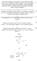
- Three parameters, i.e. the setting height of the stereo camera, the pitch angle of the stereo camera, and the inclination angle of the stereo camera are usually used as external parameters of the stereo camera. Fig.
- FIG. 1 is a schematic diagram of external parameters of a stereo camera.
- the three-dimensional coordinate system formed by axis x c , axis z c and axis y c is a camera coordinate system corresponding to the stereo camera, and the stereo camera is the origin of the camera coordinate, which is identified as 0 c .
- the coordinate system formed by axis x, axis z and axis y represented by the dashed line is the world coordinate system, with the origin of 0.
- the camera coordinate system is translated to the ground plane, so that the origin 0 c of the camera coordinate system coincides with the origin 0 of the world coordinate system.
- the distance H between the ground plane and the origin of the camera coordinate system is the setting height of the stereo camera; the angle P is the pitch angle of the stereo camera, and the angle I is the inclination angle of the stereo camera.
- a method for determining external parameters of a stereo camera generally include:
- the accurate external parameters of the stereo camera must be determined by means of a vertical edge perpendicular to the ground in the scene as a reference point, which has a high requirement for the application scenario.
- the embodiments of application is to provide a method and a device for determining external parameters of a stereo camera, and the external parameters of the stereo camera can be determined without using a reference point in a scene.
- the specific technical solutions are as follows.
- An embodiment of application discloses a method for determining external parameters of a stereo camera.
- the method includes: acquiring ground surface data of a location where the stereo camera is positioned; generating, according to three-dimensional coordinates of each of pixels in the ground surface data in a camera coordinate system corresponding to the stereo camera, a first plane equation in the camera coordinate system that conforms to the three-dimensional coordinates of the pixels; determining, according to a distance between an origin of the camera coordinate system and the ground surface, a setting height of the stereo camera; generating, according to the first plane equation, a plane normal vector corresponding to the first plane equation; and determining, according to the plane normal vector, a pitch angle of the stereo camera and an inclination angle of the stereo camera.
- the method further includes: performing filtering processing on the ground surface data when the ground surface data does not meet a preset condition; wherein the filtering processing includes median filtering in time domain and median filtering in spatial domain.
- generating, according to three-dimensional coordinates of each of pixels in the ground surface data in a camera coordinate system corresponding to the stereo camera, a first plane equation in the camera coordinate system that conforms to the three-dimensional coordinates of the pixels includes: selecting at least three pixels from pixels in the ground surface data, and using three-dimensional coordinates of the at least three pixels in the camera coordinate system corresponding to the stereo camera as a first sample set; generating, according to the first sample set, a second plane equation that conforms to three-dimensional coordinates of pixels in the first sample set in the camera coordinate system; determining, among the pixels in the ground surface data, all pixels that meet the second plane equation, and using the three-dimensional coordinates of the pixels that meet the second plane equation in the camera coordinate system as a second sample set; and generating, according to the second sample set, the first plane equation in the camera coordinate system that conforms to the three-dimensional coordinates of the pixels in the ground surface data in the camera coordinate system.
- selecting at least three pixels from pixels in the ground surface data includes: selecting at least three pixels from the pixels in the ground surface data by using a random sample consensus RANSAC algorithm.
- selecting at least three pixels from pixels in the ground surface data, and using three-dimensional coordinates of the at least three pixels in the camera coordinate system corresponding to the stereo camera as a first sample set and generating, according to the first sample set, a second plane equation that conforms to three-dimensional coordinates of pixels in the first sample set in the camera coordinate system includes: selecting at least three pixels from the pixels in the ground surface data by using a RANSAC algorithm, and using the three-dimensional coordinates of the at least three pixels in the camera coordinate system corresponding to the stereo camera as the first sample set; generating, according to the first sample set, a current plane equation that conforms to the three-dimensional coordinates of pixels in the first sample set in the camera coordinate system; determining whether the current plane equation satisfies a preset condition; using the current plane equation as the second plane equation when the current plane equation satisfies the preset condition; increasing the number of iterations by 1 when the current plane equation does not satisfy the preset condition and returning to perform the steps of selecting at least three pixels from pixels
- the preset condition includes: the number of pixels, among the pixels in the ground surface data, that meet the current plane equation reaches a preset first threshold, or the number of iterations corresponding to the current plane equation reaches a preset second threshold.
- generating, according to the second sample set, the first plane equation in the camera coordinate system that conforms to the three-dimensional coordinates of the pixels in the ground surface data in the camera coordinate system includes: performing fitting processing on the second sample set by using a least squares method to generate the first plane equation that conforms to the three-dimensional coordinates of the pixels in the ground surface data in the camera coordinate system.
- determining, according to the plane normal vector, a pitch angle of the stereo camera and an inclination angle of the stereo camera includes: determining, in the camera coordinate system, a first angle by which a corresponding axis z c rotates about an axis x in a clockwise direction when the stereo camera rotates from a standard attitude to a current attitude, and using the first angle as the pitch angle of the stereo camera; and determining, in the camera coordinate system, a second angle by which a corresponding axis x c rotates about an axis z in a clockwise direction when the stereo camera rotates from the standard attitude to the current attitude, and using the second angle as the inclination angle of the stereo camera; wherein a three-dimensional coordinate system defined by the axis x c , the axis z c , and an axis y c is the camera coordinate system; a three-dimensional coordinate system defined by the axis x , the axis z , and an axis
- An embodiment of the present application further discloses a device for determining external parameters of a stereo camera.
- the device includes: an acquiring unit, configured for acquiring ground surface data of a location where the stereo camera is positioned; a first generating unit, configured for generating, according to three-dimensional coordinates of each of pixels in the ground surface data in a camera coordinate system corresponding to the stereo camera, a first plane equation in the camera coordinate system that conforms to the three-dimensional coordinates of the pixels; a first determining unit, configured for determining, according to a distance between an origin of the camera coordinate system and the ground surface, a setting height of the stereo camera; a second generating unit, configured for generating, according to the first plane equation, a plane normal vector corresponding to the first plane equation; and a second determining unit, configured for determining, according to the plane normal vector, a pitch angle of the stereo camera and an inclination angle of the stereo camera.
- the device further includes a filtering unit, configured for performing filtering processing on the ground surface data when the ground surface data does not meet a preset condition; wherein the filtering processing includes median filtering in time domain and median filtering in spatial domain.
- a filtering unit configured for performing filtering processing on the ground surface data when the ground surface data does not meet a preset condition; wherein the filtering processing includes median filtering in time domain and median filtering in spatial domain.
- the first generating unit includes: a first selecting subunit, a first generating subunit, a first determining subunit, and a second generating subunit; wherein the first selecting subunit is configured for selecting at least three pixels from pixels in the ground surface data, and using three-dimensional coordinates of the at least three pixels in the camera coordinate system corresponding to the stereo camera as a first sample set; the first generating sub-unit is configured for generating, according to the first sample set, a second plane equation that conforms to three-dimensional coordinates of pixels in the first sample set in the camera coordinate system; the first determining subunit is configured for determining, among the pixels in the ground surface data, all pixels that meet the second plane equation, and using the three-dimensional coordinates of the pixels that meet the second plane equation in the camera coordinate system as a second sample set; and the second generating sub-unit is configured for generating, according to the second sample set, the first plane equation in the camera coordinate system that conforms to the three-dimensional coordinates of the pixels in the ground surface data in the camera coordinate
- the first selecting subunit is further configured for selecting at least three pixels from the pixels in the ground surface data by using a random sample consensus RANSAC algorithm.
- the first generating subunit includes: a second selecting subunit, a third generating subunit, a determining subunit, a second determining subunit, and a returning and performing subunit; wherein, the second selecting subunit is configured for selecting at least three pixels from the pixels in the ground surface data by using a RANSAC algorithm, and using the three-dimensional coordinates of the at least three pixels in the camera coordinate system corresponding to the stereo camera as the first sample set; the third generating subunit is configured for generating, according to the first sample set, a current plane equation that conforms to the three-dimensional coordinates of pixels in the first sample set in the camera coordinate system; the determining subunit is configured for determining whether the current plane equation satisfies a preset condition; the second determining subunit is configured for using the current plane equation as the second plane equation when the current plane equation satisfies the preset condition; the returning and performing subunit is configured for increasing the number of iterations by 1 when the current plane equation does not satisfy the preset condition and returning to
- the preset condition includes the number of pixels, among the pixels in the ground surface data, that meet the current plane equation reaches a preset first threshold, or the number of iterations corresponding to the current plane equation reaches a preset second threshold.
- the second generating subunit is specifically configured for performing fitting processing on the second sample set by using a least squares method to generate the first plane equation that conforms to the three-dimensional coordinates of the pixels in the ground surface data in the camera coordinate system.
- the second determining unit includes: a third determining subunit and a fourth determining subunit; wherein, the third determining subunit is configured for determining, in the camera coordinate system, a first angle by which a corresponding axis z c rotates about an axis x in a clockwise direction when the stereo camera rotates from a standard attitude to a current attitude, and using the first angle as the pitch angle of the stereo camera; and the fourth determining sub-unit is configured for determining, in the camera coordinate system, a second angle by which a corresponding axis x c rotates about an axis z in a clockwise direction when the stereo camera rotates from the standard attitude to the current attitude, and using the second angle as the inclination angle of the stereo camera; wherein a three-dimensional coordinate system defined by the axis x c , the axis z c , and an axis y c is the camera coordinate system; a three-dimensional coordinate system defined by the axis x c
- the method and device for determining external parameters of a stereo camera provided by the embodiments of the present application can determine, according to the ground surface data, a first plane equation in the camera coordinate system that conforms to the three-dimensional coordinates of each pixel in the ground surface data in the camera coordinate system, such that the first plane equation is applicable to each pixel in the ground surface data.
- the setting height of the stereo camera is determined according to the distance between the origin of the camera coordinate system and the ground surface.
- a plane normal vector is generated according to the first plane equation, and the pitch angle of the stereo camera and the inclination angle of the stereo camera is determined according to the plane normal vector.
- the external parameters of the stereo camera can be determined only by the acquired ground surface data without a reference point in the scene, which is suitable for most application scenarios, and avoids affecting the acquisition of external parameters due to the application scenario not meeting the requirements.
- the accuracy of the external parameters of the stereo camera is ensured, thereby ensuring the stereoscopic image obtained by the stereo camera.
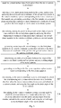
- Fig. 2 is a flowchart of a method for determining external parameters of a stereo camera according to an embodiment of the present application. The method includes the following steps.
- Step 201 acquiring ground surface data of a location where a stereo camera is positioned;
- the external parameters of the stereo camera determined according to the ground surface data of the location of the stereo camera can only be applied for capturing of the stereo camera at the current location. For example, if the stereo camera is currently located on hillside, the external parameters determined according to the ground surface data of the hillside can only be suitable for capturing of the stereo camera on hillside, and cannot be used for capturing of the stereo camera on plain; otherwise it will affect the capturing effect of the stereo camera.
- a binocular camera can be used to generate a two-dimensional image and a disparity image of the ground surface, or a time-of-flight (TOF) depth camera can be used to generate a two-dimensional image and a depth image of the ground surface, to which the present application is not limited.
- TOF time-of-flight
- the ground surface data may include a two-dimensional image and a disparity image of the ground surface
- the binocular camera may convert the two-dimensional coordinates of the two-dimensional image of the ground surface in the image coordinate system to three-dimensional coordinates in the camera coordinate system corresponding to the binocular camera based on the disparity image of the ground surface.
- the camera coordinate system herein is a three-dimensional coordinate system with the binocular camera as the origin.
- the ground surface data may include a two-dimensional image and a depth image of the ground surface
- the TOF depth camera can convert the two-dimensional coordinates of the two-dimensional image of the ground surface in the image coordinate system to three-dimensional coordinates in the camera coordinate system corresponding to the TOF depth camera based on the depth image of the ground surface.
- the camera coordinate system herein is a three-dimensional coordinate system with the TOF depth camera as the origin.
- the method may further include: performing filtering processing on the ground surface data when the ground surface data does not meet a preset condition; wherein the filtering processing includes median filtering in time domain and median filtering in spatial domain.
- the specific preset condition may vary depending on the type of the stereo camera, but the basic rule of the preset condition is related to noise threshold of the noise value in the ground surface data. If the noise in the ground surface data is large and exceeds the noise threshold, the ground surface data needs to be filtered; and if the noise in the ground surface data is small and does not exceed the noise threshold, the ground surface data need not be filtered.
- the certain pixel in the image to be processed may be replaced by the average of the pixels in the same position in the continuous multi-frames before and after the image to be processed, and the same replacement process may be performed on all the pixels in the image to be processed.
- the certain pixel In the median filtering in spatial domain, for a certain pixel in the image to be processed, the certain pixel may be replaced by the average of a 3 ⁇ 3 pixel matrix around the certain pixel in the image to be processed, and the same replacement process may be performed on all the pixels in the image to be processed.
- the frame of image may be filtered by using the median filtering in time domain to improve the imaging quality of the certain frame of the image.
- the image may be filtered by using the median filtering in spatial domain to improve the imaging quality of the image.
- the filtering process on the ground surface data is not necessary. If the quality of the ground surface data conforms to the preset condition, the filtering process can be omitted.
- the two-dimensional coordinates of the two-dimensional image of the ground surface in the image coordinate system can be converted into three-dimensional coordinates in the camera coordinate system; but before that, it is also necessary to first determine the validity of the disparity image or the depth image in the ground surface data.
- the ground surface data includes the disparity image
- it is necessary to determine whether the disparity image is valid that is, whether the corresponding disparity value of each pixel of a plane image in the disparity image is within a reasonable range. For example, in a certain scene, the range from the closest distance to the farthest distance in the captured image is known, and the disparity values corresponding to the closest distance and the farthest distance are also known. If a certain disparity value in the disparity image exceeds the disparity values corresponding to the closest distance and farthest distance, then the certain disparity value in the disparity image is invalid. Such pixel in the plane image corresponding to the certain disparity value can be ignored, and the rest of the pixels in the plane image can be used for subsequent calculation.
- the ground surface data includes the depth image
- it is necessary to determine whether the depth image is valid that is, whether the corresponding depth value in the depth image of each pixel in the plane image is within a reasonable range.
- the specific determining method is similar to that for the disparity value, i.e. determining whether each depth value in the depth image is within a valid range. If a certain depth value exceeds the valid range, the certain depth value is invalid. Such certain depth in the plane image corresponding to the certain pixel may be ignored, and the rest of the pixels in the plane image can be used for subsequent calculation.
- Step 202 generating, according to three-dimensional coordinates of each pixel in the ground surface data in a camera coordinate system corresponding to the stereo camera, a first plane equation in the camera coordinate system that conforms to the three-dimensional coordinates of the pixels.
- a plane equation to be determined can be preset, which contains multiple unknown parameters. Then the unknown parameters in the plane equation can be determined according to the three-dimensional coordinates of each pixel in the ground surface data in the camera coordinate system. Finally, the plane equation with the determined parameters is used as the first plane equation. In this way, the first plane equation can be consistency with the distribution of pixels in the ground surface data to the greatest extent, and ensure the accuracy of the obtained external parameters of the stereo camera.
- Step 203 determining, according to a distance between the origin of the camera coordinate system and the ground surface, a setting height of the stereo camera.
- the distance between the origin and the ground surface in the camera coordinate system can be calculated, and the distance is determined as the setting height of the stereo camera; wherein the setting height of the stereo camera is one of three external parameters of the stereo camera.
- Step 204 determining, according to the first plane equation, a plane normal vector corresponding to the first plane equation.
- This step can be realized by the same method as the related art, and the plane normal vector corresponding to the first plane equation can be calculated according to the first plane equation obtained in step 203, so as to calculate the pitch angle and the inclination angle of the stereo camera.
- Step 205 determining, according to the plane normal vector, a pitch angle of the stereo camera and an inclination angle of the stereo camera.
- step 205 may specifically include:
- a first plane equation can be determined according to the three-dimensional coordinates of each pixel in the ground surface data in the camera coordinate system, wherein the first plane equation can represent the distribution of all the pixels in the ground surface data; then the setting height of the stereo camera is determined according to the distance between the origin of the camera coordinate system and the ground surface, and a plane normal vector of the first plane equation is generated; and the pitch angle of the stereo camera and the inclination angle of the stereo camera are determined according to the plane normal vector.
- the external parameters of the stereo camera can be determined based only on the acquired ground surface data without a reference point in the scene, which is suitable for most application scenarios, and avoids affecting the acquisition of external parameters due to the application scenario not meeting the requirements. The accuracy of the external parameters of the stereo camera is ensured.
- Fig. 3 is another flowchart of a method for determining external parameters of a stereo camera according to an embodiment of the present application. The method includes the following steps.
- Step 301 acquiring ground surface data of a location where the stereo camera is positioned.
- Step 302 selecting at least three pixels from pixels in the ground surface data, and using three-dimensional coordinates of the at least three pixels in the camera coordinate system corresponding to the stereo camera as a first sample set; generating, according to the first sample set, a second plane equation that conforms to three-dimensional coordinates of each pixels in the first sample set in the camera coordinate system.
- the equation (1) is solved by substituting the three-dimensional coordinates of the three pixels to obtain a', b ', c ' and d'.
- Fig. 4 is another flowchart of a method for determining external parameters of a stereo camera in the embodiment of the present application, where the step 303 may specifically include the following sub-steps.
- Substep 11 selecting at least three pixels from the pixels in the ground surface data by using a RANSAC (RANdom SAmple Consensus) algorithm, and using the three-dimensional coordinates of the at least three pixels in the camera coordinate system corresponding to the stereo camera as the first sample set.
- RANSAC Random SAmple Consensus
- Substep 12 generating, according to the first sample set, a current plane equation that conforms to the three-dimensional coordinates of pixels in the first sample set in the camera coordinate system.
- Substep 13 determining whether the current plane equation satisfies a preset condition.
- Substep 14 when the current plane equation satisfies the preset condition, determining the current plane equation as the second plane equation.
- Substep 15 when the current plane equation does not satisfy the preset condition, increasing the number of iterations by 1, and returning to substep 11.
- the preset condition may specifically include: the number of the pixels among the pixels in the ground surface data that meet the current plane equation reaches a preset first threshold, or the number of iterations for the current plane equation reaches a preset second threshold.
- the first threshold may be the specific number of pixels in the ground surface data that conform to the current plane equation, or may be the percentage of the number of pixels in the ground surface data that conform to the current plane equation with respect to the total number of pixels in the ground surface data.
- the first threshold and the second threshold may be set according to actual conditions; the specific expression of the first threshold is not limited in the present application.
- Step 303 determining, among the pixels in the ground surface data, all pixels that conform to the second plane equation, and using the three-dimensional coordinates of the pixels that conform to the second plane equation in the camera coordinate system as a second sample set.
- the pixels that conform to the second plane equation (1) determined in step 302 are selected from all pixels in the ground surface data, and the three-dimensional coordinates of these pixels are used as a second sample set.
- Step 304 generating, according to the second sample set, the first plane equation in the camera coordinate system that conforms to the three-dimensional coordinates of the pixels in the ground surface data in the camera coordinate system.
- the step 305 may specifically include: performing fitting processing on the second sample set by using a least squares method to generate the first plane equation that conforms to the three-dimensional coordinates of the pixels in the ground surface data in the camera coordinate system.
- First step It is known that there are n pixels in the second sample set, and the three-dimensional coordinates are ( x 1 , y 1 , z 1 ), ( x 2 , y 2 , z 2 ), ..., ( x n , y n , z n ).
- a a / d
- b b / d
- c c / d
- the second step solving the equation (5) by using the least squares method, and the following equation (6) is obtained:
- X A T A ⁇ 1 A T b
- X is the least squares solution of equation (5);
- the matrix A T is the transposed matrix of matrix A, and the matrix ( A T A ) -1 is the inverse matrix of the matrix A T A , ( A T A ) -1
- a T is the pseudoinverse matrix of the matrix A.
- the matrix X solved by the equation (6) is an 1 ⁇ 3 matrix defined by a , b and c , the matrix X can be used to determine the value of a , b and c in the modified first plane equation in the formula (3), and in turn the a, b, c , and d in the first plane equation in equation (2) can be calculated, and finally the specific form of the first plane equation can be obtained.
- Step 305 determining, according to a distance between the origin of the camera coordinate system and the ground surface, a setting height of the stereo camera.
- Step 306 generating, according to the first plane equation, a plane normal vector corresponding to the first plane equation.
- Step 307 determining, in the camera coordinate system, a first angle by which the corresponding axis z c rotates about the axis x in a clockwise direction when the stereo camera rotates from a standard attitude to a current attitude, and using the first angle as the pitch angle of the stereo camera.
- Step 308 determining, in the camera coordinate system, a second angle by which the corresponding axis x c rotates about the axis z in a clockwise direction when the stereo camera rotates from the standard attitude to the current attitude, and using the second angle as the inclination angle of the stereo camera.
- Fig. 5 is a schematic diagram of determining external parameters of a stereo camera.
- the three-dimensional coordinate system defined by the axis x c , the axis z c , and the axis y c in the upper part of the figure is the camera coordinate system corresponding to the stereo camera, and the stereo camera is the origin of the camera coordinate system, with reference number 0 c ;
- the three-dimensional coordinate system defined by the axis x, the axis z, and the axis y which is indicated by the dotted line on the ground plane, is a world coordinate system with the origin of 0.
- the height H is the setting height of the stereo camera
- the angle P is the pitch angle of the stereo camera
- the angle I is the inclination angle of the stereo camera.
- the pitch angle P is the angle by which the axis z c will rotate about the axis x in a clockwise direction when the stereo camera rotates from the standard attitude to the current attitude as shown in Fig. 5 .
- the inclination angle I is the angle by which the axis x c will rotate about the axis z in a clockwise direction when the stereo camera rotates from the standard attitude to the current attitude as shown in Fig. 5 .
- the standard attitude is an attitude of the stereo camera in which the directions of the axis x c and the axis z c in the camera coordinate system coincide with the directions of the axis x and the axis z in the world coordinate system and the direction of the axis y c in the camera coordinate system is opposite to the direction of the axis y in the world coordinate system. It can be understood that when the stereo camera is in the standard attitude, the pitch angle P and the inclination angle I are both 0.
- H ax 1 + by 1 + cz 1 + d a 2 + b 2 + c 2
- H is the setting height of the stereo camera
- a, b, c, and d are the parameters in the first plane equation
- the state of the stereo camera can be determined by the positive and negative of the components of the plane normal vector on the axis y c and the axis z c , and then the pitch angle P of the stereo camera is solved, and the calculation equations are as shown in the equations (8) to (12):
- the stereo camera can obtain high-quality stereoscopic images.
- the second plane equation can be generated through multiple calculation iterations according to the three-dimensional coordinates of each pixel in the ground surface data in the camera coordinate system. Then, all the pixels of the ground surface data that conform to the second plane equation are determined, the least squares calculation is performed on these pixels, and the first plane equation which can represent the distribution pattern of all the pixels in the ground surface data can be obtained.
- the external parameters of the stereo camera can be determined according to the plane normal vector and the origin of the camera coordinate system. In this way, the method for determining external parameters of a stereo camera by ground surface data can be applied to most application scenarios, and is not only convenient but also ensures that the obtained external parameters are accurate and reliable.
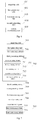
- Fig. 6 is a structural diagram of a device for determining external parameters of a stereo camera according to an embodiment of the present application.
- the device corresponds to the method flow shown in Fig. 2 , and specifically includes the following units:
- the device further includes: a filtering unit, configured for performing filtering processing on the ground surface data when the ground surface data does not meet a preset condition; wherein the filtering processing comprises median filtering in time domain and median filtering in spatial domain.
- a filtering unit configured for performing filtering processing on the ground surface data when the ground surface data does not meet a preset condition; wherein the filtering processing comprises median filtering in time domain and median filtering in spatial domain.
- the device embodiment of the present application can determine a first plane equation according to the ground surface data and the three-dimensional coordinates of each pixel in the ground surface data in the camera coordinate system, wherein the first plane equation can represent the distribution pattern of all the pixels in the ground surface data. Then the setting height of the stereo camera is determined according to the distance between the origin of the camera coordinate system and the ground surface, and a plane normal vector of the first plane equation is generated. Finally, the pitch angle of the stereo camera and the inclination angle of the stereo camera are determined according to the plane normal vector. In this way, the external parameters of the stereo camera can be determined only by the acquired ground surface data without a reference point in the scene, which is suitable for most application scenarios, and avoids affecting the acquisition of external parameters due to the application scenario not meeting the requirements. The accuracy of the external parameters of the stereo camera is ensured.
- Fig. 7 is another structural diagram of a device for determining external parameters of a stereo camera according to an embodiment of the present application.
- the device corresponds to the method flow shown in Fig. 3 , and the device includes: an acquiring unit 701, and a first generating unit 702, the first determining unit 703, the second generating unit 704, and the second determining unit 705; wherein the acquiring unit 701 may be identical to the obtaining unit 601 shown in Fig. 6 , the first determining unit 703 may be identical to the first determining unit 603 shown in Fig. 6 , and the second generating unit 704 may be identical to the second generating unit 604 shown in Fig. 6 , therefore details are not described herein again.
- the first generating unit 702 specifically includes a first selecting subunit 706, a first generating subunit 707, a first determining subunit 708, and a second generating subunit 709; wherein, the first selecting subunit 706 is configured for selecting at least three pixels from pixels in the ground surface data, and using three-dimensional coordinates of the at least three pixels in the camera coordinate system corresponding to the stereo camera as a first sample set; the first generating sub-unit 707 is configured for generating, according to the first sample set, a second plane equation that conforms to three-dimensional coordinates of pixels in the first sample set in the camera coordinate system; the first determining subunit 708 is configured for determining, among the pixels in the ground surface data, all pixels that meet the second plane equation, and using the three-dimensional coordinates of the pixels that meet the second plane equation in the camera coordinate system as a second sample set; and the second generating sub-unit 709 is configured for generating, according to the second sample set, the first plane equation in the camera coordinate system that conforms to the three-dimensional
- the first selecting subunit 706 is specifically configured for selecting at least three pixels from the pixels in the ground surface data by using a random sample consensus RANSAC algorithm.
- the first generating subunit 707 specifically includes: a second selecting subunit 710, a third generating subunit 711, a determining subunit 712, a second determining subunit 713, and a returning and performing subunit 714; wherein, the second selecting subunit 710 is for selecting at least three pixels from the pixels in the ground surface data by using a RANSAC algorithm, and using the three-dimensional coordinates of the at least three pixels in the camera coordinate system corresponding to the stereo camera as the first sample set; the third generating subunit 711 is configured for generating, according to the first sample set, a current plane equation that conforms to the three-dimensional coordinates of pixels in the first sample set in the camera coordinate system; the determining subunit 712 is configured for determining whether the current plane equation satisfies a preset condition; the second determining subunit 713 is configured for using the current plane equation as the second plane equation when the current plane equation satisfies the preset condition; the returning and performing subunit 714; wherein, the second selecting sub
- the preset condition includes the number of pixels, among the pixels in the ground surface data, that meet the current plane equation reaches a preset first threshold, or the number of iterations corresponding to the current plane equation reaches a preset second threshold.
- the second generating subunit 709 is specifically configured for performing fitting processing on the second sample set by using a least squares method to generate the first plane equation that conforms to the three-dimensional coordinates of the pixels in the ground surface data in the camera coordinate system.
- the second determining unit 705 includes a third determining subunit 715 and a fourth determining subunit 716; wherein the third determining subunit 715 is configured for determining, in the camera coordinate system, a first angle by which a corresponding axis z c rotates about an axis x in a clockwise direction when the stereo camera rotates from a standard attitude to a current attitude, and using the first angle as the pitch angle of the stereo camera; the fourth determining sub-unit 716 is configured for determining, in the camera coordinate system, a second angle by which a corresponding axis x c rotates about an axis z in a clockwise direction when the stereo camera rotates from the standard attitude to the current attitude, and using the second angle as the inclination angle of the stereo camera; wherein a three-dimensional coordinate system defined by the axis x c , the axis z c , and an axis y c is the camera coordinate system; a
- the second plane equation can be generated through multiple calculation iterations according to the three-dimensional coordinates of each pixel in the ground surface data in the camera coordinate system. Then, all the pixels of the ground surface data that conform to the second plane equation are determined, the least squares calculation is performed on these pixels, and the first plane equation which can represent the distribution pattern of all the pixels in the ground surface data can be obtained.
- the external parameters of the stereo camera can be determined according to the plane normal vector and the origin of the camera coordinate system. In this way, the method for determining external parameters of a stereo camera by ground surface data can be applied to most application scenarios, and is not only convenient but also ensures that the obtained external parameters are accurate and reliable.
- An embodiment of the present application also discloses a storage medium, configured to store executable program codes.
- the executable program codes when being executed, are used to implement a method for determining external parameters of a stereo camera. The method includes the following steps:
- the method further includes: performing filtering processing on the ground surface data when the ground surface data does not meet a preset condition; wherein the filtering processing comprises median filtering in time domain and median filtering in spatial domain.
- generating, according to three-dimensional coordinates of each of pixels in the ground surface data in a camera coordinate system corresponding to the stereo camera, a first plane equation in the camera coordinate system that conforms to the three-dimensional coordinates of the pixels includes:
- selecting at least three pixels from pixels in the ground surface data includes: selecting at least three pixels from the pixels in the ground surface data by using a random sample consensus RANSAC algorithm.
- selecting at least three pixels from pixels in the ground surface data, and using three-dimensional coordinates of the at least three pixels in the camera coordinate system corresponding to the stereo camera as a first sample set and generating, according to the first sample set, a second plane equation that conforms to three-dimensional coordinates of pixels in the first sample set in the camera coordinate system includes:
- the preset condition includes: the number of pixels, among the pixels in the ground surface data, that meet the current plane equation reaches a preset first threshold, or the number of iterations corresponding to the current plane equation reaches a preset second threshold.
- generating, according to the second sample set, the first plane equation in the camera coordinate system that conforms to the three-dimensional coordinates of the pixels in the ground surface data in the camera coordinate system includes: performing fitting processing on the second sample set by using a least squares method to generate the first plane equation that conforms to the three-dimensional coordinates of the pixels in the ground surface data in the camera coordinate system.
- determining, according to the plane normal vector, a pitch angle of the stereo camera and an inclination angle of the stereo camera includes:
- the second plane equation can be generated through multiple calculation iterations according to the three-dimensional coordinates of each pixel in the ground surface data in the camera coordinate system. Then, all the pixels of the ground surface data that conform to the second plane equation are determined, the least squares calculation is performed on these pixels, and the first plane equation which can represent the distribution pattern of all the pixels in the ground surface data can be obtained.
- the external parameters of the stereo camera can be determined according to the plane normal vector and the origian of the camera coordinate system. In this way, the method for determining external parameters of a stereo camera by ground surface data can be applied to most application scenarios, and is not only convenient but also ensures that the obtained external parameters are accurate and reliable.
- An embodiment of the present application also discloses an application program, configured to implement a method for determining external parameters of a stereo camera. The method includes the following steps:
- the method further includes: performing filtering processing on the ground surface data when the ground surface data does not meet a preset condition; wherein the filtering processing comprises median filtering in time domain and median filtering in spatial domain.
- generating, according to three-dimensional coordinates of each of pixels in the ground surface data in a camera coordinate system corresponding to the stereo camera, a first plane equation in the camera coordinate system that conforms to the three-dimensional coordinates of the pixels includes:
- selecting at least three pixels from pixels in the ground surface data includes: selecting at least three pixels from the pixels in the ground surface data by using a random sample consensus RANSAC algorithm.
- selecting at least three pixels from pixels in the ground surface data, and using three-dimensional coordinates of the at least three pixels in the camera coordinate system corresponding to the stereo camera as a first sample set and generating, according to the first sample set, a second plane equation that conforms to three-dimensional coordinates of pixels in the first sample set in the camera coordinate system includes:
- the preset condition includes: the number of pixels, among the pixels in the ground surface data, that meet the current plane equation reaches a preset first threshold, or the number of iterations corresponding to the current plane equation reaches a preset second threshold.
- generating, according to the second sample set, the first plane equation in the camera coordinate system that conforms to the three-dimensional coordinates of the pixels in the ground surface data in the camera coordinate system includes: performing fitting processing on the second sample set by using a least squares method to generate the first plane equation that conforms to the three-dimensional coordinates of the pixels in the ground surface data in the camera coordinate system.
- determining, according to the plane normal vector, a pitch angle of the stereo camera and an inclination angle of the stereo camera includes:
- the second plane equation can be generated through multiple calculation iterations according to the three-dimensional coordinates of each pixel in the ground surface data in the camera coordinate system. Then, all the pixels of the ground surface data that conform to the second plane equation are determined, the least squares calculation is performed on these pixels, and the first plane equation which can represent the distribution pattern of all the pixels in the ground surface data can be obtained.
- the external parameters of the stereo camera can be determined according to the plane normal vector and the origin of the camera coordinate system. In this way, the method for determining external parameters of a stereo camera by ground surface data can be applied to most application scenarios, and is not only convenient but also ensures that the obtained external parameters are accurate and reliable.
- An embodiment of the present application also provides an electronic device including a controller, a communication interface, a memory, and a communication bus; wherein the controller, the communication interface, and the memory communicates with each other via the communication bus; the memory is configured to store executable program codes; the controller is configured to read the executable program codes stored in the memory to execute an program corresponding to the executable program codes, so as to implement the method for determining external parameters of a stereo camera, which method includes the following steps:
- the method further includes: performing filtering processing on the ground surface data when the ground surface data does not meet a preset condition; wherein the filtering processing comprises median filtering in time domain and median filtering in spatial domain.
- generating, according to three-dimensional coordinates of each of pixels in the ground surface data in a camera coordinate system corresponding to the stereo camera, a first plane equation in the camera coordinate system that conforms to the three-dimensional coordinates of the pixels includes:
- selecting at least three pixels from pixels in the ground surface data includes: selecting at least three pixels from the pixels in the ground surface data by using a random sample consensus RANSAC algorithm.
- selecting at least three pixels from pixels in the ground surface data, and using three-dimensional coordinates of the at least three pixels in the camera coordinate system corresponding to the stereo camera as a first sample set and generating, according to the first sample set, a second plane equation that conforms to three-dimensional coordinates of pixels in the first sample set in the camera coordinate system includes:
- the preset condition includes: the number of pixels, among the pixels in the ground surface data, that meet the current plane equation reaches a preset first threshold, or the number of iterations corresponding to the current plane equation reaches a preset second threshold.
- generating, according to the second sample set, the first plane equation in the camera coordinate system that conforms to the three-dimensional coordinates of the pixels in the ground surface data in the camera coordinate system includes: performing fitting processing on the second sample set by using a least squares method to generate the first plane equation that conforms to the three-dimensional coordinates of the pixels in the ground surface data in the camera coordinate system.
- determining, according to the plane normal vector, a pitch angle of the stereo camera and an inclination angle of the stereo camera includes:
- the second plane equation can be generated through multiple calculation iterations according to the three-dimensional coordinates of each pixel in the ground surface data in the camera coordinate system. Then, all the pixels of the ground surface data that conform to the second plane equation are determined, the least squares calculation is performed on these pixels, and the first plane equation which can represent the distribution pattern of all the pixels in the ground surface data can be obtained.
- the external parameters of the stereo camera can be determined according to the plane normal vector and the origin of the camera coordinate system. In this way, the method for determining external parameters of a stereo camera by ground surface data can be applied to most application scenarios, and is not only convenient but also ensures that the obtained external parameters are accurate and reliable.
Landscapes
- Engineering & Computer Science (AREA)
- Computer Vision & Pattern Recognition (AREA)
- Physics & Mathematics (AREA)
- General Physics & Mathematics (AREA)
- Theoretical Computer Science (AREA)
- Multimedia (AREA)
- Signal Processing (AREA)
- Length Measuring Devices By Optical Means (AREA)
- Image Processing (AREA)
- Studio Devices (AREA)
Abstract
Description
- The present application claims the priority to a Chinese patent application No.
201610889992.7 - The present application relates to the field of image processing, and in particular, to a method and device for determining external parameters of a stereo camera.
- With the rapid development of image processing technology, applications such as human detection, target tracking, object detection, distance detection, object scanning recognition and 3D reconstruction of a scene based on stereo vision images have also been rapidly developed.
- In general, a stereo camera can be used to obtain stereoscopic images. Before obtaining a stereoscopic image using a stereo camera, the stereo camera should be calibrated in advance to determine accurate camera parameters. Specifically, the camera parameters include internal parameters and external parameters. The external parameters indicate the position and direction of the stereo camera in the world coordinate system. That is to say, the external parameters of a stereo camera represent the coordinate transformation relationship between the camera coordinate system and the world coordinate system. Further, the external parameters of the stereo camera have a great influence on the accuracy of the images captured by the stereo camera. Three parameters, i.e. the setting height of the stereo camera, the pitch angle of the stereo camera, and the inclination angle of the stereo camera are usually used as external parameters of the stereo camera.
Fig. 1 is a schematic diagram of external parameters of a stereo camera. In the upper part ofFig. 1 , the three-dimensional coordinate system formed by axis xc, axis zc and axis yc is a camera coordinate system corresponding to the stereo camera, and the stereo camera is the origin of the camera coordinate, which is identified as 0c . On the ground plane ofFig. 1 , the coordinate system formed by axis x, axis z and axis y represented by the dashed line is the world coordinate system, with the origin of 0. The camera coordinate system is translated to the ground plane, so that theorigin 0c of the camera coordinate system coincides with theorigin 0 of the world coordinate system. The distance H between the ground plane and the origin of the camera coordinate system is the setting height of the stereo camera; the angle P is the pitch angle of the stereo camera, and the angle I is the inclination angle of the stereo camera. - At present, a method for determining external parameters of a stereo camera generally include:
- inputting an initial values of the external parameters of the stereo camera;
- capturing a scene image to detect a vertical edge perpendicular to the ground in the scene image;
- evaluating the accuracy of the external parameters of the stereo camera according to the approximation of the shape of the vertical edge in the scene that is projected onto the coordinate plane in the world coordinate system with a circle;
- if the accuracy of the external parameters of the stereo camera does not conform to the evaluation criteria, adjusting the external parameters of the stereo camera, and iterating the above evaluation process until the external parameters of the stereo camera conform to the evaluation criteria.
- It can be seen that, in the prior art, in the method for determining the external parameters of the stereo camera, the accurate external parameters of the stereo camera must be determined by means of a vertical edge perpendicular to the ground in the scene as a reference point, which has a high requirement for the application scenario.
- The embodiments of application is to provide a method and a device for determining external parameters of a stereo camera, and the external parameters of the stereo camera can be determined without using a reference point in a scene. The specific technical solutions are as follows.
- An embodiment of application discloses a method for determining external parameters of a stereo camera. The method includes: acquiring ground surface data of a location where the stereo camera is positioned; generating, according to three-dimensional coordinates of each of pixels in the ground surface data in a camera coordinate system corresponding to the stereo camera, a first plane equation in the camera coordinate system that conforms to the three-dimensional coordinates of the pixels; determining, according to a distance between an origin of the camera coordinate system and the ground surface, a setting height of the stereo camera; generating, according to the first plane equation, a plane normal vector corresponding to the first plane equation; and determining, according to the plane normal vector, a pitch angle of the stereo camera and an inclination angle of the stereo camera.
- Preferably, the method further includes: performing filtering processing on the ground surface data when the ground surface data does not meet a preset condition; wherein the filtering processing includes median filtering in time domain and median filtering in spatial domain.
- Preferably, generating, according to three-dimensional coordinates of each of pixels in the ground surface data in a camera coordinate system corresponding to the stereo camera, a first plane equation in the camera coordinate system that conforms to the three-dimensional coordinates of the pixels includes: selecting at least three pixels from pixels in the ground surface data, and using three-dimensional coordinates of the at least three pixels in the camera coordinate system corresponding to the stereo camera as a first sample set; generating, according to the first sample set, a second plane equation that conforms to three-dimensional coordinates of pixels in the first sample set in the camera coordinate system; determining, among the pixels in the ground surface data, all pixels that meet the second plane equation, and using the three-dimensional coordinates of the pixels that meet the second plane equation in the camera coordinate system as a second sample set; and generating, according to the second sample set, the first plane equation in the camera coordinate system that conforms to the three-dimensional coordinates of the pixels in the ground surface data in the camera coordinate system.
- Preferably, selecting at least three pixels from pixels in the ground surface data includes: selecting at least three pixels from the pixels in the ground surface data by using a random sample consensus RANSAC algorithm.
- Preferably, selecting at least three pixels from pixels in the ground surface data, and using three-dimensional coordinates of the at least three pixels in the camera coordinate system corresponding to the stereo camera as a first sample set and generating, according to the first sample set, a second plane equation that conforms to three-dimensional coordinates of pixels in the first sample set in the camera coordinate system includes: selecting at least three pixels from the pixels in the ground surface data by using a RANSAC algorithm, and using the three-dimensional coordinates of the at least three pixels in the camera coordinate system corresponding to the stereo camera as the first sample set; generating, according to the first sample set, a current plane equation that conforms to the three-dimensional coordinates of pixels in the first sample set in the camera coordinate system; determining whether the current plane equation satisfies a preset condition; using the current plane equation as the second plane equation when the current plane equation satisfies the preset condition; increasing the number of iterations by 1 when the current plane equation does not satisfy the preset condition and returning to perform the steps of selecting at least three pixels from pixels in the ground surface data, and using three-dimensional coordinates of the at least three pixels in the camera coordinate system corresponding to the stereo camera as a first sample set; wherein an initial value of the number of iterations is 0.
- Preferably, the preset condition includes: the number of pixels, among the pixels in the ground surface data, that meet the current plane equation reaches a preset first threshold, or the number of iterations corresponding to the current plane equation reaches a preset second threshold.
- Preferably, generating, according to the second sample set, the first plane equation in the camera coordinate system that conforms to the three-dimensional coordinates of the pixels in the ground surface data in the camera coordinate system includes: performing fitting processing on the second sample set by using a least squares method to generate the first plane equation that conforms to the three-dimensional coordinates of the pixels in the ground surface data in the camera coordinate system.
- Preferably, determining, according to the plane normal vector, a pitch angle of the stereo camera and an inclination angle of the stereo camera includes: determining, in the camera coordinate system, a first angle by which a corresponding axis zc rotates about an axis x in a clockwise direction when the stereo camera rotates from a standard attitude to a current attitude, and using the first angle as the pitch angle of the stereo camera; and determining, in the camera coordinate system, a second angle by which a corresponding axis xc rotates about an axis z in a clockwise direction when the stereo camera rotates from the standard attitude to the current attitude, and using the second angle as the inclination angle of the stereo camera; wherein a three-dimensional coordinate system defined by the axis xc, the axis zc , and an axis yc is the camera coordinate system; a three-dimensional coordinate system defined by the axis x, the axis z, and an axis y is a world coordinate system; when directions of the axis xc and the axis zc coincide with directions of the axis x and the axis z, and when direction of the axis yc is opposite to direction of the axis y, the stereo camera is in the standard attitude.
- An embodiment of the present application further discloses a device for determining external parameters of a stereo camera. The device includes: an acquiring unit, configured for acquiring ground surface data of a location where the stereo camera is positioned; a first generating unit, configured for generating, according to three-dimensional coordinates of each of pixels in the ground surface data in a camera coordinate system corresponding to the stereo camera, a first plane equation in the camera coordinate system that conforms to the three-dimensional coordinates of the pixels; a first determining unit, configured for determining, according to a distance between an origin of the camera coordinate system and the ground surface, a setting height of the stereo camera; a second generating unit, configured for generating, according to the first plane equation, a plane normal vector corresponding to the first plane equation; and a second determining unit, configured for determining, according to the plane normal vector, a pitch angle of the stereo camera and an inclination angle of the stereo camera.
- Preferably, the device further includes a filtering unit, configured for performing filtering processing on the ground surface data when the ground surface data does not meet a preset condition; wherein the filtering processing includes median filtering in time domain and median filtering in spatial domain.
- Preferably, the first generating unit includes: a first selecting subunit, a first generating subunit, a first determining subunit, and a second generating subunit; wherein the first selecting subunit is configured for selecting at least three pixels from pixels in the ground surface data, and using three-dimensional coordinates of the at least three pixels in the camera coordinate system corresponding to the stereo camera as a first sample set; the first generating sub-unit is configured for generating, according to the first sample set, a second plane equation that conforms to three-dimensional coordinates of pixels in the first sample set in the camera coordinate system; the first determining subunit is configured for determining, among the pixels in the ground surface data, all pixels that meet the second plane equation, and using the three-dimensional coordinates of the pixels that meet the second plane equation in the camera coordinate system as a second sample set; and the second generating sub-unit is configured for generating, according to the second sample set, the first plane equation in the camera coordinate system that conforms to the three-dimensional coordinates of the pixels in the ground surface data in the camera coordinate system.
- Preferably, the first selecting subunit is further configured for selecting at least three pixels from the pixels in the ground surface data by using a random sample consensus RANSAC algorithm.
- Preferably, the first generating subunit includes: a second selecting subunit, a third generating subunit, a determining subunit, a second determining subunit, and a returning and performing subunit; wherein, the second selecting subunit is configured for selecting at least three pixels from the pixels in the ground surface data by using a RANSAC algorithm, and using the three-dimensional coordinates of the at least three pixels in the camera coordinate system corresponding to the stereo camera as the first sample set; the third generating subunit is configured for generating, according to the first sample set, a current plane equation that conforms to the three-dimensional coordinates of pixels in the first sample set in the camera coordinate system; the determining subunit is configured for determining whether the current plane equation satisfies a preset condition; the second determining subunit is configured for using the current plane equation as the second plane equation when the current plane equation satisfies the preset condition; the returning and performing subunit is configured for increasing the number of iterations by 1 when the current plane equation does not satisfy the preset condition and returning to perform the steps of selecting at least three pixels from pixels in the ground surface data, and using three-dimensional coordinates of the at least three pixels in the camera coordinate system corresponding to the stereo camera as a first sample set; wherein an initial value of the number of iterations is 0.
- Preferably, the preset condition includes the number of pixels, among the pixels in the ground surface data, that meet the current plane equation reaches a preset first threshold, or the number of iterations corresponding to the current plane equation reaches a preset second threshold.
- Preferably, the second generating subunit is specifically configured for performing fitting processing on the second sample set by using a least squares method to generate the first plane equation that conforms to the three-dimensional coordinates of the pixels in the ground surface data in the camera coordinate system.
- Preferably, the second determining unit includes: a third determining subunit and a fourth determining subunit; wherein, the third determining subunit is configured for determining, in the camera coordinate system, a first angle by which a corresponding axis zc rotates about an axis x in a clockwise direction when the stereo camera rotates from a standard attitude to a current attitude, and using the first angle as the pitch angle of the stereo camera; and the fourth determining sub-unit is configured for determining, in the camera coordinate system, a second angle by which a corresponding axis xc rotates about an axis z in a clockwise direction when the stereo camera rotates from the standard attitude to the current attitude, and using the second angle as the inclination angle of the stereo camera; wherein a three-dimensional coordinate system defined by the axis xc, the axis zc, and an axis yc is the camera coordinate system; a three-dimensional coordinate system defined by the axis x, the axis z, and an axis y is a world coordinate system; when directions of the axis xc and the axis zc coincide with directions of the axis x and the axis z, and when direction of the axis yc is opposite to direction of the axis y, the stereo camera is in the standard attitude.
- The method and device for determining external parameters of a stereo camera provided by the embodiments of the present application can determine, according to the ground surface data, a first plane equation in the camera coordinate system that conforms to the three-dimensional coordinates of each pixel in the ground surface data in the camera coordinate system, such that the first plane equation is applicable to each pixel in the ground surface data. The setting height of the stereo camera is determined according to the distance between the origin of the camera coordinate system and the ground surface. And finally, a plane normal vector is generated according to the first plane equation, and the pitch angle of the stereo camera and the inclination angle of the stereo camera is determined according to the plane normal vector. In this way, the external parameters of the stereo camera can be determined only by the acquired ground surface data without a reference point in the scene, which is suitable for most application scenarios, and avoids affecting the acquisition of external parameters due to the application scenario not meeting the requirements. The accuracy of the external parameters of the stereo camera is ensured, thereby ensuring the stereoscopic image obtained by the stereo camera.
- In order to illustrate the technical solutions in the embodiments of the present application or the prior art more clearly, the drawings to be used in the embodiments or the prior art description will be briefly described below. Obviously, the drawings in the following description are only for some embodiments of the application, other drawings may also be obtained by those of ordinary skill in the art without any creative efforts.
-
Fig. 1 is a schematic diagram of external parameters of a stereo camera. -
Fig. 2 is a flowchart of a method for determining external parameters of a stereo camera according to an embodiment of the present application. -
Fig. 3 is another flowchart of a method for determining external parameters of a stereo camera according to an embodiment of the present application. -
Fig. 4 is another flow chart of a method for determining external parameters of a stereo camera according to an embodiment of the present application. -
Fig. 5 is a schematic diagram of determining external parameters of a stereo camera according to an embodiment of the present application. -
Fig. 6 is a structural diagram of a device for determining external parameters of a stereo camera according to an embodiment of the present application. -
Fig. 7 is another structural diagram of a device for determining external parameters of a stereo camera according to an embodiment of the present application. - The technical solutions in the embodiments of the present application will be clearly and completely described in the following with reference to the drawings of the embodiments of the present application. It is obvious that the described embodiments are only a part of the embodiments of the present application, and not all of the embodiments. All other embodiments obtained by a person of ordinary skill in the art based on the embodiments of the present application without any creative efforts fall within the protection scope of the present application.
- The embodiment of the present application discloses a method for determining external parameters of a stereo camera.
Fig. 2 is a flowchart of a method for determining external parameters of a stereo camera according to an embodiment of the present application. The method includes the following steps. - Step 201: acquiring ground surface data of a location where a stereo camera is positioned;
It should be noted that, the external parameters of the stereo camera determined according to the ground surface data of the location of the stereo camera can only be applied for capturing of the stereo camera at the current location. For example, if the stereo camera is currently located on hillside, the external parameters determined according to the ground surface data of the hillside can only be suitable for capturing of the stereo camera on hillside, and cannot be used for capturing of the stereo camera on plain; otherwise it will affect the capturing effect of the stereo camera. - In practical applications, a binocular camera can be used to generate a two-dimensional image and a disparity image of the ground surface, or a time-of-flight (TOF) depth camera can be used to generate a two-dimensional image and a depth image of the ground surface, to which the present application is not limited.
- Specifically, when a binocular camera is used, the ground surface data may include a two-dimensional image and a disparity image of the ground surface, and the binocular camera may convert the two-dimensional coordinates of the two-dimensional image of the ground surface in the image coordinate system to three-dimensional coordinates in the camera coordinate system corresponding to the binocular camera based on the disparity image of the ground surface. The camera coordinate system herein is a three-dimensional coordinate system with the binocular camera as the origin. When a TOF depth camera is used, the ground surface data may include a two-dimensional image and a depth image of the ground surface, and the TOF depth camera can convert the two-dimensional coordinates of the two-dimensional image of the ground surface in the image coordinate system to three-dimensional coordinates in the camera coordinate system corresponding to the TOF depth camera based on the depth image of the ground surface. The camera coordinate system herein is a three-dimensional coordinate system with the TOF depth camera as the origin.
- In an alternative embodiment of the present application, the method may further include:
performing filtering processing on the ground surface data when the ground surface data does not meet a preset condition; wherein the filtering processing includes median filtering in time domain and median filtering in spatial domain. - It should be noted that, due to different characteristics of the data acquired by different stereo cameras, the specific preset condition may vary depending on the type of the stereo camera, but the basic rule of the preset condition is related to noise threshold of the noise value in the ground surface data. If the noise in the ground surface data is large and exceeds the noise threshold, the ground surface data needs to be filtered; and if the noise in the ground surface data is small and does not exceed the noise threshold, the ground surface data need not be filtered.
- In the median filtering in time domain, for a certain pixel in the image to be processed, the certain pixel in the image to be processed may be replaced by the average of the pixels in the same position in the continuous multi-frames before and after the image to be processed, and the same replacement process may be performed on all the pixels in the image to be processed. In the median filtering in spatial domain, for a certain pixel in the image to be processed, the certain pixel may be replaced by the average of a 3×3 pixel matrix around the certain pixel in the image to be processed, and the same replacement process may be performed on all the pixels in the image to be processed.
- Specifically, in a case of an inaccuracy of disparity in a certain frame of image due to errors in a disparity calculation, the frame of image may be filtered by using the median filtering in time domain to improve the imaging quality of the certain frame of the image. In the case where the imaging quality of the image is poor since the disparity calculation cannot be performed on a special position in the feature scene, the image may be filtered by using the median filtering in spatial domain to improve the imaging quality of the image.
- Of course, the filtering process on the ground surface data is not necessary. If the quality of the ground surface data conforms to the preset condition, the filtering process can be omitted.
- Next, the two-dimensional coordinates of the two-dimensional image of the ground surface in the image coordinate system can be converted into three-dimensional coordinates in the camera coordinate system; but before that, it is also necessary to first determine the validity of the disparity image or the depth image in the ground surface data.
- When the ground surface data includes the disparity image, it is necessary to determine whether the disparity image is valid, that is, whether the corresponding disparity value of each pixel of a plane image in the disparity image is within a reasonable range. For example, in a certain scene, the range from the closest distance to the farthest distance in the captured image is known, and the disparity values corresponding to the closest distance and the farthest distance are also known. If a certain disparity value in the disparity image exceeds the disparity values corresponding to the closest distance and farthest distance, then the certain disparity value in the disparity image is invalid. Such pixel in the plane image corresponding to the certain disparity value can be ignored, and the rest of the pixels in the plane image can be used for subsequent calculation.
- When the ground surface data includes the depth image, it is necessary to determine whether the depth image is valid, that is, whether the corresponding depth value in the depth image of each pixel in the plane image is within a reasonable range. The specific determining method is similar to that for the disparity value, i.e. determining whether each depth value in the depth image is within a valid range. If a certain depth value exceeds the valid range, the certain depth value is invalid. Such certain depth in the plane image corresponding to the certain pixel may be ignored, and the rest of the pixels in the plane image can be used for subsequent calculation.
- Step 202: generating, according to three-dimensional coordinates of each pixel in the ground surface data in a camera coordinate system corresponding to the stereo camera, a first plane equation in the camera coordinate system that conforms to the three-dimensional coordinates of the pixels.
- Specifically, a plane equation to be determined can be preset, which contains multiple unknown parameters. Then the unknown parameters in the plane equation can be determined according to the three-dimensional coordinates of each pixel in the ground surface data in the camera coordinate system. Finally, the plane equation with the determined parameters is used as the first plane equation. In this way, the first plane equation can be consistency with the distribution of pixels in the ground surface data to the greatest extent, and ensure the accuracy of the obtained external parameters of the stereo camera.
- Step 203: determining, according to a distance between the origin of the camera coordinate system and the ground surface, a setting height of the stereo camera.
- Since the origin in the camera coordinate system corresponding to a stereo camera is the stereo camera, the distance between the origin and the ground surface in the camera coordinate system can be calculated, and the distance is determined as the setting height of the stereo camera; wherein the setting height of the stereo camera is one of three external parameters of the stereo camera.
- Step 204: determining, according to the first plane equation, a plane normal vector corresponding to the first plane equation.
- This step can be realized by the same method as the related art, and the plane normal vector corresponding to the first plane equation can be calculated according to the first plane equation obtained in
step 203, so as to calculate the pitch angle and the inclination angle of the stereo camera. - Step 205: determining, according to the plane normal vector, a pitch angle of the stereo camera and an inclination angle of the stereo camera.
- Specifically, in another optional embodiment of the present application,
step 205 may specifically include: - determining, in the camera coordinate system, a first angle by which the corresponding axis zc rotates about the axis x in a clockwise direction when the stereo camera rotates from a standard attitude to a current attitude, and using the first angle as the pitch angle of the stereo camera; and
- determining, in the camera coordinate system, a second angle by which the corresponding axis xc rotates about the axis z in a clockwise direction when the stereo camera rotates from the standard attitude to the current attitude, and using the second angle as the inclination angle of the stereo camera;
- wherein the three-dimensional coordinate system defined by the axis xc, the axis zc, and the axis yc is the camera coordinate system; the three-dimensional coordinate system defined by the axis x, the axis z, and the axis y is a world coordinate system; when the directions of the axis xc and the axis zc coincide with the directions of the axis x and the axis z and when the direction of the axis yc is opposite to the direction of the axis y, the stereo camera is in the standard attitude.
- By applying the embodiments of the present application, a first plane equation can be determined according to the three-dimensional coordinates of each pixel in the ground surface data in the camera coordinate system, wherein the first plane equation can represent the distribution of all the pixels in the ground surface data; then the setting height of the stereo camera is determined according to the distance between the origin of the camera coordinate system and the ground surface, and a plane normal vector of the first plane equation is generated; and the pitch angle of the stereo camera and the inclination angle of the stereo camera are determined according to the plane normal vector. In this way, the external parameters of the stereo camera can be determined based only on the acquired ground surface data without a reference point in the scene, which is suitable for most application scenarios, and avoids affecting the acquisition of external parameters due to the application scenario not meeting the requirements. The accuracy of the external parameters of the stereo camera is ensured.
-
Fig. 3 is another flowchart of a method for determining external parameters of a stereo camera according to an embodiment of the present application. The method includes the following steps. - Step 301: acquiring ground surface data of a location where the stereo camera is positioned.
- Step 302: selecting at least three pixels from pixels in the ground surface data, and using three-dimensional coordinates of the at least three pixels in the camera coordinate system corresponding to the stereo camera as a first sample set; generating, according to the first sample set, a second plane equation that conforms to three-dimensional coordinates of each pixels in the first sample set in the camera coordinate system.
- Specifically, the second plane equation can be preset as shown in the equation (1):

- In a preferred embodiment of the present application, as shown in
Fig. 4, Fig. 4 is another flowchart of a method for determining external parameters of a stereo camera in the embodiment of the present application, where thestep 303 may specifically include the following sub-steps. -
Substep 11, selecting at least three pixels from the pixels in the ground surface data by using a RANSAC (RANdom SAmple Consensus) algorithm, and using the three-dimensional coordinates of the at least three pixels in the camera coordinate system corresponding to the stereo camera as the first sample set. - Of course, other algorithms may also be used to select at least three pixels from the pixels of the ground surface data. The specific method for selecting at least three pixels from the ground surface data is not limited in the present application.
-
Substep 12, generating, according to the first sample set, a current plane equation that conforms to the three-dimensional coordinates of pixels in the first sample set in the camera coordinate system. -
Substep 13, determining whether the current plane equation satisfies a preset condition. -
Substep 14, when the current plane equation satisfies the preset condition, determining the current plane equation as the second plane equation. -
Substep 15, when the current plane equation does not satisfy the preset condition, increasing the number of iterations by 1, and returning tosubstep 11. - Wherein the initial value of the number of iterations is 0.
- In a further preferred embodiment of the present application, the preset condition may specifically include:
the number of the pixels among the pixels in the ground surface data that meet the current plane equation reaches a preset first threshold, or the number of iterations for the current plane equation reaches a preset second threshold. - For example, the first threshold may be the specific number of pixels in the ground surface data that conform to the current plane equation, or may be the percentage of the number of pixels in the ground surface data that conform to the current plane equation with respect to the total number of pixels in the ground surface data. The first threshold and the second threshold may be set according to actual conditions; the specific expression of the first threshold is not limited in the present application.
- Step 303: determining, among the pixels in the ground surface data, all pixels that conform to the second plane equation, and using the three-dimensional coordinates of the pixels that conform to the second plane equation in the camera coordinate system as a second sample set.
- Specifically, the pixels that conform to the second plane equation (1) determined in
step 302 are selected from all pixels in the ground surface data, and the three-dimensional coordinates of these pixels are used as a second sample set. - Step 304: generating, according to the second sample set, the first plane equation in the camera coordinate system that conforms to the three-dimensional coordinates of the pixels in the ground surface data in the camera coordinate system.
- In another preferred embodiment of the present application, the
step 305 may specifically include:
performing fitting processing on the second sample set by using a least squares method to generate the first plane equation that conforms to the three-dimensional coordinates of the pixels in the ground surface data in the camera coordinate system. - The following is an example of the specific process of generating the first plane equation.
- First step: It is known that there are n pixels in the second sample set, and the three-dimensional coordinates are (x1, y1, z1 ), (x2, y2, z2 ), ..., (xn, yn, zn ). At the same time, the first plane equation can be preset as shown in equation (2):


a =a/d,b =b/d,c =c/d. - The three-dimensional coordinates corresponding to the n pixels in the second sample set are brought into the modified first plane equation, as shown in formula (3):

a =a/d,b =b/d,c =c/d; wherein the formulas in equation (4) can be written as a matrix, as shown in equation (5):
a ,b andc , and the matrix B is [-1; -1; -1]. - The second step: solving the equation (5) by using the least squares method, and the following equation (6) is obtained:

- Third step: since the matrix X solved by the equation (6) is an 1×3 matrix defined by
a ,b andc , the matrix X can be used to determine the value ofa ,b andc in the modified first plane equation in the formula (3), and in turn the a, b, c, and d in the first plane equation in equation (2) can be calculated, and finally the specific form of the first plane equation can be obtained. -
Step 305, determining, according to a distance between the origin of the camera coordinate system and the ground surface, a setting height of the stereo camera. -
Step 306, generating, according to the first plane equation, a plane normal vector corresponding to the first plane equation. -
Step 307, determining, in the camera coordinate system, a first angle by which the corresponding axis zc rotates about the axis x in a clockwise direction when the stereo camera rotates from a standard attitude to a current attitude, and using the first angle as the pitch angle of the stereo camera. -
Step 308, determining, in the camera coordinate system, a second angle by which the corresponding axis xc rotates about the axis z in a clockwise direction when the stereo camera rotates from the standard attitude to the current attitude, and using the second angle as the inclination angle of the stereo camera. - The specific process of calculating the three external parameters of the stereo camera is described below.
-
Fig. 5 is a schematic diagram of determining external parameters of a stereo camera. InFig. 5 , the three-dimensional coordinate system defined by the axis xc, the axis zc, and the axis yc in the upper part of the figure is the camera coordinate system corresponding to the stereo camera, and the stereo camera is the origin of the camera coordinate system, withreference number 0c ; the three-dimensional coordinate system defined by the axis x, the axis z, and the axis y, which is indicated by the dotted line on the ground plane, is a world coordinate system with the origin of 0. The camera coordinate system is translated to the ground plane, such that theorigin 0c of the camera coordinate system coincides with theorigin 0 of the world coordinate system.n is the plane normal vectorn =(a ,b ,c ) corresponding to the first plane equation, which is calculated instep 305, wherein there are two possible direction of the plane normal vectorn , which is the direction indicated inFig. 5 , or the direction opposite to the direction indicated inFig 5 . InFig. 5 , the height H is the setting height of the stereo camera, the angle P is the pitch angle of the stereo camera, and the angle I is the inclination angle of the stereo camera. Specifically, the pitch angle P is the angle by which the axis zc will rotate about the axis x in a clockwise direction when the stereo camera rotates from the standard attitude to the current attitude as shown inFig. 5 . The inclination angle I is the angle by which the axis xc will rotate about the axis z in a clockwise direction when the stereo camera rotates from the standard attitude to the current attitude as shown inFig. 5 . The standard attitude is an attitude of the stereo camera in which the directions of the axis xc and the axis zc in the camera coordinate system coincide with the directions of the axis x and the axis z in the world coordinate system and the direction of the axis yc in the camera coordinate system is opposite to the direction of the axis y in the world coordinate system. It can be understood that when the stereo camera is in the standard attitude, the pitch angle P and the inclination angle I are both 0. - First, as shown in
Fig. 5 , the expression of the distance between the origin in the camera coordinate system and the ground surface is as shown in the equation (7).
- Next, the state of the stereo camera can be determined by the positive and negative of the components of the plane normal vectoron the axis yc and the axis zc, and then the pitch angle P of the stereo camera is solved, and the calculation equations are as shown in the equations (8) to (12):

- when
b ' ≥ 0,c ' ≥ 0,
- when
b ' ≥ 0,c ' < 0,
- when
b ' < 0,c ' ≥ 0,
- when
b ' < 0,c ' < 0,
- Finally, the calculation equations for solving the inclination angle I of the stereo camera are as shown in equation (12) and equation (13):
- when
c ' ≥ 0,
- when
c ' < 0,
- In this way, it can determine three external parameters corresponding to the stereo camera, so that the stereo camera can obtain high-quality stereoscopic images.
- It can be seen that, by applying the embodiments of the present application, the second plane equation can be generated through multiple calculation iterations according to the three-dimensional coordinates of each pixel in the ground surface data in the camera coordinate system. Then, all the pixels of the ground surface data that conform to the second plane equation are determined, the least squares calculation is performed on these pixels, and the first plane equation which can represent the distribution pattern of all the pixels in the ground surface data can be obtained. In turn, the external parameters of the stereo camera can be determined according to the plane normal vector and the origin of the camera coordinate system. In this way, the method for determining external parameters of a stereo camera by ground surface data can be applied to most application scenarios, and is not only convenient but also ensures that the obtained external parameters are accurate and reliable.
- Referring to
Fig. 6, Fig. 6 is a structural diagram of a device for determining external parameters of a stereo camera according to an embodiment of the present application. The device corresponds to the method flow shown inFig. 2 , and specifically includes the following units: - an acquiring
unit 601, configured for acquiring ground surface data of a location where the stereo camera is positioned; - a
first generating unit 602, configured for generating, according to three-dimensional coordinates of each of pixels in the ground surface data in a camera coordinate system corresponding to the stereo camera, a first plane equation in the camera coordinate system that conforms to the three-dimensional coordinates of the pixels; - a first determining
unit 603, configured for determining, according to a distance between an origin of the camera coordinate system and the ground surface, a setting height of the stereo camera; - a
second generating unit 604, configured for generating, according to the first plane equation, a plane normal vector corresponding to the first plane equation; and - a second determining
unit 605, configured for determining, according to the plane normal vector, a pitch angle of the stereo camera and an inclination angle of the stereo camera. - In a preferred embodiment of the present application, the device further includes:
a filtering unit, configured for performing filtering processing on the ground surface data when the ground surface data does not meet a preset condition; wherein the filtering processing comprises median filtering in time domain and median filtering in spatial domain. - The device embodiment of the present application can determine a first plane equation according to the ground surface data and the three-dimensional coordinates of each pixel in the ground surface data in the camera coordinate system, wherein the first plane equation can represent the distribution pattern of all the pixels in the ground surface data. Then the setting height of the stereo camera is determined according to the distance between the origin of the camera coordinate system and the ground surface, and a plane normal vector of the first plane equation is generated. Finally, the pitch angle of the stereo camera and the inclination angle of the stereo camera are determined according to the plane normal vector. In this way, the external parameters of the stereo camera can be determined only by the acquired ground surface data without a reference point in the scene, which is suitable for most application scenarios, and avoids affecting the acquisition of external parameters due to the application scenario not meeting the requirements. The accuracy of the external parameters of the stereo camera is ensured.
- Referring to
Fig. 7, Fig. 7 is another structural diagram of a device for determining external parameters of a stereo camera according to an embodiment of the present application. The device corresponds to the method flow shown inFig. 3 , and the device includes: an acquiringunit 701, and afirst generating unit 702, the first determiningunit 703, thesecond generating unit 704, and the second determiningunit 705; wherein the acquiringunit 701 may be identical to the obtainingunit 601 shown inFig. 6 , the first determiningunit 703 may be identical to the first determiningunit 603 shown inFig. 6 , and thesecond generating unit 704 may be identical to thesecond generating unit 604 shown inFig. 6 , therefore details are not described herein again. - The
first generating unit 702 specifically includes a first selectingsubunit 706, afirst generating subunit 707, a first determiningsubunit 708, and asecond generating subunit 709; wherein,
the first selectingsubunit 706 is configured for selecting at least three pixels from pixels in the ground surface data, and using three-dimensional coordinates of the at least three pixels in the camera coordinate system corresponding to the stereo camera as a first sample set;
thefirst generating sub-unit 707 is configured for generating, according to the first sample set, a second plane equation that conforms to three-dimensional coordinates of pixels in the first sample set in the camera coordinate system;
the first determiningsubunit 708 is configured for determining, among the pixels in the ground surface data, all pixels that meet the second plane equation, and using the three-dimensional coordinates of the pixels that meet the second plane equation in the camera coordinate system as a second sample set; and
thesecond generating sub-unit 709 is configured for generating, according to the second sample set, the first plane equation in the camera coordinate system that conforms to the three-dimensional coordinates of the pixels in the ground surface data in the camera coordinate system. - In a preferred embodiment of the present application, the first selecting
subunit 706 is specifically configured for selecting at least three pixels from the pixels in the ground surface data by using a random sample consensus RANSAC algorithm. - In still another preferred embodiment of the present application, the
first generating subunit 707 specifically includes: a second selectingsubunit 710, athird generating subunit 711, a determiningsubunit 712, a second determiningsubunit 713, and a returning and performingsubunit 714; wherein,
the second selectingsubunit 710 is for selecting at least three pixels from the pixels in the ground surface data by using a RANSAC algorithm, and using the three-dimensional coordinates of the at least three pixels in the camera coordinate system corresponding to the stereo camera as the first sample set;
thethird generating subunit 711 is configured for generating, according to the first sample set, a current plane equation that conforms to the three-dimensional coordinates of pixels in the first sample set in the camera coordinate system;
the determiningsubunit 712 is configured for determining whether the current plane equation satisfies a preset condition;
the second determiningsubunit 713 is configured for using the current plane equation as the second plane equation when the current plane equation satisfies the preset condition;
the returning and performingsubunit 714 is configured for increasing the number of iterations by 1 when the current plane equation does not satisfy the preset condition and returning to perform the steps of selecting at least three pixels from pixels in the ground surface data, and using three-dimensional coordinates of the at least three pixels in the camera coordinate system corresponding to the stereo camera as a first sample set; wherein an initial value of the number of iterations is 0. - In another preferred embodiment of the present application, the preset condition includes the number of pixels, among the pixels in the ground surface data, that meet the current plane equation reaches a preset first threshold, or the number of iterations corresponding to the current plane equation reaches a preset second threshold.
- In yet another preferred embodiment of the present application, the
second generating subunit 709 is specifically configured for performing fitting processing on the second sample set by using a least squares method to generate the first plane equation that conforms to the three-dimensional coordinates of the pixels in the ground surface data in the camera coordinate system. - In yet another preferred embodiment of the present application, the second determining
unit 705 includes a third determiningsubunit 715 and a fourth determiningsubunit 716;
wherein the third determiningsubunit 715 is configured for determining, in the camera coordinate system, a first angle by which a corresponding axis zc rotates about an axis x in a clockwise direction when the stereo camera rotates from a standard attitude to a current attitude, and using the first angle as the pitch angle of the stereo camera;
the fourth determining sub-unit 716 is configured for determining, in the camera coordinate system, a second angle by which a corresponding axis xc rotates about an axis z in a clockwise direction when the stereo camera rotates from the standard attitude to the current attitude, and using the second angle as the inclination angle of the stereo camera;
wherein a three-dimensional coordinate system defined by the axis xc, the axis zc, and an axis yc is the camera coordinate system; a three-dimensional coordinate system defined by the axis x, the axis z, and an axis y is a world coordinate system; when directions of the axis xc and the axis zc coincide with directions of the axis x and the axis z, and when direction of the axis yc is opposite to direction of the axis y, the stereo camera is in the standard attitude. - It can be seen that, in the device embodiments of the present application, the second plane equation can be generated through multiple calculation iterations according to the three-dimensional coordinates of each pixel in the ground surface data in the camera coordinate system. Then, all the pixels of the ground surface data that conform to the second plane equation are determined, the least squares calculation is performed on these pixels, and the first plane equation which can represent the distribution pattern of all the pixels in the ground surface data can be obtained. In turn, the external parameters of the stereo camera can be determined according to the plane normal vector and the origin of the camera coordinate system. In this way, the method for determining external parameters of a stereo camera by ground surface data can be applied to most application scenarios, and is not only convenient but also ensures that the obtained external parameters are accurate and reliable.
- An embodiment of the present application also discloses a storage medium, configured to store executable program codes. The executable program codes, when being executed, are used to implement a method for determining external parameters of a stereo camera. The method includes the following steps:
- acquiring ground surface data of a location where the stereo camera is positioned;
- generating, according to three-dimensional coordinates of each of pixels in the ground surface data in a camera coordinate system corresponding to the stereo camera, a first plane equation in the camera coordinate system that conforms to the three-dimensional coordinates of the pixels;
- determining, according to a distance between an origin of the camera coordinate system and the ground surface, a setting height of the stereo camera;
- generating, according to the first plane equation, a plane normal vector corresponding to the first plane equation; and
- determining, according to the plane normal vector, a pitch angle of the stereo camera and an inclination angle of the stereo camera.
- Preferably, the method further includes: performing filtering processing on the ground surface data when the ground surface data does not meet a preset condition; wherein the filtering processing comprises median filtering in time domain and median filtering in spatial domain.
- Preferably, generating, according to three-dimensional coordinates of each of pixels in the ground surface data in a camera coordinate system corresponding to the stereo camera, a first plane equation in the camera coordinate system that conforms to the three-dimensional coordinates of the pixels includes:
- selecting at least three pixels from pixels in the ground surface data, and using three-dimensional coordinates of the at least three pixels in the camera coordinate system corresponding to the stereo camera as a first sample set;
- generating, according to the first sample set, a second plane equation that conforms to three-dimensional coordinates of pixels in the first sample set in the camera coordinate system;
- determining, among the pixels in the ground surface data, all pixels that meet the second plane equation, and using the three-dimensional coordinates of the pixels that meet the second plane equation in the camera coordinate system as a second sample set; and
- generating, according to the second sample set, the first plane equation in the camera coordinate system that conforms to the three-dimensional coordinates of the pixels in the ground surface data in the camera coordinate system.
- Preferably, selecting at least three pixels from pixels in the ground surface data includes: selecting at least three pixels from the pixels in the ground surface data by using a random sample consensus RANSAC algorithm.
- Preferably, selecting at least three pixels from pixels in the ground surface data, and using three-dimensional coordinates of the at least three pixels in the camera coordinate system corresponding to the stereo camera as a first sample set and generating, according to the first sample set, a second plane equation that conforms to three-dimensional coordinates of pixels in the first sample set in the camera coordinate system includes:
- selecting at least three pixels from the pixels in the ground surface data by using a RANSAC algorithm, and using the three-dimensional coordinates of the at least three pixels in the camera coordinate system corresponding to the stereo camera as the first sample set;
- generating, according to the first sample set, a current plane equation that conforms to the three-dimensional coordinates of pixels in the first sample set in the camera coordinate system;
- determining whether the current plane equation satisfies a preset condition;
- using the current plane equation as the second plane equation when the current plane equation satisfies the preset condition;
- increasing the number of iterations by 1 when the current plane equation does not satisfy the preset condition and returning to perform the steps of selecting at least three pixels from pixels in the ground surface data, and using three-dimensional coordinates of the at least three pixels in the camera coordinate system corresponding to the stereo camera as a first sample set; wherein an initial value of the number of iterations is 0.
- Preferably, the preset condition includes: the number of pixels, among the pixels in the ground surface data, that meet the current plane equation reaches a preset first threshold, or the number of iterations corresponding to the current plane equation reaches a preset second threshold.
- Preferably, generating, according to the second sample set, the first plane equation in the camera coordinate system that conforms to the three-dimensional coordinates of the pixels in the ground surface data in the camera coordinate system includes:
performing fitting processing on the second sample set by using a least squares method to generate the first plane equation that conforms to the three-dimensional coordinates of the pixels in the ground surface data in the camera coordinate system. - Preferably, determining, according to the plane normal vector, a pitch angle of the stereo camera and an inclination angle of the stereo camera includes:
- determining, in the camera coordinate system, a first angle by which a corresponding axis zc rotates about an axis x in a clockwise direction when the stereo camera rotates from a standard attitude to a current attitude, and using the first angle as the pitch angle of the stereo camera; and
- determining, in the camera coordinate system, a second angle by which a corresponding axis xc rotates about an axis z in a clockwise direction when the stereo camera rotates from the standard attitude to the current attitude, and using the second angle as the inclination angle of the stereo camera;
- wherein a three-dimensional coordinate system defined by the axis xc, the axis zc , and an axis yc is the camera coordinate system; a three-dimensional coordinate system defined by the axis x, the axis z, and an axis y is a world coordinate system; when directions of the axis xc and the axis zc coincide with directions of the axis x and the axis z, and when direction of the axis yc is opposite to direction of the axis y, the stereo camera is in the standard attitude.
- It can be seen that, in the storage medium embodiment of txhe present application, the second plane equation can be generated through multiple calculation iterations according to the three-dimensional coordinates of each pixel in the ground surface data in the camera coordinate system. Then, all the pixels of the ground surface data that conform to the second plane equation are determined, the least squares calculation is performed on these pixels, and the first plane equation which can represent the distribution pattern of all the pixels in the ground surface data can be obtained. In turn, the external parameters of the stereo camera can be determined according to the plane normal vector and the origian of the camera coordinate system. In this way, the method for determining external parameters of a stereo camera by ground surface data can be applied to most application scenarios, and is not only convenient but also ensures that the obtained external parameters are accurate and reliable.
- An embodiment of the present application also discloses an application program, configured to implement a method for determining external parameters of a stereo camera. The method includes the following steps:
- acquiring ground surface data of a location where the stereo camera is positioned;
- generating, according to three-dimensional coordinates of each of pixels in the ground surface data in a camera coordinate system corresponding to the stereo camera, a first plane equation in the camera coordinate system that conforms to the three-dimensional coordinates of the pixels;
- determining, according to a distance between an origin of the camera coordinate system and the ground surface, a setting height of the stereo camera;
- generating, according to the first plane equation, a plane normal vector corresponding to the first plane equation; and
- determining, according to the plane normal vector, a pitch angle of the stereo camera and an inclination angle of the stereo camera.
- Preferably, the method further includes: performing filtering processing on the ground surface data when the ground surface data does not meet a preset condition; wherein the filtering processing comprises median filtering in time domain and median filtering in spatial domain.
- Preferably, generating, according to three-dimensional coordinates of each of pixels in the ground surface data in a camera coordinate system corresponding to the stereo camera, a first plane equation in the camera coordinate system that conforms to the three-dimensional coordinates of the pixels includes:
- selecting at least three pixels from pixels in the ground surface data, and using three-dimensional coordinates of the at least three pixels in the camera coordinate system corresponding to the stereo camera as a first sample set;
- generating, according to the first sample set, a second plane equation that conforms to three-dimensional coordinates of pixels in the first sample set in the camera coordinate system;
- determining, among the pixels in the ground surface data, all pixels that meet the second plane equation, and using the three-dimensional coordinates of the pixels that meet the second plane equation in the camera coordinate system as a second sample set; and
- generating, according to the second sample set, the first plane equation in the camera coordinate system that conforms to the three-dimensional coordinates of the pixels in the ground surface data in the camera coordinate system.
- Preferably, selecting at least three pixels from pixels in the ground surface data includes: selecting at least three pixels from the pixels in the ground surface data by using a random sample consensus RANSAC algorithm.
- Preferably, selecting at least three pixels from pixels in the ground surface data, and using three-dimensional coordinates of the at least three pixels in the camera coordinate system corresponding to the stereo camera as a first sample set and generating, according to the first sample set, a second plane equation that conforms to three-dimensional coordinates of pixels in the first sample set in the camera coordinate system includes:
- selecting at least three pixels from the pixels in the ground surface data by using a RANSAC algorithm, and using the three-dimensional coordinates of the at least three pixels in the camera coordinate system corresponding to the stereo camera as the first sample set;
- generating, according to the first sample set, a current plane equation that conforms to the three-dimensional coordinates of pixels in the first sample set in the camera coordinate system;
- determining whether the current plane equation satisfies a preset condition;
- using the current plane equation as the second plane equation when the current plane equation satisfies the preset condition;
- increasing the number of iterations by 1 when the current plane equation does not satisfy the preset condition and returning to perform the steps of selecting at least three pixels from pixels in the ground surface data, and using three-dimensional coordinates of the at least three pixels in the camera coordinate system corresponding to the stereo camera as a first sample set; wherein an initial value of the number of iterations is 0.
- Preferably, the preset condition includes: the number of pixels, among the pixels in the ground surface data, that meet the current plane equation reaches a preset first threshold, or the number of iterations corresponding to the current plane equation reaches a preset second threshold.
- Preferably, generating, according to the second sample set, the first plane equation in the camera coordinate system that conforms to the three-dimensional coordinates of the pixels in the ground surface data in the camera coordinate system includes:
performing fitting processing on the second sample set by using a least squares method to generate the first plane equation that conforms to the three-dimensional coordinates of the pixels in the ground surface data in the camera coordinate system. - Preferably, determining, according to the plane normal vector, a pitch angle of the stereo camera and an inclination angle of the stereo camera includes:
- determining, in the camera coordinate system, a first angle by which a corresponding axis zc rotates about an axis x in a clockwise direction when the stereo camera rotates from a standard attitude to a current attitude, and using the first angle as the pitch angle of the stereo camera; and
- determining, in the camera coordinate system, a second angle by which a corresponding axis xc rotates about an axis z in a clockwise direction when the stereo camera rotates from the standard attitude to the current attitude, and using the second angle as the inclination angle of the stereo camera;
- wherein a three-dimensional coordinate system defined by the axis xc, the axis zc, and an axis yc is the camera coordinate system; a three-dimensional coordinate system defined by the axis x, the axis z, and an axis y is a world coordinate system; when directions of the axis xc and the axis zc coincide with directions of the axis x and the axis z, and when direction of the axis yc is opposite to direction of the axis y, the stereo camera is in the standard attitude.
- It can be seen that, in the application program embodiment of txhe present application, the second plane equation can be generated through multiple calculation iterations according to the three-dimensional coordinates of each pixel in the ground surface data in the camera coordinate system. Then, all the pixels of the ground surface data that conform to the second plane equation are determined, the least squares calculation is performed on these pixels, and the first plane equation which can represent the distribution pattern of all the pixels in the ground surface data can be obtained. In turn, the external parameters of the stereo camera can be determined according to the plane normal vector and the origin of the camera coordinate system. In this way, the method for determining external parameters of a stereo camera by ground surface data can be applied to most application scenarios, and is not only convenient but also ensures that the obtained external parameters are accurate and reliable.
- An embodiment of the present application also provides an electronic device including a controller, a communication interface, a memory, and a communication bus; wherein the controller, the communication interface, and the memory communicates with each other via the communication bus;
the memory is configured to store executable program codes;
the controller is configured to read the executable program codes stored in the memory to execute an program corresponding to the executable program codes, so as to implement the method for determining external parameters of a stereo camera, which method includes the following steps: - acquiring ground surface data of a location where the stereo camera is positioned;
- generating, according to three-dimensional coordinates of each of pixels in the ground surface data in a camera coordinate system corresponding to the stereo camera, a first plane equation in the camera coordinate system that conforms to the three-dimensional coordinates of the pixels;
- determining, according to a distance between an origin of the camera coordinate system and the ground surface, a setting height of the stereo camera;
- generating, according to the first plane equation, a plane normal vector corresponding to the first plane equation; and
- determining, according to the plane normal vector, a pitch angle of the stereo camera and an inclination angle of the stereo camera.
- Preferably, the method further includes: performing filtering processing on the ground surface data when the ground surface data does not meet a preset condition; wherein the filtering processing comprises median filtering in time domain and median filtering in spatial domain.
- Preferably, generating, according to three-dimensional coordinates of each of pixels in the ground surface data in a camera coordinate system corresponding to the stereo camera, a first plane equation in the camera coordinate system that conforms to the three-dimensional coordinates of the pixels includes:
- selecting at least three pixels from pixels in the ground surface data, and using three-dimensional coordinates of the at least three pixels in the camera coordinate system corresponding to the stereo camera as a first sample set;
- generating, according to the first sample set, a second plane equation that conforms to three-dimensional coordinates of pixels in the first sample set in the camera coordinate system;
- determining, among the pixels in the ground surface data, all pixels that meet the second plane equation, and using the three-dimensional coordinates of the pixels that meet the second plane equation in the camera coordinate system as a second sample set; and
- generating, according to the second sample set, the first plane equation in the camera coordinate system that conforms to the three-dimensional coordinates of the pixels in the ground surface data in the camera coordinate system.
- Preferably, selecting at least three pixels from pixels in the ground surface data includes: selecting at least three pixels from the pixels in the ground surface data by using a random sample consensus RANSAC algorithm.
- Preferably, selecting at least three pixels from pixels in the ground surface data, and using three-dimensional coordinates of the at least three pixels in the camera coordinate system corresponding to the stereo camera as a first sample set and generating, according to the first sample set, a second plane equation that conforms to three-dimensional coordinates of pixels in the first sample set in the camera coordinate system includes:
- selecting at least three pixels from the pixels in the ground surface data by using a RANSAC algorithm, and using the three-dimensional coordinates of the at least three pixels in the camera coordinate system corresponding to the stereo camera as the first sample set;
- generating, according to the first sample set, a current plane equation that conforms to the three-dimensional coordinates of pixels in the first sample set in the camera coordinate system;
- determining whether the current plane equation satisfies a preset condition;
- using the current plane equation as the second plane equation when the current plane equation satisfies the preset condition;
- increasing the number of iterations by 1 when the current plane equation does not satisfy the preset condition and returning to perform the steps of selecting at least three pixels from pixels in the ground surface data, and using three-dimensional coordinates of the at least three pixels in the camera coordinate system corresponding to the stereo camera as a first sample set; wherein an initial value of the number of iterations is 0.
- Preferably, the preset condition includes: the number of pixels, among the pixels in the ground surface data, that meet the current plane equation reaches a preset first threshold, or the number of iterations corresponding to the current plane equation reaches a preset second threshold.
- Preferably, generating, according to the second sample set, the first plane equation in the camera coordinate system that conforms to the three-dimensional coordinates of the pixels in the ground surface data in the camera coordinate system includes:
performing fitting processing on the second sample set by using a least squares method to generate the first plane equation that conforms to the three-dimensional coordinates of the pixels in the ground surface data in the camera coordinate system. - Preferably, determining, according to the plane normal vector, a pitch angle of the stereo camera and an inclination angle of the stereo camera includes:
- determining, in the camera coordinate system, a first angle by which a corresponding axis zc rotates about an axis x in a clockwise direction when the stereo camera rotates from a standard attitude to a current attitude, and using the first angle as the pitch angle of the stereo camera; and
- determining, in the camera coordinate system, a second angle by which a corresponding axis xc rotates about an axis z in a clockwise direction when the stereo camera rotates from the standard attitude to the current attitude, and using the second angle as the inclination angle of the stereo camera;
- wherein a three-dimensional coordinate system defined by the axis xc, the axis zc , and an axis yc is the camera coordinate system; a three-dimensional coordinate system defined by the axis x, the axis z, and an axis y is a world coordinate system; when directions of the axis xc and the axis zc coincide with directions of the axis x and the axis z, and when direction of the axis yc is opposite to direction of the axis y, the stereo camera is in the standard attitude.
- It can be seen that, in the application program embodiment of the present application, the second plane equation can be generated through multiple calculation iterations according to the three-dimensional coordinates of each pixel in the ground surface data in the camera coordinate system. Then, all the pixels of the ground surface data that conform to the second plane equation are determined, the least squares calculation is performed on these pixels, and the first plane equation which can represent the distribution pattern of all the pixels in the ground surface data can be obtained. In turn, the external parameters of the stereo camera can be determined according to the plane normal vector and the origin of the camera coordinate system. In this way, the method for determining external parameters of a stereo camera by ground surface data can be applied to most application scenarios, and is not only convenient but also ensures that the obtained external parameters are accurate and reliable.
- It should be noted that, in the specification of the invention, relationship terms such as "first," "second" and the like are only used to distinguish one entity or operation from another entity or operation, and do not necessarily require or imply that there is any such actual relationship or order between those entities or operations. Moreover, the terms "include," "contain" or any other variants are intended to cover a non-exclusive inclusion, such that processes, methods, objects or devices comprising a series of elements include not only those elements, but also other elements not specified or the elements inherent to those processes, methods, objects, or devices. Without further limitations, an element limited by the phrase "comprise(s) a... "do not exclude that there are other identical elements in the processes, methods, objects, or devices that comprise that element.
- The various embodiments in the present specification are described in a related manner. The same or similar parts between the various embodiments may be referred to each other, and each embodiment focuses on the differences from the other embodiments. In particular, for the system embodiment, since it is basically similar to the method embodiment, the description is relatively simple, and the relevant parts can be referred to the description of the method embodiment.
- The above is only the preferred embodiments of the present application, and is not intended to limit the protection scope of the present application. Any modifications, equivalent substitutions, improvements, etc. made within the spirit and principles of the present application fall within the protection scope of the present application.


Claims (19)
- A method for determining external parameters of a stereo camera, comprising:acquiring ground surface data of a location where the stereo camera is positioned;generating, according to three-dimensional coordinates of each of pixels in the ground surface data in a camera coordinate system corresponding to the stereo camera, a first plane equation in the camera coordinate system that conforms to the three-dimensional coordinates of the pixels;determining, according to a distance between an origin of the camera coordinate system and the ground surface, a setting height of the stereo camera;generating, according to the first plane equation, a plane normal vector corresponding to the first plane equation; anddetermining, according to the plane normal vector, a pitch angle of the stereo camera and an inclination angle of the stereo camera.
- The method according to claim 1, further comprising:
performing filtering processing on the ground surface data when the ground surface data does not meet a preset condition; wherein the filtering processing comprises median filtering in time domain and median filtering in spatial domain. - The method according to claim 1, wherein, generating, according to three-dimensional coordinates of each of pixels in the ground surface data in a camera coordinate system corresponding to the stereo camera, a first plane equation in the camera coordinate system that conforms to the three-dimensional coordinates of the pixels comprises:selecting at least three pixels from pixels in the ground surface data, and using three-dimensional coordinates of the at least three pixels in the camera coordinate system corresponding to the stereo camera as a first sample set;generating, according to the first sample set, a second plane equation that conforms to three-dimensional coordinates of pixels in the first sample set in the camera coordinate system;determining, among the pixels in the ground surface data, all pixels that meet the second plane equation, and using the three-dimensional coordinates of the pixels that meet the second plane equation in the camera coordinate system as a second sample set; andgenerating, according to the second sample set, the first plane equation in the camera coordinate system that conforms to the three-dimensional coordinates of the pixels in the ground surface data in the camera coordinate system.
- The method according to claim 3, wherein, selecting at least three pixels from pixels in the ground surface data comprises:
selecting at least three pixels from the pixels in the ground surface data by using a random sample consensus RANSAC algorithm. - The method according to claim 4, wherein, selecting at least three pixels from pixels in the ground surface data, and using three-dimensional coordinates of the at least three pixels in the camera coordinate system corresponding to the stereo camera as a first sample set and generating, according to the first sample set, a second plane equation that conforms to three-dimensional coordinates of pixels in the first sample set in the camera coordinate system comprises:selecting at least three pixels from the pixels in the ground surface data by using a RANSAC algorithm, and using the three-dimensional coordinates of the at least three pixels in the camera coordinate system corresponding to the stereo camera as the first sample set;generating, according to the first sample set, a current plane equation that conforms to the three-dimensional coordinates of pixels in the first sample set in the camera coordinate system;determining whether the current plane equation satisfies a preset condition;using the current plane equation as the second plane equation when the current plane equation satisfies the preset condition;increasing the number of iterations by 1 when the current plane equation does not satisfy the preset condition and returning to perform the steps of selecting at least three pixels from pixels in the ground surface data, and using three-dimensional coordinates of the at least three pixels in the camera coordinate system corresponding to the stereo camera as a first sample set; wherein an initial value of the number of iterations is 0.
- The method according to claim 5, wherein, the preset condition comprises:
the number of pixels, among the pixels in the ground surface data, that meet the current plane equation reaches a preset first threshold, or the number of iterations corresponding to the current plane equation reaches a preset second threshold. - The method according to claim 3, wherein, generating, according to the second sample set, the first plane equation in the camera coordinate system that conforms to the three-dimensional coordinates of the pixels in the ground surface data in the camera coordinate system comprises:
performing fitting processing on the second sample set by using a least squares method to generate the first plane equation that conforms to the three-dimensional coordinates of the pixels in the ground surface data in the camera coordinate system. - The method according to claim 1, wherein, determining, according to the plane normal vector, a pitch angle of the stereo camera and an inclination angle of the stereo camera comprises:determining, in the camera coordinate system, a first angle by which a corresponding axis zc rotates about an axis x in a clockwise direction when the stereo camera rotates from a standard attitude to a current attitude, and using the first angle as the pitch angle of the stereo camera; anddetermining, in the camera coordinate system, a second angle by which a corresponding axis xc rotates about an axis z in a clockwise direction when the stereo camera rotates from the standard attitude to the current attitude, and using the second angle as the inclination angle of the stereo camera;wherein a three-dimensional coordinate system defined by the axis xc, the axis zc , and an axis yc is the camera coordinate system; a three-dimensional coordinate system defined by the axis x, the axis z, and an axis y is a world coordinate system; when directions of the axis xc and the axis zc coincide with directions of the axis x and the axis z, and when direction of the axis yc is opposite to direction of the axis y, the stereo camera is in the standard attitude.
- A device for determining external parameters of a stereo camera, comprising:an acquiring unit, configured for acquiring ground surface data of a location where the stereo camera is positioned;a first generating unit, configured for generating, according to three-dimensional coordinates of each of pixels in the ground surface data in a camera coordinate system corresponding to the stereo camera, a first plane equation in the camera coordinate system that conforms to the three-dimensional coordinates of the pixels;a first determining unit, configured for determining, according to a distance between an origin of the camera coordinate system and the ground surface, a setting height of the stereo camera;a second generating unit, configured for generating, according to the first plane equation, a plane normal vector corresponding to the first plane equation; anda second determining unit, configured for determining, according to the plane normal vector, a pitch angle of the stereo camera and an inclination angle of the stereo camera.
- The device according to claim 9, wherein, the device further comprises:
a filtering unit, configured for performing filtering processing on the ground surface data when the ground surface data does not meet a preset condition; wherein the filtering processing comprises median filtering in time domain and median filtering in spatial domain. - The device according to claim 9, wherein, the first generating unit comprises: a first selecting subunit, a first generating subunit, a first determining subunit, and a second generating subunit; wherein
the first selecting subunit is configured for selecting at least three pixels from pixels in the ground surface data, and using three-dimensional coordinates of the at least three pixels in the camera coordinate system corresponding to the stereo camera as a first sample set;
the first generating sub-unit is configured for generating, according to the first sample set, a second plane equation that conforms to three-dimensional coordinates of pixels in the first sample set in the camera coordinate system;
the first determining subunit is configured for determining, among the pixels in the ground surface data, all pixels that meet the second plane equation, and using the three-dimensional coordinates of the pixels that meet the second plane equation in the camera coordinate system as a second sample set; and
the second generating sub-unit is configured for generating, according to the second sample set, the first plane equation in the camera coordinate system that conforms to the three-dimensional coordinates of the pixels in the ground surface data in the camera coordinate system. - The device according to claim 11, wherein, the first selecting subunit is further configured for selecting at least three pixels from the pixels in the ground surface data by using a random sample consensus RANSAC algorithm.
- The device according to claim 12, wherein, the first generating subunit comprises: a second selecting subunit, a third generating subunit, a determining subunit, a second determining subunit, and a returning and performing subunit; wherein,
the second selecting subunit is configured for selecting at least three pixels from the pixels in the ground surface data by using a RANSAC algorithm, and using the three-dimensional coordinates of the at least three pixels in the camera coordinate system corresponding to the stereo camera as the first sample set;
the third generating subunit is configured for generating, according to the first sample set, a current plane equation that conforms to the three-dimensional coordinates of pixels in the first sample set in the camera coordinate system;
the determining subunit is configured for determining whether the current plane equation satisfies a preset condition;
the second determining subunit is configured for using the current plane equation as the second plane equation when the current plane equation satisfies the preset condition;
the returning and performing subunit is configured for increasing the number of iterations by 1 when the current plane equation does not satisfy the preset condition and returning to perform the steps of selecting at least three pixels from pixels in the ground surface data, and using three-dimensional coordinates of the at least three pixels in the camera coordinate system corresponding to the stereo camera as a first sample set; wherein an initial value of the number of iterations is 0. - The device according to claim 13, wherein, the preset condition comprises:
the number of pixels, among the pixels in the ground surface data, that meet the current plane equation reaches a preset first threshold, or the number of iterations corresponding to the current plane equation reaches a preset second threshold. - The device according to claim 11, wherein, the second generating subunit is further configured for performing fitting processing on the second sample set by using a least squares method to generate the first plane equation that conforms to the three-dimensional coordinates of the pixels in the ground surface data in the camera coordinate system.
- The device according to claim 9, wherein, the second determining unit comprises: a third determining subunit and a fourth determining subunit; wherein,
the third determining subunit is configured for determining, in the camera coordinate system, a first angle by which a corresponding axis zc rotates about an axis x in a clockwise direction when the stereo camera rotates from a standard attitude to a current attitude, and using the first angle as the pitch angle of the stereo camera; and
the fourth determining sub-unit is configured for determining, in the camera coordinate system, a second angle by which a corresponding axis xc rotates about an axis z in a clockwise direction when the stereo camera rotates from the standard attitude to the current attitude, and using the second angle as the inclination angle of the stereo camera;
wherein a three-dimensional coordinate system defined by the axis xc, the axis zc, and an axis yc is the camera coordinate system; a three-dimensional coordinate system defined by the axis x, the axis z, and an axis y is a world coordinate system; when directions of the axis xc and the axis zc coincide with directions of the axis x and the axis z, and when direction of the axis yc is opposite to direction of the axis y, the stereo camera is in the standard attitude. - A storage medium, which is used for storing executable program codes, wherein the executable program codes, when being executed, are configured to implement the method for determining external parameters of a stereo camera according to any one of claims 1-8.
- An application program, which is configured to, when being executed, implement the method for determining external parameters of a stereo camera according to any one of claims 1-8.
- A device for determining external parameters of a stereo camera, comprising: a controller, a memory, a communication interface, and a bus; wherein the controller, the memory, and the communication interface are connected and communicate with each other via the bus;
the memory is configured to store executable program codes;
the controller is configured to read the executable program codes stored in the memory to execute an program corresponding to the executable program codes, so as to implement the method for determining external parameters of a stereo camera according to any one of claims 1-8.
Applications Claiming Priority (2)
| Application Number | Priority Date | Filing Date | Title |
|---|---|---|---|
| CN201610889992.7A CN107945234A (en) | 2016-10-12 | 2016-10-12 | A kind of definite method and device of stereo camera external parameter |
| PCT/CN2017/105061 WO2018068678A1 (en) | 2016-10-12 | 2017-09-30 | Method and device for determining external parameter of stereoscopic camera |
Publications (2)
| Publication Number | Publication Date |
|---|---|
| EP3528209A1 true EP3528209A1 (en) | 2019-08-21 |
| EP3528209A4 EP3528209A4 (en) | 2019-08-21 |
Family
ID=61905164
Family Applications (1)
| Application Number | Title | Priority Date | Filing Date |
|---|---|---|---|
| EP17860823.8A Ceased EP3528209A4 (en) | 2016-10-12 | 2017-09-30 | METHOD AND DEVICE FOR DETERMINING AN EXTERNAL PARAMETER OF A STEREOSCOPIC APPARATUS |
Country Status (4)
| Country | Link |
|---|---|
| US (1) | US11010924B2 (en) |
| EP (1) | EP3528209A4 (en) |
| CN (1) | CN107945234A (en) |
| WO (1) | WO2018068678A1 (en) |
Families Citing this family (23)
| Publication number | Priority date | Publication date | Assignee | Title |
|---|---|---|---|---|
| CN108510540B (en) * | 2017-02-23 | 2020-02-07 | 杭州海康威视数字技术股份有限公司 | Stereoscopic vision camera and height acquisition method thereof |
| CN108082083B (en) * | 2018-01-16 | 2019-11-01 | 京东方科技集团股份有限公司 | The display methods and display system and vehicle anti-collision system of a kind of occluded object |
| US11202055B2 (en) * | 2018-02-28 | 2021-12-14 | Blackberry Limited | Rapid ground-plane discrimination in stereoscopic images |
| US10957074B2 (en) * | 2019-01-29 | 2021-03-23 | Microsoft Technology Licensing, Llc | Calibrating cameras using human skeleton |
| CN111750850B (en) * | 2019-03-27 | 2021-12-14 | 杭州海康威视数字技术股份有限公司 | Angle information acquisition method, device and system |
| CN111292380B (en) * | 2019-04-02 | 2022-12-02 | 展讯通信(上海)有限公司 | Image processing method and device |
| CN110209001B (en) * | 2019-06-04 | 2024-06-14 | 上海亦我信息技术有限公司 | A tripod for 3D modeling and camera shooting posture recognition method |
| CN112541950B (en) * | 2019-09-20 | 2025-01-03 | 杭州海康机器人股份有限公司 | A method and device for calibrating external parameters of a depth camera |
| CN111573220B (en) * | 2020-05-25 | 2022-03-11 | 莆田学院 | Express parcel sorting adjustment method based on Internet of things |
| CN112070885B (en) * | 2020-08-31 | 2024-05-14 | 中国科学院空天信息创新研究院 | Three-dimensional reconstruction method and system based on photogrammetry photometric stereo model |
| CN114765667B (en) * | 2021-01-13 | 2025-09-09 | 安霸国际有限合伙企业 | Fixed pattern calibration for multi-view stitching |
| CN112884727A (en) * | 2021-01-28 | 2021-06-01 | 华北电力大学(保定) | Wind turbine blade vibration monitoring method |
| CN112966207A (en) * | 2021-01-28 | 2021-06-15 | 北京清源能控科技有限公司 | Vibration monitoring method based on image acquisition |
| CN113206994B (en) * | 2021-03-30 | 2023-03-28 | 华为技术有限公司 | Camera automatic engineering survey method and device, electronic equipment, chip and storage medium |
| CN113055601B (en) * | 2021-03-30 | 2023-01-10 | Oppo广东移动通信有限公司 | Binocular photography correction method, binocular photography correction device and electronic equipment |
| CN113284197B (en) * | 2021-07-22 | 2021-11-23 | 浙江华睿科技股份有限公司 | TOF camera external reference calibration method and device for AGV, and electronic equipment |
| CN113808195B (en) * | 2021-08-26 | 2024-04-12 | 领翌技术(横琴)有限公司 | Visual positioning method, device and storage medium |
| CN113808216B (en) * | 2021-08-31 | 2024-12-10 | 上海商汤临港智能科技有限公司 | Camera calibration method and device, electronic device and storage medium |
| CN114066981A (en) * | 2021-11-11 | 2022-02-18 | 国网辽宁省电力有限公司沈阳供电公司 | Unmanned aerial vehicle ground target positioning method |
| US11887338B2 (en) * | 2022-06-16 | 2024-01-30 | Motional Ad Llc | Maintaining calibration of an IBIS camera |
| CN116242308A (en) * | 2022-12-23 | 2023-06-09 | 上海汽车工业(集团)有限公司 | Camera attitude angle determination method, device, equipment and computer storage medium |
| CN116518921A (en) * | 2023-05-10 | 2023-08-01 | 成都纵横自动化技术股份有限公司 | Target object height measurement method and system based on unmanned aerial vehicle photoelectric pod |
| CN117291907B (en) * | 2023-11-22 | 2024-01-30 | 百强阀门集团有限公司 | Valve sealing surface detection method and system |
Family Cites Families (10)
| Publication number | Priority date | Publication date | Assignee | Title |
|---|---|---|---|---|
| KR101619076B1 (en) * | 2009-08-25 | 2016-05-10 | 삼성전자 주식회사 | Method of detecting and tracking moving object for mobile platform |
| EP2615580B1 (en) * | 2012-01-13 | 2016-08-17 | Softkinetic Software | Automatic scene calibration |
| CN102736634B (en) | 2012-07-10 | 2014-09-03 | 浙江捷尚视觉科技股份有限公司 | Camera angle regulation method for vehicle panorama |
| US8970709B2 (en) * | 2013-03-13 | 2015-03-03 | Electronic Scripting Products, Inc. | Reduced homography for recovery of pose parameters of an optical apparatus producing image data with structural uncertainty |
| EP3041228A4 (en) * | 2013-08-30 | 2017-06-28 | Clarion Co., Ltd. | Camera calibration device, camera calibration system, and camera calibration method |
| CN104574342B (en) * | 2013-10-14 | 2017-06-23 | 株式会社理光 | The noise recognizing method and Noise Identification device of parallax depth image |
| CN105007475B (en) * | 2014-04-17 | 2017-08-04 | 聚晶半导体股份有限公司 | Method and device for generating depth information |
| CN104463856B (en) * | 2014-11-25 | 2017-06-27 | 大连理工大学 | Ground extraction method of 3D point cloud data of outdoor scene based on normal vector sphere |
| CN104680496B (en) * | 2015-03-17 | 2018-01-05 | 山东大学 | A kind of Kinect depth map restorative procedures based on color images |
| US20170359561A1 (en) * | 2016-06-08 | 2017-12-14 | Uber Technologies, Inc. | Disparity mapping for an autonomous vehicle |
-
2016
- 2016-10-12 CN CN201610889992.7A patent/CN107945234A/en active Pending
-
2017
- 2017-09-30 EP EP17860823.8A patent/EP3528209A4/en not_active Ceased
- 2017-09-30 US US16/340,901 patent/US11010924B2/en active Active
- 2017-09-30 WO PCT/CN2017/105061 patent/WO2018068678A1/en not_active Ceased
Also Published As
| Publication number | Publication date |
|---|---|
| US11010924B2 (en) | 2021-05-18 |
| WO2018068678A1 (en) | 2018-04-19 |
| CN107945234A (en) | 2018-04-20 |
| US20190236807A1 (en) | 2019-08-01 |
| EP3528209A4 (en) | 2019-08-21 |
Similar Documents
| Publication | Publication Date | Title |
|---|---|---|
| US11010924B2 (en) | Method and device for determining external parameter of stereoscopic camera | |
| CN106780590B (en) | Method and system for acquiring depth map | |
| JP7134012B2 (en) | Parallax estimation device and method | |
| US10789719B2 (en) | Method and apparatus for detection of false alarm obstacle | |
| CN106503671B (en) | The method and apparatus for determining human face posture | |
| CN112541950B (en) | A method and device for calibrating external parameters of a depth camera | |
| US20230252664A1 (en) | Image Registration Method and Apparatus, Electronic Apparatus, and Storage Medium | |
| WO2020119467A1 (en) | High-precision dense depth image generation method and device | |
| CN105989326B (en) | Method and device for determining three-dimensional position information of human eyes | |
| CN112446926B (en) | Relative position calibration method and device for laser radar and multi-eye fish-eye camera | |
| CN111680574B (en) | Face detection method and device, electronic equipment and storage medium | |
| CN109712230B (en) | Three-dimensional model supplement method, device, storage medium and processor | |
| EP3189493B1 (en) | Depth map based perspective correction in digital photos | |
| CN113902851A (en) | Face three-dimensional reconstruction method and device, electronic equipment and storage medium | |
| EP3756164B1 (en) | Methods of modeling a 3d object, and related devices and computer program products | |
| CN107133977A (en) | A kind of quick stereo matching process that model is produced based on probability | |
| CN113902852A (en) | Face three-dimensional reconstruction method and device, electronic equipment and storage medium | |
| CN112686937B (en) | A method, device and apparatus for generating a depth image | |
| CN117872327A (en) | A combined calibration method and system for binocular camera and 3D laser radar | |
| CN114332125A (en) | Point cloud reconstruction method and device, electronic equipment and storage medium | |
| CN117670969A (en) | Depth estimation method, device, terminal equipment and storage medium | |
| CN109191522B (en) | A method and system for robot displacement correction based on 3D modeling | |
| JP2019091122A (en) | Depth map filter processing device, depth map filter processing method and program | |
| CN113902853A (en) | Face three-dimensional reconstruction method and device, electronic equipment and storage medium | |
| CN107659772B (en) | 3D image generation method and device and electronic equipment |
Legal Events
| Date | Code | Title | Description |
|---|---|---|---|
| STAA | Information on the status of an ep patent application or granted ep patent |
Free format text: STATUS: THE INTERNATIONAL PUBLICATION HAS BEEN MADE |
|
| PUAI | Public reference made under article 153(3) epc to a published international application that has entered the european phase |
Free format text: ORIGINAL CODE: 0009012 |
|
| STAA | Information on the status of an ep patent application or granted ep patent |
Free format text: STATUS: REQUEST FOR EXAMINATION WAS MADE |
|
| 17P | Request for examination filed |
Effective date: 20190425 |
|
| A4 | Supplementary search report drawn up and despatched |
Effective date: 20190724 |
|
| AK | Designated contracting states |
Kind code of ref document: A1 Designated state(s): AL AT BE BG CH CY CZ DE DK EE ES FI FR GB GR HR HU IE IS IT LI LT LU LV MC MK MT NL NO PL PT RO RS SE SI SK SM TR |
|
| AX | Request for extension of the european patent |
Extension state: BA ME |
|
| DAV | Request for validation of the european patent (deleted) | ||
| DAX | Request for extension of the european patent (deleted) | ||
| STAA | Information on the status of an ep patent application or granted ep patent |
Free format text: STATUS: EXAMINATION IS IN PROGRESS |
|
| 17Q | First examination report despatched |
Effective date: 20200810 |
|
| REG | Reference to a national code |
Ref country code: DE Ref legal event code: R003 |
|
| STAA | Information on the status of an ep patent application or granted ep patent |
Free format text: STATUS: THE APPLICATION HAS BEEN REFUSED |
|
| 18R | Application refused |
Effective date: 20210928 |