EP3514494A1 - Constructing and updating a behavioral layer of a multi layered road network high definition digital map - Google Patents
Constructing and updating a behavioral layer of a multi layered road network high definition digital map Download PDFInfo
- Publication number
- EP3514494A1 EP3514494A1 EP18152440.6A EP18152440A EP3514494A1 EP 3514494 A1 EP3514494 A1 EP 3514494A1 EP 18152440 A EP18152440 A EP 18152440A EP 3514494 A1 EP3514494 A1 EP 3514494A1
- Authority
- EP
- European Patent Office
- Prior art keywords
- map
- behavioral
- road network
- high definition
- detected objects
- Prior art date
- Legal status (The legal status is an assumption and is not a legal conclusion. Google has not performed a legal analysis and makes no representation as to the accuracy of the status listed.)
- Withdrawn
Links
Images
Classifications
-
- G—PHYSICS
- G01—MEASURING; TESTING
- G01C—MEASURING DISTANCES, LEVELS OR BEARINGS; SURVEYING; NAVIGATION; GYROSCOPIC INSTRUMENTS; PHOTOGRAMMETRY OR VIDEOGRAMMETRY
- G01C21/00—Navigation; Navigational instruments not provided for in groups G01C1/00 - G01C19/00
- G01C21/38—Electronic maps specially adapted for navigation; Updating thereof
- G01C21/3863—Structures of map data
- G01C21/387—Organisation of map data, e.g. version management or database structures
- G01C21/3878—Hierarchical structures, e.g. layering
-
- G—PHYSICS
- G01—MEASURING; TESTING
- G01C—MEASURING DISTANCES, LEVELS OR BEARINGS; SURVEYING; NAVIGATION; GYROSCOPIC INSTRUMENTS; PHOTOGRAMMETRY OR VIDEOGRAMMETRY
- G01C21/00—Navigation; Navigational instruments not provided for in groups G01C1/00 - G01C19/00
- G01C21/26—Navigation; Navigational instruments not provided for in groups G01C1/00 - G01C19/00 specially adapted for navigation in a road network
- G01C21/34—Route searching; Route guidance
- G01C21/36—Input/output arrangements for on-board computers
- G01C21/3667—Display of a road map
- G01C21/367—Details, e.g. road map scale, orientation, zooming, illumination, level of detail, scrolling of road map or positioning of current position marker
-
- G—PHYSICS
- G01—MEASURING; TESTING
- G01C—MEASURING DISTANCES, LEVELS OR BEARINGS; SURVEYING; NAVIGATION; GYROSCOPIC INSTRUMENTS; PHOTOGRAMMETRY OR VIDEOGRAMMETRY
- G01C21/00—Navigation; Navigational instruments not provided for in groups G01C1/00 - G01C19/00
- G01C21/38—Electronic maps specially adapted for navigation; Updating thereof
- G01C21/3804—Creation or updating of map data
- G01C21/3833—Creation or updating of map data characterised by the source of data
- G01C21/3841—Data obtained from two or more sources, e.g. probe vehicles
-
- G—PHYSICS
- G06—COMPUTING OR CALCULATING; COUNTING
- G06F—ELECTRIC DIGITAL DATA PROCESSING
- G06F16/00—Information retrieval; Database structures therefor; File system structures therefor
- G06F16/20—Information retrieval; Database structures therefor; File system structures therefor of structured data, e.g. relational data
- G06F16/29—Geographical information databases
-
- G—PHYSICS
- G06—COMPUTING OR CALCULATING; COUNTING
- G06N—COMPUTING ARRANGEMENTS BASED ON SPECIFIC COMPUTATIONAL MODELS
- G06N20/00—Machine learning
-
- G—PHYSICS
- G06—COMPUTING OR CALCULATING; COUNTING
- G06N—COMPUTING ARRANGEMENTS BASED ON SPECIFIC COMPUTATIONAL MODELS
- G06N5/00—Computing arrangements using knowledge-based models
- G06N5/04—Inference or reasoning models
-
- G—PHYSICS
- G08—SIGNALLING
- G08G—TRAFFIC CONTROL SYSTEMS
- G08G1/00—Traffic control systems for road vehicles
- G08G1/01—Detecting movement of traffic to be counted or controlled
- G08G1/0104—Measuring and analyzing of parameters relative to traffic conditions
- G08G1/0108—Measuring and analyzing of parameters relative to traffic conditions based on the source of data
- G08G1/0112—Measuring and analyzing of parameters relative to traffic conditions based on the source of data from the vehicle, e.g. floating car data [FCD]
-
- G—PHYSICS
- G08—SIGNALLING
- G08G—TRAFFIC CONTROL SYSTEMS
- G08G1/00—Traffic control systems for road vehicles
- G08G1/01—Detecting movement of traffic to be counted or controlled
- G08G1/0104—Measuring and analyzing of parameters relative to traffic conditions
- G08G1/0125—Traffic data processing
- G08G1/0129—Traffic data processing for creating historical data or processing based on historical data
-
- G—PHYSICS
- G08—SIGNALLING
- G08G—TRAFFIC CONTROL SYSTEMS
- G08G1/00—Traffic control systems for road vehicles
- G08G1/01—Detecting movement of traffic to be counted or controlled
- G08G1/0104—Measuring and analyzing of parameters relative to traffic conditions
- G08G1/0137—Measuring and analyzing of parameters relative to traffic conditions for specific applications
- G08G1/0141—Measuring and analyzing of parameters relative to traffic conditions for specific applications for traffic information dissemination
Definitions
- the present disclosure relates generally to a method for constructing and updating a behavioral layer of a multi layered road network high definition digital map. It also relates to a road network high definition map comprising such a behavioral layer as well as a Geographic Information System that is arranged to construct and update such a behavioral layer of a multi layered road network high definition digital map.
- vehicle borne sensors for sensing vehicle motion and surroundings
- vehicle borne actuators for controlling different road vehicle functionalities, such as steering, throttling and braking.
- Increased on-board data processing capabilities ties together the vehicle borne sensors and actuators such that autonomous or semi-autonomous drive capabilities are enabled.
- autonomous road vehicle When a road vehicle runs in autonomous mode, which means that the driver is not required to perform maneuvers, the road vehicle will usually be dependent on inputs from multiple data sources to perform the autonomous driving.
- An autonomous road vehicle requires information about its surrounding environment to drive safely. For instance, a detailed description of the road network inside of which it is operating is required for the autonomous road vehicle to cautiously navigate and plan future trajectories. It must also detect and classify surrounding objects, and estimate their physical properties such as positions, velocities and accelerations. To perform such tasks, autonomous road vehicles are usually provided with high definition map information and information from multiple sensors measuring both the internal state of the vehicle as well as its surrounding environment.
- Meter-resolution maps may be good enough for Global Positioning System, GPS-based navigation, but autonomous road vehicles need maps that can tell them where the curb is within a few centimeters.
- High definition maps are an important component for self-driving road vehicles, i.e. road vehicles having autonomous or semi-autonomous drive capabilities.
- the main challenges for these maps are related not only to construction of the map but also to updating them over time. As both these procedures are very expensive and unfeasible to be done using a limited amount of resources that might be available, crowdsourcing is being widely used to fulfil this task.
- vehicles or other transportation systems wirelessly send an affordable level of information, as a summary of their detections from their surroundings, to a server.
- the information is collected in the server and appropriate processing and aggregations are applied to remove the noises and mistakes from the collected data.
- results from these processing's and aggregations are then used to create or update the available maps.
- Several different layers are usually created for high definition maps, where different levels of information are available at different layers.
- the focus of such maps is usually to get a physical understanding of the environment, e.g., how many lane markings that are available, where the road signs are located etc.
- An object of the present invention is to improve utility, construction and updating of a multi layered road network high definition digital map.
- a method for constructing and updating a behavioral layer of a multi layered road network high definition digital map comprising: detecting by sensors of a plurality of road vehicles travelling through the road network data relating to at least the positions and velocities of static and moving objects; sending data concerning the detected objects to the cloud for data aggregation; analyzing the aggregated data from said plurality of road vehicles to determine or predict behavioral patterns of the detected objects for different segments of the map; and adding the determined or predicted behavioral patterns of the detected objects to the behavioral layer of the map.
- the method further comprises using machine learning to determine or predict the behavioral patterns of the detected objects for the different segments of the map.
- the method further comprises using advanced processing of signals from the sensors to determine and classify the type of the detected objects.
- the method comprises using advanced machine learning and deep learning algorithms in the advanced processing of the sensor signals to determine and classify the type of the detected objects.
- the method further comprises using in-vehicle systems to perform predictions of the future behavior of detected moving objects and sending data relating to such predictions to the cloud for the data aggregation.
- the method further comprises using advanced prediction methods including at least one of deep learning, Generative Adversarial Nets or Bayesian learning, to perform predictions of both the intentions of the moving objects and their possible near future trajectories.
- advanced prediction methods including at least one of deep learning, Generative Adversarial Nets or Bayesian learning, to perform predictions of both the intentions of the moving objects and their possible near future trajectories.
- a road network high definition map comprising a behavioral layer constructed and updated according to the method described herein.
- a Geographic Information System that is arranged to construct and update a behavioral layer of a multi layered road network high definition digital map using the method described herein.
- the above embodiments have the beneficial effects of providing to a multi layered road network high definition digital map a behavioral layer that can be used to enhance understanding of self-driving vehicles or Advanced Driver Assistance Systems about a surrounding environment. It can also be used by road and traffic authorities to take suitable actions, e.g., to put appropriate traffic signs in place, to minimize the risk of accidents in regions where the behavioral layer indicates a need for such actions.
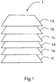
- Multi layered digital maps 1, as illustrated schematically in figure 1 can be regarded as maps having a series of layers, e.g. as illustrated layers 1 a through f. These layers may e.g. start with a basemap defining the geometry of the roads, the next layer may provide the map attributes (names, turn restrictions etc.), then on top of that may come community contributed content, then we may e.g. have the 'real road speeds', such as e.g. provided by IQ Routes, etc. Each higher layer of the map 1 provides more information and adds more value to the layers below.
- This information can be used to enhance understanding of self-driving vehicles or Advanced Driver Assistance Systems (ADAS) about a surrounding environment. It can also be used by road and traffic authorities to take suitable actions, e.g. to put appropriate traffic signs in place, to minimize the risk of accidents in regions where the behavioral layer of the map 1 indicates a need for such actions. It may also be possible to determine irregularities in the road network 3, such as e.g. potholes or roadworks.
- ADAS Advanced Driver Assistance Systems
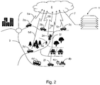
- the proposed method comprises detecting by sensors (not shown) of a plurality of road vehicles 2a-f travelling through the road network, e.g. as illustrated schematically in figure 2 , data relating to at least the positions and velocities of static and moving objects 4a-d.
- the respective vehicles 2a-f are equipped with detection systems such as one or more sensors (e.g. camera, lidar or radar based sensors or fusions of these) by which surrounding objects 4a-d can be detected and their positions and velocities relative to the respective detecting vehicle 2a-f determined.
- the method further comprises sending data, illustrated by the broken arrows 5a-f, concerning the detected objects 4a-d to the cloud 6 for data aggregation, e.g. as a spatiotemporal database.
- the cloud is a term referring to accessing computer, information technology, and software applications through a network connection, often by accessing data centers using wide area networking or Internet connectivity.
- Cloud computing enables to consume a computational resource, such as a virtual machine, storage or an application, as a utility.
- the data according to the proposed method is suitably sent to the cloud 6 from the respective vehicles 2a-f using well known wireless communication technologies.
- the aggregated data from said plurality of road vehicles 2a-f is analyzed to determine or predict behavioral patterns 7 of the detected objects 4a-d for different segments of the map 1.
- the determined or predicted behavioral patterns 7 of the detected objects 4a-d are added to the behavioral layer of the map 1.
- the method further comprises using machine learning to determine or predict the behavioral patterns 7 of the detected objects 4a-d for the different segments of the map 1.
- the method comprises using advanced processing of signals from the sensors to determine and classify the type of the detected objects 4a-d. Possible classifications could e.g. include pedestrian, cyclist, animal, vehicle (car, bus, lorry) etc. It should be noted that fixed static objects, e.g. fixed roadside installations, will normally be determined or predicted to remain static, whereas e.g. static vehicles or individuals could be predicted to move.
- the method comprises using advanced machine learning and deep learning algorithms in the advanced processing of the sensor signals to determine and classify the type of the detected objects 4a-d.
- the method further comprises using in-vehicle systems to perform predictions of the future behavior of detected moving objects 4a-d and sending data 5a-f relating to such predictions to the cloud 6 for the data aggregation.
- in-vehicle systems to perform predictions of the future behavior of detected moving objects 4a-d and sending data 5a-f relating to such predictions to the cloud 6 for the data aggregation.
- this information should be also sent to cloud 6.
- aggregation algorithms in the cloud 6 can use this information to optimally decide on what kind of behavior can be expected in this segment of the road network 3.
- the systems inside several a vehicles 2a-f travelling through the road network 3 detect pedestrians near the same location, crossing the road or predicted to cross the road, this may be an indication that this kind of behavior can be expected at this particular geographical position.
- crossings for example when there are no traffic lights, the detected or predicted behavior of other road users and vehicles are sent to the cloud 6 and data analysis is performed to get the main behavior pattern of the road users in different parts of the crossing. This can e.g. be used to abstract the collected information to see how Give Way is being used in a crossing.
- the method further comprises using advanced prediction methods including at least one of deep learning, Generative Adversarial Nets or Bayesian learning, to perform predictions of both the intentions of the moving objects 4a-d and their possible near future trajectories.
- a predicted trajectory might consist of several possibilities. In such cases, one or several of these predictions can be sent to the cloud 6.
- a family detected standing near the bus stop 4c may be predicted to remain standing there if determined that a bus 4d is approaching the bus stop 4c, or alternatively if data from a bus network schedule indicates that a bus 4d is expected at that bus stop 4c within a predetermined timespan.
- a road network high definition map 1 comprising a behavioral layer constructed and updated according to the method described herein.
- GIS Geographic Information System
- a map layer is a GIS database containing features representing a particular class or type of real-world entities such as vehicles, cyclists, pedestrians, or animals.
- a behavioral layer contains both the visual representation of each feature and a link from the feature to its database attributes, e.g. behavioral attributes.
- the Geographic Information System or GIS is a computer system that allows you to map, model, query, and analyze large quantities of data within a single database according to their location.
- the GIS using the method described herein allows constructing and updating a behavioral layer of a multi layered road network high definition digital map 1.
Landscapes
- Engineering & Computer Science (AREA)
- Remote Sensing (AREA)
- Radar, Positioning & Navigation (AREA)
- Physics & Mathematics (AREA)
- General Physics & Mathematics (AREA)
- Theoretical Computer Science (AREA)
- Automation & Control Theory (AREA)
- Databases & Information Systems (AREA)
- Chemical & Material Sciences (AREA)
- General Engineering & Computer Science (AREA)
- Software Systems (AREA)
- Analytical Chemistry (AREA)
- Data Mining & Analysis (AREA)
- Evolutionary Computation (AREA)
- Artificial Intelligence (AREA)
- Mathematical Physics (AREA)
- Computing Systems (AREA)
- Medical Informatics (AREA)
- Computer Vision & Pattern Recognition (AREA)
- Computational Linguistics (AREA)
- Traffic Control Systems (AREA)
- Aviation & Aerospace Engineering (AREA)
- Business, Economics & Management (AREA)
- Health & Medical Sciences (AREA)
- Game Theory and Decision Science (AREA)
Abstract
Description
- The present disclosure relates generally to a method for constructing and updating a behavioral layer of a multi layered road network high definition digital map. It also relates to a road network high definition map comprising such a behavioral layer as well as a Geographic Information System that is arranged to construct and update such a behavioral layer of a multi layered road network high definition digital map.
- One area of technology that is evolving rapidly is the area of autonomous or semi-autonomous drive capabilities for road vehicles. This is enabled through the introduction of vehicle borne sensors, for sensing vehicle motion and surroundings, and vehicle borne actuators, for controlling different road vehicle functionalities, such as steering, throttling and braking. Increased on-board data processing capabilities ties together the vehicle borne sensors and actuators such that autonomous or semi-autonomous drive capabilities are enabled.
- When a road vehicle runs in autonomous mode, which means that the driver is not required to perform maneuvers, the road vehicle will usually be dependent on inputs from multiple data sources to perform the autonomous driving. An autonomous road vehicle requires information about its surrounding environment to drive safely. For instance, a detailed description of the road network inside of which it is operating is required for the autonomous road vehicle to cautiously navigate and plan future trajectories. It must also detect and classify surrounding objects, and estimate their physical properties such as positions, velocities and accelerations. To perform such tasks, autonomous road vehicles are usually provided with high definition map information and information from multiple sensors measuring both the internal state of the vehicle as well as its surrounding environment.
- Such high definition maps required by autonomous road vehicles differ in several important ways from the maps used today for turn-by-turn directions. Meter-resolution maps may be good enough for Global Positioning System, GPS-based navigation, but autonomous road vehicles need maps that can tell them where the curb is within a few centimeters.
- High definition maps are an important component for self-driving road vehicles, i.e. road vehicles having autonomous or semi-autonomous drive capabilities. The main challenges for these maps are related not only to construction of the map but also to updating them over time. As both these procedures are very expensive and unfeasible to be done using a limited amount of resources that might be available, crowdsourcing is being widely used to fulfil this task.
- In this context, vehicles or other transportation systems wirelessly send an affordable level of information, as a summary of their detections from their surroundings, to a server. The information is collected in the server and appropriate processing and aggregations are applied to remove the noises and mistakes from the collected data.
- The results from these processing's and aggregations are then used to create or update the available maps. Several different layers are usually created for high definition maps, where different levels of information are available at different layers. The focus of such maps is usually to get a physical understanding of the environment, e.g., how many lane markings that are available, where the road signs are located etc.
- An object of the present invention is to improve utility, construction and updating of a multi layered road network high definition digital map.
- This is provided by a method for constructing and updating a behavioral layer of a multi layered road network high definition digital map, the method comprising: detecting by sensors of a plurality of road vehicles travelling through the road network data relating to at least the positions and velocities of static and moving objects; sending data concerning the detected objects to the cloud for data aggregation; analyzing the aggregated data from said plurality of road vehicles to determine or predict behavioral patterns of the detected objects for different segments of the map; and adding the determined or predicted behavioral patterns of the detected objects to the behavioral layer of the map.
- In a further embodiment the method further comprises using machine learning to determine or predict the behavioral patterns of the detected objects for the different segments of the map.
- In a yet further embodiment the method further comprises using advanced processing of signals from the sensors to determine and classify the type of the detected objects.
- In a still further embodiment the method comprises using advanced machine learning and deep learning algorithms in the advanced processing of the sensor signals to determine and classify the type of the detected objects.
- In an additional embodiment the method further comprises using in-vehicle systems to perform predictions of the future behavior of detected moving objects and sending data relating to such predictions to the cloud for the data aggregation.
- In yet an additional embodiment the method further comprises using advanced prediction methods including at least one of deep learning, Generative Adversarial Nets or Bayesian learning, to perform predictions of both the intentions of the moving objects and their possible near future trajectories.
- Furthermore, here envisaged is a road network high definition map comprising a behavioral layer constructed and updated according to the method described herein.
- Also, here envisaged is a Geographic Information System that is arranged to construct and update a behavioral layer of a multi layered road network high definition digital map using the method described herein.
- The above embodiments have the beneficial effects of providing to a multi layered road network high definition digital map a behavioral layer that can be used to enhance understanding of self-driving vehicles or Advanced Driver Assistance Systems about a surrounding environment. It can also be used by road and traffic authorities to take suitable actions, e.g., to put appropriate traffic signs in place, to minimize the risk of accidents in regions where the behavioral layer indicates a need for such actions.
- In the following, embodiments herein will be described in greater detail by way of example only with reference to attached drawings, in which:
-
Fig. 1 illustrates schematically a multi layered road network high definition digital map according to an example embodiment; -
Fig. 2 illustrates schematically a method for constructing and updating a behavioral layer of a multi layered road network high definition digital map according to an example embodiment. - In the following will be described some example embodiments of a method for constructing and updating a behavioral layer of a multi layered road network high definition
digital map 1. - Multi layered
digital maps 1, as illustrated schematically infigure 1 , can be regarded as maps having a series of layers, e.g. as illustratedlayers 1 a through f. These layers may e.g. start with a basemap defining the geometry of the roads, the next layer may provide the map attributes (names, turn restrictions etc.), then on top of that may come community contributed content, then we may e.g. have the 'real road speeds', such as e.g. provided by IQ Routes, etc. Each higher layer of themap 1 provides more information and adds more value to the layers below. - There are many sources for the initial data of the map layers, ranging from Local Authorities, National Planning and Mapping agencies (i.e. Ordnance Survey), driver feedback, MapShare, Satellite Imagery etc.
- One important aspect of how we as human drivers observe the environment is through semantics and we can reason and relate several events together. For example, a rushing person close to a tram station while there is a tram approaching the station usually means that the person is rushing to take the tram.
- Herein is proposed the addition of a behavioral layer to multi layered road network high definition
digital maps 1 where crowdsourcing, data analysis and potentially machine learning are used to create a level describing how other road users usually behave in this part of themap 1. - This information can be used to enhance understanding of self-driving vehicles or Advanced Driver Assistance Systems (ADAS) about a surrounding environment. It can also be used by road and traffic authorities to take suitable actions, e.g. to put appropriate traffic signs in place, to minimize the risk of accidents in regions where the behavioral layer of the
map 1 indicates a need for such actions. It may also be possible to determine irregularities in theroad network 3, such as e.g. potholes or roadworks. - The proposed method comprises detecting by sensors (not shown) of a plurality of
road vehicles 2a-f travelling through the road network, e.g. as illustrated schematically infigure 2 , data relating to at least the positions and velocities of static and movingobjects 4a-d. Thus, it is assumed that therespective vehicles 2a-f are equipped with detection systems such as one or more sensors (e.g. camera, lidar or radar based sensors or fusions of these) by which surroundingobjects 4a-d can be detected and their positions and velocities relative to the respective detectingvehicle 2a-f determined. - The method further comprises sending data, illustrated by the
broken arrows 5a-f, concerning the detected objects 4a-d to thecloud 6 for data aggregation, e.g. as a spatiotemporal database. - The cloud is a term referring to accessing computer, information technology, and software applications through a network connection, often by accessing data centers using wide area networking or Internet connectivity. Cloud computing enables to consume a computational resource, such as a virtual machine, storage or an application, as a utility.
- The data according to the proposed method is suitably sent to the
cloud 6 from therespective vehicles 2a-f using well known wireless communication technologies. - According to the proposed method the aggregated data from said plurality of
road vehicles 2a-f is analyzed to determine or predictbehavioral patterns 7 of the detected objects 4a-d for different segments of themap 1. - Finally, in accordance with a general embodiment of the method, the determined or predicted
behavioral patterns 7 of the detected objects 4a-d are added to the behavioral layer of themap 1. - Optionally the method further comprises using machine learning to determine or predict the
behavioral patterns 7 of the detected objects 4a-d for the different segments of themap 1. - In further embodiment the method comprises using advanced processing of signals from the sensors to determine and classify the type of the detected objects 4a-d. Possible classifications could e.g. include pedestrian, cyclist, animal, vehicle (car, bus, lorry) etc. It should be noted that fixed static objects, e.g. fixed roadside installations, will normally be determined or predicted to remain static, whereas e.g. static vehicles or individuals could be predicted to move.
- In a still further embodiment the method comprises using advanced machine learning and deep learning algorithms in the advanced processing of the sensor signals to determine and classify the type of the detected objects 4a-d.
- In an additional embodiment the method further comprises using in-vehicle systems to perform predictions of the future behavior of detected moving
objects 4a-d and sendingdata 5a-f relating to such predictions to thecloud 6 for the data aggregation. Thus, if the systems inside avehicle 2a-f travelling through theroad network 3 detect apedestrian 4a waiting on the side of the road and the system predicts that the pedestrian intends to cross the street, this information should be also sent tocloud 6. In this case, it is important to also have a notion of uncertainty that can be used to assess the system's confidence in the collecteddata 5a-f. Then aggregation algorithms in thecloud 6 can use this information to optimally decide on what kind of behavior can be expected in this segment of theroad network 3. Thus, if the systems inside several avehicles 2a-f travelling through theroad network 3 detect pedestrians near the same location, crossing the road or predicted to cross the road, this may be an indication that this kind of behavior can be expected at this particular geographical position. - Considering crossing or roundabouts. In crossings, for example when there are no traffic lights, the detected or predicted behavior of other road users and vehicles are sent to the
cloud 6 and data analysis is performed to get the main behavior pattern of the road users in different parts of the crossing. This can e.g. be used to abstract the collected information to see how Give Way is being used in a crossing. - In yet an additional embodiment the method further comprises using advanced prediction methods including at least one of deep learning, Generative Adversarial Nets or Bayesian learning, to perform predictions of both the intentions of the moving
objects 4a-d and their possible near future trajectories. A predicted trajectory might consist of several possibilities. In such cases, one or several of these predictions can be sent to thecloud 6. - Considering e.g. the example of a
bus stop 4c. as illustrated infigure 2 . A family detected standing near thebus stop 4c may be predicted to remain standing there if determined that abus 4d is approaching thebus stop 4c, or alternatively if data from a bus network schedule indicates that abus 4d is expected at thatbus stop 4c within a predetermined timespan. - Furthermore, here envisaged is a road network
high definition map 1 comprising a behavioral layer constructed and updated according to the method described herein. - Also, here envisaged is a Geographic Information System (GIS) that is arranged to construct and update a behavioral layer of a multi layered road network high definition
digital map 1 using the method described herein. - A map layer is a GIS database containing features representing a particular class or type of real-world entities such as vehicles, cyclists, pedestrians, or animals. A behavioral layer contains both the visual representation of each feature and a link from the feature to its database attributes, e.g. behavioral attributes.
- The Geographic Information System or GIS is a computer system that allows you to map, model, query, and analyze large quantities of data within a single database according to their location. The GIS using the method described herein allows constructing and updating a behavioral layer of a multi layered road network high definition
digital map 1. - Thus, in accordance with the proposed method is determined what actually takes place in the traffic environment to create a behavioral layer that can be used to determine the probabilities of something occurring at a specific geographical position at a specific point in time.
- Many modifications and other embodiments of the inventions set forth herein will come to mind to one skilled in the art to which these inventions pertain having the benefit of the teachings presented in the foregoing descriptions and the associated drawings. Therefore, it is to be understood that the inventions are not to be limited to the specific embodiments disclosed and that modifications and other embodiments are intended to be included within the scope of the appended claims. Moreover, although the foregoing descriptions and the associated drawings describe exemplary embodiments in the context of certain exemplary combinations of elements and/or functions, it should be appreciated that different combinations of elements and/or functions may be provided by alternative embodiments without departing from the scope of the appended claims. In this regard, for example, different combinations of elements and/or functions than those explicitly described above are also contemplated as may be set forth in some of the appended claims. In cases where advantages, benefits or solutions to problems are described herein, it should be appreciated that such advantages, benefits and/or solutions may be applicable to some example embodiments, but not necessarily all example embodiments. Thus, any advantages, benefits or solutions described herein should not be thought of as being critical, required or essential to all embodiments or to that which is claimed herein. Although specific terms are employed herein, they are used in a generic and descriptive sense only and not for purposes of limitation.
Claims (8)
- Method for constructing and updating a behavioral layer of a multi layered road network high definition digital map (1), the method comprising:detecting by sensors of a plurality of road vehicles (2) travelling through the road network (3) data relating to at least the positions and velocities of static and moving objects (4);sending data (5) concerning the detected objects (4) to the cloud (6) for data aggregation;analysing the aggregated data (5) from said plurality of road vehicles (2) to determine or predict behavioral patterns (7) of the detected objects (4) for different segments of the map (1); andadding the determined or predicted behavioral patterns (7) of the detected objects (4) to the behavioral layer of the map (1).
- A method (1) according to claim 1, wherein it further comprises using machine learning to determine or predict the behavioral patterns (7) of the detected objects (4) for the different segments of the map (1).
- A method (1) according to any one of claims 1 or 2, wherein it further comprises using advanced processing of signals from the sensors to determine and classify the type of the detected objects (4).
- A method (1) according to claim 3, wherein it further comprises using advanced machine learning and deep learning algorithms in the advanced processing of the sensor signals to determine and classify the type of the detected objects (4).
- A method (1) according to claim 4, wherein it further comprises using in-vehicle systems to perform predictions of the future behavior of detected moving objects (4) and sending data relating to such predictions to the cloud (6) for the data aggregation.
- A method (1) according to claim 5, wherein it further comprises using advanced prediction methods including at least one of deep learning, Generative Adversarial Nets or Bayesian learning, to perform predictions of both the intentions of the moving objects (4) and their possible near future trajectories.
- A road network high definition map (1) comprising a behavioral layer constructed and updated according to the method of any one of claims 1-6.
- A Geographic Information System that is arranged to construct and update a behavioral layer of a multi layered road network high definition digital map (1) using the method according to any one of claims 1 to 7.
Priority Applications (3)
| Application Number | Priority Date | Filing Date | Title |
|---|---|---|---|
| EP18152440.6A EP3514494A1 (en) | 2018-01-19 | 2018-01-19 | Constructing and updating a behavioral layer of a multi layered road network high definition digital map |
| CN201910048316.0A CN110068343A (en) | 2018-01-19 | 2019-01-18 | Building and the behavior layer for updating Multi-layer road network high-definition digital map |
| US16/251,126 US20190227562A1 (en) | 2018-01-19 | 2019-01-18 | Constructing and updating a behavioral layer of a multi layeredroad network high definition digital map |
Applications Claiming Priority (1)
| Application Number | Priority Date | Filing Date | Title |
|---|---|---|---|
| EP18152440.6A EP3514494A1 (en) | 2018-01-19 | 2018-01-19 | Constructing and updating a behavioral layer of a multi layered road network high definition digital map |
Publications (1)
| Publication Number | Publication Date |
|---|---|
| EP3514494A1 true EP3514494A1 (en) | 2019-07-24 |
Family
ID=61017806
Family Applications (1)
| Application Number | Title | Priority Date | Filing Date |
|---|---|---|---|
| EP18152440.6A Withdrawn EP3514494A1 (en) | 2018-01-19 | 2018-01-19 | Constructing and updating a behavioral layer of a multi layered road network high definition digital map |
Country Status (3)
| Country | Link |
|---|---|
| US (1) | US20190227562A1 (en) |
| EP (1) | EP3514494A1 (en) |
| CN (1) | CN110068343A (en) |
Cited By (1)
| Publication number | Priority date | Publication date | Assignee | Title |
|---|---|---|---|---|
| CN111176279A (en) * | 2019-12-31 | 2020-05-19 | 北京四维图新科技股份有限公司 | Method, device, device and storage medium for determining vulnerable population area |
Families Citing this family (32)
| Publication number | Priority date | Publication date | Assignee | Title |
|---|---|---|---|---|
| WO2018125928A1 (en) | 2016-12-29 | 2018-07-05 | DeepScale, Inc. | Multi-channel sensor simulation for autonomous control systems |
| WO2018176000A1 (en) | 2017-03-23 | 2018-09-27 | DeepScale, Inc. | Data synthesis for autonomous control systems |
| US11409692B2 (en) | 2017-07-24 | 2022-08-09 | Tesla, Inc. | Vector computational unit |
| US11157441B2 (en) | 2017-07-24 | 2021-10-26 | Tesla, Inc. | Computational array microprocessor system using non-consecutive data formatting |
| US10671349B2 (en) | 2017-07-24 | 2020-06-02 | Tesla, Inc. | Accelerated mathematical engine |
| US11893393B2 (en) | 2017-07-24 | 2024-02-06 | Tesla, Inc. | Computational array microprocessor system with hardware arbiter managing memory requests |
| US12307350B2 (en) | 2018-01-04 | 2025-05-20 | Tesla, Inc. | Systems and methods for hardware-based pooling |
| US11561791B2 (en) | 2018-02-01 | 2023-01-24 | Tesla, Inc. | Vector computational unit receiving data elements in parallel from a last row of a computational array |
| US11215999B2 (en) | 2018-06-20 | 2022-01-04 | Tesla, Inc. | Data pipeline and deep learning system for autonomous driving |
| US11361457B2 (en) | 2018-07-20 | 2022-06-14 | Tesla, Inc. | Annotation cross-labeling for autonomous control systems |
| US11636333B2 (en) | 2018-07-26 | 2023-04-25 | Tesla, Inc. | Optimizing neural network structures for embedded systems |
| US11562231B2 (en) | 2018-09-03 | 2023-01-24 | Tesla, Inc. | Neural networks for embedded devices |
| ES3063986T3 (en) | 2018-10-11 | 2026-04-21 | Tesla Inc | Systems and methods for training machine models with augmented data |
| US11196678B2 (en) | 2018-10-25 | 2021-12-07 | Tesla, Inc. | QOS manager for system on a chip communications |
| US11816585B2 (en) | 2018-12-03 | 2023-11-14 | Tesla, Inc. | Machine learning models operating at different frequencies for autonomous vehicles |
| US11537811B2 (en) | 2018-12-04 | 2022-12-27 | Tesla, Inc. | Enhanced object detection for autonomous vehicles based on field view |
| IL270540A (en) * | 2018-12-26 | 2020-06-30 | Yandex Taxi Llc | Method and system for training machine learning algorithm to detect objects at distance |
| US11610117B2 (en) | 2018-12-27 | 2023-03-21 | Tesla, Inc. | System and method for adapting a neural network model on a hardware platform |
| US11150664B2 (en) | 2019-02-01 | 2021-10-19 | Tesla, Inc. | Predicting three-dimensional features for autonomous driving |
| US10997461B2 (en) | 2019-02-01 | 2021-05-04 | Tesla, Inc. | Generating ground truth for machine learning from time series elements |
| US11567514B2 (en) | 2019-02-11 | 2023-01-31 | Tesla, Inc. | Autonomous and user controlled vehicle summon to a target |
| US10956755B2 (en) | 2019-02-19 | 2021-03-23 | Tesla, Inc. | Estimating object properties using visual image data |
| EP4014218A1 (en) * | 2019-09-02 | 2022-06-22 | Skygrid, LLC | Aggregating data for unmanned aerial vehicle (uav) navigation |
| CN110675632B (en) * | 2019-11-11 | 2021-11-30 | 重庆邮电大学 | Vehicle short-time trajectory prediction control method aiming at multi-feature space and data sparseness |
| CN111026825B (en) * | 2019-12-02 | 2023-04-18 | 广州力挚网络科技有限公司 | Method and device for determining roundabout set |
| US20210325898A1 (en) * | 2020-04-21 | 2021-10-21 | Micron Technology, Inc. | Using drone data to generate high-definition map for autonomous vehicle navigation |
| US12524015B2 (en) | 2020-09-14 | 2026-01-13 | Robert Bosch Gmbh | Method and apparatus for planning a path for a mobile object |
| EP4036892A1 (en) * | 2021-02-02 | 2022-08-03 | Aptiv Technologies Limited | Detection system for predicting information on pedestrian |
| US12462575B2 (en) | 2021-08-19 | 2025-11-04 | Tesla, Inc. | Vision-based machine learning model for autonomous driving with adjustable virtual camera |
| KR20240048533A (en) | 2021-08-19 | 2024-04-15 | 테슬라, 인크. | Training vision-based systems using simulated content |
| US12623691B2 (en) | 2022-05-20 | 2026-05-12 | Tesla, Inc. | Fail-safe corrective actions based on vision information for autonomous vehicles |
| WO2025260268A1 (en) * | 2024-06-19 | 2025-12-26 | Qualcomm Incorporated | High-definition maps motion models layer for obstacle tracking and future trajectory prediction |
Citations (5)
| Publication number | Priority date | Publication date | Assignee | Title |
|---|---|---|---|---|
| WO2013170882A1 (en) * | 2012-05-15 | 2013-11-21 | Telefonaktiebolaget L M Ericsson (Publ) | Collaborative vehicle detection of objects with a predictive distribution |
| US20160107688A1 (en) * | 2013-05-24 | 2016-04-21 | Robert Bosch Gmbh | Driver assistance system including additional information in connection with a road map |
| CN105573323A (en) * | 2016-01-12 | 2016-05-11 | 福州华鹰重工机械有限公司 | automatic driving track generation method and apparatus |
| US20170248963A1 (en) * | 2015-11-04 | 2017-08-31 | Zoox, Inc. | Adaptive mapping to navigate autonomous vehicles responsive to physical environment changes |
| US20180004226A1 (en) * | 2016-07-01 | 2018-01-04 | Uber Technologies, Inc. | System and method for managing submaps for controlling autonomous vehicles |
Family Cites Families (9)
| Publication number | Priority date | Publication date | Assignee | Title |
|---|---|---|---|---|
| US20090138188A1 (en) * | 2005-07-22 | 2009-05-28 | Andrej Kores | Method, device and system for modeling a road network graph |
| US7912627B2 (en) * | 2006-03-03 | 2011-03-22 | Inrix, Inc. | Obtaining road traffic condition data from mobile data sources |
| US9297455B2 (en) * | 2012-11-20 | 2016-03-29 | GM Global Technology Operations LLC | GPS-based predictive shift schedule for automatic transmission |
| US9576480B1 (en) * | 2015-09-21 | 2017-02-21 | Sap Se | Centrally-managed vehicle network |
| US10152882B2 (en) * | 2015-11-30 | 2018-12-11 | Nissan North America, Inc. | Host vehicle operation using remote vehicle intention prediction |
| EP3206411B1 (en) * | 2016-02-11 | 2020-10-07 | Volvo Car Corporation | Arrangement and method for predicting road friction within a road network |
| DE102016217645B4 (en) * | 2016-09-15 | 2023-01-19 | Volkswagen Aktiengesellschaft | Method for providing information about a probable driving intention of a vehicle |
| MX373535B (en) * | 2017-03-02 | 2020-04-07 | Nissan Motor | DRIVING ASSISTANCE METHOD AND DRIVING ASSISTANCE DEVICE. |
| BR112019024714A2 (en) * | 2017-05-24 | 2020-06-09 | Nissan Motor Co., Ltd. | travel assistance method of travel assistance device and travel assistance device |
-
2018
- 2018-01-19 EP EP18152440.6A patent/EP3514494A1/en not_active Withdrawn
-
2019
- 2019-01-18 US US16/251,126 patent/US20190227562A1/en not_active Abandoned
- 2019-01-18 CN CN201910048316.0A patent/CN110068343A/en active Pending
Patent Citations (5)
| Publication number | Priority date | Publication date | Assignee | Title |
|---|---|---|---|---|
| WO2013170882A1 (en) * | 2012-05-15 | 2013-11-21 | Telefonaktiebolaget L M Ericsson (Publ) | Collaborative vehicle detection of objects with a predictive distribution |
| US20160107688A1 (en) * | 2013-05-24 | 2016-04-21 | Robert Bosch Gmbh | Driver assistance system including additional information in connection with a road map |
| US20170248963A1 (en) * | 2015-11-04 | 2017-08-31 | Zoox, Inc. | Adaptive mapping to navigate autonomous vehicles responsive to physical environment changes |
| CN105573323A (en) * | 2016-01-12 | 2016-05-11 | 福州华鹰重工机械有限公司 | automatic driving track generation method and apparatus |
| US20180004226A1 (en) * | 2016-07-01 | 2018-01-04 | Uber Technologies, Inc. | System and method for managing submaps for controlling autonomous vehicles |
Cited By (2)
| Publication number | Priority date | Publication date | Assignee | Title |
|---|---|---|---|---|
| CN111176279A (en) * | 2019-12-31 | 2020-05-19 | 北京四维图新科技股份有限公司 | Method, device, device and storage medium for determining vulnerable population area |
| CN111176279B (en) * | 2019-12-31 | 2023-09-26 | 北京四维图新科技股份有限公司 | Determination method, device, equipment and storage medium for vulnerable crowd area |
Also Published As
| Publication number | Publication date |
|---|---|
| CN110068343A (en) | 2019-07-30 |
| US20190227562A1 (en) | 2019-07-25 |
Similar Documents
| Publication | Publication Date | Title |
|---|---|---|
| US20190227562A1 (en) | Constructing and updating a behavioral layer of a multi layeredroad network high definition digital map | |
| US20250104418A1 (en) | Systems and methods for effecting map layer updates based on collected sensor data | |
| US11977393B2 (en) | Navigational constraints for autonomous vehicles | |
| US11458993B2 (en) | Detecting a road closure by a lead autonomous vehicle (AV) and updating routing plans for following AVs | |
| US20260080693A1 (en) | Systems and methods for generating lane data using vehicle trajectory sampling | |
| US11681294B2 (en) | Method and system for prediction of roadwork zone | |
| US20220198351A1 (en) | Contextually defining an interest index for shared and autonomous vehicles | |
| EP4120217A1 (en) | Batch control for autonomous vehicles | |
| US10760918B2 (en) | Spatiotemporal lane maneuver delay for road navigation | |
| US9886857B2 (en) | Organized intelligent merging | |
| US12412121B2 (en) | Determining traffic violation hotspots | |
| US20200193823A1 (en) | Method and system for validating existence of roadwork | |
| US12165415B2 (en) | Providing access to an autonomous vehicle based on user's detected interest | |
| US12565235B2 (en) | Detecting a construction zone by a lead autonomous vehicle (AV) and updating routing plans for following AVs | |
| KR102550039B1 (en) | Vehicle path planning | |
| US12230139B2 (en) | Predicting traffic violation hotspots using map features and sensors data | |
| EP4202886A1 (en) | Using maps at multiple resolutions and scale for trajectory prediction | |
| US20220309521A1 (en) | Computing a vehicle interest index | |
| KR102562381B1 (en) | System and Method for Contextualizing Objects in Vehicle Horizon | |
| US12162510B2 (en) | Location intelligence for building empathetic driving behavior to enable L5 cars | |
| EP3967978B1 (en) | Detecting a construction zone by a lead autonomous vehicle (av) and updating routing plans for following autonomous vehicles (avs) | |
| US20250085128A1 (en) | Systems and methods for inferring information about stationary elements based on semantic relationships | |
| US12529575B2 (en) | System and method for detecting active road work zones | |
| US20220065647A1 (en) | Autonomous vehicle planned route prediction | |
| US12488594B1 (en) | Systems and methods for ingesting data based on predefined driving sequences |
Legal Events
| Date | Code | Title | Description |
|---|---|---|---|
| STAA | Information on the status of an ep patent application or granted ep patent |
Free format text: STATUS: EXAMINATION IS IN PROGRESS |
|
| PUAI | Public reference made under article 153(3) epc to a published international application that has entered the european phase |
Free format text: ORIGINAL CODE: 0009012 |
|
| 17P | Request for examination filed |
Effective date: 20180119 |
|
| AK | Designated contracting states |
Kind code of ref document: A1 Designated state(s): AL AT BE BG CH CY CZ DE DK EE ES FI FR GB GR HR HU IE IS IT LI LT LU LV MC MK MT NL NO PL PT RO RS SE SI SK SM TR |
|
| AX | Request for extension of the european patent |
Extension state: BA ME |
|
| RAP3 | Party data changed (applicant data changed or rights of an application transferred) |
Owner name: VOLVO CAR CORPORATION Owner name: ZENUITY AB |
|
| P01 | Opt-out of the competence of the unified patent court (upc) registered |
Effective date: 20230602 |
|
| STAA | Information on the status of an ep patent application or granted ep patent |
Free format text: STATUS: THE APPLICATION IS DEEMED TO BE WITHDRAWN |
|
| 18D | Application deemed to be withdrawn |
Effective date: 20241126 |