EP3464025B1 - Supervisory control of vehicles - Google Patents
Supervisory control of vehicles Download PDFInfo
- Publication number
- EP3464025B1 EP3464025B1 EP17803364.3A EP17803364A EP3464025B1 EP 3464025 B1 EP3464025 B1 EP 3464025B1 EP 17803364 A EP17803364 A EP 17803364A EP 3464025 B1 EP3464025 B1 EP 3464025B1
- Authority
- EP
- European Patent Office
- Prior art keywords
- vehicle
- travel
- lane
- road
- command
- Prior art date
- Legal status (The legal status is an assumption and is not a legal conclusion. Google has not performed a legal analysis and makes no representation as to the accuracy of the status listed.)
- Active
Links
Images






Classifications
-
- B—PERFORMING OPERATIONS; TRANSPORTING
- B60—VEHICLES IN GENERAL
- B60W—CONJOINT CONTROL OF VEHICLE SUB-UNITS OF DIFFERENT TYPE OR DIFFERENT FUNCTION; CONTROL SYSTEMS SPECIALLY ADAPTED FOR HYBRID VEHICLES; ROAD VEHICLE DRIVE CONTROL SYSTEMS FOR PURPOSES NOT RELATED TO THE CONTROL OF A PARTICULAR SUB-UNIT
- B60W30/00—Purposes of road vehicle drive control systems not related to the control of a particular sub-unit, e.g. of systems using conjoint control of vehicle sub-units
- B60W30/14—Adaptive cruise control
- B60W30/143—Speed control
-
- G—PHYSICS
- G05—CONTROLLING; REGULATING
- G05D—SYSTEMS FOR CONTROLLING OR REGULATING NON-ELECTRIC VARIABLES
- G05D1/00—Control of position, course, altitude or attitude of land, water, air or space vehicles, e.g. using automatic pilots
- G05D1/0011—Control of position, course, altitude or attitude of land, water, air or space vehicles, e.g. using automatic pilots associated with a remote control arrangement
- G05D1/0038—Control of position, course, altitude or attitude of land, water, air or space vehicles, e.g. using automatic pilots associated with a remote control arrangement by providing the operator with simple or augmented images from one or more cameras located onboard the vehicle, e.g. tele-operation
-
- B—PERFORMING OPERATIONS; TRANSPORTING
- B60—VEHICLES IN GENERAL
- B60K—ARRANGEMENT OR MOUNTING OF PROPULSION UNITS OR OF TRANSMISSIONS IN VEHICLES; ARRANGEMENT OR MOUNTING OF PLURAL DIVERSE PRIME-MOVERS IN VEHICLES; AUXILIARY DRIVES FOR VEHICLES; INSTRUMENTATION OR DASHBOARDS FOR VEHICLES; ARRANGEMENTS IN CONNECTION WITH COOLING, AIR INTAKE, GAS EXHAUST OR FUEL SUPPLY OF PROPULSION UNITS IN VEHICLES
- B60K35/00—Instruments specially adapted for vehicles; Arrangement of instruments in or on vehicles
-
- B—PERFORMING OPERATIONS; TRANSPORTING
- B60—VEHICLES IN GENERAL
- B60K—ARRANGEMENT OR MOUNTING OF PROPULSION UNITS OR OF TRANSMISSIONS IN VEHICLES; ARRANGEMENT OR MOUNTING OF PLURAL DIVERSE PRIME-MOVERS IN VEHICLES; AUXILIARY DRIVES FOR VEHICLES; INSTRUMENTATION OR DASHBOARDS FOR VEHICLES; ARRANGEMENTS IN CONNECTION WITH COOLING, AIR INTAKE, GAS EXHAUST OR FUEL SUPPLY OF PROPULSION UNITS IN VEHICLES
- B60K35/00—Instruments specially adapted for vehicles; Arrangement of instruments in or on vehicles
- B60K35/20—Output arrangements, i.e. from vehicle to user, associated with vehicle functions or specially adapted therefor
- B60K35/21—Output arrangements, i.e. from vehicle to user, associated with vehicle functions or specially adapted therefor using visual output, e.g. blinking lights or matrix displays
- B60K35/23—Head-up displays [HUD]
-
- B—PERFORMING OPERATIONS; TRANSPORTING
- B60—VEHICLES IN GENERAL
- B60W—CONJOINT CONTROL OF VEHICLE SUB-UNITS OF DIFFERENT TYPE OR DIFFERENT FUNCTION; CONTROL SYSTEMS SPECIALLY ADAPTED FOR HYBRID VEHICLES; ROAD VEHICLE DRIVE CONTROL SYSTEMS FOR PURPOSES NOT RELATED TO THE CONTROL OF A PARTICULAR SUB-UNIT
- B60W30/00—Purposes of road vehicle drive control systems not related to the control of a particular sub-unit, e.g. of systems using conjoint control of vehicle sub-units
- B60W30/10—Path keeping
- B60W30/12—Lane keeping
-
- B—PERFORMING OPERATIONS; TRANSPORTING
- B60—VEHICLES IN GENERAL
- B60W—CONJOINT CONTROL OF VEHICLE SUB-UNITS OF DIFFERENT TYPE OR DIFFERENT FUNCTION; CONTROL SYSTEMS SPECIALLY ADAPTED FOR HYBRID VEHICLES; ROAD VEHICLE DRIVE CONTROL SYSTEMS FOR PURPOSES NOT RELATED TO THE CONTROL OF A PARTICULAR SUB-UNIT
- B60W30/00—Purposes of road vehicle drive control systems not related to the control of a particular sub-unit, e.g. of systems using conjoint control of vehicle sub-units
- B60W30/18—Propelling the vehicle
- B60W30/18009—Propelling the vehicle related to particular drive situations
- B60W30/181—Preparing for stopping
-
- B—PERFORMING OPERATIONS; TRANSPORTING
- B60—VEHICLES IN GENERAL
- B60W—CONJOINT CONTROL OF VEHICLE SUB-UNITS OF DIFFERENT TYPE OR DIFFERENT FUNCTION; CONTROL SYSTEMS SPECIALLY ADAPTED FOR HYBRID VEHICLES; ROAD VEHICLE DRIVE CONTROL SYSTEMS FOR PURPOSES NOT RELATED TO THE CONTROL OF A PARTICULAR SUB-UNIT
- B60W30/00—Purposes of road vehicle drive control systems not related to the control of a particular sub-unit, e.g. of systems using conjoint control of vehicle sub-units
- B60W30/18—Propelling the vehicle
- B60W30/18009—Propelling the vehicle related to particular drive situations
- B60W30/18163—Lane change; Overtaking manoeuvres
-
- B—PERFORMING OPERATIONS; TRANSPORTING
- B60—VEHICLES IN GENERAL
- B60W—CONJOINT CONTROL OF VEHICLE SUB-UNITS OF DIFFERENT TYPE OR DIFFERENT FUNCTION; CONTROL SYSTEMS SPECIALLY ADAPTED FOR HYBRID VEHICLES; ROAD VEHICLE DRIVE CONTROL SYSTEMS FOR PURPOSES NOT RELATED TO THE CONTROL OF A PARTICULAR SUB-UNIT
- B60W40/00—Estimation or calculation of non-directly measurable driving parameters for road vehicle drive control systems not related to the control of a particular sub unit, e.g. by using mathematical models
- B60W40/10—Estimation or calculation of non-directly measurable driving parameters for road vehicle drive control systems not related to the control of a particular sub unit, e.g. by using mathematical models related to vehicle motion
- B60W40/105—Speed
-
- B—PERFORMING OPERATIONS; TRANSPORTING
- B60—VEHICLES IN GENERAL
- B60W—CONJOINT CONTROL OF VEHICLE SUB-UNITS OF DIFFERENT TYPE OR DIFFERENT FUNCTION; CONTROL SYSTEMS SPECIALLY ADAPTED FOR HYBRID VEHICLES; ROAD VEHICLE DRIVE CONTROL SYSTEMS FOR PURPOSES NOT RELATED TO THE CONTROL OF A PARTICULAR SUB-UNIT
- B60W50/00—Details of control systems for road vehicle drive control not related to the control of a particular sub-unit, e.g. process diagnostic or vehicle driver interfaces
- B60W50/08—Interaction between the driver and the control system
- B60W50/14—Means for informing the driver, warning the driver or prompting a driver intervention
-
- B—PERFORMING OPERATIONS; TRANSPORTING
- B60—VEHICLES IN GENERAL
- B60W—CONJOINT CONTROL OF VEHICLE SUB-UNITS OF DIFFERENT TYPE OR DIFFERENT FUNCTION; CONTROL SYSTEMS SPECIALLY ADAPTED FOR HYBRID VEHICLES; ROAD VEHICLE DRIVE CONTROL SYSTEMS FOR PURPOSES NOT RELATED TO THE CONTROL OF A PARTICULAR SUB-UNIT
- B60W60/00—Drive control systems specially adapted for autonomous road vehicles
- B60W60/001—Planning or execution of driving tasks
- B60W60/0011—Planning or execution of driving tasks involving control alternatives for a single driving scenario, e.g. planning several paths to avoid obstacles
-
- B—PERFORMING OPERATIONS; TRANSPORTING
- B60—VEHICLES IN GENERAL
- B60W—CONJOINT CONTROL OF VEHICLE SUB-UNITS OF DIFFERENT TYPE OR DIFFERENT FUNCTION; CONTROL SYSTEMS SPECIALLY ADAPTED FOR HYBRID VEHICLES; ROAD VEHICLE DRIVE CONTROL SYSTEMS FOR PURPOSES NOT RELATED TO THE CONTROL OF A PARTICULAR SUB-UNIT
- B60W60/00—Drive control systems specially adapted for autonomous road vehicles
- B60W60/001—Planning or execution of driving tasks
- B60W60/0025—Planning or execution of driving tasks specially adapted for specific operations
- B60W60/00253—Taxi operations
-
- G—PHYSICS
- G02—OPTICS
- G02B—OPTICAL ELEMENTS, SYSTEMS OR APPARATUS
- G02B27/00—Optical systems or apparatus not provided for by any of the groups G02B1/00 - G02B26/00, G02B30/00
- G02B27/01—Head-up displays
-
- G—PHYSICS
- G05—CONTROLLING; REGULATING
- G05D—SYSTEMS FOR CONTROLLING OR REGULATING NON-ELECTRIC VARIABLES
- G05D1/00—Control of position, course, altitude or attitude of land, water, air or space vehicles, e.g. using automatic pilots
- G05D1/0055—Control of position, course, altitude or attitude of land, water, air or space vehicles, e.g. using automatic pilots with safety arrangements
-
- G—PHYSICS
- G05—CONTROLLING; REGULATING
- G05D—SYSTEMS FOR CONTROLLING OR REGULATING NON-ELECTRIC VARIABLES
- G05D1/00—Control of position, course, altitude or attitude of land, water, air or space vehicles, e.g. using automatic pilots
- G05D1/0088—Control of position, course, altitude or attitude of land, water, air or space vehicles, e.g. using automatic pilots characterized by the autonomous decision making process, e.g. artificial intelligence, predefined behaviours
-
- G—PHYSICS
- G05—CONTROLLING; REGULATING
- G05D—SYSTEMS FOR CONTROLLING OR REGULATING NON-ELECTRIC VARIABLES
- G05D1/00—Control of position, course, altitude or attitude of land, water, air or space vehicles, e.g. using automatic pilots
- G05D1/02—Control of position or course in two dimensions
- G05D1/021—Control of position or course in two dimensions specially adapted to land vehicles
- G05D1/0231—Control of position or course in two dimensions specially adapted to land vehicles using optical position detecting means
- G05D1/0246—Control of position or course in two dimensions specially adapted to land vehicles using optical position detecting means using a video camera in combination with image processing means
-
- B—PERFORMING OPERATIONS; TRANSPORTING
- B60—VEHICLES IN GENERAL
- B60W—CONJOINT CONTROL OF VEHICLE SUB-UNITS OF DIFFERENT TYPE OR DIFFERENT FUNCTION; CONTROL SYSTEMS SPECIALLY ADAPTED FOR HYBRID VEHICLES; ROAD VEHICLE DRIVE CONTROL SYSTEMS FOR PURPOSES NOT RELATED TO THE CONTROL OF A PARTICULAR SUB-UNIT
- B60W50/00—Details of control systems for road vehicle drive control not related to the control of a particular sub-unit, e.g. process diagnostic or vehicle driver interfaces
- B60W50/08—Interaction between the driver and the control system
- B60W50/14—Means for informing the driver, warning the driver or prompting a driver intervention
- B60W2050/146—Display means
-
- B—PERFORMING OPERATIONS; TRANSPORTING
- B60—VEHICLES IN GENERAL
- B60W—CONJOINT CONTROL OF VEHICLE SUB-UNITS OF DIFFERENT TYPE OR DIFFERENT FUNCTION; CONTROL SYSTEMS SPECIALLY ADAPTED FOR HYBRID VEHICLES; ROAD VEHICLE DRIVE CONTROL SYSTEMS FOR PURPOSES NOT RELATED TO THE CONTROL OF A PARTICULAR SUB-UNIT
- B60W2420/00—Indexing codes relating to the type of sensors based on the principle of their operation
- B60W2420/40—Photo, light or radio wave sensitive means, e.g. infrared sensors
- B60W2420/403—Image sensing, e.g. optical camera
-
- B—PERFORMING OPERATIONS; TRANSPORTING
- B60—VEHICLES IN GENERAL
- B60W—CONJOINT CONTROL OF VEHICLE SUB-UNITS OF DIFFERENT TYPE OR DIFFERENT FUNCTION; CONTROL SYSTEMS SPECIALLY ADAPTED FOR HYBRID VEHICLES; ROAD VEHICLE DRIVE CONTROL SYSTEMS FOR PURPOSES NOT RELATED TO THE CONTROL OF A PARTICULAR SUB-UNIT
- B60W2420/00—Indexing codes relating to the type of sensors based on the principle of their operation
- B60W2420/40—Photo, light or radio wave sensitive means, e.g. infrared sensors
- B60W2420/408—Radar; Laser, e.g. lidar
-
- B—PERFORMING OPERATIONS; TRANSPORTING
- B60—VEHICLES IN GENERAL
- B60W—CONJOINT CONTROL OF VEHICLE SUB-UNITS OF DIFFERENT TYPE OR DIFFERENT FUNCTION; CONTROL SYSTEMS SPECIALLY ADAPTED FOR HYBRID VEHICLES; ROAD VEHICLE DRIVE CONTROL SYSTEMS FOR PURPOSES NOT RELATED TO THE CONTROL OF A PARTICULAR SUB-UNIT
- B60W2520/00—Input parameters relating to overall vehicle dynamics
- B60W2520/10—Longitudinal speed
-
- B—PERFORMING OPERATIONS; TRANSPORTING
- B60—VEHICLES IN GENERAL
- B60W—CONJOINT CONTROL OF VEHICLE SUB-UNITS OF DIFFERENT TYPE OR DIFFERENT FUNCTION; CONTROL SYSTEMS SPECIALLY ADAPTED FOR HYBRID VEHICLES; ROAD VEHICLE DRIVE CONTROL SYSTEMS FOR PURPOSES NOT RELATED TO THE CONTROL OF A PARTICULAR SUB-UNIT
- B60W2540/00—Input parameters relating to occupants
- B60W2540/10—Accelerator pedal position
-
- B—PERFORMING OPERATIONS; TRANSPORTING
- B60—VEHICLES IN GENERAL
- B60W—CONJOINT CONTROL OF VEHICLE SUB-UNITS OF DIFFERENT TYPE OR DIFFERENT FUNCTION; CONTROL SYSTEMS SPECIALLY ADAPTED FOR HYBRID VEHICLES; ROAD VEHICLE DRIVE CONTROL SYSTEMS FOR PURPOSES NOT RELATED TO THE CONTROL OF A PARTICULAR SUB-UNIT
- B60W2540/00—Input parameters relating to occupants
- B60W2540/12—Brake pedal position
-
- B—PERFORMING OPERATIONS; TRANSPORTING
- B60—VEHICLES IN GENERAL
- B60W—CONJOINT CONTROL OF VEHICLE SUB-UNITS OF DIFFERENT TYPE OR DIFFERENT FUNCTION; CONTROL SYSTEMS SPECIALLY ADAPTED FOR HYBRID VEHICLES; ROAD VEHICLE DRIVE CONTROL SYSTEMS FOR PURPOSES NOT RELATED TO THE CONTROL OF A PARTICULAR SUB-UNIT
- B60W2540/00—Input parameters relating to occupants
- B60W2540/229—Attention level, e.g. attentive to driving, reading or sleeping
-
- B—PERFORMING OPERATIONS; TRANSPORTING
- B60—VEHICLES IN GENERAL
- B60W—CONJOINT CONTROL OF VEHICLE SUB-UNITS OF DIFFERENT TYPE OR DIFFERENT FUNCTION; CONTROL SYSTEMS SPECIALLY ADAPTED FOR HYBRID VEHICLES; ROAD VEHICLE DRIVE CONTROL SYSTEMS FOR PURPOSES NOT RELATED TO THE CONTROL OF A PARTICULAR SUB-UNIT
- B60W2552/00—Input parameters relating to infrastructure
- B60W2552/53—Road markings, e.g. lane marker or crosswalk
-
- B—PERFORMING OPERATIONS; TRANSPORTING
- B60—VEHICLES IN GENERAL
- B60W—CONJOINT CONTROL OF VEHICLE SUB-UNITS OF DIFFERENT TYPE OR DIFFERENT FUNCTION; CONTROL SYSTEMS SPECIALLY ADAPTED FOR HYBRID VEHICLES; ROAD VEHICLE DRIVE CONTROL SYSTEMS FOR PURPOSES NOT RELATED TO THE CONTROL OF A PARTICULAR SUB-UNIT
- B60W2554/00—Input parameters relating to objects
- B60W2554/20—Static objects
-
- B—PERFORMING OPERATIONS; TRANSPORTING
- B60—VEHICLES IN GENERAL
- B60W—CONJOINT CONTROL OF VEHICLE SUB-UNITS OF DIFFERENT TYPE OR DIFFERENT FUNCTION; CONTROL SYSTEMS SPECIALLY ADAPTED FOR HYBRID VEHICLES; ROAD VEHICLE DRIVE CONTROL SYSTEMS FOR PURPOSES NOT RELATED TO THE CONTROL OF A PARTICULAR SUB-UNIT
- B60W2554/00—Input parameters relating to objects
- B60W2554/40—Dynamic objects, e.g. animals, windblown objects
- B60W2554/402—Type
- B60W2554/4026—Cycles
-
- B—PERFORMING OPERATIONS; TRANSPORTING
- B60—VEHICLES IN GENERAL
- B60W—CONJOINT CONTROL OF VEHICLE SUB-UNITS OF DIFFERENT TYPE OR DIFFERENT FUNCTION; CONTROL SYSTEMS SPECIALLY ADAPTED FOR HYBRID VEHICLES; ROAD VEHICLE DRIVE CONTROL SYSTEMS FOR PURPOSES NOT RELATED TO THE CONTROL OF A PARTICULAR SUB-UNIT
- B60W2554/00—Input parameters relating to objects
- B60W2554/40—Dynamic objects, e.g. animals, windblown objects
- B60W2554/402—Type
- B60W2554/4029—Pedestrians
-
- B—PERFORMING OPERATIONS; TRANSPORTING
- B60—VEHICLES IN GENERAL
- B60W—CONJOINT CONTROL OF VEHICLE SUB-UNITS OF DIFFERENT TYPE OR DIFFERENT FUNCTION; CONTROL SYSTEMS SPECIALLY ADAPTED FOR HYBRID VEHICLES; ROAD VEHICLE DRIVE CONTROL SYSTEMS FOR PURPOSES NOT RELATED TO THE CONTROL OF A PARTICULAR SUB-UNIT
- B60W2554/00—Input parameters relating to objects
- B60W2554/40—Dynamic objects, e.g. animals, windblown objects
- B60W2554/404—Characteristics
- B60W2554/4041—Position
-
- B—PERFORMING OPERATIONS; TRANSPORTING
- B60—VEHICLES IN GENERAL
- B60W—CONJOINT CONTROL OF VEHICLE SUB-UNITS OF DIFFERENT TYPE OR DIFFERENT FUNCTION; CONTROL SYSTEMS SPECIALLY ADAPTED FOR HYBRID VEHICLES; ROAD VEHICLE DRIVE CONTROL SYSTEMS FOR PURPOSES NOT RELATED TO THE CONTROL OF A PARTICULAR SUB-UNIT
- B60W2554/00—Input parameters relating to objects
- B60W2554/40—Dynamic objects, e.g. animals, windblown objects
- B60W2554/404—Characteristics
- B60W2554/4045—Intention, e.g. lane change or imminent movement
-
- B—PERFORMING OPERATIONS; TRANSPORTING
- B60—VEHICLES IN GENERAL
- B60W—CONJOINT CONTROL OF VEHICLE SUB-UNITS OF DIFFERENT TYPE OR DIFFERENT FUNCTION; CONTROL SYSTEMS SPECIALLY ADAPTED FOR HYBRID VEHICLES; ROAD VEHICLE DRIVE CONTROL SYSTEMS FOR PURPOSES NOT RELATED TO THE CONTROL OF A PARTICULAR SUB-UNIT
- B60W2554/00—Input parameters relating to objects
- B60W2554/60—Traversable objects, e.g. speed bumps or curbs
-
- B—PERFORMING OPERATIONS; TRANSPORTING
- B60—VEHICLES IN GENERAL
- B60W—CONJOINT CONTROL OF VEHICLE SUB-UNITS OF DIFFERENT TYPE OR DIFFERENT FUNCTION; CONTROL SYSTEMS SPECIALLY ADAPTED FOR HYBRID VEHICLES; ROAD VEHICLE DRIVE CONTROL SYSTEMS FOR PURPOSES NOT RELATED TO THE CONTROL OF A PARTICULAR SUB-UNIT
- B60W2556/00—Input parameters relating to data
- B60W2556/10—Historical data
-
- B—PERFORMING OPERATIONS; TRANSPORTING
- B60—VEHICLES IN GENERAL
- B60W—CONJOINT CONTROL OF VEHICLE SUB-UNITS OF DIFFERENT TYPE OR DIFFERENT FUNCTION; CONTROL SYSTEMS SPECIALLY ADAPTED FOR HYBRID VEHICLES; ROAD VEHICLE DRIVE CONTROL SYSTEMS FOR PURPOSES NOT RELATED TO THE CONTROL OF A PARTICULAR SUB-UNIT
- B60W2710/00—Output or target parameters relating to a particular sub-units
-
- B—PERFORMING OPERATIONS; TRANSPORTING
- B60—VEHICLES IN GENERAL
- B60W—CONJOINT CONTROL OF VEHICLE SUB-UNITS OF DIFFERENT TYPE OR DIFFERENT FUNCTION; CONTROL SYSTEMS SPECIALLY ADAPTED FOR HYBRID VEHICLES; ROAD VEHICLE DRIVE CONTROL SYSTEMS FOR PURPOSES NOT RELATED TO THE CONTROL OF A PARTICULAR SUB-UNIT
- B60W2756/00—Output or target parameters relating to data
- B60W2756/10—Involving external transmission of data to or from the vehicle
-
- B—PERFORMING OPERATIONS; TRANSPORTING
- B60—VEHICLES IN GENERAL
- B60Y—INDEXING SCHEME RELATING TO ASPECTS CROSS-CUTTING VEHICLE TECHNOLOGY
- B60Y2300/00—Purposes or special features of road vehicle drive control systems
- B60Y2300/14—Cruise control
- B60Y2300/143—Speed control
-
- B—PERFORMING OPERATIONS; TRANSPORTING
- B60—VEHICLES IN GENERAL
- B60Y—INDEXING SCHEME RELATING TO ASPECTS CROSS-CUTTING VEHICLE TECHNOLOGY
- B60Y2300/00—Purposes or special features of road vehicle drive control systems
- B60Y2300/18—Propelling the vehicle
- B60Y2300/18008—Propelling the vehicle related to particular drive situations
- B60Y2300/18091—Preparing for stopping
-
- B—PERFORMING OPERATIONS; TRANSPORTING
- B60—VEHICLES IN GENERAL
- B60Y—INDEXING SCHEME RELATING TO ASPECTS CROSS-CUTTING VEHICLE TECHNOLOGY
- B60Y2300/00—Purposes or special features of road vehicle drive control systems
- B60Y2300/18—Propelling the vehicle
- B60Y2300/18008—Propelling the vehicle related to particular drive situations
- B60Y2300/18166—Overtaking, changing lanes
-
- G—PHYSICS
- G01—MEASURING; TESTING
- G01C—MEASURING DISTANCES, LEVELS OR BEARINGS; SURVEYING; NAVIGATION; GYROSCOPIC INSTRUMENTS; PHOTOGRAMMETRY OR VIDEOGRAMMETRY
- G01C21/00—Navigation; Navigational instruments not provided for in groups G01C1/00 - G01C19/00
- G01C21/26—Navigation; Navigational instruments not provided for in groups G01C1/00 - G01C19/00 specially adapted for navigation in a road network
- G01C21/34—Route searching; Route guidance
- G01C21/36—Input/output arrangements for on-board computers
- G01C21/3626—Details of the output of route guidance instructions
- G01C21/3658—Lane guidance
Definitions
- This description relates to supervisory control of vehicles.
- a human driver normally can control a vehicle to proceed safely and reliably to a destination on, for example, a road network shared with other vehicles and pedestrians, while complying with applicable rules of the road.
- a self-driving we sometimes use the term "self-driving" interchangeably with “autonomous" vehicle, a sequence of control actions can be generated based on real-time sensor data, geographic data (such as maps), regulatory and normative data (rules of the road), and historical information (such as traffic patterns).
- US 2016/139594 A1 describes devices, systems, and methods for remotely operating an autonomous passenger vehicle.
- vehicle sensors can capture data about the vehicle and the unexpected driving environment, including images, radar and lidar data, etc.
- the captured data can be sent to a remote operator.
- the remote operator can manually operate the vehicle remotely or issue commands to the autonomous vehicle to be executed by on various vehicle systems.
- US 2015/248131 A1 describes systems and methods that enable an autonomous vehicle to request assistance from a remote operator in certain predetermined situations.
- One example method includes determining a representation of an environment of an autonomous vehicle based on sensor data of the environment. Based on the representation, the method may also include identifying a situation from a predetermined set of situations for which the autonomous vehicle will request remote assistance. The method may further include sending a request for assistance to a remote assistor, the request including the representation of the environment and the identified situation. The method may additionally include receiving a response from the remote assistor indicating an autonomous operation. The method may also include causing the autonomous vehicle to perform the autonomous operation.
- US 2015/346724 A1 describes a method and apparatus for providing autonomous control of a vehicle.
- a vehicle can be manually controlled by an operator.
- An autonomous system can monitor the operator's control inputs and the environment of the vehicle to determine whether the control inputs result in safe operation of the vehicle. If control inputs are not safe, then the autonomous system can modify the operator's unsafe inputs into safe inputs. In various instances, the autonomous system can operate the vehicle without operator input. In the event an operator attempts to apply control inputs to the vehicle while the autonomous system is otherwise in control, the autonomous system can check to see whether the operator's inputs result in safe operation of the vehicle. If the operator's control inputs are safe, then the autonomous system can replace its autonomous commands with the operator's commands.
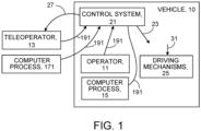
- the supervisory control may be asserted by a human operator 11 who is located either inside the vehicle or by a teleoperator 13 located outside the vehicle, for example, at a location remote from the vehicle. (In some implementations the supervisory control may be asserted by an in-vehicle computer process 15 or a remote process 171 alone or in combination with a human operator.) The supervisory control can be asserted by supervisory commands 191 provided by the human operator (or the computer process).
- a supervisory command expresses an objective (such as a movement or maneuver) to be attained in operation of the vehicle.
- the objective expressed by a supervisory command is not expressed at the high level of, for example, a sequence of roads to be followed to reach a destination or a turn to be made from one denominated (named or numbered) road to another according to a planned route, nor is it expressed at the low level, for example, of control inputs to the accelerator, brake, steering, or other driving mechanisms of the vehicle.
- the supervisory command could express a short-term movement objective, such as a changing the vehicle's lane of travel on a road network or taking an off-ramp of a limited access road, or stopping the vehicle at the next available location on a street, to name a few.
- a short-term movement objective such as a changing the vehicle's lane of travel on a road network or taking an off-ramp of a limited access road, or stopping the vehicle at the next available location on a street, to name a few.
- supervisory control and supervisory commands can take advantage of physical features of roads and other man-made traveling paths, including features that permit alternative short-run paths along a segment of a route.
- highways typically have multiple lanes, shoulders, ramps, rest areas, and other features that can be the subject of selections made by a human operator (or a computer process) for a variety of purposes.
- Supervisory control and supervisory commands can relate to navigating intersections, passing slow-moving vehicles, or making turns from street to street within the street network of an urban environment.
- the supervisory commands are selected or specified (we sometimes use the term "selected” broadly to include making a choice among presented options or specifying or stating the objective or command even though alternative choices have not been presented or a combination of them) by a human operator.
- the human operator may or may not be a passenger in the vehicle.
- the human operator may make the selection using one or more of a number of possible input modalities, for example, by clicking on a display screen using a mouse, speaking the objective or selection, touching a touch-sensitive display screen, or entering information (to name a few), to achieve an objective (e.g., a travel lane of the vehicle or a turn direction). Travel lanes are also sometimes known as "lane corridors".
- the selected supervisory command is provided to the control system 21 of the vehicle (either directly within the vehicle or wirelessly from the location of a remote human operator to the vehicle). Then, the control system 21 of the self-driving vehicle uses algorithms to determine a sequence of steering wheel, brake, and throttle inputs 23, to cause the vehicle to execute the inputs to achieve the objective expressed by the supervisory command, while avoiding collisions with obstacles (e.g. other vehicles, cyclists, pedestrians, etc.) and adhering to the rules of the road (e.g. obeying traffic signage and signals and adhering to proper precedence in intersections).
- obstacles e.g. other vehicles, cyclists, pedestrians, etc.
- adhering to the rules of the road e.g. obeying traffic signage and signals and adhering to proper precedence in intersections.
- the systems and techniques that we describe here therefore provide a way to control a vehicle that is at least, in part, in contrast to direct control of the vehicle's steering, throttle, brakes, or other driving mechanisms 25 by a human operator sitting in a driver's seat of the vehicle.
- the supervisory control of the vehicle using supervisory commands need not fully substitute either for fully autonomous control of a vehicle or for fully human control of the vehicle. Rather, any two or all three of the modalities (fully autonomous, fully human, supervisory control) can be used cooperatively, or from time to time, to control the vehicle.
- supervisory control is used by a human operator inside the vehicle, and is a convenient way to command a vehicle's travel at a higher conceptual or supervisory level without having to constantly monitor and adjust the steering, throttle, and braking levels.
- the supervisory control mode therefore results in a more comfortable and less stressful driving experience.
- Teleoperation is a useful approach to controlling vehicles that are unoccupied (e.g., a self-driving taxi that has dropped off a passenger and is in route to pick up another passenger) or is occupied by a passenger who has become incapacitated or otherwise requires assistance.
- a remotely located teleoperator views a data stream 27 from the vehicle comprised of, for example, a forward-looking video stream collected by one or more cameras on the vehicle.
- the teleoperator selects a short-term movement or maneuver or other supervisory objective for the vehicle's control system to execute or achieve, for example, switching to a different travel lane or to a different upcoming roadway.
- the short-term supervisory control objective is wirelessly transmitted as a supervisory command to a control computer or other control system 21 located on board the vehicle, which subsequently develops and executes the series of inputs 23 to the vehicle necessary to achieve the objective within the given road conditions.
- the supervisory character of the supervisory commands can be especially useful if the communication link between the teleoperator and vehicle is subject to communication delays (i.e., latency).
- latency i.e., it can be difficult for a remote teleoperator to designate a sequence of steering wheel, brake, and throttle inputs to accurately control the vehicle along a desired path or maneuver.
- aspects of the lane-based or other supervisory control described here use supervisory commands that typically are presented at a much lower frequency and produce vehicle motion that is robust to the degrading effects of latency.
- a supervisory command representing a short-term objective such as lane-based control
- an operator inside the vehicle can control the vehicle using supervisory commands when the operator so desires and allow a teleoperator to control the vehicle under certain conditions (e.g., if the operator becomes incapacitated).
- both an in-vehicle and a remote operator can be selecting non-conflicting supervisory commands at essentially the same time; in case of conflicts between supervisory commands provided from the vehicle and from the remote operator, a conflict resolution mechanism can be used to mediate the conflict.
- the systems and techniques that we describe here therefore enable controlling operation of a vehicle by an operator either inside the vehicle or outside the vehicle (e.g., at a remote location) by selecting a supervisory command or otherwise identifying a short-term maneuver or other objective, for example, a desired lane of travel for the vehicle on a road network.
- self-driving (or autonomous) vehicle broadly to include, for example, any mobile device that carries passengers or objects or both from one or more pick-up locations to one or more drop-off locations, without always (or in some cases ever) requiring direct control or supervision by a human operator, for example, without requiring a human operator to take over control responsibility at any time.
- self-driving vehicles are self-driving road vehicles, self-driving off-road vehicles, self-driving delivery vehicles, self-driving cars, self-driving buses, self-driving vans or trucks, drones, or aircraft, among others.
- supervisory control by a human operator can be applied to a fully self-driving vehicle or to a non-fully-self-driving vehicle (which is also sometimes known as a "partially automated" vehicle).
- regulatory data or sometimes, the term “rules of operation” or “rules of the road” broadly to include, for example, regulations, laws, and formal or informal rules governing the behavior patterns of users of devices, such as road users including vehicle drivers. These include rules of the road as well as best practices and passenger or operator preferences, described with similar precision and depth.
- historical information broadly to include, for example statistical data on behavior patterns of road users, including pedestrians, and cyclists, in each case possibly as a function of location, time of day, day of the week, seasonal and weather data, or other relevant features, or combinations of them.
- supervisory control broadly to include, for example, any kind of control that occurs with a frequency less often than is required for the direct control inputs 31 to the accelerator, brake, steering, or other driving mechanisms 25 of a vehicle or applies to a time frame that is longer than the time frame associated with each of such direct control inputs or applies to a travel distance that is longer than the minimal distance to which a typical control input to the driving mechanisms of the car applies.
- the frequency of supervisory control may be less than once every few seconds or once every minute or once every few minutes or even less frequently.
- the time frame to which the supervisory control applies may be, in some cases, longer than a few seconds or longer than a few minutes.
- the travel distance to which a supervisory control applies may, for instance, be greater than a few hundred feet or greater than a mile or greater than a few miles.
- object broadly to include, for example, a travel goal or maneuver relative to the physical features of roads and other man-made traveling paths, including features that permit alternative short-run paths or maneuvers along a segment of a route.
- supervisory command broadly to include, for example, any statement, selection, choice, identification, or other expression of a supervisory control objective made in any manner or by any action or gesture or utterance through any kind of an interface, including a human user interface.
- the vehicle in some implementations that involve facilitating the operation of a self-driving road (or other) vehicle 10, for example, the vehicle can be driven without direct human control or supervisory control through an environment 12, while avoiding collisions with obstacles 14 (such as other vehicles, pedestrians, cyclists, and environmental elements) and obeying the rules of operation (rules of the road 16, for example).
- the vehicle e.g., the computer system or data processing equipment 18 (see also figure 9 ) associated with, for example attached to, the vehicle
- a world model is a representation of the environment of the vehicle, e.g., constructed using data from a geolocation device, a map, or geographic information system or combinations of them, and sensors that detect other vehicles, cyclists, pedestrians, or other obstacles.
- the computer system e.g., aboard the vehicle, collects data from a variety of sensors 22 (e.g., LIDAR, monocular or stereoscopic cameras, RADAR) that are mounted to the vehicle (which we sometimes refer to as the "ego vehicle"), then analyzes this data to determine the positions and motion properties (which we sometimes refer to as obstacle information 24) of relevant objects (obstacles) in the environment.
- sensors 22 e.g., LIDAR, monocular or stereoscopic cameras, RADAR
- relevant objects broadly includes, for example, other vehicles, cyclists, pedestrians, and animals, as well as poles, curbs, traffic cones, traffic signs, traffic signals, and barriers. There may also be objects in the environment that are not relevant, such as small roadside debris and vegetation. In some instances, self-driving vehicles also rely on obstacle information gathered by vehicle-to-vehicle or vehicle-to-infrastructure communication 26.
- the computer system aboard the self-driving vehicle employs an algorithmic process 28 to automatically generate a candidate trajectory set 30 and execute a selected trajectory 31 of the set (determined by a trajectory selection process 37) through the environment toward a designated goal 32 and, in response to supervisory commands 191 that it may receive along the way, select alternate trajectories.
- the term trajectory set broadly includes, for example, a set of paths or routes from one place to another, e.g., from a pickup location to a drop off location.
- a trajectory can comprise a sequence of transitions each from one world state to a subsequent world state.
- the designated goal is generally provided by an algorithmic process 34 that relies, for example, on passenger-provided information 35 about a passenger's destination or a goal destination provided by an algorithmic process or a combination of the two.
- the word "goal” is used broadly to include, for example, the objective to be reached by the self-driving or other vehicle, such as, an interim drop off location, a final drop off location, a destination, among others, or maintaining a present course.
- the term “passenger” is used broadly to include, for example, one or more human beings who are carried by the self-driving or other vehicle, or a party who determines a destination for an object to be carried by a self-driving vehicle, among other things. In some instances, the party is remote to the vehicle and provides goal information to the vehicle prior to or during operation.
- the goal to be reached (or other objective to be attained) by the self-driving or other vehicle is not a physical location, but a command to maintain a course or speed of the vehicle, without a pre-determined destination, or to proceed on a certain course (e.g., traveling in a compass direction).
- the automatically generated candidate trajectory set 30 can contain one or more trajectories each possessing at least the following properties:
- Automated candidate trajectory generation should satisfy the three properties described above, in a context in which the environment (e.g., the road) is shared with other independent agents 21, including vehicles, pedestrians, and cyclists, who move independently under their own wills.
- the environment e.g., the road
- other independent agents 21 including vehicles, pedestrians, and cyclists, who move independently under their own wills.
- Automated candidate trajectory generation also should systematically ensure that the driving rules will be correctly obeyed by the ego vehicle in complex scenarios involving several relevant driving rules or the presence of numerous obstacles, or scenarios in which there does not exist a trajectory that would comply with all of the driving rules, or combinations of two or more of such conditions.
- a trajectory selection process 37 choses a trajectory 31 for the vehicle to follow.
- the trajectory selection process is responsive to supervisory commands 191 provided by, for example, a driver or other passenger at the vehicle or a remote teleoperator.
- the supervisory commands may involve, for example, selecting a travel lane, turning onto a different roadway, changing velocity, stopping travel, or other typical movement or other objectives.
- the trajectory selection process determines if a candidate trajectory exists that satisfies the supervisory command and selects a qualifying candidate trajectory as the selected trajectory.
- control actions for the vehicle can be based on real-time sensor data and historical information that enable the vehicle to respond safely and reliably to supervisory commands provided by a passenger or a teleoperator, while driving on, for example, a road network shared with other vehicles and pedestrians and complying with the applicable driving rules.
- an example system 50 can include some or all of the following basic elements:
- a display device is located in a remote location such as an office, where it can be viewed by a teleoperator.
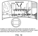
- the display device is a standard video monitor 200, a head-mounted virtual reality display device, an in-vehicle head-up display 220 ( figure 19 ), a display device mounted in the vehicle center console or embedded in the back of the front seats (to be visible to occupants in the rear of the vehicle) or mounted elsewhere in the vehicle, or may take on other forms.
- a steering wheel 230 can include buttons 232 by which the operator can send supervisory commands for given maneuvers, and a central electronic display of simple intuitive icons 234 that represent alternatives (in this case lane changes to the left or right) from which a user can select.
- An input device 53 (as illustrated in figures 18 , 19 , and 20 ) connected to, or embedded within, the display device 70, and connected to the computer system 18 (and therefore located either aboard the vehicle or at a remote location, or both), which in its typical state allows an operator located either inside the vehicle or at a remote location to select a supervisory objective or a supervisory command that expresses a supervisory objective, for example, one of potentially multiple travel lanes containing safe trajectories, and, in some instances, also specify a desired speed of the vehicle.
- any one or more (or a combination) of a broad variety of maneuvers can be specified by the operator through the input device including lane changes, u-turns (say, by using a "u-turn” button), pulling off onto a shoulder, parking, multipoint turns, or taking a ramp, to name a few.
- the operator designates the general desired path of the vehicle without having to provide specific steering, brake, and throttle commands at high frequency.
- the input device 53 can assume many forms, including a touchscreen (that would enable an operator to touch a part of the screen to indicate a travel lane), a mouse or trackball, or a keyboard, or a visual system or an audio system that can interpret the operator's gestures or utterances or combinations of two or more of them.
- the input device can also take the form of a standard steering wheel and pedal set (e.g.. brake and throttle), in which case the operator can designate a desired travel lane by steering the wheel to indicate a desired maneuver (i.e. turning the wheel to the right would indicate a desire to choose a travel lane to the right of the vehicle), and actuate the pedals to adjust a desired vehicle speed setpoint.
- a standard steering wheel and pedal set e.g. brake and throttle
- an input device is located in a remote location such as an office or in another vehicle such as a van or trailer, where it can be viewed by a teleoperator.
- a remote location such as an office or in another vehicle such as a van or trailer, where it can be viewed by a teleoperator.
- the teleoperation scenario does not preclude the use of a steering wheel and pedals as an input device at the remote location.
- an operational state of the input device allows an operator located inside the vehicle or at a remote location to directly command the position of the vehicle steering wheel, brake, and throttle, select the gear, and activate turn signals, hazard lights, and other indicators, in other words, to drive the vehicle in the conventional way.
- this form of direct vehicle control may have disadvantages in certain cases (e.g., when the communication link between the teleoperator and vehicle is subject to long communication delays), in certain instances it is useful as a back-up control mode, for example, in scenarios in which it is not possible to safely execute lane-based or other supervisory control, e.g., in cases where a collision has resulted in damage to certain vehicle sensors that are required for lane-based or other supervisory control.
- a wireless communication device 72 configured, among other things, to transmit data from a remotely located database to the vehicle and to transmit data to a remotely located database.
- the transmitted data includes video information captured from a camera showing the scene ahead of or behind the vehicle or both.
- the transmitted data carries a wide variety of additional information including, for example, the operation, state, or condition of the vehicle, the trajectory of the vehicle, the optimal trajectory, information related to maps, information derived from one or more of the sensors, information about obstacles, alerts of various types, and other information, and combinations of any two or more of them.
- a vehicle 10 having features and functions (e.g., actuators) that are instrumented to receive and act upon direct commands 76 corresponding to control actions (e.g., steering, acceleration, deceleration, gear selection) and for auxiliary functions (e.g., turn indicator activation) from the computer system.
- control actions e.g., steering, acceleration, deceleration, gear selection
- auxiliary functions e.g., turn indicator activation
- direct command is used broadly to include, for example, any instruction, direction, mandate, request, or call, or combination of them, that is delivered to the operational features and functions of the vehicle.
- control action is used broadly to include, for example, any action, activation, or actuation that is necessary, useful, or associated with causing the vehicle to proceed along at least a part of a trajectory or to perform some other operation.
- control inputs broadly to refer to signals, instructions, or data that are sent to cause control actions to occur.
- (L) A memory 65 to which the computer system 18 has access on the vehicle to store, for example, any of the data and information mentioned above.
- FIG. 3 Described below, and as shown in figure 3 (and referring also to figure 9 ) is an example technique 80 for supervisory control (e.g., lane-based control) of a vehicle by a remote teleoperator or by an operator located inside the vehicle, resulting in a set or sequence of control actions 82 used by actuators or other driving mechanisms 87 (e.g., the features and functions of the vehicle that can respond to control actions) and based on real-time sensor data, other data sources, and historical information.
- the techniques comprise at least the following processes that are run on the computer system 18 in the vehicle 10 (the steps in an exemplary process are shown in figure 4 :
- Quantities expressed as part of the world state include, but are not limited to, statistics on: the current position, velocity, and acceleration of the ego vehicle; estimates of the types, positions, velocities, and current intents of other nearby vehicles, pedestrians, cyclists, scooters, carriages, carts, and other moving objects or obstacles; the positions and types of nearby static obstacles (e.g., poles, signs, curbs, traffic marking cones and barrels, road dividers, trees); and the positions, types and information content of road markings, road signs, and traffic signals.
- nearby static obstacles e.g., poles, signs, curbs, traffic marking cones and barrels, road dividers, trees
- the world state also includes information about the roadway's physical properties, such as the number of vehicular and cyclist travel lanes, lane width, lane traffic direction, lane marker type and location, and the spatial locations of road features such as crosswalks, traffic signs, and traffic signals.
- the world state 88 contains probabilistic estimates of the states of the ego vehicle and of nearby vehicles, including maximum likelihood estimate, error covariance, and sufficient statistics for the variables of interest.
- the computer system 18 usefully functions in the absence of a complete set of the quantities listed above.
- one or more of the computed quantities described in 1 through 11 above are stored in the memory unit on the vehicle.
- a planning process 90 as also shown in figure 6 , which takes as an input a world state 88 (e.g., a data structure of the form of the output of the world model) and employs known numerical or analytical methods in order to estimate or predict a set of trajectories (i.e., a sequence of states indexed by time), known as the feasible trajectory set 98 as of that time, that the physical ego vehicle could feasibly follow from the given time to some future time.
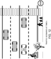
- Figure 12 shows a schematic view of a world state of an ego vehicle at a given time.
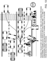
- Figure 13 illustrates a corresponding feasible trajectory set.
- the term "feasibly” is used broadly to include, for example, a circumstance in which a trajectory can be followed by the vehicle with a reasonable degree of precision at the vehicle's current or expected operating speed, given the current road geometry, road surface conditions, and environmental conditions.
- Typical algorithmic methods employed in the planning process include methods based on state lattices, rapidly exploring random trees, numerical optimization, and others.
- the feasible trajectory set typically contains multiple trajectories but, in some instances, contains one or zero trajectories.
- a pruning process 110 as also shown in figure 7 , which takes as an input a world state 88 and the feasible trajectory set 98, and eliminates from further analysis any trajectory that is determined to be in collision with any static or dynamic object or obstacle identified in the world model process or predicted to be in collision at some future time, by employing known collision checking methods.
- Figure 14 illustrates a candidate trajectory set resulting from a pruning process based on the trajectory set of figure 13 .
- the pruning process also eliminates from further analysis any trajectory that crosses the boundaries of the drivable road surface, either by departing the roadway or crossing into an oncoming lane of traffic in a manner that could lead to collision with an oncoming vehicle, by employing analysis of the geometric properties of both the trajectory and the boundaries of the drivable road surface. If analysis suggests that it is safe to cross into an oncoming lane of traffic, for the purpose of passing a slow-moving or parked car, or executing a multi-point turn or U turn, then such trajectories may be ignored by the pruning process. If analysis suggests that it is safe to cross the boundary of the road surface onto a road shoulder, then such trajectories may be ignored by the pruning process.
- the pruning process also eliminates from further consideration any trajectory that violates local rules of operation or rules of the road, common driving practices, or the driving preferences of a general class of passenger or a particular passenger or a combination of any two or more of those factors.
- the pruning process also eliminates from further consideration any trajectory that fails to satisfy a condition related to the "cost" of the trajectory, where the cost can be determined through analysis of any number of properties relevant to the driving task, including the geometric properties of the trajectory (which influences the comfort that would be experienced by passengers when traveling along the trajectory), the type, frequency of incidence, and severity of violation of local rules of operation or rules of the road, common driving practices, or the driving preferences of a general class of passenger or a particular passenger associated with the trajectory.
- the output of the pruning process is known as the candidate trajectory set 119 as of that time.
- a lane identification process 110 which takes as an input a world state 88 and a candidate trajectory set 119, and identifies none, one, or more than one candidate travel lanes in which the ego vehicle may safely travel from the given time to some future time.
- a candidate travel lane is conceived as a tube-like structure that contains one or more candidate trajectories, and may be confined to a single travel lane (i.e., the current travel lane of the ego vehicle), or may exhibit one or more lane changes.
- Candidate travel lanes are generated by identifying connected lane segments that contain a candidate trajectory, by analysis of the spatial properties of both the candidate trajectory and road network.
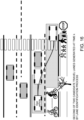
- Figures 15 and 16 illustrate respectively two candidate travel lanes generated by a lane identification process based on the candidate trajectory set of figure 14 .
- a candidate travel lane does not necessarily align with marked lanes on a street, road, or highway, and a candidate travel lane may overlap or lie within a shoulder.
- the output of the lane identification process is known as the candidate travel lane set 121 as of that time.
- the candidate travel lane set (or other candidate travel path set) is presented to an operator located, for example, either inside the vehicle or at a remote location, or both, through a variety of display media and methods, including presentation of iconic representations associated with candidate travel lanes ( figure 20 ), presentation of translucent overlays associated with each candidate travel lane on a heads up display ( figure 19 ) to an operator located inside the vehicle, or presentation of translucent overlays associated with each candidate travel lane atop a video stream captured by an on-vehicle camera and displayed to a remote vehicle operator on a video screen ( figure 18 ) or a virtual reality head-mounted display, among other approaches.
- an estimate of the free space could be displayed to the operator based on sensor and map data; the operator then could specify a geometric path that the planned path should be close to, or avoidance constrains, for use by the planner.
- a lane (or other type of travel path) selection process 120 which takes as an input a candidate travel lane (or other travel path) set 121 and, in some instances, takes as an input a supervisory command 191 provided through an input device(s) by an operator located, for example, either inside the vehicle or at a remote location.
- the input from the operator identifies or otherwise selects one of potentially multiple travel lanes (or other types of travel paths) within the candidate set as the desired lane or path of travel for the ego vehicle.
- the input device is a traditional vehicle steering wheel and pedal set, or a touch screen, mouse, speech command recognition system, or other general input device, or combinations of them.
- the input device in addition to providing a means for lane selection or other maneuvers, the input device also allows an operator to activate vehicle lights (e.g., signal, hazard, and headlights), the vehicle horn, locks, and other standard functions.
- the travel lane (or other travel path) most closely associated with the current travel lane or path is chosen as the desired lane of travel. This can be accomplished, for example, by analyzing all candidate travel lanes in the candidate travel lane set, and computing a metric related to the degree of geometry similarity between the current travel lane and all candidate travel lanes. The candidate travel lane with the highest degree of geometry similarity to the current travel lane is selected as the desired lane of travel.
- the output of the lane selection process is known as the selected travel lane 131 (or in other examples, the selected travel path).
- an emergency stop procedure may be initiated, in which the vehicle automatically applies maximum braking effort or decelerates at a more comfortable rate, so long as the vehiclewill not hit an object along its current path.
- a lane-based or other supervisory control process 140 (see figure 4 ), which takes as an input the desired lane or path of travel and generates a sequence of control actions 82 used by actuators (e.g., the features and functions of the vehicle that can respond to control actions) to guide the vehicle through the desired lane of travel or other movement or objective.
- actuators e.g., the features and functions of the vehicle that can respond to control actions
- Possible ways to guide a vehicle along a desired travel lane with defined lane boundaries are numerous, and include exemplary methods such as the following:
- lane change signals may be automatically activated at the appropriate time.
- hazard lights may be automatically activated at the appropriate time.
- supervisory commands made be selected or expressed by a machine or by a machine in combination with a human operator.
Landscapes
- Engineering & Computer Science (AREA)
- Automation & Control Theory (AREA)
- Transportation (AREA)
- Mechanical Engineering (AREA)
- Physics & Mathematics (AREA)
- Remote Sensing (AREA)
- Radar, Positioning & Navigation (AREA)
- General Physics & Mathematics (AREA)
- Aviation & Aerospace Engineering (AREA)
- Human Computer Interaction (AREA)
- Evolutionary Computation (AREA)
- Medical Informatics (AREA)
- Multimedia (AREA)
- Computer Vision & Pattern Recognition (AREA)
- Electromagnetism (AREA)
- Business, Economics & Management (AREA)
- Health & Medical Sciences (AREA)
- Artificial Intelligence (AREA)
- Game Theory and Decision Science (AREA)
- Chemical & Material Sciences (AREA)
- Combustion & Propulsion (AREA)
- Mathematical Physics (AREA)
- Optics & Photonics (AREA)
- Control Of Driving Devices And Active Controlling Of Vehicle (AREA)
- Traffic Control Systems (AREA)
Description
- This description relates to supervisory control of vehicles.
- Human or autonomous driving of vehicles poses risks associated with how the vehicle is driven in light of the state of the vehicle and the state of the environment, including other vehicles and obstacles.
- A human driver normally can control a vehicle to proceed safely and reliably to a destination on, for example, a road network shared with other vehicles and pedestrians, while complying with applicable rules of the road. For a self-driving (we sometimes use the term "self-driving" interchangeably with "autonomous") vehicle, a sequence of control actions can be generated based on real-time sensor data, geographic data (such as maps), regulatory and normative data (rules of the road), and historical information (such as traffic patterns).
-
US 2016/139594 A1 describes devices, systems, and methods for remotely operating an autonomous passenger vehicle. When an autonomous vehicle encounters an unexpected driving environment unsuitable for autonomous operation, such as road construction or an obstruction, vehicle sensors can capture data about the vehicle and the unexpected driving environment, including images, radar and lidar data, etc. The captured data can be sent to a remote operator. The remote operator can manually operate the vehicle remotely or issue commands to the autonomous vehicle to be executed by on various vehicle systems. -
US 2015/248131 A1 describes systems and methods that enable an autonomous vehicle to request assistance from a remote operator in certain predetermined situations. One example method includes determining a representation of an environment of an autonomous vehicle based on sensor data of the environment. Based on the representation, the method may also include identifying a situation from a predetermined set of situations for which the autonomous vehicle will request remote assistance. The method may further include sending a request for assistance to a remote assistor, the request including the representation of the environment and the identified situation. The method may additionally include receiving a response from the remote assistor indicating an autonomous operation. The method may also include causing the autonomous vehicle to perform the autonomous operation. -
US 2015/346724 A1 describes a method and apparatus for providing autonomous control of a vehicle. A vehicle can be manually controlled by an operator. An autonomous system can monitor the operator's control inputs and the environment of the vehicle to determine whether the control inputs result in safe operation of the vehicle. If control inputs are not safe, then the autonomous system can modify the operator's unsafe inputs into safe inputs. In various instances, the autonomous system can operate the vehicle without operator input. In the event an operator attempts to apply control inputs to the vehicle while the autonomous system is otherwise in control, the autonomous system can check to see whether the operator's inputs result in safe operation of the vehicle. If the operator's control inputs are safe, then the autonomous system can replace its autonomous commands with the operator's commands. - The invention is defined by the appended claims.
-
-
Figure 1 is a block diagram of a vehicle. -
Figure 2 is a block diagram of a system for generating control actions. -
Figure 3 is a block diagram of a vehicle. -
Figure 4 is a flow diagram of processes to generate control actions. -
Figure 5 is a schematic diagram of a world model process. -
Figure 6 is a block diagram of a planning process. -
Figure 7 is a block diagram of a pruning process. -
Figure 8 is a block diagram. -
Figure 9 is a block diagram of a computer system. -
Figure 10 is a flow diagram of a lane identification process. -
Figure 11 is a flow diagram of a lane selection process. -
Figure 12 is a schematic view of a traffic scenario. -
Figure 13 is a schematic view of feasible trajectories. -
Figure 14 is a schematic view of a candidate trajectory set. -
Figures 15 and16 are schematic views of first and second candidate travel lanes. -
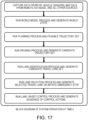
Figure 17 is a block diagram at time k. -
Figures 18 ,19 , and20 are displays. - As shown in
Figure 1 , here we describe ways to assert supervisory control of the operation of avehicle 10. The supervisory control may be asserted by ahuman operator 11 who is located either inside the vehicle or by ateleoperator 13 located outside the vehicle, for example, at a location remote from the vehicle. (In some implementations the supervisory control may be asserted by an in-vehicle computer process 15 or aremote process 171 alone or in combination with a human operator.) The supervisory control can be asserted bysupervisory commands 191 provided by the human operator (or the computer process). - A supervisory command expresses an objective (such as a movement or maneuver) to be attained in operation of the vehicle. In general, the objective expressed by a supervisory command is not expressed at the high level of, for example, a sequence of roads to be followed to reach a destination or a turn to be made from one denominated (named or numbered) road to another according to a planned route, nor is it expressed at the low level, for example, of control inputs to the accelerator, brake, steering, or other driving mechanisms of the vehicle. Rather, in some implementations, the supervisory command could express a short-term movement objective, such as a changing the vehicle's lane of travel on a road network or taking an off-ramp of a limited access road, or stopping the vehicle at the next available location on a street, to name a few.
- Thus, the supervisory control and supervisory commands can take advantage of physical features of roads and other man-made traveling paths, including features that permit alternative short-run paths along a segment of a route. For example, highways typically have multiple lanes, shoulders, ramps, rest areas, and other features that can be the subject of selections made by a human operator (or a computer process) for a variety of purposes. Supervisory control and supervisory commands can relate to navigating intersections, passing slow-moving vehicles, or making turns from street to street within the street network of an urban environment.
- In some implementations of the systems and techniques that we describe here, the supervisory commands are selected or specified (we sometimes use the term "selected" broadly to include making a choice among presented options or specifying or stating the objective or command even though alternative choices have not been presented or a combination of them) by a human operator. The human operator may or may not be a passenger in the vehicle. The human operator may make the selection using one or more of a number of possible input modalities, for example, by clicking on a display screen using a mouse, speaking the objective or selection, touching a touch-sensitive display screen, or entering information (to name a few), to achieve an objective (e.g., a travel lane of the vehicle or a turn direction). Travel lanes are also sometimes known as "lane corridors".
- The selected supervisory command is provided to the
control system 21 of the vehicle (either directly within the vehicle or wirelessly from the location of a remote human operator to the vehicle). Then, thecontrol system 21 of the self-driving vehicle uses algorithms to determine a sequence of steering wheel, brake, andthrottle inputs 23, to cause the vehicle to execute the inputs to achieve the objective expressed by the supervisory command, while avoiding collisions with obstacles (e.g. other vehicles, cyclists, pedestrians, etc.) and adhering to the rules of the road (e.g. obeying traffic signage and signals and adhering to proper precedence in intersections). - In some implementations, the systems and techniques that we describe here therefore provide a way to control a vehicle that is at least, in part, in contrast to direct control of the vehicle's steering, throttle, brakes, or
other driving mechanisms 25 by a human operator sitting in a driver's seat of the vehicle. In some implementations of the systems and techniques that we describe here, the supervisory control of the vehicle using supervisory commands need not fully substitute either for fully autonomous control of a vehicle or for fully human control of the vehicle. Rather, any two or all three of the modalities (fully autonomous, fully human, supervisory control) can be used cooperatively, or from time to time, to control the vehicle. - In some implementations, supervisory control is used by a human operator inside the vehicle, and is a convenient way to command a vehicle's travel at a higher conceptual or supervisory level without having to constantly monitor and adjust the steering, throttle, and braking levels. The supervisory control mode therefore results in a more comfortable and less stressful driving experience.
- In addition to or in combination with in-vehicle supervisory control, supervisory control of a vehicle is useful for controlling the vehicle remotely (we sometimes refer to this as "teleoperation"). Teleoperation is a useful approach to controlling vehicles that are unoccupied (e.g., a self-driving taxi that has dropped off a passenger and is in route to pick up another passenger) or is occupied by a passenger who has become incapacitated or otherwise requires assistance. In such a scenario, a remotely located teleoperator views a
data stream 27 from the vehicle comprised of, for example, a forward-looking video stream collected by one or more cameras on the vehicle. The teleoperator then selects a short-term movement or maneuver or other supervisory objective for the vehicle's control system to execute or achieve, for example, switching to a different travel lane or to a different upcoming roadway. The short-term supervisory control objective is wirelessly transmitted as a supervisory command to a control computer orother control system 21 located on board the vehicle, which subsequently develops and executes the series ofinputs 23 to the vehicle necessary to achieve the objective within the given road conditions. - In such a teleoperation scenario, the supervisory character of the supervisory commands, for example, lane-based control, can be especially useful if the communication link between the teleoperator and vehicle is subject to communication delays (i.e., latency). In such instances, it can be difficult for a remote teleoperator to designate a sequence of steering wheel, brake, and throttle inputs to accurately control the vehicle along a desired path or maneuver. In contrast, aspects of the lane-based or other supervisory control described here use supervisory commands that typically are presented at a much lower frequency and produce vehicle motion that is robust to the degrading effects of latency.
- As noted above, in some implementations, it is useful to enable a supervisory command representing a short-term objective, such as lane-based control, to be selected either on board the vehicle or using teleoperation. In some cases, an operator inside the vehicle can control the vehicle using supervisory commands when the operator so desires and allow a teleoperator to control the vehicle under certain conditions (e.g., if the operator becomes incapacitated). In some cases, both an in-vehicle and a remote operator can be selecting non-conflicting supervisory commands at essentially the same time; in case of conflicts between supervisory commands provided from the vehicle and from the remote operator, a conflict resolution mechanism can be used to mediate the conflict.
- The systems and techniques that we describe here therefore enable controlling operation of a vehicle by an operator either inside the vehicle or outside the vehicle (e.g., at a remote location) by selecting a supervisory command or otherwise identifying a short-term maneuver or other objective, for example, a desired lane of travel for the vehicle on a road network.
- We use the term "self-driving (or autonomous) vehicle" broadly to include, for example, any mobile device that carries passengers or objects or both from one or more pick-up locations to one or more drop-off locations, without always (or in some cases ever) requiring direct control or supervision by a human operator, for example, without requiring a human operator to take over control responsibility at any time. Some examples of self-driving vehicles are self-driving road vehicles, self-driving off-road vehicles, self-driving delivery vehicles, self-driving cars, self-driving buses, self-driving vans or trucks, drones, or aircraft, among others. Although control by a human operator is not required, as we discuss here, supervisory control by a human operator (either in the vehicle or remotely) can be applied to a fully self-driving vehicle or to a non-fully-self-driving vehicle (which is also sometimes known as a "partially automated" vehicle).
- We use the term "regulatory data" (or sometimes, the term "rules of operation" or "rules of the road") broadly to include, for example, regulations, laws, and formal or informal rules governing the behavior patterns of users of devices, such as road users including vehicle drivers. These include rules of the road as well as best practices and passenger or operator preferences, described with similar precision and depth. We use the term "historical information" broadly to include, for example statistical data on behavior patterns of road users, including pedestrians, and cyclists, in each case possibly as a function of location, time of day, day of the week, seasonal and weather data, or other relevant features, or combinations of them.
- We use the term "supervisory control" broadly to include, for example, any kind of control that occurs with a frequency less often than is required for the
direct control inputs 31 to the accelerator, brake, steering, orother driving mechanisms 25 of a vehicle or applies to a time frame that is longer than the time frame associated with each of such direct control inputs or applies to a travel distance that is longer than the minimal distance to which a typical control input to the driving mechanisms of the car applies. For example, the frequency of supervisory control may be less than once every few seconds or once every minute or once every few minutes or even less frequently. The time frame to which the supervisory control applies may be, in some cases, longer than a few seconds or longer than a few minutes. The travel distance to which a supervisory control applies may, for instance, be greater than a few hundred feet or greater than a mile or greater than a few miles. - We use the term "objective" broadly to include, for example, a travel goal or maneuver relative to the physical features of roads and other man-made traveling paths, including features that permit alternative short-run paths or maneuvers along a segment of a route.
- We use the term "supervisory command" broadly to include, for example, any statement, selection, choice, identification, or other expression of a supervisory control objective made in any manner or by any action or gesture or utterance through any kind of an interface, including a human user interface.
- Additional information about control of autonomous vehicles is set forth in
United States patent application serial 15/078,143, filed 3/23/2016 . - As shown in
figure 2 , in some implementations that involve facilitating the operation of a self-driving road (or other)vehicle 10, for example, the vehicle can be driven without direct human control or supervisory control through anenvironment 12, while avoiding collisions with obstacles 14 (such as other vehicles, pedestrians, cyclists, and environmental elements) and obeying the rules of operation (rules of theroad 16, for example). In the case of an autonomous vehicle, to accomplish automated driving, the vehicle (e.g., the computer system or data processing equipment 18 (see alsofigure 9 ) associated with, for example attached to, the vehicle) first generally constructs aworld model 20. - Roughly speaking, a world model is a representation of the environment of the vehicle, e.g., constructed using data from a geolocation device, a map, or geographic information system or combinations of them, and sensors that detect other vehicles, cyclists, pedestrians, or other obstacles. To construct the world model, the computer system, e.g., aboard the vehicle, collects data from a variety of sensors 22 (e.g., LIDAR, monocular or stereoscopic cameras, RADAR) that are mounted to the vehicle (which we sometimes refer to as the "ego vehicle"), then analyzes this data to determine the positions and motion properties (which we sometimes refer to as obstacle information 24) of relevant objects (obstacles) in the environment. The term "relevant objects" broadly includes, for example, other vehicles, cyclists, pedestrians, and animals, as well as poles, curbs, traffic cones, traffic signs, traffic signals, and barriers. There may also be objects in the environment that are not relevant, such as small roadside debris and vegetation. In some instances, self-driving vehicles also rely on obstacle information gathered by vehicle-to-vehicle or vehicle-to-
infrastructure communication 26. - Given the world model, the computer system aboard the self-driving vehicle employs an
algorithmic process 28 to automatically generate a candidate trajectory set 30 and execute a selectedtrajectory 31 of the set (determined by a trajectory selection process 37) through the environment toward a designatedgoal 32 and, in response tosupervisory commands 191 that it may receive along the way, select alternate trajectories. The term trajectory set broadly includes, for example, a set of paths or routes from one place to another, e.g., from a pickup location to a drop off location. In some implementations, a trajectory can comprise a sequence of transitions each from one world state to a subsequent world state. - The designated goal is generally provided by an
algorithmic process 34 that relies, for example, on passenger-providedinformation 35 about a passenger's destination or a goal destination provided by an algorithmic process or a combination of the two. The word "goal" is used broadly to include, for example, the objective to be reached by the self-driving or other vehicle, such as, an interim drop off location, a final drop off location, a destination, among others, or maintaining a present course. The term "passenger" is used broadly to include, for example, one or more human beings who are carried by the self-driving or other vehicle, or a party who determines a destination for an object to be carried by a self-driving vehicle, among other things. In some instances, the party is remote to the vehicle and provides goal information to the vehicle prior to or during operation. - In some instances, the goal to be reached (or other objective to be attained) by the self-driving or other vehicle is not a physical location, but a command to maintain a course or speed of the vehicle, without a pre-determined destination, or to proceed on a certain course (e.g., traveling in a compass direction).
- The automatically generated candidate trajectory set 30 can contain one or more trajectories each possessing at least the following properties:
- 1) It should be feasible, e.g., can be followed by the vehicle with a reasonable degree of precision at the vehicle's current or expected operating speed;
- 2) It should be collision free, e.g., were the vehicle to travel along the trajectory, it would not collide with any objects; and
- 3) It should obey a predefined set of rules, which may include local rules of operation or rules of the road,
common driving practices 17, or the drivingpreferences 19 of a general class of passenger or a particular passenger or a combination of any two or more of those factors. Together these and possibly other similar factors are sometimes referred to generally as rules of operation (and we sometimes refer to rules of operation as driving rules). When no trajectory exists that obeys all predefined driving rules, the trajectory can minimize the severity and extent of rule violation. - Automated candidate trajectory generation should satisfy the three properties described above, in a context in which the environment (e.g., the road) is shared with other
independent agents 21, including vehicles, pedestrians, and cyclists, who move independently under their own wills. - Automated candidate trajectory generation also should systematically ensure that the driving rules will be correctly obeyed by the ego vehicle in complex scenarios involving several relevant driving rules or the presence of numerous obstacles, or scenarios in which there does not exist a trajectory that would comply with all of the driving rules, or combinations of two or more of such conditions.
- Given, the automatically generated candidate trajectory set, a
trajectory selection process 37 choses atrajectory 31 for the vehicle to follow. In addition to receiving the candidate trajectory set 30 and selecting thetrajectory 31, the trajectory selection process is responsive tosupervisory commands 191 provided by, for example, a driver or other passenger at the vehicle or a remote teleoperator. The supervisory commands may involve, for example, selecting a travel lane, turning onto a different roadway, changing velocity, stopping travel, or other typical movement or other objectives. In response to a supervisory command, the trajectory selection process determines if a candidate trajectory exists that satisfies the supervisory command and selects a qualifying candidate trajectory as the selected trajectory. - In some implementations of the systems and techniques that we describe here, control actions for the vehicle can be based on real-time sensor data and historical information that enable the vehicle to respond safely and reliably to supervisory commands provided by a passenger or a teleoperator, while driving on, for example, a road network shared with other vehicles and pedestrians and complying with the applicable driving rules.
- As shown in
figure 3 , anexample system 50 can include some or all of the following basic elements: - (A)
Sensors 52 able to measure or infer or both properties of the ego vehicle'sstate 54 andcondition 56, such as the vehicle's position, linear and angular velocity and acceleration, and heading. Such sensors include but are not limited to, e.g., GPS, inertial measurement units that measure both vehicle linear accelerations and angular rates, individual wheel speed sensors and derived estimates of individual wheel slip ratios, individual wheel brake pressure or braking torque sensors, engine torque or individual wheel torque sensors, and steering wheel angle and angular rate sensors, and combinations of them. The properties of the vehicle being sensed could also include the condition of software processes on the car, tire pressure, and mechanical faults, among others. - (B)
Sensors 58 able to measure properties of the vehicle'senvironment 12. Such sensors include but are not limited to, e.g., LIDAR, RADAR, monocular or stereo video cameras in the visible light, infrared, or thermal spectra, ultrasonic sensors, time-of-flight (TOF) depth sensors, as well as temperature and rain sensors, and combinations of them. Data from such sensors can be processed to yield information about the type, position, velocity, and estimated future motion of other vehicles, pedestrians, cyclists, scooters, carriages, carts, animals, and other moving objects. Data from such sensors can also be used to identify and interpret relevant objects and features such as static obstacles (e.g., poles, signs, curbs, traffic signals, traffic marking cones and barrels, road dividers, trees), road markings, and road signs. Sensors of this type are commonly available on vehicles that have a driver assistance capability or a highly automated driving capability (e.g., a self-driving vehicle). - (C)
Devices 60 able to communicate the measured or inferred or both properties of other vehicles' states and conditions, such as other vehicles' positions, linear and angular velocities and accelerations, and headings. These devices include Vehicle-to-Vehicle (V2) and Vehicle-to-Infrastructure (V2I) communication devices and devices for wireless communications over point-to-point or ad-hoc networks or both. The devices can operate across the electro-magnetic spectrum (including radio and optical communications) or other media (e.g., acoustic communications). - (D) Data sources providing historical, real-time, or predictive (or any two or more of them) data about the environment, including traffic congestion updates and weather conditions. In some instances, such data is stored on a
memory storage unit 65 on the vehicle or transmitted to the vehicle by wireless communication from a remotely located database. - (E)
Data sources 64 providing road maps drawn from GIS databases, potentially including high-precision maps of the roadway geometric properties, maps describing road network connectivity properties, maps describing roadway physical properties (such as the number of vehicular and cyclist travel lanes, lane width, lane traffic direction, lane marker type, and location), and maps describing the spatial locations of road features such as crosswalks, traffic signs of various types (e.g., stop, yield), and traffic signals of various types (e.g., red-yellow-green indicators, flashing yellow or red indicators, right or left turn arrows). In some instances, such data is stored on amemory unit 65 on the vehicle or transmitted to the vehicle by wireless communication from a remotely locateddatabase 67. - (F)
Data sources 66 providing historical information about driving properties (e.g. typical speed and acceleration profiles) of vehicles that have previously traveled along a given road section at a similar time of day. In some instances, such data is stored on a memory storage unit on the vehicle or transmitted to the vehicle through wireless communication from a remotely located database. - (G) A computer system 18 (data processor) located on the vehicle that is capable of executing
algorithms 69, e.g., as described in this application. The algorithms, among other things, process data provided by the above sources and (in addition to other results discussed below), compute potential trajectories that the ego vehicle may follow through the local environment over a short future time horizon (the time horizon can be, for example, on the order of 2-5 seconds, although, in some cases, the time horizon can be shorter (for example, fractions of seconds) or longer (for example tens of seconds, minutes, or many minutes). The algorithms can also jointly analyze the potential trajectories, the properties of the environment (e.g. the locations of neighboring vehicles and other obstacles), and the properties of the local road network (i.e. the positions and physical properties of travel lanes) to identify alternative travel lanes or other travel paths that contain safe trajectories for the ego vehicle to travel along. - (H) A display device or
devices 70 aboard the vehicle (or may also be located remotely for use by a teleoperator) that is connected to the computer system, to provide a wide variety of information to a vehicle operator or teleoperator. As shown infigure 18 , in some examples, this information includes avideo display 200 of the environment ahead of theego vehicle 202, and visual identification, in the form of a translucent overlay, colored outline, orother format 204, of travel lanes that have been identified to contain safe trajectories for the ego vehicle using, for example, the systems and techniques that we describe in this document. In some instances, the display device also transmits video information from the rear of thevehicle 206, if the vehicle is in reverse gear to aid a backing up maneuver, or if the vehicle is in a forward gear to serve a function similar to a rear view mirror to inform the vehicle operator (or a teleoperator) of traffic behind the vehicle. - In some instances, other information is also provided to the operator regarding, for example, the operation, state, or condition of the
vehicle 208, the alertness or health of a human driver or passenger, the trajectory of the vehicle, maps, information derived from one or more of the sensors, information about obstacles, alerts of various types, input controls 210 representing possible maneuvers that an operator could select, and other information, and combinations of any two or more of them. In the teleoperation scenario, a display device is located in a remote location such as an office, where it can be viewed by a teleoperator. In some instances, the display device is astandard video monitor 200, a head-mounted virtual reality display device, an in-vehicle head-up display 220 (figure 19 ), a display device mounted in the vehicle center console or embedded in the back of the front seats (to be visible to occupants in the rear of the vehicle) or mounted elsewhere in the vehicle, or may take on other forms. For example, as shown infigure 20 , asteering wheel 230 can includebuttons 232 by which the operator can send supervisory commands for given maneuvers, and a central electronic display of simpleintuitive icons 234 that represent alternatives (in this case lane changes to the left or right) from which a user can select. - (I) An input device 53 (as illustrated in
figures 18 ,19 , and20 ) connected to, or embedded within, thedisplay device 70, and connected to the computer system 18 (and therefore located either aboard the vehicle or at a remote location, or both), which in its typical state allows an operator located either inside the vehicle or at a remote location to select a supervisory objective or a supervisory command that expresses a supervisory objective, for example, one of potentially multiple travel lanes containing safe trajectories, and, in some instances, also specify a desired speed of the vehicle. More broadly, any one or more (or a combination) of a broad variety of maneuvers can be specified by the operator through the input device including lane changes, u-turns (say, by using a "u-turn" button), pulling off onto a shoulder, parking, multipoint turns, or taking a ramp, to name a few. By using the input device to select, for example, a specific desired travel lane, the operator designates the general desired path of the vehicle without having to provide specific steering, brake, and throttle commands at high frequency. - The input device 53 can assume many forms, including a touchscreen (that would enable an operator to touch a part of the screen to indicate a travel lane), a mouse or trackball, or a keyboard, or a visual system or an audio system that can interpret the operator's gestures or utterances or combinations of two or more of them. The input device can also take the form of a standard steering wheel and pedal set (e.g.. brake and throttle), in which case the operator can designate a desired travel lane by steering the wheel to indicate a desired maneuver (i.e. turning the wheel to the right would indicate a desire to choose a travel lane to the right of the vehicle), and actuate the pedals to adjust a desired vehicle speed setpoint. In the teleoperation scenario, an input device is located in a remote location such as an office or in another vehicle such as a van or trailer, where it can be viewed by a teleoperator. The teleoperation scenario does not preclude the use of a steering wheel and pedals as an input device at the remote location.
- In some implementations, an operational state of the input device allows an operator located inside the vehicle or at a remote location to directly command the position of the vehicle steering wheel, brake, and throttle, select the gear, and activate turn signals, hazard lights, and other indicators, in other words, to drive the vehicle in the conventional way. Although this form of direct vehicle control may have disadvantages in certain cases (e.g., when the communication link between the teleoperator and vehicle is subject to long communication delays), in certain instances it is useful as a back-up control mode, for example, in scenarios in which it is not possible to safely execute lane-based or other supervisory control, e.g., in cases where a collision has resulted in damage to certain vehicle sensors that are required for lane-based or other supervisory control.
- (J) A
wireless communication device 72 configured, among other things, to transmit data from a remotely located database to the vehicle and to transmit data to a remotely located database. In some instances, the transmitted data includes video information captured from a camera showing the scene ahead of or behind the vehicle or both. In some instances, the transmitted data carries a wide variety of additional information including, for example, the operation, state, or condition of the vehicle, the trajectory of the vehicle, the optimal trajectory, information related to maps, information derived from one or more of the sensors, information about obstacles, alerts of various types, and other information, and combinations of any two or more of them. - (K) A
vehicle 10 having features and functions (e.g., actuators) that are instrumented to receive and act upondirect commands 76 corresponding to control actions (e.g., steering, acceleration, deceleration, gear selection) and for auxiliary functions (e.g., turn indicator activation) from the computer system. The term "direct command" is used broadly to include, for example, any instruction, direction, mandate, request, or call, or combination of them, that is delivered to the operational features and functions of the vehicle. The term "control action" is used broadly to include, for example, any action, activation, or actuation that is necessary, useful, or associated with causing the vehicle to proceed along at least a part of a trajectory or to perform some other operation. We sometimes use the term "control inputs" broadly to refer to signals, instructions, or data that are sent to cause control actions to occur. - (L) A
memory 65 to which thecomputer system 18 has access on the vehicle to store, for example, any of the data and information mentioned above. - Described below, and as shown in
figure 3 (and referring also tofigure 9 ) is anexample technique 80 for supervisory control (e.g., lane-based control) of a vehicle by a remote teleoperator or by an operator located inside the vehicle, resulting in a set or sequence ofcontrol actions 82 used by actuators or other driving mechanisms 87 (e.g., the features and functions of the vehicle that can respond to control actions) and based on real-time sensor data, other data sources, and historical information. In some implementations, the techniques comprise at least the following processes that are run on thecomputer system 18 in the vehicle 10 (the steps in an exemplary process are shown infigure 4 : - (A) A
world model process 84, as shown also infigure 5 , which analyzesdata 86 collected, for example, by on-board vehicle sensors 87 anddata sources 89, and data received through vehicle-to-vehicle or vehicle-to-infrastructure communication devices, to generate an estimate (and relevant statistics associated with the estimate) ofquantities 83 that characterize the ego vehicle and its environment. Roughly speaking the world model estimates the state of the ego vehicle and the environment based on the incoming data. The estimate produced by the world model as of a given time is called aworld state 88 as of that time. - Quantities expressed as part of the world state include, but are not limited to, statistics on: the current position, velocity, and acceleration of the ego vehicle; estimates of the types, positions, velocities, and current intents of other nearby vehicles, pedestrians, cyclists, scooters, carriages, carts, and other moving objects or obstacles; the positions and types of nearby static obstacles (e.g., poles, signs, curbs, traffic marking cones and barrels, road dividers, trees); and the positions, types and information content of road markings, road signs, and traffic signals. In some instances, the world state also includes information about the roadway's physical properties, such as the number of vehicular and cyclist travel lanes, lane width, lane traffic direction, lane marker type and location, and the spatial locations of road features such as crosswalks, traffic signs, and traffic signals. The
world state 88 contains probabilistic estimates of the states of the ego vehicle and of nearby vehicles, including maximum likelihood estimate, error covariance, and sufficient statistics for the variables of interest. - As shown also in
figure 5 , when theworld model process 84 is executed with respect to a given time, data is captured from all available vehicle sensors and data sources and processed to compute some or all of the followingquantities 83 as of that time: - 1. The position and heading of the ego vehicle in a global coordinate frame. In some instances, these quantities are directly measured using a GPS system or computed by known techniques (e.g., so-called "localization" methods that combine information from GPS, IMU (inertial measurement unit), wheel speed sensors, and potentially other sensors such as LIDAR sensors.
- 2. The linear and angular velocity and acceleration of the ego vehicle. In some instances, these quantities are directly measured using an IMU system.
- 3. The steering angle of the ego vehicle. In some instances, this quantity is directly measured by standard automotive sensors.
- 4. The positions of stop signs, yield signs, speed limit signs, and other traffic signs relevant to the ego vehicle's current direction of travel. In some instances, these quantities are measured using commercially available devices or by known techniques). In some instances, the quantities are also gathered from commercially available map data that includes such information (e.g., from specialty map providers such as TomTom®), or from commercially available maps that have been manually annotated to include such information. In some instances, if such information is gathered from map data, it is stored on the
memory storage unit 65 on the vehicle or transmitted to the vehicle by wireless communication from a remotely located database, as mentioned earlier. - 5. The boundaries of the drivable road surface, markings demarcating individual travel lanes (including both the positions and types of such markings), and the identified edges of an unpaved track. In some instances, these quantities are measured using commercially available sensors or by known techniques. In some instances, these quantities are also gathered from commercially available map data as described in item 4.
- 6. The state (e.g., red/yellow/green/arrow) of traffic signals relevant to the ego vehicle's current direction of travel. In some instances, these quantities are measured by commercially available devices or known techniques.
- 7. The positions of pedestrian crosswalks, stop lines, and other road features. In some instances, these quantities are gathered from commercially available map data as described in item 4. In some cases these quantities are derived from on-vehicle sensors.
- 8. The positions and velocities of other vehicles, pedestrians, cyclists, scooters, carriages, carts, and other moving objects relevant to the ego vehicle's current lane of travel. In some instances, these quantities are measured using commercially available devices.
- 9. The positions of static obstacles (e.g., poles, signs, curbs, traffic marking cones and barrels, road dividers, trees) on the drivable road surface. In some instances, these quantities are measured using commercially available devices.
- 10. The current atmospheric conditions, for example, whether it is snowing or raining, and whether it is cold enough for ice to be present on the road surface. In some instances, these quantities are directly measured or inferred using standard automotive rain and temperature sensors.
- 11. Historical information about driving properties (e.g. typical speed and acceleration profiles) of vehicles that have previously traveled along the road section at a similar time of day. In some instances, such data is stored on the memory storage unit on the vehicle or transmitted to the vehicle using wireless communication from the remotely located database.
- In some instances, the
computer system 18 usefully functions in the absence of a complete set of the quantities listed above. In some instances, one or more of the computed quantities described in 1 through 11 above are stored in the memory unit on the vehicle. - (B) A
planning process 90, as also shown infigure 6 , which takes as an input a world state 88 (e.g., a data structure of the form of the output of the world model) and employs known numerical or analytical methods in order to estimate or predict a set of trajectories (i.e., a sequence of states indexed by time), known as the feasible trajectory set 98 as of that time, that the physical ego vehicle could feasibly follow from the given time to some future time.Figure 12 shows a schematic view of a world state of an ego vehicle at a given time.Figure 13 illustrates a corresponding feasible trajectory set. The term "feasibly" is used broadly to include, for example, a circumstance in which a trajectory can be followed by the vehicle with a reasonable degree of precision at the vehicle's current or expected operating speed, given the current road geometry, road surface conditions, and environmental conditions. Typical algorithmic methods employed in the planning process include methods based on state lattices, rapidly exploring random trees, numerical optimization, and others. The feasible trajectory set typically contains multiple trajectories but, in some instances, contains one or zero trajectories. - (C) A
pruning process 110, as also shown infigure 7 , which takes as an input aworld state 88 and the feasible trajectory set 98, and eliminates from further analysis any trajectory that is determined to be in collision with any static or dynamic object or obstacle identified in the world model process or predicted to be in collision at some future time, by employing known collision checking methods.Figure 14 illustrates a candidate trajectory set resulting from a pruning process based on the trajectory set offigure 13 . - The pruning process also eliminates from further analysis any trajectory that crosses the boundaries of the drivable road surface, either by departing the roadway or crossing into an oncoming lane of traffic in a manner that could lead to collision with an oncoming vehicle, by employing analysis of the geometric properties of both the trajectory and the boundaries of the drivable road surface. If analysis suggests that it is safe to cross into an oncoming lane of traffic, for the purpose of passing a slow-moving or parked car, or executing a multi-point turn or U turn, then such trajectories may be ignored by the pruning process. If analysis suggests that it is safe to cross the boundary of the road surface onto a road shoulder, then such trajectories may be ignored by the pruning process.
- In some instances, the pruning process also eliminates from further consideration any trajectory that violates local rules of operation or rules of the road, common driving practices, or the driving preferences of a general class of passenger or a particular passenger or a combination of any two or more of those factors.
- In some instances, the pruning process also eliminates from further consideration any trajectory that fails to satisfy a condition related to the "cost" of the trajectory, where the cost can be determined through analysis of any number of properties relevant to the driving task, including the geometric properties of the trajectory (which influences the comfort that would be experienced by passengers when traveling along the trajectory), the type, frequency of incidence, and severity of violation of local rules of operation or rules of the road, common driving practices, or the driving preferences of a general class of passenger or a particular passenger associated with the trajectory.
- The output of the pruning process is known as the candidate trajectory set 119 as of that time.
- (D) A
lane identification process 110, as shown infigure 10 , which takes as an input aworld state 88 and a candidate trajectory set 119, and identifies none, one, or more than one candidate travel lanes in which the ego vehicle may safely travel from the given time to some future time. A candidate travel lane is conceived as a tube-like structure that contains one or more candidate trajectories, and may be confined to a single travel lane (i.e., the current travel lane of the ego vehicle), or may exhibit one or more lane changes. Candidate travel lanes are generated by identifying connected lane segments that contain a candidate trajectory, by analysis of the spatial properties of both the candidate trajectory and road network.Figures 15 and16 illustrate respectively two candidate travel lanes generated by a lane identification process based on the candidate trajectory set offigure 14 . A candidate travel lane does not necessarily align with marked lanes on a street, road, or highway, and a candidate travel lane may overlap or lie within a shoulder. - An example procedure for analyzing the spatial properties of both the candidate trajectory and road network is as follows:
- 1) Discretize into closely-spaced points the road "backbone" path that is typically included in a road network database and describes the structure, geographic properties, and connectivity properties of the road(s) of interest; in some cases discretization may not be necessary for such an analysis; it may be sufficient to have a representation of the backbone discretized points or parametrized curve); and there could be multiple potential lanes for some points if lanes are merging or diverging;
- 2) Analyze each closely-spaced point in a region surrounding the ego vehicle to determine if the point lies within a specified small distance from a specific candidate trajectory of interest. If a point lies within a specified distance, declare that point and a region (similar in size to the width of a typical travel lane) around that point to be part of a candidate travel lane. The output of steps 1-2 is a tube-like structure, within which lies the candidate trajectory of interest.
- 3) Repeat the process of 1-2 for all candidate trajectories in the candidate trajectory set to identify a candidate travel lane associated with each candidate trajectory.
- 4) Analyze the similarity of all candidate travel lanes generated by 1-3 by computing a metric related to the degree of geometry similarity between each of the candidate travel lanes. The candidate travel lanes with a degree of geometric similarity that exceeds a pre-defined threshold can be combined into a single candidate travel lane.
- The output of the lane identification process is known as the candidate travel lane set 121 as of that time.
- Although in this example we refer to lane identification and a candidate travel lane set, a wide variety of obj ectives and travel paths and maneuvers (such as U turns, multi-point turns, and parking maneuvers) other than lane changes could similarly be the subject of
identification process 110 and could result in a candidate travel path set by identifying connected travel path segments that contain a candidate trajectory. Similar alternatives to the lane-related concepts discussed below would also be possible. - In some instances, the candidate travel lane set (or other candidate travel path set) is presented to an operator located, for example, either inside the vehicle or at a remote location, or both, through a variety of display media and methods, including presentation of iconic representations associated with candidate travel lanes (
figure 20 ), presentation of translucent overlays associated with each candidate travel lane on a heads up display (figure 19 ) to an operator located inside the vehicle, or presentation of translucent overlays associated with each candidate travel lane atop a video stream captured by an on-vehicle camera and displayed to a remote vehicle operator on a video screen (figure 18 ) or a virtual reality head-mounted display, among other approaches. In some implementations, an estimate of the free space could be displayed to the operator based on sensor and map data; the operator then could specify a geometric path that the planned path should be close to, or avoidance constrains, for use by the planner. - (E) A lane (or other type of travel path)
selection process 120, as shown infigure 11 , which takes as an input a candidate travel lane (or other travel path) set 121 and, in some instances, takes as an input asupervisory command 191 provided through an input device(s) by an operator located, for example, either inside the vehicle or at a remote location. The input from the operator identifies or otherwise selects one of potentially multiple travel lanes (or other types of travel paths) within the candidate set as the desired lane or path of travel for the ego vehicle. In some instances, the input device is a traditional vehicle steering wheel and pedal set, or a touch screen, mouse, speech command recognition system, or other general input device, or combinations of them. In some instances, in addition to providing a means for lane selection or other maneuvers, the input device also allows an operator to activate vehicle lights (e.g., signal, hazard, and headlights), the vehicle horn, locks, and other standard functions. - If no travel lane (or other travel path) is selected by the operator, the travel lane (or other travel path) most closely associated with the current travel lane or path, by analysis of the spatial properties of the current travel lane or path and the candidate travel lane or path set, is chosen as the desired lane of travel. This can be accomplished, for example, by analyzing all candidate travel lanes in the candidate travel lane set, and computing a metric related to the degree of geometry similarity between the current travel lane and all candidate travel lanes. The candidate travel lane with the highest degree of geometry similarity to the current travel lane is selected as the desired lane of travel.
- The output of the lane selection process is known as the selected travel lane 131 (or in other examples, the selected travel path).
- If the candidate travel lane set is empty, therefore preventing selection of a desired travel lane and implying that there exists no candidate trajectories, an emergency stop procedure may be initiated, in which the vehicle automatically applies maximum braking effort or decelerates at a more comfortable rate, so long as the vehiclewill not hit an object along its current path.
- (F) A lane-based or other supervisory control process 140 (see
figure 4 ), which takes as an input the desired lane or path of travel and generates a sequence ofcontrol actions 82 used by actuators (e.g., the features and functions of the vehicle that can respond to control actions) to guide the vehicle through the desired lane of travel or other movement or objective. Possible ways to guide a vehicle along a desired travel lane with defined lane boundaries are numerous, and include exemplary methods such as the following: - 1) Employing Model Predictive Control (MPC) to identify a sequence of control actions subject to the constraint that the resulting vehicle trajectory must lie within the desired travel lane boundaries, with the goal (expressed through formulation of a cost function in the MPC problem) of maintaining a travel speed near to the desired travel speed, and a position near to the computed centerline of the desired travel lane.
- 2) Employing a pure pursuit control method to track the centerline of the desired travel lane at the desired velocity. More generally, employing control methods that lie within the general family of PD (proportional-derivative) control methods.
- As part of the lane-based or other supervisory control process, if the selected travel lane requires the ego vehicle to change lanes, lane change signals may be automatically activated at the appropriate time. Also as part of the lane-based or other supervisory control process, if the selected travel lane requires the ego vehicle to perform an emergency stop or to come to a stop at the road shoulder, hazard lights may be automatically activated at the appropriate time.
- For example, although much of the discussion has involved lane change supervisory commands, a wide variety of other maneuvers, movements, and other actions may be the subject of the supervisory commands, as suggested above.
- We have also focused the discussion on a human operator being the source of the supervisory commands. In some implementations, however, the supervisory commands made be selected or expressed by a machine or by a machine in combination with a human operator.
Claims (8)
- A method comprising:receiving, by an autonomous vehicle (10), a command (191) from a source (13, 171) that is remote from the vehicle (10), the command (191) expressing an objective for operation of the vehicle (10) within a denominated travel segment of a planned travel route, wherein a control system (21) of the vehicle (10) is configured to determine a time series of control inputs (23) that are to be delivered to one or more of the brake, accelerator, steering, or other operational actuator (87) of the vehicle (10), to cause the vehicle (10) to execute the control inputs (23) to achieve the objective expressed by the command (191);the command (191) being expressed to cause operation of the vehicle (10) along a selected man-made travel structure of the denominated travel segment;determining a feasible manner of operation of the vehicle (10) to effect the command (191);characterised bydetermining whether or not the feasible manner of operation will violate a rule of operation (16, 17, 19) of the vehicle (10), wherein the rule of operation (16, 17, 19) of the vehicle (10) includes one or more of rules of the road (16), common driving practices (17), and driving preferences (19) of a general class of passenger or a particular passenger;in response to determining that the feasible manner of operation will violate a rule of operation (16, 17, 19) of the vehicle (10), minimizing the extent of the violation of the rule of operation (16, 17, 19), ruling out the violation entirely, or applying a compromise strategy between enforcing the rules of operation (16, 17, 19) and ignoring the rules of operation (16, 17, 19); andgenerating a succession of control inputs (23) to one or more of the brake, accelerator, steering or other operational actuator (87) of the vehicle (10) in accordance with the determined feasible manner of operation.
- The method of claim 1, wherein the source either comprises a teleoperation facility or is located in another vehicle.
- The method of claim 1, wherein the command is received from a human being (13), or a process (171), or a combination of a human being and a process at the remote source.
- The method of claim 1, wherein a display (200) of the vehicle (10) and its environment (12, 202) is provided at the remote source to a human operator (13).
- The method of claim 1, wherein the objective comprises a maneuver other than a single lane change.
- The method of claim 5, wherein the maneuver comprises either one of:two or more lane changes,changing speed,bringing the vehicle (10) to a stop at a place where a stop is permissible,entering a shoulder of the road,proceeding on a ramp,a U-turn, oran emergency stop.
- The method of one of claims 1 to 6, wherein the objective comprises a lane change.
- The method of claim 1, wherein the denominated travel segment comprises a named or numbered highway, road, or street.
Applications Claiming Priority (2)
| Application Number | Priority Date | Filing Date | Title |
|---|---|---|---|
| US15/161,996 US10303166B2 (en) | 2016-05-23 | 2016-05-23 | Supervisory control of vehicles |
| PCT/US2017/033811 WO2017205278A1 (en) | 2016-05-23 | 2017-05-22 | Supervisory control of vehicles |
Publications (3)
| Publication Number | Publication Date |
|---|---|
| EP3464025A1 EP3464025A1 (en) | 2019-04-10 |
| EP3464025A4 EP3464025A4 (en) | 2020-01-08 |
| EP3464025B1 true EP3464025B1 (en) | 2023-08-23 |
Family
ID=60329062
Family Applications (1)
| Application Number | Title | Priority Date | Filing Date |
|---|---|---|---|
| EP17803364.3A Active EP3464025B1 (en) | 2016-05-23 | 2017-05-22 | Supervisory control of vehicles |
Country Status (6)
| Country | Link |
|---|---|
| US (3) | US10303166B2 (en) |
| EP (1) | EP3464025B1 (en) |
| JP (1) | JP2019519420A (en) |
| KR (1) | KR102034009B1 (en) |
| CN (2) | CN112721946A (en) |
| WO (1) | WO2017205278A1 (en) |
Families Citing this family (120)
| Publication number | Priority date | Publication date | Assignee | Title |
|---|---|---|---|---|
| CN112051855B (en) * | 2016-01-05 | 2025-04-08 | 御眼视觉技术有限公司 | Navigation system for host vehicle, autonomous vehicle, and method of navigating autonomous vehicle |
| US10303166B2 (en) | 2016-05-23 | 2019-05-28 | nuTonomy Inc. | Supervisory control of vehicles |
| US10309792B2 (en) | 2016-06-14 | 2019-06-04 | nuTonomy Inc. | Route planning for an autonomous vehicle |
| US10126136B2 (en) | 2016-06-14 | 2018-11-13 | nuTonomy Inc. | Route planning for an autonomous vehicle |
| US11092446B2 (en) | 2016-06-14 | 2021-08-17 | Motional Ad Llc | Route planning for an autonomous vehicle |
| US10829116B2 (en) | 2016-07-01 | 2020-11-10 | nuTonomy Inc. | Affecting functions of a vehicle based on function-related information about its environment |
| US10656640B2 (en) * | 2016-07-07 | 2020-05-19 | Applied Minds, Llc | Systems and methods for centralized control of autonomous vehicles |
| US10139244B2 (en) * | 2016-08-17 | 2018-11-27 | Veoneer Us Inc. | ADAS horizon and vision supplemental V2X |
| US10346797B2 (en) * | 2016-09-26 | 2019-07-09 | Cybernet Systems, Inc. | Path and load localization and operations supporting automated warehousing using robotic forklifts or other material handling vehicles |
| US10331129B2 (en) | 2016-10-20 | 2019-06-25 | nuTonomy Inc. | Identifying a stopping place for an autonomous vehicle |
| US10857994B2 (en) | 2016-10-20 | 2020-12-08 | Motional Ad Llc | Identifying a stopping place for an autonomous vehicle |
| US10681513B2 (en) | 2016-10-20 | 2020-06-09 | nuTonomy Inc. | Identifying a stopping place for an autonomous vehicle |
| US10473470B2 (en) | 2016-10-20 | 2019-11-12 | nuTonomy Inc. | Identifying a stopping place for an autonomous vehicle |
| US10279807B2 (en) * | 2017-02-17 | 2019-05-07 | GM Global Technology Operations LLC | System and method for predicting a possible lane departure when driving a vehicle autonomously or semi-autonomously, and for taking a remedial action to prevent a lane departure |
| US10267911B2 (en) * | 2017-03-31 | 2019-04-23 | Ford Global Technologies, Llc | Steering wheel actuation |
| US11397436B2 (en) | 2017-04-10 | 2022-07-26 | Chian Chiu Li | Autonomous driving under user instructions |
| US10753763B2 (en) * | 2017-04-10 | 2020-08-25 | Chian Chiu Li | Autonomous driving under user instructions |
| US10683034B2 (en) | 2017-06-06 | 2020-06-16 | Ford Global Technologies, Llc | Vehicle remote parking systems and methods |
| US10585430B2 (en) | 2017-06-16 | 2020-03-10 | Ford Global Technologies, Llc | Remote park-assist authentication for vehicles |
| US10627810B2 (en) | 2017-06-16 | 2020-04-21 | nuTonomy Inc. | Intervention in operation of a vehicle having autonomous driving capabilities |
| US10775781B2 (en) | 2017-06-16 | 2020-09-15 | Ford Global Technologies, Llc | Interface verification for vehicle remote park-assist |
| US10740988B2 (en) * | 2017-06-16 | 2020-08-11 | nuTonomy Inc. | Intervention in operation of a vehicle having autonomous driving capabilities |
| IL253769B (en) * | 2017-07-31 | 2022-03-01 | Israel Aerospace Ind Ltd | Planning a path in motion |
| CN111051171B (en) * | 2017-08-25 | 2025-05-06 | 福特全球技术公司 | Detection of anomalies in the interior of an autonomous vehicle |
| US10585439B2 (en) * | 2017-08-29 | 2020-03-10 | Ford Global Technologies, Llc | Vehicle inspection |
| US11167758B2 (en) * | 2017-08-30 | 2021-11-09 | Nissan Motor Co., Ltd. | Vehicle position correction method and vehicle position correction device for drive-assisted vehicle |
| US10496098B2 (en) * | 2017-09-12 | 2019-12-03 | Baidu Usa Llc | Road segment-based routing guidance system for autonomous driving vehicles |
| US10580304B2 (en) | 2017-10-02 | 2020-03-03 | Ford Global Technologies, Llc | Accelerometer-based external sound monitoring for voice controlled autonomous parking |
| EP3471075B1 (en) * | 2017-10-16 | 2025-01-15 | Volkswagen Aktiengesellschaft | Method for collision avoidance between a vulnerable road user vehicle and a surrounding vehicle, vulnerable road user vehicle, further vehicle and computer program |
| US10627811B2 (en) | 2017-11-07 | 2020-04-21 | Ford Global Technologies, Llc | Audio alerts for remote park-assist tethering |
| US10825340B1 (en) * | 2017-11-17 | 2020-11-03 | State Farm Mutual Automotive Insurance Company | Autonomous vehicle maneuver system for emergency vehicles and non-standard traffic flow |
| US10578676B2 (en) | 2017-11-28 | 2020-03-03 | Ford Global Technologies, Llc | Vehicle monitoring of mobile device state-of-charge |
| US11148661B2 (en) | 2018-01-02 | 2021-10-19 | Ford Global Technologies, Llc | Mobile device tethering for a remote parking assist system of a vehicle |
| US10974717B2 (en) | 2018-01-02 | 2021-04-13 | Ford Global Technologies, I.LC | Mobile device tethering for a remote parking assist system of a vehicle |
| US10814864B2 (en) | 2018-01-02 | 2020-10-27 | Ford Global Technologies, Llc | Mobile device tethering for a remote parking assist system of a vehicle |
| US10688918B2 (en) | 2018-01-02 | 2020-06-23 | Ford Global Technologies, Llc | Mobile device tethering for a remote parking assist system of a vehicle |
| US10585431B2 (en) | 2018-01-02 | 2020-03-10 | Ford Global Technologies, Llc | Mobile device tethering for a remote parking assist system of a vehicle |
| US10583830B2 (en) | 2018-01-02 | 2020-03-10 | Ford Global Technologies, Llc | Mobile device tethering for a remote parking assist system of a vehicle |
| US10737690B2 (en) | 2018-01-02 | 2020-08-11 | Ford Global Technologies, Llc | Mobile device tethering for a remote parking assist system of a vehicle |
| US10684773B2 (en) * | 2018-01-03 | 2020-06-16 | Ford Global Technologies, Llc | Mobile device interface for trailer backup-assist |
| US11215984B2 (en) * | 2018-01-09 | 2022-01-04 | Uatc, Llc | Systems and methods for controlling an autonomous vehicle |
| US10747218B2 (en) | 2018-01-12 | 2020-08-18 | Ford Global Technologies, Llc | Mobile device tethering for remote parking assist |
| KR102018554B1 (en) * | 2018-01-18 | 2019-09-05 | 엘지전자 주식회사 | Vehicle control device mounted on vehicle and method for controlling the vehicle |
| US10917748B2 (en) | 2018-01-25 | 2021-02-09 | Ford Global Technologies, Llc | Mobile device tethering for vehicle systems based on variable time-of-flight and dead reckoning |
| US10816977B2 (en) * | 2018-01-26 | 2020-10-27 | Baidu Usa Llc | Path and speed optimization fallback mechanism for autonomous vehicles |
| US10684627B2 (en) | 2018-02-06 | 2020-06-16 | Ford Global Technologies, Llc | Accelerometer-based external sound monitoring for position aware autonomous parking |
| JP6979366B2 (en) * | 2018-02-07 | 2021-12-15 | 本田技研工業株式会社 | Vehicle control devices, vehicle control methods, and programs |
| US11188070B2 (en) | 2018-02-19 | 2021-11-30 | Ford Global Technologies, Llc | Mitigating key fob unavailability for remote parking assist systems |
| US10507868B2 (en) | 2018-02-22 | 2019-12-17 | Ford Global Technologies, Llc | Tire pressure monitoring for vehicle park-assist |
| US11203353B2 (en) * | 2018-03-09 | 2021-12-21 | Mitsubishi Heavy Industries, Ltd. | Steering control system, steering system, car, steering control method and recording medium |
| US10732622B2 (en) | 2018-04-05 | 2020-08-04 | Ford Global Technologies, Llc | Advanced user interaction features for remote park assist |
| JP7062496B2 (en) * | 2018-04-06 | 2022-05-06 | 日産自動車株式会社 | Vehicle remote control method and vehicle remote control device |
| US10683004B2 (en) | 2018-04-09 | 2020-06-16 | Ford Global Technologies, Llc | Input signal management for vehicle park-assist |
| US10759417B2 (en) | 2018-04-09 | 2020-09-01 | Ford Global Technologies, Llc | Input signal management for vehicle park-assist |
| US10793144B2 (en) | 2018-04-09 | 2020-10-06 | Ford Global Technologies, Llc | Vehicle remote park-assist communication counters |
| US10493981B2 (en) | 2018-04-09 | 2019-12-03 | Ford Global Technologies, Llc | Input signal management for vehicle park-assist |
| FR3080346B1 (en) * | 2018-04-23 | 2020-05-15 | Renault S.A.S. | METHOD FOR THE SELECTION BY A MOTOR VEHICLE OF A PREFERRED TRAFFIC LANE FOR CROSSING A TOLL AREA |
| US11397430B2 (en) * | 2018-08-09 | 2022-07-26 | Panasonic Intellectual Property Corporation Of America | Information processing method, information processing apparatus, and information processing system |
| US10384605B1 (en) | 2018-09-04 | 2019-08-20 | Ford Global Technologies, Llc | Methods and apparatus to facilitate pedestrian detection during remote-controlled maneuvers |
| US10821972B2 (en) | 2018-09-13 | 2020-11-03 | Ford Global Technologies, Llc | Vehicle remote parking assist systems and methods |
| US10717432B2 (en) | 2018-09-13 | 2020-07-21 | Ford Global Technologies, Llc | Park-assist based on vehicle door open positions |
| US10967851B2 (en) | 2018-09-24 | 2021-04-06 | Ford Global Technologies, Llc | Vehicle system and method for setting variable virtual boundary |
| US10529233B1 (en) | 2018-09-24 | 2020-01-07 | Ford Global Technologies Llc | Vehicle and method for detecting a parking space via a drone |
| DE102018216423A1 (en) * | 2018-09-26 | 2020-03-26 | Robert Bosch Gmbh | Determination of a control signal for a semi-autonomous vehicle |
| US10793123B2 (en) * | 2018-10-04 | 2020-10-06 | Waymo Llc | Emergency braking for autonomous vehicles |
| EP3633468B1 (en) | 2018-10-04 | 2021-12-22 | Technische Universität München | Distributed automated synthesis of correct-by-construction controllers |
| US10908603B2 (en) | 2018-10-08 | 2021-02-02 | Ford Global Technologies, Llc | Methods and apparatus to facilitate remote-controlled maneuvers |
| US10628687B1 (en) | 2018-10-12 | 2020-04-21 | Ford Global Technologies, Llc | Parking spot identification for vehicle park-assist |
| US11097723B2 (en) | 2018-10-17 | 2021-08-24 | Ford Global Technologies, Llc | User interfaces for vehicle remote park assist |
| US11137754B2 (en) | 2018-10-24 | 2021-10-05 | Ford Global Technologies, Llc | Intermittent delay mitigation for remote vehicle operation |
| JP2022513192A (en) * | 2018-12-11 | 2022-02-07 | エッジ ケース リサーチ,インコーポレイテッド | Human monitoring Methods and devices for monitoring the performance and safety of autonomous systems |
| JP7206886B2 (en) | 2018-12-19 | 2023-01-18 | トヨタ自動車株式会社 | Driving support device |
| WO2020139318A1 (en) * | 2018-12-26 | 2020-07-02 | Fuji Corporation | Stocker system |
| US11409285B2 (en) * | 2018-12-27 | 2022-08-09 | Continental Automotive Systems, Inc. | Method for maneuver prediction of traffic participant |
| US11789442B2 (en) | 2019-02-07 | 2023-10-17 | Ford Global Technologies, Llc | Anomalous input detection |
| CN109871017B (en) * | 2019-02-20 | 2022-09-13 | 阿波罗智能技术(北京)有限公司 | Automatic driving reference line calling method and device and terminal |
| US11195344B2 (en) | 2019-03-15 | 2021-12-07 | Ford Global Technologies, Llc | High phone BLE or CPU burden detection and notification |
| US11169517B2 (en) | 2019-04-01 | 2021-11-09 | Ford Global Technologies, Llc | Initiation of vehicle remote park-assist with key fob |
| US11275368B2 (en) | 2019-04-01 | 2022-03-15 | Ford Global Technologies, Llc | Key fobs for vehicle remote park-assist |
| EP3748300B1 (en) | 2019-06-07 | 2025-03-05 | Zenuity AB | Lane-level map matching |
| DE102019115788A1 (en) * | 2019-06-11 | 2020-12-17 | Valeo Schalter Und Sensoren Gmbh | Automatic identification of an ego lane and adaptation of a driving trajectory for an ego vehicle depending on the ego lane |
| CN110362096B (en) * | 2019-08-13 | 2021-05-18 | 东北大学 | Unmanned vehicle dynamic trajectory planning method based on local optimality |
| US20210061303A1 (en) * | 2019-08-30 | 2021-03-04 | Optimus Ride, Inc. | Monitor assignment system and method |
| EP3822946B1 (en) * | 2019-11-13 | 2022-08-03 | Volkswagen AG | Control of an at least partly automated vehicle |
| US11247571B2 (en) * | 2019-11-18 | 2022-02-15 | GM Global Technology Operations LLC | Intelligent energy management system for a vehicle and corresponding method |
| CN110955245B (en) * | 2019-12-09 | 2021-06-08 | 深圳市银星智能科技股份有限公司 | Path tracking method and device, mobile robot and non-transitory computer readable storage medium |
| US11353877B2 (en) * | 2019-12-16 | 2022-06-07 | Zoox, Inc. | Blocked region guidance |
| RU2750243C2 (en) | 2019-12-24 | 2021-06-24 | Общество с ограниченной ответственностью "Яндекс Беспилотные Технологии" | Method and system for generating a trajectory for a self-driving car (sdc) |
| CN111038513B (en) * | 2019-12-25 | 2021-08-20 | 潍柴动力股份有限公司 | Control method, control device and control system for vehicle cornering |
| US11421996B2 (en) | 2020-01-24 | 2022-08-23 | Here Global B.V. | Method, apparatus, and system for comparing and assimilating road lane representations using geospatial data and attribute data |
| DE102020201519B4 (en) * | 2020-02-07 | 2023-08-24 | Volkswagen Aktiengesellschaft | Method and apparatus for operating a visual interface between a vehicle and a vehicle occupant |
| US12573245B2 (en) * | 2020-03-06 | 2026-03-10 | Sonatus, Inc. | System, method, and apparatus for managing vehicle automation |
| US12403921B2 (en) | 2020-03-06 | 2025-09-02 | Sonatus, Inc. | System, method, and apparatus for managing vehicle automation |
| US12528442B2 (en) | 2020-03-06 | 2026-01-20 | Sonatus, Inc. | System, method, and apparatus for managing vehicle data collection |
| CN115701295B (en) * | 2020-03-13 | 2026-03-31 | 哲内提 | Methods and systems for vehicle routing planning |
| DE102020112899A1 (en) * | 2020-05-13 | 2021-11-18 | Audi Aktiengesellschaft | Method and system for fully automatic guidance of a motor vehicle and motor vehicle |
| US11407429B2 (en) * | 2020-06-23 | 2022-08-09 | Ford Global Technologies, Llc | Road resource conflict resolution algorithm |
| US12077173B2 (en) | 2020-06-23 | 2024-09-03 | Chian Chiu Li | Autonomous driving under user instructions |
| US20220074758A1 (en) * | 2020-09-09 | 2022-03-10 | Here Global B.V. | Method, apparatus, and system for providing lane-level routing or mapping based on vehicle or user health status data |
| US20220101155A1 (en) * | 2020-09-25 | 2022-03-31 | Motional Ad Llc | Trajectory Generation Using Road Network Model |
| CN112793562B (en) * | 2021-02-03 | 2023-02-28 | 武汉理工大学 | A planning and tracking control method for an automatic parking path, a planning device, a storage medium and a computer device |
| DE102021201512A1 (en) * | 2021-02-17 | 2022-08-18 | Robert Bosch Gesellschaft mit beschränkter Haftung | Method for modeling the environment of an automated vehicle |
| EP4050450B1 (en) * | 2021-02-24 | 2024-04-10 | Volkswagen Ag | Methods, computer programs and apparatus for performing a tele-operated driving session |
| US12424102B2 (en) * | 2021-03-01 | 2025-09-23 | T-Mobile Usa, Inc. | Network assisted platooning for self driving vehicles |
| JP7548085B2 (en) * | 2021-03-18 | 2024-09-10 | トヨタ自動車株式会社 | Remote function selection device |
| DE102021203057B4 (en) * | 2021-03-26 | 2025-10-30 | Volkswagen Aktiengesellschaft | Segment-based driver analysis and individualized driver assistance |
| JP7472866B2 (en) * | 2021-07-06 | 2024-04-23 | トヨタ自動車株式会社 | Vehicle steering guide torque control device |
| US12491883B1 (en) * | 2021-09-09 | 2025-12-09 | Waymo Llc | Planning lane changes for autonomous vehicles using machine learning |
| USD1023055S1 (en) * | 2022-01-20 | 2024-04-16 | Waymo Llc | Display screen or portion thereof with graphical user interface |
| US12612035B2 (en) * | 2022-06-16 | 2026-04-28 | Zoox, Inc. | Vehicle safety system |
| JP7355188B1 (en) * | 2022-09-09 | 2023-10-03 | いすゞ自動車株式会社 | Traffic management device and traffic management method |
| US12455569B1 (en) * | 2022-09-30 | 2025-10-28 | Zoox, Inc. | Intelligent vehicle pull over |
| WO2024086049A1 (en) * | 2022-10-17 | 2024-04-25 | Motional Ad Llc | Guided generation of trajectories for remote vehicle assistance |
| JP7711693B2 (en) * | 2022-12-23 | 2025-07-23 | トヨタ自動車株式会社 | Information processing device, information processing system, information processing method, and information processing program |
| JP2025024550A (en) * | 2023-08-07 | 2025-02-20 | トヨタ自動車株式会社 | Vehicle control device, vehicle control method, and computer program |
| US20250076874A1 (en) * | 2023-08-31 | 2025-03-06 | Nissan North America, Inc. | Safeguarded Tele-Operation for Autonomous Driving |
| US20250091603A1 (en) * | 2023-09-15 | 2025-03-20 | GM Global Technology Operations LLC | Voice controlled autonomous driving system |
| US12437635B2 (en) * | 2023-10-31 | 2025-10-07 | Nissan North America, Inc. | Real-time traffic condition warning system |
| US12399020B1 (en) * | 2023-11-08 | 2025-08-26 | Wm Intellectual Property Holdings, L.L.C. | System and method for managing drivers of waste service vehicles using a route manager daily assistance (RMDA) computer-based platform |
| CN121019609B (en) * | 2025-10-27 | 2026-01-27 | 重庆长安汽车股份有限公司 | Vehicle steering control method, controller and vehicle |
Family Cites Families (65)
| Publication number | Priority date | Publication date | Assignee | Title |
|---|---|---|---|---|
| JPS4850191A (en) * | 1971-10-27 | 1973-07-14 | ||
| JP2769052B2 (en) * | 1991-04-09 | 1998-06-25 | インターナショナル・ビジネス・マシーンズ・コーポレイション | Autonomous mobile machine, control apparatus and method for mobile machine |
| US6405132B1 (en) * | 1997-10-22 | 2002-06-11 | Intelligent Technologies International, Inc. | Accident avoidance system |
| US6370475B1 (en) * | 1997-10-22 | 2002-04-09 | Intelligent Technologies International Inc. | Accident avoidance system |
| DE59809476D1 (en) | 1997-11-03 | 2003-10-09 | Volkswagen Ag | Autonomous vehicle and method for controlling an autonomous vehicle |
| US9014953B2 (en) * | 2000-09-08 | 2015-04-21 | Intelligent Technologies International, Inc. | Wireless sensing and communication system for traffic lanes |
| US7260465B2 (en) | 2002-04-30 | 2007-08-21 | Ford Global Technology, Llc | Ramp identification in adaptive cruise control |
| TWI238126B (en) | 2004-04-19 | 2005-08-21 | Jian-Chiuan Hu | Two-step controlled car turn signals having U-turn display function |
| US20060103590A1 (en) | 2004-10-21 | 2006-05-18 | Avner Divon | Augmented display system and methods |
| JP4449803B2 (en) * | 2005-03-28 | 2010-04-14 | 日本電気株式会社 | Time series analysis system, method and program |
| JP4923647B2 (en) * | 2006-03-17 | 2012-04-25 | 株式会社デンソー | Driving support image display device and program |
| JP4983542B2 (en) * | 2007-10-25 | 2012-07-25 | トヨタ自動車株式会社 | Vehicle travel control device |
| US8170739B2 (en) | 2008-06-20 | 2012-05-01 | GM Global Technology Operations LLC | Path generation algorithm for automated lane centering and lane changing control system |
| US8229618B2 (en) | 2008-09-11 | 2012-07-24 | Deere & Company | Leader-follower fully autonomous vehicle with operator on side |
| DE102008062916A1 (en) * | 2008-12-23 | 2010-06-24 | Continental Safety Engineering International Gmbh | Method for determining a collision probability of a vehicle with a living being |
| WO2010101749A1 (en) * | 2009-03-05 | 2010-09-10 | Massachusetts Institute Of Technology | Predictive semi-autonomous vehicle navigation system |
| CN102548822B (en) * | 2009-12-28 | 2015-06-03 | 丰田自动车株式会社 | Driving assistance device |
| WO2012172077A1 (en) * | 2011-06-17 | 2012-12-20 | Robert Bosch Gmbh | Method and device for assisting a driver in performing lateral guidance of a vehicle on a carriageway |
| CN102358287A (en) * | 2011-09-05 | 2012-02-22 | 北京航空航天大学 | Trajectory tracking control method used for automatic driving robot of vehicle |
| US9187117B2 (en) * | 2012-01-17 | 2015-11-17 | Ford Global Technologies, Llc | Autonomous lane control system |
| DE102012002695B4 (en) | 2012-02-14 | 2024-08-01 | Zf Cv Systems Hannover Gmbh | Procedure for determining an emergency braking situation of a vehicle |
| JP5987259B2 (en) | 2012-06-19 | 2016-09-07 | 株式会社リコー | Automated driving navigation system |
| US20140018994A1 (en) * | 2012-07-13 | 2014-01-16 | Thomas A. Panzarella | Drive-Control Systems for Vehicles Such as Personal-Transportation Vehicles |
| US9120485B1 (en) | 2012-09-14 | 2015-09-01 | Google Inc. | Methods and systems for smooth trajectory generation for a self-driving vehicle |
| US9096267B2 (en) * | 2013-01-21 | 2015-08-04 | GM Global Technology Operations LLC | Efficient data flow algorithms for autonomous lane changing, passing and overtaking behaviors |
| US8988524B2 (en) * | 2013-03-11 | 2015-03-24 | The United States Of America As Represented By The Secretary Of The Army | Apparatus and method for estimating and using a predicted vehicle speed in an indirect vision driving task |
| US10451428B2 (en) | 2013-03-15 | 2019-10-22 | Volkswagen Aktiengesellschaft | Automatic driving route planning application |
| JP2016513805A (en) * | 2013-03-15 | 2016-05-16 | キャリパー コーポレイション | Lane-level vehicle navigation for vehicle routing and traffic management |
| US10037689B2 (en) * | 2015-03-24 | 2018-07-31 | Donald Warren Taylor | Apparatus and system to manage monitored vehicular flow rate |
| US20140371987A1 (en) | 2013-03-15 | 2014-12-18 | Ford Global Technologies Llc | Reconfigurable steering wheel with visual feedback related to vehicle systems |
| CN103335658B (en) * | 2013-06-19 | 2016-09-14 | 华南农业大学 | A kind of autonomous vehicle barrier-avoiding method generated based on arc path |
| WO2015008032A1 (en) | 2013-07-15 | 2015-01-22 | Bae Systems Plc | Route planning |
| US9360865B2 (en) | 2013-09-20 | 2016-06-07 | Ford Global Technologies, Llc | Transitioning from autonomous vehicle control to driver control |
| DE102013223000A1 (en) * | 2013-11-12 | 2015-05-13 | Robert Bosch Gmbh | Method for determining a driving curve, control arrangement for carrying out the method and vehicle with such a control arrangement |
| US9340207B2 (en) * | 2014-01-16 | 2016-05-17 | Toyota Motor Engineering & Manufacturing North America, Inc. | Lateral maneuver planner for automated driving system |
| US9720410B2 (en) | 2014-03-03 | 2017-08-01 | Waymo Llc | Remote assistance for autonomous vehicles in predetermined situations |
| US9097549B1 (en) | 2014-03-17 | 2015-08-04 | Ford Global Technologies, Llc | Learning automated vehicle |
| US20150292894A1 (en) | 2014-04-11 | 2015-10-15 | Telecommunication Systems, Inc. | Travel route |
| US9404761B2 (en) | 2014-05-30 | 2016-08-02 | Nissan North America, Inc. | Autonomous vehicle lane routing and navigation |
| US10124800B2 (en) | 2014-05-30 | 2018-11-13 | The Boeing Company | Variably controlled ground vehicle |
| WO2015187679A1 (en) * | 2014-06-02 | 2015-12-10 | Vnomics Corp | Systems and methods for measuring and reducing vehicle fuel waste |
| US20150345971A1 (en) | 2014-06-03 | 2015-12-03 | Nissan North America, Inc. | Synchronously updated vehicle transportation network information for autonomous vehicle routing and navigation |
| KR101551096B1 (en) | 2014-06-05 | 2015-09-21 | 현대자동차주식회사 | Lane changing apparatus and method of autonomous vehicle |
| JP6201916B2 (en) * | 2014-07-04 | 2017-09-27 | 株式会社デンソー | Vehicle operation mode control device |
| JP6201927B2 (en) | 2014-08-01 | 2017-09-27 | トヨタ自動車株式会社 | Vehicle control device |
| KR20160015987A (en) * | 2014-08-01 | 2016-02-15 | 한국전자통신연구원 | Remote Autonomous Driving System based on the High Accuracy of Localization by indoor Infrastructure's Map and Sensor and Method thereof |
| US9650042B2 (en) | 2014-09-11 | 2017-05-16 | Cummins Inc. | Systems and methods for route planning |
| JP6310565B2 (en) * | 2014-09-11 | 2018-04-11 | 本田技研工業株式会社 | Driving assistance device |
| US9494935B2 (en) | 2014-11-13 | 2016-11-15 | Toyota Motor Engineering & Manufacturing North America, Inc. | Remote operation of autonomous vehicle in unexpected environment |
| CN118816924A (en) * | 2015-02-10 | 2024-10-22 | 御眼视觉技术有限公司 | Sparse maps for autonomous vehicle navigation |
| US20160318530A1 (en) * | 2015-04-30 | 2016-11-03 | Roger Laverne Johnson | System, method and apparatus for managing railroad operations and assets using frequently acquired, path oriented, geospatial and time registered, sensor mapped data |
| JP5910904B1 (en) * | 2015-07-31 | 2016-04-27 | パナソニックIpマネジメント株式会社 | Driving support device, driving support system, driving support method, driving support program, and autonomous driving vehicle |
| US20150348112A1 (en) | 2015-08-12 | 2015-12-03 | Madhusoodhan Ramanujam | Providing Advertisements to Autonomous Vehicles |
| US9904286B2 (en) * | 2015-10-13 | 2018-02-27 | Nokia Technologies Oy | Method and apparatus for providing adaptive transitioning between operational modes of an autonomous vehicle |
| JP6558239B2 (en) * | 2015-12-22 | 2019-08-14 | アイシン・エィ・ダブリュ株式会社 | Automatic driving support system, automatic driving support method, and computer program |
| US10410113B2 (en) * | 2016-01-14 | 2019-09-10 | Preferred Networks, Inc. | Time series data adaptation and sensor fusion systems, methods, and apparatus |
| US9568915B1 (en) * | 2016-02-11 | 2017-02-14 | Mitsubishi Electric Research Laboratories, Inc. | System and method for controlling autonomous or semi-autonomous vehicle |
| US9645577B1 (en) * | 2016-03-23 | 2017-05-09 | nuTonomy Inc. | Facilitating vehicle driving and self-driving |
| US10303166B2 (en) | 2016-05-23 | 2019-05-28 | nuTonomy Inc. | Supervisory control of vehicles |
| DE102016009764A1 (en) * | 2016-08-11 | 2018-02-15 | Trw Automotive Gmbh | A control system and method of controlling a motor vehicle along a path and avoiding a collision with another motor vehicle |
| FR3063958B1 (en) * | 2017-03-20 | 2019-03-22 | Peugeot Citroen Automobiles Sa | METHOD AND DEVICE FOR ASSISTING A DRIVER OF AUTONOMOUS DRIVING VEHICLE, ESPECIALLY IN A MANUAL CONTROL RECOVERY |
| JP6859902B2 (en) * | 2017-08-31 | 2021-04-14 | トヨタ自動車株式会社 | Vehicle control unit |
| JP6630976B2 (en) * | 2017-11-10 | 2020-01-15 | 本田技研工業株式会社 | Display system, display method, and program |
| US10761535B2 (en) * | 2018-08-21 | 2020-09-01 | GM Global Technology Operations LLC | Intelligent vehicle navigation systems, methods, and control logic for multi-lane separation and trajectory extraction of roadway segments |
| KR102673147B1 (en) * | 2019-01-30 | 2024-06-07 | 주식회사 에이치엘클레무브 | Driver assistance system and controlling method thereof |
-
2016
- 2016-05-23 US US15/161,996 patent/US10303166B2/en active Active
-
2017
- 2017-05-22 CN CN202011560653.7A patent/CN112721946A/en active Pending
- 2017-05-22 KR KR1020187037246A patent/KR102034009B1/en active Active
- 2017-05-22 JP JP2018561549A patent/JP2019519420A/en active Pending
- 2017-05-22 CN CN201780044168.4A patent/CN109476337B/en active Active
- 2017-05-22 WO PCT/US2017/033811 patent/WO2017205278A1/en not_active Ceased
- 2017-05-22 EP EP17803364.3A patent/EP3464025B1/en active Active
-
2019
- 2019-02-14 US US16/276,426 patent/US11175656B2/en active Active
-
2021
- 2021-11-15 US US17/526,530 patent/US20220147041A1/en not_active Abandoned
Also Published As
| Publication number | Publication date |
|---|---|
| WO2017205278A1 (en) | 2017-11-30 |
| US11175656B2 (en) | 2021-11-16 |
| JP2019519420A (en) | 2019-07-11 |
| US20220147041A1 (en) | 2022-05-12 |
| KR20190030199A (en) | 2019-03-21 |
| EP3464025A4 (en) | 2020-01-08 |
| KR102034009B1 (en) | 2019-11-11 |
| US20190179304A1 (en) | 2019-06-13 |
| CN112721946A (en) | 2021-04-30 |
| CN109476337B (en) | 2021-01-05 |
| EP3464025A1 (en) | 2019-04-10 |
| CN109476337A (en) | 2019-03-15 |
| US20170336788A1 (en) | 2017-11-23 |
| US10303166B2 (en) | 2019-05-28 |
Similar Documents
| Publication | Publication Date | Title |
|---|---|---|
| US11175656B2 (en) | Supervisory control of vehicles | |
| US20240246540A1 (en) | Data driven rule books | |
| US11820365B2 (en) | Systems and methods for navigating a vehicle | |
| JP7362899B2 (en) | Vehicle driving support method and driving support device | |
| CN114274962B (en) | Method and system for controlling a vehicle through a multi-lane turn | |
| KR20220110070A (en) | Homotopic-based planner for autonomous vehicles | |
| GB2615192A (en) | Conditional motion predictions | |
| KR20200125910A (en) | Graphical user interface for display of autonomous vehicle behaviors | |
| KR20230154470A (en) | trajectory checker | |
| CN112634633A (en) | Navigating a multi-lane parking intersection with autonomous vehicles | |
| CN114764002B (en) | Systems and methods for vehicles and computer-readable media | |
| US20180281796A1 (en) | Processing a request signal regarding operation of an autonomous vehicle | |
| EP4183651B1 (en) | Processing a request signal regarding operation of an autonomous vehicle | |
| KR20230154250A (en) | automatic emergency braking system | |
| KR20230156768A (en) | break arbitration | |
| JP2021172264A (en) | Vehicular travel support method and travel support apparatus | |
| CN115729229B (en) | Methods and vehicle systems for use in vehicles | |
| US11584391B2 (en) | System and method for communicating vehicle actions | |
| JP2022090190A (en) | Travel support method and travel support device | |
| CN114938674A (en) | Classifying perceptual objects based on activity |
Legal Events
| Date | Code | Title | Description |
|---|---|---|---|
| STAA | Information on the status of an ep patent application or granted ep patent |
Free format text: STATUS: THE INTERNATIONAL PUBLICATION HAS BEEN MADE |
|
| PUAI | Public reference made under article 153(3) epc to a published international application that has entered the european phase |
Free format text: ORIGINAL CODE: 0009012 |
|
| STAA | Information on the status of an ep patent application or granted ep patent |
Free format text: STATUS: REQUEST FOR EXAMINATION WAS MADE |
|
| 17P | Request for examination filed |
Effective date: 20181221 |
|
| AK | Designated contracting states |
Kind code of ref document: A1 Designated state(s): AL AT BE BG CH CY CZ DE DK EE ES FI FR GB GR HR HU IE IS IT LI LT LU LV MC MK MT NL NO PL PT RO RS SE SI SK SM TR |
|
| AX | Request for extension of the european patent |
Extension state: BA ME |
|
| DAV | Request for validation of the european patent (deleted) | ||
| DAX | Request for extension of the european patent (deleted) | ||
| A4 | Supplementary search report drawn up and despatched |
Effective date: 20191206 |
|
| RIC1 | Information provided on ipc code assigned before grant |
Ipc: G01C 21/26 20060101ALI20191202BHEP Ipc: B62D 6/04 20060101ALI20191202BHEP Ipc: B62D 6/00 20060101AFI20191202BHEP Ipc: G01C 21/34 20060101ALI20191202BHEP Ipc: G05D 1/02 20060101ALI20191202BHEP Ipc: G01C 21/00 20060101ALI20191202BHEP Ipc: G05D 1/00 20060101ALN20191202BHEP |
|
| RAP1 | Party data changed (applicant data changed or rights of an application transferred) |
Owner name: MOTIONAL AD LLC |
|
| STAA | Information on the status of an ep patent application or granted ep patent |
Free format text: STATUS: EXAMINATION IS IN PROGRESS |
|
| 17Q | First examination report despatched |
Effective date: 20210615 |
|
| GRAP | Despatch of communication of intention to grant a patent |
Free format text: ORIGINAL CODE: EPIDOSNIGR1 |
|
| STAA | Information on the status of an ep patent application or granted ep patent |
Free format text: STATUS: GRANT OF PATENT IS INTENDED |
|
| RIC1 | Information provided on ipc code assigned before grant |
Ipc: G05D 1/00 20060101ALN20230227BHEP Ipc: G05D 1/02 20060101ALI20230227BHEP Ipc: G01C 21/34 20060101ALI20230227BHEP Ipc: G01C 21/26 20060101ALI20230227BHEP Ipc: G01C 21/00 20060101ALI20230227BHEP Ipc: B62D 6/04 20060101ALI20230227BHEP Ipc: B62D 6/00 20060101AFI20230227BHEP |
|
| INTG | Intention to grant announced |
Effective date: 20230315 |
|
| P01 | Opt-out of the competence of the unified patent court (upc) registered |
Effective date: 20230525 |
|
| GRAS | Grant fee paid |
Free format text: ORIGINAL CODE: EPIDOSNIGR3 |
|
| GRAA | (expected) grant |
Free format text: ORIGINAL CODE: 0009210 |
|
| STAA | Information on the status of an ep patent application or granted ep patent |
Free format text: STATUS: THE PATENT HAS BEEN GRANTED |
|
| AK | Designated contracting states |
Kind code of ref document: B1 Designated state(s): AL AT BE BG CH CY CZ DE DK EE ES FI FR GB GR HR HU IE IS IT LI LT LU LV MC MK MT NL NO PL PT RO RS SE SI SK SM TR |
|
| REG | Reference to a national code |
Ref country code: GB Ref legal event code: FG4D |
|
| REG | Reference to a national code |
Ref country code: CH Ref legal event code: EP |
|
| REG | Reference to a national code |
Ref country code: DE Ref legal event code: R096 Ref document number: 602017073161 Country of ref document: DE |
|
| REG | Reference to a national code |
Ref country code: IE Ref legal event code: FG4D |
|
| REG | Reference to a national code |
Ref country code: LT Ref legal event code: MG9D |
|
| REG | Reference to a national code |
Ref country code: NL Ref legal event code: MP Effective date: 20230823 |
|
| REG | Reference to a national code |
Ref country code: AT Ref legal event code: MK05 Ref document number: 1602284 Country of ref document: AT Kind code of ref document: T Effective date: 20230823 |
|
| PG25 | Lapsed in a contracting state [announced via postgrant information from national office to epo] |
Ref country code: GR Free format text: LAPSE BECAUSE OF FAILURE TO SUBMIT A TRANSLATION OF THE DESCRIPTION OR TO PAY THE FEE WITHIN THE PRESCRIBED TIME-LIMIT Effective date: 20231124 |
|
| PG25 | Lapsed in a contracting state [announced via postgrant information from national office to epo] |
Ref country code: IS Free format text: LAPSE BECAUSE OF FAILURE TO SUBMIT A TRANSLATION OF THE DESCRIPTION OR TO PAY THE FEE WITHIN THE PRESCRIBED TIME-LIMIT Effective date: 20231223 |
|
| PG25 | Lapsed in a contracting state [announced via postgrant information from national office to epo] |
Ref country code: SE Free format text: LAPSE BECAUSE OF FAILURE TO SUBMIT A TRANSLATION OF THE DESCRIPTION OR TO PAY THE FEE WITHIN THE PRESCRIBED TIME-LIMIT Effective date: 20230823 Ref country code: RS Free format text: LAPSE BECAUSE OF FAILURE TO SUBMIT A TRANSLATION OF THE DESCRIPTION OR TO PAY THE FEE WITHIN THE PRESCRIBED TIME-LIMIT Effective date: 20230823 Ref country code: PT Free format text: LAPSE BECAUSE OF FAILURE TO SUBMIT A TRANSLATION OF THE DESCRIPTION OR TO PAY THE FEE WITHIN THE PRESCRIBED TIME-LIMIT Effective date: 20231226 Ref country code: NO Free format text: LAPSE BECAUSE OF FAILURE TO SUBMIT A TRANSLATION OF THE DESCRIPTION OR TO PAY THE FEE WITHIN THE PRESCRIBED TIME-LIMIT Effective date: 20231123 Ref country code: NL Free format text: LAPSE BECAUSE OF FAILURE TO SUBMIT A TRANSLATION OF THE DESCRIPTION OR TO PAY THE FEE WITHIN THE PRESCRIBED TIME-LIMIT Effective date: 20230823 Ref country code: LV Free format text: LAPSE BECAUSE OF FAILURE TO SUBMIT A TRANSLATION OF THE DESCRIPTION OR TO PAY THE FEE WITHIN THE PRESCRIBED TIME-LIMIT Effective date: 20230823 Ref country code: LT Free format text: LAPSE BECAUSE OF FAILURE TO SUBMIT A TRANSLATION OF THE DESCRIPTION OR TO PAY THE FEE WITHIN THE PRESCRIBED TIME-LIMIT Effective date: 20230823 Ref country code: IS Free format text: LAPSE BECAUSE OF FAILURE TO SUBMIT A TRANSLATION OF THE DESCRIPTION OR TO PAY THE FEE WITHIN THE PRESCRIBED TIME-LIMIT Effective date: 20231223 Ref country code: HR Free format text: LAPSE BECAUSE OF FAILURE TO SUBMIT A TRANSLATION OF THE DESCRIPTION OR TO PAY THE FEE WITHIN THE PRESCRIBED TIME-LIMIT Effective date: 20230823 Ref country code: GR Free format text: LAPSE BECAUSE OF FAILURE TO SUBMIT A TRANSLATION OF THE DESCRIPTION OR TO PAY THE FEE WITHIN THE PRESCRIBED TIME-LIMIT Effective date: 20231124 Ref country code: FI Free format text: LAPSE BECAUSE OF FAILURE TO SUBMIT A TRANSLATION OF THE DESCRIPTION OR TO PAY THE FEE WITHIN THE PRESCRIBED TIME-LIMIT Effective date: 20230823 Ref country code: AT Free format text: LAPSE BECAUSE OF FAILURE TO SUBMIT A TRANSLATION OF THE DESCRIPTION OR TO PAY THE FEE WITHIN THE PRESCRIBED TIME-LIMIT Effective date: 20230823 |
|
| PG25 | Lapsed in a contracting state [announced via postgrant information from national office to epo] |
Ref country code: PL Free format text: LAPSE BECAUSE OF FAILURE TO SUBMIT A TRANSLATION OF THE DESCRIPTION OR TO PAY THE FEE WITHIN THE PRESCRIBED TIME-LIMIT Effective date: 20230823 |
|
| PG25 | Lapsed in a contracting state [announced via postgrant information from national office to epo] |
Ref country code: ES Free format text: LAPSE BECAUSE OF FAILURE TO SUBMIT A TRANSLATION OF THE DESCRIPTION OR TO PAY THE FEE WITHIN THE PRESCRIBED TIME-LIMIT Effective date: 20230823 |
|
| PG25 | Lapsed in a contracting state [announced via postgrant information from national office to epo] |
Ref country code: SM Free format text: LAPSE BECAUSE OF FAILURE TO SUBMIT A TRANSLATION OF THE DESCRIPTION OR TO PAY THE FEE WITHIN THE PRESCRIBED TIME-LIMIT Effective date: 20230823 Ref country code: RO Free format text: LAPSE BECAUSE OF FAILURE TO SUBMIT A TRANSLATION OF THE DESCRIPTION OR TO PAY THE FEE WITHIN THE PRESCRIBED TIME-LIMIT Effective date: 20230823 Ref country code: ES Free format text: LAPSE BECAUSE OF FAILURE TO SUBMIT A TRANSLATION OF THE DESCRIPTION OR TO PAY THE FEE WITHIN THE PRESCRIBED TIME-LIMIT Effective date: 20230823 Ref country code: EE Free format text: LAPSE BECAUSE OF FAILURE TO SUBMIT A TRANSLATION OF THE DESCRIPTION OR TO PAY THE FEE WITHIN THE PRESCRIBED TIME-LIMIT Effective date: 20230823 Ref country code: DK Free format text: LAPSE BECAUSE OF FAILURE TO SUBMIT A TRANSLATION OF THE DESCRIPTION OR TO PAY THE FEE WITHIN THE PRESCRIBED TIME-LIMIT Effective date: 20230823 Ref country code: CZ Free format text: LAPSE BECAUSE OF FAILURE TO SUBMIT A TRANSLATION OF THE DESCRIPTION OR TO PAY THE FEE WITHIN THE PRESCRIBED TIME-LIMIT Effective date: 20230823 Ref country code: SK Free format text: LAPSE BECAUSE OF FAILURE TO SUBMIT A TRANSLATION OF THE DESCRIPTION OR TO PAY THE FEE WITHIN THE PRESCRIBED TIME-LIMIT Effective date: 20230823 |
|
| REG | Reference to a national code |
Ref country code: DE Ref legal event code: R097 Ref document number: 602017073161 Country of ref document: DE |
|
| PG25 | Lapsed in a contracting state [announced via postgrant information from national office to epo] |
Ref country code: IT Free format text: LAPSE BECAUSE OF FAILURE TO SUBMIT A TRANSLATION OF THE DESCRIPTION OR TO PAY THE FEE WITHIN THE PRESCRIBED TIME-LIMIT Effective date: 20230823 |
|
| PLBE | No opposition filed within time limit |
Free format text: ORIGINAL CODE: 0009261 |
|
| STAA | Information on the status of an ep patent application or granted ep patent |
Free format text: STATUS: NO OPPOSITION FILED WITHIN TIME LIMIT |
|
| 26N | No opposition filed |
Effective date: 20240524 |
|
| PG25 | Lapsed in a contracting state [announced via postgrant information from national office to epo] |
Ref country code: SI Free format text: LAPSE BECAUSE OF FAILURE TO SUBMIT A TRANSLATION OF THE DESCRIPTION OR TO PAY THE FEE WITHIN THE PRESCRIBED TIME-LIMIT Effective date: 20230823 |
|
| PG25 | Lapsed in a contracting state [announced via postgrant information from national office to epo] |
Ref country code: BG Free format text: LAPSE BECAUSE OF FAILURE TO SUBMIT A TRANSLATION OF THE DESCRIPTION OR TO PAY THE FEE WITHIN THE PRESCRIBED TIME-LIMIT Effective date: 20230823 |
|
| PG25 | Lapsed in a contracting state [announced via postgrant information from national office to epo] |
Ref country code: BG Free format text: LAPSE BECAUSE OF FAILURE TO SUBMIT A TRANSLATION OF THE DESCRIPTION OR TO PAY THE FEE WITHIN THE PRESCRIBED TIME-LIMIT Effective date: 20230823 |
|
| REG | Reference to a national code |
Ref country code: CH Ref legal event code: PL |
|
| PG25 | Lapsed in a contracting state [announced via postgrant information from national office to epo] |
Ref country code: MC Free format text: LAPSE BECAUSE OF FAILURE TO SUBMIT A TRANSLATION OF THE DESCRIPTION OR TO PAY THE FEE WITHIN THE PRESCRIBED TIME-LIMIT Effective date: 20230823 |
|
| PG25 | Lapsed in a contracting state [announced via postgrant information from national office to epo] |
Ref country code: LU Free format text: LAPSE BECAUSE OF NON-PAYMENT OF DUE FEES Effective date: 20240522 |
|
| PG25 | Lapsed in a contracting state [announced via postgrant information from national office to epo] |
Ref country code: MC Free format text: LAPSE BECAUSE OF FAILURE TO SUBMIT A TRANSLATION OF THE DESCRIPTION OR TO PAY THE FEE WITHIN THE PRESCRIBED TIME-LIMIT Effective date: 20230823 Ref country code: LU Free format text: LAPSE BECAUSE OF NON-PAYMENT OF DUE FEES Effective date: 20240522 Ref country code: CH Free format text: LAPSE BECAUSE OF NON-PAYMENT OF DUE FEES Effective date: 20240531 |
|
| REG | Reference to a national code |
Ref country code: BE Ref legal event code: MM Effective date: 20240531 |
|
| PG25 | Lapsed in a contracting state [announced via postgrant information from national office to epo] |
Ref country code: IE Free format text: LAPSE BECAUSE OF NON-PAYMENT OF DUE FEES Effective date: 20240522 |
|
| PG25 | Lapsed in a contracting state [announced via postgrant information from national office to epo] |
Ref country code: BE Free format text: LAPSE BECAUSE OF NON-PAYMENT OF DUE FEES Effective date: 20240531 |
|
| PG25 | Lapsed in a contracting state [announced via postgrant information from national office to epo] |
Ref country code: FR Free format text: LAPSE BECAUSE OF NON-PAYMENT OF DUE FEES Effective date: 20240531 |
|
| PGFP | Annual fee paid to national office [announced via postgrant information from national office to epo] |
Ref country code: DE Payment date: 20250416 Year of fee payment: 9 |
|
| PGFP | Annual fee paid to national office [announced via postgrant information from national office to epo] |
Ref country code: GB Payment date: 20250519 Year of fee payment: 9 |
|
| PG25 | Lapsed in a contracting state [announced via postgrant information from national office to epo] |
Ref country code: CY Free format text: LAPSE BECAUSE OF FAILURE TO SUBMIT A TRANSLATION OF THE DESCRIPTION OR TO PAY THE FEE WITHIN THE PRESCRIBED TIME-LIMIT; INVALID AB INITIO Effective date: 20170522 |
|
| PG25 | Lapsed in a contracting state [announced via postgrant information from national office to epo] |
Ref country code: HU Free format text: LAPSE BECAUSE OF FAILURE TO SUBMIT A TRANSLATION OF THE DESCRIPTION OR TO PAY THE FEE WITHIN THE PRESCRIBED TIME-LIMIT; INVALID AB INITIO Effective date: 20170522 |