EP3407223A1 - Location based full text search - Google Patents
Location based full text search Download PDFInfo
- Publication number
- EP3407223A1 EP3407223A1 EP18184315.2A EP18184315A EP3407223A1 EP 3407223 A1 EP3407223 A1 EP 3407223A1 EP 18184315 A EP18184315 A EP 18184315A EP 3407223 A1 EP3407223 A1 EP 3407223A1
- Authority
- EP
- European Patent Office
- Prior art keywords
- geographical coordinate
- location
- geographic
- value
- search term
- Prior art date
- Legal status (The legal status is an assumption and is not a legal conclusion. Google has not performed a legal analysis and makes no representation as to the accuracy of the status listed.)
- Granted
Links
- 239000013598 vector Substances 0.000 claims abstract description 111
- 238000000034 method Methods 0.000 claims abstract description 59
- 238000004590 computer program Methods 0.000 claims description 8
- 230000006870 function Effects 0.000 description 15
- 238000010586 diagram Methods 0.000 description 12
- 230000008569 process Effects 0.000 description 12
- 238000013459 approach Methods 0.000 description 5
- 230000005055 memory storage Effects 0.000 description 4
- 230000004044 response Effects 0.000 description 4
- 230000000007 visual effect Effects 0.000 description 4
- 238000004891 communication Methods 0.000 description 3
- 238000012545 processing Methods 0.000 description 3
- 230000009286 beneficial effect Effects 0.000 description 2
- 230000008859 change Effects 0.000 description 2
- 238000013500 data storage Methods 0.000 description 2
- 238000013507 mapping Methods 0.000 description 2
- 238000004422 calculation algorithm Methods 0.000 description 1
- 238000004364 calculation method Methods 0.000 description 1
- 238000011161 development Methods 0.000 description 1
- 230000000694 effects Effects 0.000 description 1
- 238000005516 engineering process Methods 0.000 description 1
- 238000012423 maintenance Methods 0.000 description 1
- 238000004519 manufacturing process Methods 0.000 description 1
- 239000003550 marker Substances 0.000 description 1
- 235000013550 pizza Nutrition 0.000 description 1
- 230000008439 repair process Effects 0.000 description 1
Images


Classifications
-
- G—PHYSICS
- G06—COMPUTING; CALCULATING OR COUNTING
- G06F—ELECTRIC DIGITAL DATA PROCESSING
- G06F16/00—Information retrieval; Database structures therefor; File system structures therefor
- G06F16/20—Information retrieval; Database structures therefor; File system structures therefor of structured data, e.g. relational data
- G06F16/29—Geographical information databases
-
- G—PHYSICS
- G06—COMPUTING; CALCULATING OR COUNTING
- G06F—ELECTRIC DIGITAL DATA PROCESSING
- G06F16/00—Information retrieval; Database structures therefor; File system structures therefor
- G06F16/20—Information retrieval; Database structures therefor; File system structures therefor of structured data, e.g. relational data
- G06F16/22—Indexing; Data structures therefor; Storage structures
- G06F16/2228—Indexing structures
- G06F16/2237—Vectors, bitmaps or matrices
-
- G—PHYSICS
- G06—COMPUTING; CALCULATING OR COUNTING
- G06F—ELECTRIC DIGITAL DATA PROCESSING
- G06F16/00—Information retrieval; Database structures therefor; File system structures therefor
- G06F16/30—Information retrieval; Database structures therefor; File system structures therefor of unstructured textual data
- G06F16/31—Indexing; Data structures therefor; Storage structures
- G06F16/316—Indexing structures
-
- G—PHYSICS
- G06—COMPUTING; CALCULATING OR COUNTING
- G06F—ELECTRIC DIGITAL DATA PROCESSING
- G06F16/00—Information retrieval; Database structures therefor; File system structures therefor
- G06F16/30—Information retrieval; Database structures therefor; File system structures therefor of unstructured textual data
- G06F16/33—Querying
- G06F16/3331—Query processing
- G06F16/3332—Query translation
Definitions
- the present invention relates generally to location based full text search, and more particularly, relates to location based full text search using interwoven location and data values.
- Full text search (FTS) systems search for relevant documents based on key words entered by a system user.
- the user enters a set of terms, referred to as tokens, and the FTS system retrieves documents containing all of the terms in the set.
- FTS Full text search
- Lucene described at http://lucene.apache.org/
- a web-based mapping application may allow a user to zoom into a certain region of a map and then enter one or more search terms, such as "restaurant” or "hotel.” The web-based mapping application may then overlay push-pin icons over the map identifying where restaurants or hotels are located in the displayed region.
- a spatial search may be conducted to return all points of interest within a geographic area.
- a full text search may then be conducted on the set of returned points of interest using one or more entered search tokens. This approach may be efficient if the spatial search is somewhat selective (i.e., a relatively small geographic area).
- a full text search may be conducted first followed by a spatial search conducted upon the returned list of full text search results. This approach may be efficient if the full text search is somewhat selective.
- a full text search and a spatial search may be conducted in parallel and the intersection of the two result sets may constitute the result set. This approach may be efficient if both searches are rather selective.
- a system generates interwoven bit vectors for documents that are stored in a database.
- An interwoven bit vector may be the combination of a data value associated with a search term and a location value.
- the location value may be based on a portion of a map that a user is viewing. Executing a search using an interwoven bit vector may be faster and more efficient than separately executing a search using the underlying data token and/or the underlying location value.
- a method comprising: receiving data indicative of a location; receiving a search term; identifying a first geographical coordinate and a second geographical coordinate corresponding to the location; combining, using a processor, the first geographical coordinate and the second geographical coordinate into a single dimensional location value; and combining, using the processor, the single dimensional location value and the search term into a vector.
- an apparatus comprising: at least one processor; and at least one memory including computer program code for one or more programs, the at least one memory and the computer program code configured to, with the at least one processor, cause the apparatus to perform at least the following: identify a first geographical coordinate and a second geographical coordinate corresponding to a location; combine the first geographical coordinate and the second geographical coordinate into a single dimensional location value; and combine the single dimensional location value and a search term for a point of interest into a vector.
- the at least one memory and the computer program code configured to, with the at least one processor, cause the apparatus to: query a geographic database with the vector.
- the at least one memory and the computer program code configured to receive search results limited spatially by a geographic area based on the location and limited textually by the search term.
- the vector includes alternating portions of the first geographical coordinate, the second geographical coordinate, and the search term.
- the at least one memory and the computer program code configured to, with the at least one processor, cause the apparatus to: modify a character length of at least one of the first geographical coordinate, the second geographical coordinate, and the search term so that the first geographical coordinate, the second geographical coordinate, and the search term have the same length.
- the first geographical coordinate and the second geographical coordinate are based on a geographic position of a device or a map area viewed on the device.
- an apparatus comprising: a geographic database; and a processor configured to identify a first geographical coordinate and a second geographical coordinate corresponding to a location and combine the first geographical coordinate, the second geographical coordinate, and a search term into a single dimensional vector for querying the geographic database.
- the geographic database is configured to return search results limited spatially by a geographic area based on the location and limited textually by the search term.
- the processor is configured to access an offset value for an index in the geographic database, wherein the vector includes alternating portions of the first geographical coordinate, the second geographical coordinate, and the search term defined at least in part by the offset value.
- the method and system for performing location based full text search as described herein may be performed on any computing platform, such as a navigation system, a server, a personal computer, a mobile telephone, and so on.
- a navigation system example is provided for purposes of explaining the details of the location based full text search system. However, it is understood that this is a non-limiting example.
- Figure 1 is a block diagram of a navigation system 10 associated with a computing platform 12.
- the computing platform 12 may be associated with a vehicle. Additionally, the computing platform 12 may be a personal digital assistant (PDA), mobile telephone, personal computer, or any other computer.
- PDA personal digital assistant
- the navigation system 10 is a combination of hardware and software components.
- the navigation system 10 includes a processor 14, a drive 16 connected to the processor 14, and a non-volatile memory storage device 18 for storing navigation application software programs 20 and possibly other information.
- the navigation system 10 also includes a positioning system 22.
- the positioning system 22 may utilize GPS-type technology, a dead reckoning-type system, or combinations of these or other systems, all of which are known in the art.
- the positioning system 22 may include suitable sensing devices that measure the traveling distance speed, direction, orientation, and so on.
- the positioning system 22 may also include a GPS system.
- the positioning system 22 outputs a signal to the processor 14.
- the navigation application software programs 20 that run on the processor 14 use the signal from the positioning system 22 to determine the location, direction, orientation, etc., of the computing platform 12.
- the navigation system 10 also includes a user interface 24 that allows the end user to input information into the navigation system 10 and obtain information from the navigation system 10.
- the input information may include a request for navigation features and functions of the navigation system 10.
- the navigation system 10 uses a geographic database 26.
- the geographic database 26 is stored on a storage medium, such as a CD-ROM or DVD, that is installed in the drive 16 so that the geographic database 26 can be read and used by the navigation system 10.
- the navigation system 10 also includes a storage device 28, such as a hard disk or memory card, on which a portion of the geographic database 26 is stored.
- the geographic database 26 is stored on a hard disk.
- the geographic database 26 may be a geographic database published by NAVTEQ North America, LLC of Chicago, Illinois. The geographic database 26 does not have to be physically provided at the location of the navigation system 10. In alternative embodiments, some or the entire geographic database 26 may be located remotely from the rest of the navigation system 10 and portions of the geographic data provided via a communications system 30, as needed.
- the navigation application software programs 20 load from the non-volatile memory storage device 18 into a random access memory (RAM) 44 associated with the processor 14.
- the processor 14 also receives input from the user interface 24.
- the navigation system 10 uses the geographic database 26 stored on the storage medium and/or storage device 28, possibly in conjunction with the outputs from the positioning system 22 and the communications system 30, to provide various navigation features and functions.
- the navigation application software programs 20 may include separate applications (or subprograms) that provide the various navigation-related features and functions.
- the navigation functions and features may include destination selection 32 (identifying one or more places to be used as a destination based on user input), route calculation 34 (determining a route from an origin to a destination), route guidance 36 (providing detailed directions for reaching a destination), map display 38, and positioning 40 (e.g., map matching).
- Other functions and programming 42 may be included in the navigation system 10.
- the navigation application software programs 20 may be written in a suitable computer programming language such as C, although other programming languages, such as C++ or Java, are also suitable. All of the components described above may be conventional (or other than conventional) and the manufacture and use of these components are known to those of skill in the art.
- the geographic database 26 is a compiled database product, which is produced directly or indirectly from a master version of a geographic database.
- Figure 2 shows a master version of a geographic database 45.
- the master version of the geographic database 45 contains data that represent geographic features in a coverage area.
- the coverage area may correspond to an entire country, such as the United States.
- the coverage area may correspond to several countries, such as the United States, Canada, and Mexico, or France, Germany, and Italy, and so on.
- the coverage area of the master version of the geographic database 45 may represent only a single region within a country, such as the West Coast or the Midwest of the U.S.
- the master version of the geographic database 45 includes data that represent geographic features in the entire coverage area, there may be parts of the coverage area that contain geographic features that are not represented by data in the geographic database, or for which the representation of geographic features is sparse.
- the master version of the geographic database 45 includes data about a road network located in the coverage area.
- the data about the road network include various kinds of information, such as the geographic coordinates of positions of the roads, street names of the roads, addresses ranges along the roads, turn restrictions at intersections of roads, and so on.
- the master version of the geographic database 45 also includes data about points of interest in the covered area. Points of interest may include hotels, restaurants, museums, stadiums, offices, automobile dealerships, auto repair shops, etc.
- the master version of the geographic database 45 may include data about the locations of these points of interests.
- the master version of the geographic database 45 may also include data about places, such as cities, towns, or other communities.
- the master version of the geographic database 45 may include other kinds of information.
- the master version of the geographic database 45 is maintained as the copy that has the most up-to-date data relating to the coverage area. Accordingly, the master version of the geographic database 45 is updated, expanded, and/or otherwise modified on a regular and continuing basis. To facilitate these operations, the master version of the geographic database 45 is stored in a format that facilitates updating, maintenance, and development. For example, the data in the master version 45 may be uncompressed. Examples of suitable formats include Oracle Spatial and VSAM although other formats, both proprietary and non-proprietary, including GDF, may be suitable. In general, the format of the master database 45 is not suitable for use in systems that provide navigation functions, such as navigation systems.
- the master version of the geographic database 45 is used to make compiled database products 48, one example of which is the geographic database 26 depicted in Figure 1 .
- data from the master version of the geographic database 45 is first compiled into an intermediate or delivery format, such as GDF. Then, the database in the delivery format is used to make the compiled database products 48.
- the compiled database products 48 are made using a compiler 46.
- the compiler 46 is a software program run on an appropriate computer platform.
- the compiler 46 obtains geographic data from the intermediate format database (which was formed from the master geographic database 45) and organizes the data into a format (or formats) to produce the compiled (or working) version of the geographic databases 48.
- the format of the compiled geographic databases 48 facilitates use of the geographic data in the end users' systems for navigation-related purposes.
- the compiled database products 48 may include only portions of all the data in the master version of the geographic database 45.
- the compiled database products 48 may include data that relate to only one or more specific sub-areas within the coverage area of the master version of the geographic database 45.
- the compiled database products 48 may include fewer than all the data attributes that describe geographic features represented in the master version of the geographic database 45.
- the compiled database products 48 are used on various kinds of computing platforms.
- the compiled database products 48 are used in navigation systems (such as in-vehicle navigation systems and hand-held portable navigation systems), personal computers (including desktop and notebook computers), and other kinds of devices, such as pagers, telephones, personal digital assistants, tablets, smartphones, etc.
- the compiled database products 48 are also used on networked computing platforms and environments, including systems connected to the Internet.
- the compiled database products 48 are stored on media that are suitable for the hardware platforms on which they are used.
- the compiled database products may be stored on CD-ROM disks, hard drives, DVD disks, flash memory, or other types of media that are available now or that become available in the future.
- the geographic data are organized differently than in the master version of the geographic database 45.
- a compiled database is organized, arranged, structured and stored in a form that facilitates the use of the data in the computing platform in which it is installed.
- a compiled database 48 may also be stored in a compressed format on the media on which it is located. An example of how the road network is represented in a compiled database product 48 is provided with reference to Figures 3 and 4 .
- Figure 3 shows a map 50 of a geographic region 52.
- the geographic region 52 may correspond to a metropolitan or rural area, a state, a country, or combinations thereof, or any other area of comparable size.
- Located in the geographic region 52 are physical geographic features, such as roads, points of interest (including businesses, facilities, etc.), lakes, rivers, railroads, municipalities, etc.
- Figure 3 also includes an enlarged map 54 of a portion 56 of the geographic region 52.
- the enlarged map 54 illustrates part of the road network 58 in the geographic region 52.
- the road network 58 includes, among other things, roads and intersections located in the geographic region 52.
- each road in the geographic region 52 is composed of one or more road segments 60.
- a road segment 60 represents a portion of the road.
- Each road segment 60 is shown to have associated with it two nodes 62; one node represents the point at one end of the road segment and the other node represents the point at the other end of the road segment.
- the node at either end of a road segment may correspond to a location at which the road meets another road, i.e., an intersection, or where the road dead-ends.
- a geographic database 70 contains data 72 that represents some of the physical geographic features in the geographic region (52 in Figure 3 ).
- the geographic database 70 may constitute all or part of the geographic database 26.
- the geographic database 70 may be a subset of the data contained within the geographic database 26.
- the geographic database 70 may be accessible through the navigation system 10 and the computing platform 12.
- the geographic database 70 may be a standalone database located remotely from the geographic database 26, the navigation system 10, and/or the computing platform 12 but nonetheless accessible via the communication system 30 and/or the processor 14.
- the data 72 contained in the geographic database 70 includes data that represent the road network 58.
- the geographic database 70 that represents the geographic region 52 contains at least one database record 74 (also referred to as "entity” or "entry") for each road segment 60 in the geographic region 52 in Figure 3 .
- the road segment data record 74 may include a segment ID by which the data record can be identified in the geographic database 70.
- Each road segment data record 74 has associated with it information (such as "attributes”, “fields”, etc.) that describes features of the represented road segment.
- the road segment data record 74 may include data that indicate the restrictions, if any, on the direction of vehicular travel permitted on the represented road segment, data indicating a speed limit or speed category (i.e., the maximum permitted vehicular speed of travel) on the represented road segment, data indicating whether the represented road segment is part of a controlled access road (such as an expressway), a ramp to a controlled access road, a bridge, a tunnel, a toll road, a ferry, and so on.
- a controlled access road such as an expressway
- the road segment data record 74 also includes data providing the geographic coordinates (e.g., the latitude and longitude) of the endpoints of the represented road segment and data providing the shape of the road segment.
- the endpoint data are references to the node data records 76 that represent the nodes corresponding to the endpoints of the represented road segment.
- the road segment data record 74 may also include or be associated with other data that refer to various other attributes of the represented road segment.
- the various attributes associated with a road segment may be included in a single road segment record, or may be included in more than one type of record that are cross-referenced to each other.
- the road segment data record 74 may include data identifying what turn restrictions exist at each of the nodes that correspond to intersections at the ends of the road portion represented by the road segment, the name or names by which the represented road segment is known, the street address ranges along the represented road segment, and so on.
- the geographic database 70 that represents the geographic region 52 also includes a database record 76 (or "entity” or “entry”) for each node 62 in the geographic region 52.
- entity or “entry”
- Each of the node data records 76 may have associated information (such as “attributes”, “fields”, etc.) that allows identification of the road segment(s) that connect to it and/or its geographic position (e.g., its latitude and longitude coordinates).
- the geographic database 70 may also include other kinds of data 78.
- the other kinds of data 78 may represent other kinds of geographic features or anything else.
- the other kinds of data may include point of interest data.
- the point of interest data may include point of interest records comprising a type (e.g., the type of point of interest, such as restaurant, hotel, city hall, police station, historical marker, ATM, golf course, etc.), location of the point of interest, a phone number, hours of operation, etc.
- Each point of interest has a unique physical location and each of the locations can be identified by its two dimensional (or three dimensional) geographic coordinates, (i.e., latitude, longitude, and optionally altitude). Additionally, the locations may correspond to one of the nodes or may correspond to a point along a road segment.
- the geographic database 70 also includes indexes 80.
- the indexes 80 may include various types of indexes that relate the different types of data to each other or that relate to other aspects of the data contained in the geographic database 70.
- One of the indexes is an index that is described with respect to Figures 5-11 .
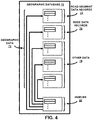
- FIG. 5 is a block diagram of a location based full text search (LBFTS) index creation system 500.
- the LBFTS index creation system 500 may be embodied as program instructions stored on a non-transitory computer-readable medium (CRM), which when executed by a processor cause the processor to carry out function as described further herein.
- the LBFTS index creation system 500 may be embodied as a processor coupled to memory storage.
- the memory storage may have stored thereon program instructions, which, when executed by the processor, cause the LBFTS system 400 to carry out functions as described herein. Any such program instructions may be written in a suitable computer programming language such as C, C++, Java, or any other suitable program language now known or later developed.
- the LBFTS index creation system 500 may be part of or accessible to the compiler 46.
- the LBFTS index creation system 500 is shown in Figure 5 as including a location table 502, a token converter 504, an interwoven bit vector generator 506, and an index 508.
- the interwoven bit vector generator 506 generates interwoven bit vectors based on an input from the location table 502 and the token converter 504.
- the index 508 associates document identifiers with interwoven bit vectors generated by the interwoven bit vector generator 506.
- the index 508 may be a one-dimensional index, such as a B-Tree.
- the location table 502 is shown in Figure 5 as part of the LBFTS index creation system 500, the location table 500 may also be included in the geographic database 26 or another location accessible by the LBFTS index creation system 500.
- the location table 502 associates locations, such as points of interest, with a location value, such as a Morton code.
- a Morton code (sometimes referred to as a z-order curve) is a space-filling curve that enables a multi-dimensional value (such as a latitude/longitude value) to be expressed as a one-dimensional integer value.
- Using a one-dimensional integer value to represent a point of interest's location may allow the index 508 to be a one-dimensional index structure, such as a B-Tree, which may be more efficient than multi-dimensional index structures, such as R-Trees.
- a Morton code is generated by interweaving bits of multi-dimensional values.
- Figure 6 illustrates an example in which a two-dimensional value is converted to a one-dimensional Morton code.
- the two-dimensional value (45, 87) is first converted to binary.
- the value 45 is converted to 0100 0101 and the value 87 is converted to 1000 0111.
- the two binary values are interwoven together, starting with the first binary value, to form the one-dimensional interwoven bit vector 01100000 00110111.
- the first binary value is underlined so its bits can be identified in the interwoven bit vector.
- the interwoven bit vector is converted to decimal as 6037.
- the example two-dimensional values depicted in Figure 6 are comprised of two values, each one byte in length. Therefore, the Morton code generated from these two one-byte values is two-bytes in length.
- a point of interest may be associated with a two-dimensional value comprised of a latitude value and a longitude value. Depending on the implementation, the latitude and longitude values may be four bytes each, which would yield an eight-byte Morton code. Of course, other value lengths are also possible.
- the location table 502 may be a relational table having the form: POIs(PoiID INTEGER, MortonCode INTEGER, Category INTEGER).
- a query for all points of interest that are located within a certain region may be formatted as follows.
- a regional box query may be accomplished through a single range query (like the query above) or a sequence of ranges.
- This example and other examples provided herein use SQLite syntax. However, depending on the implementation, other suitable commands and data structures may be used as well.
- map tiles may also be associated with Morton codes.
- the location table 502 may have the form: Tiles(TileID INTEGER, TileData BLOB) where TileID is equal to the Morton code of the tile.
- a query for a range of tiles may be formatted as follows.
- a map of a geographic region may be divided by overlaying a grid on the map.
- the grid is formed of grid lines that divide the represented geographic region into a plurality of areas or map tiles.
- the lines of the grid represent the boundaries of the map tiles.
- the map tiles are rectangular; however, the map tiles may have other shapes.
- the map tiles may all have the same dimensions; however, other dimensions may be used.
- a grouping of data corresponding to a map tile contains a plurality of individual data records that represent the geographic features that are encompassed within the map tile area.
- each separate grouping of data contains the data records that represent the geographic features, such as the roads, intersections, points of interest, and other features, encompassed within a corresponding map tile area.
- Map tiles that depict a relatively small geographic area typically have larger Morton codes than map tiles that depict a relatively large geographic area.
- a map tile that depicts a small geographic area may referred to as “zoomed-in,” whereas a map tile that depicts a large geographic area may be referred to as “zoomed-out.”
- index creation may occur during the compilation process of generating geographic database products as shown in Figure 2 .
- the index may be created and stored on any computing platform prior to operation (i.e., querying) of the LBFTS system.
- a user of the navigation system 10 may desire to view a specific map tile and search for all points of interest within that map tile that match one or more entered search tokens.
- the LBFTS index creation system 500 For each point of interest (or other database entry), the LBFTS index creation system 500 generates an interwoven bit vector that is a combination of the point of interest's Morton code (location value) and at least one data value associated with the search tokens.
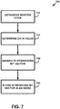
- FIG 7 is a flow diagram of a method 700 for creating the index 508.
- the LBFTS index creation system 500 determines a Morton code for a point of interest.
- the Morton codes may be stored in the location table 502 having the form: POIs(PoiID INTEGER, MortonCode INTEGER, Category INTEGER).
- the interwoven bit vector generator 506 uses the point of interest's identifier ( PoiID ) to retrieve the Morton code associated with the point of interest from the location table 502.
- Figure 8 depicts a Morton code associated with the point of interest having the identifier POI1.
- the Morton codes may not be stored in the location table 502.
- the LBFTS index creation system 500 may generate a Morton code for a particular point of interest based on the latitude and longitude values associated with the point of interest.
- the LBFTS index creation system 500 may retrieve the latitude and longitude values from the location table 502, the geographic database 26, or another location accessible to the LBFTS index creation system 500.
- the LBFTS index creation system 500 may then store the generated Morton code in the location table 502.
- the LBFTS index creation system 500 obtains a 32-bit (4-byte) latitude value for POI1 of: 11101100 10101101 1100010001100111. Likewise, LBFTS index creation system 500 obtains a 32-bit (4-byte) longitude value for POI1 of: 11100011 01111010 11000101 11001000.
- the latitude value shown in Figure 8 is underlined as a visual aid.
- the LBFTS index creation system 500 Based on the latitude and longitude values, the LBFTS index creation system 500 generates a Morton code by interweaving single bits of the latitude value with single bits of the longitude value, starting with the latitude value.
- the generated 64-bit (8-byte) Morton code becomes:
- the LBFTS index creation system 500 may start with a bit from the longitude value instead of the latitude value. Further, the LBFTS index creation system 500 could interweave two (or more) bits of the latitude value with two (or more) bits of the longitude value. And still further, the LBFTS index creation system 500 may interweave or combine the latitude value with the longitude value according to any number of other suitable ways.
- the LBFTS index creation system 500 receives a data token associated with the point of interest.
- the LBFTS index creation system 500 receives the data token "NAVTEQ.”
- the token converter 504 converts the data token into a binary value (referred to herein as a "data value").
- the length of the Morton code is eight bytes but other lengths are possible as well.
- the token converter 504 may determine whether the length of the data value is smaller than the length of the Morton code, equal to the length of the Morton code, or greater than the length of the Morton code. If the data value is smaller than the length of the Morton code, the token converter 504 may append one or more zero-bytes to the data value until the length of the data value is equal to the length of the Morton code. If the data token has the same length as the Morton code, then the token converter 504 may append nothing to the data value. And if the data value is larger than the Morton code, the token converter 504 may append one or more zero-bytes to the Morton code until the lengths are equal.
- the data token "NAVTEQ" is six characters in length and, therefore, represented by a data value of six bytes.
- the token converter 504 may append two zero-bytes to the end of the six-byte data value in order for length of the data value to equal the length of the Morton code.
- the eight-byte data value becomes:
- the interwoven bit vector generator 506 generates an interwoven bit vector using the Morton code from the location table 502 and the data value from the token convertor 504.
- An interwoven bit vector may be generated by interweaving a fixed number of bits of the data value with a fixed number of bits of the Morton code. This fixed number may be referred to as an "offset number" and stored in metadata of the index 508.
- the offset number is typically one, two, or three (although it could be any suitable number). According to the example depicted in Figure 8 , the offset number is two.
- the interwoven bit vector is generated by interweaving two bits of the Morton code with two bits of the data token value until all the bits from both values are used.
- the example interwoven bit vector becomes:
- interwoven bit vectors Other suitable ways of generating interwoven bit vectors exist as well, such as interweaving differing numbers of bits from each value.
- the interwoven bit vector generator 506 stores the interwoven bit vector in the index 508.
- the index 508 may be a relation table having the following form.
- the LBFTS index creation system 500 may carry out the method 700 for each data token associated with a point of interest.
- there may be eight data tokens associated with POI1 e.g., "NAVTEQ,” “Otto,” “Volger,” “Strasse,” “1,” “65843,” “Sulzbach,” and “Deutschland”
- FtsAndSpatialIndex associated with POI1.
- Each column in FtsAndSpatialIndex may be a primary key.
- the index 508 may utilize a B-Tree or other suitable one-dimensional index on the InterwovenData column.
- FIG. 9 is a block diagram of a location based full text search (LBFTS) system 900.
- the LBFTS system 900 includes a query processor 902 and an index 904.
- the index 904 may be a copy of the index 508 generated using the method 700. As previously described, in the navigation system example, the index 904 may be included in the indexes 80.
- the query processor 902 may be embodied as program instructions stored on a non-transitory computer-readable medium, which when executed by a processor cause the processor to carry out function as described further herein. Any such program instructions may be written in a suitable computer programming language such as C, C++, Java, or any other suitable program language now known or later developed.
- the query processor 902 may be part of the navigation programs 20 contained within the non-volatile memory 18 of the navigation system 10.
- the query processor 902 may be used in the navigation system 10 as part of destination selection.
- some or all of the query processor 902 may be included as part of the destination selection program 32.
- the LBFTS index creation system 500 and the LBFTS system 900 may be combined into a single LBFTS system. They are shown separately because some functions of the query processor 902 are not needed during index creation. Additionally, as described with the navigation system example, the components of the LBFTS index creation system 500, 900 do not need to be co-located as shown in Figures 5 and 9 .
- the index 904 may be the same as the index 508 once the index creation process is completed.
- Figure 10 is a block diagram of a method 1000 for facilitating a location based full text search.
- the LBFTS system 900 receives a location value from a user.
- the user may be a user of navigation system 10.
- a user may be viewing a particular map tile via the user interface 24 of navigation system 10.
- the LBFTS system 900 may receive from the navigation system 10 an indication of the tile ID associated with the map tile the user is viewing.
- the tile ID is a Morton code.
- the LBFTS system 900 may receive a location value directly from the user. For instance, a user may enter via user interface 24 a latitude value and a longitude value. The LBFTS system 900 may receive the latitude and longitude values and generate a Morton code based on the received latitude and longitude value according to the process described above with respect to block 702 and Figure 8 (or any other suitable process). Alternatively, the user may enter a Morton code directly and the LBFTS system 900 may receive the Morton code as the location value. The LBFTS system 900 may receive a location value in any number of other suitable ways as well including, for example, via the positioning system 22.
- the LBFTS system 900 receives at least one search term from a user.
- the search term may be a word that relates to a desired destination or point of interest (e.g., street name, point of interest name, category, or part of an address).
- the user may enter the search term via the user interface 24 or in any other suitable way.
- the query processor 902 generates an interwoven bit vector for each received search term in block 1004.
- the interwoven bit vector for a given search term is based on the given search term and the received location value (e.g., Morton code) from block 1002.
- the LBFTS system 900 receives or determines a Morton code as: 11111100 10100101 10011101 (underlined in Figure 11A as a visual aid).
- Morton code depicted in Figure 11A is three bytes in length. However, Morton code lengths may be shorter or longer in practice depending on the particular map tile a user is viewing and/or depending on the set of latitude and longitude coordinates the LBFTS system 900 may have otherwise determined.
- the LBFTS system 900 may receive "NAV" as a search term at block 1004.
- the query processor 902 may convert the search term to binary.
- "NAV" becomes: 01001110 01000001 01010110.
- the query processor 902 may then generate an interwoven bit vector according to the process previously described with respect to method 700 and Figure 8 .
- the query processor 902 may determine the offset value from metadata in the index 904, which is two in this example.
- the query processor 902 may generate the interwoven bit vector by interweaving two bits from the data value with two bits of the Morton code until all bits from each value have been used.
- the interwoven bit vector becomes: 1101110011110010 1001100001000101 1001010111010110.
- the query processor 902 performs a query using at least part of the generated interwoven bit vector.
- the query processor 902 may generate an upper-bound bit vector and a lower-bound bit vector.
- the query processor 902 may generate an upper-bound bit vector by appending one-bytes to the end of the interwoven bit vector until the upper-bound bit vector is a predetermined length.
- the predetermined length depicted in Figure 11A is sixteen bytes; however, other suitable predetermined lengths are possible as well.
- the query processor 902 may generate a lower-bound bit vector by appending zero-bytes to the interwoven bit vector until the lower-bound bit vector is the predetermined length.
- the query processor 902 may issue a range query as follows.
- the query processor 902 provides the result set of document identifiers or other data associated with the queried interwoven bit vector.
- the document identifiers are associated with documents.
- the term document means any kind of electronic data record or file that contains text.
- relevant documents may be a segment, node, point of interest, or other record stored in the geographic database 26.
- the query processor 902 may provide the result set to another system, which then retrieves the documents and provides the documents to the user. Alternatively, the query processor 902 may retrieve the documents associated with the document identifier and then provide the documents to the user.
- the query processor 902 may identify POI1 because POI1 has associated with it the interwoven bit vector:
- the LBFTS system 900 may receive or otherwise determine a Morton code as: 11111100 10100101 10011101. A user may enter "NA" as a search term.
- the LBFTS system 900 may make a determination that the received search term has a shorter data value length than the Morton code. In the example depicted in Figure 11B , the data value is two bytes whereas the Morton code is three bytes. In response to making this determination, the LBFTS system 900 may append at least one zero-byte to the data value so that the data value's length is equal to the Morton code's length.
- the binary value of "NA" with an appended zero-byte is: 01001110 01000001 00000000.
- the LBFTS system 900 may then generate an interwoven bit vector in accordance with the interweaving process previously described and produce the interwoven bit vector: 1101110011110010 1001100001000101 1000010011000100. To facilitate a query, the LBFTS system 900 may then generate an upper-bound bit vector and a lower-bound bit vector.
- the lower-bound bit vector may be generated in accordance with the process previously described with respect to Figure 11A and is as follows: 1101110011110010 1001100001000101 1000010011000100 00000000000000000000000000000000000000000000000000000000000000000000.
- the upper-bound bit vector is generated as if a one-byte was appended to the data value instead of a zero-byte.
- the bits of the upper-bound bit vector that are marked with a double underline are the bits that have been changed from zero to one. This change may facilitate more accurate querying.
- the LBFTS system 900 may issue a range query as follows.
- the LBFTS system 900 may receive or otherwise determine a Morton code as: 11111100 10100101 10011101.
- a user may enter "NAVTEQ" as a search term.
- the LBFTS system 900 may make a determination that the received search term has a data value having a longer length than the received Morton code.
- the data value is six bytes whereas the Morton code is three bytes.
- the LBFTS system 900 may append at least one zero-byte to the Morton code so that the length of the Morton code and the length of the data value are equal.
- the binary form of "NAVTEQ" is:
- the LBFTS system 900 may then generate an interwoven bit vector in accordance with the interweaving process previously described and produce the interwoven token:
- the LBFTS system 900 may then generate an upper-bound bit vector and a lower-bound bit vector.
- the lower-bound bit vector may be generated in accordance with the process previously described with respect to Figures 11A and 11B and is as follows:
- the upper-bound bit vector is generated as if one or more one-bytes were appended to the Morton code instead of one or more zero-bytes.
- the bits in the upper-bound bit vector that are marked with a double underline are the bits that have been changed from zero to one. As described above, this change may facilitate more accurate querying.
- the LBFTS system 900 may issue a range query as follows.
- the LBFTS system 900 may generate two (or more) interwoven bit vectors, two (or more) sets of upper-bound and lower-bound bit vectors, and issue an intersect query. For example, if the LBFTS system 900 receives at block 1004 "NAV" and "SULZBACH," the LBFTS system 900 may at block 1008 issue a query as follows:
- the LBFTS index creation system 500 may utilize hexadecimal or other numeral system instead of binary. For example, with respect to method 700 at block 702, the LBFTS index creation system 500 may determine the Morton code associated with POI1 and convert it to hexadecimal. The hexadecimal value for the Morton code associated with POI1 is "FCA5 9DE6 F031 786A.”
- the LBFTS index creation system 500 may determine a data value associated with POI1 in accordance with the process previously described with respect to block 704. Instead of converting the data token to binary, the LBFTS index creation system 500 may instead proceed to block 706 and generate an interwoven bit vector by interweaving characters of the data token with the hexadecimal Morton code. In one embodiment, the LBFTS index creation system 500 may interweave two characters of the Morton code with one character of the data token to yield: "FCNA5A9DVE9TF0E31Q7806A0.” In other embodiments, however, the LBFTS index creation system 500 may interweave characters from the Morton code and characters from the data token according to other suitable ways.
- the LBFTS index creation system 500 may store the interwoven bit vector in a relational table according to the process previously described with respect to block 708.
- the LBFTS index creation system 500 may store the interwoven token in a standard FTS3 table of the form VT_POI(PoiID INTEGER, Data BLOB, InterwovenStrings BLOB).
- the column InterwovenStrings contains the interwoven strings generated from the Morton code and the data tokens associated with the same POI.
- the InterwovenStrings column for POI1 would contain eight interwoven strings.
- FTS3 is the term for the SQLite Full Text Search engine and is provided as an example only. Other full text search systems, such as Lucene and SQL, may also be used.
- the LBFTS system 900 may process a query in a similar way. For instance, at block 1002, the LBFTS system 900 may determine the Morton code of a particular map tile as "FCA59DE6.” At block 1004, the LBFTS system 900 may receive a search token "NAVTEQ.” At block 1006, the LBFTS system 900 may generate an interwoven token based on the Morton code and the received search term. An interwoven token based on "FCA59DE6" and "NAVTEQ" may be "FCNA5A9DVE9T.” However, other suitable ways of generating interwoven tokens exist and may be used as well. Finally, at block 1008, the LBFTS system 900 may issue a query using the generated interwoven bit vector as follows.
- the generation and storage of interwoven bit vectors for each POI may contribute to an increased data size, which may have several negative consequences including added cost and processing time.
- the LBFTS index creation system 500 may facilitate the storage of shortened interwoven bit vectors.
- a table of the form FtsAndSpatialBlobIndex may store the starting prefix of an interwoven bit vector in the InterwovenDataPrefix column.
- the POI IDs and all interwoven bit vectors that share the same prefix may be stored in the same record in the column ListOfInterwovenDataSuffixAndIDs with only the data that comes after the shared prefix.
- the LBFTS index creation system 500 may store the size of the prefix in the metadata of the index 508.
- One example prefix size is 48 bits. Thus, if five interwoven bit vectors are each 128 bits in length and have identical first 48 bits, then the identical string of 48 bits may be stored in the InterwovenDataPrefix column. The remaining 80 bits of each of the five interwoven bit vectors may be stored in the ListOfInterwovenDataSuffixAndIDs column. Those skilled in the art will understand that this is merely an example and other prefix sizes may be used as well including, for example, 12, 16, 24, 32, 56, and so on. In this scenario, only the prefix is stored in the index 508.
- interwoven bit vectors may be stored in any proprietary database structure or proprietary file structure.
- the database or file structure may not be based on SQL but, instead, on any suitable proprietary algorithm in accordance with the entirety of the present disclosure.
- the Morton code (or other location value) received at block 1002 may be based on a single map tile. However, sometimes a user of the navigation system 10 may be viewing a combination of map tiles. For example, half of a user's screen may be showing part of a level 12 map tile, whereas the other half may be showing part of a level 13 map tile. Other examples of map tile combinations are possible as well.
- the LBFTS system 900 may determine the Morton code of each of the map tiles represented on the user's screen and generate separate interwoven bit vectors for each of the determined Morton codes. Each of the generated interwoven bit vectors is based on a received search term and one of the Morton codes. Subsequently, the LBFTS system 900 may carry out separate queries using the interwoven bit vectors and combine the list of results for the user.
- the LBFTS systems 500, 900 and the methods 700, 1000 may increase query processing speed. As a result, the LBFTS systems 500, 900 and the methods 700, 1000 may be beneficial during destination selection with a navigation system. However, based on this disclosure, those skilled in the art will realize that the LBFTS systems 500,900 and the methods 700, 1000 may be used in navigation systems for other location based full text search applications and in other systems that perform location based full text searches.
Abstract
Description
- The present invention relates generally to location based full text search, and more particularly, relates to location based full text search using interwoven location and data values.
- Full text search (FTS) systems search for relevant documents based on key words entered by a system user. The user enters a set of terms, referred to as tokens, and the FTS system retrieves documents containing all of the terms in the set. For example, Lucene (described at http://lucene.apache.org/) and SQLite's FTS module (described at http://www.sqlite.org/cvstrac/wiki?p=FtsUsage) are both FTS systems.
- Often a user wants to combine FTS with a spatial search. For instance, a web-based mapping application may allow a user to zoom into a certain region of a map and then enter one or more search terms, such as "restaurant" or "hotel." The web-based mapping application may then overlay push-pin icons over the map identifying where restaurants or hotels are located in the displayed region.
- Generally, there are three approaches to execute a location based full text search. First, a spatial search may be conducted to return all points of interest within a geographic area. A full text search may then be conducted on the set of returned points of interest using one or more entered search tokens. This approach may be efficient if the spatial search is somewhat selective (i.e., a relatively small geographic area). Second, a full text search may be conducted first followed by a spatial search conducted upon the returned list of full text search results. This approach may be efficient if the full text search is somewhat selective. Third, a full text search and a spatial search may be conducted in parallel and the intersection of the two result sets may constitute the result set. This approach may be efficient if both searches are rather selective.
- However, when the spatial search and the full text search are both rather unselective, none of these three approaches are particularly efficient. One example in which the spatial search and the full text search are both rather unselective is if a user conducted a search for "Pizza" within Chicago, Illinois. Thus, it would be beneficial to have a location based full text search system that works efficiently when the single search criteria are unselective but the combination of them is selective.
- A method and system for performing a location based full text search that increases search query speed is described. According to one example, a system generates interwoven bit vectors for documents that are stored in a database. An interwoven bit vector may be the combination of a data value associated with a search term and a location value. The location value may be based on a portion of a map that a user is viewing. Executing a search using an interwoven bit vector may be faster and more efficient than separately executing a search using the underlying data token and/or the underlying location value.
- According to a first aspect of the disclosure we provide a method comprising: receiving data indicative of a location; receiving a search term; identifying a first geographical coordinate and a second geographical coordinate corresponding to the location; combining, using a processor, the first geographical coordinate and the second geographical coordinate into a single dimensional location value; and combining, using the processor, the single dimensional location value and the search term into a vector.
- According to a second aspect of the disclosure we provide an apparatus comprising: at least one processor; and at least one memory including computer program code for one or more programs, the at least one memory and the computer program code configured to, with the at least one processor, cause the apparatus to perform at least the following: identify a first geographical coordinate and a second geographical coordinate corresponding to a location; combine the first geographical coordinate and the second geographical coordinate into a single dimensional location value; and combine the single dimensional location value and a search term for a point of interest into a vector.
- Optionally the at least one memory and the computer program code configured to, with the at least one processor, cause the apparatus to: query a geographic database with the vector.
- Optionally, the at least one memory and the computer program code configured to receive search results limited spatially by a geographic area based on the location and limited textually by the search term.
- Optionally the vector includes alternating portions of the first geographical coordinate, the second geographical coordinate, and the search term.
- Optionally, the at least one memory and the computer program code configured to, with the at least one processor, cause the apparatus to: modify a character length of at least one of the first geographical coordinate, the second geographical coordinate, and the search term so that the first geographical coordinate, the second geographical coordinate, and the search term have the same length.
- Optionally, the first geographical coordinate and the second geographical coordinate are based on a geographic position of a device or a map area viewed on the device.
- According to a third aspect of the disclosure we provide an apparatus comprising: a geographic database; and a processor configured to identify a first geographical coordinate and a second geographical coordinate corresponding to a location and combine the first geographical coordinate, the second geographical coordinate, and a search term into a single dimensional vector for querying the geographic database.
- Optionally, the geographic database is configured to return search results limited spatially by a geographic area based on the location and limited textually by the search term.
- Optionally, the processor is configured to access an offset value for an index in the geographic database, wherein the vector includes alternating portions of the first geographical coordinate, the second geographical coordinate, and the search term defined at least in part by the offset value.
- These as well as other aspects and advantages will become apparent to those of ordinary skill in the art by reading the following detailed description, with reference where appropriate to the accompanying drawings. Further, it is understood that this summary is merely an example and is not intended to limit the scope of the invention as claimed.
- Presently preferred embodiments are described below in conjunction with the appended drawing figures, wherein like reference numerals refer to like elements in the various figures, and wherein:
-
Figure 1 is a block diagram depicting a navigation system, according to an example; -
Figure 2 is a block diagram that illustrates forming geographic database products from a master version of a geographic database; according to an example; -
Figure 3 depicts a map of a geographic region, according to an example; -
Figure 4 is a block diagram of a geographic database that represents the geographic region ofFigure 3 , according to an example; -
Figure 5 is a block diagram of a location based full text search system, according to an example; -
Figure 6 depicts a one-dimensional value generated from a two-dimensional value, according to an example; -
Figure 7 is a flow diagram of a method of generating an index for a location based full text search system, according to an example; -
Figure 8 depicts generation of an interwoven bit vector, according to an example; -
Figure 9 is a block diagram of a location based full text search system, according to another example; -
Figure 10 is a flow diagram of a method of performing a location based full text search using the system depicted inFigure 9 , according to an example; and -
Figures 11A, 11B , and11C depict generation of interwoven bit vectors, according to some examples. - The method and system for performing location based full text search as described herein may be performed on any computing platform, such as a navigation system, a server, a personal computer, a mobile telephone, and so on. A navigation system example is provided for purposes of explaining the details of the location based full text search system. However, it is understood that this is a non-limiting example.
-
Figure 1 is a block diagram of anavigation system 10 associated with acomputing platform 12. Thecomputing platform 12 may be associated with a vehicle. Additionally, thecomputing platform 12 may be a personal digital assistant (PDA), mobile telephone, personal computer, or any other computer. Thenavigation system 10 is a combination of hardware and software components. In one embodiment, thenavigation system 10 includes aprocessor 14, adrive 16 connected to theprocessor 14, and a non-volatilememory storage device 18 for storing navigation application software programs 20 and possibly other information. - The
navigation system 10 also includes apositioning system 22. Thepositioning system 22 may utilize GPS-type technology, a dead reckoning-type system, or combinations of these or other systems, all of which are known in the art. Thepositioning system 22 may include suitable sensing devices that measure the traveling distance speed, direction, orientation, and so on. Thepositioning system 22 may also include a GPS system. Thepositioning system 22 outputs a signal to theprocessor 14. The navigation application software programs 20 that run on theprocessor 14 use the signal from thepositioning system 22 to determine the location, direction, orientation, etc., of thecomputing platform 12. - The
navigation system 10 also includes auser interface 24 that allows the end user to input information into thenavigation system 10 and obtain information from thenavigation system 10. The input information may include a request for navigation features and functions of thenavigation system 10. To provide navigation features and functions, thenavigation system 10 uses ageographic database 26. - In one embodiment, the
geographic database 26 is stored on a storage medium, such as a CD-ROM or DVD, that is installed in thedrive 16 so that thegeographic database 26 can be read and used by thenavigation system 10. In one embodiment, thenavigation system 10 also includes astorage device 28, such as a hard disk or memory card, on which a portion of thegeographic database 26 is stored. In another embodiment, thegeographic database 26 is stored on a hard disk. In one embodiment, thegeographic database 26 may be a geographic database published by NAVTEQ North America, LLC of Chicago, Illinois. Thegeographic database 26 does not have to be physically provided at the location of thenavigation system 10. In alternative embodiments, some or the entiregeographic database 26 may be located remotely from the rest of thenavigation system 10 and portions of the geographic data provided via acommunications system 30, as needed. - In one exemplary type of system, the navigation application software programs 20 load from the non-volatile
memory storage device 18 into a random access memory (RAM) 44 associated with theprocessor 14. Theprocessor 14 also receives input from theuser interface 24. Thenavigation system 10 uses thegeographic database 26 stored on the storage medium and/orstorage device 28, possibly in conjunction with the outputs from thepositioning system 22 and thecommunications system 30, to provide various navigation features and functions. The navigation application software programs 20 may include separate applications (or subprograms) that provide the various navigation-related features and functions. The navigation functions and features may include destination selection 32 (identifying one or more places to be used as a destination based on user input), route calculation 34 (determining a route from an origin to a destination), route guidance 36 (providing detailed directions for reaching a destination),map display 38, and positioning 40 (e.g., map matching). Other functions andprogramming 42 may be included in thenavigation system 10. - The navigation application software programs 20 may be written in a suitable computer programming language such as C, although other programming languages, such as C++ or Java, are also suitable. All of the components described above may be conventional (or other than conventional) and the manufacture and use of these components are known to those of skill in the art.
- The
geographic database 26 is a compiled database product, which is produced directly or indirectly from a master version of a geographic database.Figure 2 shows a master version of ageographic database 45. The master version of thegeographic database 45 contains data that represent geographic features in a coverage area. The coverage area may correspond to an entire country, such as the United States. Alternatively, the coverage area may correspond to several countries, such as the United States, Canada, and Mexico, or France, Germany, and Italy, and so on. According to another alternative, the coverage area of the master version of thegeographic database 45 may represent only a single region within a country, such as the West Coast or the Midwest of the U.S. Although the master version of thegeographic database 45 includes data that represent geographic features in the entire coverage area, there may be parts of the coverage area that contain geographic features that are not represented by data in the geographic database, or for which the representation of geographic features is sparse. - The master version of the
geographic database 45 includes data about a road network located in the coverage area. The data about the road network include various kinds of information, such as the geographic coordinates of positions of the roads, street names of the roads, addresses ranges along the roads, turn restrictions at intersections of roads, and so on. The master version of thegeographic database 45 also includes data about points of interest in the covered area. Points of interest may include hotels, restaurants, museums, stadiums, offices, automobile dealerships, auto repair shops, etc. The master version of thegeographic database 45 may include data about the locations of these points of interests. The master version of thegeographic database 45 may also include data about places, such as cities, towns, or other communities. The master version of thegeographic database 45 may include other kinds of information. - The master version of the
geographic database 45 is maintained as the copy that has the most up-to-date data relating to the coverage area. Accordingly, the master version of thegeographic database 45 is updated, expanded, and/or otherwise modified on a regular and continuing basis. To facilitate these operations, the master version of thegeographic database 45 is stored in a format that facilitates updating, maintenance, and development. For example, the data in themaster version 45 may be uncompressed. Examples of suitable formats include Oracle Spatial and VSAM although other formats, both proprietary and non-proprietary, including GDF, may be suitable. In general, the format of themaster database 45 is not suitable for use in systems that provide navigation functions, such as navigation systems. - The master version of the
geographic database 45 is used to make compileddatabase products 48, one example of which is thegeographic database 26 depicted inFigure 1 . In one method of operation, data from the master version of thegeographic database 45 is first compiled into an intermediate or delivery format, such as GDF. Then, the database in the delivery format is used to make the compileddatabase products 48. The compileddatabase products 48 are made using acompiler 46. Thecompiler 46 is a software program run on an appropriate computer platform. Thecompiler 46 obtains geographic data from the intermediate format database (which was formed from the master geographic database 45) and organizes the data into a format (or formats) to produce the compiled (or working) version of thegeographic databases 48. The format of the compiledgeographic databases 48 facilitates use of the geographic data in the end users' systems for navigation-related purposes. - The compiled
database products 48 may include only portions of all the data in the master version of thegeographic database 45. For example, the compileddatabase products 48 may include data that relate to only one or more specific sub-areas within the coverage area of the master version of thegeographic database 45. Further, the compileddatabase products 48 may include fewer than all the data attributes that describe geographic features represented in the master version of thegeographic database 45. - The compiled
database products 48 are used on various kinds of computing platforms. For example, the compileddatabase products 48 are used in navigation systems (such as in-vehicle navigation systems and hand-held portable navigation systems), personal computers (including desktop and notebook computers), and other kinds of devices, such as pagers, telephones, personal digital assistants, tablets, smartphones, etc. The compileddatabase products 48 are also used on networked computing platforms and environments, including systems connected to the Internet. - The compiled
database products 48 are stored on media that are suitable for the hardware platforms on which they are used. For example, the compiled database products may be stored on CD-ROM disks, hard drives, DVD disks, flash memory, or other types of media that are available now or that become available in the future. - In the compiled
databases 48, the geographic data are organized differently than in the master version of thegeographic database 45. A compiled database is organized, arranged, structured and stored in a form that facilitates the use of the data in the computing platform in which it is installed. A compileddatabase 48 may also be stored in a compressed format on the media on which it is located. An example of how the road network is represented in a compileddatabase product 48 is provided with reference toFigures 3 and4 . -
Figure 3 shows amap 50 of ageographic region 52. Thegeographic region 52 may correspond to a metropolitan or rural area, a state, a country, or combinations thereof, or any other area of comparable size. Located in thegeographic region 52 are physical geographic features, such as roads, points of interest (including businesses, facilities, etc.), lakes, rivers, railroads, municipalities, etc. -
Figure 3 also includes anenlarged map 54 of aportion 56 of thegeographic region 52. Theenlarged map 54 illustrates part of theroad network 58 in thegeographic region 52. Theroad network 58 includes, among other things, roads and intersections located in thegeographic region 52. As shown in theportion 56, each road in thegeographic region 52 is composed of one ormore road segments 60. Aroad segment 60 represents a portion of the road. Eachroad segment 60 is shown to have associated with it twonodes 62; one node represents the point at one end of the road segment and the other node represents the point at the other end of the road segment. The node at either end of a road segment may correspond to a location at which the road meets another road, i.e., an intersection, or where the road dead-ends. - Referring to
Figure 4 , ageographic database 70 containsdata 72 that represents some of the physical geographic features in the geographic region (52 inFigure 3 ). Thegeographic database 70 may constitute all or part of thegeographic database 26. For example, thegeographic database 70 may be a subset of the data contained within thegeographic database 26. Thegeographic database 70 may be accessible through thenavigation system 10 and thecomputing platform 12. Alternatively or additionally, thegeographic database 70 may be a standalone database located remotely from thegeographic database 26, thenavigation system 10, and/or thecomputing platform 12 but nonetheless accessible via thecommunication system 30 and/or theprocessor 14. - The
data 72 contained in thegeographic database 70 includes data that represent theroad network 58. In the embodiment ofFigure 4 , thegeographic database 70 that represents thegeographic region 52 contains at least one database record 74 (also referred to as "entity" or "entry") for eachroad segment 60 in thegeographic region 52 inFigure 3 . The roadsegment data record 74 may include a segment ID by which the data record can be identified in thegeographic database 70. - Each road
segment data record 74 has associated with it information (such as "attributes", "fields", etc.) that describes features of the represented road segment. The roadsegment data record 74 may include data that indicate the restrictions, if any, on the direction of vehicular travel permitted on the represented road segment, data indicating a speed limit or speed category (i.e., the maximum permitted vehicular speed of travel) on the represented road segment, data indicating whether the represented road segment is part of a controlled access road (such as an expressway), a ramp to a controlled access road, a bridge, a tunnel, a toll road, a ferry, and so on. - The road
segment data record 74 also includes data providing the geographic coordinates (e.g., the latitude and longitude) of the endpoints of the represented road segment and data providing the shape of the road segment. In one embodiment, the endpoint data are references to thenode data records 76 that represent the nodes corresponding to the endpoints of the represented road segment. - The road
segment data record 74 may also include or be associated with other data that refer to various other attributes of the represented road segment. The various attributes associated with a road segment may be included in a single road segment record, or may be included in more than one type of record that are cross-referenced to each other. For example, the roadsegment data record 74 may include data identifying what turn restrictions exist at each of the nodes that correspond to intersections at the ends of the road portion represented by the road segment, the name or names by which the represented road segment is known, the street address ranges along the represented road segment, and so on. - The
geographic database 70 that represents thegeographic region 52 also includes a database record 76 (or "entity" or "entry") for eachnode 62 in thegeographic region 52. (The terms "nodes" and "segments" represent only one terminology for describing these physical geographic features and other terminology for describing these features is intended to be encompassed within the scope of these concepts). Each of the node data records 76 may have associated information (such as "attributes", "fields", etc.) that allows identification of the road segment(s) that connect to it and/or its geographic position (e.g., its latitude and longitude coordinates). - The
geographic database 70 may also include other kinds ofdata 78. The other kinds ofdata 78 may represent other kinds of geographic features or anything else. The other kinds of data may include point of interest data. For example, the point of interest data may include point of interest records comprising a type (e.g., the type of point of interest, such as restaurant, hotel, city hall, police station, historical marker, ATM, golf course, etc.), location of the point of interest, a phone number, hours of operation, etc. Each point of interest has a unique physical location and each of the locations can be identified by its two dimensional (or three dimensional) geographic coordinates, (i.e., latitude, longitude, and optionally altitude). Additionally, the locations may correspond to one of the nodes or may correspond to a point along a road segment. - The
geographic database 70 also includesindexes 80. Theindexes 80 may include various types of indexes that relate the different types of data to each other or that relate to other aspects of the data contained in thegeographic database 70. One of the indexes is an index that is described with respect toFigures 5-11 . -
Figure 5 is a block diagram of a location based full text search (LBFTS)index creation system 500. The LBFTSindex creation system 500 may be embodied as program instructions stored on a non-transitory computer-readable medium (CRM), which when executed by a processor cause the processor to carry out function as described further herein. The LBFTSindex creation system 500 may be embodied as a processor coupled to memory storage. The memory storage may have stored thereon program instructions, which, when executed by the processor, cause the LBFTS system 400 to carry out functions as described herein. Any such program instructions may be written in a suitable computer programming language such as C, C++, Java, or any other suitable program language now known or later developed. In the navigation system example, the LBFTSindex creation system 500 may be part of or accessible to thecompiler 46. - The LBFTS
index creation system 500 is shown inFigure 5 as including a location table 502, atoken converter 504, an interwovenbit vector generator 506, and anindex 508. The interwovenbit vector generator 506 generates interwoven bit vectors based on an input from the location table 502 and thetoken converter 504. Theindex 508 associates document identifiers with interwoven bit vectors generated by the interwovenbit vector generator 506. For example, theindex 508 may be a one-dimensional index, such as a B-Tree. - While the location table 502 is shown in
Figure 5 as part of the LBFTSindex creation system 500, the location table 500 may also be included in thegeographic database 26 or another location accessible by the LBFTSindex creation system 500. The location table 502 associates locations, such as points of interest, with a location value, such as a Morton code. A Morton code (sometimes referred to as a z-order curve) is a space-filling curve that enables a multi-dimensional value (such as a latitude/longitude value) to be expressed as a one-dimensional integer value. Using a one-dimensional integer value to represent a point of interest's location may allow theindex 508 to be a one-dimensional index structure, such as a B-Tree, which may be more efficient than multi-dimensional index structures, such as R-Trees. - A Morton code is generated by interweaving bits of multi-dimensional values.
Figure 6 illustrates an example in which a two-dimensional value is converted to a one-dimensional Morton code. The two-dimensional value (45, 87) is first converted to binary. Thevalue 45 is converted to 0100 0101 and the value 87 is converted to 1000 0111. Next, the two binary values are interwoven together, starting with the first binary value, to form the one-dimensionalinterwoven bit vector 01100000 00110111. As a visual aid, the first binary value is underlined so its bits can be identified in the interwoven bit vector. Finally, the interwoven bit vector is converted to decimal as 6037. - The example two-dimensional values depicted in
Figure 6 are comprised of two values, each one byte in length. Therefore, the Morton code generated from these two one-byte values is two-bytes in length. A point of interest may be associated with a two-dimensional value comprised of a latitude value and a longitude value. Depending on the implementation, the latitude and longitude values may be four bytes each, which would yield an eight-byte Morton code. Of course, other value lengths are also possible. - The location table 502 may be a relational table having the form: POIs(PoiID INTEGER, MortonCode INTEGER, Category INTEGER). A query for all points of interest that are located within a certain region may be formatted as follows.
- SELECT *FROM POIs WHERE MortonCode BETWEEN X AND Y,
where X and Y are integers. A regional box query may be accomplished through a single range query (like the query above) or a sequence of ranges. This example and other examples provided herein use SQLite syntax. However, depending on the implementation, other suitable commands and data structures may be used as well. - In addition to associating points of interest with Morton codes, map tiles may also be associated with Morton codes. In this example, the location table 502 may have the form: Tiles(TileID INTEGER, TileData BLOB) where TileID is equal to the Morton code of the tile. A query for a range of tiles may be formatted as follows.
- SELECT FROM TileID WHERE TileID BETWEEN X AND Y,
where X and Y are integers. - A map of a geographic region may be divided by overlaying a grid on the map. The grid is formed of grid lines that divide the represented geographic region into a plurality of areas or map tiles. The lines of the grid represent the boundaries of the map tiles. Typically, the map tiles are rectangular; however, the map tiles may have other shapes. The map tiles may all have the same dimensions; however, other dimensions may be used.
- A grouping of data corresponding to a map tile contains a plurality of individual data records that represent the geographic features that are encompassed within the map tile area. Thus, each separate grouping of data contains the data records that represent the geographic features, such as the roads, intersections, points of interest, and other features, encompassed within a corresponding map tile area.
- Map tiles that depict a relatively small geographic area typically have larger Morton codes than map tiles that depict a relatively large geographic area. A map tile that depicts a small geographic area may referred to as "zoomed-in," whereas a map tile that depicts a large geographic area may be referred to as "zoomed-out."
- In the navigation system example, index creation may occur during the compilation process of generating geographic database products as shown in
Figure 2 . In other examples, the index may be created and stored on any computing platform prior to operation (i.e., querying) of the LBFTS system. - In practice, a user of the
navigation system 10 may desire to view a specific map tile and search for all points of interest within that map tile that match one or more entered search tokens. For each point of interest (or other database entry), the LBFTSindex creation system 500 generates an interwoven bit vector that is a combination of the point of interest's Morton code (location value) and at least one data value associated with the search tokens. -
Figure 7 is a flow diagram of amethod 700 for creating theindex 508. Atblock 702, the LBFTSindex creation system 500 determines a Morton code for a point of interest. The Morton codes may be stored in the location table 502 having the form: POIs(PoiID INTEGER, MortonCode INTEGER, Category INTEGER). Thus, for a particular point of interest, the interwovenbit vector generator 506 uses the point of interest's identifier (PoiID) to retrieve the Morton code associated with the point of interest from the location table 502. By way of example,Figure 8 depicts a Morton code associated with the point of interest having the identifier POI1. - In other embodiments, the Morton codes may not be stored in the location table 502. In this example, the LBFTS
index creation system 500 may generate a Morton code for a particular point of interest based on the latitude and longitude values associated with the point of interest. The LBFTSindex creation system 500 may retrieve the latitude and longitude values from the location table 502, thegeographic database 26, or another location accessible to the LBFTSindex creation system 500. The LBFTSindex creation system 500 may then store the generated Morton code in the location table 502. - Referring back to
Figure 8 , the LBFTSindex creation system 500 obtains a 32-bit (4-byte) latitude value for POI1 of:
11101100 10101101 1100010001100111. Likewise, LBFTSindex creation system 500 obtains a 32-bit (4-byte) longitude value for POI1 of:
11100011 01111010 11000101 11001000.
The latitude value shown inFigure 8 is underlined as a visual aid. Based on the latitude and longitude values, the LBFTSindex creation system 500 generates a Morton code by interweaving single bits of the latitude value with single bits of the longitude value, starting with the latitude value. The generated 64-bit (8-byte) Morton code becomes: - 11111100 10100101 10011101 11100110
- 11110000 00110001 01111000 01101010.
- The method described above is merely an example and other methods exist for generating a Morton code based on latitude and longitude values. For instance, the LBFTS
index creation system 500 may start with a bit from the longitude value instead of the latitude value. Further, the LBFTSindex creation system 500 could interweave two (or more) bits of the latitude value with two (or more) bits of the longitude value. And still further, the LBFTSindex creation system 500 may interweave or combine the latitude value with the longitude value according to any number of other suitable ways. - At
block 704, the LBFTSindex creation system 500 receives a data token associated with the point of interest. Referring back toFigure 8 , the LBFTSindex creation system 500 receives the data token "NAVTEQ." Thetoken converter 504 converts the data token into a binary value (referred to herein as a "data value"). In some embodiments, it may be preferable for the bit-length of the data value to be equal to the bit-length of the Morton code. In the example depicted inFigure 8 , the length of the Morton code is eight bytes but other lengths are possible as well. - Therefore, at
block 704, thetoken converter 504 may determine whether the length of the data value is smaller than the length of the Morton code, equal to the length of the Morton code, or greater than the length of the Morton code. If the data value is smaller than the length of the Morton code, thetoken converter 504 may append one or more zero-bytes to the data value until the length of the data value is equal to the length of the Morton code. If the data token has the same length as the Morton code, then thetoken converter 504 may append nothing to the data value. And if the data value is larger than the Morton code, thetoken converter 504 may append one or more zero-bytes to the Morton code until the lengths are equal. - In the example depicted in
Figure 8 , the data token "NAVTEQ" is six characters in length and, therefore, represented by a data value of six bytes. Thus, thetoken converter 504 may append two zero-bytes to the end of the six-byte data value in order for length of the data value to equal the length of the Morton code. The eight-byte data value becomes: - 01001110 01000001 01010110 01010100
- 01000101 01010001 00000000 00000000.
- At
block 706, the interwovenbit vector generator 506 generates an interwoven bit vector using the Morton code from the location table 502 and the data value from thetoken convertor 504. An interwoven bit vector may be generated by interweaving a fixed number of bits of the data value with a fixed number of bits of the Morton code. This fixed number may be referred to as an "offset number" and stored in metadata of theindex 508. - The offset number is typically one, two, or three (although it could be any suitable number). According to the example depicted in
Figure 8 , the offset number is two. Thus, the interwoven bit vector is generated by interweaving two bits of the Morton code with two bits of the data token value until all the bits from both values are used. The example interwoven bit vector becomes: - 1101110011110010 1001100001000101
- 1001010111010110 1101100101011000
- 1101110000010001 0001110100000101
- 0100110010000000 0100100010001000.
- Other suitable ways of generating interwoven bit vectors exist as well, such as interweaving differing numbers of bits from each value.
- At
block 708, the interwovenbit vector generator 506 stores the interwoven bit vector in theindex 508. Theindex 508 may be a relation table having the following form. - FtsAndSpatialIndex(InterwovenData BLOB, PoiID INTEGER)
Each interwoven bit vector may occupy a separate record in the table. - For example, the LBFTS
index creation system 500 may carry out themethod 700 for each data token associated with a point of interest. For example, there may be eight data tokens associated with POI1 (e.g., "NAVTEQ," "Otto," "Volger," "Strasse," "1," "65843," "Sulzbach," and "Deutschland"). Thus, there would be eight records in FtsAndSpatialIndex associated with POI1. Each column in FtsAndSpatialIndex may be a primary key. In addition, theindex 508 may utilize a B-Tree or other suitable one-dimensional index on the InterwovenData column. -
Figure 9 is a block diagram of a location based full text search (LBFTS)system 900. TheLBFTS system 900 includes aquery processor 902 and anindex 904. Theindex 904 may be a copy of theindex 508 generated using themethod 700. As previously described, in the navigation system example, theindex 904 may be included in theindexes 80. - The
query processor 902 may be embodied as program instructions stored on a non-transitory computer-readable medium, which when executed by a processor cause the processor to carry out function as described further herein. Any such program instructions may be written in a suitable computer programming language such as C, C++, Java, or any other suitable program language now known or later developed. - In the navigation system example, the
query processor 902 may be part of the navigation programs 20 contained within thenon-volatile memory 18 of thenavigation system 10. For example, thequery processor 902 may be used in thenavigation system 10 as part of destination selection. In this example, some or all of thequery processor 902 may be included as part of thedestination selection program 32. - The LBFTS
index creation system 500 and theLBFTS system 900 may be combined into a single LBFTS system. They are shown separately because some functions of thequery processor 902 are not needed during index creation. Additionally, as described with the navigation system example, the components of the LBFTSindex creation system Figures 5 and9 . Theindex 904 may be the same as theindex 508 once the index creation process is completed. -
Figure 10 is a block diagram of amethod 1000 for facilitating a location based full text search. Atblock 1002, theLBFTS system 900 receives a location value from a user. For example, the user may be a user ofnavigation system 10. In at least one embodiment, a user may be viewing a particular map tile via theuser interface 24 ofnavigation system 10. TheLBFTS system 900 may receive from thenavigation system 10 an indication of the tile ID associated with the map tile the user is viewing. The tile ID is a Morton code. - Alternatively, the
LBFTS system 900 may receive a location value directly from the user. For instance, a user may enter via user interface 24 a latitude value and a longitude value. TheLBFTS system 900 may receive the latitude and longitude values and generate a Morton code based on the received latitude and longitude value according to the process described above with respect to block 702 andFigure 8 (or any other suitable process). Alternatively, the user may enter a Morton code directly and theLBFTS system 900 may receive the Morton code as the location value. TheLBFTS system 900 may receive a location value in any number of other suitable ways as well including, for example, via thepositioning system 22. - At
block 1004, theLBFTS system 900 receives at least one search term from a user. The search term may be a word that relates to a desired destination or point of interest (e.g., street name, point of interest name, category, or part of an address). The user may enter the search term via theuser interface 24 or in any other suitable way. - At
block 1006, thequery processor 902 generates an interwoven bit vector for each received search term inblock 1004. The interwoven bit vector for a given search term is based on the given search term and the received location value (e.g., Morton code) fromblock 1002. According to the example depicted inFigure 11A , theLBFTS system 900 receives or determines a Morton code as:
11111100 10100101 10011101
(underlined inFigure 11A as a visual aid). - The Morton code depicted in
Figure 11A is three bytes in length. However, Morton code lengths may be shorter or longer in practice depending on the particular map tile a user is viewing and/or depending on the set of latitude and longitude coordinates theLBFTS system 900 may have otherwise determined. - The
LBFTS system 900 may receive "NAV" as a search term atblock 1004. In response to receiving the search term, thequery processor 902 may convert the search term to binary. In the example depicted inFigure 11A , "NAV" becomes:
01001110 01000001 01010110. - At
block 1006, thequery processor 902 may then generate an interwoven bit vector according to the process previously described with respect tomethod 700 andFigure 8 . For instance, thequery processor 902 may determine the offset value from metadata in theindex 904, which is two in this example. Thus, thequery processor 902 may generate the interwoven bit vector by interweaving two bits from the data value with two bits of the Morton code until all bits from each value have been used. The interwoven bit vector becomes:
1101110011110010 1001100001000101 1001010111010110. - At
block 1008, thequery processor 902 performs a query using at least part of the generated interwoven bit vector. To facilitate the query, thequery processor 902 may generate an upper-bound bit vector and a lower-bound bit vector. In accordance with the example depicted inFigure 11A , thequery processor 902 may generate an upper-bound bit vector by appending one-bytes to the end of the interwoven bit vector until the upper-bound bit vector is a predetermined length. The predetermined length depicted inFigure 11A is sixteen bytes; however, other suitable predetermined lengths are possible as well. Similarly, thequery processor 902 may generate a lower-bound bit vector by appending zero-bytes to the interwoven bit vector until the lower-bound bit vector is the predetermined length. - Upon generating the upper-bound and lower-bound bit vectors, the
query processor 902 may issue a range query as follows.
- At
block 1010, thequery processor 902 provides the result set of document identifiers or other data associated with the queried interwoven bit vector. The document identifiers are associated with documents. The term document means any kind of electronic data record or file that contains text. In the example of a navigation system, relevant documents may be a segment, node, point of interest, or other record stored in thegeographic database 26. - The
query processor 902 may provide the result set to another system, which then retrieves the documents and provides the documents to the user. Alternatively, thequery processor 902 may retrieve the documents associated with the document identifier and then provide the documents to the user. - For instance, in response to the above query, the
query processor 902 may identify POI1 because POI1 has associated with it the interwoven bit vector: - 1101110011110010 1001100001000101 1001010111010110
- 1101100101011000 1101110000010001 0001110100000101
- 0100110010000000 0100100010001000.
- Several other queries are possible depending on the length and number of search terms a user enters. According to the example depicted in
Figure 11B , theLBFTS system 900 may receive or otherwise determine a Morton code as:
11111100 10100101 10011101.
A user may enter "NA" as a search term. - Upon receiving the search term, the
LBFTS system 900 may make a determination that the received search term has a shorter data value length than the Morton code. In the example depicted inFigure 11B , the data value is two bytes whereas the Morton code is three bytes. In response to making this determination, theLBFTS system 900 may append at least one zero-byte to the data value so that the data value's length is equal to the Morton code's length. The binary value of "NA" with an appended zero-byte is:
01001110 01000001 00000000. - The
LBFTS system 900 may then generate an interwoven bit vector in accordance with the interweaving process previously described and produce the interwoven bit vector:
1101110011110010 1001100001000101 1000010011000100.
To facilitate a query, theLBFTS system 900 may then generate an upper-bound bit vector and a lower-bound bit vector. The lower-bound bit vector may be generated in accordance with the process previously described with respect toFigure 11A and is as follows:
1101110011110010 1001100001000101 1000010011000100
0000000000000000 0000000000000000 0000000000000000
0000000000000000 0000000000000000.
However, when a zero-byte is appended to the data value because the search term is shorter than the Morton code, the upper-bound bit vector is generated as if a one-byte was appended to the data value instead of a zero-byte. InFigure 11B , the bits of the upper-bound bit vector that are marked with a double underline are the bits that have been changed from zero to one. This change may facilitate more accurate querying. - Finally, after the upper-bound and lower-bound bit vectors are generated, the
LBFTS system 900 may issue a range query as follows.

- According to the example depicted in
Figure 11C , theLBFTS system 900 may receive or otherwise determine a Morton code as:
11111100 10100101 10011101. - A user may enter "NAVTEQ" as a search term. Upon receiving the search term, the
LBFTS system 900 may make a determination that the received search term has a data value having a longer length than the received Morton code. In the example depicted inFigure 11C , the data value is six bytes whereas the Morton code is three bytes. In response to making this determination, theLBFTS system 900 may append at least one zero-byte to the Morton code so that the length of the Morton code and the length of the data value are equal. The binary form of "NAVTEQ" is: - 01001110 01000001 01010110
- 01010100 01000101 01010001.
- 11111100 10100101 10011101
- 00000000 00000000 00000000.
- The
LBFTS system 900 may then generate an interwoven bit vector in accordance with the interweaving process previously described and produce the interwoven token: - 1101110011110010 1001100001000101 1001010111010110
- 0001000100010000 0001000000010001 0001000100000001.
- To facilitate a query, the
LBFTS system 900 may then generate an upper-bound bit vector and a lower-bound bit vector. The lower-bound bit vector may be generated in accordance with the process previously described with respect toFigures 11A and 11B and is as follows: - 1101110011110010 1001100001000101 1001010111010110
- 0001000100010000 0001000000010001 0001000100000001
- 0000000000000000 0000000000000000.
- However, when one or more zero-bytes are appended to the Morton code because the data value is longer than the Morton code, the upper-bound bit vector is generated as if one or more one-bytes were appended to the Morton code instead of one or more zero-bytes. In
Figure 11C , the bits in the upper-bound bit vector that are marked with a double underline are the bits that have been changed from zero to one. As described above, this change may facilitate more accurate querying. - Finally, after the upper-bound and lower-bound bit vectors are generated, the
LBFTS system 900 may issue a range query as follows.
- According to another example, if the
LBFTS system 900 receives two (or more) search terms atblock 1004, theLBFTS system 900 may generate two (or more) interwoven bit vectors, two (or more) sets of upper-bound and lower-bound bit vectors, and issue an intersect query. For example, if theLBFTS system 900 receives atblock 1004 "NAV" and "SULZBACH," theLBFTS system 900 may atblock 1008 issue a query as follows:
- One more of the following alternative embodiments may be used in place of or in combination with any of the above-disclosed embodiments as well as any of the hereinafter-described alternative embodiments as appropriate.
- The LBFTS
index creation system 500 may utilize hexadecimal or other numeral system instead of binary. For example, with respect tomethod 700 atblock 702, the LBFTSindex creation system 500 may determine the Morton code associated with POI1 and convert it to hexadecimal. The hexadecimal value for the Morton code associated with POI1 is "FCA5 9DE6 F031 786A." - The LBFTS
index creation system 500 may determine a data value associated with POI1 in accordance with the process previously described with respect to block 704. Instead of converting the data token to binary, the LBFTSindex creation system 500 may instead proceed to block 706 and generate an interwoven bit vector by interweaving characters of the data token with the hexadecimal Morton code. In one embodiment, the LBFTSindex creation system 500 may interweave two characters of the Morton code with one character of the data token to yield: "FCNA5A9DVE9TF0E31Q7806A0." In other embodiments, however, the LBFTSindex creation system 500 may interweave characters from the Morton code and characters from the data token according to other suitable ways. - The LBFTS
index creation system 500 may store the interwoven bit vector in a relational table according to the process previously described with respect to block 708. Alternatively, the LBFTSindex creation system 500 may store the interwoven token in a standard FTS3 table of the form VT_POI(PoiID INTEGER, Data BLOB, InterwovenStrings BLOB). The column InterwovenStrings contains the interwoven strings generated from the Morton code and the data tokens associated with the same POI. For example, the InterwovenStrings column for POI1 would contain eight interwoven strings. FTS3 is the term for the SQLite Full Text Search engine and is provided as an example only. Other full text search systems, such as Lucene and SQL, may also be used. - The
LBFTS system 900 may process a query in a similar way. For instance, atblock 1002, theLBFTS system 900 may determine the Morton code of a particular map tile as "FCA59DE6." Atblock 1004, theLBFTS system 900 may receive a search token "NAVTEQ." Atblock 1006, theLBFTS system 900 may generate an interwoven token based on the Morton code and the received search term. An interwoven token based on "FCA59DE6" and "NAVTEQ" may be "FCNA5A9DVE9T." However, other suitable ways of generating interwoven tokens exist and may be used as well. Finally, atblock 1008, theLBFTS system 900 may issue a query using the generated interwoven bit vector as follows. - SELECT * FROM VT_POI WHERE VT_POI match "InterwovenStrings:
"FCNA5A9DVE9T *" AND DATA like '%NAVTEQ%'
In this query, the interwoven string is used as a rough filter. The resulting candidate set is then be refined by the SQL like clause. - The generation and storage of interwoven bit vectors for each POI may contribute to an increased data size, which may have several negative consequences including added cost and processing time. In order to minimize the size increase, the LBFTS
index creation system 500 may facilitate the storage of shortened interwoven bit vectors. - For example, a table of the form FtsAndSpatialBlobIndex (InterwovenDataPrefix BLOB, ListOfInterwovenDataSuffixAndIDs BLOB) may store the starting prefix of an interwoven bit vector in the InterwovenDataPrefix column. The POI IDs and all interwoven bit vectors that share the same prefix may be stored in the same record in the column ListOfInterwovenDataSuffixAndIDs with only the data that comes after the shared prefix. The LBFTS
index creation system 500 may store the size of the prefix in the metadata of theindex 508. - One example prefix size is 48 bits. Thus, if five interwoven bit vectors are each 128 bits in length and have identical first 48 bits, then the identical string of 48 bits may be stored in the InterwovenDataPrefix column. The remaining 80 bits of each of the five interwoven bit vectors may be stored in the ListOfInterwovenDataSuffixAndIDs column. Those skilled in the art will understand that this is merely an example and other prefix sizes may be used as well including, for example, 12, 16, 24, 32, 56, and so on. In this scenario, only the prefix is stored in the
index 508. - In addition to storing interwoven bit vectors in relations indexed by B-Trees, those skilled in the art will understand that interwoven bit vectors may be stored in any proprietary database structure or proprietary file structure. The database or file structure may not be based on SQL but, instead, on any suitable proprietary algorithm in accordance with the entirety of the present disclosure.
- The Morton code (or other location value) received at
block 1002 may be based on a single map tile. However, sometimes a user of thenavigation system 10 may be viewing a combination of map tiles. For example, half of a user's screen may be showing part of alevel 12 map tile, whereas the other half may be showing part of a level 13 map tile. Other examples of map tile combinations are possible as well. - When a user is viewing multiple map tiles, the
LBFTS system 900 may determine the Morton code of each of the map tiles represented on the user's screen and generate separate interwoven bit vectors for each of the determined Morton codes. Each of the generated interwoven bit vectors is based on a received search term and one of the Morton codes. Subsequently, theLBFTS system 900 may carry out separate queries using the interwoven bit vectors and combine the list of results for the user. - The
LBFTS systems methods LBFTS systems methods methods - It is intended that the foregoing detailed description be regarded as illustrative rather than limiting and that it is understood that the following claims including all equivalents are intended to define the scope of the invention. For example, while many of the examples used points of interest documents, other documents may be searched using the system and methods described herein. The claims should not be read as limited to the described order or elements unless stated to that effect. Therefore, all embodiments that come within the scope of the following claims are claimed as the invention.
- We disclose aspects of the disclosure and optional features in the following numbered clauses:
- 1. A computer-implemented method for facilitating location based full text search, the method comprising:
- receiving a location value;
- receiving a search term;
- generating an interwoven bit vector based on the search term and the location value;
- querying an index using the interwoven bit vector; and
- receiving, based on the querying, a result set that is associated with the search term and the location value.
- 2. The method of
clause 1,
wherein the location value is a first character string,
wherein the search term is a second character string, and
wherein generating the interwoven bit vector comprises interweaving characters of the first character string with characters of the second character string creating an interwoven character string containing alternating portions of characters of the first character string and the second character string. - 3. The method of
clause 2, wherein an offset number is used when creating the interwoven character string, wherein the offset number identifies a number of characters from each character string to use before alternating. - 4. The method of
clause 2, wherein the first character string and the second character string are binary strings or hexadecimal strings. - 5. The method of
clause 1, wherein the location value is a first binary string, wherein the search term is converted to a second binary string, and wherein the method further comprises:- generating an upper-bound bit vector by appending at least one one-bit to the end of the second binary string such that the upper-bound bit vector has a length equal to a particular number of bytes; and
- generating a lower-bound bit vector by appending at least one zero-bit to the end of the second binary string such that the lower-bound bit vector has a length equal to the particular number of bytes,
- wherein querying an index using the interwoven bit vector comprises querying the index using the upper-bound bit vector and the lower-bound bit vector as a search range.
- 6. The method of
clause 1, further comprising converting the search term to binary. - 7. The method of
clause 1,
wherein the location value is a first character string,
wherein the search term is a second character string, and
wherein the method further comprises at least one of (i) truncating the first character string such that the first character string has a length equal to a particular number of bytes, and (ii) truncating the second character string such that the second character string has a length equal to the particular number of bytes. - 8. The method of
clause 1, wherein receiving a location value comprises determining a Morton code. - 9. The method of clause 8, wherein determining the Morton code comprises:
- determining a latitude value associated with a physical location;
- determining a longitude value associated with the physical location; and
- generating the Morton code by interweaving characters of the latitude value with characters of the longitude value.
- 10. A computer-implemented method for creating interwoven bit vectors, the method comprising:
- determining a Morton code that is associated with a database entry;
- determining a data value that is associated with the database entry;
- generating an interwoven bit vector based on the Morton code and the data value; and
- storing the interwoven bit vector in an index such that the interwoven bit vector is associated with the database entry.
- 11. The method of
clause 10, wherein determining a Morton code that is associated with the database entry comprises:- determining a latitude value that is associated with the database entry;
- determining a longitude value that is associated with the database entry; and
- generating the Morton code by interweaving characters of the latitude value with characters of the longitude value.
- 12. The method of
clause 10, wherein generating an interwoven bit vector based on the determined Morton code and the determined data value comprises generating an interwoven character string by interweaving characters of the Morton code with characters of the data value to create an interwoven character string containing alternating portions of an offset number of characters of the Morton code and the offset number of characters of the data token. - 13. The method of
clause 10, wherein storing the generated interwoven bit vector in an index comprises:- determining a preferred bit length;
- splitting the interwoven bit vector into a prefix and a suffix such that the prefix has a length equal to the preferred bit length; and
- storing the suffix in the index such that the suffix is associated with the database entry.
- 14. A navigation system comprising:
- a processor;
- a geographic database that includes an index; and
- data storage containing instructions executable by the processor for carrying out destination functions, the functions including:
- receiving a location value;
- receiving a search term;
- generating an interwoven bit vector based on the search term and the location value;
- querying the index using the interwoven bit vector; and
- receiving a result set of document identifiers associated with destinations.
- 15. The system of
clause 14, wherein the location value is determined based on a map tile that a navigation system user is viewing on a map display. - 16. The system of clause 15, wherein the location value is a tile identifier of the map tile stored in the geographic database.
- 17. The system of
clause 14, further comprising converting the search term to binary. - 18. The system of
clause 14, wherein the search term is a destination that a navigation system user entered into a user interface of the navigation system. - 19. The system of
clause 14, wherein querying the index includes generating an upper-bound bit vector and a lower-bound bit vector from the interwoven bit vector and using the upper-bound bit vector and the lower-bound bit vector as a search range. - 20. The system of
clause 14, wherein the data storage further contains instructions executable by the processor for carrying out map display functions, the functions including:- receiving the result set of document identifiers;
- retrieving documents associated with the document identifiers from the geographic database; and
- displaying a map that identifies locations specified within the documents.
Claims (15)
- A method comprising:receiving data indicative of a location;receiving a search term;identifying a first geographical coordinate and a second geographical coordinate corresponding to the location;combining, using a processor, the first geographical coordinate and the second geographical coordinate into a single dimensional location value; andcombining, using the processor, the single dimensional location value and the search term into a vector.
- The method of claim 1, further comprising:
querying a geographic database with the vector. - The method of claim 2, further comprising:
receiving search results limited spatially by a geographic area based on the location and limited textually by the search term. - The method of any preceding claim, further comprising:
performing range query based on the vector. - The method of any preceding claim, wherein the vector includes alternating portions of the first geographical coordinate, the second geographical coordinate, and the search term.
- The method of any preceding claim, wherein a length of the alternating portions is defined by an offset value, wherein the offset value is defined by a geographic database.
- The method of any preceding claim, further comprising:
modifying a character length of at least one of the first geographical coordinate, the second geographical coordinate, and the search term so that the first geographical coordinate, the second geographical coordinate, and the search term have the same length. - The method of any preceding claim, further comprising:converting the first geographical coordinate to a numbering system;converting the second geographical coordinate to the numbering system; orconverting the search term to the number system.
- The method of claim 8, wherein the numbering system is binary or hexadecimal.
- The method of any preceding claim, further comprising:identifying a map tile viewed on a device; andselecting the data indicative of the location based on the map tile.
- The method of any preceding claim, further comprising:detecting a geographic position of a device; andselecting the data indicative of the location based on the geographic position of the device.
- An apparatus comprising:at least one processor; andat least one memory including computer program code for one or more programs, the at least one memory and the computer program code configured to, with the at least one processor, cause the apparatus to perform at least the following:identify a first geographical coordinate and a second geographical coordinate corresponding to a location;combine the first geographical coordinate and the second geographical coordinate into a single dimensional location value; andcombine the single dimensional location value and a search term for a point of interest into a vector.
- The apparatus of claim 12, wherein the at least one memory and the computer program code configured to, with the at least one processor, cause the apparatus to:
query a geographic database with the vector. - The apparatus of claim 12, wherein the first geographical coordinate and the second geographical coordinate are based on a geographic position of a device or a map area viewed on the device.
- An apparatus comprising:a geographic database; anda processor configured to identify a first geographical coordinate and a second geographical coordinate corresponding to a location and combine the first geographical coordinate, the second geographical coordinate, and a search term into a single dimensional vector for querying the geographic database.
Applications Claiming Priority (3)
| Application Number | Priority Date | Filing Date | Title |
|---|---|---|---|
| US13/301,998 US8738595B2 (en) | 2011-11-22 | 2011-11-22 | Location based full text search |
| EP12786985.7A EP2783307B1 (en) | 2011-11-22 | 2012-11-14 | Location based full text search |
| PCT/EP2012/072544 WO2013075986A1 (en) | 2011-11-22 | 2012-11-14 | Location based full text search |
Related Parent Applications (2)
| Application Number | Title | Priority Date | Filing Date |
|---|---|---|---|
| EP12786985.7A Division EP2783307B1 (en) | 2011-11-22 | 2012-11-14 | Location based full text search |
| EP12786985.7A Division-Into EP2783307B1 (en) | 2011-11-22 | 2012-11-14 | Location based full text search |
Publications (2)
| Publication Number | Publication Date |
|---|---|
| EP3407223A1 true EP3407223A1 (en) | 2018-11-28 |
| EP3407223B1 EP3407223B1 (en) | 2020-08-19 |
Family
ID=47178702
Family Applications (2)
| Application Number | Title | Priority Date | Filing Date |
|---|---|---|---|
| EP18184315.2A Active EP3407223B1 (en) | 2011-11-22 | 2012-11-14 | Location based full text search |
| EP12786985.7A Active EP2783307B1 (en) | 2011-11-22 | 2012-11-14 | Location based full text search |
Family Applications After (1)
| Application Number | Title | Priority Date | Filing Date |
|---|---|---|---|
| EP12786985.7A Active EP2783307B1 (en) | 2011-11-22 | 2012-11-14 | Location based full text search |
Country Status (3)
| Country | Link |
|---|---|
| US (2) | US8738595B2 (en) |
| EP (2) | EP3407223B1 (en) |
| WO (1) | WO2013075986A1 (en) |
Cited By (1)
| Publication number | Priority date | Publication date | Assignee | Title |
|---|---|---|---|---|
| US11762914B2 (en) * | 2020-10-06 | 2023-09-19 | SafeGraph, Inc. | Systems and methods for matching multi-part place identifiers |
Families Citing this family (48)
| Publication number | Priority date | Publication date | Assignee | Title |
|---|---|---|---|---|
| US9104695B1 (en) | 2009-07-27 | 2015-08-11 | Palantir Technologies, Inc. | Geotagging structured data |
| US9965821B2 (en) | 2012-03-09 | 2018-05-08 | Nvidia Corporation | Fully parallel in-place construction of 3D acceleration structures in a graphics processing unit |
| JP5862413B2 (en) * | 2012-03-28 | 2016-02-16 | 富士通株式会社 | Information conversion rule generation program, information conversion rule generation device, and information conversion rule generation method |
| US9501507B1 (en) | 2012-12-27 | 2016-11-22 | Palantir Technologies Inc. | Geo-temporal indexing and searching |
| US9171063B2 (en) * | 2013-03-13 | 2015-10-27 | Facebook, Inc. | Short-term hashes |
| KR101730754B1 (en) * | 2013-03-15 | 2017-04-26 | 제너럴 인스트루먼트 코포레이션 | Dlna/dtcp stream conversion for secure media playback |
| GB201306942D0 (en) * | 2013-04-17 | 2013-05-29 | Tomtom Int Bv | Methods, devices and computer software for facilitating searching and display of locations relevant to a digital map |
| GB201306937D0 (en) * | 2013-04-17 | 2013-05-29 | Tomtom Int Bv | Methods, devices and computer software for facilitating searching and display of locations relevant to a digital map |
| GB201306944D0 (en) | 2013-04-17 | 2013-05-29 | Tomtom Int Bv | Methods, devices and computer software for facilitating searching and display of locations relevant to a digital map |
| US8799799B1 (en) | 2013-05-07 | 2014-08-05 | Palantir Technologies Inc. | Interactive geospatial map |
| US10169370B2 (en) * | 2013-06-14 | 2019-01-01 | Here Global B.V. | Navigation database customization |
| US9355484B2 (en) * | 2014-03-17 | 2016-05-31 | Apple Inc. | System and method of tile management |
| US10552424B2 (en) * | 2014-06-16 | 2020-02-04 | Morou Boukari | Process and device for searching for a place |
| US9798740B2 (en) * | 2014-12-29 | 2017-10-24 | Here Global B.V. | Updates for navigational map data organized in lists |
| EP3611632A1 (en) | 2015-03-16 | 2020-02-19 | Palantir Technologies Inc. | Displaying attribute and event data along paths |
| CN106156195B (en) * | 2015-04-20 | 2019-06-18 | 阿里巴巴集团控股有限公司 | Searching method and its system based on location information |
| EP3303996A1 (en) | 2015-06-04 | 2018-04-11 | HERE Global B.V. | Incremental update of compressed navigational databases |
| US10733164B2 (en) * | 2015-06-23 | 2020-08-04 | Microsoft Technology Licensing, Llc | Updating a bit vector search index |
| US10242071B2 (en) | 2015-06-23 | 2019-03-26 | Microsoft Technology Licensing, Llc | Preliminary ranker for scoring matching documents |
| US10229143B2 (en) | 2015-06-23 | 2019-03-12 | Microsoft Technology Licensing, Llc | Storage and retrieval of data from a bit vector search index |
| US20160378803A1 (en) * | 2015-06-23 | 2016-12-29 | Microsoft Technology Licensing, Llc | Bit vector search index |
| US11392568B2 (en) * | 2015-06-23 | 2022-07-19 | Microsoft Technology Licensing, Llc | Reducing matching documents for a search query |
| US10467215B2 (en) * | 2015-06-23 | 2019-11-05 | Microsoft Technology Licensing, Llc | Matching documents using a bit vector search index |
| US11281639B2 (en) | 2015-06-23 | 2022-03-22 | Microsoft Technology Licensing, Llc | Match fix-up to remove matching documents |
| US10565198B2 (en) | 2015-06-23 | 2020-02-18 | Microsoft Technology Licensing, Llc | Bit vector search index using shards |
| US9600146B2 (en) | 2015-08-17 | 2017-03-21 | Palantir Technologies Inc. | Interactive geospatial map |
| US10706434B1 (en) | 2015-09-01 | 2020-07-07 | Palantir Technologies Inc. | Methods and systems for determining location information |
| US9639580B1 (en) | 2015-09-04 | 2017-05-02 | Palantir Technologies, Inc. | Computer-implemented systems and methods for data management and visualization |
| CN107291782A (en) * | 2016-04-13 | 2017-10-24 | 南京兆畅通讯技术有限公司 | A kind of numeral with geographical position latitude and longitude numerical digit is combined as the efficient geographical position information searching method of index |
| US10068199B1 (en) | 2016-05-13 | 2018-09-04 | Palantir Technologies Inc. | System to catalogue tracking data |
| CN106294575B (en) * | 2016-07-21 | 2019-11-05 | 国家林业和草原局调查规划设计院 | A kind of forest land figure spot vector data querying method based on Lucene |
| US9686357B1 (en) | 2016-08-02 | 2017-06-20 | Palantir Technologies Inc. | Mapping content delivery |
| US10515433B1 (en) | 2016-12-13 | 2019-12-24 | Palantir Technologies Inc. | Zoom-adaptive data granularity to achieve a flexible high-performance interface for a geospatial mapping system |
| US10270727B2 (en) | 2016-12-20 | 2019-04-23 | Palantir Technologies, Inc. | Short message communication within a mobile graphical map |
| JP6740898B2 (en) * | 2016-12-28 | 2020-08-19 | カシオ計算機株式会社 | Map recording device, program and map recording method |
| US10579239B1 (en) | 2017-03-23 | 2020-03-03 | Palantir Technologies Inc. | Systems and methods for production and display of dynamically linked slide presentations |
| US10895946B2 (en) | 2017-05-30 | 2021-01-19 | Palantir Technologies Inc. | Systems and methods for using tiled data |
| US10371537B1 (en) | 2017-11-29 | 2019-08-06 | Palantir Technologies Inc. | Systems and methods for flexible route planning |
| US11599706B1 (en) | 2017-12-06 | 2023-03-07 | Palantir Technologies Inc. | Systems and methods for providing a view of geospatial information |
| US10698756B1 (en) | 2017-12-15 | 2020-06-30 | Palantir Technologies Inc. | Linking related events for various devices and services in computer log files on a centralized server |
| CN108763240A (en) * | 2018-03-22 | 2018-11-06 | 五八有限公司 | Data query method, apparatus, equipment and storage medium based on OLAP |
| US10896234B2 (en) | 2018-03-29 | 2021-01-19 | Palantir Technologies Inc. | Interactive geographical map |
| US10830599B2 (en) | 2018-04-03 | 2020-11-10 | Palantir Technologies Inc. | Systems and methods for alternative projections of geographical information |
| US11585672B1 (en) | 2018-04-11 | 2023-02-21 | Palantir Technologies Inc. | Three-dimensional representations of routes |
| US10429197B1 (en) | 2018-05-29 | 2019-10-01 | Palantir Technologies Inc. | Terrain analysis for automatic route determination |
| US10467435B1 (en) | 2018-10-24 | 2019-11-05 | Palantir Technologies Inc. | Approaches for managing restrictions for middleware applications |
| US11025672B2 (en) | 2018-10-25 | 2021-06-01 | Palantir Technologies Inc. | Approaches for securing middleware data access |
| US11828869B2 (en) | 2019-07-09 | 2023-11-28 | The Aerospace Corporation | Narrowband antijam signaling system (NASS) and device |
Citations (1)
| Publication number | Priority date | Publication date | Assignee | Title |
|---|---|---|---|---|
| WO2008005809A2 (en) * | 2006-06-30 | 2008-01-10 | Tele Atlas North America, Inc. | Nearest search on adaptive index with variable compression |
Family Cites Families (40)
| Publication number | Priority date | Publication date | Assignee | Title |
|---|---|---|---|---|
| US5852821A (en) * | 1993-04-16 | 1998-12-22 | Sybase, Inc. | High-speed data base query method and apparatus |
| US6035298A (en) * | 1995-10-19 | 2000-03-07 | British Telecommunications Public Limited Company | Accessing plural independent databases having plural database schemas |
| US5710915A (en) | 1995-12-21 | 1998-01-20 | Electronic Data Systems Corporation | Method for accelerating access to a database clustered partitioning |
| WO1998010307A1 (en) * | 1996-09-09 | 1998-03-12 | Dennis Jay Dupray | Location of a mobile station |
| CA2242158C (en) | 1997-07-01 | 2004-06-01 | Hitachi, Ltd. | Method and apparatus for searching and displaying structured document |
| JP4286345B2 (en) | 1998-05-08 | 2009-06-24 | 株式会社リコー | Search support system and computer-readable recording medium |
| US6466901B1 (en) | 1998-11-30 | 2002-10-15 | Apple Computer, Inc. | Multi-language document search and retrieval system |
| US6868410B2 (en) | 2000-06-05 | 2005-03-15 | Stephen E. Fortin | High-performance location management platform |
| US7219108B2 (en) | 2001-06-22 | 2007-05-15 | Oracle International Corporation | Query prunning using exterior tiles in an R-tree index |
| KR100483321B1 (en) | 2001-10-17 | 2005-04-15 | 한국과학기술원 | The Device and Method for Similarity Search Using Hyper-rectangle Based Multidimensional Data Segmentation |
| JP3918531B2 (en) | 2001-11-29 | 2007-05-23 | 株式会社日立製作所 | Similar document search method and system |
| US6670920B1 (en) * | 2002-08-15 | 2003-12-30 | Bae Systems Information And Electronic Systems Integration Inc. | System and method for single platform, synthetic aperture geo-location of emitters |
| AU2003279992A1 (en) | 2002-10-21 | 2004-05-13 | Ebay Inc. | Listing recommendation in a network-based commerce system |
| JP4332356B2 (en) | 2003-01-22 | 2009-09-16 | キヤノン株式会社 | Information retrieval apparatus and method, and control program |
| WO2005024562A2 (en) * | 2003-08-11 | 2005-03-17 | Eloret Corporation | System and method for pattern recognition in sequential data |
| US7707039B2 (en) | 2004-02-15 | 2010-04-27 | Exbiblio B.V. | Automatic modification of web pages |
| US20050228860A1 (en) * | 2004-04-12 | 2005-10-13 | Kimmo Hamynen | Methods and apparatus for geographically based Web services |
| US8489624B2 (en) | 2004-05-17 | 2013-07-16 | Google, Inc. | Processing techniques for text capture from a rendered document |
| US7426507B1 (en) * | 2004-07-26 | 2008-09-16 | Google, Inc. | Automatic taxonomy generation in search results using phrases |
| US7627545B2 (en) * | 2005-02-02 | 2009-12-01 | At&T Intellectual Property Ii, Lp. | Geocoding method using multidimensional vector spaces |
| US7818326B2 (en) * | 2005-08-31 | 2010-10-19 | Mcafee, Inc. | System and method for word indexing in a capture system and querying thereof |
| NO336576B1 (en) * | 2005-09-06 | 2015-09-28 | Aptomar As | Head |
| US7644082B2 (en) | 2006-03-03 | 2010-01-05 | Perfect Search Corporation | Abbreviated index |
| US7730062B2 (en) | 2006-08-01 | 2010-06-01 | Topix Llc | Cap-sensitive text search for documents |
| US7716201B2 (en) | 2006-08-10 | 2010-05-11 | Yahoo! Inc. | Method and apparatus for reconstructing a search query |
| FR2905756B1 (en) * | 2006-09-12 | 2009-11-27 | Thales Sa | METHOD AND APPARATUS FOR AIRCRAFT, FOR COLLISION EVACUATION WITH FIELD |
| CN101335004B (en) * | 2007-11-02 | 2010-04-21 | 华为技术有限公司 | Method and apparatus for multi-stage quantization |
| WO2009117835A1 (en) * | 2008-03-27 | 2009-10-01 | Hotgrinds Canada | Search system and method for serendipitous discoveries with faceted full-text classification |
| US8312032B2 (en) | 2008-07-10 | 2012-11-13 | Google Inc. | Dictionary suggestions for partial user entries |
| WO2010024116A1 (en) | 2008-08-26 | 2010-03-04 | インターナショナル・ビジネス・マシーンズ・コーポレーション | Search device, search method and search program using open search engine |
| US8407216B2 (en) | 2008-09-25 | 2013-03-26 | Yahoo! Inc. | Automated tagging of objects in databases |
| US8145662B2 (en) * | 2008-12-31 | 2012-03-27 | Ebay Inc. | Methods and apparatus for generating a data dictionary |
| KR101679447B1 (en) * | 2009-06-02 | 2016-11-24 | 인텔 코포레이션 | Methods, systems and computer program products for providing a distributed associative memory base |
| BR112012001862A2 (en) | 2009-07-21 | 2016-03-15 | Adc Telecommunications Inc | quick universal cabinet mounting box |
| EP2306333A1 (en) | 2009-09-04 | 2011-04-06 | Jentro Technologies GmbH | Offline software library |
| US8255379B2 (en) * | 2009-11-10 | 2012-08-28 | Microsoft Corporation | Custom local search |
| US20110196602A1 (en) | 2010-02-08 | 2011-08-11 | Navteq North America, Llc | Destination search in a navigation system using a spatial index structure |
| US8972467B2 (en) * | 2010-08-31 | 2015-03-03 | Sovanta Ag | Method for selecting a data set from a plurality of data sets by means of an input device |
| US8606771B2 (en) * | 2010-12-21 | 2013-12-10 | Microsoft Corporation | Efficient indexing of error tolerant set containment |
| US9009148B2 (en) | 2011-12-19 | 2015-04-14 | Microsoft Technology Licensing, Llc | Clickthrough-based latent semantic model |
-
2011
- 2011-11-22 US US13/301,998 patent/US8738595B2/en active Active
-
2012
- 2012-11-14 EP EP18184315.2A patent/EP3407223B1/en active Active
- 2012-11-14 EP EP12786985.7A patent/EP2783307B1/en active Active
- 2012-11-14 WO PCT/EP2012/072544 patent/WO2013075986A1/en active Application Filing
-
2014
- 2014-05-12 US US14/275,266 patent/US9235598B2/en active Active
Patent Citations (1)
| Publication number | Priority date | Publication date | Assignee | Title |
|---|---|---|---|---|
| WO2008005809A2 (en) * | 2006-06-30 | 2008-01-10 | Tele Atlas North America, Inc. | Nearest search on adaptive index with variable compression |
Non-Patent Citations (2)
| Title |
|---|
| ANONYMOUS: "Z-order curve", 1 April 2011 (2011-04-01), XP002692878, Retrieved from the Internet <URL:http://web.archive.org/web/20110401153322/http://en.wikipedia.org/wiki/Z-order_curve> [retrieved on 20130214] * |
| OOSTEROM ET AL: "The Spatial Location Code", 12 August 1996 (1996-08-12), XP002692877, Retrieved from the Internet <URL:http://www.gdmc.nl/oosterom/slc.pdf> [retrieved on 20130214] * |
Cited By (1)
| Publication number | Priority date | Publication date | Assignee | Title |
|---|---|---|---|---|
| US11762914B2 (en) * | 2020-10-06 | 2023-09-19 | SafeGraph, Inc. | Systems and methods for matching multi-part place identifiers |
Also Published As
| Publication number | Publication date |
|---|---|
| EP2783307A1 (en) | 2014-10-01 |
| US20140250141A1 (en) | 2014-09-04 |
| US20130132398A1 (en) | 2013-05-23 |
| US8738595B2 (en) | 2014-05-27 |
| EP3407223B1 (en) | 2020-08-19 |
| WO2013075986A1 (en) | 2013-05-30 |
| US9235598B2 (en) | 2016-01-12 |
| EP2783307B1 (en) | 2018-11-14 |
Similar Documents
| Publication | Publication Date | Title |
|---|---|---|
| US9235598B2 (en) | Location based full text search | |
| US8700661B2 (en) | Full text search using R-trees | |
| US8990010B2 (en) | System and method for using skyline queries to search for points of interest along a route | |
| EP2363816B1 (en) | Destination search in a navigation system using a spatial index structure | |
| US8620577B2 (en) | System and method for searching for points of interest along a route | |
| US7574428B2 (en) | Geometry-based search engine for navigation systems | |
| US7046827B2 (en) | Adapting point geometry for storing address density | |
| US7197500B1 (en) | System and method for use and storage of geographic data on physical media | |
| CA2219043C (en) | Improved system and method for use and storage of geographical data on physical media | |
| US20070276845A1 (en) | Locality indexes and method for indexing localities | |
| US7092817B2 (en) | Map information retrieving | |
| EP3152683A1 (en) | Tile-based geocoder | |
| US8401780B2 (en) | Method of prioritizing similar names of locations for use by a navigation system | |
| EP2783308B1 (en) | Full text search based on interwoven string tokens | |
| EP2354984B1 (en) | Full text search in navigation systems |
Legal Events
| Date | Code | Title | Description |
|---|---|---|---|
| PUAI | Public reference made under article 153(3) epc to a published international application that has entered the european phase |
Free format text: ORIGINAL CODE: 0009012 |
|
| STAA | Information on the status of an ep patent application or granted ep patent |
Free format text: STATUS: THE APPLICATION HAS BEEN PUBLISHED |
|
| AC | Divisional application: reference to earlier application |
Ref document number: 2783307 Country of ref document: EP Kind code of ref document: P |
|
| AK | Designated contracting states |
Kind code of ref document: A1 Designated state(s): AL AT BE BG CH CY CZ DE DK EE ES FI FR GB GR HR HU IE IS IT LI LT LU LV MC MK MT NL NO PL PT RO RS SE SI SK SM TR |
|
| STAA | Information on the status of an ep patent application or granted ep patent |
Free format text: STATUS: REQUEST FOR EXAMINATION WAS MADE |
|
| 17P | Request for examination filed |
Effective date: 20190516 |
|
| RBV | Designated contracting states (corrected) |
Designated state(s): AL AT BE BG CH CY CZ DE DK EE ES FI FR GB GR HR HU IE IS IT LI LT LU LV MC MK MT NL NO PL PT RO RS SE SI SK SM TR |
|
| REG | Reference to a national code |
Ref country code: DE Ref legal event code: R079 Ref document number: 602012071945 Country of ref document: DE Free format text: PREVIOUS MAIN CLASS: G06F0017300000 Ipc: G06F0016220000 |
|
| GRAP | Despatch of communication of intention to grant a patent |
Free format text: ORIGINAL CODE: EPIDOSNIGR1 |
|
| STAA | Information on the status of an ep patent application or granted ep patent |
Free format text: STATUS: GRANT OF PATENT IS INTENDED |
|
| RIC1 | Information provided on ipc code assigned before grant |
Ipc: G06F 16/29 20190101ALI20200220BHEP Ipc: G06F 16/31 20190101ALI20200220BHEP Ipc: G06F 16/22 20190101AFI20200220BHEP |
|
| RIN1 | Information on inventor provided before grant (corrected) |
Inventor name: PFEIFLE, MARTIN |
|
| INTG | Intention to grant announced |
Effective date: 20200325 |
|
| GRAS | Grant fee paid |
Free format text: ORIGINAL CODE: EPIDOSNIGR3 |
|
| GRAA | (expected) grant |
Free format text: ORIGINAL CODE: 0009210 |
|
| STAA | Information on the status of an ep patent application or granted ep patent |
Free format text: STATUS: THE PATENT HAS BEEN GRANTED |
|
| AC | Divisional application: reference to earlier application |
Ref document number: 2783307 Country of ref document: EP Kind code of ref document: P |
|
| AK | Designated contracting states |
Kind code of ref document: B1 Designated state(s): AL AT BE BG CH CY CZ DE DK EE ES FI FR GB GR HR HU IE IS IT LI LT LU LV MC MK MT NL NO PL PT RO RS SE SI SK SM TR |
|
| REG | Reference to a national code |
Ref country code: CH Ref legal event code: EP |
|
| REG | Reference to a national code |
Ref country code: DE Ref legal event code: R096 Ref document number: 602012071945 Country of ref document: DE |
|
| REG | Reference to a national code |
Ref country code: AT Ref legal event code: REF Ref document number: 1304741 Country of ref document: AT Kind code of ref document: T Effective date: 20200915 |
|
| REG | Reference to a national code |
Ref country code: IE Ref legal event code: FG4D |
|
| REG | Reference to a national code |
Ref country code: NL Ref legal event code: FP |
|
| REG | Reference to a national code |
Ref country code: LT Ref legal event code: MG4D |
|
| PG25 | Lapsed in a contracting state [announced via postgrant information from national office to epo] |
Ref country code: GR Free format text: LAPSE BECAUSE OF FAILURE TO SUBMIT A TRANSLATION OF THE DESCRIPTION OR TO PAY THE FEE WITHIN THE PRESCRIBED TIME-LIMIT Effective date: 20201120 Ref country code: FI Free format text: LAPSE BECAUSE OF FAILURE TO SUBMIT A TRANSLATION OF THE DESCRIPTION OR TO PAY THE FEE WITHIN THE PRESCRIBED TIME-LIMIT Effective date: 20200819 Ref country code: PT Free format text: LAPSE BECAUSE OF FAILURE TO SUBMIT A TRANSLATION OF THE DESCRIPTION OR TO PAY THE FEE WITHIN THE PRESCRIBED TIME-LIMIT Effective date: 20201221 Ref country code: NO Free format text: LAPSE BECAUSE OF FAILURE TO SUBMIT A TRANSLATION OF THE DESCRIPTION OR TO PAY THE FEE WITHIN THE PRESCRIBED TIME-LIMIT Effective date: 20201119 Ref country code: SE Free format text: LAPSE BECAUSE OF FAILURE TO SUBMIT A TRANSLATION OF THE DESCRIPTION OR TO PAY THE FEE WITHIN THE PRESCRIBED TIME-LIMIT Effective date: 20200819 Ref country code: BG Free format text: LAPSE BECAUSE OF FAILURE TO SUBMIT A TRANSLATION OF THE DESCRIPTION OR TO PAY THE FEE WITHIN THE PRESCRIBED TIME-LIMIT Effective date: 20201119 Ref country code: HR Free format text: LAPSE BECAUSE OF FAILURE TO SUBMIT A TRANSLATION OF THE DESCRIPTION OR TO PAY THE FEE WITHIN THE PRESCRIBED TIME-LIMIT Effective date: 20200819 Ref country code: LT Free format text: LAPSE BECAUSE OF FAILURE TO SUBMIT A TRANSLATION OF THE DESCRIPTION OR TO PAY THE FEE WITHIN THE PRESCRIBED TIME-LIMIT Effective date: 20200819 |
|
| REG | Reference to a national code |
Ref country code: AT Ref legal event code: MK05 Ref document number: 1304741 Country of ref document: AT Kind code of ref document: T Effective date: 20200819 |
|
| PG25 | Lapsed in a contracting state [announced via postgrant information from national office to epo] |
Ref country code: PL Free format text: LAPSE BECAUSE OF FAILURE TO SUBMIT A TRANSLATION OF THE DESCRIPTION OR TO PAY THE FEE WITHIN THE PRESCRIBED TIME-LIMIT Effective date: 20200819 Ref country code: RS Free format text: LAPSE BECAUSE OF FAILURE TO SUBMIT A TRANSLATION OF THE DESCRIPTION OR TO PAY THE FEE WITHIN THE PRESCRIBED TIME-LIMIT Effective date: 20200819 Ref country code: LV Free format text: LAPSE BECAUSE OF FAILURE TO SUBMIT A TRANSLATION OF THE DESCRIPTION OR TO PAY THE FEE WITHIN THE PRESCRIBED TIME-LIMIT Effective date: 20200819 Ref country code: IS Free format text: LAPSE BECAUSE OF FAILURE TO SUBMIT A TRANSLATION OF THE DESCRIPTION OR TO PAY THE FEE WITHIN THE PRESCRIBED TIME-LIMIT Effective date: 20201219 |
|
| PG25 | Lapsed in a contracting state [announced via postgrant information from national office to epo] |
Ref country code: SM Free format text: LAPSE BECAUSE OF FAILURE TO SUBMIT A TRANSLATION OF THE DESCRIPTION OR TO PAY THE FEE WITHIN THE PRESCRIBED TIME-LIMIT Effective date: 20200819 Ref country code: RO Free format text: LAPSE BECAUSE OF FAILURE TO SUBMIT A TRANSLATION OF THE DESCRIPTION OR TO PAY THE FEE WITHIN THE PRESCRIBED TIME-LIMIT Effective date: 20200819 Ref country code: CZ Free format text: LAPSE BECAUSE OF FAILURE TO SUBMIT A TRANSLATION OF THE DESCRIPTION OR TO PAY THE FEE WITHIN THE PRESCRIBED TIME-LIMIT Effective date: 20200819 Ref country code: DK Free format text: LAPSE BECAUSE OF FAILURE TO SUBMIT A TRANSLATION OF THE DESCRIPTION OR TO PAY THE FEE WITHIN THE PRESCRIBED TIME-LIMIT Effective date: 20200819 Ref country code: EE Free format text: LAPSE BECAUSE OF FAILURE TO SUBMIT A TRANSLATION OF THE DESCRIPTION OR TO PAY THE FEE WITHIN THE PRESCRIBED TIME-LIMIT Effective date: 20200819 |
|
| REG | Reference to a national code |
Ref country code: DE Ref legal event code: R097 Ref document number: 602012071945 Country of ref document: DE |
|
| PG25 | Lapsed in a contracting state [announced via postgrant information from national office to epo] |
Ref country code: AL Free format text: LAPSE BECAUSE OF FAILURE TO SUBMIT A TRANSLATION OF THE DESCRIPTION OR TO PAY THE FEE WITHIN THE PRESCRIBED TIME-LIMIT Effective date: 20200819 Ref country code: AT Free format text: LAPSE BECAUSE OF FAILURE TO SUBMIT A TRANSLATION OF THE DESCRIPTION OR TO PAY THE FEE WITHIN THE PRESCRIBED TIME-LIMIT Effective date: 20200819 Ref country code: ES Free format text: LAPSE BECAUSE OF FAILURE TO SUBMIT A TRANSLATION OF THE DESCRIPTION OR TO PAY THE FEE WITHIN THE PRESCRIBED TIME-LIMIT Effective date: 20200819 |
|
| PLBE | No opposition filed within time limit |
Free format text: ORIGINAL CODE: 0009261 |
|
| STAA | Information on the status of an ep patent application or granted ep patent |
Free format text: STATUS: NO OPPOSITION FILED WITHIN TIME LIMIT |
|
| PG25 | Lapsed in a contracting state [announced via postgrant information from national office to epo] |
Ref country code: SK Free format text: LAPSE BECAUSE OF FAILURE TO SUBMIT A TRANSLATION OF THE DESCRIPTION OR TO PAY THE FEE WITHIN THE PRESCRIBED TIME-LIMIT Effective date: 20200819 Ref country code: MC Free format text: LAPSE BECAUSE OF FAILURE TO SUBMIT A TRANSLATION OF THE DESCRIPTION OR TO PAY THE FEE WITHIN THE PRESCRIBED TIME-LIMIT Effective date: 20200819 |
|
| REG | Reference to a national code |
Ref country code: CH Ref legal event code: PL |
|
| 26N | No opposition filed |
Effective date: 20210520 |
|
| GBPC | Gb: european patent ceased through non-payment of renewal fee |
Effective date: 20201119 |
|
| PG25 | Lapsed in a contracting state [announced via postgrant information from national office to epo] |
Ref country code: LU Free format text: LAPSE BECAUSE OF NON-PAYMENT OF DUE FEES Effective date: 20201114 Ref country code: IT Free format text: LAPSE BECAUSE OF FAILURE TO SUBMIT A TRANSLATION OF THE DESCRIPTION OR TO PAY THE FEE WITHIN THE PRESCRIBED TIME-LIMIT Effective date: 20200819 |
|
| REG | Reference to a national code |
Ref country code: BE Ref legal event code: MM Effective date: 20201130 |
|
| PG25 | Lapsed in a contracting state [announced via postgrant information from national office to epo] |
Ref country code: SI Free format text: LAPSE BECAUSE OF FAILURE TO SUBMIT A TRANSLATION OF THE DESCRIPTION OR TO PAY THE FEE WITHIN THE PRESCRIBED TIME-LIMIT Effective date: 20200819 Ref country code: CH Free format text: LAPSE BECAUSE OF NON-PAYMENT OF DUE FEES Effective date: 20201130 Ref country code: LI Free format text: LAPSE BECAUSE OF NON-PAYMENT OF DUE FEES Effective date: 20201130 |
|
| PG25 | Lapsed in a contracting state [announced via postgrant information from national office to epo] |
Ref country code: FR Free format text: LAPSE BECAUSE OF NON-PAYMENT OF DUE FEES Effective date: 20201130 Ref country code: IE Free format text: LAPSE BECAUSE OF NON-PAYMENT OF DUE FEES Effective date: 20201114 |
|
| PG25 | Lapsed in a contracting state [announced via postgrant information from national office to epo] |
Ref country code: GB Free format text: LAPSE BECAUSE OF NON-PAYMENT OF DUE FEES Effective date: 20201119 |
|
| PG25 | Lapsed in a contracting state [announced via postgrant information from national office to epo] |
Ref country code: IS Free format text: LAPSE BECAUSE OF FAILURE TO SUBMIT A TRANSLATION OF THE DESCRIPTION OR TO PAY THE FEE WITHIN THE PRESCRIBED TIME-LIMIT Effective date: 20201219 Ref country code: TR Free format text: LAPSE BECAUSE OF FAILURE TO SUBMIT A TRANSLATION OF THE DESCRIPTION OR TO PAY THE FEE WITHIN THE PRESCRIBED TIME-LIMIT Effective date: 20200819 Ref country code: MT Free format text: LAPSE BECAUSE OF FAILURE TO SUBMIT A TRANSLATION OF THE DESCRIPTION OR TO PAY THE FEE WITHIN THE PRESCRIBED TIME-LIMIT Effective date: 20200819 Ref country code: CY Free format text: LAPSE BECAUSE OF FAILURE TO SUBMIT A TRANSLATION OF THE DESCRIPTION OR TO PAY THE FEE WITHIN THE PRESCRIBED TIME-LIMIT Effective date: 20200819 |
|
| PG25 | Lapsed in a contracting state [announced via postgrant information from national office to epo] |
Ref country code: MK Free format text: LAPSE BECAUSE OF FAILURE TO SUBMIT A TRANSLATION OF THE DESCRIPTION OR TO PAY THE FEE WITHIN THE PRESCRIBED TIME-LIMIT Effective date: 20200819 |
|
| PG25 | Lapsed in a contracting state [announced via postgrant information from national office to epo] |
Ref country code: BE Free format text: LAPSE BECAUSE OF NON-PAYMENT OF DUE FEES Effective date: 20201130 |
|
| P01 | Opt-out of the competence of the unified patent court (upc) registered |
Effective date: 20230519 |
|
| PGFP | Annual fee paid to national office [announced via postgrant information from national office to epo] |
Ref country code: NL Payment date: 20230915 Year of fee payment: 12 |
|
| PGFP | Annual fee paid to national office [announced via postgrant information from national office to epo] |
Ref country code: DE Payment date: 20230919 Year of fee payment: 12 |