EP3361217A1 - Division map creation system and method for creating a division map - Google Patents
Division map creation system and method for creating a division map Download PDFInfo
- Publication number
- EP3361217A1 EP3361217A1 EP17207027.8A EP17207027A EP3361217A1 EP 3361217 A1 EP3361217 A1 EP 3361217A1 EP 17207027 A EP17207027 A EP 17207027A EP 3361217 A1 EP3361217 A1 EP 3361217A1
- Authority
- EP
- European Patent Office
- Prior art keywords
- work
- division map
- field
- travel
- division
- Prior art date
- Legal status (The legal status is an assumption and is not a legal conclusion. Google has not performed a legal analysis and makes no representation as to the accuracy of the status listed.)
- Withdrawn
Links
Images


Classifications
-
- G—PHYSICS
- G01—MEASURING; TESTING
- G01C—MEASURING DISTANCES, LEVELS OR BEARINGS; SURVEYING; NAVIGATION; GYROSCOPIC INSTRUMENTS; PHOTOGRAMMETRY OR VIDEOGRAMMETRY
- G01C21/00—Navigation; Navigational instruments not provided for in groups G01C1/00 - G01C19/00
- G01C21/005—Navigation; Navigational instruments not provided for in groups G01C1/00 - G01C19/00 with correlation of navigation data from several sources, e.g. map or contour matching
-
- A—HUMAN NECESSITIES
- A01—AGRICULTURE; FORESTRY; ANIMAL HUSBANDRY; HUNTING; TRAPPING; FISHING
- A01B—SOIL WORKING IN AGRICULTURE OR FORESTRY; PARTS, DETAILS, OR ACCESSORIES OF AGRICULTURAL MACHINES OR IMPLEMENTS, IN GENERAL
- A01B69/00—Steering of agricultural machines or implements; Guiding agricultural machines or implements on a desired track
- A01B69/007—Steering or guiding of agricultural vehicles, e.g. steering of the tractor to keep the plough in the furrow
- A01B69/008—Steering or guiding of agricultural vehicles, e.g. steering of the tractor to keep the plough in the furrow automatic
-
- G—PHYSICS
- G01—MEASURING; TESTING
- G01C—MEASURING DISTANCES, LEVELS OR BEARINGS; SURVEYING; NAVIGATION; GYROSCOPIC INSTRUMENTS; PHOTOGRAMMETRY OR VIDEOGRAMMETRY
- G01C21/00—Navigation; Navigational instruments not provided for in groups G01C1/00 - G01C19/00
- G01C21/20—Instruments for performing navigational calculations
-
- G—PHYSICS
- G05—CONTROLLING; REGULATING
- G05D—SYSTEMS FOR CONTROLLING OR REGULATING NON-ELECTRIC VARIABLES
- G05D1/00—Control of position, course, altitude or attitude of land, water, air or space vehicles, e.g. using automatic pilots
- G05D1/02—Control of position or course in two dimensions
- G05D1/021—Control of position or course in two dimensions specially adapted to land vehicles
- G05D1/0268—Control of position or course in two dimensions specially adapted to land vehicles using internal positioning means
- G05D1/0274—Control of position or course in two dimensions specially adapted to land vehicles using internal positioning means using mapping information stored in a memory device
-
- G—PHYSICS
- G06—COMPUTING OR CALCULATING; COUNTING
- G06F—ELECTRIC DIGITAL DATA PROCESSING
- G06F16/00—Information retrieval; Database structures therefor; File system structures therefor
- G06F16/20—Information retrieval; Database structures therefor; File system structures therefor of structured data, e.g. relational data
- G06F16/29—Geographical information databases
-
- G—PHYSICS
- G06—COMPUTING OR CALCULATING; COUNTING
- G06Q—INFORMATION AND COMMUNICATION TECHNOLOGY [ICT] SPECIALLY ADAPTED FOR ADMINISTRATIVE, COMMERCIAL, FINANCIAL, MANAGERIAL OR SUPERVISORY PURPOSES; SYSTEMS OR METHODS SPECIALLY ADAPTED FOR ADMINISTRATIVE, COMMERCIAL, FINANCIAL, MANAGERIAL OR SUPERVISORY PURPOSES, NOT OTHERWISE PROVIDED FOR
- G06Q50/00—Information and communication technology [ICT] specially adapted for implementation of business processes of specific business sectors, e.g. utilities or tourism
- G06Q50/02—Agriculture; Fishing; Forestry; Mining
Definitions
- the disclosure relates to a division map creation system and a method for creating a division map obtained by dividing a work field in which a work vehicle travels into a plurality of sections.
- a fertilization map is created to indicate an amount of fertilization at the time of fertilizing crops planted in a field (corresponding to the "work field" above).
- reflectance of natural light in the field is calculated for each predetermined mesh, and a fertilization map in mesh units is created based on a hot water extractable nitrogen map in mesh units in the field, data on crops and fertilizer, and data on an amount of previously prepared standard fertilizer.
- a border of the mesh is predetermined with a prescribed size (for example, 10 m x 10 m) based on a division line for defining, for example, a direction of the ridge and a periphery and a boundary of the field.
- a work vehicle to be used varies among, for example, the case of planting, the case of fertilizing, and the case of harvesting in the field, and a work width in one-time work also varies depending on the work vehicle. Further, a route along which the work vehicle travels in the field may vary in accordance with the work performed by the work vehicle.
- a division map creation system for creating a division map obtained by dividing a work field in which work vehicles are configured to travel into a plurality of sections according to independent claim 1 is provided. Further, a method for creating a division map according to claim 5 is proposed. Further embodiments are disclosed in dependent claims.
- a division map creation system for creating a division map obtained by dividing a work field in which work vehicles are configured to travel into a plurality of sections.
- the system comprises: a work field information acquisition unit to acquire work field information including position information indicating a position of the work field and shape information indicating a shape of the work field; a route information acquisition unit to acquire route information indicating individual travel routes when the work vehicles travel in the work field based on the work field information; a division map creation unit to create the division maps in accordance with work widths of works performed when the work vehicles travel in the work field based on the route information and travel directions of the work vehicles during traveling; and a storage unit to store the division maps created by the division map creation unit in association with the work vehicles.
- a method for creating a division map obtained by dividing a work field in which work vehicles are configured to travel into a plurality of sections using a division map creation system comprising a work field information acquisition unit, a route information acquisition unit, a division map creation unit, and a storage unit.
- the method comprises: acquiring, by the work field information acquisition unit, work field information including position information indicating a position of the work field and shape information indicating a shape of the work field; acquiring, by the route information acquisition unit, route information indicating individual travel routes when the work vehicles travel in the work field based on the work field information; creating, by the division map creation unit, the division maps in accordance with work widths of works performed when the work vehicles travel in the work field based on the route information and travel directions of the work vehicles during traveling; and storing, by the storage unit, the division maps created by the division map creation unit in association with the work vehicles.
- a division map may be created by dividing a work field into a plurality of sections in accordance with a work width and a travel direction of a work vehicle, thereby enabling creation of a work map suitable for the work of the work vehicle. It may thus be possible to effectively use the work map in accordance with the work of the work vehicle.
- the work vehicles may be a plurality of types of work vehicles, and the storage unit may be configured to store a plurality of division maps in association with the types of the work vehicles.
- the plurality of the division maps may belong to an identical work field.
- a division map may be created in accordance with the work width and along the travel direction of each of a plurality of types of work vehicles, thereby enabling creation of a work map in accordance with each of the work vehicles even when work widths of the work vehicles are different from each other. It may thus be possible to effectively use the work map in accordance with the work of each of the work vehicles.
- the plurality of types of work vehicles may be work vehicles to perform different works and the travel routes along which the work vehicles are configured to travel in the work field may be different from each other.
- a division map may be created in accordance with the work width and along the travel direction of each of a plurality of types of work vehicles. Thereby, creation of a work map in accordance with each of the work vehicles may be created even when travel routes of the work vehicles are different from each other. It may thus be possible to effectively use the work maps even when the work vehicles travel based on travel routes in accordance with works of the work vehicles.
- the storage unit may be configured to store each of the plurality of sections of the division maps in association with work information related to works performed by the work vehicles.
- the work vehicle may perform work with reference to the work map at the time of performing work, and may thus perform work suitable for the work field.
- a division map creation system has the function of creating a division map obtained by dividing a work field into a plurality of sections.
- a division map creation system 1 will be described.
- Fig. 1 is a diagram schematically showing a configuration of a division map creation system 1.
- the division map creation system 1 is configured including functional units that are a work field information acquisition unit 10, a route information acquisition unit 20, a division map creation unit 30, and a storage unit 40, and these functional units are constructed with hardware, software, or both, with a CPU taken as a core member so as to perform processing relating to creation of the division map.
- the work field information acquisition unit 10 and the route information acquisition unit 20 are mounted on a work vehicle 2 and the division map creation unit 30 and the storage unit 40 are mounted on a server 4 different from the work vehicle 2.
- the work field information acquisition unit 10 acquires work field information including position information indicating the position of a work field 3 and shape information indicating the shape of the work field 3.
- the work field 3 is a place where the work vehicle 2 travels while performing work.
- the work vehicle 2 is an agricultural work machine for performing a variety of work in the field, and the work field 3 corresponds to the field.
- the position information may correspond to position information including latitude and longitude.
- the shape information may be information indicating the shape of the work field 3 when the work field 3 is viewed from above.
- the work field information acquisition unit 10 may acquire the work field information including the position information which is information including the latitude and longitude of the field and the shape information which is information indicating the shape of the field.
- the work field information acquisition unit 10 may acquire the work field information by communication or may acquire the work field information by inputting data.
- the route information acquisition unit 20 acquires route information indicating individual travel routes when the work vehicles 2 travel in the work field 3 based on the work field information.
- the work field information is transmitted from the work field information acquisition unit 10 described above.
- the work vehicle 2 sets a travel route so as to efficiently complete the work in the work field 3, and then performs automatic travel based on the travel route.
- the route information acquisition unit 20 may acquire route information indicating this travel route.
- a plurality of work vehicles 2 of a plurality of types of work vehicles 2 is provided.
- the plurality of types of work vehicles 2 may be work vehicles 2 that are different in at least one of a width of work performed by the work vehicle 2 (work width) and a content of the work.
- the plurality of types of work vehicles 2 are work vehicles 2 that perform different work and the travel routes along which the work vehicles 2 travel in the work field 3 are different from each other.
- a tractor, a rice transplanter, and a combine will be described as examples.
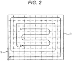
- Fig. 2 shows an example of a travel route of a tractor
- Fig. 3 shows an example of a travel route of a rice transplanter
- each of the work vehicles 2 may automatically creates the travel route shown in each of Figs. 2 to 4 .
- the travel route is indicated by a route traveled from A to B and then traveled from C to D. Since the setting for a travel route as above is known as such, the explanation thereof will be omitted.
- the division map creation unit 30 creates a division map in accordance with the work width of the work performed when the work vehicle 2 travels in the work field 3 based on the route information and the travel direction of the work vehicle 2 during traveling.
- the division map creation unit 30 is mounted in a server 4 provided separately from the work vehicle 2, and route information is transmitted from the route information acquisition unit 20 in the work vehicle 2.
- the division map may be a mesh-like map obtained by dividing the work field 3 in which the work vehicle 2 travels into a plurality of sections.
- Figs. 2 to 4 show a plurality of sections divided by broken lines. The examples of Figs.
- the division map creation unit 30 may create a division map divided into a plurality of sections for each area (work width) where the work vehicle 2 actually passes and works as described above.
- the division map may be created such that the center of the travel route passes through the center of the section, or such that the center of the travel route is deviated from the center of the section.
- the storage unit 40 stores the division map created by the division map creation unit 30 in association with the work vehicle 2. As described above, the travel route and a plurality of sections may vary depending on the work vehicle 2. Therefore, the storage unit 40 stores the division map created by the division map creation unit 30 in association with the work vehicle 2 traveling in the work field 3 along the travel route used for creating the division map. When a plurality of types of work vehicles 2 having different work contents work in the single work field 3, the storage unit 40 may store a plurality of division maps in association with the single work field 3 for each type of the work vehicles 2.
- the storage unit 40 may store each of a plurality of sections of the division map in association with work information related to the work performed by the work vehicle 2.
- work information on the work performed by the work vehicle 2 include a vehicle speed at the time of the work vehicle 2 performing the work, a cultivation depth at the time of cultivating the work field 3, a height setting for the ground work device (impulse), a fertilizing amount, and the like.
- the work information may indicate the type of the crop when the work vehicle 2 is a combine.
- the storage unit 40 may store each of a plurality of sections in association with such information as detailed above.
- the data managed by the division map may match the data acquired by the actual work. This may allow an improvement in accuracy. Further, the use of the division map of the own vehicle in accordance with the work of the work vehicle 2 may enable the work vehicle 2 to work efficiently.
- the work field information acquisition unit 10 and the route information acquisition unit 20 are mounted on the work vehicle 2 and the division map creation unit 30 and the storage unit 40 are mounted on the server 4 different from the work vehicle 2.
- all of the work field information acquisition unit 10, the route information acquisition unit 20, the division map creation unit 30, and the storage unit 40 may be mounted on the work vehicle 2, or all the functional units may be mounted on the server 4.
- the work vehicle 2 has been described by taking a plurality of types of work vehicles 2 as an example, the work vehicle 2 may not be of a plurality of types.
- the description has been given with the examples of a tractor, a rice transplanter, and a combine as the plurality of types of work vehicles 2, it is also possible to apply the system to other work vehicles 2.
- the storage unit 40 stores each of a plurality of sections of the division map in association with work information related to the work performed by the work vehicle 2.
- the storage unit 40 may store each of a plurality of sections of the division map not in association with work information related to the work performed by the work vehicle 2.
- the travel route has been described as being a route along which the work vehicle 2 travels during automatic traveling.
- the travel route may be a travel route at the time of causing the work vehicle 2 to manually travel, or may be a travel route at the time of teaching the work vehicle 2 for traveling by remote control.
- the work width is changed in the middle of the work (e.g., at the time of planting on each row by the rice transplanter, at the time of one-side folding by a tractor harrow, etc.)
- the work field may be divided into a plurality of sections with the changed work width.
- the technology disclosed herein is applicable to a division map creation system that creates a division map obtained by dividing a work field in which a work vehicle travels into a plurality of sections.
Landscapes
- Engineering & Computer Science (AREA)
- Radar, Positioning & Navigation (AREA)
- Remote Sensing (AREA)
- Physics & Mathematics (AREA)
- General Physics & Mathematics (AREA)
- Life Sciences & Earth Sciences (AREA)
- Theoretical Computer Science (AREA)
- Automation & Control Theory (AREA)
- Business, Economics & Management (AREA)
- Databases & Information Systems (AREA)
- Aviation & Aerospace Engineering (AREA)
- Environmental Sciences (AREA)
- Soil Sciences (AREA)
- Mechanical Engineering (AREA)
- Strategic Management (AREA)
- Mining & Mineral Resources (AREA)
- Marketing (AREA)
- Tourism & Hospitality (AREA)
- Human Resources & Organizations (AREA)
- General Business, Economics & Management (AREA)
- General Health & Medical Sciences (AREA)
- Economics (AREA)
- Health & Medical Sciences (AREA)
- Primary Health Care (AREA)
- Data Mining & Analysis (AREA)
- General Engineering & Computer Science (AREA)
- Marine Sciences & Fisheries (AREA)
- Animal Husbandry (AREA)
- Agronomy & Crop Science (AREA)
- Guiding Agricultural Machines (AREA)
- Instructional Devices (AREA)
- Management, Administration, Business Operations System, And Electronic Commerce (AREA)
Abstract
The present disclosure refers to a division map creation system (1) for creating a division map obtained by dividing a work field (3) in which work vehicles (2) are configured to travel into a plurality of sections. The system (1) includes: a work field information acquisition unit (10) to acquire work field information including position information indicating a position of the work field (3) and shape information indicating a shape of the work field (3); a route information acquisition unit (20) to acquire route information indicating individual travel routes when the work vehicles (2) travel on the work field (3) based on the work field information; a division map creation unit (30) to create the division map in accordance with a work width of work performed when the work vehicles (2) travel in the work field (3) based on the route information and a travel direction of the work vehicles (2) during traveling; and a storage unit (40) to store the division map created by the division map creation unit (30) in association with the work vehicles (2). Further, a method for creating a division map is provided.
Description
- The disclosure relates to a division map creation system and a method for creating a division map obtained by dividing a work field in which a work vehicle travels into a plurality of sections.
- For efficiently performing work and harvesting in a field, for example, methods for managing the field by dividing the field into a plurality of sections have been used. As a technique of this type, there is, for example, a technique described in
JP 2011-254711 A - In the fertilization map creation system described in
JP 2011-254711 A - In the technique described in
JP 2011-254711 A JP 2011-254711 A - It is an object to provide a division map creation system and a method capable of creating a division map obtained by dividing a work field into a plurality of sections in order to make effective use of a map in accordance with work.
- For solving the problem, a division map creation system for creating a division map obtained by dividing a work field in which work vehicles are configured to travel into a plurality of sections according to
independent claim 1 is provided. Further, a method for creating a division map according toclaim 5 is proposed. Further embodiments are disclosed in dependent claims. - According to an aspect, a division map creation system for creating a division map obtained by dividing a work field in which work vehicles are configured to travel into a plurality of sections is provided. The system comprises: a work field information acquisition unit to acquire work field information including position information indicating a position of the work field and shape information indicating a shape of the work field; a route information acquisition unit to acquire route information indicating individual travel routes when the work vehicles travel in the work field based on the work field information; a division map creation unit to create the division maps in accordance with work widths of works performed when the work vehicles travel in the work field based on the route information and travel directions of the work vehicles during traveling; and a storage unit to store the division maps created by the division map creation unit in association with the work vehicles.
- According to a further aspect, a method for creating a division map obtained by dividing a work field in which work vehicles are configured to travel into a plurality of sections using a division map creation system is provided, the division map creation system comprising a work field information acquisition unit, a route information acquisition unit, a division map creation unit, and a storage unit. The method comprises: acquiring, by the work field information acquisition unit, work field information including position information indicating a position of the work field and shape information indicating a shape of the work field; acquiring, by the route information acquisition unit, route information indicating individual travel routes when the work vehicles travel in the work field based on the work field information; creating, by the division map creation unit, the division maps in accordance with work widths of works performed when the work vehicles travel in the work field based on the route information and travel directions of the work vehicles during traveling; and storing, by the storage unit, the division maps created by the division map creation unit in association with the work vehicles.
- A division map may be created by dividing a work field into a plurality of sections in accordance with a work width and a travel direction of a work vehicle, thereby enabling creation of a work map suitable for the work of the work vehicle. It may thus be possible to effectively use the work map in accordance with the work of the work vehicle.
- The work vehicles may be a plurality of types of work vehicles, and the storage unit may be configured to store a plurality of division maps in association with the types of the work vehicles. The plurality of the division maps may belong to an identical work field.
- A division map may be created in accordance with the work width and along the travel direction of each of a plurality of types of work vehicles, thereby enabling creation of a work map in accordance with each of the work vehicles even when work widths of the work vehicles are different from each other. It may thus be possible to effectively use the work map in accordance with the work of each of the work vehicles.
- The plurality of types of work vehicles may be work vehicles to perform different works and the travel routes along which the work vehicles are configured to travel in the work field may be different from each other.
- A division map may be created in accordance with the work width and along the travel direction of each of a plurality of types of work vehicles. Thereby, creation of a work map in accordance with each of the work vehicles may be created even when travel routes of the work vehicles are different from each other. It may thus be possible to effectively use the work maps even when the work vehicles travel based on travel routes in accordance with works of the work vehicles.
- The storage unit may be configured to store each of the plurality of sections of the division maps in association with work information related to works performed by the work vehicles.
- The work vehicle may perform work with reference to the work map at the time of performing work, and may thus perform work suitable for the work field.
- The embodiments described above with regard to a division map creation system may apply to the method for creating a division map mutatis mutandis.
-
- Fig. 1
- is a diagram schematically showing a configuration of a division map creation system.
- Fig. 2
- is a view showing a travel route and a division map of a tractor.
- Fig. 3
- is a view showing a travel route and a division map of a rice transplanter.
- Fig. 4
- is a view showing a travel route and a division map of a combine.
- A division map creation system according to the disclosure has the function of creating a division map obtained by dividing a work field into a plurality of sections. Hereinafter, a division
map creation system 1 will be described. -
Fig. 1 is a diagram schematically showing a configuration of a divisionmap creation system 1. As shown inFig. 1 , the divisionmap creation system 1 is configured including functional units that are a work fieldinformation acquisition unit 10, a routeinformation acquisition unit 20, a divisionmap creation unit 30, and astorage unit 40, and these functional units are constructed with hardware, software, or both, with a CPU taken as a core member so as to perform processing relating to creation of the division map. In an embodiment, the work fieldinformation acquisition unit 10 and the routeinformation acquisition unit 20 are mounted on awork vehicle 2 and the divisionmap creation unit 30 and thestorage unit 40 are mounted on aserver 4 different from thework vehicle 2. - The work field
information acquisition unit 10 acquires work field information including position information indicating the position of awork field 3 and shape information indicating the shape of thework field 3. Thework field 3 is a place where thework vehicle 2 travels while performing work. According to an embodiment, thework vehicle 2 is an agricultural work machine for performing a variety of work in the field, and thework field 3 corresponds to the field. The position information may correspond to position information including latitude and longitude. The shape information may be information indicating the shape of thework field 3 when thework field 3 is viewed from above. Hence the work fieldinformation acquisition unit 10 may acquire the work field information including the position information which is information including the latitude and longitude of the field and the shape information which is information indicating the shape of the field. The work fieldinformation acquisition unit 10 may acquire the work field information by communication or may acquire the work field information by inputting data. - The route
information acquisition unit 20 acquires route information indicating individual travel routes when thework vehicles 2 travel in thework field 3 based on the work field information. The work field information is transmitted from the work fieldinformation acquisition unit 10 described above. In an embodiment, when the work field information is inputted to thework vehicle 2, thework vehicle 2 sets a travel route so as to efficiently complete the work in thework field 3, and then performs automatic travel based on the travel route. The routeinformation acquisition unit 20 may acquire route information indicating this travel route. - According to an embodiment, a plurality of
work vehicles 2 of a plurality of types ofwork vehicles 2 is provided. The plurality of types ofwork vehicles 2 may be workvehicles 2 that are different in at least one of a width of work performed by the work vehicle 2 (work width) and a content of the work. In an embodiment, the plurality of types ofwork vehicles 2 are workvehicles 2 that perform different work and the travel routes along which thework vehicles 2 travel in thework field 3 are different from each other. Specifically, as a plurality of types ofwork vehicle 2, a tractor, a rice transplanter, and a combine will be described as examples.Fig. 2 shows an example of a travel route of a tractor,Fig. 3 shows an example of a travel route of a rice transplanter, andFig. 4 shows an example of a travel route of a combine. When each of thework vehicles 2 is provided with work field information on thework field 3 and entrance and exit information indicating anentrance door 5 where thework vehicle 2 enters and exits thework field 3, each of thework vehicles 2 may automatically creates the travel route shown in each ofFigs. 2 to 4 . In each ofFigs. 2 to 4 , the travel route is indicated by a route traveled from A to B and then traveled from C to D. Since the setting for a travel route as above is known as such, the explanation thereof will be omitted. - Returning to
Fig. 1 , the divisionmap creation unit 30 creates a division map in accordance with the work width of the work performed when thework vehicle 2 travels in thework field 3 based on the route information and the travel direction of thework vehicle 2 during traveling. In an embodiment, the divisionmap creation unit 30 is mounted in aserver 4 provided separately from thework vehicle 2, and route information is transmitted from the routeinformation acquisition unit 20 in thework vehicle 2. The division map may be a mesh-like map obtained by dividing thework field 3 in which thework vehicle 2 travels into a plurality of sections.Figs. 2 to 4 show a plurality of sections divided by broken lines. The examples ofFigs. 2 to 4 show that the work widths of the work of the tractor and the rice transplanter are the same, and the work width of the combine is smaller than the work widths of the tractor and the rice transplanter. For this reason, the sections shown by the broken lines are smaller inFig. 4 than those inFigs. 2 and3 . Although each of the sections is squared along the travel direction with the work width taken as a reference in the examples shown, the shape of the sections is not particularly restricted to a square. The divisionmap creation unit 30 may create a division map divided into a plurality of sections for each area (work width) where thework vehicle 2 actually passes and works as described above. This may enable creation of a division map in accordance with the work content of thework vehicle 2, thus eliminating the need for division into unnecessarily fine sections. The division map may be created such that the center of the travel route passes through the center of the section, or such that the center of the travel route is deviated from the center of the section. - The
storage unit 40 stores the division map created by the divisionmap creation unit 30 in association with thework vehicle 2. As described above, the travel route and a plurality of sections may vary depending on thework vehicle 2. Therefore, thestorage unit 40 stores the division map created by the divisionmap creation unit 30 in association with thework vehicle 2 traveling in thework field 3 along the travel route used for creating the division map. When a plurality of types ofwork vehicles 2 having different work contents work in thesingle work field 3, thestorage unit 40 may store a plurality of division maps in association with thesingle work field 3 for each type of thework vehicles 2. - Further, the
storage unit 40 may store each of a plurality of sections of the division map in association with work information related to the work performed by thework vehicle 2. Examples of the work information on the work performed by thework vehicle 2 include a vehicle speed at the time of thework vehicle 2 performing the work, a cultivation depth at the time of cultivating thework field 3, a height setting for the ground work device (impulse), a fertilizing amount, and the like. The work information may indicate the type of the crop when thework vehicle 2 is a combine. Thestorage unit 40 may store each of a plurality of sections in association with such information as detailed above. - According to embodiments described above, it may be possible to create a division map suitable for the work performed by the
work vehicle 2. Accordingly, the data managed by the division map may match the data acquired by the actual work. This may allow an improvement in accuracy. Further, the use of the division map of the own vehicle in accordance with the work of thework vehicle 2 may enable thework vehicle 2 to work efficiently. - In the above embodiment, the work field
information acquisition unit 10 and the routeinformation acquisition unit 20 are mounted on thework vehicle 2 and the divisionmap creation unit 30 and thestorage unit 40 are mounted on theserver 4 different from thework vehicle 2. However, all of the work fieldinformation acquisition unit 10, the routeinformation acquisition unit 20, the divisionmap creation unit 30, and thestorage unit 40 may be mounted on thework vehicle 2, or all the functional units may be mounted on theserver 4. - In the above embodiment, although the
work vehicle 2 has been described by taking a plurality of types ofwork vehicles 2 as an example, thework vehicle 2 may not be of a plurality of types. Although the description has been given with the examples of a tractor, a rice transplanter, and a combine as the plurality of types ofwork vehicles 2, it is also possible to apply the system toother work vehicles 2. - In the above embodiment, the
storage unit 40 stores each of a plurality of sections of the division map in association with work information related to the work performed by thework vehicle 2. However, thestorage unit 40 may store each of a plurality of sections of the division map not in association with work information related to the work performed by thework vehicle 2. - In the above embodiment, the travel route has been described as being a route along which the
work vehicle 2 travels during automatic traveling. However, the travel route may be a travel route at the time of causing thework vehicle 2 to manually travel, or may be a travel route at the time of teaching thework vehicle 2 for traveling by remote control. - In the above embodiment, the description has been given assuming that the division map is created by dividing the work field into a plurality of sections based on the work width of the
work vehicle 2. However, when the work width is changed in the middle of the work (e.g., at the time of planting on each row by the rice transplanter, at the time of one-side folding by a tractor harrow, etc.), the work field may be divided into a plurality of sections with the changed work width. - The technology disclosed herein is applicable to a division map creation system that creates a division map obtained by dividing a work field in which a work vehicle travels into a plurality of sections.
-
- 1:
- vehicle body
- 7:
- satellite positioning module
- 13:
- steering mechanism
- 14:
- steering motor
- 22:
- steering wheel
- 40:
- touch panel
- 41:
- information input operation tool
- 42:
- sensitivity adjustment operation tool
- 44:
- work traveling information acquisition unit
- 45:
- work traveling information storing unit
- 46:
- travel route generation unit
- 50:
- steering control module
- 51:
- travel route setting unit
- 53:
- travel control unit
- 55:
- travel locus calculation unit
- 70:
- own vehicle position calculation unit
- 501:
- steering control unit
- 502:
- control input value calculation unit
- 503:
- steering sensitivity setting unit
- 504:
- steering sensitivity adjustment unit
Claims (5)
- A division map creation system for creating a division map obtained by dividing a work field in which work vehicles are configured to travel into a plurality of sections, the system comprising:- a work field information acquisition unit to acquire work field information including position information indicating a position of the work field and shape information indicating a shape of the work field;- a route information acquisition unit to acquire route information indicating individual travel routes when the work vehicles travel in the work field based on the work field information;- a division map creation unit to create the division maps in accordance with work widths of works performed when the work vehicles travel in the work field based on the route information and travel directions of the work vehicles during traveling; and- a storage unit to store the division maps created by the division map creation unit in association with the work vehicles.
- The division map creation system according to claim 1, wherein- the work vehicles are a plurality of types of work vehicles, and- the storage unit is configured to store a plurality of the division maps in association with types of the work vehicles, the plurality of the division maps belonging to an identical work field.
- The division map creation system according to claim 2, wherein- the plurality of types of work vehicles are work vehicles to perform different works, and- travel routes along which the work vehicles are configured to travel in the work field are different from each other.
- The division map creation system according to any one of claims 1 to 3, wherein the storage unit is configured to store each of the plurality of sections of the division maps in association with work information related to the works performed by the work vehicles.
- A method for creating a division map obtained by dividing a work field in which work vehicles are configured to travel into a plurality of sections using a division map creation system comprising- a work field information acquisition unit;- a route information acquisition unit;- a division map creation unit; and- a storage unit;the method comprising:- acquiring, by the work field information acquisition unit, work field information including position information indicating a position of the work field and shape information indicating a shape of the work field;- acquiring, by the route information acquisition unit, route information indicating individual travel routes when the work vehicles travel in the work field based on the work field information;- creating, by the division map creation unit, the division maps in accordance with work widths of works performed when the work vehicles travel in the work field based on the route information and travel directions of the work vehicles during traveling; and- storing, by the storage unit, the division maps created by the division map creation unit in association with the work vehicles.
Applications Claiming Priority (1)
| Application Number | Priority Date | Filing Date | Title |
|---|---|---|---|
| JP2017008343A JP6956490B2 (en) | 2017-01-20 | 2017-01-20 | Split map creation system |
Publications (1)
| Publication Number | Publication Date |
|---|---|
| EP3361217A1 true EP3361217A1 (en) | 2018-08-15 |
Family
ID=60811776
Family Applications (1)
| Application Number | Title | Priority Date | Filing Date |
|---|---|---|---|
| EP17207027.8A Withdrawn EP3361217A1 (en) | 2017-01-20 | 2017-12-13 | Division map creation system and method for creating a division map |
Country Status (4)
| Country | Link |
|---|---|
| US (1) | US10782132B2 (en) |
| EP (1) | EP3361217A1 (en) |
| JP (1) | JP6956490B2 (en) |
| CN (1) | CN108334535A (en) |
Families Citing this family (7)
| Publication number | Priority date | Publication date | Assignee | Title |
|---|---|---|---|---|
| JP7105659B2 (en) * | 2018-09-13 | 2022-07-25 | ヤンマーパワーテクノロジー株式会社 | Image information synthesizing device |
| JP7329645B2 (en) * | 2018-12-14 | 2023-08-18 | ヤンマーパワーテクノロジー株式会社 | Work support system |
| JP2020099269A (en) * | 2018-12-21 | 2020-07-02 | 株式会社クボタ | Field work vehicle and travel route generation system |
| JP7332502B2 (en) * | 2020-02-27 | 2023-08-23 | 三菱マヒンドラ農機株式会社 | Route creation management system |
| JP2022087961A (en) * | 2020-12-02 | 2022-06-14 | ヤンマーホールディングス株式会社 | Combine and travelling route creation method |
| CN113387099B (en) * | 2021-06-30 | 2023-01-10 | 深圳市海柔创新科技有限公司 | Map construction method, device, equipment, storage system and storage medium |
| JP7782533B2 (en) * | 2023-09-21 | 2025-12-09 | 井関農機株式会社 | Work vehicles |
Citations (4)
| Publication number | Priority date | Publication date | Assignee | Title |
|---|---|---|---|---|
| US6236924B1 (en) * | 1999-06-21 | 2001-05-22 | Caterpillar Inc. | System and method for planning the operations of an agricultural machine in a field |
| US20070233374A1 (en) * | 2006-03-30 | 2007-10-04 | Norbert Diekhans | Method for creating a route plan for agricultural machine systems |
| JP2011254711A (en) | 2010-06-05 | 2011-12-22 | Zukosha:Kk | Fertilization map generating system, method for the same, industrial helicopter, server, and controlled fertilizer applicator |
| US20160174453A1 (en) * | 2014-07-29 | 2016-06-23 | Kubota Corporation | Work Vehicle Coordinating System |
Family Cites Families (12)
| Publication number | Priority date | Publication date | Assignee | Title |
|---|---|---|---|---|
| US4630773A (en) * | 1984-11-06 | 1986-12-23 | Soil Teq., Inc. | Method and apparatus for spreading fertilizer |
| US5220876A (en) * | 1992-06-22 | 1993-06-22 | Ag-Chem Equipment Co., Inc. | Variable rate application system |
| US5931882A (en) * | 1993-07-29 | 1999-08-03 | Raven Industries | Combination grid recipe and depth control system |
| JP2000014208A (en) * | 1998-07-03 | 2000-01-18 | Bio Oriented Technol Res Advancement Inst | Operation support device for field work vehicles |
| JP2004129522A (en) * | 2002-10-08 | 2004-04-30 | Yanmar Agricult Equip Co Ltd | Combine |
| JP2004213239A (en) * | 2002-12-27 | 2004-07-29 | Iseki & Co Ltd | Work management device |
| JP5420510B2 (en) * | 2010-09-30 | 2014-02-19 | 本田技研工業株式会社 | Control device for autonomous vehicle |
| JP5944805B2 (en) * | 2012-09-26 | 2016-07-05 | 株式会社クボタ | Combine and combine management system |
| JP6118615B2 (en) * | 2013-03-29 | 2017-04-19 | 株式会社クボタ | Agricultural management support device and agricultural management support system |
| CN106163259A (en) * | 2014-03-07 | 2016-11-23 | 洋马株式会社 | Crops harvester |
| JP2016071726A (en) * | 2014-09-30 | 2016-05-09 | 井関農機株式会社 | Work information storage device |
| JP2016187305A (en) * | 2015-03-28 | 2016-11-04 | 井関農機株式会社 | Mobile agricultural machine |
-
2017
- 2017-01-20 JP JP2017008343A patent/JP6956490B2/en active Active
- 2017-11-29 CN CN201711223694.5A patent/CN108334535A/en active Pending
- 2017-12-13 EP EP17207027.8A patent/EP3361217A1/en not_active Withdrawn
- 2017-12-14 US US15/841,295 patent/US10782132B2/en active Active
Patent Citations (4)
| Publication number | Priority date | Publication date | Assignee | Title |
|---|---|---|---|---|
| US6236924B1 (en) * | 1999-06-21 | 2001-05-22 | Caterpillar Inc. | System and method for planning the operations of an agricultural machine in a field |
| US20070233374A1 (en) * | 2006-03-30 | 2007-10-04 | Norbert Diekhans | Method for creating a route plan for agricultural machine systems |
| JP2011254711A (en) | 2010-06-05 | 2011-12-22 | Zukosha:Kk | Fertilization map generating system, method for the same, industrial helicopter, server, and controlled fertilizer applicator |
| US20160174453A1 (en) * | 2014-07-29 | 2016-06-23 | Kubota Corporation | Work Vehicle Coordinating System |
Also Published As
| Publication number | Publication date |
|---|---|
| JP2018116214A (en) | 2018-07-26 |
| JP6956490B2 (en) | 2021-11-02 |
| US20180209792A1 (en) | 2018-07-26 |
| CN108334535A (en) | 2018-07-27 |
| US10782132B2 (en) | 2020-09-22 |
Similar Documents
| Publication | Publication Date | Title |
|---|---|---|
| EP3725632B1 (en) | Travel path generation system and field work vehicle | |
| US10782132B2 (en) | Division map creation system and method for creating division maps | |
| US11825761B2 (en) | Apparatus and methods for field operations based on historical field operation data | |
| Seyyedhasani et al. | Reducing field work time using fleet routing optimization | |
| EP0821296B1 (en) | Route planning system for agricultural working vehicles | |
| US11044842B2 (en) | Path planning for area coverage | |
| US7747370B2 (en) | Method for creating end of row turns for agricultural vehicles | |
| EP3618600B1 (en) | Guidance working depth compensation | |
| RU2439835C2 (en) | Routing system and method for systems of farm machines | |
| US8296052B2 (en) | Method for avoiding point rows for quadrilateral fields using autoguidance | |
| CN111093355A (en) | Agricultural support device and agricultural support system | |
| DE102019111315A1 (en) | Autonomous agricultural work machine and method of operating it | |
| WO2011139590A2 (en) | System, method, and computer program product for managing a research seed location | |
| JP2023086963A (en) | Work information generator | |
| JP2019088217A (en) | Field work support terminal, field work machine, and field work support program | |
| JP6772105B2 (en) | Work management system | |
| Soitinaho et al. | Heuristic cooperative coverage path planning for multiple autonomous agricultural field machines performing sequentially dependent tasks of different working widths and turn characteristics | |
| Song et al. | Development of path planning algorithm for an autonomous mower tractor | |
| DE19921995A1 (en) | Arrangement for ensuring neighboring strips converge when a field is being cultivated with agricultural machinery has a DGPS receiver onboard connecting to satellites with the position data to create an electronic display | |
| DE102024118312A1 (en) | GUIDANCE AND/OR AUTOMATION OF WORK VEHICLES IN RELATION TO RECOGNIZED REGIONS OF INTEREST IN A WORK AREA | |
| CN111435489A (en) | Agriculture dealing system | |
| JP7050874B2 (en) | Work management system | |
| DE102022103370A1 (en) | Method for sensor-assisted guidance of a work machine and corresponding arrangement | |
| EP4643625A1 (en) | Field registration device, field registration method, and computer program | |
| KR102781653B1 (en) | Method for generating path of a work machine based autonomous driving and apparatus thereof |
Legal Events
| Date | Code | Title | Description |
|---|---|---|---|
| PUAI | Public reference made under article 153(3) epc to a published international application that has entered the european phase |
Free format text: ORIGINAL CODE: 0009012 |
|
| AK | Designated contracting states |
Kind code of ref document: A1 Designated state(s): AL AT BE BG CH CY CZ DE DK EE ES FI FR GB GR HR HU IE IS IT LI LT LU LV MC MK MT NL NO PL PT RO RS SE SI SK SM TR |
|
| AX | Request for extension of the european patent |
Extension state: BA ME |
|
| STAA | Information on the status of an ep patent application or granted ep patent |
Free format text: STATUS: THE APPLICATION IS DEEMED TO BE WITHDRAWN |
|
| 18D | Application deemed to be withdrawn |
Effective date: 20190216 |