EP3358530A1 - Compressed edge map representation for image aided navigation - Google Patents
Compressed edge map representation for image aided navigation Download PDFInfo
- Publication number
- EP3358530A1 EP3358530A1 EP17202930.8A EP17202930A EP3358530A1 EP 3358530 A1 EP3358530 A1 EP 3358530A1 EP 17202930 A EP17202930 A EP 17202930A EP 3358530 A1 EP3358530 A1 EP 3358530A1
- Authority
- EP
- European Patent Office
- Prior art keywords
- edges
- fitting
- image
- mathematical model
- map
- Prior art date
- Legal status (The legal status is an assumption and is not a legal conclusion. Google has not performed a legal analysis and makes no representation as to the accuracy of the status listed.)
- Granted
Links
Images



Classifications
-
- G—PHYSICS
- G09—EDUCATION; CRYPTOGRAPHY; DISPLAY; ADVERTISING; SEALS
- G09B—EDUCATIONAL OR DEMONSTRATION APPLIANCES; APPLIANCES FOR TEACHING, OR COMMUNICATING WITH, THE BLIND, DEAF OR MUTE; MODELS; PLANETARIA; GLOBES; MAPS; DIAGRAMS
- G09B23/00—Models for scientific, medical, or mathematical purposes, e.g. full-sized devices for demonstration purposes
- G09B23/02—Models for scientific, medical, or mathematical purposes, e.g. full-sized devices for demonstration purposes for mathematics
- G09B23/04—Models for scientific, medical, or mathematical purposes, e.g. full-sized devices for demonstration purposes for mathematics for geometry, trigonometry, projection or perspective
-
- G—PHYSICS
- G01—MEASURING; TESTING
- G01C—MEASURING DISTANCES, LEVELS OR BEARINGS; SURVEYING; NAVIGATION; GYROSCOPIC INSTRUMENTS; PHOTOGRAMMETRY OR VIDEOGRAMMETRY
- G01C21/00—Navigation; Navigational instruments not provided for in groups G01C1/00 - G01C19/00
- G01C21/38—Electronic maps specially adapted for navigation; Updating thereof
- G01C21/3804—Creation or updating of map data
- G01C21/3807—Creation or updating of map data characterised by the type of data
- G01C21/3826—Terrain data
-
- G—PHYSICS
- G01—MEASURING; TESTING
- G01C—MEASURING DISTANCES, LEVELS OR BEARINGS; SURVEYING; NAVIGATION; GYROSCOPIC INSTRUMENTS; PHOTOGRAMMETRY OR VIDEOGRAMMETRY
- G01C21/00—Navigation; Navigational instruments not provided for in groups G01C1/00 - G01C19/00
- G01C21/38—Electronic maps specially adapted for navigation; Updating thereof
- G01C21/3804—Creation or updating of map data
- G01C21/3833—Creation or updating of map data characterised by the source of data
- G01C21/3852—Data derived from aerial or satellite images
-
- G—PHYSICS
- G01—MEASURING; TESTING
- G01C—MEASURING DISTANCES, LEVELS OR BEARINGS; SURVEYING; NAVIGATION; GYROSCOPIC INSTRUMENTS; PHOTOGRAMMETRY OR VIDEOGRAMMETRY
- G01C21/00—Navigation; Navigational instruments not provided for in groups G01C1/00 - G01C19/00
- G01C21/38—Electronic maps specially adapted for navigation; Updating thereof
- G01C21/3863—Structures of map data
- G01C21/3867—Geometry of map features, e.g. shape points, polygons or for simplified maps
-
- G—PHYSICS
- G01—MEASURING; TESTING
- G01C—MEASURING DISTANCES, LEVELS OR BEARINGS; SURVEYING; NAVIGATION; GYROSCOPIC INSTRUMENTS; PHOTOGRAMMETRY OR VIDEOGRAMMETRY
- G01C21/00—Navigation; Navigational instruments not provided for in groups G01C1/00 - G01C19/00
- G01C21/38—Electronic maps specially adapted for navigation; Updating thereof
- G01C21/3863—Structures of map data
- G01C21/387—Organisation of map data, e.g. version management or database structures
- G01C21/3881—Tile-based structures
-
- G—PHYSICS
- G06—COMPUTING OR CALCULATING; COUNTING
- G06F—ELECTRIC DIGITAL DATA PROCESSING
- G06F16/00—Information retrieval; Database structures therefor; File system structures therefor
- G06F16/50—Information retrieval; Database structures therefor; File system structures therefor of still image data
-
- G—PHYSICS
- G06—COMPUTING OR CALCULATING; COUNTING
- G06T—IMAGE DATA PROCESSING OR GENERATION, IN GENERAL
- G06T17/00—Three-dimensional [3D] modelling for computer graphics
-
- G—PHYSICS
- G06—COMPUTING OR CALCULATING; COUNTING
- G06T—IMAGE DATA PROCESSING OR GENERATION, IN GENERAL
- G06T9/00—Image coding
- G06T9/20—Contour coding, e.g. using detection of edges
-
- G—PHYSICS
- G06—COMPUTING OR CALCULATING; COUNTING
- G06F—ELECTRIC DIGITAL DATA PROCESSING
- G06F16/00—Information retrieval; Database structures therefor; File system structures therefor
- G06F16/20—Information retrieval; Database structures therefor; File system structures therefor of structured data, e.g. relational data
- G06F16/29—Geographical information databases
-
- G—PHYSICS
- G06—COMPUTING OR CALCULATING; COUNTING
- G06T—IMAGE DATA PROCESSING OR GENERATION, IN GENERAL
- G06T7/00—Image analysis
- G06T7/10—Segmentation; Edge detection
- G06T7/13—Edge detection
Definitions
- a map may be used to provide absolute position updates. This process works by comparing the image of a scene viewed by a camera to a database of images at known locations. The relative offset between these two images reflects the error in the current navigation state estimate. Maintaining a database of images for navigation requires a great deal of storage, such as tens or hundreds of gigabytes for realistic missions.
- edges can be extracted from an image using one of many known edge detection routines, such as the Canny or Sobel methods. After extraction, edges from the camera image and database image can be compared for use in vision-aided navigation as described above. Edges from an image are advantageous to use because they are robust to different sensor bands. For example, edges from an infrared image often match edges from an optical-band image very well.
- a method of generating a map for image aided navigation comprises detecting one or more edges in one or more terrain images, and obtaining a compressed edge representation of the one or more edges.
- the compressed edge representation is obtained by a method comprising fitting a geometric form or other mathematical model to the one or more edges, calculating one or more coefficients based on the fitted geometric form or other mathematical model, and storing the one or more coefficients in a database for use in generating the map for image aided navigation.
- a method and system for compressed edge map representation is provided for use in image aided navigation.
- the present approach provides a compression method for the storage of an image database that is optimized for an edge matching method of image correlation.
- the edges of an image are represented using geometric forms or other mathematical models.
- Exemplary geometric forms or mathematical models include line segments; curve segments such as splines, quadratic curves, or cubic curves; higher order polynomials such as fourth or fifth order; or any other mathematical model to which edges of an image can be fit. This approach allows for just the coefficients of the geometric forms or other mathematical model to be stored, significantly reducing memory requirements.
- the present approach allows maps of interest to fit in small amounts of flash memory, for example. This enables very low cost, size, weight and power (C-SWAP) systems to benefit from map-based image aided navigation.
- Figure 1 is a flow diagram of a method 100 for generating a map for image aided navigation according to one implementation.
- the method 100 comprises detecting one or more edges in a terrain image (block 110).
- the method 100 then obtains a compressed edge representation of the one or more edges in the terrain image (block 120).
- a means for obtaining the compressed edge representation includes an algorithmic technique that fits a geometric form or other mathematical model to the one or more edges in the terrain image (block 122), and calculates one or more coefficients based on the fitted geometric form or other mathematical model (block 124).
- the one or more coefficients are then stored for use in generating the map for image aided navigation (block 126).
- line segments are used to represent the edges of an image. Initially, the image is divided into pixel blocks of a uniform size, such as 8 x 8 pixel blocks. Then, for each pixel block, one or multiple line segments are fitted to the edge pixels inside the pixel block. This can be accomplished using any number of standard fitting routines, such as a least squares method or singular value decomposition. Lastly, the coordinates of the line segment endpoints are stored. This allows a very large compression of an image database for use in edge-based vision navigation.
- an edge detector such as a Canny edge detector can be applied to each image in world imagery, and then a long-edge selection algorithm can be applied, such that only edge pixels that belong to a long edge are retained and stored in a world map.
- the long edges correspond to topographic features that correlate well, while short edges typically correspond to noise, clutter or textures that vary greatly with season, year and the imager spectrum.
- current camera images can also be subjected to an edge detector, have long edges selected, and then the long edges of the stored world map and the current image are correlated during image aided navigation.
- the long-edge selection algorithm prunes the detected edges, keeping only those necessary for navigation.
- This algorithm is robust to noise in terrain data, and has been evaluated on satellite imagery for various types of terrain.
- the algorithm runs a Canny edge detector on a fine resolution image, and then selects the long edges in the image in the following manner. Initially, the edge-pixel image is divided into 8 x 8 pixel blocks. Then, in each 8 x 8 pixel block, the pixels that correspond to edge pixels are fit to a line using a least-squares fit. If there are enough edge pixels in that 8 x 8 pixel block and they fit well to a line, then the start and end points of each fitted line segment are saved to memory, while all edge pixels are deleted. This significantly reduces the amount of memory needed to store a world map, as shown in Table 1 discussed hereafter. Correlation of images based on long edges also makes the correlation more robust to image noise.
- edge and line segments were evaluated for eight different examples of terrain: urban, suburban 1, suburban 2, rural 1, rural 2, forest 1, forest 2, and desert.
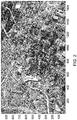
- Figure 2 shows an urban terrain type image, for example, with line segment edge representations.
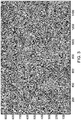
- Figure 3 shows a forest terrain type image, for example, with line segment edge representations.
- an urban environment is rich with edge features, such as roads, buildings and other man-made structures that provide ample edges for the algorithm. Even unbroken forest can present an edge rich environment, as shown in Figure 3 .
- a Canny edge detector with a selected blur-size sigma can be used.
- the selection of blur sigma can be automated in the map building process by monitoring the number of detected edge pixels and adjusting the blur sigma accordingly to achieve a target edge density.
- a threshold was also set on how far the edge pixels could be from the best fit line, in order to consider the line to be good enough to keep.
- a second pass over the line segments may be performed to consolidate collinear line segments from different 8 x 8 pixel regions.
- Figure 4 shows a close-up view of the urban terrain type image of Figure 2 .
- Figure 5 depicts the extracted edge pixels and line segments from the image of Figure 4 , in which the line segments have been fitted to the edge pixels over the 8 x 8 pixel blocks.
- Figure 6 is a graph of a correlation peak of edge representation.
- the correlation peak is derived from "decompressing" the line segments back into edge pixels and correlating against the original edge pixels. All edge pixels near lines are correlated with unpacked line segments.
- the strong central peak in the graph of Figure 6 shows that the decompressed edge representation correlates well with the original edge pixels, indicating that little information is lost in the compression process.
- the present compressed edge map representation technique can implemented as part of a world map building process that offers absolute positioning, computational efficiency, sensor agnostic operation, and a massive compression of data, enabling whole-world map representations to be stored on every platform.
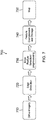
- Figure 7 illustrates a process 700 for producing and storing a world map according to the present approach.
- the input to the map-making process is ortho-imagery (block 710), which produces high resolution geometrically-corrected (ortho-rectified) images.
- ortho-imagery (block 710), which produces high resolution geometrically-corrected (ortho-rectified) images.
- such images are free of deformation from camera angle, lens distortion, or topographic relief.
- USGS United States Geological Survey
- Commercial software is also available to produce ortho-imagery from conventional aerial or satellite photographs.
- edge detection of edges in the imagery is carried out (block 720).
- edge detection There are multiple different methods for edge detection, with the most commonly used being the Canny edge detector.
- Edge feature selection and pre-processing of the edges for use in the map is the next step (block 730).
- the next step is feature compression and storage (block 740).
- image compression and storage In images which have relatively few edges, storing only a list of the locations of the edge pixels may be sufficient. For images that are dominated by a few long edges (the ideal situation for correlation), the edges can be stored extremely efficiently using mathematical models. Because correlation techniques are very robust to variation in a portion of the image, issues regarding staleness of the database are minimized.
- the feature compression and storage allows whole-world map representations to be easily stored (block 750), such as on a platform that employs image aided navigation.
- the process of navigating against the compressed whole-world map representations employs feature decompression of the relevant portion of the map. As map portions are locally indexed, it is unnecessary to decompress the entire map. This decompression stage is the inverse operation of the compression method applied during the generation of the map, returning the applicable portion of the map to a binary pixel image representation of edges. Further processing is then performed for the image aided navigation.
- a computer or processor used in the present system and method can be implemented using software, firmware, hardware, or any appropriate combination thereof, as known to one of skill in the art. These may be supplemented by, or incorporated in, specially-designed application-specific integrated circuits (ASICs) or field programmable gate arrays (FPGAs).
- ASICs application-specific integrated circuits
- FPGAs field programmable gate arrays
- the computer or processor can also include functions with software programs, firmware, or other computer readable instructions for carrying out various process tasks, calculations, and control functions used in the present method and system.
- the present method can be implemented by computer executable instructions, such as program modules or components, which are executed by a processing means such as at least one processor.
- program modules include routines, programs, objects, data components, data structures, algorithms, and the like, which perform particular tasks or implement particular abstract data types.
- Instructions for carrying out the various process tasks, calculations, and generation of other data used in the operation of the methods described herein can be implemented in software, firmware, or other computer-readable or processor-readable instructions. These instructions are typically stored on any appropriate computer program product that includes a computer readable medium used for storage of computer readable instructions or data structures. Such a computer readable medium can be any available media that can be accessed by a processing means such as a general purpose or special purpose computer or processor, or any programmable logic device.
- Suitable processor-readable media may include storage or memory media such as magnetic or optical media.
- storage or memory media may include conventional hard disks, compact disks, DVDs, Blu-ray discs, or other optical storage disks; volatile or non-volatile media such as Random Access Memory (RAM); Read Only Memory (ROM), Electrically Erasable Programmable ROM (EEPROM), flash memory, and the like; or any other media that can be used to carry or store desired program code in the form of computer executable instructions or data structures.
- RAM Random Access Memory
- ROM Read Only Memory
- EEPROM Electrically Erasable Programmable ROM
- flash memory and the like
- any other media that can be used to carry or store desired program code in the form of computer executable instructions or data structures.
- Example 1 includes a method of generating a map for image aided navigation, the method comprising: detecting one or more edges in one or more terrain images; and obtaining a compressed edge representation of the one or more edges, the compressed edge representation obtained by a method comprising: fitting a geometric form or other mathematical model to the one or more edges; calculating one or more coefficients based on the fitted geometric form or other mathematical model; and storing the one or more coefficients in a database for use in generating the map for image aided navigation.
- Example 2 includes the method of Example 1, wherein the one or more edges in the terrain image are detected with a Canny edge detector.
- Example 3 includes the method of any of Examples 1-2, wherein fitting the geometric form or other mathematical model to the one or more edges comprises fitting one or more line segments to the one or more edges.
- Example 4 includes the method of Example 3, wherein fitting the one or more line segments to the one or more edges comprises: dividing the one or more terrain images into multiple pixel blocks of a uniform size; and fitting the one or more line segments to edge pixels inside of each pixel block.
- Example 5 includes the method of Example 4, wherein fitting the one or more line segments to the edge pixels inside of each pixel block is carried out using a routine comprising a least-squares fit technique or a singular value decomposition.
- Example 6 includes the method of Example 4, wherein calculating the one or more coefficients comprises determining coordinates of endpoints for the one or more line segments.
- Example 7 includes the method of Example 6, wherein storing the one or more coefficients comprises storing the coordinates of the endpoints for the one or more line segments.
- Example 8 includes the method of any of Examples 1-2, wherein fitting the geometric form or other mathematical model to the one or more edges comprises fitting one or more curve segments to the one or more edges.
- Example 9 includes the method of Example 8, wherein the one or more curve segments comprise one or more splines, one or more quadratic curves, or one or more cubic curves.
- Example 10 includes the method of any of Examples 1-2, wherein fitting the geometric form or other mathematical model to the one or more edges comprises fitting one or more higher order polynomials to the one or more edges.
- Example 11 includes the method of any of Examples 1-10, wherein the map for image aided navigation comprises a world map.
- Example 12 includes a system for generating a map for image aided navigation, the system comprising: at least one processor; and a memory unit in operative communication with the at least one processor and including a database, the memory unit comprising a non-transitory computer readable medium having instructions executable by the at least one processor to perform a method comprising: detecting one or more edges in one or more terrain images; and obtaining a compressed edge representation of the one or more edges, the compressed edge representation obtained by a method comprising: fitting a geometric form or other mathematical model to the one or more edges; calculating one or more coefficients based on the fitted geometric form or other mathematical model; and storing the one or more coefficients in the database for use in generating the map for image aided navigation.
- Example 13 includes the system of Example 12, wherein the one or more edges in the terrain image are detected with a Canny edge detector.
- Example 14 includes the system of any of Examples 12-13, wherein fitting the geometric form or other mathematical model to the one or more edges comprises fitting one or more line segments to the one or more edges.
- Example 15 includes the system of Example 14, wherein calculating the one or more coefficients comprises determining coordinates of endpoints for the one or more line segments.
- Example 16 includes the system of Example 15, wherein storing the one or more coefficients comprises storing the coordinates of the endpoints for the one or more line segments
- Example 17 includes the system of any of Examples 12-13, wherein fitting the geometric form or other mathematical model to the one or more edges comprises fitting one or more curve segments to the one or more edges.
- Example 18 includes the system of any of Examples 12-13, wherein fitting the geometric form or other mathematical model to the one or more edges comprises fitting one or more higher order polynomials to the one or more edges.
- Example 19 includes a computer implemented system for generating a map for image aided navigation, the computer implemented system comprising: an edge detector configured to identify multiple edges in each of a plurality of terrain images; and means for obtaining a compressed edge representation of the edges in the terrain images, wherein the means for obtaining the compressed edge representation is configured to: fit a geometric form or other mathematical model to the edges; calculate coefficients based on the fitted geometric form or other mathematical model; and store the coefficients in a database for use in generating the map for image aided navigation.
- Example 20 includes the computer implemented system of Example 19, wherein: the geometric form or other mathematical model comprises a plurality of line segments; and the coefficients stored in the database comprise coordinates of endpoints for the line segments.
Landscapes
- Engineering & Computer Science (AREA)
- Remote Sensing (AREA)
- Radar, Positioning & Navigation (AREA)
- Physics & Mathematics (AREA)
- General Physics & Mathematics (AREA)
- Theoretical Computer Science (AREA)
- Automation & Control Theory (AREA)
- Geometry (AREA)
- Computational Mathematics (AREA)
- Pure & Applied Mathematics (AREA)
- Mathematical Optimization (AREA)
- Mathematical Analysis (AREA)
- Databases & Information Systems (AREA)
- Mathematical Physics (AREA)
- General Engineering & Computer Science (AREA)
- Data Mining & Analysis (AREA)
- Software Systems (AREA)
- Computer Graphics (AREA)
- Multimedia (AREA)
- Algebra (AREA)
- Business, Economics & Management (AREA)
- Educational Administration (AREA)
- Educational Technology (AREA)
- Processing Or Creating Images (AREA)
- Image Processing (AREA)
- Image Analysis (AREA)
Abstract
Description
- This invention was made with Government support under Government Contract No. FA8651-16-C-0333 awarded by the Department of the Air Force/AFRL. The Government has certain rights in the invention.
- In vision-aided navigation, a map may be used to provide absolute position updates. This process works by comparing the image of a scene viewed by a camera to a database of images at known locations. The relative offset between these two images reflects the error in the current navigation state estimate. Maintaining a database of images for navigation requires a great deal of storage, such as tens or hundreds of gigabytes for realistic missions.
- One conventional approach to image matching uses edge features or boundaries of objects shown in the images. The edges can be extracted from an image using one of many known edge detection routines, such as the Canny or Sobel methods. After extraction, edges from the camera image and database image can be compared for use in vision-aided navigation as described above. Edges from an image are advantageous to use because they are robust to different sensor bands. For example, edges from an infrared image often match edges from an optical-band image very well.
- Most image matching methods store whole imagery for navigation. Although compression, such as JPEG, is often used, this still requires a very large database to cover areas of interest for a mission, requiring the use of an expensive, power-hungry, and unreliable hard drive to store the images.
- A method of generating a map for image aided navigation comprises detecting one or more edges in one or more terrain images, and obtaining a compressed edge representation of the one or more edges. The compressed edge representation is obtained by a method comprising fitting a geometric form or other mathematical model to the one or more edges, calculating one or more coefficients based on the fitted geometric form or other mathematical model, and storing the one or more coefficients in a database for use in generating the map for image aided navigation.
- Features of the present invention will become apparent to those skilled in the art from the following description with reference to the drawings. Understanding that the drawings depict only typical embodiments and are not therefore to be considered limiting in scope, the invention will be described with additional specificity and detail through the use of the accompanying drawings, in which:
-
Figure 1 is a flow diagram of a method for generating a map for image aided navigation, according to one implementation; -
Figure 2 is an urban terrain type image, which shows line segment edge representations; -
Figure 3 is a forest terrain type image, which shows line segment edge representations; -
Figure 4 is a close-up image of a section of the urban terrain type image ofFigure 2 ; -
Figure 5 depicts the extracted edge pixels and line segments from the image ofFigure 4 ; -
Figure 6 is a graph of a correlation peak of an edge representation; and -
Figure 7 is a flow diagram of a process for producing a world map for image aided navigation, according to one implementation. - In the following detailed description, embodiments are described in sufficient detail to enable those skilled in the art to practice the invention. It is to be understood that other embodiments may be utilized without departing from the scope of the invention. The following detailed description is, therefore, not to be taken in a limiting sense.
- A method and system for compressed edge map representation is provided for use in image aided navigation. The present approach provides a compression method for the storage of an image database that is optimized for an edge matching method of image correlation.
- The present approach significantly reduces the memory required for a database by providing much greater compression when compared to conventional whole image approaches. In the present method, the edges of an image are represented using geometric forms or other mathematical models. Exemplary geometric forms or mathematical models include line segments; curve segments such as splines, quadratic curves, or cubic curves; higher order polynomials such as fourth or fifth order; or any other mathematical model to which edges of an image can be fit. This approach allows for just the coefficients of the geometric forms or other mathematical model to be stored, significantly reducing memory requirements.
- The present approach allows maps of interest to fit in small amounts of flash memory, for example. This enables very low cost, size, weight and power (C-SWAP) systems to benefit from map-based image aided navigation.
- Further details of the present method and system are described hereafter with reference to the drawings.
-
Figure 1 is a flow diagram of amethod 100 for generating a map for image aided navigation according to one implementation. Themethod 100 comprises detecting one or more edges in a terrain image (block 110). Themethod 100 then obtains a compressed edge representation of the one or more edges in the terrain image (block 120). A means for obtaining the compressed edge representation includes an algorithmic technique that fits a geometric form or other mathematical model to the one or more edges in the terrain image (block 122), and calculates one or more coefficients based on the fitted geometric form or other mathematical model (block 124). The one or more coefficients are then stored for use in generating the map for image aided navigation (block 126). - In one example method, line segments are used to represent the edges of an image. Initially, the image is divided into pixel blocks of a uniform size, such as 8 x 8 pixel blocks. Then, for each pixel block, one or multiple line segments are fitted to the edge pixels inside the pixel block. This can be accomplished using any number of standard fitting routines, such as a least squares method or singular value decomposition. Lastly, the coordinates of the line segment endpoints are stored. This allows a very large compression of an image database for use in edge-based vision navigation.
- In one example implementation, an edge detector such as a Canny edge detector can be applied to each image in world imagery, and then a long-edge selection algorithm can be applied, such that only edge pixels that belong to a long edge are retained and stored in a world map. The long edges correspond to topographic features that correlate well, while short edges typically correspond to noise, clutter or textures that vary greatly with season, year and the imager spectrum. In addition, current camera images can also be subjected to an edge detector, have long edges selected, and then the long edges of the stored world map and the current image are correlated during image aided navigation.
- The long-edge selection algorithm prunes the detected edges, keeping only those necessary for navigation. This algorithm is robust to noise in terrain data, and has been evaluated on satellite imagery for various types of terrain. In one approach, the algorithm runs a Canny edge detector on a fine resolution image, and then selects the long edges in the image in the following manner. Initially, the edge-pixel image is divided into 8 x 8 pixel blocks. Then, in each 8 x 8 pixel block, the pixels that correspond to edge pixels are fit to a line using a least-squares fit. If there are enough edge pixels in that 8 x 8 pixel block and they fit well to a line, then the start and end points of each fitted line segment are saved to memory, while all edge pixels are deleted. This significantly reduces the amount of memory needed to store a world map, as shown in Table 1 discussed hereafter. Correlation of images based on long edges also makes the correlation more robust to image noise.
- In one exemplary test, edge and line segments were evaluated for eight different examples of terrain: urban, suburban 1, suburban 2, rural 1, rural 2, forest 1, forest 2, and desert.
Figure 2 shows an urban terrain type image, for example, with line segment edge representations.Figure 3 shows a forest terrain type image, for example, with line segment edge representations. As shown inFigure 2 , an urban environment is rich with edge features, such as roads, buildings and other man-made structures that provide ample edges for the algorithm. Even unbroken forest can present an edge rich environment, as shown inFigure 3 . - For most terrain types, a Canny edge detector with a selected blur-size sigma can be used. The selection of blur sigma can be automated in the map building process by monitoring the number of detected edge pixels and adjusting the blur sigma accordingly to achieve a target edge density. When fitting the line to an 8 x 8 pixel region, only regions with at least 4 edge pixels were used, since a line fits through any 2 points, and at least 4 points are needed to get some statistical significance for the line fit. A threshold was also set on how far the edge pixels could be from the best fit line, in order to consider the line to be good enough to keep. For lines that were good enough, the points (x1, y1) and (x2, y2) where the line intersected the boundaries of the 8 x 8 pixel region were saved, to represent that line segment. In order to achieve an even higher compression ratio, a second pass over the line segments may be performed to consolidate collinear line segments from different 8 x 8 pixel regions.
-
Figure 4 shows a close-up view of the urban terrain type image ofFigure 2 .Figure 5 depicts the extracted edge pixels and line segments from the image ofFigure 4 , in which the line segments have been fitted to the edge pixels over the 8 x 8 pixel blocks. -
Figure 6 is a graph of a correlation peak of edge representation. The correlation peak is derived from "decompressing" the line segments back into edge pixels and correlating against the original edge pixels. All edge pixels near lines are correlated with unpacked line segments. The strong central peak in the graph ofFigure 6 shows that the decompressed edge representation correlates well with the original edge pixels, indicating that little information is lost in the compression process. - In this example, different terrain types were used to get a representative sample of the various types of terrain that might be encountered on a mission. The number of line segments needed to represent a 1 megapixel map of each of these various terrain types varied greatly, from 1,151 line segments in a region with just a few field edges (Rural 2), to 15,357 line segments in a city with many building edges (Urban). However, the fraction of Earth's surface covered by cities is so small that cities do not dominate the total line-segment count for a world map. Table 1 shows the number of image pixels, number of edge pixels, number of line segments, and number of edge pixels after the line segments are unpacked back into pixels for correlation, for various terrain types.
Table 1 Urban Suburban1 Suburban2 Rural 1 Rural 2 Forest 1 Forest 2 Desert Image Pixels 1,640,268 1,632,514 595,023 1,563,547 482,864 1,501,440 1,642,767 1,419,840 Edge pixels 180,992 142,218 38,712 23,863 15,444 64,686 64,251 50,502 Line segments 15,357 12,662 3,209 2,084 1,151 6,226 6,253 4,800 Unpacked pixels 77,982 61,831 15,247 10,100 5,269 29,300 29,381 21,560 - Comparing rows 1 and 3 of Table 1 shows that there are 0.5 percent as many line segments as pixels. Thus, a 10 meter by 10 meter resolution on Earth's 29 percent land mass, requires 0.29*(4*pi)*(6,370,000 m/10 m)2 = 1.5e12 pixels, or equivalently, 1.5e12 * 0.005 = 7.5e9 line segments. Since four numbers are needed to store the two coordinates of the start and end points, and those numbers require 2 bytes each, the memory requirements are: (8 bytes/line segment)*(7.5e9 line segments) = 60 GigaBytes (GB). If the map is stored for two different seasons, then a total of 120 GB are needed. This would fit into 128 GB flash memory chips, which are available as inexpensive, COTS components.
- The present compressed edge map representation technique can implemented as part of a world map building process that offers absolute positioning, computational efficiency, sensor agnostic operation, and a massive compression of data, enabling whole-world map representations to be stored on every platform.
Figure 7 illustrates aprocess 700 for producing and storing a world map according to the present approach. - Initially, the input to the map-making process is ortho-imagery (block 710), which produces high resolution geometrically-corrected (ortho-rectified) images. Like a true map, such images are free of deformation from camera angle, lens distortion, or topographic relief. These images are readily available for the continental United States from the United States Geological Survey (USGS), and for other parts of the world from various other government agencies. Commercial software is also available to produce ortho-imagery from conventional aerial or satellite photographs.
- In a first processing step, edge detection of edges in the imagery is carried out (block 720). There are multiple different methods for edge detection, with the most commonly used being the Canny edge detector. Edge feature selection and pre-processing of the edges for use in the map is the next step (block 730).
- The next step is feature compression and storage (block 740). In images which have relatively few edges, storing only a list of the locations of the edge pixels may be sufficient. For images that are dominated by a few long edges (the ideal situation for correlation), the edges can be stored extremely efficiently using mathematical models. Because correlation techniques are very robust to variation in a portion of the image, issues regarding staleness of the database are minimized. The feature compression and storage allows whole-world map representations to be easily stored (block 750), such as on a platform that employs image aided navigation.
- The process of navigating against the compressed whole-world map representations employs feature decompression of the relevant portion of the map. As map portions are locally indexed, it is unnecessary to decompress the entire map. This decompression stage is the inverse operation of the compression method applied during the generation of the map, returning the applicable portion of the map to a binary pixel image representation of edges. Further processing is then performed for the image aided navigation.
- A computer or processor used in the present system and method can be implemented using software, firmware, hardware, or any appropriate combination thereof, as known to one of skill in the art. These may be supplemented by, or incorporated in, specially-designed application-specific integrated circuits (ASICs) or field programmable gate arrays (FPGAs). The computer or processor can also include functions with software programs, firmware, or other computer readable instructions for carrying out various process tasks, calculations, and control functions used in the present method and system.
- The present method can be implemented by computer executable instructions, such as program modules or components, which are executed by a processing means such as at least one processor. Generally, program modules include routines, programs, objects, data components, data structures, algorithms, and the like, which perform particular tasks or implement particular abstract data types.
- Instructions for carrying out the various process tasks, calculations, and generation of other data used in the operation of the methods described herein can be implemented in software, firmware, or other computer-readable or processor-readable instructions. These instructions are typically stored on any appropriate computer program product that includes a computer readable medium used for storage of computer readable instructions or data structures. Such a computer readable medium can be any available media that can be accessed by a processing means such as a general purpose or special purpose computer or processor, or any programmable logic device.
- Suitable processor-readable media may include storage or memory media such as magnetic or optical media. For example, storage or memory media may include conventional hard disks, compact disks, DVDs, Blu-ray discs, or other optical storage disks; volatile or non-volatile media such as Random Access Memory (RAM); Read Only Memory (ROM), Electrically Erasable Programmable ROM (EEPROM), flash memory, and the like; or any other media that can be used to carry or store desired program code in the form of computer executable instructions or data structures.
- Example 1 includes a method of generating a map for image aided navigation, the method comprising: detecting one or more edges in one or more terrain images; and obtaining a compressed edge representation of the one or more edges, the compressed edge representation obtained by a method comprising: fitting a geometric form or other mathematical model to the one or more edges; calculating one or more coefficients based on the fitted geometric form or other mathematical model; and storing the one or more coefficients in a database for use in generating the map for image aided navigation.
- Example 2 includes the method of Example 1, wherein the one or more edges in the terrain image are detected with a Canny edge detector.
- Example 3 includes the method of any of Examples 1-2, wherein fitting the geometric form or other mathematical model to the one or more edges comprises fitting one or more line segments to the one or more edges.
- Example 4 includes the method of Example 3, wherein fitting the one or more line segments to the one or more edges comprises: dividing the one or more terrain images into multiple pixel blocks of a uniform size; and fitting the one or more line segments to edge pixels inside of each pixel block.
- Example 5 includes the method of Example 4, wherein fitting the one or more line segments to the edge pixels inside of each pixel block is carried out using a routine comprising a least-squares fit technique or a singular value decomposition.
- Example 6 includes the method of Example 4, wherein calculating the one or more coefficients comprises determining coordinates of endpoints for the one or more line segments.
- Example 7 includes the method of Example 6, wherein storing the one or more coefficients comprises storing the coordinates of the endpoints for the one or more line segments.
- Example 8 includes the method of any of Examples 1-2, wherein fitting the geometric form or other mathematical model to the one or more edges comprises fitting one or more curve segments to the one or more edges.
- Example 9 includes the method of Example 8, wherein the one or more curve segments comprise one or more splines, one or more quadratic curves, or one or more cubic curves.
- Example 10 includes the method of any of Examples 1-2, wherein fitting the geometric form or other mathematical model to the one or more edges comprises fitting one or more higher order polynomials to the one or more edges.
- Example 11 includes the method of any of Examples 1-10, wherein the map for image aided navigation comprises a world map.
- Example 12 includes a system for generating a map for image aided navigation, the system comprising: at least one processor; and a memory unit in operative communication with the at least one processor and including a database, the memory unit comprising a non-transitory computer readable medium having instructions executable by the at least one processor to perform a method comprising: detecting one or more edges in one or more terrain images; and obtaining a compressed edge representation of the one or more edges, the compressed edge representation obtained by a method comprising: fitting a geometric form or other mathematical model to the one or more edges; calculating one or more coefficients based on the fitted geometric form or other mathematical model; and storing the one or more coefficients in the database for use in generating the map for image aided navigation.
- Example 13 includes the system of Example 12, wherein the one or more edges in the terrain image are detected with a Canny edge detector.
- Example 14 includes the system of any of Examples 12-13, wherein fitting the geometric form or other mathematical model to the one or more edges comprises fitting one or more line segments to the one or more edges.
- Example 15 includes the system of Example 14, wherein calculating the one or more coefficients comprises determining coordinates of endpoints for the one or more line segments.
- Example 16 includes the system of Example 15, wherein storing the one or more coefficients comprises storing the coordinates of the endpoints for the one or more line segments
- Example 17 includes the system of any of Examples 12-13, wherein fitting the geometric form or other mathematical model to the one or more edges comprises fitting one or more curve segments to the one or more edges.
- Example 18 includes the system of any of Examples 12-13, wherein fitting the geometric form or other mathematical model to the one or more edges comprises fitting one or more higher order polynomials to the one or more edges.
- Example 19 includes a computer implemented system for generating a map for image aided navigation, the computer implemented system comprising: an edge detector configured to identify multiple edges in each of a plurality of terrain images; and means for obtaining a compressed edge representation of the edges in the terrain images, wherein the means for obtaining the compressed edge representation is configured to: fit a geometric form or other mathematical model to the edges; calculate coefficients based on the fitted geometric form or other mathematical model; and store the coefficients in a database for use in generating the map for image aided navigation.
- Example 20 includes the computer implemented system of Example 19, wherein: the geometric form or other mathematical model comprises a plurality of line segments; and the coefficients stored in the database comprise coordinates of endpoints for the line segments.
- The present invention may be embodied in other specific forms without departing from its essential characteristics. The described embodiments are to be considered in all respects only as illustrative and not restrictive. The scope of the invention is therefore indicated by the appended claims rather than by the foregoing description. All changes that come within the meaning and range of equivalency of the claims are to be embraced within their scope.
Claims (9)
- A method of generating a map for image aided navigation, the method comprising:detecting one or more edges in one or more terrain images; andobtaining a compressed edge representation of the one or more edges, the compressed edge representation obtained by a method comprising:fitting a geometric form or other mathematical model to the one or more edges;calculating one or more coefficients based on the fitted geometric form or other mathematical model; andstoring the one or more coefficients in a database for use in generating the map for image aided navigation.
- The method of claim 1, wherein the one or more edges in the terrain image are detected with a Canny edge detector.
- The method of claim 1, wherein fitting the geometric form or other mathematical model to the one or more edges comprises fitting one or more line segments to the one or more edges.
- The method of claim 3, wherein fitting the one or more line segments to the one or more edges comprises:dividing the one or more terrain images into multiple pixel blocks of a uniform size; andfitting the one or more line segments to edge pixels inside of each pixel block.
- The method of claim 4, wherein fitting the one or more line segments to the edge pixels inside of each pixel block is carried out using a routine comprising a least-squares fit technique or a singular value decomposition.
- The method of claim 4, wherein:calculating the one or more coefficients comprises determining coordinates of endpoints for the one or more line segments; andstoring the one or more coefficients comprises storing the coordinates of the endpoints for the one or more line segments.
- The method of claim 1, wherein fitting the geometric form or other mathematical model to the one or more edges comprises fitting one or more curve segments to the one or more edges.
- The method of claim 1, wherein fitting the geometric form or other mathematical model to the one or more edges comprises fitting one or more higher order polynomials to the one or more edges.
- A system for generating a map for image aided navigation, the system comprising:at least one processor; anda memory unit in operative communication with the at least one processor and including a database, the memory unit comprising a non-transitory computer readable medium having instructions executable by the at least one processor to perform a method comprising:detecting one or more edges in one or more terrain images; andobtaining a compressed edge representation of the one or more edges, the compressed edge representation obtained by a method comprising:fitting a geometric form or other mathematical model to the one or more edges;calculating one or more coefficients based on the fitted geometric form or other mathematical model; andstoring the one or more coefficients in the database for use in generating the map for image aided navigation.
Applications Claiming Priority (1)
| Application Number | Priority Date | Filing Date | Title |
|---|---|---|---|
| US15/424,188 US10311752B2 (en) | 2017-02-03 | 2017-02-03 | Compressed edge map representation for image aided navigation |
Publications (2)
| Publication Number | Publication Date |
|---|---|
| EP3358530A1 true EP3358530A1 (en) | 2018-08-08 |
| EP3358530B1 EP3358530B1 (en) | 2025-02-26 |
Family
ID=60452419
Family Applications (1)
| Application Number | Title | Priority Date | Filing Date |
|---|---|---|---|
| EP17202930.8A Active EP3358530B1 (en) | 2017-02-03 | 2017-11-21 | Compressed edge map representation for image aided navigation |
Country Status (2)
| Country | Link |
|---|---|
| US (1) | US10311752B2 (en) |
| EP (1) | EP3358530B1 (en) |
Families Citing this family (6)
| Publication number | Priority date | Publication date | Assignee | Title |
|---|---|---|---|---|
| CN110869945A (en) * | 2017-10-16 | 2020-03-06 | 惠普印迪格公司 | Image processing apparatus |
| US11092669B1 (en) * | 2018-04-12 | 2021-08-17 | Rockwell Collins, Inc. | Ground clutter filter and method for detect and avoid sensing |
| CN110457417B (en) * | 2019-08-02 | 2022-01-11 | 珠海格力电器股份有限公司 | Indoor map construction method based on edge detection algorithm, computer storage medium and terminal |
| US11650057B2 (en) | 2020-04-22 | 2023-05-16 | Honeywell International Inc. | Edge detection via window grid normalization |
| US11555703B2 (en) | 2020-04-22 | 2023-01-17 | Honeywell International Inc. | Adaptive gaussian derivative sigma systems and methods |
| CN119762618B (en) * | 2024-11-05 | 2026-01-27 | 北京城建设计发展集团股份有限公司 | Matrixing compression method and system for building drawings of rail transit station |
Family Cites Families (12)
| Publication number | Priority date | Publication date | Assignee | Title |
|---|---|---|---|---|
| KR100209132B1 (en) * | 1996-07-11 | 1999-07-15 | 전주범 | Method for coding contour in block based object coding system |
| US7805442B1 (en) * | 2000-12-05 | 2010-09-28 | Navteq North America, Llc | Method and system for representation of geographical features in a computer-based system |
| JP4517504B2 (en) | 2000-12-22 | 2010-08-04 | 株式会社ニコン | Image encoding apparatus, electronic camera, and recording medium |
| US7660441B2 (en) * | 2004-07-09 | 2010-02-09 | Southern California, University | System and method for fusing geospatial data |
| IL164650A0 (en) | 2004-10-18 | 2005-12-18 | Odf Optronics Ltd | An application for the extraction and modeling of skyline for and stabilization the purpese of orientation |
| US20110087425A1 (en) * | 2009-10-08 | 2011-04-14 | Telenav, Inc. | Navigation system with map compression and method of operation thereof |
| AU2011221435B2 (en) * | 2010-09-01 | 2016-02-25 | The University Of Sydney | System and method for terrain analysis |
| US8823732B2 (en) | 2010-12-17 | 2014-09-02 | Pictometry International Corp. | Systems and methods for processing images with edge detection and snap-to feature |
| TW201227606A (en) * | 2010-12-30 | 2012-07-01 | Hon Hai Prec Ind Co Ltd | Electronic device and method for designing a specified scene using the electronic device |
| US8766975B2 (en) * | 2012-07-19 | 2014-07-01 | Honeywell International Inc. | Method of correlating images with terrain elevation maps for navigation |
| CN103206957B (en) * | 2012-12-26 | 2016-03-02 | 辽宁师范大学 | The lane detection and tracking method of vehicular autonomous navigation |
| US9177225B1 (en) * | 2014-07-03 | 2015-11-03 | Oim Squared Inc. | Interactive content generation |
-
2017
- 2017-02-03 US US15/424,188 patent/US10311752B2/en active Active
- 2017-11-21 EP EP17202930.8A patent/EP3358530B1/en active Active
Non-Patent Citations (2)
| Title |
|---|
| DANIEL KEREN, DAVID COOPER: "Describing complicated objects by implicit polynomials", IEEE TRANSACTIONS ON PATTERN ANALYSIS AND MACHINE INTELLIGENCE, vol. 16, no. 1, 1 January 1994 (1994-01-01), pages 38 - 52, XP002781454 * |
| LEI Z ET AL: "3L fitting of higher degree implicit polynomials", PROCEEDINGS / THIRD IEEE WORKSHOP ON APPLICATIONS OF COMPUTER VISION, WACV '96, DECEMBER 2 - 4, 1996, SARASOTA, FLORIDA, IEEE COMPUTER SOCIETY PRESS, LOS ALAMITOS, CA, USA, 2 December 1996 (1996-12-02), pages 148 - 153, XP010206425, ISBN: 978-0-8186-7620-8, DOI: 10.1109/ACV.1996.572044 * |
Also Published As
| Publication number | Publication date |
|---|---|
| EP3358530B1 (en) | 2025-02-26 |
| US10311752B2 (en) | 2019-06-04 |
| US20180225989A1 (en) | 2018-08-09 |
Similar Documents
| Publication | Publication Date | Title |
|---|---|---|
| EP3358530B1 (en) | Compressed edge map representation for image aided navigation | |
| Bosch et al. | A multiple view stereo benchmark for satellite imagery | |
| Murtiyoso et al. | Documentation of heritage buildings using close‐range UAV images: dense matching issues, comparison and case studies | |
| US9990753B1 (en) | Image stitching | |
| CN102693542B (en) | Image characteristic matching method | |
| CN105046251B (en) | A kind of automatic ortho-rectification method based on environment No.1 satellite remote-sensing image | |
| CN112419374A (en) | A UAV Localization Method Based on Image Registration | |
| CN102708385B (en) | Method and system for comparison and recognition of three-dimensional vehicle types in video monitoring scenes | |
| CN108364279B (en) | A Method for Determining the Pointing Bias of Geostationary Remote Sensing Satellites | |
| CN103635935A (en) | 3D streets | |
| US8766975B2 (en) | Method of correlating images with terrain elevation maps for navigation | |
| CN109523585A (en) | A kind of multi-source Remote Sensing Images feature matching method based on direction phase equalization | |
| Alobeid et al. | Comparison of matching algorithms for DSM generation in urban areas from Ikonos imagery | |
| FR2969802A1 (en) | METHOD FOR DETERMINING LOCATION ERROR IN A GEOREFERENCED IMAGE AND ASSOCIATED DEVICE | |
| Sevara | Top secret topographies: recovering two and three-dimensional archaeological information from historic reconnaissance datasets using image-based modelling techniques | |
| CN114140581B (en) | Automatic modeling method, device, computer equipment and storage medium | |
| Papworth et al. | Assessing 3D metric data of digital surface models for extracting archaeological data from archive stereo-aerial photographs | |
| Sevara | Capturing the Past for the Future: an Evaluation of the Effect of Geometric Scan Deformities on the Performance of Aerial Archival Media in Image‐based Modelling Environments | |
| CN103218789A (en) | Automation ortho-rectification method based on geometric deformation step resolving | |
| CN119151889A (en) | Method, device and computer program product for identifying surface cracks in mining areas | |
| Burkhard et al. | Stereovision mobile mapping: System design and performance evaluation | |
| US12374135B2 (en) | Systems, methods and programs for generating damage print in a vehicle | |
| CN117408922A (en) | A geometric correction method for hyperspectral images | |
| Sidiropoulos et al. | A systematic solution to multi-instrument coregistration of high-resolution planetary images to an orthorectified baseline | |
| Jang et al. | Topographic information extraction from KOMPSAT satellite stereo data using SGM |
Legal Events
| Date | Code | Title | Description |
|---|---|---|---|
| PUAI | Public reference made under article 153(3) epc to a published international application that has entered the european phase |
Free format text: ORIGINAL CODE: 0009012 |
|
| STAA | Information on the status of an ep patent application or granted ep patent |
Free format text: STATUS: REQUEST FOR EXAMINATION WAS MADE |
|
| 17P | Request for examination filed |
Effective date: 20171121 |
|
| AK | Designated contracting states |
Kind code of ref document: A1 Designated state(s): AL AT BE BG CH CY CZ DE DK EE ES FI FR GB GR HR HU IE IS IT LI LT LU LV MC MK MT NL NO PL PT RO RS SE SI SK SM TR |
|
| AX | Request for extension of the european patent |
Extension state: BA ME |
|
| STAA | Information on the status of an ep patent application or granted ep patent |
Free format text: STATUS: EXAMINATION IS IN PROGRESS |
|
| 17Q | First examination report despatched |
Effective date: 20200220 |
|
| P01 | Opt-out of the competence of the unified patent court (upc) registered |
Effective date: 20230421 |
|
| GRAP | Despatch of communication of intention to grant a patent |
Free format text: ORIGINAL CODE: EPIDOSNIGR1 |
|
| STAA | Information on the status of an ep patent application or granted ep patent |
Free format text: STATUS: GRANT OF PATENT IS INTENDED |
|
| INTG | Intention to grant announced |
Effective date: 20241015 |
|
| RAP3 | Party data changed (applicant data changed or rights of an application transferred) |
Owner name: HONEYWELL INTERNATIONAL INC. |
|
| GRAS | Grant fee paid |
Free format text: ORIGINAL CODE: EPIDOSNIGR3 |
|
| GRAA | (expected) grant |
Free format text: ORIGINAL CODE: 0009210 |
|
| STAA | Information on the status of an ep patent application or granted ep patent |
Free format text: STATUS: THE PATENT HAS BEEN GRANTED |
|
| AK | Designated contracting states |
Kind code of ref document: B1 Designated state(s): AL AT BE BG CH CY CZ DE DK EE ES FI FR GB GR HR HU IE IS IT LI LT LU LV MC MK MT NL NO PL PT RO RS SE SI SK SM TR |
|
| REG | Reference to a national code |
Ref country code: GB Ref legal event code: FG4D |
|
| REG | Reference to a national code |
Ref country code: CH Ref legal event code: EP |
|
| REG | Reference to a national code |
Ref country code: DE Ref legal event code: R096 Ref document number: 602017087989 Country of ref document: DE |
|
| REG | Reference to a national code |
Ref country code: IE Ref legal event code: FG4D |
|
| REG | Reference to a national code |
Ref country code: NL Ref legal event code: MP Effective date: 20250226 |
|
| PG25 | Lapsed in a contracting state [announced via postgrant information from national office to epo] |
Ref country code: RS Free format text: LAPSE BECAUSE OF FAILURE TO SUBMIT A TRANSLATION OF THE DESCRIPTION OR TO PAY THE FEE WITHIN THE PRESCRIBED TIME-LIMIT Effective date: 20250526 |
|
| PG25 | Lapsed in a contracting state [announced via postgrant information from national office to epo] |
Ref country code: FI Free format text: LAPSE BECAUSE OF FAILURE TO SUBMIT A TRANSLATION OF THE DESCRIPTION OR TO PAY THE FEE WITHIN THE PRESCRIBED TIME-LIMIT Effective date: 20250226 |
|
| PG25 | Lapsed in a contracting state [announced via postgrant information from national office to epo] |
Ref country code: PL Free format text: LAPSE BECAUSE OF FAILURE TO SUBMIT A TRANSLATION OF THE DESCRIPTION OR TO PAY THE FEE WITHIN THE PRESCRIBED TIME-LIMIT Effective date: 20250226 |
|
| PG25 | Lapsed in a contracting state [announced via postgrant information from national office to epo] |
Ref country code: ES Free format text: LAPSE BECAUSE OF FAILURE TO SUBMIT A TRANSLATION OF THE DESCRIPTION OR TO PAY THE FEE WITHIN THE PRESCRIBED TIME-LIMIT Effective date: 20250226 |
|
| REG | Reference to a national code |
Ref country code: LT Ref legal event code: MG9D |
|
| PG25 | Lapsed in a contracting state [announced via postgrant information from national office to epo] |
Ref country code: NO Free format text: LAPSE BECAUSE OF FAILURE TO SUBMIT A TRANSLATION OF THE DESCRIPTION OR TO PAY THE FEE WITHIN THE PRESCRIBED TIME-LIMIT Effective date: 20250526 Ref country code: IS Free format text: LAPSE BECAUSE OF FAILURE TO SUBMIT A TRANSLATION OF THE DESCRIPTION OR TO PAY THE FEE WITHIN THE PRESCRIBED TIME-LIMIT Effective date: 20250626 |
|
| PG25 | Lapsed in a contracting state [announced via postgrant information from national office to epo] |
Ref country code: NL Free format text: LAPSE BECAUSE OF FAILURE TO SUBMIT A TRANSLATION OF THE DESCRIPTION OR TO PAY THE FEE WITHIN THE PRESCRIBED TIME-LIMIT Effective date: 20250226 |
|
| PG25 | Lapsed in a contracting state [announced via postgrant information from national office to epo] |
Ref country code: HR Free format text: LAPSE BECAUSE OF FAILURE TO SUBMIT A TRANSLATION OF THE DESCRIPTION OR TO PAY THE FEE WITHIN THE PRESCRIBED TIME-LIMIT Effective date: 20250226 |
|
| PG25 | Lapsed in a contracting state [announced via postgrant information from national office to epo] |
Ref country code: PT Free format text: LAPSE BECAUSE OF FAILURE TO SUBMIT A TRANSLATION OF THE DESCRIPTION OR TO PAY THE FEE WITHIN THE PRESCRIBED TIME-LIMIT Effective date: 20250626 Ref country code: LV Free format text: LAPSE BECAUSE OF FAILURE TO SUBMIT A TRANSLATION OF THE DESCRIPTION OR TO PAY THE FEE WITHIN THE PRESCRIBED TIME-LIMIT Effective date: 20250226 |
|
| PG25 | Lapsed in a contracting state [announced via postgrant information from national office to epo] |
Ref country code: GR Free format text: LAPSE BECAUSE OF FAILURE TO SUBMIT A TRANSLATION OF THE DESCRIPTION OR TO PAY THE FEE WITHIN THE PRESCRIBED TIME-LIMIT Effective date: 20250527 Ref country code: BG Free format text: LAPSE BECAUSE OF FAILURE TO SUBMIT A TRANSLATION OF THE DESCRIPTION OR TO PAY THE FEE WITHIN THE PRESCRIBED TIME-LIMIT Effective date: 20250226 |
|
| REG | Reference to a national code |
Ref country code: AT Ref legal event code: MK05 Ref document number: 1771439 Country of ref document: AT Kind code of ref document: T Effective date: 20250226 |
|
| PG25 | Lapsed in a contracting state [announced via postgrant information from national office to epo] |
Ref country code: SE Free format text: LAPSE BECAUSE OF FAILURE TO SUBMIT A TRANSLATION OF THE DESCRIPTION OR TO PAY THE FEE WITHIN THE PRESCRIBED TIME-LIMIT Effective date: 20250226 |
|
| PG25 | Lapsed in a contracting state [announced via postgrant information from national office to epo] |
Ref country code: SM Free format text: LAPSE BECAUSE OF FAILURE TO SUBMIT A TRANSLATION OF THE DESCRIPTION OR TO PAY THE FEE WITHIN THE PRESCRIBED TIME-LIMIT Effective date: 20250226 |
|
| PG25 | Lapsed in a contracting state [announced via postgrant information from national office to epo] |
Ref country code: DK Free format text: LAPSE BECAUSE OF FAILURE TO SUBMIT A TRANSLATION OF THE DESCRIPTION OR TO PAY THE FEE WITHIN THE PRESCRIBED TIME-LIMIT Effective date: 20250226 |
|
| PG25 | Lapsed in a contracting state [announced via postgrant information from national office to epo] |
Ref country code: IT Free format text: LAPSE BECAUSE OF FAILURE TO SUBMIT A TRANSLATION OF THE DESCRIPTION OR TO PAY THE FEE WITHIN THE PRESCRIBED TIME-LIMIT Effective date: 20250226 |
|
| PG25 | Lapsed in a contracting state [announced via postgrant information from national office to epo] |
Ref country code: AT Free format text: LAPSE BECAUSE OF FAILURE TO SUBMIT A TRANSLATION OF THE DESCRIPTION OR TO PAY THE FEE WITHIN THE PRESCRIBED TIME-LIMIT Effective date: 20250226 |
|
| PG25 | Lapsed in a contracting state [announced via postgrant information from national office to epo] |
Ref country code: EE Free format text: LAPSE BECAUSE OF FAILURE TO SUBMIT A TRANSLATION OF THE DESCRIPTION OR TO PAY THE FEE WITHIN THE PRESCRIBED TIME-LIMIT Effective date: 20250226 Ref country code: CZ Free format text: LAPSE BECAUSE OF FAILURE TO SUBMIT A TRANSLATION OF THE DESCRIPTION OR TO PAY THE FEE WITHIN THE PRESCRIBED TIME-LIMIT Effective date: 20250226 |
|
| PG25 | Lapsed in a contracting state [announced via postgrant information from national office to epo] |
Ref country code: RO Free format text: LAPSE BECAUSE OF FAILURE TO SUBMIT A TRANSLATION OF THE DESCRIPTION OR TO PAY THE FEE WITHIN THE PRESCRIBED TIME-LIMIT Effective date: 20250226 |
|
| PG25 | Lapsed in a contracting state [announced via postgrant information from national office to epo] |
Ref country code: SK Free format text: LAPSE BECAUSE OF FAILURE TO SUBMIT A TRANSLATION OF THE DESCRIPTION OR TO PAY THE FEE WITHIN THE PRESCRIBED TIME-LIMIT Effective date: 20250226 |
|
| REG | Reference to a national code |
Ref country code: DE Ref legal event code: R097 Ref document number: 602017087989 Country of ref document: DE |
|
| PLBE | No opposition filed within time limit |
Free format text: ORIGINAL CODE: 0009261 |
|
| STAA | Information on the status of an ep patent application or granted ep patent |
Free format text: STATUS: NO OPPOSITION FILED WITHIN TIME LIMIT |
|
| PGFP | Annual fee paid to national office [announced via postgrant information from national office to epo] |
Ref country code: FR Payment date: 20251125 Year of fee payment: 9 |
|
| 26N | No opposition filed |
Effective date: 20251127 |