EP3340170B1 - Multi-depth image fusion method and apparatus - Google Patents
Multi-depth image fusion method and apparatus Download PDFInfo
- Publication number
- EP3340170B1 EP3340170B1 EP16850213.6A EP16850213A EP3340170B1 EP 3340170 B1 EP3340170 B1 EP 3340170B1 EP 16850213 A EP16850213 A EP 16850213A EP 3340170 B1 EP3340170 B1 EP 3340170B1
- Authority
- EP
- European Patent Office
- Prior art keywords
- depth
- foreground
- point
- pixel
- projected
- Prior art date
- Legal status (The legal status is an assumption and is not a legal conclusion. Google has not performed a legal analysis and makes no representation as to the accuracy of the status listed.)
- Active
Links
Images


Classifications
-
- G—PHYSICS
- G06—COMPUTING OR CALCULATING; COUNTING
- G06T—IMAGE DATA PROCESSING OR GENERATION, IN GENERAL
- G06T5/00—Image enhancement or restoration
- G06T5/50—Image enhancement or restoration using two or more images, e.g. averaging or subtraction
-
- G—PHYSICS
- G06—COMPUTING OR CALCULATING; COUNTING
- G06T—IMAGE DATA PROCESSING OR GENERATION, IN GENERAL
- G06T17/00—Three-dimensional [3D] modelling for computer graphics
-
- G—PHYSICS
- G06—COMPUTING OR CALCULATING; COUNTING
- G06T—IMAGE DATA PROCESSING OR GENERATION, IN GENERAL
- G06T7/00—Image analysis
- G06T7/10—Segmentation; Edge detection
- G06T7/136—Segmentation; Edge detection involving thresholding
-
- G—PHYSICS
- G06—COMPUTING OR CALCULATING; COUNTING
- G06T—IMAGE DATA PROCESSING OR GENERATION, IN GENERAL
- G06T7/00—Image analysis
- G06T7/50—Depth or shape recovery
-
- G—PHYSICS
- G06—COMPUTING OR CALCULATING; COUNTING
- G06T—IMAGE DATA PROCESSING OR GENERATION, IN GENERAL
- G06T2207/00—Indexing scheme for image analysis or image enhancement
- G06T2207/10—Image acquisition modality
- G06T2207/10024—Color image
-
- G—PHYSICS
- G06—COMPUTING OR CALCULATING; COUNTING
- G06T—IMAGE DATA PROCESSING OR GENERATION, IN GENERAL
- G06T2207/00—Indexing scheme for image analysis or image enhancement
- G06T2207/10—Image acquisition modality
- G06T2207/10028—Range image; Depth image; 3D point clouds
-
- G—PHYSICS
- G06—COMPUTING OR CALCULATING; COUNTING
- G06T—IMAGE DATA PROCESSING OR GENERATION, IN GENERAL
- G06T2207/00—Indexing scheme for image analysis or image enhancement
- G06T2207/20—Special algorithmic details
- G06T2207/20212—Image combination
- G06T2207/20221—Image fusion; Image merging
Definitions
- the present invention relates to the field of image processing technologies, and in particular, to a method and an apparatus for fusing a plurality of depth images.
- a technology for fusing a plurality of depth images is a technology for fusing a plurality of depth images of a same scene at different viewing angles to generate a three-dimensional point cloud of a photographed scene.
- a three-dimensional camera system including two or more cameras is widely applied to obtaining depth information of a three-dimensional scene and reconstructing a three-dimensional point cloud of the scene.
- the reconstructed three-dimensional point cloud may be applied to scenes such as augmented reality and scene viewpoint transformation.
- a plurality of three-dimensional image collection systems need to be used to obtain a plurality of depth images of different areas of the scene, and then a three-dimensional point cloud is generated by means of fusion by using an algorithm for fusing a plurality of depth images.
- a three-dimensional point cloud is generated by means of fusion by using an algorithm for fusing a plurality of depth images.
- incorrect areas in each depth image need to be reduced as much as possible, and precise registration of intrinsic and extrinsic parameters of different image collection apparatuses needs to be ensured.
- a region at a foreground border location of a three-dimensional scene is at a border location of foreground and background, and has a scene depth that presents a relatively sharp step, an error or an offset often occurs in an estimated depth value of a pixel at the foreground border location. Consequently, there is an outlier (outlier) or an outlier block that deviates from a general foreground outline around a foreground object in a reconstructed three-dimensional point cloud.
- a depth image at each moment is first generated by using a plane sweep (plane sweep) method, then a moment is selected as a reference moment (tref), where a camera location at this moment is a reference viewpoint, and then depth fusion is performed on a depth image at another moment and a depth image at the reference moment.
- plane sweep plane sweep
- tref reference moment
- a basic process of a technology for depth fusion of the depth image at the another moment and the depth image at the reference moment is as follows:
- FIG. 1 is a schematic diagram of projection between different viewpoints.
- depth values of corresponding pixel locations in a projected depth image at the current moment (tcur) and a depth image at the reference moment (tref) are compared, and a final depth value is selected according to a comparison result. If a depth value of a pixel location p at the moment tcur affects visibility of a depth value at the moment tref, the depth value at the moment tref is deleted, and N moments before and after the moment tref are selected as a support moment set ⁇ ref of the moment tref.
- FIG. 2 is a schematic diagram of a depth fusion principle.
- the prior art has the following disadvantage: although a discontinuity characteristic in a scene is eliminated by an averaging operation performed on depth values in a support area in a depth fusion process, a pixel offset occurs in a depth discontinuous location in the scene. Consequently, a three-dimensional image finally formed is distorted.
- the present invention provides a method and an apparatus for fusing a plurality of depth images.
- the method and the apparatus provided in the present invention resolve a problem that in a three-dimensional scene, a pixel offset occurs in a depth discontinuous location at which a foreground object borders a background object, and consequently a three-dimensional image finally formed is distorted.
- a method for fusing a plurality of depth images includes:
- the obtaining a three-dimensional point cloud by means of fusion and according to the first foreground pixel and the N-1 projected points corresponding to the first foreground pixel includes:
- the obtaining the three-dimensional point cloud by means of fusion and according to the first foreground pixel and the first reliable projected point includes:
- the method further includes:
- the calculating respective depth confidence levels of the N-1 projected points corresponding to the first foreground pixel includes:
- the method before the determining whether depth values of the foreground three-dimensional space point in respective coordinate systems of the N-1 image collection units are greater than or equal to depth values of the respective N-1 projected points corresponding to the first foreground pixel, the method further includes:
- the obtaining a first foreground pixel of an i th depth image of the N depth images includes: obtaining a first pixel in the i th depth image, and when a depth value of the first pixel is less than or equal to a preset depth threshold, and a color value of a pixel that corresponds to the first pixel and that is in an i th color image is not equal to a background color value of the i th color image, using the first pixel as the first foreground pixel, where the i th color image is an image collected by the i th image collection unit.
- an apparatus for fusing a plurality of depth images includes:
- the fusion unit includes:
- the fusion subunit is configured to:
- the fusion subunit is further configured to:
- the calculation unit is configured to:
- the determining unit is further configured to:
- the foreground point obtaining unit is configured to: obtain a first pixel in the i th depth image, and when a depth value of the first pixel is less than or equal to a preset depth threshold, and a color value of a pixel that corresponds to the first pixel and that is in an i th color image is not equal to a background color value of the i th color image, use the first pixel as the first foreground pixel, where the i th color image is an image collected by the i th image collection unit.
- first, foreground and background of an image are separated; next, in a process of fusing a plurality of depth images, it is determined whether the depth values of the foreground three-dimensional space point in the respective coordinate systems of the N-1 image collection units are greater than or equal to the depth values of the respective N-1 projected points corresponding to the foreground pixel; and then when the depth values of the foreground three-dimensional space point in the respective coordinate systems of the N-1 image collection units are greater than or equal to the depth values of the respective N-1 projected points corresponding to the foreground pixel, a three-dimensional point cloud is obtained by means of fusion and according to the foreground pixel and the N-1 projected points corresponding to the foreground pixel.
- this embodiment of the present invention provides a method for fusing a plurality of depth images.
- the method specifically includes the following implementation steps.
- Step 301 Obtain N depth images collected by N image collection units, where N ⁇ 2.
- an image collected by an image collection unit may include two parts: a depth image and a color image, and a depth image and a color image collected by each image collection unit are in a one-to-one correspondence.
- Step 302 Obtain a first foreground pixel of an i th depth image of the N depth images, where i ⁇ 1 and i ⁇ N, and the i th depth image is a depth image collected by an i th image collection unit of the N image collection units.
- a foreground pixel is a pixel used to identify a main part of an image instead of background of the image.
- the first foreground pixel may be obtained (that is, a foreground pixel and a background pixel are separated) by using a plurality of methods such as a depth segmentation method, a color segmentation method, and a segmentation method that combines depth and color.
- the method that combines color and depth is used to describe a specific implementation of obtaining the first foreground pixel of the i th depth image of the N depth images.
- a first pixel in the i th depth image is obtained, and when a depth value of the first pixel is less than or equal to a preset depth threshold, and a color value of a pixel that corresponds to the first pixel and that is in an i th color image is not equal to a background color value of the i th color image, the first pixel is used as the first foreground pixel, where the i th color image is an image collected by the i th image collection unit.
- Step 303 Back-project the first foreground pixel to three-dimensional space, to obtain a foreground three-dimensional space point, and project the foreground three-dimensional space point to imaging planes of N-1 image collection units of the N image collection units other than the i th collection unit, to obtain N-1 projected points that correspond to the first foreground pixel and that are in depth images respectively collected by the N-1 image collection units.
- An imaging plane of an image collection unit is a plane in which the image collection unit internally collects light reflected by an image to be taken, to form a corresponding image.
- Step 304 Determine whether depth values of the foreground three-dimensional space point in respective coordinate systems of the N-1 image collection units are greater than or equal to depth values of the respective N-1 projected points corresponding to the first foreground pixel.
- Step 305 When the depth values of the foreground three-dimensional space point in the respective coordinate systems of the N-1 image collection units are greater than or equal to the depth values of the respective N-1 projected points corresponding to the first foreground pixel, obtain a three-dimensional point cloud by means of fusion and according to the first foreground pixel and the N-1 projected points corresponding to the first foreground pixel.
- the three-dimensional point cloud may be obtained by means of fusion and according to the first foreground pixel and the N-1 projected points corresponding to the first foreground pixel in the following specific implementation (as shown in FIG. 4 ).
- Step 401 Calculate respective depth confidence levels of the N-1 projected points corresponding to the first foreground pixel, where the depth confidence levels of the N-1 projected points corresponding to the first foreground pixel are respectively used to indicate depth value change degrees of pixels in image areas in which the N-1 projected points corresponding to the first foreground pixel are respectively located.
- the calculating respective depth confidence levels of the N-1 projected points corresponding to the first foreground pixel includes:
- Step 402 Determine, according to the respective depth confidence levels of the N-1 projected points corresponding to the first foreground pixel, a first reliable projected point whose depth confidence level meets a preset condition in the N-1 projected points corresponding to the first foreground pixel.
- the first reliable projected point whose depth confidence level meets the preset condition may be a projected point whose depth confidence level is less than a specified threshold.
- Step 403 Obtain the three-dimensional point cloud by means of fusion and according to the first foreground pixel and the first reliable projected point.
- C i ( w ) indicates flatness of a depth value change in the rectangular window whose center is a pixel w .
- C i ( w ) indicates that a depth change is more flatter in the image area, that is, depths of pixels are more consistent in the image area, and a depth value confidence level of the point w is higher.
- larger C i ( w ) indicates that a depth change is more drastic in the image area, that is, depths of pixels are less consistent in the image area, and a depth value confidence level of the point w is lower.
- the obtaining the three-dimensional point cloud by means of fusion and according to information about the first foreground pixel and information about the first reliable projected point includes the following steps (as shown in FIG. 5 ).
- Step 501 Calculate an adjacent degree of the first reliable projected point, where the adjacent degree of the first reliable projected point is a difference between a depth value of the first reliable projected point and a depth value of the foreground three-dimensional space point, and the depth value of the foreground three-dimensional space point is a depth value of the foreground three-dimensional space point in a coordinate system of an image collection unit used to collect the first reliable projected point.
- Step 502 Determine, in the first reliable projected point, a second reliable projected point whose adjacent degree meets a preset condition.
- the depth value d ij ( w ) is a depth value of a three-dimensional space point p in a coordinate system of a j th image collection unit.
- D j ( r j ) is a depth value of a projected point r j after a pixel that corresponds to the three-dimensional space point p and that is in the i th image collection unit is projected to an image plane of a j th camera location.
- Step 503 Back-project the second reliable projected point to three-dimensional space, to obtain a three-dimensional space point corresponding to the second reliable projected point.
- Step 504 Use three-dimensional coordinate averages of three-dimensional coordinates of the three-dimensional space point corresponding to the second reliable projected point and three-dimensional coordinates of the foreground three-dimensional space point as three-dimensional coordinate values of a three-dimensional space point obtained by means of fusion, and use the three-dimensional space point obtained by means of fusion as a three-dimensional space point of the three-dimensional point cloud obtained by means of fusion, to obtain the three-dimensional point cloud by means of fusion.
- an image collected by the image collection unit further includes a color image
- a color value of a three-dimensional space point obtained after the fusion further needs to be determined.
- the method further includes:
- the color value may be indicated by luminance and chrominance information, or may be indicated by red green blue (RGB) or YUV.
- an image fusion process in addition to a pixel (or referred to as a survivor) that is determined in the foregoing manner of "determining whether depth values of the foreground three-dimensional space point in respective coordinate systems of the N-1 image collection units are greater than or equal to depth values of the respective N-1 projected points corresponding to the first foreground pixel" and that is effective in three-dimensional point cloud fusion, there are some pixels (or referred to as outliers) that deviate from correct locations during image collection. In this embodiment, to ensure that an image is restored to a large extent, the outliers may be adjusted, so that the outliers can be located at the correct locations after correction.
- a specific implementation may be as follows (as shown in FIG. 6 ):
- a survivor (survivor) and an outlier (outlier) have the following specific meanings.
- a survivor is defined as follows (as shown in FIG. 7 ): A foreground pixel w is back-projected to a three-dimensional space point p in a world coordinate system; the three-dimensional space point p is projected to an image plane corresponding to a j th image collection unit, to obtain a pixel r j that corresponds to the foreground pixel w and that is in the image plane corresponding to the j th image collection unit; a depth value d ij ( w ) of the three-dimensional space point p in a coordinate system of the j th image collection unit is obtained; a depth value D j ( r j ) of the pixel r j in a depth image corresponding to the j th image collection unit is obtained; and if d ij ( w ) is not less than D j ( r j ), it is determined that the foreground pixel w is a survivor.
- a value relationship between d ij ( w ) and D j ( r j ) indicates visibility that is of the foreground pixel w in the i th image collection unit and that is at a location of the j th image collection unit.
- d ij ( w ) ⁇ D j ( r j ) it indicates that the projected point that is of the point w and that is at the location of the j th image collection unit does not affect visibility of another pixel at the location of the j th image collection unit.
- a physical meaning of a survivor at a location of the i th image collection unit is as follows: A pixel in an image collected by the i th image collection unit is visible at the location of the i th image collection unit, and the pixel does not affect visibility of a pixel at a location of any other image collection unit.
- An outlier is defined as follows (as shown in FIG. 8 ): The foreground pixel w is back-projected to the three-dimensional space point p in the world coordinate system; the three-dimensional space point p is projected to the image plane corresponding to the j th image collection unit, to obtain the pixel r j that corresponds to the foreground pixel w and that is in the image plane corresponding to the j th image collection unit; the depth value D j ( r j ) of the pixel r j in the depth image corresponding to the j th image collection unit is obtained; it is determined, according to the depth value D j ( r j ) , whether the pixel r j is a background pixel point; and if yes, it is determined that the foreground pixel w is an outlier.
- an outlier indicates that the projected point that is of the point w and that is at the location of the j th image collection unit deviates to the exterior of a general foreground outline.
- the depth value of the point w may be increased by an offset, and the projected point p of the point w moves, along a direction of a projected line from the point p to the i th image collection unit (for example, a camera), to a point p ' at a location on the surface of the foreground object.
- the outlier w is correctly fused to the interior of the foreground object, thereby improving fusion quality of the three-dimensional point cloud.
- Step 601 Determine whether there is a background pixel in the N-1 projected points corresponding to the first foreground pixel; if there is a background pixel, perform step 602; otherwise, perform step 603.
- Step 602 When there is a background pixel in the N-1 projected points corresponding to the first foreground pixel, increase a depth value of the first foreground pixel by a depth offset whose value is within a preset numerical value range, to update the depth value of the first foreground pixel, and perform the determining whether depth values of the foreground three-dimensional space point in respective coordinate systems of the N-1 image collection units are greater than or equal to depth values of the respective N-1 projected points corresponding to the first foreground pixel.
- Step 603 When there is no background pixel in the N-1 projected points corresponding to the first foreground pixel, perform the determining whether depth values of the foreground three-dimensional space point in respective coordinate systems of the N-1 image collection units are greater than or equal to depth values of the respective N-1 projected points corresponding to the first foreground pixel.
- the solution for reconstructing a three-dimensional object of a plurality of depth images provided in the present invention can effectively remove a pixel whose depth is incorrectly estimated and that is in the border of a foreground object, thereby improving quality of the border of a three-dimensional point cloud of the object.
- FIG. 9a to FIG. 9c depth images and color images of three cameras of a speaker test sequence that are taken in a laboratory are used as input data of the technical solution of the present invention (figures corresponding to the three cameras of the speaker test sequence are FIG. 9a to FIG. 9c, FIG. 9a corresponds to a first camera, FIG. 9b corresponds to a second camera, and FIG. 9c corresponds to a third camera).
- Images shown in FIG. 9a to FIG. 9c are first separated by using a color segmentation technology and a depth segmentation technology, to separate a foreground area and a background area.
- offset fusion is performed on an outlier (outlier), and survivor sets corresponding to camera locations are obtained.
- FIG. 10a is a virtual viewpoint image generated by drawing, at a location of the second camera, a three-dimensional point cloud generated by using the solution provided in the embodiments of the present invention.
- FIG. 10b is a virtual viewpoint image generated by drawing, at a location of the second camera, a three-dimensional point cloud generated when an outlier has no depth offset.
- FIG. 10a and FIG. 10b are separately compared with FIG. 9b .
- foreground person outlines are basically consistent and match each other; and because no outlier is modified, the foreground person outline in FIG. 10b is much larger than a foreground person outline in FIG. 9b . Therefore, according to the method provided in the embodiments of the present invention, an outlier around a foreground person outline can be effectively removed, thereby improving quality of reconstructing a three-dimensional point cloud.
- this embodiment of the present invention provides an apparatus for fusing a plurality of depth images.
- the apparatus specifically includes: an image obtaining unit 1101, a foreground point obtaining unit 1102, a projection unit 1103, a determining unit 1104, and a fusion unit 1105.
- the image obtaining unit 1101 is configured to obtain N depth images collected by N image collection units, where N ⁇ 2.
- the foreground point obtaining unit 1102 is configured to obtain a first foreground pixel of an i th depth image of the N depth images obtained by the image obtaining unit, where i ⁇ 1 and i ⁇ N, and the i th depth image is a depth image collected by an i th image collection unit of the N image collection units.
- the image foreground point obtaining unit 1102 is specifically configured to: obtain a first pixel in the i th depth image, and when a depth value of the first pixel is less than or equal to a preset depth threshold, and a color value of a pixel that corresponds to the first pixel and that is in an i th color image is not equal to a background color value of the i th color image, use the first pixel as the first foreground pixel, where the i th color image is an image collected by the i th image collection unit.
- the projection unit 1103 is configured to: back-project the first foreground pixel obtained by the foreground point obtaining unit to three-dimensional space, to obtain a foreground three-dimensional space point, and project the foreground three-dimensional space point to imaging planes of N-1 image collection units of the N image collection units other than the i th collection unit, to obtain N-1 projected points that correspond to the first foreground pixel and that are in depth images respectively collected by the N-1 image collection units.
- the determining unit 1104 is configured to determine whether depth values of the foreground three-dimensional space point obtained by the projection unit in respective coordinate systems of the N-1 image collection units are greater than or equal to depth values of the respective N-1 projected points corresponding to the first foreground pixel.
- the fusion unit 1105 is configured to: when the determining unit determines that the depth values of the foreground three-dimensional space point in the respective coordinate systems of the N-1 image collection units are greater than or equal to the depth values of the respective N-1 projected points corresponding to the first foreground pixel, obtain a three-dimensional point cloud by means of fusion and according to the first foreground pixel and the N-1 projected points corresponding to the first foreground pixel.
- the fusion unit 1105 includes:
- the fusion subunit is specifically configured to:
- an image collected by the image collection unit further includes a color image
- a color value of a three-dimensional space point obtained after the fusion further needs to be determined.
- the fusion subunit is further configured to:
- a survivor in addition to a pixel (or referred to as a survivor) that is determined in the foregoing manner of "determining whether depth values of the foreground three-dimensional space point in respective coordinate systems of the N-1 image collection units are greater than or equal to depth values of the respective N-1 projected points corresponding to the first foreground pixel" and that is effective in three-dimensional point cloud fusion, there are some pixels (or referred to as outliers) that deviate from correct locations during image collection.
- the outliers may be adjusted, so that the outliers can be located at the correct locations after correction.
- a survivor (survivor) and an outlier (outlier) have the following specific meanings.
- a survivor is defined as follows (as shown in FIG. 7 ): A foreground pixel w is back-projected to a three-dimensional space point p in a world coordinate system; the three-dimensional space point p is projected to an image plane corresponding to a j th image collection unit, to obtain a pixel w that corresponds to the foreground pixel r j and that is in the image plane corresponding to the j th image collection unit; a depth value d ij ( w ) of the three-dimensional space point p in a coordinate system of the j th image collection unit is obtained; a depth value D j ( r j ) of the pixel r j in a depth image corresponding to the j th image collection unit is obtained; and if d ij ( w ) is not less than D j ( r j ), it is determined that the foreground pixel w is a survivor.
- a value relationship between d ij ( w ) and D j ( r j ) indicates visibility that is of the foreground pixel w in the i th image collection unit and that is at a location of the j th image collection unit.
- d ij ( w ) ⁇ D j ( r j ) it indicates that the projected point that is of the point w and that is at the location of the j th image collection unit does not affect visibility of another pixel at the location of the j th image collection unit.
- a physical meaning of a survivor at a location of the i th image collection unit is as follows: A pixel in an image collected by the i th image collection unit is visible at the location of the i th image collection unit, and the pixel does not affect visibility of a pixel at a location of any other image collection unit.
- An outlier is defined as follows (as shown in FIG. 8 ): The foreground pixel w is back-projected to the three-dimensional space point p in the world coordinate system; the three-dimensional space point p is projected to the image plane corresponding to the j th image collection unit, to obtain the pixel w that corresponds to the foreground pixel r j and that is in the image plane corresponding to the j th image collection unit; the depth value D j ( r j ) of the pixel r j in the depth image corresponding to the j th image collection unit is obtained; it is determined, according to the depth value D j ( r j ), whether the pixel r j is a background pixel point; and if yes, it is determined that the foreground pixel w is an outlier.
- an outlier indicates that the projected point that is of the point w and that is at the location of the j th image collection unit deviates to the exterior of a general foreground outline.
- the depth value of the point w may be increased by an offset, and the projected point p of the point w moves, along a direction of a projected line from the point p to the i th image collection unit (for example, a camera), to a point p ' at a location on the surface of the foreground object.
- the outlier w is correctly fused to the interior of the foreground object, thereby improving fusion quality of the three-dimensional point cloud.
- the determining unit 1104 in this embodiment of the present invention may be specifically configured to:
- this embodiment of the present invention further provides an electronic device.
- the electronic device includes:
- first, foreground and background of an image are separated; next, in a process of fusing a plurality of depth images, it is determined, by using a depth value of a pixel, whether a fusion pixel is a survivor (thereby removing some points whose depth values are erroneous); and then an averaging operation is performed on depth values of survivors that meet a condition.
- the solution for reconstructing a three-dimensional object of a plurality of depth images provided in the present invention can effectively remove a pixel whose depth is incorrectly estimated and that is in the border of a foreground object, thereby improving quality of the border of a three-dimensional point cloud of the object.
Landscapes
- Engineering & Computer Science (AREA)
- Physics & Mathematics (AREA)
- General Physics & Mathematics (AREA)
- Theoretical Computer Science (AREA)
- Computer Vision & Pattern Recognition (AREA)
- Computer Graphics (AREA)
- Geometry (AREA)
- Software Systems (AREA)
- Image Processing (AREA)
- Image Analysis (AREA)
Description
- The present invention relates to the field of image processing technologies, and in particular, to a method and an apparatus for fusing a plurality of depth images.
- A technology for fusing a plurality of depth images is a technology for fusing a plurality of depth images of a same scene at different viewing angles to generate a three-dimensional point cloud of a photographed scene. As machine vision technologies develop, a three-dimensional camera system including two or more cameras is widely applied to obtaining depth information of a three-dimensional scene and reconstructing a three-dimensional point cloud of the scene. The reconstructed three-dimensional point cloud may be applied to scenes such as augmented reality and scene viewpoint transformation.
- Generally, for a three-dimensional scene that has a large size, a plurality of three-dimensional image collection systems need to be used to obtain a plurality of depth images of different areas of the scene, and then a three-dimensional point cloud is generated by means of fusion by using an algorithm for fusing a plurality of depth images. To obtain a high-quality three-dimensional point cloud, incorrect areas in each depth image need to be reduced as much as possible, and precise registration of intrinsic and extrinsic parameters of different image collection apparatuses needs to be ensured.
- However, during actual application, on one hand, because of an error of a measurement device or limitation of a three-dimensional matching algorithm, a single depth image always includes a pixel whose depth value is incorrectly estimated. On the other hand, because of different manufacturing processes, parameters of different cameras are also slightly different. These problems all affect quality of a three-dimensional point cloud that is output by using an algorithm for fusing a plurality of depth images.
- In particular, a region at a foreground border location of a three-dimensional scene is at a border location of foreground and background, and has a scene depth that presents a relatively sharp step, an error or an offset often occurs in an estimated depth value of a pixel at the foreground border location. Consequently, there is an outlier (outlier) or an outlier block that deviates from a general foreground outline around a foreground object in a reconstructed three-dimensional point cloud.
- To resolve the foregoing problems, a depth image fusion technology based on visibility is provided in the prior art. This technology may be specifically implemented as follows:
- According to the depth image fusion technology based on visibility, a three-dimensional scene is photographed by using a single action camera, and each photographing moment corresponds to a camera location. In this technology, a depth image at each moment is first generated by using a plane sweep (plane sweep) method, then a moment is selected as a reference moment (tref), where a camera location at this moment is a reference viewpoint, and then depth fusion is performed on a depth image at another moment and a depth image at the reference moment. A basic process of a technology for depth fusion of the depth image at the another moment and the depth image at the reference moment is as follows:
- First, a depth image at a current moment (tcur) is projected to a camera location at a reference moment (tref) by using camera parameters at different moments (
FIG. 1 is a schematic diagram of projection between different viewpoints). - Next, depth values of corresponding pixel locations in a projected depth image at the current moment (tcur) and a depth image at the reference moment (tref) are compared, and a final depth value is selected according to a comparison result. If a depth value of a pixel location p at the moment tcur affects visibility of a depth value at the moment tref, the depth value at the moment tref is deleted, and N moments before and after the moment tref are selected as a support moment set Ωref of the moment tref. If the depth value at the moment tcur is closer to a depth value of the point p in Ωref than the depth value at the moment tref, weighted averaging is performed on the depth value of the point p at the moment tcur and a depth value of the point p in a support area in Ωref, and a depth of p is updated to a depth value obtained after the weighted averaging (
FIG. 2 is a schematic diagram of a depth fusion principle). - The prior art has the following disadvantage: although a discontinuity characteristic in a scene is eliminated by an averaging operation performed on depth values in a support area in a depth fusion process, a pixel offset occurs in a depth discontinuous location in the scene. Consequently, a three-dimensional image finally formed is distorted.
- The present invention provides a method and an apparatus for fusing a plurality of depth images. The method and the apparatus provided in the present invention resolve a problem that in a three-dimensional scene, a pixel offset occurs in a depth discontinuous location at which a foreground object borders a background object, and consequently a three-dimensional image finally formed is distorted.
- According to a first aspect, a method for fusing a plurality of depth images is provided. The method includes:
- obtaining N depth images collected by N image collection units, where N≥2;
- obtaining a first foreground pixel of an ith depth image of the N depth images, where i≥1 and i≤N, and the ith depth image is a depth image collected by an ith image collection unit of the N image collection units;
- back-projecting the first foreground pixel to three-dimensional space, to obtain a foreground three-dimensional space point, and projecting the foreground three-dimensional space point to imaging planes of N-1 image collection units of the N image collection units other than the ith collection unit, to obtain N-1 projected points that correspond to the first foreground pixel and that are in depth images respectively collected by the N-1 image collection units;
- determining whether depth values of the foreground three-dimensional space point in respective coordinate systems of the N-1 image collection units are greater than or equal to depth values of the respective N-1 projected points corresponding to the first foreground pixel; and
- when the depth values of the foreground three-dimensional space point in the respective coordinate systems of the N-1 image collection units are greater than or equal to the depth values of the respective N-1 projected points corresponding to the first foreground pixel, obtaining a three-dimensional point cloud by means of fusion and according to the first foreground pixel and the N-1 projected points corresponding to the first foreground pixel.
- With reference to the first aspect, in a first possible implementation, the obtaining a three-dimensional point cloud by means of fusion and according to the first foreground pixel and the N-1 projected points corresponding to the first foreground pixel includes:
- calculating respective depth confidence levels of the N-1 projected points corresponding to the first foreground pixel, where the depth confidence levels of the N-1 projected points corresponding to the first foreground pixel are respectively used to indicate depth value change degrees of pixels in image areas in which the N-1 projected points corresponding to the first foreground pixel are respectively located;
- determining, according to the respective depth confidence levels of the N-1 projected points corresponding to the first foreground pixel, a first reliable projected point whose depth confidence level meets a preset condition in the N-1 projected points corresponding to the first foreground pixel; and
- obtaining the three-dimensional point cloud by means of fusion and according to the first foreground pixel and the first reliable projected point.
- With reference to the first possible implementation of the first aspect, in a second possible implementation, the obtaining the three-dimensional point cloud by means of fusion and according to the first foreground pixel and the first reliable projected point includes:
- calculating an adjacent degree of the first reliable projected point, where the adjacent degree of the first reliable projected point is a difference between a depth value of the first reliable projected point and a depth value of the foreground three-dimensional space point, and the depth value of the foreground three-dimensional space point is a depth value of the foreground three-dimensional space point in a coordinate system of an image collection unit used to collect the first reliable projected point;
- determining, according the first reliable projected point, a second reliable projected point whose adjacent degree meets a preset condition; and
- back-projecting the second reliable projected point to three-dimensional space, to obtain a three-dimensional space point corresponding to the second reliable projected point; and using three-dimensional coordinate averages of three-dimensional coordinates of the three-dimensional space point corresponding to the second reliable projected point and three-dimensional coordinates of the foreground three-dimensional space point as three-dimensional coordinate values of a three-dimensional space point obtained by means of fusion, and using the three-dimensional space point obtained by means of fusion as a three-dimensional space point of the three-dimensional point cloud obtained by means of fusion, to obtain the three-dimensional point cloud by means of fusion.
- With reference to the second possible implementation of the first aspect, in a third possible implementation, the method further includes:
- obtaining N color images collected by the N image collection units, where the N color images are in a one-to-one correspondence to the N depth images;
- obtaining a second color value of a pixel that corresponds to the second reliable projected point and that is in the N color images, and a foreground color value of a pixel that corresponds to the first foreground pixel and that is in the N color images; and
- using a color value average of the second color value and the foreground color value as a color value of the three-dimensional space point obtained by means of fusion.
- With reference to any one of the first to the third possible implementations, in a fourth possible implementation, the calculating respective depth confidence levels of the N-1 projected points corresponding to the first foreground pixel includes:
- determining, in an image area in which any projected point of the N-1 projected points is located, a maximum depth value and a minimum depth value in the image area;
- obtaining a difference between the maximum depth value and the minimum depth value, where when the difference is greater than a preset difference threshold, the difference is set to be equal to the difference threshold; and
- scaling the difference by using a preset scale factor so that the difference is within a preset interval range, and using the scaled difference as a depth confidence level of the projected point.
- With reference to the first aspect or any one of the first to the fourth possible implementations of the first aspect, in a fifth possible implementation, before the determining whether depth values of the foreground three-dimensional space point in respective coordinate systems of the N-1 image collection units are greater than or equal to depth values of the respective N-1 projected points corresponding to the first foreground pixel, the method further includes:
- determining whether there is a background pixel in the N-1 projected points corresponding to the first foreground pixel; and
- when there is a background pixel in the N-1 projected points corresponding to the first foreground pixel, increasing a depth value of the first foreground pixel by a depth offset whose value is within a preset numerical value range, to update the depth value of the first foreground pixel, and performing the determining whether depth values of the foreground three-dimensional space point in respective coordinate systems of the N-1 image collection units are greater than or equal to depth values of the respective N-1 projected points corresponding to the first foreground pixel; or
- when there is no background pixel in the N-1 projected points corresponding to the first foreground pixel, performing the determining whether depth values of the foreground three-dimensional space point in respective coordinate systems of the N-1 image collection units are greater than or equal to depth values of the respective N-1 projected points corresponding to the first foreground pixel.
- With reference to the first aspect or any one of the first to the fifth possible implementations of the first aspect, in a sixth possible implementation, the obtaining a first foreground pixel of an ith depth image of the N depth images includes:
obtaining a first pixel in the ith depth image, and when a depth value of the first pixel is less than or equal to a preset depth threshold, and a color value of a pixel that corresponds to the first pixel and that is in an ith color image is not equal to a background color value of the ith color image, using the first pixel as the first foreground pixel, where the ith color image is an image collected by the ith image collection unit. - According to a second aspect, an apparatus for fusing a plurality of depth images is provided. The apparatus includes:
- an image obtaining unit, configured to obtain N depth images collected by N image collection units, where N≥2;
- a foreground point obtaining unit, configured to obtain a first foreground pixel of an ith depth image of the N depth images obtained by the image obtaining unit, where i≥1 and i≤N, and the ith depth image is a depth image collected by an ith image collection unit of the N image collection units;
- a projection unit, configured to: back-project the first foreground pixel obtained by the foreground point obtaining unit to three-dimensional space, to obtain a foreground three-dimensional space point, and project the foreground three-dimensional space point to imaging planes of N-1 image collection units of the N image collection units other than the ith collection unit, to obtain N-1 projected points that correspond to the first foreground pixel and that are in depth images respectively collected by the N-1 image collection units;
- a determining unit, configured to determine whether depth values of the foreground three-dimensional space point obtained by the projection unit in respective coordinate systems of the N-1 image collection units are greater than or equal to depth values of the respective N-1 projected points corresponding to the first foreground pixel; and
- a fusion unit, configured to: when the determining unit determines that the depth values of the foreground three-dimensional space point in the respective coordinate systems of the N-1 image collection units are greater than or equal to the depth values of the respective N-1 projected points corresponding to the first foreground pixel, obtain a three-dimensional point cloud by means of fusion and according to the first foreground pixel and the N-1 projected points corresponding to the first foreground pixel.
- With reference to the second aspect, in a first possible implementation, the fusion unit includes:
- a calculation unit, configured to calculate respective depth confidence levels of the N-1 projected points corresponding to the first foreground pixel, where the depth confidence levels of the N-1 projected points corresponding to the first foreground pixel are respectively used to indicate depth value change degrees of pixels in image areas in which the N-1 projected points corresponding to the first foreground pixel are respectively located;
- a determining unit, configured to determine, according to the respective depth confidence levels of the N-1 projected points corresponding to the first foreground pixel that are calculated by the calculation sub-unit, a first reliable projected point whose depth confidence level meets a preset condition in the N-1 projected points corresponding to the first foreground pixel; and
- a fusion subunit, configured to obtain the three-dimensional point cloud by means of fusion and according to the first foreground pixel and the first reliable projected point that is determined by the determining unit.
- With reference to the first possible implementation of the second aspect, in a second possible implementation, the fusion subunit is configured to:
- calculate an adjacent degree of the first reliable projected point, where the adjacent degree of the first reliable projected point is a difference between a depth value of the first reliable projected point and a depth value of the foreground three-dimensional space point, and the depth value of the foreground three-dimensional space point is a depth value of the foreground three-dimensional space point in a coordinate system of an image collection unit used to collect the first reliable projected point;
- determine, according the first reliable projected point, a second reliable projected point whose adjacent degree meets a preset condition;
- back-project the second reliable projected point to three-dimensional space, to obtain a three-dimensional space point corresponding to the second reliable projected point; and
- use three-dimensional coordinate averages of three-dimensional coordinates of the three-dimensional space point corresponding to the second reliable projected point and three-dimensional coordinates of the foreground three-dimensional space point as three-dimensional coordinate values of a three-dimensional space point obtained by means of fusion, and use the three-dimensional space point obtained by means of fusion as a three-dimensional space point of the three-dimensional point cloud obtained by means of fusion, to obtain the three-dimensional point cloud by means of fusion.
- With reference to the second possible implementation of the second aspect, in a third possible implementation, the fusion subunit is further configured to:
- obtain N color images collected by the N image collection units, where the N color images are in a one-to-one correspondence to the N depth images;
- obtain a second color value of a pixel that corresponds to the second reliable projected point and that is in the N color images, and a foreground color value of a pixel that corresponds to the first foreground pixel and that is in the N color images; and
- use a color value average of the second color value and the foreground color value as a color value of the three-dimensional space point obtained by means of fusion.
- With reference to any one of the first to the third possible implementations of the second aspect, in a fourth possible implementation, the calculation unit is configured to:
- determine, in an image area in which any projected point of the N-1 projected points is located, a maximum depth value and a minimum depth value in the image area; and
- obtain a difference between the maximum depth value and the minimum depth value, where when the difference is greater than a preset difference threshold, the difference is set to be equal to the difference threshold; and scale the difference by using a preset scale factor so that the difference is within a preset interval range, and use the scaled difference as a depth confidence level of the projected point.
- With reference to the second aspect or any one of the first to the fourth possible implementations of the second aspect, in a fifth possible implementation, the determining unit is further configured to:
- before determining whether the depth values of the foreground three-dimensional space point in the respective coordinate systems of the N-1 image collection units are greater than or equal to the depth values of the respective N-1 projected points corresponding to the first foreground pixel, determine whether there is a background pixel in the N-1 projected points corresponding to the first foreground pixel; and
- when there is a background pixel in the N-1 projected points corresponding to the first foreground pixel, increase a depth value of the first foreground pixel by a depth offset whose value is within a preset numerical value range, to update the depth value of the first foreground pixel, and perform the determining whether depth values of the foreground three-dimensional space point in respective coordinate systems of the N-1 image collection units are greater than or equal to depth values of the respective N-1 projected points corresponding to the first foreground pixel; or
- when there is no background pixel in the N-1 projected points corresponding to the first foreground pixel, perform the determining whether depth values of the foreground three-dimensional space point in respective coordinate systems of the N-1 image collection units are greater than or equal to depth values of the respective N-1 projected points corresponding to the first foreground pixel.
- With reference to the second aspect or any one of the first to the fifth possible implementations of the second aspect, in a sixth possible implementation, the foreground point obtaining unit is configured to:
obtain a first pixel in the ith depth image, and when a depth value of the first pixel is less than or equal to a preset depth threshold, and a color value of a pixel that corresponds to the first pixel and that is in an ith color image is not equal to a background color value of the ith color image, use the first pixel as the first foreground pixel, where the ith color image is an image collected by the ith image collection unit. - One or two of the foregoing technical solutions have at least the following technical effects.
- According to the method and the apparatus provided in embodiments of the present invention, first, foreground and background of an image are separated; next, in a process of fusing a plurality of depth images, it is determined whether the depth values of the foreground three-dimensional space point in the respective coordinate systems of the N-1 image collection units are greater than or equal to the depth values of the respective N-1 projected points corresponding to the foreground pixel; and then when the depth values of the foreground three-dimensional space point in the respective coordinate systems of the N-1 image collection units are greater than or equal to the depth values of the respective N-1 projected points corresponding to the foreground pixel, a three-dimensional point cloud is obtained by means of fusion and according to the foreground pixel and the N-1 projected points corresponding to the foreground pixel. It is determined whether the depth values of the foreground three-dimensional space point in the respective coordinate systems of the N-1 image collection units are greater than or equal to the depth values of the respective N-1 projected points corresponding to the foreground pixel, to remove some pixels that cause a three-dimensional point cloud to be distorted after the fusion, thereby improving quality of the border of a three-dimensional point cloud of an object.
-
-
FIG. 1 is a schematic diagram of projection between different viewpoints in the prior art; -
FIG. 2 is a schematic diagram of a depth fusion principle in the prior art; -
FIG. 3 is a flowchart of a method for fusing a plurality of depth images according to an embodiment of the present invention; -
FIG. 4 is a flowchart of a method for obtaining a three-dimensional point cloud by means of fusion and according to an embodiment of the present invention; -
FIG. 5 is a flowchart of a method for determining coordinates of each point in a three-dimensional point cloud obtained by means of fusion and according to an embodiment of the present invention; -
FIG. 6 is a schematic flowchart of a method for correcting an outlier according to an embodiment of the present invention; -
FIG. 7 is a schematic diagram of defining a survivor according to an embodiment of the present invention; -
FIG. 8 is a schematic diagram of defining an outlier according to an embodiment of the present invention; -
FIG. 9a to FIG. 9c are images correspondingly collected by three cameras; -
FIG. 10a is an image drawn by using a three-dimensional point cloud generated by using a solution according to an embodiment of the present invention; -
FIG. 10b is an image drawn by using a three-dimensional point cloud generated by using a solution in the prior art; -
FIG. 11 is a schematic structural diagram of an apparatus for fusing a plurality of depth images according to an embodiment of the present invention; and -
FIG. 12 is a schematic structural diagram of an electronic device according to an embodiment of the present invention. - To make the objectives, technical solutions, and advantages of the embodiments of the present invention clearer, the following clearly describes the technical solutions in the embodiments of the present invention with reference to the accompanying drawings in the embodiments of the present invention. Apparently, the described embodiments are some but not all of the embodiments of the present invention. All other embodiments obtained by a person of ordinary skill in the art based on the embodiments of the present invention without creative efforts shall fall within the protection scope of the present invention.
- As shown in
FIG. 3 , this embodiment of the present invention provides a method for fusing a plurality of depth images. The method specifically includes the following implementation steps. - Step 301: Obtain N depth images collected by N image collection units, where N≥2.
- In this embodiment, an image collected by an image collection unit may include two parts: a depth image and a color image, and a depth image and a color image collected by each image collection unit are in a one-to-one correspondence.
- Step 302: Obtain a first foreground pixel of an ith depth image of the N depth images, where i≥1 and i≤N, and the ith depth image is a depth image collected by an ith image collection unit of the N image collection units.
- A foreground pixel is a pixel used to identify a main part of an image instead of background of the image. The first foreground pixel may be obtained (that is, a foreground pixel and a background pixel are separated) by using a plurality of methods such as a depth segmentation method, a color segmentation method, and a segmentation method that combines depth and color. In this embodiment, the method that combines color and depth is used to describe a specific implementation of obtaining the first foreground pixel of the ith depth image of the N depth images.
- A first pixel in the ith depth image is obtained, and when a depth value of the first pixel is less than or equal to a preset depth threshold, and a color value of a pixel that corresponds to the first pixel and that is in an ith color image is not equal to a background color value of the ith color image, the first pixel is used as the first foreground pixel, where the ith color image is an image collected by the ith image collection unit.
- Step 303: Back-project the first foreground pixel to three-dimensional space, to obtain a foreground three-dimensional space point, and project the foreground three-dimensional space point to imaging planes of N-1 image collection units of the N image collection units other than the ith collection unit, to obtain N-1 projected points that correspond to the first foreground pixel and that are in depth images respectively collected by the N-1 image collection units.
- An imaging plane of an image collection unit is a plane in which the image collection unit internally collects light reflected by an image to be taken, to form a corresponding image.
- Step 304: Determine whether depth values of the foreground three-dimensional space point in respective coordinate systems of the N-1 image collection units are greater than or equal to depth values of the respective N-1 projected points corresponding to the first foreground pixel.
- Step 305: When the depth values of the foreground three-dimensional space point in the respective coordinate systems of the N-1 image collection units are greater than or equal to the depth values of the respective N-1 projected points corresponding to the first foreground pixel, obtain a three-dimensional point cloud by means of fusion and according to the first foreground pixel and the N-1 projected points corresponding to the first foreground pixel.
- In this embodiment, the three-dimensional point cloud may be obtained by means of fusion and according to the first foreground pixel and the N-1 projected points corresponding to the first foreground pixel in the following specific implementation (as shown in
FIG. 4 ). - Step 401: Calculate respective depth confidence levels of the N-1 projected points corresponding to the first foreground pixel, where the depth confidence levels of the N-1 projected points corresponding to the first foreground pixel are respectively used to indicate depth value change degrees of pixels in image areas in which the N-1 projected points corresponding to the first foreground pixel are respectively located.
- The calculating respective depth confidence levels of the N-1 projected points corresponding to the first foreground pixel includes:
- determining, in an image area in which any projected point of the N-1 projected points is located, a maximum depth value and a minimum depth value in the image area;
- obtaining a difference between the maximum depth value and the minimum depth value, where when the difference is greater than a preset difference threshold, the difference is set to be equal to the difference threshold; and
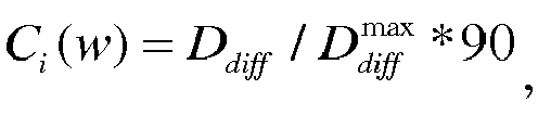
- scaling the difference by using a preset scale factor so that the difference is within a preset interval range, and using the scaled difference as a depth confidence level Ci (w) of the projected point. In a specific usage scene, the scaling interval may be [0, 90].
- Step 402: Determine, according to the respective depth confidence levels of the N-1 projected points corresponding to the first foreground pixel, a first reliable projected point whose depth confidence level meets a preset condition in the N-1 projected points corresponding to the first foreground pixel.
- A lower depth confidence level indicates more reliable depth values of the N-1 projected points. Therefore, in this embodiment, the first reliable projected point whose depth confidence level meets the preset condition may be a projected point whose depth confidence level is less than a specified threshold.
- Step 403: Obtain the three-dimensional point cloud by means of fusion and according to the first foreground pixel and the first reliable projected point.
- As can be learned according to the process of determining the depth confidence level Ci (w) provided in this embodiment, if it is determined that an image area of the depth confidence level is a rectangular window with a specified length and a specified width, Ci (w) indicates flatness of a depth value change in the rectangular window whose center is a pixel w. Smaller Ci (w) indicates that a depth change is more flatter in the image area, that is, depths of pixels are more consistent in the image area, and a depth value confidence level of the point w is higher. On the contrary, larger Ci (w) indicates that a depth change is more drastic in the image area, that is, depths of pixels are less consistent in the image area, and a depth value confidence level of the point w is lower.
- Optionally, in this embodiment, coordinate values of each three-dimensional point need to be determined after image fusion. Therefore, the obtaining the three-dimensional point cloud by means of fusion and according to information about the first foreground pixel and information about the first reliable projected point includes the following steps (as shown in
FIG. 5 ). - Step 501: Calculate an adjacent degree of the first reliable projected point, where the adjacent degree of the first reliable projected point is a difference between a depth value of the first reliable projected point and a depth value of the foreground three-dimensional space point, and the depth value of the foreground three-dimensional space point is a depth value of the foreground three-dimensional space point in a coordinate system of an image collection unit used to collect the first reliable projected point.
- Step 502: Determine, in the first reliable projected point, a second reliable projected point whose adjacent degree meets a preset condition.
- When a difference between a depth value d ij (w) corresponding to a reliable projected point m and a depth value Dj (rj ) is less than a specified threshold

- Step 503: Back-project the second reliable projected point to three-dimensional space, to obtain a three-dimensional space point corresponding to the second reliable projected point.
- Step 504: Use three-dimensional coordinate averages of three-dimensional coordinates of the three-dimensional space point corresponding to the second reliable projected point and three-dimensional coordinates of the foreground three-dimensional space point as three-dimensional coordinate values of a three-dimensional space point obtained by means of fusion, and use the three-dimensional space point obtained by means of fusion as a three-dimensional space point of the three-dimensional point cloud obtained by means of fusion, to obtain the three-dimensional point cloud by means of fusion.
- Further, if an image collected by the image collection unit further includes a color image, during image fusion, a color value of a three-dimensional space point obtained after the fusion further needs to be determined. The method further includes:
- obtaining N color images collected by the N image collection units, where the N color images are in a one-to-one correspondence to the N depth images;
- obtaining a second color value of a pixel that corresponds to the second reliable projected point and that is in the N color images, and a foreground color value of a pixel that corresponds to the first foreground pixel and that is in the N color images, and
- using a color value average of the second color value and the foreground color value as a color value of the three-dimensional space point obtained by means of fusion.
- The color value may be indicated by luminance and chrominance information, or may be indicated by red green blue (RGB) or YUV.
- In an image fusion process, in addition to a pixel (or referred to as a survivor) that is determined in the foregoing manner of "determining whether depth values of the foreground three-dimensional space point in respective coordinate systems of the N-1 image collection units are greater than or equal to depth values of the respective N-1 projected points corresponding to the first foreground pixel" and that is effective in three-dimensional point cloud fusion, there are some pixels (or referred to as outliers) that deviate from correct locations during image collection. In this embodiment, to ensure that an image is restored to a large extent, the outliers may be adjusted, so that the outliers can be located at the correct locations after correction. A specific implementation may be as follows (as shown in
FIG. 6 ): - In this embodiment of the present invention, a survivor (survivor) and an outlier (outlier) have the following specific meanings.
- A survivor (survivor) is defined as follows (as shown in
FIG. 7 ): A foreground pixel w is back-projected to a three-dimensional space point p in a world coordinate system; the three-dimensional space point p is projected to an image plane corresponding to a jth image collection unit, to obtain a pixel rj that corresponds to the foreground pixel w and that is in the image plane corresponding to the jth image collection unit; a depth value d ij (w) of the three-dimensional space point p in a coordinate system of the jth image collection unit is obtained; a depth value Dj (rj ) of the pixel rj in a depth image corresponding to the jth image collection unit is obtained; and if d ij (w) is not less than Dj (rj ), it is determined that the foreground pixel w is a survivor. - In this embodiment, a value relationship between d ij (w) and Dj (rj ) indicates visibility that is of the foreground pixel w in the ith image collection unit and that is at a location of the jth image collection unit. When d ij (w) ≥ Dj (rj ), it indicates that the projected point that is of the point w and that is at the location of the jth image collection unit does not affect visibility of another pixel at the location of the jth image collection unit. As can be learned according to the definition of a survivor, a physical meaning of a survivor at a location of the ith image collection unit is as follows: A pixel in an image collected by the ith image collection unit is visible at the location of the ith image collection unit, and the pixel does not affect visibility of a pixel at a location of any other image collection unit.
- An outlier (outlier) is defined as follows (as shown in
FIG. 8 ): The foreground pixel w is back-projected to the three-dimensional space point p in the world coordinate system; the three-dimensional space point p is projected to the image plane corresponding to the jth image collection unit, to obtain the pixel rj that corresponds to the foreground pixel w and that is in the image plane corresponding to the jth image collection unit; the depth value Dj (rj ) of the pixel rj in the depth image corresponding to the jth image collection unit is obtained; it is determined, according to the depth value Dj (rj ), whether the pixel rj is a background pixel point; and if yes, it is determined that the foreground pixel w is an outlier. - In conclusion, an outlier indicates that the projected point that is of the point w and that is at the location of the jth image collection unit deviates to the exterior of a general foreground outline.
- Based on the foregoing concepts of an outlier and a survivor, to ensure that the pixel w that is determined as an outlier is correctly fused to the interior of a foreground object, the depth value of the point w may be increased by an offset, and the projected point p of the point w moves, along a direction of a projected line from the point p to the ith image collection unit (for example, a camera), to a point p' at a location on the surface of the foreground object. In the manner of adding a depth offset, the outlier w is correctly fused to the interior of the foreground object, thereby improving fusion quality of the three-dimensional point cloud.
- Step 601: Determine whether there is a background pixel in the N-1 projected points corresponding to the first foreground pixel; if there is a background pixel, perform
step 602; otherwise, performstep 603. - Step 602: When there is a background pixel in the N-1 projected points corresponding to the first foreground pixel, increase a depth value of the first foreground pixel by a depth offset whose value is within a preset numerical value range, to update the depth value of the first foreground pixel, and perform the determining whether depth values of the foreground three-dimensional space point in respective coordinate systems of the N-1 image collection units are greater than or equal to depth values of the respective N-1 projected points corresponding to the first foreground pixel.
- Step 603: When there is no background pixel in the N-1 projected points corresponding to the first foreground pixel, perform the determining whether depth values of the foreground three-dimensional space point in respective coordinate systems of the N-1 image collection units are greater than or equal to depth values of the respective N-1 projected points corresponding to the first foreground pixel.
- According to the method provided in this embodiment of the present invention, first, foreground and background of an image are separated; next, in a process of fusing a plurality of depth images, it is determined, by using a depth value of a pixel, whether a fusion pixel is a survivor (thereby removing some points whose depth values are erroneous); and then an averaging operation is performed on depth values of survivors that meet a condition. Therefore, despite a depth discontinuous location, the solution for reconstructing a three-dimensional object of a plurality of depth images provided in the present invention can effectively remove a pixel whose depth is incorrectly estimated and that is in the border of a foreground object, thereby improving quality of the border of a three-dimensional point cloud of the object.
- To describe content of the solution of the present invention in detail, depth images and color images of three cameras of a speaker test sequence that are taken in a laboratory are used as input data of the technical solution of the present invention (figures corresponding to the three cameras of the speaker test sequence are
FIG. 9a to FIG. 9c, FIG. 9a corresponds to a first camera,FIG. 9b corresponds to a second camera, andFIG. 9c corresponds to a third camera). - Images shown in
FIG. 9a to FIG. 9c are first separated by using a color segmentation technology and a depth segmentation technology, to separate a foreground area and a background area. A background color BC is black; therefore, RGB of the background color is set as follows: R=0, G=0, and B=0. A value of a depth threshold Dth in depth segmentation is Dth = 0mm. - A depth confidence level at each pixel location is calculated by using a formula

- Foreground pixels in the images of the three cameras are projected, offset fusion is performed on an outlier (outlier), and survivor sets corresponding to camera locations are obtained. When offset fusion is performed on outliers in the images of the three cameras, a depth offset threshold is set to

- The survivor sets of the camera locations are averaged to obtain a final three-dimensional point cloud, a threshold of a depth confidence level in a depth reliability rule is set to CTh = 60, and a threshold of a depth difference in a depth adjacency rule is set to

- As shown in
FIG. 10a and FIG. 10b, FIG. 10a is a virtual viewpoint image generated by drawing, at a location of the second camera, a three-dimensional point cloud generated by using the solution provided in the embodiments of the present invention.FIG. 10b is a virtual viewpoint image generated by drawing, at a location of the second camera, a three-dimensional point cloud generated when an outlier has no depth offset.FIG. 10a and FIG. 10b are separately compared withFIG. 9b . As can be learned, inFIG. 10a and FIG. 10b , foreground person outlines are basically consistent and match each other; and because no outlier is modified, the foreground person outline inFIG. 10b is much larger than a foreground person outline inFIG. 9b . Therefore, according to the method provided in the embodiments of the present invention, an outlier around a foreground person outline can be effectively removed, thereby improving quality of reconstructing a three-dimensional point cloud. - As shown in
FIG. 11 , this embodiment of the present invention provides an apparatus for fusing a plurality of depth images. The apparatus specifically includes: animage obtaining unit 1101, a foregroundpoint obtaining unit 1102, aprojection unit 1103, a determiningunit 1104, and afusion unit 1105. - The
image obtaining unit 1101 is configured to obtain N depth images collected by N image collection units, where N≥2. - The foreground
point obtaining unit 1102 is configured to obtain a first foreground pixel of an ith depth image of the N depth images obtained by the image obtaining unit, where i≥1 and i≤N, and the ith depth image is a depth image collected by an ith image collection unit of the N image collection units. - Optionally, the image foreground
point obtaining unit 1102 is specifically configured to:
obtain a first pixel in the ith depth image, and when a depth value of the first pixel is less than or equal to a preset depth threshold, and a color value of a pixel that corresponds to the first pixel and that is in an ith color image is not equal to a background color value of the ith color image, use the first pixel as the first foreground pixel, where the ith color image is an image collected by the ith image collection unit. - The
projection unit 1103 is configured to: back-project the first foreground pixel obtained by the foreground point obtaining unit to three-dimensional space, to obtain a foreground three-dimensional space point, and project the foreground three-dimensional space point to imaging planes of N-1 image collection units of the N image collection units other than the ith collection unit, to obtain N-1 projected points that correspond to the first foreground pixel and that are in depth images respectively collected by the N-1 image collection units. - The determining
unit 1104 is configured to determine whether depth values of the foreground three-dimensional space point obtained by the projection unit in respective coordinate systems of the N-1 image collection units are greater than or equal to depth values of the respective N-1 projected points corresponding to the first foreground pixel. - The
fusion unit 1105 is configured to: when the determining unit determines that the depth values of the foreground three-dimensional space point in the respective coordinate systems of the N-1 image collection units are greater than or equal to the depth values of the respective N-1 projected points corresponding to the first foreground pixel, obtain a three-dimensional point cloud by means of fusion and according to the first foreground pixel and the N-1 projected points corresponding to the first foreground pixel. - Optionally, the
fusion unit 1105 includes: - a calculation unit, configured to calculate respective depth confidence levels of the N-1 projected points corresponding to the first foreground pixel, where the depth confidence levels of the N-1 projected points corresponding to the first foreground pixel are respectively used to indicate depth value change degrees of pixels in image areas in which the N-1 projected points corresponding to the first foreground pixel are respectively located, where
- optionally, the calculation unit is specifically configured to:
- determine, in an image area in which any projected point of the N-1 projected points is located, a maximum depth value and a minimum depth value in the image area; and
- obtain a difference between the maximum depth value and the minimum depth value, where when the difference is greater than a preset difference threshold, the difference is set to be equal to the difference threshold; and scale the difference by using a preset scale factor so that the difference is within a preset interval range, and use the scaled difference as a depth confidence level of the projected point;
- a determining unit, configured to determine, according to the respective depth confidence levels of the N-1 projected points corresponding to the first foreground pixel that are calculated by the calculation sub-unit, a first reliable projected point whose depth confidence level meets a preset condition in the N-1 projected points corresponding to the first foreground pixel; and
- a fusion subunit, configured to obtain the three-dimensional point cloud by means of fusion and according to the first foreground pixel and the first reliable projected point that is determined by the determining unit.
- Optionally, the fusion subunit is specifically configured to:
- calculate an adjacent degree of the first reliable projected point, where the adjacent degree of the first reliable projected point is a difference between a depth value of the first reliable projected point and a depth value of the foreground three-dimensional space point, and the depth value of the foreground three-dimensional space point is a depth value of the foreground three-dimensional space point in a coordinate system of an image collection unit used to collect the first reliable projected point;
- determine, in the first reliable projected point, a second reliable projected point whose adjacent degree meets a preset condition;
- back-project the second reliable projected point to three-dimensional space, to obtain a three-dimensional space point corresponding to the second reliable projected point; and
- use three-dimensional coordinate averages of three-dimensional coordinates of the three-dimensional space point corresponding to the second reliable projected point and three-dimensional coordinates of the foreground three-dimensional space point as three-dimensional coordinate values of a three-dimensional space point obtained by means of fusion, and use the three-dimensional space point obtained by means of fusion as a three-dimensional space point of the three-dimensional point cloud obtained by means of fusion, to obtain the three-dimensional point cloud by means of fusion.
- Further, if an image collected by the image collection unit further includes a color image, during image fusion, a color value of a three-dimensional space point obtained after the fusion further needs to be determined. The fusion subunit is further configured to:
- obtain N color images collected by the N image collection units, where the N color images are in a one-to-one correspondence to the N depth images;
- obtain a second color value of a pixel that corresponds to the second reliable projected point and that is in the N color images, and a foreground color value of a pixel that corresponds to the first foreground pixel and that is in the N color images; and
- use a color value average of the second color value and the foreground color value as a color value of the three-dimensional space point obtained by means of fusion.
- In an image fusion process, in addition to a pixel (or referred to as a survivor) that is determined in the foregoing manner of "determining whether depth values of the foreground three-dimensional space point in respective coordinate systems of the N-1 image collection units are greater than or equal to depth values of the respective N-1 projected points corresponding to the first foreground pixel" and that is effective in three-dimensional point cloud fusion, there are some pixels (or referred to as outliers) that deviate from correct locations during image collection. In this embodiment, to ensure that an image is restored to a large extent, the outliers may be adjusted, so that the outliers can be located at the correct locations after correction. In this embodiment of the present invention, a survivor (survivor) and an outlier (outlier) have the following specific meanings.
- A survivor (survivor) is defined as follows (as shown in
FIG. 7 ): A foreground pixel w is back-projected to a three-dimensional space point p in a world coordinate system; the three-dimensional space point p is projected to an image plane corresponding to a jth image collection unit, to obtain a pixel w that corresponds to the foreground pixel rj and that is in the image plane corresponding to the jth image collection unit; a depth value d ij (w) of the three-dimensional space point p in a coordinate system of the jth image collection unit is obtained; a depth value Dj (rj ) of the pixel rj in a depth image corresponding to the jth image collection unit is obtained; and if d ij (w) is not less than Dj (rj ), it is determined that the foreground pixel w is a survivor. - In this embodiment, a value relationship between d ij (w) and Dj (rj ) indicates visibility that is of the foreground pixel w in the ith image collection unit and that is at a location of the jth image collection unit. When d ij (w) ≥ Dj (rj ), it indicates that the projected point that is of the point w and that is at the location of the jth image collection unit does not affect visibility of another pixel at the location of the jth image collection unit. As can be learned according to the definition of a survivor, a physical meaning of a survivor at a location of the ith image collection unit is as follows: A pixel in an image collected by the ith image collection unit is visible at the location of the ith image collection unit, and the pixel does not affect visibility of a pixel at a location of any other image collection unit.
- An outlier (outlier) is defined as follows (as shown in
FIG. 8 ): The foreground pixel w is back-projected to the three-dimensional space point p in the world coordinate system; the three-dimensional space point p is projected to the image plane corresponding to the jth image collection unit, to obtain the pixel w that corresponds to the foreground pixel rj and that is in the image plane corresponding to the jth image collection unit; the depth value Dj (rj ) of the pixel rj in the depth image corresponding to the jth image collection unit is obtained; it is determined, according to the depth value Dj (rj ), whether the pixel rj is a background pixel point; and if yes, it is determined that the foreground pixel w is an outlier. - In conclusion, an outlier indicates that the projected point that is of the point w and that is at the location of the jth image collection unit deviates to the exterior of a general foreground outline.
- Based on the foregoing concepts of an outlier and a survivor, to ensure that the pixel w that is determined as an outlier is correctly fused to the interior of a foreground object, the depth value of the point w may be increased by an offset, and the projected point p of the point w moves, along a direction of a projected line from the point p to the ith image collection unit (for example, a camera), to a point p' at a location on the surface of the foreground object. In the manner of adding a depth offset, the outlier w is correctly fused to the interior of the foreground object, thereby improving fusion quality of the three-dimensional point cloud. Based on the foregoing concepts of an outlier and a survivor, correspondingly, the determining
unit 1104 in this embodiment of the present invention may be specifically configured to: - before determining whether the depth values of the foreground three-dimensional space point in the respective coordinate systems of the N-1 image collection units are greater than or equal to the depth values of the respective N-1 projected points corresponding to the first foreground pixel, determine whether there is a background pixel in the N-1 projected points corresponding to the first foreground pixel; and
- when there is a background pixel in the N-1 projected points corresponding to the first foreground pixel, increase a depth value of the first foreground pixel by a depth offset whose value is within a preset numerical value range, to update the depth value of the first foreground pixel, and perform the determining whether depth values of the foreground three-dimensional space point in respective coordinate systems of the N-1 image collection units are greater than or equal to depth values of the respective N-1 projected points corresponding to the first foreground pixel; or
- when there is no background pixel in the N-1 projected points corresponding to the first foreground pixel, perform the determining whether depth values of the foreground three-dimensional space point in respective coordinate systems of the N-1 image collection units are greater than or equal to depth values of the respective N-1 projected points corresponding to the first foreground pixel.
- As shown in
FIG. 12 , this embodiment of the present invention further provides an electronic device. The electronic device includes: - N
image collection apparatuses 1201, configured to collect N depth images, where N≥2; and - a processor 1202, configured to: obtain a first foreground pixel of an ith depth image of the N depth images obtained by N image collection units, where i≥1 and i≤N, and the ith depth image is a depth image collected by an ith image collection unit of the N image collection units; back-project the first foreground pixel obtained by a foreground point obtaining unit to three-dimensional space, to obtain a foreground three-dimensional space point, and project the foreground three-dimensional space point to imaging planes of N-1 image collection units of the N image collection units other than the ith collection unit, to obtain N-1 projected points that correspond to the first foreground pixel and that are in depth images respectively collected by the N-1 image collection units; determine whether depth values of the foreground three-dimensional space point obtained by a projection unit in respective coordinate systems of the N-1 image collection units are greater than or equal to depth values of the respective N-1 projected points corresponding to the first foreground pixel; and when a determining unit determines that the depth values of the foreground three-dimensional space point in the respective coordinate systems of the N-1 image collection units are greater than or equal to the depth values of the respective N-1 projected points corresponding to the first foreground pixel, obtain a three-dimensional point cloud by means of fusion and according to the first foreground pixel and the N-1 projected points corresponding to the first foreground pixel.
- The foregoing one or more technical solutions in the embodiments of this application have at least the following technical effects.
- According to the method and the apparatus provided in the embodiments of the present invention, first, foreground and background of an image are separated; next, in a process of fusing a plurality of depth images, it is determined, by using a depth value of a pixel, whether a fusion pixel is a survivor (thereby removing some points whose depth values are erroneous); and then an averaging operation is performed on depth values of survivors that meet a condition. Therefore, despite a depth discontinuous location, the solution for reconstructing a three-dimensional object of a plurality of depth images provided in the present invention can effectively remove a pixel whose depth is incorrectly estimated and that is in the border of a foreground object, thereby improving quality of the border of a three-dimensional point cloud of the object.
- The methods described in the present invention are not limited to the embodiments described in the Description of Embodiments. Another implementation obtained by a person skilled in the art according to the technical solutions of the present invention still belongs to a technical innovation scope of the present invention.
- Obviously, a person skilled in the art can make various modifications and variations to the present invention without departing from the scope of the present invention. The present invention is intended to cover these modifications and variations provided that they fall within the scope of protection defined by the following claims and their equivalent technologies.
Claims (14)
- A method for fusing a plurality of depth images, wherein the method comprises:obtaining N depth images collected by N image collection units, wherein N≥2;obtaining a first foreground pixel of an ith depth image of the N depth images, wherein i≥1 and i≤N, and the ith depth image is a depth image collected by an ith image collection unit of the N image collection units;back-projecting the first foreground pixel to three-dimensional space, to obtain a foreground three-dimensional space point, and projecting the foreground three-dimensional space point to imaging planes of N-1 image collection units of the N image collection units other than the ith collection unit, to obtain N-1 projected points that correspond to the first foreground pixel and that are in depth images respectively collected by the N-1 image collection units;determining whether depth values of the foreground three-dimensional space point in respective coordinate systems of the N-1 image collection units are greater than or equal to depth values of the respective N-1 projected points corresponding to the first foreground pixel; andwhen the depth values of the foreground three-dimensional space point in the respective coordinate systems of the N-1 image collection units are greater than or equal to the depth values of the respective N-1 projected points corresponding to the first foreground pixel, obtaining a three-dimensional point cloud by means of fusion and according to the first foreground pixel and the N-1 projected points corresponding to the first foreground pixel.
- The method according to claim 1, wherein the obtaining a three-dimensional point cloud by means of fusion and according to the first foreground pixel and the N-1 projected points corresponding to the first foreground pixel comprises:calculating respective depth confidence levels of the N-1 projected points corresponding to the first foreground pixel, wherein the depth confidence levels of the N-1 projected points corresponding to the first foreground pixel are respectively used to indicate depth value change degrees of pixels in image areas in which the N-1 projected points corresponding to the first foreground pixel are respectively located;determining, according to the respective depth confidence levels of the N-1 projected points corresponding to the first foreground pixel, a first reliable projected point whose depth confidence level meets a preset condition in the N-1 projected points corresponding to the first foreground pixel; andobtaining the three-dimensional point cloud by means of fusion and according to the first foreground pixel and the first reliable projected point.
- The method according to claim 2, wherein the obtaining the three-dimensional point cloud by means of fusion and according to the first foreground pixel and the first reliable projected point comprises:calculating an adjacent degree of the first reliable projected point, wherein the adjacent degree of the first reliable projected point is a difference between a depth value of the first reliable projected point and a depth value of the foreground three-dimensional space point, and the depth value of the foreground three-dimensional space point is a depth value of the foreground three-dimensional space point in a coordinate system of an image collection unit used to collect the first reliable projected point;determining, according the first reliable projected point, a second reliable projected point whose adjacent degree meets a preset condition; andback-projecting the second reliable projected point to three-dimensional space, to obtain a three-dimensional space point corresponding to the second reliable projected point; and using three-dimensional coordinate averages of three-dimensional coordinates of the three-dimensional space point corresponding to the second reliable projected point and three-dimensional coordinates of the foreground three-dimensional space point as three-dimensional coordinate values of a three-dimensional space point obtained by means of fusion, and using the three-dimensional space point obtained by means of fusion as a three-dimensional space point of the three-dimensional point cloud obtained by means of fusion, to obtain the three-dimensional point cloud by means of fusion.
- The method according to claim 3, wherein the method further comprises:obtaining N color images collected by the N image collection units, wherein the N color images are in a one-to-one correspondence to the N depth images;obtaining a second color value of a pixel that corresponds to the second reliable projected point and that is in the N color images, and a foreground color value of a pixel that corresponds to the first foreground pixel and that is in the N color images; andusing a color value average of the second color value and the foreground color value as a color value of the three-dimensional space point obtained by means of fusion.
- The method according to any one of claims 2 to 4, wherein the calculating respective depth confidence levels of the N-1 projected points corresponding to the first foreground pixel comprises:determining, in an image area in which any projected point of the N-1 projected points is located, a maximum depth value and a minimum depth value in the image area;obtaining a difference between the maximum depth value and the minimum depth value, wherein when the difference is greater than a preset difference threshold, the difference is set to be equal to the difference threshold; andscaling the difference by using a preset scale factor so that the difference is within a preset interval range, and using the scaled difference as a depth confidence level of the projected point.
- The method according to any one of claims 1 to 5, wherein before the determining whether depth values of the foreground three-dimensional space point in respective coordinate systems of the N-1 image collection units are greater than or equal to depth values of the respective N-1 projected points corresponding to the first foreground pixel, the method further comprises:determining whether there is a background pixel in the N-1 projected points corresponding to the first foreground pixel; andwhen there is a background pixel in the N-1 projected points corresponding to the first foreground pixel, increasing a depth value of the first foreground pixel by a depth offset whose value is within a preset numerical value range, to update the depth value of the first foreground pixel, and performing the determining whether depth values of the foreground three-dimensional space point in respective coordinate systems of the N-1 image collection units are greater than or equal to depth values of the respective N-1 projected points corresponding to the first foreground pixel; orwhen there is no background pixel in the N-1 projected points corresponding to the first foreground pixel, performing the determining whether depth values of the foreground three-dimensional space point in respective coordinate systems of the N-1 image collection units are greater than or equal to depth values of the respective N-1 projected points corresponding to the first foreground pixel.
- The method according to any one of claims 1 to 6, wherein the obtaining a first foreground pixel of an ith depth image of the N depth images comprises:
obtaining a first pixel in the ith depth image, and when a depth value of the first pixel is less than or equal to a preset depth threshold, and a color value of a pixel that corresponds to the first pixel and that is in an ith color image is not equal to a background color value of the ith color image, using the first pixel as the first foreground pixel, wherein the ith color image is an image collected by the ith image collection unit. - An apparatus for fusing a plurality of depth images, wherein the apparatus comprises:an image obtaining unit, configured to obtain N depth images collected by N image collection units, wherein N≥2;a foreground point obtaining unit, configured to obtain a first foreground pixel of an ith depth image of the N depth images obtained by the image obtaining unit, wherein i≥1 and i≤N, and the ith depth image is a depth image collected by an ith image collection unit of the N image collection units;a projection unit, configured to: back-project the first foreground pixel obtained by the foreground point obtaining unit to three-dimensional space, to obtain a foreground three-dimensional space point, and project the foreground three-dimensional space point to imaging planes of N-1 image collection units of the N image collection units other than the ith collection unit, to obtain N-1 projected points that correspond to the first foreground pixel and that are in depth images respectively collected by the N-1 image collection units;a determining unit, configured to determine whether depth values of the foreground three-dimensional space point obtained by the projection unit in respective coordinate systems of the N-1 image collection units are greater than or equal to depth values of the respective N-1 projected points corresponding to the first foreground pixel; anda fusion unit, configured to: when the determining unit determines that the depth values of the foreground three-dimensional space point in the respective coordinate systems of the N-1 image collection units are greater than or equal to the depth values of the respective N-1 projected points corresponding to the first foreground pixel, obtain a three-dimensional point cloud by means of fusion and according to the first foreground pixel and the N-1 projected points corresponding to the first foreground pixel.
- The apparatus according to claim 8, wherein the fusion unit comprises:a calculation unit, configured to calculate respective depth confidence levels of the N-1 projected points corresponding to the first foreground pixel, wherein the depth confidence levels of the N-1 projected points corresponding to the first foreground pixel are respectively used to indicate depth value change degrees of pixels in image areas in which the N-1 projected points corresponding to the first foreground pixel are respectively located;a determining unit, configured to determine, according to the respective depth confidence levels of the N-1 projected points corresponding to the first foreground pixel that are calculated by the calculation unit, a first reliable projected point whose depth confidence level meets a preset condition in the N-1 projected points corresponding to the first foreground pixel; anda fusion subunit, configured to obtain the three-dimensional point cloud by means of fusion and according to the first foreground pixel and the first reliable projected point that is determined by the determining unit.
- The apparatus according to claim 9, wherein the fusion subunit is configured to:calculate an adjacent degree of the first reliable projected point, wherein the adjacent degree of the first reliable projected point is a difference between a depth value of the first reliable projected point and a depth value of the foreground three-dimensional space point, and the depth value of the foreground three-dimensional space point is a depth value of the foreground three-dimensional space point in a coordinate system of an image collection unit used to collect the first reliable projected point;determine, according the first reliable projected point, a second reliable projected point whose adjacent degree meets a preset condition;back-project the second reliable projected point to three-dimensional space, to obtain a three-dimensional space point corresponding to the second reliable projected point; anduse three-dimensional coordinate averages of three-dimensional coordinates of the three-dimensional space point corresponding to the second reliable projected point and three-dimensional coordinates of the foreground three-dimensional space point as three-dimensional coordinate values of a three-dimensional space point obtained by means of fusion, and use the three-dimensional space point obtained by means of fusion as a three-dimensional space point of the three-dimensional point cloud obtained by means of fusion, to obtain the three-dimensional point cloud by means of fusion.
- The apparatus according to claim 10, wherein the fusion subunit is further configured to:obtain N color images collected by the N image collection units, wherein the N color images are in a one-to-one correspondence to the N depth images;obtain a second color value of a pixel that corresponds to the second reliable projected point and that is in the N color images, and a foreground color value of a pixel that corresponds to the first foreground pixel and that is in the N color images; anduse a color value average of the second color value and the foreground color value as a color value of the three-dimensional space point obtained by means of fusion.
- The apparatus according to any one of claims 9 to 11, wherein the calculation unit is configured to:determine, in an image area in which any projected point of the N-1 projected points is located, a maximum depth value and a minimum depth value in the image area;obtain a difference between the maximum depth value and the minimum depth value, wherein when the difference is greater than a preset difference threshold, the difference is set to be equal to the difference threshold; and scale the difference by using a preset scale factor so that the difference is within a preset interval range, and use the scaled difference as a depth confidence level of the projected point.
- The apparatus according to any one of claims 8 to 12, wherein the determining unit is further configured to:before determining whether the depth values of the foreground three-dimensional space point in the respective coordinate systems of the N-1 image collection units are greater than or equal to the depth values of the respective N-1 projected points corresponding to the first foreground pixel, determine whether there is a background pixel in the N-1 projected points corresponding to the first foreground pixel; andwhen there is a background pixel in the N-1 projected points corresponding to the first foreground pixel, increase a depth value of the first foreground pixel by a depth offset whose value is within a preset numerical value range, to update the depth value of the first foreground pixel, and perform the determining whether depth values of the foreground three-dimensional space point in respective coordinate systems of the N-1 image collection units are greater than or equal to depth values of the respective N-1 projected points corresponding to the first foreground pixel; orwhen there is no background pixel in the N-1 projected points corresponding to the first foreground pixel, perform the determining whether depth values of the foreground three-dimensional space point in respective coordinate systems of the N-1 image collection units are greater than or equal to depth values of the respective N-1 projected points corresponding to the first foreground pixel.
- The apparatus according to any one of claims 8 to 13, wherein the foreground point obtaining unit is configured to:
obtain a first pixel in the ith depth image, and when a depth value of the first pixel is less than or equal to a preset depth threshold, and a color value of a pixel that corresponds to the first pixel and that is in an ith color image is not equal to a background color value of the ith color image, use the first pixel as the first foreground pixel, wherein the ith color image is an image collected by the ith image collection unit.
Applications Claiming Priority (2)
| Application Number | Priority Date | Filing Date | Title |
|---|---|---|---|
| CN201510644681.XA CN105374019B (en) | 2015-09-30 | 2015-09-30 | A kind of more depth map fusion methods and device |
| PCT/CN2016/096087 WO2017054589A1 (en) | 2015-09-30 | 2016-08-19 | Multi-depth image fusion method and apparatus |
Publications (3)
| Publication Number | Publication Date |
|---|---|
| EP3340170A1 EP3340170A1 (en) | 2018-06-27 |
| EP3340170A4 EP3340170A4 (en) | 2018-10-03 |
| EP3340170B1 true EP3340170B1 (en) | 2019-07-17 |
Family
ID=55376191
Family Applications (1)
| Application Number | Title | Priority Date | Filing Date |
|---|---|---|---|
| EP16850213.6A Active EP3340170B1 (en) | 2015-09-30 | 2016-08-19 | Multi-depth image fusion method and apparatus |
Country Status (4)
| Country | Link |
|---|---|
| US (1) | US20180218485A1 (en) |
| EP (1) | EP3340170B1 (en) |
| CN (1) | CN105374019B (en) |
| WO (1) | WO2017054589A1 (en) |
Families Citing this family (41)
| Publication number | Priority date | Publication date | Assignee | Title |
|---|---|---|---|---|
| US10699476B2 (en) * | 2015-08-06 | 2020-06-30 | Ams Sensors Singapore Pte. Ltd. | Generating a merged, fused three-dimensional point cloud based on captured images of a scene |
| CN105374019B (en) * | 2015-09-30 | 2018-06-19 | 华为技术有限公司 | A kind of more depth map fusion methods and device |
| CN105979203B (en) * | 2016-04-29 | 2019-04-23 | 中国石油大学(北京) | A kind of multi-camera cooperative monitoring method and device |
| DE102016113138B4 (en) * | 2016-07-15 | 2018-02-15 | Fraunhofer-Gesellschaft zur Förderung der angewandten Forschung e.V. | System, in particular magnetic resonance system, for generating images |
| CN106845525A (en) * | 2016-12-28 | 2017-06-13 | 上海电机学院 | A kind of depth confidence network image bracket protocol based on bottom fusion feature |
| JP7159057B2 (en) * | 2017-02-10 | 2022-10-24 | パナソニック インテレクチュアル プロパティ コーポレーション オブ アメリカ | Free-viewpoint video generation method and free-viewpoint video generation system |
| CN107437261B (en) * | 2017-07-14 | 2021-03-09 | 梅卡曼德(北京)机器人科技有限公司 | Depth image acquisition method |
| KR102129458B1 (en) * | 2017-11-22 | 2020-07-08 | 한국전자통신연구원 | Method for reconstructing three dimension information of object and apparatus for the same |
| CN108038902B (en) * | 2017-12-07 | 2021-08-27 | 合肥工业大学 | High-precision three-dimensional reconstruction method and system for depth camera |
| CN108230381B (en) * | 2018-01-17 | 2020-05-19 | 华中科技大学 | Multi-view stereoscopic vision method combining space propagation and pixel level optimization |
| CN110349247B (en) * | 2018-04-08 | 2022-10-14 | 哈尔滨工业大学 | Indoor scene CAD three-dimensional reconstruction method based on semantic understanding |
| CN110895822B (en) * | 2018-09-13 | 2023-09-01 | 虹软科技股份有限公司 | Method of operating a depth data processing system |
| CN110809788B (en) * | 2018-09-26 | 2021-11-02 | 深圳市大疆创新科技有限公司 | Depth image fusion method, device and computer-readable storage medium |
| CN111260698B (en) * | 2018-12-03 | 2024-01-02 | 北京魔门塔科技有限公司 | Binocular image feature matching method and vehicle-mounted terminal |
| CN109840881B (en) * | 2018-12-12 | 2023-05-05 | 奥比中光科技集团股份有限公司 | 3D special effect image generation method, device and equipment |
| CN111353934B (en) * | 2018-12-24 | 2023-05-16 | 杭州海康威视数字技术股份有限公司 | Video synthesis method and device |
| CN109785429B (en) * | 2019-01-25 | 2020-08-21 | 北京极智无限科技有限公司 | Three-dimensional reconstruction method and device |
| CN112184603B (en) * | 2019-07-04 | 2022-06-24 | 浙江商汤科技开发有限公司 | Point cloud fusion method and device, electronic equipment and computer storage medium |
| CN110517348B (en) * | 2019-07-23 | 2023-01-06 | 西安电子科技大学 | 3D Point Cloud Reconstruction Method of Target Object Based on Image Foreground Segmentation |
| CN112446843B (en) * | 2019-08-28 | 2024-08-06 | 深圳市光鉴科技有限公司 | Image reconstruction method, system, equipment and medium based on multiple depth maps |
| CN112106112A (en) * | 2019-09-16 | 2020-12-18 | 深圳市大疆创新科技有限公司 | Point cloud fusion method, device and system and storage medium |
| CN110675456B (en) * | 2019-09-18 | 2020-06-16 | 深圳普罗米修斯视觉技术有限公司 | Method and device for calibrating external parameters of multi-depth camera and storage medium |
| CN111009002B (en) * | 2019-10-16 | 2020-11-06 | 贝壳找房(北京)科技有限公司 | Point cloud registration detection method and device, electronic equipment and storage medium |
| CN110880161B (en) * | 2019-11-21 | 2023-05-09 | 大庆思特传媒科技有限公司 | Depth image stitching and fusion method and system for multiple hosts and multiple depth cameras |
| WO2021102948A1 (en) * | 2019-11-29 | 2021-06-03 | 深圳市大疆创新科技有限公司 | Image processing method and device |
| US11430179B2 (en) * | 2020-02-24 | 2022-08-30 | Microsoft Technology Licensing, Llc | Depth buffer dilation for remote rendering |
| CN111598940B (en) * | 2020-05-21 | 2023-05-30 | 电子科技大学 | A method for locating the center point of hemispherical photography |
| CN112330815B (en) * | 2020-11-26 | 2024-05-14 | 北京百度网讯科技有限公司 | Three-dimensional point cloud data processing method, device and equipment based on obstacle fusion |
| CN112529917A (en) * | 2020-12-22 | 2021-03-19 | 中国第一汽车股份有限公司 | Three-dimensional target segmentation method, device, equipment and storage medium |
| CN113344830B (en) * | 2021-05-10 | 2024-06-21 | 深圳瀚维智能医疗科技有限公司 | Fusion method and device based on multiple single-channel temperature images |
| US11741671B2 (en) | 2021-06-16 | 2023-08-29 | Samsung Electronics Co., Ltd. | Three-dimensional scene recreation using depth fusion |
| CN113283543B (en) * | 2021-06-24 | 2022-04-15 | 北京优锘科技有限公司 | WebGL-based image projection fusion method, device, storage medium and equipment |
| CN114264355B (en) * | 2021-11-18 | 2024-06-25 | 河南讯飞智元信息科技有限公司 | Weight detection method, device, electronic equipment and storage medium |
| CN114028813A (en) * | 2021-11-24 | 2022-02-11 | 咪咕互动娱乐有限公司 | Method, device and computer-readable storage medium for generating game screen |
| TWI818880B (en) * | 2023-03-31 | 2023-10-11 | 宸祿科技股份有限公司 | Image fusion system and method for parallelization optimization of image fusion algorithm |
| CN116523809B (en) * | 2023-07-03 | 2023-10-17 | 首都医科大学附属北京口腔医院 | Image fusion device |
| CN117152040B (en) * | 2023-10-26 | 2024-02-23 | 埃洛克航空科技(北京)有限公司 | A depth map-based point cloud fusion method and device |
| US20250218014A1 (en) * | 2024-01-03 | 2025-07-03 | Qualcomm Incorporated | Storing depth information |
| CN119625037B (en) * | 2024-12-13 | 2025-11-25 | 复旦大学 | A multi-focus photoacoustic imaging registration and fusion method based on blind deconvolution |
| CN120953342B (en) * | 2025-10-15 | 2026-01-02 | 山东港口科技集团有限公司 | A Real-Time Fusion Detection Method for Bulk Cargo Ship Holds Based on Laser Point Clouds |
| CN121544811B (en) * | 2026-01-16 | 2026-04-07 | 中国矿业大学 | Three-dimensional reconstruction method and equipment for electric power facilities based on multi-source point cloud cooperation |
Family Cites Families (11)
| Publication number | Priority date | Publication date | Assignee | Title |
|---|---|---|---|---|
| US6868191B2 (en) * | 2000-06-28 | 2005-03-15 | Telefonaktiebolaget Lm Ericsson (Publ) | System and method for median fusion of depth maps |
| US20110200249A1 (en) * | 2010-02-17 | 2011-08-18 | Harris Corporation | Surface detection in images based on spatial data |
| CN101964117B (en) * | 2010-09-25 | 2013-03-27 | 清华大学 | Depth map fusion method and device |
| EP2538242B1 (en) * | 2011-06-24 | 2014-07-02 | Softkinetic Software | Depth measurement quality enhancement. |
| EP2923174A2 (en) * | 2012-11-22 | 2015-09-30 | GeoSim Systems Ltd. | Point-cloud fusion |
| CN103903246A (en) * | 2012-12-26 | 2014-07-02 | 株式会社理光 | Object detection method and device |
| CN103198473B (en) * | 2013-03-05 | 2016-02-24 | 腾讯科技(深圳)有限公司 | A kind of degree of depth drawing generating method and device |
| CN103248911B (en) * | 2013-05-20 | 2015-11-04 | 山东大学 | A Virtual Viewpoint Rendering Method Based on Space-Time Combination in Multi-viewpoint Video |
| CN104346608B (en) * | 2013-07-26 | 2017-09-08 | 株式会社理光 | Sparse depth figure denseization method and apparatus |
| CN103581648B (en) * | 2013-10-18 | 2015-08-26 | 清华大学深圳研究生院 | Draw the hole-filling method in new viewpoint |
| CN105374019B (en) * | 2015-09-30 | 2018-06-19 | 华为技术有限公司 | A kind of more depth map fusion methods and device |
-
2015
- 2015-09-30 CN CN201510644681.XA patent/CN105374019B/en active Active
-
2016
- 2016-08-19 WO PCT/CN2016/096087 patent/WO2017054589A1/en not_active Ceased
- 2016-08-19 EP EP16850213.6A patent/EP3340170B1/en active Active
-
2018
- 2018-03-29 US US15/940,562 patent/US20180218485A1/en not_active Abandoned
Non-Patent Citations (1)
| Title |
|---|
| None * |
Also Published As
| Publication number | Publication date |
|---|---|
| US20180218485A1 (en) | 2018-08-02 |
| CN105374019B (en) | 2018-06-19 |
| EP3340170A1 (en) | 2018-06-27 |
| WO2017054589A1 (en) | 2017-04-06 |
| CN105374019A (en) | 2016-03-02 |
| EP3340170A4 (en) | 2018-10-03 |
Similar Documents
| Publication | Publication Date | Title |
|---|---|---|
| US20180218485A1 (en) | Method and apparatus for fusing plurality of depth images | |
| CN109660783B (en) | Virtual reality parallax correction | |
| US9374571B2 (en) | Image processing device, imaging device, and image processing method | |
| CN106875339B (en) | Fisheye image splicing method based on strip-shaped calibration plate | |
| EP3232661B1 (en) | Image processing method and device | |
| CN106803899B (en) | Merge the method and apparatus of image | |
| CN107316326B (en) | Edge-based disparity map calculation method and device applied to binocular stereo vision | |
| US10091435B2 (en) | Video segmentation from an uncalibrated camera array | |
| CN111340749B (en) | Image quality detection method, device, equipment and storage medium | |
| CN102124745A (en) | Apparatus and method for converting two-dimensional image signal into three-dimensional image signal | |
| CN113301320B (en) | Image information processing method and device and electronic equipment | |
| KR100996897B1 (en) | Circumferential Distortion Image Correction Method of Wide Angle Lens by Linear Fitting | |
| CN102609941A (en) | Three-dimensional registering method based on ToF (Time-of-Flight) depth camera | |
| CN111311482A (en) | Background blurring method, device, terminal device and storage medium | |
| KR101941801B1 (en) | Image processing method and device for led display screen | |
| CN106251365A (en) | Many exposure video fusion method and device | |
| CN114697623A (en) | Projection surface selection and projection image correction method and device, projector and medium | |
| JP2018524896A (en) | Method and apparatus for determining a depth map of an image | |
| CN111369660A (en) | Seamless texture mapping method for three-dimensional model | |
| CN111798374B (en) | Image stitching method, device, equipment and medium | |
| CN111010554B (en) | Projection processing method, projection processing device, projector and readable storage medium | |
| CN101945299B (en) | Camera-equipment-array based dynamic scene depth restoring method | |
| WO2022142311A1 (en) | Method for segmenting target object in image, three-dimensional reconstruction method, and related apparatus | |
| CN113938578A (en) | Image blurring method, storage medium and terminal device | |
| CN115753019B (en) | Pose adjustment method, device and equipment of acquisition equipment and readable storage medium |
Legal Events
| Date | Code | Title | Description |
|---|---|---|---|
| STAA | Information on the status of an ep patent application or granted ep patent |
Free format text: STATUS: THE INTERNATIONAL PUBLICATION HAS BEEN MADE |
|
| PUAI | Public reference made under article 153(3) epc to a published international application that has entered the european phase |
Free format text: ORIGINAL CODE: 0009012 |
|
| STAA | Information on the status of an ep patent application or granted ep patent |
Free format text: STATUS: REQUEST FOR EXAMINATION WAS MADE |
|
| 17P | Request for examination filed |
Effective date: 20180323 |
|
| AK | Designated contracting states |
Kind code of ref document: A1 Designated state(s): AL AT BE BG CH CY CZ DE DK EE ES FI FR GB GR HR HU IE IS IT LI LT LU LV MC MK MT NL NO PL PT RO RS SE SI SK SM TR |
|
| AX | Request for extension of the european patent |
Extension state: BA ME |
|
| RIN1 | Information on inventor provided before grant (corrected) |
Inventor name: EBEL, SASCHA Inventor name: SCHREER, OLIVER Inventor name: FELDMANN, INGO Inventor name: XI, MING |
|
| A4 | Supplementary search report drawn up and despatched |
Effective date: 20180831 |
|
| RIC1 | Information provided on ipc code assigned before grant |
Ipc: G06T 5/50 20060101AFI20180827BHEP Ipc: G06T 17/00 20060101ALI20180827BHEP |
|
| GRAP | Despatch of communication of intention to grant a patent |
Free format text: ORIGINAL CODE: EPIDOSNIGR1 |
|
| STAA | Information on the status of an ep patent application or granted ep patent |
Free format text: STATUS: GRANT OF PATENT IS INTENDED |
|
| DAV | Request for validation of the european patent (deleted) | ||
| DAX | Request for extension of the european patent (deleted) | ||
| RIC1 | Information provided on ipc code assigned before grant |
Ipc: G06T 5/50 20060101AFI20181212BHEP Ipc: G06T 17/00 20060101ALI20181212BHEP |
|
| INTG | Intention to grant announced |
Effective date: 20190107 |
|
| GRAJ | Information related to disapproval of communication of intention to grant by the applicant or resumption of examination proceedings by the epo deleted |
Free format text: ORIGINAL CODE: EPIDOSDIGR1 |
|
| STAA | Information on the status of an ep patent application or granted ep patent |
Free format text: STATUS: REQUEST FOR EXAMINATION WAS MADE |
|
| GRAR | Information related to intention to grant a patent recorded |
Free format text: ORIGINAL CODE: EPIDOSNIGR71 |
|
| GRAS | Grant fee paid |
Free format text: ORIGINAL CODE: EPIDOSNIGR3 |
|
| STAA | Information on the status of an ep patent application or granted ep patent |
Free format text: STATUS: GRANT OF PATENT IS INTENDED |
|
| GRAA | (expected) grant |
Free format text: ORIGINAL CODE: 0009210 |
|
| STAA | Information on the status of an ep patent application or granted ep patent |
Free format text: STATUS: THE PATENT HAS BEEN GRANTED |
|
| INTC | Intention to grant announced (deleted) | ||
| INTG | Intention to grant announced |
Effective date: 20190606 |
|
| AK | Designated contracting states |
Kind code of ref document: B1 Designated state(s): AL AT BE BG CH CY CZ DE DK EE ES FI FR GB GR HR HU IE IS IT LI LT LU LV MC MK MT NL NO PL PT RO RS SE SI SK SM TR |
|
| REG | Reference to a national code |
Ref country code: GB Ref legal event code: FG4D |
|
| REG | Reference to a national code |
Ref country code: CH Ref legal event code: EP |
|
| REG | Reference to a national code |
Ref country code: DE Ref legal event code: R096 Ref document number: 602016017134 Country of ref document: DE |
|
| REG | Reference to a national code |
Ref country code: IE Ref legal event code: FG4D |
|
| REG | Reference to a national code |
Ref country code: AT Ref legal event code: REF Ref document number: 1156541 Country of ref document: AT Kind code of ref document: T Effective date: 20190815 |
|
| REG | Reference to a national code |
Ref country code: NL Ref legal event code: MP Effective date: 20190717 |
|
| REG | Reference to a national code |
Ref country code: LT Ref legal event code: MG4D |
|
| REG | Reference to a national code |
Ref country code: AT Ref legal event code: MK05 Ref document number: 1156541 Country of ref document: AT Kind code of ref document: T Effective date: 20190717 |
|
| PG25 | Lapsed in a contracting state [announced via postgrant information from national office to epo] |
Ref country code: FI Free format text: LAPSE BECAUSE OF FAILURE TO SUBMIT A TRANSLATION OF THE DESCRIPTION OR TO PAY THE FEE WITHIN THE PRESCRIBED TIME-LIMIT Effective date: 20190717 Ref country code: HR Free format text: LAPSE BECAUSE OF FAILURE TO SUBMIT A TRANSLATION OF THE DESCRIPTION OR TO PAY THE FEE WITHIN THE PRESCRIBED TIME-LIMIT Effective date: 20190717 Ref country code: SE Free format text: LAPSE BECAUSE OF FAILURE TO SUBMIT A TRANSLATION OF THE DESCRIPTION OR TO PAY THE FEE WITHIN THE PRESCRIBED TIME-LIMIT Effective date: 20190717 Ref country code: NO Free format text: LAPSE BECAUSE OF FAILURE TO SUBMIT A TRANSLATION OF THE DESCRIPTION OR TO PAY THE FEE WITHIN THE PRESCRIBED TIME-LIMIT Effective date: 20191017 Ref country code: AT Free format text: LAPSE BECAUSE OF FAILURE TO SUBMIT A TRANSLATION OF THE DESCRIPTION OR TO PAY THE FEE WITHIN THE PRESCRIBED TIME-LIMIT Effective date: 20190717 Ref country code: PT Free format text: LAPSE BECAUSE OF FAILURE TO SUBMIT A TRANSLATION OF THE DESCRIPTION OR TO PAY THE FEE WITHIN THE PRESCRIBED TIME-LIMIT Effective date: 20191118 Ref country code: LT Free format text: LAPSE BECAUSE OF FAILURE TO SUBMIT A TRANSLATION OF THE DESCRIPTION OR TO PAY THE FEE WITHIN THE PRESCRIBED TIME-LIMIT Effective date: 20190717 Ref country code: BG Free format text: LAPSE BECAUSE OF FAILURE TO SUBMIT A TRANSLATION OF THE DESCRIPTION OR TO PAY THE FEE WITHIN THE PRESCRIBED TIME-LIMIT Effective date: 20191017 Ref country code: NL Free format text: LAPSE BECAUSE OF FAILURE TO SUBMIT A TRANSLATION OF THE DESCRIPTION OR TO PAY THE FEE WITHIN THE PRESCRIBED TIME-LIMIT Effective date: 20190717 |
|
| PG25 | Lapsed in a contracting state [announced via postgrant information from national office to epo] |
Ref country code: LV Free format text: LAPSE BECAUSE OF FAILURE TO SUBMIT A TRANSLATION OF THE DESCRIPTION OR TO PAY THE FEE WITHIN THE PRESCRIBED TIME-LIMIT Effective date: 20190717 Ref country code: AL Free format text: LAPSE BECAUSE OF FAILURE TO SUBMIT A TRANSLATION OF THE DESCRIPTION OR TO PAY THE FEE WITHIN THE PRESCRIBED TIME-LIMIT Effective date: 20190717 Ref country code: GR Free format text: LAPSE BECAUSE OF FAILURE TO SUBMIT A TRANSLATION OF THE DESCRIPTION OR TO PAY THE FEE WITHIN THE PRESCRIBED TIME-LIMIT Effective date: 20191018 Ref country code: ES Free format text: LAPSE BECAUSE OF FAILURE TO SUBMIT A TRANSLATION OF THE DESCRIPTION OR TO PAY THE FEE WITHIN THE PRESCRIBED TIME-LIMIT Effective date: 20190717 Ref country code: RS Free format text: LAPSE BECAUSE OF FAILURE TO SUBMIT A TRANSLATION OF THE DESCRIPTION OR TO PAY THE FEE WITHIN THE PRESCRIBED TIME-LIMIT Effective date: 20190717 Ref country code: IS Free format text: LAPSE BECAUSE OF FAILURE TO SUBMIT A TRANSLATION OF THE DESCRIPTION OR TO PAY THE FEE WITHIN THE PRESCRIBED TIME-LIMIT Effective date: 20191117 |
|
| PG25 | Lapsed in a contracting state [announced via postgrant information from national office to epo] |
Ref country code: TR Free format text: LAPSE BECAUSE OF FAILURE TO SUBMIT A TRANSLATION OF THE DESCRIPTION OR TO PAY THE FEE WITHIN THE PRESCRIBED TIME-LIMIT Effective date: 20190717 |
|
| PG25 | Lapsed in a contracting state [announced via postgrant information from national office to epo] |
Ref country code: EE Free format text: LAPSE BECAUSE OF FAILURE TO SUBMIT A TRANSLATION OF THE DESCRIPTION OR TO PAY THE FEE WITHIN THE PRESCRIBED TIME-LIMIT Effective date: 20190717 Ref country code: PL Free format text: LAPSE BECAUSE OF FAILURE TO SUBMIT A TRANSLATION OF THE DESCRIPTION OR TO PAY THE FEE WITHIN THE PRESCRIBED TIME-LIMIT Effective date: 20190717 Ref country code: RO Free format text: LAPSE BECAUSE OF FAILURE TO SUBMIT A TRANSLATION OF THE DESCRIPTION OR TO PAY THE FEE WITHIN THE PRESCRIBED TIME-LIMIT Effective date: 20190717 Ref country code: DK Free format text: LAPSE BECAUSE OF FAILURE TO SUBMIT A TRANSLATION OF THE DESCRIPTION OR TO PAY THE FEE WITHIN THE PRESCRIBED TIME-LIMIT Effective date: 20190717 Ref country code: IT Free format text: LAPSE BECAUSE OF FAILURE TO SUBMIT A TRANSLATION OF THE DESCRIPTION OR TO PAY THE FEE WITHIN THE PRESCRIBED TIME-LIMIT Effective date: 20190717 |
|
| PG25 | Lapsed in a contracting state [announced via postgrant information from national office to epo] |
Ref country code: SK Free format text: LAPSE BECAUSE OF FAILURE TO SUBMIT A TRANSLATION OF THE DESCRIPTION OR TO PAY THE FEE WITHIN THE PRESCRIBED TIME-LIMIT Effective date: 20190717 Ref country code: LI Free format text: LAPSE BECAUSE OF NON-PAYMENT OF DUE FEES Effective date: 20190831 Ref country code: CZ Free format text: LAPSE BECAUSE OF FAILURE TO SUBMIT A TRANSLATION OF THE DESCRIPTION OR TO PAY THE FEE WITHIN THE PRESCRIBED TIME-LIMIT Effective date: 20190717 Ref country code: SM Free format text: LAPSE BECAUSE OF FAILURE TO SUBMIT A TRANSLATION OF THE DESCRIPTION OR TO PAY THE FEE WITHIN THE PRESCRIBED TIME-LIMIT Effective date: 20190717 Ref country code: LU Free format text: LAPSE BECAUSE OF NON-PAYMENT OF DUE FEES Effective date: 20190819 Ref country code: IS Free format text: LAPSE BECAUSE OF FAILURE TO SUBMIT A TRANSLATION OF THE DESCRIPTION OR TO PAY THE FEE WITHIN THE PRESCRIBED TIME-LIMIT Effective date: 20200224 Ref country code: MC Free format text: LAPSE BECAUSE OF FAILURE TO SUBMIT A TRANSLATION OF THE DESCRIPTION OR TO PAY THE FEE WITHIN THE PRESCRIBED TIME-LIMIT Effective date: 20190717 Ref country code: CH Free format text: LAPSE BECAUSE OF NON-PAYMENT OF DUE FEES Effective date: 20190831 |
|
| REG | Reference to a national code |
Ref country code: BE Ref legal event code: MM Effective date: 20190831 |
|
| REG | Reference to a national code |
Ref country code: DE Ref legal event code: R097 Ref document number: 602016017134 Country of ref document: DE |
|
| PLBE | No opposition filed within time limit |
Free format text: ORIGINAL CODE: 0009261 |
|
| STAA | Information on the status of an ep patent application or granted ep patent |
Free format text: STATUS: NO OPPOSITION FILED WITHIN TIME LIMIT |
|
| PG2D | Information on lapse in contracting state deleted |
Ref country code: IS |
|
| PG25 | Lapsed in a contracting state [announced via postgrant information from national office to epo] |
Ref country code: IE Free format text: LAPSE BECAUSE OF NON-PAYMENT OF DUE FEES Effective date: 20190819 |
|
| 26N | No opposition filed |
Effective date: 20200603 |
|
| PG25 | Lapsed in a contracting state [announced via postgrant information from national office to epo] |
Ref country code: BE Free format text: LAPSE BECAUSE OF NON-PAYMENT OF DUE FEES Effective date: 20190831 Ref country code: SI Free format text: LAPSE BECAUSE OF FAILURE TO SUBMIT A TRANSLATION OF THE DESCRIPTION OR TO PAY THE FEE WITHIN THE PRESCRIBED TIME-LIMIT Effective date: 20190717 |
|
| PG25 | Lapsed in a contracting state [announced via postgrant information from national office to epo] |
Ref country code: CY Free format text: LAPSE BECAUSE OF FAILURE TO SUBMIT A TRANSLATION OF THE DESCRIPTION OR TO PAY THE FEE WITHIN THE PRESCRIBED TIME-LIMIT Effective date: 20190717 |
|
| PG25 | Lapsed in a contracting state [announced via postgrant information from national office to epo] |
Ref country code: MT Free format text: LAPSE BECAUSE OF FAILURE TO SUBMIT A TRANSLATION OF THE DESCRIPTION OR TO PAY THE FEE WITHIN THE PRESCRIBED TIME-LIMIT Effective date: 20190717 Ref country code: HU Free format text: LAPSE BECAUSE OF FAILURE TO SUBMIT A TRANSLATION OF THE DESCRIPTION OR TO PAY THE FEE WITHIN THE PRESCRIBED TIME-LIMIT; INVALID AB INITIO Effective date: 20160819 |
|
| PG25 | Lapsed in a contracting state [announced via postgrant information from national office to epo] |
Ref country code: MK Free format text: LAPSE BECAUSE OF FAILURE TO SUBMIT A TRANSLATION OF THE DESCRIPTION OR TO PAY THE FEE WITHIN THE PRESCRIBED TIME-LIMIT Effective date: 20190717 |
|
| PGFP | Annual fee paid to national office [announced via postgrant information from national office to epo] |
Ref country code: DE Payment date: 20250702 Year of fee payment: 10 |
|
| PGFP | Annual fee paid to national office [announced via postgrant information from national office to epo] |
Ref country code: GB Payment date: 20250703 Year of fee payment: 10 |
|
| PGFP | Annual fee paid to national office [announced via postgrant information from national office to epo] |
Ref country code: FR Payment date: 20250703 Year of fee payment: 10 |