EP3340106A1 - Method for assigning particular classes of interest within measurement data - Google Patents
Method for assigning particular classes of interest within measurement data Download PDFInfo
- Publication number
- EP3340106A1 EP3340106A1 EP16206779.7A EP16206779A EP3340106A1 EP 3340106 A1 EP3340106 A1 EP 3340106A1 EP 16206779 A EP16206779 A EP 16206779A EP 3340106 A1 EP3340106 A1 EP 3340106A1
- Authority
- EP
- European Patent Office
- Prior art keywords
- data
- classification
- interest
- class
- measurement
- Prior art date
- Legal status (The legal status is an assumption and is not a legal conclusion. Google has not performed a legal analysis and makes no representation as to the accuracy of the status listed.)
- Granted
Links
Images


Classifications
-
- G—PHYSICS
- G06—COMPUTING OR CALCULATING; COUNTING
- G06F—ELECTRIC DIGITAL DATA PROCESSING
- G06F18/00—Pattern recognition
- G06F18/20—Analysing
- G06F18/24—Classification techniques
-
- G—PHYSICS
- G06—COMPUTING OR CALCULATING; COUNTING
- G06V—IMAGE OR VIDEO RECOGNITION OR UNDERSTANDING
- G06V30/00—Character recognition; Recognising digital ink; Document-oriented image-based pattern recognition
- G06V30/10—Character recognition
- G06V30/19—Recognition using electronic means
- G06V30/191—Design or setup of recognition systems or techniques; Extraction of features in feature space; Clustering techniques; Blind source separation
- G06V30/1916—Validation; Performance evaluation
-
- G—PHYSICS
- G06—COMPUTING OR CALCULATING; COUNTING
- G06F—ELECTRIC DIGITAL DATA PROCESSING
- G06F18/00—Pattern recognition
- G06F18/20—Analysing
- G06F18/21—Design or setup of recognition systems or techniques; Extraction of features in feature space; Blind source separation
- G06F18/217—Validation; Performance evaluation; Active pattern learning techniques
-
- G—PHYSICS
- G06—COMPUTING OR CALCULATING; COUNTING
- G06F—ELECTRIC DIGITAL DATA PROCESSING
- G06F18/00—Pattern recognition
- G06F18/20—Analysing
- G06F18/22—Matching criteria, e.g. proximity measures
-
- G—PHYSICS
- G06—COMPUTING OR CALCULATING; COUNTING
- G06V—IMAGE OR VIDEO RECOGNITION OR UNDERSTANDING
- G06V20/00—Scenes; Scene-specific elements
-
- G—PHYSICS
- G06—COMPUTING OR CALCULATING; COUNTING
- G06V—IMAGE OR VIDEO RECOGNITION OR UNDERSTANDING
- G06V20/00—Scenes; Scene-specific elements
- G06V20/40—Scenes; Scene-specific elements in video content
- G06V20/41—Higher-level, semantic clustering, classification or understanding of video scenes, e.g. detection, labelling or Markovian modelling of sport events or news items
-
- G—PHYSICS
- G06—COMPUTING OR CALCULATING; COUNTING
- G06V—IMAGE OR VIDEO RECOGNITION OR UNDERSTANDING
- G06V20/00—Scenes; Scene-specific elements
- G06V20/60—Type of objects
- G06V20/64—Three-dimensional [3D] objects
-
- G—PHYSICS
- G06—COMPUTING OR CALCULATING; COUNTING
- G06T—IMAGE DATA PROCESSING OR GENERATION, IN GENERAL
- G06T2207/00—Indexing scheme for image analysis or image enhancement
- G06T2207/30—Subject of image; Context of image processing
- G06T2207/30181—Earth observation
- G06T2207/30192—Weather; Meteorology
Definitions
- the present invention relates to a method and system for surveying and/or metrology, in particular terrestrial surveying, airborne surveying, mobile mapping, a measurement by a total station, terrestrial laser scanning, a measurement by a coordinate measurement machine, a measurement by a laser tracker, a measurement by an articulated arm, and a measurement by a triangulation sensor, for assigning particular classes of interest within measurement data according to claim 1 and claim 8 respectively.
- raw data e.g. point cloud data, imaging data (2D or 3D), multi-spectral data, radar data, lidar data, data by a total station, or data from a laser tracker
- higher-level geometrical and semantic representations e.g. for surface reconstructions, geometry fitting, 3d-modelling in particular surface meshing, fitting of parametric 2D or 3D primitives, selective processing, data decimation, data visualization, benchmarking, and/or object detection or recognition.
- Targets of interest within the measurement data are often classified into semantic and geometrical target classes, with possible hierarchical sub-classes, e.g.
- point cloud classification might be based on feature vectors consisting of point- or region-wise properties, e.g. such as
- classification on image data might be based on feature vectors consisting of local, region-wise or global properties, e.g. such as
- features and classification rules are extracted automatically from training data.
- the acquired data are unstructured and highly inhomogeneous with strong variations in the point density, e.g. in a 3D point cloud, caused by a quadratic decrease of the point density with distance to the point cloud capturing device, as well as a decrease of laser/light intensity with distance and points falling below a detection threshold or points that are captured with reduced accuracy (low S/N).
- specific scan patterns may be used with different spacing of scan points in x,y,z direction, or data sets may be incomplete due to occlusions.
- multiscale classification features describing short-, mid-, and long-range semantic and geometric properties e.g. further including orientation and height information
- computational algorithms need to cope with inhomogeneous and incomplete datasets.
- 10's to 100's of millions of data points or image pixels need to be processed, efficient algorithms, e.g. implementing parallel computing, and large data storage are required.
- an object might look different if data are recorded at different places and during different seasons of the year. For example, since buildings in Asia may look quite different from buildings in Europe, a classifier that is purely trained based on data captured in Europe might not work well in other regions of the world.
- Machine learning algorithms allows an automation of different processes in classifying measurement data.
- Such a classification framework based on a subclass of general machine learning (ML), provides a very efficient "learning approach” for pattern recognition as compared to rule-based programming.
- Machine learning algorithms can deal with tasks of large complexity, make use of implicit or explicit user feedback, thus becoming adaptive, and provide "per point” probabilities of the classification. This saves time, reduces processing costs and decreases amount of manual work.
- supervised ML an algorithm implicitly learns which characterizing properties (i.e. a combination of features) define target properties of points (such as class membership, affiliation to a contour line, etc.) according to definitions made by the user when labelling training data.
- unsupervised ML the algorithm finds hidden structure in unlabeled data, e.g. based on the data alone or with the aid of additional information such as for example a class specific (a-priori) model based on a specific classifier or a set of classifiers. This is also called “clustering” or “segmentation” and involves grouping points of the measurement data into categories based on some measure of inherent similarity or distance.
- Probabilistic classification algorithms further use statistical inference to find the best class for a given instance. Instead of simply determining a "best" class for each instance, probabilistic algorithms provide a probability of the instance being a member of each of the possible classes, wherein normally the one class with the highest probability is selected. This has several advantages over non-probabilistic algorithms, i.e. associating a confidence value for weighting its choice, and consequently, providing an option to abstain a choice when its confidence value is too low.
- a particular object is to improve on training of a classifier in a classification algorithm, wherein training is based on machine learning.
- a further object is to reduce the error rate of automated classification, in particular to increase the object detection rate, to reduce false alarms and/or to reduce the need for human intervention.
- the invention relates to a method for surveying and/or metrology for assigning a class of interest within measurement data, the method comprising an acquisition of measurement data, particularly at least one of imaging data, multi-spectral data, radar data, lidar data, and point cloud data, for at least one measurement object, which is at least partly captured by the measurement data; and a classification of the measurement data by a classification algorithm for providing an assignment of the at least one measurement object - represented by a single data point of the measurement data or a multitude of measurement points - to a first class of interest within the measurement data, based on the measurement data and a classification model comprising at least the first class of interest.
- the method might be applied to terrestrial surveying, airborne surveying, mobile mapping, a measurement by a total station, terrestrial laser scanning, a measurement by a coordinate measurement machine, a measurement by a laser tracker, a measurement by an articulated arm, or a measurement by a triangulation sensor; wherein measurement data may comprise ground penetrating radar data, point cloud data, e.g. resulting from lidar measurements or generated from image data, multi-spectral imaging data from a 2D camera or a 3D camera, data from a laser tracker, a lidar scanner, etc.
- measurement data may comprise ground penetrating radar data, point cloud data, e.g. resulting from lidar measurements or generated from image data, multi-spectral imaging data from a 2D camera or a 3D camera, data from a laser tracker, a lidar scanner, etc.
- the measurement object might be a physical 2D or 3D object, e.g. a specific surface, landscapes, a workpiece, a reflector, or a tool, with specific properties, e.g. a specific multi-spectral or electric response, wherein the measurement object might be captured by a single data point of the measurement data or a multitude of measurement points.
- the measurement data may comprise information from one object only, e.g. the full object being captured or only subparts of the object, or the data may comprise information on a multitude of different objects, as well as background data which is not foreseen for classification.
- the assignment of the at least one measurement object to a first class of interest within the measurement data is processed by a feedback procedure providing feedback data comprising at least one of verification information for the assignment of the measurement object to the first class of interest, in particular at least one of a confirmation of the assignment, a rejection of the assignment, and a warning, particularly if the assignment is wrong or uncertain; change information of the assignment of the measurement object to the first class of interest, in particular at least one of removal of the assignment and re-assignment to a second class of interest; a definition of a new class of interest, e.g.
- defining a new class from scratch by merging existing classes into a new class or by splitting an existing class into new classes, or by adapting an existing class; an instruction for removal of a class of interest from the classification model; a first selection of the measurement data to be used for the classification; and identification of a second selection of the measurement data to be ignored for further processing; wherein the feedback data is provided to a training procedure, the training procedure being based on a machine learning algorithm, e.g. relying on deep learning for supervised learning and/or unsupervised learning, and providing update information for the classification model.
- suitable training data may be acquired and prepared with each measurement task, particularly reducing data storage, overhead time, and false classification, which lead to more accurate classification and more efficient training of a multitude of classifiers for a wide range of different applications.
- the feedback procedure might be executed close to real-time, e.g. during measuring by means of a feedback unit being part (integral or external) of the measurement device, or the feedback procedure might be executed offline, e.g. during a dedicated feedback workstep, e.g with a dedicated software tool installed on a computer.
- the feedback data are provided based on at least one of explicit feedback by means of the feedback procedure, in particular by an operator of a measurement device used for the acquisition of the measurement data and/or by a software used for processing of the measurement data; and implicit feedback, in particular based on at least one of system settings of the measurement device used for the acquisition of the measurement data, particularly wherein the system settings are defined by an operator of the measurement device, a quality assessment of the measurement data, particularly an automatic quality assessment by a control and evaluation functionality of the classification unit, and an interpretation of a lack of explicit feedback as a confirmation of the assignment.
- control and evaluation functionality of the classification unit may be provided by a display and trigger keys integral with the measurement device, a touch screen of an external operating device, or an input option for a dedicated office software.
- the feedback procedure is supported by a notification functionality providing a status information of the classification, in particular comprising at least one of a notification when the assignment is finished, a notification when the classification has failed, and a quality assessment on the assignment, e.g. a warning if the assignment is uncertain, possibly with an indication on the degree of the uncertainty or the cause of the uncertainty.
- a notification functionality providing a status information of the classification, in particular comprising at least one of a notification when the assignment is finished, a notification when the classification has failed, and a quality assessment on the assignment, e.g. a warning if the assignment is uncertain, possibly with an indication on the degree of the uncertainty or the cause of the uncertainty.
- an uncertainty might occur for borderline cases within feature space, e.g. wherein - based on a given uncertainty in calculating feature vectors, particularly when the object lies close to a borderline or on a borderline in feature space - an object has similar probability to be assigned to multiple classes. In such cases it might further be useful if the feedback procedure automatically asks for explicit user feedback before continuing processing.
- the notification functionality may be based on at least one of a visual representation of the status information, in particular a visual representation of the measurement data on a display with a defined color coding for sub samples of the measurement data being assigned to different classes of interest and/or by a text message, and an acoustic notification of the status information, particularly an audio code or a voice signal, in particular wherein the notification functionality triggers the feedback procedure.
- a visual representation of the status information in particular a visual representation of the measurement data on a display with a defined color coding for sub samples of the measurement data being assigned to different classes of interest and/or by a text message
- an acoustic notification of the status information particularly an audio code or a voice signal
- the feedback procedure might comprise a visualization of a checklist, a functional diagram, a schematic illustration, or an image, e.g. a 2D or 3D image of the measured scene wherein objects of specific classes are highlighted by dedicated colors.
- an acoustic notification might be an audio signal or an audio code such as a single beep signal or a sequence of beep signals when classification has finished or failed, or the acoustic notification might be more complex, e.g. a voice signal giving detailed information on the classification status (e.g. "point stored") and/or giving additional information on the classification result (e.g. "hydrant - point stored"). For example, by also indicating the classification result ("hydrant”), a user can take immediate action if the classification is incorrect.
- a user might then review the classification by input means of the measuring device, an operating device associated with the measuring device, or input options of a dedicated office software running on a computer.
- an operator When the feedback procedure is triggered by the notification functionality, an operator might for example be given a defined time window after completion of the assignment option to enter feedback, wherein refraining from doing so is interpreted as confirmation of the assignment, or an input request might be triggered requiring a user to confirm the classification before sending data to the training procedure.
- the training procedure is adapted for at least one of processing feedback data provided by classifications of a multitude of measurement data, in particular wherein the multitude of measurement data being acquired by a multitude of measurement devices; and processing additional data provided to the training procedure, in particular the additional data comprising at least one of a digital building model, particularly a CAD model, digital mapping data, satellite data, imaging data, and footprint data.
- a digital building model particularly a CAD model, digital mapping data, satellite data, imaging data, and footprint data.
- the update information for the classification model is made available to a multitude of classification algorithms, in particular classification algorithms running on a multitude of classification units with a defined access to the update information and a defined update procedure.
- the improved classifiers may be stored and shared on a central database, e.g. in a sense of a "classifier app-store", wherein access to specific classifiers might be based on a specific update interval, a user group for a specific measurement application, a measurement location, or a measurement time, wherein the update might be performed automatically or wherein an operator of a measurement device can download the required model from the central database for a specific measuring task.
- a central database e.g. in a sense of a "classifier app-store”
- access to specific classifiers might be based on a specific update interval, a user group for a specific measurement application, a measurement location, or a measurement time, wherein the update might be performed automatically or wherein an operator of a measurement device can download the required model from the central database for a specific measuring task.
- the classification model might be provided out of a set of different models, differing from each other by at least one of a region-specific classification parameter; a region-specific class of interest; a time-specific classification parameter; a time-specific class of interest; an application-specific classification parameter; and an application-specific class of interest; wherein the classification model being provided based on at least one of a time information, a location information, and an application information, corresponding with the acquisition of the measurement data, particularly provided by acquisition of additional data of a global positioning system, in particular for classifying at least one of seasonal vegetation, region-specific vegetation, and region-specific infrastructure, particularly a building type.
- the classification performance is highly dependent on the type and characteristics of the measurement data to be classified. Therefore, a choice between different algorithms and different sets of classification parameters is required.
- the classification might be based on at least one of a class of interest based on a semantic property, in particular based on at least one of terrain, vegetation, and hardscape; a class of interest based on a geometrical property, in particular based on at least one of planar surfaces, breaklines, and a 3D primitive; linear classification, in particular based on Fisher's linear discriminant, logistic regression, naive Bayes classifiers, or the perceptron; a support vector machine, in particular a least squares support vector machine; a quadratic classifier; Kernel estimation, in particular k-nearest neighbour; boosting; a decision tree, in particular based on random forests; deep learning, in particular based on a neural network, particularly a convolutional neural network; and learning vector quantization.
- the invention further relates to a system for surveying and/or metrology for assigning a class of interest within measurement data, comprising a measurement device with a data acquisition unit for an acquisition of measurement data, particularly at least one of imaging data, multi-spectral data, radar data, lidar data, and point cloud data, for at least one measurement object, which is at least partly captured by the measurement data; and a classification unit for executing a classification of the measurement data by a classification algorithm for providing an assignment of the at least one measurement object to a first class of interest within the measurement data, based on the measurement data and a classification model made available to the classification unit comprising at least the first class of interest.
- the system further comprises a feedback functionality for processing the assignment by a feedback procedure providing feedback data comprising at least one of verification information for the assignment of the measurement object to the first class of interest, in particular at least one of a confirmation of the assignment, a rejection of the assignment, and a warning, particularly if the assignment is wrong or uncertain; change information of the assignment of the measurement object to the first class of interest, in particular by at least one of removal of the assignment and re-assignment to a second class of interest; a definition of a new class of interest, in particular by at least one of modifying an existing class, splitting an existing class into at least two new classes, and merging multiple existing classes into a new class; an instruction for removal of a class of interest from the classification model; a first selection of the measurement data to be used for the classification; and identification of a second selection of the measurement data to be ignored for further processing; wherein the feedback data is provided to a training unit comprising a training procedure, the training procedure being based on a machine learning algorithm and providing update information
- the feedback data are provided based on at least one of explicit feedback by means of the feedback functionality, in particular by an operator of the measurement device for the acquisition of the measurement data and/or by a software used for processing of the measurement data; and implicit feedback, in particular based on at least one of system settings of the measurement device, particularly wherein the system settings are defined by an operator of the measurement device, a quality assessment of the measurement data, particularly an automatic quality assessment by a control and evaluation functionality of the classification unit, and an interpretation of a lack of explicit feedback as a confirmation of the assignment.
- a further embodiment relates to a system wherein the feedback procedure is supported by a notification functionality providing a status information of the classification, in particular comprising at least one of a notification when the assignment is finished, a notification when the classification has failed, and a a quality assessment on the assignment, wherein the notification functionality being based on at least one of a visual representation of the status information, in particular a visual representation of the measurement data on a display with a defined color coding for sub samples of the measurement data being assigned to different classes of interest and/or by a text message; and an acoustic notification of the status information, in particular an audio code or a voice signal; in particular wherein the notification functionality triggers the feedback procedure.
- a notification functionality providing a status information of the classification, in particular comprising at least one of a notification when the assignment is finished, a notification when the classification has failed, and a a quality assessment on the assignment
- the notification functionality being based on at least one of a visual representation of the status information, in particular a visual representation of the measurement data on
- the training procedure is adapted for at least one of processing feedback data provided by classifications of a multitude of measurement data, in particular wherein the multitude of measurement data being acquired by a multitude of measurement devices; and processing additional data provided to the training procedure, in particular the additional data comprising at least one of a digital building model, particularly a CAD model, digital mapping data, satellite data, imaging data, and footprint data.
- the system is characterized in that the update information for the classification model is made available to a multitude of classification algorithms, in particular classification algorithms running on a multitude of classification units with a defined access to the update information and a defined update procedure.
- Another embodiment relates to a system with the classification model being provided out of a set of different models, differing from each other by at least one of a region-specific classification parameter; a region-specific class of interest; a time-specific classification parameter; a time-specific class of interest; an application-specific classification parameter; and an application-specific class of interest; wherein the classification model being provided based on at least one of a time information, a location information, and an application information, corresponding with the acquisition of the measurement data, particularly provided by acquisition of additional data of a global positioning system, in particular for classifying at least one of seasonal vegetation, region-specific vegetation, and region-specific infrastructure, particularly a building type.
- the classification might be based on at least one of a class of interest based on a semantic property, in particular based on at least one of terrain, vegetation, and hardscape; a class of interest based on a geometrical property, in particular based on at least one of planar surfaces, breaklines, and a 3D primitive; linear classification, in particular based on Fisher's linear discriminant, logistic regression, naive Bayes classifiers, or the perceptron; a support vector machine, in particular a least squares support vector machine; a quadratic classifier; Kernel estimation, in particular k-nearest neighbour; boosting; a decision tree, in particular based on random forests; deep learning, in particular based on a neural network, particularly a convolutional neural network; and learning vector quantization.
- a semantic property in particular based on at least one of terrain, vegetation, and hardscape
- a class of interest based on a geometrical property, in particular based on at least one of planar surfaces, breaklines, and
- Figure 1 shows an exemplary illustration for a classification process, here in the field of construction or building surveying, wherein raw measurement data of a scene, here a point cloud 1, for example recorded by a terrestrial lidar scanning system or a photogrammetric reconstruction system, is classified with geometric classes, e.g. such as edge lines 2, border lines 3, or rectangular window frames 4, and semantic classes and subclasses, e.g. such as windows 5, roof 6, vegetation, e.g. divided into (high) trees 7A and (low) bushes 7B, in order to transform the initial point cloud 1 into a higher level representation of the point cloud 100, e.g. for extracting more information or for monitoring purposes.
- geometric classes e.g. such as edge lines 2, border lines 3, or rectangular window frames 4
- semantic classes and subclasses e.g. such as windows 5, roof 6, vegetation, e.g. divided into (high) trees 7A and (low) bushes 7B, in order to transform the initial point cloud 1 into a higher level representation of the point cloud 100, e.
- An automatic assignment of classes and subclasses within measurement data e.g. a point cloud 1
- a point cloud often requires time-consuming preparation processes, in particular for defining dedicated classifying parameters, e.g. for the calculation of feature vectors consisting of point- or region-wise properties specific for a given classification scene, e.g. such as the geometry in local neighbourhood, orientation or curvature/roughness, eigenvalues/-vectors of covariance matrices and moments of structure tensors, intensity and color variations, etc.
- the objects to be classified and the classes of interest within the measurement data may vary for different applications. Furthermore, often an initial rough classification of objects or contour lines is required, wherein in many cases the human eye and human judgement are still the best solution to identify an object within the measurement data.
- Targets of interest within the measurement data are often classified into semantic and geometrical target classes, with possible hierarchical sub-classes, e.g. "man-made” or “natural terrain”, “high” (trees) or “low” (bushes) “vegetation”, contour lines, i.e. linear features along which the orientation (the normal vector) of the underlying surface exhibits an unusual discontinuity, planar surfaces, or 2D or 3D primitives such as circles, cylinders, ellipsoids, etc.
- hierarchical sub-classes e.g. "man-made” or “natural terrain”, “high” (trees) or “low” (bushes) “vegetation”
- contour lines i.e. linear features along which the orientation (the normal vector) of the underlying surface exhibits an unusual discontinuity, planar surfaces, or 2D or 3D primitives such as circles, cylinders, ellipsoids, etc.
- Machine learning algorithms allows an automation of different processes in classifying measurement data.
- Such a classification algorithm based on a subclass of general machine learning (ML), provides a very efficient, adaptive "learning approach” for pattern recognition as compared to rule-based programming.
- Machine learning algorithms can deal with tasks of large complexity, make use of implicit or explicit user feedback and provide "per point” probabilities of the classification. This saves time, reduces processing costs and decreases amount of preparation work.
- Figure 2 illustrates a particular idea of the invention, here in the field of surveying with multiple laser scanners 8,8', to improve on the provision of training data, wherein the acquisition of suitable training data and classification feedback for a training procedure - particularly for a training procedure being based on machine learning - is acquired in parallel with each acquisition and classification of actual measurement data. Therefore, many operators, e.g. surveyors working in a surveying office, may contribute during their daily work to the improvement of a classifier of a classification model and all of them benefit from an improved classifier after an update of a classification unit on their measurement instruments or on an office software, e.g. in a sense of a "crowd-based-training" of classifiers.
- multiple laser scanners 8,8' are used for acquiring measurement data at different surveying locations 9,9'.
- the measurement data are automatically classified by a classification algorithm according to a classification model with predefined classes of interest and attributed classification parameters.
- the automatic classification result and the measurement data are then verified or adapted by a feedback procedure - explicitly, e.g. by operator feedback, and/or implicitly, e.g. by interpreting lack of explicit feedback as confirmation of the classification - and feedback data from the feedback procedure, e.g. comprising verified or adapted classification information and part of the measurement data, are provided to a training algorithm, e.g. stored on a central server 11, to be used as training data in a training procedure providing an improved classifier for a class of interest.
- a training algorithm e.g. stored on a central server 11
- the classification model 10 with predefined classes of interest and attributed classification parameters might also be stored on the central server 11 and made available to a classification unit of the laser scanners 8,8', e.g. the classification unit being integral to the laser scanners 8,8' and/or being stored on an external device of the laser scanners 8,8', e.g. a dedicated tablet device 12 for operating the laser scanner 8.
- a classification unit of the laser scanners 8,8' e.g. the classification unit being integral to the laser scanners 8,8' and/or being stored on an external device of the laser scanners 8,8', e.g. a dedicated tablet device 12 for operating the laser scanner 8.
- the classification model might be stored on a dedicated office software for classifying the measurement data acquired by the laser scanners 8,8', or the measurement data acquired by the laser scanners 8,8' may be transferred to the central server 11 and the classification might be solely executed on the central server 11.
- an operator of the laser scanner 8,8' - or an offline worker in an office using a dedicated office software containing the classification algorithm and being provided with the measurement data of the laser scanners 8,8' - might be provided with visual aids, e.g. by means of the tablet device 12 or an office software, and/or acoustic aids.
- visual aids e.g. by means of the tablet device 12 or an office software, and/or acoustic aids.
- a user might be informed about the classification results e.g. on an instrument screen, an audio output 13 (e.g. "Manhole cover - point measured"), an LED color indicator, etc.
- the user might then manually assign the correct class to the measurement point, e.g. by using trigger keys on the laser scanners 8,8', a touch screen of the tablet device 12, or an input option for a dedicated office software.
- the feedback procedure might further be triggered by the notification functionality, e.g. an acoustic notification 13 that the classification is finished, e.g. giving the operator of the laser scanner 8,8' the option to provide feedback within a defined time window, wherein refraining from doing so is interpreted as confirmation of the assignment.
- the notification functionality e.g. an acoustic notification 13 that the classification is finished, e.g. giving the operator of the laser scanner 8,8' the option to provide feedback within a defined time window, wherein refraining from doing so is interpreted as confirmation of the assignment.
- the improved classifiers may then be made available and distributed to dedicated classification algorithms, e.g. on dedicated measurement instruments and surveying software within a surveying office requiring specific classifiers such as for example classifiers for Western European and North American infrastructure vs. classifiers for Asian infrastructure, classifiers based on a season, e.g. summer vs. winter, and location, e.g. fir forest vs. oak forest.
- dedicated classification algorithms e.g. on dedicated measurement instruments and surveying software within a surveying office requiring specific classifiers such as for example classifiers for Western European and North American infrastructure vs. classifiers for Asian infrastructure, classifiers based on a season, e.g. summer vs. winter, and location, e.g. fir forest vs. oak forest.
- the improved classifiers may be stored on a central database, e.g. in a sense of a "classifier app-store", wherein access to specific classifiers might be restricted, e.g. based on user groups, wherein an operator of a measurement device can download the required classification model from the central database for a specific measuring task.
- a central database e.g. in a sense of a "classifier app-store”
- access to specific classifiers might be restricted, e.g. based on user groups, wherein an operator of a measurement device can download the required classification model from the central database for a specific measuring task.
- measurement instruments here the laser scanners 8,8'
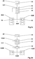
- Figure 3a shows an embodiment wherein measurement data are acquired with a data acquisition unit 15 of a first measurement device 80A. Based on the measurement data and a classification model made available to a classification unit 16, a first classification is performed, i.e. an object - defined by a multitude of measurement points or a single measurement point of the measurement data - is automatically assigned to a class of interest given by the classification model, e.g. "manhole cover".
- a user is informed about the classification results e.g. on an instrument screen, an audio output, an LED color indicator, etc.
- the user then - either implicitly or explicitly - provides feedback about the classification by means of a feedback unit 17 which creates feedback data, e.g. the user might confirm the classification result, change the result, define a new class of interest, delete a class of interest, and select a subsample of the measurement data to be used for future classification and/or training.
- the feedback data are transmitted to a training unit 18, e.g. stored on an external server 110, where a classifier is trained and improved based on a training procedure based on machine learning.
- An improved classification model i.e. comprising an improved classifier or a set of improved classifiers, is then transmitted to a set of defined measurement devices 80A,80B,80C,80X (not shown) for an update of their classification algorithms.
- the improved classification model might be rolled out to a software product for classifying data, e.g. stored on a dedicated computer or central server.
- Figure 3b shows an embodiment wherein measurement data are acquired by a data acquisition unit 15 of a first measurement device 81A. Based on the measurement data and a classification model stored on a classification unit 16 integral with the first measurement device 81A, a first classification is performed based on a classification model, i.e. an object is automatically assigned to a class of interest, e.g. "manhole cover".
- a classification model i.e. an object is automatically assigned to a class of interest, e.g. "manhole cover”.
- the measurement data and the first classification result are transmitted to a computer 120 comprising a feedback unit 17, e.g. a dedicated software product such as Leica Infinity, where a user, e.g. an online user such as the operator of the measurement device 81A or an offline user in an office, provides feedback about the classification, which creates feedback data for a training unit 18, here stored on the same computer 120.
- a feedback unit 17 e.g. a dedicated software product such as Leica Infinity
- the improved classification model with an improved classifier is transmitted to a set of defined measurement devices 81A,81b,81C,81X (not shown) for an update of their classification algorithms, and/or the improved classification model might further be provided to dedicated software products (not shown) for classifying data, e.g. stored on dedicated computers or on a central server.
- Figure 3c shows an embodiment wherein measurement data are generated by a data acquisition unit 15 of a measurement device 82, e.g. a generic measurement device without classification functionality.
- the measurement data are imported into a dedicated software product, e.g. such as the Leica Cyclone software, which is stored on a computer 121 and comes with an automatic classification functionality 16 for classifying the measurement data based on a classification model.
- the software further comprises a feedback functionality 17 and a training functionality 18, wherein a user, e.g. offline in an office, provides implicit or explicit feedback by means of the feedback functionality 17, which creates feedback data for the training functionality 18 of the software.
- the improved classification model with an improved classifier is made available to the classification part 16 of the software product and transmitted to a set of defined measurement devices 83A,83B,83X (not shown) having a classification functionality 16 for an update of their classification algorithms, and/or the improved classification model might be further rolled out to different software products on different computers (not shown).
- Figure 3d shows an embodiment wherein measurement data are generated by a data acquisition unit 15 of a measurement device 84, e.g. a generic measurement device without classification functionality.
- the measurement data are transmitted onto a first computer 122A comprising a dedicated software product (e.g. Leica Cyclone) with automatic classification functionality 16, based on a classification model, and a feedback portion 17 providing feedback data.
- the feedback data are then provided to a training procedure, here for example stored on a central server 111, for training classifiers and providing an improved classification model.
- the improved classification model is distributed from the central server 111 as an update to a set of instances of the software product installed on different computers 122A,122B,122C,122X (not shown), and/or the improved classification model might for example be further provided to a set of measurement devices with classification functionality (not shown).
Landscapes
- Engineering & Computer Science (AREA)
- Theoretical Computer Science (AREA)
- Physics & Mathematics (AREA)
- General Physics & Mathematics (AREA)
- Multimedia (AREA)
- Data Mining & Analysis (AREA)
- Computer Vision & Pattern Recognition (AREA)
- Artificial Intelligence (AREA)
- Life Sciences & Earth Sciences (AREA)
- Bioinformatics & Cheminformatics (AREA)
- Bioinformatics & Computational Biology (AREA)
- Evolutionary Biology (AREA)
- Evolutionary Computation (AREA)
- General Engineering & Computer Science (AREA)
- Computational Linguistics (AREA)
- Software Systems (AREA)
- Image Analysis (AREA)
- Information Retrieval, Db Structures And Fs Structures Therefor (AREA)
Abstract
Description
- The present invention relates to a method and system for surveying and/or metrology, in particular terrestrial surveying, airborne surveying, mobile mapping, a measurement by a total station, terrestrial laser scanning, a measurement by a coordinate measurement machine, a measurement by a laser tracker, a measurement by an articulated arm, and a measurement by a triangulation sensor, for assigning particular classes of interest within measurement data according to claim 1 and
claim 8 respectively. - In the art of general classification of measurement data, raw data, e.g. point cloud data, imaging data (2D or 3D), multi-spectral data, radar data, lidar data, data by a total station, or data from a laser tracker, are transformed into higher-level geometrical and semantic representations, e.g. for surface reconstructions, geometry fitting, 3d-modelling in particular surface meshing, fitting of parametric 2D or 3D primitives, selective processing, data decimation, data visualization, benchmarking, and/or object detection or recognition.
- Targets of interest within the measurement data are often classified into semantic and geometrical target classes, with possible hierarchical sub-classes, e.g.
- ∘ semantic target classes
- terrain: man-made or natural
- vegetation: high (trees) or low (bushes)
- hardscape: buildings, cars, and remaining objects, e.g. wherein buildings can consist of wall, roof, balcony, window, door, etc.
- application-specific classes: workpieces, products, tools, etc.
- classes for filtering and/or data reduction, e.g. classes for automatically filtering out unwanted points like scanning artefacts caused by moving objects or vegetation which may not be relevant for projects in construction,
- ∘ geometrical target classes
- contour lines ("breaklines"), i.e. linear features where the curvature radius of the surface is small, i.e. along which the orientation ("normal vector") of the underlying surface exhibits an unusual discontinuity
- planar surfaces
- objects with a predefined geometry (e.g. long vertical cylinders resembling light posts).
- For example, point cloud classification might be based on feature vectors consisting of point- or region-wise properties, e.g. such as
- o geometry in local neighborhood, e.g. based on the eigenvalues/-vectors of the covariance matrix and/or moments of structure tensors in the neighborhood indicating properties like planarity, curvature, linearity, orientation and/or roughness
- o height information such as vertical range, height to ground/ceiling, etc.
- o intensity and/or color, and variations thereof.
- For example, classification on image data might be based on feature vectors consisting of local, region-wise or global properties, e.g. such as
- ∘ histogram of oriented gradients or dense SIFT features (scale-invariant feature transform)
- ∘ Haar-like features
- ∘ Bag-of-Words features
- ∘ image features based on image oversegmentation.
- In particular, in a machine learning framework for deep learning, e.g. based on Convolutional Neural Networks, features and classification rules are extracted automatically from training data.
- The assignment of such classes and subclasses within measurement data still requires time-consuming processes and the human eye and human judgement. In attempt to automatize such assignment processes by computer implemented solutions many computational challenges are faced.
- Often the acquired data are unstructured and highly inhomogeneous with strong variations in the point density, e.g. in a 3D point cloud, caused by a quadratic decrease of the point density with distance to the point cloud capturing device, as well as a decrease of laser/light intensity with distance and points falling below a detection threshold or points that are captured with reduced accuracy (low S/N). In a scanning dataset, specific scan patterns may be used with different spacing of scan points in x,y,z direction, or data sets may be incomplete due to occlusions.
- In case of image data, variability of the appearance of an object might be very high as well. For example, object appearance depends on viewing direction, distance to the object, image resolution, lighting conditions and image sensor properties. Furthermore, in contrast to 3D point clouds an absolute scale of an object on the image is not defined.
- Therefore, multiscale classification features describing short-, mid-, and long-range semantic and geometric properties, e.g. further including orientation and height information, are required, and computational algorithms need to cope with inhomogeneous and incomplete datasets. Moreover, since 10's to 100's of millions of data points or image pixels need to be processed, efficient algorithms, e.g. implementing parallel computing, and large data storage are required.
- There are many applications with different definitions of classes. For example, for one application the classification of a point cloud into three classes (e.g. "man-made", "vegetation" and "terrain") might be sufficient, whereas another application might require splitting up vegetation in separate classes for "trees", "bushes", etc.
- Then again, for data reduction it might be sufficient to only have a few selective classes, e.g. in a simple case filtering a dataset based on only two classes, i.e. "data points to keep" and "data points to filter out".
- Moreover, an object might look different if data are recorded at different places and during different seasons of the year. For example, since buildings in Asia may look quite different from buildings in Europe, a classifier that is purely trained based on data captured in Europe might not work well in other regions of the world.
- Therefore, great efforts relating to manual classification steps, e.g. manual data filtering and manual data assignment, are required. On the other hand, these ongoing efforts may be beneficially used as a departure point for an inventive classification and/or training workflow based on machine learning.
- Application of machine learning algorithms allows an automation of different processes in classifying measurement data. Such a classification framework, based on a subclass of general machine learning (ML), provides a very efficient "learning approach" for pattern recognition as compared to rule-based programming. Machine learning algorithms can deal with tasks of large complexity, make use of implicit or explicit user feedback, thus becoming adaptive, and provide "per point" probabilities of the classification. This saves time, reduces processing costs and decreases amount of manual work.
- In so-called "supervised ML" an algorithm implicitly learns which characterizing properties (i.e. a combination of features) define target properties of points (such as class membership, affiliation to a contour line, etc.) according to definitions made by the user when labelling training data.
- On the other hand, in so-called "unsupervised ML" the algorithm finds hidden structure in unlabeled data, e.g. based on the data alone or with the aid of additional information such as for example a class specific (a-priori) model based on a specific classifier or a set of classifiers. This is also called "clustering" or "segmentation" and involves grouping points of the measurement data into categories based on some measure of inherent similarity or distance.
- Probabilistic classification algorithms further use statistical inference to find the best class for a given instance. Instead of simply determining a "best" class for each instance, probabilistic algorithms provide a probability of the instance being a member of each of the possible classes, wherein normally the one class with the highest probability is selected. This has several advantages over non-probabilistic algorithms, i.e. associating a confidence value for weighting its choice, and consequently, providing an option to abstain a choice when its confidence value is too low.
- However, usage of machine learning algorithms requires a lot of training data. In case of supervised machine learning also labeling information (i.e. assignment of the object classes to the data) is necessary. The data acquisition, preparation and labeling requires a lot of efforts and time.
- Summarizing, it is difficult in practice to use one pretrained classifier for large varieties of different applications, definitions of classes, object's appearance, etc.
- Even with increasing computing power and data storage, the large complexity required for automatically assigning particular classes of interest within measurement data pushes traditional methods, such as rule-based computational methods, to their limits, and a high degree of human interaction is still required.
- It is therefore an object of the present invention to improve processes for assigning classes of interest within measurement data in surveying and/or metrology, particularly by improving current workflows and/or by enabling new workflows and applications.
- A particular object is to improve on training of a classifier in a classification algorithm, wherein training is based on machine learning.
- A further object is to reduce the error rate of automated classification, in particular to increase the object detection rate, to reduce false alarms and/or to reduce the need for human intervention.
- Those objects are achieved by realising the features of the independent claim. Features which further develop the invention in an alternative or advantageous manner are described in the dependent patent claims.
- The invention relates to a method for surveying and/or metrology for assigning a class of interest within measurement data, the method comprising an acquisition of measurement data, particularly at least one of imaging data, multi-spectral data, radar data, lidar data, and point cloud data, for at least one measurement object, which is at least partly captured by the measurement data; and a classification of the measurement data by a classification algorithm for providing an assignment of the at least one measurement object - represented by a single data point of the measurement data or a multitude of measurement points - to a first class of interest within the measurement data, based on the measurement data and a classification model comprising at least the first class of interest.
- For example, the method might be applied to terrestrial surveying, airborne surveying, mobile mapping, a measurement by a total station, terrestrial laser scanning, a measurement by a coordinate measurement machine, a measurement by a laser tracker, a measurement by an articulated arm, or a measurement by a triangulation sensor; wherein measurement data may comprise ground penetrating radar data, point cloud data, e.g. resulting from lidar measurements or generated from image data, multi-spectral imaging data from a 2D camera or a 3D camera, data from a laser tracker, a lidar scanner, etc.
- The measurement object might be a physical 2D or 3D object, e.g. a specific surface, landscapes, a workpiece, a reflector, or a tool, with specific properties, e.g. a specific multi-spectral or electric response, wherein the measurement object might be captured by a single data point of the measurement data or a multitude of measurement points. Furthermore, the measurement data may comprise information from one object only, e.g. the full object being captured or only subparts of the object, or the data may comprise information on a multitude of different objects, as well as background data which is not foreseen for classification.
- According to the invention, the assignment of the at least one measurement object to a first class of interest within the measurement data is processed by a feedback procedure providing feedback data comprising at least one of verification information for the assignment of the measurement object to the first class of interest, in particular at least one of a confirmation of the assignment, a rejection of the assignment, and a warning, particularly if the assignment is wrong or uncertain; change information of the assignment of the measurement object to the first class of interest, in particular at least one of removal of the assignment and re-assignment to a second class of interest; a definition of a new class of interest, e.g. defining a new class from scratch, by merging existing classes into a new class or by splitting an existing class into new classes, or by adapting an existing class; an instruction for removal of a class of interest from the classification model; a first selection of the measurement data to be used for the classification; and identification of a second selection of the measurement data to be ignored for further processing; wherein the feedback data is provided to a training procedure, the training procedure being based on a machine learning algorithm, e.g. relying on deep learning for supervised learning and/or unsupervised learning, and providing update information for the classification model.
- In particular, with the inventive method suitable training data may be acquired and prepared with each measurement task, particularly reducing data storage, overhead time, and false classification, which lead to more accurate classification and more efficient training of a multitude of classifiers for a wide range of different applications.
- The feedback procedure might be executed close to real-time, e.g. during measuring by means of a feedback unit being part (integral or external) of the measurement device, or the feedback procedure might be executed offline, e.g. during a dedicated feedback workstep, e.g with a dedicated software tool installed on a computer.
- In a particular embodiment the feedback data are provided based on at least one of explicit feedback by means of the feedback procedure, in particular by an operator of a measurement device used for the acquisition of the measurement data and/or by a software used for processing of the measurement data; and implicit feedback, in particular based on at least one of system settings of the measurement device used for the acquisition of the measurement data, particularly wherein the system settings are defined by an operator of the measurement device, a quality assessment of the measurement data, particularly an automatic quality assessment by a control and evaluation functionality of the classification unit, and an interpretation of a lack of explicit feedback as a confirmation of the assignment.
- For example, the control and evaluation functionality of the classification unit may be provided by a display and trigger keys integral with the measurement device, a touch screen of an external operating device, or an input option for a dedicated office software.
- In a further embodiment the feedback procedure is supported by a notification functionality providing a status information of the classification, in particular comprising at least one of a notification when the assignment is finished, a notification when the classification has failed, and a quality assessment on the assignment, e.g. a warning if the assignment is uncertain, possibly with an indication on the degree of the uncertainty or the cause of the uncertainty.
- For example, an uncertainty might occur for borderline cases within feature space, e.g. wherein - based on a given uncertainty in calculating feature vectors, particularly when the object lies close to a borderline or on a borderline in feature space - an object has similar probability to be assigned to multiple classes. In such cases it might further be useful if the feedback procedure automatically asks for explicit user feedback before continuing processing.
- The notification functionality may be based on at least one of a visual representation of the status information, in particular a visual representation of the measurement data on a display with a defined color coding for sub samples of the measurement data being assigned to different classes of interest and/or by a text message, and an acoustic notification of the status information, particularly an audio code or a voice signal, in particular wherein the notification functionality triggers the feedback procedure.
- For example, the feedback procedure might comprise a visualization of a checklist, a functional diagram, a schematic illustration, or an image, e.g. a 2D or 3D image of the measured scene wherein objects of specific classes are highlighted by dedicated colors.
- For example, an acoustic notification might be an audio signal or an audio code such as a single beep signal or a sequence of beep signals when classification has finished or failed, or the acoustic notification might be more complex, e.g. a voice signal giving detailed information on the classification status (e.g. "point stored") and/or giving additional information on the classification result (e.g. "hydrant - point stored"). For example, by also indicating the classification result ("hydrant"), a user can take immediate action if the classification is incorrect.
- Based on the notification, a user might then review the classification by input means of the measuring device, an operating device associated with the measuring device, or input options of a dedicated office software running on a computer.
- When the feedback procedure is triggered by the notification functionality, an operator might for example be given a defined time window after completion of the assignment option to enter feedback, wherein refraining from doing so is interpreted as confirmation of the assignment, or an input request might be triggered requiring a user to confirm the classification before sending data to the training procedure.
- In a particular embodiment, the training procedure is adapted for at least one of processing feedback data provided by classifications of a multitude of measurement data, in particular wherein the multitude of measurement data being acquired by a multitude of measurement devices; and processing additional data provided to the training procedure, in particular the additional data comprising at least one of a digital building model, particularly a CAD model, digital mapping data, satellite data, imaging data, and footprint data.
- Therefore, many operators, e.g. surveyors working in a surveying office, may contribute during their daily work to the improvement of a classifier of a classification model and all of them benefit from an improved classifier after an update of a classification unit on their measurement instruments or an office software.
- In another embodiment the update information for the classification model is made available to a multitude of classification algorithms, in particular classification algorithms running on a multitude of classification units with a defined access to the update information and a defined update procedure.
- For example, the improved classifiers may be stored and shared on a central database, e.g. in a sense of a "classifier app-store", wherein access to specific classifiers might be based on a specific update interval, a user group for a specific measurement application, a measurement location, or a measurement time, wherein the update might be performed automatically or wherein an operator of a measurement device can download the required model from the central database for a specific measuring task.
- In particular, the classification model might be provided out of a set of different models, differing from each other by at least one of a region-specific classification parameter; a region-specific class of interest; a time-specific classification parameter; a time-specific class of interest; an application-specific classification parameter; and an application-specific class of interest; wherein the classification model being provided based on at least one of a time information, a location information, and an application information, corresponding with the acquisition of the measurement data, particularly provided by acquisition of additional data of a global positioning system, in particular for classifying at least one of seasonal vegetation, region-specific vegetation, and region-specific infrastructure, particularly a building type.
- The classification performance is highly dependent on the type and characteristics of the measurement data to be classified. Therefore, a choice between different algorithms and different sets of classification parameters is required. For example, the classification might be based on at least one of a class of interest based on a semantic property, in particular based on at least one of terrain, vegetation, and hardscape; a class of interest based on a geometrical property, in particular based on at least one of planar surfaces, breaklines, and a 3D primitive; linear classification, in particular based on Fisher's linear discriminant, logistic regression, naive Bayes classifiers, or the perceptron; a support vector machine, in particular a least squares support vector machine; a quadratic classifier; Kernel estimation, in particular k-nearest neighbour; boosting; a decision tree, in particular based on random forests; deep learning, in particular based on a neural network, particularly a convolutional neural network; and learning vector quantization.
- The invention further relates to a system for surveying and/or metrology for assigning a class of interest within measurement data, comprising a measurement device with a data acquisition unit for an acquisition of measurement data, particularly at least one of imaging data, multi-spectral data, radar data, lidar data, and point cloud data, for at least one measurement object, which is at least partly captured by the measurement data; and a classification unit for executing a classification of the measurement data by a classification algorithm for providing an assignment of the at least one measurement object to a first class of interest within the measurement data, based on the measurement data and a classification model made available to the classification unit comprising at least the first class of interest.
- According to the invention, the system further comprises a feedback functionality for processing the assignment by a feedback procedure providing feedback data comprising at least one of verification information for the assignment of the measurement object to the first class of interest, in particular at least one of a confirmation of the assignment, a rejection of the assignment, and a warning, particularly if the assignment is wrong or uncertain; change information of the assignment of the measurement object to the first class of interest, in particular by at least one of removal of the assignment and re-assignment to a second class of interest; a definition of a new class of interest, in particular by at least one of modifying an existing class, splitting an existing class into at least two new classes, and merging multiple existing classes into a new class; an instruction for removal of a class of interest from the classification model; a first selection of the measurement data to be used for the classification; and identification of a second selection of the measurement data to be ignored for further processing; wherein the feedback data is provided to a training unit comprising a training procedure, the training procedure being based on a machine learning algorithm and providing update information for the classification model.
- In a particular embodiment of the system the feedback data are provided based on at least one of explicit feedback by means of the feedback functionality, in particular by an operator of the measurement device for the acquisition of the measurement data and/or by a software used for processing of the measurement data; and implicit feedback, in particular based on at least one of system settings of the measurement device, particularly wherein the system settings are defined by an operator of the measurement device, a quality assessment of the measurement data, particularly an automatic quality assessment by a control and evaluation functionality of the classification unit, and an interpretation of a lack of explicit feedback as a confirmation of the assignment.
- A further embodiment relates to a system wherein the feedback procedure is supported by a notification functionality providing a status information of the classification, in particular comprising at least one of a notification when the assignment is finished, a notification when the classification has failed, and a a quality assessment on the assignment, wherein the notification functionality being based on at least one of a visual representation of the status information, in particular a visual representation of the measurement data on a display with a defined color coding for sub samples of the measurement data being assigned to different classes of interest and/or by a text message; and an acoustic notification of the status information, in particular an audio code or a voice signal; in particular wherein the notification functionality triggers the feedback procedure.
- In another embodiment the training procedure is adapted for at least one of processing feedback data provided by classifications of a multitude of measurement data, in particular wherein the multitude of measurement data being acquired by a multitude of measurement devices; and processing additional data provided to the training procedure, in particular the additional data comprising at least one of a digital building model, particularly a CAD model, digital mapping data, satellite data, imaging data, and footprint data.
- In a particular embodiment the system is characterized in that the update information for the classification model is made available to a multitude of classification algorithms, in particular classification algorithms running on a multitude of classification units with a defined access to the update information and a defined update procedure.
- Another embodiment relates to a system with the classification model being provided out of a set of different models, differing from each other by at least one of a region-specific classification parameter; a region-specific class of interest; a time-specific classification parameter; a time-specific class of interest; an application-specific classification parameter; and an application-specific class of interest; wherein the classification model being provided based on at least one of a time information, a location information, and an application information, corresponding with the acquisition of the measurement data, particularly provided by acquisition of additional data of a global positioning system, in particular for classifying at least one of seasonal vegetation, region-specific vegetation, and region-specific infrastructure, particularly a building type.
- In particular, the classification might be based on at least one of a class of interest based on a semantic property, in particular based on at least one of terrain, vegetation, and hardscape; a class of interest based on a geometrical property, in particular based on at least one of planar surfaces, breaklines, and a 3D primitive; linear classification, in particular based on Fisher's linear discriminant, logistic regression, naive Bayes classifiers, or the perceptron; a support vector machine, in particular a least squares support vector machine; a quadratic classifier; Kernel estimation, in particular k-nearest neighbour; boosting; a decision tree, in particular based on random forests; deep learning, in particular based on a neural network, particularly a convolutional neural network; and learning vector quantization.
- The method and system according to the invention are described or explained in more detail below, purely by way of example, with reference to working examples shown schematically in the drawing. Specifically,
- Fig. 1:
- an exemplary illustration for a classification process, here in the field of construction or building surveying;
- Fig. 2:
- an exemplary illustration of the inventive method of acquiring actual measurement data to be classified at different surveying locations and providing feedback information and feedback data for a training procedure of a classification model;
- Fig. 3a-d:
- schematic embodiments of different arrangements of the data acquisition unit, the classification unit, the feedback unit, and the training unit.
- The diagrams of the figures should not be considered as being drawn to scale. Where appropriate, the same reference signs are used for the same features or for features with similar functionalities.
-
Figure 1 shows an exemplary illustration for a classification process, here in the field of construction or building surveying, wherein raw measurement data of a scene, here a point cloud 1, for example recorded by a terrestrial lidar scanning system or a photogrammetric reconstruction system, is classified with geometric classes, e.g. such asedge lines 2,border lines 3, or rectangular window frames 4, and semantic classes and subclasses, e.g. such as windows 5, roof 6, vegetation, e.g. divided into (high)trees 7A and (low)bushes 7B, in order to transform the initial point cloud 1 into a higher level representation of thepoint cloud 100, e.g. for extracting more information or for monitoring purposes. - An automatic assignment of classes and subclasses within measurement data, e.g. a point cloud 1, often requires time-consuming preparation processes, in particular for defining dedicated classifying parameters, e.g. for the calculation of feature vectors consisting of point- or region-wise properties specific for a given classification scene, e.g. such as the geometry in local neighbourhood, orientation or curvature/roughness, eigenvalues/-vectors of covariance matrices and moments of structure tensors, intensity and color variations, etc.
- Also the objects to be classified and the classes of interest within the measurement data may vary for different applications. Furthermore, often an initial rough classification of objects or contour lines is required,
wherein in many cases the human eye and human judgement are still the best solution to identify an object within the measurement data. - Targets of interest within the measurement data are often classified into semantic and geometrical target classes, with possible hierarchical sub-classes, e.g. "man-made" or "natural terrain", "high" (trees) or "low" (bushes) "vegetation", contour lines, i.e. linear features along which the orientation (the normal vector) of the underlying surface exhibits an unusual discontinuity, planar surfaces, or 2D or 3D primitives such as circles, cylinders, ellipsoids, etc.
- Application of machine learning algorithms allows an automation of different processes in classifying measurement data. Such a classification algorithm, based on a subclass of general machine learning (ML), provides a very efficient, adaptive "learning approach" for pattern recognition as compared to rule-based programming. Machine learning algorithms can deal with tasks of large complexity, make use of implicit or explicit user feedback and provide "per point" probabilities of the classification. This saves time, reduces processing costs and decreases amount of preparation work.
- However, usage of machine learning algorithms requires a lot of training data. In case of supervised machine learning also labeling information (i.e. assignment of the object classes to the data) is necessary. Because of the complexity and the wide range of different applications with varying classification parameters and classes of interest, the data acquisition, preparation and labeling requires great effort.
- Furthermore, for the selection of suitable training data a lot of data surplus is acquired, often pushing data handling and data storage to the limit. Modern measurement devices are able to acquire TB of data per day. The bottleneck is the transmission of the data from the measurement device to services e.g. running on the internet. Therefore, a data reduction, i.e. elimination of non relevant data or data without additional information content, directly on the measurement device based on classification feedback is advantageous. An example is the scanning of a planar wall which might be represented by some thousands of scanning points whereas only a few data points and parameters would be necessary for defining the position, orientation and dimension of the wall.
-
Figure 2 illustrates a particular idea of the invention, here in the field of surveying withmultiple laser scanners 8,8', to improve on the provision of training data, wherein the acquisition of suitable training data and classification feedback for a training procedure - particularly for a training procedure being based on machine learning - is acquired in parallel with each acquisition and classification of actual measurement data. Therefore, many operators, e.g. surveyors working in a surveying office, may contribute during their daily work to the improvement of a classifier of a classification model and all of them benefit from an improved classifier after an update of a classification unit on their measurement instruments or on an office software, e.g. in a sense of a "crowd-based-training" of classifiers. - For example,
multiple laser scanners 8,8' are used for acquiring measurement data atdifferent surveying locations 9,9'. The measurement data are automatically classified by a classification algorithm according to a classification model with predefined classes of interest and attributed classification parameters. The automatic classification result and the measurement data are then verified or adapted by a feedback procedure - explicitly, e.g. by operator feedback, and/or implicitly, e.g. by interpreting lack of explicit feedback as confirmation of the classification - and feedback data from the feedback procedure, e.g. comprising verified or adapted classification information and part of the measurement data, are provided to a training algorithm, e.g. stored on acentral server 11, to be used as training data in a training procedure providing an improved classifier for a class of interest. - The
classification model 10 with predefined classes of interest and attributed classification parameters might also be stored on thecentral server 11 and made available to a classification unit of thelaser scanners 8,8', e.g. the classification unit being integral to thelaser scanners 8,8' and/or being stored on an external device of thelaser scanners 8,8', e.g. adedicated tablet device 12 for operating thelaser scanner 8. - Alternatively, the classification model might be stored on a dedicated office software for classifying the measurement data acquired by the
laser scanners 8,8', or the measurement data acquired by thelaser scanners 8,8' may be transferred to thecentral server 11 and the classification might be solely executed on thecentral server 11. - For providing feedback for the classification result, an operator of the
laser scanner 8,8' - or an offline worker in an office using a dedicated office software containing the classification algorithm and being provided with the measurement data of thelaser scanners 8,8' - might be provided with visual aids, e.g. by means of thetablet device 12 or an office software, and/or acoustic aids. For example, a user might be informed about the classification results e.g. on an instrument screen, an audio output 13 (e.g. "Manhole cover - point measured"), an LED color indicator, etc. In case of an incorrect assignment the user might then manually assign the correct class to the measurement point, e.g. by using trigger keys on thelaser scanners 8,8', a touch screen of thetablet device 12, or an input option for a dedicated office software. - In particular, the feedback procedure might further be triggered by the notification functionality, e.g. an
acoustic notification 13 that the classification is finished, e.g. giving the operator of thelaser scanner 8,8' the option to provide feedback within a defined time window, wherein refraining from doing so is interpreted as confirmation of the assignment. - By making use of the feedback data from a multitude of feedback procedures, i.e. feedback taking into account dedicated applications and environments, e.g. taking into account a multitude of different workpieces, a time of day, daytime and night time measurements, a particular part of the year, a date or a season, a global position, a rough position such as longitude and latitude, or a climate zone, training of a dedicated classifier is improved, particularly training by a machine learning algorithm.
- The improved classifiers may then be made available and distributed to dedicated classification algorithms, e.g. on dedicated measurement instruments and surveying software within a surveying office requiring specific classifiers such as for example classifiers for Western European and North American infrastructure vs. classifiers for Asian infrastructure, classifiers based on a season, e.g. summer vs. winter, and location, e.g. fir forest vs. oak forest.
- For example, the improved classifiers may be stored on a central database, e.g. in a sense of a "classifier app-store", wherein access to specific classifiers might be restricted, e.g. based on user groups, wherein an operator of a measurement device can download the required classification model from the central database for a specific measuring task.
- Alternatively, measurement instruments, here the
laser scanners 8,8', may be provided with information about the application or the measurement task and/or with time and/or position data, e.g. from aglobal positioning system 14 or manually input by an operator, based on which dedicated classification models with region-specific, time-specific, and/or application-specific classifiers are automatically retrieved from the central database. - According to the invention, various implementations and arrangements are possible for the data acquisition unit, the classification unit, the feedback functionality, and the training unit. A selection of different implementations is schematically illustrated by
Figures 3a to 3d . -
Figure 3a shows an embodiment wherein measurement data are acquired with adata acquisition unit 15 of afirst measurement device 80A. Based on the measurement data and a classification model made available to aclassification unit 16, a first classification is performed, i.e. an object - defined by a multitude of measurement points or a single measurement point of the measurement data - is automatically assigned to a class of interest given by the classification model, e.g. "manhole cover". - A user is informed about the classification results e.g. on an instrument screen, an audio output, an LED color indicator, etc. The user then - either implicitly or explicitly - provides feedback about the classification by means of a
feedback unit 17 which creates feedback data, e.g. the user might confirm the classification result, change the result, define a new class of interest, delete a class of interest, and select a subsample of the measurement data to be used for future classification and/or training. - The feedback data are transmitted to a
training unit 18, e.g. stored on anexternal server 110, where a classifier is trained and improved based on a training procedure based on machine learning. - An improved classification model, i.e. comprising an improved classifier or a set of improved classifiers, is then transmitted to a set of defined
measurement devices - Alternatively or in addition (not shown), the improved classification model might be rolled out to a software product for classifying data, e.g. stored on a dedicated computer or central server.
-
Figure 3b shows an embodiment wherein measurement data are acquired by adata acquisition unit 15 of afirst measurement device 81A. Based on the measurement data and a classification model stored on aclassification unit 16 integral with thefirst measurement device 81A, a first classification is performed based on a classification model, i.e. an object is automatically assigned to a class of interest, e.g. "manhole cover". - The measurement data and the first classification result are transmitted to a
computer 120 comprising afeedback unit 17, e.g. a dedicated software product such as Leica Infinity, where a user, e.g. an online user such as the operator of themeasurement device 81A or an offline user in an office, provides feedback about the classification, which creates feedback data for atraining unit 18, here stored on thesame computer 120. - Then the improved classification model with an improved classifier is transmitted to a set of defined
measurement devices -
Figure 3c shows an embodiment wherein measurement data are generated by adata acquisition unit 15 of ameasurement device 82, e.g. a generic measurement device without classification functionality. The measurement data are imported into a dedicated software product, e.g. such as the Leica Cyclone software, which is stored on acomputer 121 and comes with anautomatic classification functionality 16 for classifying the measurement data based on a classification model. Here, the software further comprises afeedback functionality 17 and atraining functionality 18, wherein a user, e.g. offline in an office, provides implicit or explicit feedback by means of thefeedback functionality 17, which creates feedback data for thetraining functionality 18 of the software. - Then the improved classification model with an improved classifier is made available to the
classification part 16 of the software product and transmitted to a set of definedmeasurement devices classification functionality 16 for an update of their classification algorithms, and/or the improved classification model might be further rolled out to different software products on different computers (not shown). -
Figure 3d shows an embodiment wherein measurement data are generated by adata acquisition unit 15 of ameasurement device 84, e.g. a generic measurement device without classification functionality. The measurement data are transmitted onto afirst computer 122A comprising a dedicated software product (e.g. Leica Cyclone) withautomatic classification functionality 16, based on a classification model, and afeedback portion 17 providing feedback data. The feedback data are then provided to a training procedure, here for example stored on acentral server 111, for training classifiers and providing an improved classification model. - Then, the improved classification model is distributed from the
central server 111 as an update to a set of instances of the software product installed ondifferent computers - Although the invention is illustrated above, partly with reference to some preferred embodiments, it must be understood that numerous modifications and combinations of different features of the embodiments can be made. All of these modifications lie within the scope of the appended claims.
Claims (14)
- Method for surveying and/or metrology for assigning a class of interest within measurement data, with• acquisition (15) of measurement data, particularly at least one of imaging data, multi-spectral data, radar data, lidar data, and point cloud data, for at least one measurement object, which is at least partly captured by the measurement data, and• a classification (16) of the measurement data by a classification algorithm for providing an assignment of the at least one measurement object to a first class of interest within the measurement data, based oncharacterized in that∘ the measurement data and∘ a classification model comprising at least the first class of interest,
the assignment being processed by a feedback procedure (17) providing feedback data comprising at least one of• verification information for the assignment of the measurement object to the first class of interest, in particular at least one of∘ a confirmation of the assignment,∘ a rejection of the assignment, and∘ a warning, particularly if the assignment is wrong or uncertain,• change information of the assignment of the measurement object to the first class of interest, in particular at least one ofo removal of the assignment, ando re-assignment to a second class of interest,• a definition of a new class of interest, in particular by at least one of∘ modifying an existing class,∘ splitting an existing class into at least two new classes, and∘ merging multiple existing classes into a new class,• an instruction for removal of a class of interest from the classification model,• a first selection of the measurement data to be used for the classification, and• identification of a second selection of the measurement data to be ignored for further processing,wherein the feedback data is provided to a training procedure (18), the training procedure being based on a machine learning algorithm and providing update information for the classification model. - Method according to claim 1,
characterized in that
the feedback data being provided based on at least one of• explicit feedback by means of the feedback procedure (17), in particular by an operator of a measurement device (8,8',80,81,82,83,84) for the acquisition of the measurement data and/or by a software used for processing of the measurement data, and• implicit feedback, in particular based on at least one of∘ system settings of the measurement device used for the acquisition of the measurement data, particularly wherein the system settings are defined by an operator of the measurement device,∘ a quality assessment of the measurement data, particularly an automatic quality assessment by a control and evaluation functionality of the classification unit, and∘ an interpretation of a lack of explicit feedback as a confirmation of the assignment. - Method according to claim 1 or 2,
characterized in that
the feedback procedure (17) being supported by a notification functionality providing a status information of the classification, in particular comprising at least one of• a notification when the assignment is finished,• a notification when the classification has failed,
and• a quality assessment on the assignment,wherein the notification functionality being based on at least one of• a visual representation of the status information, in particular a visual representation of the measurement data on a display with a defined color coding for sub samples of the measurement data being assigned to different classes of interest and/or by a text message, and• an acoustic notification of the status information, in particular an audio code or a voice signal,in particular wherein the notification functionality triggers the feedback procedure. - Method according to any one of the preceding claims,
characterized in that
the training procedure (18) being adapted for at least one of• processing feedback data provided by classifications of a multitude of measurement data, in particular wherein the multitude of measurement data being acquired by a multitude of measurement devices (8,8',80,81,82,83,84), and• processing additional data provided to the training procedure (18), in particular the additional data comprising at least one of∘ a digital building model, particularly a CAD model,∘ digital mapping data,∘ satellite data,∘ imaging data, and∘ footprint data. - Method according to any one of the preceding claims,
characterized in that
the update information for the classification model is made available to a multitude of classification algorithms, in particular classification algorithms running on a multitude of classification units (16) with a defined access to the update information and a defined update procedure. - Method according to any one of the preceding claims,
characterized in that
the classification model being provided out of a set of different models, differing from each other by at least one of• a region-specific classification parameter,• a region-specific class of interest,• a time-specific classification parameter,• a time-specific class of interest,• an application-specific classification parameter, and• an application-specific class of interest,wherein the classification model being provided based on at least one of a time information, a location information, and an application information, corresponding with the acquisition of the measurement data, particularly provided by acquisition of additional data of a global positioning system (14),
in particular for classifying at least one of seasonal vegetation, region-specific vegetation, and region-specific infrastructure, particularly a building type. - Method according to any one of the preceding claims,
characterized in that
the classification being based on at least one of• a class of interest based on a semantic property, in particular based on at least one of terrain, vegetation, and hardscape,• a class of interest based on a geometrical property, in particular based on at least one of planar surfaces, breaklines, and a 3D primitive,• linear classification, in particular based on Fisher's linear discriminant, logistic regression, naive Bayes classifiers, or the perceptron,• a support vector machine, in particular a least squares support vector machine,• a quadratic classifier,• Kernel estimation, in particular k-nearest neighbour,• boosting,• a decision tree, in particular based on random forests,• deep learning, in particular based on a neural network, particularly a convolutional neural network, and• learning vector quantization. - System for surveying and/or metrology for assigning a class of interest within measurement data, comprising• a measurement device (8,8',80,81,82,83,84) with a data acquisition unit (15) for an acquisition of measurement data, particularly at least one of imaging data, multi-spectral data, radar data, lidar data, and point cloud data, for at least one measurement object, which is at least partly captured by the measurement data, and• a classification unit (16) for executing a classification of the measurement data by a classification algorithm for providing an assignment of the at least one measurement object to a first class of interest within the measurement data, based oncharacterized in that∘ the measurement data and∘ an classification model made available to the classification unit comprising at least the first class of interest,
the system further comprising a feedback functionality (17) for processing the assignment by a feedback procedure providing feedback data comprising at least one of• verification information for the assignment of the measurement object to the first class of interest, in particular at least one of∘ a confirmation of the assignment,∘ a rejection of the assignment, and∘ a warning, particularly if the assignment is wrong or uncertain,• change information of the assignment of the measurement object to the first class of interest, in particular by at least one of∘ removal of the assignment, and∘ re-assignment to a second class of interest,• a definition of a new class of interest, in particular by at least one ofo modifying an existing class,o splitting an existing class into at least two new classes, ando merging multiple existing classes into a new class,• an instruction for removal of a class of interest from the classification model,• a first selection of the measurement data to be used for the classification, and• identification of a second selection of the measurement data to be ignored for further processing,wherein the feedback data is provided to a training unit comprising a training procedure (18), the training procedure being based on a machine learning algorithm and providing update information for the classification model. - System according to claim 8,
characterized in that
the feedback data being provided based on at least one of• explicit feedback by means of the feedback functionality (17), in particular by an operator of the measurement device (8,8',80,81,82,83,84) for the acquisition of the measurement data and/or by a software used for processing of the measurement data, and• implicit feedback, in particular based on at least one of∘ system settings of the measurement device, particularly wherein the system settings are defined by an operator of the measurement device,∘ a quality assessment of the measurement data, particularly an automatic quality assessment by a control and evaluation functionality of the classification unit, and∘ an interpretation of a lack of explicit feedback as a confirmation of the assignment. - System according to any one of claims 8 to 9,
characterized in that
the feedback functionality (17) being supported by a notification functionality providing a status information of the classification, in particular comprising at least one of• a notification when the assignment is finished,• a notification when the classification has failed,
and• a quality assessment on the assignment,wherein the notification functionality being based on at least one of• a visual representation of the status information, in particular a visual representation of the measurement data on a display with a defined color coding for sub samples of the measurement data being assigned to different classes of interest and/or by a text message, and• an acoustic notification of the status information, in particular an audio code or a voice signal,in particular wherein the notification functionality triggers the feedback procedure. - System according to any one of claims 8 to 10,
characterized in that
the training procedure (18) being adapted for at least one of• processing feedback data provided by classifications of a multitude of measurement data, in particular wherein the multitude of measurement data being acquired by a multitude of measurement devices (8,8',80,81,82,83,84), and• processing additional data provided to the training procedure, in particular the additional data comprising at least one of∘ a digital building model, particularly a CAD model,∘ digital mapping data,∘ satellite data,∘ imaging data, and∘ footprint data. - System according to any one of claims 8 to 11,
characterized in that
the update information for the classification model is made available to a multitude of classification algorithms, in particular classification algorithms running on a multitude of classification units (16) with a defined access to the update information and a defined update procedure. - System according to any one of claims 8 to 12,
characterized in that
the classification model being provided out of a set of different models, differing from each other by at least one of• a region-specific classification parameter,• a region-specific class of interest,• a time-specific classification parameter,• a time-specific class of interest,• an application-specific classification parameter, and• an application-specific class of interest,wherein the classification model being provided based on at least one of a time information, a location information, and an application information, corresponding with the acquisition of the measurement data, particularly provided by acquisition of additional data of a global positioning system (14),
in particular for classifying at least one of seasonal vegetation, region-specific vegetation, and region-specific infrastructure, particularly a building type. - System according to any one of claims 8 to 13,
characterized in that
the classification being based on at least one of• a class of interest based on a semantic property, in particular based on at least one of terrain, vegetation, and hardscape,• a class of interest based on a geometrical property, in particular based on at least one of planar surfaces, breaklines, and a 3D primitive,• linear classification, in particular based on Fisher's linear discriminant, logistic regression, naive Bayes classifiers, or the perceptron,• a support vector machine, in particular a least squares support vector machine,• a quadratic classifier,• Kernel estimation, in particular k-nearest neighbour,• boosting,• a decision tree, in particular based on random forests,• deep learning, in particular based on a neural network, particularly a convolutional neural network, and• learning vector quantization.
Priority Applications (3)
| Application Number | Priority Date | Filing Date | Title |
|---|---|---|---|
| EP16206779.7A EP3340106B1 (en) | 2016-12-23 | 2016-12-23 | Method and system for assigning particular classes of interest within measurement data |
| CN201711338068.0A CN108241870B (en) | 2016-12-23 | 2017-12-14 | Method for assigning a specific category of interest within measurement data |
| US15/853,460 US10740606B2 (en) | 2016-12-23 | 2017-12-22 | Method for assigning particular classes of interest within measurement data |
Applications Claiming Priority (1)
| Application Number | Priority Date | Filing Date | Title |
|---|---|---|---|
| EP16206779.7A EP3340106B1 (en) | 2016-12-23 | 2016-12-23 | Method and system for assigning particular classes of interest within measurement data |
Publications (2)
| Publication Number | Publication Date |
|---|---|
| EP3340106A1 true EP3340106A1 (en) | 2018-06-27 |
| EP3340106B1 EP3340106B1 (en) | 2023-02-08 |
Family
ID=57890640
Family Applications (1)
| Application Number | Title | Priority Date | Filing Date |
|---|---|---|---|
| EP16206779.7A Active EP3340106B1 (en) | 2016-12-23 | 2016-12-23 | Method and system for assigning particular classes of interest within measurement data |
Country Status (3)
| Country | Link |
|---|---|
| US (1) | US10740606B2 (en) |
| EP (1) | EP3340106B1 (en) |
| CN (1) | CN108241870B (en) |
Cited By (13)
| Publication number | Priority date | Publication date | Assignee | Title |
|---|---|---|---|---|
| KR102025113B1 (en) * | 2018-08-27 | 2019-09-25 | 영남대학교 산학협력단 | Method for generating an image using a lidar and device for the same |
| WO2020098674A1 (en) * | 2018-11-14 | 2020-05-22 | Huawei Technologies Co., Ltd. | Method and system for deep neural networks using dynamically selected feature-relevant points from point cloud |
| CN112347113A (en) * | 2020-09-16 | 2021-02-09 | 北京中兵数字科技集团有限公司 | Aviation data fusion method, aviation data fusion device and storage medium |
| US11313677B2 (en) | 2017-12-11 | 2022-04-26 | Hexagon Technology Center Gmbh | Automated surveying of real world objects |
| US11367265B2 (en) * | 2020-10-15 | 2022-06-21 | Cape Analytics, Inc. | Method and system for automated debris detection |
| US11568639B2 (en) | 2015-08-31 | 2023-01-31 | Cape Analytics, Inc. | Systems and methods for analyzing remote sensing imagery |
| US11861843B2 (en) | 2022-01-19 | 2024-01-02 | Cape Analytics, Inc. | System and method for object analysis |
| US11875413B2 (en) | 2021-07-06 | 2024-01-16 | Cape Analytics, Inc. | System and method for property condition analysis |
| US11967097B2 (en) | 2021-12-16 | 2024-04-23 | Cape Analytics, Inc. | System and method for change analysis |
| US12050994B2 (en) | 2018-11-14 | 2024-07-30 | Cape Analytics, Inc. | Systems, methods, and computer readable media for predictive analytics and change detection from remotely sensed imagery |
| US12229845B2 (en) | 2022-06-13 | 2025-02-18 | Cape Analytics, Inc. | System and method for property group analysis |
| US12333788B2 (en) | 2022-01-24 | 2025-06-17 | Cape Analytics, Inc. | System and method for subjective property parameter determination |
| US12579786B2 (en) | 2021-10-19 | 2026-03-17 | Cape Analytics, Inc. | System and method for property typicality determination |
Families Citing this family (17)
| Publication number | Priority date | Publication date | Assignee | Title |
|---|---|---|---|---|
| US11867833B2 (en) * | 2017-03-01 | 2024-01-09 | The University Court Of The University Of St Andrews | Classification method and device |
| AT521845B1 (en) * | 2018-09-26 | 2021-05-15 | Waits Martin | Method for adjusting the focus of a film camera |
| CN109493287B (en) * | 2018-10-10 | 2022-03-15 | 浙江大学 | A deep learning-based quantitative spectral data analysis and processing method |
| JP7503370B2 (en) * | 2019-07-01 | 2024-06-20 | 株式会社小松製作所 | Method for producing trained task classification estimation model, computer-implemented method, and system including work machine |
| EP3767332B1 (en) * | 2019-07-18 | 2023-12-13 | Aptiv Technologies Limited | Methods and systems for radar object detection |
| US11131657B2 (en) * | 2019-07-18 | 2021-09-28 | Technion Research & Development Foundation Limited | Method and system for estimation of fruitlet drop |
| US12217139B2 (en) * | 2019-10-15 | 2025-02-04 | Siemens Aktiengesellschaft | Transforming a trained artificial intelligence model into a trustworthy artificial intelligence model |
| US11574485B2 (en) | 2020-01-17 | 2023-02-07 | Apple Inc. | Automatic measurements based on object classification |
| CN113137916B (en) * | 2020-01-17 | 2023-07-11 | 苹果公司 | Automatic measurement based on object classification |
| US11610119B2 (en) * | 2020-02-21 | 2023-03-21 | Ai4 International Oy | Method and system for processing spatial data |
| US11734767B1 (en) | 2020-02-28 | 2023-08-22 | State Farm Mutual Automobile Insurance Company | Systems and methods for light detection and ranging (lidar) based generation of a homeowners insurance quote |
| US12248907B1 (en) | 2020-04-27 | 2025-03-11 | State Farm Mutual Automobile Insurance Company | Systems and methods for commercial inventory mapping |
| US20220299649A1 (en) * | 2021-03-19 | 2022-09-22 | Qualcomm Incorporated | Object detection for a rotational sensor |
| US20240244455A1 (en) * | 2021-05-20 | 2024-07-18 | Telefonaktiebolaget Lm Ericsson (Publ) | Method and apparatus for determining communication parameter |
| EP4257922A1 (en) * | 2022-04-05 | 2023-10-11 | Hexagon Technology Center GmbH | Optoelectronic measuring device having scanning functionality |
| CN115492493A (en) * | 2022-07-28 | 2022-12-20 | 重庆长安汽车股份有限公司 | Tail gate control method, device, equipment and medium |
| JP2024133937A (en) * | 2023-03-20 | 2024-10-03 | 株式会社リコー | Three-dimensional shape generating device, three-dimensional shape generating method, program, and three-dimensional shape generating system |
Citations (1)
| Publication number | Priority date | Publication date | Assignee | Title |
|---|---|---|---|---|
| US20110274362A1 (en) * | 2008-12-29 | 2011-11-10 | Hitachi High-Techologies Corporation | Image classification standard update method, program, and image classification device |
Family Cites Families (20)
| Publication number | Priority date | Publication date | Assignee | Title |
|---|---|---|---|---|
| US7792353B2 (en) * | 2006-10-31 | 2010-09-07 | Hewlett-Packard Development Company, L.P. | Retraining a machine-learning classifier using re-labeled training samples |
| US8615133B2 (en) * | 2007-03-26 | 2013-12-24 | Board Of Regents Of The Nevada System Of Higher Education, On Behalf Of The Desert Research Institute | Process for enhancing images based on user input |
| US8229163B2 (en) * | 2007-08-22 | 2012-07-24 | American Gnc Corporation | 4D GIS based virtual reality for moving target prediction |
| GB2492246B (en) * | 2008-03-03 | 2013-04-10 | Videoiq Inc | Dynamic object classification |
| US8224097B2 (en) * | 2008-06-12 | 2012-07-17 | Sri International | Building segmentation for densely built urban regions using aerial LIDAR data |
| US20100306249A1 (en) * | 2009-05-27 | 2010-12-02 | James Hill | Social network systems and methods |
| US8401282B2 (en) * | 2010-03-26 | 2013-03-19 | Mitsubishi Electric Research Laboratories, Inc. | Method for training multi-class classifiers with active selection and binary feedback |
| CN102034107B (en) * | 2010-12-02 | 2012-12-05 | 西安电子科技大学 | Unhealthy image differentiating method based on robust visual attention feature and sparse representation |
| CN102609715B (en) * | 2012-01-09 | 2015-04-08 | 江西理工大学 | Object type identification method combining plurality of interest point testers |
| US9488492B2 (en) * | 2014-03-18 | 2016-11-08 | Sri International | Real-time system for multi-modal 3D geospatial mapping, object recognition, scene annotation and analytics |
| US9489635B1 (en) * | 2012-11-01 | 2016-11-08 | Google Inc. | Methods and systems for vehicle perception feedback to classify data representative of types of objects and to request feedback regarding such classifications |
| CN102880729A (en) * | 2012-11-02 | 2013-01-16 | 深圳市宜搜科技发展有限公司 | Figure image retrieval method and device based on human face detection and recognition |
| US9219886B2 (en) * | 2012-12-17 | 2015-12-22 | Emerson Electric Co. | Method and apparatus for analyzing image data generated during underground boring or inspection activities |
| US9686023B2 (en) * | 2013-01-02 | 2017-06-20 | Qualcomm Incorporated | Methods and systems of dynamically generating and using device-specific and device-state-specific classifier models for the efficient classification of mobile device behaviors |
| CN103353989B (en) * | 2013-06-18 | 2016-01-20 | 西安电子科技大学 | Based on priori and the SAR image change detection merging gray scale and textural characteristics |
| US9824276B2 (en) * | 2014-04-15 | 2017-11-21 | Open Range Consulting | System and method for assessing rangeland |
| CN105446988B (en) * | 2014-06-30 | 2018-10-30 | 华为技术有限公司 | The method and apparatus for predicting classification |
| CN106156257A (en) * | 2015-04-28 | 2016-11-23 | 北大方正集团有限公司 | A kind of Tendency Prediction method of microblogging public sentiment event |
| US10037471B2 (en) * | 2016-07-05 | 2018-07-31 | Nauto Global Limited | System and method for image analysis |
| CN106211084B (en) * | 2016-09-07 | 2019-07-12 | 中国人民解放军国防科学技术大学 | Environment perception method based on GSM signal |
-
2016
- 2016-12-23 EP EP16206779.7A patent/EP3340106B1/en active Active
-
2017
- 2017-12-14 CN CN201711338068.0A patent/CN108241870B/en active Active
- 2017-12-22 US US15/853,460 patent/US10740606B2/en active Active
Patent Citations (1)
| Publication number | Priority date | Publication date | Assignee | Title |
|---|---|---|---|---|
| US20110274362A1 (en) * | 2008-12-29 | 2011-11-10 | Hitachi High-Techologies Corporation | Image classification standard update method, program, and image classification device |
Cited By (24)
| Publication number | Priority date | Publication date | Assignee | Title |
|---|---|---|---|---|
| US11568639B2 (en) | 2015-08-31 | 2023-01-31 | Cape Analytics, Inc. | Systems and methods for analyzing remote sensing imagery |
| US12293579B2 (en) | 2015-08-31 | 2025-05-06 | Cape Analytics, Inc. | Systems and methods for analyzing remote sensing imagery |
| US12243301B2 (en) | 2015-08-31 | 2025-03-04 | Cape Analytics, Inc. | Systems and methods for analyzing remote sensing imagery |
| US11313677B2 (en) | 2017-12-11 | 2022-04-26 | Hexagon Technology Center Gmbh | Automated surveying of real world objects |
| KR102025113B1 (en) * | 2018-08-27 | 2019-09-25 | 영남대학교 산학협력단 | Method for generating an image using a lidar and device for the same |
| US11609332B2 (en) | 2018-08-27 | 2023-03-21 | Research Cooperation Foundation Of Yeungnam University | Method and apparatus for generating image using LiDAR |
| CN112912928B (en) * | 2018-11-14 | 2024-01-16 | 华为技术有限公司 | Methods and systems for deep neural networks for dynamic selection of feature-relevant points from point clouds |
| US11676005B2 (en) | 2018-11-14 | 2023-06-13 | Huawei Technologies Co., Ltd. | Method and system for deep neural networks using dynamically selected feature-relevant points from a point cloud |
| WO2020098674A1 (en) * | 2018-11-14 | 2020-05-22 | Huawei Technologies Co., Ltd. | Method and system for deep neural networks using dynamically selected feature-relevant points from point cloud |
| CN112912928A (en) * | 2018-11-14 | 2021-06-04 | 华为技术有限公司 | Method and system for deep neural networks for dynamic selection of feature-related points from point clouds |
| US12050994B2 (en) | 2018-11-14 | 2024-07-30 | Cape Analytics, Inc. | Systems, methods, and computer readable media for predictive analytics and change detection from remotely sensed imagery |
| CN112347113A (en) * | 2020-09-16 | 2021-02-09 | 北京中兵数字科技集团有限公司 | Aviation data fusion method, aviation data fusion device and storage medium |
| US11367265B2 (en) * | 2020-10-15 | 2022-06-21 | Cape Analytics, Inc. | Method and system for automated debris detection |
| US20220277538A1 (en) * | 2020-10-15 | 2022-09-01 | Cape Analytics, Inc. | Method and system for automated debris detection |
| US12272109B2 (en) * | 2020-10-15 | 2025-04-08 | Cape Analytics, Inc. | Method and system for automated debris detection |
| US11875413B2 (en) | 2021-07-06 | 2024-01-16 | Cape Analytics, Inc. | System and method for property condition analysis |
| US12136127B2 (en) | 2021-07-06 | 2024-11-05 | Cape Analytics, Inc. | System and method for property condition analysis |
| US12579786B2 (en) | 2021-10-19 | 2026-03-17 | Cape Analytics, Inc. | System and method for property typicality determination |
| US11967097B2 (en) | 2021-12-16 | 2024-04-23 | Cape Analytics, Inc. | System and method for change analysis |
| US12100159B2 (en) | 2022-01-19 | 2024-09-24 | Cape Analytics, Inc. | System and method for object analysis |
| US11861843B2 (en) | 2022-01-19 | 2024-01-02 | Cape Analytics, Inc. | System and method for object analysis |
| US12518395B2 (en) | 2022-01-19 | 2026-01-06 | Cape Analytics, Inc. | System and method for object analysis |
| US12333788B2 (en) | 2022-01-24 | 2025-06-17 | Cape Analytics, Inc. | System and method for subjective property parameter determination |
| US12229845B2 (en) | 2022-06-13 | 2025-02-18 | Cape Analytics, Inc. | System and method for property group analysis |
Also Published As
| Publication number | Publication date |
|---|---|
| CN108241870A (en) | 2018-07-03 |
| US10740606B2 (en) | 2020-08-11 |
| CN108241870B (en) | 2022-01-25 |
| US20180181789A1 (en) | 2018-06-28 |
| EP3340106B1 (en) | 2023-02-08 |
Similar Documents
| Publication | Publication Date | Title |
|---|---|---|
| US10740606B2 (en) | Method for assigning particular classes of interest within measurement data | |
| CN119027031B (en) | Intelligent storage method and device based on cloud warehouse | |
| CN114241448B (en) | Obstacle course angle acquisition method and device, electronic equipment, vehicle and computer readable storage medium | |
| CN117970367A (en) | Laser detection method for port machine equipment | |
| US20140169639A1 (en) | Image Detection Method and Device | |
| CN112949366A (en) | Obstacle identification method and device | |
| CN118451449A (en) | System and method for paint defect detection using machine learning | |
| US20130163858A1 (en) | Component recognizing apparatus and component recognizing method | |
| CN118570765B (en) | Obstacle detection and tracking method, device, computer equipment and storage medium | |
| Satari et al. | A multi‐resolution hybrid approach for building model reconstruction from lidar data | |
| Zelener et al. | Cnn-based object segmentation in urban lidar with missing points | |
| CN120612627A (en) | A crack tracking and prediction method based on point cloud registration | |
| CN117576653A (en) | Target tracking methods, devices, computer equipment and storage media | |
| CN118225072A (en) | Map updating method and device based on 2D-SLAM, electronic equipment and storage medium | |
| CN117146841A (en) | A semantic map construction method based on the combination of lidar and binocular vision | |
| Carrilho et al. | Extraction of building roof planes with stratified random sample consensus | |
| CN119888691B (en) | Transparent obstacle detection and map reconstruction method and system based on laser radar point cloud data | |
| Sohn et al. | A model‐based approach for reconstructing a terrain surface from airborne LIDAR data | |
| CN115619703A (en) | Storage tank top corrosion determination method, system, equipment and storage medium | |
| Hamledari | InPRO: automated indoor construction progress monitoring using unmanned aerial vehicles | |
| KR20240156279A (en) | Apparatus and method for performing visual localization effectively | |
| Zhao et al. | Building extraction from lidar point cloud data using marked point process | |
| CN119380105B (en) | A Power Line Target Extraction Method Based on Random Forest and Class-A Classification Strategy | |
| CN121304681B (en) | A method and system for predicting the development trend of concrete cracks based on time-series images | |
| KR102934665B1 (en) | Apparatus and method for forming three-dimensional objects |
Legal Events
| Date | Code | Title | Description |
|---|---|---|---|
| PUAI | Public reference made under article 153(3) epc to a published international application that has entered the european phase |
Free format text: ORIGINAL CODE: 0009012 |
|
| STAA | Information on the status of an ep patent application or granted ep patent |
Free format text: STATUS: THE APPLICATION HAS BEEN PUBLISHED |
|
| AK | Designated contracting states |
Kind code of ref document: A1 Designated state(s): AL AT BE BG CH CY CZ DE DK EE ES FI FR GB GR HR HU IE IS IT LI LT LU LV MC MK MT NL NO PL PT RO RS SE SI SK SM TR |
|
| AX | Request for extension of the european patent |
Extension state: BA ME |
|
| STAA | Information on the status of an ep patent application or granted ep patent |
Free format text: STATUS: REQUEST FOR EXAMINATION WAS MADE |
|
| 17P | Request for examination filed |
Effective date: 20181218 |
|
| RBV | Designated contracting states (corrected) |
Designated state(s): AL AT BE BG CH CY CZ DE DK EE ES FI FR GB GR HR HU IE IS IT LI LT LU LV MC MK MT NL NO PL PT RO RS SE SI SK SM TR |
|
| STAA | Information on the status of an ep patent application or granted ep patent |
Free format text: STATUS: EXAMINATION IS IN PROGRESS |
|
| 17Q | First examination report despatched |
Effective date: 20190424 |
|
| RIN1 | Information on inventor provided before grant (corrected) |
Inventor name: REIMANN, BERND Inventor name: METZLER, BERNHARD Inventor name: VELIZHEV, ALEXANDER |
|
| GRAP | Despatch of communication of intention to grant a patent |
Free format text: ORIGINAL CODE: EPIDOSNIGR1 |
|
| STAA | Information on the status of an ep patent application or granted ep patent |
Free format text: STATUS: GRANT OF PATENT IS INTENDED |
|
| INTG | Intention to grant announced |
Effective date: 20220722 |
|
| GRAS | Grant fee paid |
Free format text: ORIGINAL CODE: EPIDOSNIGR3 |
|
| GRAA | (expected) grant |
Free format text: ORIGINAL CODE: 0009210 |
|
| STAA | Information on the status of an ep patent application or granted ep patent |
Free format text: STATUS: THE PATENT HAS BEEN GRANTED |
|
| AK | Designated contracting states |
Kind code of ref document: B1 Designated state(s): AL AT BE BG CH CY CZ DE DK EE ES FI FR GB GR HR HU IE IS IT LI LT LU LV MC MK MT NL NO PL PT RO RS SE SI SK SM TR |
|
| REG | Reference to a national code |
Ref country code: GB Ref legal event code: FG4D |
|
| REG | Reference to a national code |
Ref country code: CH Ref legal event code: EP Ref country code: AT Ref legal event code: REF Ref document number: 1547624 Country of ref document: AT Kind code of ref document: T Effective date: 20230215 |
|
| REG | Reference to a national code |
Ref country code: DE Ref legal event code: R096 Ref document number: 602016077765 Country of ref document: DE |
|
| REG | Reference to a national code |
Ref country code: IE Ref legal event code: FG4D |
|
| REG | Reference to a national code |
Ref country code: LT Ref legal event code: MG9D |
|
| REG | Reference to a national code |
Ref country code: NL Ref legal event code: MP Effective date: 20230208 |
|
| REG | Reference to a national code |
Ref country code: AT Ref legal event code: MK05 Ref document number: 1547624 Country of ref document: AT Kind code of ref document: T Effective date: 20230208 |
|
| PG25 | Lapsed in a contracting state [announced via postgrant information from national office to epo] |
Ref country code: RS Free format text: LAPSE BECAUSE OF FAILURE TO SUBMIT A TRANSLATION OF THE DESCRIPTION OR TO PAY THE FEE WITHIN THE PRESCRIBED TIME-LIMIT Effective date: 20230208 Ref country code: PT Free format text: LAPSE BECAUSE OF FAILURE TO SUBMIT A TRANSLATION OF THE DESCRIPTION OR TO PAY THE FEE WITHIN THE PRESCRIBED TIME-LIMIT Effective date: 20230609 Ref country code: NO Free format text: LAPSE BECAUSE OF FAILURE TO SUBMIT A TRANSLATION OF THE DESCRIPTION OR TO PAY THE FEE WITHIN THE PRESCRIBED TIME-LIMIT Effective date: 20230508 Ref country code: NL Free format text: LAPSE BECAUSE OF FAILURE TO SUBMIT A TRANSLATION OF THE DESCRIPTION OR TO PAY THE FEE WITHIN THE PRESCRIBED TIME-LIMIT Effective date: 20230208 Ref country code: LV Free format text: LAPSE BECAUSE OF FAILURE TO SUBMIT A TRANSLATION OF THE DESCRIPTION OR TO PAY THE FEE WITHIN THE PRESCRIBED TIME-LIMIT Effective date: 20230208 Ref country code: LT Free format text: LAPSE BECAUSE OF FAILURE TO SUBMIT A TRANSLATION OF THE DESCRIPTION OR TO PAY THE FEE WITHIN THE PRESCRIBED TIME-LIMIT Effective date: 20230208 Ref country code: HR Free format text: LAPSE BECAUSE OF FAILURE TO SUBMIT A TRANSLATION OF THE DESCRIPTION OR TO PAY THE FEE WITHIN THE PRESCRIBED TIME-LIMIT Effective date: 20230208 Ref country code: ES Free format text: LAPSE BECAUSE OF FAILURE TO SUBMIT A TRANSLATION OF THE DESCRIPTION OR TO PAY THE FEE WITHIN THE PRESCRIBED TIME-LIMIT Effective date: 20230208 Ref country code: AT Free format text: LAPSE BECAUSE OF FAILURE TO SUBMIT A TRANSLATION OF THE DESCRIPTION OR TO PAY THE FEE WITHIN THE PRESCRIBED TIME-LIMIT Effective date: 20230208 |
|
| PG25 | Lapsed in a contracting state [announced via postgrant information from national office to epo] |
Ref country code: SE Free format text: LAPSE BECAUSE OF FAILURE TO SUBMIT A TRANSLATION OF THE DESCRIPTION OR TO PAY THE FEE WITHIN THE PRESCRIBED TIME-LIMIT Effective date: 20230208 Ref country code: PL Free format text: LAPSE BECAUSE OF FAILURE TO SUBMIT A TRANSLATION OF THE DESCRIPTION OR TO PAY THE FEE WITHIN THE PRESCRIBED TIME-LIMIT Effective date: 20230208 Ref country code: IS Free format text: LAPSE BECAUSE OF FAILURE TO SUBMIT A TRANSLATION OF THE DESCRIPTION OR TO PAY THE FEE WITHIN THE PRESCRIBED TIME-LIMIT Effective date: 20230608 Ref country code: GR Free format text: LAPSE BECAUSE OF FAILURE TO SUBMIT A TRANSLATION OF THE DESCRIPTION OR TO PAY THE FEE WITHIN THE PRESCRIBED TIME-LIMIT Effective date: 20230509 Ref country code: FI Free format text: LAPSE BECAUSE OF FAILURE TO SUBMIT A TRANSLATION OF THE DESCRIPTION OR TO PAY THE FEE WITHIN THE PRESCRIBED TIME-LIMIT Effective date: 20230208 |
|
| PG25 | Lapsed in a contracting state [announced via postgrant information from national office to epo] |
Ref country code: SM Free format text: LAPSE BECAUSE OF FAILURE TO SUBMIT A TRANSLATION OF THE DESCRIPTION OR TO PAY THE FEE WITHIN THE PRESCRIBED TIME-LIMIT Effective date: 20230208 Ref country code: RO Free format text: LAPSE BECAUSE OF FAILURE TO SUBMIT A TRANSLATION OF THE DESCRIPTION OR TO PAY THE FEE WITHIN THE PRESCRIBED TIME-LIMIT Effective date: 20230208 Ref country code: EE Free format text: LAPSE BECAUSE OF FAILURE TO SUBMIT A TRANSLATION OF THE DESCRIPTION OR TO PAY THE FEE WITHIN THE PRESCRIBED TIME-LIMIT Effective date: 20230208 Ref country code: DK Free format text: LAPSE BECAUSE OF FAILURE TO SUBMIT A TRANSLATION OF THE DESCRIPTION OR TO PAY THE FEE WITHIN THE PRESCRIBED TIME-LIMIT Effective date: 20230208 Ref country code: CZ Free format text: LAPSE BECAUSE OF FAILURE TO SUBMIT A TRANSLATION OF THE DESCRIPTION OR TO PAY THE FEE WITHIN THE PRESCRIBED TIME-LIMIT Effective date: 20230208 |
|
| REG | Reference to a national code |
Ref country code: DE Ref legal event code: R097 Ref document number: 602016077765 Country of ref document: DE |
|
| PG25 | Lapsed in a contracting state [announced via postgrant information from national office to epo] |
Ref country code: SK Free format text: LAPSE BECAUSE OF FAILURE TO SUBMIT A TRANSLATION OF THE DESCRIPTION OR TO PAY THE FEE WITHIN THE PRESCRIBED TIME-LIMIT Effective date: 20230208 |
|
| PLBE | No opposition filed within time limit |
Free format text: ORIGINAL CODE: 0009261 |
|
| STAA | Information on the status of an ep patent application or granted ep patent |
Free format text: STATUS: NO OPPOSITION FILED WITHIN TIME LIMIT |
|
| 26N | No opposition filed |
Effective date: 20231109 |
|
| PG25 | Lapsed in a contracting state [announced via postgrant information from national office to epo] |
Ref country code: SI Free format text: LAPSE BECAUSE OF FAILURE TO SUBMIT A TRANSLATION OF THE DESCRIPTION OR TO PAY THE FEE WITHIN THE PRESCRIBED TIME-LIMIT Effective date: 20230208 |
|
| PG25 | Lapsed in a contracting state [announced via postgrant information from national office to epo] |
Ref country code: IT Free format text: LAPSE BECAUSE OF FAILURE TO SUBMIT A TRANSLATION OF THE DESCRIPTION OR TO PAY THE FEE WITHIN THE PRESCRIBED TIME-LIMIT Effective date: 20230208 |
|
| REG | Reference to a national code |
Ref country code: CH Ref legal event code: PL |
|
| PG25 | Lapsed in a contracting state [announced via postgrant information from national office to epo] |
Ref country code: LU Free format text: LAPSE BECAUSE OF NON-PAYMENT OF DUE FEES Effective date: 20231223 |
|
| PG25 | Lapsed in a contracting state [announced via postgrant information from national office to epo] |
Ref country code: MC Free format text: LAPSE BECAUSE OF FAILURE TO SUBMIT A TRANSLATION OF THE DESCRIPTION OR TO PAY THE FEE WITHIN THE PRESCRIBED TIME-LIMIT Effective date: 20230208 |
|
| REG | Reference to a national code |
Ref country code: BE Ref legal event code: MM Effective date: 20231231 |
|
| PG25 | Lapsed in a contracting state [announced via postgrant information from national office to epo] |
Ref country code: MC Free format text: LAPSE BECAUSE OF FAILURE TO SUBMIT A TRANSLATION OF THE DESCRIPTION OR TO PAY THE FEE WITHIN THE PRESCRIBED TIME-LIMIT Effective date: 20230208 Ref country code: LU Free format text: LAPSE BECAUSE OF NON-PAYMENT OF DUE FEES Effective date: 20231223 |
|
| REG | Reference to a national code |
Ref country code: IE Ref legal event code: MM4A |
|
| PG25 | Lapsed in a contracting state [announced via postgrant information from national office to epo] |
Ref country code: IE Free format text: LAPSE BECAUSE OF NON-PAYMENT OF DUE FEES Effective date: 20231223 |
|
| PG25 | Lapsed in a contracting state [announced via postgrant information from national office to epo] |
Ref country code: BE Free format text: LAPSE BECAUSE OF NON-PAYMENT OF DUE FEES Effective date: 20231231 |
|
| PG25 | Lapsed in a contracting state [announced via postgrant information from national office to epo] |
Ref country code: CH Free format text: LAPSE BECAUSE OF NON-PAYMENT OF DUE FEES Effective date: 20231231 |
|
| PG25 | Lapsed in a contracting state [announced via postgrant information from national office to epo] |
Ref country code: IE Free format text: LAPSE BECAUSE OF NON-PAYMENT OF DUE FEES Effective date: 20231223 Ref country code: CH Free format text: LAPSE BECAUSE OF NON-PAYMENT OF DUE FEES Effective date: 20231231 Ref country code: BE Free format text: LAPSE BECAUSE OF NON-PAYMENT OF DUE FEES Effective date: 20231231 |
|
| PG25 | Lapsed in a contracting state [announced via postgrant information from national office to epo] |
Ref country code: BG Free format text: LAPSE BECAUSE OF FAILURE TO SUBMIT A TRANSLATION OF THE DESCRIPTION OR TO PAY THE FEE WITHIN THE PRESCRIBED TIME-LIMIT Effective date: 20230208 |
|
| PG25 | Lapsed in a contracting state [announced via postgrant information from national office to epo] |
Ref country code: BG Free format text: LAPSE BECAUSE OF FAILURE TO SUBMIT A TRANSLATION OF THE DESCRIPTION OR TO PAY THE FEE WITHIN THE PRESCRIBED TIME-LIMIT Effective date: 20230208 |
|
| PG25 | Lapsed in a contracting state [announced via postgrant information from national office to epo] |
Ref country code: CY Free format text: LAPSE BECAUSE OF FAILURE TO SUBMIT A TRANSLATION OF THE DESCRIPTION OR TO PAY THE FEE WITHIN THE PRESCRIBED TIME-LIMIT; INVALID AB INITIO Effective date: 20161223 |
|
| PG25 | Lapsed in a contracting state [announced via postgrant information from national office to epo] |
Ref country code: HU Free format text: LAPSE BECAUSE OF FAILURE TO SUBMIT A TRANSLATION OF THE DESCRIPTION OR TO PAY THE FEE WITHIN THE PRESCRIBED TIME-LIMIT; INVALID AB INITIO Effective date: 20161223 |
|
| PG25 | Lapsed in a contracting state [announced via postgrant information from national office to epo] |
Ref country code: TR Free format text: LAPSE BECAUSE OF FAILURE TO SUBMIT A TRANSLATION OF THE DESCRIPTION OR TO PAY THE FEE WITHIN THE PRESCRIBED TIME-LIMIT Effective date: 20230208 |
|
| PGFP | Annual fee paid to national office [announced via postgrant information from national office to epo] |
Ref country code: DE Payment date: 20251211 Year of fee payment: 10 |
|
| PGFP | Annual fee paid to national office [announced via postgrant information from national office to epo] |
Ref country code: GB Payment date: 20251219 Year of fee payment: 10 |
|
| REG | Reference to a national code |
Ref country code: DE Ref legal event code: R081 Ref document number: 602016077765 Country of ref document: DE Owner name: HEXAGON INNOVATION HUB GMBH, CH Free format text: FORMER OWNER: HEXAGON TECHNOLOGY CENTER GMBH, HEERBRUGG, CH |
|
| PGFP | Annual fee paid to national office [announced via postgrant information from national office to epo] |
Ref country code: FR Payment date: 20251229 Year of fee payment: 10 |
|
| REG | Reference to a national code |
Ref country code: GB Ref legal event code: 732E Free format text: REGISTERED BETWEEN 20260305 AND 20260311 |