EP3182773A1 - Positioning method and electronic device - Google Patents
Positioning method and electronic device Download PDFInfo
- Publication number
- EP3182773A1 EP3182773A1 EP15844279.8A EP15844279A EP3182773A1 EP 3182773 A1 EP3182773 A1 EP 3182773A1 EP 15844279 A EP15844279 A EP 15844279A EP 3182773 A1 EP3182773 A1 EP 3182773A1
- Authority
- EP
- European Patent Office
- Prior art keywords
- terminal
- geomagnetic
- positioned terminal
- information group
- geomagnetic information
- Prior art date
- Legal status (The legal status is an assumption and is not a legal conclusion. Google has not performed a legal analysis and makes no representation as to the accuracy of the status listed.)
- Withdrawn
Links
- 238000000034 method Methods 0.000 title claims abstract description 132
- 230000001960 triggered effect Effects 0.000 claims description 8
- 238000005516 engineering process Methods 0.000 abstract description 28
- 101100268665 Caenorhabditis elegans acc-1 gene Proteins 0.000 description 27
- 101100268668 Caenorhabditis elegans acc-2 gene Proteins 0.000 description 26
- 238000004891 communication Methods 0.000 description 14
- 238000010586 diagram Methods 0.000 description 10
- 101100268670 Caenorhabditis elegans acc-3 gene Proteins 0.000 description 9
- 230000007547 defect Effects 0.000 description 6
- 238000012545 processing Methods 0.000 description 6
- 230000011664 signaling Effects 0.000 description 5
- 238000012986 modification Methods 0.000 description 4
- 230000004048 modification Effects 0.000 description 4
- 241000023308 Acca Species 0.000 description 3
- 101100000438 Mus musculus Acacb gene Proteins 0.000 description 3
- 230000000694 effects Effects 0.000 description 3
- 230000007774 longterm Effects 0.000 description 2
- 238000010295 mobile communication Methods 0.000 description 2
- 235000012149 noodles Nutrition 0.000 description 2
- 238000012216 screening Methods 0.000 description 2
- 230000005358 geomagnetic field Effects 0.000 description 1
- 230000003993 interaction Effects 0.000 description 1
- 238000005259 measurement Methods 0.000 description 1
- 235000014594 pastries Nutrition 0.000 description 1
Images



Classifications
-
- H—ELECTRICITY
- H04—ELECTRIC COMMUNICATION TECHNIQUE
- H04W—WIRELESS COMMUNICATION NETWORKS
- H04W64/00—Locating users or terminals or network equipment for network management purposes, e.g. mobility management
- H04W64/003—Locating users or terminals or network equipment for network management purposes, e.g. mobility management locating network equipment
-
- G—PHYSICS
- G01—MEASURING; TESTING
- G01S—RADIO DIRECTION-FINDING; RADIO NAVIGATION; DETERMINING DISTANCE OR VELOCITY BY USE OF RADIO WAVES; LOCATING OR PRESENCE-DETECTING BY USE OF THE REFLECTION OR RERADIATION OF RADIO WAVES; ANALOGOUS ARRANGEMENTS USING OTHER WAVES
- G01S5/00—Position-fixing by co-ordinating two or more direction or position line determinations; Position-fixing by co-ordinating two or more distance determinations
- G01S5/02—Position-fixing by co-ordinating two or more direction or position line determinations; Position-fixing by co-ordinating two or more distance determinations using radio waves
- G01S5/0257—Hybrid positioning
- G01S5/0263—Hybrid positioning by combining or switching between positions derived from two or more separate positioning systems
- G01S5/0264—Hybrid positioning by combining or switching between positions derived from two or more separate positioning systems at least one of the systems being a non-radio wave positioning system
-
- G—PHYSICS
- G01—MEASURING; TESTING
- G01C—MEASURING DISTANCES, LEVELS OR BEARINGS; SURVEYING; NAVIGATION; GYROSCOPIC INSTRUMENTS; PHOTOGRAMMETRY OR VIDEOGRAMMETRY
- G01C21/00—Navigation; Navigational instruments not provided for in groups G01C1/00 - G01C19/00
- G01C21/04—Navigation; Navigational instruments not provided for in groups G01C1/00 - G01C19/00 by terrestrial means
- G01C21/08—Navigation; Navigational instruments not provided for in groups G01C1/00 - G01C19/00 by terrestrial means involving use of the magnetic field of the earth
-
- H—ELECTRICITY
- H04—ELECTRIC COMMUNICATION TECHNIQUE
- H04W—WIRELESS COMMUNICATION NETWORKS
- H04W24/00—Supervisory, monitoring or testing arrangements
- H04W24/02—Arrangements for optimising operational condition
-
- H—ELECTRICITY
- H04—ELECTRIC COMMUNICATION TECHNIQUE
- H04W—WIRELESS COMMUNICATION NETWORKS
- H04W64/00—Locating users or terminals or network equipment for network management purposes, e.g. mobility management
Definitions
- the present invention relates to the field of communications technologies, and in particular, to a positioning method and an electronic device.
- Positioning services have developed into an important public service in people's daily life, and a core technology of the positioning services is a positioning technology.
- Current mainstream positioning technologies include: a Global Positioning System (Global Position System, GPS) technology using a positioning satellite for positioning, a CELL ID positioning technology determining a location of a to-be-positioned terminal by obtaining a cell identity (CELL ID) of the location of the to-be-positioned terminal, and a positioning technology using an active signal device for positioning, such as Wireless Fidelity (Wireless Fidelity, WiFi) or Bluetooth.
- GPS Global Position System
- CELL ID positioning technology determining a location of a to-be-positioned terminal by obtaining a cell identity (CELL ID) of the location of the to-be-positioned terminal
- CELL ID cell identity
- an active signal device for positioning such as Wireless Fidelity (Wireless Fidelity, WiFi) or Bluetooth.
- geomagnetic positioning technology there is also a geomagnetic positioning technology, and a theoretical basis of the geomagnetic positioning technology is that: geomagnetic filed strength of any place on the Earth is different, and the geomagnetic filed strength corresponds to a latitude and a longitude in a one-to-one manner, so that as long as geomagnetic field strength of a location of a to-be-positioned terminal is measured, positioning can be implemented.
- the GPS technology and the positioning technology using the active signal device depend heavily on a signal source.
- a signal is not good or not stable, interruption occurs, and as a result, a continuous and stable positioning service cannot be provided.
- the CELL ID positioning technology is stable, positioning precision is low, and only the positioning precision in a cell range can be provided.
- surface configuration interferes with geomagnetic information, a case that multiple places have close or same geomagnetic information may occur. As a result, positioning accuracy of the geomagnetic positioning technology is relatively low.
- the present invention provides a positioning method, to resolve a technical problem in an existing positioning technology that positioning stability, positioning precision, and positioning accuracy cannot be achieved simultaneously.
- a positioning method including:
- the obtaining, according to the geomagnetic information group of the to-be-positioned terminal, geographic location information of the to-be-positioned terminal includes:
- the obtaining, according to the geomagnetic information group of the to-be-positioned terminal, geographic location information of the to-be-positioned terminal includes:
- the obtaining, according to the geomagnetic information group of the to-be-positioned terminal, geographic location information of the to-be-positioned terminal includes:
- the determining at least one neighboring terminal of the to-be-positioned terminal according to the cell identity of the to-be-positioned terminal includes:
- the context information is one or a combination of multiple of a Wireless Fidelity identifier, a Bluetooth identifier, or a Global Positioning System parameter.
- the obtaining geomagnetic information of a location of each neighboring terminal of the at least one neighboring terminal and geomagnetic information of a location of the to-be-positioned terminal, to generate a geomagnetic information group of the to-be-positioned terminal includes:
- the method further includes:
- a positioning method including:
- a positioning method including:
- a positioning method including:
- an electronic device including:
- the transceiver is further configured to:
- the transceiver is further configured to: send the cell identity of the to-be-positioned terminal to a positioning server, and receive a location information set that is returned by the positioning server and that corresponds to the cell identity of the to-be-positioned terminal, where the location information set includes: at least one geomagnetic information group and at least one piece of geographic location information corresponding to the at least one geomagnetic information group; and the processor is further configured to: determine, from the at least one geomagnetic information group, a matching geomagnetic information group matching the geomagnetic information group of the to-be-positioned terminal; and determine, from the at least one piece of geographic location information, geographic location information corresponding to the matching geomagnetic information group as the geographic location information of the to-be-positioned terminal.
- the transceiver is further configured to: send the cell identity of the to-be-positioned terminal and the geomagnetic information group of the to-be-positioned terminal to a positioning server, and receive geographic location information that is returned by the positioning server and that corresponds to a matching geomagnetic information group matching the geomagnetic information group of the to-be-positioned terminal; and the processor is further configured to determine the geographic location information corresponding to the matching geomagnetic information group as the geographic location information of the to-be-positioned terminal.
- the processor is further configured to:
- the context information is one or a combination of multiple of a Wireless Fidelity identifier, a Bluetooth identifier, or a Global Positioning System parameter.
- the transceiver is further configured to: obtain geomagnetic information of a location of each neighboring terminal of the at least one neighboring terminal and the geomagnetic information of the location of the to-be-positioned terminal, to form a pre geomagnetic information group, and send the pre geomagnetic information group to the processor; and the processor is further configured to receive the pre geomagnetic information group sent by the transceiver, and determine geomagnetic information from the pre geomagnetic information group, to form the geomagnetic information group of the to-be-positioned terminal, where a difference between a vertical component value of the determined geomagnetic information from the pre geomagnetic information group and a vertical component value of the geomagnetic information of the location of the to-be-positioned terminal is less than a preset threshold.
- the processor is further configured to:
- a positioning server including:
- a positioning server including:
- a positioning server including:
- a neighboring terminal whose cell identity is the same as a target cell identity of a to-be-positioned terminal is determined, geomagnetic information of a location of the neighboring terminal and target geomagnetic information of a location of the to-be-positioned terminal are used as a geomagnetic information group, to position geographic location information by using a geomagnetic positioning technology, which not only keeps stability of the CELL ID positioning technology, but also improves positioning precision by means of hierarchical positioning.
- FIG. 1 is a system used to implement the positioning method in the present invention, and the system includes: a positioning server, a to-be-positioned terminal, and multiple nearby terminals (for example: a first terminal, a second terminal, and a third terminal, where only two terminals are shown in FIG. 1 ).
- the system may be specifically a communication system based on UMTS, or may be a communication system based on Global System for Mobile Communications (Global System For Mobile Communication, GSM), or may be a communication system based on Long Term Evolution (Long Term Evolution, LTE), or may be a communication system based on code division multiple access (Code Division Multiple Access, CDMA), or may be based on time division-synchronous code division multiple access (Time Division-Synchronous Code Division Multiple Access, TD-SCDMA), or the like, which is not limited in this application.
- GSM Global System for Mobile Communications
- LTE Long Term Evolution
- CDMA code division multiple access
- TD-SCDMA time division-synchronous code division multiple access
- the positioning method includes:
- the positioning method provided in this embodiment may be applied to a terminal such as a mobile phone, a tablet computer or a smart watch, or may be applied to a positioning server, which is not limited in this embodiment.
- the positioning method provided in this embodiment may include two cases: primary positioning and secondary positioning. Descriptions are separately provided below by using an example in which the positioning method is applied to a to-be-positioned terminal.
- the primary positioning is introduced first.
- an area matching the geomagnetic information group of the to-be-positioned terminal is determined in an actually measured geomagnetic information image, and the geographic location information is obtained according to a terrestrial coordinate system.
- step S201 of obtaining a CELL ID of a to-be-positioned terminal is performed.
- the to-be-positioned terminal when a user opens a positioning application and performs a positioning trigger operation, after receiving the operation, the to-be-positioned terminal may be triggered to obtain the CELL ID of the to-be-positioned terminal, or after receiving a positioning instruction sent by another device, the to-be-positioned terminal may be triggered to obtain the CELL ID of the to-be-positioned terminal, which is not limited in this embodiment.
- the to-be-positioned terminal may invoke a CellLocation interface to communicate with a server, a base station, or a radio network controller (Radio Network Controller, RNC), so as to obtain the CELL ID.
- a radio network controller Radio Network Controller, RNC
- step S201 after the CELL ID of the to-be-positioned terminal is obtained, step S202 of determining at least one neighboring terminal of the to-be-positioned terminal according to the CELL ID of the to-be-positioned terminal, where a CELL ID of each neighboring terminal of the at least one neighboring terminal is the same as the CELL ID of the to-be-positioned terminal is performed.
- manners of determining the at least one neighboring terminal may include at least two manners below: determining the at least one neighboring terminal according to a CELL ID, and determining the at least one neighboring terminal according to a CELL ID and context information. Descriptions are separately provided as follows:
- the at least one neighboring terminal is determined according to a CELL ID.
- a terminal whose CELL ID is the same as the CELL ID of the to-be-positioned terminal is determined as the at least one neighboring terminal.
- the to-be-positioned terminal may communicate with a server, to determine the terminal whose CELL ID is the same as the CELL ID of the to-be-positioned terminal.
- the to-be-positioned terminal sends the CELL ID of the to-be-positioned terminal to the server.
- the server queries, from a storage unit, a context list including the CELL ID, or the server communicates with a base station corresponding to the CELL ID, to obtain a context list of the terminal corresponding to the CELL ID. Therefore, the at least one neighboring terminal is determined.
- a CELL ID of a to-be-positioned terminal Ma is c1982
- the context list may be shown in Table 1: Table 1 Terminal identifier CELL ID Bluetooth identifier WiFi identifier Mb c1982 ⁇ b1, b2, b3 ⁇ 01 Mc c1982 ⁇ b1, a1, a4 ⁇ 02 Md c1982 ⁇ b1, a2, a5 ⁇ 01 Me c1982 ⁇ c1, c2, c3 ⁇ 03
- the at least one neighboring terminal of the to-be-positioned terminal Ma includes: Mb, Mc, Md, and Me.
- a terminal whose CELL ID is the same as the CELL ID of the to-be-positioned terminal is determined as the at least one neighboring terminal. Because the rest data does not need to be analyzed and processed, a neighboring terminal can be determined rapidly, thereby improving positioning efficiency.
- the at least one neighboring terminal is determined according to a CELL ID and context information.
- a candidate neighboring terminal group may first be determined according to the CELL ID, then the context information is analyzed, and a neighboring terminal is determined from the candidate neighboring terminal group, or a candidate neighboring terminal group may first be determined according to the context information, and then a neighboring terminal is determined from the candidate neighboring terminal group according to the CELL ID.
- the method for determining at least one candidate neighboring terminal and obtaining context information is the same as the method for determining a neighboring terminal according to a CELL ID and obtaining context information of the neighboring terminal in the first case, and details are not described herein again.
- the context information may be one or a combination of multiple of a WiFi identifier, a Bluetooth identifier, or a GPS parameter.
- the determining a candidate neighboring terminal whose context information matches the context information of the to-be-positioned terminal is specifically determining the candidate neighboring terminal whose context information is the same as the context information of the to-be-positioned terminal.
- the determining a candidate neighboring terminal whose context information matches the context information of the to-be-positioned terminal is specifically determining the candidate neighboring terminal, where a matching degree between the context information of the candidate neighboring terminal and the context information of the to-be-positioned terminal is greater than a preset value.
- the context information is a Bluetooth identifier.
- the CELL ID of the to-be-positioned terminal Ma is c1982
- the Bluetooth identifier is b1
- the at least one neighboring terminal, determined from Table 1, of the to-be-positioned terminal Ma includes: Mb, Mc, and Md, but does not include Me.
- the context information is a WiFi identifier.
- the CELL ID of the to-be-positioned terminal Ma is c1982
- the WiFi identifier is 01
- the at least one neighboring terminal, determined from Table 1, of the to-be-positioned terminal Ma includes: Mb and Md, but does not include Mc and Me.
- the context information is a Bluetooth identifier
- the to-be-positioned terminal performs scanning to obtain a Bluetooth identifier of a nearby Bluetooth device, determines the Bluetooth device obtained through scanning as the at least one candidate neighboring terminal, sends a Bluetooth connection request to the scanned Bluetooth device, to establish a Bluetooth communication connection, then sends a request to obtain a CELL ID of the Bluetooth device obtained through scanning, and determines a device whose CELL ID is the same as the CELL ID of the to-be-positioned terminal as a neighboring terminal.
- the context information is a GPS parameter
- the to-be-positioned terminal sends a GPS parameter of the to-be-positioned terminal to a server
- the server determines that a terminal whose GPS parameter represents a location close to a location represented by the GPS parameter of the to-be-positioned terminal is used as the at least one candidate neighboring terminal, and sends a CELL ID of the at least one candidate neighboring terminal to the to-be-positioned terminal, to determine a device whose CELL ID is the same as the CELL ID of the to-be-positioned terminal as a neighboring terminal.
- the at least one neighboring terminal is determined, which can further narrow down a range of a neighboring terminal, improve accuracy of determining the neighboring terminal, and improve positioning precision.
- step S203 of obtaining geomagnetic information of a location of each neighboring terminal of the at least one neighboring terminal and geomagnetic information of a location of the to-be-positioned terminal, to generate a geomagnetic information group of the to-be-positioned terminal is performed.
- the geomagnetic information may include: a component value in an X direction parallel to a horizontal plane, a component value in a Y direction parallel to the horizontal plane, a vertical component value in a Z direction perpendicular to the horizontal plane, and a geomagnetic precision value, where the component value in the X direction represents a geomagnetic strength in the X direction, the component value in the Y direction represents a geomagnetic strength in the Y direction, the vertical component value represents a geomagnetic strength in the Z direction, and the geomagnetic precision value represents measurement precision of a component value in each direction.
- the geomagnetic information may be ⁇ x, y, z, acc ⁇ , where x is the component value in the X direction, y is the component value in the Y direction, z is the vertical component value, and acc is the geomagnetic precision value.
- the geomagnetic information of the location of the to-be-positioned terminal may be obtained through sensing by using a geomagnetic sensor disposed on the to-be-positioned terminal.
- the geomagnetic information of the location of each neighboring terminal of the at least one neighboring terminal may be obtained by means of direct communication between the to-be-positioned terminal and the at least one neighboring terminal by using a WIFI connection or a Bluetooth connection, or may be obtained by means of communication between the to-be-positioned terminal and the at least one neighboring terminal by using a server, which is not limited in this embodiment.
- a vertical distribution range of a neighboring terminal for positioning may further be narrowed down according to the vertical component value in the geomagnetic information, and specific steps include:
- geomagnetic information of a neighboring terminal basically located in one same horizontal plane with the to-be-positioned terminal is selected through screening according to the vertical component value of the geomagnetic information, to form the geomagnetic information group, thereby further narrowing down a positioning range, and improving positioning precision.
- step S204 of obtaining, according to the geomagnetic information group of the to-be-positioned terminal, geographic location information of the to-be-positioned terminal is performed.
- a manner of obtaining the geographic location information of the to-be-positioned terminal may be: sending the geomagnetic information group of the to-be-positioned terminal to a positioning server; and then receiving the geographic location information of the to-be-positioned terminal returned by the positioning server based on the geomagnetic information group of the to-be-positioned terminal.
- a manner of obtaining the geographic location information of the to-be-positioned terminal returned by the positioning server may be: first determining, by the positioning server, an area matching the geomagnetic information group of the to-be-positioned terminal in an actually measured geomagnetic information map, and then obtaining terrestrial coordinates and the geographic location information that are of the area according to a terrestrial coordinate system.
- the positioning server may correspondingly store the cell identifier, the geomagnetic information group, the terrestrial coordinates, and the geographic location information that are of the to-be-positioned terminal, for use in a subsequent positioning process.
- a geomagnetic information group is generated according to geomagnetic information of a location of the neighboring terminal and target geomagnetic information of a location of the to-be-positioned terminal, to position geographic location information by using a geomagnetic positioning technology, which not only keeps stability of the CELL ID positioning technology, but also improves positioning precision by means of hierarchical positioning.
- the secondary positioning is introduced next.
- the secondary positioning is rapid positioning performed by using the geographic location information prestored in the previous positioning process, and specific implementation steps of the secondary positioning are described in detail below also by using an example in which the positioning method is applied to a to-be-positioned terminal:
- the secondary positioning also includes step S201, step S202, step S203, and step S204 in the primary positioning, where the obtaining, according to the geomagnetic information group of the to-be-positioned terminal, geographic location information of the to-be-positioned terminal in step S204, as shown in FIG. 3 , includes:
- the matching geomagnetic information group may be a geomagnetic information group that is the same as the geomagnetic information group of the to-be-positioned terminal, or may be a geomagnetic information group having a matching degree between the geomagnetic information group and the geomagnetic information group of the to-be-positioned terminal being greater than a threshold, which is not limited in this embodiment.
- a CELL ID of a to-be-positioned terminal Ma is c1982
- a geomagnetic information group is ⁇ x0', y0', z0', acc0' ⁇ , ⁇ x1', y1', z1', acc1' ⁇ , and ⁇ x2', y2', z2', acc2' ⁇ :
- the positioning server After receiving the CELL ID, the positioning server parses that the CELL ID is c1982, reads, from a storage unit, all geomagnetic information groups stored corresponding to c1982, and corresponding geographic location information, to form a location information set, and sends the location information set to the to-be-positioned terminal.
- the location information set is shown in Table 2: Table 2 CELL ID Geomagnetic information groups Geographic location information c1982 First group: ⁇ x0, y0, z0, acc0 ⁇ , ⁇ x1, y1, z1, acc1 ⁇ , ⁇ x2, y2, z2, acc2 ⁇ , and ⁇ x3, y3, z3, acc3 ⁇ Address: No.
- the to-be-positioned terminal determines, from the received geomagnetic information groups, a matching geomagnetic information group matching the geomagnetic information group of the to-be-positioned terminal.
- the geomagnetic information group is a geomagnetic information group including geomagnetic information of a neighboring terminal that is obtained through screening according to the vertical component value of the geomagnetic information and that is basically located in a same horizontal plane with the to-be-positioned terminal, and a specific matching manner is as follows:
- a component value in an X direction and a component value in a Y direction in the geomagnetic information group of the to-be-positioned terminal are separately multiplied by a geomagnetic precision value to obtain the geomagnetic information group of the to-be-positioned terminal after precision is weighted:
- a component value in an X direction and a component value in a Y direction of each geomagnetic information group in the location information set are separately multiplied by a corresponding geomagnetic precision value, to obtain the geomagnetic information group of the location information set after precision is weighted as follows:
- a first geomagnetic information group after precision is weighted in Table 2:
- a matching degree of each geomagnetic information group is separately calculated according to the geomagnetic information after precision is weighted, and details are as follows:
- a matching degree between the first geomagnetic information group in Table 2 and the geomagnetic information group of the to-be-positioned terminal P 1 x 0 * acc 0 x 0 ′ * acc 0 ′ + y 0 * acc 0 y 0 ′ * acc 0 ′ + x 1 * acc 1 x 0 ′ * acc 0 ′ + y 1 * acc 1 y 0 ′ * acc 0 ′ + x 2 * acc 2 x 0 ′ * acc 0 ′ + y 2 * acc 2 y 0 ′ * acc 0 ′ + x 3 * acc 3 x 0 ′ * acc 0 ′ + y 3 * acc 3 y 0 ′ * acc 0 ′ + y 3 * acc 3 y 0 ′ * acc 0 ′ + x 0 * acc 0 ′ + x 0 * acc 0 ′ + y 3 *
- a matching degree between the second geomagnetic information group in Table 2 and the geomagnetic information group of the to-be-positioned terminal P 2 x a * acc a x 0 ′ * acc 0 ′ + y a * acc a y 0 ′ * acc 0 ′ + x b * acc b x 0 ′ * acc 0 ′ + y b * acc b y 0 ′ * acc 0 ′ + x c * acc c x 0 ′ * acc 0 ′ + y c * acc c y 0 ′ * acc 0 ′ + x a * acc a x 1 ′ * acc 1 ′ + y c * acc a y 1 ′ * acc 1 ′ + x b * acc b x 1 ′ * acc 1 ′ + y b * acc b y 1 ′ * acc 1 ′
- the first geomagnetic information group having a relatively high matching degree in Table 2 is determined as a matching geomagnetic information group, so that geographic location information corresponding to the first geomagnetic information group is determined, that is, the No. 1 noodle restaurant, No. 10 First Avenue, Beijing, is the geographic location information of the to-be-positioned terminal.
- a to-be-positioned terminal may also send a geomagnetic information group to a positioning server, and on a side of the positioning server, matching is performed to obtain a geomagnetic information group, and geographic location information corresponding to the matching geomagnetic information group is determined.
- specific steps of the obtaining, by the to-be-positioned terminal, the geographic location information of the to-be-positioned terminal are as follows:
- the method for performing matching on a side of the positioning server to obtain a matching geomagnetic information group is the same as the method for obtaining a matching geomagnetic information group through matching by a to-be-positioned terminal, and details are not described herein again.
- the positioning method may also be applied to a positioning server, and when the positioning method is applied to the positioning server, specific steps are as follows:
- the positioning server may receive the CELL ID and a positioning request that are sent by the to-be-positioned terminal.
- step S202 of determining at least one neighboring terminal of the to-be-positioned terminal according to the CELL ID of the to-be-positioned terminal, where a CELL ID of each neighboring terminal of the at least one neighboring terminal is the same as the CELL ID of the to-be-positioned terminal is performed.
- the positioning server may communicate with a base station in a cell at which the to-be-positioned terminal is located, to determine the at least one neighboring terminal, or may read a prestored correspondence between a CELL ID and a terminal from a storage unit to determine the at least one neighboring terminal.
- step S203 of obtaining geomagnetic information of a location of each neighboring terminal of the at least one neighboring terminal and geomagnetic information of a location of the to-be-positioned terminal, to generate a geomagnetic information group of the to-be-positioned terminal is performed.
- the positioning server may communicate with the at least one neighboring terminal and the to-be-positioned terminal, to obtain the geomagnetic information group, or may communicate with the at least one neighboring terminal by using the to-be-positioned terminal, to obtain the geomagnetic information group.
- step S204 of obtaining, according to the geomagnetic information group of the to-be-positioned terminal, geographic location information of the to-be-positioned terminal is performed.
- the positioning server may first determine an area matching the geomagnetic information group of the to-be-positioned terminal in an actually measured geomagnetic information map, and then obtain terrestrial coordinates and geographic location information that are of the area according to a terrestrial coordinate system.
- the positioning server may find, from a prestored location information set, a matching geomagnetic information group matching the geomagnetic information group of the to-be-positioned terminal, and then determine the geographic location information corresponding to the matching geomagnetic information group as the geographic location information of the to-be-positioned terminal.
- a positioning principle during application of the positioning method to the positioning server is basically the same as a positioning principle during application of the positioning method to the to-be-positioned terminal, details are not described herein again.
- a positioning map may be output for the user to perform accurate positioning. That is, after the geographic location information of the to-be-positioned terminal is obtained in step S204:
- the positioning map is output for the user to perform positioning, which can avoid complex operation steps each time because a user needs to perform positioning, and also can ensure positioning precision.
- a CELL ID is first used to obtain a relatively large positioning range, and then a to-be-positioned terminal and geomagnetic information of a location of a neighboring terminal of the to-be-positioned terminal are used to perform precise positioning, which, on one hand, can overcome a defect that the method for positioning by using an active source signal device such as WiFi and Bluetooth is not stable, thereby improving positioning stability, and on the other hand, overcomes a defect that the method for positioning by using a CELL ID has low precision, thereby improving positioning precision.
- an active source signal device such as WiFi and Bluetooth
- the to-be-positioned terminal and geomagnetic information of the location of the neighboring terminal of the to-be-positioned terminal are used to perform coordinated positioning, which can avoid a defect of inaccurate positioning when only geomagnetic information is used for positioning, thereby improving positioning accuracy, and implementing a technical effect that positioning stability, precision, and accuracy are achieved simultaneously.
- Embodiment 1 when the positioning method in Embodiment 1 is applied to a to-be-positioned terminal, the method is described from a perspective of a positioning server in the system shown in FIG. 1 .
- FIG. 4 is a processing flowchart on a side of a positioning server during primary positioning according to an embodiment of the present invention.
- the positioning method includes:
- the to-be-positioned terminal may be a terminal such as a mobile phone, a tablet computer, or a smart watch, which is not limited in this embodiment.
- the determining, according to the geomagnetic information group, geographic location information corresponding to the geomagnetic information group in step S402 may be: first determining, by a positioning server, an area matching the geomagnetic information group of the to-be-positioned terminal in an actually measured geomagnetic information map, and then obtaining terrestrial coordinates and the geographic location information that are of the area according to a terrestrial coordinate system.
- FIG. 5 is a processing flowchart 1 on a side of a positioning server during secondary positioning according to an embodiment of the present invention.
- the positioning method includes:
- the to-be-positioned terminal may be a terminal such as a mobile phone, a tablet computer, or a smart watch, which is not limited in this embodiment.
- the determining, from a prestored geomagnetic database according to the CELL ID, a location information set corresponding to the cell identity in step S502 may be: parsing, by a positioning server after the positioning server receives the CELL ID, a value of the CELL ID, and reading, from a storage unit, all geomagnetic information groups stored corresponding to the value of the CELL ID, and the corresponding geographic location information, to form the location information set.
- a to-be-positioned terminal may also send a geomagnetic information group to the positioning server, and on a side of a positioning server, matching is performed to obtain a matching geomagnetic information group, and geographic location information corresponding to the matching geomagnetic information group is determined.
- FIG. 6 is a processing flowchart 2 on a side of a positioning server during secondary positioning according to an embodiment of the present invention.
- FIG. 7 shows a system used to implement the positioning method provided in this embodiment, and the system includes: a positioning server, a to-be-positioned terminal, and at least one active signal device.
- the positioning method includes:
- the positioning method provided in this embodiment may be applied to a to-be-positioned terminal such as a mobile phone, a tablet computer, or a smart watch, which is not limited in this embodiment.
- the active signal device may be a Bluetooth device using a Bluetooth technology to perform broadcasting, or may be a WiFi device that performs broadcasting by using a WiFi technology, which is not limited in this embodiment.
- the to-be-positioned terminal searches for and receives signaling broadcast by the nearby active signal device by using WiFi or Bluetooth, and parses the received signaling, to obtain the geomagnetic information of the active signal device and the device identifier of the active signal device.
- step S802 of sending the device identifier to the positioning server when the geomagnetic information meets a preset condition is performed.
- the geomagnetic information meets the preset condition, and there may be at least two cases: In one case, the geomagnetic information meets an area limitation, and in the other case, the geomagnetic information matches history geomagnetic information.
- the two cases are separately described below:
- the geomagnetic information meets the area limitation.
- the sending the device identifier to the positioning server when the geomagnetic information meets a preset condition is specifically:
- any one or more of a component value in an X direction, a component value in a Y direction, a component value in a Z direction, and a geomagnetic precision value in the geomagnetic information are within the preset value range, so that it is determined whether an area corresponding to the geomagnetic information in a terrestrial coordinate system is in a preset area.
- the device identifier is sent to the positioning server.
- the preset area may be an initial area determined according to a positioning technology such as a CELL ID.
- the device identifier is sent to the positioning server for positioning, thereby ensuring that geomagnetic information for positioning meets a requirement of positioning precision, and improving positioning precision.
- the geomagnetic information matches the history geomagnetic information.
- the sending the device identifier to the positioning server when the geomagnetic information meets a preset condition is specifically:
- the method for determining whether the geomagnetic information matches the history geomagnetic information may be: determining whether a matching degree between the geomagnetic information and the history geomagnetic information is greater than a preset threshold.
- a specific method for calculating a matching degree may be the same as the method for calculating a matching degree provided in Embodiment 1, and details are not described herein again.
- the device identifier is sent to the positioning server for positioning, to screen out geomagnetic information sent by the active signal device whose position changes greatly, thereby ensuring that geomagnetic information for positioning meets an accuracy requirement, and improving positioning accuracy.
- the method is described below from a perspective of an active signal device in the system shown in FIG. 7 .
- FIG. 9 is a processing flowchart on the side of the active signal device according to an embodiment of the present invention.
- the positioning method includes:
- the positioning method provided in this embodiment may be applied to an active signal device that performs broadcasting by using a Bluetooth technology, or may be applied to an active signal device that performs broadcasting by using a WiFi technology, which is not limited in this embodiment.
- the geomagnetic information of the location of the active signal device may be obtained through sensing by using a geomagnetic sensor disposed on the active signal device.
- this application further provides an electronic device.
- the electronic device includes:
- a specific connection relationship is: the processor 1001 is connected to the transceiver 1002.
- the electronic device may be a terminal such as a mobile phone, a tablet computer, or a smart watch, or may be a positioning server, which is not limited in this embodiment.
- the transceiver 1002 is further configured to: send the geomagnetic information group of the to-be-positioned terminal to a positioning server; and receive the geographic location information of the to-be-positioned terminal returned by the positioning server based on the geomagnetic information group of the to-be-positioned terminal.
- the transceiver 1002 is further configured to: send the cell identity of the to-be-positioned terminal to the positioning server, receive a location information set that is returned by the positioning server and that corresponds to the cell identity of the to-be-positioned terminal, where the location information set includes at least one geomagnetic information group and at least one piece of geographic location information corresponding to the at least one geomagnetic information group; and the processor 1001 is further configured to: determine, from the at least one geomagnetic information group, a matching geomagnetic information group matching the geomagnetic information group of the to-be-positioned terminal; and determine, from the at least one piece of geographic location information, geographic location information corresponding to the matching geomagnetic information group as the geographic location information of the to-be-positioned terminal.
- the transceiver 1002 is further configured to: send the cell identity of the to-be-positioned terminal and the geomagnetic information group of the to-be-positioned terminal to the positioning server, and receive the geographic location information that is returned by the positioning server and that corresponds to a matching geomagnetic information group matching the geomagnetic information group of the to-be-positioned terminal; and the processor 1001 is further configured to determine the geographic location information corresponding to the matching geomagnetic information group as the geographic location information of the to-be-positioned terminal.
- the processor 1001 is further configured to: determine at least one candidate neighboring terminal according to the cell identity of the to-be-positioned terminal, where the at least one candidate neighboring terminal includes a candidate neighboring terminal whose cell identity is the same as the cell identity of the to-be-positioned terminal; obtain context information of each candidate neighboring terminal of the at least one candidate neighboring terminal and context information of the to-be-positioned terminal; and determine, from the at least one candidate neighboring terminal, a candidate neighboring terminal whose context information matches the context information of the to-be-positioned terminal, to form at least one neighboring terminal of the to-be-positioned terminal.
- the context information is one or a combination of multiple of a Wireless Fidelity identifier, a Bluetooth identifier, or a Global Positioning System parameter.
- the transceiver 1002 is further configured to: obtain geomagnetic information of a location of each neighboring terminal of the at least one neighboring terminal and the geomagnetic information of the location of the to-be-positioned terminal, to form a pre geomagnetic information group, and send the pre geomagnetic information group to the processor 1001; and the processor 1001 is further configured to: receive the pre geomagnetic information group sent by the transceiver 1002, determine geomagnetic information from the pre geomagnetic information group, to form the geomagnetic information group of the to-be-positioned terminal, where a difference between a vertical component value of the determined geomagnetic information from the pre geomagnetic information group and a vertical component value of the geomagnetic information of the location of the to-be-positioned terminal is less than a preset threshold.
- the processor 1001 is further configured to: obtain positioning precision of the geographic location information of the to-be-positioned terminal; determine whether the positioning precision meets a preset precision requirement; and when the positioning precision does not meet the preset precision requirement, control to display a set positioning map; and after detecting a determining operation that is triggered to determine a positioning point on the positioning map, based on the determining operation, obtain information about a precise geographic location of the positioning point as the geographic location information of the to-be-positioned terminal.
- Embodiment 1 The electronic device provided in this embodiment and the positioning method in Embodiment 1 are two aspects based on a same inventive concept, an implementation process of the method is already described above in detail, so that a person skilled in the art can clearly learn a device structure and the implementation process in this embodiment according to the description above, and for brevity of the specification, details are not described herein again.
- this application further provides a positioning server.
- the positioning server includes:
- a specific connection relationship is: the processor 1102 is connected to the transceiver 1101.
- this application further provides a positioning server.
- the positioning server includes:
- a specific connection relationship is: the processor 1202 is connected to the transceiver 1201.
- this application further provides a positioning server.
- the positioning server includes:
- a specific connection relationship is: the processor 1302 is connected to the transceiver 1301.
- the positioning server provided in this embodiment and the positioning method in Embodiment 2 are two aspects based on a same inventive concept, an implementation process of the method is already described above in detail, so that a person skilled in the art can clearly learn a device structure and the implementation process in this embodiment according to the description above, and for brevity of the specification, details are not described herein again.
- this application further provides a terminal.
- the terminal includes:
- the terminal further includes:
- a specific connection relationship is: the processor 1402 is connected to the transceiver 1401.
- the terminal provided in this embodiment and the positioning method in Embodiment 3 are two aspects based on a same inventive concept, an implementation process of the method is already described above in detail, so that a person skilled in the art can clearly learn a device structure and the implementation process in this embodiment according to the description above, and for brevity of the specification, details are not described herein again.
- this application further provides an active signal device.
- the active signal device includes:
- the terminal provided in this embodiment and the positioning method in Embodiment 4 are two aspects based on a same inventive concept, an implementation process of the method is already described above in detail, so that a person skilled in the art can clearly learn a device structure and the implementation process in this embodiment according to the description above, and for brevity of the specification, details are not described herein again.
- FIG. 16 shows a system used to implement the communication method provided in this embodiment, and the system includes: a precision marketing server, a terminal for defining a precision marketing rule, and at least one user terminal.
- the positioning method includes:
- the user terminal may be a terminal such as a mobile phone, a tablet computer, or a smart watch, which is not limited in this embodiment.
- the geomagnetic information may include: a component value in an X direction parallel to a horizontal plane, a component value in a Y direction parallel to the horizontal plane, and a vertical component value in a Z direction perpendicular to the horizontal plane, where the component value in the X direction represents a geomagnetic strength in the X direction, the component value in the Y direction represents a geomagnetic strength in the Y direction, and the vertical component value represents a geomagnetic strength in a Z direction.
- the geomagnetic information may be ⁇ x, y, z ⁇ , where x is the component value in the X direction, y is the component value in the Y direction, and z is the vertical component value.
- step S1702 is performed, that is, the precision marketing server determines a user terminal group from the at least one user terminal according to a preset geomagnetic information value range, where the geomagnetic information of the location of each user terminal in the user terminal group meets the geomagnetic information value range.
- the preset geomagnetic information value range may be sent in advance by the terminal for defining a precision marketing rule in the system shown in FIG. 16 to the precision marketing server.
- the geomagnetic information value range may include: a value range of the component value in the X direction, a value range of the component value in the Y direction, and a value range of the vertical component value in the geomagnetic information.
- the component value in the X direction, the component value in the Y direction, and the vertical component value of each user terminal in the user terminal group all meet corresponding value range requirements.
- step S1703 of sending, by the precision marketing server, preset data to each user terminal in the user terminal group is performed.
- the preset data may be sent in advance by the terminal for defining a precision marketing rule in the system shown in FIG. 16 to the precision marketing server.
- this application further provides a precision marketing server.
- the precision marketing server includes:
- the user terminal may be a terminal such as a mobile phone, a tablet computer, or a smart watch, which is not limited in this embodiment.
- a specific connection relationship is: the processor 1802 is connected to the transceiver 1801.
- the precision marketing server provided in this embodiment and the communication method in Embodiment 9 are two aspects based on a same inventive concept, an implementation process of the method is already described above in detail, so that a person skilled in the art can clearly learn a device structure and the implementation process in this embodiment according to the description above, and for brevity of the specification, details are not described herein again.
- the transceiver may be a transceiver unit or a transceiver module
- the processor may be a processing unit or a processing module.
Landscapes
- Engineering & Computer Science (AREA)
- Remote Sensing (AREA)
- Radar, Positioning & Navigation (AREA)
- Signal Processing (AREA)
- Computer Networks & Wireless Communication (AREA)
- Physics & Mathematics (AREA)
- General Physics & Mathematics (AREA)
- Geology (AREA)
- General Life Sciences & Earth Sciences (AREA)
- Automation & Control Theory (AREA)
- Environmental & Geological Engineering (AREA)
- Life Sciences & Earth Sciences (AREA)
- Mobile Radio Communication Systems (AREA)
- Telephonic Communication Services (AREA)
- Telephone Function (AREA)
- Position Fixing By Use Of Radio Waves (AREA)
Abstract
Description
- This application claims priority to Chinese Patent Application No.
201410499303.2 - The present invention relates to the field of communications technologies, and in particular, to a positioning method and an electronic device.
- Positioning services have developed into an important public service in people's daily life, and a core technology of the positioning services is a positioning technology.
- Current mainstream positioning technologies include: a Global Positioning System (Global Position System, GPS) technology using a positioning satellite for positioning, a CELL ID positioning technology determining a location of a to-be-positioned terminal by obtaining a cell identity (CELL ID) of the location of the to-be-positioned terminal, and a positioning technology using an active signal device for positioning, such as Wireless Fidelity (Wireless Fidelity, WiFi) or Bluetooth.
- In addition, there is also a geomagnetic positioning technology, and a theoretical basis of the geomagnetic positioning technology is that: geomagnetic filed strength of any place on the Earth is different, and the geomagnetic filed strength corresponds to a latitude and a longitude in a one-to-one manner, so that as long as geomagnetic field strength of a location of a to-be-positioned terminal is measured, positioning can be implemented.
- However, the GPS technology and the positioning technology using the active signal device depend heavily on a signal source. When a signal is not good or not stable, interruption occurs, and as a result, a continuous and stable positioning service cannot be provided. Although the CELL ID positioning technology is stable, positioning precision is low, and only the positioning precision in a cell range can be provided. In addition, because surface configuration interferes with geomagnetic information, a case that multiple places have close or same geomagnetic information may occur. As a result, positioning accuracy of the geomagnetic positioning technology is relatively low.
- That is, there is a technical problem in an existing positioning technology that positioning stability, positioning precision, and positioning accuracy cannot be achieved simultaneously.
- The present invention provides a positioning method, to resolve a technical problem in an existing positioning technology that positioning stability, positioning precision, and positioning accuracy cannot be achieved simultaneously.
- According to a first aspect, a positioning method is provided, including:
- obtaining a cell identity of a to-be-positioned terminal;
- determining at least one neighboring terminal of the to-be-positioned terminal according to the cell identity of the to-be-positioned terminal, where a cell identity of each neighboring terminal of the at least one neighboring terminal is the same as the cell identity of the to-be-positioned terminal;
- obtaining geomagnetic information of a location of each neighboring terminal of the at least one neighboring terminal and geomagnetic information of a location of the to-be-positioned terminal, to generate a geomagnetic information group of the to-be-positioned terminal; and
- obtaining, according to the geomagnetic information group of the to-be-positioned terminal, geographic location information of the to-be-positioned terminal.
- With reference to the first aspect, in a first possible implementation manner, the obtaining, according to the geomagnetic information group of the to-be-positioned terminal, geographic location information of the to-be-positioned terminal includes:
- sending the geomagnetic information group of the to-be-positioned terminal to a positioning server; and
- receiving the geographic location information of the to-be-positioned terminal returned based on the geomagnetic information group of the to-be-positioned terminal by the positioning server.
- With reference to the first aspect, in a second possible implementation manner, the obtaining, according to the geomagnetic information group of the to-be-positioned terminal, geographic location information of the to-be-positioned terminal includes:
- sending the cell identity of the to-be-positioned terminal to a positioning server;
- receiving a location information set that is returned by the positioning server and that corresponds to the cell identity of the to-be-positioned terminal, where the location information set includes: at least one geomagnetic information group and at least one piece of geographic location information corresponding to the at least one geomagnetic information group;
- determining, from the at least one geomagnetic information group, a matching geomagnetic information group matching the geomagnetic information group of the to-be-positioned terminal; and
- determining, from the at least one piece of geographic location information, geographic location information corresponding to the matching geomagnetic information group as the geographic location information of the to-be-positioned terminal.
- With reference to the first aspect, in a third possible implementation manner, the obtaining, according to the geomagnetic information group of the to-be-positioned terminal, geographic location information of the to-be-positioned terminal includes:
- sending the cell identity of the to-be-positioned terminal and the geomagnetic information group of the to-be-positioned terminal to a positioning server;
- receiving geographic location information that is returned by the positioning server and that corresponds to a matching geomagnetic information group matching the geomagnetic information group of the to-be-positioned terminal; and
- determining, from the at least one piece of geographic location information, the geographic location information corresponding to the matching geomagnetic information group as the geographic location information of the to-be-positioned terminal.
- With reference to any one of the first aspect or the first possible implementation manner to the third possible implementation manner of the first aspect, in a fourth possible implementation manner, the determining at least one neighboring terminal of the to-be-positioned terminal according to the cell identity of the to-be-positioned terminal includes:
- determining at least one candidate neighboring terminal according to the cell identity of the to-be-positioned terminal, where the at least one candidate neighboring terminal includes a candidate neighboring terminal whose cell identity is the same as the cell identity of the to-be-positioned terminal;
- obtaining context information of each candidate neighboring terminal of the at least one candidate neighboring terminal and context information of the to-be-positioned terminal; and
- determining, from the at least one candidate neighboring terminal, a candidate neighboring terminal whose context information matches the context information of the to-be-positioned terminal, to form the at least one neighboring terminal of the to-be-positioned terminal.
- With reference to the first aspect or the fourth possible implementation manner of the first aspect, in a fifth possible implementation manner, the context information is one or a combination of multiple of a Wireless Fidelity identifier, a Bluetooth identifier, or a Global Positioning System parameter.
- With reference to the first aspect, in a sixth possible implementation manner, the obtaining geomagnetic information of a location of each neighboring terminal of the at least one neighboring terminal and geomagnetic information of a location of the to-be-positioned terminal, to generate a geomagnetic information group of the to-be-positioned terminal includes:
- obtaining the geomagnetic information of the location of each neighboring terminal of the at least one neighboring terminal and the geomagnetic information of the location of the to-be-positioned terminal, to form a pre geomagnetic information group; and
- determining geomagnetic information from the pre geomagnetic information group, to form the geomagnetic information group of the to-be-positioned terminal, where a difference between a vertical component value of the determined geomagnetic information from the pre geomagnetic information group and a vertical component value of the geomagnetic information of the location of the to-be-positioned terminal is less than a preset threshold.
- With reference to the first aspect, in a seventh possible implementation manner, after the obtaining, according to the geomagnetic information group of the to-be-positioned terminal, geographic location information of the to-be-positioned terminal, the method further includes:
- obtaining positioning precision of the geographic location information of the to-be-positioned terminal;
- determining whether the positioning precision meets a preset precision requirement;
- when the positioning precision does not meet the preset precision requirement, displaying a set positioning map;
- detecting a determining operation that is triggered to determine a positioning point on the positioning map; and
- based on the determining operation, obtaining information about a precise geographic location of the positioning point as the geographic location information of the to-be-positioned terminal.
- According to a second aspect, a positioning method is provided, including:
- receiving a geomagnetic information group sent by a to-be-positioned terminal, where the geomagnetic information group includes geomagnetic information of a location of a neighboring terminal and geomagnetic information of a location of the to-be-positioned terminal, and the neighboring terminal is a terminal whose cell identity is the same as a cell identity of the to-be-positioned terminal;
- determining, according to the geomagnetic information group, geographic location information corresponding to the geomagnetic information group; and
- sending the geographic location information to the to-be-positioned terminal.
- According to a third aspect, a positioning method is provided, including:
- receiving a cell identity sent by a to-be-positioned terminal;
- determining, from a prestored geomagnetic database according to the cell identity, a location information set corresponding to the cell identity, where the location information set includes: at least one geomagnetic information group and at least one piece of geographic location information corresponding to the at least one geomagnetic information group; and
- sending the location information set to the to-be-positioned terminal.
- According to a fourth aspect, a positioning method is provided, including:
- receiving a cell identity and a geomagnetic information group of a to-be-positioned terminal that are sent by the to-be-positioned terminal;
- determining, from a prestored geomagnetic database according to the cell identity, a location information set corresponding to the cell identity, where the location information set includes: at least one geomagnetic information group and at least one piece of geographic location information corresponding to the at least one geomagnetic information group;
- determining, from the at least one geomagnetic information group, a matching geomagnetic information group matching the geomagnetic information group of the to-be-positioned terminal;
- determining, from the at least one piece of geographic location information, geographic location information corresponding to the matching geomagnetic information group; and
- sending the geographic location information corresponding to the matching geomagnetic information group to the to-be-positioned terminal.
- According to a fifth aspect, an electronic device is provided, including:
- a processor, configured to: obtain a cell identity of a to-be-positioned terminal; and determine at least one neighboring terminal of the to-be-positioned terminal according to the cell identity of the to-be-positioned terminal, where a cell identity of each neighboring terminal of the at least one neighboring terminal is the same as the cell identity of the to-be-positioned terminal; and
- a transceiver, configured to: obtain geomagnetic information of a location of each neighboring terminal of the at least one neighboring terminal determined by the processor and geomagnetic information of a location of the to-be-positioned terminal, to generate a geomagnetic information group of the to-be-positioned terminal; and obtain, according to the geomagnetic information group of the to-be-positioned terminal, geographic location information of the to-be-positioned terminal.
- With reference to the fifth aspect, in a first possible implementation manner, the transceiver is further configured to:
- send the geomagnetic information group of the to-be-positioned terminal to a positioning server; and receive the geographic location information of the to-be-positioned terminal returned by the positioning server based on the geomagnetic information group of the to-be-positioned terminal.
- With reference to the fifth aspect, in a second possible implementation manner, the transceiver is further configured to: send the cell identity of the to-be-positioned terminal to a positioning server, and receive a location information set that is returned by the positioning server and that corresponds to the cell identity of the to-be-positioned terminal, where the location information set includes: at least one geomagnetic information group and at least one piece of geographic location information corresponding to the at least one geomagnetic information group; and
the processor is further configured to: determine, from the at least one geomagnetic information group, a matching geomagnetic information group matching the geomagnetic information group of the to-be-positioned terminal; and determine, from the at least one piece of geographic location information, geographic location information corresponding to the matching geomagnetic information group as the geographic location information of the to-be-positioned terminal. - With reference to the fifth aspect, in a third possible implementation manner, the transceiver is further configured to: send the cell identity of the to-be-positioned terminal and the geomagnetic information group of the to-be-positioned terminal to a positioning server, and receive geographic location information that is returned by the positioning server and that corresponds to a matching geomagnetic information group matching the geomagnetic information group of the to-be-positioned terminal; and
the processor is further configured to determine the geographic location information corresponding to the matching geomagnetic information group as the geographic location information of the to-be-positioned terminal. - With reference to any one of the fifth aspect, or the first possible implementation manner of the fifth aspect to the third possible implementation of the fifth aspect, in a fourth possible implementation manner, the processor is further configured to:
- determine at least one candidate neighboring terminal according to the cell identity of the to-be-positioned terminal, where the at least one candidate neighboring terminal includes a candidate neighboring terminal whose cell identity is the same as the cell identity of the to-be-positioned terminal; obtain context information of each candidate neighboring terminal of the at least one candidate neighboring terminal and context information of the to-be-positioned terminal; and determine, from the at least one candidate neighboring terminal, a candidate neighboring terminal whose context information matches the context information of the to-be-positioned terminal, to form the at least one neighboring terminal of the to-be-positioned terminal.
- With reference to the fifth aspect or the fourth possible implementation manner of the fifth aspect, in a fifth possible implementation manner, the context information is one or a combination of multiple of a Wireless Fidelity identifier, a Bluetooth identifier, or a Global Positioning System parameter.
- With reference to the fifth aspect, in a sixth possible implementation manner, the transceiver is further configured to: obtain geomagnetic information of a location of each neighboring terminal of the at least one neighboring terminal and the geomagnetic information of the location of the to-be-positioned terminal, to form a pre geomagnetic information group, and send the pre geomagnetic information group to the processor; and
the processor is further configured to receive the pre geomagnetic information group sent by the transceiver, and determine geomagnetic information from the pre geomagnetic information group, to form the geomagnetic information group of the to-be-positioned terminal, where a difference between a vertical component value of the determined geomagnetic information from the pre geomagnetic information group and a vertical component value of the geomagnetic information of the location of the to-be-positioned terminal is less than a preset threshold. - With reference to the fifth aspect, in a seventh possible implementation manner, the processor is further configured to:
- obtain positioning precision of the geographic location information of the to-be-positioned terminal; determine whether the positioning precision meets a preset precision requirement; and when the positioning precision does not meet the preset precision requirement, control to display a set positioning map; and after detecting a determining operation that is triggered to determine a positioning point on the positioning map, based on the determining operation, obtain information about a precise geographic location of the positioning point as the geographic location information of the to-be-positioned terminal.
- According to a sixth aspect, a positioning server is provided, including:
- a transceiver, configured to: receive a geomagnetic information group sent by a to-be-positioned terminal, and send the geomagnetic information group to a processor, where the geomagnetic information group includes geomagnetic information of a location of a neighboring terminal and geomagnetic information of a location of the to-be-positioned terminal, where the neighboring terminal is a terminal whose cell identity is the same as a cell identity of the to-be-positioned terminal; and
- the processor, configured to determine, according to the geomagnetic information group sent by the transceiver, geographic location information corresponding to the geomagnetic information group, and control the transceiver to send the geographic location information to the to-be-positioned terminal.
- According to a seventh aspect, a positioning server is provided, including:
- a transceiver, configured to: receive a cell identity sent by a to-be-positioned terminal, and send the cell identity to a processor; and
- the processor, configured to: determine, from a prestored geomagnetic database according to the cell identity sent by the transceiver, a location information set corresponding to the cell identity, where the location information set includes at least one geomagnetic information group and at least one piece of geographic location information corresponding to the at least one geomagnetic information group; and control the transceiver to send the location information set to the to-be-positioned terminal.
- According to an eighth aspect, a positioning server is provided, including:
- a transceiver, configured to: receive a cell identity and a geomagnetic information group of a to-be-positioned terminal that are sent by the to-be-positioned terminal; and send the cell identity and the geomagnetic information group of the to-be-positioned terminal to a processor; and
- the processor, configured to: determine, from a prestored geomagnetic database according to the cell identity, a location information set corresponding to the cell identity, where the location information set includes at least one geomagnetic information group and at least one piece of geographic location information corresponding to the at least one geomagnetic information group; determine, from the at least one geomagnetic information group, a matching geomagnetic information group matching the geomagnetic information group of the to-be-positioned terminal; determine, from the at least one piece of geographic location information, geographic location information corresponding to the matching geomagnetic information group; and control the transceiver to send the geographic location information corresponding to the matching geomagnetic information group to the to-be-positioned terminal.
- In the embodiments of the present invention, according to a highly stable CELL ID positioning technology, a neighboring terminal whose cell identity is the same as a target cell identity of a to-be-positioned terminal is determined, geomagnetic information of a location of the neighboring terminal and target geomagnetic information of a location of the to-be-positioned terminal are used as a geomagnetic information group, to position geographic location information by using a geomagnetic positioning technology, which not only keeps stability of the CELL ID positioning technology, but also improves positioning precision by means of hierarchical positioning.
- To describe the technical solutions in the embodiments of the present invention or in the prior art more clearly, the following briefly describes the accompanying drawings required for describing the embodiments. Apparently, the accompanying drawings in the following description show some embodiments of the present invention, and a person of ordinary skill in the art may still derive other drawings from these accompanying drawings without creative efforts.
-
FIG. 1 is a schematic diagram of a system corresponding to a positioning method according to an embodiment of the present invention; -
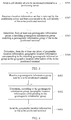
FIG. 2 is a flowchart of a positioning method according to an embodiment of the present invention; -
FIG. 3 is a flowchart on a side of a to-be-positioned terminal during secondary positioning according to an embodiment of the present invention; -
FIG. 4 is a flowchart on a side of a positioning server during primary positioning according to an embodiment of the present invention; -
FIG. 5 is a flowchart 1 on a side of a positioning server during secondary positioning according to an embodiment of the present invention; -
FIG. 6 is a flowchart 2 on a side of a positioning server during secondary positioning according to an embodiment of the present invention; -
FIG. 7 is a schematic diagram of a system corresponding to a positioning method according to another embodiment of the present invention; -
FIG. 8 is a flowchart of a positioning method according to another embodiment of the present invention; -
FIG. 9 is a flowchart of a positioning method on a side of a positioning server according to another embodiment of the present invention; -
FIG. 10 is a schematic structural diagram of an electronic device according to an embodiment of the present invention; -
FIG. 11 is a schematic structural diagram 1 of a positioning server according to an embodiment of the present invention; -
FIG. 12 is a schematic structural diagram 2 of a positioning server according to an embodiment of the present invention; -
FIG. 13 is a schematic structural diagram 3 of a positioning server according to an embodiment of the present invention; -
FIG. 14 is a schematic structural diagram of a terminal according to an embodiment of the present invention; -
FIG. 15 is a schematic structural diagram of an active signal device according to an embodiment of the present invention; -
FIG. 16 is a schematic diagram of a system corresponding to a communication method according to an embodiment of the present invention; -
FIG. 17 is a flowchart of a communication method according to an embodiment of the present invention; and -
FIG. 18 is a schematic structural diagram of a precision marketing server according to an embodiment of the present invention. - To make the objectives, technical solutions, and advantages of the embodiments of the present invention clearer, the following clearly and completely describes the technical solutions in the embodiments of the present invention with reference to the accompanying drawings in the embodiments of the present invention. Apparently, the described embodiments are some but not all of the embodiments of the present invention. All other embodiments obtained by a person of ordinary skill in the art based on the embodiments of the present invention without creative efforts shall fall within the protection scope of the present invention.
- Before the embodiments of the present invention are introduced, a system corresponding to a positioning method in the embodiments of the present invention is introduced first. As shown in
FIG. 1, FIG. 1 is a system used to implement the positioning method in the present invention, and the system includes: a positioning server, a to-be-positioned terminal, and multiple nearby terminals (for example: a first terminal, a second terminal, and a third terminal, where only two terminals are shown inFIG. 1 ). The system may be specifically a communication system based on UMTS, or may be a communication system based on Global System for Mobile Communications (Global System For Mobile Communication, GSM), or may be a communication system based on Long Term Evolution (Long Term Evolution, LTE), or may be a communication system based on code division multiple access (Code Division Multiple Access, CDMA), or may be based on time division-synchronous code division multiple access (Time Division-Synchronous Code Division Multiple Access, TD-SCDMA), or the like, which is not limited in this application. - This embodiment provides a positioning method. As shown in
FIG. 2 , the positioning method includes: - Step S201: Obtain a cell identity of a to-be-positioned terminal.
- Step S202: Determine at least one neighboring terminal of the to-be-positioned terminal according to the cell identity of the to-be-positioned terminal, where a cell identity of each neighboring terminal of the at least one neighboring terminal is the same as the cell identity of the to-be-positioned terminal.
- Step S203: Obtain geomagnetic information of a location of each neighboring terminal of the at least one neighboring terminal and geomagnetic information of a location of the to-be-positioned terminal, to generate a geomagnetic information group of the to-be-positioned terminal.
- Step S204: Obtain, according to the geomagnetic information group of the to-be-positioned terminal, geographic location information of the to-be-positioned terminal.
- In a specific implementation process, the positioning method provided in this embodiment may be applied to a terminal such as a mobile phone, a tablet computer or a smart watch, or may be applied to a positioning server, which is not limited in this embodiment.
- In a specific implementation process, according to different manners of obtaining geographic location information, the positioning method provided in this embodiment may include two cases: primary positioning and secondary positioning. Descriptions are separately provided below by using an example in which the positioning method is applied to a to-be-positioned terminal.
- The primary positioning is introduced first.
- That is, an area matching the geomagnetic information group of the to-be-positioned terminal is determined in an actually measured geomagnetic information image, and the geographic location information is obtained according to a terrestrial coordinate system. Specific implementation steps are as follows:
- First, step S201 of obtaining a CELL ID of a to-be-positioned terminal is performed.
- In a specific implementation process, when a user opens a positioning application and performs a positioning trigger operation, after receiving the operation, the to-be-positioned terminal may be triggered to obtain the CELL ID of the to-be-positioned terminal, or after receiving a positioning instruction sent by another device, the to-be-positioned terminal may be triggered to obtain the CELL ID of the to-be-positioned terminal, which is not limited in this embodiment.
- Specifically, for a manner of obtaining the CELL ID of the to-be-positioned terminal, for example, an Android operating system is installed on the to-be-positioned terminal, the to-be-positioned terminal may invoke a CellLocation interface to communicate with a server, a base station, or a radio network controller (Radio Network Controller, RNC), so as to obtain the CELL ID.
- In step S201, after the CELL ID of the to-be-positioned terminal is obtained, step S202 of determining at least one neighboring terminal of the to-be-positioned terminal according to the CELL ID of the to-be-positioned terminal, where a CELL ID of each neighboring terminal of the at least one neighboring terminal is the same as the CELL ID of the to-be-positioned terminal is performed.
- In a specific implementation process, manners of determining the at least one neighboring terminal may include at least two manners below: determining the at least one neighboring terminal according to a CELL ID, and determining the at least one neighboring terminal according to a CELL ID and context information. Descriptions are separately provided as follows:
- First, the at least one neighboring terminal is determined according to a CELL ID.
- That is, a terminal whose CELL ID is the same as the CELL ID of the to-be-positioned terminal is determined as the at least one neighboring terminal.
- In a specific implementation process, the to-be-positioned terminal may communicate with a server, to determine the terminal whose CELL ID is the same as the CELL ID of the to-be-positioned terminal.
- Specifically, that is, the to-be-positioned terminal sends the CELL ID of the to-be-positioned terminal to the server. The server queries, from a storage unit, a context list including the CELL ID, or the server communicates with a base station corresponding to the CELL ID, to obtain a context list of the terminal corresponding to the CELL ID. Therefore, the at least one neighboring terminal is determined.
- For example, when a CELL ID of a to-be-positioned terminal Ma is c1982, the context list may be shown in Table 1:
Table 1 Terminal identifier CELL ID Bluetooth identifier WiFi identifier Mb c1982 {b1, b2, b3} 01 Mc c1982 {b1, a1, a4} 02 Md c1982 {b1, a2, a5} 01 Me c1982 {c1, c2, c3} 03 - In Table 1, it is determined that the at least one neighboring terminal of the to-be-positioned terminal Ma includes: Mb, Mc, Md, and Me.
- Specifically, a terminal whose CELL ID is the same as the CELL ID of the to-be-positioned terminal is determined as the at least one neighboring terminal. Because the rest data does not need to be analyzed and processed, a neighboring terminal can be determined rapidly, thereby improving positioning efficiency.
- Further, in a positioning process, because there is no need to rely on an intermittently available signal source such as WiFi or Bluetooth, a case of intermittent positioning failures is avoided, thereby improving positioning reliability.
- Second, the at least one neighboring terminal is determined according to a CELL ID and context information.
- In a specific implementation process, a candidate neighboring terminal group may first be determined according to the CELL ID, then the context information is analyzed, and a neighboring terminal is determined from the candidate neighboring terminal group, or a candidate neighboring terminal group may first be determined according to the context information, and then a neighboring terminal is determined from the candidate neighboring terminal group according to the CELL ID.
- For a case in which a candidate neighboring terminal group is first determined according to a CELL ID, and then a neighboring terminal is determined by analyzing context information, specific implementation steps may be:
- determining at least one candidate neighboring terminal according to the CELL ID of the to-be-positioned terminal, where the at least one candidate neighboring terminal includes a candidate neighboring terminal whose CELL ID is the same as the CELL ID of the to-be-positioned terminal;
- obtaining context information of each candidate neighboring terminal of the at least one candidate neighboring terminal and context information of the to-be-positioned terminal; and
- determining, from the at least one candidate neighboring terminal, a candidate neighboring terminal whose context information matches the context information of the to-be-positioned terminal, to form the at least one neighboring terminal of the to-be-positioned terminal.
- In a specific implementation process, the method for determining at least one candidate neighboring terminal and obtaining context information is the same as the method for determining a neighboring terminal according to a CELL ID and obtaining context information of the neighboring terminal in the first case, and details are not described herein again.
- In this embodiment of this application, the context information may be one or a combination of multiple of a WiFi identifier, a Bluetooth identifier, or a GPS parameter.
- In a specific implementation process, when the context information is a WiFi identifier and/or a Bluetooth identifier, the determining a candidate neighboring terminal whose context information matches the context information of the to-be-positioned terminal is specifically determining the candidate neighboring terminal whose context information is the same as the context information of the to-be-positioned terminal.
- When the context information is a GPS parameter, the determining a candidate neighboring terminal whose context information matches the context information of the to-be-positioned terminal is specifically determining the candidate neighboring terminal, where a matching degree between the context information of the candidate neighboring terminal and the context information of the to-be-positioned terminal is greater than a preset value.
- For example, refer to Table 1 too. For example, the context information is a Bluetooth identifier. When the CELL ID of the to-be-positioned terminal Ma is c1982, and the Bluetooth identifier is b1, the at least one neighboring terminal, determined from Table 1, of the to-be-positioned terminal Ma includes: Mb, Mc, and Md, but does not include Me.
- For example, the context information is a WiFi identifier. When the CELL ID of the to-be-positioned terminal Ma is c1982, and the WiFi identifier is 01, the at least one neighboring terminal, determined from Table 1, of the to-be-positioned terminal Ma includes: Mb and Md, but does not include Mc and Me.
- For a case in which a candidate neighboring terminal group is determined according to context information, and then a neighboring terminal is determined according to a CELL ID, specific implementation steps may be:
- determining, according to the context information of the to-be-positioned terminal, at least one candidate neighboring terminal whose context information matches the context information of the to-be-positioned terminal; and
- determining a candidate neighboring terminal whose CELL ID is the same as the CELL ID of the to-be-positioned terminal from the at least one candidate neighboring terminal, to form the at least one neighboring terminal of the to-be-positioned terminal.
- For example, the context information is a Bluetooth identifier, the to-be-positioned terminal performs scanning to obtain a Bluetooth identifier of a nearby Bluetooth device, determines the Bluetooth device obtained through scanning as the at least one candidate neighboring terminal, sends a Bluetooth connection request to the scanned Bluetooth device, to establish a Bluetooth communication connection, then sends a request to obtain a CELL ID of the Bluetooth device obtained through scanning, and determines a device whose CELL ID is the same as the CELL ID of the to-be-positioned terminal as a neighboring terminal.
- For example, the context information is a GPS parameter, the to-be-positioned terminal sends a GPS parameter of the to-be-positioned terminal to a server, the server determines that a terminal whose GPS parameter represents a location close to a location represented by the GPS parameter of the to-be-positioned terminal is used as the at least one candidate neighboring terminal, and sends a CELL ID of the at least one candidate neighboring terminal to the to-be-positioned terminal, to determine a device whose CELL ID is the same as the CELL ID of the to-be-positioned terminal as a neighboring terminal.
- Specifically, with reference to the CELL ID and the context information, the at least one neighboring terminal is determined, which can further narrow down a range of a neighboring terminal, improve accuracy of determining the neighboring terminal, and improve positioning precision.
- After the at least one neighboring terminal is determined in step S202, step S203 of obtaining geomagnetic information of a location of each neighboring terminal of the at least one neighboring terminal and geomagnetic information of a location of the to-be-positioned terminal, to generate a geomagnetic information group of the to-be-positioned terminal is performed.
- Specifically, the geomagnetic information may include: a component value in an X direction parallel to a horizontal plane, a component value in a Y direction parallel to the horizontal plane, a vertical component value in a Z direction perpendicular to the horizontal plane, and a geomagnetic precision value, where the component value in the X direction represents a geomagnetic strength in the X direction, the component value in the Y direction represents a geomagnetic strength in the Y direction, the vertical component value represents a geomagnetic strength in the Z direction, and the geomagnetic precision value represents measurement precision of a component value in each direction.
- For example, the geomagnetic information may be {x, y, z, acc}, where x is the component value in the X direction, y is the component value in the Y direction, z is the vertical component value, and acc is the geomagnetic precision value.
- In a specific implementation process, the geomagnetic information of the location of the to-be-positioned terminal may be obtained through sensing by using a geomagnetic sensor disposed on the to-be-positioned terminal.
- In a specific implementation process, the geomagnetic information of the location of each neighboring terminal of the at least one neighboring terminal may be obtained by means of direct communication between the to-be-positioned terminal and the at least one neighboring terminal by using a WIFI connection or a Bluetooth connection, or may be obtained by means of communication between the to-be-positioned terminal and the at least one neighboring terminal by using a server, which is not limited in this embodiment.
- In this embodiment of this application, to further narrow down a range of the geomagnetic information group of the to-be-positioned terminal and improve positioning precision, a vertical distribution range of a neighboring terminal for positioning may further be narrowed down according to the vertical component value in the geomagnetic information, and specific steps include:
- obtaining the geomagnetic information of the location of each neighboring terminal of the at least one neighboring terminal and the geomagnetic information of the location of the to-be-positioned terminal, to form a pre geomagnetic information group; and
- determining geomagnetic information from the pre geomagnetic information group, to form the geomagnetic information group of the to-be-positioned terminal, where a difference between a vertical component value of the determined geomagnetic information from the pre geomagnetic information group and a vertical component value of the geomagnetic information of the location of the to-be-positioned terminal is less than a preset threshold.
- Specifically, geomagnetic information of a neighboring terminal basically located in one same horizontal plane with the to-be-positioned terminal is selected through screening according to the vertical component value of the geomagnetic information, to form the geomagnetic information group, thereby further narrowing down a positioning range, and improving positioning precision.
- After the geomagnetic information group of the to-be-positioned terminal is generated in step S203, step S204 of obtaining, according to the geomagnetic information group of the to-be-positioned terminal, geographic location information of the to-be-positioned terminal is performed.
- In this embodiment of this application, a manner of obtaining the geographic location information of the to-be-positioned terminal may be: sending the geomagnetic information group of the to-be-positioned terminal to a positioning server; and then receiving the geographic location information of the to-be-positioned terminal returned by the positioning server based on the geomagnetic information group of the to-be-positioned terminal.
- Specifically, a manner of obtaining the geographic location information of the to-be-positioned terminal returned by the positioning server may be: first determining, by the positioning server, an area matching the geomagnetic information group of the to-be-positioned terminal in an actually measured geomagnetic information map, and then obtaining terrestrial coordinates and the geographic location information that are of the area according to a terrestrial coordinate system.
- In a specific implementation process, to improve efficiency of subsequent positioning, after determining the geographic location information of the to-be-positioned terminal, the positioning server may correspondingly store the cell identifier, the geomagnetic information group, the terrestrial coordinates, and the geographic location information that are of the to-be-positioned terminal, for use in a subsequent positioning process.
- Specifically, during primary positioning, according to a highly stable CELL ID positioning technology, a neighboring terminal whose cell identity is the same as a target cell identity of a to-be-positioned terminal is determined, a geomagnetic information group is generated according to geomagnetic information of a location of the neighboring terminal and target geomagnetic information of a location of the to-be-positioned terminal, to position geographic location information by using a geomagnetic positioning technology, which not only keeps stability of the CELL ID positioning technology, but also improves positioning precision by means of hierarchical positioning.
- After the primary positioning is introduced, the secondary positioning is introduced next.
- The secondary positioning is rapid positioning performed by using the geographic location information prestored in the previous positioning process, and specific implementation steps of the secondary positioning are described in detail below also by using an example in which the positioning method is applied to a to-be-positioned terminal:
- The secondary positioning also includes step S201, step S202, step S203, and step S204 in the primary positioning, where the obtaining, according to the geomagnetic information group of the to-be-positioned terminal, geographic location information of the to-be-positioned terminal in step S204, as shown in
FIG. 3 , includes: - Step S301: Send the cell identity of the to-be-positioned terminal to a positioning server.
- Step S302: Receive a location information set that is returned by the positioning server and that corresponds to the cell identity of the to-be-positioned terminal, where the location information set includes: at least one geomagnetic information group and at least one piece of geographic location information corresponding to the at least one geomagnetic information group.
- Step S303: Determine, from the at least one geomagnetic information group, a matching geomagnetic information group matching the geomagnetic information group of the to-be-positioned terminal.
- Step S304: Determine, from the at least one piece of geographic location information, geographic location information corresponding to the matching geomagnetic information group as the geographic location information of the to-be-positioned terminal.
- In a specific implementation process, the matching geomagnetic information group may be a geomagnetic information group that is the same as the geomagnetic information group of the to-be-positioned terminal, or may be a geomagnetic information group having a matching degree between the geomagnetic information group and the geomagnetic information group of the to-be-positioned terminal being greater than a threshold, which is not limited in this embodiment.
- For example, when a CELL ID of a to-be-positioned terminal Ma is c1982, and a geomagnetic information group is {x0', y0', z0', acc0'}, {x1', y1', z1', acc1'}, and {x2', y2', z2', acc2'}:
- The to-be-positioned terminal sends the CELL ID to the positioning server.
- After receiving the CELL ID, the positioning server parses that the CELL ID is c1982, reads, from a storage unit, all geomagnetic information groups stored corresponding to c1982, and corresponding geographic location information, to form a location information set, and sends the location information set to the to-be-positioned terminal. The location information set is shown in Table 2:
Table 2 CELL ID Geomagnetic information groups Geographic location information c1982 First group: {x0, y0, z0, acc0}, {x1, y1, z1, acc1}, {x2, y2, z2, acc2}, and {x3, y3, z3, acc3} Address: No. 10 First Avenue, Beijing Longitude: 88 Latitude: 33 Precision: 100 m Name: the No. 1 noodle restaurant Second group: {xa, ya, za, acca}, {xb, yb, zb, accb}, and {xc, yc, zc, accc} Address: No. 6 Second avenue, Beijing Longitude: 87 Latitude: 32 Precision: 20 m Name: the No. 1 pastry shop - Next, the to-be-positioned terminal determines, from the received geomagnetic information groups, a matching geomagnetic information group matching the geomagnetic information group of the to-be-positioned terminal.
- For example, the geomagnetic information group is a geomagnetic information group including geomagnetic information of a neighboring terminal that is obtained through screening according to the vertical component value of the geomagnetic information and that is basically located in a same horizontal plane with the to-be-positioned terminal, and a specific matching manner is as follows:
- A component value in an X direction and a component value in a Y direction in the geomagnetic information group of the to-be-positioned terminal are separately multiplied by a geomagnetic precision value to obtain the geomagnetic information group of the to-be-positioned terminal after precision is weighted:
- {x0'*acc0', y0'*acc0', z0'}, {x1'*acc1', y1'*acc1', z1'*acc1'}, and {x2'*acc2', y2'*acc2', z2'}
- Similarly, a component value in an X direction and a component value in a Y direction of each geomagnetic information group in the location information set are separately multiplied by a corresponding geomagnetic precision value, to obtain the geomagnetic information group of the location information set after precision is weighted as follows:
- A first geomagnetic information group after precision is weighted in Table 2:
- {x0*acc0, y0*acc0, z0}, {x1*acc1, y1*acc1, z1}, {x2*acc2, y2*acc2, z2}, and {x3*acc3, y3*acc3, z3}
- A second geomagnetic information group after precision is weighted in Table 2:
- {xa*acca, ya*acca, za}, {xb*accb, yb*accb, zb}, and {xc*accc, yc*accc, zc}
- A matching degree of each geomagnetic information group is separately calculated according to the geomagnetic information after precision is weighted, and details are as follows:
- A matching degree between the first geomagnetic information group in Table 2 and the geomagnetic information group of the to-be-positioned terminal
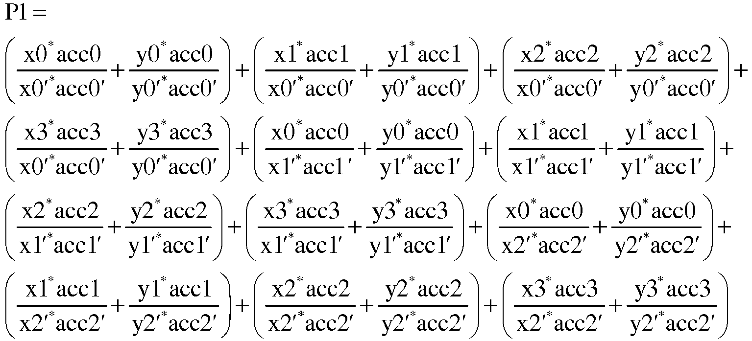
- A matching degree between the second geomagnetic information group in Table 2 and the geomagnetic information group of the to-be-positioned terminal

- It is assumed that P1 is equal to 0.8, P2 is equal to 0.72, and because P1 is greater than P2, the first geomagnetic information group having a relatively high matching degree in Table 2 is determined as a matching geomagnetic information group, so that geographic location information corresponding to the first geomagnetic information group is determined, that is, the No. 1 noodle restaurant, No. 10 First Avenue, Beijing, is the geographic location information of the to-be-positioned terminal.
- In a specific implementation process, during secondary positioning, a to-be-positioned terminal may also send a geomagnetic information group to a positioning server, and on a side of the positioning server, matching is performed to obtain a geomagnetic information group, and geographic location information corresponding to the matching geomagnetic information group is determined. In this case, specific steps of the obtaining, by the to-be-positioned terminal, the geographic location information of the to-be-positioned terminal are as follows:
- sending the cell identity of the to-be-positioned terminal and the geomagnetic information group of the to-be-positioned terminal to the positioning server;
- receiving the geographic location information that is returned by the positioning server and that corresponds to the matching geomagnetic information group matching the geomagnetic information group of the to-be-positioned terminal; and
- determining the geographic location information corresponding to the matching geomagnetic information group as the geographic location information of the to-be-positioned terminal.
- Specifically, the method for performing matching on a side of the positioning server to obtain a matching geomagnetic information group is the same as the method for obtaining a matching geomagnetic information group through matching by a to-be-positioned terminal, and details are not described herein again.
- Certainly, the positioning method may also be applied to a positioning server, and when the positioning method is applied to the positioning server, specific steps are as follows:
- First, step S201 of obtaining a CELL ID of a to-be-positioned terminal is performed.
- In a specific implementation process, the positioning server may receive the CELL ID and a positioning request that are sent by the to-be-positioned terminal.
- Next, step S202 of determining at least one neighboring terminal of the to-be-positioned terminal according to the CELL ID of the to-be-positioned terminal, where a CELL ID of each neighboring terminal of the at least one neighboring terminal is the same as the CELL ID of the to-be-positioned terminal is performed.
- In a specific implementation process, the positioning server may communicate with a base station in a cell at which the to-be-positioned terminal is located, to determine the at least one neighboring terminal, or may read a prestored correspondence between a CELL ID and a terminal from a storage unit to determine the at least one neighboring terminal.
- Next, step S203 of obtaining geomagnetic information of a location of each neighboring terminal of the at least one neighboring terminal and geomagnetic information of a location of the to-be-positioned terminal, to generate a geomagnetic information group of the to-be-positioned terminal is performed.
- In a specific implementation process, the positioning server may communicate with the at least one neighboring terminal and the to-be-positioned terminal, to obtain the geomagnetic information group, or may communicate with the at least one neighboring terminal by using the to-be-positioned terminal, to obtain the geomagnetic information group.
- Then, step S204 of obtaining, according to the geomagnetic information group of the to-be-positioned terminal, geographic location information of the to-be-positioned terminal is performed.
- During primary positioning, the positioning server may first determine an area matching the geomagnetic information group of the to-be-positioned terminal in an actually measured geomagnetic information map, and then obtain terrestrial coordinates and geographic location information that are of the area according to a terrestrial coordinate system.
- During secondary positioning, the positioning server may find, from a prestored location information set, a matching geomagnetic information group matching the geomagnetic information group of the to-be-positioned terminal, and then determine the geographic location information corresponding to the matching geomagnetic information group as the geographic location information of the to-be-positioned terminal.
- Because a positioning principle during application of the positioning method to the positioning server is basically the same as a positioning principle during application of the positioning method to the to-be-positioned terminal, details are not described herein again.
- In a specific implementation process, when the geographic location information obtained during primary positioning or secondary positioning cannot meet a requirement of positioning precision of a user, a positioning map may be output for the user to perform accurate positioning. That is, after the geographic location information of the to-be-positioned terminal is obtained in step S204:
- obtaining positioning precision of the geographic location information of the to-be-positioned terminal;
- determining whether the positioning precision meets a preset precision requirement; and
- when the positioning precision does not meet the preset precision requirement, displaying a set positioning map;
- detecting a determining operation that is triggered to determine a positioning point on the positioning map; and
- based on the determining operation, obtaining information about a precise geographic location of the positioning point as the geographic location information of the to-be-positioned terminal.
- Specifically, when the positioning precision cannot meet the preset precision requirement, the positioning map is output for the user to perform positioning, which can avoid complex operation steps each time because a user needs to perform positioning, and also can ensure positioning precision.
- Specifically, according to the positioning method provided by this application, a CELL ID is first used to obtain a relatively large positioning range, and then a to-be-positioned terminal and geomagnetic information of a location of a neighboring terminal of the to-be-positioned terminal are used to perform precise positioning, which, on one hand, can overcome a defect that the method for positioning by using an active source signal device such as WiFi and Bluetooth is not stable, thereby improving positioning stability, and on the other hand, overcomes a defect that the method for positioning by using a CELL ID has low precision, thereby improving positioning precision. In addition, the to-be-positioned terminal and geomagnetic information of the location of the neighboring terminal of the to-be-positioned terminal are used to perform coordinated positioning, which can avoid a defect of inaccurate positioning when only geomagnetic information is used for positioning, thereby improving positioning accuracy, and implementing a technical effect that positioning stability, precision, and accuracy are achieved simultaneously.
- Next, when the positioning method in Embodiment 1 is applied to a to-be-positioned terminal, the method is described from a perspective of a positioning server in the system shown in
FIG. 1 . - In this embodiment, there are two cases: primary positioning and secondary positioning, and a case in which the method provided in Embodiment 1 is applied to a to-be-positioned terminal on a side of a positioning server is described.
- For primary positioning, referring to
FIG. 4, FIG. 4 is a processing flowchart on a side of a positioning server during primary positioning according to an embodiment of the present invention. - The positioning method includes:
- Step S401: Receive a geomagnetic information group sent by a to-be-positioned terminal, where the geomagnetic information group includes geomagnetic information of a location of a neighboring terminal and geomagnetic information of a location of the to-be-positioned terminal, where the neighboring terminal is a terminal whose cell identity is the same as a cell identity of the to-be-positioned terminal.
- Step S402: Determine, according to the geomagnetic information group, geographic location information corresponding to the geomagnetic information group.
- Step S403: Send the geographic location information to the to-be-positioned terminal.
- In a specific implementation process, the to-be-positioned terminal may be a terminal such as a mobile phone, a tablet computer, or a smart watch, which is not limited in this embodiment.
- In a specific implementation process, the determining, according to the geomagnetic information group, geographic location information corresponding to the geomagnetic information group in step S402 may be: first determining, by a positioning server, an area matching the geomagnetic information group of the to-be-positioned terminal in an actually measured geomagnetic information map, and then obtaining terrestrial coordinates and the geographic location information that are of the area according to a terrestrial coordinate system.
- For secondary positioning, referring to
FIG. 5, FIG. 5 is a processing flowchart 1 on a side of a positioning server during secondary positioning according to an embodiment of the present invention. - The positioning method includes:
- Step S501: Receive a cell identity sent by a to-be-positioned terminal.
- Step S502: Determine, from a prestored geomagnetic database according to the cell identity, a location information set corresponding to the cell identity, where the location information set includes: at least one geomagnetic information group and at least one piece of geographic location information corresponding to the at least one geomagnetic information group.
- Step S503: Send the location information set to the to-be-positioned terminal.
- In a specific implementation process, the to-be-positioned terminal may be a terminal such as a mobile phone, a tablet computer, or a smart watch, which is not limited in this embodiment.
- In a specific implementation process, the determining, from a prestored geomagnetic database according to the CELL ID, a location information set corresponding to the cell identity in step S502 may be: parsing, by a positioning server after the positioning server receives the CELL ID, a value of the CELL ID, and reading, from a storage unit, all geomagnetic information groups stored corresponding to the value of the CELL ID, and the corresponding geographic location information, to form the location information set.
- In a specific implementation process, during secondary positioning, a to-be-positioned terminal may also send a geomagnetic information group to the positioning server, and on a side of a positioning server, matching is performed to obtain a matching geomagnetic information group, and geographic location information corresponding to the matching geomagnetic information group is determined. Referring to
FIG. 6, FIG. 6 is a processing flowchart 2 on a side of a positioning server during secondary positioning according to an embodiment of the present invention. - In this case, specific steps of secondary positioning on the side of the positioning server are as follows:
- Step S601: Receive a cell identity and a geomagnetic information group of a to-be-positioned terminal that are sent by the to-be-positioned terminal.
- Step S602: Determine, from a prestored geomagnetic database according to the cell identity, a location information set corresponding to the cell identity, where the location information set includes: at least one geomagnetic information group and at least one piece of geographic location information corresponding to the at least one geomagnetic information group.
- Step S603: Determine, from the at least one geomagnetic information group, a matching geomagnetic information group matching the geomagnetic information group of the to-be-positioned terminal.
- Step S604: Determine, from the at least one piece of geographic location information, geographic location information corresponding to the matching geomagnetic information group.
- Step S605: Send the geographic location information corresponding to the matching geomagnetic information group to the to-be-positioned terminal.
- In this embodiment, a positioning method is provided.
- Before this embodiment is introduced, a system corresponding to the positioning method in this embodiment is introduced first. As shown in
FIG. 7, FIG. 7 shows a system used to implement the positioning method provided in this embodiment, and the system includes: a positioning server, a to-be-positioned terminal, and at least one active signal device. - As shown in
FIG. 8 , the positioning method includes: - Step S801: Obtain geomagnetic information of a location of an active signal device and a device identifier of the active signal device that are broadcast by the active signal device.
- Step S802: When the geomagnetic information meets a preset condition, send the device identifier to the positioning server.
- Step S803: Receive geographic location information corresponding to the device identifier returned by the positioning server based on the device identifier and a prestored correspondence between a device identifier and geographic location information.
- In a specific implementation process, the positioning method provided in this embodiment may be applied to a to-be-positioned terminal such as a mobile phone, a tablet computer, or a smart watch, which is not limited in this embodiment.
- In a specific implementation process, the active signal device may be a Bluetooth device using a Bluetooth technology to perform broadcasting, or may be a WiFi device that performs broadcasting by using a WiFi technology, which is not limited in this embodiment.
- The method provided in this embodiment is described below:
- First, step S801 of obtaining geomagnetic information of a location of an active signal device and a device identifier of the active signal device that are broadcast by the active signal device is performed.
- Specifically, after receiving a positioning request, the to-be-positioned terminal searches for and receives signaling broadcast by the nearby active signal device by using WiFi or Bluetooth, and parses the received signaling, to obtain the geomagnetic information of the active signal device and the device identifier of the active signal device.
- Next, step S802 of sending the device identifier to the positioning server when the geomagnetic information meets a preset condition is performed.
- In a specific implementation process, the geomagnetic information meets the preset condition, and there may be at least two cases: In one case, the geomagnetic information meets an area limitation, and in the other case, the geomagnetic information matches history geomagnetic information. The two cases are separately described below:
- First, the geomagnetic information meets the area limitation.
- That is, the sending the device identifier to the positioning server when the geomagnetic information meets a preset condition is specifically:
- determining whether a component value in the geomagnetic information is within a preset value range; and
- when the component value in the geomagnetic information is within the preset value range, send the device identifier to the positioning server.
- Specifically, that is, it is first determined that any one or more of a component value in an X direction, a component value in a Y direction, a component value in a Z direction, and a geomagnetic precision value in the geomagnetic information are within the preset value range, so that it is determined whether an area corresponding to the geomagnetic information in a terrestrial coordinate system is in a preset area.
- When it is determined that the area corresponding to the geomagnetic information in the terrestrial coordinate system is in the one preset area, then the device identifier is sent to the positioning server.
- In a specific implementation process, the preset area may be an initial area determined according to a positioning technology such as a CELL ID.
- Specifically, when the component value in the geomagnetic information is within the preset value range, the device identifier is sent to the positioning server for positioning, thereby ensuring that geomagnetic information for positioning meets a requirement of positioning precision, and improving positioning precision.
- Second, the geomagnetic information matches the history geomagnetic information.
- That is, the sending the device identifier to the positioning server when the geomagnetic information meets a preset condition is specifically:
- determining whether the geomagnetic information matches prestored history geomagnetic information corresponding to the device identifier; and
- when the geomagnetic information matches the history geomagnetic information, sending the device identifier to the positioning server.
- In a specific implementation process, the method for determining whether the geomagnetic information matches the history geomagnetic information may be: determining whether a matching degree between the geomagnetic information and the history geomagnetic information is greater than a preset threshold.
- A specific method for calculating a matching degree may be the same as the method for calculating a matching degree provided in Embodiment 1, and details are not described herein again.
- Specifically, when the geomagnetic information matches the history geomagnetic information, the device identifier is sent to the positioning server for positioning, to screen out geomagnetic information sent by the active signal device whose position changes greatly, thereby ensuring that geomagnetic information for positioning meets an accuracy requirement, and improving positioning accuracy.
- The method is described below from a perspective of an active signal device in the system shown in
FIG. 7 . - In this embodiment, the foregoing method is described from a side of an active signal device. Referring to
FIG. 9, FIG. 9 is a processing flowchart on the side of the active signal device according to an embodiment of the present invention. - The positioning method includes:
- Step S901: Obtain geomagnetic information of a location of an active signal device and a device identifier of the active signal device.
- Step S902: Broadcast the geomagnetic information and the device identifier.
- In a specific implementation process, the positioning method provided in this embodiment may be applied to an active signal device that performs broadcasting by using a Bluetooth technology, or may be applied to an active signal device that performs broadcasting by using a WiFi technology, which is not limited in this embodiment.
- In a specific implementation process, the geomagnetic information of the location of the active signal device may be obtained through sensing by using a geomagnetic sensor disposed on the active signal device.
- Next, with reference to
FIG. 7 , from a perspective of interaction among the active signal device, a to-be-positioned terminal, and a positioning server, specific steps for implementing the positioning methods in Embodiment 3 and Embodiment 4 are described: - invoking, by the active signal device, a geomagnetic sensor to obtain geomagnetic data;
- correspondingly storing, by the active signal device, a timestamp and the geomagnetic data;
- broadcasting, by the active signal device, geomagnetic data, device information, a device ID, signaling strength, and the like that are currently obtained;
- obtaining and receiving, by the to-be-positioned terminal after the to-be-positioned terminal receives a positioning request, signaling broadcast by the active signal device;
- positioning and parsing, by the to-be-positioned terminal, a signaling message, separately identifying a status of a geomagnetic record of each device in the message, sequentially identifying, according to geomagnetic values of an X axis, a Y axis, and a Z axis, an identifier of a device whose geomagnetic data changes greatly and an identifier of a device whose geomagnetic data changes within an allowable range, and setting a device identifier group after a status is identified to a device identifier group for querying a location;
- sending, by the to-be-positioned terminal, the device identifier group for querying a location to the positioning server, to request to query a location;
- setting, by the positioning server, the identifier of the device whose geomagnetic data changes greatly to be invalid, and obtaining location information corresponding to the identifier of the device whose geomagnetic data changes within the allowable range;
- returning, by the positioning server, the location information to a location query unit; and
- returning, by the location query unit, queried location information to the to-be-positioned terminal.
- Based on a same inventive concept, this application further provides an electronic device.
- As shown in
FIG. 10 , the electronic device includes: - a
processor 1001, configured to obtain a cell identity of a to-be-positioned terminal; and determine at least one neighboring terminal of the to-be-positioned terminal according to the cell identity of the to-be-positioned terminal, where a cell identity of each neighboring terminal of the at least one neighboring terminal is the same as the cell identity of the to-be-positioned terminal; and - a
transceiver 1002, configured to obtain geomagnetic information of a location of each neighboring terminal of the at least one neighboring terminal determined by theprocessor 1001 and geomagnetic information of a location of the to-be-positioned terminal, to generate a geomagnetic information group of the to-be-positioned terminal; and obtain, according to the geomagnetic information group of the to-be-positioned terminal, geographic location information of the to-be-positioned terminal. - A specific connection relationship is: the
processor 1001 is connected to thetransceiver 1002. - In this embodiment, the electronic device may be a terminal such as a mobile phone, a tablet computer, or a smart watch, or may be a positioning server, which is not limited in this embodiment.
- In this embodiment, when the electronic device is a terminal, the
transceiver 1002 is further configured to: send the geomagnetic information group of the to-be-positioned terminal to a positioning server; and receive the geographic location information of the to-be-positioned terminal returned by the positioning server based on the geomagnetic information group of the to-be-positioned terminal. - In this embodiment, when the electronic device is a terminal, the
transceiver 1002 is further configured to: send the cell identity of the to-be-positioned terminal to the positioning server, receive a location information set that is returned by the positioning server and that corresponds to the cell identity of the to-be-positioned terminal, where the location information set includes at least one geomagnetic information group and at least one piece of geographic location information corresponding to the at least one geomagnetic information group; and
theprocessor 1001 is further configured to: determine, from the at least one geomagnetic information group, a matching geomagnetic information group matching the geomagnetic information group of the to-be-positioned terminal; and determine, from the at least one piece of geographic location information, geographic location information corresponding to the matching geomagnetic information group as the geographic location information of the to-be-positioned terminal. - In this embodiment, when the electronic device is a terminal, the
transceiver 1002 is further configured to: send the cell identity of the to-be-positioned terminal and the geomagnetic information group of the to-be-positioned terminal to the positioning server, and receive the geographic location information that is returned by the positioning server and that corresponds to a matching geomagnetic information group matching the geomagnetic information group of the to-be-positioned terminal; and
theprocessor 1001 is further configured to determine the geographic location information corresponding to the matching geomagnetic information group as the geographic location information of the to-be-positioned terminal. - Further, the
processor 1001 is further configured to: determine at least one candidate neighboring terminal according to the cell identity of the to-be-positioned terminal, where the at least one candidate neighboring terminal includes a candidate neighboring terminal whose cell identity is the same as the cell identity of the to-be-positioned terminal; obtain context information of each candidate neighboring terminal of the at least one candidate neighboring terminal and context information of the to-be-positioned terminal; and determine, from the at least one candidate neighboring terminal, a candidate neighboring terminal whose context information matches the context information of the to-be-positioned terminal, to form at least one neighboring terminal of the to-be-positioned terminal. - Specifically, the context information is one or a combination of multiple of a Wireless Fidelity identifier, a Bluetooth identifier, or a Global Positioning System parameter.
- Further, the
transceiver 1002 is further configured to: obtain geomagnetic information of a location of each neighboring terminal of the at least one neighboring terminal and the geomagnetic information of the location of the to-be-positioned terminal, to form a pre geomagnetic information group, and send the pre geomagnetic information group to theprocessor 1001; and
theprocessor 1001 is further configured to: receive the pre geomagnetic information group sent by thetransceiver 1002, determine geomagnetic information from the pre geomagnetic information group, to form the geomagnetic information group of the to-be-positioned terminal, where a difference between a vertical component value of the determined geomagnetic information from the pre geomagnetic information group and a vertical component value of the geomagnetic information of the location of the to-be-positioned terminal is less than a preset threshold. - In this embodiment, the
processor 1001 is further configured to: obtain positioning precision of the geographic location information of the to-be-positioned terminal; determine whether the positioning precision meets a preset precision requirement; and when the positioning precision does not meet the preset precision requirement, control to display a set positioning map; and after detecting a determining operation that is triggered to determine a positioning point on the positioning map, based on the determining operation, obtain information about a precise geographic location of the positioning point as the geographic location information of the to-be-positioned terminal. - The electronic device provided in this embodiment and the positioning method in Embodiment 1 are two aspects based on a same inventive concept, an implementation process of the method is already described above in detail, so that a person skilled in the art can clearly learn a device structure and the implementation process in this embodiment according to the description above, and for brevity of the specification, details are not described herein again.
- Based on a same inventive concept, this application further provides a positioning server.
- As shown in
FIG. 11 , the positioning server includes: - a
transceiver 1101, configured to receive a geomagnetic information group sent by a to-be-positioned terminal, and send the geomagnetic information group to a processor, where the geomagnetic information group includes geomagnetic information of a location of a neighboring terminal and geomagnetic information of a location of the to-be-positioned terminal, where the neighboring terminal is a terminal whose cell identity is the same as a cell identity of the to-be-positioned terminal; and - a
processor 1102, configured to determine, according to the geomagnetic information group sent by thetransceiver 1101, geographic location information corresponding to the geomagnetic information group, and control the transceiver to send the geographic location information to the to-be-positioned terminal. - A specific connection relationship is: the
processor 1102 is connected to thetransceiver 1101. - Based on a same inventive concept, this application further provides a positioning server.
- As shown in
FIG. 12 , the positioning server includes: - a
transceiver 1201, configured to receive a cell identity sent by a to-be-positioned terminal, and send the cell identity to aprocessor 1202; and - the
processor 1202, configured to determine, from a prestored geomagnetic database according to the cell identity sent by thetransceiver 1201, a location information set corresponding to the cell identity, where the location information set includes at least one geomagnetic information group and at least one piece of geographic location information corresponding to the at least one geomagnetic information group; and control the transceiver to send the location information set to the to-be-positioned terminal. - A specific connection relationship is: the
processor 1202 is connected to thetransceiver 1201. - Based on a same inventive concept, this application further provides a positioning server.
- As shown in
FIG. 13 , the positioning server includes: - a
transceiver 1301, configured to: receive a cell identity sent by a to-be-positioned terminal and a geomagnetic information group of the to-be-positioned terminal; and send the cell identity and the geomagnetic information group of the to-be-positioned terminal to aprocessor 1302; and - the
processor 1302, configured to: determine, from a prestored geomagnetic database according to the cell identity, a location information set corresponding to the cell identity, where the location information set includes at least one geomagnetic information group and at least one piece of geographic location information corresponding to the at least one geomagnetic information group; determine, from the at least one geomagnetic information group, a matching geomagnetic information group matching the geomagnetic information group of the to-be-positioned terminal; determine, from the at least one piece of geographic location information, geographic location information corresponding to the matching geomagnetic information group; and control thetransceiver 1301 to send the geographic location information corresponding to the matching geomagnetic information group to the to-be-positioned terminal. - A specific connection relationship is: the
processor 1302 is connected to thetransceiver 1301. - The positioning server provided in this embodiment and the positioning method in Embodiment 2 are two aspects based on a same inventive concept, an implementation process of the method is already described above in detail, so that a person skilled in the art can clearly learn a device structure and the implementation process in this embodiment according to the description above, and for brevity of the specification, details are not described herein again.
- Based on a same inventive concept, this application further provides a terminal.
- As shown in
FIG. 14 , the terminal includes: - a
transceiver 1401, configured to: obtain geomagnetic information of a location of an active signal device and a device identifier of the active signal device that are broadcast by the active signal device; when the geomagnetic information meets a preset condition, send the device identifier to a positioning server; and receive geographic location information that corresponds to the device identifier and that is returned by the positioning server based on the device identifier and a prestored correspondence between a device identifier and geographic location information. - Further, the terminal further includes:
- a
processor 1402, configured to: receive the geomagnetic information and the device identifier that are sent by thetransceiver 1401, determine whether the geomagnetic information matches prestored history geomagnetic information corresponding to the device identifier, and when the geomagnetic information matches the history geomagnetic information, control thetransceiver 1401 to send the device identifier to the positioning server. - A specific connection relationship is: the
processor 1402 is connected to thetransceiver 1401. - The terminal provided in this embodiment and the positioning method in Embodiment 3 are two aspects based on a same inventive concept, an implementation process of the method is already described above in detail, so that a person skilled in the art can clearly learn a device structure and the implementation process in this embodiment according to the description above, and for brevity of the specification, details are not described herein again.
- Based on a same inventive concept, this application further provides an active signal device.
- As shown in
FIG. 15 , the active signal device includes: - a
transceiver 1501, configured to obtain geomagnetic information of a location of an active signal device and a device identifier of the active signal device; and broadcast the geomagnetic information and the device identifier. - The terminal provided in this embodiment and the positioning method in Embodiment 4 are two aspects based on a same inventive concept, an implementation process of the method is already described above in detail, so that a person skilled in the art can clearly learn a device structure and the implementation process in this embodiment according to the description above, and for brevity of the specification, details are not described herein again.
- In this embodiment, a communication method is provided.
- Before this embodiment is introduced, a system corresponding to the communication method in this embodiment is introduced first. As shown in
FIG. 16, FIG. 16 shows a system used to implement the communication method provided in this embodiment, and the system includes: a precision marketing server, a terminal for defining a precision marketing rule, and at least one user terminal. - As shown in
FIG. 17 , the positioning method includes: - Step S 1701: The precision marketing server obtains geomagnetic information of a location of each user terminal of the at least one user terminal.
- Step S1702: The precision marketing server determines a user terminal group from the at least one user terminal according to a preset geomagnetic information value range, where the geomagnetic information of the location of each user terminal in the user terminal group meets the geomagnetic information value range.
- Step S1703: The precision marketing server sends preset data to each user terminal in the user terminal group.
- In a specific implementation process, the user terminal may be a terminal such as a mobile phone, a tablet computer, or a smart watch, which is not limited in this embodiment.
- The method provided in this embodiment is described below:
- First, step S1701 of obtaining, by the precision marketing server, geomagnetic information of a location of each user terminal of the at least one user terminal is performed.
- Specifically, the geomagnetic information may include: a component value in an X direction parallel to a horizontal plane, a component value in a Y direction parallel to the horizontal plane, and a vertical component value in a Z direction perpendicular to the horizontal plane, where the component value in the X direction represents a geomagnetic strength in the X direction, the component value in the Y direction represents a geomagnetic strength in the Y direction, and the vertical component value represents a geomagnetic strength in a Z direction.
- For example, the geomagnetic information may be {x, y, z}, where x is the component value in the X direction, y is the component value in the Y direction, and z is the vertical component value.
- Next, step S1702 is performed, that is, the precision marketing server determines a user terminal group from the at least one user terminal according to a preset geomagnetic information value range, where the geomagnetic information of the location of each user terminal in the user terminal group meets the geomagnetic information value range.
- In a specific implementation process, the preset geomagnetic information value range may be sent in advance by the terminal for defining a precision marketing rule in the system shown in
FIG. 16 to the precision marketing server. - Specifically, the geomagnetic information value range may include: a value range of the component value in the X direction, a value range of the component value in the Y direction, and a value range of the vertical component value in the geomagnetic information. The component value in the X direction, the component value in the Y direction, and the vertical component value of each user terminal in the user terminal group all meet corresponding value range requirements.
- Finally, step S1703 of sending, by the precision marketing server, preset data to each user terminal in the user terminal group is performed.
- In a specific implementation process, the preset data may be sent in advance by the terminal for defining a precision marketing rule in the system shown in
FIG. 16 to the precision marketing server. - Based on a same inventive concept, this application further provides a precision marketing server.
- As shown in
FIG. 18 , the precision marketing server includes: - a
transceiver 1801, configured to receive geomagnetic information of a location of each user terminal of the at least one user terminal; and send the geomagnetic information to aprocessor 1802; and - the
processor 1802, configured to determine a user terminal group from the at least one user terminal according to a preset geomagnetic information value range, where geomagnetic information of a location of each user terminal in the user terminal group meets the geomagnetic information value range; and control thetransceiver 1801 to send preset data to each user terminal in the user terminal group. - In a specific implementation process, the user terminal may be a terminal such as a mobile phone, a tablet computer, or a smart watch, which is not limited in this embodiment.
- A specific connection relationship is: the
processor 1802 is connected to thetransceiver 1801. - The precision marketing server provided in this embodiment and the communication method in Embodiment 9 are two aspects based on a same inventive concept, an implementation process of the method is already described above in detail, so that a person skilled in the art can clearly learn a device structure and the implementation process in this embodiment according to the description above, and for brevity of the specification, details are not described herein again.
- In several embodiments provided in this application, it should be understood that, the transceiver may be a transceiver unit or a transceiver module, and the processor may be a processing unit or a processing module.
- The technical solutions in the embodiments of the present application include at least one technical effect or advantage below:
- In this embodiment of the present invention, a CELL ID is first used to obtain a relatively large positioning range, and then a to-be-positioned terminal and geomagnetic information of a location of a neighboring terminal of the to-be-positioned terminal are used to perform precise positioning, which, on one hand, can overcome a defect that the method for positioning by using an active source signal device such as WiFi and Bluetooth is not stable, thereby improving positioning stability, and on the other hand, overcomes a defect that the method for positioning by using a CELL ID has low precision, thereby improving positioning precision. In addition, the to-be-positioned terminal and geomagnetic information of the location of the neighboring terminal of the to-be-positioned terminal are used to perform coordinated positioning, which can avoid a defect of inaccurate positioning when only geomagnetic information is used for positioning, thereby improving positioning accuracy, and implementing a technical effect that positioning stability, precision, and accuracy are achieved simultaneously.
- Although some preferred embodiments of the present invention have been described, persons skilled in the art can make changes and modifications to these embodiments once they learn the basic inventive concept. Therefore, the following claims are intended to be construed as to cover the exemplary embodiments and all changes and modifications falling within the scope of the present invention.
- Obviously, a person skilled in the art can make various modifications and variations to the present invention without departing from the spirit and scope of the present invention. The present invention is intended to cover these modifications and variations provided that they fall within the scope of protection defined by the following claims and their equivalent technologies.
Claims (22)
- A positioning method, comprising:obtaining a cell identity of a to-be-positioned terminal;determining at least one neighboring terminal of the to-be-positioned terminal according to the cell identity of the to-be-positioned terminal, wherein a cell identity of each neighboring terminal of the at least one neighboring terminal is the same as the cell identity of the to-be-positioned terminal;obtaining geomagnetic information of a location of each neighboring terminal of the at least one neighboring terminal and geomagnetic information of a location of the to-be-positioned terminal, to generate a geomagnetic information group of the to-be-positioned terminal; andobtaining, according to the geomagnetic information group of the to-be-positioned terminal, geographic location information of the to-be-positioned terminal.
- The positioning method according to claim 1, wherein the obtaining, according to the geomagnetic information group of the to-be-positioned terminal, geographic location information of the to-be-positioned terminal comprises:sending the geomagnetic information group of the to-be-positioned terminal to a positioning server; andreceiving the geographic location information of the to-be-positioned terminal returned based on the geomagnetic information group of the to-be-positioned terminal by the positioning server.
- The positioning method according to claim 1, wherein the obtaining, according to the geomagnetic information group of the to-be-positioned terminal, geographic location information of the to-be-positioned terminal comprises:sending the cell identity of the to-be-positioned terminal to a positioning server;receiving a location information set that is returned by the positioning server and that corresponds to the cell identity of the to-be-positioned terminal, wherein the location information set comprises: at least one geomagnetic information group and at least one piece of geographic location information corresponding to the at least one geomagnetic information group;determining, from the at least one geomagnetic information group, a matching geomagnetic information group matching the geomagnetic information group of the to-be-positioned terminal; anddetermining, from the at least one piece of geographic location information, geographic location information corresponding to the matching geomagnetic information group as the geographic location information of the to-be-positioned terminal.
- The positioning method according to claim 1, wherein the obtaining, according to the geomagnetic information group of the to-be-positioned terminal, geographic location information of the to-be-positioned terminal comprises:sending the cell identity of the to-be-positioned terminal and the geomagnetic information group of the to-be-positioned terminal to a positioning server;receiving geographic location information that is returned by the positioning server and that corresponds to a matching geomagnetic information group matching the geomagnetic information group of the to-be-positioned terminal; anddetermining the geographic location information corresponding to the matching geomagnetic information group as the geographic location information of the to-be-positioned terminal.
- The positioning method according to any one of claims 1 to 4, wherein the determining at least one neighboring terminal of the to-be-positioned terminal according to the cell identity of the to-be-positioned terminal comprises:determining at least one candidate neighboring terminal according to the cell identity of the to-be-positioned terminal, wherein the at least one candidate neighboring terminal comprises a candidate neighboring terminal whose cell identity is the same as the cell identity of the to-be-positioned terminal;obtaining context information of each candidate neighboring terminal of the at least one candidate neighboring terminal and context information of the to-be-positioned terminal; anddetermining, from the at least one candidate neighboring terminal, a candidate neighboring terminal whose context information matches the context information of the to-be-positioned terminal, to form the at least one neighboring terminal of the to-be-positioned terminal.
- The positioning method according to claim 5, wherein the context information is one or a combination of multiple of a Wireless Fidelity identifier, a Bluetooth identifier, or a Global Positioning System parameter.
- The positioning method according to claim 1, wherein the obtaining geomagnetic information of a location of each neighboring terminal of the at least one neighboring terminal and geomagnetic information of a location of the to-be-positioned terminal, to generate a geomagnetic information group of the to-be-positioned terminal comprises:obtaining the geomagnetic information of the location of each neighboring terminal of the at least one neighboring terminal and the geomagnetic information of the location of the to-be-positioned terminal, to form a pre geomagnetic information group; anddetermining geomagnetic information from the pre geomagnetic information group, to form the geomagnetic information group of the to-be-positioned terminal, wherein a difference between a vertical component value of the determined geomagnetic information from the pre geomagnetic information group and a vertical component value of the geomagnetic information of the location of the to-be-positioned terminal is less than a preset threshold.
- The positioning method according to claim 1, wherein after the obtaining, according to the geomagnetic information group of the to-be-positioned terminal, geographic location information of the to-be-positioned terminal, the method further comprises:obtaining positioning precision of the geographic location information of the to-be-positioned terminal;determining whether the positioning precision meets a preset precision requirement;when the positioning precision does not meet the preset precision requirement, displaying a set positioning map;detecting a determining operation that is triggered to determine a positioning point on the positioning map; andbased on the determining operation, obtaining information about a precise geographic location of the positioning point as the geographic location information of the to-be-positioned terminal.
- A positioning method, comprising:receiving a geomagnetic information group sent by a to-be-positioned terminal, wherein the geomagnetic information group comprises geomagnetic information of a location of a neighboring terminal and geomagnetic information of a location of the to-be-positioned terminal, and the neighboring terminal is a terminal whose cell identity is the same as a cell identity of the to-be-positioned terminal;determining, according to the geomagnetic information group, geographic location information corresponding to the geomagnetic information group; andsending the geographic location information to the to-be-positioned terminal.
- A positioning method, comprising:receiving a cell identity sent by a to-be-positioned terminal;determining, from a prestored geomagnetic database according to the cell identity, a location information set corresponding to the cell identity, wherein the location information set comprises: at least one geomagnetic information group and at least one piece of geographic location information corresponding to the at least one geomagnetic information group; andsending the location information set to the to-be-positioned terminal.
- A positioning method, comprising:receiving a cell identity and a geomagnetic information group of a to-be-positioned terminal that are sent by the to-be-positioned terminal;determining, from a prestored geomagnetic database according to the cell identity, a location information set corresponding to the cell identity, wherein the location information set comprises: at least one geomagnetic information group and at least one piece of geographic location information corresponding to the at least one geomagnetic information group;determining, from the at least one geomagnetic information group, a matching geomagnetic information group matching the geomagnetic information group of the to-be-positioned terminal;determining, from the at least one piece of geographic location information, geographic location information corresponding to the matching geomagnetic information group; andsending the geographic location information corresponding to the matching geomagnetic information group to the to-be-positioned terminal.
- An electronic device, comprising:a processor, configured to: obtain a cell identity of a to-be-positioned terminal; and determine at least one neighboring terminal of the to-be-positioned terminal according to the cell identity of the to-be-positioned terminal, wherein a cell identity of each neighboring terminal of the at least one neighboring terminal is the same as the cell identity of the to-be-positioned terminal; anda transceiver, configured to: obtain geomagnetic information of a location of each neighboring terminal of the at least one neighboring terminal determined by the processor and geomagnetic information of a location of the to-be-positioned terminal, to generate a geomagnetic information group of the to-be-positioned terminal; and obtain, according to the geomagnetic information group of the to-be-positioned terminal, geographic location information of the to-be-positioned terminal.
- The electronic device according to claim 12, wherein the transceiver is further configured to:send the geomagnetic information group of the to-be-positioned terminal to a positioning server; and receive the geographic location information of the to-be-positioned terminal returned based on the geomagnetic information group of the to-be-positioned terminal by the positioning server.
- The electronic device according to claim 12, wherein
the transceiver is further configured to: send the cell identity of the to-be-positioned terminal to a positioning server, and receive a location information set that is returned by the positioning server and that corresponds to the cell identity of the to-be-positioned terminal, wherein the location information set comprises: at least one geomagnetic information group and at least one piece of geographic location information corresponding to the at least one geomagnetic information group; and
the processor is further configured to: determine, from the at least one geomagnetic information group, a matching geomagnetic information group matching the geomagnetic information group of the to-be-positioned terminal; and determine, from the at least one piece of geographic location information, geographic location information corresponding to the matching geomagnetic information group as the geographic location information of the to-be-positioned terminal. - The electronic device according to claim 12, wherein
the transceiver is further configured to: send the cell identity of the to-be-positioned terminal and the geomagnetic information group of the to-be-positioned terminal to a positioning server, and receive geographic location information that is returned by the positioning server and that corresponds to a matching geomagnetic information group matching the geomagnetic information group of the to-be-positioned terminal; and
the processor is further configured to determine the geographic location information corresponding to the matching geomagnetic information group as the geographic location information of the to-be-positioned terminal. - The electronic device according to any one of claims 12 to 15, wherein the processor is further configured to:determine at least one candidate neighboring terminal according to the cell identity of the to-be-positioned terminal, wherein the at least one candidate neighboring terminal comprises a candidate neighboring terminal whose cell identity is the same as the cell identity of the to-be-positioned terminal; obtain context information of each candidate neighboring terminal of the at least one candidate neighboring terminal and context information of the to-be-positioned terminal; and determine, from the at least one candidate neighboring terminal, a candidate neighboring terminal whose context information matches the context information of the to-be-positioned terminal, to form the at least one neighboring terminal of the to-be-positioned terminal.
- The electronic device according to claim 16, wherein the context information is one or a combination of multiple of a Wireless Fidelity identifier, a Bluetooth identifier, or a Global Positioning System parameter.
- The electronic device according to claim 13, wherein
the transceiver is further configured to: obtain geomagnetic information of a location of each neighboring terminal of the at least one neighboring terminal and the geomagnetic information of the location of the to-be-positioned terminal, to form a pre geomagnetic information group, and send the pre geomagnetic information group to the processor; and
the processor is further configured to receive the pre geomagnetic information group sent by the transceiver, and determine geomagnetic information from the pre geomagnetic information group, to form the geomagnetic information group of the to-be-positioned terminal, wherein a difference between a vertical component value of the determined geomagnetic information from the pre geomagnetic information group and a vertical component value of the geomagnetic information of the location of the to-be-positioned terminal is less than a preset threshold. - The electronic device according to claim 13, wherein the processor is further configured to:obtain positioning precision of the geographic location information of the to-be-positioned terminal; determine whether the positioning precision meets a preset precision requirement; and when the positioning precision does not meet the preset precision requirement, control to display a set positioning map; and after detecting a determining operation that is triggered to determine a positioning point on the positioning map, based on the determining operation, obtain information about a precise geographic location of the positioning point as the geographic location information of the to-be-positioned terminal.
- A positioning server, comprising:a transceiver, configured to: receive a geomagnetic information group sent by a to-be-positioned terminal, and send the geomagnetic information group to a processor, wherein the geomagnetic information group comprises geomagnetic information of a location of a neighboring terminal and geomagnetic information of a location of the to-be-positioned terminal, wherein the neighboring terminal is a terminal whose cell identity is the same as a cell identity of the to-be-positioned terminal; andthe processor, configured to: determine, according to the geomagnetic information group sent by the transceiver, geographic location information corresponding to the geomagnetic information group, and control the transceiver to send the geographic location information to the to-be-positioned terminal.
- A positioning server, comprising:a transceiver, configured to: receive a cell identity sent by a to-be-positioned terminal, and send the cell identity to a processor; andthe processor, configured to: determine, from a prestored geomagnetic database according to the cell identity sent by the transceiver, a location information set corresponding to the cell identity, wherein the location information set comprises at least one geomagnetic information group and at least one piece of geographic location information corresponding to the at least one geomagnetic information group; and control the transceiver to send the location information set to the to-be-positioned terminal.
- A positioning server, comprising:a transceiver, configured to: receive a cell identity and a geomagnetic information group of a to-be-positioned terminal that are sent by the to-be-positioned terminal; and send the cell identity and the geomagnetic information group of the to-be-positioned terminal to a processor; andthe processor, configured to: determine, from a prestored geomagnetic database according to the cell identity, a location information set corresponding to the cell identity, wherein the location information set comprises at least one geomagnetic information group and at least one piece of geographic location information corresponding to the at least one geomagnetic information group; determine, from the at least one geomagnetic information group, a matching geomagnetic information group matching the geomagnetic information group of the to-be-positioned terminal; determine, from the at least one piece of geographic location information, geographic location information corresponding to the matching geomagnetic information group; and control the transceiver to send the geographic location information corresponding to the matching geomagnetic information group to the to-be-positioned terminal.
Applications Claiming Priority (2)
| Application Number | Priority Date | Filing Date | Title |
|---|---|---|---|
| CN201410499303.2A CN105451329B (en) | 2014-09-25 | 2014-09-25 | A positioning method and electronic device |
| PCT/CN2015/086938 WO2016045462A1 (en) | 2014-09-25 | 2015-08-14 | Positioning method and electronic device |
Publications (2)
| Publication Number | Publication Date |
|---|---|
| EP3182773A1 true EP3182773A1 (en) | 2017-06-21 |
| EP3182773A4 EP3182773A4 (en) | 2017-08-23 |
Family
ID=55560999
Family Applications (1)
| Application Number | Title | Priority Date | Filing Date |
|---|---|---|---|
| EP15844279.8A Withdrawn EP3182773A4 (en) | 2014-09-25 | 2015-08-14 | Positioning method and electronic device |
Country Status (4)
| Country | Link |
|---|---|
| US (1) | US9913243B2 (en) |
| EP (1) | EP3182773A4 (en) |
| CN (1) | CN105451329B (en) |
| WO (1) | WO2016045462A1 (en) |
Cited By (1)
| Publication number | Priority date | Publication date | Assignee | Title |
|---|---|---|---|---|
| CN112013842A (en) * | 2020-08-29 | 2020-12-01 | 桂林电子科技大学 | Multi-mode indoor positioning method based on image geomagnetic field and inertial sensor |
Families Citing this family (5)
| Publication number | Priority date | Publication date | Assignee | Title |
|---|---|---|---|---|
| US10524224B2 (en) * | 2017-07-18 | 2019-12-31 | Futurewei Technologies, Inc. | Method and system for positioning of remote user equipment |
| EP3592055B1 (en) * | 2018-07-03 | 2022-03-23 | Sony Network Communications Europe B.V. | Methods for securely validating localization of a wireless communication device, and related devices |
| CN111121752B (en) * | 2019-12-30 | 2021-08-10 | 中祖建设安装工程有限公司 | Control method and system of intelligent construction site positioning device |
| CN111194003B (en) * | 2020-01-13 | 2021-06-04 | 上海麦腾物联网技术有限公司 | A control method and system for distinguishing bluetooth devices based on geomagnetic sensors |
| CN112087649B (en) | 2020-08-05 | 2022-04-15 | 华为技术有限公司 | Equipment searching method and electronic equipment |
Family Cites Families (10)
| Publication number | Priority date | Publication date | Assignee | Title |
|---|---|---|---|---|
| JP2008122160A (en) * | 2006-11-09 | 2008-05-29 | Nec Corp | Portable terminal, server, simple navigation system, simple navigation method, and program |
| CN101652630B (en) * | 2007-04-02 | 2012-04-25 | Nxp股份有限公司 | Low cost electronic compass with 2D magnetometer |
| CN101354253B (en) | 2008-09-19 | 2010-09-01 | 北京航空航天大学 | Geomagnetic auxiliary navigation algorithm based on matching degree |
| KR101702922B1 (en) * | 2010-05-31 | 2017-02-09 | 삼성전자주식회사 | Apparatus and method for recognizing zone in portable terminal |
| KR101744723B1 (en) | 2010-12-20 | 2017-06-20 | 한국전자통신연구원 | Indoor location position system and method for recognizing indoor location position using the same |
| CN102547572A (en) * | 2012-03-01 | 2012-07-04 | 华为技术有限公司 | Method and device for determining position of users and communication system |
| JP6069952B2 (en) * | 2012-08-24 | 2017-02-01 | 富士通株式会社 | Positioning method of mobile terminal device, control program, mobile terminal device |
| CN103067861B (en) * | 2013-01-16 | 2019-08-27 | 百度在线网络技术(北京)有限公司 | The geographical position information acquisition method and equipment of radio reception device |
| CN103363988B (en) | 2013-07-24 | 2016-02-03 | 武汉诚迈科技有限公司 | A kind of method utilizing intelligent mobile phone sensor to realize the navigation of earth magnetism indoor positioning |
| CN104020447A (en) * | 2014-05-27 | 2014-09-03 | 美新半导体(无锡)有限公司 | Indoor combined positioning system and positioning method thereof |
-
2014
- 2014-09-25 CN CN201410499303.2A patent/CN105451329B/en active Active
-
2015
- 2015-08-14 WO PCT/CN2015/086938 patent/WO2016045462A1/en not_active Ceased
- 2015-08-14 EP EP15844279.8A patent/EP3182773A4/en not_active Withdrawn
-
2017
- 2017-03-20 US US15/463,014 patent/US9913243B2/en not_active Expired - Fee Related
Cited By (1)
| Publication number | Priority date | Publication date | Assignee | Title |
|---|---|---|---|---|
| CN112013842A (en) * | 2020-08-29 | 2020-12-01 | 桂林电子科技大学 | Multi-mode indoor positioning method based on image geomagnetic field and inertial sensor |
Also Published As
| Publication number | Publication date |
|---|---|
| EP3182773A4 (en) | 2017-08-23 |
| US9913243B2 (en) | 2018-03-06 |
| CN105451329B (en) | 2019-04-05 |
| US20170195985A1 (en) | 2017-07-06 |
| WO2016045462A1 (en) | 2016-03-31 |
| CN105451329A (en) | 2016-03-30 |
Similar Documents
| Publication | Publication Date | Title |
|---|---|---|
| US9913243B2 (en) | Positioning method and electronic device | |
| US20240295626A1 (en) | Positioning method and apparatus, and storage medium | |
| US11523252B2 (en) | Positioning method, terminal, and server | |
| KR101895455B1 (en) | Method and apparatus for providing semantic location in electronic device | |
| EP3264839B1 (en) | Positioning method, positioning server and positioning system | |
| EP3036557B1 (en) | System and method for selecting a wi-fi access point for position determination | |
| CN102186191A (en) | Methods and devices for measuring OTDOA (observed time difference of arrival) and sending positioning assistance data and system | |
| CN108712712B (en) | Wireless fidelity WiFi network associated information display method and device | |
| EP3145223A1 (en) | Positioning method, device, positioning center, terminal and computer storage medium | |
| RU2658808C2 (en) | Methods and systems for dynamic detection of consumer venue | |
| CN105282704A (en) | Information pushing method and device | |
| US10517063B2 (en) | Enhancing an estimate of the location of a wireless terminal by using one or more types of identifiers of a wireless network | |
| CN106375593B (en) | Method and device for determining a positioning mode | |
| JP2002314477A (en) | Information providing system, its method and user terminal used for it, and its program | |
| JP5716739B2 (en) | Information processing apparatus, information processing system, and information processing method | |
| CN111026979A (en) | Target recommendation method and system and computer-readable storage medium | |
| CN104135547B (en) | A kind of IP address properties verification method and system | |
| CN111401879B (en) | Method and device for calibrating station position information | |
| US10306585B2 (en) | Signal determining method and apparatus | |
| CN112804634B (en) | Wi-Fi signal processing method, device, equipment and storage medium | |
| US9584970B2 (en) | Terminal device, base station device, communication system, and communication method adapted to transmit location information | |
| US20160100354A1 (en) | Terminal device, communication system, and method implemented by the terminal device | |
| US20240007991A1 (en) | Positioning method and apparatus, and communication device | |
| JP2016017898A (en) | Information processing device and information processing method | |
| CN118555652B (en) | Positioning method, device, electronic device and computer storage medium |
Legal Events
| Date | Code | Title | Description |
|---|---|---|---|
| STAA | Information on the status of an ep patent application or granted ep patent |
Free format text: STATUS: THE INTERNATIONAL PUBLICATION HAS BEEN MADE |
|
| PUAI | Public reference made under article 153(3) epc to a published international application that has entered the european phase |
Free format text: ORIGINAL CODE: 0009012 |
|
| STAA | Information on the status of an ep patent application or granted ep patent |
Free format text: STATUS: REQUEST FOR EXAMINATION WAS MADE |
|
| 17P | Request for examination filed |
Effective date: 20170316 |
|
| AK | Designated contracting states |
Kind code of ref document: A1 Designated state(s): AL AT BE BG CH CY CZ DE DK EE ES FI FR GB GR HR HU IE IS IT LI LT LU LV MC MK MT NL NO PL PT RO RS SE SI SK SM TR |
|
| AX | Request for extension of the european patent |
Extension state: BA ME |
|
| A4 | Supplementary search report drawn up and despatched |
Effective date: 20170721 |
|
| RIC1 | Information provided on ipc code assigned before grant |
Ipc: H04W 64/00 20090101AFI20170717BHEP |
|
| DAV | Request for validation of the european patent (deleted) | ||
| DAX | Request for extension of the european patent (deleted) | ||
| STAA | Information on the status of an ep patent application or granted ep patent |
Free format text: STATUS: EXAMINATION IS IN PROGRESS |
|
| 17Q | First examination report despatched |
Effective date: 20180406 |
|
| STAA | Information on the status of an ep patent application or granted ep patent |
Free format text: STATUS: THE APPLICATION HAS BEEN WITHDRAWN |
|
| 18W | Application withdrawn |
Effective date: 20190814 |