EP2957869A1 - Method and apparatus for determining reachable area based on road network - Google Patents
Method and apparatus for determining reachable area based on road network Download PDFInfo
- Publication number
- EP2957869A1 EP2957869A1 EP14200494.4A EP14200494A EP2957869A1 EP 2957869 A1 EP2957869 A1 EP 2957869A1 EP 14200494 A EP14200494 A EP 14200494A EP 2957869 A1 EP2957869 A1 EP 2957869A1
- Authority
- EP
- European Patent Office
- Prior art keywords
- road
- node
- road node
- current location
- user
- Prior art date
- Legal status (The legal status is an assumption and is not a legal conclusion. Google has not performed a legal analysis and makes no representation as to the accuracy of the status listed.)
- Granted
Links
Images


Classifications
-
- G—PHYSICS
- G01—MEASURING; TESTING
- G01C—MEASURING DISTANCES, LEVELS OR BEARINGS; SURVEYING; NAVIGATION; GYROSCOPIC INSTRUMENTS; PHOTOGRAMMETRY OR VIDEOGRAMMETRY
- G01C21/00—Navigation; Navigational instruments not provided for in groups G01C1/00 - G01C19/00
- G01C21/26—Navigation; Navigational instruments not provided for in groups G01C1/00 - G01C19/00 specially adapted for navigation in a road network
- G01C21/34—Route searching; Route guidance
-
- G—PHYSICS
- G01—MEASURING; TESTING
- G01C—MEASURING DISTANCES, LEVELS OR BEARINGS; SURVEYING; NAVIGATION; GYROSCOPIC INSTRUMENTS; PHOTOGRAMMETRY OR VIDEOGRAMMETRY
- G01C21/00—Navigation; Navigational instruments not provided for in groups G01C1/00 - G01C19/00
- G01C21/26—Navigation; Navigational instruments not provided for in groups G01C1/00 - G01C19/00 specially adapted for navigation in a road network
- G01C21/34—Route searching; Route guidance
- G01C21/3453—Special cost functions, i.e. other than distance or default speed limit of road segments
-
- G—PHYSICS
- G01—MEASURING; TESTING
- G01C—MEASURING DISTANCES, LEVELS OR BEARINGS; SURVEYING; NAVIGATION; GYROSCOPIC INSTRUMENTS; PHOTOGRAMMETRY OR VIDEOGRAMMETRY
- G01C21/00—Navigation; Navigational instruments not provided for in groups G01C1/00 - G01C19/00
- G01C21/26—Navigation; Navigational instruments not provided for in groups G01C1/00 - G01C19/00 specially adapted for navigation in a road network
- G01C21/34—Route searching; Route guidance
- G01C21/3446—Details of route searching algorithms, e.g. Dijkstra, A*, arc-flags or using precalculated routes
-
- G—PHYSICS
- G01—MEASURING; TESTING
- G01C—MEASURING DISTANCES, LEVELS OR BEARINGS; SURVEYING; NAVIGATION; GYROSCOPIC INSTRUMENTS; PHOTOGRAMMETRY OR VIDEOGRAMMETRY
- G01C21/00—Navigation; Navigational instruments not provided for in groups G01C1/00 - G01C19/00
- G01C21/26—Navigation; Navigational instruments not provided for in groups G01C1/00 - G01C19/00 specially adapted for navigation in a road network
- G01C21/34—Route searching; Route guidance
- G01C21/36—Input/output arrangements for on-board computers
- G01C21/3697—Output of additional, non-guidance related information, e.g. low fuel level
Definitions
- the present invention relates to the field of location services, and more particularly to a method and apparatus for determining a reachable area based on a road network.
- a location based service is used for acquiring geographical location information about a terminal device and providing relevant information services for a user according to the acquired geographical location information.
- peripheral retrieval is a very important service.
- various map applications APPs
- POI peripheral point of interest
- APPs may provide peripheral point of interest (POI) information according the geographical location where a terminal device is located, thereby helping a user to use the terminal device to inquire about the locations of a restaurant, a cinema, common facilities, etc. within a predetermined range surrounding the location.
- POI peripheral point of interest
- taxi paging software the need to send a paging request to a terminal device in a taxi within a predetermined range based on a location where a user is located.
- the existing manner for calculating a reachable area widely uses a concentric circle or a rectangle as a reachable range of a user. That is to say, when services of peripheral retrieval, etc. are carried out, a concentric circle or a view display area serves as a result filtering condition.
- the existing practices actually assume that a user has various isotropic moving abilities as if on a uniform surface which is infinitely large; however, actually, a moving policy of the user is often moving along a road network, and the distance moved after leaving the road network will not be too far, and therefore, an actual reachable area of the user should be a buffer area of a path on which the user may extend.
- Another problem in the existing practices is not considering the influence of landforms which can not be crossed by a user, such as a closed area, a water area or a mountain, on the user reachable area; however, road network-based reachable area analysis may avoid similar problems to some extent.
- the calculation efficiency of the existing method for calculating a reachable area based on a road network is not high, and the calculation cost is higher than that of the method for calculating a reachable area based on concentric circles or grids.
- Sample statistics in the Beijing area show that time spent on inquiries based on a road network of over 2.3 km may exceed 500 ms; therefore, the aspect of efficiency of the manner for calculating a reachable area based on a road network still needs to be improved.
- One aspect of the present invention provides a method for determining a reachable area based on a road network, comprising: acquiring a current location of a user and a road network map; generating a road node map based on the road network map; searching on the road node map for a boundary point extending for a maximum travel distance starting from the current location of the user along a road; and determining a reachable area based on the searched boundary point.
- a road node is an end point of a road.
- the step of searching on the road node map for a boundary point extending for a maximum travel distance starting from the current location of the user along a road comprises: searching for a road node surrounding the current location of the user; checking the shortest path from the searched road node to the current location of the user; and when the length of the shortest path from the searched road node to the current location of the user is longer than the maximum travel distance, determining a boundary point of the reachable area on the shortest path.
- the step of searching for a road node surrounding the current location of the user comprises: firstly searching for a road node of a road closest to the current location of the user.
- the step of searching on the road node map for a boundary point extending for a maximum travel distance starting from the current location of a user along a road comprises: when the length of the shortest path from the searched road node to the current location of the user is shorter than the maximum travel distance, searching for a road node which is adjacent to the road node and has not been accessed, and checking the length of the shortest path from the road node that has not been accessed to the current location of the user.
- the step of determining a reachable area comprises: determining the area within a convex polygon formed by connecting the searched boundary points as being the reachable area.
- an apparatus for determining a reachable area based on a road network comprising: a location information acquisition unit, for acquiring current location information; a road node map unit, for generating and storing road node map data; and a controller, for acquiring current location information about a user from the location information acquisition unit, acquiring a road node map from the road node map unit, searching on the road node map for a boundary point extending for a maximum travel distance starting from the current location of the user along a road, and determining a reachable area based on the searched boundary point.
- the road node map unit generates road node map data based on pre-stored map data, or receives the road node map data from the outside.
- the controller searches for a road node surrounding the current location of the user, and checks the shortest path from the searched road node to the current location of the user, wherein when the length of the shortest path from the searched road node to the current location of the user is longer than the maximum travel distance, the controller determines a boundary point of the reachable area on the shortest path.
- the controller searches for a road node which is adjacent to the road node and has not been accessed, and checks the length of the shortest path from the road node that has not been accessed to the current location of the user.
- the controller determines the area within a convex polygon formed by connecting the searched boundary points as being the reachable area.
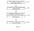
- Fig. 1 is a flowchart illustrating a method for determining a reachable area based on a road network according to the embodiments of the present invention.
- a current location of a user and a road network map are acquired.
- a user may carry an apparatus with a positioning function, for example, a mobile phone, a navigator, etc. with a GPS positioning function.
- the current location of the user may be acquired by means of the apparatus with a positioning function, and a road network map within a predetermined range surrounding the current location is obtained.
- the road network map may be map data pre-stored in the mobile phone or the navigator, and may also be acquired from the outside.
- the mobile phone may be used to download the road network map from a server by connecting to the Internet through a cellular network connection.
- a road node map is generated based on the road network map.
- the road node map is a topology diagram generated based on roads in the road network map.
- the road node map will be described in detail later with reference to Fig. 2 .
- the roads in the road network map are connected among road nodes.
- the road nodes are end points on roads, and usually these end points are end points of the roads, i.e. a crossing, such as a crossroad, a T-junction and the like. Certainly, the end points may also be terminating points of the roads.
- the user may be located at any location on the roads in the road network, and may also be located at any location on map areas divided by the roads.
- a boundary point extending for a maximum travel distance D starting from the current location of the user along a road is started to be searched from the current location of the user.
- a reachable area of the user is within the range of the distance to the current location of the user as the maximum travel distance D (for example, 1 kilometer).
- the farthest reached boundary point on a reachable road is obtained by extending the maximum travel distance D to a surrounding area on a road based on the current location of the user.
- an initial road node of a road corresponding to the location thereof is obtained, and a road node surrounding the initial road node is further searched starting from the initial road node, and the shortest path from the searched road node to the current location of the user is calculated. If it is found that the shortest path from a road node to the current location of the user exceeds D, then the farthest reached boundary point of the reachable area may be determined on the shortest path.
- step S107 the reachable area is determined according to the boundary point determined in step S105.
- the reachable area may be formed according to the current location of the user and the at least two farthest reached boundary points.
- a current location of a user is at a road node 0, while 3 road nodes 201, 202 and 203 exist near the road node 0, and the distances between the road node 0 and the road nodes 201, 202 and 203 are respectively 6, 1 and 2 units.
- the road node 0 will be referred to as an initial road node below.
- an adjacent road node list comprising adjacent road nodes 201, 202 and 203 directly connected to the road node 0 may be generated. Whether the distance between each adjacent road node in the adjacent road node list and the initial road node is longer than the maximum travel distance D may be successively determined.
- the initial road node may be determined as shown in Fig. 3 .
- the nearest distance i.e. an on-road distance
- the distances between an on-road point and two nodes v1 and v2 of the road are respectively W-w and w, assuming that W-w and w are both shorter than the maximum travel distance D.
- two adjacent road nodes v3 and v4 exist in the initial road node v1, while two adjacent road nodes v5 and v6 exist in the initial road node v2.
- the process of extending the maximum travel distance D to a road node surrounding the current location based on the current location of the user so as to calculate the reachable area in step S105 may be converted into a bi-initial road node extending process.
- a location with the distance D on the road before the initial road node and the adjacent road node may be determined as a boundary point of the reachable area.
- an adjacent road node with the distance to the initial road node 0 being shorter than the maximum travel distance D may serve as an intermediate node, and an adjacent road node of the intermediate node is searched and the above extending process is repeated, until the distances between all the subsequently searched adjacent road nodes and the initial road node all exceed the maximum travel distance D.
- Fig. 2(b) whether the distances between the road nodes 201, 202 and 203 and the initial road node 0 are longer than D is determined.
- D 5
- the distance between the node 201 and the initial road node 0 is 6, and since the distance is longer than the maximum travel distance, a point a on the road between the node 0 and the node 201 is determined as being a boundary point of the reachable area.
- the distance between the node 202 and the initial road node 0 is 1, which is shorter than the maximum travel distance 5, and therefore, the node 202 is set as an accessed intermediate node so as to continue to use the node in subsequent extending calculations, and meanwhile, the distance 1 between the node 202 and the node 202 and the initial road node 0 is recorded in an intermediate node list.
- the distance between the node 203 and the initial road node 0 is 2, which is likewise shorter than the maximum travel distance 5; therefore, the node 203 is set as an accessed intermediate node, and the node 203 and the corresponding distance 2 are recorded in the intermediate node list.
- adjacent road nodes of the node 202 located in the intermediate node list comprise nodes 201, 203 and 204.
- Fig. 2(d) whether an adjacent road node which has not been accessed exists in the nodes in the intermediate node list is determined according to a similar manner as described above with reference to Fig. 2(c) , and the process is repeated until all the adjacent road nodes of the nodes in the intermediate node list have been accessed. For example, in Fig. 2(d) , a node 205 in adjacent road nodes 205 and 202 of the node 201 is not accessed, and whether the distance from the initial road node 0 to the node 205 through the node 202 exceeds the maximum travel distance is determined.
- the distance from the node 203 to an adjacent road node 206 is 7, while the minimum distance from the initial road node 0 to the node 203 is 2; therefore, a point c on the road from the node 203 to the node 206 may be determined as being a boundary point of the reachable area.
- the node 204 since there is no adjacent road node except the road node 202 which has been accessed, the node 204 per se is determined as being a boundary point of the reachable area. In this way, after all the nodes in the intermediate node list have been accessed, the boundary points a, b, c and 204 of the reachable area may finally be obtained.
- a convex polygon is formed by connecting the initial road node 0 and the boundary points a, b, c and 204, and it can be seen that the area in the convex polygon is the final reachable area.
- the apparatus 400 comprises a location information acquisition unit 410, a road node map unit 420 and a controller 430.
- the location information acquisition unit 410 is used for acquiring current location information about the apparatus 400.
- the road node map unit 420 is used for generating and storing road node map data.
- the road node map unit 420 may generate the road node map data based on pre-stored map data, and may also receive the road node map data from the outside through a communication unit (not shown).
- the controller 430 acquires current location information about a user from the location information acquisition unit 410, acquires a road node map from the road node map unit 420, searches on the road node map for a boundary point extending for a maximum travel distance starting from the current location of the user along a road, and determines a reachable area based on the searched boundary point.
- the controller 430 extends the maximum travel distance along the road on the acquired road node map based on the current location of the user so as to obtain a boundary point of the reachable area.
- the controller 430 may search for a road node connected to a road closest to a user based on the current location of the user, and checks the shortest path from the searched road node to the current location of the user. When the length of the shortest path from the searched road node to the current location of the user is longer than the maximum travel distance, the controller 430 may determine a boundary point of the reachable area on the shortest path.
- the controller 430 When the length of the shortest path from the searched road node to the current location of the user is shorter than the maximum travel distance, the controller 430 continues to search for a road node which is adjacent to the road node and has not been accessed, and checks the length of the shortest path from the road node that has not been accessed to the current location of the user. The above searching and checking processes are repeatedly executed until the distances of the shortest paths from the searched new road nodes that have not been accessed to the current location of the user all exceed the maximum travel distance. At this moment, the controller 430 determines a final reachable area according to at least one boundary point obtained in the above process. Particularly, if at least two boundary points exist, then the controller 430 may determine the area within a convex polygon formed by connecting the searched boundary points as the reachable area according to the current location of the user and the at least two boundary points.
- the reachable area determination method takes the current location of a user and road connection conditions in a road network into consideration so as to better adapt to vehicle traffic characteristics and facilitate implementing subsequent services based on the reachable area.
- the reachable area determination manner of the present invention may be applied to taxi calling software so as to be able to push a taxi calling request, within a determined reachable area, to all taxies within the area based on the current location of the user. In this way, the taxi calling request may be pushed more effectively and more accurately.
- the method according to the present invention may be recorded in a computer readable medium including program instructions executing various operations implemented by a computer.
- the medium may also merely include program instructions or include data files, data structures, etc. combined with the program instructions.
- Examples of the computer readable medium include a magnetic medium (for example, a hard disk, a floppy disk and a magnetic tape), an optical medium (for example, a CD-ROM and a DVD), a magneto-optical medium (for example, an optical disk), and a hardware apparatus particularly configured for storing and executing program instructions (for example, a read-only memory (ROM), a random access memory (RAM), a flash memory, etc.).
- the medium may also be a transmission medium including a carrier for transmitting signals of stipulated program instructions, data structures, etc. (for example, an optical line or a metal line, waveguide, etc.).
- Examples of the program instructions include, for example, machine codes produced by a compiler, and a file containing high-level codes that may be executed by a computer using an interpreter.
Landscapes
- Engineering & Computer Science (AREA)
- Radar, Positioning & Navigation (AREA)
- Remote Sensing (AREA)
- Automation & Control Theory (AREA)
- Physics & Mathematics (AREA)
- General Physics & Mathematics (AREA)
- Navigation (AREA)
- Mobile Radio Communication Systems (AREA)
- Instructional Devices (AREA)
Abstract
Description
- The present invention relates to the field of location services, and more particularly to a method and apparatus for determining a reachable area based on a road network.
- A location based service (LBS) is used for acquiring geographical location information about a terminal device and providing relevant information services for a user according to the acquired geographical location information. When information services are provided, peripheral retrieval is a very important service. For example, various map applications (APPs) may provide peripheral point of interest (POI) information according the geographical location where a terminal device is located, thereby helping a user to use the terminal device to inquire about the locations of a restaurant, a cinema, common facilities, etc. within a predetermined range surrounding the location. As another example, in taxi paging software, the need to send a paging request to a terminal device in a taxi within a predetermined range based on a location where a user is located.
- For the sake of the factors of inquiry efficiency and stability, the existing manner for calculating a reachable area widely uses a concentric circle or a rectangle as a reachable range of a user. That is to say, when services of peripheral retrieval, etc. are carried out, a concentric circle or a view display area serves as a result filtering condition. The existing practices actually assume that a user has various isotropic moving abilities as if on a uniform surface which is infinitely large; however, actually, a moving policy of the user is often moving along a road network, and the distance moved after leaving the road network will not be too far, and therefore, an actual reachable area of the user should be a buffer area of a path on which the user may extend. Another problem in the existing practices is not considering the influence of landforms which can not be crossed by a user, such as a closed area, a water area or a mountain, on the user reachable area; however, road network-based reachable area analysis may avoid similar problems to some extent.
- However, the calculation efficiency of the existing method for calculating a reachable area based on a road network is not high, and the calculation cost is higher than that of the method for calculating a reachable area based on concentric circles or grids. Sample statistics in the Beijing area show that time spent on inquiries based on a road network of over 2.3 km may exceed 500 ms; therefore, the aspect of efficiency of the manner for calculating a reachable area based on a road network still needs to be improved.
- One aspect of the present invention provides a method for determining a reachable area based on a road network, comprising: acquiring a current location of a user and a road network map; generating a road node map based on the road network map; searching on the road node map for a boundary point extending for a maximum travel distance starting from the current location of the user along a road; and determining a reachable area based on the searched boundary point.
- According to one aspect of the present invention, a road node is an end point of a road.
- According to one aspect of the present invention, the step of searching on the road node map for a boundary point extending for a maximum travel distance starting from the current location of the user along a road comprises: searching for a road node surrounding the current location of the user; checking the shortest path from the searched road node to the current location of the user; and when the length of the shortest path from the searched road node to the current location of the user is longer than the maximum travel distance, determining a boundary point of the reachable area on the shortest path.
- According to one aspect of the present invention, the step of searching for a road node surrounding the current location of the user comprises: firstly searching for a road node of a road closest to the current location of the user.
- According to one aspect of the present invention, the step of searching on the road node map for a boundary point extending for a maximum travel distance starting from the current location of a user along a road comprises: when the length of the shortest path from the searched road node to the current location of the user is shorter than the maximum travel distance, searching for a road node which is adjacent to the road node and has not been accessed, and checking the length of the shortest path from the road node that has not been accessed to the current location of the user.
- According to one aspect of the present invention, the step of determining a reachable area comprises: determining the area within a convex polygon formed by connecting the searched boundary points as being the reachable area.
- According to another aspect of the present invention, an apparatus for determining a reachable area based on a road network is provided, comprising: a location information acquisition unit, for acquiring current location information; a road node map unit, for generating and storing road node map data; and a controller, for acquiring current location information about a user from the location information acquisition unit, acquiring a road node map from the road node map unit, searching on the road node map for a boundary point extending for a maximum travel distance starting from the current location of the user along a road, and determining a reachable area based on the searched boundary point.
- According to another aspect of the present invention, the road node map unit generates road node map data based on pre-stored map data, or receives the road node map data from the outside.
- According to another aspect of the present invention, the controller searches for a road node surrounding the current location of the user, and checks the shortest path from the searched road node to the current location of the user, wherein when the length of the shortest path from the searched road node to the current location of the user is longer than the maximum travel distance, the controller determines a boundary point of the reachable area on the shortest path.
- According to another aspect of the present invention, when the length of the shortest path from the searched road node to the current location of the user is shorter than the maximum travel distance, the controller searches for a road node which is adjacent to the road node and has not been accessed, and checks the length of the shortest path from the road node that has not been accessed to the current location of the user.
- According to another aspect of the present invention, the controller determines the area within a convex polygon formed by connecting the searched boundary points as being the reachable area.
- The above and other objects and characteristics of the present invention will be more apparent from the following description in conjunction with the accompanying drawings, in which:
-
Fig. 1 is a flowchart illustrating a method for determining a reachable area based on a road network according to the embodiments of the present invention; -
Fig. 2(a)-Fig. 2(e) are schematic node diagrams illustrating a process for calculating a reachable area according to the embodiments of the present invention; -
Fig. 3 is a schematic diagram illustrating determining an initial road node in the process of calculating a reachable area according to the embodiments of the present invention; and -
Fig. 4 is a schematic diagram illustrating an apparatus for determining a reachable area based on a road network according to the embodiments of the present invention. - The description with reference to the accompanying drawings is provided below to assist in a comprehensive understanding of exemplary embodiments of the present invention as defined by the claims and their equivalents. In the description, unless explicitly specified, the same variable has the same definition. The description comprises various specific details to assist in understanding, but this description will merely be considered as exemplary. Therefore, those of ordinary skill in the art will appreciate that various changes and modifications as described herein may be made without departing from the scope and spirit of the present invention. In addition, the description regarding well-known functions and constructions may be omitted for clarity and conciseness.
-
Fig. 1 is a flowchart illustrating a method for determining a reachable area based on a road network according to the embodiments of the present invention. - As shown in
Fig. 1 , firstly, in step S101, a current location of a user and a road network map are acquired. Here, a user may carry an apparatus with a positioning function, for example, a mobile phone, a navigator, etc. with a GPS positioning function. In this way, the current location of the user may be acquired by means of the apparatus with a positioning function, and a road network map within a predetermined range surrounding the current location is obtained. The road network map may be map data pre-stored in the mobile phone or the navigator, and may also be acquired from the outside. For example, the mobile phone may be used to download the road network map from a server by connecting to the Internet through a cellular network connection. - Next, in step S103, a road node map is generated based on the road network map. The road node map is a topology diagram generated based on roads in the road network map. The road node map will be described in detail later with reference to
Fig. 2 . Here, the roads in the road network map are connected among road nodes. The road nodes are end points on roads, and usually these end points are end points of the roads, i.e. a crossing, such as a crossroad, a T-junction and the like. Certainly, the end points may also be terminating points of the roads. The user may be located at any location on the roads in the road network, and may also be located at any location on map areas divided by the roads. - Then, in step S105, a boundary point extending for a maximum travel distance D starting from the current location of the user along a road is started to be searched from the current location of the user. Here, assuming that the moving speed of the user is uniform, then within a predetermined time, a reachable area of the user is within the range of the distance to the current location of the user as the maximum travel distance D (for example, 1 kilometer). Specifically, the farthest reached boundary point on a reachable road is obtained by extending the maximum travel distance D to a surrounding area on a road based on the current location of the user. In the present invention, based on the current location of the user, an initial road node of a road corresponding to the location thereof is obtained, and a road node surrounding the initial road node is further searched starting from the initial road node, and the shortest path from the searched road node to the current location of the user is calculated. If it is found that the shortest path from a road node to the current location of the user exceeds D, then the farthest reached boundary point of the reachable area may be determined on the shortest path.
- Finally, in step S107, the reachable area is determined according to the boundary point determined in step S105. Here, if at least two farthest reached boundary points exist, then the reachable area may be formed according to the current location of the user and the at least two farthest reached boundary points.
- The process for calculating a reachable area on a road node map by extending the maximum travel distance D based on a road node will be described in detail with reference to
Fig. 2(a)-Fig. 2(e) . - Firstly, as shown in
Fig. 2(a) , assuming that a current location of a user is at aroad node 0, while 3road nodes road node 0, and the distances between theroad node 0 and theroad nodes road node 0 will be referred to as an initial road node below. Based on the initial road node, an adjacent road node list comprisingadjacent road nodes road node 0 may be generated. Whether the distance between each adjacent road node in the adjacent road node list and the initial road node is longer than the maximum travel distance D may be successively determined. - The case where the current location of the user overlaps with a road node is taken into consideration above. However, in actual conditions, the current location of the user is likely not located at the road node, and also likely not located on a road of the road network, and therefore, the initial road node may be determined as shown in
Fig. 3 . Specifically, as shown inFig. 3 , the nearest distance (i.e. an on-road distance) between the current location (i.e. a starting point) of the user and the closest road is assumed as d, while the distances between an on-road point and two nodes v1 and v2 of the road are respectively W-w and w, assuming that W-w and w are both shorter than the maximum travel distance D. In this way, initial road nodes v1 and v2 may be obtained in two directions, and accordingly, at the initial road node v1, when a reachable area is calculated, the maximum travel distance used thereby is D1 = D - d - (W-w), while at the initial road node v2, when the reachable area is calculated, the maximum travel distance used thereby is D2 = D - d - w. As shown inFig. 3 , two adjacent road nodes v3 and v4 exist in the initial road node v1, while two adjacent road nodes v5 and v6 exist in the initial road node v2. In this way, the process of extending the maximum travel distance D to a road node surrounding the current location based on the current location of the user so as to calculate the reachable area in step S105 may be converted into a bi-initial road node extending process. - In the following, referring back to
Fig. 2(b) , after the adjacent road node list of the initial road node is generated, whether the distance between each adjacent road node in the adjacent road node list and the initial road node is longer than the maximum travel distance D is determined. With regard to an adjacent road node with a distance longer than the maximum travel distance D, a location with the distance D on the road before the initial road node and the adjacent road node may be determined as a boundary point of the reachable area. Then, an adjacent road node with the distance to theinitial road node 0 being shorter than the maximum travel distance D may serve as an intermediate node, and an adjacent road node of the intermediate node is searched and the above extending process is repeated, until the distances between all the subsequently searched adjacent road nodes and the initial road node all exceed the maximum travel distance D. - Specifically, in
Fig. 2(b) , whether the distances between theroad nodes initial road node 0 are longer than D is determined. Here, it is assumed that D = 5. It can be seen fromFig. 2(b) that the distance between thenode 201 and theinitial road node 0 is 6, and since the distance is longer than the maximum travel distance, a point a on the road between thenode 0 and thenode 201 is determined as being a boundary point of the reachable area. Being different from thenode 201, the distance between thenode 202 and theinitial road node 0 is 1, which is shorter than the maximum travel distance 5, and therefore, thenode 202 is set as an accessed intermediate node so as to continue to use the node in subsequent extending calculations, and meanwhile, thedistance 1 between thenode 202 and thenode 202 and theinitial road node 0 is recorded in an intermediate node list. Likewise, the distance between thenode 203 and theinitial road node 0 is 2, which is likewise shorter than the maximum travel distance 5; therefore, thenode 203 is set as an accessed intermediate node, and thenode 203 and thecorresponding distance 2 are recorded in the intermediate node list. - Next, an adjacent road node of the road node in the intermediate node list is obtained so as to update the adjacent road node list, and whether the distance from the initial road node to a road node in adjacent list nodes through a road node in the intermediate node list exceeds the maximum travel distance D is determined. As shown in
Fig. 2(c) , adjacent road nodes of thenode 202 located in the intermediate node list comprisenodes node 201 through thenode 202 is 1 + 2 = 3, and the distance is shorter than the maximum travel distance 5; therefore, thenode 201 is put into the intermediate node list, and thenode 201 is set as having been accessed, and meanwhile, thedistance 3 is recorded as the distance from thenode 201 to theinitial road node 0. The distance to thenode 204 through thenode 202 is 1+2=3<5; therefore, thenode 204 is set as having been accessed, and is put into the intermediate node list and thecorresponding distance 3 is recorded. The distance to thenode 203 through thenode 202 is 1 + 3 = 4 < 5, but since thenode 203 has been in the intermediate node list and the intermediate node list has recorded that the distance from theinitial road node 0 to thenode 203 is 2, i.e., the shortest path distance from theinitial road node 0 to thenode 203 is 2, there is no need to update the distance from thenode 203 to theinitial road node 0. - Next, as shown in
Fig. 2(d) , whether an adjacent road node which has not been accessed exists in the nodes in the intermediate node list is determined according to a similar manner as described above with reference toFig. 2(c) , and the process is repeated until all the adjacent road nodes of the nodes in the intermediate node list have been accessed. For example, inFig. 2(d) , anode 205 inadjacent road nodes node 201 is not accessed, and whether the distance from theinitial road node 0 to thenode 205 through thenode 202 exceeds the maximum travel distance is determined. Here, since the distance from thenode 202 to thenode 205 is 4, the distance from theinitial road node 0 to thenode 205 through thenode 202 is 1 + 2 + 4 = 7, which is longer than the maximum travel distance 5; therefore, a point b with the distance being 2 on the road from thenode 202 to thenode 205 is determined as being a boundary point of the reachable area. Likewise, the distance from thenode 203 to anadjacent road node 206 is 7, while the minimum distance from theinitial road node 0 to thenode 203 is 2; therefore, a point c on the road from thenode 203 to thenode 206 may be determined as being a boundary point of the reachable area. However, with regard to thenode 204, since there is no adjacent road node except theroad node 202 which has been accessed, thenode 204 per se is determined as being a boundary point of the reachable area. In this way, after all the nodes in the intermediate node list have been accessed, the boundary points a, b, c and 204 of the reachable area may finally be obtained. - At last, as shown in
Fig. 2(e) , a convex polygon is formed by connecting theinitial road node 0 and the boundary points a, b, c and 204, and it can be seen that the area in the convex polygon is the final reachable area. - It should be understood that the above is merely a manner for calculating the farthest reached boundary point by extending along a road to an adjacent road node, and other algorithms may also be used to calculate the farthest reached point.
- An
apparatus 400 for determining a reachable area based on a road network according to the embodiments of the present invention will be described below with reference toFig. 4 . - As shown in
Fig. 4 , theapparatus 400 comprises a locationinformation acquisition unit 410, a roadnode map unit 420 and acontroller 430. - The location
information acquisition unit 410 is used for acquiring current location information about theapparatus 400. The roadnode map unit 420 is used for generating and storing road node map data. Here, the roadnode map unit 420 may generate the road node map data based on pre-stored map data, and may also receive the road node map data from the outside through a communication unit (not shown). - The
controller 430 acquires current location information about a user from the locationinformation acquisition unit 410, acquires a road node map from the roadnode map unit 420, searches on the road node map for a boundary point extending for a maximum travel distance starting from the current location of the user along a road, and determines a reachable area based on the searched boundary point. - Here, the
controller 430 extends the maximum travel distance along the road on the acquired road node map based on the current location of the user so as to obtain a boundary point of the reachable area. Thecontroller 430 may search for a road node connected to a road closest to a user based on the current location of the user, and checks the shortest path from the searched road node to the current location of the user. When the length of the shortest path from the searched road node to the current location of the user is longer than the maximum travel distance, thecontroller 430 may determine a boundary point of the reachable area on the shortest path. When the length of the shortest path from the searched road node to the current location of the user is shorter than the maximum travel distance, thecontroller 430 continues to search for a road node which is adjacent to the road node and has not been accessed, and checks the length of the shortest path from the road node that has not been accessed to the current location of the user. The above searching and checking processes are repeatedly executed until the distances of the shortest paths from the searched new road nodes that have not been accessed to the current location of the user all exceed the maximum travel distance. At this moment, thecontroller 430 determines a final reachable area according to at least one boundary point obtained in the above process. Particularly, if at least two boundary points exist, then thecontroller 430 may determine the area within a convex polygon formed by connecting the searched boundary points as the reachable area according to the current location of the user and the at least two boundary points. - The reachable area determination method according to the present invention takes the current location of a user and road connection conditions in a road network into consideration so as to better adapt to vehicle traffic characteristics and facilitate implementing subsequent services based on the reachable area. For example, the reachable area determination manner of the present invention may be applied to taxi calling software so as to be able to push a taxi calling request, within a determined reachable area, to all taxies within the area based on the current location of the user. In this way, the taxi calling request may be pushed more effectively and more accurately.
- The method according to the present invention may be recorded in a computer readable medium including program instructions executing various operations implemented by a computer. The medium may also merely include program instructions or include data files, data structures, etc. combined with the program instructions. Examples of the computer readable medium include a magnetic medium (for example, a hard disk, a floppy disk and a magnetic tape), an optical medium (for example, a CD-ROM and a DVD), a magneto-optical medium (for example, an optical disk), and a hardware apparatus particularly configured for storing and executing program instructions (for example, a read-only memory (ROM), a random access memory (RAM), a flash memory, etc.). The medium may also be a transmission medium including a carrier for transmitting signals of stipulated program instructions, data structures, etc. (for example, an optical line or a metal line, waveguide, etc.). Examples of the program instructions include, for example, machine codes produced by a compiler, and a file containing high-level codes that may be executed by a computer using an interpreter.
- Although the present invention has been specifically shown and described with reference to exemplary embodiments of the present invention, it shall be understood by those skilled in the art that various changes in the form and details may be made thereto without departing from the spirit and scope of the present invention as defined by the claims.
Claims (13)
- A method for determining a reachable area based on a road network, comprising:acquiring a current location and a road network map;generating a road node map based on the road network map;searching on the road node map for a boundary point extending for a maximum travel distance starting from the current location of a user along a road; anddetermining a reachable area based on the searched boundary point.
- The method as claimed in claim 1, characterized in that a road node is an end point of a road.
- The method as claimed in claim 1, characterized in that the step of searching on the road node map for a boundary point extending for a maximum travel distance starting from the current location of a user along a road comprises:searching for a road node surrounding the current location of the user;checking the shortest path from the searched road node to the current location of the user; andwhen the length of the shortest path from the searched road node to the current location of the user is longer than the maximum travel distance, determining a boundary point of the reachable area on the shortest path.
- The method as claimed in claim 3, characterized in that the step of searching for a road node surrounding the current location of the user comprises:firstly searching for a road node of a road closest to the current location of the user.
- The method as claimed in claim 3, the step of searching on the road node map for a boundary point extending for a maximum travel distance starting from the current location of a user along a road comprises:when the length of the shortest path from the searched road node to the current location of the user is shorter than the maximum travel distance, searching for a road node which is adjacent to the road node and has not been accessed, and checking the length of the shortest path from the road node that has not been accessed to the current location of the user.
- The method as claimed in claim 1, characterized in that the step of determining a reachable area comprises: determining the area within a convex polygon formed by connecting the searched boundary points as being the reachable area.
- An apparatus for determining a reachable area based on a road network, comprising:a location information acquisition unit, for acquiring current location information;a road node map unit, for generating and storing road node map data; anda controller, for acquiring current location information about a user from the location information acquisition unit, acquiring a road node map from the road node map unit, searching on the road node map for a boundary point extending for a maximum travel distance starting from the current location of the user along a road, and determining a reachable area based on the searched boundary point.
- The apparatus as claimed in claim 7, characterized in that a road node is an end point of a road.
- The apparatus as claimed in claim 7, characterized in that the road node map unit generates road node map data based on pre-stored map data, or receives the road node map data from the outside.
- The apparatus as claimed in claim 7, characterized in that the controller searches for a road node surrounding the current location of the user, and checks the shortest path from the searched road node to the current location of the user,
wherein when the length of the shortest path from the searched road node to the current location of the user is longer than the maximum travel distance, the controller determines a boundary point of the reachable area on the shortest path. - The apparatus as claimed in claim 10, characterized in that when the length of the shortest path from the searched road node to the current location of the user is shorter than the maximum travel distance, the controller searches for a road node which is adjacent to the road node and has not been accessed, and checks the length of the shortest path from the road node that has not been accessed to the current location of the user.
- The apparatus as claimed in claim 7, characterized in that the controller determines the area within a convex polygon formed by connecting the searched boundary points as being the reachable area.
- A computer program configured to perform the method of any preceding method claim.
Applications Claiming Priority (1)
| Application Number | Priority Date | Filing Date | Title |
|---|---|---|---|
| CN201410271484.3A CN104023313A (en) | 2014-06-18 | 2014-06-18 | Method and device for determining achievable region based on road network |
Publications (2)
| Publication Number | Publication Date |
|---|---|
| EP2957869A1 true EP2957869A1 (en) | 2015-12-23 |
| EP2957869B1 EP2957869B1 (en) | 2019-04-17 |
Family
ID=51439843
Family Applications (1)
| Application Number | Title | Priority Date | Filing Date |
|---|---|---|---|
| EP14200494.4A Not-in-force EP2957869B1 (en) | 2014-06-18 | 2014-12-29 | Method and apparatus for determining reachable area based on road network |
Country Status (5)
| Country | Link |
|---|---|
| US (1) | US9778048B2 (en) |
| EP (1) | EP2957869B1 (en) |
| JP (1) | JP2016004266A (en) |
| KR (1) | KR102336824B1 (en) |
| CN (1) | CN104023313A (en) |
Families Citing this family (14)
| Publication number | Priority date | Publication date | Assignee | Title |
|---|---|---|---|---|
| GB201608233D0 (en) * | 2016-05-04 | 2016-06-22 | Tomtom Navigation Bv | Methods and systems for determining safe return range |
| CN107346319B (en) * | 2016-05-06 | 2020-05-08 | 高德软件有限公司 | Cross-city reachable library creating method and device |
| DE102017220242A1 (en) * | 2017-11-14 | 2019-05-16 | Robert Bosch Gmbh | Method and device for creating and providing a card |
| CN109211238B (en) * | 2018-08-28 | 2020-08-18 | 成都四相致新科技有限公司 | A real-time positioning anti-traversal optimization method |
| CN111062658B (en) * | 2019-12-04 | 2022-11-18 | 南京苏宁加电子商务有限公司 | Distribution range generation method and device, computer equipment and storage medium |
| CN111210628B (en) * | 2020-01-14 | 2021-04-27 | 首都师范大学 | Method and Device for Boundary Road Section Selection in Urban Accessible Area Calculation |
| CN111652434B (en) * | 2020-06-02 | 2023-09-29 | 百度在线网络技术(北京)有限公司 | Road network data processing method and device, electronic equipment and computer storage medium |
| CN112185116B (en) * | 2020-09-29 | 2021-11-23 | 重庆文理学院 | Method for evaluating disaster-resistant toughness of urban road traffic network |
| CN112202892B (en) * | 2020-09-30 | 2022-02-18 | 中国联合网络通信集团有限公司 | A kind of method and device for determining MEC boundary |
| CN114543820B (en) * | 2020-11-24 | 2023-09-22 | 博泰车联网科技(上海)股份有限公司 | Road matching method and related device |
| CN112751911B (en) * | 2020-12-15 | 2022-10-21 | 北京百度网讯科技有限公司 | Road network data processing method, device, equipment and storage medium |
| CN113328785B (en) * | 2021-05-27 | 2022-03-18 | 广州爱浦路网络技术有限公司 | Method for paging terminal in satellite communication and core network for satellite communication |
| CN113592180B (en) * | 2021-08-02 | 2023-07-07 | 上海歆广数据科技有限公司 | Seed point service area division method and system |
| CN114046798B (en) * | 2021-11-16 | 2023-07-25 | 中国联合网络通信集团有限公司 | A route planning method, device and storage medium for assisting city exploration |
Citations (2)
| Publication number | Priority date | Publication date | Assignee | Title |
|---|---|---|---|---|
| US20130096818A1 (en) * | 2011-10-14 | 2013-04-18 | Pablo A. Vicharelli | Method and system for vehicle range analysis |
| WO2014001565A1 (en) * | 2012-06-29 | 2014-01-03 | Tomtom Development Germany Gmbh | Apparatus and method for route searching |
Family Cites Families (11)
| Publication number | Priority date | Publication date | Assignee | Title |
|---|---|---|---|---|
| GB0002985D0 (en) * | 2000-02-09 | 2000-03-29 | Travelfusion Limited | Integrated journey planner |
| JP4603950B2 (en) * | 2005-07-29 | 2010-12-22 | 株式会社ナビタイムジャパン | Navigation system, POI search method, information distribution server, and portable terminal |
| EP1926074A4 (en) * | 2005-09-12 | 2014-01-08 | Panasonic Corp | CARD DISPLAY DEVICE |
| CN101458087B (en) * | 2007-12-14 | 2013-01-09 | 环达电脑(上海)有限公司 | Navigation head using image map and method thereof |
| CN101261136B (en) * | 2008-04-25 | 2012-11-28 | 浙江大学 | Route searching method based on mobile navigation system |
| JP5516525B2 (en) * | 2011-07-20 | 2014-06-11 | トヨタ自動車株式会社 | Driving assistance device |
| WO2013027270A1 (en) * | 2011-08-23 | 2013-02-28 | パイオニア株式会社 | Image processing device, image processing management device, terminal, processing device, and image processing method |
| US10345108B2 (en) * | 2012-05-16 | 2019-07-09 | Polaris Industries Inc. | System and method for multi-plane routing |
| EP2685215B1 (en) * | 2012-07-13 | 2021-04-28 | Harman Becker Automotive Systems GmbH | Method of estimating an ability of a vehicle to reach a target road segment, method of generating a database therefor, and corresponding navigation system |
| JP6026295B2 (en) * | 2013-01-23 | 2016-11-16 | 株式会社デンソーアイティーラボラトリ | Curve shape modeling apparatus, method, and in-vehicle navigation apparatus |
| US20140372031A1 (en) * | 2013-06-17 | 2014-12-18 | Rivendell Technologies, LLC | Systems, methods and computer-readable media for generating digital wayfinding maps |
-
2014
- 2014-06-18 CN CN201410271484.3A patent/CN104023313A/en active Pending
- 2014-12-26 JP JP2014264860A patent/JP2016004266A/en active Pending
- 2014-12-29 EP EP14200494.4A patent/EP2957869B1/en not_active Not-in-force
- 2014-12-29 US US14/585,065 patent/US9778048B2/en active Active
- 2014-12-31 KR KR1020140195024A patent/KR102336824B1/en not_active Expired - Fee Related
Patent Citations (2)
| Publication number | Priority date | Publication date | Assignee | Title |
|---|---|---|---|---|
| US20130096818A1 (en) * | 2011-10-14 | 2013-04-18 | Pablo A. Vicharelli | Method and system for vehicle range analysis |
| WO2014001565A1 (en) * | 2012-06-29 | 2014-01-03 | Tomtom Development Germany Gmbh | Apparatus and method for route searching |
Also Published As
| Publication number | Publication date |
|---|---|
| US9778048B2 (en) | 2017-10-03 |
| JP2016004266A (en) | 2016-01-12 |
| US20150369616A1 (en) | 2015-12-24 |
| KR20150145169A (en) | 2015-12-29 |
| KR102336824B1 (en) | 2021-12-09 |
| CN104023313A (en) | 2014-09-03 |
| EP2957869B1 (en) | 2019-04-17 |
Similar Documents
| Publication | Publication Date | Title |
|---|---|---|
| EP2957869B1 (en) | Method and apparatus for determining reachable area based on road network | |
| US10890454B2 (en) | Integrating online navigation data with cached navigation data during active navigation | |
| US10401188B2 (en) | Method and apparatus for providing point of interest information | |
| JP5494270B2 (en) | Information providing apparatus and information providing method | |
| US20190277651A1 (en) | Techniques and architectures for proactively providing offline maps | |
| WO2015169219A1 (en) | Navigation method and apparatus | |
| JP2007318354A (en) | Communication device for mobile and communication method for mobile | |
| KR20140046049A (en) | Providing wireless transmitter almanac information to mobile device based on expected route | |
| JP2015156171A5 (en) | ||
| WO2023142923A1 (en) | Electronic map switching method, electronic map processing method, terminal, server, and storage medium | |
| CN106855878B (en) | Method and device for displaying historical driving track based on electronic map | |
| US20220101209A1 (en) | Information processing device, information processing system, and method of information processing | |
| WO2014139377A1 (en) | Method and device for monitoring road flow | |
| US20150051830A1 (en) | Enhanced navigation | |
| JP5342291B2 (en) | Map data update system, map data update method | |
| Shahzada et al. | Dynamic vehicle navigation: An A* algorithm based approach using traffic and road information | |
| KR101007017B1 (en) | Method and apparatus for selecting PIO between users using location based service | |
| CN116821525A (en) | Method and related device for determining endurance range | |
| KR102659046B1 (en) | Method and system for resetting navigation pathway | |
| CN104776852B (en) | A kind of method the time required to the acquisition guidance path based on GSM quantity | |
| JP5935730B2 (en) | Guidance route search system | |
| JP5929782B2 (en) | Guidance route search system | |
| CN115331466B (en) | Parking route information generation method, apparatus, device, medium, and program product | |
| CN114427857B (en) | A navigation method, device, electronic device and storage medium | |
| CN109297480A (en) | The method and system of position for management equipment |
Legal Events
| Date | Code | Title | Description |
|---|---|---|---|
| PUAI | Public reference made under article 153(3) epc to a published international application that has entered the european phase |
Free format text: ORIGINAL CODE: 0009012 |
|
| AK | Designated contracting states |
Kind code of ref document: A1 Designated state(s): AL AT BE BG CH CY CZ DE DK EE ES FI FR GB GR HR HU IE IS IT LI LT LU LV MC MK MT NL NO PL PT RO RS SE SI SK SM TR |
|
| AX | Request for extension of the european patent |
Extension state: BA ME |
|
| 17P | Request for examination filed |
Effective date: 20160620 |
|
| RBV | Designated contracting states (corrected) |
Designated state(s): AL AT BE BG CH CY CZ DE DK EE ES FI FR GB GR HR HU IE IS IT LI LT LU LV MC MK MT NL NO PL PT RO RS SE SI SK SM TR |
|
| STAA | Information on the status of an ep patent application or granted ep patent |
Free format text: STATUS: EXAMINATION IS IN PROGRESS |
|
| 17Q | First examination report despatched |
Effective date: 20161222 |
|
| GRAP | Despatch of communication of intention to grant a patent |
Free format text: ORIGINAL CODE: EPIDOSNIGR1 |
|
| STAA | Information on the status of an ep patent application or granted ep patent |
Free format text: STATUS: GRANT OF PATENT IS INTENDED |
|
| INTG | Intention to grant announced |
Effective date: 20181107 |
|
| RIN1 | Information on inventor provided before grant (corrected) |
Inventor name: WANG, FENG Inventor name: LI, ZHITANG |
|
| GRAS | Grant fee paid |
Free format text: ORIGINAL CODE: EPIDOSNIGR3 |
|
| GRAA | (expected) grant |
Free format text: ORIGINAL CODE: 0009210 |
|
| STAA | Information on the status of an ep patent application or granted ep patent |
Free format text: STATUS: THE PATENT HAS BEEN GRANTED |
|
| AK | Designated contracting states |
Kind code of ref document: B1 Designated state(s): AL AT BE BG CH CY CZ DE DK EE ES FI FR GB GR HR HU IE IS IT LI LT LU LV MC MK MT NL NO PL PT RO RS SE SI SK SM TR |
|
| REG | Reference to a national code |
Ref country code: GB Ref legal event code: FG4D |
|
| REG | Reference to a national code |
Ref country code: CH Ref legal event code: EP |
|
| REG | Reference to a national code |
Ref country code: DE Ref legal event code: R096 Ref document number: 602014044834 Country of ref document: DE |
|
| REG | Reference to a national code |
Ref country code: AT Ref legal event code: REF Ref document number: 1122048 Country of ref document: AT Kind code of ref document: T Effective date: 20190515 Ref country code: IE Ref legal event code: FG4D |
|
| REG | Reference to a national code |
Ref country code: NL Ref legal event code: MP Effective date: 20190417 |
|
| REG | Reference to a national code |
Ref country code: LT Ref legal event code: MG4D |
|
| PG25 | Lapsed in a contracting state [announced via postgrant information from national office to epo] |
Ref country code: NL Free format text: LAPSE BECAUSE OF FAILURE TO SUBMIT A TRANSLATION OF THE DESCRIPTION OR TO PAY THE FEE WITHIN THE PRESCRIBED TIME-LIMIT Effective date: 20190417 |
|
| PG25 | Lapsed in a contracting state [announced via postgrant information from national office to epo] |
Ref country code: ES Free format text: LAPSE BECAUSE OF FAILURE TO SUBMIT A TRANSLATION OF THE DESCRIPTION OR TO PAY THE FEE WITHIN THE PRESCRIBED TIME-LIMIT Effective date: 20190417 Ref country code: HR Free format text: LAPSE BECAUSE OF FAILURE TO SUBMIT A TRANSLATION OF THE DESCRIPTION OR TO PAY THE FEE WITHIN THE PRESCRIBED TIME-LIMIT Effective date: 20190417 Ref country code: LT Free format text: LAPSE BECAUSE OF FAILURE TO SUBMIT A TRANSLATION OF THE DESCRIPTION OR TO PAY THE FEE WITHIN THE PRESCRIBED TIME-LIMIT Effective date: 20190417 Ref country code: FI Free format text: LAPSE BECAUSE OF FAILURE TO SUBMIT A TRANSLATION OF THE DESCRIPTION OR TO PAY THE FEE WITHIN THE PRESCRIBED TIME-LIMIT Effective date: 20190417 Ref country code: NO Free format text: LAPSE BECAUSE OF FAILURE TO SUBMIT A TRANSLATION OF THE DESCRIPTION OR TO PAY THE FEE WITHIN THE PRESCRIBED TIME-LIMIT Effective date: 20190717 Ref country code: PT Free format text: LAPSE BECAUSE OF FAILURE TO SUBMIT A TRANSLATION OF THE DESCRIPTION OR TO PAY THE FEE WITHIN THE PRESCRIBED TIME-LIMIT Effective date: 20190817 Ref country code: SE Free format text: LAPSE BECAUSE OF FAILURE TO SUBMIT A TRANSLATION OF THE DESCRIPTION OR TO PAY THE FEE WITHIN THE PRESCRIBED TIME-LIMIT Effective date: 20190417 Ref country code: AL Free format text: LAPSE BECAUSE OF FAILURE TO SUBMIT A TRANSLATION OF THE DESCRIPTION OR TO PAY THE FEE WITHIN THE PRESCRIBED TIME-LIMIT Effective date: 20190417 |
|
| PG25 | Lapsed in a contracting state [announced via postgrant information from national office to epo] |
Ref country code: LV Free format text: LAPSE BECAUSE OF FAILURE TO SUBMIT A TRANSLATION OF THE DESCRIPTION OR TO PAY THE FEE WITHIN THE PRESCRIBED TIME-LIMIT Effective date: 20190417 Ref country code: PL Free format text: LAPSE BECAUSE OF FAILURE TO SUBMIT A TRANSLATION OF THE DESCRIPTION OR TO PAY THE FEE WITHIN THE PRESCRIBED TIME-LIMIT Effective date: 20190417 Ref country code: GR Free format text: LAPSE BECAUSE OF FAILURE TO SUBMIT A TRANSLATION OF THE DESCRIPTION OR TO PAY THE FEE WITHIN THE PRESCRIBED TIME-LIMIT Effective date: 20190718 Ref country code: BG Free format text: LAPSE BECAUSE OF FAILURE TO SUBMIT A TRANSLATION OF THE DESCRIPTION OR TO PAY THE FEE WITHIN THE PRESCRIBED TIME-LIMIT Effective date: 20190717 Ref country code: RS Free format text: LAPSE BECAUSE OF FAILURE TO SUBMIT A TRANSLATION OF THE DESCRIPTION OR TO PAY THE FEE WITHIN THE PRESCRIBED TIME-LIMIT Effective date: 20190417 |
|
| REG | Reference to a national code |
Ref country code: AT Ref legal event code: MK05 Ref document number: 1122048 Country of ref document: AT Kind code of ref document: T Effective date: 20190417 |
|
| PG25 | Lapsed in a contracting state [announced via postgrant information from national office to epo] |
Ref country code: IS Free format text: LAPSE BECAUSE OF FAILURE TO SUBMIT A TRANSLATION OF THE DESCRIPTION OR TO PAY THE FEE WITHIN THE PRESCRIBED TIME-LIMIT Effective date: 20190817 |
|
| REG | Reference to a national code |
Ref country code: DE Ref legal event code: R097 Ref document number: 602014044834 Country of ref document: DE |
|
| PG25 | Lapsed in a contracting state [announced via postgrant information from national office to epo] |
Ref country code: CZ Free format text: LAPSE BECAUSE OF FAILURE TO SUBMIT A TRANSLATION OF THE DESCRIPTION OR TO PAY THE FEE WITHIN THE PRESCRIBED TIME-LIMIT Effective date: 20190417 Ref country code: RO Free format text: LAPSE BECAUSE OF FAILURE TO SUBMIT A TRANSLATION OF THE DESCRIPTION OR TO PAY THE FEE WITHIN THE PRESCRIBED TIME-LIMIT Effective date: 20190417 Ref country code: EE Free format text: LAPSE BECAUSE OF FAILURE TO SUBMIT A TRANSLATION OF THE DESCRIPTION OR TO PAY THE FEE WITHIN THE PRESCRIBED TIME-LIMIT Effective date: 20190417 Ref country code: SK Free format text: LAPSE BECAUSE OF FAILURE TO SUBMIT A TRANSLATION OF THE DESCRIPTION OR TO PAY THE FEE WITHIN THE PRESCRIBED TIME-LIMIT Effective date: 20190417 Ref country code: AT Free format text: LAPSE BECAUSE OF FAILURE TO SUBMIT A TRANSLATION OF THE DESCRIPTION OR TO PAY THE FEE WITHIN THE PRESCRIBED TIME-LIMIT Effective date: 20190417 Ref country code: DK Free format text: LAPSE BECAUSE OF FAILURE TO SUBMIT A TRANSLATION OF THE DESCRIPTION OR TO PAY THE FEE WITHIN THE PRESCRIBED TIME-LIMIT Effective date: 20190417 |
|
| PLBE | No opposition filed within time limit |
Free format text: ORIGINAL CODE: 0009261 |
|
| STAA | Information on the status of an ep patent application or granted ep patent |
Free format text: STATUS: NO OPPOSITION FILED WITHIN TIME LIMIT |
|
| PG25 | Lapsed in a contracting state [announced via postgrant information from national office to epo] |
Ref country code: IT Free format text: LAPSE BECAUSE OF FAILURE TO SUBMIT A TRANSLATION OF THE DESCRIPTION OR TO PAY THE FEE WITHIN THE PRESCRIBED TIME-LIMIT Effective date: 20190417 Ref country code: SM Free format text: LAPSE BECAUSE OF FAILURE TO SUBMIT A TRANSLATION OF THE DESCRIPTION OR TO PAY THE FEE WITHIN THE PRESCRIBED TIME-LIMIT Effective date: 20190417 |
|
| 26N | No opposition filed |
Effective date: 20200120 |
|
| PG25 | Lapsed in a contracting state [announced via postgrant information from national office to epo] |
Ref country code: TR Free format text: LAPSE BECAUSE OF FAILURE TO SUBMIT A TRANSLATION OF THE DESCRIPTION OR TO PAY THE FEE WITHIN THE PRESCRIBED TIME-LIMIT Effective date: 20190417 |
|
| PG25 | Lapsed in a contracting state [announced via postgrant information from national office to epo] |
Ref country code: SI Free format text: LAPSE BECAUSE OF FAILURE TO SUBMIT A TRANSLATION OF THE DESCRIPTION OR TO PAY THE FEE WITHIN THE PRESCRIBED TIME-LIMIT Effective date: 20190417 |
|
| REG | Reference to a national code |
Ref country code: CH Ref legal event code: PL |
|
| REG | Reference to a national code |
Ref country code: BE Ref legal event code: MM Effective date: 20191231 |
|
| PG25 | Lapsed in a contracting state [announced via postgrant information from national office to epo] |
Ref country code: MC Free format text: LAPSE BECAUSE OF FAILURE TO SUBMIT A TRANSLATION OF THE DESCRIPTION OR TO PAY THE FEE WITHIN THE PRESCRIBED TIME-LIMIT Effective date: 20190417 |
|
| PG25 | Lapsed in a contracting state [announced via postgrant information from national office to epo] |
Ref country code: LU Free format text: LAPSE BECAUSE OF NON-PAYMENT OF DUE FEES Effective date: 20191229 Ref country code: IE Free format text: LAPSE BECAUSE OF NON-PAYMENT OF DUE FEES Effective date: 20191229 |
|
| PG25 | Lapsed in a contracting state [announced via postgrant information from national office to epo] |
Ref country code: BE Free format text: LAPSE BECAUSE OF NON-PAYMENT OF DUE FEES Effective date: 20191231 Ref country code: CH Free format text: LAPSE BECAUSE OF NON-PAYMENT OF DUE FEES Effective date: 20191231 Ref country code: LI Free format text: LAPSE BECAUSE OF NON-PAYMENT OF DUE FEES Effective date: 20191231 |
|
| PG25 | Lapsed in a contracting state [announced via postgrant information from national office to epo] |
Ref country code: CY Free format text: LAPSE BECAUSE OF FAILURE TO SUBMIT A TRANSLATION OF THE DESCRIPTION OR TO PAY THE FEE WITHIN THE PRESCRIBED TIME-LIMIT Effective date: 20190417 |
|
| PG25 | Lapsed in a contracting state [announced via postgrant information from national office to epo] |
Ref country code: HU Free format text: LAPSE BECAUSE OF FAILURE TO SUBMIT A TRANSLATION OF THE DESCRIPTION OR TO PAY THE FEE WITHIN THE PRESCRIBED TIME-LIMIT; INVALID AB INITIO Effective date: 20141229 Ref country code: MT Free format text: LAPSE BECAUSE OF FAILURE TO SUBMIT A TRANSLATION OF THE DESCRIPTION OR TO PAY THE FEE WITHIN THE PRESCRIBED TIME-LIMIT Effective date: 20190417 |
|
| PG25 | Lapsed in a contracting state [announced via postgrant information from national office to epo] |
Ref country code: MK Free format text: LAPSE BECAUSE OF FAILURE TO SUBMIT A TRANSLATION OF THE DESCRIPTION OR TO PAY THE FEE WITHIN THE PRESCRIBED TIME-LIMIT Effective date: 20190417 |
|
| P01 | Opt-out of the competence of the unified patent court (upc) registered |
Effective date: 20230526 |
|
| PGFP | Annual fee paid to national office [announced via postgrant information from national office to epo] |
Ref country code: GB Payment date: 20231221 Year of fee payment: 10 |
|
| PGFP | Annual fee paid to national office [announced via postgrant information from national office to epo] |
Ref country code: FR Payment date: 20231220 Year of fee payment: 10 Ref country code: DE Payment date: 20231208 Year of fee payment: 10 |
|
| REG | Reference to a national code |
Ref country code: DE Ref legal event code: R119 Ref document number: 602014044834 Country of ref document: DE |
|
| GBPC | Gb: european patent ceased through non-payment of renewal fee |
Effective date: 20241229 |
|
| PG25 | Lapsed in a contracting state [announced via postgrant information from national office to epo] |
Ref country code: DE Free format text: LAPSE BECAUSE OF NON-PAYMENT OF DUE FEES Effective date: 20250701 |
|
| PG25 | Lapsed in a contracting state [announced via postgrant information from national office to epo] |
Ref country code: GB Free format text: LAPSE BECAUSE OF NON-PAYMENT OF DUE FEES Effective date: 20241229 |
|
| PG25 | Lapsed in a contracting state [announced via postgrant information from national office to epo] |
Ref country code: FR Free format text: LAPSE BECAUSE OF NON-PAYMENT OF DUE FEES Effective date: 20241231 |