EP2881751A1 - Method implemented by a mobile device for obtaining its position and device implementing this method - Google Patents
Method implemented by a mobile device for obtaining its position and device implementing this method Download PDFInfo
- Publication number
- EP2881751A1 EP2881751A1 EP13306657.1A EP13306657A EP2881751A1 EP 2881751 A1 EP2881751 A1 EP 2881751A1 EP 13306657 A EP13306657 A EP 13306657A EP 2881751 A1 EP2881751 A1 EP 2881751A1
- Authority
- EP
- European Patent Office
- Prior art keywords
- obtaining
- possible positions
- anchor
- distance
- instant
- Prior art date
- Legal status (The legal status is an assumption and is not a legal conclusion. Google has not performed a legal analysis and makes no representation as to the accuracy of the status listed.)
- Withdrawn
Links
- 238000000034 method Methods 0.000 title claims abstract description 26
- 238000004590 computer program Methods 0.000 claims description 7
- 238000005259 measurement Methods 0.000 claims description 4
- 238000001514 detection method Methods 0.000 claims description 3
- 230000000737 periodic effect Effects 0.000 claims description 3
- 230000003213 activating effect Effects 0.000 claims description 2
- 238000005516 engineering process Methods 0.000 description 5
- 238000007726 management method Methods 0.000 description 2
- 230000003287 optical effect Effects 0.000 description 2
- 238000004891 communication Methods 0.000 description 1
- 230000007812 deficiency Effects 0.000 description 1
- 238000004377 microelectronic Methods 0.000 description 1
- 230000035945 sensitivity Effects 0.000 description 1
Images


Classifications
-
- G—PHYSICS
- G01—MEASURING; TESTING
- G01S—RADIO DIRECTION-FINDING; RADIO NAVIGATION; DETERMINING DISTANCE OR VELOCITY BY USE OF RADIO WAVES; LOCATING OR PRESENCE-DETECTING BY USE OF THE REFLECTION OR RERADIATION OF RADIO WAVES; ANALOGOUS ARRANGEMENTS USING OTHER WAVES
- G01S5/00—Position-fixing by co-ordinating two or more direction or position line determinations; Position-fixing by co-ordinating two or more distance determinations
- G01S5/02—Position-fixing by co-ordinating two or more direction or position line determinations; Position-fixing by co-ordinating two or more distance determinations using radio waves
- G01S5/0294—Trajectory determination or predictive filtering, e.g. target tracking or Kalman filtering
-
- G—PHYSICS
- G01—MEASURING; TESTING
- G01S—RADIO DIRECTION-FINDING; RADIO NAVIGATION; DETERMINING DISTANCE OR VELOCITY BY USE OF RADIO WAVES; LOCATING OR PRESENCE-DETECTING BY USE OF THE REFLECTION OR RERADIATION OF RADIO WAVES; ANALOGOUS ARRANGEMENTS USING OTHER WAVES
- G01S5/00—Position-fixing by co-ordinating two or more direction or position line determinations; Position-fixing by co-ordinating two or more distance determinations
- G01S5/02—Position-fixing by co-ordinating two or more direction or position line determinations; Position-fixing by co-ordinating two or more distance determinations using radio waves
- G01S5/0257—Hybrid positioning
- G01S5/0263—Hybrid positioning by combining or switching between positions derived from two or more separate positioning systems
- G01S5/0264—Hybrid positioning by combining or switching between positions derived from two or more separate positioning systems at least one of the systems being a non-radio wave positioning system
Definitions
- This invention relates to a method enabling a device, for example a smartphone, to determine its own position.
- the GPS (Global Positioning System) technology uses information sent from GPS satellites. Such a technology requires a GPS receiver to be embedded in a mobile device to be tracked.
- One of the drawbacks of this technology is its cost relatively to precision of the location information reported. Indeed, the more precise the location information the more expansive the GPS receiver.
- a mobile device receives signals from at least three base stations, and determines its relative location with respect to each of these three base stations using each base station coordinates and signal emitting time.
- Such a method requires precise time synchronization between the base stations and the mobile device.
- US 6,300,905 discloses a method for tracking the location of a mobile device using CDMA (Code Division Multiple Access) and TDMA (Time Division Multiple Access) systems.
- the base station measures the mobile device radio frequency forward link signal and the propagation-delay time to calculate the distance between the mobile device and the base station, and utilizes at least three multiple sector antennas to measure the mobile device's azimuth angle.
- the invention concerns a method implemented by a mobile device for obtaining its position, said method comprising the steps of:
- the invention concerns also a device comprising:
- the invention therefore provides a very simple and cheap allows solution for determination the position of a device, the method neither requiring the use of a GPS receiver nor the use of several sector antennas.
- the solution of the invention is also very simple to implement from a system point of view, since it requires only one anchor device.
- the device of the invention may for example be a smartphone.
- the method of the invention comprises a step of obtaining the position information of said anchor device in periodic manner, said position being broadcast by said anchor device.
- the method of the invention comprises a step of requesting the position information of said anchor device to said anchor device.
- the distance is estimated using the strength of a signal received from said anchor device and the time and transmitted power of said signal by said anchor device.
- the device determines the vector of movement using sensors employing earth's magnetic field measurements and motion detection.
- the module for obtaining a vector of movement of the device comprises at least one sensor among an accelerometer, a gyroscope and a compass sensors.
- the steps of the management method are determined by computer program instructions.
- the invention is also directed to a computer program on an information medium, adapted to be executed in a computer, and including instructions for implementing the above management method.
- This program can use any programming language and take the form of source code, object code or an intermediate code between source code and object code, such as a partially compiled form, or any other desirable form.
- the invention is also directed to a computer readable information medium containing instructions of the above computer program.
- the information medium can be any entity or device capable of storing the program.
- it can include storage means such as a ROM, for example a CD ROM or a microelectronic circuit ROM, or magnetic storage means, for example a diskette (floppy disk) or a hard disk.
- the information medium can be a transmissible medium such as an electrical or optical signal which can be routed via an electrical or optical cable, by radio or by other means.
- the program according to the invention can in particular be downloaded over an Internet type network.
- the information medium can be an integrated circuit incorporating the program and adapted to execute the method in question or to be used in its execution.
- step E10 device A obtains the absolute position in Earth of anchor device B.
- anchor device B broadcasts its position in periodic manner, during a Wi-Fi discovery procedure.
- anchor device B provides its position to device A upon reception of a specific request received from device A.
- step E20 device A determines a measure D0 of its distance to anchor device B.
- this measure is estimated by device A using the strength of a signal received from anchor device B and the time and transmitted power of said signal by anchor device B.
- step E30 device A determines a set AE0 of its possible positions from this measure D0.
- this first set AE0 is the circle of center B and radius D0.
- step E40 device A estimates a vector of its movement, i.e. a distance and direction of its movement during a short period of time.
- device A determines said distance and direction using sensors employing earth's magnetic field measurements and motion detection.
- device A measures own travelled distance over a given interval and the angle with respect to the Earth coordinate system (azimuth).
- device A stores a relative initial position (i.e. local coordinates Lx,Ly,Lz) and, at periodical intervals during a given period of time, utilizes sensors to detect its own vertical/horizontal position change as well as position change with respect to the azimuth.
- the accuracy of these values depends on many factors, such as sensor mechanics and sensitivity, rounding, initial position of the device, etc.
- step E50 device A determines a subsequent set of its possible positions AE1 at a subsequent instant t1 from said set AE0 and from said vector of movement V0, as shown Figure 2B .
- step E70 device A obtains a new current set of possible positions AE1* by selecting within the subsequent set AE1 those which are at distance D1 from anchor device B.
- the new current set AE1* comprises two positions AE1* at the intersection of set AE1 with the circle of center B and radius D1.
- step E80 device A determines whether said current set AE1* comprises more than one element.
- step E80 is followed by step E40, where device A determines, at time current time t1, its vector of movement V1.
- step E50 device A determines a subsequent set of its possible positions AE2 at a subsequent instant t2 from said set AE1* and from said vector of movement V1, as shown Figure 2D .
- step E70 device A obtains a new current set of possible positions AE2* by selecting within the subsequent set AE2 those which are at distance D2 from anchor device B.
- the new current set AE2* comprises only one position on the circle of center B and radius D2.
- step E80 device A determines that current set AE2* comprises only one position.
- the current position of device A is therefore considered to be this position.
- Device A can recalculate this its own current position in the Earth spherical coordinate system, knowing its relative position to the anchor device B and the position of anchor device B in the Earth spherical coordinate system.
- Figure 3 represents a device, more particularly, a smartphone A according to a particular embodiment of the invention.
- this smartphone comprises a processor 10, Wi-Fi communication means 11, a RAM volatile memory 12 and a non-volatile memory 13, for example a Read-Only memory or a flash memory.
- the non-volatile memory 13 is a recording medium according to the invention. It can be read by processor 10. It records a computer program according to the invention, this program comprising instructions for executing the steps E10 to E80 described above in reference to figure 2 enabling the smartphone A to determine its position of obtaining the position knowing the position of anchor device B.
- Device A comprises a module for obtaining a vector of movement of said device.
- this module 14 comprises several sensors including an accelerometer 14a, a gyroscope 14b and a compass 14c.
- Wi_Fi module 11 is used to receive the position of anchor device B and to evaluate the distance between device A and anchor device B.
- Processor 10 when executing the computer program of the invention, constitutes a module for determining the possible positions of the device A using the vector of movement of device A and the distance to to anchor device B as explained above.
Landscapes
- Physics & Mathematics (AREA)
- Engineering & Computer Science (AREA)
- General Physics & Mathematics (AREA)
- Radar, Positioning & Navigation (AREA)
- Remote Sensing (AREA)
- Position Fixing By Use Of Radio Waves (AREA)
- Navigation (AREA)
Abstract
This method implemented by a mobile device for obtaining its position comprises the steps of:
a. determining (E30) a current set of possible positions of said device from a measure of the distance between said device and an anchor device at a current instant;
b. determining (E50) a subsequent set of possible positions at a subsequent instant from said current set and from a vector of movement of said device at said current instant;
c. estimating (E60) the distance between said device and said anchor device at said subsequent instant
d. obtaining (E70) a new current set of possible positions of said device by selecting within said subsequent set of possible positions those which are at said distance from said anchor device
repeating steps b. to d. until said current set (AE1*) comprises only one element and estimating that the position of said device is said element.
a. determining (E30) a current set of possible positions of said device from a measure of the distance between said device and an anchor device at a current instant;
b. determining (E50) a subsequent set of possible positions at a subsequent instant from said current set and from a vector of movement of said device at said current instant;
c. estimating (E60) the distance between said device and said anchor device at said subsequent instant
d. obtaining (E70) a new current set of possible positions of said device by selecting within said subsequent set of possible positions those which are at said distance from said anchor device
repeating steps b. to d. until said current set (AE1*) comprises only one element and estimating that the position of said device is said element.
Description
- This invention relates to a method enabling a device, for example a smartphone, to determine its own position.
- With the developing of telecommunications, many solutions for tracking a mobile device have been proposed. The location information reported by such solutions are used in providing position-based services such as emergency rescue, locating a shop, searching for missing people, etc.
- The GPS (Global Positioning System) technology uses information sent from GPS satellites. Such a technology requires a GPS receiver to be embedded in a mobile device to be tracked. One of the drawbacks of this technology is its cost relatively to precision of the location information reported. Indeed, the more precise the location information the more expansive the GPS receiver.
- Another method for tracking the location of a mobile device is the triangulation technology. A mobile device receives signals from at least three base stations, and determines its relative location with respect to each of these three base stations using each base station coordinates and signal emitting time.
- Such a method requires precise time synchronization between the base stations and the mobile device.
- In order to overcome these deficiencies, methods for tracking the position of a mobile device using only one base station have been proposed.
-
US 6,300,905 discloses a method for tracking the location of a mobile device using CDMA (Code Division Multiple Access) and TDMA (Time Division Multiple Access) systems. In the method disclosed, the base station measures the mobile device radio frequency forward link signal and the propagation-delay time to calculate the distance between the mobile device and the base station, and utilizes at least three multiple sector antennas to measure the mobile device's azimuth angle. - However, such a method does not provide precise location information of the mobile device because the resolution and precision of the measurement depend on the number of antennas used.
- According to a first aspect, the invention concerns a method implemented by a mobile device for obtaining its position, said method comprising the steps of:
- a. determining a current set of possible positions of this device from a measure of the distance between said device and an anchor device at a current instant ;
- b. determining a subsequent set of possible positions at a subsequent instant from said current set and from a vector of movement of said device at said current instant;
- c. estimating the distance between said device and said anchor device at said subsequent instant;
- d. obtaining a new current set of possible positions of said device by selecting within said subsequent set of possible positions those which are at said distance from said anchor device;
- The invention concerns also a device comprising:
- a module for determining a current set of possible positions of this device a measure of the distance between said device and an anchor device at a current instant;
- a control module for activating, as long as said current set comprises more than one element :
- a module for obtaining a vector of movement of the device ;
- a module for determining a subsequent set of possible positions of this device at a subsequent instant from said current set and from a vector of movement of said device at said current instant;
- a module for obtaining a new current set of possible positions of said device, this module having means for estimating the distance between said device to said anchor device at said subsequent instant and for selecting within said subsequent set of possible positions those which are at said distance from said anchor device;
- said control module being configured to estimate that the position of said device is the element of said current set when said current set comprises only one element.
- The invention therefore provides a very simple and cheap allows solution for determination the position of a device, the method neither requiring the use of a GPS receiver nor the use of several sector antennas.
- The solution of the invention is also very simple to implement from a system point of view, since it requires only one anchor device.
- The device of the invention may for example be a smartphone.
- In one embodiment, the method of the invention comprises a step of obtaining the position information of said anchor device in periodic manner, said position being broadcast by said anchor device.
- In another embodiment, the method of the invention comprises a step of requesting the position information of said anchor device to said anchor device.
- In one embodiment of the invention, the distance is estimated using the strength of a signal received from said anchor device and the time and transmitted power of said signal by said anchor device.
- In one embodiment of the invention, the device determines the vector of movement using sensors employing earth's magnetic field measurements and motion detection.
- In one embodiment of the invention, the module for obtaining a vector of movement of the device comprises at least one sensor among an accelerometer, a gyroscope and a compass sensors.
- In a preferred implementation, the steps of the management method are determined by computer program instructions.
- Consequently, the invention is also directed to a computer program on an information medium, adapted to be executed in a computer, and including instructions for implementing the above management method.
- This program can use any programming language and take the form of source code, object code or an intermediate code between source code and object code, such as a partially compiled form, or any other desirable form.
- The invention is also directed to a computer readable information medium containing instructions of the above computer program.
- The information medium can be any entity or device capable of storing the program. For example, it can include storage means such as a ROM, for example a CD ROM or a microelectronic circuit ROM, or magnetic storage means, for example a diskette (floppy disk) or a hard disk.
- Moreover, the information medium can be a transmissible medium such as an electrical or optical signal which can be routed via an electrical or optical cable, by radio or by other means. The program according to the invention can in particular be downloaded over an Internet type network.
- Alternatively, the information medium can be an integrated circuit incorporating the program and adapted to execute the method in question or to be used in its execution.
- Other characteristics and advantages of the invention will be described in reference to
figures 1 to 3 in which: -
Figure 1 represent in the form of a flow chart, the main steps of a method for determining the position of a device according to a specific embodiment of the invention; -
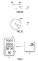
Figures 2A to 2E present, in an Euclidian 2D space, the determination of the position of a device in a specific example; -
Figure 3 represent schematically a device according to a specific embodiment of the invention. - In this detailed description, we consider a smartphone or device A which moves in the vicinity of an anchor device B, devices A and B having the possibility to communicate using Wi-Fi technology.
- At step E10 (t=t0), device A obtains the absolute position in Earth of anchor device B.
- In this embodiment, anchor device B broadcasts its position in periodic manner, during a Wi-Fi discovery procedure.
- In another embodiment, anchor device B provides its position to device A upon reception of a specific request received from device A.
- At step E20 (t=t0), device A determines a measure D0 of its distance to anchor device B.
- In this embodiment, this measure is estimated by device A using the strength of a signal received from anchor device B and the time and transmitted power of said signal by anchor device B.
- At step E30 (t=t0), device A determines a set AE0 of its possible positions from this measure D0. As shown
figure 2A , this first set AE0 is the circle of center B and radius D0. - At step E40 (t=t0), device A estimates a vector of its movement, i.e. a distance and direction of its movement during a short period of time.
- In this embodiment, device A determines said distance and direction using sensors employing earth's magnetic field measurements and motion detection. In particular, device A measures own travelled distance over a given interval and the angle with respect to the Earth coordinate system (azimuth).
- For example, device A stores a relative initial position (i.e. local coordinates Lx,Ly,Lz) and, at periodical intervals during a given period of time, utilizes sensors to detect its own vertical/horizontal position change as well as position change with respect to the azimuth. The accuracy of these values depends on many factors, such as sensor mechanics and sensitivity, rounding, initial position of the device, etc.
- At step E50 (t=t0), device A determines a subsequent set of its possible positions AE1 at a subsequent instant t1 from said set AE0 and from said vector of movement V0, as shown
Figure 2B . In other device A determines at t=t0, the positions in which it is likely to be at a subsequent instant t1, from its possible positions at t=t0 and its vector of movement V0 at t=t0. - At step E60, device A determines a measure D1 of its distance to anchor device B when said subsequent instant becomes said current instant, i.e. at t=t1.
- At step E70 (t=t1), device A obtains a new current set of possible positions AE1* by selecting within the subsequent set AE1 those which are at distance D1 from anchor device B. As shown
figure 2C , the new current set AE1* comprises two positions AE1* at the intersection of set AE1 with the circle of center B and radius D1. - At step E80 (t=t1), device A determines whether said current set AE1* comprises more than one element.
- If yes, step E80 is followed by step E40, where device A determines, at time current time t1, its vector of movement V1.
- At step E50 (t=t1), device A determines a subsequent set of its possible positions AE2 at a subsequent instant t2 from said set AE1* and from said vector of movement V1, as shown
Figure 2D . In other device A determines at t=t1, the positions in which it is likely to be at a subsequent instant t2, from its possible positions at t=t1 and its vector of movement V1 at t=t1. - At step E60, device A determines a measure D2 of its distance to anchor device B when said subsequent instant t2 becomes said current instant; ie at t=t2.
- At step E70 (t=t2), device A obtains a new current set of possible positions AE2* by selecting within the subsequent set AE2 those which are at distance D2 from anchor device B. As shown
figure 2E , the new current set AE2* comprises only one position on the circle of center B and radius D2. - At step E80 (t=t2), device A determines that current set AE2* comprises only one position.
- The current position of device A is therefore considered to be this position.
- Device A can recalculate this its own current position in the Earth spherical coordinate system, knowing its relative position to the anchor device B and the position of anchor device B in the Earth spherical coordinate system.
- For sake of clarity, the invention was presented in the context of Euclidean 2D situation, but the invention applies similarly in an Euclidean 3D space.
-
Figure 3 represents a device, more particularly, a smartphone A according to a particular embodiment of the invention. - In this particular embodiment, this smartphone comprises a
processor 10, Wi-Fi communication means 11, a RAMvolatile memory 12 and anon-volatile memory 13, for example a Read-Only memory or a flash memory. - The
non-volatile memory 13 is a recording medium according to the invention. It can be read byprocessor 10. It records a computer program according to the invention, this program comprising instructions for executing the steps E10 to E80 described above in reference tofigure 2 enabling the smartphone A to determine its position of obtaining the position knowing the position of anchor device B. - Device A comprises a module for obtaining a vector of movement of said device. In this embodiment, this
module 14 comprises several sensors including anaccelerometer 14a, agyroscope 14b and acompass 14c. - In this embodiment,
Wi_Fi module 11 is used to receive the position of anchor device B and to evaluate the distance between device A and anchor device B. -
Processor 10, when executing the computer program of the invention, constitutes a module for determining the possible positions of the device A using the vector of movement of device A and the distance to to anchor device B as explained above.
Claims (10)
- A method implemented by a mobile device (A) for obtaining its position, said method comprising the steps of:a. determining (E30) a current set of possible positions (AE0) of said device from a measure (D0) of the distance between said device (A) and an anchor device (B) at a current instant (t0);b. determining (E50) a subsequent set of possible positions (AE1) at a subsequent instant (t1) from said current set and from a vector of movement (V0) of said device (A) at said current instant (t0);c. estimating (E60) the distance (D1) between said device (A) and said anchor device (B) at said subsequent instant (t1)d. obtaining (E70) a new current set (AE1*) of possible positions of said device (A) by selecting (E70) within said subsequent set of possible positions those which are at said distance from said anchor device (B)repeating steps b. to d. until said current set (AE1*) comprises only one element and estimating that the position of said device is said element.
- The method of Claim 1, comprising a step (E10) of obtaining the position information of said anchor device (B) in periodic manner, said position being broadcast by said anchor device (B).
- The method of Claim 1, comprising a step (E10) of requesting the position information of said anchor device (B) to said anchor device (B).
- The method of any one of Claims 1 to 3, wherein said measure of distance is estimated using the strength of a signal received from said anchor device (B) and the time and transmitted power of said signal by said anchor device (B).
- The method of any one of Claims 1 to 4, wherein said device (A) determines said vector of movement (V1) using sensors employing earth's magnetic field measurements and motion detection.
- A device (A) comprising:- a module for determining a current set of possible positions (AE0) of this device from a measure (D0) of the distance between said device (A) and an anchor device (B) at a current instant (t0);- a control module for activating, as long as said current set (AE1*) comprises more than one element :- a module for obtaining a vector of movement of said device ;- a module for determining a subsequent set of possible positions (AE1) of this device at a subsequent instant (t1) from said current set and from a vector of movement (V0) of said device (A) at said current instant (t0);- a module for obtaining a new current set (AE1*) of possible positions of said device (A), this module having means for estimating the distance (D1) between said device (A) and said anchor device (B) at said subsequent instant (t1) and for selecting (E70) within said subsequent set of possible positions those which are at said distance from said anchor device (B);- said control module being configured to estimate that the position of said device is the element of said current set when said current set comprises only one element.
- A device according to Claim 6, wherein the module for obtaining a vector of movement of said device comprises at least one sensor among an accelerometer, a gyroscope and a compass sensors.
- A device according to Claims 6 or 7 characterized in that it is a smartphone.
- A computer program comprising instructions for executing the steps of the method of obtaining the position of a device according to any one of claims 1 to 5 when the program is executed by a processor (10).
- A recording medium (13) that can be read by a processor, said recording medium storing a computer program comprising instructions for executing the steps of the method of obtaining the position of a device any one of claims 1 to 5.
Priority Applications (4)
| Application Number | Priority Date | Filing Date | Title |
|---|---|---|---|
| EP13306657.1A EP2881751A1 (en) | 2013-12-03 | 2013-12-03 | Method implemented by a mobile device for obtaining its position and device implementing this method |
| EP14835491.3A EP3077840B1 (en) | 2013-12-03 | 2014-11-28 | Method implemented by a mobile device for obtaining its position and device implementing this method |
| PCT/IB2014/002918 WO2015082996A1 (en) | 2013-12-03 | 2014-11-28 | Method implemented by a mobile device for obtaining its position and device implementing this method |
| US15/100,939 US10330768B2 (en) | 2013-12-03 | 2014-11-28 | Method implemented by a mobile device for obtaining its position and device implementing this method |
Applications Claiming Priority (1)
| Application Number | Priority Date | Filing Date | Title |
|---|---|---|---|
| EP13306657.1A EP2881751A1 (en) | 2013-12-03 | 2013-12-03 | Method implemented by a mobile device for obtaining its position and device implementing this method |
Publications (1)
| Publication Number | Publication Date |
|---|---|
| EP2881751A1 true EP2881751A1 (en) | 2015-06-10 |
Family
ID=49882986
Family Applications (2)
| Application Number | Title | Priority Date | Filing Date |
|---|---|---|---|
| EP13306657.1A Withdrawn EP2881751A1 (en) | 2013-12-03 | 2013-12-03 | Method implemented by a mobile device for obtaining its position and device implementing this method |
| EP14835491.3A Active EP3077840B1 (en) | 2013-12-03 | 2014-11-28 | Method implemented by a mobile device for obtaining its position and device implementing this method |
Family Applications After (1)
| Application Number | Title | Priority Date | Filing Date |
|---|---|---|---|
| EP14835491.3A Active EP3077840B1 (en) | 2013-12-03 | 2014-11-28 | Method implemented by a mobile device for obtaining its position and device implementing this method |
Country Status (3)
| Country | Link |
|---|---|
| US (1) | US10330768B2 (en) |
| EP (2) | EP2881751A1 (en) |
| WO (1) | WO2015082996A1 (en) |
Citations (2)
| Publication number | Priority date | Publication date | Assignee | Title |
|---|---|---|---|---|
| US6300905B1 (en) | 1999-10-05 | 2001-10-09 | Lucent Technologies Inc. | Location finding using a single base station in CDMA/TDMA systems |
| US20130029685A1 (en) * | 2011-07-26 | 2013-01-31 | Mehran Moshfeghi | Distributed method and system for determining the position of a mobile device using long-range signals and calibrating the position using short-range signals |
Family Cites Families (5)
| Publication number | Priority date | Publication date | Assignee | Title |
|---|---|---|---|---|
| US5452211A (en) * | 1992-08-10 | 1995-09-19 | Caterpillar Inc. | Method and system for determining vehicle position |
| JPH08340570A (en) * | 1995-06-12 | 1996-12-24 | Kokusai Electric Co Ltd | Mobile object position confirmation system |
| US20060267841A1 (en) * | 2003-01-02 | 2006-11-30 | Lee Chong U | Position determination with peer-to-peer communication |
| GB201107849D0 (en) * | 2011-05-11 | 2011-06-22 | Cambridge Silicon Radio Ltd | Cooperative positioning |
| US9244152B1 (en) * | 2012-06-01 | 2016-01-26 | Amazon Technologies, Inc. | Determining device locations using movement, signal strength |
-
2013
- 2013-12-03 EP EP13306657.1A patent/EP2881751A1/en not_active Withdrawn
-
2014
- 2014-11-28 EP EP14835491.3A patent/EP3077840B1/en active Active
- 2014-11-28 WO PCT/IB2014/002918 patent/WO2015082996A1/en not_active Ceased
- 2014-11-28 US US15/100,939 patent/US10330768B2/en active Active
Patent Citations (2)
| Publication number | Priority date | Publication date | Assignee | Title |
|---|---|---|---|---|
| US6300905B1 (en) | 1999-10-05 | 2001-10-09 | Lucent Technologies Inc. | Location finding using a single base station in CDMA/TDMA systems |
| US20130029685A1 (en) * | 2011-07-26 | 2013-01-31 | Mehran Moshfeghi | Distributed method and system for determining the position of a mobile device using long-range signals and calibrating the position using short-range signals |
Non-Patent Citations (1)
| Title |
|---|
| PREM B KUMAR ET AL: "A Survey of Positioning Algorithms on Mobile Devices in Location Based Services", INTERNATIONAL JOURNAL OF ADVANCED RESEARCH IN COMPUTER SCIENCE AND SOFTWARE ENGINEERING, 6 June 2013 (2013-06-06), XP055119283, Retrieved from the Internet <URL:http://www.ijarcsse.com/docs/papers/Volume_3/6_June2013/V3I5-0480.pdf> [retrieved on 20140521] * |
Also Published As
| Publication number | Publication date |
|---|---|
| US20160299211A1 (en) | 2016-10-13 |
| WO2015082996A1 (en) | 2015-06-11 |
| EP3077840B1 (en) | 2020-01-08 |
| EP3077840A1 (en) | 2016-10-12 |
| US10330768B2 (en) | 2019-06-25 |
Similar Documents
| Publication | Publication Date | Title |
|---|---|---|
| Tian et al. | A low-cost INS and UWB fusion pedestrian tracking system | |
| EP3967087B1 (en) | Collaborative positioning | |
| KR102604366B1 (en) | System and method for location measurement | |
| EP2357494B1 (en) | Sensor-assisted location-aware mobile device | |
| EP2449411B1 (en) | Trajectory-based location determination | |
| US9035827B2 (en) | Positioning using a local wave-propagation model | |
| US9103917B2 (en) | Method and system for determining location within a building based on historical location information | |
| US9377519B2 (en) | Server-based mobile device regional candidate position fix mode selection | |
| EP2336808A1 (en) | Method and system for mobile device based GNSS position computation without ephemeris data | |
| US20210405213A1 (en) | Techniques for detection of global navigation satellite system (gnss) error using motion sensor output | |
| US9116006B2 (en) | Apparatus and method for determining indoor collection points and collecting heterogeneous infrastructure measurement information | |
| KR20150018827A (en) | Method and apparatus for determining locations of access points | |
| Elazab et al. | Integrated cooperative localization for connected vehicles in urban canyons | |
| US8634846B2 (en) | Method and system for determining a location of a mobile device based on a plurality of location samples | |
| CN112630803A (en) | Positioning system and method | |
| WO2016064631A1 (en) | Mitigating effects of multipath during position computation | |
| US20170201865A1 (en) | Location estimation apparatus and method using combination of different positioning resources | |
| KR20130116151A (en) | Method of estimating location of pedestrian using step length estimation model parameter and apparatus for the same | |
| US20160124069A1 (en) | Systems and methods for estimating a two-dimensional position of a receiver | |
| US20150141042A1 (en) | Mobile terminal, system and method | |
| KR101975438B1 (en) | Synchronous interior navigation system and method using gnss | |
| US9921291B2 (en) | Multi-tiered distance travelled estimator | |
| EP3077840B1 (en) | Method implemented by a mobile device for obtaining its position and device implementing this method | |
| KR101428374B1 (en) | Method and apparatus for location tracking of mobile terminal | |
| Elazab | Integrated cooperative localization in vanets for gps denied environments |
Legal Events
| Date | Code | Title | Description |
|---|---|---|---|
| PUAI | Public reference made under article 153(3) epc to a published international application that has entered the european phase |
Free format text: ORIGINAL CODE: 0009012 |
|
| 17P | Request for examination filed |
Effective date: 20131203 |
|
| AK | Designated contracting states |
Kind code of ref document: A1 Designated state(s): AL AT BE BG CH CY CZ DE DK EE ES FI FR GB GR HR HU IE IS IT LI LT LU LV MC MK MT NL NO PL PT RO RS SE SI SK SM TR |
|
| AX | Request for extension of the european patent |
Extension state: BA ME |
|
| STAA | Information on the status of an ep patent application or granted ep patent |
Free format text: STATUS: THE APPLICATION IS DEEMED TO BE WITHDRAWN |
|
| 18D | Application deemed to be withdrawn |
Effective date: 20151211 |