EP2815202B1 - A method for determining threat status for combat aircrafts - Google Patents
A method for determining threat status for combat aircrafts Download PDFInfo
- Publication number
- EP2815202B1 EP2815202B1 EP12868862.9A EP12868862A EP2815202B1 EP 2815202 B1 EP2815202 B1 EP 2815202B1 EP 12868862 A EP12868862 A EP 12868862A EP 2815202 B1 EP2815202 B1 EP 2815202B1
- Authority
- EP
- European Patent Office
- Prior art keywords
- combat
- aircraft
- aircrafts
- situation
- displaying
- Prior art date
- Legal status (The legal status is an assumption and is not a legal conclusion. Google has not performed a legal analysis and makes no representation as to the accuracy of the status listed.)
- Active
Links
Images
Classifications
-
- F—MECHANICAL ENGINEERING; LIGHTING; HEATING; WEAPONS; BLASTING
- F41—WEAPONS
- F41G—WEAPON SIGHTS; AIMING
- F41G3/00—Aiming or laying means
- F41G3/22—Aiming or laying means for vehicle-borne armament, e.g. on aircraft
-
- F—MECHANICAL ENGINEERING; LIGHTING; HEATING; WEAPONS; BLASTING
- F41—WEAPONS
- F41G—WEAPON SIGHTS; AIMING
- F41G9/00—Systems for controlling missiles or projectiles, not provided for elsewhere
-
- F—MECHANICAL ENGINEERING; LIGHTING; HEATING; WEAPONS; BLASTING
- F41—WEAPONS
- F41G—WEAPON SIGHTS; AIMING
- F41G9/00—Systems for controlling missiles or projectiles, not provided for elsewhere
- F41G9/002—Systems for controlling missiles or projectiles, not provided for elsewhere for guiding a craft to a correct firing position
Definitions
- the invention relates to a method for decision support of a first combat aircraft in a combat situation.
- Document US 4,947,350 describes a tactical routing apparatus, for instance for an aircraft, which comprises stores for storing data representing the geographical domain through which the aircraft is to pass and data representing the location and type of a plurality of threats, and a processor for determining and displaying on a video display unit the optimal route connecting two points and the probability of successfully completing the route.
- HMI human machine interface
- decision support supports the multiple use of sensors by merging objects detected by several different sensors and coordinating and correlating these objects in a situation picture. This is usually done via networks in further steps to create a common situation picture between several aircraft within an aircraft group.
- the second combat aircraft corresponds to at least one second combat aircraft arranged near the ground or on the ground and/or to another threat object which is arranged near the ground or on the ground, i.e. to a ground based threat, such as to a surface-to-air missile site, SAM for short.
- a ground based threat such as to a surface-to-air missile site, SAM for short.
- SAM surface-to-air missile site
- a single geographic zone is integrated as the sum of the pluralities of the second combat aircrafts and/or the ground based threats.
- an integrated detection area and an integrated shoot-down area is obtained.
- Each enemy aircraft comprises its own detection area.
- the first combat aircraft preferably recognizes the larger sum as an integrated defence detection area.
- the plurality of enemy aircrafts preferably communicate their information between them such that when the first combat aircraft is detected and/or shot down by any of the enemy aircrafts the other enemy aircrafts become aware of this.
- the method comprises the step of storing the analyzed data in step b) and/or the recorded data in step c), wherein the recorded data is adapted for generating a situation picture.
- the method comprises the step of displaying the analyzed data in step b) and/or the recorded data in step c).
- the step of displaying the recorded data in step c) preferably comprises displaying a plurality of situation pictures.
- the method preferably records the altitude of the first combat aircraft and/or of the second combat aircraft and displays the altitude together with the plurality of situation pictures such that a plurality of three dimensional plots results.
- the method preferably records time and displays the time together with a plurality of three dimensional plots such that a plurality of four dimensional plots results.
- the method further comprises the step of analyzing a flight regulated restriction and/or a landing zone approach requirement adapted for indicating a flight regulated area and/or a no-fly region.
- a flight regulated area preferably corresponds to a landing area or to a commercial flight "corridor”.
- a no-fly region or no-fly zone preferably corresponds to a third country border.
- the step of detecting is preferably performed by a sensor, such as radar, a database and/or a link.
- a sensor such as radar
- a database this preferably corresponds to detecting by using a plurality of libraries for comparison purposes and when the step of detecting is performed by a link this preferably corresponds to an object, such as to a marine object, sending the required information to the first combat aircraft.
- the first combat aircraft comprises a pilot's own aircraft and the second combat aircraft comprises an enemy aircraft and/or a ground based threat, such as a SAM, arranged near or on the ground or to a marine vessel.
- a ground based threat such as a SAM
- the second combat aircraft corresponds to an UAV.
- the ground based threat preferably corresponds to a SAM.
- the invention thus serves for reducing the work load and stress level of the pilot before entering a combat situation. The pilot can then plan his entry into a detection zone more effectively and achieves a position of superiority before the subsequent duel. Thus the pilot can completely avoid approaching a shoot-down zone.
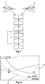
- Fig. 1 illustrates the steps of a method for decision support of a first combat aircraft 1 in a combat situation according to a preferred embodiment of the invention.
- the method comprises the step of detecting 3 a second combat aircraft 2, wherein the second combat aircraft 2 is different from the first combat aircraft 1.
- the second combat aircraft 2 is analyzed 4 in order to determine its type, its sensor capacity and its total weapons capacity.
- the sensor capacity and the total weapons capacity of the second combat aircraft 2 is recorded 5 in order to determine a first geographic zone adapted for defining the detection limit of the second combat aircraft 2 and a second geographic zone adapted for defining a shoot-down limit of the second combat aircraft 2.
- the method can comprise the step of storing 6 the analyzed data in step b) and/or the recorded data in step c). Further, the method can comprise the step of displaying 7 the analyzed data in step b) and/or the recorded data in step c). Moreover, the method can comprise the step of analyzing 8 a flight regulated restriction and/or a landing zone approach requirement adapted for indicating a flight regulated area and/or a no-fly region.
- Fig. 2 shows the geographic zones 9, 10 integrated on the basis of the total capacity of the enemy according to another preferred embodiment of the invention. Every detected or assumed enemy is type-classified. Typing enables an idea to be gained of the detectability of the sensor system of the enemy and also of the shoot-down capacity, i.e. the weapons system, of the enemy. All detected enemies are incorporated in the situation picture in the position perceived.
- the sensor limit range of the enemy or enemies involved are linked together by means of union such that a total sensor limit area can be illustrated to the pilot.
- the union of the sensor coverage forms the total detection area of the enemy framed by detection limit and corresponds to the first geographic zone 9. It is noted that the corresponding limit for the weapons range forms the shoot-down limit corresponding to the second geographic zone 10.
- Fixed limits of another type, for instance of a no-fly region and third party landing limits, are also incorporated in the HMI implementation according to this preferred embodiment of the invention.
- the invention provides a possibility of being able to visualize decision support quickly and reliably relating to the risk based on being detected by the enemy aircraft or threat object and of being shot down.
Landscapes
- Engineering & Computer Science (AREA)
- General Engineering & Computer Science (AREA)
- Aviation & Aerospace Engineering (AREA)
- Radar Systems Or Details Thereof (AREA)
- Traffic Control Systems (AREA)
- Measurement Of Mechanical Vibrations Or Ultrasonic Waves (AREA)
Description
- The invention relates to a method for decision support of a first combat aircraft in a combat situation.
- Document
US 4,947,350 describes a tactical routing apparatus, for instance for an aircraft, which comprises stores for storing data representing the geographical domain through which the aircraft is to pass and data representing the location and type of a plurality of threats, and a processor for determining and displaying on a video display unit the optimal route connecting two points and the probability of successfully completing the route. - In combat aircrafts highly developed functions for human machine interface, HMI for short, and decision support exist and work as support functions for the pilot environment. These solutions are typically based on and adapted for high tempo in flight and combat situations where HMI and decision support together describe the current situation and display tools and solutions to the pilot. The solutions are usually based on the aircraft itself and its available resources and tools. Sensors, such as radar, are operated by the pilot as a tool for close-range scanning or for scanning objects for identification and continued pursuit. Typically, decision support supports the multiple use of sensors by merging objects detected by several different sensors and coordinating and correlating these objects in a situation picture. This is usually done via networks in further steps to create a common situation picture between several aircraft within an aircraft group.
- When complexity increases because more tools and sensors are supplied, the possibilities available to the pilot to control his tools and/or sensors in time are limited and made difficult. In time-critical situations, for instance in air combat, the pilot risks becoming the underdog in combat. Another limitation is the fact that each tool and/or sensor has its own characteristics and peculiarities. Each sensor and/or tool thus requires its own interface and control functions which the pilot needs to be able to understand and use correctly.
- Examples of prior art may be found in document
US 5838262 of 19 December 1996 , from Sikorsky Aircraft Corp., which is entitled "aircraft virtual image display system and method for providing a real-time perspective threat coverage display". - It is the object of the invention to provide a possibility to assist a pilot in decision support in complicated combat situations while being reliable, fast and easy to handle for the pilot in order to make a quick and efficient decision.
- This object is achieved by the subject matter of
independent claim 1. Preferred embodiments are defined in the sub claims. - It is an idea of the invention to use information for a pilot or an unmanned aerial vehicle, UAV for short, in order to handle a complicated situation. Usually obstacles, such as hills, have an impact on the geographic zone. Furthermore, the geographic zone typically moves with the second combat aircraft. It is noted that the first geographic zone and the second geographic zone are independent from each other and that the first geographic zone refers to the sensors available and the second geographic zone refers to the weapons and/or fire control systems available.
- According to a preferred embodiment of the invention, the second combat aircraft corresponds to at least one second combat aircraft arranged near the ground or on the ground and/or to another threat object which is arranged near the ground or on the ground, i.e. to a ground based threat, such as to a surface-to-air missile site, SAM for short. By adding a plurality of second combat aircrafts and/or by adding a plurality of ground based threats a single geographic zone is integrated as the sum of the pluralities of the second combat aircrafts and/or the ground based threats. Preferably, by combining the SAM zone and the enemy aircraft zone, i.e., the aircraft zones of the second combat aircrafts, an integrated detection area and an integrated shoot-down area is obtained. Each enemy aircraft comprises its own detection area. In case of a plurality of enemy aircrafts and/or a plurality of ground stations it becomes possible to add their parts into a larger sum, i.e. to a larger detection area and/or to a longer range. The first combat aircraft preferably recognizes the larger sum as an integrated defence detection area. The plurality of enemy aircrafts preferably communicate their information between them such that when the first combat aircraft is detected and/or shot down by any of the enemy aircrafts the other enemy aircrafts become aware of this.
- According to a preferred embodiment of the invention, the method comprises the step of storing the analyzed data in step b) and/or the recorded data in step c), wherein the recorded data is adapted for generating a situation picture. Preferably, the method comprises the step of displaying the analyzed data in step b) and/or the recorded data in step c). The step of displaying the recorded data in step c) preferably comprises displaying a plurality of situation pictures. The method preferably records the altitude of the first combat aircraft and/or of the second combat aircraft and displays the altitude together with the plurality of situation pictures such that a plurality of three dimensional plots results. The method preferably records time and displays the time together with a plurality of three dimensional plots such that a plurality of four dimensional plots results.
- According to a preferred embodiment of the invention, the method further comprises the step of analyzing a flight regulated restriction and/or a landing zone approach requirement adapted for indicating a flight regulated area and/or a no-fly region. A flight regulated area preferably corresponds to a landing area or to a commercial flight "corridor". A no-fly region or no-fly zone preferably corresponds to a third country border.
- The step of detecting is preferably performed by a sensor, such as radar, a database and/or a link. When the step of detecting is performed by a database this preferably corresponds to detecting by using a plurality of libraries for comparison purposes and when the step of detecting is performed by a link this preferably corresponds to an object, such as to a marine object, sending the required information to the first combat aircraft. Preferably, the first combat aircraft comprises a pilot's own aircraft and the second combat aircraft comprises an enemy aircraft and/or a ground based threat, such as a SAM, arranged near or on the ground or to a marine vessel. However, according to other preferred embodiments, also UAVs can be involved. Preferably, the second combat aircraft corresponds to an UAV. The ground based threat preferably corresponds to a SAM.
- It is an idea of the invention to provide an HMI implementation which analyzes and summarizes the integrated ability of the enemy to detect and/or to destroy the pilot's own aircraft in a combat situation. All detected or assumed enemies with their assessed characteristics are summarized to form an integrated position evaluation. Their total sensor capacity is preferably recorded as a detection limit and the total weapons capacity preferably corresponds to a shoot-down limit or to a destroy limit. The invention thus serves for reducing the work load and stress level of the pilot before entering a combat situation. The pilot can then plan his entry into a detection zone more effectively and achieves a position of superiority before the subsequent duel. Thus the pilot can completely avoid approaching a shoot-down zone.
- These and other aspects of the invention will be apparent from and elucidated with reference to the embodiments described hereinafter.
- In the drawings:
- Fig. 1
- illustrates the steps of a method for decision support of a first combat aircraft in a combat situation according to a preferred embodiment of the invention; and
- Fig. 2
- illustrates the geographic zones integrated on the basis of the total capacity of the enemy according to another preferred embodiment of the invention.
-
Fig. 1 illustrates the steps of a method for decision support of afirst combat aircraft 1 in a combat situation according to a preferred embodiment of the invention. The method comprises the step of detecting 3 asecond combat aircraft 2, wherein thesecond combat aircraft 2 is different from thefirst combat aircraft 1. In a second step, thesecond combat aircraft 2 is analyzed 4 in order to determine its type, its sensor capacity and its total weapons capacity. In a third step, the sensor capacity and the total weapons capacity of thesecond combat aircraft 2 is recorded 5 in order to determine a first geographic zone adapted for defining the detection limit of thesecond combat aircraft 2 and a second geographic zone adapted for defining a shoot-down limit of thesecond combat aircraft 2. In further steps, the method can comprise the step of storing 6 the analyzed data in step b) and/or the recorded data in step c). Further, the method can comprise the step of displaying 7 the analyzed data in step b) and/or the recorded data in step c). Moreover, the method can comprise the step of analyzing 8 a flight regulated restriction and/or a landing zone approach requirement adapted for indicating a flight regulated area and/or a no-fly region. -
Fig. 2 shows thegeographic zones geographic zone 9. It is noted that the corresponding limit for the weapons range forms the shoot-down limit corresponding to the secondgeographic zone 10. Fixed limits of another type, for instance of a no-fly region and third party landing limits, are also incorporated in the HMI implementation according to this preferred embodiment of the invention. - It is an idea of the invention that before combat the pilot becomes able to prioritize his overview in the whole situation picture. Further, a more effective idea of the situation is given by means of an integrated situation picture for situations which do not contain a duel. The invention provides a possibility of being able to visualize decision support quickly and reliably relating to the risk based on being detected by the enemy aircraft or threat object and of being shot down.
- While the invention has been illustrated and described in detail in the drawings and foregoing description, such illustration and description are to be considered illustrative or exemplary and not restrictive and it is not intended to limit the invention to the disclosed embodiments. The mere fact that certain measures are recited in mutually different dependent claims does not indicate that a combination of these measures cannot be used advantageously.
Claims (12)
- A method for decision support of a first combat aircraft (1) in a combat situation comprising the steps of:a) detecting (3) a plurality of second combat aircrafts (2), wherein the plurality of second combat aircrafts (2) is different from the first combat aircraft (1),b) analyzing (4) the plurality of second combat aircrafts (2) to determine their type, their sensor capacity and their total weapons capacity, andc) recording (5) the sensor capacity and the total weapons capacity of the plurality of second combat aircrafts (2) and determining for each one of the plurality of second combat aircraft a respective first geographic zone adapted for defining the detection limit of the respective second combat aircrafts (2) and a respective second geographic zone adapted for defining a shoot-down limit of the respective second combat aircrafts (2), wherein the first and the second geographic zones are adapted for decision support of the first combat aircraft (1) in the combat situation with the plurality of second combat aircrafts (2),said method being characterized in that the respective first geographic zones are integrated as a single geographic zone by summing the respective first geographical zones to thereby form an integrated detection area, and in that the respective second geographic zones are integrated as a single geographic zone by summing the respective second geographical zones to thereby form an integrated shoot-down area.
- The method according to claim 1, comprising the step of storing (6) the analyzed data in step b) and/or the recorded data in step c), wherein the recorded data is adapted for generating a situation picture.
- The method according to one of the preceding claims, comprising the step of displaying (7) the analyzed data in step b) and/or the recorded data in step c).
- The method according to claim 3, wherein the step of displaying (7) the recorded data in step c) comprises displaying a plurality of situation pictures.
- The method according to claim 4, further recording (5) the altitude of the first combat aircraft (1) and/or of the plurality of second combat aircrafts (2) and displaying (7) the altitude together with the plurality of situation pictures such that a plurality of three dimensional plots results.
- The method according to claim 5, further recording (5) time and displaying (7) the time together with the plurality of three dimensional plots such that a plurality of four dimensional plots results.
- The method according to one of the preceding claims, further comprising the step of analyzing (8) a flight regulated restriction and/or a landing zone approach requirement adapted for indicating a flight regulated area and/or a no-fly region.
- The method according to one of the preceding claims, wherein the step of detecting (3) is performed by a sensor, such as radar, a database and/or a link.
- The method according to claim 8, wherein when the step of detecting (3) is performed by a database this corresponds to detecting by using a plurality of libraries for comparison purposes and when the step of detecting (3) is performed by a link this corresponds to an object, such as to a marine object, sending the required information to the first combat aircraft (1).
- The method according to one of the preceding claims, wherein the first combat aircraft (1) comprises a pilot's own aircraft and the plurality of second combat aircrafts (2) comprises an enemy aircraft and/or a ground based threat.
- The method according to claim 10, wherein the plurality of second combat aircrafts (2) corresponds to an unmanned aerial vehicle.
- The method according to claim 10, wherein the ground based threat corresponds to a surface-to-air missile site.
Applications Claiming Priority (1)
| Application Number | Priority Date | Filing Date | Title |
|---|---|---|---|
| PCT/SE2012/050168 WO2013122521A1 (en) | 2012-02-16 | 2012-02-16 | A method for determining threat status for combat aircrafts |
Publications (3)
| Publication Number | Publication Date |
|---|---|
| EP2815202A1 EP2815202A1 (en) | 2014-12-24 |
| EP2815202A4 EP2815202A4 (en) | 2015-10-28 |
| EP2815202B1 true EP2815202B1 (en) | 2020-11-18 |
Family
ID=48984520
Family Applications (1)
| Application Number | Title | Priority Date | Filing Date |
|---|---|---|---|
| EP12868862.9A Active EP2815202B1 (en) | 2012-02-16 | 2012-02-16 | A method for determining threat status for combat aircrafts |
Country Status (5)
| Country | Link |
|---|---|
| US (1) | US8909394B2 (en) |
| EP (1) | EP2815202B1 (en) |
| BR (1) | BR112014010852A8 (en) |
| IN (1) | IN2014DN03130A (en) |
| WO (1) | WO2013122521A1 (en) |
Families Citing this family (9)
| Publication number | Priority date | Publication date | Assignee | Title |
|---|---|---|---|---|
| BR112014014149A2 (en) * | 2011-12-16 | 2017-06-13 | Saab Ab | decision support method of a combat object |
| US8791836B2 (en) | 2012-03-07 | 2014-07-29 | Lockheed Martin Corporation | Reflexive response system for popup threat survival |
| US9030347B2 (en) * | 2012-05-03 | 2015-05-12 | Lockheed Martin Corporation | Preemptive signature control for vehicle survivability planning |
| US9240001B2 (en) | 2012-05-03 | 2016-01-19 | Lockheed Martin Corporation | Systems and methods for vehicle survivability planning |
| US10822110B2 (en) | 2015-09-08 | 2020-11-03 | Lockheed Martin Corporation | Threat countermeasure assistance system |
| EP3357040A4 (en) | 2015-09-30 | 2019-06-26 | Alarm.com Incorporated | DRONES DETECTION SYSTEMS |
| SE1650700A1 (en) * | 2016-05-23 | 2017-11-24 | Saab Ab | HMI controlled by combat situation |
| US11240274B2 (en) | 2017-12-21 | 2022-02-01 | Alarm.Com Incorporated | Monitoring system for securing networks from hacker drones |
| CN114239281B (en) * | 2021-12-17 | 2024-05-03 | 中国航空研究院 | Battlefield information ontology model construction method for multi-domain collaborative combat |
Family Cites Families (18)
| Publication number | Priority date | Publication date | Assignee | Title |
|---|---|---|---|---|
| CA1253965A (en) | 1985-04-01 | 1989-05-09 | Declan G. Murray | Tactical routing system and method |
| IL112239A0 (en) * | 1994-01-18 | 1995-03-30 | Honeywell Inc | Method and system for managing aircraft threat data |
| US5635662A (en) * | 1996-02-07 | 1997-06-03 | The United States Of America As Represented By The Secretary Of The Navy | Method and apparatus for avoiding detection by a threat projectile |
| US5838262A (en) | 1996-12-19 | 1998-11-17 | Sikorsky Aircraft Corporation | Aircraft virtual image display system and method for providing a real-time perspective threat coverage display |
| GB9929656D0 (en) * | 1999-12-16 | 2000-02-09 | Lucy John C | Airborne fire fighting craft |
| US7132961B2 (en) * | 2002-08-12 | 2006-11-07 | Bae Systems Information And Electronic Systems Integration Inc. | Passive RF, single fighter aircraft multifunction aperture sensor, air to air geolocation |
| US7376542B2 (en) | 2003-08-15 | 2008-05-20 | The Boeing Company | System, method and computer program product for modeling a force structure |
| US7447593B2 (en) * | 2004-03-26 | 2008-11-04 | Raytheon Company | System and method for adaptive path planning |
| US7269411B2 (en) * | 2004-06-16 | 2007-09-11 | The Boeing Company | Methods and systems for providing information network access to a host agent via a guardian agent |
| FR2874258B1 (en) * | 2004-08-10 | 2006-11-03 | Thales Sa | METHOD FOR DISPLAYING MAPPING INFORMATION AND AERONAUTICAL AREAS ON AIRCRAFT SCREEN |
| EP1877829A2 (en) * | 2005-03-28 | 2008-01-16 | United Technologies Corporation | Vehicle-based threat detection system |
| US7148835B1 (en) * | 2005-06-24 | 2006-12-12 | Lockheed Martin Corporation | Method and apparatus for identifying ownship threats |
| US7848879B2 (en) * | 2006-12-04 | 2010-12-07 | Lockheed Martin Corporation | Survivability system |
| US8594882B2 (en) * | 2008-01-16 | 2013-11-26 | The Boeing Company | Damage detection system |
| US8164510B2 (en) * | 2008-01-31 | 2012-04-24 | Bae Systems Information And Electronic Systems Integration Inc. | Quantity smoother |
| US8280702B2 (en) | 2008-07-08 | 2012-10-02 | Lockheed Martin Corporation | Vehicle aspect control |
| US7948426B2 (en) * | 2009-10-26 | 2011-05-24 | Southwest Research Institute | Detection and location of radio frequency weapons from high altitude glider system |
| US8483356B2 (en) * | 2009-10-29 | 2013-07-09 | Rapiscan Systems, Inc. | Mobile aircraft inspection system |
-
2012
- 2012-02-16 EP EP12868862.9A patent/EP2815202B1/en active Active
- 2012-02-16 US US14/352,280 patent/US8909394B2/en active Active
- 2012-02-16 IN IN3130DEN2014 patent/IN2014DN03130A/en unknown
- 2012-02-16 BR BR112014010852A patent/BR112014010852A8/en not_active Application Discontinuation
- 2012-02-16 WO PCT/SE2012/050168 patent/WO2013122521A1/en not_active Ceased
Non-Patent Citations (1)
| Title |
|---|
| None * |
Also Published As
| Publication number | Publication date |
|---|---|
| EP2815202A4 (en) | 2015-10-28 |
| WO2013122521A1 (en) | 2013-08-22 |
| BR112014010852A2 (en) | 2017-06-13 |
| IN2014DN03130A (en) | 2015-05-22 |
| BR112014010852A8 (en) | 2017-06-20 |
| US8909394B2 (en) | 2014-12-09 |
| EP2815202A1 (en) | 2014-12-24 |
| US20140277852A1 (en) | 2014-09-18 |
Similar Documents
| Publication | Publication Date | Title |
|---|---|---|
| US8909394B2 (en) | Method for determining threat status for combat aircrafts | |
| National Research Council et al. | Autonomous vehicles in support of naval operations | |
| Zheng et al. | Leveraging the internet of things for a more efficient and effective military | |
| EP2498055B2 (en) | Management System for Unmanned Aerial Vehicles | |
| Adnan et al. | Drone use in military and civilian application: Risk to national security | |
| US20100010793A1 (en) | Vehicle aspect control | |
| WO2015009705A2 (en) | Mission component evaluation and response architecture | |
| US9007257B2 (en) | Method for variable control of a zone sensor in a combat aircraft | |
| Sattler | Aviation Artificial Intelligence: How Will it Fare in the Multi-Domain environment | |
| Otto | Small unmanned aircraft systems (SUAS) flight plan: 2016-2036. Bridging the gap between tactical and strategic | |
| Robertson | Systems theoretic process analysis applied to manned-unmanned teaming | |
| Schnitker et al. | Drone law and policy: Integration into the legal order of civil aviation | |
| Piekarski et al. | Employment of uncrewed systems in attacks on critical infrastructure: a hybrid threat perspective. Security challenges related to recent developments in technology. | |
| Studiawan et al. | Drone and UAV Forensics: A Hands-On Approach | |
| US20140288907A1 (en) | Method for duel handling in a combat aircraft | |
| Teo | Closing the gap between research and field applications for multi-UAV cooperative missions | |
| Özer | Avionics and communication architecture design for intelligent automated fixed-wing armed aircraft | |
| Kochan | Automation in the sky | |
| Doyle | Mission Engineering Methodology for Realization of Unmanned Surface Vessel Operations | |
| Lee | Embracing autonomy: The key to developing a new generation of remotely piloted aircraft for operations in contested air environments | |
| US11545040B2 (en) | MUM-T route emphasis | |
| EP3465096B1 (en) | Method for controlling a display mode in a combat aircraft | |
| Helldin et al. | Supporting fighter pilot decision making through team option awareness | |
| Nohel et al. | The Requirements of Commanders on Ground Control Station of Heterogenous Swarm Robotic Systems | |
| Ehredt | NATO-Joint Air Power Competence Centre |
Legal Events
| Date | Code | Title | Description |
|---|---|---|---|
| PUAI | Public reference made under article 153(3) epc to a published international application that has entered the european phase |
Free format text: ORIGINAL CODE: 0009012 |
|
| 17P | Request for examination filed |
Effective date: 20140709 |
|
| AK | Designated contracting states |
Kind code of ref document: A1 Designated state(s): AL AT BE BG CH CY CZ DE DK EE ES FI FR GB GR HR HU IE IS IT LI LT LU LV MC MK MT NL NO PL PT RO RS SE SI SK SM TR |
|
| AX | Request for extension of the european patent |
Extension state: BA ME |
|
| DAX | Request for extension of the european patent (deleted) | ||
| RA4 | Supplementary search report drawn up and despatched (corrected) |
Effective date: 20150924 |
|
| RIC1 | Information provided on ipc code assigned before grant |
Ipc: F41G 3/22 20060101AFI20150918BHEP Ipc: F41G 9/00 20060101ALI20150918BHEP Ipc: G05D 1/10 20060101ALI20150918BHEP |
|
| STAA | Information on the status of an ep patent application or granted ep patent |
Free format text: STATUS: EXAMINATION IS IN PROGRESS |
|
| 17Q | First examination report despatched |
Effective date: 20190405 |
|
| GRAP | Despatch of communication of intention to grant a patent |
Free format text: ORIGINAL CODE: EPIDOSNIGR1 |
|
| STAA | Information on the status of an ep patent application or granted ep patent |
Free format text: STATUS: GRANT OF PATENT IS INTENDED |
|
| INTG | Intention to grant announced |
Effective date: 20200619 |
|
| GRAS | Grant fee paid |
Free format text: ORIGINAL CODE: EPIDOSNIGR3 |
|
| GRAA | (expected) grant |
Free format text: ORIGINAL CODE: 0009210 |
|
| STAA | Information on the status of an ep patent application or granted ep patent |
Free format text: STATUS: THE PATENT HAS BEEN GRANTED |
|
| AK | Designated contracting states |
Kind code of ref document: B1 Designated state(s): AL AT BE BG CH CY CZ DE DK EE ES FI FR GB GR HR HU IE IS IT LI LT LU LV MC MK MT NL NO PL PT RO RS SE SI SK SM TR |
|
| REG | Reference to a national code |
Ref country code: GB Ref legal event code: FG4D |
|
| REG | Reference to a national code |
Ref country code: CH Ref legal event code: EP |
|
| REG | Reference to a national code |
Ref country code: IE Ref legal event code: FG4D |
|
| REG | Reference to a national code |
Ref country code: DE Ref legal event code: R096 Ref document number: 602012073327 Country of ref document: DE |
|
| REG | Reference to a national code |
Ref country code: AT Ref legal event code: REF Ref document number: 1336234 Country of ref document: AT Kind code of ref document: T Effective date: 20201215 |
|
| REG | Reference to a national code |
Ref country code: AT Ref legal event code: MK05 Ref document number: 1336234 Country of ref document: AT Kind code of ref document: T Effective date: 20201118 |
|
| REG | Reference to a national code |
Ref country code: NL Ref legal event code: MP Effective date: 20201118 |
|
| PG25 | Lapsed in a contracting state [announced via postgrant information from national office to epo] |
Ref country code: FI Free format text: LAPSE BECAUSE OF FAILURE TO SUBMIT A TRANSLATION OF THE DESCRIPTION OR TO PAY THE FEE WITHIN THE PRESCRIBED TIME-LIMIT Effective date: 20201118 Ref country code: RS Free format text: LAPSE BECAUSE OF FAILURE TO SUBMIT A TRANSLATION OF THE DESCRIPTION OR TO PAY THE FEE WITHIN THE PRESCRIBED TIME-LIMIT Effective date: 20201118 Ref country code: PT Free format text: LAPSE BECAUSE OF FAILURE TO SUBMIT A TRANSLATION OF THE DESCRIPTION OR TO PAY THE FEE WITHIN THE PRESCRIBED TIME-LIMIT Effective date: 20210318 Ref country code: NO Free format text: LAPSE BECAUSE OF FAILURE TO SUBMIT A TRANSLATION OF THE DESCRIPTION OR TO PAY THE FEE WITHIN THE PRESCRIBED TIME-LIMIT Effective date: 20210218 Ref country code: GR Free format text: LAPSE BECAUSE OF FAILURE TO SUBMIT A TRANSLATION OF THE DESCRIPTION OR TO PAY THE FEE WITHIN THE PRESCRIBED TIME-LIMIT Effective date: 20210219 |
|
| PG25 | Lapsed in a contracting state [announced via postgrant information from national office to epo] |
Ref country code: AT Free format text: LAPSE BECAUSE OF FAILURE TO SUBMIT A TRANSLATION OF THE DESCRIPTION OR TO PAY THE FEE WITHIN THE PRESCRIBED TIME-LIMIT Effective date: 20201118 Ref country code: BG Free format text: LAPSE BECAUSE OF FAILURE TO SUBMIT A TRANSLATION OF THE DESCRIPTION OR TO PAY THE FEE WITHIN THE PRESCRIBED TIME-LIMIT Effective date: 20210218 Ref country code: IS Free format text: LAPSE BECAUSE OF FAILURE TO SUBMIT A TRANSLATION OF THE DESCRIPTION OR TO PAY THE FEE WITHIN THE PRESCRIBED TIME-LIMIT Effective date: 20210318 Ref country code: LV Free format text: LAPSE BECAUSE OF FAILURE TO SUBMIT A TRANSLATION OF THE DESCRIPTION OR TO PAY THE FEE WITHIN THE PRESCRIBED TIME-LIMIT Effective date: 20201118 Ref country code: PL Free format text: LAPSE BECAUSE OF FAILURE TO SUBMIT A TRANSLATION OF THE DESCRIPTION OR TO PAY THE FEE WITHIN THE PRESCRIBED TIME-LIMIT Effective date: 20201118 Ref country code: SE Free format text: LAPSE BECAUSE OF FAILURE TO SUBMIT A TRANSLATION OF THE DESCRIPTION OR TO PAY THE FEE WITHIN THE PRESCRIBED TIME-LIMIT Effective date: 20201118 |
|
| REG | Reference to a national code |
Ref country code: LT Ref legal event code: MG9D |
|
| PG25 | Lapsed in a contracting state [announced via postgrant information from national office to epo] |
Ref country code: HR Free format text: LAPSE BECAUSE OF FAILURE TO SUBMIT A TRANSLATION OF THE DESCRIPTION OR TO PAY THE FEE WITHIN THE PRESCRIBED TIME-LIMIT Effective date: 20201118 |
|
| PG25 | Lapsed in a contracting state [announced via postgrant information from national office to epo] |
Ref country code: SK Free format text: LAPSE BECAUSE OF FAILURE TO SUBMIT A TRANSLATION OF THE DESCRIPTION OR TO PAY THE FEE WITHIN THE PRESCRIBED TIME-LIMIT Effective date: 20201118 Ref country code: RO Free format text: LAPSE BECAUSE OF FAILURE TO SUBMIT A TRANSLATION OF THE DESCRIPTION OR TO PAY THE FEE WITHIN THE PRESCRIBED TIME-LIMIT Effective date: 20201118 Ref country code: LT Free format text: LAPSE BECAUSE OF FAILURE TO SUBMIT A TRANSLATION OF THE DESCRIPTION OR TO PAY THE FEE WITHIN THE PRESCRIBED TIME-LIMIT Effective date: 20201118 Ref country code: SM Free format text: LAPSE BECAUSE OF FAILURE TO SUBMIT A TRANSLATION OF THE DESCRIPTION OR TO PAY THE FEE WITHIN THE PRESCRIBED TIME-LIMIT Effective date: 20201118 Ref country code: EE Free format text: LAPSE BECAUSE OF FAILURE TO SUBMIT A TRANSLATION OF THE DESCRIPTION OR TO PAY THE FEE WITHIN THE PRESCRIBED TIME-LIMIT Effective date: 20201118 Ref country code: CZ Free format text: LAPSE BECAUSE OF FAILURE TO SUBMIT A TRANSLATION OF THE DESCRIPTION OR TO PAY THE FEE WITHIN THE PRESCRIBED TIME-LIMIT Effective date: 20201118 |
|
| REG | Reference to a national code |
Ref country code: DE Ref legal event code: R097 Ref document number: 602012073327 Country of ref document: DE |
|
| PG25 | Lapsed in a contracting state [announced via postgrant information from national office to epo] |
Ref country code: DK Free format text: LAPSE BECAUSE OF FAILURE TO SUBMIT A TRANSLATION OF THE DESCRIPTION OR TO PAY THE FEE WITHIN THE PRESCRIBED TIME-LIMIT Effective date: 20201118 |
|
| PLBE | No opposition filed within time limit |
Free format text: ORIGINAL CODE: 0009261 |
|
| STAA | Information on the status of an ep patent application or granted ep patent |
Free format text: STATUS: NO OPPOSITION FILED WITHIN TIME LIMIT |
|
| PG25 | Lapsed in a contracting state [announced via postgrant information from national office to epo] |
Ref country code: MC Free format text: LAPSE BECAUSE OF FAILURE TO SUBMIT A TRANSLATION OF THE DESCRIPTION OR TO PAY THE FEE WITHIN THE PRESCRIBED TIME-LIMIT Effective date: 20201118 |
|
| 26N | No opposition filed |
Effective date: 20210819 |
|
| REG | Reference to a national code |
Ref country code: BE Ref legal event code: MM Effective date: 20210228 |
|
| PG25 | Lapsed in a contracting state [announced via postgrant information from national office to epo] |
Ref country code: LU Free format text: LAPSE BECAUSE OF NON-PAYMENT OF DUE FEES Effective date: 20210216 Ref country code: LI Free format text: LAPSE BECAUSE OF NON-PAYMENT OF DUE FEES Effective date: 20210228 Ref country code: NL Free format text: LAPSE BECAUSE OF FAILURE TO SUBMIT A TRANSLATION OF THE DESCRIPTION OR TO PAY THE FEE WITHIN THE PRESCRIBED TIME-LIMIT Effective date: 20201118 Ref country code: CH Free format text: LAPSE BECAUSE OF NON-PAYMENT OF DUE FEES Effective date: 20210228 Ref country code: AL Free format text: LAPSE BECAUSE OF FAILURE TO SUBMIT A TRANSLATION OF THE DESCRIPTION OR TO PAY THE FEE WITHIN THE PRESCRIBED TIME-LIMIT Effective date: 20201118 |
|
| PG25 | Lapsed in a contracting state [announced via postgrant information from national office to epo] |
Ref country code: SI Free format text: LAPSE BECAUSE OF FAILURE TO SUBMIT A TRANSLATION OF THE DESCRIPTION OR TO PAY THE FEE WITHIN THE PRESCRIBED TIME-LIMIT Effective date: 20201118 Ref country code: ES Free format text: LAPSE BECAUSE OF FAILURE TO SUBMIT A TRANSLATION OF THE DESCRIPTION OR TO PAY THE FEE WITHIN THE PRESCRIBED TIME-LIMIT Effective date: 20201118 |
|
| PG25 | Lapsed in a contracting state [announced via postgrant information from national office to epo] |
Ref country code: IE Free format text: LAPSE BECAUSE OF NON-PAYMENT OF DUE FEES Effective date: 20210216 |
|
| PG25 | Lapsed in a contracting state [announced via postgrant information from national office to epo] |
Ref country code: IS Free format text: LAPSE BECAUSE OF FAILURE TO SUBMIT A TRANSLATION OF THE DESCRIPTION OR TO PAY THE FEE WITHIN THE PRESCRIBED TIME-LIMIT Effective date: 20210318 |
|
| PG25 | Lapsed in a contracting state [announced via postgrant information from national office to epo] |
Ref country code: BE Free format text: LAPSE BECAUSE OF NON-PAYMENT OF DUE FEES Effective date: 20210228 |
|
| PG25 | Lapsed in a contracting state [announced via postgrant information from national office to epo] |
Ref country code: HU Free format text: LAPSE BECAUSE OF FAILURE TO SUBMIT A TRANSLATION OF THE DESCRIPTION OR TO PAY THE FEE WITHIN THE PRESCRIBED TIME-LIMIT; INVALID AB INITIO Effective date: 20120216 Ref country code: CY Free format text: LAPSE BECAUSE OF FAILURE TO SUBMIT A TRANSLATION OF THE DESCRIPTION OR TO PAY THE FEE WITHIN THE PRESCRIBED TIME-LIMIT Effective date: 20201118 |
|
| PG25 | Lapsed in a contracting state [announced via postgrant information from national office to epo] |
Ref country code: MK Free format text: LAPSE BECAUSE OF FAILURE TO SUBMIT A TRANSLATION OF THE DESCRIPTION OR TO PAY THE FEE WITHIN THE PRESCRIBED TIME-LIMIT Effective date: 20201118 |
|
| PG25 | Lapsed in a contracting state [announced via postgrant information from national office to epo] |
Ref country code: MT Free format text: LAPSE BECAUSE OF FAILURE TO SUBMIT A TRANSLATION OF THE DESCRIPTION OR TO PAY THE FEE WITHIN THE PRESCRIBED TIME-LIMIT Effective date: 20201118 |
|
| PG25 | Lapsed in a contracting state [announced via postgrant information from national office to epo] |
Ref country code: TR Free format text: LAPSE BECAUSE OF FAILURE TO SUBMIT A TRANSLATION OF THE DESCRIPTION OR TO PAY THE FEE WITHIN THE PRESCRIBED TIME-LIMIT Effective date: 20201118 |
|
| PGFP | Annual fee paid to national office [announced via postgrant information from national office to epo] |
Ref country code: GB Payment date: 20251211 Year of fee payment: 15 |
|
| PGFP | Annual fee paid to national office [announced via postgrant information from national office to epo] |
Ref country code: FR Payment date: 20251209 Year of fee payment: 15 |
|
| PGFP | Annual fee paid to national office [announced via postgrant information from national office to epo] |
Ref country code: DE Payment date: 20260113 Year of fee payment: 15 |
|
| PGFP | Annual fee paid to national office [announced via postgrant information from national office to epo] |
Ref country code: IT Payment date: 20260114 Year of fee payment: 15 |